rose field decommissioning environmental impact assessment · rose field decommissioning...
TRANSCRIPT

Rose Field Decommissioning Environmental Impact Assessment
Rose Field Decommissioning
Environmental Impact Assessment

Rose Field Decommissioning Environmental Impact Assessment iii
TABLE OF CONTENTS
1. NON-TECHNICAL SUMMARY ..................................................................................................... X
2. INTRODUCTION ............................................................................................................................. 1
2.1 Location of the Rose field and facilities ............................................................................ 1
2.2 Project background and purpose ..................................................................................... 2
2.3 Regulatory context ........................................................................................................... 3
2.4 Purpose of the Environmental Impact Assessment ......................................................... 4
2.5 Stakeholder consultation .................................................................................................. 4
2.5.1 Future consultation .......................................................................................................... 4
2.6 Business Management System including environmental management ........................... 5
2.6.1 Environmental management ............................................................................................ 5
2.6.2 Contractor management .................................................................................................. 5
3. PROJECT DESCRIPTION ............................................................................................................. 6
3.1 Background ...................................................................................................................... 6
3.1.1 10” gas pipeline (PL1987) ................................................................................................ 7
3.1.2 4” umbilical (PLU1988) .................................................................................................... 7
3.1.3 Emplaced rock, concrete mattresses and grout bags ...................................................... 8
3.1.4 Summary of facilities to be decommissioned ................................................................... 9
3.2 Comparative Assessment .............................................................................................. 10
3.3 Method and equipment .................................................................................................. 14
3.3.1 Preparatory activities ..................................................................................................... 15
3.3.2 Removal of the wellhead protection structure ................................................................ 15
3.3.3 Removal of pipeline and umbilical protection ................................................................. 15
3.3.4 ‘Partial removal’ of the pipeline (including spool pieces) ............................................... 15
3.3.5 ‘Partial removal’ of the umbilical .................................................................................... 16
3.3.6 Vessels .......................................................................................................................... 16
3.3.7 Decommissioning and post-decommissioning survey/monitoring programme .............. 17
3.3.8 Summary of principal planned decommissioning activities ............................................ 17
4. ENVIRONMENTAL BASELINE ................................................................................................... 19
4.1 Physical and chemical environment ............................................................................... 19
4.1.1 Bathymetry ..................................................................................................................... 19
4.1.2 Currents ......................................................................................................................... 22
4.1.3 Meteorology ................................................................................................................... 23
4.1.4 Sea temperatures and salinity ....................................................................................... 23

Rose Field Decommissioning Environmental Impact Assessment iv
4.1.5 Seabed characteristic, sediments and types ................................................................. 23
4.1.6 Seabed chemistry .......................................................................................................... 27
4.2 Biological environment ................................................................................................... 30
4.2.1 Benthos .......................................................................................................................... 30
4.2.2 Plankton ......................................................................................................................... 35
4.2.3 Finfish and shellfish ....................................................................................................... 35
4.2.4 Seabirds ......................................................................................................................... 40
4.2.5 Protected sites ............................................................................................................... 41
4.2.6 Marine mammals ........................................................................................................... 47
4.3 Socio-economic environment ......................................................................................... 48
4.3.1 Other oil and gas facilities .............................................................................................. 48
4.3.2 Shipping ......................................................................................................................... 48
4.3.3 Wind farms ..................................................................................................................... 49
4.3.4 Aggregate extraction ...................................................................................................... 49
4.3.5 Ministry of Defence (MOD) ............................................................................................ 49
4.3.6 Commercial fishing industry ........................................................................................... 49
4.4 Summary of environmental sensitivities ......................................................................... 53
5. EIA METHODOLOGY ................................................................................................................... 54
5.1 Overview ........................................................................................................................ 54
5.2 Impacts from planned activities ...................................................................................... 54
5.2.1 Duration/frequency ......................................................................................................... 54
5.2.2 Consequence/severity ................................................................................................... 55
5.2.3 Combining duration/frequency and consequence/severity to establish significance of impact ............................................................................................................................ 56
5.3 Impacts from unplanned events ..................................................................................... 57
5.3.1 Likelihood ....................................................................................................................... 57
5.3.2 Severity/consequence .................................................................................................... 57
5.3.3 Combining likelihood and severity to establish risk from the unplanned event .............. 58
5.4 Assessment of impacts, risks and control measures ..................................................... 58
6. ENVIRONMENTAL IMPACT ASSESSMENT .............................................................................. 59
6.1 Energy use and atmospheric emissions ........................................................................ 59
6.1.1 Sources .......................................................................................................................... 59
6.1.2 Impacts and receptors ................................................................................................... 62
6.1.3 Transboundary and cumulative impacts ........................................................................ 63
6.1.4 Control and mitigation measures ................................................................................... 63

Rose Field Decommissioning Environmental Impact Assessment v
6.1.5 Conclusion ..................................................................................................................... 63
6.2 Underwater noise ........................................................................................................... 64
6.2.1 Sources .......................................................................................................................... 64
6.2.2 Impacts and receptors ................................................................................................... 65
6.2.3 Transboundary and cumulative impacts ........................................................................ 68
6.2.4 Control and mitigation measures ................................................................................... 68
6.2.5 Conclusion ..................................................................................................................... 68
6.3 Seabed disturbance ....................................................................................................... 69
6.3.1 Sources .......................................................................................................................... 69
6.3.2 Impacts and receptors ................................................................................................... 70
6.3.3 Transboundary and cumulative impacts ........................................................................ 73
6.3.4 Control and mitigation measures ................................................................................... 73
6.3.5 Conclusion ..................................................................................................................... 73
6.4 Discharges and releases to sea ..................................................................................... 74
6.4.1 Sources .......................................................................................................................... 74
6.4.2 Impacts and receptors ................................................................................................... 74
6.4.3 Transboundary and cumulative impacts ........................................................................ 77
6.4.4 Control and mitigation measures ................................................................................... 77
6.4.5 Conclusion ..................................................................................................................... 77
6.5 Large hydrocarbon releases and oil spill response ........................................................ 78
6.5.1 Potential sources ........................................................................................................... 78
6.5.2 Oil spill fate and trajectory modelling ............................................................................. 78
6.5.3 Impacts and receptors ................................................................................................... 79
6.5.4 Transboundary and cumulative impacts ........................................................................ 81
6.5.5 Control and mitigation measures ................................................................................... 81
6.5.6 Conclusion ..................................................................................................................... 81
6.6 Waste ............................................................................................................................. 82
6.6.1 Regulatory requirements ................................................................................................ 82
6.6.2 Potential for waste generation ....................................................................................... 83
6.6.3 Control and mitigation measures ................................................................................... 84
6.7 Socio-economic impacts ................................................................................................ 84
6.7.1 Sources .......................................................................................................................... 85
6.7.2 Impacts and receptors ................................................................................................... 85
6.7.3 Transboundary and cumulative impacts ........................................................................ 86

Rose Field Decommissioning Environmental Impact Assessment vi
6.7.4 Control and mitigation measures ................................................................................... 87
6.7.5 Conclusion ..................................................................................................................... 87
7. CONCLUSIONS ............................................................................................................................ 88
8. REFERENCES .............................................................................................................................. 92
9. APPENDIX A– ENVIRONMENTAL WORKSHOP OUTPUT .................................................. XCIX
FIGURES AND TABLES
Table 1-1: Summary of Rose subsea facilities for decommissioning ............................................. xi Table 1-2: Summary of decommissioning activities ....................................................................... xii Table 2-1: Summary of stakeholder comments .............................................................................. 4 Table 3-1: Content of umbilical cores ............................................................................................. 8 Table 3-2: Pipeline Comparative Assessment of options for decommissioning ........................... 10 Table 3-3: Umbilical Comparative Assessment of options for decommissioning ......................... 11 Table 3-4: Midline mattresses Comparative Assessment of options for decommissioning .......... 11 Table 3-5: Summary of Decommissioning Programmes .............................................................. 13 Table 3-6: Vessel requirements for decommissioning of the pipeline .......................................... 17 Table 3-7: Vessel requirements for decommissioning of the umbilical ......................................... 17 Table 4-1: Sediment characteristics. (Adapted from [5]) .............................................................. 24 Table 4-2: Summary of sediment hydrocarbon analysis. (Adapted from [5]) ................................ 27 Table 4-3: Sediment metal concentrations [5] .............................................................................. 29 Table 4-4: Herring spawning potential (adapted from [5]) ............................................................ 38 Table 4-5: JNCC seabird vulnerabilities [45] ................................................................................ 41 Table 4-6: Protected areas in the vicinity of the Rose field. .......................................................... 44 Table 4-7: Cetaceans recorded in the vicinity of Rose ................................................................. 48 Table 4-8: Adjacent oil and gas infrastructure to the Amethyst A2D platform .............................. 48 Table 4-9: Total landings by UK fishing fleet in 36F0 compared with total Area IVb [61] ............. 50 Table 4-10: Fishing effort by gear type in the region of the Rose wellhead* [61] ......................... 51 Table 4-11: Average values of the top 4 landed demersal species in 36F0 ................................. 51 Table 4-12: Key environmental sensitivities ................................................................................. 53 Table 5-1: Duration / frequency of an aspect ................................................................................ 54 Table 5-2: Consequence / severity of an environmental aspect ................................................... 55 Table 5-3: Significance of environmental impact .......................................................................... 56 Table 5-4: Environmental impact acceptance criteria ................................................................... 57 Table 5-5: Likelihood of an unplanned activity / event occurring .................................................. 57 Table 5-6: Centrica Energy upstream HSE risk assessment matrix ............................................. 58 Table 5-7: Risk acceptance criteria .............................................................................................. 58 Table 6-1: Estimated energy use & atmospheric emissions for partial removal of pipeline .......... 61 Table 6-2: Estimated energy use & atmospheric emissions for partial removal of umbilical ........ 61 Table 6-3: Recommended noise thresholds for porpoises ........................................................... 67 Table 6-4: Estimate of seabed area impacted by decommissioning activities .............................. 70 Table 6-5: Inventory disposition .................................................................................................... 83 Table 6-6: Re-use, recycling & disposal aspirations for material recovered to shore ................... 83 Table 6-7: Cumulative legacy seabed take ................................................................................... 87 Figure 1.1: Rose field area ............................................................................................................. x Figure 2.1 Location of Rose Field ................................................................................................... 1

Rose Field Decommissioning Environmental Impact Assessment vii
Figure 2.2: Rose field layout and facilities ...................................................................................... 2 Figure 3.1: Rose pipeline system battery limits .............................................................................. 6 Figure 3.2: Rose wellhead protection structure and Xmas tree ...................................................... 7 Figure 3.3: Rose umbilical cross section ........................................................................................ 8 Figure 3.4: Pipeline and umbilical approaches showing mattress protection features and cut locations ......................................................................................................................................... 9 Figure 3-5: Recommended decommissioning approach .............................................................. 14 Figure 3.6: Rose decommissioning schedule ............................................................................... 14 Figure 4.1: Bathymetry and shaded relief of bathymetry showing the location of The Silver Pit (deeper waters) [5]........................................................................................................................ 21 Figure 4.2: General water circulation [26] ..................................................................................... 22 Figure 4.3: Mean wind direction distribution for the Humber Estuary platform. Source www.windfinder.com ..................................................................................................................... 23 Figure 4.4: Seabed characterisation [5] ........................................................................................ 25 Figure 4.5: Subsea infrastructure features and sampling locations [5] ......................................... 26 Figure 4.6: SS.SCS.CCS biotope complex observed at Site 7(L) & Site 16 (R) ........................... 31 Figure 4.7: SS.SMx.CMx.FluHyd biotope complex observed at Site 2(TL), Site 4 (TR), Site 6 (ML), Site 12 (MR), Site 15 (BL) & Site 17 (BR) ........................................................................... 32 Figure 4.8: Biotopes identified based on video data surveyed within Rose field [5] ..................... 34 Figure 4.9: Identified spawning and nursery grounds in the area of the Rose Field [7] ................ 36 Figure 4.10: Potential herring spawning habitat [5] ...................................................................... 39 Figure 4.11: Location of protected sites in the vicinity of the Rose field ....................................... 43 Figure 4.12: Location of wind farm and aggregate extraction licenses ......................................... 49 Figure 4.13: Average annual landing values of key species for period 2010 - 2013 36F0 [61] .... 50 Figure 4.14: Annual landing values for key species in 36F0 ........................................................ 51 Figure 6.1: Waste hierarchy .......................................................................................................... 82 Figure 6.2: Estimated materials to shore: pipelines ...................................................................... 84

Rose Field Decommissioning Environmental Impact Assessment viii
TERMS AND ABBREVIATIONS
ACRONYM DESCRIPTION ACRONYM DESCRIPTION
ALARP As low as is reasonably practicable BMS Business Management System
BODC British Oceanographic Data Centre BS British Standards
CA Comparative assessment CEFAS Centre for Environment, Fisheries and Aquaculture Science
Centrica Centrica Energy Exploration and Production
CH4 Methane
CO2 Carbon dioxide CoP Cessation of Production
CSEMP UK Clean Seas Environment Monitoring Programme
cSAC Candidate Special Areas of Conservation
DECC Department of Energy and Climate Change
Direct / Indirect
impacts or emissions
Impacts or emission that are owned or controlled by Centrica / a consequence of the activities but are owned or controlled by an entity other than Centrica
DP Decommissioning Programmes DSV Diving Support Vessel
EEC European Economic Community EC European Commission
EMP Environmental Management Plan EIA Environmental Impact Assessment
EN European Norm EMS Environmental Management System
ERM
“Effects Range Medium” sediment concentrations threshold developed by the US Environmental Protection Agency below environmental impacts are anticipated to be significant
ERL
“Effects Range Low” sediment concentrations threshold developed by the US Environmental Protection Agency below environmental impacts are not anticipated
EU European Union ES Environmental Statement
HSE Health, Safety and Environment GJ Gigajoule
ISO International Organization for Standardization
ICES International Council for the Exploration of the Sea
Km kilometre JNCC Joint Nature Conservation Committee
m/s Metres per second LAT Lowest astronomical tide
MAT Master Application Template MARPOL International Convention for the Prevention of Pollution from Ships
MCZ Marine Conservation Zone MCAA Marine and Coastal Access Act
MOD Ministry of Defence MERMAN Marine Environment Monitoring and Assessment National database
NGO Non-Governmental Organisation NFFO National Federation of Fishermen's Organisations
NOX Nitrous oxides NORM Naturally Occurring Radioactive Material
OCNS Offshore Chemical Notification Scheme
NUI Normally Unattended Installation
OPEP Oil Pollution Emergency Plan OCR Offshore Chemical Regulation

Rose Field Decommissioning Environmental Impact Assessment ix
ACRONYM DESCRIPTION ACRONYM DESCRIPTION
OSPAR Oslo and Paris Convention OPPC Offshore Pollution Prevention and Control
PAH Polycyclic aromatic hydrocarbon P&A Plugging and Abandonment
rMCZ Recommended Marine Conservation Zone
QSE Quality Safety Environment
SAC Special Area of Conservation ROVSV Remotely Operated Vehicle Support Vessel
SOPEP Shipboard Oil Pollution Emergency Plan
SAT Subsidiary Application Template
SUTU Subsea Umbilical Termination Unit SPA Special Protection Area
TOC Total Organic Carbon THC Total Hydrocarbons
UCM
Unresolved Complex Mixture. The UCM fraction often represents the major component of hydrocarbons within hydrocarbon-polluted sediments
TOM Total Organic Matter
UKCS United Kingdom Continental Shelf UK United Kingdom
WFD Waste Framework Directive VOCs Volatile organic compounds
WHPS Wellhead protection structure

Rose Field Decommissioning Environmental Impact Assessment x
1. NON-TECHNICAL SUMMARY
This summary outlines the findings of the Environmental Impact Assessment (EIA) conducted by Centrica Energy Exploration & Production (Centrica) for the decommissioning of the Rose gas field. The assessment concludes that the overall significance of the impacts from decommissioning is low.
The purpose of the report is to record and communicate the findings of the Environmental Impact Assessment, which assessed the potential for environmental impacts as a result of the decommissioning activities.
The EIA report has been prepared to support the following Decommissioning Programmes:
The Rose installation (a wellhead protection structure); and,
The associated pipeline and umbilical.
The Comparative Assessment (CA) and the EIA are supporting documents to the Decommissioning Programmes and will be submitted to the Department of Energy and Climate Change (DECC) for consideration under the regulatory approval process. A number of studies and surveys were undertaken to support the decommissioning and have been considered during the EIA, as appropriate.
The Rose field (block 47/15b), wholly owned and operated by Centrica Resources Ltd (CRL), is located in the southern North Sea. The field was discovered in 1998 and developed as a single subsea well (47/15b-6W) tied back to the Perenco operated Amethyst A2D platform via a 9km, 10” diameter pipeline (Figure 0-1). First gas occurred in 2004. The well is currently ‘live’ but not producing and is scheduled for pipeline isolation and plug and abandonment (P&A) as early as Q2 2015. The Rose field exploration well (47/15b-5) was previously plugged and abandoned and is therefore not considered in this document.
Figure 1.1: Rose field area
The Cessation of Production (CoP) document [1] for the Rose field was submitted to the DECC

Rose Field Decommissioning Environmental Impact Assessment xi
for approval in December 2014.
A summary of the Rose facilities is provided in Table 1-1 below.
Table 1-1: Summary of Rose subsea facilities for decommissioning
Sector of UKCS Southern
Distance from English Coast 54km
Distance of Rose well from UK/Dutch median line
130km
Latitude/Longitude (WGS84 System) 53º 39.927’ N and 0º 54.380 ”E
License Block Block 47/15b
License number P776
Owner: Centrica Resources Limited 100% equity owner
Cessation of production approval date Q2 2015 (projected)
Scope of Decommissioning Programmes
Partial removal of gas pipeline (10” x 9.0km).
Partial removal of the umbilical1 (4” x 9.4km, multi-
core) and its associated ballast wire (9.0km).
Complete removal of wellhead protection structure (WHPS).
Complete removal (where possible) of materials used to protect the pipeline and umbilical such as concrete mattresses (116 in total) and grout bags (approximately 200 in total, excluding emplaced rock).
1 The umbilical carries hydraulic fluid, corrosion inhibitor and methanol in addition to the power and signals
required for the control and operation of the wellhead and pipeline.
Regulatory context
Decommissioning of offshore oil and gas facilities on the UK Continental Shelf (UKCS) is governed by a range of legislation and guidance but falls principally under the Petroleum Act 1998 (as amended by the Energy Act 2008 [2]). The Petroleum Act sets out the requirements for a formal Decommissioning Programme, which must be approved by the DECC before decommissioning commences. The DECC Guidance Notes [3] require that the Decommissioning Programme is supported by an Environmental Impact Assessment, which considers the potential environmental impacts.
Environmental management
Centrica operate an environmental management system which is certified to the requirements of the international environmental management systems standard BS EN ISO 14001:2004 [4].
Decommissioning summary
The decommissioning activities are summarised in Table 1-2 below. Prior to decommissioning of the Rose field a range of preparatory activities will be completed. These will include cleaning of the contents of the gas pipeline and the umbilical.

Rose Field Decommissioning Environmental Impact Assessment xii
Table 1-2: Summary of decommissioning activities
10” Pipeline
PL1987
The gas pipeline will be decommissioned following a ‘partial removal’ approach, as it is sufficiently buried under the seabed with the exception of the ends and spool pieces, which will be recovered.
Approximately 9km of the pipeline will be left in-situ, where there is sufficient depth of cover. Sections of untrenched pipeline and pipeline with insufficient burial, of approximately 200m and 180m at the approaches to Rose wellhead and Amethyst A2D platform respectively (and including spool pieces) will be cut removed and returned to shore for recycling. The ends of the pipeline decommissioned in-situ will be excavated by water-jetting prior to cutting and allowed to backfill naturally. 18 areas of rock emplacement will remain in-situ. Five spool pieces with total length of approximately 90m at Rose wellhead and three spool pieces with total length of approximately 70m at Amethyst A2D will be disconnected, recovered and returned to shore for recycling. The pipeline riser and associated spool piece will remain with Amethyst A2D and be removed with the platform.
4” Umbilical (including ballast wire)
PLU1988
The umbilical will be decommissioned following a ‘partial removal’ approach, as it is sufficiently buried under the seabed with the exception of the ends which will be recovered.
The umbilical will be disconnected from the Subsea Termination Unit (SUTU) at the Rose wellhead and cut approximately 150m away where it becomes buried. The cut section will be recovered. At the Amethyst A2D platform the umbilical will be cut at the base of the J-tube and at a second location approximately 170m away from the platform where it becomes buried. The 60m section of umbilical inside the J-tube will be recovered. Both sections of umbilical at Amethyst A2D will be recovered.
Recovered sections will be returned to shore for recycling or disposal to landfill.
Wellhead Protection Structure (WHPS)
The structure will be completely recovered.
Sections of the WHPS will be removed by divers in order to disconnect the pipeline spool pieces and allow drilling rig access for later well plugging and abandonment activities.
Concrete mattresses and grout bags
Recovered from the wellhead end and at Amethyst A2D platform end. Four buried mattresses, at two midline locations, placed over the umbilical will be left in-situ.
The mattresses and grout bags will be removed from the Rose wellhead end and the Amethyst A2D platform end of the pipeline and umbilical by lifting to a vessel for onshore disposal.
Environmental setting and sensitivities
Water depth at the Rose wellhead is approximately 24m although water depth within the field ranges from 22m to 59m. The area is typical of the offshore regions of the southern North Sea, where hydrographical, meteorological, geological and biological characteristics are relatively uniform over large areas. Commercial users of the area are mainly associated with oil and gas exploration and development, shipping and fishing.
In 2001 the seabed sediments were surveyed as part of the development EIA and recorded as

Rose Field Decommissioning Environmental Impact Assessment xiii
mega-rippled, mobile, shelly, fine to coarse sand, with varying quantities of gravel. A pre-decommissioning survey undertaken in 2012 revealed three main regions of distinct acoustic reflectivity that were characterised as: sandy gravel; gravelly sand; and, slightly gravelly sand. A transition area between gravelly sand and sandy gravel was also characterised, whilst in the west of the survey area within the ‘Silver Pit’, a slightly different reflectivity was observed and video imagery revealed that sandy gravel was more ‘shelly’ in nature than at other locations. The shallower water depths in this area of the southern North Sea allow hydrodynamic processes such as prevailing currents to cause changes over time to sediment composition and distribution on the seabed.
The ecosystem comprises a wide range of fauna from planktonic species through to molluscs, crustaceans, various fish species and larger marine mammals such as harbour porpoise and harbour and grey seals.
The 2001 survey also assessed the seabed suitability for herring spawning and concluded a mostly ‘moderate suitability’, although the pre-decommissioning survey indicated that herring, as well as sandeel, sprat, lemon sole and sole all spawn within the area. Fishing effort in the area is relatively low compared to other parts of the southern/central North Sea, focussing mainly on crustaceans. A range of seabird species are commonly observed. Many of these species may be sensitive to disturbance.
Impacts
Energy use and emissions to air
The principal energy use and associated atmospheric emissions will arise from fuel combustion for propulsion and power generation by the vessels required for the decommissioning programme. These emissions will include components that have the potential to contribute to global warming, acid rainfall, and dry deposition of particulate and photochemical pollution, or to impact upon local air and water quality. The impacts have been assessed as being short-term and of low significance.
Atmospheric emissions will be minimised by careful planning and optimisation of vessel schedules to ensure efficient operations. All equipment will be maintained for efficient operation and fuel consumption will be continuously monitored.
Underwater noise
Underwater noise has the potential to impact on fish and marine mammals. The subsea noise levels generated by the vessels and the pipeline cutting equipment to be used in the decommissioning programme are unlikely to result in physiological damage to species. The impacts have been assessed as being short-term and of low significance.
Activities such as underwater cutting and the use of dynamic positioning systems on vessels will be planned and closely controlled to minimise noise emissions.
Seabed disturbance
Activities being undertaken at or near the seabed have the potential for localised seabed disturbance. The activities which will lead to greatest disturbance of the seabed is the water-jetting of sediment and the lifting of sections of pipeline and umbilical. Once these activities are completed, it is expected that the seabed and its associated ecosystem will rapidly recover. The impacts have been assessed as being short-term and of low significance.
Activities will be planned and closely controlled to seabed disturbance..

Rose Field Decommissioning Environmental Impact Assessment xiv
Discharges to sea
Planned discharges to sea during the decommissioning programme include routine operational discharges from the vessels and releases of residual contamination from the pipeline and the umbilical when containment is broken.
Vessel discharges will be of short duration and within the normal scope of shipping activities. The prevailing hydrodynamic conditions are expected to ensure rapid dispersion. The impacts have been assessed as being short-term and of low significance.
The majority of discharges during pipeline disconnection and lifting will consist of residual levels of contamination only as the pipeline and umbilical will have been cleaned and flushed prior to decommissioning. The umbilical cores containing hydraulic fluid will not have been cleaned and their contents will be directly discharged to sea. The chemical has previously been permitted for discharge at the location and the volume discharged will be small. The discharge is expected to be rapidly dispersed under prevailing hydrodynamic conditions. The impacts have been assessed as being short-term and of low significance.
Releases to sea
Accidental events involving the release of polluting materials such as hydrocarbons or chemicals are unlikely to occur during the programme owing to the stringent control measures and operational procedures that are in place.
There remains the potential, however, for release to sea of a large quantity of diesel from the vessels. Although the likelihood of such an event is extremely low, the potential impact has been assessed. This was undertaken by reviewing the behaviour of a larger release that was modelled during the preparation of the Oil Pollution Emergency Plan for the Rose well location. This modelling is inherently conservative in relation to the credible worst case for the decommissioning programme and demonstrates that the acute impacts from a release of diesel is likely to be short-term. The significance has been assessed as low.
Emergency response measures are in place which will mitigate the impact of any accidental diesel spillage
Waste
The decommissioning programme will generate both hazardous and non-hazardous waste materials. Wastes will be segregated according to characteristics and their disposal routes will be determined according to the waste hierarchy, taking account of the potential for recycle or recovery for reuse. Landfill disposal of waste will only be used as a last resort.
Wastes may include concrete (mattresses and grout bags) and scrap metal (primarily steel). Naturally occurring radioactive material is not expected to be present. If contaminated items are identified, appropriate handling measures will be employed.
Waste management activities will be conducted in full compliance with all relevant legislation and regulatory controls, including shore side regulations for those wastes transferred ashore for treatment or disposal.
Socio-economic impacts
The potential impacts upon commercial activities, such as fisheries, oil and gas operations and shipping have been assessed.
Access to commercial fishing may be restricted whilst certain of the decommissioning activities are undertaken. Given the short duration and relatively small ‘footprint’ of the required activities,
Rose Field Decommissioning Environmental Impact Assessment xv
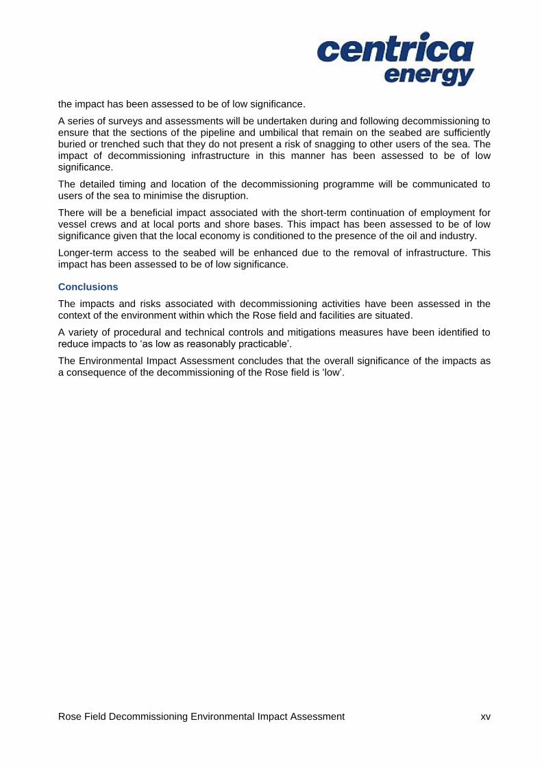
the impact has been assessed to be of low significance.
A series of surveys and assessments will be undertaken during and following decommissioning to ensure that the sections of the pipeline and umbilical that remain on the seabed are sufficiently buried or trenched such that they do not present a risk of snagging to other users of the sea. The impact of decommissioning infrastructure in this manner has been assessed to be of low significance.
The detailed timing and location of the decommissioning programme will be communicated to users of the sea to minimise the disruption.
There will be a beneficial impact associated with the short-term continuation of employment for vessel crews and at local ports and shore bases. This impact has been assessed to be of low significance given that the local economy is conditioned to the presence of the oil and industry.
Longer-term access to the seabed will be enhanced due to the removal of infrastructure. This impact has been assessed to be of low significance.
Conclusions
The impacts and risks associated with decommissioning activities have been assessed in the context of the environment within which the Rose field and facilities are situated.
A variety of procedural and technical controls and mitigations measures have been identified to reduce impacts to ‘as low as reasonably practicable’.
The Environmental Impact Assessment concludes that the overall significance of the impacts as a consequence of the decommissioning of the Rose field is ‘low’.

Rose Field Decommissioning Environmental Impact Assessment 1
2. INTRODUCTION
This Environmental Impact Assessment (EIA) report is a supporting document to the Decommissioning Programmes required by the Department of Energy and Climate Change (DECC) for the decommissioning of the Rose installation (a wellhead protection structure) and its associated pipeline and umbilical. The term ‘Rose field and facilities’ is used herein to describe the Rose installation and pipeline and umbilical.
The EIA report presents the findings of the process undertaken by Centrica relating to the decommissioning of the Rose field and facilities. The original EIA [7] prepared for the Rose development has been used a reference.
2.1 Location of the Rose field and facilities
The Rose field is located in the southern North Sea in the United Kingdom Continental Shelf (UKCS) block 47/15b, (Figure 2.1), lying approximately 54km east of the English coastline and 130km from the UK/Netherlands median line.
Figure 2.1 Location of Rose Field

Rose Field Decommissioning Environmental Impact Assessment 2
2.2 Project background and purpose
The Rose field was discovered in 1998 by BG Group and Centrica. In 2002 Centrica bought out the 60% holding of BG Group and went on to develop the field with first gas occurring in 2004. The Rose field development (P776) is wholly owned by Centrica Resources Limited and comprises a single subsea production well (47/15b-6W) tied back to the Perenco (formerly BP) - operated Amethyst A2D platform, via a 10” diameter pipeline, approximately 9.0km in length (see Figure 1.2 for Rose field layout and facilities). No processing occurs on the Amethyst A2D platform, and production is comingled and exported to Dimlington via PL649. Both the Amethyst A2D platform and the Rose production well are located in water depths of approximately 24m. Water depth along the pipeline route varies between 22m and 59m (LAT).
The Rose well has not produced since 2010 and failed to restart in 2011 due to what was believed to be heavy liquid loading. The various engineering options and other opportunities examined by Centrica for extending production were deemed to be neither technically nor economically feasible. On this basis the likelihood of recovering additional reserves was considered minimal, hence the application for cessation of production and preparation for decommissioning.
The Rose production well is currently ‘live’ but not producing and is scheduled for pipeline isolation and plugging and abandonment (P&A) as early as Q2 2015.
The Rose field exploration well (47/15b-5) was previously subject to P&A in 2011.
Figure 2.2: Rose field layout and facilities

Rose Field Decommissioning Environmental Impact Assessment 3
2.3 Regulatory context
The relevant UK and international legislation is outlined below.
The UK international obligations on decommissioning are governed principally by the 1992 Convention for the Protection of the Marine Environment of the North East Atlantic (OSPAR) Convention [8]. The OSPAR Decision 98/3 [9] sets out the UK’s international obligations on the decommissioning of offshore installations. However, pipelines and umbilicals, such as PL1987 and PLU1988 at Rose are not included within the Decision.
The decommissioning of offshore oil and gas infrastructure (including pipelines) in the UKCS is principally governed by the Petroleum Act 1998 (as amended by the Energy Act 2008) [2]. The Petroleum Act sets out the requirements for a formal Decommissioning Programme, which must be approved by the DECC before the owners of an offshore installation or pipeline may proceed with decommissioning.
The DECC Guidance Notes [3] on the Decommissioning of Offshore Oil and Gas Installations and Pipelines advise that any Decommissioning Programme must be supported by an EIA. The Guidance goes on to state that the EIA should include an assessment of the following:
All potential impacts on the marine environment including exposure of biota to contaminants; other biological impacts arising from physical effects; conflicts with the conservation of species and their habitats;
All potential impacts on other environmental compartments, including emissions to the atmosphere, leaching to groundwater, discharges to surface fresh water and impacts on the soil;
Consumption of natural resources and energy associated with reuse and recycling;
Interference with other legitimate uses of the sea and consequential impacts on the physical environment; and,
Potential impacts on amenities, the activities of communities and on future uses of the environment.
The Marine and Coastal Access Act 2009 (MCAA) [10] states that an EIA is required for all licence applications relating to decommissioning activities. The MCAA licence application will be made at the time of decommissioning.
Other relevant legislation includes:
The Offshore Petroleum Activities (Conservation of Habitats) Regulations 2001 [11];
The Offshore Chemical Regulations 2002 [12];
The Offshore Petroleum Activities (Oil Pollution Prevention and Control) Regulations 2005 [13];
The Merchant Shipping (Oil Pollution Preparedness, Response and Co-operation Convention) Regulations 1998 (requiring an OPEP) [14];
The Offshore Petroleum Production and Pipe-lines (Assessment of Environmental Effects) Regulations 1999 [15];
Environmental Protection Act 1990 [16];
Special Waste Regulations 1996 [17];
Hazardous Waste (England and Wales) Regulations 2005 [18];

Rose Field Decommissioning Environmental Impact Assessment 4
Transfrontier Shipment of Waste Regulations 2007 [19]; and,
Transfrontier Shipment of Radioactive Waste and Spent Fuel Regulations 2008 [20].
As part of the requirements of the ISO 14001 certified Environmental Management System (EMS) [4], Centrica has identified all applicable legal and other requirements associated with the decommissioning activities.
2.4 Purpose of the Environmental Impact Assessment
As described in the DECC Guidance Notes [3], this EIA report has been produced following the EIA guidance for the Offshore Petroleum Production and Pipelines (Assessment of Environmental Effects) Regulations (1999, as amended) [15]. This EIA report presents the findings of the process and has been prepared for submission as part of the planning and consents requirements. The purpose of the EIA is to understand and communicate the significant environmental impacts associated with the decommissioning and to identify the required control and mitigation measures.
The EIA and this report, assesses potential impacts in order to support the UK legislative requirements.
2.5 Stakeholder consultation
Stakeholder consultation is an important part of the decommissioning process. Informal responses received to date from stakeholders that are relevant to the EIA are shown in Table 1-1 and will be addressed as the project progresses.
Table 2-1: Summary of stakeholder comments
Stakeholder Comment Response
STATUTORY CONSULTATIONS
NFFO Advice given was to commence discussions around 1 year before decommissioning.
Discussions with NFFO personnel.
Discussed at regular meetings with no concerns raised to date.
A proposed way forward was agreed.
Discussions continue.
DECC The EIA report should cover the scope of the Decommissioning Programmes, not including well P&A.
Included in this report.
2.5.1 Future consultation
The formal consultation will begin with the submission of the draft Decommissioning Programmes, supported by this EIA report, to the DECC. The consultation process at this stage will include the use of the Centrica internet website to make these documents publicly available. Hard copies will also be available in the Centrica Aberdeen office for inspection by members of the public.

Rose Field Decommissioning Environmental Impact Assessment 5
2.6 Business Management System including environmental management
The management of the decommissioning activities is addressed within the Centrica EMS certified to the requirements of ISO 14001:2004. The EMS includes the procedures for environmental management in line with the Company’s HSE policies and applicable legal requirements.
2.6.1 Environmental management
Centrica has a commitment to health, safety and security, as outlined below:
The health, safety and security of our employees, customers and others who may be affected by our activities are a top priority. We believe that all work-related fatalities, injuries and illnesses can be prevented and we are committed to ensuring that all employees work in a safe and healthy way.
The company’s Business Management System (BMS), which describes those controls required to address Quality, Safety and Environmental (QSE) risks, is designed to meet business needs and to adopt a consistent approach to QSE management by satisfying the requirements of the recognised, applicable management systems standards, for environment, ISO 14001 Environmental management systems.
Centrica also has a commitment to the environment and details of this are outlined below:
We are committed to understanding, managing and reducing the environmental impact of our activities. In particular we are committed to playing our part in the transition to low carbon energy, while ensuring the security of present and future energy supplies. We aim to achieve this by sourcing and producing energy from cleaner sources, reducing wasted energy and developing and deploying new technology.
We aim to reduce the carbon intensity of our power generation by developing renewable energy sources. We are also committed to leading the consumer market for low carbon energy products and services, helping customers to reduce their energy usage.
We recognise that our operations, together with the way we deliver products and services, can have a major impact on the environment. For example, in the way we produce and use energy, manage our local environment and its biodiversity, operate our fleet of vehicles and manage the waste we create. We will work with our employees and suppliers to reduce these impacts through innovation, technology and cultural change. In addition we will quantify, measure and communicate our environmental performance in a rigorous and clear manner.
2.6.2 Contractor management
Centrica will appoint a project management team to select and manage the operations of competent contractors. The team will ensure the decommissioning is executed safely, in accordance with Centrica Health and Safety principles and safeguard the environment in line with the environmental policy. Any change to the proposed decommissioning activities will be discussed with the DECC.

Rose Field Decommissioning Environmental Impact Assessment 6
3. PROJECT DESCRIPTION
This section describes the Rose field and facilities that will be decommissioned and outlines the methodology that will be utilised. The process that was followed to identify the recommended decommissioning option is also presented.
3.1 Background
The Rose field was developed using a single subsea well producing gas via a 10” diameter, 9.042km long steel pipeline to the third party operated Amethyst A2D platform. The platform is classified as a Normally Unattended Installation (NUI) from which controls, hydraulic energy and chemicals are supplied to the wellhead, Xmas tree and pipeline via a 9.400km long umbilical. The steel pipeline riser and umbilical are located inside a 30” diameter caisson at the platform, with the umbilical being routed through the same caisson inside a steel tube with a 90 degree bend at its base (referred to as a J-tube).
Figure 2.2 shows the Rose field layout and Figure 3.1 below shows the battery limits of the pipeline system.
Figure 3.1: Rose pipeline system battery limits
The Rose well is located at the upstream end of the pipeline system and comprises the wellhead, Xmas tree, subsea umbilical termination unit (SUTU) and wellhead protection structure (WHPS). The WHPS is connected to the wellhead and positioned over the top of the Xmas tree. The WHPS is designed to be over-trawlable to minimise the snagging risk presented to commercial fishing and other third party users. The WHPS and Xmas tree are shown in Figure 3.2.
The Amethyst A2D platform will remain operational after the Rose facilities have been decommissioned. The caisson, riser, J-tube and topside facilities uniquely associated with Rose will be removed when the platform is decommissioned.

Rose Field Decommissioning Environmental Impact Assessment 7
Figure 3.2: Rose wellhead protection structure and Xmas tree
3.1.1 10” gas pipeline (PL1987)
The 10” nominal bore carbon steel gas pipeline has a thin, three layer polypropylene outer coating which was applied to give protection from external corrosion. The pipeline was installed by a rigid pipe reel lay vessel and laid in a pre-cut trench. The trench was mechanically backfilled with seabed material, giving typically 1m or more of cover. Within the vicinity of the Rose wellhead, and within the Amethyst A2D platform 500m exclusion zone there are sections of approximately 180 - 200m in length, where the pipeline is not buried but covered with concrete mattresses and grout bags. There are also 18 midline sections where the buried pipeline is covered with emplaced rock. The purpose of the rock sections, which are typically 30 -40m in length, is to provide downforce at locations where the pipeline was susceptible to upheaval buckling while in service. There are no pipeline crossings.
The pipeline is connected to the Xmas tree by six rigid spool pieces, totalling approximately 90m in length. These comprise sections of straight pipe and horizontal and vertical bends that are designed to absorb pipeline end expansion and to facilitate fit-up and tie-in of the pipeline and Xmas tree.
The pipeline is connected to the riser at the Amethyst A2D platform by four rigid spool pieces totalling approximately 100m in length.
3.1.2 4” umbilical (PLU1988)
The 4” (96.5mm) diameter umbilical cross-section is shown in Figure 2-3. The umbilical was laid in a pre-cut trench that was left to backfill naturally with sediments. It comprises a composite flexible configuration of small diameter thermoplastic cores and polyethylene coated cables, the purpose of which is to provide the necessary controls, hydraulic energy and chemicals to operate the well and pipeline. In addition, the umbilical contains polyethylene filler elements and fibre tape, surrounded by layers of varying thicknesses of polyethylene and galvanised steel wire. The umbilical is attached to a steel ballast wire that provides additional weight to maintain its stability within the sediment in the trench. The steel ballast wire, which is made up of nine 1km long sections, runs the length of the buried umbilical. Umbilical elements which are on the surface or within the platform J-tube have no steel ballast wire attached.
The connection of the umbilical to the Rose Xmas tree is made at the SUTU, which is located within the WHPS.

Rose Field Decommissioning Environmental Impact Assessment 8
Figure 3.3: Rose umbilical cross section
The content of the umbilical cores and their approximate volumes at the time of decommissioning is shown in Table 3-1.
Table 3-1: Content of umbilical cores
Core No. Core Description Approximate Volume (m
3)
Content at decommissioning
1 & 2 Hydraulic Cores (2x) 2.4 (2 x 1.2) Oceanic HW540 v2
3 & 4 Hydraulic Cores (2x) 1.4 (2 x 0.7) Oceanic HW540 v2
5 & 9 Methanol/Corrosion Inhibitor Cores (2x)
5.4 (2 x 2.7) Water with methanol/corrosion inhibitor residues
Others Electrical/Signal N/A N/A
3.1.3 Emplaced rock, concrete mattresses and grout bags
As stated above, the pipeline has 18 median locations of emplaced rock, totalling approximately 5,547 tonnes distributed along the length of the pipeline.
The pipeline and umbilical are each protected with concrete mattresses at either end where they emerge from their trenches. There are 63 mattresses at the ends of the pipeline (30 at Rose, 33 at Amethyst A2D), and 49 mattresses at the ends of the umbilical (25 at Rose, 24 at Amethyst A2D). There are additional mattresses placed over the umbilical at two midline locations; one

Rose Field Decommissioning Environmental Impact Assessment 9
located 0.86km from the platform and a group of three located 5.70km further towards the Rose wellhead (shown schematically on the Rose field layout and facilities in Figure 2.2). The purpose of these additional mattresses, which have become buried since installation, is to mitigate areas of insufficient cover over the umbilical.
Grout bags (typically 25kg in weight) have been used to fill voids, as scour prevention, to provide improvements to protective cover to the exposed sections of pipeline and umbilical, and to ensure smooth transitions between the pipeline and the seabed. It is estimated that around 200 grout bags have been placed on the seabed (some will be located on top of one another). These are mostly under and adjacent to the spool pieces and tie-in points at the ends of the pipeline and umbilical.
Figure 3.4: Pipeline and umbilical approaches showing mattress protection features and cut locations
3.1.4 Summary of facilities to be decommissioned
The following facilities and materials will be decommissioned:
WHPS;
Spool pieces;
Pipeline;
Umbilical, including ballast wire and SUTU; and,
Concrete mattresses and grout bags.
The decommissioning (removal) of the Rose wellhead and Xmas tree is governed under the Offshore Installation and Wells (Design and Construction etc.) Regulations 1996 [21] and will be undertaken in accordance with the Oil and Gas UK guidelines for the suspension and

Rose Field Decommissioning Environmental Impact Assessment 10
abandonment of wells. These items will be decommissioned under a separate programme undertaken by a drilling rig and hence are not assessed in this document.
All emplaced rock will be left in-situ and is not assessed further in this document.
3.2 Comparative Assessment
A Comparative Assessment (CA) [22] of pipeline and umbilical decommissioning options is a key supporting document of the Decommissioning Programmes submitted to the DECC. The options were assessed using the DECC Decommissioning Guidance Notes and Centrica Comparative Assessment guidelines. During the assessment process, evaluations were made principally on a qualitative basis using Centrica's established corporate risk assessment tables but also combined with deterministic values from the cost and energy use estimates which were normalised to provide a consistent measure against all Comparative Assessment evaluation criteria of:
Safety
Environmental
Technical
Societal
Cost
The Comparative Assessment was undertaken with a focus on the decommissioning options for the 10” pipeline, the 4” umbilical and the midline mattresses on the umbilical (Table 3-2, Table 2-3 and Table 3-4 below). The options were assessed using the DECC Decommissioning Guidance Notes [3] and Centrica Comparative Assessment guidelines [23].
Table 3-2: Pipeline Comparative Assessment of options for decommissioning
Item Option 1
Complete Removal
Option 2
Partial Removal
Buried pipeline
Remove. Use pipe reel lay construction vessel to pull pipeline out through covered trench and onto reel using “reverse lay” technique. Return pipe to shore for cutting into transportable lengths and processing
Leave in situ. No work
Exposed pipeline ends Remove. Recover with reel lay vessel as part of reverse lay process
Cut and remove. Use divers from DSV to unbolt buried pipeline from riser, excavate local areas to give access for cutting pipeline and allow seabed to backfill naturally. This may also involve local water jetting.
6 spool pieces at Rose wellhead, and 3 spool pieces at Amethyst A2D platform
Remove. Divers disconnect flanges and rig spools for lifting to Dive Support Vessel
Remove. As option 1.
Single spool piece adjacent to rigid riser inside jacket at Amethyst A2D platform
Leave in situ with the Amethyst A2D platform for possible reuse (to be decommissioned in future)
Leave in situ. As option 1.

Rose Field Decommissioning Environmental Impact Assessment 11
Table 3-3: Umbilical Comparative Assessment of options for decommissioning
Item
Option 1
Complete Removal
Option 2
Partial Removal (ends only)
Option 3
Partial Removal (rock
emplacement)
Option 4
Partial Removal (3.5km removal)
Buried Umbilical
Remove. Pull umbilical out through covered trench and onto a reel mounted on a vessel, possibly a reel lay vessel, but probably the Dive Support Vessel. Return umbilical to shore for cutting into transportable lengths / weights and processing
Remove poorly buried or potentially unstable sections and leave acceptably buried sections in situ.
Locate poorly buried sections, excavate extremities by local water jetting, cut, and connect to winch for recovering to deck of vessel
As option 2, but also place graded rock over areas with relatively shallow cover
As option 2 but remove additional length of umbilical 3.5km long measured from Amethyst A2D platform with relatively shallow cover within Silver Pit area
Umbilical ends within Amethyst A2D platform 500m exclusion zone
Remove. Disconnect from TUTU on topsides, connect rigging to subsea end and pull section out from bottom of J tube to deck of DSV using winch
Remove.
As option 1
Remove.
As option 1
Remove.
As option 1
SUTU and umbilical ends at Rose wellhead
Remove. As part of reverse reel process
Remove with umbilical end section
As “Complete Removal.”
Cut and Remove Cut and Remove
Table 3-4: Midline mattresses Comparative Assessment of options for decommissioning
Item Option 1
Complete Removal
Option 2
Excavation and backfill with rock
Option 3
Leave in situ
Buried Midline Mattresses Excavate local area and remove
Excavate local area and remove mattresses. Thereafter, backfill excavated area with graded rock
Leave in situ
The results of the assessment showed the risks and impacts of all pipeline and umbilical options to be broadly acceptable, although it could be argued that the technical and safety risks associated with complete removal of a pipeline or umbilical would be tolerable rather than be
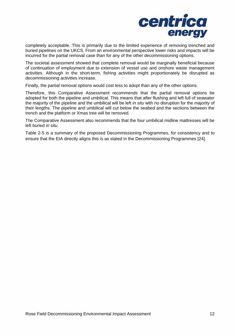
Rose Field Decommissioning Environmental Impact Assessment 12
completely acceptable. This is primarily due to the limited experience of removing trenched and buried pipelines on the UKCS. From an environmental perspective lower risks and impacts will be incurred for the partial removal case than for any of the other decommissioning options.
The societal assessment showed that complete removal would be marginally beneficial because of continuation of employment due to extension of vessel use and onshore waste management activities. Although in the short-term, fishing activities might proportionately be disrupted as decommissioning activities increase.
Finally, the partial removal options would cost less to adopt than any of the other options.
Therefore, this Comparative Assessment recommends that the partial removal options be adopted for both the pipeline and umbilical. This means that after flushing and left full of seawater the majority of the pipeline and the umbilical will be left in situ with no disruption for the majority of their lengths. The pipeline and umbilical will cut below the seabed and the sections between the trench and the platform or Xmas tree will be removed.
The Comparative Assessment also recommends that the four umbilical midline mattresses will be left buried in situ.
Table 2-5 is a summary of the proposed Decommissioning Programmes, for consistency and to
ensure that the EIA directly aligns this is as stated in the Decommissioning Programmes [24].
Rose Field Decommissioning Environmental Impact Assessment 13
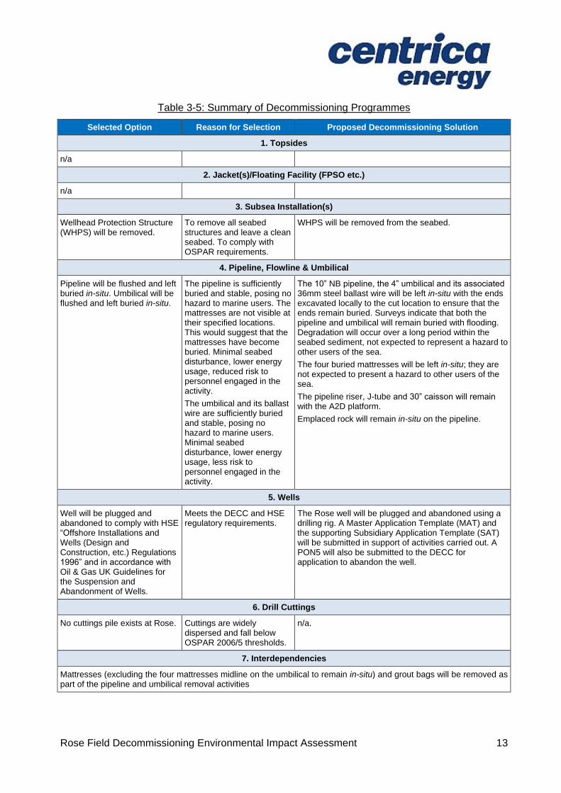
Table 3-5: Summary of Decommissioning Programmes
Selected Option Reason for Selection Proposed Decommissioning Solution
1. Topsides
n/a
2. Jacket(s)/Floating Facility (FPSO etc.)
n/a
3. Subsea Installation(s)
Wellhead Protection Structure (WHPS) will be removed.
To remove all seabed structures and leave a clean seabed. To comply with OSPAR requirements.
WHPS will be removed from the seabed.
4. Pipeline, Flowline & Umbilical
Pipeline will be flushed and left buried in-situ. Umbilical will be flushed and left buried in-situ.
The pipeline is sufficiently buried and stable, posing no hazard to marine users. The mattresses are not visible at their specified locations. This would suggest that the mattresses have become buried. Minimal seabed disturbance, lower energy usage, reduced risk to personnel engaged in the activity.
The umbilical and its ballast wire are sufficiently buried and stable, posing no hazard to marine users. Minimal seabed disturbance, lower energy usage, less risk to personnel engaged in the activity.
The 10” NB pipeline, the 4” umbilical and its associated 36mm steel ballast wire will be left in-situ with the ends excavated locally to the cut location to ensure that the ends remain buried. Surveys indicate that both the pipeline and umbilical will remain buried with flooding. Degradation will occur over a long period within the seabed sediment, not expected to represent a hazard to other users of the sea.
The four buried mattresses will be left in-situ; they are not expected to present a hazard to other users of the sea.
The pipeline riser, J-tube and 30” caisson will remain with the A2D platform.
Emplaced rock will remain in-situ on the pipeline.
5. Wells
Well will be plugged and abandoned to comply with HSE “Offshore Installations and Wells (Design and Construction, etc.) Regulations 1996” and in accordance with Oil & Gas UK Guidelines for the Suspension and Abandonment of Wells.
Meets the DECC and HSE regulatory requirements.
The Rose well will be plugged and abandoned using a drilling rig. A Master Application Template (MAT) and the supporting Subsidiary Application Template (SAT) will be submitted in support of activities carried out. A PON5 will also be submitted to the DECC for application to abandon the well.
6. Drill Cuttings
No cuttings pile exists at Rose. Cuttings are widely dispersed and fall below OSPAR 2006/5 thresholds.
n/a.
7. Interdependencies
Mattresses (excluding the four mattresses midline on the umbilical to remain in-situ) and grout bags will be removed as part of the pipeline and umbilical removal activities
Rose Field Decommissioning Environmental Impact Assessment 14
Figure 3-5: Recommended decommissioning approach
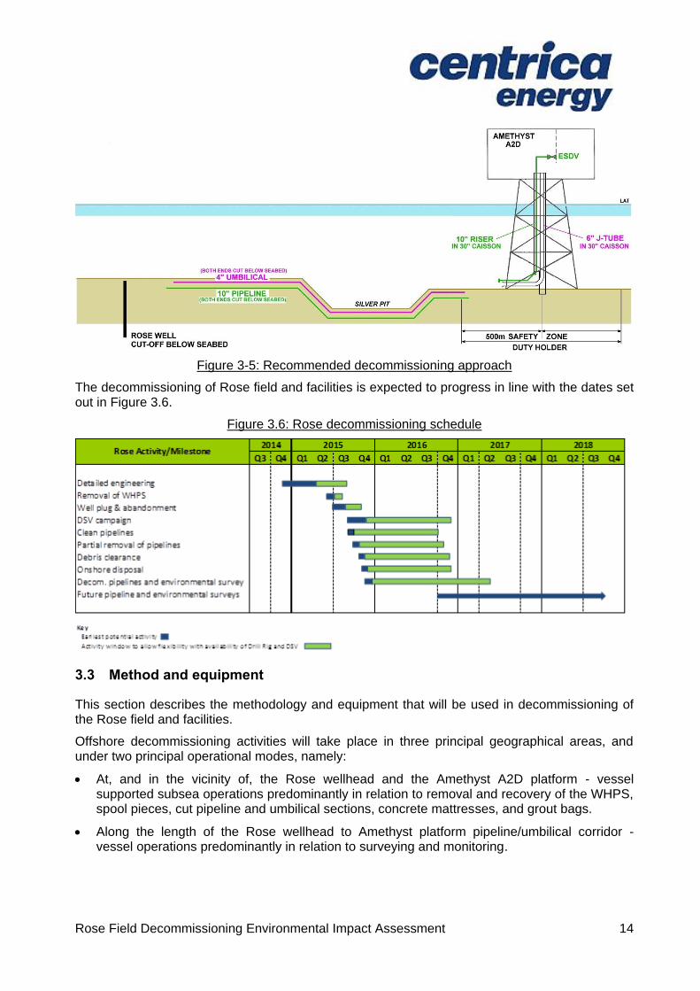
The decommissioning of Rose field and facilities is expected to progress in line with the dates set out in Figure 3.6.
Figure 3.6: Rose decommissioning schedule
3.3 Method and equipment
This section describes the methodology and equipment that will be used in decommissioning of the Rose field and facilities.
Offshore decommissioning activities will take place in three principal geographical areas, and under two principal operational modes, namely:
At, and in the vicinity of, the Rose wellhead and the Amethyst A2D platform - vessel supported subsea operations predominantly in relation to removal and recovery of the WHPS, spool pieces, cut pipeline and umbilical sections, concrete mattresses, and grout bags.
Along the length of the Rose wellhead to Amethyst platform pipeline/umbilical corridor - vessel operations predominantly in relation to surveying and monitoring.

Rose Field Decommissioning Environmental Impact Assessment 15
3.3.1 Preparatory activities
Certain offshore activities will be undertaken in preparation for decommissioning and for completeness, these have been summarised below. They do not form part of the pipeline and umbilical Decommissioning Programme and their environmental impacts have not been assessed in this document.
Isolation of the Rose Xmas tree from the Amethyst A2D platform (disconnection of the umbilical and gas jumper at the tree);
Cleaning of the pipeline to remove remaining gas, liquids and loose solid deposits. The pipeline will first be pigged and then flushed, leaving it filled with inhibited seawater. Pigging waste and wash water will be returned to the Amethyst A2D platform for treatment and/or disposal. It will not be possible to clean the spool pieces at the Rose wellhead end in this manner; and,
Cleaning of the umbilical cores that contain corrosion inhibitor and/or methanol. The cores will be flushed with potable water. Displaced chemicals and wash water will be returned to the Amethyst A2D platform for treatment and/or disposal.
3.3.2 Removal of the wellhead protection structure
The WHPS will be decommissioned in two stages. A DSV will initially be used to partially dismantle the WHPS in order to allow access for a drilling rig. The DSV will deploy a diver-operated cutting tool to remove its top and sides, which will be recovered to surface. The drilling rig will then deploy a tool to mechanically disconnect the remainder of the WHPS from the wellhead and to recover it to surface.
All component parts of the WHPS will be transported to the shore where, preferentially, they will be reconditioned for reuse. If this is not possible, constituent materials (predominantly steel) will be recycled.
3.3.3 Removal of pipeline and umbilical protection
All 112 concrete mattresses and all grout bags (approximately 200) at the Rose wellhead and Amethyst A2D platform ends will, where technically feasible, be removed and recovered by a DSV to shore for reuse, recycling or disposal to landfill in accordance with the waste hierarchy principles. Given the relatively short duration that the mattresses and grout bags have been installed (ca. 13 years), it is assumed that (rather than single lifts) the concrete mattresses and grout bags will be able to be placed into purpose-built transport frames and debris baskets for temporary seabed placement.
Trials will be undertaken to assess if these assumptions are correct in advance of the main DSV mobilisation. This will allow alternative arrangements to be planned should the above assumptions be incorrect.
The four buried mattresses that have been placed over the umbilical at midline locations will be left in-situ. Emplaced rock protection will also be left in-situ.
3.3.4 ‘Partial removal’ of the pipeline (including spool pieces)
All of the spool pieces at the Rose wellhead end of the pipeline and with one exception, all of the spool pieces at the Amethyst A2D platform end of the pipeline will be removed by DSV and recovered to the shore for recycling. The riser spool piece located under the Amethyst platform

Rose Field Decommissioning Environmental Impact Assessment 16
will not be removed. Spool pieces will either be unbolted, or cut into manageable lengths.
As stated in Section 2.1.1, the majority of the pipeline is trenched and sufficiently buried to a depth of at least 0.6m to top of pipe to present no expected threat to marine users [3]. This section of the pipeline will be subject to in-situ decommissioning.
The sections of the pipeline that make the transition from full burial to the seabed surface, and the sections of the pipeline that rest on the seabed are classed, respectively, as ‘insufficiently buried’ and ‘not buried’. These sections of the pipeline will be removed by DSV and recovered to shore for recycling. The pipeline will be cut into approximate 20m lengths using a specialist diver-operated cutting tool before being cut further into smaller lengths suitable for road transport. Figure 3.4 shows the locations of the cuts. At the Amethyst A2D platform end, the pipeline will be unbolted where it enters the platform structure at the riser spool piece flange and the unduried or ‘insufficiently’ buried section will be cut, removed and recovered for recycling onshore. The riser will remain in place.
Access to the pipeline circumference may require the deployment of a water-jetting tool from the DSV to displace sediment. Water-jetting of the seabed may be required to gain access for cutting and/or unbolting of the spool pieces/pipeline and access for lifting. This will be undertaken using a specialist tool deployed by a DSV/ROVSV. The excavations containing the cut ends of the section that will be subject to in-situ decommissioning will be left to backfill naturally.
3.3.5 ‘Partial removal’ of the umbilical
The umbilical will be disconnected from the SUTU at the Rose wellhead end and cut at the base of Amethyst A2D platform riser using a diver-operated cutting tool deployed from a DSV. The SUTU will be disconnected from the Xmas tree and recovered to surface by the DSV. The section of umbilical inside the J-tube will be removed and recovered by the DSV.
The majority of the umbilical is trenched and sufficiently lowered below sea level to a depth of at least 0.6m to top of pipe, while depth of backfill material lying over the umbilical varies along the route. This section of the umbilical (which is fitted with steel ballast wire) will be subject to in-situ decommissioning.
The sections of the umbilical that are ‘insufficiently’ buried (i.e. un-trenched or transitionally trenched) at both the wellhead and the Amethyst A2D platform will be cut by divers using a specialist tool, removed by DSV and recovered to shore for preferential recycling. If this is not possible, they will be disposed of to landfill.
Access to the umbilical circumference may require the deployment of a water-jetting tool from the DSV to displace sediment. No emplaced rock is present in the vicinity of the cut ends.
3.3.6 Vessels
A range of specialist and support vessel types (e.g. DSV, standby) will be required at various times, and for various durations, to undertake particular component activities of the offshore decommissioning programme. The performance characteristics including the fuel consumption of the generic vessel types required to execute the work programme are well understood. This has allowed, in conjunction with a consideration of the programme vessels’ schedule, estimates of fuel consumption to be made.(Table 3-6 and Table 2-7).
Estimates of fuel use have been based on Institute of Petroleum Guidelines [25]. The durations given allow for transit to/from the Rose – Amethyst area as well as operations.

Rose Field Decommissioning Environmental Impact Assessment 17
The vessel durations given are worst case estimates. Vessel use will continue to be optimised until decommissioning commences. Actual durations are likely to be lower (in alignment with commitments made in this EIA report). While decommissioning of the pipeline and umbilical will be undertaken during the same campaign, vessel use has been presented separately to be consistent with Comparative Assessment and Decommissioning Programmes documentation.
Table 3-6: Vessel requirements for decommissioning of the pipeline
Vessel Fuel usage (Tonnes)
Type Duration (Days)
DSV 31 558
Standby 31 24.8
ROVSV 7 126
Surveys 9 13.5
Table 3-7: Vessel requirements for decommissioning of the umbilical
3.3.7 Decommissioning and post-decommissioning survey/monitoring programme
A seabed debris survey, a pipeline and umbilical ‘as left’ trenching/burial status survey, and a seabed ‘over-trawlability’ assessment will be undertaken at the conclusion of decommissioning activities.
Post-decommissioning assessments of the trenching/burial status of the pipeline and umbilical sections that were decommissioned in-situ, and of the environmental status of the seabed will also be undertaken. While the exact timing and extent of required ‘legacy’ monitoring will be agreed with the DECC, at least two such rounds will be undertaken. The estimates of survey vessel days used in Tables 2.6 and 2.7 are based upon this minimum requirement and allow for both vessel mobilisation and demobilisation. It should be noted however that legacy monitoring of decommissioned Rose field infrastructure will be undertaken in combination with other Centrica surveying requirements at the time in the southern North Sea and that actual required vessel days are likely to be lower.
3.3.8 Summary of principal planned decommissioning activities
Offshore
General (in support of all removal activities below):
Vessel Fuel usage (Tonnes)
Type Duration (Days)
DSV 5.5 99
Standby 5.5 4.4
Survey 9 13.5

Rose Field Decommissioning Environmental Impact Assessment 18
Use of specialist and support vessels.
Removal of the wellhead protection structure:
Partial dismantling (by cutting) of the WHPS. Undertaken using a specialist tool deployed by a surface vessel;
Removal and recovery (lifting) of part of the WHPS to the surface vessel;
Mechanical disconnection of the remaining part of the WHPS from the wellhead. Undertaken by a drilling rig; and,
Removal and recovery (lifting) of the remaining part of the WHPS to the drilling rig.
‘Partial removal’ of the pipeline (including spool pieces) and umbilical:
Unbolting/cutting each spool piece located between the Rose wellhead and pipeline, and the Amethyst platform riser and pipeline. Unbolting of the SUTU from the Rose Xmas tree and its cutting at the base of the Amethyst riser. Unbolting will be undertaken by divers deployed from a surface vessel, cutting will be undertaken using specialist tool(s) deployed by a surface vessel;
Water-jetting of the seabed to permit access for the unbolting/cutting and lifting of spool pieces, pipeline and umbilical. Undertaken using a specialist tool deployed by a surface vessel;
Cutting of the pipeline and the umbilical. Undertaken using specialist tool(s) deployed by a surface vessel; and,
Removal and recovery (lifting) of spool pieces, and cut sections of pipeline and umbilical to the surface vessel.
Removal of pipeline and umbilical protection:
Removal and recovery (lifting) of concrete mattresses and grout bags to a surface vessel.
Execution of decommissioning and post-decommissioning survey/monitoring programme:
Use of specialist vessels.
Onshore
Processing of recovered materials:
The light processing (cleaning and cutting etc. but excluding recycling) of recovered materials at a shore base, in preparation for their reuse, recycling or disposal. Undertaken by a variety of plant and equipment.

Rose Field Decommissioning Environmental Impact Assessment 19
4. ENVIRONMENTAL BASELINE
This section describes the environmental setting of the Rose field and the receptors, both within the field and the surrounding area, which may be affected by the proposed decommissioning activities described in Section 2. The Rose field and facilities are located in an area of the southern North Sea that is both environmentally sensitive (including and herring spawning) and close to busy shipping lanes. The information will be used to assess the level of impact that the proposed activities will have on the existing environment.
The Environmental Statement (ES) for the development of the Rose field was prepared in 2002 [7]. A series of environmental surveys were undertaken within the Rose field and in the surrounding area in 2001 to inform the ES. A pre-decommissioning environmental survey was undertaken in 2012 [5]. The results of this survey have been used to update, where necessary, the findings of the ES and to establish the environmental baseline for this assessment.
The pre-decommissioning survey was undertaken within the vicinity of the Rose wellhead (47/15b-6W) and along the length of the Rose to Amethyst A2D pipeline and umbilical corridor. The survey, undertaken in August 2012, collected geophysical and environmental data using a combination of single-beam and multi-beam bathymetry, sidescan sonar and environmental sampling. The environmental sampling locations, where habitat mapping, grab and video analysis were undertaken, were informed by the bathymetry and sidescan sonar data.
Four samples (3, 4, 9 & 10) were taken in a cruciform pattern approximately 250m from the Rose wellhead; four further samples (1, 2, 5 & 6) at 250m intervals both north-north-west and south-south-east along the main tidal axis; and four samples (12-15) along the Rose to Amethyst pipeline corridor at approximately 2km intervals. Two additional samples (8 & 11), 1km west and 1km east of the wellhead, were collected from areas of undisturbed sediment as reference sites. Sample 7 was also collected, as a reference site, 1.25km south-south-east of the wellhead. The two sampling sites (8 & 9) to the south-west of the wellhead were moved slightly north to allow 200m between the sampling sites and the pipeline. Two video only sites (16 & 17) were added on review of the sidescan sonar data, to target different habitats along the pipeline. The locations of all samples are presented in Figure 4.5.
Comparing the observations of the 2002 ES, which described the environment in the area surrounding the Rose prior to its development in 2001/2002, and the pre-decommissioning survey in 2012 allows consideration of the recovery of the environment from the disturbance associated with original development.
4.1 Physical and chemical environment
This section provides information on the physical and chemical characteristics of the environment at and around the Rose field. The physical environment in which the Rose field is located is typical of the southern North Sea region.
4.1.1 Bathymetry
The 2002 ES states that water depths in the immediate area of the well location are shallow, varying between 23m and 24m and that the well lies approximately 1,200m to the north of an area of sand waves. The tops of the largest of these sand waves are 16m below Lowest Astronomical Tide (LAT) [7].
The 2012 survey recorded the majority of the survey area within a depth range of 20m to 30m LAT, but down to a depth of 60m in the area known as Silver Pit, towards the Amethyst A2D

Rose Field Decommissioning Environmental Impact Assessment 20
platform end of the pipeline (Figure 4.1). These depths are typical of the wider region, with deeper water corresponding to shelf troughs, such as Silver Pit. Over the majority of the survey area, depth changes were gradual, between 21.9m and 31.4m. The shallowest depth recorded, 14.2m, was directly over the Rose wellhead, which was found to be 9m higher than the surrounding seabed (Figure 4.1) [5].

Rose Field Decommissioning Environmental Impact Assessment 21
Figure 4.1: Bathymetry and shaded relief of bathymetry showing the location of The Silver Pit (deeper waters) [5]

Rose Field Decommissioning Environmental Impact Assessment 22
4.1.2 Currents
The entire water mass surrounding the UK southern North Sea moves in a south-easterly direction following the contours of the English coast (Figure 4.2). The current then moves in a north-easterly direction as it approaches the Norfolk coast making up the general anticlockwise direction of water flow for the North Sea. The North Sea has a single outflow, which commences in the Skagerrak, formed from all the inflows from the Baltic and Norwegian coastal run off. This current is known as the Norwegian Coastal Current and leaves the North Sea at its north-eastern margin [26]. The general water circulation is shown in Figure 4.2 below.
The majority of the North Sea is influenced by meteorological factors, which have a key role in ecosystem structuring. However in the shallower southern North Sea, the strong tidal flows prevent stratification of the water column and the input of nutrients from riverine sources reduce the influence of seasonal climatic factors.
Figure 4.2: General water circulation [26]
The local current direction close to the Amethyst A2D location (taken from the Admiralty Chart for Flamborough Head to Blakeney Point) is predominantly north to south. Minimum and maximum tidal rates at spring tides range from 0.46m/s to 1.49m/s, whilst values for neap tide rates range from 0.15m/s to 0.82m/s. The spring and neap flood tides have the highest rate when compared with spring and neap ebb tide rates.
At the Rose wellhead location the tidal currents are influenced by the Outer Dowsing Channel and Shoal where current directions are more aligned in a north-north-west to south-south-east direction. Tidal rates at this location are likely to be lower than at the Amethyst A2D platform with typical ranges of 0.26m/s to 0.87m/s at spring tides and 0.15m/s to 0.46m/s at neap tides.
X Rose field

Rose Field Decommissioning Environmental Impact Assessment 23
4.1.3 Meteorology
Wind speed and direction in the vicinity of the Rose field is seasonal but also highly variable, particularly during the spring. In summer, winds are light, averaging 9 - 10 knots and generally from the south-west. In autumn and winter, winds are stronger averaging 16 - 17 knots, although still typically from the south-west (Figure 3.3).
Figure 4.3: Mean wind direction distribution for the Humber Estuary platform. Source www.windfinder.com
4.1.4 Sea temperatures and salinity
The temperatures within the southern North Sea vary seasonally, ranging from 5˚C in the winter months up to 15˚C in the summer months. Salinity in the North Sea remains constant throughout the year at approximately 34‰. As described in Section 3.1.2 above, the physical characteristics of the southern North Sea result in a well-mixed water column, preventing stratification. As a result, there is minimal difference between the temperature and salinity at the surface and that at the seabed.
4.1.5 Seabed characteristic, sediments and types
The nature of seabed sediments is an important factor in providing information to help assess the potential for resuspension and transport of sediments. It is also a determining factor in the flora and fauna present and for their suitability as spawning and nursery grounds.
The 2002 ES described the seabed sediments in the immediate vicinity of the Rose field as consisting of megarippled (aligned in an approximately east-west direction), mobile, shelly, fine to coarse sand, with varying quantities of gravel [7].
As part of the pre-decommissioning environmental survey [5], the pipeline/umbilical and surrounding areas were surveyed (Figure 4.4) and subsequently sampled at a number of locations (Figure 4.5). Three main regions of distinct acoustic reflectivity were identified in the low frequency data, these were characterised according to Folk [27] as: sandy gravel; gravelly sand; and slightly gravelly sand. A transition area between gravelly sand and sandy gravel was also

Rose Field Decommissioning Environmental Impact Assessment 24
characterised. Within the Silver Pit, in the west of the survey area, a slightly different reflectivity was observed. Video imagery revealed that here the sandy gravel was more shelly in nature than at other locations.
The main areas of sandy gravel were located in the central area and the far western end of the pipeline. Gravelly sand was characterised on the pipeline to the east of Silver Pit, a section towards the Rose wellhead end of the pipeline and to the south-east of the wellhead itself. A small patch of slightly gravelly sand was demarcated far south-east from the Rose wellhead. The areas to the north and west of the wellhead were predominantly transitional areas of gravelly sand and sandy gravel, as were the two patches on the pipeline. Figure 4.4 presents the seabed characterisation in the vicinity of the wellhead and along the length of the pipeline.
Variations of acoustic reflectivity in the data were used to identify seabed features. The main features observed were the wellhead, with the pipeline and umbilical clearly visible in the data, as well as the trenched pipeline and areas of emplaced rock. Boulders were frequently identified across the entire survey area. Regions of dunes were observed across the survey area, in general orientated approximately east to west, as observed in the 2002 ES. Cobbles and boulders were also visible throughout the data, but were not characterised as they were well dispersed across the area [5]. Table 4-1 presents the results of the analysis of the grab samples collected.
Table 4-1: Sediment characteristics. (Adapted from [5])
Site Mean
Particle Diameter (µm)
Mean Particle Diameter (Phi)
% Gravel (64000 – 2000 µm)
% Sand (<2000 – 63 µm)
% Mud (<63 µm)
Folk Class *
Total Organic Carbon (%)
Total Organic Matter (%)
1 751.4 0.4 15.1 84 0.9 gS 0.3 7.6
2 482.9 1.1 11.0 87.5 1.6 gS 0.4 9.4
3 652.8 0.6 18.8 80.4 0.9 gS 0.4 9.5
4 461.0 1.1 5.4 93.6 1.0 gS 0.4 7.7
5 904.6 0.1 30.3 69.1 0.7 sG 0.3 7.5
6 903.6 0.2 34.8 64.6 0.6 sG 0.2 7.2
7 406.3 1.3 1.0 98.1 0.9 (g)S 0.2 6.4
8 690.9 0.5 18.6 80.7 0.8 gS 0.3 7.8
10 956.2 0.1 38.7 60.7 0.6 sG 0.3 6.4
11 869.1 0.2 34.0 65.3 0.6 sG 0.2 6.1
12 515.3 1.0 10.4 88.5 1.1 gS 0.3 7.6
13 7986.5 3.0 65.8 33.1 1.1 sG - -
14 537.0 0.9 14.5 84.0 1.5 gS 0.5 8.4
gS = gravelly sand, sG = sandy gravel, (g)S = slightly gravelly sand
The results for Total Organic Carbon (TOC) and Total Organic Matter (TOM) are presented in Table 4-1 above. TOC concentrations are consistently low, between 0.2% and 0.5% with an average of 0.3% across all sites. These results are comparable to other values obtained from the southern North Sea, which recorded organic carbon values of between 0.02% and 0.51% ([29] as cited by [7]).TOM results varied between 6.1% (Site 11) and 9.5% (Site 3) with an average of 7.6%. These values were noted as being high in respect to the TOC and when compared to other values from the North Sea. Quality control procedures were checked from the sample collection to the laboratory analysis and no obvious sources for the high values were found [5].

Rose Field Decommissioning Environmental Impact Assessment 25
Figure 4.4: Seabed characterisation [5]

Rose Field Decommissioning Environmental Impact Assessment 26
Figure 4.5: Subsea infrastructure features and sampling locations [5]

Rose Field Decommissioning Environmental Impact Assessment 27
4.1.6 Seabed chemistry
For the purposes of this report, seabed chemistry is discussed as the composition of hydrocarbons and metals present within the sediments in and around the Rose field.
Hydrocarbon concentrations
The 2002 ES states that the hydrocarbon content of southern North Sea sediments had been surveyed previously and that levels of up to 3,000mg/kg were recorded near sites where oil based muds had been used whilst drilling gas wells. However subsequent analysis had indicated that the trend for hydrocarbons was downwards ([26] as cited by [7]).
Sediment hydrocarbon analysis results from the pre-decommissioning environmental survey are presented in Table 4-2 below. Total Hydrocarbons (THC) varied from 2.29mg/kg (Site 11) to 22.84mg/kg (Site 14) and averaged 10.65mg/kg across the entire survey area. Background hydrocarbon concentrations are generally higher in fine sediments (muds and silts) than in coarser sediments (sands and gravels) due to their greater surface area and adsorptive capacity ([29]] as cited by [5]). Site 14, which had the highest THC value, also had one of the highest (1.49%) mud (<63 µm) fraction of any of the sampled sites (Table 4-1).
All sites were significantly below the Centre for Environment, Fisheries and Aquaculture Science (Cefas) Action Level 1 (AL1 - in general, contaminant levels in material below Action Level 1 are of no concern and are unlikely to influence the licensing decision) of 100mg/kg for THC. The typical range for THC in offshore North Sea surface sediments is 17 – 120mg/kg ([29] as cited by [5]). This illustrates how low the concentrations of THC recorded from the samples taken from the survey area are [5]. Furthermore the results represent a significant reduction in recorded concentrations from those presented in the 2002 ES [7].
Studies by the Norwegian Oil Industry Association [30] and UKOOA (2002) [31] indicate that THC concentrations below 50mg/kg are unlikely to represent a significant environmental impact.
Table 4-2: Summary of sediment hydrocarbon analysis. (Adapted from [5])
Site THC (mg/kg)
UCM nC10- nC20 nC21- nC37 nC10- nC37 NPD
1 16.97 15 0.811 0.584 1.395 0.169
2 9.99 9 0.292 0.349 0.642 0.094
3 8.39 8 0.201 0.221 0.422 0.092
5 19.23 18 0.679 0.611 1.290 0.253
6 3.73 6 0.193 0.232 0.425 0.061
7 4.74 4 0.137 0.210 0.348 0.019
8 4.03 4 0.070 0.099 0.169 0.022
10 4.56 4 0.136 0.162 0.298 0.051
11 2.29 2 0.052 0.124 0.176 0.027
12 17.42 16 0.776 0.612 1.388 0.237
14 22.84 20 0.913 1.561 2.474 0.238
The Unresolved Complex Mixture (UCM), also shown within Table 4-2, can provide an indication of the origin of hydrocarbons in the sediment and the extent to which they are weathered. Four of

Rose Field Decommissioning Environmental Impact Assessment 28
the Sites 7, 8, 10 and 11 have low levels of UCM across the entire hydrocarbon range measured. The other sites (1 - 3, 5, 6, 12 & 14) show a consistent pattern of low level high weight UCM. Site 14 had the most distinguished trace, which is typical of background levels of hydrocarbons in areas where oil and gas exploration occurs ([32] as cited by [5]). Hydrocarbons in this weight range (nC21-nC33) commonly originate from terrestrial or vascular plant sources, or could represent the residue of highly weathered and degraded petrogenic material [33]. The relatively large UCM and high proportion to the individual n-alkanes indicates there has been a high degree of weathering of the hydrocarbons, suggesting they did not originate from any recent input as the lighter n-alkanes are lost first as a result of evaporation, dispersion, dilution and degradation.
The levels of all hydrocarbons recorded (petroleum and polycyclic aromatic) were within the range expected for the North Sea.
Metal concentrations
The heavy metal analysis results are shown in Table 4-3 below. With the exception of arsenic at all sites and chromium and nickel at Site 1 (approximately 500m north of the well location), all metal concentrations within the sediments were found to be below Cefas AL1 and the UK Clean Seas Environment Monitoring Programme (CSEMP) Effects Range Low (ERL) levels (concentrations below the ERL rarely cause adverse effects in marine organisms).
Arsenic was found to be above the CSEMP ERL value (8.2mg/kg) at all sites, but was below the CSEMP Effects Range Medium (ERM) (concentrations below the ERM are unlikely to cause adverse effects in marine organisms) value (70mg/kg) and the Cefas AL1 value (20mg/kg). A study by Whalley et al. [34] found that arsenic concentrations varied between <0.15mg/kg and 135mg/kg for areas including Dogger Bank, Western North Sea and the Humber Estuary. The Humber was found to have elevated arsenic levels, but when the results were normalised against iron they appear to have reduced significance. The current arsenic values (9 - 14mg/kg) are within the range recorded by [34] and, therefore, are not considered to be notably out of line for the area, or indicative of any contamination from oil and gas activities in the area.
Chromium levels at Site 1 (45.5mg/kg) were found to be above the Cefas AL1 (40mg/kg) but below the CSEMP ERL level (81mg/kg). The proposed revised Cefas Action Level for chromium is 50mg/kg, which would place the level found at Site 1 below the threshold level. Values between 10mg/kg and 127mg/kg were obtained from the site named “Off Humber/Wash”, a monitoring site, for which data is held within the Marine Environment Monitoring and Assessment National (MERMAN) database. The MERMAN database holds data from the CSEMP, previously known as the National Marine Monitoring Programme (NMMP) and the National Monitoring Plan (NMP). The values within this survey ranged between 8.0mg/kg and 45.5mg/kg, which fall within or below the levels found at the CSEMP monitoring site.
Nickel concentrations were all below Cefas AL1 (20mg/kg) and CSEMP ERL (21mg/kg) limits at all sites with the exception of Site 1 (23mg/kg), which was higher for both Cefas and CSEMP ERL limits. However the nickel concentration was below the CSEMP ERM (52mg/kg) AL2 values (200mg/kg). Previous data collected in the area, obtained from the Marine Environment Monitoring and Assessment National database, show the repeat monitoring site named “Off Humber/Wash” had values between 27mg/kg and 57mg/kg. The value recorded at Site 1 fell below this range.

Rose Decommissioning Environmental Impact Assessment 29
Table 4-3: Sediment metal concentrations [5]

Rose Field Decommissioning Environmental Impact Assessment 30
4.2 Biological environment
4.2.1 Benthos
Benthos refers to the community of organisms which live in, on or near the seabed. As such the benthic community present are dependent upon available substrate and sediment composition as well as depth. For example, in fine and sandy sediments, benthic communities are typically dominated by infaunal species (those which live within the sediment). In general, differences in species composition are as a consequence of changes in sediment particle size [7].
The North Sea Benthos Survey of 1986, found that in the southern North Sea where the water is less than 30m deep and the seabed deposits coarse, the macrofauna is comprised of errant polychaetes i.e. Nepthys caeca, the heart urchin (Echinocardium cordatum) and the burrowing amphipod (Urothoe poseidonis) ([35] as cited by [7]). The meiobenthic fauna, particularly the copepods, was dominated by Ectinosomatididae, Ameridae and interstitial Leptacidae, albeit at low densities of 3 - 81 individuals 10cm-2 ([36] as cited by [7]).
The Marine Habitat Classification for Britain and Ireland [37], first published online in 2004 by Connor et al, allows users to categorise benthic communities as biotopes, based on a combination of the marine substrate and the marine flora and fauna present. As part of the pre-decommissioning survey, habitats recorded were classified to their lowest practical level in accordance with the ‘Marine Habitat Classification [37]. Two biotopes were identified within the Rose field and vicinity (Figure 4.8).
The finer, sandy sediments within the survey area were classified as a circalittoral coarse sediment (SS.SCS.CCS) biotope complex and was found at Stations 7 and 16. The coarser well mixed gravelly sand areas with cobbles and small boulders within the survey area were classified as a F. foliacea and Hydrallmania falcata on tide-swept circalittoral mixed sediment (SS.SMx.CMx.FluHyd) biotope complex and was found at Stations 1 - 6, 8 - 15 and 17 [5].
Descriptions of the observed biotopes, as well as the benthic species characteristic of these complexes are presented below.
Circalittoral Coarse Sediment (SS.SCS.CCS)
Connor et al [37] describe the circalittoral coarse sediment biotope complex as typically comprising coarse sands, gravel and shingle. The habitat, as with shallower coarse sediments, may be characterised by robust infaunal polychaetes, mobile crustacea and bivalves.
The faunal community observed within this biotope complex during the survey was impoverished, with only the mobile crustacea Paguridae and Liocarcinus sp. (crabs) being recorded as frequent, along with Ammodytidae (sand lance). The bryozoan A. diaphanum and F. follacea were noted as rare.
Photographs of the biotope complex observed at these sites are presented in Figure 4.6.

Rose Field Decommissioning Environmental Impact Assessment 31
Figure 4.6: SS.SCS.CCS biotope complex observed at Site 7(L) & Site 16 (R)
Flustra foliacea and Hydrallmania falcata on tide-swept Circalittoral Mixed Sediment (SS.SMx.CMx.FluHyd)
Connor et al. [37] describe the F. foliacea and H. falcata on tide-swept Circalittoral Mixed Sediment biotope complex as typically comprising medium to coarse sand with variable compositions of overlaying gravel and pebbles with the bryozoan F. foliacea and the hydroid H. falcata the characterising species.
Other hydroids such as Sertularia argentea, Nemertesia antennina and occasionally Nemertesia ramosa, occur where suitably stable hard substrata is found. The anemone Urticina felina and the soft coral A. digitatum may also characterise this biotope. Barnacles Balanus crenatus and tube worms Pomatoceros triqueter may be present, as well as the robust bryozoan A. diaphanum and the hydroid Vesicularia spiniosa.
The faunal community observed within this biotope complex during the survey was more abundant in comparison to the circalittoral coarse sediment biotope complex; fauna observed included the hydroids F. foliacea and N. antennina, anemones such as Urticina sp., the soft coral Alcyonium digitatum and the bryzoan A. diaphanum. In addition Cirripedia, Pomatoceros sp. Vesicularia spinosa and Asterias rubens were also observed.
Photographs of this biotope complex are presented in Figure 4.7.

Rose Field Decommissioning Environmental Impact Assessment 32
Figure 4.7: SS.SMx.CMx.FluHyd biotope complex observed at Site 2(TL), Site 4 (TR), Site 6 (ML), Site 12 (MR), Site 15 (BL) & Site 17 (BR)

Rose Field Decommissioning Environmental Impact Assessment 33
Conspicuous species noted in the surface sediments of the grab samples during the decommissioning surveys included Abietinaria abietina, Plumulariidae, Ophiura albida, Crepidula fornicata and Mytilidae.

Rose Field Decommissioning Environmental Impact Assessment 34
Figure 4.8: Biotopes identified based on video data surveyed within Rose field [5]

Rose Field Decommissioning Environmental Impact Assessment 35
4.2.2 Plankton
Within the North Sea, planktonic assemblages are influenced mainly by vertical mixing and the availability of light and nutrients for growth [38]. During the winter months the rate of phytoplankton production decreases and increased concentrations of key nutrients i.e. phosphorus, ammonia, nitrogen and silicate, can be recorded as these are no longer used up during the production of phytoplankton. However, during the spring months, the rate of primary production increases significantly, coupled with a reduction in the available nutrients, which is subsequently followed in August by a smaller peak in abundance of phytoplankton [39]. These large phytoplankton blooms which occur in the North Sea during the spring and autumn support the majority of marine food chains in the area.
The North Sea phytoplankton community is dominated by the dinoflagellates Ceratium fusus, Ceratium furca, and Ceratium tripos. The population of diatoms is also significant and includes Chaetoceros (both the Hyalochaere and Phaeocerus sub-genus) [38]. Notably however, the abundance of these has been recorded as decreasing over time (from 1990 to 2000) and dinoflagellates are becoming more abundant due to the increased inflow into the North Sea [40].
The population of zooplankton is mainly composed of small copepods, predominantly Para-psuedocalanus sp, with echinoderm larvae being the second most abundant.
Planktonic organisms, primarily copepods, compose the main food resource for many commercial fish species ([35] as cited by [7]).
4.2.3 Finfish and shellfish
In general there is little interaction between fish and offshore oil and gas activities, although some species are known to congregate around offshore platforms and subsea infrastructure as they tend to provide habitat and shelter.
Many fish species are found in the North Sea and can be broadly classified according to their commercial use: pelagic (mid-water fish); demersal (near-bottom dwelling fish); and shellfish. Pelagic fish feed in the water column, primarily upon the zooplankton and demersal fish feed on or near the seabed. The most abundant, pelagic fish, form a fundamental part of the North Sea food web i.e. sandeel (pelagic), herring, sprat and mackerel. The fish present in the area of Rose are characteristic of those present in the southern North Sea. Further information regarding the fish species caught within the southern North Sea is provided in Section 4.3.6, which discusses commercial fisheries.
Spawning areas
Generally, spawning areas and nursery grounds are dynamic features of species’ life history traits and thus are rarely fixed to the same location from year to year [41]. Broadly, commercially important species spawn in the spring between January and June. The exceptions to this are herring and sandeel which spawn in autumn and shellfish species such as lobster and edible crab which are generally winter spawners.
Coull et al. [42] indicate that the following species spawn within block 47/15 (Figure 4.9). Spawning times are given in brackets. Sandeels (Nov-Feb), plaice (Dec-Mar), sole (Mar-May), lemon sole (Apr-Sept), sprat (May-Aug) and herring (Aug-Oct).
The data have been subsequently supplemented by Ellis et al [43]. Ellis et al confirms the presence of ecologically important fish habitats. This includes spawning grounds for spurdog, herring, cod, whiting, sand eels, plaice and sole.

Rose Field Decommissioning Environmental Impact Assessment 36
Figure 4.9: Identified spawning and nursery grounds in the area of the Rose Field [7]
Note: 2010 data is not available for all species. In these cases the most up to data available has

Rose Field Decommissioning Environmental Impact Assessment 37
been used.
Herring spawning
Most of the fish species spawn over wide areas of the North Sea, however herring have particular spawning requirements which makes the species particularly susceptible to impacts from anthropogenic activities. Herring require raised areas of gravel, elevated above the surrounding seabed, free of silt and irrigated by good water circulation. These areas of gravel are limited in number and extent and it is important that those that do exist remain viable spawning grounds. If such an area is identified particular restrictions apply e.g. for seismic survey, drilling and pipeline hydrotest discharge, that may not be carried out within one mile of them at spawning time (Aug – Oct).
The 2002 ES [7] concluded that no area suitable for herring spawning was identified within 1 mile of the well location. However the survey work at that time was incomplete and there remained an additional area to survey in 2002/2003 to complete the coverage. Herring spawning potential was reassessed as part of the most recent surveys undertaken in 2012 [3].
As described in Section 3.1.5, numerous ripples/dunes were present within the survey area having elevated thin sections of the seabed and therefore potentially meeting the criteria ‘elevated above surrounding seabed’. Upon further investigation these were also shown to be composed of mixed sediments, a potentially suitable substrate for herring spawning grounds. Areas of elevated seabed were present at the majority of sites, including those around the wellhead; with only four sites (11, 13, 14 and 15) not having elevated areas. Sites 7 and 16 had a small gravel fraction which was observed in the troughs of the sediment features rather than the elevated sections. This was taken into consideration when classifying the herring spawning potential at these sites.
Particle size data showed fine sediments were <1.6% (Table 4-1) from all stations, with all stations therefore meeting the requirement of <2% fine material. Station 7 comprised mainly medium sand with negligible (1%) coarse sediments. Station 16 had a similar sediment composition to Site 7 with only a very small gravel component noted. These stations were classified as having low herring spawning potential. In the North Sea, herring require stable coarse sand and/or gravel substrates to successfully spawn, therefore, the medium sand habitat observed at these sites were considered unsuitable for herring spawning ([43] as cited by [5]).
As Figure 4.10 illustrates ‘moderate’ potential spawning habitat was identified around the Rose wellhead at sites 1-6 and 8-10. In addition, two more discrete patches on the pipeline at Site 12, near the eastern end and Site 17 at the western end were also classified as having ‘moderate’ potential spawning habitat for herring. The assessment of ‘moderate’ for Site 17 is conservative and reflective of the absence of sufficient data for this location. All eleven of these sites fulfilled the gravel, elevation and <2% fines criteria where sufficient data were available but were classified as poorly or very poorly sorted therefore could not be rated as having a ‘high’ spawning potential. A further section, west of Site 14, on the pipeline was also categorised as having ‘moderate’ potential as spawning habitat.
A small patch furthest south-east of the Rose wellhead, within which Site 7 was located, had a ‘low-moderate’ spawning potential classification whilst another small area around Site 11, furthest east, was categorised as habitat with ‘low’ spawning potential for herring (Figure 4.10).
The majority of the pipeline was also classified as comprising ‘low’ potential spawning habitat for herring (Figure 4.10). Sites 13 - 15 met only two of the criteria in Table 4-4 having gravel present and <2% fines. Similarly Site 16 was also within the area of ‘low’ potential on the pipeline but with only very small quantities of gravel in the troughs seen.

Rose Field Decommissioning Environmental Impact Assessment 38
Table 4-4 below summarises the herring spawning potential of all the surveyed sites in the vicinity of the Rose – Amethyst area.
Table 4-4: Herring spawning potential (adapted from [5])
Station Adjacent Infrastructure
Elevated <2% Fine Sediments
Sorting Classification
Spawning Potential
1 - Yes Yes Poorly Sorted Moderate
2 Wellhead Yes Yes Poorly Sorted Moderate
3 Wellhead Yes Yes Poorly Sorted Moderate
4 Wellhead Yes Yes Poorly Sorted Moderate
5 Wellhead Yes Yes Very Poorly Sorted Moderate
6 - Yes Yes Very Poorly Sorted Moderate
7 - Yes Yes Moderately Well Sorted Low - Moderate
8 Pipeline/Umbilical Yes Yes Poorly Sorted Moderate
9 Wellhead Yes - - Moderate
10 Wellhead Yes Yes Very Poorly Sorted Moderate
11 - No Yes Poorly Sorted Low
12 Pipeline/Umbilical Yes Yes Poorly Sorted Moderate
13 Pipeline/Umbilical No Yes Very Poorly Sorted Low
14 Pipeline/Umbilical No Yes Poorly Sorted Low
15 Pipeline/Umbilical No - - Low
16 Pipeline/Umbilical Yes - - Low
17 Closest sample to A2D Yes - - Moderate

Rose Field Decommissioning Environmental Impact Assessment 39
Figure 4.10: Potential herring spawning habitat [5]

Rose Field Decommissioning Environmental Impact Assessment 40
Nursery grounds
Nursery grounds are generally defined as areas which have a higher density of juveniles, reduced rates of predation and faster growth rates than other habitats. This therefore results in areas providing a greater relative contribution of recruitment by juveniles to adult populations of commercially important species [44]. Nursery ground locations are dependent on a number of factors including the reproductive mode of the species, and the location and extent of spawning grounds. As the location of spawning grounds are often subject to change year on year this is also reflected in the location of nursery grounds.
Whiting, lemon sole, and sandeel are known to use the waters of Block47/15 as a nursery area in the period immediately following spawning (Figure 3.9) [42]. This has subsequently been confirmed by Ellis et al [43] which identifies the area to be a spawning ground for herring, sandeels, plaice and sole. The widespread commercial fishery for crab, lobster and whelks in the region indicates that these species must also breed here.
As both spawning areas and nursery grounds are subject to annual change, data collected on the location of these sites generally covers a wide area. Therefore grounds identified in the vicinity of the Rose field are not unique, but represent a small proportion of available grounds around the UK and are not definitive fixed areas for spawning and nursery grounds of identified species.
4.2.4 Seabirds
The offshore waters of the southern North Sea are visited by several seabird species mainly for feeding purposes. Among the species using the waters in the vicinity of block 47/15 fulmars (Fulmarus glacialis) are present in highest numbers in the southern North Sea during the early and late breeding seasons, leading to peak densities in September. Species using the waters in the vicinity of the Rose field are most notably species of auk (Alcidae) including guillemot and razorbill. These birds spend the majority of the time on the surface of the sea. Increased numbers of gannets (Morus bassanus), occur in November and December when dispersion from breeding sites is at a maximum. Kittiwakes (Rissa tridactyla) are widely distributed throughout the year. Lesser black-backed gulls (Larus fuscus) are mainly present during summer, whilst in contrast guillemot (Uria aalge) numbers are present in greatest numbers during winter months. In addition, substantial numbers of terns (Sterna hirundo) migrate northwards through the offshore North Sea in April and May, with return passage from July to September [44].
Seabird vulnerability to surface pollution varies throughout the year with peaks in late summer after breeding when the birds disperse into the North Sea, and during the winter months with the arrival of over-wintering birds. The JNCC ranks seabird vulnerabilities on a four point scale (1 is the highest vulnerability and 4 the lowest). This index takes account of seabird breeding and population recovery rates, the numbers of birds present, the time spent at sea and dependence on the sea, in order to assess the vulnerability of seabirds to oil pollution. Seabird vulnerabilities in Block 47/15 and the surrounding blocks are lowest during the breeding months of May to July and highest, with rating of 1, in August, November and December (Table 4-5).

Rose Field Decommissioning Environmental Impact Assessment 41
Table 4-5: JNCC seabird vulnerabilities [45]
Block J F M A M J J A S O N D All
47/9 2 1 2 4 3 3 2 1 1 2 1 1 1
47/10 1 1 2 2 2 3 2 1 1 2 1 1 1
47/14 4 2 4 4 4 4 3 1 2 3 1 1 2
47/15 4 2 3 2 3 4 3 1 2 2 1 1 2
47/19 4 2 4 4 4 4 3 1 2 3 1 1 2
47/20 4 2 3 2 3 4 3 1 2 2 1 1 2
48/6 1 1 2 2 2 4 4 1 2 2 1 2 2
Key: High Sensitivity = 1, Low Sensitivity = 4.
Much of the North Sea and its surrounding coastline are designated as internationally important breeding and feeding habitats for birds. These designations are discussed in more detail below.
4.2.5 Protected sites
Special Areas of Conservation
There are currently 108 Special Areas of Conservation (SACs) with marine components, covering 7.6% of the UK sea area. Of these, 88 SACs are completely within inshore waters, 16 are completely within offshore waters and there are four sites which are within both inshore and offshore waters. In addition there are three Annex I marine habitats (Sandbanks which are slightly covered by seawater all the time, reefs, and submarine structures made by leaking gases) and four Annex II species grey seal, common seal, bottlenose dolphin and harbour porpoise) present in UK waters for which the European Commission has stated additional SACs must be designated. A number of candidate SACs (cSACs) have been put forward and are in the latter stages of the designation process.
As is evident from Figure 4.11, there are a number of SACs and cSACs in proximity to the Rose field. At the time of the 2002 ES there were no formally recognised marine components to SACs or cSACs. However, a survey was undertaken of the area surrounding the Rose wellhead to identify any areas containing the Habitats Directive Annex I habitat of ‘Sandbanks which are slightly covered by sea water all the time’ [7]. It was concluded that whilst sand waves do occur in the region, the well location was selected to be sufficiently distant from these areas and the nearest sand bank was located over 1,200 metres to the south. The water depth at the location of the well was 24m [7].
The pre-decommissioning survey undertaken in 2012 also concluded that although, dunes were observed and cobbles collected in the grab samples, no evidence in the acoustic, video or grab data collected from this survey indicated the presence of any species or habitats of conservation importance under the Offshore Marine Conservation [46] [5].
Special Protection Areas
Special Protection Areas (SPAs) are strictly protected sites classified in accordance with Article 4 of the EC Birds Directive, which came into force in April 1979. They are classified for rare and vulnerable birds (as listed on Annex I of the Directive), and for regularly occurring migratory species. There are a total of 270 SPAs designated in the UK. Three of these sites are within the vicinity of the Rose field (Figure 4.11) and have been discussed further below (Table 3.6).

Rose Field Decommissioning Environmental Impact Assessment 42
Marine Conservation Zones
The Marine and Coastal Access Act 2009 [10] allows for the creation of Marine Conservation Zones (MCZs) anywhere in English and Welsh territorial and UK offshore waters. The purpose of MCZs is to protect a range of nationally important marine wildlife, habitats, geology and geomorphology, they will exist alongside European marine sites to form an ecologically coherent network of marine protected areas. From the original list of recommended sites, 27 MCZs were designated in English waters in 2013. It should be noted that none of the recommended MCZs listed in Table 3.6 are currently designated. However this is an ongoing process with further rMCZs expected to be designated over coming years.
The Holderness Inshore rMCZ is currently being consulted on for designation in the first tranche of 2015. Figure 4.11 shows the designated areas, (SACs, cSACs, SPAs and rMCZs) in the vicinity of the Rose field. describes the key designated sites in the immediate vicinity of the Rose field in further detail and lists the priority features for which the sites are designated.
As Figure 4.11 shows, a number of recommended MCZs are located in close proximity to the Rose field. The Rose pipeline and umbilical run through both the Holderness Offshore and Silver Pit rMCZs (cut out from Figure 3.11). Site 15 was located within the Silver Pit and Site 17 on the slope from the Silver Pit up to the Amethyst A2D platform.

Rose Field Decommissioning Environmental Impact Assessment 43
Figure 4.11: Location of protected sites in the vicinity of the Rose field

Rose Field Decommissioning Environmental Impact Assessment 44
Table 4-6: Protected areas in the vicinity of the Rose field.
Protected Area (name and
designation)
Approximate distance from
Rose (km)
Primary features for which the site is designated / recommended.
Inner Dowsing, Race Bank and
North Ridge (cSAC)
31 Qualifying features: Annex I Habitats –
Sandbanks slightly covered by seawater all the time; and
Sabellaria spinulosa reefs.
The area encompasses a wide range of sandbank types (banks bordering channels, linear relict banks, sinusoidal banks with distinctive ‘comb-like’ subsidiary banks) and biogenic reefs of the worm Sabellaria spinulosa. Shallow sandbanks can be vegetated with eel grass beds or maerl and animals that live on sandbanks include worms, crabs, starfish, sandeels and flatfish such as plaice and sole. The presence of sandeels in particular also makes sandbanks a rich feeding ground for other wildlife such as seabirds, seals and porpoises.
North Norfolk Sandbanks and
Saturn Reef (cSAC)
43 Qualifying features: Annex I Habitats –
Sandbanks slightly covered by seawater all the time; and
Sabellaria spinulosa reefs.
The North Norfolk Sandbanks are the most extensive example of the offshore linear ridge sandbank type in UK waters [47]. They are subject to a range of current strengths that are strongest on the banks closest to shore and reduce offshore [48]. The outer banks are the best example of open sea, tidal sandbanks in a moderate current strength in UK waters. Sandwaves are present, being best developed on the inner banks; the outer banks having small or no sandwaves associated with them [48]. The banks support communities of invertebrates which are typical of sandy sediments in the southern North Sea such as polychaete worms, isopods, crabs and starfish.
The Saturn Sabellaria spinulosa biogenic reef, first discovered in 2002, consists of thousands of fragile sand-tubes made by ross worms (polychaetes) which have consolidated together to create a solid structure rising above the seabed. In 2003, the Saturn reef covered an area approximately 750m by 500m just to the south of Swarte Bank, varying in density over this area [49].
Humber Estuary
(SAC)
51 Qualifying features: Annex I Habitats –
Estuaries;
Atlantic salt meadows
Mudflats and sandflats not covered by seawater at low tide; and
Sandbanks slightly covered by seawater all the time
The Humber is the second largest coastal plain estuary in the UK, and the largest coastal plain estuary on the east coast of Britain. It is a muddy, macro-tidal estuary, fed by the Rivers Ouse, Trent and Hull, Ancholme and Graveney. Suspended sediment concentrations are high, and are derived from a variety of sources, including marine sediments and eroding boulder clay along the Holderness coast. This is the northernmost of the English east coast estuaries whose structure and function is intimately linked with soft eroding shorelines. Habitats within the Humber Estuary include Atlantic salt meadows and a range of sand dune types in the outer estuary, together with subtidal sandbanks (see description above), extensive intertidal mudflats, glasswort beds and coastal lagoons.
Humber Estuary SPA
51 Qualifying features: Annex I EC Birds Directive –
Botaurus stellaris : Recurvirostra avosetta; Limosa lapponica:

Rose Field Decommissioning Environmental Impact Assessment 45
Protected Area (name and
designation)
Approximate distance from
Rose (km)
Primary features for which the site is designated / recommended.
Pluvialis apricaria; Circus aeruginosus; Sterna albifrons
Breeding and wintering area
The Botarus stellaris and the Recurvirostra avosetta among other species of birds regularly use the Humber coastal plain estuary for breeding, accounting for 10.5% and 8.6% of the UK’s population respectively. The Circus aeruginosus and the Sterna albifrons also use this area for breeding.
The lagoons, salt marshes, sand dunes and beaches, mud and sand flats, form a habitat used during winter by Limosa lapponica and Pluvialis apricaria specimens, together with the Botaurus stellaris; Circus cyaneus; and the Recurvirostra avosetta in minor numbers. Regularly occurring migratory species that use the area for wintering and breeding include the Calidris alpina alpine (Northern Siberia / Europe / Western Africa); Calidris canutus (North-eastern Canada / Greenland / Iceland / Northwestern Europe); Limosa limosa islandica (Iceland); Tadorna tadorna (North-western Europe), and the Tringa tetanus (Eastern Atlantic) (www.jncc.defra.gov.uk [50] ).
The Wash SPA 70 Qualifying features: Annex I EC Birds Directive –
Sterna albifrons; Sterna hirundo; Cygnus columbianus bewickii,
Limosa lapponica; Anas Penelope; Branta bernicla bernicla
Calidris canutus; Limosa limosa islandica
Breeding and wintering area
The Wash is a large sea inlet with mud and sand flats that hosts birds of the species Sterna albifrons (Eastern Atlantic) and Sterna hirundo (Northern /Eastern Europe) during breeding season, and the Cygnus columbianus bewickii, and Limosa lapponica during winter. This marine area is also used by migratory species that come from Western Siberia such as the Anas Penelope and the Branta bernicla bernicla; the Anser brachyrhynchus from Eastern Greenland and Iceland; and by Arenaria interpres and Anas acuta specimens from different parts of the Palearctic zone. Around 54% of the Calidris canutus and 11% of the Limosa limosa islandica UK’s population commonly use this site for wintering [50].
North Norfolk
Coast (SPA)
70 Qualifying features: Annex I EC Birds Directive –
Sterna albifrons; Sterna hirundo; Cygnus columbianus bewickii,
Limosa lapponica; Anas Penelope; Branta bernicla bernicla
Calidris canutus; Limosa limosa islandica
Breeding and wintering area
The Wash is a large sea inlet with mud and sand flats that hosts birds of the species Sterna albifrons (Eastern Atlantic) and Sterna hirundo (Northern /Eastern Europe) during breeding season, and the Cygnus columbianus bewickii, and Limosa lapponica during winter. This marine area is also used by migratory species that come from Western Siberia such as the Anas Penelope and the Branta bernicla bernicla; the Anser brachyrhynchus from Eastern Greenland and Iceland; and by Arenaria interpres and Anas acuta specimens from different parts of the Palearctic zone. Around 54% of the Calidris canutus and 11% of the

Rose Field Decommissioning Environmental Impact Assessment 46
Protected Area (name and
designation)
Approximate distance from
Rose (km)
Primary features for which the site is designated / recommended.
Limosa limosa islandica UK’s population commonly use this site for wintering [50].
Holderness Offshore (rMCZ)
0 The seafloor consists of mixed and coarse sediment interspersed with small cobbles and ross worm reef, creating a mosaic of habitats for attaching and burrowing creatures. This area is significant for crustaceans, including edible crabs and common lobster.
To the south of the site is the Inner Silver Pit, a deep canyon with sloping walls covered in a living turf of brittlestars. Harbour porpoises and grey and harbour seals are regularly seen here foraging for food (www.wildlifetrusts.org [51]).
Silver Pit (rMCZ) 0 The seafloor consists of mixed sediments and ross worm reef which in addition to blue mussel beds supports an abundance of marine wildlife, including brittlestars, sea squirts, hydroids, buried polychaete worms and bivalve molluscs. The deepest areas are carpeted in common and serpent’s table brittlestars. Lemon and dover sole, sprat, whiting, cod, plaice and herring all spawn here and attract feeding white-beaked dolphins, minke whales and harbour porpoises [51].
Wash Approach (rMCZ)
31 This diverse seabed consists of sandbanks (including the Race Bank, North Ridge and Dungeon Shoal Banks), interspersed with cobbles, ribbons of coarse sand, gravel and ross worm reef.
Carpets of bryozoans, sea squirts, hydroids, sponges and anemones cover the sand and gravel, with squat lobsters and crabs present. Harbour porpoises, grey and harbour seals feed here all year round alongside abundant numbers of seabirds.
The diverse waters also support many species of fish, including sandeels, Dover and lemon sole, whiting, thornback rays, sea scorpions, dragonet and weaver fish.
Lincs Belt (rMCZ) 45 Characterised by coarse and mixed sediment, sand, peat and clay. Patches of Ross Worm and subtidal chalk are also found here. At its deepest the site reaches 10 m. Life found on both the seabed and in the water column is extremely rich and characterised by brown shrimps, bristleworms and dense mats of hydroids and bryozoans such as hornwrack. Important spawning and nursery grounds are found here for fish such as sprat, lesser pipefish, lemon sole, plaice and herring. It is also home to a key UK grey seal breeding ground, which annually sees 1,300 pups born, and a nationally important colony of little terns.
Holderness Inshore (rMCZ)
45 The seafloor here boasts a wealth of diversity, including habitats of cobbles, mixed sediment, sand and chalk, alongside patches of peat and clay. This mosaic supports a dense coverage of hydroid and bryozoan turf, sponges and ross worm reef as well as many fish, including tope and smoothhound. Over 8 different types of crabs have been seen at Holderness Inshore as well as the purple bloody Henry starfish and common sunstars. Harbour porpoises and minke whales are often spotted from the shore passing through this area.

Rose Field Decommissioning Environmental Impact Assessment 47
4.2.6 Marine mammals
Marine mammals can be subdivided into four recognised groups; cetaceans (whales, dolphins and porpoises), pinnipeds (seals, sea lions and walruses), sirenians (manatees and dugongs) and fissipeds (polar bears and species of sea otter). Sirenians and fissipeds are not present in UK waters.
Five species of cetacean are present throughout the year or are recorded annually as seasonal visitors to the wider southern North Sea in varying numbers. These are minke whale (Balaenoptera acutorostrata), harbour porpoise (Phocoena phocoena), white-beaked dolphin (Lagenorhynchus albirostris), the white-sided dolphin (Lagenorhynchus acutus) and killer whale (Orcinus orca) ([52] as cited by [53]).
Two species of pinniped are resident in UK waters, the grey seal (Halichoerus grypus) and the harbour or common seal (Phoca vitulina), and both occur regularly over large parts of the southern North Sea. Both species breed in the UK, with harbour seals pupping in June and July and grey seals pupping between October and December.
The harbour seal is one of the most widespread pinniped species and is found in all coastal waters around the North Sea. Animals around the UK belong to a European sub-species (P. vitulina vitulina), approximately 33% of the world population of this sub-species occurs in the UK. Pupping occurs on land from June to July, while the moult is centred around August and extends into September. Therefore, from June to September harbour seals are ashore more often than at other times of the year.
Grey seals are found across the North Atlantic Ocean and in the Baltic Sea. Approximately half of the world’s population occurs in the northeast Atlantic (including the Baltic Sea); with approximately 40% of these animals occurring in the UK [54]. It is estimated that approximately 70,000 seals are associated with breeding colonies in the North Sea with over 90% of the UK population breeding in Scotland [54]. Most of the grey seal population will be on land for several weeks from October to December during the pupping and breeding season, and again in February and March during the annual moult. Densities at sea are likely to be lower during this period than at other times of the year [54].
Seals are widespread throughout coastal waters surrounding breeding colonies and haul-out sites. Their distribution at sea is constrained by the need to return periodically to land [54]. Harbour seals are not normally recorded more than 60km from shore meaning the location of Rose is likely to be near the limit of their range.
All the species described above are recorded as observed within the nearby rMCZs, namely the Holderness Offshore and Silver Pit areas ( The presence of harbour porpoises and grey seals is also reported within the Inner Dowsing, Race Bank and North Ridge cSAC (Table 3-6).
However, data indicates that harbour porpoise is the only marine mammal occurring in the southern North Sea in the vicinity of Rose in recordable densities (Table 4-7). White-beaked dolphin sightings drop off sharply south of the Humber estuary. Atlantic white-sided dolphins are the only other species to have been sighted in extremely low numbers in the southern North Sea in general [55].
This information is also supported by shipboard data presented by the SCANS-II project [56], which shows harbour porpoise as the most predominant species in the vicinity of the Rose field, although common dolphin, white-beaked dolphins and white-sided dolphins have been sighted in the area of Rose field. The times of year these species have been observed in the area are shown in Table 4-7 [55].

Rose Field Decommissioning Environmental Impact Assessment 48
Harbour porpoise, grey seals and harbour seals are all listed under Annex II of the European Habitats Directive (92/43EEC) [57] and are therefore European Protected Species and it is an offense to intentionally disturb, injure or kill species, or to undertake activities which could potentially harm species allocated with protection under the Offshore Marine Conservation (Natural Habitats &c) Regulations [58] without the necessary license.
Table 4-7: Cetaceans recorded in the vicinity of Rose
Species J F M A M J J A S O N D
Harbour porpoise
Common dolphin
White-beaked dolphin
White-sided dolphin
4.3 Socio-economic environment
4.3.1 Other oil and gas facilities
As described in Section 1, the Rose wellhead is connected to the Amethyst A2D platform via a 10” pipeline and 4” umbilical. The Amethyst A2D platform is one of four platforms in the Amethyst field and is connected to the A1D, B1D and C1D platforms, as well as to the Helvellyn wellhead. The table below gives approximate distances from the Amethyst A2D platform to adjacent platforms.
Table 4-8: Adjacent oil and gas infrastructure to the Amethyst A2D platform
Platform Approximate distance (km)
Amethyst A1D 4.6
Amethyst B1D 8.9
Amethyst C1D 12.8
4.3.2 Shipping
The density of shipping traffic within the southern North Sea is relatively high, due to the presence of a number of large international ports within the region, including, amongst others, the UK ports of:
Hull (a commercial and passenger port, with roll on/roll off ferry services to Zeebrugge and Rotterdam);
Immingham (a commercial container port on the Humber);
Grimsby (particularly important for commercial fishing landings); and
Great Yarmouth (a supply/fabrication base for the offshore oil and gas industry and a roll on/roll off ferry service to the Netherlands).
A shipping collision risk assessment was undertaken at the time of the 2002 ES using the COAST database for shipping routes that passed within 10nm (18.53km) of the Rose wellhead location. 118 routes were identified and grouped into 27 ‘common routes’ with an annual shipping traffic of 18,682 vessels equivalent to 51 per day [7]. An updated shipping

Rose Field Decommissioning Environmental Impact Assessment 49
collision risk assessment will be produced in support of well P&A and will be used to inform planning.
4.3.3 Wind farms
There are a number of wind farm licensed areas and wind farm projects under development in the vicinity of the Rose field. Figure 4.12 shows the location of the nearest wind farm license areas with the closest wind farm being approximately 15km south of the Rose – Amethyst location [59].
Figure 4.12: Location of wind farm and aggregate extraction licenses
4.3.4 Aggregate extraction
There are several licenced aggregate areas within 40km to the west, south and east of the Rose field [60]. Figure 4.12 shows the location of the closest aggregate extraction license areas in relation to the Rose – Amethyst area [60]. The closest aggregate extraction site is approximately 30km west.
4.3.5 Ministry of Defence (MOD)
There are known to be military firing practice ranges on the coast to the north and south of the Humber Estuary. Details will be confirmed with the MOD prior to decommissioning activities.
4.3.6 Commercial fishing industry
The International Council for the Exploration of the Sea (ICES) divided the North Sea into a number of sea areas, each of which is sub-divided into rectangles. ICES statistical
Approx. 25km

Rose Field Decommissioning Environmental Impact Assessment 50
rectangles are the smallest unit used in the collection and collation of fisheries statistics (landings/catch data) from vessel logbook data (except for UK vessels <10m vessels targeting shellfish, which are subject to a separate catch return system). Rose lies within ICES statistical rectangle 36F0 which lies just within ICES sea Area IVb (also more commonly known as the Central North Sea).
The Central North Sea is an important area for commercial fisheries by UK vessels with a total value of landings for demersal species in 2013 of £34,528,000, £2,156,000 for pelagic species and £45,924,000 for all shellfish species [61]. Historically fishing in the region around the Humber concentrated on trawling for plaice, sole, whiting, cod and other whitefish, as well as Norway lobsters (Nephrops). However over recent years, this has decreased and there has been a large increase in potting for crab, lobster and whelk and dredging for scallops which is reflected in the landings data (Table 4-9) [61].
The quantity of the UK landings from vessels both under and over 10m for ICES rectangle 36F0 as well as the wider IVb sea area are illustrated in Table 4-9 below. The table shows that ICES rectangle 36F0 provides a relatively small contribution (<8%) to the total landings of all species in the area IVb area.
Table 4-9: Total landings by UK fishing fleet in 36F0 compared with total Area IVb [61]
Year Total Landings by UK Fishing Fleet (£)
Area IVb Total 36F0 % of landings of IVb
2010 £74, 477,000 £4,273,710 6%
2011 £90,319,000 £4,659,109 5%
2012 £90,933,000 £5,853,180 6%
2013 £82,609,000 £6,529,001 8%
As can be seen from Figure 4.13 the majority of landings from ICES rectangle 36F0 are crustaceans (lobster and crab) from pots and traps, totalling an annual average of approximately £4.8M which constitutes 91% of landings in ICES rectangle 36F0 (Figure 4.13).
Figure 4.13: Average annual landing values of key species for period 2010 - 2013 36F0 [61]
As demonstrated in Figure 4.13 above and supported by Table 4-10 below, in the period 2010 – 2013, UK fishing effort in the region of the Rose wellhead was predominantly focused

Rose Field Decommissioning Environmental Impact Assessment 51
on the use of pots and traps, with more than 86% of the fishing effort employing this gear (Table 4-10).
Table 4-10: Fishing effort by gear type in the region of the Rose wellhead* [61]
Year Total effort (days)
Number of days and % of total effort
Pots & Traps Dredge Other
2010 1,908 1,742 (91%)
Disclosive Data (2%)
137 (7%)
2011 1,704 1,565 (92%)
Disclosive Data Disclosive Data
2012 2,046 1,749 (86%)
203 (10%)
82 (4%)
2013 2,088 2,059 (99%)
Disclosive Data (0.6%)
10 (0.4%)
* Data are based on reported landings from ICES rectangles within which more than five UK vessels measuring over 10m were active. In those ICES rectangles where <5 vessels were active the information is considered disclosive and is therefore not available.
UK landings data for the key species in 36F0 for the period 2010 - 2013 shows that the most important period in terms of landing values for lobster and edible crab is between July and November, with an annual average peak value of £578,013 for lobsters in August and a peak of £271,319 in October for edible crab. Figure 4.14 reiterates the importance of crustaceans and molluscs to the commercial fishing industry in the vicinity of the Rose field.
Figure 4.14: Annual landing values for key species in 36F0
In addition to the significant shellfish fishery, a number of demersal species are also taken from the area, the most valuable of which are cod, haddock, thornback ray, and bass (Table 4-11). Other species landed include lemon sole, sole, whiting, dab, turbot and plaice.
Table 4-11: Average values of the top 4 landed demersal species in 36F0

Rose Field Decommissioning Environmental Impact Assessment 52
Species Average Value (£)
Cod £12,758
Bass £3,233
Haddock £2,076
Thornback Ray £8,419
Demersal species comprise approximately 2% of the total value of landings from 36F0 (Figure 4.14). In the period 2010 - 2013 the combined landed weight of all demersal species was 90.2 tonnes, with a total value of £164,331, significantly less than that of the shell fish landed.
Pelagic species (e.g. mackerel and herring) comprise a very small portion of the value of the total recorded landings averaging 0.40%. In the period 2010 - 2013 the combined landed weight of pelagic species was 1.44 tonnes with a value of £329.69, significantly less than both the shellfish and the demersal fish landed.
Whilst the importance of the central North Sea (sea area IVb) and rectangle 36F0 to UK commercial fisheries is discussed above. It should also be noted that the North Sea is an important fishery for other EU registered vessels. In 2013 approximately 58,000 tonnes of fish were landed into the UK by foreign vessels. The vessels were predominantly registered in France and Demark, and the majority of species landed were demersal or pelagic fish [61].

Rose Field Decommissioning Environmental Impact Assessment 53
4.4 Summary of environmental sensitivities
Table 4-12 summarises the environmental sensitivities in the vicinity of Rose.
Table 4-12: Key environmental sensitivities1
Jan Feb Mar Apr May Jun Jul Aug Sep Oct Nov Dec
Habitats Directive: Annex I Habitats
Surveys did not identify habitats which would be categorised under the EC Habitats Directive as being of conservation significance. Protected sites (SACs, cSACs & rMCZs) exist in the vicinity of the Rose field. Some of them have Annex I habitats as qualifying features.
Habitats Directive: Annex II Species
Surveys did not identify any species which would be categorised under the EC Habitats Directive. However, harbour porpoises, harbour/common seals and grey seals are all reported as being present in the vicinity of the Rose field and are all listed under Annex II of the habitats directive. Only harbour porpoise are reported to be present in any recordable density.
Benthic Fauna
Benthic communities, sensitive to disturbance and easily damaged/destroyed, are present within the vicinity of the Rose field. The protected sites (SAC, cSACs, SPAs & rMCZs) in the vicinity of the Rose field have been proposed in part due to their sensitive benthic habitats. However, benthic communities in the Rose field are not unique and are similar to those found in the surrounding southern North Sea.
Plankton
During summer there is a smaller peak in abundance of phytoplankton. However during the winter months the rate of phytoplankton production decreases due to increased ionic concentrations.
Fish
The Rose field and the surrounding area are spawning grounds for a number of species, including herring, lemon sole, sole, sandeel and sprat, and a nursery ground for whiting, lemon sole and sandeel. Specific spawning months overlap and while fish species sensitivities are not fully comparable they should be considered highly sensitive throughout the year, due to overlapping sensitive periods. Herring in particular spawn between August – October.
Marine Mammals
Harbour porpoises, harbour/common seals and grey seals are all reported as being present in the vicinity of the Rose field. Only harbour porpoise are reported to be present in any recordable density. Data indicates that harbour porpoise numbers are at their lowest July – September.
Seabirds
Seabird vulnerability to surface pollution varies throughout the year with peaks in late summer after breeding when the birds disperse into the North Sea, and during the winter months with the arrival of over-wintering birds. Seabird vulnerabilities in Block 47/15 and the surrounding blocks are lowest during the breeding months of May to July and highest in August, November and December.
1 Note: Sensitivities as listed in the above Table are not comparable with each other as they are indicative of the
varying levels of sensitivity throughout the year, but not equal in sensitivity.

Rose Field Decommissioning Environmental Impact Assessment 54
Jan Feb Mar Apr May Jun Jul Aug Sep Oct Nov Dec
Fisheries
Fishing effort in vicinity of the Rose field is focused around shellfish species, making use of pots and traps. Fishing activity is at its highest during the summer months with static gear being mostly employed. Some fishing takes place throughout the year.
Shipping
Twenty seven shipping routes have been identified passing within 10km of the well location.
Very high sensitivity Low sensitivity
High sensitivity Not surveyed / No data available
Moderate sensitivity
5. EIA METHODOLOGY
5.1 Overview
The EIA process identifies the environmental impacts of a project from activities (both planned activities and unplanned events) and aims to prevent, reduce and offset any adverse impacts identified. Planned activities and unplanned events likely to affect the environment (aspects) or other users of the environment are first identified, then assessed to define the level of impact they could cause. Where necessary, project specific control and / or mitigation measures in addition to the industry standard, legislative and prescriptive controls and mitigation measures are identified in order to reduce any impacts to as low as reasonably practicable (ALARP) in line with the philosophy of the Centrica Environmental Policy.
5.2 Impacts from planned activities
The environmental impact assessment matrix is used to assess the planned impacts before and after control/mitigation measures. The controls and mitigations then form the basis for the Environmental Management Plan (EMP) thereby providing a systematic approach to controlling the impacts on, and interactions with, the environment.
5.2.1 Duration/frequency
A consideration of both the duration and frequency of each aspect (impact causing activity) allows a numerical score of between one and five to be awarded (Table 5-1).
Table 5-1: Duration / frequency of an aspect
Planned aspect Category
One to many years Long term continuous
5
One month to a year Short term continuous or intermittent over a long duration
4
One week to a month Short term intermittent
3
One day to a week One off over a few weeks
2
Rose Field Decommissioning Environmental Impact Assessment 55
Planned aspect Category
Less than a day One off over a day
1
5.2.2 Consequence/severity
The consequence/severity of each aspect is also rated on a scale of one to five as shown in Table 5-2. Where consequence/severity appears to fall within two categories, the higher category should be selected to provide a worst case for the purposes of the assessment.
Table 5-2: Consequence / severity of an environmental aspect
Level Definition
Catastrophic (5)
Change in ecosystem (land, air or water) leading to long-term (greater than 10 years) damage and impact on associated species with poor potential for recovery to the area or species.
The thresholds for impact on species / features / environmental area are:
2 hectares of more littoral or sub-littoral zone or coastal benthic community, or the benthic community of any fish spawning area;
100ha or more of the open sea benthic community;
10% of wide spread habitat area or population;
5% of a protected area;
1% of a protected species population impacted (not limited to mortality); for threatened or rare species appropriate statutory conservation organisations should be contacted to discuss the appropriate threshold;
soil, groundwater or aquifer contamination that would be regarded as contaminated by relevant authorities;
changes in air or water quality that would exceed relevant / applicable air quality standards.
Damage to an area of archaeological importance or nationally registered building such that there would be a loss of importance / de-registering if no remedial / restorative work is undertaken.
Long term substantial loss of private users or public finance (e.g. long term loss of fishing grounds).
Major (4) Change in ecosystem (land, air or water) leading to medium-term (greater than 2 years) damage and impact on associated species with recovery likely between 2 and 10 years to the area or species.
The thresholds for impact on species / feature / environmental area are:
2 hectares or more of littoral or sub-littoral zone or coastal benthic community, or the benthic community of any fish spawning area;
100ha or more of the open sea benthic community;
10% of wide spread habitat area or population;
5% of a protected area;
1% of a protected species population impacted (not limited to mortality); for threatened or rare species appropriate statutory conservation organisations should be contacted to discuss the appropriate threshold.
soil, groundwater or aquifer contamination that would be regarded a contaminated by relevant authorities;
changes in air or water quality that would exceed relevant/applicable air quality

Rose Field Decommissioning Environmental Impact Assessment 56
Level Definition
standards;
Damage to an area of archaeological importance or a nationally registered building such that there would be a loss of integrity, not leading to de-registering / categorisation with a requirement for remedial / restorative work to be undertaken; and
Medium term, substantial loss or long term, minor loss of private users or public finance (e.g. medium term loss of fishing grounds).
Severe (3) Change in ecosystem (land, air or water) leading to short-term damage and impact on associated species with recovery anticipated within 2 years to an area or species;
The thresholds for impact on species / feature / environmental area are:
Damage to an area of archaeological importance or nationally registered building with a requirement for minor remedial / restorative work to be undertaken; and
Possible short or medium term minor loss to private users or public finances (e.g. short term loss of fishing grounds).
Moderate (2) Change is within scope of existing variability but potentially detectable.
Minor (1) Effects are unlikely to be noticed or detectable.
5.2.3 Combining duration/frequency and consequence/severity to establish significance of impact
The overall environmental impact posed by each aspect is assessed using the combination of the consequence/severity and duration/frequency scores in Table 5-3 to provide an indication of the significance of the impact associated with the aspect. There are three possible impact significance ratings corresponding to the coloured squares as shown in Table 5-3.
Table 5-3: Significance of environmental impact
Duration / frequency
1 2 3 4 5
Co
nseq
uen
ce
/
Severi
ty
5 High High High High High
4 Medium High High High High
3 Low Medium Medium Medium Medium
2 Low Low Low Medium Medium
1 Low Low Low Low Low

Rose Field Decommissioning Environmental Impact Assessment 57
Table 5-4: Environmental impact acceptance criteria
Significance Acceptability Action required
High Impacts are intolerable in this region
Controls and measures to reduce impact to ALARP (at least a medium) must be identified, documented, approved and implemented. The aspect should be reassessed once control measures have been identified.
Medium Impacts are tolerable Controls and measures to reduce impact to ALARP must be identified, documented, approved and implemented. The aspect should be reassessed once control measures have been identified.
Low Impacts are broadly acceptable
Controls measures are subject to continuous improvement
5.3 Impacts from unplanned events
As for Centrica’s impact assessment matrix, the Centrica risk assessment matrix for assessing the risk and severity of impact from unplanned events is a 5x5 Boston square. However rather than considering the duration/frequency of an event, the risk assessment matrix considers the likelihood of an event occurring and its impact to determine the risk.
5.3.1 Likelihood
A consideration of the likelihood of each aspect (impact causing activity) allows a numerical score of between one and five to be awarded (Table 5-5).
Table 5-5: Likelihood of an unplanned activity / event occurring
Descriptor Description Category
Very Likely Almost inevitable that an event would result 5
Likely Not certain to happen but an additional factor may result in an event
4
Possible Could happen when additional factors are present but otherwise unlikely to occur
3
Unlikely A rare combination of factors would be required for an event to occur
2
Very Unlikely An almost inconceivable combination of factors would be required for an event to occur
1
5.3.2 Severity/consequence
The severity of each aspect resulting from an unplanned activity / event is also rated on a scale of one to five as shown in Table 5-5. Where the severity / consequence appears to fall within two categories, the higher category is selected to provide a worst case for the purposes of the assessment.

Rose Field Decommissioning Environmental Impact Assessment 58
5.3.3 Combining likelihood and severity to establish risk from the unplanned event
The overall environmental risk posed by each aspect is assessed using the combination of the severity/consequence and probability/likelihood scores to provide an indication of the significance of the impact of the risk associated with the aspect (Table 5-6). There are three possible risk ratings corresponding to the coloured squares as shown in Table 5-7.
Table 5-6: Centrica Energy upstream HSE risk assessment matrix
Likelihood
1 2 3 4 5
Sev
eri
ty /
co
ns
eq
ue
nce
5 Medium Medium High High High
4 Low Medium Medium High High
3 Low Low Medium Medium High
2 Low Low Low Medium High
1 Low Low Low Low Medium
Table 5-7: Risk acceptance criteria
Risk Level Acceptability Action Required
High HSE risks are intolerable at this level
Controls and measures to reduce impact to ALARP must be identified, documented, approved and implemented by the responsible L4 or higher leader.
Medium Risks are tolerable and managed to ALARP
Controls and measures to reduce impact to ALARP must be identified, documented, approved and implemented by the responsible leader.
Low Risks are broadly acceptable
Controls are subject to continuous improvement through implementation of the HSEQ MS and in light of changes such as technology improvements.
5.4 Assessment of impacts, risks and control measures
Using the information provided in Section 3 and Section 4 and the criteria set out above an Environmental Management Workshop was held which includes the identification of the aspects and assessment of the environmental impact and risk of the aspects.
Those environmental aspects that are:
subject to regulatory control;
were found to pose a moderate or high risk to the environment; or
were recognised during the consultation phase as areas of public concern
are further assessed and described in Section 6.

Rose Field Decommissioning Environmental Impact Assessment 59
6. ENVIRONMENTAL IMPACT ASSESSMENT
An Environmental Assessment and Management Workshop was held on the 24th September 2014. The scope of the decommissioning programme assessed included: preparation of the facilities for decommissioning; subsea infrastructure removal; general project activities; and legacy issues and requirements.
The EIA worksheet tables resulting from the workshop are presented in Appendix A.
This section examines the environmental impact of the following aspects of the decommissioning programme:
Energy use and atmospheric emissions;
Underwater noise;
Seabed disturbance;
Discharges and releases to sea;
Large hydrocarbon releases and oil spill response; and,
Waste.
The socio-economic impacts of the decommissioning programme is addressed separately at the end of this section.
6.1 Energy use and atmospheric emissions
This section identifies the various offshore and onshore energy requirements connected with the decommissioning programme. It then estimates the quantity and assesses the impact of the associated atmospheric emissions.
Following the adoption of appropriate control and mitigation measures, residual effects and impacts are assessed in the context of the sensitivity of, and the dispersive capacity of, the receiving environment.
The Energy Institute’s (formerly the Institute of Petroleum) Emissions Estimate Guidelines for decommissioning [25] have been used to inform this assessment. They advise that:
A materials inventory for each structure to be decommissioned must be created;
All activities associated with the decommissioning programmes should be identified; and,
A calculation of direct and indirect energy use and the associated atmospheric emissions from the various activities should be undertaken using suitable conversion factors.
6.1.1 Sources
The decommissioning programme’s direct and indirect energy requirements will result in the emission of a range of gaseous combustion products including, primarily, carbon dioxide (CO2), and also smaller quantities of methane (CH4), nitrogen oxides (NOx), sulphur dioxide (SO2) and volatile organic compounds (VOCs).
The principal planned activities of the decommissioning programme, including their location and estimated duration, are described in Section 2. Of these, the use of specialist and support vessels has been identified as the only offshore activity that will have a substantive direct energy requirement, and therefore the only activity warranting additional assessment.

Rose Field Decommissioning Environmental Impact Assessment 60
The onshore transport and light processing (e.g. cleaning and cutting, but excluding recycling) of recovered materials (primarily steel) will require the use of a variety of vehicles, plant and equipment at a shore base. Given that these emissions are estimated to be of an order of magnitude less that the primary offshore source described above, an assessment of the energy use from these activities has not been undertaken. It is considered that they have no material significance.
Under the Energy Institute’s guidance, the significant indirect energy use associated with the following activities has also been accounted for:
Offshore in situ decommissioning: the replacement energy that would be indirectly required in the manufacture of ‘lost’ materials; and,
Onshore recycling: the energy that would be indirectly used in recycling recovered materials.
Offshore
Specialist and support vessels:
The energy (fuel) required by these vessels to provide propulsion and dynamic station-keeping, and ancillary services (e.g. electrical power, winching) will account for the majority of the decommissioning programme’s atmospheric emissions.
While contracts securing the services of named vessels have not yet been established, the performance characteristics (including the fuel consumption) of the generic vessel types required to execute the work programme are well understood. This has allowed, in conjunction with a consideration of the vessels’ work programme schedule, estimates of atmospheric emissions to be made. Refer to Table 6-1 & Table 6-2.
Onshore
Replacement energy of ‘lost’ material:
An estimate of the indirect, replacement energy that would be required to manufacture a quantity of steel equivalent to that contained within the pipeline and umbilical sections that will be decommissioned in-situ has been undertaken. Refer to Refer to Table 6-1 & Table 6-2.
Recycling:
An estimate of the indirect energy that would be required to recycle the recovered steel has been undertaken. It should be noted that the atmospheric emissions resulting from this energy use would occur at a location(s) remote from the Rose field and its facilities. Refer to Refer to Table 6-1 & Table 6-2.
It is considered that the in-situ decommissioning of materials or the recycling of recovered materials other than steel will not be undertaken on a scale that would be materially significant to this assessment.
Whilst onshore manufacturing (replacement) and recycling activities will consume energy, they will typically only generate indirect emissions (related to power or heat generation).

Rose Field Decommissioning Environmental Impact Assessment 61
Table 6-1: Estimated energy use & atmospheric emissions for partial removal of pipeline
Decommissioning
Aspect
Vessel type Energy (GJ) Emissions (tonnes)
type Days CO2 NOx SO2 CH4
Direct
Vessel Type
DSV 31 24,050 1,785 33 1.9 0.19
Standby 31 1,069 79 1 0.1 0.01
ROVSV 7 5,431 403 7 0.4 0.04
Survey 9 582 43 1 0.1 0.01
Total 31,132 2,310 42 2.5 0.25
Indirect
Replacement of steel
left in-situ 890 tonnes 22,247 1,652.7 122.8 9.1 0.7
Recycling of recovered
steel 38 tonnes 344 25.6 1.9 0.2 0
Total 22,591 1,678.3 124.7 9.3 0.7
Table 6-2: Estimated energy use & atmospheric emissions for partial removal of umbilical
Decommissioning
Aspect
Vessel type
Energy (GJ)
Emissions (Tonnes)
Type Days CO2 NOx SO2 CH4
Direct
Vessel Type
DSV 5.5 4,268 317 5.9 0.3 0.03
Standby 5.5 190 14 0.2 0.1 0.01
Survey 9 581 43 1.0 0.1 0.01
Total 5,039 374 7.1 0.5 0.05
Indirect
Replacement of steel left in situ
138 tonnes 3,464 257.3 4.7 0.3 0.03
Recycling of recovered steel
3 tonnes 25.1 1.9 0.06 0 0
Total 3,489.1 259.2 4.76 0.3 0.03

Rose Field Decommissioning Environmental Impact Assessment 62
6.1.2 Impacts and receptors
Offshore
As demonstrated by the tables above, the principal energy consumption and atmospheric emissions will arise from the use of specialist and support vessels conducting offshore activities. This direct energy consumption accounts for approximately 60% of the total energy consumption and associated atmospheric emissions resulting from, or attributable to, the decommissioning programme.
The impact of NOx, SO2 and VOC in the atmosphere is the formation of photochemical pollution in the presence of sunlight, comprising mainly low level ozone, but by-products may include nitric acid, sulphuric acid and nitrate-based particulate. The formation of acid and particulate may lead to a contribution to acid rainfall and the dry deposition of particulate.
If such deposition occurs at sea, it is possible that the substances will dissolve in sea water. The ultimate fate of emitted pollutants can often be difficult to predict owing to the dependence on weather (especially wind), which may be highly variable and may lead to wide variations in pollutant fate over quite short timescales.
In general, environmental conditions offshore will lead to rapid dispersion and dilution of atmospheric emissions. The Rose field and facilities are located approximately 54km from the nearest UK coastline and offshore weather conditions and prevailing south westerly winds will mean that impacts to air and water quality will be localised and short-term. The significance of impacts from atmospheric emissions to either sea water quality or air quality has therefore been assessed as low.
Section 3.2 describes the biological environment and Table 4-12 the key environmental sensitivities in and around the Rose field. There are spawning and nursery grounds and the potential for both marine mammals and seabirds to be present throughout the year. Given the relatively short duration of these activities and the low impact on air and water quality (assessed above), the significance of the impact on biological receptors has been assessed as low.
CO2 emissions contribute to greenhouse gas emissions and global warming impacts. The total direct and indirect estimated CO2 emissions produced as part of the decommissioning activities (2,310+1,678+374+259) = 4,622 tonnes) in relation to the total CO2 produced annually in the North Sea and ports (20,671,000 tonnes) [63] is 0.02%. On this basis, the significance of the impact of CO2 emissions has been assessed as low.
Onshore
The indirect energy required by the programme (for replacement of ‘lost’ steel and for recycling of recovered steel) has been estimated as approximately 40% of the total direct and indirect energy use required by the decommissioning programme. This equates to some (1,678+259) = 1,937 tonnes of CO2. To put these emissions into context, approximately 445,000 tonnes of CO2e were emitted from industry in Scotland in 2012 [62]. Indirect CO2 emissions attributable to the decommissioning programme represent approximately 0.43% of this value.
Power or heat generation for primary or secondary smelting, and the associated emissions, is permitted under the Environmental Permitting regime (England) and the Pollution Prevention and Control regime (Scotland). The impact of emissions will have had to have been assessed as ‘acceptable’ for these permits to have been approved.

Rose Field Decommissioning Environmental Impact Assessment 63
6.1.3 Transboundary and cumulative impacts
The Rose field is located approximately 130km west-south-west of the UK/Netherlands median line. The transboundary impact of the direct atmospheric emissions arising from the decommissioning activities has been assessed to be of low significance owing to the anticipated rapid dispersion and dilution of emissions that will occur under prevailing meteorological conditions, and over distance.
In comparison with the current levels of shipping traffic present in the vicinity of the Rose field (approximately 50 vessels per day within 10nm) direct emissions from the decommissioning activities represent a very small increment only. The significance of cumulative impacts on receptors from atmospheric emissions resulting from the decommissioning activities has therefore been assessed as low.
6.1.4 Control and mitigation measures
In accordance with Centrica’s routine environmental management of vessels, the following measures will be adopted to optimise energy consumption and reduce the impacts from atmospheric emissions to ‘as low as reasonably practicable’:
Prior to mobilisation, vessels will be audited to ensure that their management system appropriately addresses maintenance of both generator and engine efficiency in line with manufacturer’s specifications;
Fuel used for mobilised vessels will be monitored and comply with MARPOL [64] requirements, in particular with regard to low sulphur content;
Decommissioning activities will be planned to minimise vessel use (e.g. optimisation of vessel schedules);
Fuel consumption will be minimised by operational practices and power management systems for engines, generators and any other combustion plant (as required under the contract with the subcontractor); and,
Planned, preventative maintenance systems will be required for all vessels to ensure that all equipment (combustion and mechanical/electrical) is maintained at peak operating efficiency for minimum overall fuel usage (as required under the contract with the subcontractor).
6.1.5 Conclusion
The principal energy use and associated atmospheric emissions associated with the Rose field decommissioning programme concerns the use of vessels. The emissions from them will have components with the potential to contribute to global warming and acid rainfall, to deposit dry particulate, or to cause impacts on local air quality.
The total energy requirement of the decommissioning programme is estimated to be 62,251GJ of which the direct energy use (related to vessel use) is estimated to be 36,171GJ and the indirect energy use (attributable to materials replacement and recycling) is estimated to be 26,080GJ.
The direct atmospheric emissions generated by the decommissioning have the potential to impact both local and regional air quality. The prevailing offshore meteorological conditions in the Rose area are expected however to rapidly dilute and disperse airborne contaminants.
The direct and indirect CO2 emissions generated by the decommissioning represent approximately 0.02% of the total CO2 produced annually in the North Sea and ports. On this

Rose Field Decommissioning Environmental Impact Assessment 64
basis it is concluded that they do not make a substantive contribution to global warming potential.
Standard mitigation measures to optimise energy usage by vessels will include operational practices and power management systems for engines, generators and any other combustion plant and planned preventative maintenance systems for all equipment for peak operational efficiency.
In summary, due to the localised and relatively short duration of activities, and with the identified control and mitigation measures in place, the overall significance of the impact of energy use and associated atmospheric emissions arising from the decommissioning of the Rose field is considered to be low.
6.2 Underwater noise
This section identifies, and then assesses the impact of the various surface and subsea sources of underwater noise resulting from the decommissioning programme.
Following the adoption of appropriate control and mitigation measures, residual effects and impacts are assessed with regard to the sensitivity of known receptors in the receiving environment.
6.2.1 Sources
The principal planned activities of the decommissioning programme, including their location and estimated duration, are described in Section 2. Of these, the use of specialist and support vessels, and the use of water-jetting and cutting tools have been identified as having the potential to generate noise at levels warranting additional assessment.
There are a number of natural sources, including the sea itself, that generate background underwater noise, including waves, wind and rain and the noise generated naturally by the moving underwater environment, including that by marine mammals. In addition there are various anthropogenic sources of background noise, such as vessel movements associated with shipping and fishing, offshore wind and sonar associated with defence, fishing and hydrocarbons exploration. The characteristics of the noise produced vary with the type of activity. In general, sound can be characterised with reference to the frequency at which it is emitted (measured in hertz, Hz) and the strength or intensity of the sound (measured in decibels, dB). Sound levels in the marine environment diminish with distance from source by dispersion in three dimensions and absorption by the water [65]. Sound can be described as continuous noise, where there are no sudden rises or falls in pressure or impulsive noise.
Surface
Specialist and support vessels:
The operation of vessels will account for the majority of surface-generated noise. The following categories of vessel noise have been identified:
Propeller noise;
Flow noise: the action of water passing the hull (and dependent upon speed);
The use of thrusters for dynamic station-keeping; and,
Machine noise: the operation of engines, generators, winches etc.
The intensity and frequency of sound produced by vessels is related to vessel size and operating status. Larger vessels typically produce lower frequency sounds. In general,

Rose Field Decommissioning Environmental Impact Assessment 65
vessels produce noise over the range 100Hz to 10kHz, with strongest energy over the range 200Hz to 2kHz. Broadband source levels for these activities rarely exceed about 190dB re1μPam, even for a vessel using dynamic positioning, and are typically much lower [66 & 67].
Subsea
Cutting and water-jetting tools:
Specialist tools, separately deployed from surface vessel(s) will be used for water-jetting sediments and for cutting the WHPS, spool pieces, and pipeline and umbilical sections. Operation of these tools will account for the majority of the subsea noise generated at, or close to the seabed.
The precise specification and detailed performance characteristics of the water-jetting and cutting tools are not yet known. Furthermore, the literature contains little general information with respect to their expected noise generation. However, peak source intensities of 148 to 180dB re 1μPa are reported for a range of diver-operated tools including cutters, with most energy in the frequency range 200 to 1,000Hz [68].
The use of both underwater cutting tools and water-jetting tools is likely to be intermittent and of short duration.
6.2.2 Impacts and receptors
Surface
Sound is important for numerous species of marine organisms, with fish and in particular marine mammals having developed a range of complex mechanisms for both the emission and detection of sound [69]. Cetaceans (a sub set of marine mammals including whales, dolphins and porpoises) use sound for navigation, communication and prey detection. Thus anthropogenic underwater noise has the potential to impact on marine mammals [69] [70]. Underwater noise may cause animals to become displaced from activities, potentially interrupting feeding, resting and/or migration. This may impact body condition and reproductive success of individuals and ultimately the health of a population [69] [70]. Feeding may also be affected indirectly if noise disturbs prey species [69] [70].
Fish:
Very few studies have investigated the effects of anthropogenic sound on fish behaviour and little is known about the long-term effects or the cumulative effects of sound exposure on fish. The effects of underwater sound on fish vary according to the species in question and whether they are loud or when they are less intense but continuous. The exposure to intense sound is therefore brief, where sound is localized, since it passes by the fish quickly. Longer lasting sounds however, such as shipping can extend over a large region and cannot be as easily avoided by fish [71].
The lowest level of sound that a fish (or any other organism) can detect is known as the threshold of detection. All fish are able to detect sounds within the frequency range of the most widely occurring anthropogenic sounds [72]. Studies have shown how different fish species can react to different sound frequency ranges. Most fish species hear sounds from below 50Hz up to 500 - 1500Hz. A small number of species can detect sounds over 3kHz, but this is very rare and only very few species can detect sounds over 100kHz.
Behavioural responses of fish to underwater noise may include swimming away from the sound source, in an attempt to relieve the effects of the sound. The animal could also freeze and stay in place, leaving it exposed to considerable damage. When the fish swims away,

Rose Field Decommissioning Environmental Impact Assessment 66
the effects could be minimal or substantial. It may lead to a fish swimming away from an important feeding ground, which is a considerable change in behaviour. The fish might also swim away from an area where it would generally reproduce. If feeding and reproduction continues to be impeded, this could lead to long term effects. If the increased background noise level prevents fish from hearing biologically relevant sounds, this could lead to the effect of masking. As a result, a fish might be prevented from hearing for example, the sound of prey in the water [72].
There is very little data available for the sound thresholds which will result in behavioural and/or physiological impacts to fish. However, the studies undertaken, which focused on only a few species, found that the most significant impacts, sometimes mortality, resulted from prolonged exposure (1 - 5hrs) to noise generated by activities such as underwater pile driving and the use of seismic equipment which produce low frequency sounds.
The level of sound generated by the vessels associated with the decommissioning activities is highly unlikely to result in physiological damage to fish. Given the relatively high shipping activity in the area, fish behaviour will be habituated to general vessel noise. Noise generated by vessel thrusters when starting is likely to elicit a startle response in fish in the immediate vicinity.
Given the localised nature and relatively short duration of activities, the significance of the behavioural impact discussed above has been assessed as low.
Marine mammals:
As described above, the effects of sound to marine life vary according to frequency and intensity, and depend upon species sensitivity and distance relative to the source. Some marine mammals (cetaceans) are more sensitive to high frequency sounds while other species are sensitive to low frequency sound.
Harbour porpoise are one of the most common species of cetaceans in the southern North Sea and as described in Section 3 are the only species occurring in the vicinity of the Rose field in recordable densities. Their presence is predominantly during January to June and October to December. Porpoises belong to the odontocete suborder of cetaceans. They have very acute hearing with which they echolocate for communication. Their hearing extends well beyond 500Hz, and echolocation occurs well beyond human ultrasound, which is 20kHz. Frequencies below 10kHz travel further before attenuating than higher frequencies do, and for this reason, it is believed that lower frequencies resulting from pile driving for example, may be especially threatening and damaging to odontocetes because of their own channels of hearing [73].
There is a variety of literature documenting the response of marine mammals to various ship types, and their reactions vary from avoidance of the ship (sometimes moving more than 50 miles away from the source), sending out alarm calls in panic or changing their dive patterns. In one particularly relevant study harbour porpoise were seen to be disturbed by the noise produced by ships and boats, as boats approached, animals would dive into the water and swim away [74]. Shipping is broad banded and will therefore not cause immediate hearing damage. However, it may influence marine mammal behaviour depending on the species [75].
It is anticipated that all vessel movements associated with the decommissioning activities will be undertaken at relatively low speeds and that any harbour porpoise or other marine mammals will avoid areas in close proximity to vessel activities [76]. The significance of the impact has been therefore been assessed as low.

Rose Field Decommissioning Environmental Impact Assessment 67
Subsea
Fish:
When in operation, the noise generated by both cutting and water-jetting activities will be continuous, producing a relatively constant intensity and frequency. The activities themselves will be very localised and intermittent, and of short overall duration when compared with the vessels programme itself.
It is considers that the level of sound generated by the use of cutting and water-jetting tools is highly unlikely to result in physiological damage to fish. It is anticipated that the initial use of cutting and water-jetting tools will elicit a startle response in fish in the immediate vicinity. The significance of the behavioural impact discussed above has therefore been assessed as low.
Spawning:
As described in Section 3 a number of species are known to spawn within block 47/15, including sandeel, herring, sprat, lemon sole and sole. In addition, whiting, lemon sole, and sandeel are known to use the waters of block 47/15 as a nursery area in the period immediately following spawning. Of these species, most spawn over wide areas of the North Sea, however herring have particular spawning requirements. The herring spawning potential of the site was assessed as part of the pre-decommissioning environmental survey undertaken in 2012 [5]. The survey concluded that in general there was moderate potential for herring spawning particularly in the vicinity of the Rose wellhead and the Amethyst A2D platform.
Ideally, the decommissioning activities would be undertaken outside of the herring spawning period (August to October). Given that the Rose field and vicinity is not considered to have high spawning potential, the small percentage of the available spawning grounds within the North Sea effected, and the relatively short duration of the decommissioning activities (approximately 1 month of which approximately 10 days will occur at the Rose wellhead), the significance of the impact has been assessed as low.
Marine mammals:
Table 6-3 below sets out the recommended noise thresholds above which porpoises experience a Temporary Threshold Shift or recoverable hearing loss [77].
Table 6-3: Recommended noise thresholds for porpoises
Injury Behavioural response
Multiple pulse Non-pulse Multiple pulse Non-pulse
Porpoises 230dB 230dB Unknown 90 – 129dB
The underwater noise levels anticipated to be generated from the intermittent and short duration use of underwater cutting and water-jetting tools are likely to exceed the threshold at which they will result in a behavioural response but will not be sufficient to result in physiological damage. Depending on background noise levels, marine mammals in the vicinity of the activities may be disturbed and swim away.
Given the relatively short duration of the decommissioning activities and the relatively low density of marine mammals recorded in the vicinity of the Rose field, the significance of the impact has been assessed to be low.

Rose Field Decommissioning Environmental Impact Assessment 68
6.2.3 Transboundary and cumulative impacts
The Rose field is located approximately 130km west-south-west of the UK/Netherlands median line. The transboundary impact from underwater noise arising from the decommissioning activities has been assessed to be of low significance owing to the attenuation of sound emissions that will occur over distance.
The underwater noise generated from vessels and the use of underwater cutting and water-jetting tools are expected to be localised and therefore no substantive cumulative impacts are anticipated.
6.2.4 Control and mitigation measures
The following measures will be adopted to ensure that noise levels, and their effects upon potential receptors, are minimised to ‘as low as reasonably practicable’:
Machinery, tools and equipment will be in good working order and well-maintained (as required under the contract with the subcontractor);
The vessels work programme will be carefully planned to optimise use; and,
The number of required cuts will be minimised consistent with operational (including safety) considerations.
6.2.5 Conclusion
The principal sources of underwater noise associated with the Rose field decommissioning programme are concerned with the use of vessels, and the use of water-jetting and cutting tools.
The approximately 1 month vessels programme (comprising a total of approximately 100 individual vessel days spread over a multi-year period) is of relatively short duration and represents only small increment to existing vessel traffic in the area. Water-jetting and cutting tools will only require to be used intermittently over this period and at point locations.
The level of noise that will be generated is not expected to cause physiological harm or substantive behavioural interference to either fish or mammals known to inhabit the area.
Standard measures that will be applied to control noise include planned maintenance of equipment and optimisation of the work programme to minimise vessel use.
In summary, due to the localised, and short duration or intermittent nature of the activities, and with the identified control and mitigation measures in place, the overall significance of the impact of underwater noise generated during decommissioning of the Rose field is considered to be low.
Rose Field Decommissioning Environmental Impact Assessment 69
6.3 Seabed disturbance
This section identifies and then assesses the impact of the various sources of seabed disturbance that will result from the decommissioning programme. It also considers potential sources of unplanned (accidental) seabed disturbance.
Following the adoption of appropriate control and mitigation measures, residual effects and impacts are assessed in the context of the sensitivity of, and the attenuating capacity of, the receiving environment.
6.3.1 Sources
The principal planned activities of the decommissioning programme, including their location and estimated duration, are described in Section 2. Of these, in requiring activities to be carried out at, or in close proximity to, the seabed, the water-jetting of sediments, the lifting of materials, and the temporary placement of objects on the seabed warrant further assessment in terms of their potential to disturb the seabed.
It can be useful to distinguish between ‘primary’ and ‘secondary’ seabed disturbance. Primary seabed disturbance is disturbance that is directly attributable to a particular activity. The total loss of substrate underneath an object that has been placed on the seabed, and the smothering of the adjacent substrate by the settlement of sediment that was suspended by the placement activity are examples of primary disturbance.
Secondary seabed disturbance is disturbance that is not directly related to the particular activity. The mobilisation (suspension into the water column) and dispersion of chemically contaminated sediments following the placement of an object on the seabed would be an example of secondary seabed disturbance.
Water-jetting
The degree of disturbance will be related to the number of required pipeline/umbilical disconnections and cuts, and the extent to which the infrastructure being removed is buried/partially buried by sediment.
Lifting of materials
The degree of disturbance will be related to the size of the item being removed and the extent to which it is buried/partially buried by sediment.
Temporary placement of objects
The degree of disturbance will be related to the size of the object’s ‘footprint’.
Unplanned activities and events
During all lifting activities there is the potential for materials and equipment to be accidentally dropped as a consequence of procedural failure, or mechanical failure of lifting apparatus.
The degree of disturbance will be related to the size of the object’s ‘footprint’ and the length of time that recovery is delayed (the time taken for retrieval).

Rose Field Decommissioning Environmental Impact Assessment 70
Table 6-4: Estimate of seabed area impacted by decommissioning activities
Infrastructure Assumptions made Area impacted (km2)
Recovery of pipeline ends (exc. spool pieces)
Total length of pipeline ends to be recovered is approximately 0.2km. The area of seabed disturbance was assumed to be a corridor width of 10m, allowing for sediment to be moved from its current location over the partially buried pipeline ends to either side.
0.002
Recovery of umbilical ends
Total length of umbilical to be recovered is approximately 0.4km. The area of seabed disturbance was assumed to be a corridor width of 10m, allowing for sediment to be moved from current location over the buried umbilical to either side.
0.004
Recovery of spool pieces
Total length of spool pieces to be recovered is approximately 0.2km. The area of seabed disturbance was assumed to be a corridor width of 10m at each of the spool pieces as jetting will be used to clear the sediment to allow access beneath the spool pieces to facilitate disconnection and lifting.
0.002
Recovery of concrete mattresses*
To calculate the area of disturbance associated with the removal of the 112 mattresses, each measuring 6m x 3m an additional impacted area of 1m was assumed on either side of the mattresses.
0.003
Recovery of grout bags
Recovery of approximately 200 grout bags, each is assumed to impact on an area of 0.5m x 0.5m.
0.00005
Total area impacted 0.011
* It should be noted that the concrete mattresses are positioned over the pipeline and umbilical and therefore, by considering them separately, the areas calculated above include some double counting and can therefore be considered conservative. Likewise, grout bags may have been placed on top of each other.
6.3.2 Impacts and receptors
As described above, the ease with which sediments will become suspended by decommissioning activities, and the speed at which they will settle out of the water column will depend upon the nature of the sediments and the prevailing sediment transport system. In any given hydrodynamic regime, larger particles will settle out of the water column more quickly than smaller particles; therefore, sediment suspension will be easier and is likely to persist for longer in areas with a high percentage of fine sediments compared to areas with coarse sediment composition.
As well as the direct impacts to marine fauna as a result of increased turbidity assessed above, it is important to consider the indirect impact. Increased turbidity, as well as potentially having physiological impacts to fish, can also impair their ability to locate food which can impact the physical condition of an individual.
The sediments do not contain a high degree of fines. As described in Section 3, the pre-decommissioning environmental survey characterised the sediments as sandy gravel;

Rose Field Decommissioning Environmental Impact Assessment 71
gravelly sand; and slightly gravelly sand. Both Table 4-1 and Table 4-4 demonstrate that the percentage of fines at the sites surveyed was <2%. Therefore, whilst the sediments will be displaced, not all of the sediment will become suspended. It is likely that any fine fraction of the suspended materials will be rapidly dispersed and diluted by the prevailing hydrodynamic conditions and settlement of the remaining larger particles will occur relatively rapidly after suspension.
Primary disturbance
It can be useful to recognise two types of primary seabed disturbance: the loss or removal of substrate caused either by its displacement or by placing an object directly upon it, and the smothering of substrate caused by the resettlement of suspended sediment. The suspension of sediment will lead to increased suspended solid concentrations (and to increased turbidity) in the water column.
Water-jetting, the lifting of materials and the temporary placement of objects on the seabed will each give rise to both types of disturbance.
Displacement/removal and smothering will result in the loss or impairment of existing habitats (e.g. hydroid/bryzoan turf and meadows and bryzoan crusts present within the survey area) and the physical injury or death of benthic fauna.
As described in Section 3, there are two biotopes present within the site, Circalittoral Coarse Sediment (SS.SCS.CCS) and the more frequently recorded Flustra foliacea and Hydrallmania falcata on tide-swept Circalittoral Mixed Sediment (SS.SMx.CMx.FluHyd).
The fauna within the biotope SS.SCS.CCS was observed to be impoverished with only the mobile crustacea Paguridae and Liocarcinus sp. being recorded as frequent along with Ammodytidae. The bryozoan A. diaphanum and F. follacea were noted as rare. The SS.SMx.CMx.FluHyd biotope complex typically comprised medium to coarse sand with variable compositions of overlaying gravel and pebbles with the bryozoan F. foliacea and the hydroid H. falcata the characterising species. The anemone Urticina felina and the soft coral A. digitatum were also present with tube worms Pomatoceros triqueter and the robust bryozoans A. diaphanum and Vesicularia spiniosa.
The area of seabed being physically displaced or smothered as a result of the planned activities is relatively small, estimated to be 0.011km2
, Table 5-4.
Species coming into direct contact with the water-jet will be torn from their substrate, suspended into the water column, and likely be broken up. Species such as the sand lance (Ammodytidae) which burrow under the surface of the sediment are likely to be killed by the action of the water- jetting.
Lifting of materials is likely to damage/destroy any sensitive surface species settled on the sediment. It is unlikely however to affect mobile species, either on, and under the surface of the sediment, which are likely to move away from the disturbance.
The intentional or unintentional temporary placement of objects on the seabed will result in the effected substrate being no longer available for colonisation by either surface dwelling and burrowing species..
Given that the area of seabed/infrastructure that will be affected by water-jetting, lifting of materials, or temporary placement of objects represents a very small proportion only of these biotopes available in the southern North Sea, and that recolonization of affected substrate is expected to occur rapidly via recruitment of individuals from adjacent undisturbed areas, the significance of these impact has been assessed as low.
Rose Field Decommissioning Environmental Impact Assessment 72
Protected sites and spawning
The suspension of sediments into the water column can result in the smothering of benthic species [78] with the impact related to their ability to clear particles from their feeding and respiratory surfaces [79]. Whilst some may be exposed to some settlement of sediments and be unaffected, others may be unable to tolerate any covering at all. Species such as the bryzoans, hydroids, anemones, soft corals and tube worms which inhabit the surface of the seabed are sensitive to smothering and fine particulate matter may clog their filtering and respiratory apparatus. Infaunal species that burrow in to the sediment are less susceptible to negative impacts of smothering. However, the survey of the site revealed that the sediments are predominantly sandy gravel and gravelly sand, which are expected to resettle relatively rapidly after suspension, thereby limiting the areas likely to be impacted by smothering to those in the vicinity of the decommissioning activities.
As shown in Figure 4.11 theError! Reference source not found. pipeline and umbilical both pass through the Holderness Offshore and Silver Pit rMCZs, which were both recommended for their mixed sediment substrates, supporting a diverse array of benthic species. As described above, the removal of sections of pipeline and umbilical, as well as spool pieces, mattresses and grout bags, and any associated water-jetting, will disturb the overlying and immediately adjacent sediments which in turn will disturb, and is likely to damage/destroy sensitive species present. As the majority of the pipeline and umbilical is being left in-situ it will not result in any disturbance to the marine environment. The sections of pipeline and umbilical, as well as other materials to be removed represent a total area of approximately 0.005km2, which when compared with the area of the Silver Pit (168.09km2) rMCZ, represents less than 0.0001%. The recolonization of any impacted benthic fauna is expected to occur rapidly via recruitment of individuals from adjacent, undisturbed areas, as such the direct impacts of seabed displacement upon the rMCZs have been assessed to be short-term, reversible, localised and of low significance.
Since the sections of pipeline and umbilical being removed are within the Silver Pit rMCZ, it is likely that the suspension of sediment could impact the benthic habitats within those sites. However as described above, sediments are expected to settle relatively rapidly after suspension, limiting the areas likely to be impacted by smothering of those in the immediate vicinity of the activities. Given the area of disturbance described above, the significance of the impact of smothering caused by the settlement of suspended sediments on marine habitats and the rMCZs has been assessed as low.
As discussed previously a number of species of fish are known to spawn within block 47/15, with others using it as a nursery area in the period immediately following spawning. Smothering of these areas, particularly during spawning is likely to affect the spawning success which could have wider impacts to the population as a whole.
Ideally, the decommissioning activities would be undertaken outside of the spawning period to ensure there is no impact. However the overlap of spawning periods throughout the year would make this impossible, herring in particular spawn from August to October which may coincide with activities. Given that the areas likely to be impacted represent a very small percentage of the available spawning grounds within the North Sea, the short duration of the decommissioning activities (approximately 1 month), and the small percentage of fines, the significance of the overall impact of smothering caused by the settlement of suspended sediments on fish spawning has been assessed as low.
Secondary disturbance
The pre-decommissioning environmental survey found no evidence of sediment

Rose Field Decommissioning Environmental Impact Assessment 73
contamination. As described in Section 3, concentrations of hydrocarbons and heavy metals were lower than generally expected within sediments of the North Sea and with the few exceptions discussed, all were within the appropriate guidance levels (Table 4-2 and Table 4-3). Other than the increased turbidity addressed above, there are no anticipated impacts to water as a result of the decommissioning activities. The significance of the impact has therefore been assessed as low.
6.3.3 Transboundary and cumulative impacts
The Rose field is located approximately 130km west-south-west of the UK/Netherlands median line. Given this distance and the short-term and localised nature of the impacts resulting from the seabed disturbances, no substantive transboundary impacts are anticipated.
Decommissioning activities will cause some disturbance to the seabed. However, due to the limited percentage of fines in the sediment, and the short-term and localised nature of the activities, significant cumulative impacts are not anticipated.
6.3.4 Control and mitigation measures
The following measures will be adopted to ensure that seabed disturbance and its impacts are minimised to ‘as low as reasonably practicable’:
All activities which may lead to seabed disturbance will be planned, managed and implemented in such a way that disturbance is minimised;
The careful planning, selection of equipment, and management and implementation of activities (especially water-jetting); and,
A debris survey will be undertaken at the completion of the decommissioning programme. Any ‘foreign’ material, identified as resulting from decommissioning activities will be recovered from the seabed where possible.
6.3.5 Conclusion
The principal sources of seabed disturbance associated with the Rose field decommissioning programme concern the water-jetting of sediments and the lifting of materials from the seabed during their recovery. These activities will result in the displacement of substrate and the suspension and subsequent settlement of sediment.
Water-jetting and lifting operations will only be undertaken at the pipeline and umbilical ends.
Standard measures to control disturbance include operational planning and equipment selection.
The species and habitats observed in the vicinity of Rose are relatively widespread throughout the southern North Sea and the area anticipated to be impacted represents a very small percentage of the available habitat. Furthermore, all disturbed sediments are expected to recover rapidly though recruitment from adjacent undisturbed areas.
In summary, due to the localised and relatively short duration of the decommissioning activities, and with the identified control and mitigation measures in place, the overall significance of the impact of seabed disturbance as a result of the decommissioning of the Rose field is considered to be low.

Rose Field Decommissioning Environmental Impact Assessment 74
6.4 Discharges and releases to sea
This section identifies the various sources, and assesses the impact, of planned discharges to the marine environment that will result from the decommissioning programme. It also considers (with the exception of large hydrocarbon releases which are addressed in the following section) the potential for, and the effects of, unplanned (accidental) releases (‘spills’) to the marine environment.
Following the adoption of appropriate control and mitigation measures, residual effects and impacts (and the risk of such) are assessed in the context of the sensitivity of, and the assimilative capacity of, the receiving environment.
6.4.1 Sources
The principal planned activities of the decommissioning programmes, including their location and estimated duration, are described in Section 2. Of these, the use of specialist and support vessels, unbolting and cutting (breaking containment), and lifting have been identified as warranting further assessment in terms of the potential impact of their discharges and releases.
Surface discharges and releases
Specialist and support vessels:
Planned (operational) discharges (ballast water, bilge water, general shipboard drainage; treated sewage and grey water from accommodation and amenities;
Planned discharge of marine growth removed from the WHPS, pipeline and umbilical sections, and concrete mattresses and grout bags recovered to surface; and,
Unplanned releases of hydrocarbons or chemicals (e.g. from diesel bunkering).
Seabed and water column discharges
Unbolting and cutting, and lifting:
Planned discharge (post-cleaning), upon breaking containment of the umbilical, of residual concentrations of production chemicals and of hydraulic fluid at the seabed, and through the water column during recovery;
Planned discharge (post-cleaning), upon breaking containment of spool pieces/pipeline, of residual concentrations of production chemicals (corrosion inhibitor and methanol), and hydrocarbons and solids at the seabed, and through the water column during recovery; and,
Planned discharge of marine growth during cleaning of WHPS, and pipeline/umbilical surfaces to allow access for unbolting and cutting.
6.4.2 Impacts and receptors
The discharges and releases into the water column or at the seabed from decommissioning activities identified above, have the potential to impact the marine environment (plankton, benthos and fish, etc.) in the immediate vicinity of the discharge point. Bioaccumulation in the food chain may occur depending on constituents’ characteristics [80].
Operational discharges and releases from vessels
Planned operational discharges to sea from vessels will be subject to on-board control

Rose Field Decommissioning Environmental Impact Assessment 75
measures designed to secure compliance with the requirements of MARPOL [64].
Decommissioning activities will comprise approximately 100 vessel days spread over a multi-year period (Table 3-6 and Table 2-7). During this time discharges will be controlled and minimised using operating procedures and systems for optimum performance, including planned preventative maintenance systems for peak operating efficiency of on-board systems for the management of effluent, ballast water and bilge water.
It is possible that technical problems or operator error may lead to unplanned small volume releases of diesel or other hydrocarbons (e.g. through the drainage system). The likelihood of such releases is considered very low.
While water quality will be reduced at their immediate time and location, the effects of routine vessel discharges and any small volume unplanned releases will be minimised due to the expected rapid dilution and dispersal of contaminants under ambient hydrodynamic conditions. It is considered unlikely that impacts beyond those associated with normal shipping activities will occur. The significance of the impacts from these discharges has and releases has therefore been assessed as low.
Marine growth
Marine growth is entirely organic in origin. Its discharge into the marine environment either at the seabed, or at the surface will result in a short-term increase in suspended solids in the water column which would be expected to be rapidly dispersed under prevailing hydrodynamic conditions. Removed marine growth will however naturally biodegrade within the normal ecosystem cycle and it is considered highly unlikely that it will lead to detectable impacts. The significance of the impact of marine growth discharged in this manner has therefore been assessed as low.
Residual chemicals
During their cleaning, the pipeline, and the umbilical cores containing methanol/corrosion inhibitor mix will be flushed with, respectively, inhibited seawater and potable water. Following cleaning, the contained seawater and potable water (‘wash water’) is expected to contain only ‘trace’ residual concentrations of production chemicals.
Upon cutting, the contents of the pipeline and umbilical (wash waters including the residual chemicals) will begin to be discharged, initially at the seabed. Upon lifting of cut pipeline and umbilical sections, further and complete discharge of contained wash waters is expected to occur through the water column en route to surface.
It is further expected that the wash water contained within the sections of the pipeline and umbilical being decommissioned in-situ will be lost to the surrounding sediment and water column over time as their structures gradually deteriorate.
The discharge of residual production chemicals to sea is not expected to result in any detectable impact on the surrounding water quality. The significance of the impact of trace residual concentrations of production chemicals being discharged in this manner has therefore been assessed as low.
Residual hydrocarbons
During its cleaning, the pipeline will first be pigged and then flushed with inhibited seawater. Upon cutting, the contents of the pipeline (wash waters including residual hydrocarbons) will begin to be discharged, initially at the seabed. Upon lifting of cut pipeline sections, further and complete discharge of contained wash waters is expected to occur through the water column en route to surface.
As Rose was a gas producing well the concentration of residual hydrocarbons in the pipeline

Rose Field Decommissioning Environmental Impact Assessment 76
following cleaning is expected to be very low. Furthermore, hydrodynamic conditions at the seabed and in the water column are likely to be such that rapid dilution and dispersion of contaminants will occur. Any impacts would therefore be expected to be short-term and localised.
It is expected that the wash water contained within the sections of the pipeline being decommissioned in-situ will be lost to the surrounding sediment and water column over time as its structure gradually deteriorates.
The discharge of any residual hydrocarbons to sea is therefore not expected to result in a detectable impact on the surrounding water quality. The significance of the impact of residual concentrations of hydrocarbons being discharged in this manner has therefore been assessed as low.
Hydrocarbon discharges will be permitted under the Offshore Petroleum Activities (Oil Pollution Prevention and Control) Regulations 2005 (as amended) (OPPC) [13].
Hydraulic fluid
The umbilical cores containing hydraulic fluid, Oceanic HW540 v2, will not be flushed. Upon cutting, the contents of the cores will begin to be discharged, initially at the seabed. Upon lifting of cut sections, further and complete discharge of the contents is expected to occur through the water column en route to surface.
Oceanic HW540 v2 is a commonly used hydraulic fluid in subsea systems. The use and discharge of Oceanic HW540 v2 at Rose during production was permitted under the Offshore Chemicals Regulations 2002 (OCR) [12]. Oceanic HW540 v2 is rated as OCNS A and has been categorised as a UK National Plan Level 2 chemical. Over 95% of the components of Oceanic HW540 v2 are OCNS E rated. The OCNS A rating and substitution warning are a result of three components that enable the fluid to lubricate the valves. It is soluble in seawater and once discharged will rapidly disperse below the no effect concentrations (NOEC) of all its components.
As this is a subsea discharge, an Osborne-Adams risk assessment was performed and included in the existing PON15D. The residual current speed for this area of the North Sea is 0.01m/s, in a water depth of 27m (Rose). The worst case toxicity of Oceanic HW540v2 is 0.22mg/l, giving a PNEC of 0.022mg/l based on 3 tests. As a worst case, it was assumed that 13.7kg of Oceanic HW540 v2 (5,000kg per year/365 days) will be discharged subsea over a 24 hour period. These volumes are comparable to the volume likely to be discharge when the sections of umbilical are recovered. The Osborne-Adams risk assessment show that T1>T2 indicating that the subsea discharge of this product is not expected to pose a significant risk to the receiving marine environment.
It is expected that the fluid contained within the sections of the umbilical being decommissioned in-situ will be lost to the surrounding sediment and water column over time as its structure gradually deteriorates.
A more detailed, specific chemical assessment of the impact of the discharge will be included in the environmental permits submitted prior to the execution of the work under the Offshore Chemicals Regulations 2002 (OCR) 2002 [12].
The significance of the impact of hydraulic fluid being discharged in this manner has been assessed as low.
Naturally Occurring Radioactive Material (NORM)
Upon cutting and lifting of the pipeline, it is possible that residual solid material (e.g. scale) may be discharged to the seabed and water column, entrained with contained wash water.

Rose Field Decommissioning Environmental Impact Assessment 77
Levels of NORM in the gas produced from Rose have historically been very low and it is considered unlikely that solids will contain detectable levels of radioactive material.
The significance of the impact of NORM being potentially discharged in this manner has therefore been assessed as low.
6.4.3 Transboundary and cumulative impacts
The Rose field is located approximately 130km west-south-west of the UK/Netherlands median line. Given this distance, and the short-term and localised nature of the discharges and potential releases to the marine environment associated with the decommissioning activities, no substantive transboundary impacts are anticipated.
Discharges and releases to the marine environment may lead to short-term and localised impacts on marine organisms which are relatively close to the discharge point. The marine fauna that has colonised recovered infrastructure will also be lost. Cumulative impacts are however considered unlikely since the impacts arising from discharges are expected to be short-term with rapid dispersion, dilution and degradation.
6.4.4 Control and mitigation measures
All operational activities will be undertaken in compliance with regulations (particularly OPPC, OCR and MARPOL and all its annexes).
The following measures will be adopted to ensure that seabed disturbance and its impacts are minimised ‘to as low as reasonably practicable’:
Procedures and systems for the minimisation of waste and effluent generation (maintained as required under the contract with the subcontractor);
Procedures and systems for the management of ballast and bilge water (maintained as required under the contract with the subcontractor);
Accident prevention measures will be in place in order to minimise the potential for accidental spillages of hydrocarbons or other polluting materials;
Vessels will be selected and audited to ensure that effective operational systems and on-board control measures are in place; and,
Vessels’ work programmes will be optimised to minimise use.
6.4.5 Conclusion
The principal sources of discharges and releases to sea associated with the Rose field decommissioning programme concern vessels and the breaking containment/lifting of sections of pipeline and umbilical.
The approximately one month vessels programme (comprising a total of approximately 10 individual vessel days) is of relatively short duration. Operational discharges from vessels during this time are expected to be rapidly diluted and dispersed under prevailing hydrodynamic conditions.
With the exception of hydraulic fluid, residual traces of chemical and hydrocarbons only are expected to be discharged to the marine environment during recovery of the end sections of the pipeline and umbilical.
The hydraulic fluid, which will be discharged in ‘native’ form, has previously been permitted for use and discharge during production operations at this location. The volume will be small

Rose Field Decommissioning Environmental Impact Assessment 78
and being water soluble, the discharge is expected to undergo rapid dilution and dispersion under the prevailing hydrodynamic conditions.
Standard measures to manage vessel discharges include operating procedures and management systems, and planning to optimise vessel utilisation.
In summary, given the localised, and short duration or intermittent nature of the activities, and with the identified control and mitigation measures in place, the overall impact of discharges and releases to sea as a result of decommissioning the Rose field is considered to be low.
6.5 Large hydrocarbon releases and oil spill response
This section identifies the potential sources, and assesses the impact of large unplanned (accidental) releases (‘spills’) to the marine environment resulting from the decommissioning programme.
Following the adoption of appropriate prevention and response measures, the overall risk of impact presented by identified release scenarios are assessed in terms of probability of occurrence, and the consequences given the sensitivity of, and the assimilative capacity of, the receiving environment.
6.5.1 Potential sources
Unplanned releases to sea
The principal planned activities of the decommissioning programme, including their location and estimated duration, are described in Section 2. Of these, the use of specialist and support vessels, in having the potential to release a large volume of hydrocarbon (diesel fuel) to the marine environment, is the only activity considered to warrant further assessment.
Specialist and support vessels:
Unplanned large volume releases of diesel to sea associated with these vessels could occur as a result of:
Loss of structural integrity of storage tanks following a collision with another vessel or fixed facility;
Loss of structural integrity of storage tanks following corrosion or mechanical failure; and
Operator error or equipment failure.
The worst case in terms of volume and rate of release would be the immediate total loss of diesel inventory to sea as a consequence of collision or mechanical failure. This eventuality is considered to be highly unlikely owing to vessels management systems and operational controls that will be applied.
6.5.2 Oil spill fate and trajectory modelling
The Rose OPEP OSIS (Oil Spill Information System) modelling [6] considered the accidental instantaneous release of 2,212m3 of diesel over the Rose wellhead during well abandonment. This modelled scenario is comparable to the potential release from a large DSV.
Oil spill computer modelling predicts both the fate and trajectory of spilt oil. Both single trajectory and stochastic modelling, using OSIS was undertaken. Stochastic modelling takes

Rose Field Decommissioning Environmental Impact Assessment 79
its input data in the form of identified spill scenarios, location-specific statistical wind speed and wind direction frequency data (supplied by the Meteorological Office). A probability range of sea surface oiling representative of the prevailing conditions is then calculated. Single trajectory modelling, as required by the MCA, investigates the shortest beaching time for a set of worst case meteorological conditions.
The full modelling output for the release of diesel is included in Appendix B, however a summary of the results is provided below.
Overall conclusions of the modelling
Stochastic modelling output for instantaneous release of 2,212 tonnes of diesel
The stochastic modelling predicts that the diesel will be transported predominantly to the north-north-west, north, north-north-east, north-east, east, south–east, and south-south- west of the Rose location. Under this scenario, the model indicates that no beaching would occur.
The model also considered single trajectory scenarios towards both the UK and the Netherlands.
Instantaneous diesel release of 2,212m3 from the Rose well location towards onshore UK
The UK scenario assumed a 30-knot wind from 100 degrees. Upon release the diesel evaporated and mixed into the water column, persisting for 9 hours. The diesel covered an approximate distance of 21.4km. Of the original release, the total volume evaporated was 784m3 and the volume dispersed was 1,428m3. No beaching occurred.
Instantaneous diesel release of 2,212m3 from the Rose well location towards offshore Netherlands
The Netherlands scenario assumed a 30-knot wind from 270 degrees. Upon release the diesel evaporated and mixed into the water column, persisting for 9 hours. The diesel covered an approximate distance of 23.2km and did not cross the UK/Netherlands median line. Of the original release, the total volume evaporated was 781m3 and the volume dispersed was 1,431m3. No beaching occurred.
OSCAR modelling
In addition to the stochastic and single trajectory modelling, OSCAR [81] modelling was undertaken to determine the maximum uptake of hydrocarbons to sediment after an instantaneous diesel release of 3,550m3 over the Rose wellhead. This modelling assumes a worst case of the instantaneous complete loss of diesel inventory of several vessels. In addition, the modelling is undertaken using worst case environmental conditions.
The modelling predicts that after 18 days under the offshore scenario, the maximum mass of diesel in the sediment would be 34% (1,207m3). Under the onshore scenario, the maximum mass in the sediment after 3 days is 59% (2,102m3), which declines to 51% (1,810m3) after 30 days.
6.5.3 Impacts and receptors
As a consequence of the vessels management systems and operational controls that will be applied the likelihood of a major hydrocarbon release is considered to be very low. This assertion is supported by historical spill reporting data, two examples of which are:
PON1 data from 2011 – 2014 showed that there were only four hydrocarbon releases over 1 tonne with the largest being 7.16 tonnes (it is acknowledged that larger spills may

Rose Field Decommissioning Environmental Impact Assessment 80
have occurred which are not reportable under PON1s).
The summary of spills from the most recent vessel data published by ACOPS for 2012 reported 37 incidents of which the largest was 605.5 tonnes (from an unknown source) [82]. The report states that each incident was believed to have dispersed naturally without posing a threat to wildlife or the coastline.
As demonstrated by the modelling however, both surface and benthic ecosystems and species would be at risk of harm as a consequence of such a release. The severity of the impact would depend on the type and number of vulnerable species and habitats in the vicinity of the release and the trajectory of the diesel on, and within, the sea.
In general, the modelling indicates that the majority of the diesel will be present in the surface and near surface waters, ultimately either evaporating or becoming dispersed as a result of prevailing conditions. The species most likely to be impacted as a result of diesel in the surface and near surface waters are seabirds, and to a lesser extent, fish and marine mammals. Section 3 identified that the seabirds are most vulnerable during August, November and December, fish throughout the year and marine mammals predominantly from January to June and August and September. As described in Section 2, the main decommissioning activities are scheduled to be undertaken during between June and August.
Although there is some overlap between the possible timing of activities and periods of sensitivity, the modelling demonstrated that in all scenarios, the majority of the hydrocarbon release, whilst initially present at the surface and near surface, will rapidly disperse and/or evaporate, therefore this risk is relatively short term.
Given the very low likelihood of a large volume release of diesel, the timing of the activities and the short duration the diesel is predicted to persist (approx. 9 hours), the significance of the impact on surface and near-surface dwelling species has been assessed as low.
Protected sites
As described above the potential receptors to the release of hydrocarbon would include the benthic habitats and species. Section 3.2.5 described the protected sites within the vicinity of Rose field. The Inner Dowsing Race Bank and North Ridge cSAC, the Humber Estuary SAC and SPA as well as the Holderness Inshore, Lincs Belt, Wash Approach, Holderness Offshore and Silver Pit rMCZs are all recognised and either currently designated, or recommended for designation as a result of the benthic habitats (e.g. sandbanks, biogenic reefs etc.) and associated species present (Ross worms, brittle stars, sea squirts, etc.) which support a variety of fish and marine mammal species. Holderness Offshore and Silver Pit rMCZs are of particular note given that the existing pipeline and umbilical cross their boundaries (Figure 4.11) and the decommissioning activities will be undertaken in the immediate vicinity. Section 3.2.5 provides further description of the protected sites listed above.
The impact on benthic communities from elevated levels of hydrocarbons is not well defined. In response to oil exposure, benthic invertebrates can either move, tolerate the pollutant or die, depending on: the life cycle, feeding behaviour, as well as ability to metabolise toxins, especially PAH compounds. There is a lack of long-term studies that could reveal indirect or protracted impacts [83] & 84]. Recolonization rates are affected by the type of organism, time of year, availability of juvenile recruits, climatic conditions and many other influences. Some reviews indicate that recovery from oil spills occurs within three years [85 & 86] whereas others find that recovery requires up to ten years [84, 87 & [88]. In general, more dynamic environments recover more rapidly than sheltered environments. Under the modelled conditions, which due to a number of assumptions within the model (e.g. sediment

Rose Field Decommissioning Environmental Impact Assessment 81
type, currents etc. and volume of spill) offers an extreme worst case, the maximum mass of hydrocarbon partitioned to the sediment after 3 days is 59% (2,102m3), which then declines to 51% (1,810 m3) after 30 days. The exact area over which the volume partitions to the sediment is not available from the figures, however the modelling results demonstrate that a concentration exceeding 0.1kg/m2 does not occur in either onshore or offshore wind scenarios. Generally concentrations are less than 0.01kg/m² in both scenarios; only in the immediate vicinity of the spill does the hydrocarbon concentration exceed this value.
Under the offshore wind scenario, the model output (Appendix B) shows the deposition is predominantly to the east. Deposition concentrations of less than 0.0001kg/m2 are predicted to occur within a number of the adjacent protected sites. The benthic habitats to the east of the spill may experience concentrations up to 0.01kg/m2. It should be noted that these are extremely low concentrations and are comparable to, and in some cases less than the existing background concentrations of hydrocarbons within the Rose field (Table 4-2).
Under the onshore wind scenario, the model output (Appendix B) shows the deposition is predominantly to the west. Deposition concentrations of less than 0.0001kg/m2 will be experienced over the majority of the area, however Holderness Offshore and Silver Pit rMCZs may experience deposition concentrations up to 0.1kg/m2.
It is, therefore, possible that the benthic communities within the Holderness Offshore and Silver Pit rMCZs could be impacted by a worst case diesel release, however the modelled concentration of the diesel in the sediment is relatively low.
A worst case has been modelled (large instantaneous release of total inventory) with a conservative assumption of using silt rather than sand. Additionally, the likelihood of a release is very low. Recovery rates are unknown, however as the area is not, in general, sheltered, the recovery rate is anticipated to be relatively quick. These considerations combined with the control and mitigation measures in place, the overall significance of the impact on benthic habitats and associated species is low.
6.5.4 Transboundary and cumulative impacts
The principal risk of hydrocarbon release from the Rose activities is from a diesel release, of which the impact to the environment has been assessed as low. In conjunction with the procedural response it is unlikely that releases would remain present in the environment for extended periods as they will evaporate and be dispersed by weather and currents. There is therefore, limited potential for cumulative or transboundary impacts.
6.5.5 Control and mitigation measures
Centrica has developed comprehensive management and operational controls to minimise the likelihood of large hydrocarbon releases and to mitigate their impacts should they occur. These include the Marine Assurance Standard and the Rose Area OPEP. In addition, all vessels undertaking decommissioning activities will have an approved Shipboard Oil Pollution Emergency Plan developed within the requirements of Regulation 37 of MARPOL Annex 1 [64].
These control measures are considered to be effective in reducing and minimising the risk of release during the decommissioning activities to ‘as low as reasonably practicable’.
6.5.6 Conclusion
The only source of a large release of hydrocarbon (diesel) associated with the Rose field decommissioning programme concerns the use of vessels.

Rose Field Decommissioning Environmental Impact Assessment 82
Oil spill modelling using worst case volumes indicates that the diesel, whilst initially present at the surface and near surface, will rapidly disperse and/or evaporate. No beaching is indicated, nor is any international boundary shown to be transgressed. The modelling also indicates that the concentration of diesel partitioning into seabed sediments and the benthic habitat will be relatively low and comparable to the baseline concentrations recorded within the Rose field.
In summary, with the adoption of the mitigation and control measures identified above, the likelihood of a large hydrocarbon release during the decommissioning activities is considered to be very low. If a release did occur, a number of impacts have been identified. The overall significance of these impacts has however been assessed as low.
6.6 Waste
6.6.1 Regulatory requirements
The Revised Waste Framework Directive (WFD) (Directive 2008/98/EC) was adopted in December 2008 [89], with Member States being required to implement revisions by December 2010. The overriding aim is to ensure that waste management is carried out without endangering human health and without harming the environment. Article 4 also states that the waste hierarchy shall be applied as a priority order in waste prevention and management legislation and policy.
The Waste (England and Wales) (Amendment) Regulations 2012 [90] outlines the requirement for collection, transport, recovery and disposal of waste. It sets out the principles of the waste hierarchy which should be considered when treating and handling waste. In addition, the DECC Guidance Notes [3] under the Petroleum Act 1998 [2] require all decommissioning decisions to be made in line with the waste hierarchy.
Whether a material or substance is determined as a ‘waste’ is determined under EU law. The EU WFD (2006/12/EC) [89] defines waste as:
“any substance or object in the categories set out in Annex 1 of the Directive which the holder discards or intends or is required to discard”.
Materials disposed of onshore must comply with the relevant health and safety, pollution prevention, waste requirements and relevant sections of the Environmental Protection Act 1990 [16]. The waste management assessment should be based on the worst case scenario and follow the hierarchy shown in Figure 6.1, in line with relevant legislation, permits and consents.
Figure 6.1: Waste hierarchy

Rose Field Decommissioning Environmental Impact Assessment 83
Management of radioactive materials is governed under:
Radioactive Substances Act 1993 [91];
Transfrontier Shipment of Radioactive Waste [20]; and,
Spent Fuel Regulations 2008 [20].
The handling and disposal of radioactive waste requires additional authorisation.
Onward transportation of waste or recycled materials must also be in compliance with applicable legislation, such as the Carriage of Dangerous Goods and Use of Transportable Pressure Equipment Regulations 2009 [93], a highly prescriptive regulation governing the carriage of dangerous goods by road.
6.6.2 Potential for waste generation
The decommissioning will generate hazardous and non-hazardous waste that will need to be managed to ensure best use is made of the material.
Non-hazardous materials, which include metals (steel, aluminium), plastics and concrete will be kept separately from any potentially hazardous substances (mainly chemicals).
It is intended that recovered infrastructure will be returned to shore and transferred to a waste management facility, which will have all necessary approvals and licenses in place and possess the capability to reuse or recycle the majority of recovered material.
The minimisation of waste arising from the decommissioning will be of particular significance at the engineering stage, where opportunities for reuse will be considered initially prior to any other disposal route selection.
The inventory of Rose materials and the reuse, recycling and disposal aspirations of material recovered to shore are presented in Table 6-5 and Table 6-6 below and include mattresses and grout bags. For consistency these tables are as stated in the Decommissioning Programmes [24].
Table 6-5: Inventory disposition
Inventory (excludes
rock)
Total Inventory Tonnage
Planned tonnage to shore
Planned tonnage to be
decommissioned in-situ
Planned tonnage left in-situ for potential re-
use or deferred decommissioning
Installations 62 62 0 0
Pipelines 1620 495 1123 2
Table 6-6: Re-use, recycling & disposal aspirations for material recovered to shore
Inventory Re-use Recycle Disposal
Installations (62 tonnes) Approx. 45% Approx. 55% <5%
Pipelines (495 tonnes) <5% Approx. 95% <5%
The planned tonnage recovered and returned to shore includes, pipeline spool pieces, sections of pipeline, sections of umbilical, mattresses, grout bags, the WHPS, the Xmas tree and the wellhead. Figure 6.2 shows a pie chart of the material breakdown for the material recovered to shore associated with the pipeline and umbilical (including mattresses and grout bags). No breakdown of materials is provided for installations, since they are entirely comprised of steel.

Rose Field Decommissioning Environmental Impact Assessment 84
50.88
435.46
2.47
0.735.00
Total Tonnage = 495
Steel (10.29%)
Concrete (88.05%)
Plastic (0.5%)
Non-Ferrous (0.15%)
Grout (1.01%)
Estimated Material to Shore: Pipelines
Figure 6.2: Estimated materials to shore: pipelines
Naturally Occurring Radioactive Material (NORM)
NORM is not expected to be present within the infrastructure recovered. Recovered items that will have been exposed to production fluids will however be tested for NORM. Should NORM be encountered appropriate management measures will be implemented.
An application has been made for an environmental permit to allow Centrica to accumulate and dispose of radioactive waste under regulation 13 of the Environmental Permitting (England and Wales) Regulations 2010. This will be in place prior to recovery of infrastructure potentially contaminated with NORM.
6.6.3 Control and mitigation measures
Segregating materials at source and maintaining the separation between hazardous and non-hazardous streams will reduce the amount of material requiring treatment back at shore.
If hazardous waste is produced it will be pre-treated to reduce hazardous properties or, in some cases, render it non-hazardous prior to recycling or landfilling. Under the Landfill Directive [94], pre-treatment will be necessary for most hazardous wastes which are destined to be disposed of to landfill sites. Other non-hazardous wastes that cannot be reused or recycled will be disposed of to landfill.
Any NORM contaminated equipment must be handled, transported, stored, maintained or disposed of in a controlled manner. Protocols are required to ensure that equipment is not released or handled without controls to protect the worker and prevent contamination of the environment.
6.7 Socio-economic impacts
This section examines the various offshore and onshore sources (or types) of socio-economic impact (beneficial as well as detrimental) that will (or may) result from the decommissioning programme.
Following the adoption of appropriate control and mitigation measures, residual effects and impacts are assessed in terms of the sensitivity of known receptors.
Rose Field Decommissioning Environmental Impact Assessment 85
6.7.1 Sources
The principal planned activities of the decommissioning programme, including their location and estimated duration, are described in Section 2. Of these, the use of specialist and support vessels, and the onshore processing of recovered materials have been identified as the activities warranting further assessment in terms of their potential socio-economic impact.
In addition, the in-situ decommissioning of subsea infrastructure will inherently and permanently present a small, residual risk of interaction with third party users of the seabed.
Specialist and support vessels and onshore processing of recovered materials
Denial of access and interference with navigation:
The physical presence of vessels engaged in decommissioning activities may temporarily deny commercial fishing vessels access to fishing grounds, or oblige shipping (whether utilising recognised shipping lanes or involved in servicing energy industry related activities etc.) to alter their course.
Contribution to the economy:
Vessels will require the use a range of port facilities and will also need to purchase a variety of local goods and services. The light processing (cleaning, cutting etc.) of recovered materials will be undertaken at a local shore base.
Partial removal of infrastructure:
The permanent physical presence of the majority of the pipeline and umbilical following its in-situ decommissioning could present a permanent snagging risk to fishing vessels deploying bottom-trawled gear should sufficiency of trench/burial cover fail to be maintained for any reason (there are no indications that this will occur and bottom-trawled gear is not used in the area).
6.7.2 Impacts and receptors
Specialist and support vessels and onshore processing of recovered materials
As explained in Section 2.3, a range of vessel types will be required at various times, and for various durations, to undertake particular component activities of the decommissioning programme. Vessel activity will primarily be concentrated at, and in the vicinity of, the Rose wellhead and the Amethyst A2D platform. Operations in these areas will largely be associated with infrastructure removal and recovery. There will also be vessel activity along the pipeline/umbilical corridor between the wellhead and the platform. Operations in this area will largely be associated with surveying/monitoring.
The impact (loss of opportunity) associated with any denial of access to, or navigation through, an area of sea is a function of the requirement of third parties to access or transit that area, and the time over which their free access or navigation will be denied.
Third party vessels are already prevented from entering the 500m exclusion zone that has been established around the Amethyst platform. An similar exclusion zone is not currently in place however around the Rose wellhead.
Removal and recovery operations at the Rose wellhead are estimated to take 10 days. During this time third party vessels will be denied access/navigation to an approximate 1km2
area of sea.
In combination, the various components of the decommissioning and post-decommissioning

Rose Field Decommissioning Environmental Impact Assessment 86
surveying/monitoring programme are estimated to take 9 days spread over a multi-year period. The area of sea, to which at any given time, access to third party vessels will be denied, is estimated to be 1km2.
Given the localised, short-term or infrequent nature of the activities, the significance of the impact with regard to denial of access or free navigation has been assessed as low.
Specialist vessel management services (including shore base and waste management services) will be required to support the decommissioning programme. Such services may be sourced from ports and harbours local to the Rose field and in so doing will support offshore and onshore employment.
Given the relatively small scale and duration of decommissioning operations, the significance of this beneficial impact has been assessed as low.
In-situ decommissioning
The impact associated with sections of the pipelines/umbilical that have been decommissioned in-situ will be a function of the snagging risk associated with potentially impaired trench/burial status, and the requirement of third parties (predominantly commercial fishing vessels) to deploy equipment that may interact with this hazard.
A pipeline and umbilical ‘as-left’ trench/burial status survey and a seabed over-trawlability assessment will be undertaken upon conclusion of the decommissioning activities. Additional post-decommissioning trench/burial status monitoring will also be undertaken. Any requirement for trench/burial remediation (which is considered very unlikely) would be agreed with the DECC.
It is known that the commercial fishery in the Rose – Amethyst area predominantly employs pots and traps rather than bottom-trawled gear. Trawl scars were not observed in any of the pre-decommissioning seabed surveys.
Given the relatively low utilisation of the seabed by commercial fishing interests using static gear, and Centrica’s ongoing commitment to trench/burial status monitoring, the significance of the potential impact has been assessed as low.
The removal of the WHPS (and subsequent well abandonment), and spool pieces and their protection at Rose will completely remove the risk of snagging presented to third parties by this infrastructure and provide them full access to this area of seabed. The significance of this beneficial impact has been assessed as low.
6.7.3 Transboundary and cumulative impacts
The Rose field is located approximately 130km west-south-west of the UK Netherlands median line. Given this distance, and the short duration, relatively small scale and localised nature of the decommissioning activities, no substantive transboundary socio-economic impacts are anticipated.
Cumulative impacts from operations
The following socio-economic activities, if they occur at the same time, and in the same area as the decommissioning activities, could result in an ‘in-combination’ effect:
Oil and gas production (including inspection, maintenance, supply);
Oil and gas development (surveys, drilling, installation of infrastructure); and,
Oil and gas decommissioning (installation or pipelines removal and recovery).
Wind farm development and operation.

Rose Field Decommissioning Environmental Impact Assessment 87
The oil and gas infrastructure in the vicinity of the Rose field is mature. There is no known planned installation of oil and gas infrastructure that would lead to construction activity taking place at the same time as the decommissioning of Rose.
The closest wind farm licence lies approximately 15km south of the Rose field. The Humber Gateway wind farm, which is under construction, lies some 30km to the west.
The impacts associated with Rose decommissioning activities have been assessed to be localised and therefore no substantive in-combination effects are anticipated with respect to the either the operation of Amethyst A2D (a NUI located approximately 9km distant from the Rose wellhead) or the other platforms of the Amethyst field, all of which are located even further away.
Cumulative legacy impacts
Should other pipelines (or sections of pipelines) in the area (Figure 1.1) be decommissioned in-situ there could be a cumulative legacy impact (Table 5-7). Note that in addition to the local infrastructure itemised, the Amethyst field is served by a trunk gas export pipeline.
Given the relatively small number of pipelines and installations in the area, the total area potentially affected (0.006km2) is considered relatively small. The potential significance of the cumulative impact has therefore been assessed as low.
Table 6-7: Cumulative legacy seabed take
Pipeline description: To – From Pipeline length (km) Area (km2)
Rose to Amethyst A2D platform 9x2 (pipeline and
umbilical.) 0.0018
Hevellyn to Amethyst A2D platform 14x2 (pipeline and
umbilical.) 0.0028
Amethyst B1D to A2D platform 11 0.0011
Amethyst A2D to A1D platform 4 0.0004
Total area impacted 0.0061
6.7.4 Control and mitigation measures
The following measures will be adopted to ensure that detrimental socio-economic impacts are minimised to ‘as low as reasonably practicable’:
The timing and location of decommissioning activities, and the location of infrastructure that has been decommissioned in-situ, will be advertised via the Kingfisher bulletin and via Notices to Mariners.
Decommissioning and post-decommissioning seabed assessments, surveys and monitoring.
The vessels’ work schedule will be optimised.
6.7.5 Conclusion
The principal source of socio-economic impact associated with the Rose field decommissioning programme concerns the use of vessels.
The physical presence of vessels engaged in decommissioning activities will deny commercial fishing access to the Rose wellhead and its vicinity, and to the Rose – Amethyst pipeline/umbilical corridor. The approximately one month vessels programme (comprising a total of approximately 100 individual vessel days that are spread over a multi-year period) is

Rose Field Decommissioning Environmental Impact Assessment 88
however of relatively short duration. Furthermore, the area to which access is denied on these days is very limited (estimated to be 1km2).
The in-situ decommissioning of subsea infrastructure will present a very small but permanent potential for interaction with commercial fishing activities. This residual risk however will be mitigated by a commitment to ongoing trench/burial status monitoring.
In summary, due to the localised and short duration of decommissioning activities, and with the identified control and mitigation measures in place, the overall significance of the socio-economic impact from the decommissioning of the Rose field is considered to be low.
7. CONCLUSIONS
The decommissioning of the Rose field and facilities is to be carried out over the period 2015 - 2018.
A Comparative Assessment has been undertaken in order to identify the recommended decommissioning option. The EIA assessed the environmental impacts and risks associated with this selected option - the ‘partial removal’ of the pipeline and umbilical, leaving the majority of the pipeline and umbilical in-situ, and making safe the ends. The Rose WHPS and protection structures will also be removed, while the four buried concrete mattresses placed over the remaining section of umbilical will be left in-situ.
The impacts upon energy use and atmospheric emissions, underwater noise, seabed disturbance, discharges and releases to sea, waste and socio-economic impact have been assessed. The outcome of the EIA is presented in Section 5, and a summary of the key environmental sensitivities is presented in Section 3, Table 4-12.
The key conclusions from the EIA are summarised below:
Energy use and atmospheric emissions
The principal energy use and associated atmospheric emissions associated with the Rose field decommissioning programme concerns the use of vessels. The emissions from them will have components with the potential to contribute to global warming and acid rainfall, to deposit dry particulate, or to cause impacts on local air quality.
The total energy requirement of the decommissioning programme is estimated to be 62,251GJ of which the direct energy use (related to vessel use) is estimated to be 36,171GJ and the indirect energy use (attributable to materials replacement and recycling) is estimated to be 26,080GJ.
The direct atmospheric emissions generated by the decommissioning have the potential to impact both local and regional air quality. The prevailing offshore meteorological conditions in the Rose area are expected however to rapidly dilute and disperse airborne contaminants.
The direct and indirect CO2 emissions generated by the decommissioning represent approximately 0.02% of the total CO2 produced annually in the North Sea and ports. On this basis it is concluded that they do not make a substantive contribution to global warming potential.
Standard mitigation measures to optimise energy usage by vessels will include operational practices and power management systems for engines, generators and any other combustion plant and planned preventative maintenance systems for all equipment for peak operational efficiency.
In summary, due to the localised and relatively short duration of activities, and with the identified control and mitigation measures in place, the overall significance of the impact of

Rose Field Decommissioning Environmental Impact Assessment 89
energy use and associated atmospheric emissions arising from the decommissioning of the Rose field is considered to be low.
Underwater noise
The principal sources of underwater noise associated with the Rose field decommissioning programme are concerned with the use of vessels, and the use of water-jetting and cutting tools.
The approximately 1 month vessels programme (comprising a total of approximately 100 individual vessel days spread over a multi-year period) is of relatively short duration and represents only small increment to existing vessel traffic in the area. Water-jetting and cutting tools will only require to be used intermittently over this period and at point locations.
The level of noise that will be generated is not expected to cause physiological harm or substantive behavioural interference to either fish or mammals known to inhabit the area.
Standard measures that will be applied to control noise include planned maintenance of equipment and optimisation of the work programme to minimise vessel use.
In summary, due to the localised, and short duration or intermittent nature of the activities, and with the identified control and mitigation measures in place, the overall significance of the impact of underwater noise generated during decommissioning of the Rose field is considered to be low.
Seabed disturbance
The principal sources of seabed disturbance associated with the Rose field decommissioning programme concern the water-jetting of sediments and the lifting of materials from the seabed during recovery. These activities will result in the loss or removal of substrate and the smothering of substrate, as well increased turbidity in the water column.
Water-jetting and lifting operations will only be undertaken at the pipeline and umbilical ends.
Standard measures to control disturbance include operational planning and equipment selection.
The species and habitats observed in the vicinity of Rose are relatively widespread throughout the southern North Sea and the area anticipated to be impacted represents a very small percentage of the available habitat. Furthermore, all disturbed sediments are expected to recover rapidly though recruitment from adjacent undisturbed areas.
In summary, due to the localised and relatively short duration of the decommissioning activities, and with the identified control and mitigation measures in place, the overall significance of the impact of seabed disturbance as a result of the decommissioning of the Rose field is considered to be low.
Discharges and releases to sea
The principal sources of discharges and releases to sea associated with the Rose field decommissioning programme concern vessels and the breaking containment/lifting of sections of pipeline and umbilical.
The approximately one month vessels’ programme (comprising a total of approximately 100 individual vessel days) is of relatively short duration. Operational discharges from vessels during this time are expected to be rapidly diluted and dispersed under prevailing hydrodynamic conditions.
With the exception of hydraulic fluid, residual traces of chemical and hydrocarbons only are expected to be discharged to the marine environment during recovery of the end sections of

Rose Field Decommissioning Environmental Impact Assessment 90
the pipeline and umbilical.
The hydraulic fluid which will be discharged has previously been permitted for use and discharge during production operations at this location. The volume will be small and being water soluble, the discharge is expected to undergo rapid dilution and dispersion under the prevailing hydrodynamic conditions.
Standard measures to manage vessel discharges include operating procedures and management systems, and planning to optimise vessel utilisation.
In summary, given the localised, and short duration or intermittent nature of the activities, and with the identified control and mitigation measures in place, the overall impact of discharges and releases to sea as a result of decommissioning the Rose field is considered to be low.
Large hydrocarbon releases to sea
The only source of a large release of hydrocarbon (diesel) associated with the Rose field decommissioning programme concerns the use of vessels.
Oil spill modelling using worst case release volumes indicates that the diesel, whilst initially present at the surface and near surface, will rapidly disperse and/or evaporate. No beaching is indicated, nor is any international boundary shown to be transgressed. The modelling also indicates that the concentration of diesel partitioning into seabed sediments and the benthic habitat will be relatively low and comparable to the baseline concentrations recorded within the vicinity of the Rose field.
In summary, with the adoption of the mitigation and control measures identified above, the likelihood of a large hydrocarbon release during the decommissioning activities is considered to be very low. If a release did occur, a number of impacts have been identified. The overall significance of these impacts has however been assessed as low.
Waste
All wastes returned to shore will be handled and disposed of in accordance with legislation and the waste hierarchy. Segregating materials at source, and maintaining separation between hazardous and non-hazardous waste streams during transport, will reduce the amount of material requiring treatment onshore. Landfill will only be used as a last resort.
Socio-economic impacts
The principal source of socio-economic impact associated with the Rose field decommissioning programme concerns the use of vessels.
The physical presence of vessels engaged in decommissioning activities will deny commercial fishing access to the Rose wellhead and its vicinity, and to the Rose – Amethyst pipeline/umbilical corridor. The approximately one month vessels’ programme (comprising a total of approximately 100 individual vessel days that are spread over a multi-year period) is however of relatively short duration. Furthermore, the area to which access is denied on these days is very limited (estimated to be 1km2).
The in-situ decommissioning of subsea infrastructure will present a very small but permanent potential for interaction with commercial fishing activities. This residual risk however will be mitigated by a commitment to ongoing trench/burial status monitoring.
In summary, due to the localised and short duration of decommissioning activities, and with the identified control and mitigation measures in place, the overall significance of the socio-economic impact from the decommissioning of the Rose field is considered to be low.
Transboundary and cumulative impacts

Rose Field Decommissioning Environmental Impact Assessment 91
Given the distance from the Rose field to the UK/Netherlands median line, the short-term and localised nature of all identified impacts, no substantive transboundary impacts are anticipated. Given the short-term and localised nature of all identified impacts, no substantive cumulative impacts are anticipated.
The initial environmental management workshop and the subsequent environmental impact assessment has concluded that all impacts and potential impacts identified have been reduced to ‘as low as reasonably practicable’ and assessed to be of as low significance.
The overall significance of the impact as a result of the decommissioning of the Rose field is considered to be low. Most impacts will be localised and short term. There is low potential for longer term impacts.

Rose Field Decommissioning Environmental Impact Assessment 92
8. REFERENCES
[1] Centrica Energy (2014) Cessation of Production for Rose Field, CEU-PRJ-SNS0057-
REP-0002.
[2] Petroleum Act. (1998). Act No. 96/1998.
[3] Department of Energy and Climate Change (DECC). (2011). Guidance Notes on the
Offshore Petroleum Production and Pipelines (Assessment of Environmental Effects)
Regulation 1998 (as amended in 2011).
[4] BS EN ISO 14001:2004 (2004) Environmental management systems --
Requirements with guidance for use.
[5] Fugro EMU Limited (2013) Rose Environmental Decommissioning Survey,
Environmental study and Baseline Assessment. Report No. 12/J/1/03/2115/1394.
[6] Centrica plc, Venture North Sea Gas Limited (2011) Rose Well (47/15b-5 (R2)) Well
Abandonment. Oil Pollution Emergency Plan.
[7] BG Group (2002) Rose field Development, Environmental Statement. CDJB002318.
[8] OSPAR Commission. (1992). OSPAR Convention for the protection of the marine
environment of the North-East Atlantic.
[9] OSPAR Commission. (1998). Oslo and Paris decision 98/3 on the disposal of
disused offshore installation, 1998.
[10] Marine and Coastal Access Act. (2009). HM Government. Crown copyright, 2009.
[11] The Offshore Petroleum Activities (Conservation of Habitats) Regulations. (2001).
Petroleum. SI No. 2001/1754.
[12] The Offshore Chemical Regulations. (2002) (as amended 2011). Department of
Energy and Climate Change. March 2011, Edition 1.
[13] The Offshore Petroleum Activities (Oil Pollution Prevention and Control) Regulations.
(2005). (as amended 2011). Environmental Protection. SI No. 2005/2055.
[14] The Merchant Shipping (Oil Pollution Preparedness, Response and Co-operation
Convention) Regulations. (1998). Marine Pollution. SI No. 1998/1056.
[15] The Offshore Petroleum Production and Pipelines (Assessment of Environmental
Effects) Regulations. (1999). (as amended in 2007). Petroleum: Pipe-lines. SI No.
1999/360.
[16] Environmental Protection Act. (1990). (as amended in 2001). SI No. 2001/9.
[17] Special Waste Regulations. (1996). Environmental Protection. SI No. 1996/972.
[18] Hazardous Waste (England and Wales) Regulations. (2005). Environmental
Protection, England and Wales. SI No. 2005/894.
[19] Transfrontier Shipment of Waste Regulations. (2007). Environmental Protection. SI
No. 2007/1711.

Rose Field Decommissioning Environmental Impact Assessment 93
[20] Transfrontier Shipment of Radioactive Waste and Spent Fuel Regulations. (2008).
Atomic Energy and Radioactive Substances. SI No. 2008/3087.
[21] The Offshore Installations and Wells (Design and Construction, etc.) Regulations.
(1996). SI No. 1996/913.
[22] Centrica Energy (2015) Rose Comparative Assessment CEU-PRJ-SNS0057-REP-
0009
[23] Centrica Energy (2013) CE E&P Guidance for Comparative Assessment required for
Decommissioning. CEU-HSEQ-GEN-GUI-0029
[24] Centrica Energy. (2015) Rose Decommissioning Programmes, CEU-PRJ-SNS0057-
REP-0012. March 2015.
[25] IOP (2000) Guidelines for the calculation of Estimates of Energy Use and Gaseous
Emissions in the Decommissioning of Offshore Structures, published by Institute of
Petroleum, Feb 2000
[26] North Sea Task Force (1993) Quality Status Report of the North Sea
[27] Folk, R. L. (1954). The distinction between grain size and mineral composition in
sedimentary-rock nomenclature. The Journal of Geology, 344-359.
[28] Dauwe, B. D. (1999) Organic matter quality in North Sea sediments Dissertation,
University of Groningen. Available from: http://irs.ub.rug.nl/ppn/182214001
[29] Sheahan, D., Rycroft, R., Allen, Y., Kenny, A., Mason, C. and Irish, R. (2001)
Contaminant Status of the North Sea Strategic Environmental Assessment – SEA2
Technical Report 004 – Contamination, Lowestoft; Cefas
[30] OLF (Oljeindustriens Landsforening) (2003) Guidelines for characterisation of
offshore drill cuttings piles The Norwegian Oil Industry Association, Final report.
[31] UKOOA (United Kingdom Offshore Operators Association) (2002) UKOOA Drill
Cuttings Initiative Final Report. UKOOA (2002)
[32] McDougall, J. (2000) The significance of hydrocarbons in the surficial sediments from
Atlantic Margin regions IN: Atlantic Frontier Environmental Network Section 5.1,
ISBN 09538399-0-7.
[33] Russell, M., Webster, L., Walsham, P., Packer, G., Dalgarno, E. J., McIntosh, A. D.,
Fryer, R. J. and Moffat C. F. (2005) The effects of oil exploration and production in
the east shetland basin: composition and concentration of hydrocarbons in sediment
samples collected in 2002 using a stratified random sampling design and their
comparison with historic data Fisheries Research Services, Internal Report No 13/05.
[34] Whalley, C., Rowlatt, S., Bennett, M. and Lovell, D. (1999) Total arsenic in
Sediments from the Western North Sea and the Humber Estuary Marine Pollution
Bulletin, 38 (5), 394-400.
[35] Künitzer A., Basford D., Craeymeersch J. A., Dewarumez J. M., Dörjes J., Duineveld
G. C. A., Eleftheriou A., Heip C., Herman P., Kingston P., Niermann U., Rachor E.,

Rose Field Decommissioning Environmental Impact Assessment 94
Rumohr H. and de Wilde P. A. J. (1992). The benthic infauna of the North Sea:
species distribution and assemblages. ICESJournal of Marine Science 49: 127-143.
[36] Huys, R., Herman, P.M.J., Heip, C.H.R., and Soetaert, K. (1992). The meiobenthos
of the North Sea: density, biomass trends and distribution of copepod communities.
ICES J. mar. Sci., 49: 23-44
[37] Connor D W, Allan J H, Golding N, Howell K I, Lieberknecht L M, Northen K O and
Reker J B (2004) The Marine Habitat Classification for Britain & Ireland Version
04.05. JNCC Peterborough ISBN 1 861 07561 8 (internet version).
www.jncc.gov.uk/MarineHabitatClassification
[38] Striebel, M., Ptacnik, R., Stibor, H., Behl, S., Berminger, U., Haupt, F., Hingsamer,
P., Mangold, C., Ptacnikova, R., Steinbock, M., Stockenreiter, M., Wickham, S., and
Wollrab, S. (2010). Water column stratification, phytoplankton diversity and
consequences for resource use and productivity. Proceedings of the HYDRALAB III
Joint User Meeting, Hannover, February 2010.
[39] Johns D. G. and Reid P. C. (2001). Technical Report Produced for Strategic
Environmental Assessment – SEA2. An Overview of Plankton Ecology in the North
Sea.
[40] British Oceanographic Data Centre. (1998). UKDMAP (V 3).
[41] Centre for Environment, Fisheries and Aquaculture Science (CEFAS). (2001). North
Sea Fish and Fisheries. Technical report TR_003 produced for Strategic
Environmental Assessment – SEA 2.
[42] Coull K. A., Johnstone R. and Rogers S. I. (1998). Fisheries sensitivity maps in
British waters. UKOOA Ltd, Aberdeen.
[43] Ellis, J. R., Milligan, S. P., Readdy, L., Taylor, N. and Brown, M. J. (2012) Spawning
and nursery grounds of selected fish species in UK waters Science Series Technical
Report 147, Lowestoft: Cefas, 56 pp.
[44] DTI, (2001). The Energy Report Volume 2. HMSO.
[45] JNCC (1999). Seabird vulnerability data in UK waters: Block Specific Vulnerability.
Joint Nature Conservancy Committee, Aberdeen.
[46] UK Government (2010) Offshore Marine Conservation (Natural Habitats, &c.)
(Amendment) Regulations 2010 and come into force on 1st April 2010.
[47] Graham, C., Campbell, E., Cavill, J., Gillespie, E. & Williams, R. 2001. JNCC Marine
Habitats GIS Version 3: its structure and content. British Geological Survey
Commissioned Report, CR/01/238. UK: British Geological Survey. Graham et al,
(2001)
[48] Collins, M.B., Shimwell, S.J., Gao, S., Powell, H., Hewitson, C. & Taylor, J.A. 1995.
Water and sediment movement in the vicinity of linear sandbanks: the Norfolk Banks,
southern North Sea. Marine Geology, 123, 125-142.

Rose Field Decommissioning Environmental Impact Assessment 95
[49] BMT Cordah. 2003. Ross-worm non-technical report. Report to Subsea 7 as part of
contract for ConocoPhillips. 8 pp. BMT Cordah, (2003)
[50] www.jncc.defra.gov.uk, accessed on 12/02/2015
[51] www.wildlifetrusts.org, accessed on 12/02/2015
[52] Smith, J (1998). UKCS 18th Round Environmental Screening Report: Area IV
Southern North Sea. Report to UKOOA. Cordah, Neyland, Pembrokeshire. Report
No. OPRU/6/98.
[53] GDF Suez E&P UK Limited in association with RPS Energy, (2012). Juliet Field
Development Environmental Statement
[54] DECC (2009a). UK Offshore Energy- Strategic Environmental Assessment Future
Leasing for Offshore Wind Farms and Licensing for Offshore Oil & Gas and Gas
Storage. OES - Appendix 3a.7 - Marine and Other Mammals
[55] Reid J B., Evans P G H., Northridge S P (2003) Atlas of cetacean distribution in
north-west European waters.
[56] SCANS II (2006) Small Cetaceans in the European Atlantic and North Sea SCANS-
II, http://biology.standrews 2006. LIFE04NAT/GB/000245
[57] European Habitats Directive Council Directive 92/43/EEC on the Conservation of
natural habitats and of wild fauna and flora
[58] The Offshore Marine Conservation (Natural Habitats &c) Regulations. (2007).
Wildlife. SI No. 2007/1842.
[59] The Crown Estate, (2012a). UK Offshore Wind Report 2012.
http://www.thecrownestate.co.uk/media/297872/UK%20offshore%20wind%20report
%202012.pdf
[60] The Crown Estate, (2012b). Marine aggregate Dredging, 2011.
http://www.thecrownestate.co.uk/media/353669/marine_aggregates_area_involved_
14th_report.pdf
[61] MMO. (2013). UK Sea Fisheries Statistics 2013.
https://www.gov.uk/government/uploads/system/uploads/attachment_data/file/358342/UK_Se
a_Fisheries_Statistics_2013_online_version.pdf
[62] DECC (2014), National Atmospheric Emissions Inventory. The Scottish Government,
The Welsh Government and The Northern Ireland Department of the Environment
Greenhouse Gas Inventories for England, Scotland, Wales and Northern Ireland:
1990-2012, June 2014
[63] MARIN. (2011). MARIN’s emissions inventory for North Sea shipping 2009: validation
against Entec’s and extension with port emissions. Final report, report no. 25300-1-
MSCN-rev.2, MARIN, Wageningen, the Netherlands.
[64] MARPOL (1973). MARPOL 73/78. International Convention for the Prevention of
Pollution from Ships, 1973 as modified by the Protocol of 1978.

Rose Field Decommissioning Environmental Impact Assessment 96
[65] Richardson, W. J., Finley, K. J., Miller, G. W., Davis, R. A. and Koski, W. R. (1995).
Feeding, social and migration behavior of bowhead whales, Balaenamysticetus, in
Baffin Bay vs. the Beaufort Sea-Regions with diferent amounts of human activity.
Marine Mammal Science. 11, 1–45.
[66] Hannay, D.E., and MacGillivray, A. (2005) Comparative environmental analysis of the
Piltun-Astokh field pipeline route options: Sakhalin Energy Investment Company Ltd.
[67] Genesis (2011) Review and Assessment of Underwater Sound Produced from Oil
and Gas Sound Activities and Potential Reporting Requirements under the Marine
Strategy Framework Directive. Genesis Oil and Gas Consultants Report for DECC,
J71656.
[68] Anthony, T.G., Wright, N.A., and Evans, M.A. (2009) Review of diver noise exposure.
Report by QinetiQ for the Health and Safety Executive. Research Report No. RR735.
(No. RR735).
[69] Richardson, W.J., Green Jr, C.R., Malme, C.I. & Thomson, D.H. (1995). Marine
Mammals and Noise. Academic Press, New York
[70] Southall, B. L., Bowles, A. E., Ellison, W. T., Finneran, J. J., Gentry, R. L., Greene Jr,
C. R., Kastak, D., Ketten, D. R., Miller, J. H., Nachtigall, P. E., Richardson, W. J.,
Thomas, J. A., and Tyack, P. L. (2007). Marine mammal noise exposure criteria:
Initial scientific recommendations. Aquatic Mammals, 33 (4), 0167-5427.
[71] Popper, AN. Hastings, MC. (2009) The effects of human generated sound on fish.
Integrative Zoology. 4: 43-52.
[72] Popper, A.N, T.J Carlson, A.D Hawkins, and B.L Southall. (2006) “Interim criteria for
injury of fish exposed to pile driving operations: a white paper.”
<http://www.wsdot.wa.gov/NR/rdonlyres/84A6313A-9297-42C9-BFA6-
750A691E1DB3/0/BA_PileDrivingInterimCriteria.pdf
[73] Würsig, B., T. A. Jefferson and D. J. Schmidly. (2000) The marine mammals of the
Gulf of Mexico. Texas A&M University Press, College Station.
[74] Nedwell, J., Howell, D. (2004) A review of offshore windfarm related underwater
noise sources. Tech. Rep. 544R0308, Prep. by. Subacoustech Ltd., Hampshire, UK,
for:COWRIE
[75] Jasny, M. (2005) Sounding the depths: The rising toll of Sonar, Shipping and
Industrial ocean
[76] W.C. Verboom & R.A. Kastelein, Proceedings Undersea Defence Technology
Conference, Amsterdam, (2005) Some examples of marine mammal discomfort
thresholds in relation to man-made noise on marine life. Natural Resources Defence
council.
[77] Slabbekoorn, H. (2010) The impact of anthropogenic noise on animals. Elsevier
Encyclopedia online.

Rose Field Decommissioning Environmental Impact Assessment 97
[78] Gubbay, Susan (2003). Marine aggregate extraction and biodiversity. Information,
issues and gaps in understanding. Report to the Joint Marine Programme of The
Wildlife Trusts and WWF-UK.
[79] Rogers, C. R. 1990. Responses of coral reefs and reef organisms to sedimentation.
Mar. Ecol. Prog. Ser. 62: 185-202.
[80] Department of Trade and Industry (DTI) (2004) Strategic Environmental Assessment
of parts of the northern and central North Sea to the east of the Scottish mainland,
Orkney and Shetland. SEA 5.
[81] OSCAR Modelling. Centrica Well Abandonment (2331), Annex 1 – Stamford Well
Abandonment (2332) & Annex 2 – Rose Well Abandonment (2233).
[82] Advisory Committee on Protection of the Sea (ACOPS) (2012) Annual survey of
reported discharges attributed to vessels and offshore oil and gas installations
operating in the United Kingdom pollution control zone, on behalf of the Maritime and
Coastguard Agency.
[83] Hawkins, S. J., P.E. Gibbs, N.D. Pope, G.R. Burt, B.S. Chesman, S.Bray, S.V.
Proud, S.K. Spenxe, A.J.Southward, and W.J. Langston. 2002. Recovery of polluted
ecosystems: The case for long-term studies. Marine Environmental Research
54(3):215-222.
[84] Peterson, C. H., F. C. Coleman, J. B. C. Jackson, R.. Turner, G.T. Rowe, R.T.
Barner, K.A. Bjorndal R.S. Carney, R.K. Cowen, J. M. Hoekstra, J.T. Hollibaugh, S.B.
Laska, R.A. Luettich Jr., C. W. Osenberg, S. E. Roady, S.Senner, J.M. Real, and P.
Wang. 2012. A Once and Future Gulf of Mexico Ecosystem: Restoration
Recommendations of an Expert Working Group. 112 pp. Washington, D. C.: Pew
Environment Group.
[85] Moore, J. 2006. Long term ecological impacts of marine oil spills. In 2006 Interspill
Conference, Pembrokeshire, UK, 21-23 pp. London: Interspill, Ltd.
[86] Penela- Arenaz, M., J. Bellas, and E. Vazquez. 2009. Effects of the Prestige oil spill
on the biota of NW Spain: 5 years of learning. In Advances in Marine Biology, Vol.
56, edited by D. W. Sims, 365-396. London: Academic Press.
[87] Fingas, M.F. 1999. The evaporation of oil spills: development and implementation of
new prediction methodology. International Oil Spill Conference Proceedings 2999,
No. 1, pp. 281-287.
[88] Kingston, P.F. 2002. Long-term environmental impact of oil spills. Spill Science &
Technology Bulletin 7(1):53-61.
[89] Waste Framework Directive. (2006). Directive 2006/12/EC of the European
Parliament and of the Council of 5 April 2006 on waste. Official Journal of the
European Union, 144 (9).
[90] The Waste (England and Wales) (Amendment) Regulations. (2012). Environmental
Protection, England and Wales. SI No. 2012/1889.

Rose Field Decommissioning Environmental Impact Assessment 98
[91] Radioactive Substances Act. (1993). Crown Copyright 1993. Reprinted in the UK by
The Stationery Office Limited. Dd.141345. 8/99.
[92] Spent Fuel and Radioactive Waste Directive. (2011). Council Directive
2011/70/Euratom of 19 July 2011 establishing a Community framework for the
responsible and safe management of spent fuel and radioactive waste. Official
Journal of the European Union, 199(48).
[93] The Carriage of Dangerous Goods and Use of Transportable Pressure Equipment
Regulations. (2009). Health and Safety. SI NI. 2009/1348.
[94] Landfill Directive. (1999). Council Directive 1999/31/EC of 26 April 1999 on the
landfill of waste. European Union directive issued on 16 July 2001.Petroleum Act.
(1998). Act No. 96/1998.

Rose Field Decommissioning Environmental Impact Assessment XCIX
9. APPENDIX A– ENVIRONMENTAL WORKSHOP OUTPUT

Rose Field Decommissioning Environmental Impact Assessment C

Rose Field Decommissioning Environmental Impact Assessment CI

Rose Field Decommissioning Environmental Impact Assessment CII

Rose Field Decommissioning Environmental Impact Assessment CIII

Rose Field Decommissioning Environmental Impact Assessment CIV

Rose Field Decommissioning Environmental Impact Assessment CV

Rose Field Decommissioning Environmental Impact Assessment CVI
10. APPENDIX B – CENTRICA OPEP MODELLING 2011

Rose Field Decommissioning Environmental Impact Assessment CVII
Summary
Identified potential spill sources associated with well abandonment activity within the Rose field could potentially result in worst case spills of 2212m3 of diesel, 78.3m3 of lube oil and 23.82m3 of Hydraulic Oil.
Worst case stochastic modelling of diesel indicated that no beaching occurred.
Worst case single trajectory modelling for diesel illustrates that the high proportions of light ends in diesel will cause the oil to evaporate and disperse within approximately 9 hours covering a distance of 21.4km (towards UK) and 23.2km (towards Netherlands).
The impact of an oil spill on ecological receptors is dependent on the presence of vulnerable species at the time of the spill and the concentration of hydrocarbons present on the sea water surface. However, diesel has a tendency to disperse and breakdown via evaporation, therefore the period of vulnerability is likely to be much shorter than for a spillage of crude oil. The potential for harm to vulnerable species is further minimised by the deployment of emergency response and mitigation/ control measures.

Rose Field Decommissioning Environmental Impact Assessment CVIII
OSCAR Modelling Output - Onshore Wind Scenario

Rose Field Decommissioning Environmental Impact Assessment CIX
OSCAR Modelling Output - Offshore Wind Scenario