rosewood np draft - austintexas.gov
TRANSCRIPT

Rosewood Neighborhood Plan

Rosewood NeighborhoodPlan

Rosewood Neighborhood Plan 10/04/02 2
The RosewoodNeighborhood Plan
By adopting the plan, the City Council will demonstrate the City’s commitment to theimplementation of the plan. However, every action item listed in this plan will require
separate and specific implementation. Adoption of the plan does not begin theimplementation of any item. Approval of the plan does not legally obligate the City to
implement any particular action item.
An amendment to theCity of Austin's Comprehensive Plan
The Austin Tomorrow Comprehensive PlanChapter 5
Section 5-8Exhibit A
November 29, 2001

Rosewood Neighborhood Plan 10/04/02 3
CITY COUNCIL
Kirk WatsonMayor
Jackie GoodmanMayor Pro Tem
COUNCIL MEMBERSRaul AlvarezBeverly GriffithDaryl SlusherDanny ThomasWill Wynn
CITY MANAGERJesus Garza
ASSISTANT CITY MANAGERLisa Gordon
NEIGHBORHOOD PLANNING AND ZONING DEPARTMENTAlice Glasco, Director
For more information about the Rosewood Neighborhood Plan, please contact the City of Austin,Neighborhood Planning and Zoning Department, 974-6389.

Rosewood Neighborhood Plan 10/04/02 4
Acknowledgements
The following individuals attended regular meetings to help develop theRosewood Neighborhood Plan and guide the planning process:
Steve AndersonLouree AtkinsDenise BuntonClara R. Cobble
Benny DavisDanny Dorris
Mrs. Naomi GallowayThomas HallJane Haney
Louis Herrera Jr.Deena Kalai
Steve KoenigEvelyn LawrenceMichael Ledet
Angela LeeDianna Lewis
Florastine Mack
Dusty McCormickJ.D. Porter
Gilbert RiveraMarcellus Sapenter
Versie SaulsGene Shaw
Susan ShermanClint Smith
Colleen SmithElizabeth Snipes
Corrie StokesOdessa TannehillJennifer Walker
Emory WashingtonEllen Weed
Richard Zelade
Chair (past), Rosewood Planning Team, Plan Development – Danny Dorris
Chair (current), Rosewood Planning Team, Plan Adoption and ImplementationPhase – Dusty McCormick
Special thanks to the institutions that provided meeting space:
Austin Community College, Eastview CampusRosewood Recreation Center, City of Austin
Mt. Zion Baptist ChurchSt. Luke’s Baptist Church

Rosewood Neighborhood Plan 10/04/02 5
Abbreviations
AE - Austin EnergyAPD - Austin Police DepartmentCMTA - Capital Metro Transportation AuthorityNHCD - Neighborhood Housing and Community DevelopmentNPZD - Neighborhood Planning and Zoning DepartmentPARD - Parks and Recreation DepartmentRNPT - Rosewood Neighborhood Planning TeamSWS - Solid Waste Services DepartmentTPSD - Transportation Planning and Sustainability DepartmentTXDOT - Texas Department of TransportationW/WW - Water and Wastewater DepartmentWPDR - Watershed Protection and Development Review Dept.

Rosewood Neighborhood Plan 10/04/02 6
Table of Contents
Planning Process .......................................................................................................................... 8
Top 10 Priorities ......................................................................................................................10
Rosewood Neighborhood History........................................................................................11
Goal One: Make the Rosewood Neighborhood Planning Area a moreattractive, cleaner and safer place to live. ................................................................27
Goal Two: Promote affordable housing options in the Rosewoodneighborhood, while reducing the number of vacant lots. .....................................34
Goal Three: Create a transportation network that allows all residents totravel safely throughout the neighborhood..................................................................36
Goal Four: Promote commercial uses that serve the needs of neighborhoodresidents......................................................................................................................................44
Goal Five: Preserve and enhance the character of the Rosewoodneighborhood. ............................................................................................................................56
Implementation..........................................................................................................................59
Appendices ..................................................................................................................................61
Appendix 1: Final Surveys Received.......................................................................................... 61
Appendix 2: Housing Affordability Impact Statement ............................................................. 62
Appendix 3: Building in the Floodplain ..................................................................................... 63
Appendix 4: Areas of Concern................................................................................................... 64
Appendix 5: Other Items Requested by the Neighborhood ...................................................... 65
Appendix 6: Selected Neighborhood Statistics .......................................................................... 67
Appendix 7: Neighborhood Businesses ...................................................................................... 68
Appendix 8: Neighborhood Associations ................................................................................... 69
List of MapsFFigure 1: Rosewood Neighborhood Planning Area Boundaries ........................7 7FFigure 2: Streetlights ................................................................3131FFigure 3: Sidewalks ...................................................................3737FFigure 4: Bicycle Improvements......................................................4343FFigure 5: Conditional Overlays .......................................................4747FFigure 6: FFuture Land UUse Map....................................................52FFigure 7: Zoning Recommendations ...................................................533FFigure 8: Current Land Use and Zoning ..............................................54

Rosewood Neighborhood Plan 10/04/02 7
Figure 1: Rosewood Neighborhood Planning Area Boundaries

Rosewood Neighborhood Plan 10/04/02 8
Planning Process
At the direction of the Austin City Council, Neighborhood Planningstaff began working in Rosewood and several other East Austinneighborhoods in March, 2000. Following a kickoff meeting, staffand residents, property owners, business owners, andrepresentatives of area institutions have been attending meetingsand developing the plan for seventeen months. These goals,objectives, and action items were developed at numerous RosewoodNeighborhood Planning Team meetings.
Meetings –
• Meetings twice per month since March 2000
• Open House to present draft plan and land use recommendations February2001
Stakeholders –
• A diverse group (age, ethnicity) from different parts of the neighborhood
• Participation and leadership from Mt. Zion Baptist Church
• Participation from Rosewood / Glen Oaks, McKinley Heights, Boggy CreekNeighborhood Associations
Outreach –
• 2 mass mailings to entire neighborhood (all residents, property owners,businesses) to advertise planning process
• Survey mailed to entire neighborhood
• Flyer advertising Open House mailed to entire neighborhood

Rosewood Neighborhood Plan 10/04/02 9
• Plan summary and comment form mailed to entire neighborhood
• Over 200 “interested parties” - people who have attended a meeting,returned a survey or comment form, or expressed comments in another way
• Regular biweekly mailings to interested parties as well as the neighborhood’schurches and businesses
Next Steps –
• City Council to review Neighborhood Plan in September
• Anticipated that Planning Commission and City Council will conduct publichearings on proposed zoning changes in the fall.

Rosewood Neighborhood Plan 10/04/02 10
Top 10 PrioritiesWhile the neighborhood planning team would like for all items in the plan to beimplemented, some items are a greater priority. These are the 10 items mostimportant to the neighborhood.
1. Work with the Austin Police Department (APD) to strengthen enforcementof laws at problem areas within the neighborhood planning area. (SeeAppendix: Areas of Concern.) (Item 21; Implementer: APD/NPT)
2. On northbound Pleasant Valley, add a flashing yellow light with anintersection sign. (Item 37; Implementer: TPSD)
3. Promote Rosewood as a target neighborhood for the organization Hands onHousing and for the City's "Raise the Roof" program. (Item 29;Implementer: RNPT/NHCD/NPZD)
4. Build new sidewalks at locations identified as priorities by the RNPT andresponses to the survey. (Item 34; Implementer: TPSD)
5. Reduce the speed limit on Pleasant Valley Rd. from East 12th Street toWebberville Road from 40 mph to 35 mph. (Item 47; Implementer: TPSD)
6. Establish a police sub-station in the neighborhood at the former Solid WasteServices site (12th and Hargrave) or in another location that best serves theneeds of the area. (Item 18; Implementer: APD)
7. Improve safety at bus stops by adding lighting. (Item 45; Implementer: CMTA)
8. Publicize existing incentives, loans, etc. for businesses to relocate to EastAustin, as well as existing resources for Eastside business expansion or newstartups. (Item 74; Implementer: RNPT, NHCD)
9. Work with APD to identify existing and possible programs to reduce loiteringand criminal activity in these areas. (Item 24; Implementer:RNPT/APD/CMTA)
10. Work with non-profit housing organizations to promote infill housing in theneighborhood. (Item 26; Implementer: RNPT/NHCD)

Rosewood Neighborhood Plan 10/04/02 11
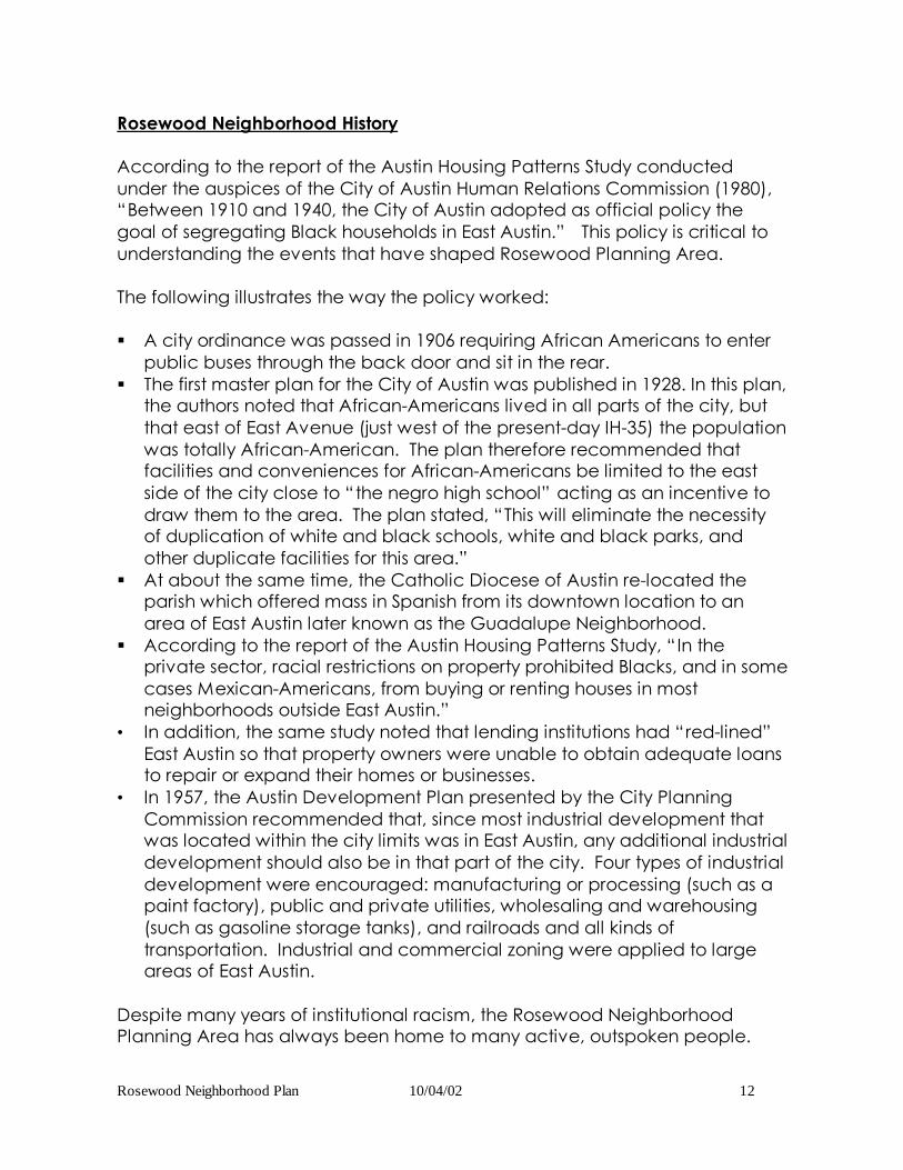
Rosewood Neighborhood History
Despite many years of institutional racism, the Rosewood Neighborhood PlanningArea has always been home to many active, outspoken people.
Rosewood Neighborhood Plan 10/04/02 12
Rosewood Neighborhood History
According to the report of the Austin Housing Patterns Study conductedunder the auspices of the City of Austin Human Relations Commission (1980),“Between 1910 and 1940, the City of Austin adopted as official policy thegoal of segregating Black households in East Austin.” This policy is critical tounderstanding the events that have shaped Rosewood Planning Area.
The following illustrates the way the policy worked:
§ A city ordinance was passed in 1906 requiring African Americans to enterpublic buses through the back door and sit in the rear.
§ The first master plan for the City of Austin was published in 1928. In this plan,the authors noted that African-Americans lived in all parts of the city, butthat east of East Avenue (just west of the present-day IH-35) the populationwas totally African-American. The plan therefore recommended thatfacilities and conveniences for African-Americans be limited to the eastside of the city close to “the negro high school” acting as an incentive todraw them to the area. The plan stated, “This will eliminate the necessityof duplication of white and black schools, white and black parks, andother duplicate facilities for this area.”
§ At about the same time, the Catholic Diocese of Austin re-located theparish which offered mass in Spanish from its downtown location to anarea of East Austin later known as the Guadalupe Neighborhood.
§ According to the report of the Austin Housing Patterns Study, “In theprivate sector, racial restrictions on property prohibited Blacks, and in somecases Mexican-Americans, from buying or renting houses in mostneighborhoods outside East Austin.”
• In addition, the same study noted that lending institutions had “red-lined”East Austin so that property owners were unable to obtain adequate loansto repair or expand their homes or businesses.
• In 1957, the Austin Development Plan presented by the City PlanningCommission recommended that, since most industrial development thatwas located within the city limits was in East Austin, any additional industrialdevelopment should also be in that part of the city. Four types of industrialdevelopment were encouraged: manufacturing or processing (such as apaint factory), public and private utilities, wholesaling and warehousing(such as gasoline storage tanks), and railroads and all kinds oftransportation. Industrial and commercial zoning were applied to largeareas of East Austin.
Despite many years of institutional racism, the Rosewood NeighborhoodPlanning Area has always been home to many active, outspoken people.

Rosewood Neighborhood Plan 10/04/02 13
The following milestones in Rosewood Neighborhood Planning Area historydemonstrate how far we have progressed.
1880s: Mr. Clint Smith’s home on East 12th Street was built. It was “built to last”when the German settlers first came to Texas, with high ceilings, southernexposure, and wine cellar typical of Plains home designs of the time. Mr.Smith’s family bought the house in the late 1930s after another home that hisfather had built near the railroad tracks was condemned to make way for anincinerator. When Mr. Smith was growing up here, 12th and Chicon was theend of the streetcar line. When he was a young man, his mother, Ms. WillieSmith, started and managed a nursery in her home to enable young womenwith families to go to school. Over the years, the Smith family home hashoused the Sunshine Police Accountability Project, CopWatch, the TravisCounty Green Party, the Nader 2000 campaign, Clean Campaigns for Austin,the Instant Runoff Voting Coalition, and the National Organization for women.
1889: Just eight years after the founding of the Austin Independent SchoolDistrict, the Austin Colored High School was established at San Marcos andEast Eleventh Street (west of the neighborhood). Austin Colored High Schoolmoved in 1907 to the corner of Olive Street and Curve Street and wasrenamed Anderson High School. Anderson High moved again in 1913 to 1607Pennsylvania Avenue. From 1889 until its closing, this high school played acrucial role in the surrounding communities.
1900s: According to an Austin Statesman account (3/23/55), the Republic ofTexas laid out Austin in 1839 with Congress Avenue as the main street. At first,the streets all had names: Sixth was Pecan Street, and nineteenth wasMagnolia Street. Then in 1887, the east-west streets were assigned numbers.According to the 1900-01 Austin City Directory, the Austin Rapid TransitRailway Company had been chartered in 1890 for 50 years, operating 12electric and 12 trailer cars over three lines, all passing the corner of CongressAvenue and Sixth Street. Mr. Clint Smith recalls growing up in East Austin thatin the late 1930s that 12th and Chicon was the end of the streetcar line.
In 1903, the Austin City Directory first listed streets. In 1905, the city directoryfirst listed streets in alphabetical order. The following Rosewood NeighborhoodPlanning Area Streets were listed in the 1905 directory.
In the western section of the neighborhood:• Alamo (with 1 family)• New York (with 12 families)• Pennsylvania (with 14 families)• Poquita (now Poquito)• Rosewood Avenue• Washington (with 24 families)

Rosewood Neighborhood Plan 10/04/02 14
• Although the numbered streets 12th through 19th appeared in the 1905directory, they extended only to the city limits just east of this area. Anearly photograph exists of Nineteenth Street:
1929: Webberville Road does not appear in the Austin City Directory until1929. Mr. Gilbert Rivera and Mrs. Herrerra recall that Webberville was a dirtfarm road even in the 1950s, when farmers used to drive their wagons up theroad full of vegetables. They took the vegetables to the artesian well thatwas located at the current corner of Airport Boulevard and Oak Springs Driveto wash them before selling them. The well was capped by the city duringthe late 1950s or early 1960s.
The City purchased the 17-acre Bertram-Huppertz parcel some time between1875 and 1929. The parcel included the Boggy Creek Greenbelt that wasextended on the southwest side of Nile Road in the 1970s and RosewoodPark. In 1929, the first listing for “Niles” road from Webberville east appearedin the Austin City Directory listing five addresses, including families with Spanishsurnames. Nile remains multi-ethnic today. Also in 1929, the City of Austin builtan after-school playground and community center (the RosewoodRecreation Center, located at 1182 N. Pleasant Valley Road). The City Parksand Recreation Department developed the land and park during the 1930s,including tennis courts, a picnic area, a bandstand, and a baseball field. Thecenter itself was renovated and expanded in 1972 - 73 with a grant from theModel Cities Program of the U.S. Department of Housing and UrbanDevelopment (HUD) and a grant from the U.S. Department of the Interior.
1935 – 1940’s: The eastern, larger portion of Rosewood-Glen OaksNeighborhood was originally the Hargrave Ranch. The grandmother of long-
time homeownerHazel Nixon,Kuhlman Street,worked for theHargraves whenshe was veryyoung. Mrs. Nixonand her familymoved into theneighborhood in1951 or 1952, andfirst bought a lot onthe hill north ofKuhlman, but thenselected hercurrent house. At

Rosewood Neighborhood Plan 10/04/02 15
that time, Rosewood-Glen Oaks was like living out in the country. TheHargrave home was in front of the Nixons, at 3008 Glen Rae (this is the oldesthouse in the neighborhood). Hargrave and Kuhlman Streets first appeared inthe Austin City Directory in 1935 but were listed as vacant. The first year thataddresses were listed on Kuhlman was 1937. In 1939, Neal was listed in theAustin City Directory with one resident. The older Hargrave parents died in the1940s and the children or grandchildren sold the property and subdivided theland. In 1942, Glen Rae, Hargrave, Kuhlman, Neal, Nile, and Walter all appearwith almost their current level of occupancy in the Austin City Directory forthat year. Ms. Jolyn Piercy’s home on Kuhlman was built by the Hargraves fortheir adult children, the Hunts, before the land was subdivided.
Owners of these homes used to find handmade square nails, handmadebarbwire, and neat old artifacts in their yards whenever they dug. There wasno running water until the late 1960's. The dump, which is under what we thinkof as our park (the Boggy Creek Greenbelt), was maintained when Mr. JamesStewart of Nile Street was young. He remembers that he and his friends wouldgo pick out the metal and take it to metal scrappers. It was no longer used asa dump by the time the Hargrave Ranch was subdivided. You can still seethe rusting parts of old cars and appliances in the banks of Boggy Creek itself.
1942: Bergstrom Air Force Base opened in September, 1942 in the Del ValleNeighborhood in southeast Austin. By the late 1950s, there were over 5,000servicemen stationed at Bergstrom.
1944: Just west of the Rosewood-Glen Oaks Neighborhood, the Doris Millerauditorium was dedicated to serve the recreational needs of local African-American servicemen and their families during World War II.

Rosewood Neighborhood Plan 10/04/02 16
The building was named in honor of Doris “Dorie” Miller, a local African-American who heroically lost his life serving during the war. The “Madison LogCabin”, placed between the Doris Miller auditorium and the RosewoodRecreation Center site, preserves historical artifacts and documents related tolocal African-American heritage.
Establishment of these facilities, designed and built to “eliminate the need forduplicate facilities throughout the city”, not only served as community servicecenters but also provided a base from which neighborhood people couldorganize.

Rosewood Neighborhood Plan 10/04/02 17
1940’s: The area around 12th and Chicon was home to numerous businesses.The sections of Chicon and Rosewood within the Rosewood NeighborhoodPlanning Area included the Fats Walker Tailor Shop, the Deluxe Ice House, theDeluxe Cab Company, the Roco Service Station, Marshall Barber Shop, andDr. Washington’s office. Further east on 12th Street, between Hargrave andAirport, were Jolly’s Grocery Store, McClain’s Grocery Store, Smith’s Plumbing,B&L Heating and Air, Chester’s Lounge, Nobles Barbecue, and Yellow Cab.12th and Chicon (the “East End”) was the last stop on the trolley line thatserved the neighborhood since 1891. By 1940, the buses had replaced thetrolley line.
1940s – 1950s: Mr. Volma Overton, later director of the NAACP, was asked togive up his seat on a bus in downtown Austin in 1947 so that whites could sitdown. When he returned to Austin as a veteran of World War II, hepurchased a home in the Cedar Valley SubdivisionAddition in what was thenTravis County (just east of Rosewood off Webberville Road). Returning Blackveterans were restricted to East Austin, and soon bought all the Cedar Valleyhomes. (Volma… My Journey, 1998, by Carolyn L. Jones).
During the late 1940s and 1950s, music lovers went to the east side of town tohear live bands at clubs on “the cuts” (East 11th) and at “the end” (East 12th).From the 1930s through the 1950s, Rosewood residents recall that AfricanAmericans could only go to the movies at two theaters in all of Austin: theHarlem Theater on East 12th and the Ritz on East 6th downtown. During thistime, the Rosewood area became an entertainment center for AfricanAmericans.
1951: Community activist and journalist Arthur B. DeWitty was nearly electedthe first Black on the Austin City Council. Election to the Council was thenchanged to all at-large, making it much more difficult for a minoritycandidate to win.
1950s: Three neighborhoods in the north and north central part of theRosewood Neighborhood Planning area were built in the 1950s. The streets inthe North Boggy Creek Neighborhood including Rountree, Pannell, Eckert,and Higgins first appear in the city directory in 1952. Streets in the McKinleyHeights Neighborhood also first appear in 1952, as do streets in the Clifford-Sanchez Neighborhood. Oak Springs Drive does not appear until 1953. Onelong-term resident recalls that many of the homes in the Rountree andMcKinley Heights neighborhoods were purchased by returning servicemen

Rosewood Neighborhood Plan 10/04/02 18
through the GI bill that provided veterans funding for first time homepurchase.
Ms. Louree Atkins of Harvey Street recalls visiting a cousin who lived on Harveyin the 1940s. At that time, there were few houses and the street was unpavedand was known as “Lovers’ Lane”. However, in 1952, she and her husband,who was in the military, returned to Austin and purchased their current home.It was a new house built next door to the house where her cousin had lived onHarvey. McKinley Heights had been built as a new subdivision with all themodern amenities. During the 1950s, Mr. Volma Overton notes aboutMcKinley Heights: “It was one of the best neighborhoods for Blacks who werefinancially able to purchase and maintain upscale homes to live”. Ms. Atkinsrecalls that McKinley Heights was known as “Little Enfield” in those days.
According to Mr. Volma Overton, the Rosewood and Salina areas wereunpaved and full of “shotgun houses” in poorly maintained condition duringthe 1950s. (Volma… My Journey, 1998, by Carolyn L. Jones).
1952: Ms. Clara Cobble’s family moved into the Booker T. Washingtonapartments on Webberville Road around 1952 when she was a child. Sheand her husband returned to the neighborhood in 1970 and now live onHolmes Court. She was just a child, and recalls that Rosewood ElementarySchool had been there for years and years. About that time, there was anapartment project of Army families on Hargrave, which were later demolishedby the Urban Renewal project.
1953: The new AndersonHigh School opened at2601 Thompson Streeton the eastern borderof the RosewoodNeighborhood PlanningArea.The new schoolincluded 25 classrooms,a lunchroom,laboratories, anauditorium, twogymnasiums, andadministrative offices.Before L.C. Anderson High School was integrated, Friday night football gamesat the Yellow Jacket Field were the highlight of the community. The stadiumwas filled to capacity. Track was also important, and the high school had abig and well-supported marching band. Following the initial desegregation ofAustin public schools in 1971, the building served as a campus for Austin

Rosewood Neighborhood Plan 10/04/02 19
Community College for a number of years and currently houses a Boys andGirls Club, a special school program, and the newly revitalized Yellow JacketField.
Since the apartment complexes managed by Austin Housing Authority duringthe 1950s had all modern facilities, Mr. Marvin Douglas recalls that “It was anhonor to live there” in those days. One problem that residents recall from thattime was the trash incinerator located at the City solid waste center onHargrave, which “smelled for miles and miles”.
Late 1950s: Mr. Gilbert Rivera, Glen Oaks Court, recalls that when he was achild growing up in the Govalle neighborhood east of Rosewood-Glen Oaks,the current site of the City maintenance yard at 2600 Webberville Road (just
south of theRosewood-ZaragosaNeighborhoodCenter) served as thelocal health clinic.Later, when hischildren were small(1970’s), the houselocated at 1183Chestnut, just north ofthe RosewoodRecreation Center,housed a healthclinic.
1956 – 1971: Urban Renewal was a federal housing and communitydevelopment program for which the City of Austin applied. Althoughplanning preceded it by over a year, Urban Renewal was kicked off by theadoption of A Workable Program for Austin, Texas September 12, 1956. Theintention was to “clear slums and eliminate urban blight” by demolishingsubstandard dwellings and businesses and encouraging new development intheir place. In the plan, it was noted that Austin had 850 units of publichousing that experienced a turnover rate of 35%, “… adequate to assuredisplaced families that housing accommodations are available.”
According to an article in an April, 1963 issue of the Daily Texan, statistics thatthe Austin Urban Renewal Agency used to support the need to “clear slums”in East Austin included the following:§ 55% of the city’s juvenile delinquency was located in the selected areas,§ as were 60% of major crimes, and

Rosewood Neighborhood Plan 10/04/02 20
§ 45 – 50% of homes in the selected areas were substandard.Unfortunately, as an article in the January 24, 1985 Daily Texan noted, “City-sponsored urban renewal programs, sometimes called ‘urban removal’ byeast Austin residents, bulldozed hundreds of east Austin homes, which were tobe replaced by new structures… ” but often were not.
From planning through execution, Urban Renewal in Austin lasted over fifteenyears. Programs begun by the Urban Renewal Agency were completed withfederal Community Development Block Grant (CDBG) funds in later years.
1960: Johnston High School was built in far east Austin, with a studentenrollment that was 30% African American and 60% Mexican American. Atthat time, most minority high school students living in Rosewood-Glen OaksNeighborhood attended either Anderson High or Johnston, as did theircounterparts throughout east Austin.
1965: When Mrs. Kathy Watts and her husband moved into their home onGlen Rae in 1965, there were no paved streets anywhere in the Rosewood-Glen Oaks Neighborhood, and streets were one lane only. Cars often cutthrough the back of their property, so the Watts family had to fence theirproperty to keep the yard safe for their children. At that time, Neal ended ata field across from Anderson High School. The Booker T. WashingtonApartments (run by the Austin Housing Authority at 905 Bedford, fronting onWebberville Road) was the most densely populated part of theneighborhood.
1967: The Rosewood-Glen Oaks Neighborhood was selected as an urbanrenewal district. This was one of the most important events in neighborhoodhistory. The neighborhood was called the Glen Oaks Project. Over the years,the Urban Renewal Agency offered Rosewood-Glen Oaks four different plansof what they would do to improve the neighborhood, but rather than doingwhat the neighborhood wanted, they did what they wanted to do instead.The Glen Oaks Project included all property within the following boundaries:§ North: 12th Street§ East: Hargrave and Neal Streets§ South: Webberville Road§ West: Northwestern Avenue and Rosewood/Chestnut AvenuesWithin this district, a total of 360 families and 20 businesses were relocated,including all families owning property on the Boggy Creek side of Nile Street.Many families did not want to move, and those who were willing to movefound the prices offered for their property inadequate for them to relocate.An article in the Austin American-Statesman June 13, 1969 listed totalrelocation payments received by three Glen Oaks families: $1,650, $2,750,and $4,950. A resident quoted in the same paper July 24, 1968 sums upneighborhood concerns: “Rev. R. H. Hawkins of 3005 Hargrave said he

Rosewood Neighborhood Plan 10/04/02 21
wanted an answer to the question: ‘If we live in a slum and get paid for slumproperty, how are we supposed to move into anything better?’” Many of thefamilies were forced to move to “the projects”, apartment complexes fundedwith federal funds and managed by the Austin Housing Authority.
Changes and improvements made by Urban Renewal included the following:§ Construction of a total of 70 new single family homes was approved to
replace the 360 that had been demolished.§ Rosewood Village, just north of the current Millennium Youth Entertainment
Complex, was built.§ Mr. Carmel Village Apartments (2504 New York Avenue, at the corner of
East 12th and Pleasant Valley Road), an apartment complex for low-income tenants to receive FHA rent supplements was built.
§ Pleasant Valley Road was extended from Webberville to East 12th Street.Today, this Pleasant Valley Road extension has a higher speed limit thanany other residential section of the road. The houses on the western side ofPleasant Valley Road were constructed after the road was built.
§ Neal was extended all the way from Hargrave to Webberville Road.§ St James Baptist Church was moved from its location on Nile Road to MLK
Boulevard.§ The Carlin Grocery Store at the corner of Pleasant Valley Road and
Webberville Road was removed (to be replaced later by the Rosewood-Zaragosa Neighborhood Center).
§ The Lalla Convalescent Home, on the northeast side of the same corner,was also built. This is the site of the 1999 struggle over placement of aresidential drug treatment center.
§ All streets in the neighborhood were paved. Although the Urban RenewalAgency initially wanted each family to pay for the paving, we stood firmthat the funding should be used for the good of the whole neighborhoodand the streets were paved at no additional cost to the homeowners.
1969: The Rosewood Shopping Center held its grand opening July 4 and 5.The center, located at Rosewood and Hargrave, was the only shoppingcenter in Texas built in an urban renewal project. It was located across thestreet from Anderson High School and included a grocery store, a varietystore, a laundry, a drug store, a barber and beauty shop, a fried chickenstore, and the urban renewal office. This shopping center was replaced in1999 by the Millennium Youth Entertainment Center.
1971 - 1979: In 1971, six years after the Civil Rights Act of 1964, U.S. DistrictJudge Jack Roberts issued an order to the Austin Independent School Districtto close Anderson High, Kealing Junior High, and St. John’s Elementaryschools, all of which had African American populations in excess of 90% oftheir student enrollments, and to integrate those students into other districtschools. AISD appealed the decision, although they did accomplish token

Rosewood Neighborhood Plan 10/04/02 22
integration. One current Rosewood-Glen Oaks Neighborhood residentremembers that the Martinique children were transferred from Avenue G toAnderson to integrate the school.
The U.S. Census of 1970 recorded that Austin was more segregated than atany other time in its history. A UT history major, John Henneberger, wasquoted in the Daily Texan (6/17/77) as saying, “Ninety-three percent of theblack population would have to move into all-white neighborhoods tointegrate the city.” AISD had contended that segregation in schoolenrollment was just a reflection of this residential pattern. The U.S. JusticeDepartment countered that the burden was on AISD to prove that thoseresidential patterns were in no way the result of past actions taken by theschool district. In 1977, the U.S. Fifth Circuit Court of Appeals ruled that AISDhad not dismantled its dual school system. Final desegregation plans for AISDwere not approved by the federal courts until 1979, when the plan of“paired” schools (one in an all-white neighborhood, one in a minorityneighborhood, with students bussed between the two) was offered by AISDand was ruled a remedy to school segregation in Austin.
1971: The Urban Renewal Authority intended to construct 100 moreapartment style low-cost housing units in Glen Oaks, but the AISD Boardvetoed that plan, saying such housing in the area would only compound theirdesegregation problems.
1975: In June of that year, the City of Austin applied for the first year ofCommunity Development Block Grant funding from the U.S. Housing andUrban Development Department. CDBG funds were to be used, like UrbanRenewal funds, to “eliminate blight”. The City’s application noted that theAustin Urban Renewal Agency was to complete projects it had notcompleted, including the Glen Oaks Project, with CDBG funds.
Also in 1975, Dr. Emma Lou Linn took her place as the second woman inhistory to serve on the Austin City Council to join the majority and vote torename 19th Street Martin Luther King, Jr. Boulevard. The vote changed thename of the street from its inception at Lamar Boulevard on the west to thecity limit on the east. The previous week, the council had voted only torename that portion from IH35 east to Ed Bluestein Boulevard, but thenumerous speakers at the public hearing about the renaming protested thepatronizing gesture of naming only that part of the street that runs throughpredominantly Black neighborhoods. There was an appeals court challengeof the name change, but the court held the change to be legal in April 1976.
1982: The Rosewood-Zaragosa Neighborhood Center and Health Clinic, nowlocated at 2800 – 2802 Webberville Road, was built with CDBG funds on theformer site of the Carlin Grocery Store.

Rosewood Neighborhood Plan 10/04/02 23
1984: Five new single family homes were built on Glen Oaks Drive.
1985: Ten new single family homes were sold to qualified first-time moderateincome homeowners on Glen Oaks Court. These new homeowners weremostly young families and were multi-ethnic. A team that included developerGary Bradley, Clark Wilson Homes, and the City of Austin, using CDBG fundsand land claimed earlier by Urban Renewal, built the homes.
Prior to the establishment of a formal neighborhood organization inRosewood-Glen Oaks, long-time residents recall that neighborhood peoplejust worked together. They watched out for strangers, making sure youngpeople respected the neighborhood, and things of that nature. Theneighborhood leaders were Ms. Watts, Ms. Nixon, and others who had beenliving in the neighborhood the longest. Neighborhood people joinedtogether to call the City on trash or traffic matters or similar things. There wasalmost never any trouble until Austin Community College, which had openedat the site of the older Anderson High School, closed and AISD opened up theAlternative School there. This school was for students who had been expelledfrom regular public schools. After the school opened, there was alwayssomething going on that caused neighborhood concern. Then when theolder couple died at the house on the corner of Neal and Kuhlman and thegrandkids moved in, the first truly serious neighborhood trouble began asthere were drug and related problems there. By this time, the neighborhoodgroup had developed from neighbors who just knew each and coulddepend on each other into a formal, official organization.
The Rosewood-Glen Oaks Neighborhood Association (recorded by the City ofAustin as Glen Oaks, Rosewood Village, Neighborhood Organization) wasformed in November 1985. The first president was Mr. Robert Gratten, with Ms.Gratten as Vice President. The second President was Ms. Lou Holloway, withMr. Gratten as Vice President. The third President was Ms. Liz Snipes, with Ms.Alta Ochletree as Vice President. Ms. Snipes, Kuhlman Street, is the currentPresident. Early efforts were directed toward neighborhood beautificationand safety efforts. Later, the association worked with the Austin PoliceDepartment to set up Neighborhood Watch and related programs to curbthe illegal activities at the problem house and reduce problems forneighborhood residents caused by kids from the alternative school. TheNeighborhood Association attained non-profit status from the InternalRevenue Service, sought, obtained, and administered funds for a smallneighborhood beautification program during the 1990s. Privacy fences werepainted, neighborhood youth were paid to mow the yards of residents whocould not keep up with them and vacant properties in the community, andsome tools were loaned out to residents.

Rosewood Neighborhood Plan 10/04/02 24
1988: The Onie B. Conley-Roy G. Guerrero Senior Activity Center wasdedicated in March 1988 by an Austin City Council that included Mayor Pro-Tem John Trevino, Jr., the first Latino ever elected to the City Council, and Dr.Charles Urdy, a professor at Huston-Tillotson College. The building was namedin honor of Ms. Onie Conley, an African-American teacher at Kealing School
for forty-threeyears and stillaneighborhoodleader, andMr. Roy G.Guerrero, athirty yearemployee ofthe City ParksandRecreationDepartmentandcommunityleader.
1997: Thomas“Hollywood”Henderson wenton a hunger strikefor a week toraise money torenovate the oldYellow JacketTrack and Field at900 Neal St., thesite of the oldAnderson HighSchool. Hisnonprofit group,East Side YouthServices andStreet Outreach, built and manage the field. Henderson is an Austin nativeand former member of the Dallas Cowboys of the National Football League.He had been let go from the Cowboys years earlier due to abuse of drugsand alcohol, and later spent some time in prison. Following his release, he

Rosewood Neighborhood Plan 10/04/02 25
turned his life around. Part of that life change was a determination to helplocal youth. Then in March 2000, he won the $28 million Texas Lottery. "Nowthat track and field will be endowed for the next 100 years," he was quoted assaying in the Austin American Statesman.
1999: “A drug treatment center for freed felons cannot move to an EastAustin location, the Austin City Council ruled Thursday,” noted an article in theAustin American-Statesman November 15, 1999. The Austin City Council votedagainst a proposal to move the drug treatment center from its location onNorth Lamar Boulevard to the former site of the Lalla Convalescent Home atthe corner of Webberville and Pleasant Valley Roads. This followed months ofmeeting and negotiating between neighborhood residents, center supportersand staff, City staff and Council members. The Rosewood-Glen OaksNeighborhood Association organized the opposition, as State regulatorsconfirmed that violent criminals or sexual offenders might be included at thecenter, which would have been located one block from the new communitycollege and just down the street from an elementary school. TheNeighborhood Association suggested that a day care center would be awelcome new neighbor there, and in 2000, a day care center did open atthat location.
1999: The Millenium Youth Entertainment Complex opened at Hargrave andNeal with a movie theater, a bowling alley, games, a food court, and a rollerskating rink. When 16-year-old Tamika Ross died in a drive-by shooting justafter Christmas, 1992 a group of young people backed by former City CouncilMember Dr. Charles Urdy asked for the city to help. It was suggested that thethen-abandoned Rosewood Shopping Center would be a good place tobuild an entertainment center so that East Austin youth would have a safeplace to go. Tamika Ross had obtained her General EducationalDevelopment certificate and was working toward a career as a hair stylist.The center cost over $10 million, of which nearly $9 million came from HUD asa loan.

Rosewood Neighborhood Plan 10/04/02 26
2000: The East View Campus of Austin Community College opened at 3401Webberville Road on vacant land that had flooded regularly during the 1940sand 1950s, just east of the neighborhood. This beautiful new campusreplaced the temporary home that ACC had in the old Anderson High Schoolduring the 1970’s and returned a much-needed resource to theneighborhood. Among the specialties offered at the East View Campus arecomputer science and health services.

Rosewood Neighborhood Plan 08/22/05 27
Goal One: Make the Rosewood Neighborhood Planning Area a more attractive, cleaner and safer place to live. Objective 1.1 Make the alleys in the neighborhood usable and safe.
Action 1: Work with Code Compliance to clean weeds and brush from alleys. (Implementer: SWS / Keep Austin Beautiful / RNPT) Action 2: Work with Code Compliance to clean weeds and brush from vacant lots (Implementer: SWS/ RNPT)
Objective 1.2 Remove the garbage, brush, and tall grass from vacant lots and public right-of-ways in the neighborhood planning area.
City Resources for Citizens to Address Ongoing Issues: 1. The City of Austin has consolidated the enforcement of various city codes under Solid Waste Services. Call 494-9400 or send an e-mail to [email protected] to report any of the following on vacant or occupied property:
Tall weeds or grass (over 12 inches) Litter and debris Stagnant water Illegal dumping Improper storage of garbage carts
In order to provide service within a reasonable time frame to all citizens wh o register complaints, it is essential that specific addresses be provided regarding those properties with trash accumulation and/or high weeds. 2. For creek blockages: nuisance trash is the responsibility of adjacent property owners to remove, or if loc ated in parkland, the Parks and Recreation Department should be contacted at 440-5167. Major blockages in creeks and drainage easements should be reported immediately to the Watershed Protection and Development Review Department at 499-3366.
Action 3: Organize 1-2 neighborhood cleanups with the Neighborhood Support Program. (Implementer: NHCD / RNPT) Action 4: Remove trash from large-scale problem areas in the neighborhood (see Appendix: Areas of Concern). (Implementer: SWS / RNPT)

Rosewood Neighborhood Plan 10/04/02 28
Action 5: Add Manor Rd. from Airport Blvd to the railroad tracks tolist of rights-of-way for the City to regularly mow. (Implementer:PARD)1
Action 6: Organize a creek cleanup of Boggy Creek for its full length inRosewood. (Implementer: Keep Austin Beautiful, WPDR, RNPT)
Objective 1.3Make the streetscapes in the neighborhood more attractive.
Action 7: Plant native shade trees along the stretch of Pleasant ValleyRd. from south of Rosewood Ave. to Webberville Rd. to shadesidewalks and slow traffic. (Implementer: PARD)2.
Action 8: Add street trees and/or landscaping along sidewalks in theneighborhood's corridors: Rosewood/Oak Springs, E. 12th, Manor,MLK, and Airport, as permitted by any future road reconstructionprojects or new development. (Implementer: TPSD/PARD).
Action 9: Provide residents trees in to plant in their front yards.(Implementer: PARD) (see footnote for 7)
Action 10: Landscape Right-of-Way triangles at Airport and MLKby planting trees and low-maintenance native plants. (Implementer:PARD, TPSD, RNPT, TxDOT)3
Action 11: Landscape the Right-of-Way triangles at Airport &Manor by planting trees and low-maintenance native plants.(Implementer: PARD, TPSD, RNPT, TxDOT)
Objective 1.4Improve streetlighting to increase safety for pedestrians and drivers.4
1 PARD recommends that this issue be referred to Code Compliance, unless there are specific visibilityproblems/locations.2 PARD recommends using Neighborwoods Program administered by Parks and Recreation Department. In thisprogram, residents play a major role by accepting, planting, and caring for trees provided by PARD.3 PARD recommends that this and the next item be funded as one CIP package. Will require: permission (likelya written agreement) from TxDOT, 3 water taps, landscape design, irrigation, electricity, surveys,implementation and maintenance.4 Fire Dept. comments: When possible, new streetlights should be oriented toward fire hydrants.

Rosewood Neighborhood Plan 10/04/02 29
Action 12: Improve existing streetlights or add new lights at thefollowing locations: (Implementer: AE)5
A. Manor Rd. between Walnut and Airport Blvd.
B. Rountree, either by adding additional lights or by installing brighter bulbs
in existing street light fixtures. Specifically, install a light at the intersection of
Eckert & Rountree, and Pannel & Rountree.
C. 1200/1300 block of Harvey
D. Graham Street in the cul-de-sac
E. On 13th St. at 2900 block, across from Mt. Zion church, and just east of
Alexander St.
F. E. 18 ½ Street, 3000 block (midblock)
G. Sanchez in the 1800 – 1900 block
H. Along Boggy Creek Greenbelt, especially at bridges and at locations that
are distant from streets. Insufficient lighting allows illegal activities occur.
I. At Chestnut and Pleasant Valley to light curve
J. 16th Street and Airport Blvd, to improve visibility for turning drivers
K. On Sol Wilson in the 2600 and 2800 (mid-block) sections
L. Oak Grove between 12th and Sol Wilson
M. Clifford between 13th and 14th, and next to store on east side of Clifford
N. Alexander St. across from Mabson ballpark
O. Crest St., about 1200 block, at the median with the tree
P. Add light (or rotate existing light) at 14th & McKinley to better light 14th St.
Q. 14 ½ St., in the 3000 block, midblock
R. Take Bedford Circle streetlight off timer so that light shines all night
S. Clean light fixture at Glen Rae & Neal
T. Glen Oaks & Glen Rae intersection
U. 22nd Street between Walnut and Alexander
V. Alexander between Manor and MLK
W. S.L. Davis and Alamo
Action 13: Trim the trees from around existing streetlights(Implementer: AE)
5 Austin Energy will continue working on existing streetlights for maintenance problems through this fiscal yearand budget year 2002. Replacements (upgrades) and new lighting will be addressed through budget year 2003.Austin Energy does not plan to fund streetlights on Boggy Creek Greenbelt (this is a Parks and RecreationDepartment item).

Rosewood Neighborhood Plan 08/22/05 30
Action 14: Trim branches from around electric lines in back of houses. (Implementer: AE)6
City Resources for Citizens to Address Ongoing Issues: Anyone living inside the Austin City limits may request streetlights for their neighborhood. Austin Energy will survey the area to determine if additional street or alley lighting is required and the best location for such lighting. For a premium upgrade, Austin Energy offers ten different styles of Decorative Post-Top Lighting. Nightwatchman lights are similar to streetlights, but can be installed for lighting your property or business. Nigh twatchman lights can also be used for lighting public or private areas that are outside the city limits but inside the Austin Energy service area. For more information, or to request a Streetlight or Nightwatchman light, call Austin Energy Illumination En gineering and Design at 505 -7602 or 505-7543. To report a problem with streetlights or nightwatchman lights, please call 505 -7617 or send us an e-mail at [email protected] . Please include your name, address, daytime phone and the location of the streetlight in need of repair.
6 Recent patrols have shown only isolated inc idences of tree contact in the electric wires. We do not believe there is a need for general pruning in the area. We will address individual trees that are close enough to our lines to cause problems. PARD trims around streetlights if there is a safety hazard, and responds to complaints. Austin Energy and PARD do not trim trees for cable and telephone facilities.

Rosewood Neighborhood Plan 10/04/02 31
Figure 2: Streetlights
0 1000 2000 Feet
ÿ Proposed StreetlightsRosewood boundary
City of AustinNPZD7/02/01
Rosewood Neighborhood Planning Area Streetlights
ÿ ÿ ÿ ÿÿ
ÿÿÿÿ
ÿÿÿ
ÿÿ
ÿ
ÿ
ÿÿ
ÿÿ
ÿ
ÿ
ÿ
ÿ
ÿ
ÿÿÿ
ÿÿ
ÿ
ÿÿ
ÿ
ÿÿ
ÿ ÿ
ÿÿ
ÿ
12TH
MANOR
CH
ICO
N
11TH
ROSEWOOD
MARTIN LUTHER KING
TILL
ERY
CH
ES
TNU
T
20TH
14TH
13TH
CE
DA
R
10TH
GOVALLE
MAP
LE
ALA
MO
GOODWIN
ULIT
SA
LIN
A
CO
LET O
32ND
WEB
BER
VILL
E
KA
30TH
OAK SPRINGS
NEAL
PLEAS
ANT VALLE
Y
16TH
NILE
22ND
LYONS
MIR
IAM
BREE
ZE
FIES
TA
SIN
GLE
TON
FREN
CH
CLIF FO
RD
LIN
CO
LN
SA
NC
HE
Z
HA
RG
RAV
E
NORTH
WESTER
NLA
RR
YLI
ND
EN
BE
DFO
RD
REAL
SWEN
SON
14TH 1/2
PR
OS
PE
C
STOKES
ALE
XA
ND
ER
LOR
ET
O
THOMPSON
WASHINGTON
HARVEY
RO
UN
TR
EE
THEO
PO
QU
ITO
17TH
WA
LNU
T
BRYAN
SOL WILSON
LEO
NA
CREST
PER
SHIN
GC
HER
ICO
NEW Y
ORK
WALTER
18TH
BENG
ECKERT
GIVENS
GLE
N R
AE
KUH
LMAN
AN
DO
LPH
RID
G
PIC
ENCINO
GR
AH
AM
ROGERS
CHA
18TH 1/2
OAKLAWN
FER
DIN
AN
D
14TH
POQ
UITO
17TH
WA
LNU
TMA
PLE
POQ
UIT
O 18TH
17TH
PO
QU
ITOC
OLE
TO
9TH
TILLERY
NEAL
16TH
13TH
WA
LNU
T
AL A
MO

Rosewood Neighborhood Plan 10/04/02 32
Objective 1.5Improve the attractiveness and condition of housing projects in theneighborhood.
Action 15: Encourage active on-site management of the RosewoodProjects to decrease the incidence of trash and to address parkingissues at the projects. (Implementer: RNPT)
Action 16: Work with the management of neighborhood’sapartment complexes to eliminate the problem of illegal dumping.(Implementer: RNPT)
Objective 1.6Increase the effectiveness of law enforcement in the neighborhood.
Members of the RNPT have stated in particular that law enforcement would bemore effective if officers could spend more time on foot or on bicycle in theneighborhood, rather than solely spending time in cars.
Action 17: Improve neighborhood relations with the APD byincreasing the level and quality of communication with APD. Planningteam members have noted that the area's police officers have theopportunity to increase the sensitivity with which they treat arearesidents. (Implementer: APD / RNPT)
Action 18: Establish a police sub-station in the neighborhood atthe former SWS site (12th and Hargrave) or in another location thatbest serves the needs of the area. (Implementer: APD)
Action 19: Establish a walking beat or a bicycle patrol on E. 12thStreet from New York Ave. to Harvey St. Planning team members havenoted that, in the past, these types of patrols dramatically reducedthe level of criminal activity. (Implementer: APD)
Action 20: Police officers who work in this neighborhood shouldbe bilingual. (Implementer: APD)
Action 21: Work with the Austin Police Department tostrengthen enforcement of laws relating to public safety issuesinvolving loitering, drug sales, and prostitution at problem areas within

Rosewood Neighborhood Plan 10/04/02 33
the neighborhood planning area. (See Appendix: Areas of Concern.)(Implementer: APD/NPT)
Objective 1.7Address potential threats to property caused by flooding and erosion problemsalong Boggy Creek.
Action 22: Investigate flood control and erosion control optionsfor the upper watershed of Boggy Creek. For improvements, usenatural-looking solutions similar to the creek improvements at GivensPark. Note: This item is underway as part of the Watershed MasterPlan. (Implementer: WPDR) 7
Objective 1.8Improve water and wastewater service to areas with aged infrastructure.
Action 23: Rehabilitate water and wastewater mains servicingRountree, Moss, Pannell, Eckert, and Higgins. (Implementer: W/WW)8
Objective 1.9Develop an activity or program to provide other opportunities for persons wholoiter at the 12th & Chicon area and the Rosewood & Chicon area.
Action 24: Work with APD to identify existing and possibleprograms to reduce loitering and criminal activity in these areas.(Implementer: RNPT/APD/CMTA)9
7 The Watershed Protection and Development Review Department has developed a master plan that integratesflood control, erosion control and water quality management activities for 17 watersheds. The RosewoodNeighborhood comprises approximately 15% of the watershed area of Boggy Creek. The department’s masterplan for Boggy Creek identified $22.6 million worth of improvements needed to address identified flooding,erosion and water quality concerns in the Boggy Creek Watershed.8 Water improvements to Higgins (replace 2” main) and Airport Blvd. (connect Moss, Pannell, Eckert andHiggins to a new main in Airport) will begin design in 30-60 days. Construction may begin in FY 2001-2002.Wastewater mains are being evaluated and will most likely be rehabilitated using trenchless methods. Thesemains have not reached a high enough priority for immediate action, but are being evaluated.9 Currently, Capital Metro is working with neighborhood representatives to improve the area of 12th St./ Chiconwith placement of amenities, lighting, landscaping and signage.

Rosewood Neighborhood Plan 10/04/02 34
GGoal Two: Promote affordable housing options in the Rosewoodneighborhood, while reducing the number of vacant lots.
Residents and property owners identified vacant lots and vacant buildings as amajor concern on the survey. A land use study10 of the Rosewood Neighborhoodfound that 17% of its lots are vacant, and that most (over 100) of these vacantlots are zoned for single family development.
Some vacant lots in the central part of the neighborhood face developmentconstraints because they lie in the floodplain. These lots should only bedeveloped if they meet City standards. See Appendix: Building in the Floodplainfor more information about developing in a floodplain, or call the WatershedEngineering Division of the City’s Watershed Protection and Development ReviewDepartment.
The neighborhood planning team would like to see the buildable, vacant lots builtas new residential or neighborhood-serving commercial development.
Also, the Rosewood Neighborhood Planning Team would like to promotecompatible, small-scale apartment complexes where existing zoning permits.
Objective 2.1Promote moderately priced infill development on vacant residential property.
Action 25: Work with the Austin Housing Authority and NHCD topromote housing options in the neighborhood. (Implementer:RNPT/NHCD)11
Action 26: Work with non-profit housing organizations to promoteinfill housing in the neighborhood. (Implementer: RNPT/NHCD)
Objective 2.2Provide for a variety of housing options.
Action 27: Allow the construction of garage apartments on single-family lots in the neighborhood. (Implementer: NPZD)
10 Study conducted by students in the Community and Regional Planning Program, University of Texas atAustin, December 2000.11 All new construction and rehabilitation programs are available in Rosewood. This does not include fundingnew construction or rehabilitation on lots located in the 25 or 100 year floodplain.

Rosewood Neighborhood Plan 10/04/02 35
Action 28: Allow small lot development in the neighborhood onexisting small lots of 2500 square feet and greater (“Small LotAmnesty”). (Implementer: NPZD)
Objective 2.3Facilitate rehabilitation of the neighborhood's houses, including its older,historic homes.
The Rosewood Neighborhood has many older houses that contribute to theneighborhood's character and are a part of its history. While some houses arein disrepair, the RNPT would like the City to focus on providing resources andinformation for owners to fix their homes. An aggressive approach to codeenforcement is neither desired nor appropriate.
The RNPT recognizes that housing safety concerns are important. Unsafestructures can result in injury or the loss of life, and there are circumstances inwhich demolition of an unsafe structure is the best choice. However, for casesin which housing rehabilitation is possible, the Neighborhood Planning Teammaintains that the ultimate goal of code enforcement should be repaired houses.
Action 29: Promote Rosewood as a target neighborhood for theorganization Hands on Housing and for the City's "Raise the Roof"program. (Implementer: RNPT/NHCD/NPZD)12
Action 30: Develop a housing rehabilitation resource guide(Spanish/English) with information on City, County, State, and non-profit resources. (Implementer: NHCD)13
Action 31: Research ownership of the neighborhood’s dilapidatedhomes. Provide information on housing rehabilitation resources(including low-interest financing) to owners. (Implementer:NHCD/RNPT)14
Action 32: Citywide, link code enforcement efforts with provisionof information regarding housing resources, by providing Housing
12 Rosewood has been included in past “Raise the Roof” events. No neighborhood has been selected for 2002yet.13 The LBJ School of Public Affairs is preparing a final draft under contract with Neighborhood Housing andCommunity Development. This will be available to all neighborhoods.14 Research on dilapidated houses is outside of Neighborhood Housing and Community Development’s realm.Rehabilitation resources are available through AHFC (974-3139).

Rosewood Neighborhood Plan 10/04/02 36
Rehabilitation Resource Guide (Spanish / English) to owners ofproperties targeted for enforcement. (Implementer: NPZD/NHCD)
Action 33: Establish a non-profit housing corporation to increasehousing opportunities in the neighborhood. (Implementer:RNPT/NHCD)15
GGoal Three: Create a transportation network that allows allresidents to travel safely throughout the neighborhood.
Objective 3.1Create a safer and better-connected sidewalk network in the Rosewoodneighborhood.
Action 34: Build new sidewalks at locations identified as prioritiesby the RNPT and responses to the survey. (Implementer: TPSD)16
♦ Repair broken sidewalks on the north side of Thompson.
♦ Just west of Airport Blvd, connect the short gap between 13th St. and Airport.
♦ On the north side of Martin Luther King Blvd. just west of Airport Blvd, add a short
(6" – 8") retaining wall to keep debris and soil from spilling onto the sidewalk
♦ On Pleasant Valley, complete gaps from E. 12th St. to Webberville Rd. Highest
priority is at least one side of the road from the bridge over 11th to the
intersection of Webberville.
♦ Complete the sidewalk system along the south side of Manor Rd., with the full
involvement of affected property owners.
♦ Add sidewalks to the west side of McKinley.
♦ Add sidewalks along the west side of Sanchez.
♦ Complete sidewalk on the east side of Clifford.
♦ Add sidewalks to east side of Poquito.
♦ Add sidewalks to east side of Chestnut Ave from 12th Street to Rosewood.
♦ Add sidewalks to south side of New York from Chicon to Poquito.
♦ Complete sidewalk network on north side of Pennsylvania from Chicon to Poquito.
♦ Add sidewalks to south side of SL Davis from Poquito to Chestnut. (lower priority)
15 The Rosewood Neighborhood can work with an existing Community Housing Development Organization orwith NHCD's Community Development Division to learn how to create capacity to become a CHDO.16 Neighborhood Planning Areas will receive some funding for sidewalk improvements, amount yet to bedetermined. The Neighborhood Planning Team should prioritize its sidewalk requests, as funding will belimited.

Rosewood Neighborhood Plan 10/04/02 37
Figure 3: Sidewalks
12TH
MANOR
CH
ICO
N
ROSEWOOD
8TH
TILL
ERY
9TH
MARTIN LUTHER KING
CH
ES
TNU
T
20TH
14TH
13TH
CED
AR
10TH
GOVALLE
MAP
LE
ALA
MO
GOODWIN
LYONS
ULIT
WEB
BER
VILL
E
CO
L ETO
OAK SPRINGS
KAY
32ND
NEAL
M FR
AN
PLEASANT VALLEY
16TH
NILE
22ND
MIR
IAM
LIN
CO
LN
FIES
TA
SIN
GLE
TON
CLIF FO
RD
BREE
ZE
FREN
CH
NOR
THW
ESTERN
PR
OSP
EC
T
SA
NC
HE
ZH
ARG
RAV
E
HER
ICO
LIN
DEN
RR
Y
BED
FOR
D
REAL
14TH 1/2
STOKES
ALEX
AN
DE
R
LOR
ET O
THOMPSON
HARVEY
RO
UN
TRE
E
THEO
PO
QU
ITO
17TH
WA
LNU
T
SOL WILSON
CREST
PER
SHIN
G
NEW Y
ORK
WALTER
18TH
BENGSTON
ECKERT
GIVENS
GLE
N R
AE
KUH
LMAN
ZARAGOSA
ND
OLP
H
RID
GE
PICKLE
ENCINO
GR
AH
AM
ROGERS
CORNELLCHARLES
18TH 1/2
OAKLAWN
FER
DIN
AN
D
HARVARD
WA
LNU
T
CO
LETO
17TH 17TH
POQ
UITO
MA
PLE
NEAL
13TH
18THTILL ER
Y
WA
LNU
T
THOMPSON
14TH
16TH
ALA
MO
Rosewood Neighborhood Planning Area Sidewalks
City of AustinNPZD7/02/01
Existing sidewalkProposed sidewalk
0 1000 2000 Fe et

Rosewood Neighborhood Plan 10/04/02 38
Objective 3.2Increase the safety at intersections throughout the neighborhood
Action 35: Increase the number of safe pedestrian crossingsalong Airport Boulevard, by making improvements to accomplish one ormore of the following: isolate pedestrians from traffic, makecrosswalks/crossing areas more visible to motorists, improve lightingso pedestrians are more visible, add landscaping and/or additionalislands. (Implementer: TXDOT/TPSD)
Action 36: Investigate a crosswalk or another way to allow schoolchildren to cross safely from Clifford/Sanchez to the north side ofMartin Luther King. (Implementer: TPSD)
Action 37: On northbound Pleasant Valley, add a flashing yellowlight with an intersection sign, or another appropriate traffic control.Limited visibility at the Hargrave (Nile) and Pleasant Valleyintersection may be a traffic hazard. A hill affects the visibility ofoncoming northbound traffic, when cars from Hargrave attempt toturn left onto Pleasant Valley. (Implementer: TPSD)17
Action 38: Install a stop sign or a yield sign on Eckert andHiggins where they intersect with Rountree. (Implementer: TPSD)18
Action 39: Improve existing signage to warn drivers of dip inroad at 12th and Chicon. This can be done by moving the existingwarning signs, or moving other signs that block the view of the existingsigns. (Implementer: TPSD)19
Action 40: At MLK and Harvey, work with business owner toaddress visibility issue of parking lot fronting MLK. Customers pullingin or out may present a traffic hazard to drivers on MLK. Reportedly,because of parked cars and signage, drivers cannot see oncomingtraffic when pulling out from Harvey St. (Implementer: RNPT/TPSD)
17 Staff will do an all-way stop study at the intersection to determine if an all-way stop can be installed. Flashingbeacons would not improve the sight distance. An all-way stop, if warranted, would provide positive control.18 The intersection of Eckert and Rountree is a 3 legged intersection and right of way is assigned by State law toRountree. Higgins is an extension of Rountree and right of way does not need to be assigned. Turn signs shouldbe provided.19 The dip sign for westbound traffic on 12th Street is obscured by a utility pole. Sign will be moved.

Rosewood Neighborhood Plan 10/04/02 39
Action 41: On MLK just east of Harvey, where westbound MLKnarrows, install a sign to draw drivers’ attention to the bend in theroad. (Implementer: TPSD)20
Action 42: Install a barrier (such as large wooden bollards) toprevent traffic from cutting through from Higgins to Martin LutherKing on the right-of-way diamond. (Implementer: TxDOT)
Action 43: Prohibit large trucks from Harvey St. and install a signto this effect. (Implementer: TPSD)21
Objective 3.3If light rail is ever built, any future rail station or stop in the neighborhoodshould be sensitive in design and siting to the character of the neighborhood.
Objective 3.4The transportation system in the neighborhood should be accessible to theelderly, disabled, and the poor. In the Residential Survey (October 2000),almost 50% of respondents reported using transit for some of their trips.Regarding desired improvements to the transit system, common surveyresponses included: Add more shelters and benches to bus stops, increasefrequency of buses on all routes (#2, #6, #18, #20), improve direct service tothe UT campus, add sidewalks and lighting around bus stops, and improve safetyat bus stops.
Action 44: Landscape areas surrounding key bus stops.(Implementer: CMTA)
Action 45: Improve safety at bus stops by adding lighting.Loitering, drinking, and drug solicitation at bus stops were listed asproblems on responses to the neighborhood survey. (Implementer:CMTA)
Objective 3.5Reduce speeding in the neighborhood.
20 Road does not narrow at this point, it is the end of the transition for the left turn bay onto Airport Boulevard.Full lane widths are provided. No recommended action is indicated.21 Harvey St. is not an appropriate truck route. No truck signs will be installed along the roadway between MLKand 12th St.

Rosewood Neighborhood Plan 10/04/02 40
Action 46: Address speeding on Airport Blvd. from Manor to OakSprings by periodically increasing traffic enforcement on Airport.(Implementer: APD)
Action 47: Reduce the speed limit on Pleasant Valley Rd. fromEast 12th Street to Webberville Road from 40 mph to 35 mph.(Implementer: TPSD)22
Action 48: Address speeding on Manor Road by periodicallyincreasing traffic enforcement on Manor. Speeding cars, poorvisibility, and the lack of a sidewalk make it difficult to get out ofdriveways or make left turns across the flow of traffic.(Implementer: APD)
Action 49: Address speeding traffic on Poquito Street byimplementing appropriate traffic control devices. (Implementer:TPSD)23
Action 50: Enforce speed limits around the intersection ofChicon and Rosewood. (Implementer: APD)
Action 51: Conduct a traffic calming study for Rountree, Moss,Pannell, Eckert, and Higgins Streets. (Implementer: TPSD) (See notefor 49)
Action 52: Conduct a traffic calming study for Harvey St.between MLK and 12th St. If traffic calming is not feasible, exploreother solutions such as stop signs. Review options with representativesfrom this area. (Implementer: TPSD) (See note for 49)
Objective 3.6Improve road conditions in the neighborhood.
22 In City Code, Pleasant Valley is designated as a 40 mph roadway. To lower the speed would require a speedstudy which shows the 85th percentile speed to be below 42 mph. Staff will have a speed study done to see if it ispossible to lower the speed limit. With the exception of the sight distance restrictions at Hargrave, the street isappropriate for the speed limit. That intersection will be investigated by staff.23 From observation, there is insufficient traffic at the intersections along Poquito to meet the minimum legalrequirements for the installation of all-way stops. Speeding and cut-through traffic issues should be addressedon a neighborhood wide basis. No current funding is available for neighborhood studies or implementation ofneighborhood traffic calming plans. The concern will be noted in the request database, and once the program isresumed, the neighborhood may be eligible for the studies and funds, based upon the priorities set by the CityCouncil.

Rosewood Neighborhood Plan 10/04/02 41
Action 53: Improve paving conditions on Manor Rd. betweenWalnut and Airport Blvd. (Implementer: TPSD)24
Action 54: Vacate unbuilt section of Harvey Street.(Implementer: WPDR)25
Objective 3.7Improvements to Airport Boulevard should serve the needs of and be compatiblewith the adjacent residential area. The neighborhood should work with theTexas Department of Transportation to ensure that any improvements alongAirport Boulevard are compatible with the Rosewood Neighborhood PlanningArea, while also serving the needs of the larger community.
Objective 3.8Manor Road should become a more pedestrian- and bike-friendly roadway.Currently, the road does not have room for bike lanes between Cherrywood andAirport Blvd. (Note: this road is a shared boundary between the Rosewood andUpper Boggy Creek (UBC) Neighborhood Planning Areas. UBC stakeholders havereviewed the draft Rosewood Neighborhood Plan and participated in theFebruary 2001 Rosewood Neighborhood Planning Open House.)
Action 55: Between Cherrywood and Airport Blvd, narrow ManorRoad to one lane in each direction with medians and/or turn lanes, anda bicycle lane. This can be accomplished through restriping when theroad is next resurfaced. The existing second lanes in each directionserve little purpose, as westbound traffic bottlenecks when Manornarrows to one lane at Cherrywood. Also, poor visibility at the Manor /Alexander and Manor / Curtis intersections make the eastbound outerlane less useful; cars on Alexander and Curtis often must pull partiallyinto the travel lane to check for oncoming traffic. Eventual buildoutshould include planted medians and street trees. (Implementer:TPSD)26
24 Will be addressed by resurfacing / restriping project.25 Street and easement vacation is administered by the Department of Public Works Real Estate Division.Requests for street vacation are initiated at DPW. Contact Melissa Torres at 974-7036. WPDRD recommendsthat a drainage easement remains or be established for drainage purposes in the vacated area.26 Currently in design is a resurfacing and restriping of Manor Road to provide a single through lane and bicyclelane in each direction.

Rosewood Neighborhood Plan 10/04/02 42
Objective 3.9Improve the neighborhood's bicycle infrastructure.
Action 56: Improve Boggy Creek Hike & Bike Trail by adding trailsigns, curb cuts, and addressing drainage problems, as illustrated inthe map of proposed bicycle improvements. (Implementer: TPSD /PARD)27
Action 57: Northeast of Rosewood and Walnut Ave., addresscreek erosion that impacts the Boggy Creek Hike & Bike Trail.(Implementer: PARD)28
Action 58: Add bicycle lanes to Oak Springs, Pleasant Valley, andRosewood. (Implementer: TPSD)
Action 59: Extend the Boggy Creek Hike & Bike Trail from 12th
Street to Manor Rd., consistent with the Upper Boggy Creek Hike andBike Trail proposal. (Implementer: TPSD)29
27 This TPSD project includes widening to 8’, asphalt topping, signage, curbcuts, and drainage improvementsbetween 14th St. and Webberville Rd. Assuming necessary funds are approved, construction is projected to startby early 2002.28 This concern was identified and assessed under the auspices of the Watershed Protection Department’s MasterPlanning process. For example, the report titled “Boggy Creek Watershed Erosion Assessment,” by RaymondChan & Associates, Inc., May 1997 identified the erosion in the reach upstream of Rosewood Avenue as a Type2 erosion concern. This means that resources other than a primary structure or roadway are currently threatenedby channel bank erosion.29 Transportation Planning and Sustainability will take the lead on this project, if it is funded. PARD will likelyhave maintenance responsibilities for the trail extension, upon construction completion.

Rosewood Neighborhood Plan 10/04/02 43
Figure 4:Bicycle Improvements
Existing Bike RoutesProposed Bike Routes
Rosewood Neighborhood Planning Area: BicycleImprovements
City of AustinNPZD7/2/01
1: Trail sign needed2: Curb cut from 12th; connect trail to sidewalk, address drainage problem3: Curb cuts and trail signs needed on both sides of Rosewood Ave.4: Drainage problem makes trail impassible.5. Creek erosion threatens trail.0 1000 2000 Feet
I 35
12TH
7T H
5T H
6T H
C
H
I CO
N
A
IR PORT
1 1TH
4T H
TIL LERY
LYON S
MAR TIN LU TH ER KIN G
SH AD
Y
C
OMAL
32 ND
I 35
SER
VIC
E ROAD
NB
I 35 S ER
VI CE R
O AD
SB
R OS EWOOD
8TH
21S T
ALFCH
E S
TN U
T
20 TH
14TH
13 TH
C
EDAR
GO NZ AL ES
SARA
PLEA S
ANT V
A LL E
Y
GO VA LLE
I 3 5 U
PP
E R D
E CK ( N B
)
MA
P L
E
A
LA M
O
GO OD W IN
U
LIT
LAF
AY
ETTE
OAK SP RIN GS
3 4T H
S
ALI N
A
CHER
RY W
OOD
C
OL E
TO
E M F
RAN
KL IN
LYD
IA
KAY
30TH
NEAL
FRE
NCH
CHAL
M ERS
K
I R
K
MUN S ON
DE
LO N
E Y
16 TH
NILE
22 N DB
REEZ
E
ANC HO R
O
N ION
MIRIAM
PE R
SHIN
G
GUN
T ER
LUNA
K I M
LED ESM
LINCOL
N
38 TH
N
ORTH WES
TERN
F
IESTA
PRA DO
S
IN
G LE
TON
LAR
R Y
CAS TR O
P
R OSPE
CT
CL
IF F
ORD
28 TH
M
C
K INL E
Y
WER
N
HAM
EDG EWOO D
P
EREZ
A
NGELIN
A
2 9TH
GILE S
SA
N C
HEZ
S
W ENS
ON
PR O CK
HARG
RA
VE
C
A L
L E S
C
HERI C
O
C OT TON
SA
N BER N
A R
D
DIA Z
M
I L
L
ROBE
RT
T M
ARTIN E Z
J R
CO NCO RD IA
LIN DE
N
RAMO
S
CO
M E
TA
C
ONC
H O
BE
DF
ORD
3
7 T
H
R EA L
14 TH 1/ 2
TANN E
GA RWOO D
A
DR IAN
E
STO KES
ALE
X A
NDER
KEIT H
V I NEL
AND
39TH
LO
R E
TO
THOMPSO N
BRA
SS
SAU
C EDO
W ASHI NGTON
HA RV EY
RO
U N
T R
E E
T
HEO
POQUIT O
17 TH
MA
P
D ON
ANN
WA LNU T
M
E R
CER
BRYAN
SOL W IL SON
SA NTA M AR IA
LEON
A
GULL
ETT
GR
E E
NWO
O D
HO LTO N
H IGGI NS
C RE ST
MOSS
MANS
E LL
NEW Y
ORK
COLE
DR UR
Y
P EN NS YLV AN IA
W
A L TER
BA
N T
ON
R
I D
GEW
A
Y
C
L A
R KS
ON
18TH
BE NG ST ON
BA
S
FOR
D
HEM
LOCK
SYC
A MOR E
CH OTE
D EN VE R
FR ANCI SCO
HA MI LTON
DA
NC
Y
MILB URN
BOB H AR RI SON
GRE GO RY
E CKE RT
DUN CA N
GI VENS
TILLOT SO N
J J S EABRO
OK
O
AK
GRO
VE
GLEN
RAE
HID ALG O
G
RAY
SO
N
K UHL
MAN
ME
RR IE LY N
N
ZA RA GO SA
S
T
AF F
O R
D
H AC KB ER RY
RA
ND O
LPH
V
I CT
ORI A
WIL LO WB RO OK
M
AUD
E
R
I DGE
P AN NE LL
CU
R T
IS
SWIS H
ER
PEOPLES
SELLERS
M
AN
O R
W
OOD
PICKLE
COR ON AD O
KOER
NER
MO RE LO S
HENN
I N
G ER
PA
N D
O R
A
EN CIN O
LAWS
ON
IN KS
G
RAH
AM
PALO
PINT
O
KERN
RAMB
LE
CAL
LE L
I MON
M
ATAM
OR
OS
DE NF
IELD
ROGER S
CORN ELLCHA RL ES
W E BER
R
ECTO
R
MYRT LE
CO LLE GE
NOW O
TNY
18 TH 1/2
9T H 1 /2
ABB ATE
OA KLA WN
T
OWER
V IEW
23R D 1/2
SU
MMER
S
26T H ST R A
MP
F
ERDIN
AND
GR ANT
HA LF
PEN
NY
G LEN OA KS
M
AC A
RONI
HAR
VA RD
WI LD R
OS
HOLM
ES
W
HEEL
ESS
EUNEVA
CA RME L
AM BE R
M
AL
DON
C OMME RC E
CH ASE
LOVI NGO
OD
COM ANC HE
CAMBR ID GE
WHEAT
MARK
S
W
A Y
NERO
Y
B REEDL OV
E
S HORT H ACK BE RR Y
GR AN DE
AL
EX AN
D E
R
31 ST
3 2ND
1 0TH
HID AL GO
I 35 RA MP
CONC
HO
LINDEN
MAP
GR
AYSO
N
16 TH
TH OMPS ON
AL
AM O
NA
V ASOTA
W
A
L N
U T
C
OL E
TO
SAN S
A BA
AL
A MO
MA
P L
E
COLE
NE AL
THO MPS ON
P
AL O PIN T
O
POQUIT O
23RD
SA NTA ROS A
GR
E E
NWO
O D
ROBIN
SON
HARG
R AVE
GON ZA LE S
16 TH 18TH
DAN
CY
17TH
PEREZ
LE
O N
A
17TH
GRE E
NWOO
D
22 N D
THO MPSO N
PE NNS Y LVA NIA
9T H
ROBI N
SON
17TH
9TH
SOL W
I LSO
N
WA LTER
COM
AL
E M
F
RA
NKL
IN
GLIS SM AN
16 TH
S
A L
I NA
30TH
10TH
I 3 5
H
A RVA RDCH
A LME
RS
CO
N C
HO
I 35 RA MP
14 TH
W
ALL
ER
CLARKS ON
CON
CHO
17 TH
GUN T
ER
VI NE
LAN D
C OR NE LL
3 8T H
H
ARVE
Y
PO
Q U
IT O
18TH
8T H
18 TH
POQUIT O
SA
L INA
T
ILLE R
Y
CHER
I C
O
17TH
WEBB
E RVI L
L E
NE W YORK
13TH
4 0T H
24TH
CONC
HO
22 ND
AN
G E
LINA
17TH
3R D
W
A
L NUT 12
3
4
OAK SPRINGS
MANOR
ROSEWOOD
PLEASANT VALLEY
12TH
BOGGY CRK TRAIL EXTENSION
5

Rosewood Neighborhood Plan 10/04/02 44
GGoal FFour: Promote commercial uses that serve the needs ofneighborhood residents
While the Rosewood area does have some businesses and services, theNeighborhood Planning Team encourages the development of new "destination"businesses that could employ people from the neighborhood and other parts ofEast Austin, and attract customers from all parts of the city. In addition, theNeighborhood Planning Team would like to promote the location of a grocerystore in the neighborhood.
Along the neighborhood's interior commercial corridors (Rosewood, E. 12thStreet, Chicon, Oak Springs, MLK and Manor), the Neighborhood Planning Teamsupports property owners' requests for variances to reduce front setbacks andto locate parking lots in the rear or on the side of buildings. This neighborhoodhas a tradition of commercial buildings built close to the sidewalk and street.
Objective 4.1Promote infill development on vacant commercial lots.
Objective 4.2Increase business opportunities for the Rosewood neighborhood’s residents.
Action 60: Review existing neighborhood services to evaluate theneed for a small business incubator for the residents of East Austinand the Rosewood neighborhood that will facilitate the establishmentof new businesses in East Austin and create jobs for area residents.(Implementer: RNPT)
Objective 4.3Where zoning permits, promote small, neighborhood-oriented businesses &services such as coffee shops, bookstores, restaurants, and corner stores.
Objective 4.4Allow live-work/flex space (Mixed Use development) on existing commercialzoning in the neighborhood (See zoning definitions below)LI – Limited Industrial. Allows commercial services, basic and limited manufacturing,warehousing and distributionCS – Commercial Services. The commercial zoning category that allows the broadest range ofcommercial uses.

Rosewood Neighborhood Plan 10/04/02 45
CS-1 – Commercial Services – Liquor Sales. Allows the same uses as CS, and also allows liquorsales.
LR – Neighborhood Commercial. Shopping facilities that provide limited business service andoffice facilities to the residents of the neighborhood.
MU – Mixed Use Combining District. Allows residential or commercial development, or bothtypes of development on the same site. Mixed Use is combined with a commercial zoningcategory.
SF-3 – Family residence. One or two residential units per lot.
Neighborhood Urban Center – Allows the development of a mixed-use, pedestrian and transit-oriented center. Would permit residential, multi-family, commercial, and office uses incommercial zoning districts. See map.
Civic / Church – Describes the use of land as public facilities, churches, schools, or similar civicuses.
Multi-family – Three or more units per lot.
Garage Apartment / Secondary Unit – A freestanding living unit that serves as a single-familyresidential use. A secondary apartment may be located above a detached garage (GarageApartment) or may be a separate single-story apartment.
Zoning Changes Proposed:The following is a list of zoning changes proposed to implement the future landuse map in the neighborhood plan. What follows is not a complete list of zoningchanges. The full list will be included in the zoning ordinance that implementsthis the future land use map. Properties not listed in the zoning ordinance willretain the same zoning, but will be included within the Neighborhood PlanCombining District.
Action 61: Change the zoning of the LI-zoned properties alongReal and Miriam Streets and along MLK Boulevard between CampbellElementary and Alexander St. to Commercial Services-Mixed Use (CS-MU) (or, apply a conditional overlay to limit certain industrial landuses). (Implementer: NPZD)
Action 62: Rezone the nursing home at Real and Miriam to a multi-family zoning category. (Implementer: NPZD)
Action 63: Along Manor Road between Walnut Street andAlexander Street, add a mixed use overlay to the properties currentlyzoned CS and LR. (Implementer: NPZD)
Action 64: Along Oak Springs Road, between Airport Blvd. andWebberville Road, add a mixed use overlay to the CS zoned property.

Rosewood Neighborhood Plan 10/04/02 46
Change zoning of SF-3 properties along this section of Oak Springs toCS and add a mixed-use overlay to these properties. (Implementer:NPZD)
Action 65: On the south side of MLK Blvd., between the railroadtracks and Harvey St., add a mixed use overlay to properties thatcurrently have commercial zoning. (Implementer: NPZD)
Action 66: At the four-way intersection of East 14th Street andClifford Street, rezone the three non-commercial properties with CSzoning to SF-3. Rezone the property with a commercial use to LR andadd a mixed-use overlay. Add a conditional overlay to limit certainuses. (Implementer: NPZD)
Action 67: On Chestnut Ave., between Pennsylvania Ave. and thealley between Chicon and SL Davis (Washington), rezone propertiescurrently zoned CS to SF-3. (Implementer: NPZD)
Action 68: Rezone the CS-1 zoned property at Rosewood andChestnut to CS. (Implementer: NPZD)
Action 69: Rezone the hair salon property at Chestnut and 12th toLR. (Implementer: NPZD)
Action 70: On Rosewood Avenue and E. 12th Street, add a mixeduse overlay to properties currently zoned commercial. (Implementer:NPZD)
Objective 4.5Retain the smaller-scale commercial character of existing commercial corridorsin the neighborhood.
Action 71: Limit the height of buildings fronting on E. 12thStreet, Manor Rd., Rosewood Ave., and Oak Springs, to 40 feet.(Implementer: NPZD)
Action 72: Establish a conditional overlay limiting land uses thatpose a potential conflict with nearby residences. (Implementer: NPZD)

Rosewood Neighborhood Plan 08/22/05 47
Figure 5: Conditional Overlays

Rosewood Neighborhood Plan 10/04/02 48
Conditional Overlay
Key: "P" = Permitted, "C" = Conditional, " - " = Not permitted
Commercial Uses:
USES DESCRIPTION
Status in East Austin Overlay
Standard Conditional Overlay
Office / Civic / Small Warehouse Conditional Overlay
Adult Oriented BusinessesAn adult arcade, adult bookstore, adult cabaret, adult lounge, adult novelty shop, adult service business, or adult theater. C* - -
Agricultural Sales & ServicesThe use of a site for the on-site sale of feed, grain, fertilizers, pesticides and similar goods, or the provision of agricultural services with incidental storage of goods off-site. C - P
Automotive Sales
The use of a site for sale or rental of automobiles, noncommercial trucks, motorcycles, motor-homes, recreational vehicles, or boats, including incidental storage, maintenance, and servicing. This use includes new and used car dealerships, motorcycle dealerships, and boat, trailer, and RV dealerships. C C P
Automotive Washing (of any type)
The use of a site for washing and cleaning of passenger vehicles, recreational vehicles, or other light duty equipment. C - P
CampgroundThe use of a site for provision of camping or parking areas and incidental services for travelers in recreational vehicles or tents. This use includes recreation vehicle parks. C - -
Com. Off-Street Parking
The use of a site for the parking of motor vehicles on a temporary basis within a privately owned off-street parking facility. This use includes commercial parking lots and garages and excludes parking as an accessory use. C - P
Commercial Blood Plasma Center
The use of a site as a facility for the donation or sale by individual donors of blood plasma and other blood products, with the exception of whole blood. A "blood bank" as defined by Texas Health and Safety Code Section 162.001 is not a commercial blood plasma center. C** - C
Construction Sales/services
a use involving construction activities, the incidental storage of materials on sites other than construction sites, and the on-site sale of materials used in the construction of buildings or other structures, other than retail sale of paint, fixtures and hardware. C - -
Convenience Storage
storage services primarily for personal effects and household goods within enclosed storage areas having individual access. This use includes mini-warehouses, and excludes workshops, hobby shops, manufacturing, and commercial activity. C - P
Drop Off Recycling Collection
a facility used for the collection and transfer, but not the actual processing, of recyclable materials. Recyclable materials include glass, paper, plastic, cans, or other source-separated, nonputrescible materials, and excludes motor oil, chemicals, household appliances, tires, automobiles, automobile parts, and putrescible materials. C - P
Equipment Repair Services
The use of a site for the repair of trucks of one ton or greater capacity, tractors, construction equipment, agricultural implements, or similar heavy equipment. This use includes truck repair garages, tractor and farm implement repair services, and machine shops, but excludes dismantling and salvage activity. C - P
Equipment Sales
The use of a site for the sale or rental of trucks of one ton or greater capacity, tractors, construction equipment, agricultural implements, mobile homes, or similar heavy equipment, including incidental storage, maintenance, and servicing. This use includes truck dealerships, construction equipment dealerships, and mobile home sales establishments. C - P
Exterminating ServicesThe use of a site for the eradication or control of rodents, insects, or other pests with incidental storage on sites other than where the service is rendered. C C P

Rosewood Neighborhood Plan 10/04/02 49
Guidance Services
The use of a site for the provision of daytime counseling, guidance, recuperative, or similar services to persons requiring rehabilitation assistance as a result of mental illness, alcoholism, detention, drug addiction, or similar condition. C C C
Hotel-MotelThe use of a site for the provision of rooms for temporary lodging. This use includes hotels, motels, and transient boarding houses. C C P
KennelsThe use of a site for the boarding and care of dogs, cats, or similar small animals. This use includes boarding kennels, pet motels, and dog training centers. C C C
Laundry Services
The use of a site for the provision of laundering, dry cleaning, or dyeing services other than those classified as personal services. This use includes bulk laundry and cleaning plants, diaper services, and linen supply services. C - P
Limited Warehouse / Distribution
The use of a site for provision of wholesaling, storage, or warehousing services within an enclosed structure. This use includes wholesale distributors, storage warehouses, and moving or storage firms. C - P
Maintenance and Service Facilities
The use of a site for the provision of maintenance, repair, vehicular or equipment servicing, material storage, or similar activities, and includes equipment service centers and similar uses having characteristics of commercial services, contracting, or industrial activities. C - P
Monument Retail Sales
The use of a site primarily for the retail sale of monuments for placement on graves. This use includes the sale, storage, and delivery of headstones, footstones, markers, statues, obelisks, cornerstones, and ledgers. C C P
Outdoor Sports & Rec.
a recreational use conducted in open, partially enclosed, or screened facilities. This use includes driving ranges, miniature golf courses, golf courses, swimming pools, tennis courts, and outdoor racquetball courts. C C P
Pawn Shop ServicesThe use of a site for the lending of money on the security of property pledged in the keeping of the pawnbroker, and the incidental sale of the property. - - -
Residential Treatment
24 hour supervision, counseling, or treatment for more than 15 residents not needing regular medical attention. This use includes alcohol and chemical dependency rehabilitation facilities, facilities to which persons convicted of alcohol or drug-related offenses are ordered to remain under custodial supervision as a condition of probation or parole, and residential care facilities and halfway houses for the emotionally ill. C C C
Service StationThe use of a site for the provision of fuel, lubricants, parts and accessories, or incidental services to motor vehicles. C - P
Vehicle Storage
The use of a site for long term storage for vehicles. This use includes storage of vehicles towed from private parking areas and impound yards, but excludes dismantling or salvage. C - C
Site development standards in CS: limit height to 40 feet.
Industrial Uses:
USES DESCRIPTION
Basic Industry
The use of a site for: (a)the basic processing and manufacturing of materials or products predominately from extracted or raw materials; (b)storage or manufacturing processes that involve flammable or explosive materials; or (c)storage or manufacturing processes that involve hazardous or commonly recognized offensive conditions, including poultry processing. C - -
Custom Manufacturing
The use of a site for on-site production of goods by the use of hand tools, domestic mechanical equipment not exceeding two horsepower, or a single kiln not exceeding 8 kilowatts, and the incidental sale of those goods. This use includes ceramic studios, candle-making shops, and custom jewelry manufacturing. C - P

Rosewood Neighborhood Plan 10/04/02 50
Objective 4.6Where appropriate in the neighborhood, promote neighborhood-friendlyindustrial uses that will enhance the quality of life of Rosewood’s residents.Example: Arts and Crafts studio.Objective 4.7Attract neighborhood-friendly, neighborhood-oriented businesses to E. 12th St.
Action 73: Publicize the neighborhood plan to businesses.(Implementer: RNPT)Action 74: Publicize existing incentives, loans, etc. forbusinesses to relocate to East Austin, as well as existing resources for
Light Manufacturing
The use of a site for manufacture, predominantly from previously prepared materials, of finished products or parts, including processing, fabrication, assembly, treatment, and packaging of the products, and incidental storage, sales, and distribution of the products. This use excludes basic industrial processing. C - P
Recycling Center
The use of a site for collection, transfer, or processing of recyclable materials. Recyclable materials include glass, paper, plastic, cans, or other source-separated, nonputrescible materials. This use excludes bulk or single-feed reverse vending machines. C - -
Resource Extraction
The use of a site for on-site extraction of surface or sub-surface mineral products or natural resources. This use includes quarries, borrow pits, sand or gravel operations, oil or gas extraction, and mining operations. C - -
General Warehouse / Distribution
open-air storage, distribution, or handling of materials or equipment. This use includes monument or stone yards, grain elevators, and open storage yards. C - -
Scrap and Salvage
The use of a site for the storage, sale, dismantling or other processing of used or waste materials that are not intended for re-use in their original forms. This use includes automotive wrecking yards, junk yards, and paper salvage yards. C - -
Art / Craft Studio IndustrialThe use of a site for the production of art work and the incidental sale of the art produced. C - P
* An adult-oriented business may not be located on a lot: (1) that is within 1,000 feet of a lot on which another adult-oriented business is located;
(3) where 50 percent or more of the lots within a 1,000 foot radius are zoned or used for a residential use.
** A commercial blood plasma center is a conditional use if the use is within:
(1) one-half mile of another commercial blood plasma center; or
Source: Sections 13-2-233 and 13-2-333.
school, church, public park or playground, or licensed day-care center is located; or
(2) 540 feet of a lot zoned or used for a residence, church, public or private school, public park or playground, or day-care facility.
Internal Neighborhood Commercial Conditional Overlay:Limit height to 40 feet. Limit all uses to LR uses, in addition, restrict the following uses:
Key: "P" = Permitted, "C" = Conditional, " - " = Not permitted
USES DESCRIPTIONStatus in LR
Recommend- ation
Guidance Services
The use of a site for the provision of daytime counseling, guidance, recuperative, or similar services to persons requiring rehabilitation assistance as a result of mental illness, alcoholism, detention, drug addiction, or similar condition. P C
General Retail Sales General
The use of a site for the sale or rental of commonly used goods for personal or household use, but excludes uses classified more specifically in this section. This use includes department stores, furniture stores, and establishments providing home furnishings, appliances, wallpaper, floor-covering, or automotive parts and accessories (excluding service and installation). P C
Service StationThe use of a site for the provision of fuel, lubricants, parts and accessories, or incidental services to motor vehicles. P -
Food Sales
The use of a site for the retail sale of food or household products for home consumption. This use includes grocery stores, delicatessens, meat markets, retail bakeries, and candy shops. P C
Very Limited Internal Neighborhood Commercial Conditional OverlayLR-MU-CO permitting ONLY General Retail Sales Convenience, and all NO uses.

Rosewood Neighborhood Plan 10/04/02 51
Eastside business expansion or new startups. (Implementer: RNPT,NHCD)30
30 Existing programs – Neighborhood Commercial Management Program, Businesses in Growth, and ACDC canbe utilized. NHCD website will be first marketing effort.

Rosewood Neighborhood Plan 10/04/02 52
r r
r
Northwestern Web
berv
ille
Oak Springs
Airport Blvd.
Martin Luther
King Jr. Blvd.
E. 12th St.
ewood Ave.
Manor
12TH
MANOR
CHIC O
N
MARTIN LUTHER KING
ROSEWOOD
8TH
T ILL
ERY
GU
CH
E STNU
T
20TH
13TH
CE D
AR
GOVALLE
MAP
L E
LYONS
ALAMO
GOODWIN
UL IT
OAK SPRINGS
COL ETO
KAY
NEAL
32ND E M FR
ANK
K
PLEASA NT VALLEY
NILE
22ND
LIN
COL N
FIE
STA
SIN
GLE
TON
MIR
IAM
CL IFFOR
D
BREE
ZE
PRO
SPEC
T
NORTHW
ESTERN
FREN
CH
MC
KIN
LEY
SANC
HEZ
SWENSO
N
HAR
GRA
VE
LIN
DEN
CHE
RIC
OMIL
L
PER
SHIN
G
BED
FOR
D
LARRY
14TH 1/2
STOKES
LOR
ETO
THOMPSON
BR
ASS
WASHINGTON
HARVEY
THEO
17TH
CREST
WALN
UT
BRYAN
SOL WILSON
ALEXAN
DER
CASTRO
MOSS
NEW Y
ORK
WALTER
RID
GEW
AY
POQ
UI TO
SAN SABA
HIGGINS
CHER
RYWOO
D
18TH
BENGSTON
DENVER
FRANCISCO
HAMILTON
ECKERT
GIVENS
TILLOTSON GLE
N R
AE
KUHLM
AN
ZARAGOSA
ST AFFO
RD
RAN
DO
L PH
BAN
TON
RIDG
E
PANNELL
18TH 1/2
PICKLE
RO
GE RS
PAN
DOR
A
ENCINO
GRAH
AM
CORNELLCHARLES
WEBER
HEN
NIN
GER
FERD
INAN
D
MA C
AR
ON
I
LOVINGOO
D
HARVARD
HOLM
ES
MA
LDO
N
CAMBRIDGE
WALN
UT
ALA MO
1
WA LN
UT
POQ
UITO
9TH
NEAL
ALEXA N
DE R
13TH
22ND
HARVARD
16TH
17TH
18TH
MA
P LE
14TH
COL ETO
HAR
VEY
GR
EENW
O
BEDF
ORD
POQ
UITO
16TH
TILLERY
7TH
THOMPSON
NEW YORK
10TH
17TH
þ
Proposed Land Use:Single-familyMulti-familyCommercialMixed UseCivicOpen SpacePotential Future Public Space
ARA Corridor
r All ow Neighborhood UrbanCenter Site Devel opment Standards
þ Potenti al environmental lysensi ti ve area - l ocati on ofsprings.
Garage apartments (secondary units) wi l l be permitted as an accessory use onresidentia l l y zoned lots. I n addition,single-fami ly uses wil l be permitted onexi sti ng l ots of 2,500 square feet orgreater (smal l lot amnesty).
A comprehensive planshal l not consti tute zoningregulations or establishzoni ng di stri ct boudar ies.
Neighborhood Pl anning &Zoning DepartmentCity of Austin, 11/28/01
Rosewood Neighborhood Planning AreaFuture Land Use and Current Zoning
Figure 6: Future Land Use Map

Rosewood Neighborhood Plan 08/22/05 53
Figure 7: Zoning Recommendations

Rosewood Neighborhood Plan 10/04/02 54
Figure 8: Current Land Use and Zoning

Rosewood Neighborhood Plan 10/04/02 55
Objective 4.8The 12th and Hargrave site is central to the neighborhood and has the potentialto be a neighborhood focal point.
Currently, the site is used by the City's Fleet Services Department, the Parksand Recreation department, and the non-profit Yellow Bikes Program. InNovember, the City convened a meeting of neighborhood representatives andCity stakeholders to discuss how the site could be used in the future. While theRosewood Neighborhood Planning Team acknowledges that final decisions aboutthe site's use will be made by the City Council and the City Manager's office,the team wants to promote inclusion of uses at the site that serve theneighborhood's residents.
Action 75: Work with the City to identify neighborhood-servinguses that can be included at the site – if possible, fronting 12th Streetand Hargrave. With the involvement of surrounding neighbors and theRNPT, allow rezoning to neighborhood-appropriate commercial zoningcategory if necessary to allow "neighborhood-support services" such asday care, restaurant, laundromat. (Implementer: RNPT)
Objective 4.9The area bounded by Boggy Creek, Alexander, Manor Rd., and Martin Luther KingJr. Blvd. is the largest undeveloped property in the neighborhood. TheRosewood Neighborhood Planning Team supports the development of this site asa mixed-use, pedestrian/bike-friendly center that includes housing for a varietyof income levels. This vision emerged from the Rosewood Neighborhood PlanningOpen House (2/10/01) during which participants in a focus group discussed thefuture of Manor Road.
Action 76: Rezone the tracts of land on the east side of AlexanderStreet between Manor Road and MLK Boulevard that back up to thehouses along Rountree, from Light Industrial (LI) to CommercialServices-Mixed use (CS-MU). Allow future mixed-use developments onthis site to use the site development standards Neighborhood UrbanCenter, intended to promote a more pedestrian-friendly development.(Implementer: NPZD)

Rosewood Neighborhood Plan 10/04/02 56
Objective 4.10The Owens Subdivision on between E. 12th Street, Sol Wilson, and Hargrave hasthe potential to become a neighborhood-serving commercial or mixed-use area.
Action 77: Rezone the SF-3 zoned properties within the OwensSubdivision to CS and allow mixed use development. (Implementer:NPZD)
Action 78: Rezone the Owens Subdivision area to allow futuremixed-use development, including the use of Neighborhood UrbanCenter site development standards. (Implementer: NPZD)
Objective 4.11Increase communication among area businesses, and between the neighborhoodand its businesses
Action 79: Encourage the development of a small businessassociation. (Implementer: RNPT)
GGoal FFive: Preserve and enhance the character of the Rosewoodneighborhood.
Objective 5.1New construction and remodeling should reflect the existing character of theneighborhood and should gain inspiration from the varied traditionalarchitectural heritages in older East Austin neighborhoods.
Action 80: Develop voluntary neighborhood design guidelines fornew construction and remodeling that reflect the character ofexisting residential areas in the neighborhood. (Implementer: TPSD)
Action 81: Publicize availability of the voluntary design guidelines.(Implementer: NPZD, TPSD)
Objective 5.1Preserve the historic character of the neighborhood.

Rosewood Neighborhood Plan 10/04/02 57
Action 82: Conduct a historic resource survey of the RosewoodNeighborhood Planning Area, focusing on sections that were built morethan 50 years ago. (Implementer: TPSD)31
Objective 5.2Preserve the existing greenspace in the neighborhood planning area.
The Rosewood Neighborhood Planning Team encourages property owners topreserve large trees in the neighborhood. Trees are a valuable resource that cansignificantly add to a property’s value.
The Neighborhood Planning Team also urges the City to preserve and maintainthe parkland in the neighborhood.
Action 83: Rezone all of the City of Austin owned parkland andgreenbelts in the neighborhood planning area from the existing zoningto Public (P). Rezone the historic structure in the RosewoodRecreation Center and Park from Single Family-Historic (SF-3-H) toPublic-Historic (P-H). (Implementer: NPZD / PARD)32
Action 84: The City has expressed the need to locate a waterquality pond on vacant land between Clifford St. and the railroadtracks. If built, create a park-like setting similar to the pond behindCentral Market at 38 ½ Street. The park can connect the Downs Fieldarea to Martin Luther King Blvd, and include an extension of theexisting hike-and-bike trail. (Implementer: WPDR / PARD)33
Objective 5.3Enhance the usability of greenspaces and civic areas in the neighborhood.
Action 85: Add crushed stone surface to informal path betweenNew York Ave. and 12th Street at Alamo, and plant trees along path.(Implementer: PARD)34
31 A new survey should be authorized for the entire neighborhood planning area – the last survey of any portionof the area was completed in 1984 and covered only approximately 1/3 of the area. There are about 225potentially historic buildings to be surveyed in the Rosewood Neighborhood Planning Area.32 Parks and Recreation Department recommends this item.33 This is one possible location for a water quality pond. No decisions have been made regarding scheduling ofprojects.34 Parks and Recreation Department’s positive recommendation depends upon a finding that the land is ownedby the City and is not needed for any other use.

Rosewood Neighborhood Plan 10/04/02 58
Action 86: Develop a map showing the different civic resources inthe neighborhood. Make the map available at the area’s civic areas –e.g. Rosewood Zaragosa Center, Rosewood Recreation Center,Millennium Center, Doris Miller Auditorium, Dewitty Center, nearbyCarver Library, etc. The map should clearly show where parking forthese areas is available, and should also show the Boggy Creek trail.(Implementer: PARD)35
35 Parks and Recreation Department and the Library Department will provide information for and display themap. Production of the map would be NPZD responsibility.

Rosewood Neighborhood Plan 10/04/02 59
IImplementationBy adopting the plan, the City Council will demonstrate the City’s commitment to theimplementation of the plan. However, every action item listed in this plan will requireseparate and specific implementation. Adoption of the plan does not begin theimplementation of any item. Approval of the plan does not legally obligate the City toimplement any particular action item. The implementation will require specific actions by theneighborhood, the City and by other agencies. The Neighborhood Plan will be supportedand implemented by:
• City Boards, Commissions and Staff• City Departmental Budgets• Capital Improvement Projects• Other Agencies and Organizations• Direct Neighborhood Action
City Boards, Commissions and StaffThe numerous boards and commissions of the City will look to the Rosewood NeighborhoodPlan when they need guidance about the neighborhood. The Parks and Recreation Boardwill have a guide available stating the neighborhood's priorities for parks and open space.The Planning Commission will already know if a proposed zoning change in Rosewoodwould be appropriate and supported by the residents and businesses of the neighborhood.Additionally, City staff will use the plan as a guidance document for review of projects andprograms.
Department BudgetsEach year every City department puts together a budget that states the department’spriorities for the coming year. By bringing the strengths and desires of the neighborhood tothe attention of City departments, the Rosewood Neighborhood Plan will help them prioritizethose projects that help safeguard the neighborhood’s assets while addressing its needs.
Capital Improvement ProjectsThere may be issues in the neighborhood that require a major capital expenditure. In theseinstances the guidance provided by the plan will be critical to guarantee the project willproceed in a fashion that keeps in mind the overall long term interests of the neighborhood.
Other Agencies and OrganizationsOther agencies and organizations outside City government will play a key role in theimplementation of the Rosewood Neighborhood Plan. As these agencies look for publicinput, the Rosewood Neighborhood Plan will be available as a clearly articulated vision of thedirection the neighborhood desires to go.

Rosewood Neighborhood Plan 10/04/02 60
Direct Neighborhood ActionSome of the elements of the Rosewood Neighborhood Plan will be implemented by directneighborhood action, possibly with some City support. Neighborhood clean-ups and creekclean-ups a few examples of projects that might best be coordinated by the neighborhood.
Implementation Schedule and TrackingThe implementation of the Rosewood Neighborhood Plan will be monitored. Some items areexpected to be completed quickly. For others, especially those items that need additionalfunding, it may be harder to schedule a firm completion date. Nevertheless, the status ofevery item proposed in the Rosewood Neighborhood Plan, the status will be tracked. TheRosewood Neighborhood Plan Implementation Tracking Chart provides an easy way tocheck the status of the implementation of the plan. For each action proposed in the plan, thechart lists the contact, the estimated cost, the current status and comments that include thenext needed action. A check date, if not a completion date, will be set for each item. Thistracking chart will be updated regularly as more information becomes available and as thestatus of projects change. An update report is scheduled for Spring 2002 to summarize theoverall implementation status of the plan's recommendations. The Tracking Chart will beavailable upon request from the City of Austin, Neighborhood Planning staff.
Updating the Rosewood Neighborhood PlanNeighborhoods are dynamic. To be effective, a neighborhood plan must be periodicallyupdated to reflect changes in the neighborhood. The Rosewood Neighborhood Plan willundergo regular review every 6 months. The Neighborhood Planning Leadership Team willconduct this review, updating the status of the action items and considering additions oramendments. The Neighborhood Planning Leadership Team may also designatesubcommittees to assist in this review however, just as the full Leadership Team representsthe diverse interests of the neighborhood, the updating subcommittee should includerepresentatives of homeowner, renters, businesses and non-resident property owners.Over time, a neighborhood plan may need more changes to stay current than would beappropriate for a small subcommittee to make. How often this will be necessary depends onhow much the conditions have changed in the neighborhood. Overall, it seems that aneighborhood plan, with any needed changes, should be re-approved and re-adopted every5-7 years.

Rosewood Neighborhood Plan 10/04/02 61
Appendices
Appendix 11: FFinal Surveys Received
Final Surveys Received 5/30/01
Residents:I support Overall, I support Overall, I do not support I do not support Totals
35 12 1 0 48
Non-resident property owners or businessesI support Overall, I support Overall, I do not support I do not support
10 3 0 0 13
Total received:61
Total supporting plan:60 98%
Total mailed: 1650Response rate: 4%

Rosewood Neighborhood Plan 10/04/02 62
Appendix 22: Housing Affordability Impact Statement

Rosewood Neighborhood Plan 10/04/02 63
Appendix 33: Building in the Floodplain
Often, part of a neighborhood will lie in an area designated as floodplain by the FederalEmergency Management Agency. This area can be the 500-year floodplain, the 100-yearfloodplain, or the 25-year floodplain.
Here are some things to consider when considering developing or redeveloping a property thatmay contain floodplain:
• Some areas in a floodplain can be developed. The first step to determining to what extent aspecific property can be developed is to call the City of Austin Watershed Protection andDevelopment Review Department, Watershed Engineering Division, at 974-3377377.
• No new construction or parking is allowed in the 25-year floodplain according to City ofAustin Code 25-7-92 (A). A registered land surveyor or registered professional engineermust make this determination.
• Construction may occur on an existing foundation. However, the new construction may nothave a larger foot print than the old foundation. Additional stories may be added up to theheight limitations allowed by the base zoning.
• Flood insurance will add to the mortgage cost of property in a floodplain.
• Impervious cover limitations for building single-family residential in a floodplain are the sameas the base zoning.
• If the proposed construction will be within the existing walls of the existing structure and isvalued at less than fifty percent (50%) of the existing structure’s market value, then a siteplan is not required.
• If the proposed construction will be within the existing walls of the existing structure and isvalued greater than fifty percent (50%) of the existing structure’s market value, then aregistered land surveyor or registered profession engineer must complete an ElevationCertificate in order to verify the floor elevation. The existing floor elevation must be atleast one foot above the 100-year floodplain elevation.
• If the construction proposed is new construction, the proposed minimum finished floorelevation must be at least one foot above the 100-year floodplain elevation. An ElevationCertificate certified by a Texas Registered Professional Land surveyor will be required inorder to document the elevation. A site plan is required, and all construction must meet thefloodplain regulations and all other building codes.
• If subdivision is necessary, the portion of the 100-year floodplain on the property must bededicated as floodplain easement.

Rosewood Neighborhood Plan 10/04/02 64
Appendix 44: Areas of Concern
Trash and dumping:
• Ravine by Sol Wilson St. and Pandora St.• Large vacant lot on Alexander St. between Manor and Martin Luther King Jr. Blvd.
Crime and Public Safety:
♦ The vacant lot at the southeast corner of East 12th Street and Chicon and along East 12thStreet from Chicon to Chestnut/Pleasant Valley
♦ The lot at the corner of Higgins and Airport Boulevard
♦ The intersection of Poquito and Rosewood and along Rosewood from Chicon to Chestnut
♦ The intersection of 12th St. and Hargrave and along 12th St. between Hargrave and Airport
♦ The intersection of Harvey & 16th and along the rest of Harvey St. between 12th St. andMLK.
♦ Rountree / Moss / Pannell / Eckert / Higgins - behavior of patrons leaving a nearby bar(across Airport Blvd.) causes problems.
♦ Alexander Ave. between Manor and MLK, and along Real St.

Rosewood Neighborhood Plan 10/04/02 65
Appendix 55: Other Items Requested by the Neighborhood
Some requested items were not recommended for implementation at the presenttime by City Departments or other agencies. It may be appropriate to revisitthese items in the future, and for this reason they are included here.
On eastbound Manor Rd., install signals such as signs and/or flashing lights towarn of the upcoming intersection of Manor Road and Curtis. (Implementer:TPSD)36
On westbound Manor Rd., install signs to warn of the upcoming lane merge. Twolanes become one lane at Manor and Chestnut. (Implementer: TPSD)37
Install a crosswalk, signs, and/or flashing warning lights on Manor Road in thevicinity of Walnut to allow for safe pedestrian and bicyclist crossings.(Implementer: TPSD)38
Develop an activity or program to provide other opportunities for persons wholoiter at the 12th & Chicon area and the Rosewood & Chicon area. Work withAPD to identify existing and possible programs to reduce loitering and criminalactivity in these areas.39
Extend UT shuttle service on Manor Rd. to Airport Blvd.40
Increase frequency of buses running on 12th and Rosewood.41
36 Currently in design is a resurfacing and restriping of Manor Road to provide a single through lane and bicyclelane in each direction. The implementation of the bicycle lane will move the traffic further from the curb andassist drivers on both Manor and Curtis in seeing each other. Signage is not recommended.37 The restriping and resurfacing of Manor Road to provide a single through lane and bicycle lane in eachdirection will eliminate the need for a sign. Not recommended.38 The restriping and resurfacing of Manor Road to provide a single through lane and bicycle lane in eachdirection will eliminate the need for a crossing.39 Currently, Capital Metro is working with neighborhood representatives to improve the area of 12th St./Chiconwith placement of amenities, lighting, landscaping and signage. See notations made for Item 50 in this Plan.40 At this time, Route 20 Manor Road operates service Weekdays, Saturdays and Sundays at comparable levels(on weekends, Route 20 exceeds service levels currently available on UT Shuttles). Weekdays, Route 20operates at 18-20 minute service throughout most of the day. Operating hours for this route are greater than anyUT Shuttle currently in operation (Route 20 begins at 4:30am and ends at 12 midnight).41 Twice annually, Capital Metro completes a review of all routes in the system. This review reports onmeasures that determine whether a service may require changes in frequency, operating hours or areas served.Routes are grouped by types of service and are reviewed with other similar routes for comparison. Under the2000 and 2001 reporting periods, Routes 2 Rosewood and 6 East 12th are listed in the middle of their group fortwo key measures (cost per passenger and passengers per hour). Service modifications are not recommended atthis time.

Rosewood Neighborhood Plan 10/04/02 66
At Govalle and Webberville Rd. intersection, explore limiting parking to eliminateproblem of blind corner.42
Install “No Parking” signs on the east side of Harvey St. within 100 feet of theintersection with 18 ½ St. on both north and south directions.43
42 Parking restriction extended in January 2001. No further action recommended.43 Typical residential intersection, no action recommended.

Rosewood Neighborhood Plan 10/04/02 67
Appendix 66: Selected Neighborhood Statistics
Neighborhood - 1990 Austin 1990 Neighborhood - 2000 Austin 2000ETHNICITY White 237 6% 62% 195 4% 53% African-American 2,893 71% 12% 2362 53% 10% Hispanic 888 22% 23% 1732 39% 31% Other race 46 1% 3% - 1% Asian - - - 23 1% 5% Multiple Ethnicities - - - 142 3% 2% TOTAL PERSONS 4,064 465,622 4,454 656562
HOUSING OCCUPANCY STATUS Occupied 1,621 84% 89% Vacant 311 16% 11%TENURE Owner Occupied 658 41% 41% Renter Occupied 963 59% 59% TOTAL HOUSING UNITS 1,932 TOTAL HOUSEHOLDS 1,621 PERSONS PER HOUSEHOLD 2.35 2.33
MEDIAN HOUSEHOLD INCOME 9,938$ 25,414 % PERSONS BELOW POVERTY LEVEL 46% 17%UNEMPLOYMENT 17% 6%
EDUCATIONAL ATTAINMENT, 1990UNIVERSE: PERSONS 25 YEARS OR OLDER Less than 9th grade education 493 20% 9th-12th grade no diploma 844 33% High school graduate 669 27% Some college no degree 288 11% Associate's degree 29 1% Bachelor's degree 92 4% Graduate or professional degree 106 4% Total 25 years and older 2521 100%
AGE DISTRIBUTION Age 0-4 334 8% Age 5-9 349 9% Age 10-13 257 6% Age 14-17 253 6% Age 18-24 350 9% Age 25-34 526 13% Age 35-44 495 12% Age 45-54 241 6% Age 55-59 203 5% Age 60-64 227 6% Age 65-74 501 12% Age 75-84 220 5% Age 85-UP 108 3%
Source: US Census Bureau, 1990 and 2000

Rosewood Neighborhood Plan 10/04/02 68
Appendix 77: Neighborhood BusinessesBusinesses, Rosewood Neighborhood Planning AreaSource: Texas Comptroller's Office, 2000Note: some listings may not be traditional storefront "businesses" but rather merely individuals with a sales tax ID.
NAME ADDRESS CITY STATE ZIPA C T V 1143 Northwestern Av AUSTIN TX 78702AB III PEST CONTROL 2929 E 12TH ST AUSTIN TX 78702Acme Meat Company 2915 E 12th St AUSTIN TX 78702ADEKUNLE ALIU 10211 BILBROOK PL AUSTIN TX 78748ALICE D RIOS 5604 STUART CIR AUSTIN TX 78721ARTHUR L BELL III PO BOX 684403 AUSTIN TX 78768Asemco Inc. 2900 Oak Springs Dr AUSTIN TX 78702Austin Community College 1169 Hargrave St AUSTIN TX 78702BETTY J BANKS & RONDA P LEWIS1406 S REDONDO DR AUSTIN TX 78721CANDY TASBY HOME MADE 2909 E 12TH ST AUSTIN TX 78702City Ice Service 2826 Real St, #1 AUSTIN TX 78722Clean Investments Inc. 2915 E Martin Luther K Blvd AUSTIN TX 78702DELE'S GROCERY STORE 1309 CLIFFORD AVE AUSTIN TX 78702Double S Ltd Inc. 2967 Manor Rd AUSTIN TX 78722Doyle & Freeman Blds 1203 Alexander Av AUSTIN TX 78702Dragon Stone Inc. 2943 E 12th St AUSTIN TX 78702East Side Youth Services 1169 Hargrave St AUSTIN TX 78702EZ PAWN #10102 1166 AIRPORT BLVD AUSTIN TX 78702Featherlite Precast Corp 2824 Real St AUSTIN TX 78722Flatbed Inc 2832 E Martin Luther K Blvd AUSTIN TX 78702Fuller Sheffield 2808 E Martin Luther K Blvd AUSTIN TX 78702GODANUS 1915 E 12TH ST AUSTIN TX 78702Guinn Lee 1207 Alexander Av AUSTIN TX 78702Harper Landscaping Service 2938 E 12th St AUSTIN TX 78702HERRERA ORNAMENTAL IRON WORKS INC2802 OAK SPRINGS DR AUSTIN TX 78702Hospice Austin 2820 E Martin Luther K Blvd AUSTIN TX 78702JOSEPH GASTON 7106 RED MAPLE CV AUSTIN TX 78759LA MORENITA MEXICAN RESTAURANT2944 E 12TH ST AUSTIN TX 78702LEOLA D CARNEGIE 1806 E 14TH ST AUSTIN TX 78702LEWIS'S FLORAL DESIGN'S 2915 E 13TH ST AUSTIN TX 78702Mazda South 2963 Manor Rd AUSTIN TX 78722Mhmr Atc 3000 Oak Springs Dr AUSTIN TX 78702Onsite Manager 1182 Hargrave St AUSTIN TX 78702Onsite Manager 1190 Hargrave St AUSTIN TX 78702Onsite Manager 2811 E 12th St AUSTIN TX 78702Onsite Manager, Church's Inc #25 1150 Airport Blvd AUSTIN TX 78702PAGER ONE COMMUNICATIONS2033 E 12TH ST AUSTIN TX 78702Perfect Image Salon 2949 E 12th St AUSTIN TX 78702Premiere Party Rental 2008 Alexander Av AUSTIN TX 78722Principal, Campbell E/S 2613 Rogers Av AUSTIN TX 78702Principal, Rice E/S 1169 Hargrave St AUSTIN TX 78702QUICK STOP GROCERY 1197 HARGRAVE ST AUSTIN TX 78702Reagan National Adv Inc 2963 Manor Rd AUSTIN TX 78722Regency Nursing Center Of TX 2806 Real St, #2 AUSTIN TX 78722Ridgeview Campus 900 Thompson St AUSTIN TX 78702Sanctuary 3121 E 12th St AUSTIN TX 78702Sherwin-Williams Paints 2834 E Martin Luther K Blvd AUSTIN TX 78702SHIVERS CANCER FOUNDATION2600 E MARTIN LUTHER KING JR BLVDAUSTIN TX 78702SONYA K BATTLE 2933 E 12TH ST AUSTIN TX 78702SOUL KITCHEN 2931 E 12TH ST BLDG B AUSTIN TX 78702Special Sales Inc 2815 Manor Rd AUSTIN TX 78702State Employment Comm. 2810 E Martin Luther K Blvd AUSTIN TX 78702Suits Etc. 2933 E 12th St AUSTIN TX 78702TEXAS EZ PAWN LP 1901 CAPITAL PKWY AUSTIN TX 78746Texas Sausage Co. 2915 E. 12th St. Austin TX 78702Transglobal Solutions 2250 Rosewood Av AUSTIN TX 78702Travis County Affordable Hsg 2709 Manor Rd AUSTIN TX 78702Trinity Company 1010 Glen Oaks Ct AUSTIN TX 78702Tukdi Marketing Inc. 1197 Hargrave St AUSTIN TX 78702United Austin For Elderly 2222 Rosewood Av AUSTIN TX 78702University Cooperative Society 2835 Real St AUSTIN TX 78722URBAN MARKET 1905 E 12TH ST AUSTIN TX 78702Wells Food Mart 1918 Rosewood Av AUSTIN TX 78702

Rosewood Neighborhood Plan 10/04/02 69
Appendix 88: Neighborhood Associations
Neighborhood Associations:
Name First Name Last Name Address Zip HomeGlen Oaks, Rosewood Village, Neighborhood Organization Elizabeth Snipes 3000 Kuhlman Ave 78702 476-9548McKinley Heights Neigh. Assn. Lauree Atkins 1801 Harvey Street 78702 477-5287Clifford-Sanchez Neigh. Assn. Darlene Ephriam 1702 Clifford Ave. 78702 495-9610Boggy Creek Neigh. Assn. Richard Zelade 2821 E. 22nd St. 78722 477-1044
Other Community Groups:
Name First Name Last Name Address Zip HomeGreater East Austin Neighborhood Assn. Joe Quintero 115 A Waller Street 78702 320-8531Save Our Neighborhood, Inc. A. Baylor 1101 Navasota 78702 458-5993Martin Luther King Jr./Airport Blvd. Sector Edna Rhambo 1810 Miriam Ave. 78702 476-2268Our East Side Neighborhood Assn. Nola Chase 1174 Graham 78702 476-0484Elm Ridge Tenant's Assn. Betty Ussery 1169 Harvey Ln. #148 78702 482-0607El Concilio, Coalition of Mexican American Neigh. Assn. Gavino Fernandez 208 Caney Street 78702 477-4013Anderson Community Development Corp. Raydell Galloway 1914 E. 12th 78702 477-0542Mueller Neighborhoods Coalition Jim Walker 3102 Breeze Terrace 78722 499-0526Zone Watch Neighborhood Assn. Thomas Henderson 512 East 11th Street Suite 201 78701 476-0056Second Street Neighborhood Assn. David Trevino 1102 East 2nd 78721 478-2686Organization of Central East Austin Neighborhoods (OCEAN) Letesia Cantu-McGarrahan 1105 East 8th Street 78702 472-9490Tankfarm Area Neighborhood Kouncil (TANK) Janie Rangel 1005 Gullett 78702 389-1423PODER People Organized in Defense of Earth & Her Resources Susana Almanza 55 North IH 35, #205 B 78702 472-9921