route 101 eureka-arcata corridor highway improvement
TRANSCRIPT
i
Route 101 Eureka-Arcata Corridor Highway Improvement Project
Historic Resources Evaluation Report
Submitted to
Prepared for Caltrans District 1 1656 Union Street Eureka, CA 95501
Prepared by JRP Historical Consulting Services
1490 Drew Avenue, Suite 110 Davis, California 95616
July 16, 2004
ii
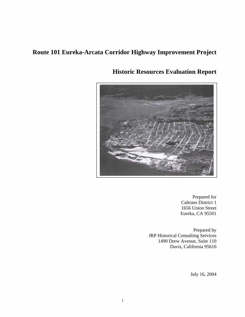
Cover Image: 1947 Aerial View of Eureka, showing the APE located at the top center of image, Courtesy of the Humboldt County Historical Society.
iii
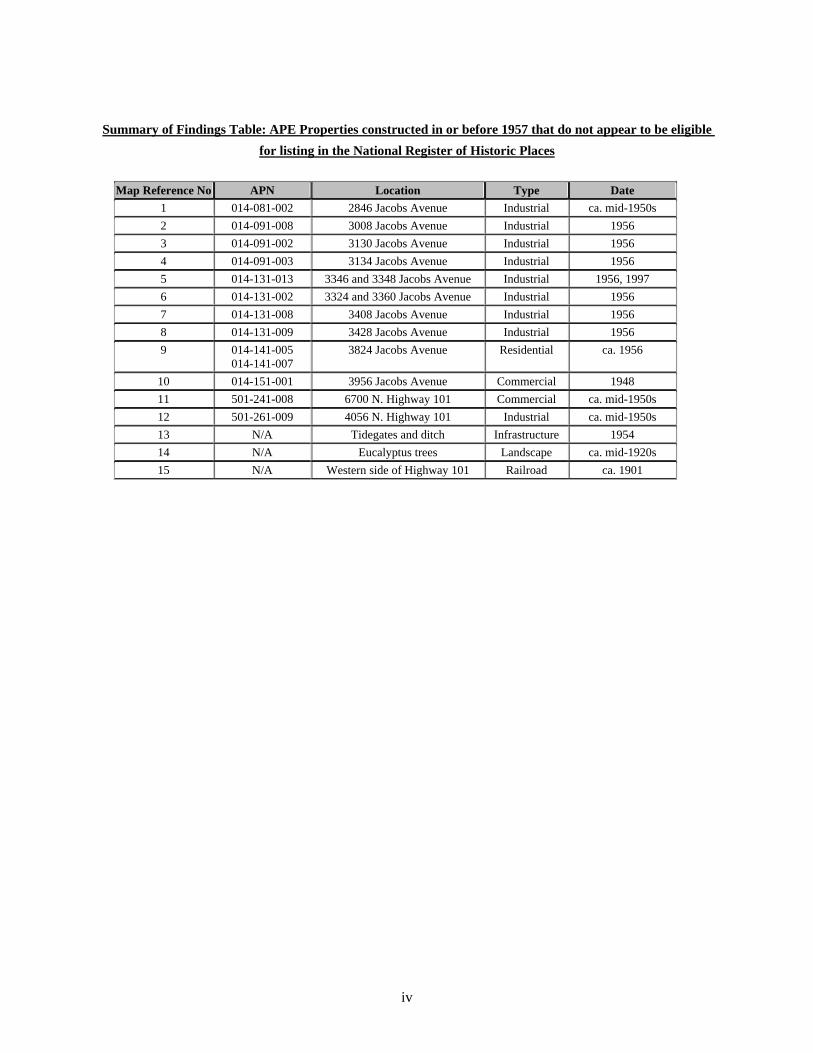
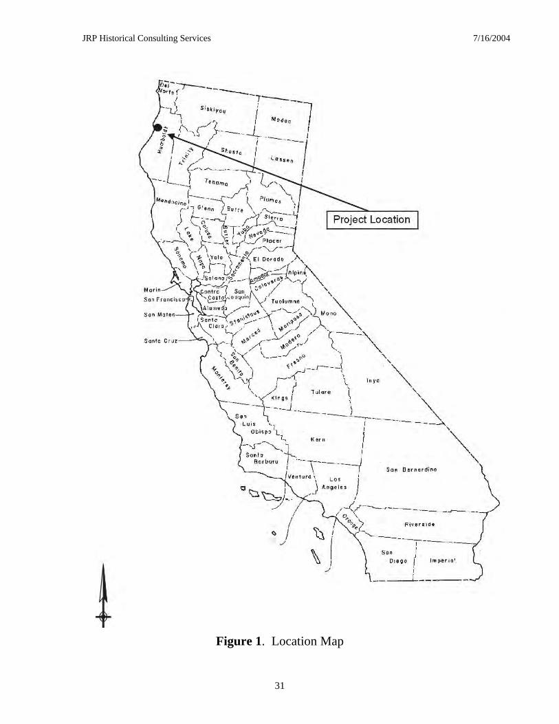
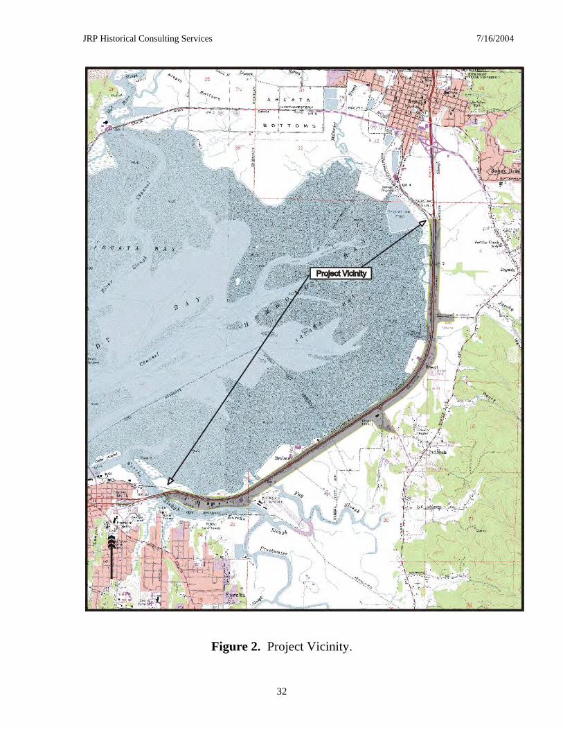
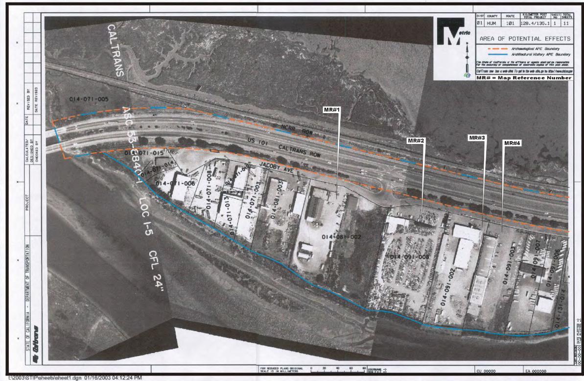
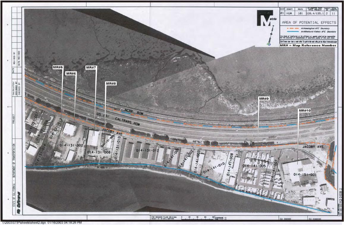
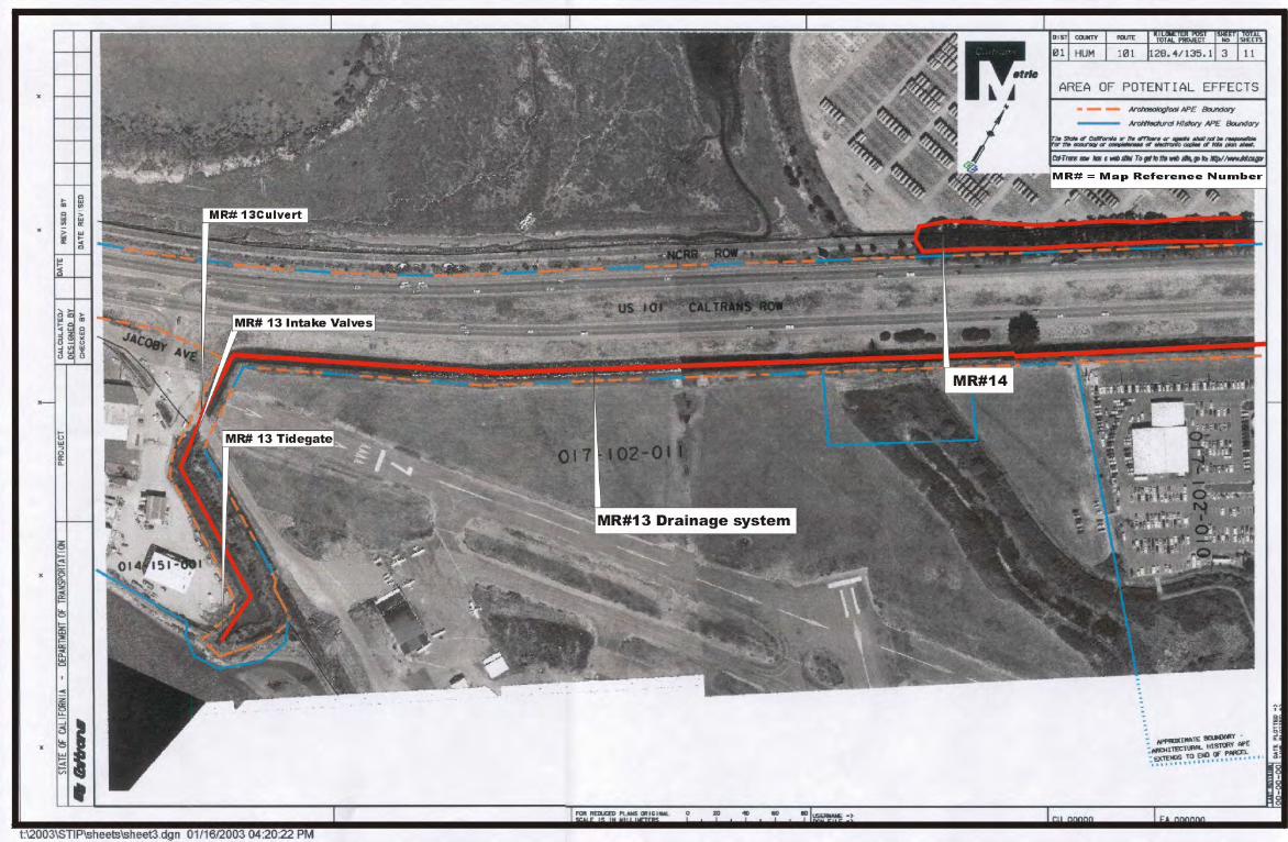
SUMMARY OF FINDINGS JRP Historical Consulting Services prepared this HRER to evaluate historical resources along Route 101 between Eureka and Bayside, to affect buildings and structures that are eligible for listing in the National Register of Historic Places (NRHP), or that would be determined historical resources for the purposes of the California Environmental Quality Act (CEQA). The purpose of this document is to comply with applicable sections of the National Historic Preservation Act (NHPA) and the implementing regulations of the Advisory Council on Historic Preservation (ACHP) as these pertain to federally funded undertakings and their impacts on historic properties. The properties have also been evaluated in accordance with Section 15064.5(a)(2)-(3) of the CEQA Guidelines using the criteria outlined in Section 5024.1 of the California Public Resources Code. The project under study in this report envisions the widening improving this section of Highway 101 located between Eureka and Bayside. The project location is shown in Figure 1 and the project vicinity is shown in Figure 2. The Area of Potential Effects, or APE, is shown in Figure 3, along with map reference numbers for all buildings and structures 50 years old or older existing within the boundaries of the APE. These figures appear in Appendix A. Fourteen resources were found to be “historic,” i.e., constructed in or prior to 1957. Fifteen DPR 523 forms documenting these resources appear in Appendix B. Of the 15 resources within the project, none appear to be eligible for the National Register or the California Register. The remaining properties were constructed in 1957 or after and were treated in accordance with the June 2002 “Caltrans Interim Policy for the Treatment of Buildings Constructed in 1957 or Later.” The memorandum documenting these resources is located in Appendix C. The table below summarizes the findings.
iv
Summary of Findings Table: APE Properties constructed in or before 1957 that do not appear to be eligible
for listing in the National Register of Historic Places
Map Reference No APN Location Type Date
1 014-081-002 2846 Jacobs Avenue Industrial ca. mid-1950s
2 014-091-008 3008 Jacobs Avenue Industrial 1956
3 014-091-002 3130 Jacobs Avenue Industrial 1956
4 014-091-003 3134 Jacobs Avenue Industrial 1956
5 014-131-013 3346 and 3348 Jacobs Avenue Industrial 1956, 1997
6 014-131-002 3324 and 3360 Jacobs Avenue Industrial 1956
7 014-131-008 3408 Jacobs Avenue Industrial 1956
8 014-131-009 3428 Jacobs Avenue Industrial 1956
9 014-141-005 014-141-007
3824 Jacobs Avenue Residential ca. 1956
10 014-151-001 3956 Jacobs Avenue Commercial 1948
11 501-241-008 6700 N. Highway 101 Commercial ca. mid-1950s
12 501-261-009 4056 N. Highway 101 Industrial ca. mid-1950s
13 N/A Tidegates and ditch Infrastructure 1954
14 N/A Eucalyptus trees Landscape ca. mid-1920s
15 N/A Western side of Highway 101 Railroad ca. 1901
JRP Historical Consulting Services 7/16/2004
v
TABLE OF CONTENTS Project Description .......................................................................................................................... 6 Research and field Methods ............................................................................................................ 7 Historical Overview ........................................................................................................................ 9
Introduction ................................................................................................................................. 9 Early Development in the Humboldt Bay Region, 1853-1900 ................................................... 9 Twentieth Century Development, 1900-1945 ........................................................................... 10
Railroads: Northwestern Pacific Railway and Southern Pacific ........................................... 11 Construction of Highway 101’s Antecedents ....................................................................... 12 The Development of modern U.S. Highway 101 and East Highway Subdivision ............... 15 The Development of modern U.S. Highway 101 and East Highway Subdivision ............... 16
Conclusion ................................................................................................................................ 19 Description of Cultural Resources ................................................................................................ 20 Resource Significance ................................................................................................................... 22 Findings and Conclusions ............................................................................................................. 24 Bibliography ................................................................................................................................. 26 Preparers qualifications ................................................................................................................. 29 Appendix A: Maps ....................................................................................................................... 30 Appendix B: DPR 523 Forms ...................................................................................................... 33 Appendix C: Caltrans Memorandum regarding Properties constructed after 1957 ..................... 34
JRP Historical Consulting Services 7/16/2004
6
PROJECT DESCRIPTION
[To be inserted by URS]
JRP Historical Consulting Services 7/16/2004
7
RESEARCH AND FIELD METHODS
The proposed Area of Potential Effects (APE) for the architectural survey for the improvements along Route 101 between Eureka and Arcata was developed in January 2003 by the California Department of Transportation (Caltrans) in conjunction with JRP and URS, and was approved by the Federal Highway Administration (FHWA) in February 2003. Consistent with Caltrans policies and general cultural resource practices, the architectural APE includes the area directly impacted by construction as well as taking into consideration the potential for indirect effects. Where the existing right of way is extensive and proposed work is minimal, the architectural APE conforms to the existing right of way. Only those resources located within the architectural APE were included the survey. The general study limit and architectural APE are shown in Figure 3, found in Appendix A. Once the APE was defined, JRP staff conducted a reconnaissance survey of the area to account in the field for all the buildings, structures, and objects found within the APE. This field reconnaissance helped to determine which buildings appeared to be more than 45 years of age and would therefore be studied for this project. Additional background research was done through First American Real Estate Solutions commercial database, review of historic and current USGS topographic maps, and other documents to confirm dates of construction. While the Secretary of Interior sets the standard guideline for review of potential National Register eligible buildings, properties that are 50 years of age or older, this age limit has been extended to include resources constructed in 1957 or before to account for lead-time between preparation of environmental documentation and actual project construction. Properties built after 1957 are not included in the survey population and are treated in accordance with the June 2002 “Caltrans Interim Policy for the Treatment of Buildings Constructed in 1957 or Later.” These properties are listed in Appendix B. The remaining parcels or features, those that are documented to be, or that appear to be over 45 years of age, became the survey population.1 The investigation of historic-era properties included research regarding their historical context, as well as resource-specific research conducted in both archival and published records. Research for this project was conducted at the California State Library, the Humboldt County Historical Society, the Humboldt Room of Humboldt State University, the California Department of Transportation Library (Headquarters in Sacramento), Caltrans District 1 Maps and Plans Office, the Earth Sciences and Map Library at
1 Not all of the resources within this survey have legal parcels or parcel numbers, such as the drainage system or tree row. For the purposes of this discussion those resources that have Assessor Parcel Numbers will be referred to as “parcels” and those that do not will be described as “features.”
JRP Historical Consulting Services 7/16/2004
8
University of California, Berkeley, Shields Library at University of California Davis. The project team also undertook personal interviews.
JRP Historical Consulting Services 7/16/2004
9
HISTORICAL OVERVIEW
Introduction Humboldt County encompasses approximately 3,500 square miles of mountains, hills, valleys, marshland and bay frontage, including the low-lying area along Humboldt Bay between Eureka and Arcata.2 The architectural APE for this project is located in the low-lying area between Eureka and Arcata. The following discussion focuses on the examination of land use and development in this area. A brief discussion of nineteenth century development is included in this report for the sake of thoroughness, although none of the resources date to this period. More specifically, this context focuses on the development during the twentieth century between Eureka and Arcata, the period during which the fourteen resources addressed by this report date.
Early Development in the Humboldt Bay Region, 1853-1900
Land companies laid out the towns surrounding Humboldt Bay, including Eureka and Arcata, in the 1850s, however, the area between Eureka and Arcata developed more slowly and was hampered by the lack of roads between the two cities. Although ferries traveled between the two towns, a direct road did not connect Eureka and Arcata until 1861, when a road from Arcata to Brainard’s Point was completed. In 1862 the road was extended to Eureka. Because the road traveled over swampy land, it continually needed repair, and by 1867 road improvements allowed daily stagecoach travel between Eureka and Arcata.3 As a result of this road, smaller hamlets grew between Eureka and Arcata, east of the bay. The road traveled through the town of Sunny Brae, located one mile south of Arcata, and continued to Bayside, approximately three miles southeast of Arcata. A post office was established at Bayside in 1886. The road turned west south of Bayside, crossing Jacoby Creek, named for Augustus Jacoby, an early settler who also owned a store in Arcata by 1856. The road continued southwest through Indianola, a small community which received its post office in 1900. The small town never prospered, and in 1915 the post office department merged it with the Bayside Post Office.4
2 Wallace W. Elliott, History of Humboldt County, California. (San Francisco: Wallace W. Elliott & Co., 1881. Reproduced for The California Traveler by Mid-Cal Publishers, Fresno, California, 1969). 3 Owen C. Coy, The Humboldt Bay Region, 74, 225, 280. 4 David L. Durham, California’s Geographic Names: A Gazetteer of Historic and Modern Names of the State (Clovis, California: Word Dancer Press, 1998), 13, 153, 83, 84; Dennis W. Turner, Place Names of Humboldt Bay, 120, 119; A.J. Doolittle, Official Map of Humboldt County, By an Act of the Board of
JRP Historical Consulting Services 7/16/2004
10
Historic maps indicate that in the 1860s the survey area on the west side of the bay was rural and settled by few families, including the Brainards, Jacobys, Roberts, Beaths, and Phillips. The area developed gradually during the late 1800s, and by 1886 Bayside appears on the road between Arcata and Eureka.5 In addition to the development of roads, railroads first were constructed around the Humboldt Bay region in the late 1800s. Logging companies were first constructed short-line railroads by who sought to bring the lumber from the area’s vast redwood forests to the mills centered in Eureka and Arcata. Local entrepreneur and mill owner John Vance of Eureka opened the area’s first railroad in 1875 along the Mad River Slough to Essex, north of Arcata. A private enterprise, the Mad River Railroad was purchased by Vance’s nephews, Edgar and John Vance, in 1891, and in 1892 the Humboldt Bay & Trinidad Lumber & Logging Company purchased the line and incorporated it as the Eureka & Klamath River Railroad in 1896. The Eureka & Klamath River Railroad soon began work on a line connecting Eureka and Arcata.6 Bayside Mill & Lumber Company also constructed a short railroad line from its lands southwest of Bayside to a pier in Humboldt Bay by 1898.7 Twentieth Century Development, 1900-1945 Development in the first few decades of the twentieth century wrought considerable changes to the survey area, as growth of the lumber industry encouraged the construction of railroads and population encouraged the growth of highways. The arrival of the Northwestern Pacific Railroad line into Eureka in 1914 opened the town’s growing lumber industry to markets in Central California, as well as contributed to growth in the region’s other commercial enterprises. The railroad also heavily promoted the line to tourists, which encouraged a tourist industry in the redwood country.
Supervisors (San Francisco: A.J. Doolittle, 1865); and Wallace W. Elliott, History of Humboldt County, 161. 5 A.J. Doolittle, Official Map of Humboldt County, By An Act of the Board of Supervisors (San Francisco: A.J. Doolittle, 1865); Stanly Forbes, Official Map of Humboldt County, California (Stanly Forbes, 1886); J.N. Lentell, Official Map of Humboldt County (J.N. Lentell, 1898); and Northwestern Pacific Railroad, Map of Line, Shively to Trinidad, Humboldt County, California (Northwestern Pacific Railroad Company, 1914). 6 Fred A. Stindt and Guy L. Dunscomb, The Northwestern Pacific Railroad: Redwood Empire Route (Redwood City and Modesto, California: Fred A. Stindt and Guy L. Dunscomb, 1964), 38. 7 A.J. Doolittle, Official Map of Humboldt County, By An Act of the Board of Supervisors (San Francisco: A.J. Doolittle, 1865); Stanly Forbes, Official Map of Humboldt County, California (Stanly Forbes, 1886); J.N. Lentell, Official Map of Humboldt County (J.N. Lentell, 1898); and Northwestern Pacific Railroad, Map of Line, Shively to Trinidad, Humboldt County, California (Northwestern Pacific Railroad Company, 1914).
JRP Historical Consulting Services 7/16/2004
11
Railroads: Northwestern Pacific Railway and Southern Pacific
In 1900, the California & Northern Railway (C&N) incorporated with the intent to build a railroad line from Eureka to Crescent City, ninety miles to the north. The C&N sought to purchase the two and half miles of graded road constructed by the Eureka & Klamath River Railroad south from Arcata, but its offer was declined. In 1901, the two companies agreed to share a joint line along the waterfront. The C&N completed the line connecting Eureka and Arcata on October 30, 1901. This line left the northern outskirts of Eureka and traveled east along the southeastern stretches of the Bay, turning northeast around present day Brainard to Bracut, formerly known as Brainard and later as Brainard Cut. At Bracut, the line traveled directly north into Arcata, bypassing the small communities of Sunny Brae, Bayside, and Indianola, located on Old Arcata Road. Because the C&N did not have the money to begin operations, the Eel River & Eureka Railroad, a small line connecting the bay with the mills at Scotia, leased the C&N’s line and in December of that year began passenger and freight service between Eureka and Arcata. The C&N never completed its line from Arcata to Crescent City.8 Although many local lines had been built by 1900, rail service did not begin to link the region with the rest of California until 1903, when the Santa Fe Railway incorporated the San Francisco & Northwestern Railway Company (SF&NW), intending to connect its California lines with the Humboldt Bay lines. The SF&NW soon purchased the Eel River & Eureka Railroad, the C&N, and several other local lines. By 1905, the Santa Fe Railway owned over fifty miles of track in Humboldt County.9 The Southern Pacific Railroad (SPRR) also desired to extend its services into the Eureka and Arcata area, and in 1903 incorporated the SF&NW and Eureka Railway Company to construct 200 miles of track between Willits and Eureka. However, by 1905 the SPRR and the Santa Fe realized the cost of constructing two competing lines into the Humboldt Bay region would be too high to make a profit. In January 1907, the two companies incorporated the Northwestern Pacific Railroad Company (NWP), which consolidated the lines of the Santa Fe’s SF&NW and Northwestern and the Southern Pacific’s San Francisco and Eureka Railway Company. The NWP also received ownership of the Eureka & Klamath River Railroad, the C&N Railway, and other north coast railroads, including those in Mendocino and Sonoma counties. The NWP completed the line from Willits north to Eureka in 1914. The railroad’s main line ended at Eureka, and the old line heading north from Eureka became known as the Trinidad Branch. In 1928, the
8 Stindt and Dunscomb, The Northwestern Pacific Railroad, 40. 9 Stindt and Dunscomb, The Northwestern Pacific Railroad, 41.
JRP Historical Consulting Services 7/16/2004
12
SPRR purchased the Santa Fe’s interest in the NWP for $4.6 million, and the NWP became a wholly-owned subsidiary of the SPRR.10
Construction of Highway 101’s Antecedents
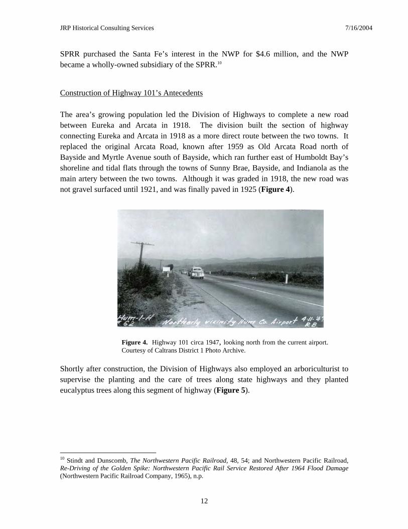
The area’s growing population led the Division of Highways to complete a new road between Eureka and Arcata in 1918. The division built the section of highway connecting Eureka and Arcata in 1918 as a more direct route between the two towns. It replaced the original Arcata Road, known after 1959 as Old Arcata Road north of Bayside and Myrtle Avenue south of Bayside, which ran further east of Humboldt Bay’s shoreline and tidal flats through the towns of Sunny Brae, Bayside, and Indianola as the main artery between the two towns. Although it was graded in 1918, the new road was not gravel surfaced until 1921, and was finally paved in 1925 (Figure 4).
Shortly after construction, the Division of Highways also employed an arboriculturist to supervise the planting and the care of trees along state highways and they planted eucalyptus trees along this segment of highway (Figure 5).
10 Stindt and Dunscomb, The Northwestern Pacific Railroad, 48, 54; and Northwestern Pacific Railroad, Re-Driving of the Golden Spike: Northwestern Pacific Rail Service Restored After 1964 Flood Damage (Northwestern Pacific Railroad Company, 1965), n.p.
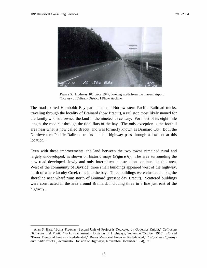
Figure 4. Highway 101 circa 1947, looking north from the current airport. Courtesy of Caltrans District 1 Photo Archive.
JRP Historical Consulting Services 7/16/2004
13
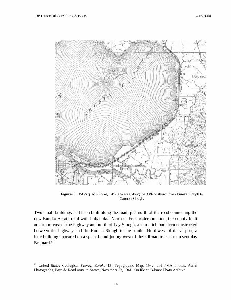
The road skirted Humboldt Bay parallel to the Northwestern Pacific Railroad tracks, traveling through the locality of Brainard (now Bracut), a rail stop most likely named for the family who had owned the land in the nineteenth century. For most of its eight mile length, the road cut through the tidal flats of the bay. The only exception is the foothill area near what is now called Bracut, and was formerly known as Brainard Cut. Both the Northwestern Pacific Railroad tracks and the highway pass through a low cut at this location.11 Even with these improvements, the land between the two towns remained rural and largely undeveloped, as shown on historic maps (Figure 6). The area surrounding the new road developed slowly and only intermittent construction continued in this area. West of the community of Bayside, three small buildings appeared west of the highway, north of where Jacoby Creek runs into the bay. Three buildings were clustered along the shoreline near wharf ruins north of Brainard (present day Bracut). Scattered buildings were constructed in the area around Brainard, including three in a line just east of the highway.
11 Alan S. Hart, “Burns Freeway: Second Unit of Project is Dedicated by Governor Knight,” California Highways and Public Works (Sacramento: Division of Highways, September/October 1955), 24; and “Burns Memorial Freeway Rededicated,” Burns Memorial Freeway Rededicated,” California Highways and Public Works (Sacramento: Division of Highways, November/December 1954), 37.
Figure 5. Highway 101 circa 1947, looking north from the current airport. Courtesy of Caltrans District 1 Photo Archive.
JRP Historical Consulting Services 7/16/2004
14
Two small buildings had been built along the road, just north of the road connecting the new Eureka-Arcata road with Indianola. North of Freshwater Junction, the county built an airport east of the highway and north of Fay Slough, and a ditch had been constructed between the highway and the Eureka Slough to the south. Northwest of the airport, a lone building appeared on a spur of land jutting west of the railroad tracks at present day Brainard.12
12 United States Geological Survey, Eureka 15’ Topographic Map, 1942; and PMA Photos, Aerial Photographs, Bayside Road route to Arcata, November 23, 1941. On file at Caltrans Photo Archive.
Figure 6. USGS quad Eureka, 1942, the area along the APE is shown from Eureka Slough to Gannon Slough.
JRP Historical Consulting Services 7/16/2004
15
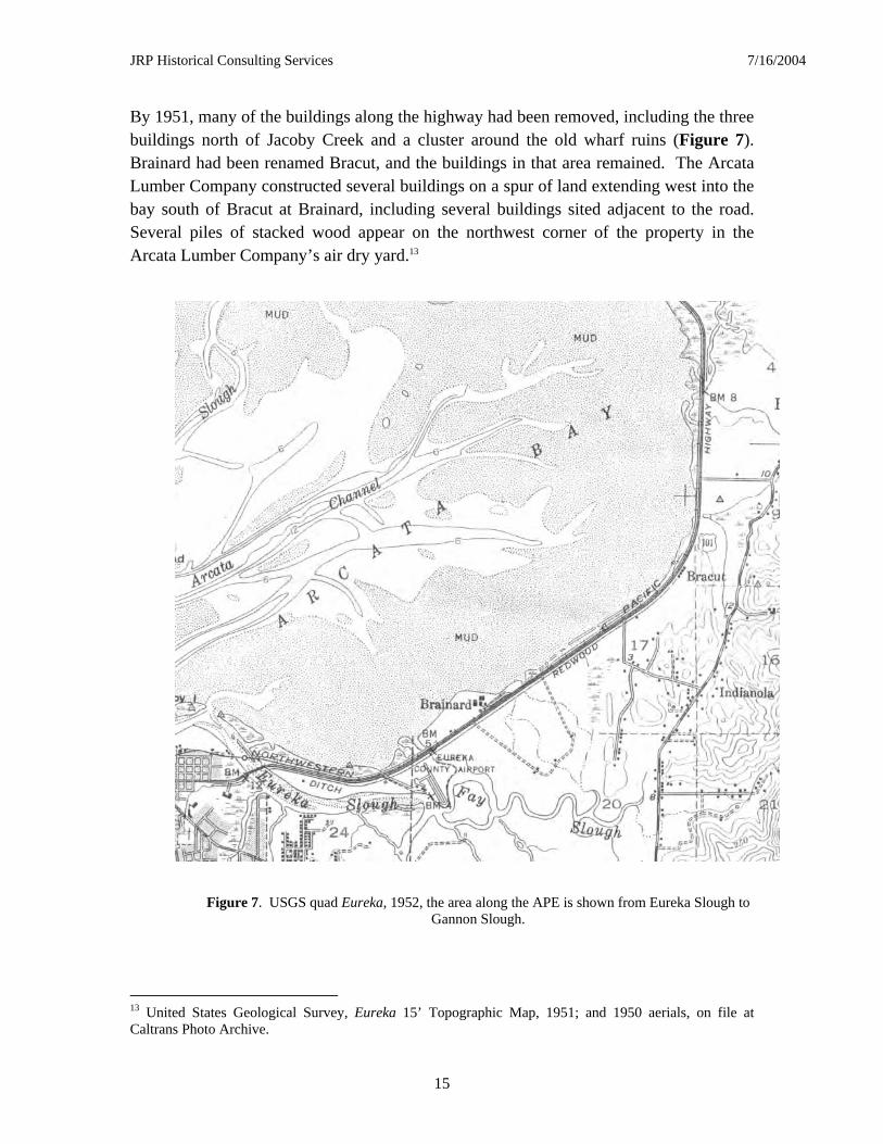
By 1951, many of the buildings along the highway had been removed, including the three buildings north of Jacoby Creek and a cluster around the old wharf ruins (Figure 7). Brainard had been renamed Bracut, and the buildings in that area remained. The Arcata Lumber Company constructed several buildings on a spur of land extending west into the bay south of Bracut at Brainard, including several buildings sited adjacent to the road. Several piles of stacked wood appear on the northwest corner of the property in the Arcata Lumber Company’s air dry yard.13
13 United States Geological Survey, Eureka 15’ Topographic Map, 1951; and 1950 aerials, on file at Caltrans Photo Archive.
Figure 7. USGS quad Eureka, 1952, the area along the APE is shown from Eureka Slough to Gannon Slough.
JRP Historical Consulting Services 7/16/2004
16
The Development of modern U.S. Highway 101 and East Highway Subdivision
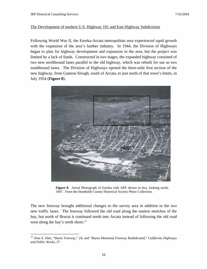
Following World War II, the Eureka-Arcata metropolitan area experienced rapid growth with the expansion of the area’s lumber industry. In 1944, the Division of Highways began to plan for highway development and expansion in the area, but the project was limited by a lack of funds. Constructed in two stages, the expanded highway consisted of two new northbound lanes parallel to the old highway, which was rebuilt for use as two southbound lanes. The Division of Highways opened the three-mile first section of the new highway, from Gannon Slough, south of Arcata, to just north of that town’s limits, in July 1954 (Figure 8).
The new freeway brought additional changes to the survey area in addition to the two new traffic lanes. The freeway followed the old road along the eastern stretches of the bay, but north of Bracut it continued north into Arcata instead of following the old road west along the bay’s north shore.14
14 Alan S. Hart, “Burns Freeway,” 24; and “Burns Memorial Freeway Rededicated,” California Highways and Public Works, 37.
Figure 8. Aerial Photograph of Eureka with APE shown in box, looking north, 1947. From the Humboldt County Historical Society Photo Collection.
JRP Historical Consulting Services 7/16/2004
17
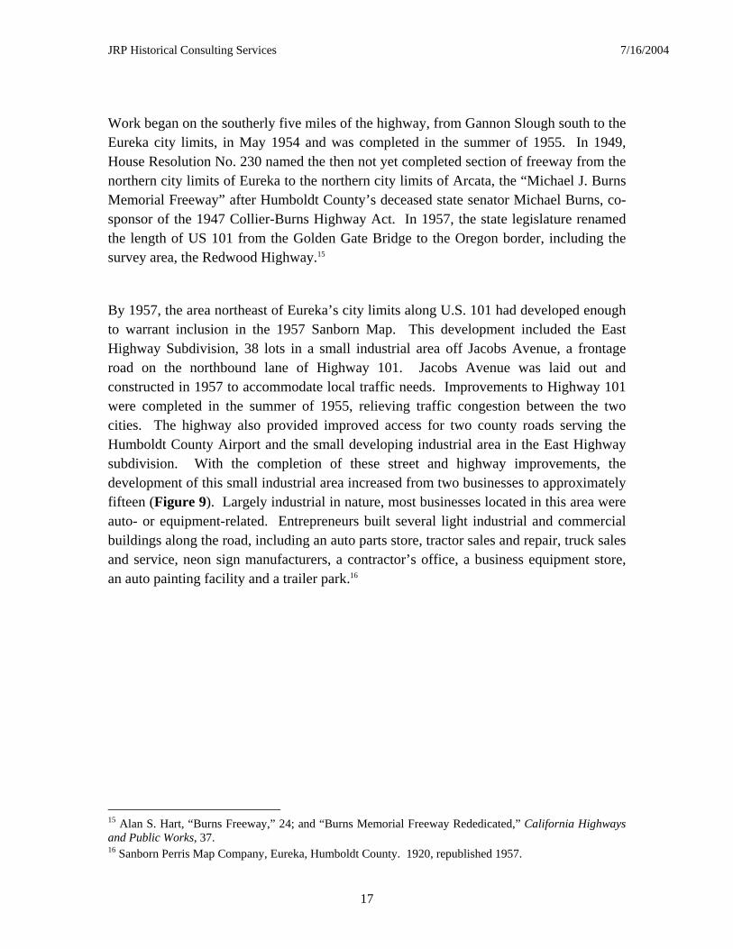
Work began on the southerly five miles of the highway, from Gannon Slough south to the Eureka city limits, in May 1954 and was completed in the summer of 1955. In 1949, House Resolution No. 230 named the then not yet completed section of freeway from the northern city limits of Eureka to the northern city limits of Arcata, the “Michael J. Burns Memorial Freeway” after Humboldt County’s deceased state senator Michael Burns, co-sponsor of the 1947 Collier-Burns Highway Act. In 1957, the state legislature renamed the length of US 101 from the Golden Gate Bridge to the Oregon border, including the survey area, the Redwood Highway.15
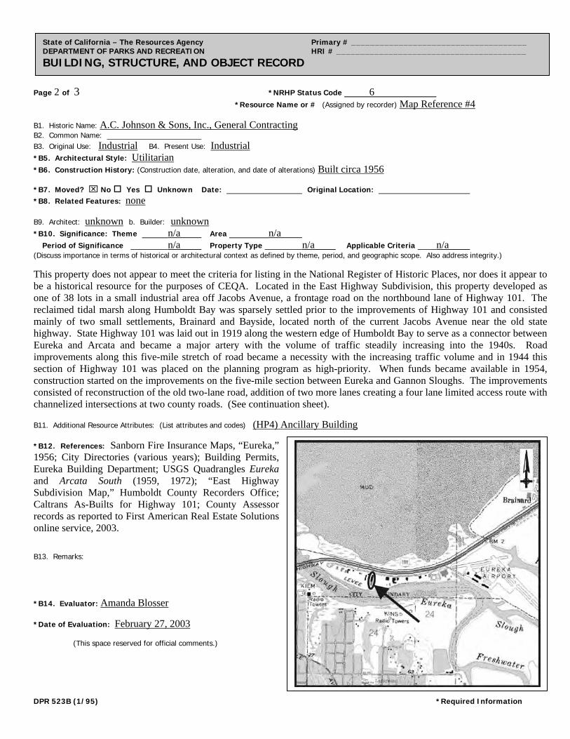
By 1957, the area northeast of Eureka’s city limits along U.S. 101 had developed enough to warrant inclusion in the 1957 Sanborn Map. This development included the East Highway Subdivision, 38 lots in a small industrial area off Jacobs Avenue, a frontage road on the northbound lane of Highway 101. Jacobs Avenue was laid out and constructed in 1957 to accommodate local traffic needs. Improvements to Highway 101 were completed in the summer of 1955, relieving traffic congestion between the two cities. The highway also provided improved access for two county roads serving the Humboldt County Airport and the small developing industrial area in the East Highway subdivision. With the completion of these street and highway improvements, the development of this small industrial area increased from two businesses to approximately fifteen (Figure 9). Largely industrial in nature, most businesses located in this area were auto- or equipment-related. Entrepreneurs built several light industrial and commercial buildings along the road, including an auto parts store, tractor sales and repair, truck sales and service, neon sign manufacturers, a contractor’s office, a business equipment store, an auto painting facility and a trailer park.16
15 Alan S. Hart, “Burns Freeway,” 24; and “Burns Memorial Freeway Rededicated,” California Highways and Public Works, 37. 16 Sanborn Perris Map Company, Eureka, Humboldt County. 1920, republished 1957.
JRP Historical Consulting Services 7/16/2004
18
Eureka continued to grow to the northeast along Humboldt Bay during the late 1950s. A levee separating Eureka Slough from the buildings on Jacobs Avenue had been constructed and north of Eureka, a drive-in theatre was built south of the road connecting the freeway to Indianola. Further north, growth along U.S. 101 continued, and new buildings along the freeway included one built just south of the Bayside Cutoff. The landscape of the area changed further in the 1950s when the new freeway was constructed in 1954 and 1955. Just south of Arcata, the old road had skirted Humboldt Bay, traveling west until turning north into town. After 1954, the Arcata Bypass skirted the east shore of Humboldt Bay, then continued directly north into Arcata instead of following the old road west along the northern reaches of the Bay.17
17 United States Geological Survey, Eureka 15’ Topographic Map, 1959; United States Geological Survey, Arcata South 7.5’ Topographic Map, 1959; United States Geological Survey, Eureka 7.5’ Topographic Map; 1958 Aerials, Caltrans Photo Archive.
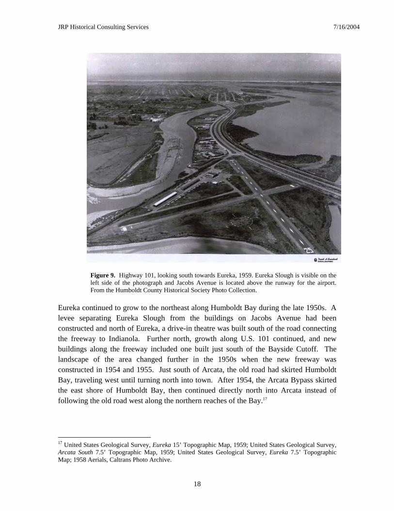
Figure 9. Highway 101, looking south towards Eureka, 1959. Eureka Slough is visible on the left side of the photograph and Jacobs Avenue is located above the runway for the airport. From the Humboldt County Historical Society Photo Collection.
JRP Historical Consulting Services 7/16/2004
19
Conclusion
The reclaimed tidal marsh along Humboldt Bay was sparsely settled prior to the improvements of Highway 101 and consisted mainly of three small settlements, Brainard, Bayside and Indianola, located east of the old state highway. State Highway 101 was laid out in 1919 along the western edge of Humboldt Bay to serve as a connector between Eureka and Arcata and became a major artery with the volume of traffic steadily increasing into the 1940s. Road improvements along this five-mile stretch of road became a necessity with the increasing traffic volume and in 1944 the Division of Highways placed this section of Highway 101 on the planning program as high-priority. When funds became available in 1954, construction started on the improvements on the five-mile section between Eureka and Gannon Sloughs. With these improvements complete, the buildings that make up most of the survey population for this project were constructed, constituting the small industrial district north of Eureka.
JRP Historical Consulting Services 7/16/2004
20
DESCRIPTION OF CULTURAL RESOURCES
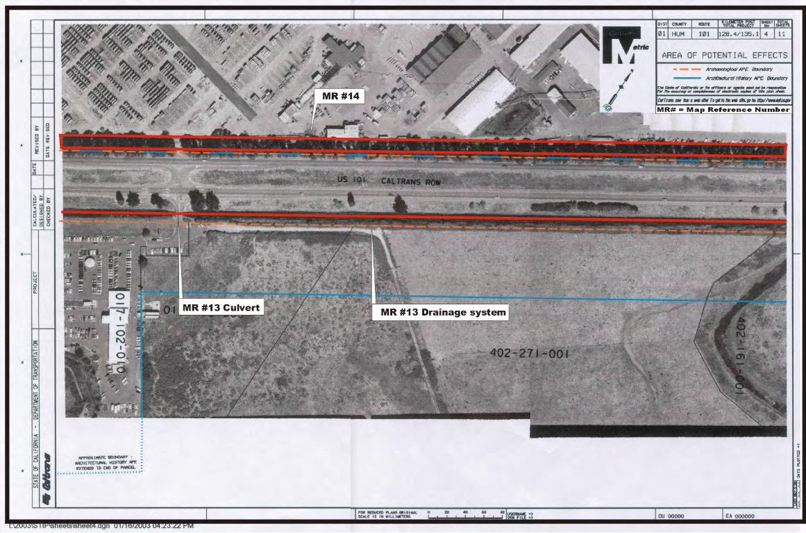
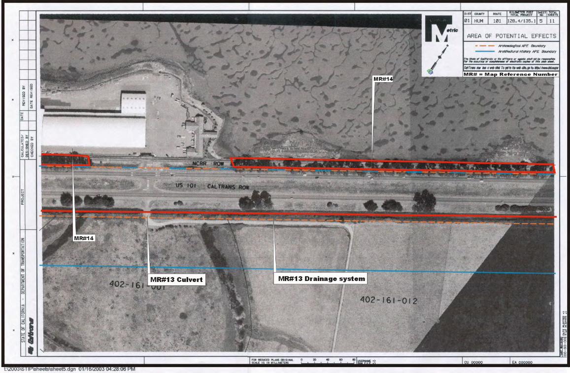
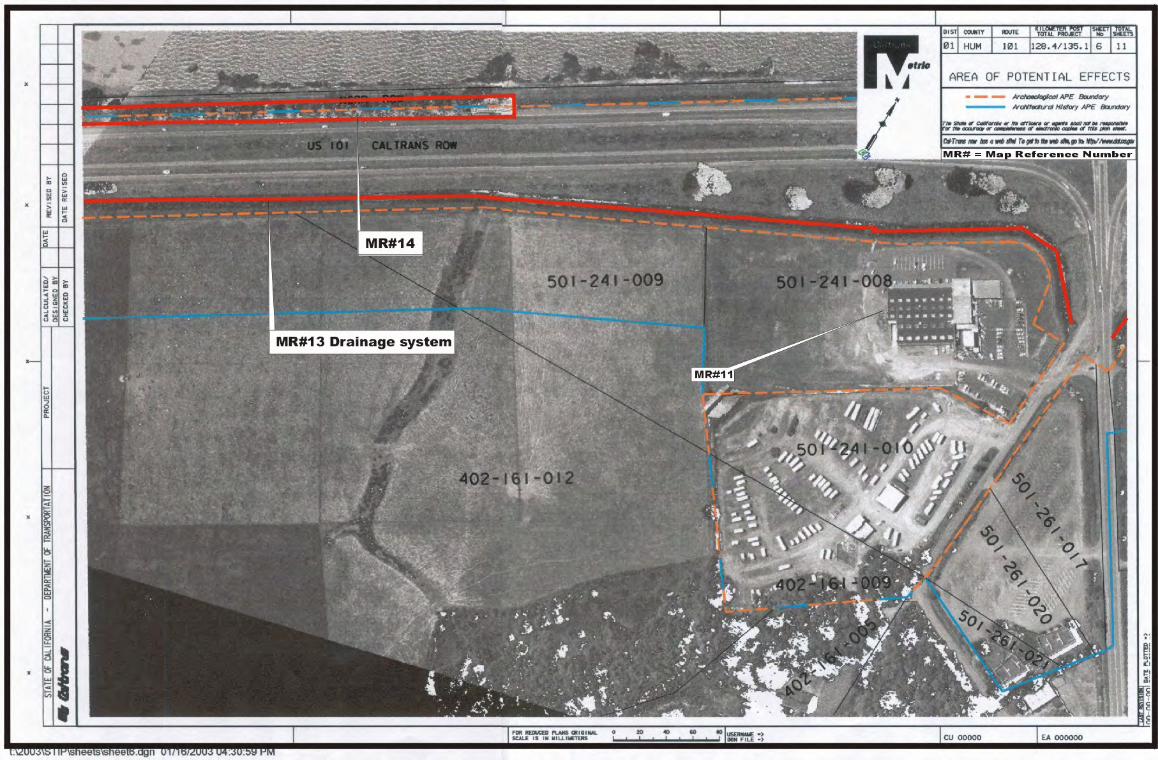
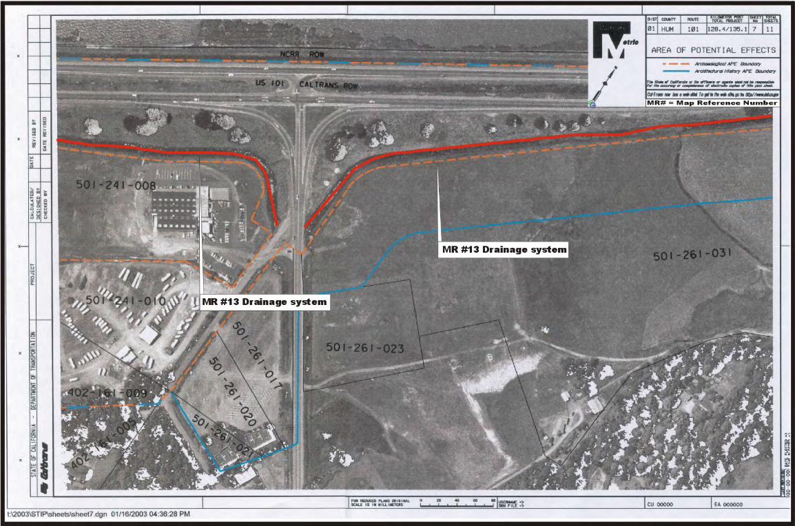
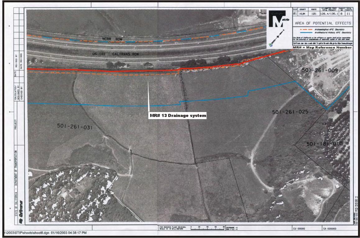
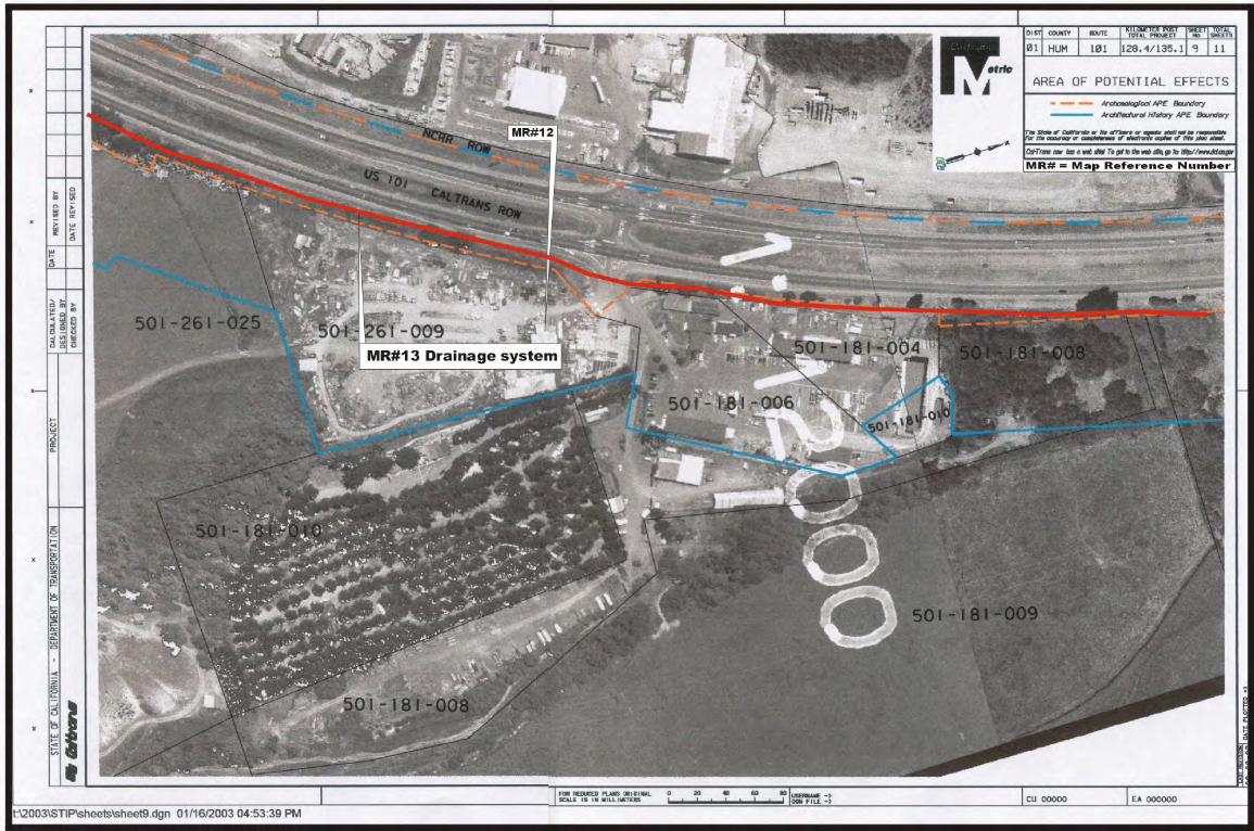
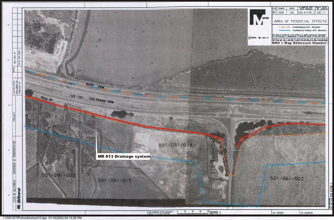
The resources within the architectural APE consist of light industrial and commercial buildings, one residential property, one infrastructure resource, one railroad segment, and a landscape element. South of the Eureka Airport, nine resources are located in the East Highway Subdivision, with one located adjacent to the subdivision (Carl Johnson Company complex at 3956 Jacobs Avenue). The resources consist of eight light industrial buildings, one trailer park, and several commercial buildings associated with the Carl Johnson Company constructed in the mid-1950s. The industrial and commercial buildings are corrugated metal sheds or stucco warehouses with little architectural detail, and are typical of utilitarian buildings built in the 1950s. The one resource associated with the trailer park appears to be wood frame. In keeping with the modest neighborhood, this building has little architectural detail. Many of the resources in this area have lost integrity because of modifications and additions. In addition, there are several properties in this area that were not recorded on DPR523 forms that are of modern construction. North of the airport, the APE includes two light industrial and commercial buildings. Most of the area within the APE north of the airport is agricultural land or vacant. The two resources in the area consist of a complex of light industrial buildings located near the Bayside Cutoff and a commercial shopping center southeast of the Indianola Cutoff. The commercial property consists of a two-story stucco building. The industrial complex consists of two wood frame office buildings and several corrugated metal sheds. The residence and several light industrial and commercial buildings, including an auto dealership and non operating drive-in movie theater, were constructed after 1957 and were not recorded on DPR523 forms. Also located within the APE is a drainage system, constructed in 1954 by Caltrans as part of the improvements to Highway 101. This drainage system is located on the east side of Highway 101, starting at Airport Road and consists of a screw valve tidegate, an earthen ditch, five culverts, and concrete outtake valve. A five mile segment of the Northwestern Pacific Railroad is located on the western edge of the APE. Constructed in 1901, the railroad is single track for the entire length of the APE, with gravel ballast, usually at-grade with timber ties. The railroad was abandoned in 1998 and vegetation generally covers the ballasts and tracks.
JRP Historical Consulting Services 7/16/2004
21
The last resource type located within the APE is a landscape element, a row of eucalyptus trees. They are located on the west side of the freeway and are mature trees approximately 30 feet tall. They were planted in a linear arrangement along the highway and are the remnant of a row of trees that lined the highway from Eureka to Gannon Slough.
JRP Historical Consulting Services 7/16/2004
22
RESOURCE SIGNIFICANCE
Of the resources surveyed for this project, none appear to be eligible for listing in the National Register of Historic Places. The buildings located in the East Highway Subdivision fit within the context of industrial development north of the city of Eureka following the expansion of Highway 101, although none of the resources appear to be significant within this context. This industrial and commercial district developed after 1949 when the East Highway Subdivision was surveyed. Most of the resources in the subdivision date after 1955, when the California Division of Highways widened Highway 101 and put in Jacobs Avenue, the frontage road through the subdivision. Along Jacobs Avenue, Map Reference Numbers 1 and 10 pre-date the freeway expansion. Map Reference Numbers 2, 3, 4, 5, 6, 7, 8, and 9 were all built immediately following the expansion of the freeway, as were Map Reference Numbers 11 and 12 which are located east of Highway 101. The drainage system also does not appear to be eligible for listing in the National Register. Infrastructure is inherently vital to communities as it is often part of essential city or regional planning, and considerably impacts communication and the distribution of people, goods, and services that facilitates development on both the local and regional levels. In particular this drainage system was important to the development of Highway 101, however, it does not appear to be associated with this context in an important manner. The five mile segment of the Northwestern Pacific Railroad does not appear eligible for listing in the National Register. Although the NWP Railroad was not evaluated in its entirety, its potential for significance was considered in order to determine whether the five mile segment would not contribute to the significance of the NWP Railroad. This report concludes that the segment would not contribute to the significance of the NWP Railroad, should the property ever be determined eligible for the National Register. The segment lacks the requisite integrity from the NWP Railroad’s likely period of significance, 1901 to 1907, and therefore does not convey any sense of the NWP Railroad’s potential significance. The five mile segment has been continually maintained since the beginning of the railroad’s operation with wholesale replacement of rails and ties. The rails and timber ties have been replaced with modern welded rails and pressure treated timber over the years and thus this line is essentially a modern property, representing modern railroad technology. The landscape element also does not appear to be eligible as an example of a designed landscape nor does it appear that there is any potential for a historic landscape within the APE. While the trees represent the substantial efforts of the Division of Highways to
JRP Historical Consulting Services 7/16/2004
23
beautify stretches of California highways, such examples of similar tree-lined stretches of highway exist in many towns and areas. The ubiquitous nature of tree-lined roads in California (and for that matter, around the nation) indicates that, however attractive or stately, they do not have significance as a “design or work of art.”18
18 Caltrans, “General Guidelines for Indentifying and Evaluating Historic Landscapes,” February 1999.
JRP Historical Consulting Services 7/16/2004
24
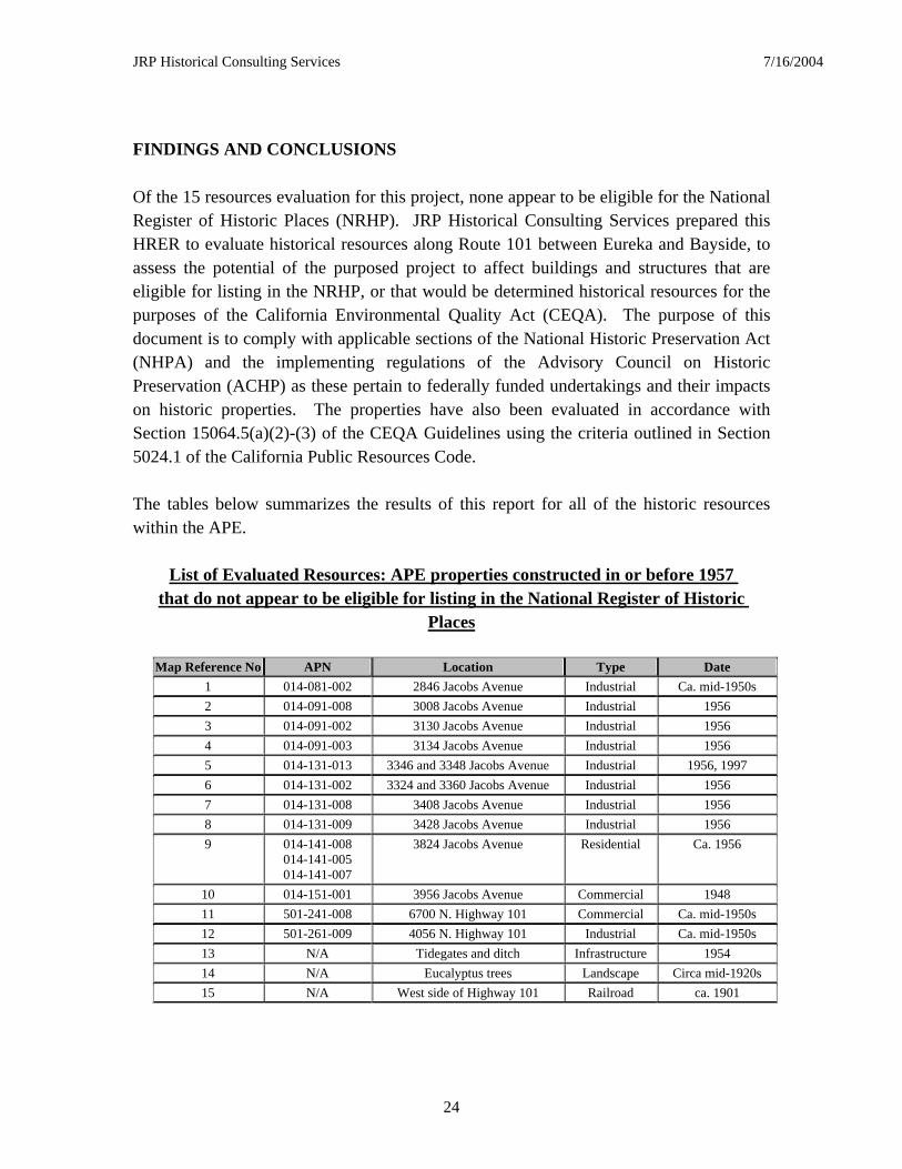
FINDINGS AND CONCLUSIONS
Of the 15 resources evaluation for this project, none appear to be eligible for the National Register of Historic Places (NRHP). JRP Historical Consulting Services prepared this HRER to evaluate historical resources along Route 101 between Eureka and Bayside, to assess the potential of the purposed project to affect buildings and structures that are eligible for listing in the NRHP, or that would be determined historical resources for the purposes of the California Environmental Quality Act (CEQA). The purpose of this document is to comply with applicable sections of the National Historic Preservation Act (NHPA) and the implementing regulations of the Advisory Council on Historic Preservation (ACHP) as these pertain to federally funded undertakings and their impacts on historic properties. The properties have also been evaluated in accordance with Section 15064.5(a)(2)-(3) of the CEQA Guidelines using the criteria outlined in Section 5024.1 of the California Public Resources Code. The tables below summarizes the results of this report for all of the historic resources within the APE.
List of Evaluated Resources: APE properties constructed in or before 1957
that do not appear to be eligible for listing in the National Register of Historic Places
Map Reference No APN Location Type Date
1 014-081-002 2846 Jacobs Avenue Industrial Ca. mid-1950s
2 014-091-008 3008 Jacobs Avenue Industrial 1956
3 014-091-002 3130 Jacobs Avenue Industrial 1956
4 014-091-003 3134 Jacobs Avenue Industrial 1956
5 014-131-013 3346 and 3348 Jacobs Avenue Industrial 1956, 1997
6 014-131-002 3324 and 3360 Jacobs Avenue Industrial 1956
7 014-131-008 3408 Jacobs Avenue Industrial 1956
8 014-131-009 3428 Jacobs Avenue Industrial 1956
9 014-141-008 014-141-005 014-141-007
3824 Jacobs Avenue Residential Ca. 1956
10 014-151-001 3956 Jacobs Avenue Commercial 1948
11 501-241-008 6700 N. Highway 101 Commercial Ca. mid-1950s
12 501-261-009 4056 N. Highway 101 Industrial Ca. mid-1950s
13 N/A Tidegates and ditch Infrastructure 1954
14 N/A Eucalyptus trees Landscape Circa mid-1920s
15 N/A West side of Highway 101 Railroad ca. 1901
JRP Historical Consulting Services 7/16/2004
25
24 properties were constructed in 1957 or later and were treated according to the Interim Policy (see Appendix C). Of these properties, none appear to meet the criteria for listing in the National Register of Historic Places, nor do they appear to be historical resources for the purposes of CEQA. As a result they require no further study.
JRP Historical Consulting Services 7/16/2004
26
BIBLIOGRAPHY
Books: Coy, Owen Cochran. The Humboldt Bay Region, 1850-1875: A Study in the American
Colonization of California. Los Angeles: The California State Historical Association, 1929. Reprinted by The Humboldt County Historical Society, 1982.
Durham, David L. California’s Geographic Names: A Gazetteer of Historic and Modern
Names of the State. Clovis, California: Word Dancer Press, 1998. Elliott, Wallace W. History of Humboldt County, California. San Francisco: Wallace W.
Elliott & Co., 1881. Reproduced by Mid-Cal Publishers, Fresno, California, 1969.
Hoover, Mildred Brooke, Hero Eugene Rensche, and Ethel Grace Rensch. Historic Spots
in California. Stanford, California: Stanford University Press, 1966. 3rd edition. Rev. by William N. Abeloe.
Hoover, Mildred Brooke, Hero Eugene Rensche, Ethel Grace Rensch, and William N.
Abeloe. Historic Spots in California. Stanford, California: Stanford University Press, 1990. 4th edition. Rev. by Douglas E. Kyle.
Longstreth, Richard. The Buildings of Main Street: A Guide to Commercial Architecture.
Walnut Creek: Altamira Press, 2000.
McAlester, Virginia and Lee. A Field Guide to American Houses. New York: Knopf, 1987.
Northwestern Pacific Railroad. Re-Driving of the Golden Spike: Northwestern Pacific
Rail Service Restored After 1964 Flood Damage. Northwestern Pacific Railroad Company, 1965.
Stindt, Fred A. and Guy L. Dunscomb. The Northwestern Pacific Railroad: Redwood
Empire Route. Redwood City and Modesto, California: Fred A. Stindt and Guy L. Dunscomb, 1964.
Turner, Dennis W. Place Names of Humboldt County, California: A Compendium, 1542-
1992. Orangevale, California: Dennis W. Turner, 1993. Periodicals: California Highways and Public Works
JRP Historical Consulting Services 7/16/2004
27
Maps: County of Humboldt, California, 1911. San Francisco: Edward Denny & Company,
1911. From the California State Library Map Collection. Map of Line, Shively to Trinidad, Humboldt County, California. Northwestern Pacific
Railroad Company, 1914. From the California State Archives Railroad Alignment and Maps Collection.
Map of the Northern Division, Northwestern Pacific R.R. Co., 1908. From the California
State Library Map Collection. Map of Humboldt County, 1914. J.N. Lentell, 1914. From the California State Library
Map Collection. Official Map of Humboldt County, 1865. San Francisco: A.J. Doolittle, 1865. From the
California State Library Map Collection. Official Map of Humboldt County, 1886. Stanly Forbes, 1886. From the California State
Library Map Collection. Official Map of Humboldt County, 1898. J.N. Lentell, 1898. From the California State
Library Map Collection. Sanborn Fire Insurance Maps. “Arcata,” 1900, 1928, 1941. Sanborn Fire Insurance Maps. “Eureka,” 1900, 1920, 1949, 1957. United States Geological Survey. Eureka 15’ Topographic Map, 1942, 1948, 1959. United States Geological Survey. Arcata South 7.5’ Topographic Map, 1959, 1972. United States Geological Survey. Eureka 7.5’ Topographic Map, 1959, 1972.
Photographs: “Eureka, California, 1947.” On file at the Humboldt County Historical Society, File No. 75.15.01.
JRP Historical Consulting Services 7/16/2004
28
“Eureka, California. November 28, 1950.” On file at the Humboldt County Historical Society, File No. 75.15.01. “Looking towards Eureka, California, from east. 1959.” On file at the Humboldt County Historical Society, File No. 75.15.01.

JRP Historical Consulting Services 7/16/2004
29
PREPARERS QUALIFICATIONS
JRP principal Rand Herbert (MAT in History, University of California, Davis, 1977) directed the research. Mr. Herbert has more than 25 years experience working as a consulting historian and architectural historian on a wide variety of historical research and cultural resources management projects, as a researcher, writer, and project manager. Staff Historian Amanda Blosser (MS in Historic Preservation, Texas Tech University) assisted with research, preparation of the report, and form preparation / site evaluations. She joined the staff of JRP as an architectural historian and historic preservation specialist in 2001. Research Assistant Courtney Chambers (MA Candidate in Public History, CSU Sacramento) worked on form preparation, helped conduct research, and assisted with various production aspects of the report.
JRP Historical Consulting Services 7/16/2004
30
APPENDIX A: MAPS
JRP Historical Consulting Services 7/16/2004
31
Figure 1. Location Map
JRP Historical Consulting Services 7/16/2004
32
Figure 2. Project Vicinity.

JRP Historical Consulting Services 7/16/2004
33
APPENDIX B: DPR 523 FORMS
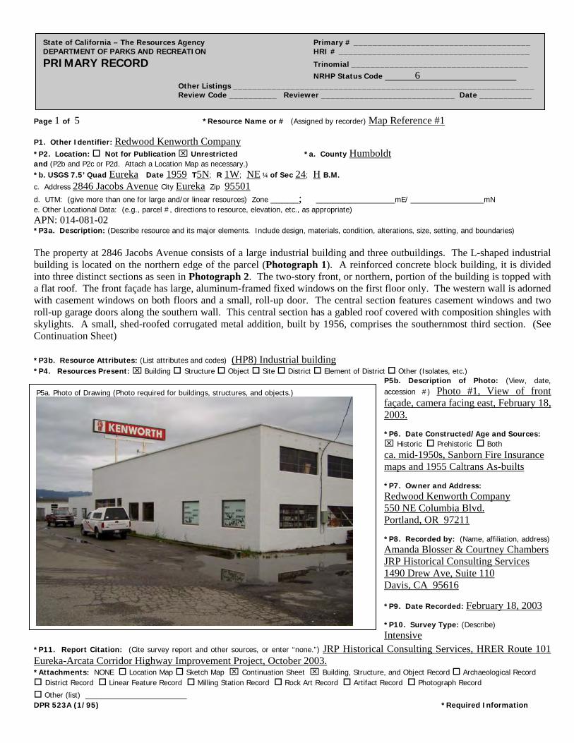
Page 1 of 5 *Resource Name or # (Assigned by recorder) Map Reference #1
State of California – The Resources Agency Primary # _____________________________________ DEPARTMENT OF PARKS AND RECREATION HRI # ________________________________________ PRIMARY RECORD Trinomial _____________________________________ NRHP Status Code 6 Other Listings _______________________________________________________________ Review Code __________ Reviewer ____________________________ Date ___________
P1. Other Identifier: Redwood Kenworth Company
*P2. Location: Not for Publication Unrestricted *a. County Humboldt and (P2b and P2c or P2d. Attach a Location Map as necessary.) *b. USGS 7.5’ Quad Eureka Date 1959 T5N; R 1W; NE ¼ of Sec 24; H B.M. c. Address 2846 Jacobs Avenue City Eureka Zip 95501
d. UTM: (give more than one for large and/or linear resources) Zone _____; ______________mE/ _____________mN e. Other Locational Data: (e.g., parcel #, directions to resource, elevation, etc., as appropriate) APN: 014-081-02 *P3a. Description: (Describe resource and its major elements. Include design, materials, condition, alterations, size, setting, and boundaries) The property at 2846 Jacobs Avenue consists of a large industrial building and three outbuildings. The L-shaped industrial building is located on the northern edge of the parcel (Photograph 1). A reinforced concrete block building, it is divided into three distinct sections as seen in Photograph 2. The two-story front, or northern, portion of the building is topped with a flat roof. The front façade has large, aluminum-framed fixed windows on the first floor only. The western wall is adorned with casement windows on both floors and a small, roll-up door. The central section features casement windows and two roll-up garage doors along the southern wall. This central section has a gabled roof covered with composition shingles with skylights. A small, shed-roofed corrugated metal addition, built by 1956, comprises the southernmost third section. (See Continuation Sheet) *P3b. Resource Attributes: (List attributes and codes) (HP8) Industrial building *P4. Resources Present: Building Structure Object Site District Element of District Other (Isolates, etc.)
P5b. Description of Photo: (View, date, accession #) Photo #1, View of front façade, camera facing east, February 18, 2003. *P6. Date Constructed/Age and Sources: Historic Prehistoric Both ca. mid-1950s, Sanborn Fire Insurance maps and 1955 Caltrans As-builts *P7. Owner and Address: Redwood Kenworth Company 550 NE Columbia Blvd. Portland, OR 97211 *P8. Recorded by: (Name, affiliation, address) Amanda Blosser & Courtney Chambers JRP Historical Consulting Services 1490 Drew Ave, Suite 110 Davis, CA 95616
*P9. Date Recorded: February 18, 2003 *P10. Survey Type: (Describe) Intensive
P5a. Photo of Drawing (Photo required for buildings, structures, and objects.)
*P11. Report Citation: (Cite survey report and other sources, or enter “none.”) JRP Historical Consulting Services, HRER Route 101 Eureka-Arcata Corridor Highway Improvement Project, October 2003. *Attachments: NONE Location Map Sketch Map Continuation Sheet Building, Structure, and Object Record Archaeological Record District Record Linear Feature Record Milling Station Record Rock Art Record Artifact Record Photograph Record
Other (list) __________________ DPR 523A (1/95) *Required Information
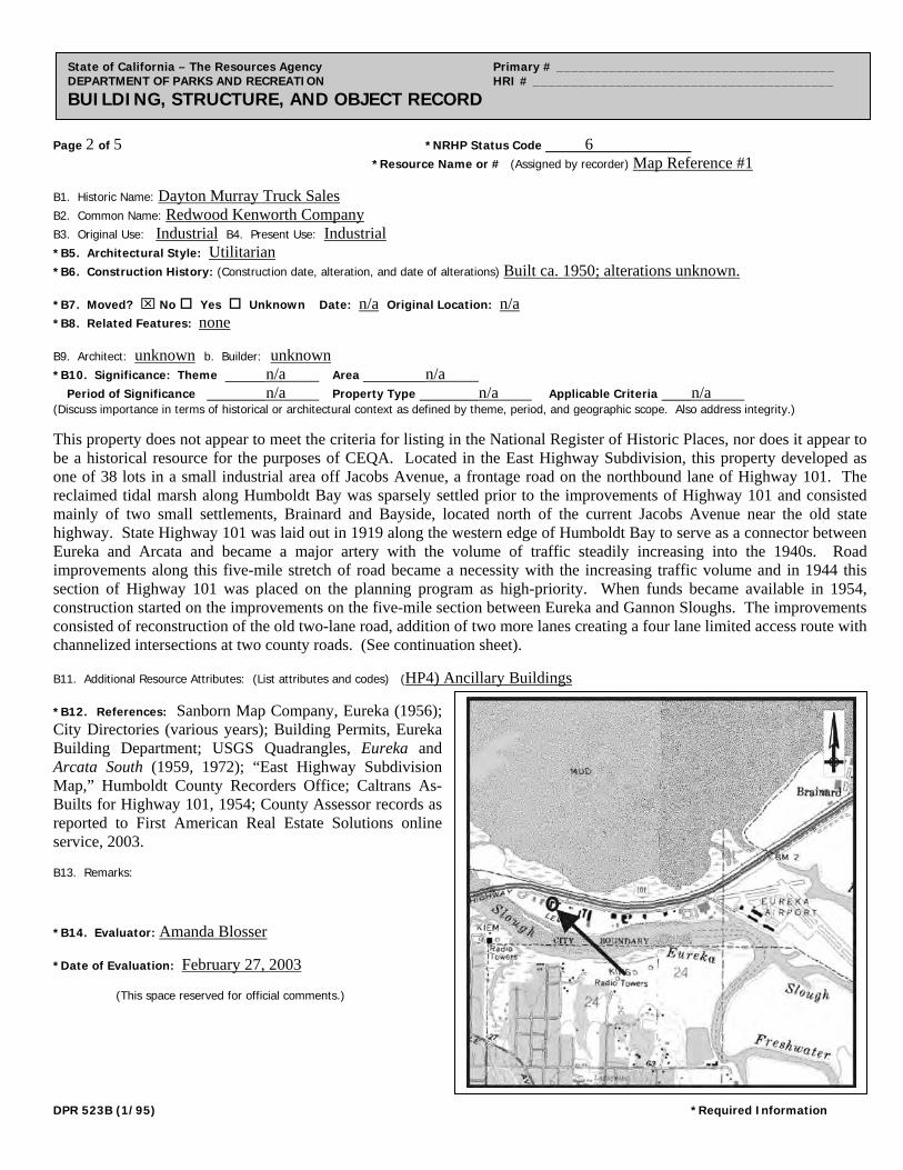
Page 2 of 5 *NRHP Status Code 6
*Resource Name or # (Assigned by recorder) Map Reference #1
State of California – The Resources Agency Primary # _____________________________________ DEPARTMENT OF PARKS AND RECREATION HRI # ________________________________________ BUILDING, STRUCTURE, AND OBJECT RECORD
B1. Historic Name: Dayton Murray Truck Sales B2. Common Name: Redwood Kenworth Company
B3. Original Use: Industrial B4. Present Use: Industrial *B5. Architectural Style: Utilitarian *B6. Construction History: (Construction date, alteration, and date of alterations) Built ca. 1950; alterations unknown. *B7. Moved? No Yes Unknown Date: n/a Original Location: n/a *B8. Related Features: none B9. Architect: unknown b. Builder: unknown *B10. Significance: Theme n/a Area n/a Period of Significance n/a Property Type n/a Applicable Criteria n/a (Discuss importance in terms of historical or architectural context as defined by theme, period, and geographic scope. Also address integrity.)
This property does not appear to meet the criteria for listing in the National Register of Historic Places, nor does it appear to be a historical resource for the purposes of CEQA. Located in the East Highway Subdivision, this property developed as one of 38 lots in a small industrial area off Jacobs Avenue, a frontage road on the northbound lane of Highway 101. The reclaimed tidal marsh along Humboldt Bay was sparsely settled prior to the improvements of Highway 101 and consisted mainly of two small settlements, Brainard and Bayside, located north of the current Jacobs Avenue near the old state highway. State Highway 101 was laid out in 1919 along the western edge of Humboldt Bay to serve as a connector between Eureka and Arcata and became a major artery with the volume of traffic steadily increasing into the 1940s. Road improvements along this five-mile stretch of road became a necessity with the increasing traffic volume and in 1944 this section of Highway 101 was placed on the planning program as high-priority. When funds became available in 1954, construction started on the improvements on the five-mile section between Eureka and Gannon Sloughs. The improvements consisted of reconstruction of the old two-lane road, addition of two more lanes creating a four lane limited access route with channelized intersections at two county roads. (See continuation sheet). B11. Additional Resource Attributes: (List attributes and codes) (HP4) Ancillary Buildings *B12. References: Sanborn Map Company, Eureka (1956); City Directories (various years); Building Permits, Eureka Building Department; USGS Quadrangles, Eureka and Arcata South (1959, 1972); “East Highway Subdivision Map,” Humboldt County Recorders Office; Caltrans As-Builts for Highway 101, 1954; County Assessor records as reported to First American Real Estate Solutions online service, 2003. B13. Remarks: *B14. Evaluator: Amanda Blosser *Date of Evaluation: February 27, 2003 (This space reserved for official comments.)
DPR 523B (1/95) *Required Information
Page 3 of 5 *Resource Name or # (Assigned by recorder) Map Reference #1 *Recorded by A. Blosser & C. Chambers *Date February 18, 2003 Continuation Update
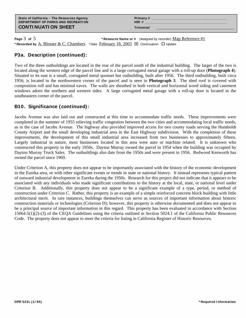
State of California – The Resources Agency Primary # _____________________________________ DEPARTMENT OF PARKS AND RECREATION HRI # ________________________________________ CONTINUATION SHEET Trinomial ____________________________________________
P3a. Description (continued): Two of the three outbuildings are located in the rear of the parcel south of the industrial building. The larger of the two is located along the western edge of the parcel line and is a large corrugated metal garage with a roll-up door (Photograph 4). Situated to its east is a small, corrugated metal quonset hut outbuilding, built after 1956. The third outbuilding, built circa 1956, is located in the northwestern corner of the parcel and is seen in Photograph 3. The shed roof is covered with composition roll and has minimal eaves. The walls are sheathed in both vertical and horizontal wood siding and casement windows adorn the northern and western sides. A large corrugated metal garage with a roll-up door is located in the southeastern corner of the parcel. B10. Significance (continued): Jacobs Avenue was also laid out and constructed at this time to accommodate traffic needs. These improvements were completed in the summer of 1955 relieving traffic congestion between the two cities and accommodating local traffic needs, as in the case of Jacobs Avenue. The highway also provided improved access for two county roads serving the Humboldt County Airport and the small developing industrial area in the East Highway subdivision. With the completion of these improvements, the development of this small industrial area increased from two businesses to approximately fifteen. Largely industrial in nature, most businesses located in this area were auto or machine related. It is unknown who constructed this property in the early 1950s. Dayton Murray owned the parcel in 1954 when the building was occupied by Dayton Murray Truck Sales. The outbuildings also date from the 1950s and were present in 1956. Redwood Kenworth has owned the parcel since 1969. Under Criterion A, this property does not appear to be importantly associated with the history of the economic development in the Eureka area, or with other significant events or trends in state or national history. It instead represents typical pattern of outward industrial development in Eureka during the 1950s. Research for this project did not indicate that it appears to be associated with any individuals who made significant contributions to the history at the local, state, or national level under Criterion B. Additionally, this property does not appear to be a significant example of a type, period, or method of construction under Criterion C. Rather, this property is an example of a simple reinforced concrete block building with little architectural merit. In rare instances, buildings themselves can serve as sources of important information about historic construction materials or technologies (Criterion D); however, this property is otherwise documented and does not appear to be a principal source of important information in this regard. This property has been evaluated in accordance with Section 15064.5(1)(2)-(3) of the CEQA Guidelines using the criteria outlined in Section 5024.1 of the California Public Resources Code. The property does not appear to meet the criteria for listing in California Register of Historic Resources.
DPR 523L (1/95) *Required Information
Page 4 of 5 *Resource Name or # (Assigned by recorder) Map Reference #1 *Recorded by A. Blosser & C. Chambers *Date February 18, 2003 Continuation Update
State of California – The Resources Agency Primary # _____________________________________ DEPARTMENT OF PARKS AND RECREATION HRI # ________________________________________ CONTINUATION SHEET Trinomial ____________________________________________
Photographs (cont):
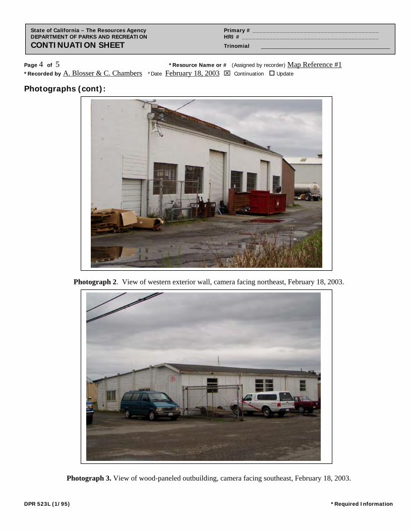
Photograph 2. View of western exterior wall, camera facing northeast, February 18, 2003.
Photograph 3. View of wood-paneled outbuilding, camera facing southeast, February 18, 2003.
DPR 523L (1/95) *Required Information
Page 5 of 5 *Resource Name or # (Assigned by recorder) Map Reference #1 *Recorded by A. Blosser & C. Chambers *Date February 18, 2003 Continuation Update
State of California – The Resources Agency Primary # _____________________________________ DEPARTMENT OF PARKS AND RECREATION HRI # ________________________________________ CONTINUATION SHEET Trinomial ____________________________________________
Photographs (cont):
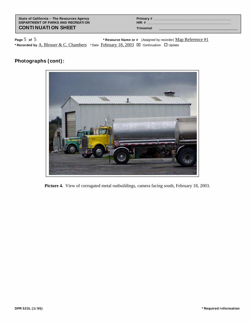
Picture 4. View of corrugated metal outbuildings, camera facing south, February 18, 2003.
DPR 523L (1/95) *Required Information
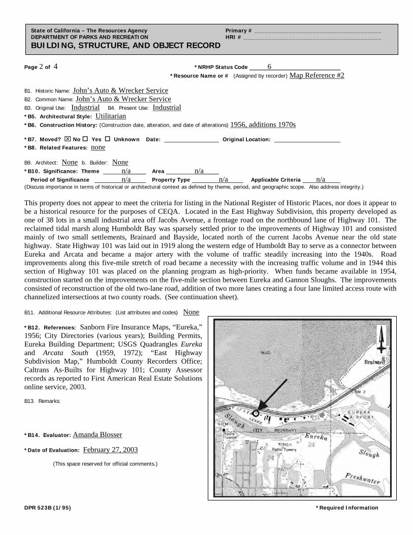
Page 1 of 4 *Resource Name or # (Assigned by recorder) Map Reference #2
State of California – The Resources Agency Primary # _____________________________________ DEPARTMENT OF PARKS AND RECREATION HRI # ________________________________________ PRIMARY RECORD Trinomial _____________________________________ NRHP Status Code 6 Other Listings _______________________________________________________________ Review Code __________ Reviewer ____________________________ Date ___________
P1. Other Identifier: John’s Auto & Wrecker Service
*P2. Location: Not for Publication Unrestricted *a. County Humboldt and (P2b and P2c or P2d. Attach a Location Map as necessary.) *b. USGS 7.5’ Quad Eureka Date 1959 photorevised 1972 T5N; R 1W; NE ¼ of Sec 24; H B.M. c. Address 3008 Jacobs Avenue City Eureka Zip 95501-0905
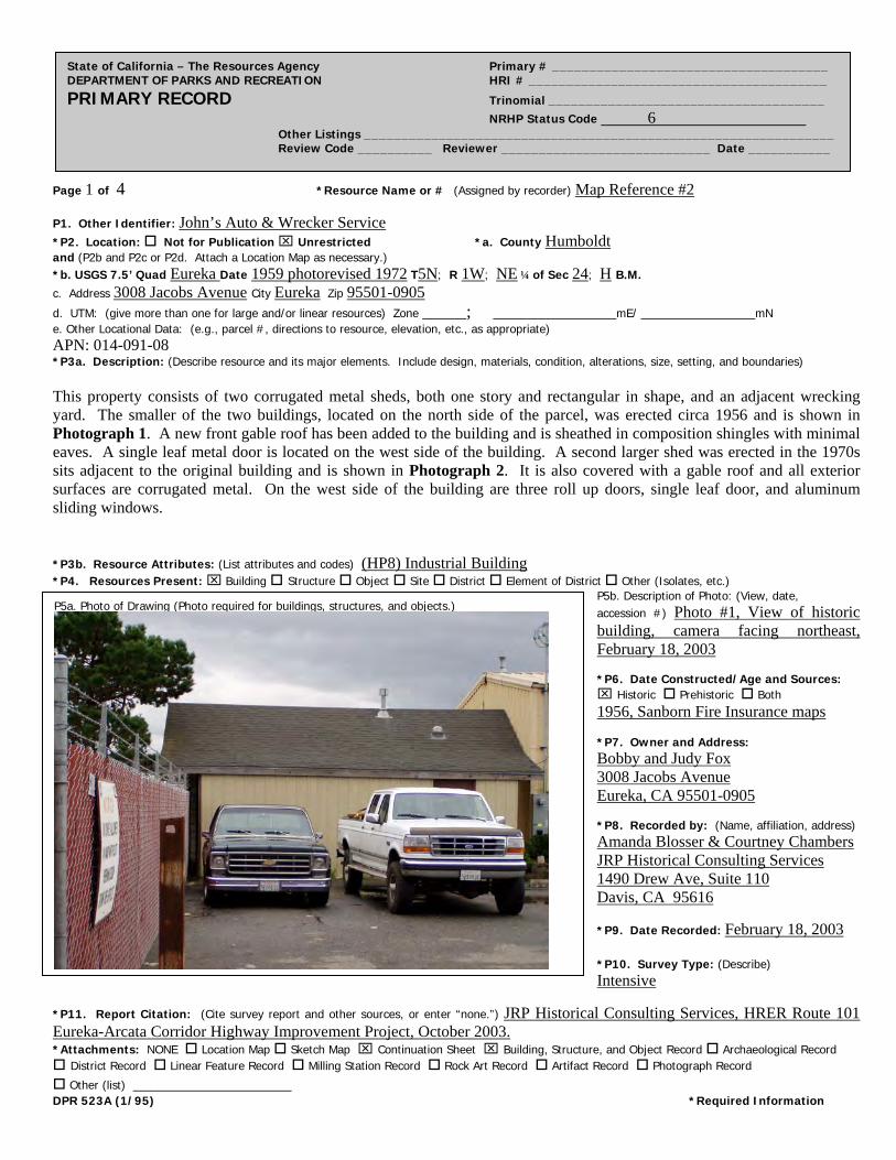
d. UTM: (give more than one for large and/or linear resources) Zone _____; ______________mE/ _____________mN e. Other Locational Data: (e.g., parcel #, directions to resource, elevation, etc., as appropriate) APN: 014-091-08 *P3a. Description: (Describe resource and its major elements. Include design, materials, condition, alterations, size, setting, and boundaries) This property consists of two corrugated metal sheds, both one story and rectangular in shape, and an adjacent wrecking yard. The smaller of the two buildings, located on the north side of the parcel, was erected circa 1956 and is shown in Photograph 1. A new front gable roof has been added to the building and is sheathed in composition shingles with minimal eaves. A single leaf metal door is located on the west side of the building. A second larger shed was erected in the 1970s sits adjacent to the original building and is shown in Photograph 2. It is also covered with a gable roof and all exterior surfaces are corrugated metal. On the west side of the building are three roll up doors, single leaf door, and aluminum sliding windows. *P3b. Resource Attributes: (List attributes and codes) (HP8) Industrial Building *P4. Resources Present: Building Structure Object Site District Element of District Other (Isolates, etc.)
P5b. Description of Photo: (View, date, accession #) Photo #1, View of historic building, camera facing northeast, February 18, 2003 *P6. Date Constructed/Age and Sources: Historic Prehistoric Both 1956, Sanborn Fire Insurance maps *P7. Owner and Address: Bobby and Judy Fox 3008 Jacobs Avenue Eureka, CA 95501-0905 *P8. Recorded by: (Name, affiliation, address) Amanda Blosser & Courtney Chambers JRP Historical Consulting Services 1490 Drew Ave, Suite 110 Davis, CA 95616
*P9. Date Recorded: February 18, 2003 *P10. Survey Type: (Describe) Intensive
P5a. Photo of Drawing (Photo required for buildings, structures, and objects.)
*P11. Report Citation: (Cite survey report and other sources, or enter “none.”) JRP Historical Consulting Services, HRER Route 101 Eureka-Arcata Corridor Highway Improvement Project, October 2003. *Attachments: NONE Location Map Sketch Map Continuation Sheet Building, Structure, and Object Record Archaeological Record District Record Linear Feature Record Milling Station Record Rock Art Record Artifact Record Photograph Record
Other (list) __________________ DPR 523A (1/95) *Required Information
Page 2 of 4 *NRHP Status Code 6
*Resource Name or # (Assigned by recorder) Map Reference #2
State of California – The Resources Agency Primary # _____________________________________ DEPARTMENT OF PARKS AND RECREATION HRI # ________________________________________ BUILDING, STRUCTURE, AND OBJECT RECORD
B1. Historic Name: John’s Auto & Wrecker Service
B2. Common Name: John’s Auto & Wrecker Service
B3. Original Use: Industrial B4. Present Use: Industrial *B5. Architectural Style: Utilitarian
*B6. Construction History: (Construction date, alteration, and date of alterations) 1956, additions 1970s *B7. Moved? No Yes Unknown Date: Original Location: *B8. Related Features: none B9. Architect: None b. Builder: None *B10. Significance: Theme n/a Area n/a Period of Significance n/a Property Type n/a Applicable Criteria n/a (Discuss importance in terms of historical or architectural context as defined by theme, period, and geographic scope. Also address integrity.) This property does not appear to meet the criteria for listing in the National Register of Historic Places, nor does it appear to be a historical resource for the purposes of CEQA. Located in the East Highway Subdivision, this property developed as one of 38 lots in a small industrial area off Jacobs Avenue, a frontage road on the northbound lane of Highway 101. The reclaimed tidal marsh along Humboldt Bay was sparsely settled prior to the improvements of Highway 101 and consisted mainly of two small settlements, Brainard and Bayside, located north of the current Jacobs Avenue near the old state highway. State Highway 101 was laid out in 1919 along the western edge of Humboldt Bay to serve as a connector between Eureka and Arcata and became a major artery with the volume of traffic steadily increasing into the 1940s. Road improvements along this five-mile stretch of road became a necessity with the increasing traffic volume and in 1944 this section of Highway 101 was placed on the planning program as high-priority. When funds became available in 1954, construction started on the improvements on the five-mile section between Eureka and Gannon Sloughs. The improvements consisted of reconstruction of the old two-lane road, addition of two more lanes creating a four lane limited access route with channelized intersections at two county roads. (See continuation sheet). B11. Additional Resource Attributes: (List attributes and codes) None *B12. References: Sanborn Fire Insurance Maps, “Eureka,” 1956; City Directories (various years); Building Permits, Eureka Building Department; USGS Quadrangles Eureka and Arcata South (1959, 1972); “East Highway Subdivision Map,” Humboldt County Recorders Office; Caltrans As-Builts for Highway 101; County Assessor records as reported to First American Real Estate Solutions online service, 2003. B13. Remarks: *B14. Evaluator: Amanda Blosser *Date of Evaluation: February 27, 2003 (This space reserved for official comments.)
DPR 523B (1/95) *Required Information
Page 3 of 4 *Resource Name or # (Assigned by recorder) Map Reference #2 *Recorded by A. Blosser & C. Chambers *Date February 18, 2003 Continuation Update
State of California – The Resources Agency Primary # _____________________________________ DEPARTMENT OF PARKS AND RECREATION HRI # ________________________________________ CONTINUATION SHEET Trinomial ____________________________________________
B10. Significance (continued): Jacobs Avenue was also laid out and constructed at this time to accommodate traffic needs. These improvements were completed in the summer of 1955 relieving traffic congestion between the two cities and accommodating local traffic needs, as in the case of Jacobs Avenue. The highway also provided improved access for two county roads serving the Humboldt County Airport and the small developing industrial area along the East Highway subdivision. With the completion of these improvements, the development of this small industrial area increased from two businesses to approximately fifteen. Largely industrial in nature, most businesses located in this area were auto or machine related. This property in 1954 was owned by Lloyd F. Barnes, who began improvements on the lot by constructed a private driveway. In 1956, the parcel was used as an auto-wrecking yard with two small one-story building, serving as an office and auto parts store. The lot is still used as an auto wrecking yard although it has expanded to salvage lot. Under Criterion A, this property does not appear to be importantly associated with the history of the economic development in the Eureka area, or with other significant events or trends in state or national history. It instead represents typical pattern of outward industrial development in Eureka during the 1950s. Research for this project did not indicate that this property appears to be associated with any individuals who made significant contributions to the history at the local, state, or national level under Criterion B. Additionally, it does not appear to be a significant example of a type, period, or method of construction. Rather, these buildings are typical examples of modern warehouses that could be mass produced buildings and assembled in different sizes as needed. This type of construction in well documented and prevalent in industrial districts across America and therefore does not appear to be eligible under Criterion C. In rare instances, buildings themselves can serve as sources of important information about historic construction materials or technologies (Criterion D); however, this property is otherwise documented and does not appear to be a principal source of important information in this regard. This property has been evaluated in accordance with Section 15064.5(1)(2)-(3) of the CEQA Guidelines using the criteria outlined in Section 5024.1 of the California Public Resources Code. The property does not appear to meet the criteria for listing in California Register of Historic Resources.
DPR 523L (1/95) *Required Information
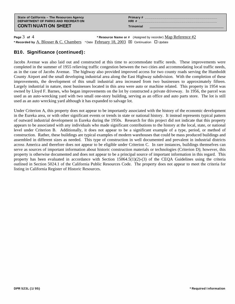
Page 4 of 4 *Resource Name or # (Assigned by recorder) Map Reference #2 *Recorded by A. Blosser & C. Chambers *Date February 18, 2003 Continuation Update
State of California – The Resources Agency Primary # _____________________________________ DEPARTMENT OF PARKS AND RECREATION HRI # ________________________________________ CONTINUATION SHEET Trinomial ____________________________________________
Photographs (cont):
Photograph 2. Corrugated metal shed addition, camera facing southeast, February 18, 2003.
DPR 523L (1/95) *Required Information
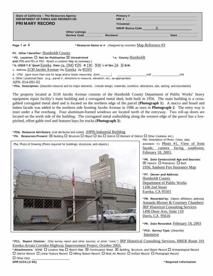
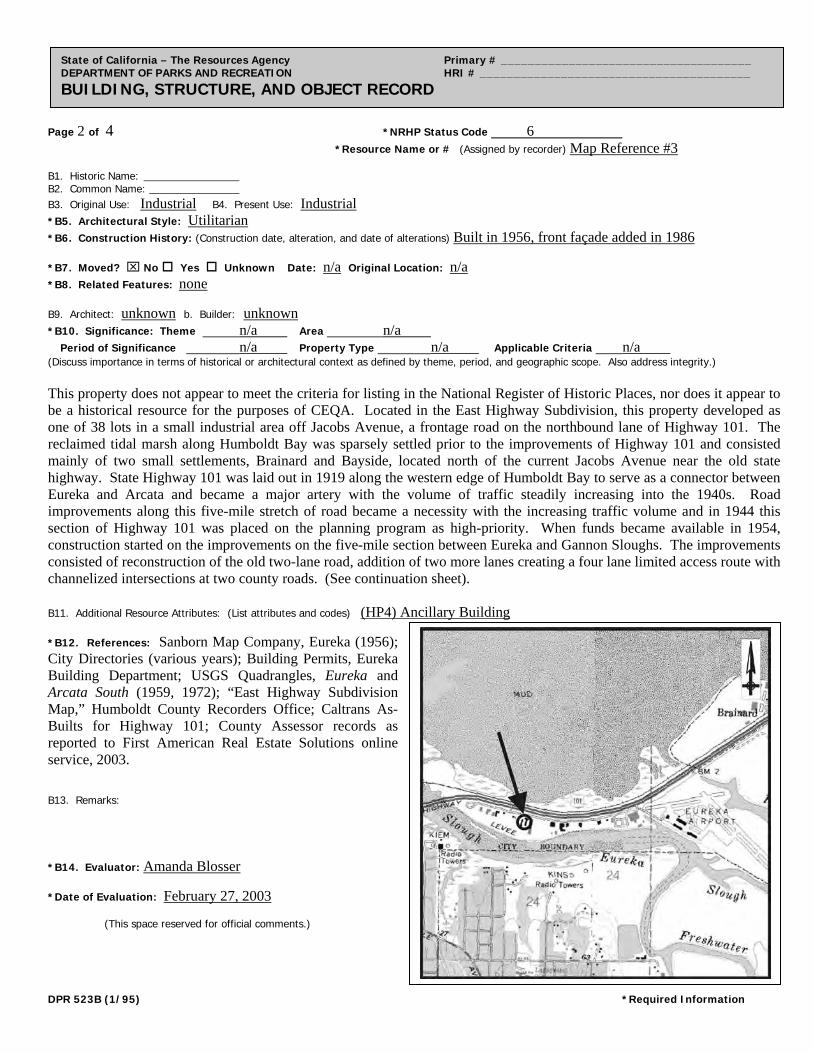
Page 1 of 4 *Resource Name or # (Assigned by recorder) Map Reference #3
State of California – The Resources Agency Primary # _____________________________________ DEPARTMENT OF PARKS AND RECREATION HRI # ________________________________________ PRIMARY RECORD Trinomial _____________________________________ NRHP Status Code 6 Other Listings _______________________________________________________________ Review Code __________ Reviewer ____________________________ Date ___________
P1. Other Identifier: Humboldt County *P2. Location: Not for Publication Unrestricted *a. County Humboldt and (P2b and P2c or P2d. Attach a Location Map as necessary.) *b. USGS 7.5’ Quad Eureka Date ca. 1945 T5N; R 1W; NW ¼ of Sec 24; H B.M. c. Address 3130 Jacobs Avenue City Eureka Zip 95501
d. UTM: (give more than one for large and/or linear resources) Zone _____; ______________mE/ _____________mN e. Other Locational Data: (e.g., parcel #, directions to resource, elevation, etc., as appropriate) APN: 014-091-02 *P3a. Description: (Describe resource and its major elements. Include design, materials, condition, alterations, size, setting, and boundaries) The property located at 3130 Jacobs Avenue consists of the Humboldt County Department of Public Works’ heavy equipment repair facility’s main building and a corrugated metal shed, both built in 1956. The main building is a cross-gabled corrugated metal shed and is located on the northern edge of the parcel (Photograph 1). A stucco and board and batten facade was added to the northern side fronting Jacobs Avenue in 1986 as seen in Photograph 2. The entry way is inset under a flat overhang. Four aluminum-framed windows are located north of the entryway. Two roll-up doors are located on the north side of the building. The corrugated metal outbuilding along the western edge of the parcel has a low-pitched, offset gable roof and features bays for trucks (Photograph 3). *P3b. Resource Attributes: (List attributes and codes) (HP8) Industrial Building *P4. Resources Present: Building Structure Object Site District Element of District Other (Isolates, etc.)
P5b. Description of Photo: (View, date, accession #) Photo #1, View of front façade, camera facing southwest, February 18, 2003. *P6. Date Constructed/Age and Sources: Historic Prehistoric Both 1956, Sanborn Fire Insurance Map *P7. Owner and Address: Humboldt County Department of Public Works 1106 2nd Street Eureka, CA 95501 *P8. Recorded by: (Name, affiliation, address) Amanda Blosser & Courtney Chambers JRP Historical Consulting Services 1490 Drew Ave, Suite 110 Davis, CA 95616
*P9. Date Recorded: February 18, 2003 *P10. Survey Type: (Describe)
Intensive
P5a. Photo of Drawing (Photo required for buildings, structures, and objects.)
*P11. Report Citation: (Cite survey report and other sources, or enter “none.”) JRP Historical Consulting Services, HRER Route 101 Eureka-Arcata Corridor Highway Improvement Project, October 2003. *Attachments: NONE Location Map Sketch Map Continuation Sheet Building, Structure, and Object Record Archaeological Record District Record Linear Feature Record Milling Station Record Rock Art Record Artifact Record Photograph Record
Other (list) __________________ DPR 523A (1/95) *Required Information
Page 2 of 4 *NRHP Status Code 6
*Resource Name or # (Assigned by recorder) Map Reference #3
State of California – The Resources Agency Primary # _____________________________________ DEPARTMENT OF PARKS AND RECREATION HRI # ________________________________________ BUILDING, STRUCTURE, AND OBJECT RECORD
B1. Historic Name: B2. Common Name: B3. Original Use: Industrial B4. Present Use: Industrial *B5. Architectural Style: Utilitarian
*B6. Construction History: (Construction date, alteration, and date of alterations) Built in 1956, front façade added in 1986 *B7. Moved? No Yes Unknown Date: n/a Original Location: n/a *B8. Related Features: none B9. Architect: unknown b. Builder: unknown *B10. Significance: Theme n/a Area n/a Period of Significance n/a Property Type n/a Applicable Criteria n/a (Discuss importance in terms of historical or architectural context as defined by theme, period, and geographic scope. Also address integrity.) This property does not appear to meet the criteria for listing in the National Register of Historic Places, nor does it appear to be a historical resource for the purposes of CEQA. Located in the East Highway Subdivision, this property developed as one of 38 lots in a small industrial area off Jacobs Avenue, a frontage road on the northbound lane of Highway 101. The reclaimed tidal marsh along Humboldt Bay was sparsely settled prior to the improvements of Highway 101 and consisted mainly of two small settlements, Brainard and Bayside, located north of the current Jacobs Avenue near the old state highway. State Highway 101 was laid out in 1919 along the western edge of Humboldt Bay to serve as a connector between Eureka and Arcata and became a major artery with the volume of traffic steadily increasing into the 1940s. Road improvements along this five-mile stretch of road became a necessity with the increasing traffic volume and in 1944 this section of Highway 101 was placed on the planning program as high-priority. When funds became available in 1954, construction started on the improvements on the five-mile section between Eureka and Gannon Sloughs. The improvements consisted of reconstruction of the old two-lane road, addition of two more lanes creating a four lane limited access route with channelized intersections at two county roads. (See continuation sheet). B11. Additional Resource Attributes: (List attributes and codes) (HP4) Ancillary Building *B12. References: Sanborn Map Company, Eureka (1956); City Directories (various years); Building Permits, Eureka Building Department; USGS Quadrangles, Eureka and Arcata South (1959, 1972); “East Highway Subdivision Map,” Humboldt County Recorders Office; Caltrans As-Builts for Highway 101; County Assessor records as reported to First American Real Estate Solutions online service, 2003. B13. Remarks: *B14. Evaluator: Amanda Blosser *Date of Evaluation: February 27, 2003 (This space reserved for official comments.)
DPR 523B (1/95) *Required Information
Page 3 of 4 *Resource Name or # (Assigned by recorder) Map Reference #3 *Recorded by A. Blosser & C. Chambers *Date February 18, 2003 Continuation Update
State of California – The Resources Agency Primary # _____________________________________ DEPARTMENT OF PARKS AND RECREATION HRI # ________________________________________ CONTINUATION SHEET Trinomial ____________________________________________
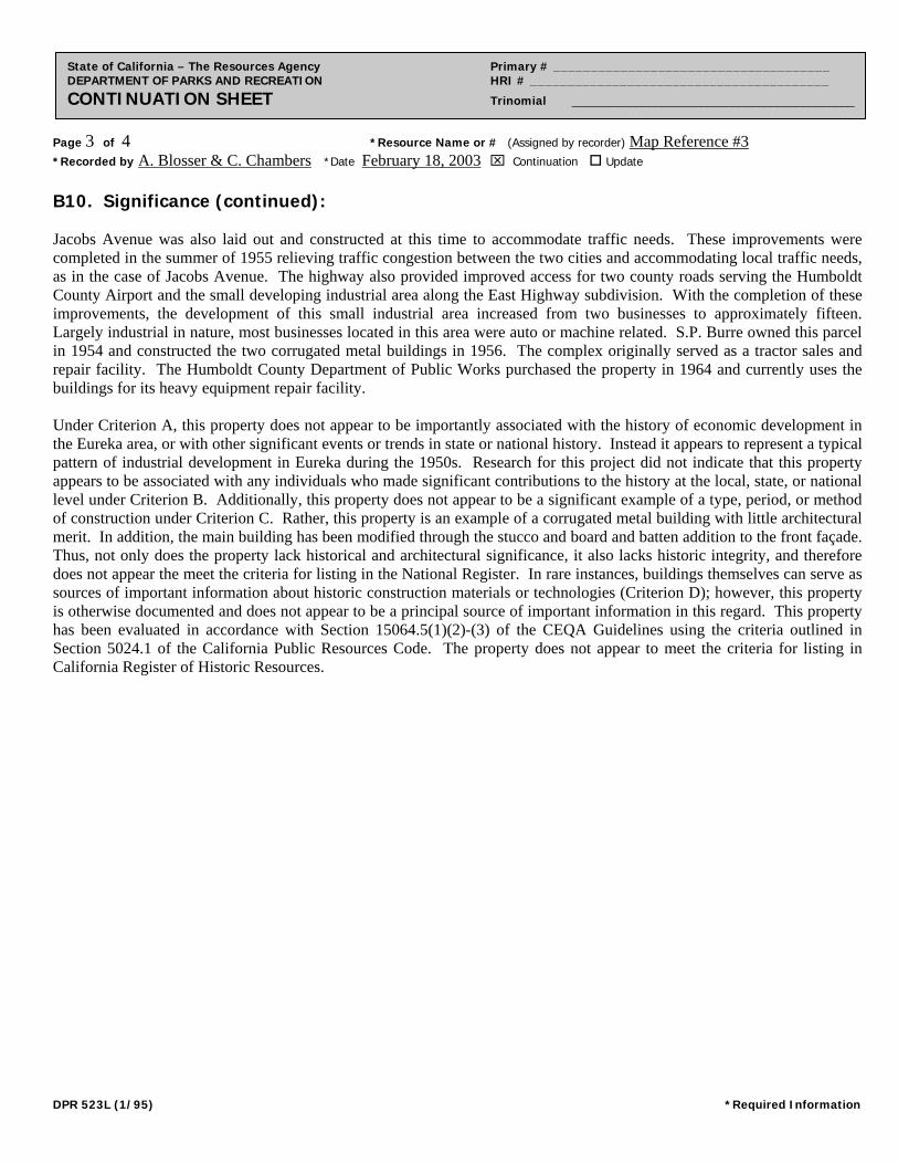
B10. Significance (continued): Jacobs Avenue was also laid out and constructed at this time to accommodate traffic needs. These improvements were completed in the summer of 1955 relieving traffic congestion between the two cities and accommodating local traffic needs, as in the case of Jacobs Avenue. The highway also provided improved access for two county roads serving the Humboldt County Airport and the small developing industrial area along the East Highway subdivision. With the completion of these improvements, the development of this small industrial area increased from two businesses to approximately fifteen. Largely industrial in nature, most businesses located in this area were auto or machine related. S.P. Burre owned this parcel in 1954 and constructed the two corrugated metal buildings in 1956. The complex originally served as a tractor sales and repair facility. The Humboldt County Department of Public Works purchased the property in 1964 and currently uses the buildings for its heavy equipment repair facility. Under Criterion A, this property does not appear to be importantly associated with the history of economic development in the Eureka area, or with other significant events or trends in state or national history. Instead it appears to represent a typical pattern of industrial development in Eureka during the 1950s. Research for this project did not indicate that this property appears to be associated with any individuals who made significant contributions to the history at the local, state, or national level under Criterion B. Additionally, this property does not appear to be a significant example of a type, period, or method of construction under Criterion C. Rather, this property is an example of a corrugated metal building with little architectural merit. In addition, the main building has been modified through the stucco and board and batten addition to the front façade. Thus, not only does the property lack historical and architectural significance, it also lacks historic integrity, and therefore does not appear the meet the criteria for listing in the National Register. In rare instances, buildings themselves can serve as sources of important information about historic construction materials or technologies (Criterion D); however, this property is otherwise documented and does not appear to be a principal source of important information in this regard. This property has been evaluated in accordance with Section 15064.5(1)(2)-(3) of the CEQA Guidelines using the criteria outlined in Section 5024.1 of the California Public Resources Code. The property does not appear to meet the criteria for listing in California Register of Historic Resources.
DPR 523L (1/95) *Required Information
Page 4 of 4 *Resource Name or # (Assigned by recorder) Map Reference #3 *Recorded by A. Blosser & C. Chambers *Date February 18, 2003 Continuation Update
State of California – The Resources Agency Primary # _____________________________________ DEPARTMENT OF PARKS AND RECREATION HRI # ________________________________________ CONTINUATION SHEET Trinomial ____________________________________________
Photographs (cont):
Photograph 2. View of stucco front addition and original building, camera facing southeast, February 18, 2003.
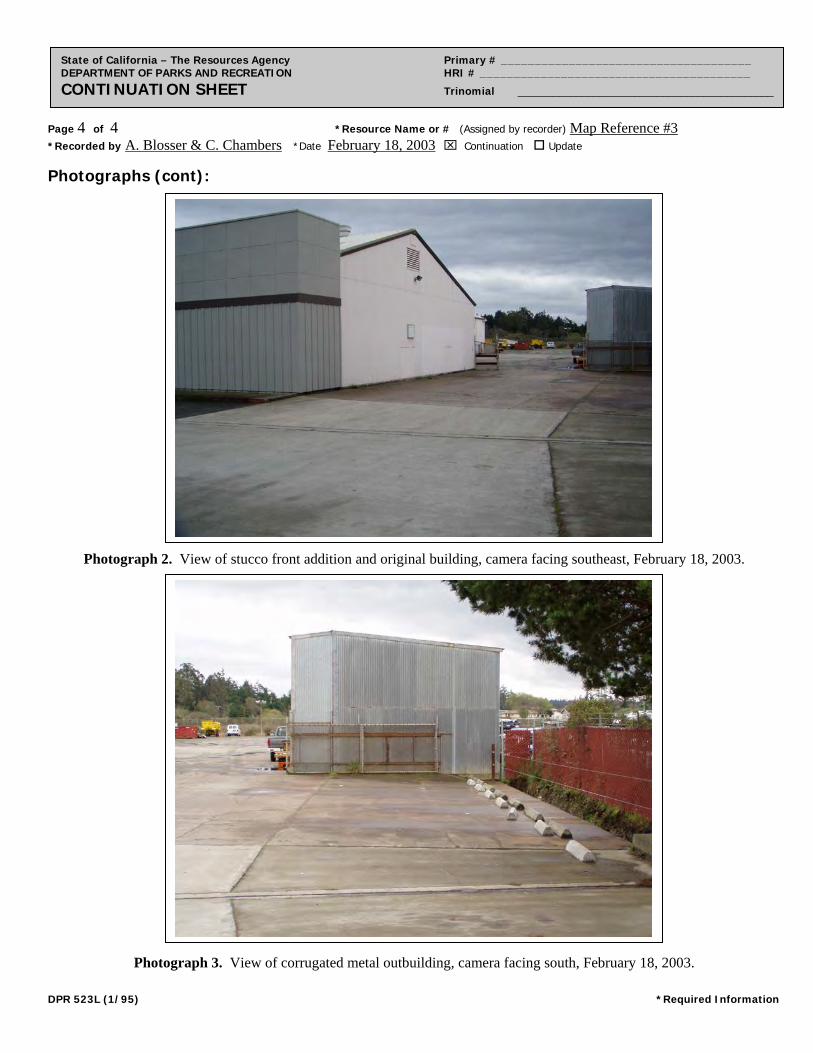
Photograph 3. View of corrugated metal outbuilding, camera facing south, February 18, 2003.
DPR 523L (1/95) *Required Information
Page 1 of 3 *Resource Name or # (Assigned by recorder) Map Reference #4
State of California – The Resources Agency Primary # _____________________________________ DEPARTMENT OF PARKS AND RECREATION HRI # ________________________________________ PRIMARY RECORD Trinomial _____________________________________ NRHP Status Code 6 Other Listings _______________________________________________________________ Review Code __________ Reviewer ____________________________ Date ___________
P1. Other Identifier: *P2. Location: Not for Publication Unrestricted *a. County Humboldt and (P2b and P2c or P2d. Attach a Location Map as necessary.) *b. USGS 7.5’ Quad Eureka Date 1959 T5N; R 1W; NW ¼ of Sec 24; H B.M. c. Address 3134 Jacobs Avenue City Eureka Zip 95501
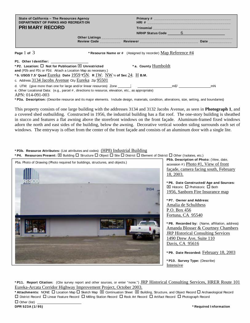
d. UTM: (give more than one for large and/or linear resources) Zone _____; ______________mE/ _____________mN e. Other Locational Data: (e.g., parcel #, directions to resource, elevation, etc., as appropriate) APN: 014-091-003 *P3a. Description: (Describe resource and its major elements. Include design, materials, condition, alterations, size, setting, and boundaries) This property consists of one large building with the addresses 3134 and 3132 Jacobs Avenue, as seen in Photograph 1, and a covered shed outbuilding. Constructed in 1956, the industrial building has a flat roof. The one-story building is sheathed in stucco and features a flat awning above the storefront windows on the front façade. Aluminum-framed fixed windows adorn the north and east sides of the building, below the awning. Decorative vertical wooden siding surrounds each set of windows. The entryway is offset from the center of the front façade and consists of an aluminum door with a single lite. *P3b. Resource Attributes: (List attributes and codes) (HP8) Industrial Building *P4. Resources Present: Building Structure Object Site District Element of District Other (Isolates, etc.)
P5b. Description of Photo: (View, date, accession #) Photo #1, View of front façade, camera facing south, February 18, 2003. *P6. Date Constructed/Age and Sources: Historic Prehistoric Both 1956, Sanborn Fire Insurance map *P7. Owner and Address: Amalia de Schulthess P.O. Box 456 Fortuna, CA 95540 *P8. Recorded by: (Name, affiliation, address) Amanda Blosser & Courtney Chambers JRP Historical Consulting Services 1490 Drew Ave, Suite 110 Davis, CA 95616
*P9. Date Recorded: February 18, 2003 *P10. Survey Type: (Describe) Intensive
P5a. Photo of Drawing (Photo required for buildings, structures, and objects.)
*P11. Report Citation: (Cite survey report and other sources, or enter “none.”) JRP Historical Consulting Services, HRER Route 101 Eureka-Arcata Corridor Highway Improvement Project, October 2003. *Attachments: NONE Location Map Sketch Map Continuation Sheet Building, Structure, and Object Record Archaeological Record District Record Linear Feature Record Milling Station Record Rock Art Record Artifact Record Photograph Record
Other (list) __________________ DPR 523A (1/95) *Required Information
Page 2 of 3 *NRHP Status Code 6
*Resource Name or # (Assigned by recorder) Map Reference #4
State of California – The Resources Agency Primary # _____________________________________ DEPARTMENT OF PARKS AND RECREATION HRI # ________________________________________ BUILDING, STRUCTURE, AND OBJECT RECORD
B1. Historic Name: A.C. Johnson & Sons, Inc., General Contracting B2. Common Name: B3. Original Use: Industrial B4. Present Use: Industrial *B5. Architectural Style: Utilitarian
*B6. Construction History: (Construction date, alteration, and date of alterations) Built circa 1956 *B7. Moved? No Yes Unknown Date: Original Location: *B8. Related Features: none B9. Architect: unknown b. Builder: unknown *B10. Significance: Theme n/a Area n/a Period of Significance n/a Property Type n/a Applicable Criteria n/a (Discuss importance in terms of historical or architectural context as defined by theme, period, and geographic scope. Also address integrity.)
This property does not appear to meet the criteria for listing in the National Register of Historic Places, nor does it appear to be a historical resource for the purposes of CEQA. Located in the East Highway Subdivision, this property developed as one of 38 lots in a small industrial area off Jacobs Avenue, a frontage road on the northbound lane of Highway 101. The reclaimed tidal marsh along Humboldt Bay was sparsely settled prior to the improvements of Highway 101 and consisted mainly of two small settlements, Brainard and Bayside, located north of the current Jacobs Avenue near the old state highway. State Highway 101 was laid out in 1919 along the western edge of Humboldt Bay to serve as a connector between Eureka and Arcata and became a major artery with the volume of traffic steadily increasing into the 1940s. Road improvements along this five-mile stretch of road became a necessity with the increasing traffic volume and in 1944 this section of Highway 101 was placed on the planning program as high-priority. When funds became available in 1954, construction started on the improvements on the five-mile section between Eureka and Gannon Sloughs. The improvements consisted of reconstruction of the old two-lane road, addition of two more lanes creating a four lane limited access route with channelized intersections at two county roads. (See continuation sheet).
B11. Additional Resource Attributes: (List attributes and codes) (HP4) Ancillary Building *B12. References: Sanborn Fire Insurance Maps, “Eureka,” 1956; City Directories (various years); Building Permits, Eureka Building Department; USGS Quadrangles Eureka and Arcata South (1959, 1972); “East Highway Subdivision Map,” Humboldt County Recorders Office; Caltrans As-Builts for Highway 101; County Assessor records as reported to First American Real Estate Solutions online service, 2003. B13. Remarks: *B14. Evaluator: Amanda Blosser *Date of Evaluation: February 27, 2003 (This space reserved for official comments.)
DPR 523B (1/95) *Required Information
Page 3 of 3 *Resource Name or # (Assigned by recorder) Map Reference #4 *Recorded by A. Blosser & C. Chambers *Date February 18, 2003 Continuation Update
State of California – The Resources Agency Primary # _____________________________________ DEPARTMENT OF PARKS AND RECREATION HRI # ________________________________________ CONTINUATION SHEET Trinomial ____________________________________________
B10. Significance (continued): Jacobs Avenue was also laid out and constructed at this time to accommodate traffic needs. These improvements were completed in the summer of 1955 relieving traffic congestion between the two cities and accommodating local traffic needs, as in the case of Jacobs Avenue. The highway also provided improved access for two county roads serving the Humboldt County Airport and the small developing industrial area along the East Highway subdivision. With the completion of these improvements, the development of this small industrial area increased from two businesses to approximately fifteen. Largely industrial in nature, most businesses located in this area were auto or machine related. A.C. Johnson & Sons owned the parcel by 1955 and constructed a building by 1956. A.C. Johnson & Sons, Inc., General Contracting occupied the site throughout the 1950s. Amalia de Schulthess purchased the property in 1992. Resco Construction Company currently occupies 3134 Jacobs Avenue, and United Rentals occupies 3132 Jacobs Avenue. Under Criterion A, this property does not appear to be importantly associated with the history of economic development in the Eureka area, or with other significant events or trends in state or national history. Instead it appears to be typical of development in Eureka during the 1950s. Research for this project did not indicate that this property appears to be associated with any individuals who made significant contributions to the history at the local, state, or national level under Criterion B. Additionally, this property does not appear to be a significant example of a type, period, or method of construction under Criterion C. Rather, this property is an example of a utilitarian building with little architectural merit. In rare instances, buildings themselves can serve as sources of important information about historic construction materials or technologies (Criterion D); however, this property is otherwise documented and does not appear to be a principal source of important information in this regard. This property has been evaluated in accordance with Section 15064.5(1)(2)-(3) of the CEQA Guidelines using the criteria outlined in Section 5024.1 of the California Public Resources Code. The property does not appear to meet the criteria for listing in California Register of Historic Resources.
DPR 523L (1/95) *Required Information
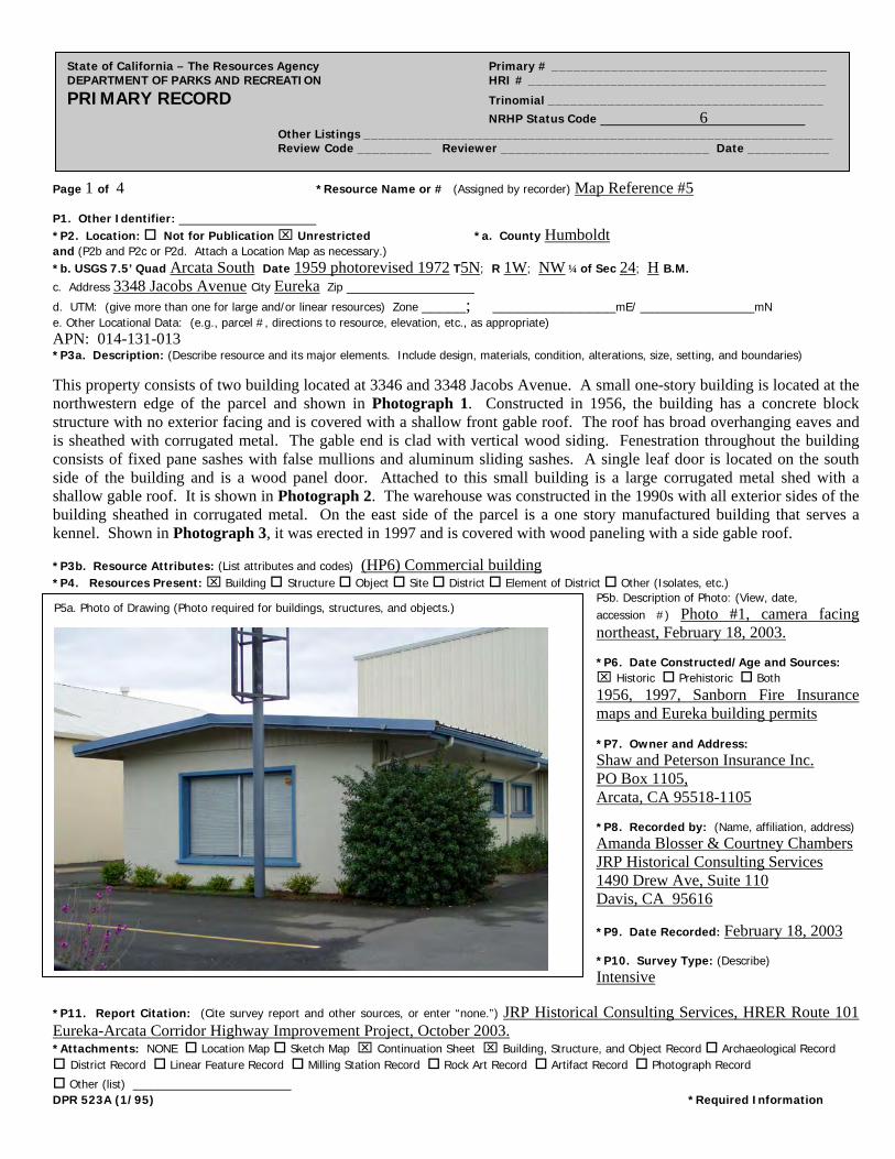
Page 1 of 4 *Resource Name or # (Assigned by recorder) Map Reference #5
State of California – The Resources Agency Primary # _____________________________________ DEPARTMENT OF PARKS AND RECREATION HRI # ________________________________________ PRIMARY RECORD Trinomial _____________________________________ NRHP Status Code 6 Other Listings _______________________________________________________________ Review Code __________ Reviewer ____________________________ Date ___________
P1. Other Identifier: *P2. Location: Not for Publication Unrestricted *a. County Humboldt and (P2b and P2c or P2d. Attach a Location Map as necessary.) *b. USGS 7.5’ Quad Arcata South Date 1959 photorevised 1972 T5N; R 1W; NW ¼ of Sec 24; H B.M. c. Address 3348 Jacobs Avenue City Eureka Zip
d. UTM: (give more than one for large and/or linear resources) Zone _____; ______________mE/ _____________mN e. Other Locational Data: (e.g., parcel #, directions to resource, elevation, etc., as appropriate) APN: 014-131-013 *P3a. Description: (Describe resource and its major elements. Include design, materials, condition, alterations, size, setting, and boundaries)
This property consists of two building located at 3346 and 3348 Jacobs Avenue. A small one-story building is located at the northwestern edge of the parcel and shown in Photograph 1. Constructed in 1956, the building has a concrete block structure with no exterior facing and is covered with a shallow front gable roof. The roof has broad overhanging eaves and is sheathed with corrugated metal. The gable end is clad with vertical wood siding. Fenestration throughout the building consists of fixed pane sashes with false mullions and aluminum sliding sashes. A single leaf door is located on the south side of the building and is a wood panel door. Attached to this small building is a large corrugated metal shed with a shallow gable roof. It is shown in Photograph 2. The warehouse was constructed in the 1990s with all exterior sides of the building sheathed in corrugated metal. On the east side of the parcel is a one story manufactured building that serves a kennel. Shown in Photograph 3, it was erected in 1997 and is covered with wood paneling with a side gable roof.
*P3b. Resource Attributes: (List attributes and codes) (HP6) Commercial building *P4. Resources Present: Building Structure Object Site District Element of District Other (Isolates, etc.)
P5b. Description of Photo: (View, date, accession #) Photo #1, camera facing northeast, February 18, 2003. *P6. Date Constructed/Age and Sources: Historic Prehistoric Both 1956, 1997, Sanborn Fire Insurance maps and Eureka building permits *P7. Owner and Address: Shaw and Peterson Insurance Inc. PO Box 1105, Arcata, CA 95518-1105 *P8. Recorded by: (Name, affiliation, address) Amanda Blosser & Courtney Chambers JRP Historical Consulting Services 1490 Drew Ave, Suite 110 Davis, CA 95616
*P9. Date Recorded: February 18, 2003 *P10. Survey Type: (Describe) Intensive
P5a. Photo of Drawing (Photo required for buildings, structures, and objects.)
*P11. Report Citation: (Cite survey report and other sources, or enter “none.”) JRP Historical Consulting Services, HRER Route 101 Eureka-Arcata Corridor Highway Improvement Project, October 2003. *Attachments: NONE Location Map Sketch Map Continuation Sheet Building, Structure, and Object Record Archaeological Record District Record Linear Feature Record Milling Station Record Rock Art Record Artifact Record Photograph Record
Other (list) __________________ DPR 523A (1/95) *Required Information
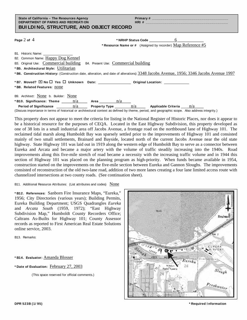
Page 2 of 4 *NRHP Status Code 6
*Resource Name or # (Assigned by recorder) Map Reference #5
State of California – The Resources Agency Primary # _____________________________________ DEPARTMENT OF PARKS AND RECREATION HRI # ________________________________________ BUILDING, STRUCTURE, AND OBJECT RECORD
B1. Historic Name: B2. Common Name: Happy Dog Kennel B3. Original Use: Commercial building B4. Present Use: Commercial building
*B5. Architectural Style: Utilitarian
*B6. Construction History: (Construction date, alteration, and date of alterations) 3348 Jacobs Avenue, 1956; 3346 Jacobs Avenue 1997 *B7. Moved? No Yes Unknown Date: Original Location: *B8. Related Features: none B9. Architect: None b. Builder: None *B10. Significance: Theme n/a Area n/a Period of Significance n/a Property Type n/a Applicable Criteria n/a (Discuss importance in terms of historical or architectural context as defined by theme, period, and geographic scope. Also address integrity.)
This property does not appear to meet the criteria for listing in the National Register of Historic Places, nor does it appear to be a historical resource for the purposes of CEQA. Located in the East Highway Subdivision, this property developed as one of 38 lots in a small industrial area off Jacobs Avenue, a frontage road on the northbound lane of Highway 101. The reclaimed tidal marsh along Humboldt Bay was sparsely settled prior to the improvements of Highway 101 and consisted mainly of two small settlements, Brainard and Bayside, located north of the current Jacobs Avenue near the old state highway. State Highway 101 was laid out in 1919 along the western edge of Humboldt Bay to serve as a connector between Eureka and Arcata and became a major artery with the volume of traffic steadily increasing into the 1940s. Road improvements along this five-mile stretch of road became a necessity with the increasing traffic volume and in 1944 this section of Highway 101 was placed on the planning program as high-priority. When funds became available in 1954, construction started on the improvements on the five-mile section between Eureka and Gannon Sloughs. The improvements consisted of reconstruction of the old two-lane road, addition of two more lanes creating a four lane limited access route with channelized intersections at two county roads. (See continuation sheet). B11. Additional Resource Attributes: (List attributes and codes) None *B12. References: Sanborn Fire Insurance Maps, “Eureka,” 1956; City Directories (various years); Building Permits, Eureka Building Department; USGS Quadrangles Eureka and Arcata South (1959, 1972); “East Highway Subdivision Map,” Humboldt County Recorders Office; Caltrans As-Builts for Highway 101; County Assessor records as reported to First American Real Estate Solutions online service, 2003. B13. Remarks: *B14. Evaluator: Amanda Blosser *Date of Evaluation: February 27, 2003 (This space reserved for official comments.)
DPR 523B (1/95) *Required Information
Page 3 of 4 *Resource Name or # (Assigned by recorder) Map Reference #5 *Recorded by A. Blosser & C. Chambers *Date February 18, 2003 Continuation Update
State of California – The Resources Agency Primary # _____________________________________ DEPARTMENT OF PARKS AND RECREATION HRI # ________________________________________ CONTINUATION SHEET Trinomial ____________________________________________
B10. Significance (continued): Jacobs Avenue was also laid out and constructed at this time to accommodate traffic needs. These improvements were completed in the summer of 1955 relieving traffic congestion between the two cities and accommodating local traffic needs, as in the case of Jacobs Avenue. The highway also provided improved access for two county roads serving the Humboldt County Airport and the small developing industrial area along the East Highway subdivision. With the completion of these improvements, the development of this small industrial area increased from two businesses to approximately fifteen. Largely industrial in nature, most businesses located in this area were auto or machine related. It is unknown who constructed this property in 1956 but it served as a restaurant. It was one of the few businesses along this strip that was not industrial. To the east side of the restaurant sat a one-story dwelling frame dwelling. The metal warehouse and kennel were erected on the site in the 1990s. Under Criterion A, this property does not appear to be associated with the history of the economic development in the Eureka area, or with other significant events or trends in state or national history. Instead it appears to be a typical example of development in Eureka during the 1950s. Research for this project did not indicate that this property appears to be associated with any individuals who made significant contributions to the history at the local, state, or national level under Criterion B. Additionally, this property does not appear to be a significant example of a type, period, or method of construction under Criterion C. Rather, this property is an example of a simple CMU building with little architectural merit. In rare instances, buildings themselves can serve as sources of important information about historic construction materials or technologies (Criterion D); however, this property is otherwise documented and does not appear to be a principal source of important information in this regard. This property has been evaluated in accordance with Section 15064.5(1)(2)-(3) of the CEQA Guidelines using the criteria outlined in Section 5024.1 of the California Public Resources Code. The property does not appear to meet the criteria for listing in California Register of Historic Resources.
DPR 523L (1/95) *Required Information
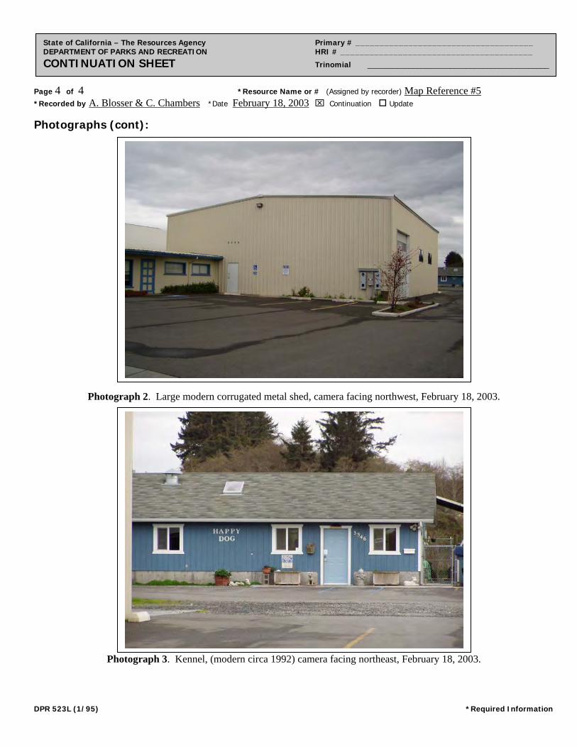
Page 4 of 4 *Resource Name or # (Assigned by recorder) Map Reference #5 *Recorded by A. Blosser & C. Chambers *Date February 18, 2003 Continuation Update
State of California – The Resources Agency Primary # _____________________________________ DEPARTMENT OF PARKS AND RECREATION HRI # ________________________________________ CONTINUATION SHEET Trinomial ____________________________________________
Photographs (cont):
Photograph 2. Large modern corrugated metal shed, camera facing northwest, February 18, 2003.
Photograph 3. Kennel, (modern circa 1992) camera facing northeast, February 18, 2003.
DPR 523L (1/95) *Required Information
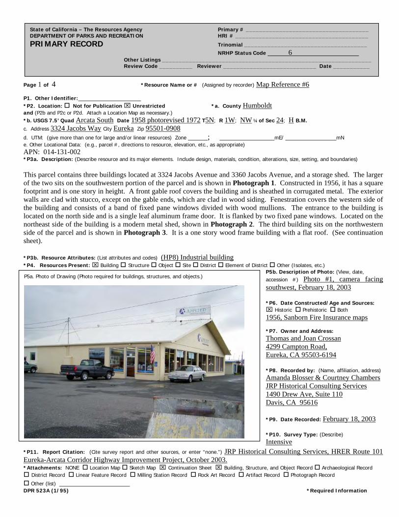
Page 1 of 4 *Resource Name or # (Assigned by recorder) Map Reference #6
State of California – The Resources Agency Primary # _____________________________________ DEPARTMENT OF PARKS AND RECREATION HRI # ________________________________________ PRIMARY RECORD Trinomial _____________________________________ NRHP Status Code 6 Other Listings _______________________________________________________________ Review Code __________ Reviewer ____________________________ Date ___________
P1. Other Identifier: *P2. Location: Not for Publication Unrestricted *a. County Humboldt and (P2b and P2c or P2d. Attach a Location Map as necessary.) *b. USGS 7.5’ Quad Arcata South Date 1958 photorevised 1972 T5N; R 1W; NW ¼ of Sec 24; H B.M. c. Address 3324 Jacobs Way City Eureka Zip 95501-0908
d. UTM: (give more than one for large and/or linear resources) Zone _____; ______________mE/ _____________mN e. Other Locational Data: (e.g., parcel #, directions to resource, elevation, etc., as appropriate) APN: 014-131-002 *P3a. Description: (Describe resource and its major elements. Include design, materials, condition, alterations, size, setting, and boundaries) This parcel contains three buildings located at 3324 Jacobs Avenue and 3360 Jacobs Avenue, and a storage shed. The larger of the two sits on the southwestern portion of the parcel and is shown in Photograph 1. Constructed in 1956, it has a square footprint and is one story in height. A front gable roof covers the building and is sheathed in corrugated metal. The exterior walls are clad with stucco, except on the gable ends, which are clad in wood siding. Fenestration covers the western side of the building and consists of a band of fixed pane windows divided with wood mullions. The entrance to the building is located on the north side and is a single leaf aluminum frame door. It is flanked by two fixed pane windows. Located on the northeast side of the building is a modern metal shed, shown in Photograph 2. The third building sits on the northwestern side of the parcel and is shown in Photograph 3. It is a one story wood frame building with a flat roof. (See continuation sheet). *P3b. Resource Attributes: (List attributes and codes) (HP8) Industrial building *P4. Resources Present: Building Structure Object Site District Element of District Other (Isolates, etc.)
P5b. Description of Photo: (View, date, accession #) Photo #1, camera facing southwest, February 18, 2003 *P6. Date Constructed/Age and Sources: Historic Prehistoric Both 1956, Sanborn Fire Insurance maps *P7. Owner and Address: Thomas and Joan Crossan 4299 Campton Road, Eureka, CA 95503-6194 *P8. Recorded by: (Name, affiliation, address) Amanda Blosser & Courtney Chambers JRP Historical Consulting Services 1490 Drew Ave, Suite 110 Davis, CA 95616 *P9. Date Recorded: February 18, 2003 *P10. Survey Type: (Describe) Intensive
P5a. Photo of Drawing (Photo required for buildings, structures, and objects.)
*P11. Report Citation: (Cite survey report and other sources, or enter “none.”) JRP Historical Consulting Services, HRER Route 101 Eureka-Arcata Corridor Highway Improvement Project, October 2003. *Attachments: NONE Location Map Sketch Map Continuation Sheet Building, Structure, and Object Record Archaeological Record District Record Linear Feature Record Milling Station Record Rock Art Record Artifact Record Photograph Record
Other (list) __________________ DPR 523A (1/95) *Required Information

Page 2 of 4 *NRHP Status Code 6
*Resource Name or # (Assigned by recorder) Map Reference #6
State of California – The Resources Agency Primary # _____________________________________ DEPARTMENT OF PARKS AND RECREATION HRI # ________________________________________ BUILDING, STRUCTURE, AND OBJECT RECORD
B1. Historic Name: Business Equipment Company B2. Common Name: Applied Technology
B3. Original Use: Commerical Building B4. Present Use: Commercial Building
*B5. Architectural Style: Utilitarian
*B6. Construction History: (Construction date, alteration, and date of alterations) 3334 and 3460 Jacobs Avenue, 1956; Storage Building, Modern *B7. Moved? No Yes Unknown Date: Original Location: *B8. Related Features: Modern Utility Shed B9. Architect: None b. Builder: Unknown *B10. Significance: Theme n/a Area n/a Period of Significance n/a Property Type n/a Applicable Criteria n/a (Discuss importance in terms of historical or architectural context as defined by theme, period, and geographic scope. Also address integrity.)
This property does not appear to meet the criteria for listing in the National Register of Historic Places, nor does it appear to be a historical resource for the purposes of CEQA. Located in the East Highway Subdivision, this property developed as one of 38 lots in a small industrial area off Jacobs Avenue, a frontage road on the northbound lane of Highway 101. The reclaimed tidal marsh along Humboldt Bay was sparsely settled prior to the improvements of Highway 101 and consisted mainly of two small settlements, Brainard and Bayside, located north of the current Jacobs Avenue near the old state highway. State Highway 101 was laid out in 1919 along the western edge of Humboldt Bay to serve as a connector between Eureka and Arcata and became a major artery with the volume of traffic steadily increasing into the 1940s. Road improvements along this five-mile stretch of road became a necessity with the increasing traffic volume and in 1944 this section of Highway 101 was placed on the planning program as high-priority. When funds became available in 1954, construction started on the improvements on the five-mile section between Eureka and Gannon Sloughs. The improvements consisted of reconstruction of the old two-lane road, addition of two more lanes creating a four lane limited access route with channelized intersections at two county roads. (See continuation sheet). B11. Additional Resource Attributes: (List attributes and codes) None *B12. References: Sanborn Fire Insurance Maps, “Eureka,” 1956; City Directories (various years); Building Permits, Eureka Building Department; USGS Quadrangles Eureka and Arcata South (1959, 1972); “East Highway Subdivision Map,” Humboldt County Recorders Office; Caltrans As-Builts for Highway 101; County Assessor records as reported to First American Real Estate Solutions online service, 2003. B13. Remarks: *B14. Evaluator: Amanda Blosser *Date of Evaluation: February 27, 2003 (This space reserved for official comments.)
DPR 523B (1/95) *Required Information
Page 3 of 4 *Resource Name or # (Assigned by recorder) Map Reference #6 *Recorded by A. Blosser & C. Chambers *Date February 18, 2003 Continuation Update
State of California – The Resources Agency Primary # _____________________________________ DEPARTMENT OF PARKS AND RECREATION HRI # ________________________________________ CONTINUATION SHEET Trinomial ____________________________________________
P3a. Description (continued): The exterior walls are clad in wood siding with a small, attached porch located on the west side of the building. Fenestration consists of aluminum sliding windows on the west and south sides. A single leaf door is located on the west side of the building and is a plain wood door. B10. Significance (continued): Jacobs Avenue was also laid out and constructed at this time to accommodate traffic needs. These improvements were completed in the summer of 1955 relieving traffic congestion between the two cities and accommodating local traffic needs, as in the case of Jacobs Avenue. The highway also provided improved access for two county roads serving the Humboldt County Airport and the small developing industrial area along the East Highway subdivision. With the completion of these improvements, the development of this small industrial area increased from two businesses to approximately fifteen. Largely industrial in nature, most businesses located in this area were auto or machine related. On this property in particular the two buildings were constructed in 1956 and served as a business supply store and a chain saw repair shop (3324) and as storage (3360). At the time of construction the parcel was owned by H.G. Guthridge but research did indicate whether he construction either of the businesses. Under Criterion A, this property does not appear to be importantly associated with the history of the economic development in the Eureka area, or with other significant events or trends in state or national history. Instead it appears to be typical of this type of development in Eureka during the 1950s. Research for this project did not indicate that this property appears to be associated with any individuals who made significant contributions to the history at the local, state, or national level under Criterion B. Additionally, it does not appear to be a significant example of a type, period, or method of construction. Rather, these buildings are typical examples of modern warehouses that could be mass produced buildings and assembled in different sizes as needed. This type of construction in well documented and prevalent in industrial districts across America and therefore does not appear to be eligible under Criterion C. In rare instances, buildings themselves can serve as sources of important information about historic construction materials or technologies (Criterion D); however, this property is otherwise documented and does not appear to be a principal source of important information in this regard. This property has been evaluated in accordance with Section 15064.5(1)(2)-(3) of the CEQA Guidelines using the criteria outlined in Section 5024.1 of the California Public Resources Code. The property does not appear to meet the criteria for listing in California Register of Historic Resources.
DPR 523L (1/95) *Required Information
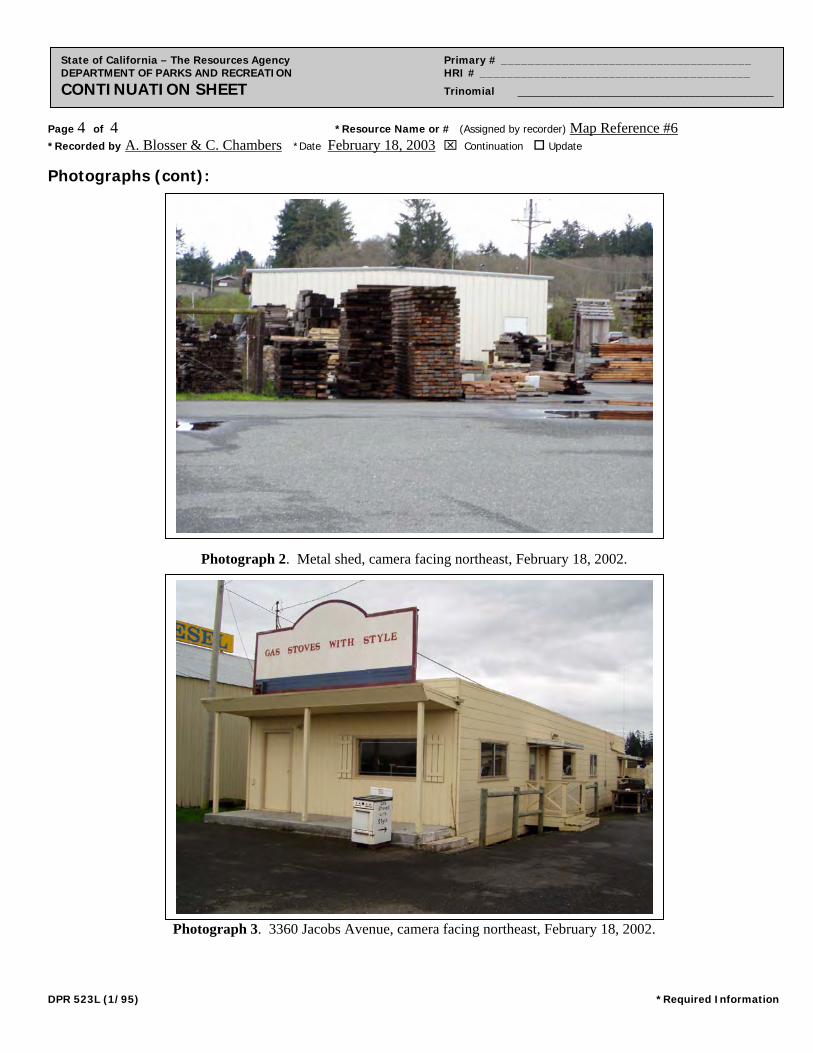
Page 4 of 4 *Resource Name or # (Assigned by recorder) Map Reference #6 *Recorded by A. Blosser & C. Chambers *Date February 18, 2003 Continuation Update
State of California – The Resources Agency Primary # _____________________________________ DEPARTMENT OF PARKS AND RECREATION HRI # ________________________________________ CONTINUATION SHEET Trinomial ____________________________________________
Photographs (cont):
Photograph 2. Metal shed, camera facing northeast, February 18, 2002.
Photograph 3. 3360 Jacobs Avenue, camera facing northeast, February 18, 2002.
DPR 523L (1/95) *Required Information
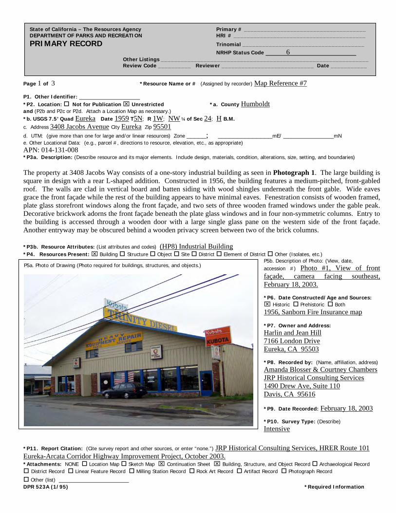
Page 1 of 3 *Resource Name or # (Assigned by recorder) Map Reference #7
State of California – The Resources Agency Primary # _____________________________________ DEPARTMENT OF PARKS AND RECREATION HRI # ________________________________________ PRIMARY RECORD Trinomial _____________________________________ NRHP Status Code 6 Other Listings _______________________________________________________________ Review Code __________ Reviewer ____________________________ Date ___________
P1. Other Identifier: *P2. Location: Not for Publication Unrestricted *a. County Humboldt and (P2b and P2c or P2d. Attach a Location Map as necessary.) *b. USGS 7.5’ Quad Eureka Date 1959 T5N; R 1W; NW ¼ of Sec 24; H B.M. c. Address 3408 Jacobs Avenue City Eureka Zip 95501
d. UTM: (give more than one for large and/or linear resources) Zone _____; ______________mE/ _____________mN e. Other Locational Data: (e.g., parcel #, directions to resource, elevation, etc., as appropriate) APN: 014-131-008 *P3a. Description: (Describe resource and its major elements. Include design, materials, condition, alterations, size, setting, and boundaries) The property at 3408 Jacobs Way consists of a one-story industrial building as seen in Photograph 1. The large building is square in design with a rear L-shaped addition. Constructed in 1956, the building features a medium-pitched, front-gabled roof. The walls are clad in vertical board and batten siding with wood shingles underneath the front gable. Wide eaves grace the front façade while the rest of the building appears to have minimal eaves. Fenestration consists of wooden framed, plate glass storefront windows along the front façade, and two sets of three wooden framed windows under the gable peak. Decorative brickwork adorns the front façade beneath the plate glass windows and in four non-symmetric columns. Entry to the building is accessed through a wooden door with a large single glass pane on the western side of the front façade. Another entryway may be obscured behind a wooden privacy screen between two of the brick columns. *P3b. Resource Attributes: (List attributes and codes) (HP8) Industrial Building *P4. Resources Present: Building Structure Object Site District Element of District Other (Isolates, etc.)
P5b. Description of Photo: (View, date, accession #) Photo #1, View of front façade, camera facing southeast, February 18, 2003. *P6. Date Constructed/Age and Sources: Historic Prehistoric Both 1956, Sanborn Fire Insurance map *P7. Owner and Address: Harlin and Jean Hill 7166 London Drive Eureka, CA 95503 *P8. Recorded by: (Name, affiliation, address) Amanda Blosser & Courtney Chambers JRP Historical Consulting Services 1490 Drew Ave, Suite 110 Davis, CA 95616
*P9. Date Recorded: February 18, 2003 *P10. Survey Type: (Describe) Intensive
P5a. Photo of Drawing (Photo required for buildings, structures, and objects.)
*P11. Report Citation: (Cite survey report and other sources, or enter “none.”) JRP Historical Consulting Services, HRER Route 101 Eureka-Arcata Corridor Highway Improvement Project, October 2003. *Attachments: NONE Location Map Sketch Map Continuation Sheet Building, Structure, and Object Record Archaeological Record District Record Linear Feature Record Milling Station Record Rock Art Record Artifact Record Photograph Record
Other (list) __________________ DPR 523A (1/95) *Required Information
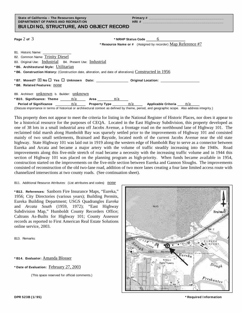
Page 2 of 3 *NRHP Status Code 6
*Resource Name or # (Assigned by recorder) Map Reference #7
State of California – The Resources Agency Primary # _____________________________________ DEPARTMENT OF PARKS AND RECREATION HRI # ________________________________________ BUILDING, STRUCTURE, AND OBJECT RECORD
B1. Historic Name: B2. Common Name: Trinity Diesel B3. Original Use: Industrial B4. Present Use: Industrial *B5. Architectural Style: Utilitarian
*B6. Construction History: (Construction date, alteration, and date of alterations) Constructed in 1956 *B7. Moved? No Yes Unknown Date: Original Location: *B8. Related Features: none B9. Architect: unknown b. Builder: unknown *B10. Significance: Theme n/a Area n/a Period of Significance n/a Property Type n/a Applicable Criteria n/a (Discuss importance in terms of historical or architectural context as defined by theme, period, and geographic scope. Also address integrity.) This property does not appear to meet the criteria for listing in the National Register of Historic Places, nor does it appear to be a historical resource for the purposes of CEQA. Located in the East Highway Subdivision, this property developed as one of 38 lots in a small industrial area off Jacobs Avenue, a frontage road on the northbound lane of Highway 101. The reclaimed tidal marsh along Humboldt Bay was sparsely settled prior to the improvements of Highway 101 and consisted mainly of two small settlements, Brainard and Bayside, located north of the current Jacobs Avenue near the old state highway. State Highway 101 was laid out in 1919 along the western edge of Humboldt Bay to serve as a connector between Eureka and Arcata and became a major artery with the volume of traffic steadily increasing into the 1940s. Road improvements along this five-mile stretch of road became a necessity with the increasing traffic volume and in 1944 this section of Highway 101 was placed on the planning program as high-priority. When funds became available in 1954, construction started on the improvements on the five-mile section between Eureka and Gannon Sloughs. The improvements consisted of reconstruction of the old two-lane road, addition of two more lanes creating a four lane limited access route with channelized intersections at two county roads. (See continuation sheet). B11. Additional Resource Attributes: (List attributes and codes) none *B12. References: Sanborn Fire Insurance Maps, “Eureka,” 1956; City Directories (various years); Building Permits, Eureka Building Department; USGS Quadrangles Eureka and Arcata South (1959, 1972); “East Highway Subdivision Map,” Humboldt County Recorders Office; Caltrans As-Builts for Highway 101; County Assessor records as reported to First American Real Estate Solutions online service, 2003. B13. Remarks: *B14. Evaluator: Amanda Blosser *Date of Evaluation: February 27, 2003 (This space reserved for official comments.)
DPR 523B (1/95) *Required Information
Page 3 of 3 *Resource Name or # (Assigned by recorder) Map Reference #7 *Recorded by A. Blosser & C. Chambers *Date February 18, 2003 Continuation Update
State of California – The Resources Agency Primary # _____________________________________ DEPARTMENT OF PARKS AND RECREATION HRI # ________________________________________ CONTINUATION SHEET Trinomial ____________________________________________
B10. Significance (continued): Jacobs Avenue was also laid out and constructed at this time to accommodate traffic needs. These improvements were completed in the summer of 1955 relieving traffic congestion between the two cities and accommodating local traffic needs, as in the case of Jacobs Avenue. The highway also provided improved access for two county roads serving the Humboldt County Airport and the small developing industrial area along the East Highway subdivision. With the completion of these improvements, the development of this small industrial area increased from two businesses to approximately fifteen. Largely industrial in nature, most businesses located in this area were auto or machine related. Constructed in 1956, this building originally housed Ryerson-Lucas Equipment Company, Inc., which remained at the address though the 1950s. Harlin and Jean Hill purchased the property in 1986. Trinity Diesel, Inc., a heavy equipment repair facility, currently occupies the building. Under Criterion A, this property does not appear to be importantly associated with the history of economic development in the Eureka area, or with other significant events or trends in state or national history. It instead represents typical pattern of outward industrial development in Eureka during the 1950s. Research for this project did not indicate that this property appears to be associated with any individuals who made significant contributions to the history at the local, state, or national level under Criterion B. Additionally, this property does not appear to be a significant example of a type, period, or method of construction under Criterion C. Rather, this property is an example of a utilitarian building with little architectural merit. In rare instances, buildings themselves can serve as sources of important information about historic construction materials or technologies (Criterion D); however, this property is otherwise documented and does not appear to be a principal source of important information in this regard. This property has been evaluated in accordance with Section 15064.5(1)(2)-(3) of the CEQA Guidelines using the criteria outlined in Section 5024.1 of the California Public Resources Code. The property does not appear to meet the criteria for listing in California Register of Historic Resources.
DPR 523L (1/95) *Required Information
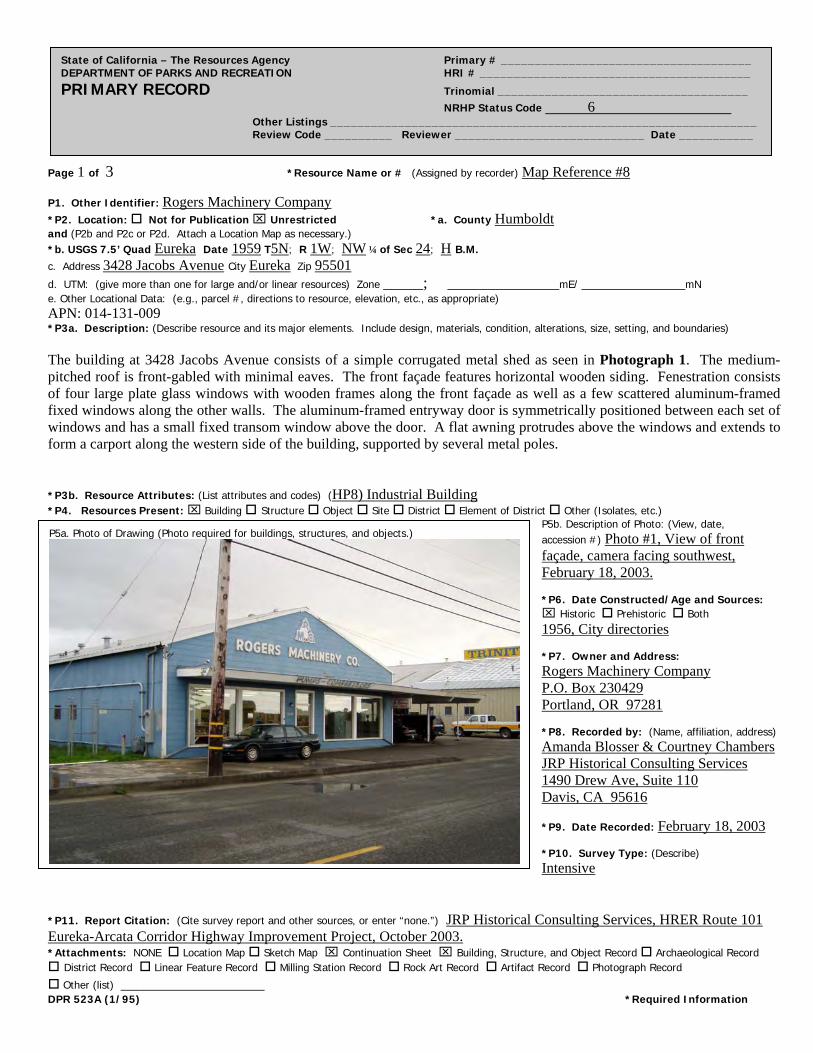
Page 1 of 3 *Resource Name or # (Assigned by recorder) Map Reference #8
State of California – The Resources Agency Primary # _____________________________________ DEPARTMENT OF PARKS AND RECREATION HRI # ________________________________________ PRIMARY RECORD Trinomial _____________________________________ NRHP Status Code 6 Other Listings _______________________________________________________________ Review Code __________ Reviewer ____________________________ Date ___________
P1. Other Identifier: Rogers Machinery Company
*P2. Location: Not for Publication Unrestricted *a. County Humboldt and (P2b and P2c or P2d. Attach a Location Map as necessary.) *b. USGS 7.5’ Quad Eureka Date 1959 T5N; R 1W; NW ¼ of Sec 24; H B.M. c. Address 3428 Jacobs Avenue City Eureka Zip 95501
d. UTM: (give more than one for large and/or linear resources) Zone _____; ______________mE/ _____________mN e. Other Locational Data: (e.g., parcel #, directions to resource, elevation, etc., as appropriate) APN: 014-131-009 *P3a. Description: (Describe resource and its major elements. Include design, materials, condition, alterations, size, setting, and boundaries) The building at 3428 Jacobs Avenue consists of a simple corrugated metal shed as seen in Photograph 1. The medium-pitched roof is front-gabled with minimal eaves. The front façade features horizontal wooden siding. Fenestration consists of four large plate glass windows with wooden frames along the front façade as well as a few scattered aluminum-framed fixed windows along the other walls. The aluminum-framed entryway door is symmetrically positioned between each set of windows and has a small fixed transom window above the door. A flat awning protrudes above the windows and extends to form a carport along the western side of the building, supported by several metal poles. *P3b. Resource Attributes: (List attributes and codes) (HP8) Industrial Building *P4. Resources Present: Building Structure Object Site District Element of District Other (Isolates, etc.)
P5b. Description of Photo: (View, date, accession #) Photo #1, View of front façade, camera facing southwest, February 18, 2003. *P6. Date Constructed/Age and Sources: Historic Prehistoric Both 1956, City directories *P7. Owner and Address: Rogers Machinery Company P.O. Box 230429 Portland, OR 97281 *P8. Recorded by: (Name, affiliation, address) Amanda Blosser & Courtney Chambers JRP Historical Consulting Services 1490 Drew Ave, Suite 110 Davis, CA 95616
*P9. Date Recorded: February 18, 2003 *P10. Survey Type: (Describe) Intensive
P5a. Photo of Drawing (Photo required for buildings, structures, and objects.)
*P11. Report Citation: (Cite survey report and other sources, or enter “none.”) JRP Historical Consulting Services, HRER Route 101 Eureka-Arcata Corridor Highway Improvement Project, October 2003. *Attachments: NONE Location Map Sketch Map Continuation Sheet Building, Structure, and Object Record Archaeological Record District Record Linear Feature Record Milling Station Record Rock Art Record Artifact Record Photograph Record
Other (list) __________________ DPR 523A (1/95) *Required Information
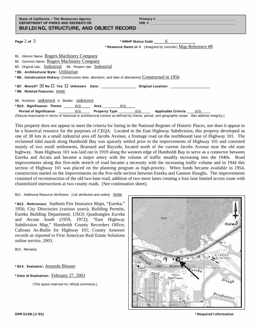
Page 2 of 3 *NRHP Status Code 6
*Resource Name or # (Assigned by recorder) Map Reference #8
State of California – The Resources Agency Primary # _____________________________________ DEPARTMENT OF PARKS AND RECREATION HRI # ________________________________________ BUILDING, STRUCTURE, AND OBJECT RECORD
B1. Historic Name: Rogers Machinery Company B2. Common Name: Rogers Machinery Company
B3. Original Use: Industrial B4. Present Use: Industrial *B5. Architectural Style: Utilitarian
*B6. Construction History: (Construction date, alteration, and date of alterations) Constructed in 1956 *B7. Moved? No Yes Unknown Date: Original Location: *B8. Related Features: none B9. Architect: unknown b. Builder: unknown *B10. Significance: Theme n/a Area n/a Period of Significance n/a Property Type n/a Applicable Criteria n/a (Discuss importance in terms of historical or architectural context as defined by theme, period, and geographic scope. Also address integrity.) This property does not appear to meet the criteria for listing in the National Register of Historic Places, nor does it appear to be a historical resource for the purposes of CEQA. Located in the East Highway Subdivision, this property developed as one of 38 lots in a small industrial area off Jacobs Avenue, a frontage road on the northbound lane of Highway 101. The reclaimed tidal marsh along Humboldt Bay was sparsely settled prior to the improvements of Highway 101 and consisted mainly of two small settlements, Brainard and Bayside, located north of the current Jacobs Avenue near the old state highway. State Highway 101 was laid out in 1919 along the western edge of Humboldt Bay to serve as a connector between Eureka and Arcata and became a major artery with the volume of traffic steadily increasing into the 1940s. Road improvements along this five-mile stretch of road became a necessity with the increasing traffic volume and in 1944 this section of Highway 101 was placed on the planning program as high-priority. When funds became available in 1954, construction started on the improvements on the five-mile section between Eureka and Gannon Sloughs. The improvements consisted of reconstruction of the old two-lane road, addition of two more lanes creating a four lane limited access route with channelized intersections at two county roads. (See continuation sheet). B11. Additional Resource Attributes: (List attributes and codes) none *B12. References: Sanborn Fire Insurance Maps, “Eureka,” 1956; City Directories (various years); Building Permits, Eureka Building Department; USGS Quadrangles Eureka and Arcata South (1959, 1972); “East Highway Subdivision Map,” Humboldt County Recorders Office; Caltrans As-Builts for Highway 101; County Assessor records as reported to First American Real Estate Solutions online service, 2003. B13. Remarks: *B14. Evaluator: Amanda Blosser *Date of Evaluation: February 27, 2003 (This space reserved for official comments.)
DPR 523B (1/95) *Required Information
Page 3 of 3 *Resource Name or # (Assigned by recorder) Map Reference #8 *Recorded by A. Blosser & C. Chambers *Date February 18, 2003 Continuation Update
State of California – The Resources Agency Primary # _____________________________________ DEPARTMENT OF PARKS AND RECREATION HRI # ________________________________________ CONTINUATION SHEET Trinomial ____________________________________________
B10. Significance (continued): Jacobs Avenue was also laid out and constructed at this time to accommodate traffic needs. These improvements were completed in the summer of 1955 relieving traffic congestion between the two cities and accommodating local traffic needs, as in the case of Jacobs Avenue. The highway also provided improved access for two county roads serving the Humboldt County Airport and the small developing industrial area along the East Highway subdivision. With the completion of these improvements, the development of this small industrial area increased from two businesses to approximately fifteen. Largely industrial in nature, most businesses located in this area were auto or machine related. Current owner and occupant Rogers Machinery Company purchased the property in 1956 and constructed the building that year. Under Criterion A, this property does not appear to be importantly associated with the history of economic development in the Eureka area, or with other significant events or trends in state or national history. Instead it appears to be a typical example of industrial development in Eureka during the 1950s. Research for this project did not indicate that this property appears to be associated with any individuals who made significant contributions to the history at the local, state, or national level under Criterion B. Additionally, this property does not appear to be a significant example of a type, period, or method of construction under Criterion C. Rather, this property is an example of a simple corrugated metal shed with little architectural merit. In rare instances, buildings themselves can serve as sources of important information about historic construction materials or technologies (Criterion D); however, this property is otherwise documented and does not appear to be a principal source of important information in this regard. This property has been evaluated in accordance with Section 15064.5(1)(2)-(3) of the CEQA Guidelines using the criteria outlined in Section 5024.1 of the California Public Resources Code. The property does not appear to meet the criteria for listing in California Register of Historic Resources.
DPR 523L (1/95) *Required Information
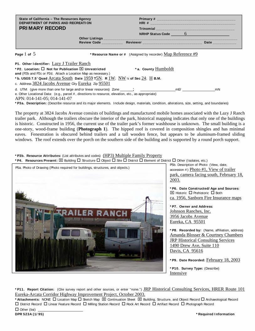
Page 1 of 5 *Resource Name or # (Assigned by recorder) Map Reference #9
State of California – The Resources Agency Primary # _____________________________________ DEPARTMENT OF PARKS AND RECREATION HRI # ________________________________________ PRIMARY RECORD Trinomial _____________________________________ NRHP Status Code 6 Other Listings _______________________________________________________________ Review Code __________ Reviewer ____________________________ Date ___________
P1. Other Identifier: Lazy J Trailer Ranch
*P2. Location: Not for Publication Unrestricted *a. County Humboldt and (P2b and P2c or P2d. Attach a Location Map as necessary.) *b. USGS 7.5’ Quad Arcata South Date 1959 T5N; R 1W; NW ¼ of Sec 24; H B.M. c. Address 3824 Jacobs Avenue City Eureka Zip 95501
d. UTM: (give more than one for large and/or linear resources) Zone _____; ______________mE/ _____________mN e. Other Locational Data: (e.g., parcel #, directions to resource, elevation, etc., as appropriate) APN: 014-141-05; 014-141-07 *P3a. Description: (Describe resource and its major elements. Include design, materials, condition, alterations, size, setting, and boundaries) The property at 3824 Jacobs Avenue consists of buildings and manufactured mobile homes associated with the Lazy J Ranch trailer park. Although the trailers obscure the interior of the park, historical mapping indicates that only one of the buildings is historic. Constructed in 1956, the current use of the trailer park’s former washhouse is unknown. The small building is a one-story, wood-frame building (Photograph 1). The hipped roof is covered in composition shingles and has minimal eaves. Fenestration is obscured behind trailers and a tall wooden fence, but appears to be aluminum-framed sliding windows. The roof extends over the porch on the southern side of the building and is supported by a round porch support. *P3b. Resource Attributes: (List attributes and codes) (HP3) Multiple Family Property *P4. Resources Present: Building Structure Object Site District Element of District Other (Isolates, etc.)
P5b. Description of Photo: (View, date, accession #) Photo #1, View of trailer park, camera facing south, February 18, 2003. *P6. Date Constructed/Age and Sources: Historic Prehistoric Both ca. 1956, Sanborn Fire Insurance maps *P7. Owner and Address: Johnson Ranches, Inc. 3956 Jacobs Avenue Eureka, CA 95501 *P8. Recorded by: (Name, affiliation, address) Amanda Blosser & Courtney Chambers JRP Historical Consulting Services 1490 Drew Ave, Suite 110 Davis, CA 95616
*P9. Date Recorded: February 18, 2003 *P10. Survey Type: (Describe) Intensive
P5a. Photo of Drawing (Photo required for buildings, structures, and objects.)
*P11. Report Citation: (Cite survey report and other sources, or enter “none.”) JRP Historical Consulting Services, HRER Route 101 Eureka-Arcata Corridor Highway Improvement Project, October 2003. *Attachments: NONE Location Map Sketch Map Continuation Sheet Building, Structure, and Object Record Archaeological Record District Record Linear Feature Record Milling Station Record Rock Art Record Artifact Record Photograph Record
Other (list) __________________ DPR 523A (1/95) *Required Information
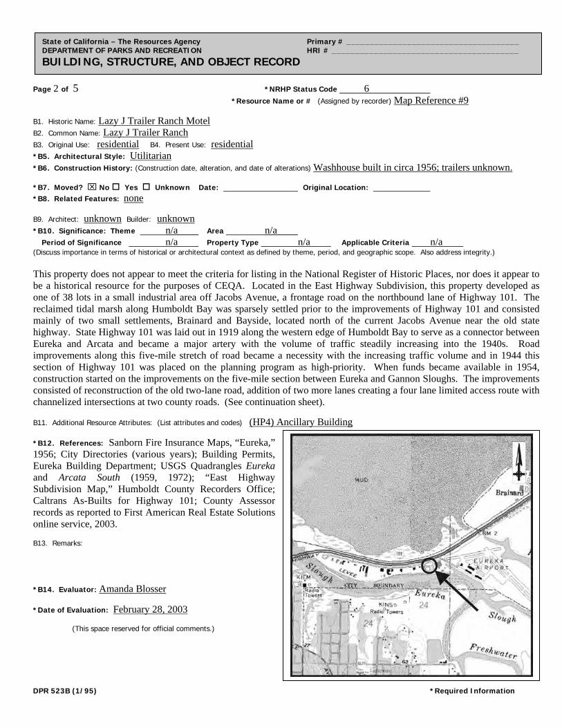
Page 2 of 5 *NRHP Status Code 6
*Resource Name or # (Assigned by recorder) Map Reference #9
State of California – The Resources Agency Primary # _____________________________________ DEPARTMENT OF PARKS AND RECREATION HRI # ________________________________________ BUILDING, STRUCTURE, AND OBJECT RECORD
B1. Historic Name: Lazy J Trailer Ranch Motel B2. Common Name: Lazy J Trailer Ranch
B3. Original Use: residential B4. Present Use: residential *B5. Architectural Style: Utilitarian
*B6. Construction History: (Construction date, alteration, and date of alterations) Washhouse built in circa 1956; trailers unknown. *B7. Moved? No Yes Unknown Date: Original Location: *B8. Related Features: none B9. Architect: unknown Builder: unknown *B10. Significance: Theme n/a Area n/a Period of Significance n/a Property Type n/a Applicable Criteria n/a (Discuss importance in terms of historical or architectural context as defined by theme, period, and geographic scope. Also address integrity.) This property does not appear to meet the criteria for listing in the National Register of Historic Places, nor does it appear to be a historical resource for the purposes of CEQA. Located in the East Highway Subdivision, this property developed as one of 38 lots in a small industrial area off Jacobs Avenue, a frontage road on the northbound lane of Highway 101. The reclaimed tidal marsh along Humboldt Bay was sparsely settled prior to the improvements of Highway 101 and consisted mainly of two small settlements, Brainard and Bayside, located north of the current Jacobs Avenue near the old state highway. State Highway 101 was laid out in 1919 along the western edge of Humboldt Bay to serve as a connector between Eureka and Arcata and became a major artery with the volume of traffic steadily increasing into the 1940s. Road improvements along this five-mile stretch of road became a necessity with the increasing traffic volume and in 1944 this section of Highway 101 was placed on the planning program as high-priority. When funds became available in 1954, construction started on the improvements on the five-mile section between Eureka and Gannon Sloughs. The improvements consisted of reconstruction of the old two-lane road, addition of two more lanes creating a four lane limited access route with channelized intersections at two county roads. (See continuation sheet).
B11. Additional Resource Attributes: (List attributes and codes) (HP4) Ancillary Building *B12. References: Sanborn Fire Insurance Maps, “Eureka,” 1956; City Directories (various years); Building Permits, Eureka Building Department; USGS Quadrangles Eureka and Arcata South (1959, 1972); “East Highway Subdivision Map,” Humboldt County Recorders Office; Caltrans As-Builts for Highway 101; County Assessor records as reported to First American Real Estate Solutions online service, 2003. B13. Remarks: *B14. Evaluator: Amanda Blosser *Date of Evaluation: February 28, 2003 (This space reserved for official comments.)
DPR 523B (1/95) *Required Information

Page 3 of 5 *Resource Name or # (Assigned by recorder) Map Reference #9 *Recorded by A. Blosser & C. Chambers *Date February 18, 2003 Continuation Update
State of California – The Resources Agency Primary # _____________________________________ DEPARTMENT OF PARKS AND RECREATION HRI # ________________________________________ CONTINUATION SHEET Trinomial ____________________________________________
B10. Significance (continued): Jacobs Avenue was also laid out and constructed at this time to accommodate traffic needs. These improvements were completed in the summer of 1955 relieving traffic congestion between the two cities and accommodating local traffic needs, as in the case of Jacobs Avenue. The highway also provided improved access for two county roads serving the Humboldt County Airport and the small developing industrial area along the East Highway subdivision. With the completion of these improvements, the development of this small industrial area increased from two businesses to approximately fifteen. Largely industrial in nature, most businesses located in this area were auto or machine related. Carl A. Johnson, owner of the former feedlot and commercial property north of the trailer park, owned the property at 3824 Jacobs Avenue by 1954 and laid out the trailer park in the mid-1950s. According to the 1956 Sanborn Fire Insurance map, Johnson constructed the washhouse in 1956 and trailers were most likely moved to the site shortly thereafter. Historical mapping indicates that no additional buildings were built between 1959 and 1972. Johnson Ranches, Inc., a business associated with Carl Johnson’s descendents, has owned the trailer park since 1959. Under Criterion A, this property does not appear to be importantly associated with the history of economic development in the Eureka area, or with other significant events or trends in state or national history. This mobile home park does not appear to be significant within the development of the mobile home from a recreation vehicle to year-around housing. Research for this project did not indicate that this property appears nor to be associated with any individuals who made significant contributions to the history at the local, state, or national level under Criterion B. Additionally, this property does not appear to be a significant example of a type, period, or method of construction under Criterion C. Rather, this property is an example of a small, utilitarian building with little architectural merit set in the midst of a trailer park. In rare instances, buildings themselves can serve as sources of important information about historic construction materials or technologies (Criterion D); however, this property is otherwise documented and does not appear to be a principal source of important information in this regard. This property has been evaluated in accordance with Section 15064.5(1)(2)-(3) of the CEQA Guidelines using the criteria outlined in Section 5024.1 of the California Public Resources Code. The property does not appear to meet the criteria for listing in California Register of Historic Resources.
DPR 523L (1/95) *Required Information
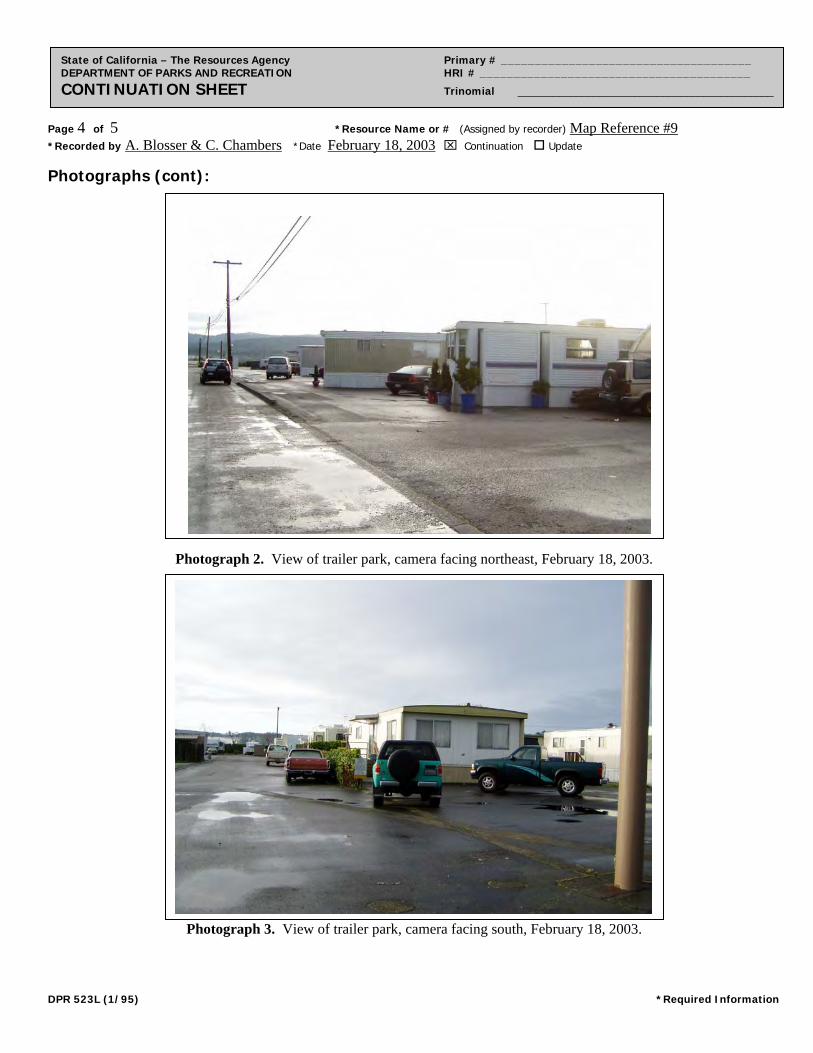
Page 4 of 5 *Resource Name or # (Assigned by recorder) Map Reference #9 *Recorded by A. Blosser & C. Chambers *Date February 18, 2003 Continuation Update
State of California – The Resources Agency Primary # _____________________________________ DEPARTMENT OF PARKS AND RECREATION HRI # ________________________________________ CONTINUATION SHEET Trinomial ____________________________________________
Photographs (cont):
Photograph 2. View of trailer park, camera facing northeast, February 18, 2003.
Photograph 3. View of trailer park, camera facing south, February 18, 2003.
DPR 523L (1/95) *Required Information
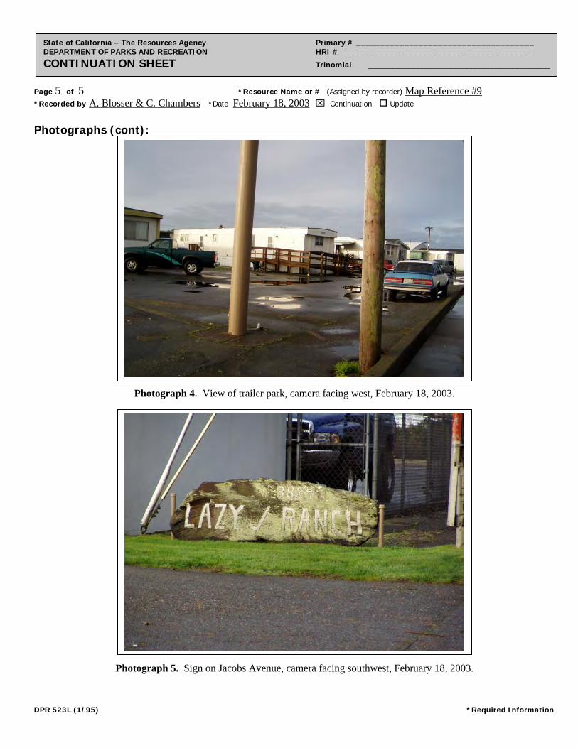
Page 5 of 5 *Resource Name or # (Assigned by recorder) Map Reference #9 *Recorded by A. Blosser & C. Chambers *Date February 18, 2003 Continuation Update
State of California – The Resources Agency Primary # _____________________________________ DEPARTMENT OF PARKS AND RECREATION HRI # ________________________________________ CONTINUATION SHEET Trinomial ____________________________________________
Photographs (cont):
Photograph 4. View of trailer park, camera facing west, February 18, 2003.
Photograph 5. Sign on Jacobs Avenue, camera facing southwest, February 18, 2003.
DPR 523L (1/95) *Required Information
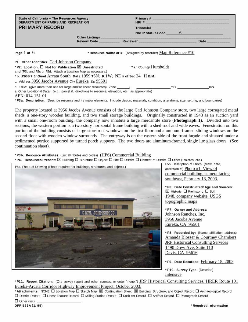
Page 1 of 6 *Resource Name or # (Assigned by recorder) Map Reference #10
State of California – The Resources Agency Primary # _____________________________________ DEPARTMENT OF PARKS AND RECREATION HRI # ________________________________________ PRIMARY RECORD Trinomial _____________________________________ NRHP Status Code 6 Other Listings _______________________________________________________________ Review Code __________ Reviewer ____________________________ Date ___________
P1. Other Identifier: Carl Johnson Company
*P2. Location: Not for Publication Unrestricted *a. County Humboldt and (P2b and P2c or P2d. Attach a Location Map as necessary.) *b. USGS 7.5’ Quad Arcata South Date 1959 T5N; R 1W; NE ¼ of Sec 24; H B.M. c. Address 3956 Jacobs Avenue City Eureka Zip 95501
d. UTM: (give more than one for large and/or linear resources) Zone _____; ______________mE/ _____________mN e. Other Locational Data: (e.g., parcel #, directions to resource, elevation, etc., as appropriate) APN: 014-151-01 *P3a. Description: (Describe resource and its major elements. Include design, materials, condition, alterations, size, setting, and boundaries) The property located at 3956 Jacobs Avenue consists of the large Carl Johnson Company store, two large corrugated metal sheds, a one-story wooden building, and two small storage buildings. Originally constructed in 1948 as an auction yard with a small one-room building, the company now inhabits a large mercantile store (Photograph 1). Divided into two sections, the western portion is a two-story horizontal frame building with a shed roof and wide eaves. Fenestration on this portion of the building consists of large storefront windows on the first floor and aluminum-framed sliding windows on the second floor with wooden window surrounds. The entryway is on the eastern side of the front façade and situated under a pedimented portico supported by turned porch supports. The two doors are aluminum-framed, single lite glass doors. (See continuation sheet).
*P3b. Resource Attributes: (List attributes and codes) (HP6) Commercial Building *P4. Resources Present: Building Structure Object Site District Element of District Other (Isolates, etc.)
P5b. Description of Photo: (View, date, accession #) Photo #1, View of commercial building, camera facing southeast, February 18, 2003. *P6. Date Constructed/Age and Sources: Historic Prehistoric Both 1948, company website, USGS topographic maps *P7. Owner and Address: Johnson Ranches, Inc. 3956 Jacobs Avenue Eureka, CA 95501 *P8. Recorded by: (Name, affiliation, address) Amanda Blosser & Courtney Chambers JRP Historical Consulting Services 1490 Drew Ave, Suite 110 Davis, CA 95616
*P9. Date Recorded: February 18, 2003 *P10. Survey Type: (Describe)
Intensive
P5a. Photo of Drawing (Photo required for buildings, structures, and objects.)
*P11. Report Citation: (Cite survey report and other sources, or enter “none.”) JRP Historical Consulting Services, HRER Route 101 Eureka-Arcata Corridor Highway Improvement Project, October 2003. *Attachments: NONE Location Map Sketch Map Continuation Sheet Building, Structure, and Object Record Archaeological Record District Record Linear Feature Record Milling Station Record Rock Art Record Artifact Record Photograph Record
Other (list) __________________ DPR 523A (1/95) *Required Information

Page 2 of 6 *NRHP Status Code 6
*Resource Name or # (Assigned by recorder) Map Reference #10
State of California – The Resources Agency Primary # _____________________________________ DEPARTMENT OF PARKS AND RECREATION HRI # ________________________________________ BUILDING, STRUCTURE, AND OBJECT RECORD
B1. Historic Name: Carl Johnson Company B2. Common Name: Carl Johnson Company
B3. Original Use: Commercial B4. Present Use: Commercial *B5. Architectural Style: Utilitarian
*B6. Construction History: (Construction date, alteration, and date of alterations) Constructed 1948, modifications dates unknown *B7. Moved? No Yes Unknown Date: Original Location: *B8. Related Features: none B9. Architect: unknown b. Builder: unknown *B10. Significance: Theme n/a Area n/a Period of Significance n/a Property Type n/a Applicable Criteria n/a (Discuss importance in terms of historical or architectural context as defined by theme, period, and geographic scope. Also address integrity.) This property does not appear to meet the criteria for listing in the National Register of Historic Places, nor does it appear to be a historical resource for the purposes of CEQA. Located west of the East Highway Subdivision and adjacent to the Eureka Airport, this property originally developed as a feedlot and agricultural supply complex serving the rural area north of Eureka. The reclaimed tidal marsh along Humboldt Bay was sparsely settled prior to the improvements of Highway 101 and consisted mainly of two small settlements, Brainard and Bayside, located north of the current Jacobs Avenue near the old state highway. State Highway 101 was laid out in 1919 along the western edge of Humboldt Bay to serve as a connector between Eureka and Arcata and became a major artery with the volume of traffic steadily increasing into the 1940s. Road improvements along this five-mile stretch of road became a necessity with the increasing traffic volume and in 1944 this section of Highway 101 was placed on the planning program as high-priority. When funds became available in 1954, construction started on the improvements on the five-mile section between Eureka and Gannon Sloughs. The improvements consisted of reconstruction of the old two-lane road, addition of two more lanes creating a four lane limited access route with channelized intersections at two county roads. (See continuation sheet).
B11. Additional Resource Attributes: (List attributes and codes) (HP4) Ancillary Building *B12. References: Sanborn Fire Insurance Maps, “Eureka,” 1956; City Directories (various years); Building Permits, Eureka Building Department; USGS Quadrangles Eureka and Arcata South (1951, 1959, 1972); Caltrans As-Builts for Highway 101; County Assessor records as reported to First American Real Estate Solutions online service, 2003. B13. Remarks: *B14. Evaluator: Amanda Blosser *Date of Evaluation: February 28, 2003 (This space reserved for official comments.)
DPR 523B (1/95) *Required Information
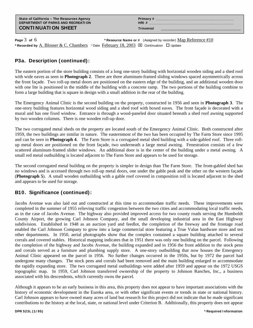
Page 3 of 6 *Resource Name or # (Assigned by recorder) Map Reference #10 *Recorded by A. Blosser & C. Chambers *Date February 18, 2003 Continuation Update
State of California – The Resources Agency Primary # _____________________________________ DEPARTMENT OF PARKS AND RECREATION HRI # ________________________________________ CONTINUATION SHEET Trinomial ____________________________________________
P3a. Description (continued): The eastern portion of the store building consists of a long one-story building with horizontal wooden siding and a shed roof with wide eaves as seen in Photograph 2. There are three aluminum-framed sliding windows spaced asymmetrically across the front façade. Two roll-up metal doors are positioned on the eastern edge of the building, and an additional wooden door with one lite is positioned in the middle of the building with a concrete ramp. The two portions of the building combine to form a large building that is square in design with a small addition in the rear of the building. The Emergency Animal Clinic is the second building on the property, constructed in 1956 and seen in Photograph 3. The one-story building features horizontal wood siding and a shed roof with boxed eaves. The front façade is decorated with a mural and has one fixed window. Entrance is through a wood-paneled door situated beneath a shed roof awning supported by two wooden columns. There is one wooden roll-up door. The two corrugated metal sheds on the property are located south of the Emergency Animal Clinic. Both constructed after 1959, the two buildings are similar in nature. The easternmost of the two has been occupied by The Farm Store since 1995 and can be seen in Photograph 4. The Farm Store is a corrugated metal shed building with a side-gabled roof. Three roll-up metal doors are positioned on the front façade, two underneath a large metal awning. Fenestration consists of a few scattered aluminum-framed slider windows. An additional door is in the center of the building under a metal awning. A small red metal outbuilding is located adjacent to The Farm Store and appears to be used for storage. The second corrugated metal building on the property is simpler in design than The Farm Store. The front-gabled shed has no windows and is accessed through two roll-up metal doors, one under the gable peak and the other on the western façade (Photograph 5). A small wooden outbuilding with a gable roof covered in composition roll is located adjacent to the shed and appears to be used for storage. B10. Significance (continued): Jacobs Avenue was also laid out and constructed at this time to accommodate traffic needs. These improvements were completed in the summer of 1955 relieving traffic congestion between the two cities and accommodating local traffic needs, as in the case of Jacobs Avenue. The highway also provided improved access for two county roads serving the Humboldt County Airport, the growing Carl Johnson Company, and the small developing industrial area in the East Highway subdivision. Established in 1948 as an auction yard and feedlot, the completion of the freeway and the frontage road enabled the Carl Johnson Company to grow into a large commercial store featuring a True Value hardware store and ten other departments. In 1950, aerial photographs show that the complex contained a square building attached to several corrals and covered stables. Historical mapping indicates that in 1951 there was only one building on the parcel. Following the completion of the highway and Jacobs Avenue, the building expanded and in 1956 the front addition to the stock pens and corrals served as a furniture and plumbing supply store. A one-story outbuilding that now houses the Emergency Animal Clinic appeared on the parcel in 1956. No further changes occurred in the 1950s, but by 1972 the parcel had undergone many changes. The stock pens and corrals had been removed and the main building enlarged to accommodate the rapidly expanding store. The two corrugated metal outbuildings were added after 1959 and appear on the 1972 USGS topographic map. In 1959, Carl Johnson transferred ownership of the property to Johnson Ranches, Inc., a business associated with his descendents, which currently owns the parcel. Although it appears to be an early business in this area, this property does not appear to have important associations with the history of economic development in the Eureka area, or with other significant events or trends in state or national history. Carl Johnson appears to have owned many acres of land but research for this project did not indicate that he made significant contributions to the history at the local, state, or national level under Criterion B. Additionally, this property does not appear
DPR 523L (1/95) *Required Information
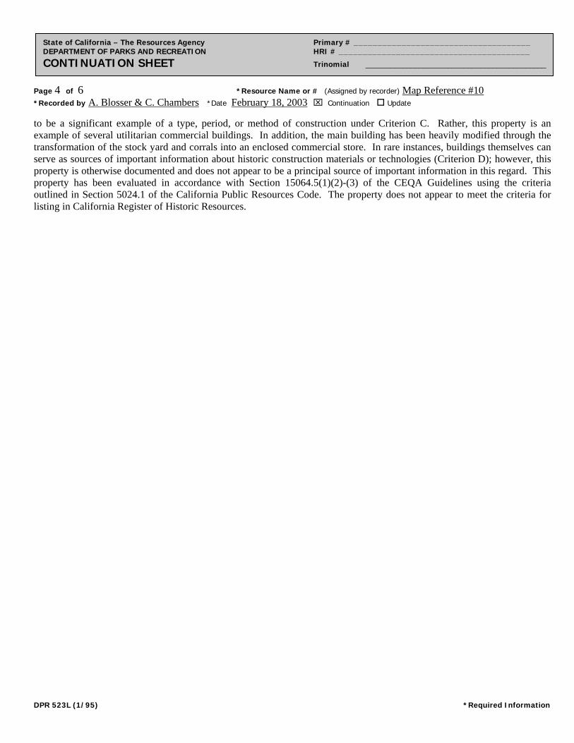
Page 4 of 6 *Resource Name or # (Assigned by recorder) Map Reference #10 *Recorded by A. Blosser & C. Chambers *Date February 18, 2003 Continuation Update
State of California – The Resources Agency Primary # _____________________________________ DEPARTMENT OF PARKS AND RECREATION HRI # ________________________________________ CONTINUATION SHEET Trinomial ____________________________________________
to be a significant example of a type, period, or method of construction under Criterion C. Rather, this property is an example of several utilitarian commercial buildings. In addition, the main building has been heavily modified through the transformation of the stock yard and corrals into an enclosed commercial store. In rare instances, buildings themselves can serve as sources of important information about historic construction materials or technologies (Criterion D); however, this property is otherwise documented and does not appear to be a principal source of important information in this regard. This property has been evaluated in accordance with Section 15064.5(1)(2)-(3) of the CEQA Guidelines using the criteria outlined in Section 5024.1 of the California Public Resources Code. The property does not appear to meet the criteria for listing in California Register of Historic Resources.
DPR 523L (1/95) *Required Information
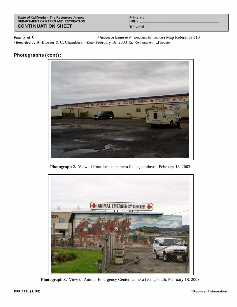
Page 5 of 6 *Resource Name or # (Assigned by recorder) Map Reference #10 *Recorded by A. Blosser & C. Chambers *Date February 18, 2003 Continuation Update
State of California – The Resources Agency Primary # _____________________________________ DEPARTMENT OF PARKS AND RECREATION HRI # ________________________________________ CONTINUATION SHEET Trinomial ____________________________________________
Photographs (cont):
Photograph 2. View of front façade, camera facing southeast, February 18, 2003.
Photograph 3. View of Animal Emergency Center, camera facing south, February 18, 2003.
DPR 523L (1/95) *Required Information
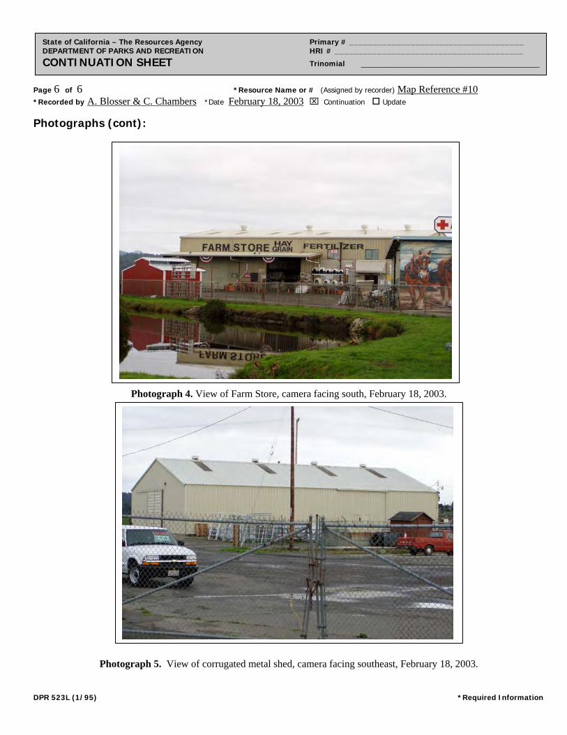
Page 6 of 6 *Resource Name or # (Assigned by recorder) Map Reference #10 *Recorded by A. Blosser & C. Chambers *Date February 18, 2003 Continuation Update
State of California – The Resources Agency Primary # _____________________________________ DEPARTMENT OF PARKS AND RECREATION HRI # ________________________________________ CONTINUATION SHEET Trinomial ____________________________________________
Photographs (cont):
Photograph 4. View of Farm Store, camera facing south, February 18, 2003.
Photograph 5. View of corrugated metal shed, camera facing southeast, February 18, 2003.
DPR 523L (1/95) *Required Information
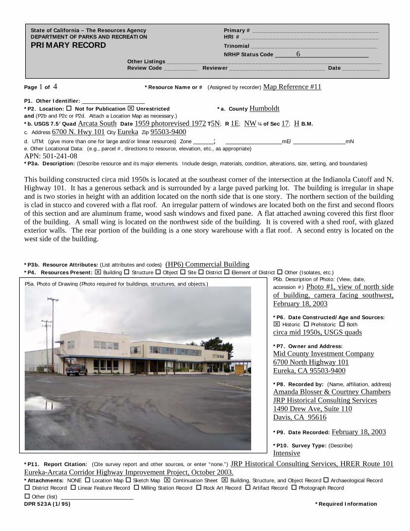
Page 1 of 4 *Resource Name or # (Assigned by recorder) Map Reference #11
State of California – The Resources Agency Primary # _____________________________________ DEPARTMENT OF PARKS AND RECREATION HRI # ________________________________________ PRIMARY RECORD Trinomial _____________________________________ NRHP Status Code 6 Other Listings _______________________________________________________________ Review Code __________ Reviewer ____________________________ Date ___________
P1. Other Identifier: *P2. Location: Not for Publication Unrestricted *a. County Humboldt and (P2b and P2c or P2d. Attach a Location Map as necessary.) *b. USGS 7.5’ Quad Arcata South Date 1959 photorevised 1972 T5N; R 1E; NW ¼ of Sec 17; H B.M. c. Address 6700 N. Hwy 101 City Eureka Zip 95503-9400
d. UTM: (give more than one for large and/or linear resources) Zone _____; ______________mE/ _____________mN e. Other Locational Data: (e.g., parcel #, directions to resource, elevation, etc., as appropriate) APN: 501-241-08 *P3a. Description: (Describe resource and its major elements. Include design, materials, condition, alterations, size, setting, and boundaries) This building constructed circa mid 1950s is located at the southeast corner of the intersection at the Indianola Cutoff and N. Highway 101. It has a generous setback and is surrounded by a large paved parking lot. The building is irregular in shape and is two stories in height with an addition located on the north side that is one story. The northern section of the building is clad in stucco and covered with a flat roof. An irregular pattern of windows are located both on the first and second floors of this section and are aluminum frame, wood sash windows and fixed pane. A flat attached awning covered this first floor of the building. A small wing is located on the northwest side of the building. It is covered with a shed roof, with glazed exterior walls. The rear portion of the building is a one story warehouse with a flat roof. A second entry is located on the west side of the building. *P3b. Resource Attributes: (List attributes and codes) (HP6) Commercial Building *P4. Resources Present: Building Structure Object Site District Element of District Other (Isolates, etc.)
P5b. Description of Photo: (View, date, accession #) Photo #1, view of north side of building, camera facing southwest, February 18, 2003 *P6. Date Constructed/Age and Sources: Historic Prehistoric Both circa mid 1950s, USGS quads *P7. Owner and Address: Mid County Investment Company 6700 North Highway 101 Eureka, CA 95503-9400 *P8. Recorded by: (Name, affiliation, address) Amanda Blosser & Courtney Chambers JRP Historical Consulting Services 1490 Drew Ave, Suite 110 Davis, CA 95616
*P9. Date Recorded: February 18, 2003 *P10. Survey Type: (Describe) Intensive
P5a. Photo of Drawing (Photo required for buildings, structures, and objects.)
*P11. Report Citation: (Cite survey report and other sources, or enter “none.”) JRP Historical Consulting Services, HRER Route 101 Eureka-Arcata Corridor Highway Improvement Project, October 2003. *Attachments: NONE Location Map Sketch Map Continuation Sheet Building, Structure, and Object Record Archaeological Record District Record Linear Feature Record Milling Station Record Rock Art Record Artifact Record Photograph Record
Other (list) __________________ DPR 523A (1/95) *Required Information
Page 2 of 4 *NRHP Status Code 6
*Resource Name or # (Assigned by recorder) Map Reference # 11
State of California – The Resources Agency Primary # _____________________________________ DEPARTMENT OF PARKS AND RECREATION HRI # ________________________________________ BUILDING, STRUCTURE, AND OBJECT RECORD
B1. Historic Name: B2. Common Name: B3. Original Use: Commercial Building B4. Present Use: Commercial Building
*B5. Architectural Style: Modern
*B6. Construction History: (Construction date, alteration, and date of alterations) circa 1950s; alterations unknown *B7. Moved? No Yes Unknown Date: Original Location: *B8. Related Features: None B9. Architect: None b. Builder: Unknown *B10. Significance: Theme n/a Area n/a Period of Significance n/a Property Type n/a Applicable Criteria n/a (Discuss importance in terms of historical or architectural context as defined by theme, period, and geographic scope. Also address integrity.) This property does not appear to meet the criteria for listing in the National Register of Historic Places, nor does it appear to be a historical resource for the purposes of CEQA. Located at the Indianola Cutoff, this property is located on what was a county road that ran from the Highway to Indianola, a small township located on the eastern edge of the bay. The reclaimed tidal marsh along Humboldt Bay was sparsely settled prior to the improvements of Highway 101 and consisted mainly of three small settlements, Brainard, Bayside and Indianola, located east of the old state highway. State Highway 101 was laid out in 1919 along the western edge of Humboldt Bay to serve as a connector between Eureka and Arcata and became a major artery with the volume of traffic steadily increasing into the 1940s. Road improvements along this five-mile stretch of road became a necessity with the increasing traffic volume and in 1944 this section of Highway 101 was placed on the planning program as high-priority. When funds became available in 1954, construction started on the improvements on the five-mile section between Eureka and Gannon Sloughs. The improvements consisted of reconstruction of the old two-lane road, addition of two more lanes creating a four lane limited access route with channelized intersections at two county roads. (See continuation sheet). B11. Additional Resource Attributes: (List attributes and codes) None *B12. References: Sanborn Fire Insurance Maps, “Eureka,” 1956; City Directories (various years); Building Permits, Eureka Building Department; USGS Quadrangles Eureka and Arcata South (1959, 1972); “East Highway Subdivision Map,” Humboldt County Recorders Office; Caltrans As-Builts for Highway 101; County Assessor records as reported to First American Real Estate Solutions online service, 2003. B13. Remarks: *B14. Evaluator: Amanda Blosser *Date of Evaluation: February 28, 2003 (This space reserved for official comments.)
DPR 523B (1/95) *Required Information

Page 3 of 4 *Resource Name or # (Assigned by recorder) Map Reference # 11 *Recorded by A. Blosser & C. Chambers *Date February 18, 2003 Continuation Update
State of California – The Resources Agency Primary # _____________________________________ DEPARTMENT OF PARKS AND RECREATION HRI # ________________________________________ CONTINUATION SHEET Trinomial ____________________________________________
B10. Significance (continued): The Indianola Cutoff was straightened at this time and a new cutoff was laid out to bypass the old road. It ran directly to Indianola at a perpendicular angle to the highway, with a new turn out on the highway to accommodate cars turning off the highway. These improvements were completed in the summer of 1955 relieving traffic congestion between the two cities and accommodating local traffic needs, as in the case of the Indianola Cutoff. The highway also provided improved access for two county roads serving the Humboldt County Airport and the small developing industrial area along the East Highway subdivision. With the completion of these improvements, the development of this small industrial area increased from two businesses to approximately fifteen at the northern edge of Eureka. The commercial and industrial area largely was concentrated in this area with a few businesses, like this one, developed north of the airport. Largely industrial in nature, most businesses located in this area were auto or equipment related. This property was one a few outside the industrial area along Jacobs Avenue that developed along the highway in the mid 1950s. Owned by Chester Hunt, historical documents did not indicate whether he constructed the building on the parcel. Under Criterion A, this property does not appear to be importantly associated with the history of commercial development in the Eureka area, or with other significant events or trends in state or national history. Instead, it appears to be a typical example of this pattern of development in Eureka during the 1950s. Research for this project did not indicate that this property appears to be associated with any individuals who made significant contributions to the history at the local, state, or national level under Criterion B. Additionally, it does not appear to be a significant example of a type, period, or method of construction. Rather, this building is a typical example of modern warehouses that could be mass produced buildings and assembled in different sizes as needed. This type of construction in well documented and prevalent in industrial districts across America and therefore does not appear to be eligible under Criterion C. In rare instances, buildings themselves can serve as sources of important information about historic construction materials or technologies (Criterion D); however, this property is otherwise documented and does not appear to be a principal source of important information in this regard. This property has been evaluated in accordance with Section 15064.5(1)(2)-(3) of the CEQA Guidelines using the criteria outlined in Section 5024.1 of the California Public Resources Code. The property does not appear to meet the criteria for listing in California Register of Historic Resources.
DPR 523L (1/95) *Required Information
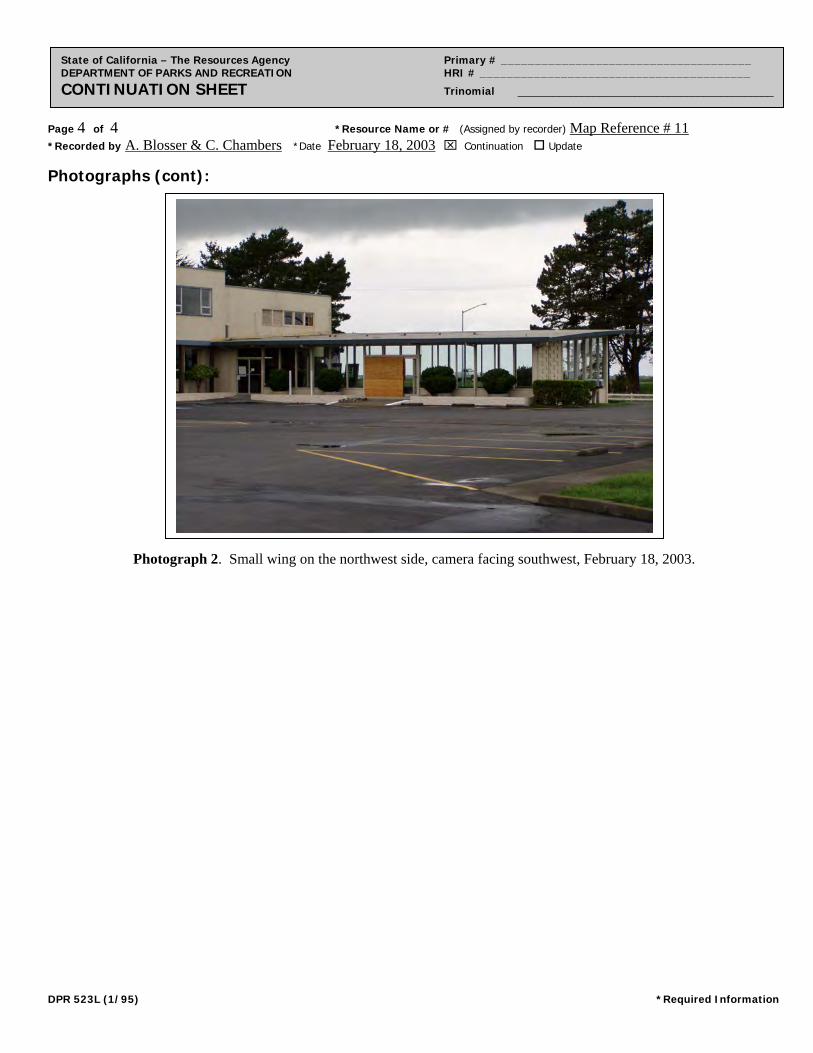
Page 4 of 4 *Resource Name or # (Assigned by recorder) Map Reference # 11 *Recorded by A. Blosser & C. Chambers *Date February 18, 2003 Continuation Update
State of California – The Resources Agency Primary # _____________________________________ DEPARTMENT OF PARKS AND RECREATION HRI # ________________________________________ CONTINUATION SHEET Trinomial ____________________________________________
Photographs (cont):
Photograph 2. Small wing on the northwest side, camera facing southwest, February 18, 2003.
DPR 523L (1/95) *Required Information
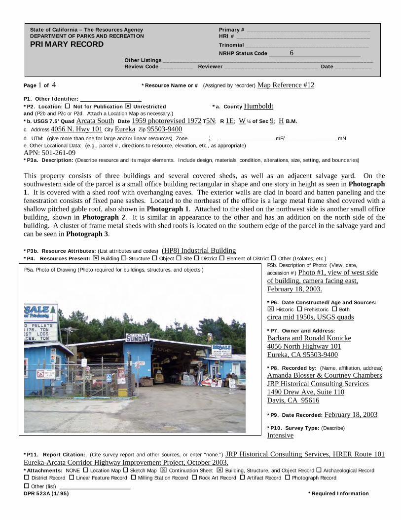
Page 1 of 4 *Resource Name or # (Assigned by recorder) Map Reference #12
State of California – The Resources Agency Primary # _____________________________________ DEPARTMENT OF PARKS AND RECREATION HRI # ________________________________________ PRIMARY RECORD Trinomial _____________________________________ NRHP Status Code 6 Other Listings _______________________________________________________________ Review Code __________ Reviewer ____________________________ Date ___________
P1. Other Identifier: *P2. Location: Not for Publication Unrestricted *a. County Humboldt and (P2b and P2c or P2d. Attach a Location Map as necessary.) *b. USGS 7.5’ Quad Arcata South Date 1959 photorevised 1972 T5N; R 1E; W ¼ of Sec 9; H B.M. c. Address 4056 N. Hwy 101 City Eureka Zip 95503-9400
d. UTM: (give more than one for large and/or linear resources) Zone _____; ______________mE/ _____________mN e. Other Locational Data: (e.g., parcel #, directions to resource, elevation, etc., as appropriate) APN: 501-261-09 *P3a. Description: (Describe resource and its major elements. Include design, materials, condition, alterations, size, setting, and boundaries) This property consists of three buildings and several covered sheds, as well as an adjacent salvage yard. On the southwestern side of the parcel is a small office building rectangular in shape and one story in height as seen in Photograph 1. It is covered with a shed roof with overhanging eaves. The exterior walls are clad in board and batten paneling and the fenestration consists of fixed pane sashes. Located to the northeast of the office is a large metal frame shed covered with a shallow pitched gable roof, also shown in Photograph 1. Attached to the shed on the northwest side is another small office building, shown in Photograph 2. It is similar in appearance to the other and has an addition on the north side of the building. A cluster of frame metal sheds with shed roofs is located on the southern edge of the parcel in the salvage yard and can be seen in Photograph 3. *P3b. Resource Attributes: (List attributes and codes) (HP8) Industrial Building *P4. Resources Present: Building Structure Object Site District Element of District Other (Isolates, etc.)
P5b. Description of Photo: (View, date, accession #) Photo #1, view of west side of building, camera facing east, February 18, 2003. *P6. Date Constructed/Age and Sources: Historic Prehistoric Both circa mid 1950s, USGS quads *P7. Owner and Address: Barbara and Ronald Konicke 4056 North Highway 101 Eureka, CA 95503-9400 *P8. Recorded by: (Name, affiliation, address) Amanda Blosser & Courtney Chambers JRP Historical Consulting Services 1490 Drew Ave, Suite 110 Davis, CA 95616
*P9. Date Recorded: February 18, 2003 *P10. Survey Type: (Describe) Intensive
P5a. Photo of Drawing (Photo required for buildings, structures, and objects.)
*P11. Report Citation: (Cite survey report and other sources, or enter “none.”) JRP Historical Consulting Services, HRER Route 101 Eureka-Arcata Corridor Highway Improvement Project, October 2003. *Attachments: NONE Location Map Sketch Map Continuation Sheet Building, Structure, and Object Record Archaeological Record District Record Linear Feature Record Milling Station Record Rock Art Record Artifact Record Photograph Record
Other (list) __________________ DPR 523A (1/95) *Required Information

Page 2 of 4 *NRHP Status Code 6
*Resource Name or # (Assigned by recorder) Map Reference # 12
State of California – The Resources Agency Primary # _____________________________________ DEPARTMENT OF PARKS AND RECREATION HRI # ________________________________________ BUILDING, STRUCTURE, AND OBJECT RECORD
B1. Historic Name: B2. Common Name: B3. Original Use: Industrial Building B4. Present Use: Industrial Building
*B5. Architectural Style: Utilitarian
*B6. Construction History: (Construction date, alteration, and date of alterations) circa 1950s; alterations 1970s *B7. Moved? No Yes Unknown Date: Original Location: *B8. Related Features: None B9. Architect: Unknown b. Builder: Unknown *B10. Significance: Theme n/a Area n/a Period of Significance n/a Property Type n/a Applicable Criteria n/a (Discuss importance in terms of historical or architectural context as defined by theme, period, and geographic scope. Also address integrity.) This property does not appear to meet the criteria for listing in the National Register of Historic Places, nor does it appear to be a historical resource for the purposes of CEQA. Located at the Bayside Cutoff, this property is located on what was a county road that ran from the state highway to Bayside, a small township located on the eastern edge of the bay. The reclaimed tidal marsh along Humboldt Bay was sparsely settled prior to the improvements of Highway 101 and consisted mainly of three small settlements, Brainard, Bayside and Indianola, located east of the old state highway. State Highway 101 was laid out in 1919 along the western edge of Humboldt Bay to serve as a connector between Eureka and Arcata and became a major artery with the volume of traffic steadily increasing into the 1940s. Road improvements along this five-mile stretch of road became a necessity with the increasing traffic volume and in 1944 this section of Highway 101 was placed on the planning program as high-priority. When funds became available in 1954, construction started on the improvements on the five-mile section between Eureka and Gannon Sloughs. The improvements consisted of reconstruction of the old two-lane road, addition of two more lanes creating a four lane limited access route with channelized intersections at two county roads. (See continuation sheet). B11. Additional Resource Attributes: (List attributes and codes) None *B12. References: Sanborn Fire Insurance Maps, “Eureka,” 1956; City Directories (various years); Building Permits, Eureka Building Department; USGS Quadrangles Eureka and Arcata South (1959, 1972); “East Highway Subdivision Map,” Humboldt County Recorders Office; Caltrans As-Builts for Highway 101; County Assessor records as reported to First American Real Estate Solutions online service, 2003. B13. Remarks: *B14. Evaluator: Amanda Blosser *Date of Evaluation: February 28, 2003 (This space reserved for official comments.)
DPR 523B (1/95) *Required Information
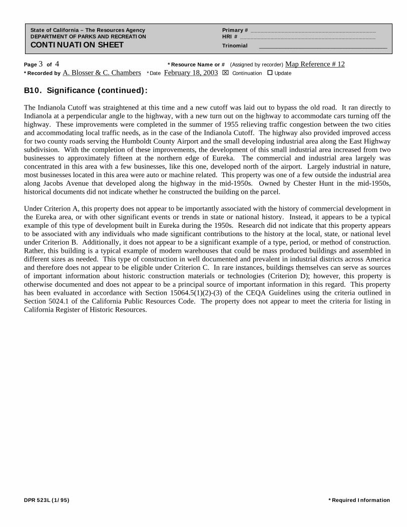
Page 3 of 4 *Resource Name or # (Assigned by recorder) Map Reference # 12 *Recorded by A. Blosser & C. Chambers *Date February 18, 2003 Continuation Update
State of California – The Resources Agency Primary # _____________________________________ DEPARTMENT OF PARKS AND RECREATION HRI # ________________________________________ CONTINUATION SHEET Trinomial ____________________________________________
B10. Significance (continued): The Indianola Cutoff was straightened at this time and a new cutoff was laid out to bypass the old road. It ran directly to Indianola at a perpendicular angle to the highway, with a new turn out on the highway to accommodate cars turning off the highway. These improvements were completed in the summer of 1955 relieving traffic congestion between the two cities and accommodating local traffic needs, as in the case of the Indianola Cutoff. The highway also provided improved access for two county roads serving the Humboldt County Airport and the small developing industrial area along the East Highway subdivision. With the completion of these improvements, the development of this small industrial area increased from two businesses to approximately fifteen at the northern edge of Eureka. The commercial and industrial area largely was concentrated in this area with a few businesses, like this one, developed north of the airport. Largely industrial in nature, most businesses located in this area were auto or machine related. This property was one of a few outside the industrial area along Jacobs Avenue that developed along the highway in the mid-1950s. Owned by Chester Hunt in the mid-1950s, historical documents did not indicate whether he constructed the building on the parcel. Under Criterion A, this property does not appear to be importantly associated with the history of commercial development in the Eureka area, or with other significant events or trends in state or national history. Instead, it appears to be a typical example of this type of development built in Eureka during the 1950s. Research did not indicate that this property appears to be associated with any individuals who made significant contributions to the history at the local, state, or national level under Criterion B. Additionally, it does not appear to be a significant example of a type, period, or method of construction. Rather, this building is a typical example of modern warehouses that could be mass produced buildings and assembled in different sizes as needed. This type of construction in well documented and prevalent in industrial districts across America and therefore does not appear to be eligible under Criterion C. In rare instances, buildings themselves can serve as sources of important information about historic construction materials or technologies (Criterion D); however, this property is otherwise documented and does not appear to be a principal source of important information in this regard. This property has been evaluated in accordance with Section 15064.5(1)(2)-(3) of the CEQA Guidelines using the criteria outlined in Section 5024.1 of the California Public Resources Code. The property does not appear to meet the criteria for listing in California Register of Historic Resources.
DPR 523L (1/95) *Required Information
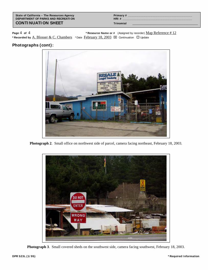
Page 4 of 4 *Resource Name or # (Assigned by recorder) Map Reference # 12 *Recorded by A. Blosser & C. Chambers *Date February 18, 2003 Continuation Update
State of California – The Resources Agency Primary # _____________________________________ DEPARTMENT OF PARKS AND RECREATION HRI # ________________________________________ CONTINUATION SHEET Trinomial ____________________________________________
Photographs (cont):
Photograph 2. Small office on northwest side of parcel, camera facing northeast, February 18, 2003.
Photograph 3. Small covered sheds on the southwest side, camera facing southwest, February 18, 2003.
DPR 523L (1/95) *Required Information
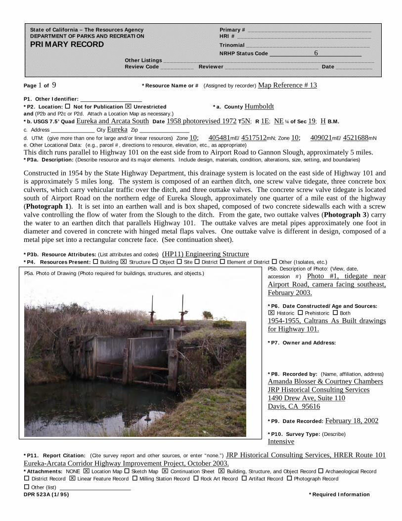
Page 1 of 9 *Resource Name or # (Assigned by recorder) Map Reference # 13
*P11. Report Citation: (Cite survey report and other sources, or enter “none.”) JRP Historical Consulting Services, HRER Route 101 Eureka-Arcata Corridor Highway Improvement Project, October 2003. *Attachments: NONE Location Map Sketch Map Continuation Sheet Building, Structure, and Object Record Archaeological Record District Record Linear Feature Record Milling Station Record Rock Art Record Artifact Record Photograph Record
Other (list) __________________ DPR 523A (1/95) *Required Information
State of California – The Resources Agency Primary # _____________________________________ DEPARTMENT OF PARKS AND RECREATION HRI # ________________________________________ PRIMARY RECORD Trinomial _____________________________________ NRHP Status Code 6 Other Listings _______________________________________________________________ Review Code __________ Reviewer ____________________________ Date ___________
P1. Other Identifier: *P2. Location: Not for Publication Unrestricted *a. County Humboldt and (P2b and P2c or P2d. Attach a Location Map as necessary.) *b. USGS 7.5’ Quad Eureka and Arcata South Date 1958 photorevised 1972 T5N; R 1E; NE ¼ of Sec 19; H B.M. c. Address City Eureka Zip
d. UTM: (give more than one for large and/or linear resources) Zone 10; 405481mE/ 4517512mN; Zone 10; 409021mE/ 4521688mN e. Other Locational Data: (e.g., parcel #, directions to resource, elevation, etc., as appropriate) This ditch runs parallel to Highway 101 on the east side from to Airport Road to Gannon Slough, approximately 5 miles. *P3a. Description: (Describe resource and its major elements. Include design, materials, condition, alterations, size, setting, and boundaries)
Constructed in 1954 by the State Highway Department, this drainage system is located on the east side of Highway 101 and is approximately 5 miles long. The system is composed of an earthen ditch, one screw valve tidegate, three concrete box culverts, which carry vehicular traffic over the ditch, and three outtake valves. The concrete screw valve tidegate is located south of Airport Road on the northern edge of Eureka Slough, approximately one quarter of a mile east of the highway (Photograph 1). It is set into an earthen wall and is box shaped, composed of two concrete sidewalls each with a screw valve controlling the flow of water from the Slough to the ditch. From the gate, two outtake valves (Photograph 3) carry the water to an earthen ditch that parallels Highway 101. The outtake valves are metal pipes approximately one foot in diameter and covered in concrete with hinged metal flaps valves. One outtake valve is different in design, composed of a metal pipe set into a rectangular concrete face. (See continuation sheet).
*P3b. Resource Attributes: (List attributes and codes) (HP11) Engineering Structure *P4. Resources Present: Building Structure Object Site District Element of District Other (Isolates, etc.)
P5b. Description of Photo: (View, date, accession #) Photo #1, tidegate near Airport Road, camera facing southeast, February 2003. *P6. Date Constructed/Age and Sources: Historic Prehistoric Both 1954-1955, Caltrans As Built drawings for Highway 101. *P7. Owner and Address: *P8. Recorded by: (Name, affiliation, address) Amanda Blosser & Courtney Chambers JRP Historical Consulting Services 1490 Drew Ave, Suite 110 Davis, CA 95616
*P9. Date Recorded: February 18, 2002 *P10. Survey Type: (Describe) Intensive
P5a. Photo of Drawing (Photo required for buildings, structures, and objects.)
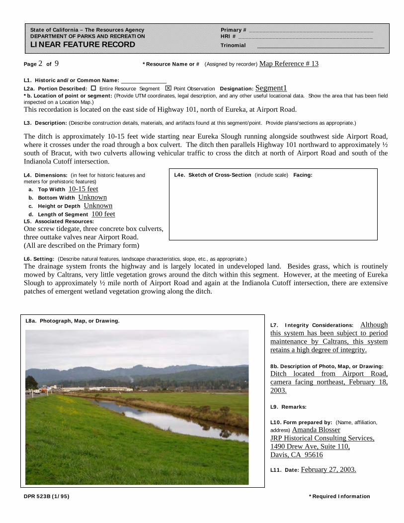
Page 2 of 9 *Resource Name or # (Assigned by recorder) Map Reference # 13
DPR 523B (1/95) *Required Information
State of California – The Resources Agency Primary # _____________________________________ DEPARTMENT OF PARKS AND RECREATION HRI # ________________________________________ LINEAR FEATURE RECORD Trinomial ____________________________________________
L1. Historic and/or Common Name: L2a. Portion Described: Entire Resource Segment Point Observation Designation: Segment1 *b. Location of point or segment: (Provide UTM coordinates, legal description, and any other useful locational data. Show the area that has been field inspected on a Location Map.) This recordation is located on the east side of Highway 101, north of Eureka, at Airport Road. L3. Description: (Describe construction details, materials, and artifacts found at this segment/point. Provide plans/sections as appropriate.)
The ditch is approximately 10-15 feet wide starting near Eureka Slough running alongside southwest side Airport Road, where it crosses under the road through a box culvert. The ditch then parallels Highway 101 northward to approximately ½ south of Bracut, with two culverts allowing vehicular traffic to cross the ditch at north of Airport Road and south of the Indianola Cutoff intersection. L4. Dimensions: (in feet for historic features and meters for prehistoric features)
a. Top Width 10-15 feet b. Bottom Width Unknown c. Height or Depth Unknown d. Length of Segment 100 feet
L5. Associated Resources: One screw tidegate, three concrete box culverts, three outtake valves near Airport Road. (All are described on the Primary form) L6. Setting: (Describe natural features, landscape characteristics, slope, etc., as appropriate.) The drainage system fronts the highway and is largely located in undeveloped land. Besides grass, which is routinely mowed by Caltrans, very little vegetation grows around the ditch within this segment. However, at the meeting of Eureka Slough to approximately ½ mile north of Airport Road and again at the Indianola Cutoff intersection, there are extensive patches of emergent wetland vegetation growing along the ditch.
L7. Integrity Considerations: Although this system has been subject to period maintenance by Caltrans, this system retains a high degree of integrity. 8b. Description of Photo, Map, or Drawing: Ditch located from Airport Road, camera facing northeast, February 18, 2003. L9. Remarks: L10. Form prepared by: (Name, affiliation, address) Amanda Blosser JRP Historical Consulting Services, 1490 Drew Ave, Suite 110, Davis, CA 95616 L11. Date: February 27, 2003.
L8a. Photograph, Map, or Drawing.
L4e. Sketch of Cross-Section (include scale) Facing:
Page 3 of 9 *Resource Name or # (Assigned by recorder) Map Reference # 13
DPR 523B (1/95) *Required Information
State of California – The Resources Agency Primary # _____________________________________ DEPARTMENT OF PARKS AND RECREATION HRI # ________________________________________ LINEAR FEATURE RECORD Trinomial ____________________________________________
L1. Historic and/or Common Name: L2a. Portion Described: Entire Resource Segment Point Observation Designation: Segment 2 *b. Location of point or segment: (Provide UTM coordinates, legal description, and any other useful locational data. Show the area that has been field inspected on a Location Map.) This recordation is located on the east side of Highway 101, approximately ½ mile south of Bracut. L3. Description: (Describe construction details, materials, and artifacts found at this segment/point. Provide plans/sections as appropriate.)
The ditch is earthen and approximately 1-2 feet wide. L4. Dimensions: (in feet for historic features and meters for prehistoric features)
e. Top Width 1-2 feet f. Bottom Width Unknown g. Height or Depth Unknown h. Length of Segment 100 feet
L5. Associated Resources: L6. Setting: (Describe natural features, landscape characteristics, slope, etc., as appropriate.) This portion of the ditch carries less water than that the portion south of the Indianola Cutoff with more vegetation growing along the ditch. The west bank of the ditch is mowed by Caltrans.
L7. Integrity Considerations: Although this system has been subject to period maintenance by Caltrans, this system retains a high degree of integrity. L8b. Description of Photo, Map, or Drawing: L9. Remarks: L10. Form prepared by: (Name, affiliation, address) Amanda Blosser JRP Historical Consulting Services, 1490 Drew Ave, Suite 110, Davis, CA 95616 L11. Date: February 27, 2003.
L8a. Photograph, Map, or Drawing.
See Location Map
L4e. Sketch of Cross-Section (include scale) Facing:
Page 4 of 9 *NRHP Status Code 6
*Resource Name or # (Assigned by recorder) Map Reference # 13
DPR 523B (1/95) *Required Information
State of California – The Resources Agency Primary # _____________________________________ DEPARTMENT OF PARKS AND RECREATION HRI # ________________________________________ BUILDING, STRUCTURE, AND OBJECT RECORD
B1. Historic Name: B2. Common Name: B3. Original Use: Drainage system B4. Present Use: Drainage system
*B5. Architectural Style: None
*B6. Construction History: (Construction date, alteration, and date of alterations) 1954, alterations unknown *B7. Moved? No Yes Unknown Date: Original Location: *B8. Related Features: Concrete screw tidegate, three culverts, and intake valves B9. Architect: Unknown b. Builder: Unknown *B10. Significance: Theme n/a Area n/a Period of Significance n/a Property Type n/a Applicable Criteria n/a (Discuss importance in terms of historical or architectural context as defined by theme, period, and geographic scope. Also address integrity.)
This drainage system does not appear to meet the criteria for listing in the National Register of Historic Places, nor does it appear to be a historical resource for the purposes of CEQA. The drainage system was constructed in 1954 as part of improvements to Highway 101 along the Humboldt Bay from Eureka Slough to Arcata. The reclaimed tidal marsh where the system is located along Humboldt Bay was sparsely settled prior to the improvements of Highway 101 and consisted mainly of two small settlements, Brainard and Bayside, located north of the current Jacobs Avenue near the old state highway. State Highway 101 was laid out in 1919 along the western edge of Humboldt Bay to serve as a connector between Eureka and Arcata and became a major artery with the volume of traffic steadily increasing into the 1940s. Road improvements along this five-mile stretch of road became a necessity with the increasing traffic volume and in 1944 this section of Highway 101 was placed on the planning program as high-priority. When funds became available in 1954, construction started on the improvements between Eureka and Gannon Sloughs. The improvements consisted of reconstruction of the old two-lane road, and the addition of two more lanes creating a four lane limited access route with channelized intersections at two county roads. (See continuation sheet).
B11. Additional Resource Attributes: (List attributes and codes) None *B12. References: Sanborn Fire Insurance Maps, “Eureka,” 1956; USGS Quadrangles Eureka and Arcata South (1959, 1972); “East Highway Subdivision Map,” Humboldt County Recorders Office; Caltrans As-Builts for Highway 101. B13. Remarks: *B14. Evaluator: Amanda Blosser *Date of Evaluation: February 28, 2003 (This space reserved for official comments.)
(Sketch Map with north arrow required.)
See Location Map
Page 5 of 9 *Resource Name or # (Assigned by recorder) Map Reference # 13 *Recorded by A. Blosser & C. Chambers *Date February 18, 2003 Continuation Update
DPR 523L (1/95) *Required Information
State of California – The Resources Agency Primary # _____________________________________ DEPARTMENT OF PARKS AND RECREATION HRI # ________________________________________ CONTINUATION SHEET Trinomial ____________________________________________
P3a. Description (continued): It is shown in Photograph 4 and is located opposite (west) of the other two valves. Once the water is released through the valves, it is carried along the highway through the earthen ditch. The ditch is shown in Photograph 2 and described in detail on the attached DPR523L form. In addition to the other features, there are three concrete box culverts of similar design that effectively act as bridges and carry vehicular traffic over the ditch. These culverts have two water flow openings and a central post. Two lane roads pass over the culverts and are guarded by a steel or wood guardrail. The culverts are located between Airport Road and the Indianola Cutoff at the Toyota Dealership and across from the north entrance of the Arcata Lumber Mill (Photograph 1 and 4). B10. Significance (continued): Jacobs Avenue was also laid out and constructed at this time to accommodate traffic needs and with this improvements, the drainage system became a necessity for carrying water to the bay. The State Division of Highways completed improvements in the summer of 1955, relieving traffic congestion between the two cities and accommodating local traffic needs, as in the case of this system. The highway also provided improved access for two county roads serving the Humboldt County Airport and the small developing industrial area along the East Highway subdivision. Under Criterion A, this drainage system does not appear to be importantly associated with significant events or trends in state or national history. Infrastructure is inherently vital to communities as it is often part of essential city or regional planning, and considerably impacts communication and the distribution of people, goods, and services that facilitates development on both the local and regional levels. These common effects of infrastructure do not typically provide ample substance to demonstrate how the resource may be associated with its historic context in an important manner. To be eligible for listing in the National Register, infrastructure type resources must be shown to have particular importance directly related to events and trends in community development and transportation, with emphasis given to specific demand for such facilities and the cause and effect relationship of its construction. The historic evidence for this drainage system does not appear to support its eligibility for listing in the National Register under Criterion A. The system also does not appear to be importantly associated with any individuals who made significant contributions to the history at the local, state, or national level under Criterion B. Additionally, all of the systems associated features do not appear to be a significant example of a engineering design or construction under Criterion C. Rather, this system represents a common solution to the problem of carrying water from the tidal marsh to the bay. In rare instances, resources themselves can serve as sources of important information about historic construction materials or technologies (Criterion D); however, this property is otherwise documented and does not appear to be a principal source of important information in this regard. This property has been evaluated in accordance with Section 15064.5(1)(2)-(3) of the CEQA Guidelines using the criteria outlined in Section 5024.1 of the California Public Resources Code. The property does not appear to meet the criteria for listing in California Register of Historic Resources.
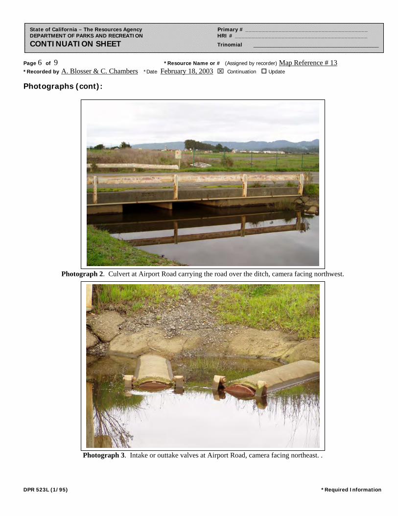
Page 6 of 9 *Resource Name or # (Assigned by recorder) Map Reference # 13 *Recorded by A. Blosser & C. Chambers *Date February 18, 2003 Continuation Update
DPR 523L (1/95) *Required Information
State of California – The Resources Agency Primary # _____________________________________ DEPARTMENT OF PARKS AND RECREATION HRI # ________________________________________ CONTINUATION SHEET Trinomial ____________________________________________
Photographs (cont):
Photograph 2. Culvert at Airport Road carrying the road over the ditch, camera facing northwest.
Photograph 3. Intake or outtake valves at Airport Road, camera facing northeast. .
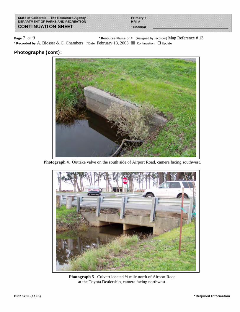
Page 7 of 9 *Resource Name or # (Assigned by recorder) Map Reference # 13 *Recorded by A. Blosser & C. Chambers *Date February 18, 2003 Continuation Update
DPR 523L (1/95) *Required Information
State of California – The Resources Agency Primary # _____________________________________ DEPARTMENT OF PARKS AND RECREATION HRI # ________________________________________ CONTINUATION SHEET Trinomial ____________________________________________
Photographs (cont):
Photograph 4. Outtake valve on the south side of Airport Road, camera facing southwest.
Photograph 5. Culvert located ½ mile north of Airport Road at the Toyota Dealership, camera facing northwest.
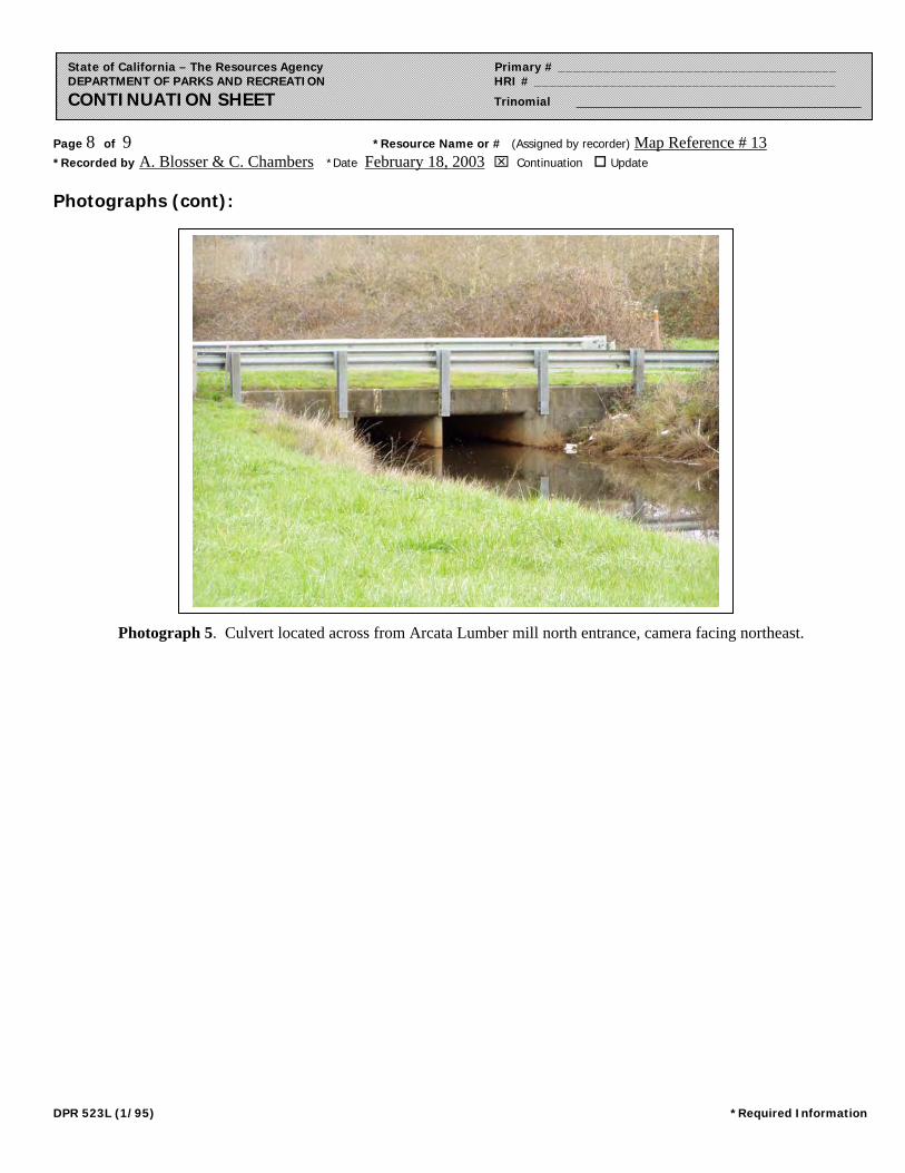
Page 8 of 9 *Resource Name or # (Assigned by recorder) Map Reference # 13 *Recorded by A. Blosser & C. Chambers *Date February 18, 2003 Continuation Update
DPR 523L (1/95) *Required Information
State of California – The Resources Agency Primary # _____________________________________ DEPARTMENT OF PARKS AND RECREATION HRI # ________________________________________ CONTINUATION SHEET Trinomial ____________________________________________
Photographs (cont):
Photograph 5. Culvert located across from Arcata Lumber mill north entrance, camera facing northeast.
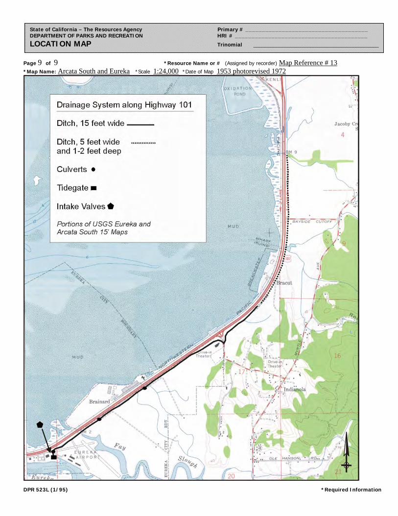
Page 9 of 9 *Resource Name or # (Assigned by recorder) Map Reference # 13 *Map Name: Arcata South and Eureka *Scale 1:24,000 *Date of Map 1953 photorevised 1972
DPR 523L (1/95) *Required Information
State of California – The Resources Agency Primary # _____________________________________ DEPARTMENT OF PARKS AND RECREATION HRI # ________________________________________ LOCATION MAP Trinomial ____________________________________________
Page 1 of 5 *Resource Name or # (Assigned by recorder) Map Reference #14
State of California – The Resources Agency Primary # _____________________________________ DEPARTMENT OF PARKS AND RECREATION HRI # ________________________________________ PRIMARY RECORD Trinomial _____________________________________ NRHP Status Code 6 Other Listings _______________________________________________________________ Review Code __________ Reviewer ____________________________ Date ___________
P1. Other Identifier: *P2. Location: Not for Publication Unrestricted *a. County Humboldt and (P2b and P2c or P2d. Attach a Location Map as necessary.)
*b. USGS 7.5’ Quad Eureka Date 1959 T___; R ___; ___ ¼ of Sec ___; _____ B.M.
c. Address City Eureka Zip
d. UTM: (give more than one for large and/or linear resources) Zone 10; 406380mE/ 4518177mN; Zone 10; 407050mE/ 45186244mN e. Other Locational Data: (e.g., parcel #, directions to resource, elevation, etc., as appropriate) *P3a. Description: (Describe resource and its major elements. Include design, materials, condition, alterations, size, setting, and boundaries) These eucalyptus trees are located on the western side of Highway 101, separating the highway from the Northwestern Pacific Railroad tracks, serving as a windbreak and light screen. The trees are spaced approximately five feet apart in a single row lining the highway. They are approximately 30 feet tall and extend from Fay Slough near the Eureka Airport to just southwest of the Indianola Cutoff, a distance of approximately one and half miles. *P3b. Resource Attributes: (List attributes and codes) (HP 30) Trees/Vegetation *P4. Resources Present: Building Structure Object Site District Element of District Other (Isolates, etc.)
P5b. Description of Photo: (View, date, accession #) See continuation sheet. *P6. Date Constructed/Age and Sources: Historic Prehistoric Both Planted in circa early 1920s. *P7. Owner and Address: Unknown *P8. Recorded by: (Name, affiliation, address) Amanda Blosser & Courtney Chambers JRP Historical Consulting Services 1490 Drew Ave, Suite 110 Davis, CA 95616 *P9. Date Recorded: February 18, 2003 *P10. Survey Type: (Describe) Intensive
P5a. Photo of Drawing (Photo required for buildings, structures, and objects.)
See continuation sheet.
*P11. Report Citation: (Cite survey report and other sources, or enter “none.”) JRP Historical Consulting Services, HRER Route 101 Eureka-Arcata Corridor Highway Improvement Project, October 2003. *Attachments: NONE Location Map Sketch Map Continuation Sheet Building, Structure, and Object Record Archaeological Record District Record Linear Feature Record Milling Station Record Rock Art Record Artifact Record Photograph Record
Other (list) __________________ DPR 523A (1/95) *Required Information
Page 2 of 5 *NRHP Status Code 6
*Resource Name or # (Assigned by recorder) Map Reference #14
State of California – The Resources Agency Primary # _____________________________________ DEPARTMENT OF PARKS AND RECREATION HRI # ________________________________________ BUILDING, STRUCTURE, AND OBJECT RECORD
B1. Historic Name: B2. Common Name: B3. Original Use: B4. Present Use: *B5. Architectural Style: *B6. Construction History: (Construction date, alteration, and date of alterations) Trees planted in circa mid-1920s *B7. Moved? No Yes Unknown Date: n/a Original Location: n/a *B8. Related Features: none B9. Architect: none b. Builder: none *B10. Significance: Theme n/a Area n/a Period of Significance n/a Property Type n/a Applicable Criteria n/a (Discuss importance in terms of historical or architectural context as defined by theme, period, and geographic scope. Also address integrity.) These eucalyptus trees do not appear to meet the criteria for listing in the National Register of Historic Places, nor do they appear to be a historical resource for the purposes of CEQA. Although the date they were planted is unknown, the trees were most likely planted between 1919 and 1925 when the highway along the bay between Arcata and Eureka was built. The reclaimed tidal marsh along Humboldt Bay was sparsely settled prior to the improvements of Highway 101 and consisted mainly of two small settlements, Brainard and Bayside, located north of the current Jacobs Avenue near the old state highway. State Highway 101 was laid out in 1919 along the western edge of Humboldt Bay to serve as a connector between Eureka and Arcata and became a major artery with the volume of traffic steadily increasing into the 1940s. Road improvements along this five-mile stretch of road became a necessity with the increasing traffic volume and in 1944 this section of Highway 101 was placed on the planning program as high-priority. When funds became available in 1954, construction started on the improvements on the five-mile section between Eureka and Gannon Sloughs. The improvements consisted of reconstruction of the old two-lane road, addition of two more lanes creating a four lane limited access route with channelized intersections at two county roads. (See continuation sheet). B11. Additional Resource Attributes: (List attributes and codes) none
*B12. References: Sanborn Fire Insurance Maps, “Eureka,” 1956; City Directories (various years); Building Permits, Eureka Building Department; USGS Quadrangles Eureka and Arcata South (1959, 1972); “East Highway Subdivision Map,” Humboldt County Recorders Office; Caltrans As-Builts for Highway 101; Caltrans “General Guidelines for Indentifying and Evaluating Historic Landscapes, ” February 1999. B13. Remarks: *B14. Evaluator: Amanda Blosser *Date of Evaluation: March 6, 2003 (This space reserved for official comments.)
(Sketch Map with north arrow required.)
See Location Map
DPR 523B (1/95) *Required Information
Page 3 of 5 *Resource Name or # (Assigned by recorder) Map Reference #14 *Recorded by A. Blosser & C. Chambers *Date February 18, 2003 Continuation Update
State of California – The Resources Agency Primary # _____________________________________ DEPARTMENT OF PARKS AND RECREATION HRI # ________________________________________ CONTINUATION SHEET Trinomial ____________________________________________
B10. Significance (continued): Jacobs Avenue was also laid out and constructed at this time to accommodate traffic needs and with this improvements, the drainage system became a necessity for carrying water to the Bay. Improvements were completed in the summer of 1955 relieving traffic congestion between the two cities and accommodating local traffic needs, as in the case of this system. The highway also provided improved access for two county roads serving the Humboldt County Airport and the small developing industrial area along the East Highway subdivision. These eucalyptus trees were most likely planted between 1919 and 1925, as part of construction for the new highway connecting Eureka and Arcata. Although the Division of Highways had to cut the trees to the ground in 1933 after a severe frost, the trees continued to grow alongside the highway. In 1920, the California Division of Highways established a state nursery that enabled the division to plant thousands of trees each year for roadside landscaping. The Division of Highways also employed an arboriculturist to supervise the planting and the care of trees along state highways as early as 1920. Additionally, in the 1920s and 1930s, private groups seeking to enhance roadside beautification planted approximately 130,000 trees along California state highways. After assuming the cost of planting and care of the trees for the first year, the Division of Highways assumed control of the trees. These private groups worked in conjunction with the state arboriculturist, who recommended coast redwood, sycamores, eucalyptus, coast live oak, and silver maple trees for use in the coastal areas of California. Eucalyptus trees were commonly planted as windbreaks along California highways during the 1920s, 1930s, 1940s, and 1950s. In 1948, a row of eucalyptus trees, along a state highway in San Bernardino County were planted specifically to shield drivers from the train headlights on the parallel train tracks. The row of eucalyptus trees lining Highway 101 in Humboldt County may have been planted for the same purposes.1 Under Criterion A, these eucalyptus trees do not appear to be importantly associated with significant events or trends in state or national history. Although part of a state-wide effort of roadside beautification, this row of Eucalyptus trees does not appear to be significant within this context. Examples of similar tree-lined highways exist in many towns and areas, including a walnut tree-lined boulevard in Davis, California, and another in rural Yolo County south of West Sacramento; palm tree-lined rural roads in Kern County; olive tree-lined rural routes throughout the Central Valley; or other eucalyptus-lined stretches of state highways. This row of trees also do not appear to be importantly associated with any individuals who made significant contributions to the history at the local, state, or national level under Criterion B. Research for this project did not indicate that these trees were associated with any historical significant persons. Under Criterion C, the row of Eucalyptus trees are not associated with the productive careers of significant figures in American landscape architecture as defined by Criterion C, nor is the design plan (a row of trees lining a road) of these trees the first of its type or represent an innovative design plan. Research for this project did not indicate that any significant person in the history of landscape gardening or architecture was involved in the decision to plant the trees; in fact, the historic record does not indicate whose decision it was to plant them. The common nature of tree lined roads does not suggest that planting suggests that it was influential or significant in the theory or practice of landscape architecture. Rural tree-lined roads are common, and were often simply the installations of landowners wishing to beautify, provide shade, protect from wind, provide privacy. Additionally, several of the trees have been removed or were cut back by the State Highway Department in 1933 after a severe frost and the integrity of this row has been compromised, eliminating any potential for a historic landscape. In rare instances, resources themselves can serve as sources of important information about historic construction materials or technologies (Criterion D); however, this property is otherwise documented and does not appear to be a principal source of important information in this regard. This property has been evaluated in accordance with Section 15064.5(1)(2)-(3) of the CEQA Guidelines using the criteria outlined in Section 5024.1 of the California Public Resources Code. The property does not appear to meet the criteria for listing in California Register of Historic Resources.
1 L.R. McNeely, “Plantings: Eucalyptus Trees Used for Windbreaks on Freeway,” California Highways and Public Works (Sacramento: California Department of Transportation, September-October, 1948), 36; “How State Cares for 130,000 Trees Privately Planted Along Highways,” California Highways and Public Works (Sacramento: California Department of Transportation, December 1931), 34; and “Tree Maintenance,” California Highways and Public Works (Sacramento: California Department of Transportation, March 1924), 6. DPR 523L (1/95) *Required Information
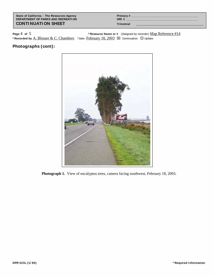
Page 4 of 5 *Resource Name or # (Assigned by recorder) Map Reference #14 *Recorded by A. Blosser & C. Chambers *Date February 18, 2003 Continuation Update
State of California – The Resources Agency Primary # _____________________________________ DEPARTMENT OF PARKS AND RECREATION HRI # ________________________________________ CONTINUATION SHEET Trinomial ____________________________________________
Photographs (cont):
Photograph
Photograph 1. View of eucalyptus trees, camera facing southwest, February 18, 2003.
DPR 523L (1/95) *Required Information
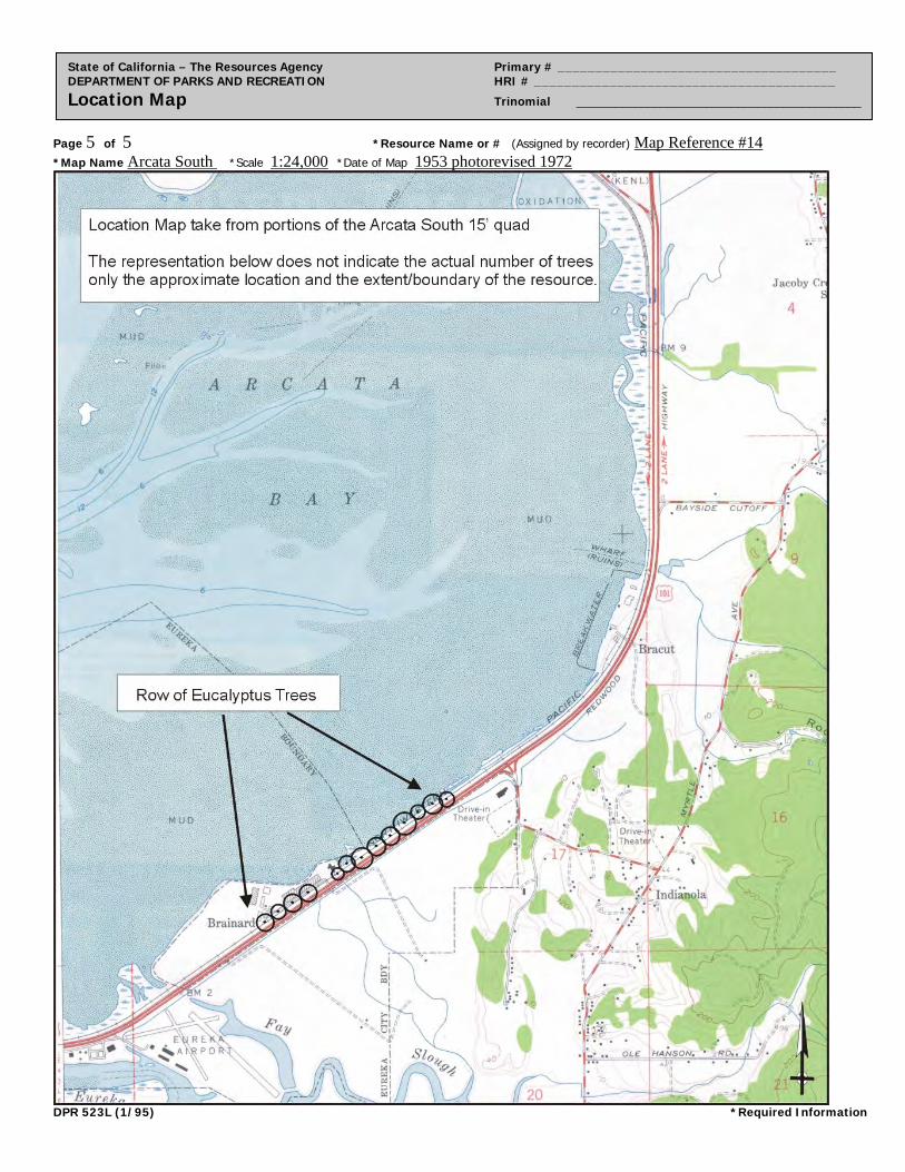
Page 5 of 5 *Resource Name or # (Assigned by recorder) Map Reference #14 *Map Name Arcata South *Scale 1:24,000 *Date of Map 1953 photorevised 1972
State of California – The Resources Agency Primary # _____________________________________ DEPARTMENT OF PARKS AND RECREATION HRI # ________________________________________ Location Map Trinomial ____________________________________________
DPR 523L (1/95) *Required Information
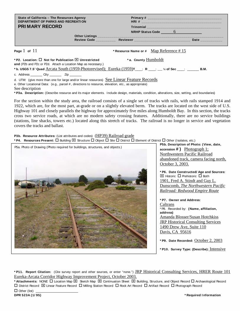
Page 1 of 11 *Resource Name or # Map Reference # 15
State of California – The Resources Agency Primary # _____________________________________ DEPARTMENT OF PARKS AND RECREATION HRI # ________________________________________ PRIMARY RECORD Trinomial _____________________________________ NRHP Status Code 6 Other Listings _______________________________________________________________ Review Code __________ Reviewer ____________________________ Date ___________
*P2. Location: Not for Publication Unrestricted *a. County Humboldt and (P2b and P2c or P2d. Attach a Location Map as necessary.)
*b. USGS 7.5’ Quad Arcata South (1959-Photorevised); Eureka (1959)T___; R ___; ___ ¼ of Sec ___; _____ B.M.
c. Address _____ City _____ Zip _____
d. UTM: (give more than one for large and/or linear resources) See Linear Feature Records e. Other Locational Data: (e.g., parcel #, directions to resource, elevation, etc., as appropriate) See description *P3a. Description: (Describe resource and its major elements. Include design, materials, condition, alterations, size, setting, and boundaries)
For the section within the study area, the railroad consists of a single set of tracks with rails, with rails stamped 1914 and 1922, which are, for the most part, at-grade or on a slightly elevated berm. The tracks are located on the west side of U.S. Highway 101 and closely parallels the highway for approximately five miles along Humboldt Bay. In this section, the tracks cross two service roads, at which are no modern safety crossing features. Additionally, there are no service buildings (stations, line shacks, towers etc.) located along this stretch of tracks. The railroad is no longer in service and vegetation covers the tracks and ballast. P3b. Resource Attributes: (List attributes and codes) (HP39) Railroad grade *P4. Resources Present: Building Structure Object Site District Element of District Other (Isolates, etc.)
P5b. Description of Photo: (View, date, accession #) Photograph 1; Northwestern Pacific Railroad abandoned track, camera facing north, October 3, 2003. *P6. Date Constructed/Age and Sources: Historic Prehistoric Both 1901, Fred A. Stindt and Guy L. Dunscomb, The Northwestern Pacific Railroad: Redwood Empire Route *P7. Owner and Address: Caltrans *P8. Recorded by: (Name, affiliation, address) Amanda Blosser/Susan Hotchkiss JRP Historical Consulting Services 1490 Drew Ave, Suite 110 Davis, CA 95616
*P9. Date Recorded: October 2, 2003
*P10. Survey Type: (Describe): Intensive
P5a. Photo of Drawing (Photo required for buildings, structures, and objects.)
*P11. Report Citation: (Cite survey report and other sources, or enter “none.”) JRP Historical Consulting Services, HRER Route 101 Eureka-Arcata Corridor Highway Improvement Project, October 2003. *Attachments: NONE Location Map Sketch Map Continuation Sheet Building, Structure, and Object Record Archaeological Record District Record Linear Feature Record Milling Station Record Rock Art Record Artifact Record Photograph Record
Other (list) __________________ DPR 523A (1/95) *Required Information
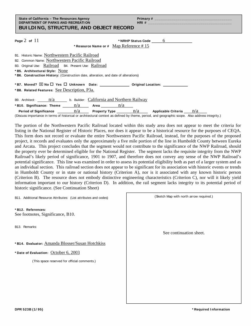
Page 2 of 11 *NRHP Status Code 6
*Resource Name or # Map Reference # 15
State of California – The Resources Agency Primary # _____________________________________ DEPARTMENT OF PARKS AND RECREATION HRI # ________________________________________ BUILDING, STRUCTURE, AND OBJECT RECORD
B1. Historic Name: Northwestern Pacific Railroad B2. Common Name: Northwestern Pacific Railroad B3. Original Use: Railroad B4. Present Use: Railroad
*B5. Architectural Style: None *B6. Construction History: (Construction date, alteration, and date of alterations)
*B7. Moved? No Yes Unknown Date: ____________ Original Location: __________ *B8. Related Features: See Description, P3a.
B9. Architect: n/a b. Builder: California and Northern Railway
*B10. Significance: Theme n/a Area n/a Period of Significance n/a Property Type n/a Applicable Criteria n/a (Discuss importance in terms of historical or architectural context as defined by theme, period, and geographic scope. Also address integrity.) The portion of the Northwestern Pacific Railroad located within this study area does not appear to meet the criteria for listing in the National Register of Historic Places, nor does it appear to be a historical resource for the purposes of CEQA. This form does not record or evaluate the entire Northwestern Pacific Railroad, instead, for the purposes of the proposed project, it records and evaluates only the approximately a five mile portion of the line in Humboldt County between Eureka and Arcata. This project concludes that the segment would not contribute to the significance of the NWP Railroad, should the property ever be determined eligible for the National Register. The segment lacks the requisite integrity from the NWP Railroad’s likely period of significance, 1901 to 1907, and therefore does not convey any sense of the NWP Railroad’s potential significance. This line was examined in order to assess its potential eligibility both as part of a larger system and as an individual section. This railroad section does not appear to be significant for its association with historic events or trends in Humboldt County or in state or national history (Criterion A), nor is it associated with any known historic person (Criterion B). The resource does not embody distinctive engineering characteristics (Criterion C), nor will it likely yield information important to our history (Criterion D). In addition, the rail segment lacks integrity to its potential period of historic significance. (See Continuation Sheet) B11. Additional Resource Attributes: (List attributes and codes) *B12. References: See footnotes, Significance, B10. B13. Remarks: *B14. Evaluator: Amanda Blosser/Susan Hotchkiss *Date of Evaluation: October 6, 2003 (This space reserved for official comments.)
(Sketch Map with north arrow required.)
See continuation sheet.
DPR 523B (1/95) *Required Information
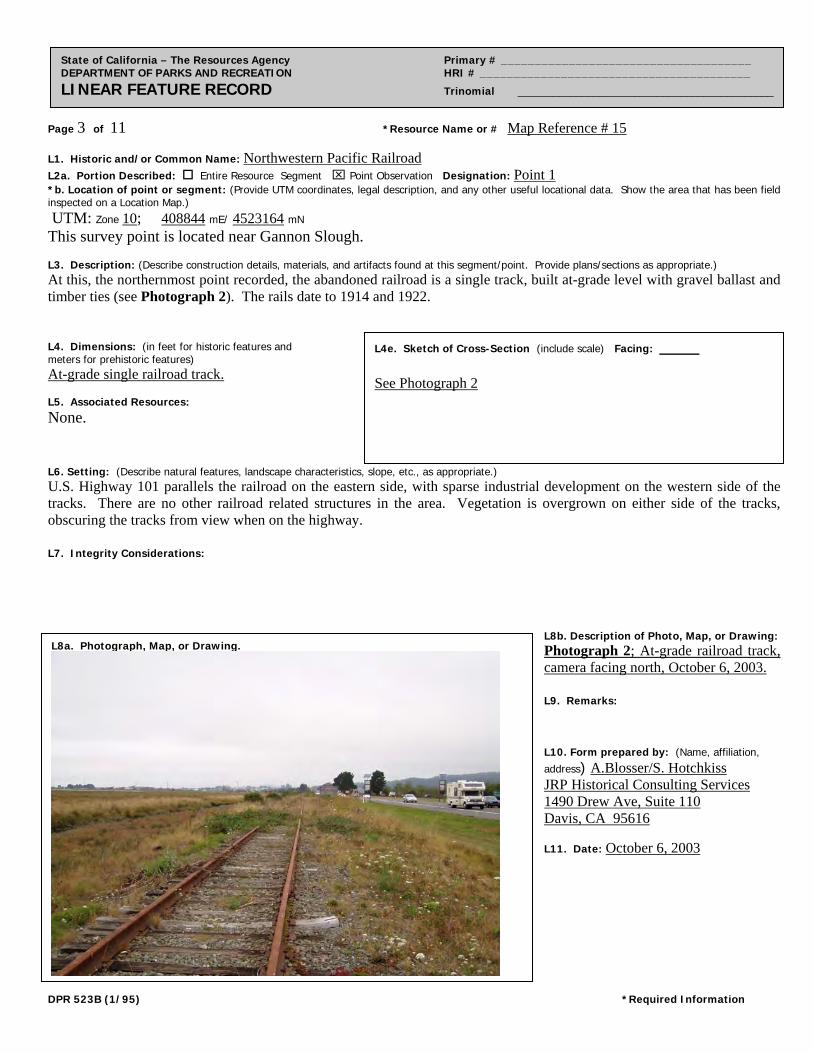
Page 3 of 11 *Resource Name or # Map Reference # 15
State of California – The Resources Agency Primary # _____________________________________ DEPARTMENT OF PARKS AND RECREATION HRI # ________________________________________ LINEAR FEATURE RECORD Trinomial ____________________________________________
L1. Historic and/or Common Name: Northwestern Pacific Railroad L2a. Portion Described: Entire Resource Segment Point Observation Designation: Point 1 *b. Location of point or segment: (Provide UTM coordinates, legal description, and any other useful locational data. Show the area that has been field inspected on a Location Map.)
UTM: Zone 10; 408844 mE/ 4523164 mN This survey point is located near Gannon Slough. L3. Description: (Describe construction details, materials, and artifacts found at this segment/point. Provide plans/sections as appropriate.) At this, the northernmost point recorded, the abandoned railroad is a single track, built at-grade level with gravel ballast and timber ties (see Photograph 2). The rails date to 1914 and 1922. L4. Dimensions: (in feet for historic features and meters for prehistoric features) At-grade single railroad track. L5. Associated Resources: None. L6. Setting: (Describe natural features, landscape characteristics, slope, etc., as appropriate.) U.S. Highway 101 parallels the railroad on the eastern side, with sparse industrial development on the western side of the tracks. There are no other railroad related structures in the area. Vegetation is overgrown on either side of the tracks, obscuring the tracks from view when on the highway. L7. Integrity Considerations:
L8b. Description of Photo, Map, or Drawing: Photograph 2; At-grade railroad track, camera facing north, October 6, 2003. L9. Remarks: L10. Form prepared by: (Name, affiliation,
address) A.Blosser/S. Hotchkiss JRP Historical Consulting Services 1490 Drew Ave, Suite 110 Davis, CA 95616 L11. Date: October 6, 2003
L8a. Photograph, Map, or Drawing.
L4e. Sketch of Cross-Section (include scale) Facing: _____ See Photograph 2
DPR 523B (1/95) *Required Information
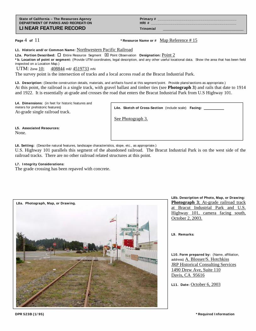
Page 4 of 11 *Resource Name or # Map Reference # 15
State of California – The Resources Agency Primary # _____________________________________ DEPARTMENT OF PARKS AND RECREATION HRI # ________________________________________ LINEAR FEATURE RECORD Trinomial ____________________________________________
L1. Historic and/or Common Name: Northwestern Pacific Railroad L2a. Portion Described: Entire Resource Segment Point Observation Designation: Point 2 *b. Location of point or segment: (Provide UTM coordinates, legal description, and any other useful locational data. Show the area that has been field inspected on a Location Map.)
UTM: Zone 10; 408844 mE/ 4519733 mN The survey point is the intersection of tracks and a local access road at the Bracut Industrial Park. L3. Description: (Describe construction details, materials, and artifacts found at this segment/point. Provide plans/sections as appropriate.) At this point, the railroad is a single track, with gravel ballast and timber ties (see Photograph 3) and rails that date to 1914 and 1922. It is essentially at-grade and crosses the road that enters the Bracut Industrial Park from U.S Highway 101. L4. Dimensions: (in feet for historic features and meters for prehistoric features) At-grade single railroad track.
L5. Associated Resources: None. L6. Setting: (Describe natural features, landscape characteristics, slope, etc., as appropriate.) U.S. Highway 101 parallels this segment of the abandoned railroad. The Bracut Industrial Park is on the west side of the railroad tracks. There are no other railroad related structures at this point. L7. Integrity Considerations: The grade crossing has been repaved with concrete.
L8b. Description of Photo, Map, or Drawing: Photograph 3; At-grade railroad track at Bracut Industrial Park and U.S. Highway 101, camera facing south, October 2, 2003. L9. Remarks: L10. Form prepared by: (Name, affiliation, address) A. Blosser/S. Hotchkiss JRP Historical Consulting Services 1490 Drew Ave, Suite 110 Davis, CA 95616 L11. Date: October 6, 2003
L8a. Photograph, Map, or Drawing.
L4e. Sketch of Cross-Section (include scale) Facing: ________ See Photograph 3.
DPR 523B (1/95) *Required Information
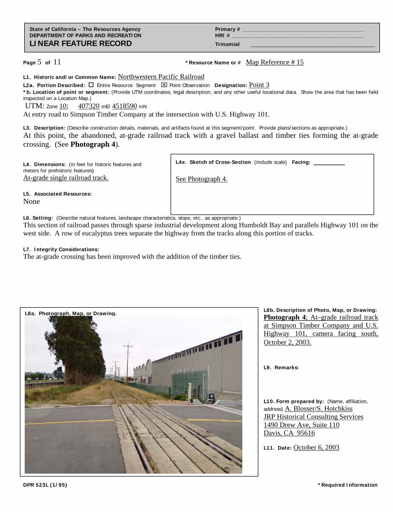
Page 5 of 11 *Resource Name or # Map Reference # 15
State of California – The Resources Agency Primary # _____________________________________ DEPARTMENT OF PARKS AND RECREATION HRI # ________________________________________ LINEAR FEATURE RECORD Trinomial ____________________________________________
L1. Historic and/or Common Name: Northwestern Pacific Railroad L2a. Portion Described: Entire Resource Segment Point Observation Designation: Point 3 *b. Location of point or segment: (Provide UTM coordinates, legal description, and any other useful locational data. Show the area that has been field inspected on a Location Map.)
UTM: Zone 10; 407320 mE/ 4518590 mN At entry road to Simpson Timber Company at the intersection with U.S. Highway 101. L3. Description: (Describe construction details, materials, and artifacts found at this segment/point. Provide plans/sections as appropriate.)
At this point, the abandoned, at-grade railroad track with a gravel ballast and timber ties forming the at-grade crossing. (See Photograph 4). L4. Dimensions: (in feet for historic features and meters for prehistoric features) At-grade single railroad track.
L5. Associated Resources: None L6. Setting: (Describe natural features, landscape characteristics, slope, etc., as appropriate.) This section of railroad passes through sparse industrial development along Humboldt Bay and parallels Highway 101 on the west side. A row of eucalyptus trees separate the highway from the tracks along this portion of tracks. L7. Integrity Considerations: The at-grade crossing has been improved with the addition of the timber ties.
L8b. Description of Photo, Map, or Drawing: Photograph 4; At–grade railroad track at Simpson Timber Company and U.S. Highway 101, camera facing south, October 2, 2003. L9. Remarks: L10. Form prepared by: (Name, affiliation, address) A. Blosser/S. Hotchkiss JRP Historical Consulting Services 1490 Drew Ave, Suite 110 Davis, CA 95616 L11. Date: October 6, 2003
L8a. Photograph, Map, or Drawing.
L4e. Sketch of Cross-Section (include scale) Facing: ________ See Photograph 4.
DPR 523L (1/95) *Required Information
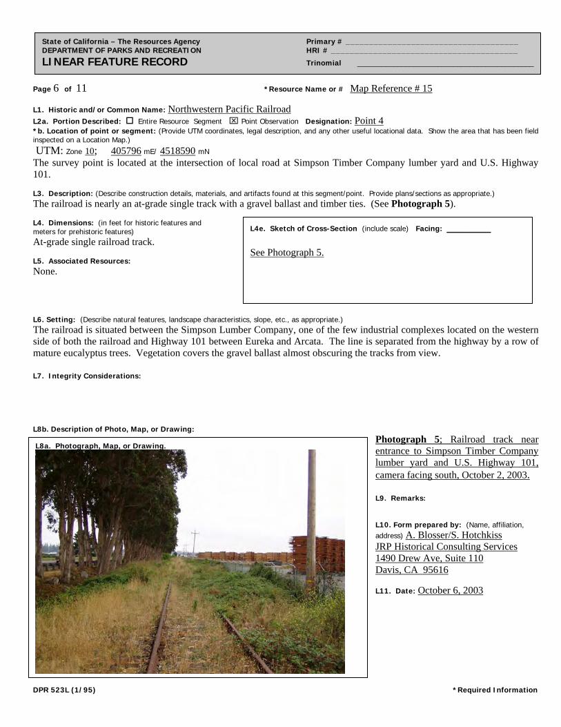
Page 6 of 11 *Resource Name or # Map Reference # 15
State of California – The Resources Agency Primary # _____________________________________ DEPARTMENT OF PARKS AND RECREATION HRI # ________________________________________ LINEAR FEATURE RECORD Trinomial ____________________________________________
L1. Historic and/or Common Name: Northwestern Pacific Railroad L2a. Portion Described: Entire Resource Segment Point Observation Designation: Point 4 *b. Location of point or segment: (Provide UTM coordinates, legal description, and any other useful locational data. Show the area that has been field inspected on a Location Map.)
UTM: Zone 10; 405796 mE/ 4518590 mN The survey point is located at the intersection of local road at Simpson Timber Company lumber yard and U.S. Highway 101. L3. Description: (Describe construction details, materials, and artifacts found at this segment/point. Provide plans/sections as appropriate.) The railroad is nearly an at-grade single track with a gravel ballast and timber ties. (See Photograph 5). L4. Dimensions: (in feet for historic features and meters for prehistoric features) At-grade single railroad track. L5. Associated Resources: None. L6. Setting: (Describe natural features, landscape characteristics, slope, etc., as appropriate.) The railroad is situated between the Simpson Lumber Company, one of the few industrial complexes located on the western side of both the railroad and Highway 101 between Eureka and Arcata. The line is separated from the highway by a row of mature eucalyptus trees. Vegetation covers the gravel ballast almost obscuring the tracks from view. L7. Integrity Considerations: L8b. Description of Photo, Map, or Drawing:
Photograph 5; Railroad track near entrance to Simpson Timber Company lumber yard and U.S. Highway 101, camera facing south, October 2, 2003. L9. Remarks: L10. Form prepared by: (Name, affiliation, address) A. Blosser/S. Hotchkiss JRP Historical Consulting Services 1490 Drew Ave, Suite 110 Davis, CA 95616 L11. Date: October 6, 2003
L8a. Photograph, Map, or Drawing.
L4e. Sketch of Cross-Section (include scale) Facing: ________ See Photograph 5.
DPR 523L (1/95) *Required Information
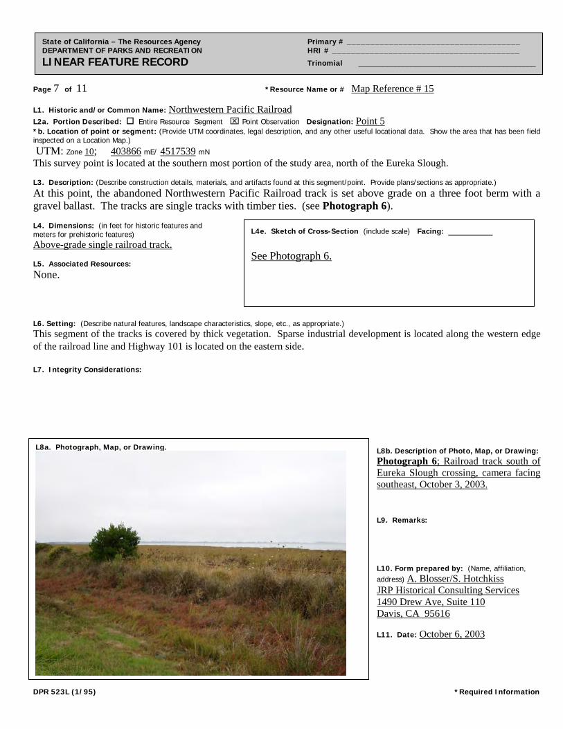
Page 7 of 11 *Resource Name or # Map Reference # 15
State of California – The Resources Agency Primary # _____________________________________ DEPARTMENT OF PARKS AND RECREATION HRI # ________________________________________ LINEAR FEATURE RECORD Trinomial ____________________________________________
L1. Historic and/or Common Name: Northwestern Pacific Railroad L2a. Portion Described: Entire Resource Segment Point Observation Designation: Point 5 *b. Location of point or segment: (Provide UTM coordinates, legal description, and any other useful locational data. Show the area that has been field inspected on a Location Map.)
UTM: Zone 10; 403866 mE/ 4517539 mN This survey point is located at the southern most portion of the study area, north of the Eureka Slough. L3. Description: (Describe construction details, materials, and artifacts found at this segment/point. Provide plans/sections as appropriate.)
At this point, the abandoned Northwestern Pacific Railroad track is set above grade on a three foot berm with a gravel ballast. The tracks are single tracks with timber ties. (see Photograph 6). L4. Dimensions: (in feet for historic features and meters for prehistoric features) Above-grade single railroad track. L5. Associated Resources: None. L6. Setting: (Describe natural features, landscape characteristics, slope, etc., as appropriate.) This segment of the tracks is covered by thick vegetation. Sparse industrial development is located along the western edge of the railroad line and Highway 101 is located on the eastern side. L7. Integrity Considerations:
L8b. Description of Photo, Map, or Drawing: Photograph 6; Railroad track south of Eureka Slough crossing, camera facing southeast, October 3, 2003. L9. Remarks: L10. Form prepared by: (Name, affiliation, address) A. Blosser/S. Hotchkiss JRP Historical Consulting Services 1490 Drew Ave, Suite 110 Davis, CA 95616 L11. Date: October 6, 2003
L8a. Photograph, Map, or Drawing.
L4e. Sketch of Cross-Section (include scale) Facing: ________ See Photograph 6.
DPR 523L (1/95) *Required Information
Page 8 of 11 *Resource Name or # (Assigned by recorder) Map Reference #15 *Recorded by Amanda Blosser/Susan Hotchkiss *Date October 2, 2003 Continuation Update
State of California – The Resources Agency Primary # _____________________________________ DEPARTMENT OF PARKS AND RECREATION HRI # ________________________________________ CONTINUATION SHEET Trinomial ____________________________________________
B10. Significance (continued): Railroads were first constructed around the Humboldt Bay region at the end of the nineteenth century. Logging companies built short-line railroads to bring the lumber from the area’s vast redwood forests to the mills centered in Eureka and Arcata. Local entrepreneur and mill owner John Vance of Eureka opened the area’s first railroad in 1875 along the Mad River Slough to Essex, north of Arcata. A private enterprise, the Mad River Railroad was purchased by Vance’s nephews, Edgar and John Vance in 1891. In 1892, the Humboldt Bay & Trinidad Lumber & Logging Company purchased the line and incorporated it as the Eureka & Klamath River Railroad (E&KRR) in 1896. The E&KRR soon began work on a line connecting Eureka and Arcata.1
California & Northern Railroad (C&N), incorporated in 1901, took over the rail line construction of the Eureka to Arcata segment from the E&KRR, completing it on October 30, 1901. This line left the northern outskirts of Eureka and traveled east along the southeastern stretches of Humboldt Bay, turning generally northeast around present day Brainard to Bracut (originally known as Brainard and later as Brainard Cut). At Bracut, the line traveled directly north into Arcata, bypassing the small communities of Sunny Brae, Bayside, and Indianola, located on Old Arcata Road. Because the C&N did not have the money to begin operations, the Eel River & Eureka Railroad, a small line connecting the bay with the mills at Scotia, leased the C&N’s line and in December of 1901 and began passenger and freight service between Eureka and Arcata, using the segment of railroad recorded in this form. Although a number of companies had built local lines by 1900, planning for rail service to link the region with the rest of California did not begin until 1903, when the Santa Fe Railway incorporated the San Francisco & Northwestern Railway Company (SF&NW), intending to connect its California lines with the Humboldt Bay lines. The SF&NW soon purchased the Eel River & Eureka Railroad, the C&N, and several other local lines. By 1905, the Santa Fe Railway owned over fifty miles of track in Humboldt County.2 The Southern Pacific Railroad (SPRR) also desired to extend its services into the Eureka and Arcata area, and in 1903 incorporated the SF&NW and Eureka Railway Company to construct 200 miles of track between Willits and Eureka. By 1905 the SPRR and the Santa Fe realized the cost of constructing two competing lines into the Humboldt Bay region would be too high to make a profit. In January 1907, the two companies incorporated the Northwestern Pacific Railroad Company (NWP), which consolidated the lines of the Santa Fe’s SF&NW and Northwestern and the Southern Pacific’s San Francisco and Eureka Railway Company. The NWP also received ownership of the Eureka & Klamath River Railroad, the C&N Railway, and other north coast railroads, including those in Mendocino and Sonoma counties. The NWP completed the line from Willits north to Eureka in 1914. This railroad line ended at Eureka, and the portion of the railroad heading north from Eureka became known as the Trinidad Branch. The arrival of the Northwestern Pacific Railroad line into Eureka in 1914 opened the town’s growing lumber industry to markets in Central California, and contributed to growth in the region’s other commercial enterprises. The railroad also heavily promoted the line to tourists, which encouraged a tourist industry in the redwood country, particularly as a resort destination to urban San Franciscans. NWP released an annual publication, “Vacation,” which advertised the many resorts and attractions to be found along the NWP redwood line. NWP marketed the “Triangle Trip,” a course originating at the Sausalito ferry terminal, traveling northwest to Monte Rio, east along the Russian River to Fulton, then returning to
1 Fred A. Stindt and Guy L. Dunscomb, The Northwestern Pacific Railroad: Redwood Empire Route (Redwood City and Modesto, California: Fred A. Stindt and Guy L. Dunscomb, 1964), 38. 2 Stindt and Dunscomb, The Northwestern Pacific Railroad, 40. Note: E&KRR was purchased by the Southern Pacific in 1903. Carranco, Lynwood, Redwood Lumber Industry, (San Marino: Golden West Books, 1982), 138. DPR 523L (1/95) *Required Information
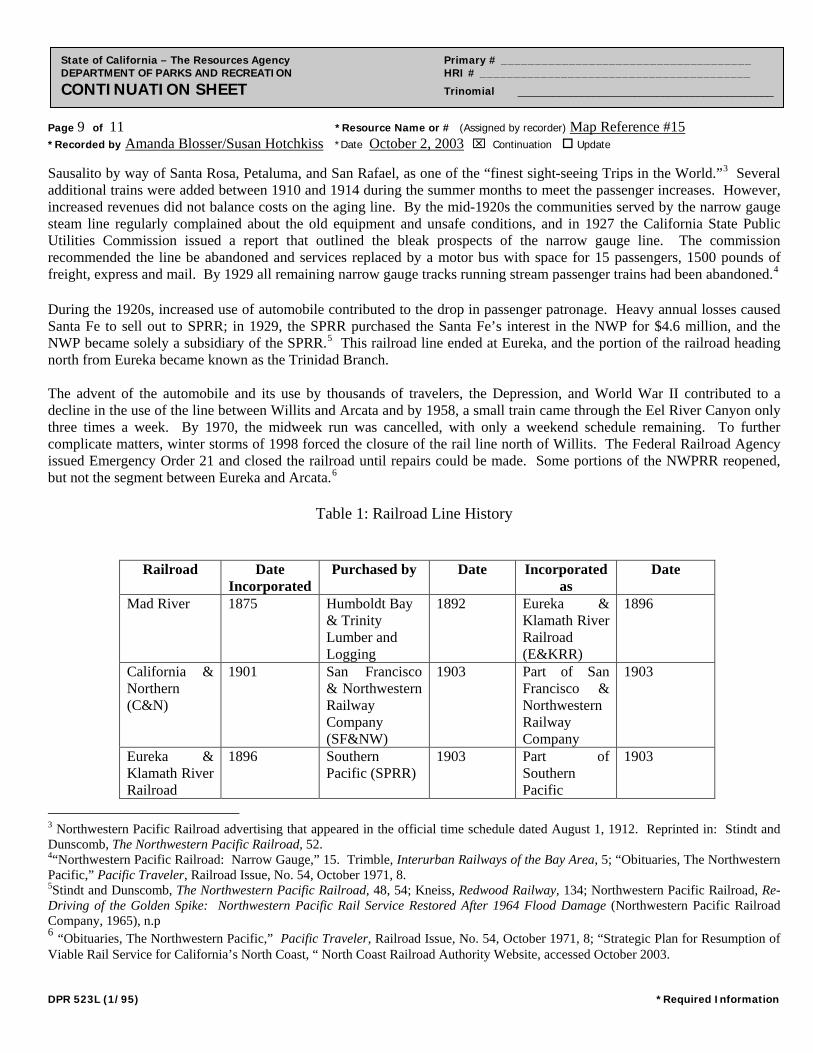
Page 9 of 11 *Resource Name or # (Assigned by recorder) Map Reference #15 *Recorded by Amanda Blosser/Susan Hotchkiss *Date October 2, 2003 Continuation Update
State of California – The Resources Agency Primary # _____________________________________ DEPARTMENT OF PARKS AND RECREATION HRI # ________________________________________ CONTINUATION SHEET Trinomial ____________________________________________
Sausalito by way of Santa Rosa, Petaluma, and San Rafael, as one of the “finest sight-seeing Trips in the World.”3 Several additional trains were added between 1910 and 1914 during the summer months to meet the passenger increases. However, increased revenues did not balance costs on the aging line. By the mid-1920s the communities served by the narrow gauge steam line regularly complained about the old equipment and unsafe conditions, and in 1927 the California State Public Utilities Commission issued a report that outlined the bleak prospects of the narrow gauge line. The commission recommended the line be abandoned and services replaced by a motor bus with space for 15 passengers, 1500 pounds of freight, express and mail. By 1929 all remaining narrow gauge tracks running stream passenger trains had been abandoned.4 During the 1920s, increased use of automobile contributed to the drop in passenger patronage. Heavy annual losses caused Santa Fe to sell out to SPRR; in 1929, the SPRR purchased the Santa Fe’s interest in the NWP for $4.6 million, and the NWP became solely a subsidiary of the SPRR.5 This railroad line ended at Eureka, and the portion of the railroad heading north from Eureka became known as the Trinidad Branch. The advent of the automobile and its use by thousands of travelers, the Depression, and World War II contributed to a decline in the use of the line between Willits and Arcata and by 1958, a small train came through the Eel River Canyon only three times a week. By 1970, the midweek run was cancelled, with only a weekend schedule remaining. To further complicate matters, winter storms of 1998 forced the closure of the rail line north of Willits. The Federal Railroad Agency issued Emergency Order 21 and closed the railroad until repairs could be made. Some portions of the NWPRR reopened, but not the segment between Eureka and Arcata.6
Table 1: Railroad Line History
Railroad Date Incorporated
Purchased by Date Incorporated as
Date
Mad River 1875 Humboldt Bay & Trinity Lumber and Logging
1892 Eureka & Klamath River Railroad (E&KRR)
1896
California & Northern (C&N)
1901 San Francisco & Northwestern Railway Company (SF&NW)
1903 Part of San Francisco & Northwestern Railway Company
1903
Eureka & Klamath River Railroad
1896 Southern Pacific (SPRR)
1903 Part of Southern Pacific
1903
3 Northwestern Pacific Railroad advertising that appeared in the official time schedule dated August 1, 1912. Reprinted in: Stindt and Dunscomb, The Northwestern Pacific Railroad, 52. 4“Northwestern Pacific Railroad: Narrow Gauge,” 15. Trimble, Interurban Railways of the Bay Area, 5; “Obituaries, The Northwestern Pacific,” Pacific Traveler, Railroad Issue, No. 54, October 1971, 8. 5Stindt and Dunscomb, The Northwestern Pacific Railroad, 48, 54; Kneiss, Redwood Railway, 134; Northwestern Pacific Railroad, Re-Driving of the Golden Spike: Northwestern Pacific Rail Service Restored After 1964 Flood Damage (Northwestern Pacific Railroad Company, 1965), n.p 6 “Obituaries, The Northwestern Pacific,” Pacific Traveler, Railroad Issue, No. 54, October 1971, 8; “Strategic Plan for Resumption of Viable Rail Service for California’s North Coast, “ North Coast Railroad Authority Website, accessed October 2003. DPR 523L (1/95) *Required Information
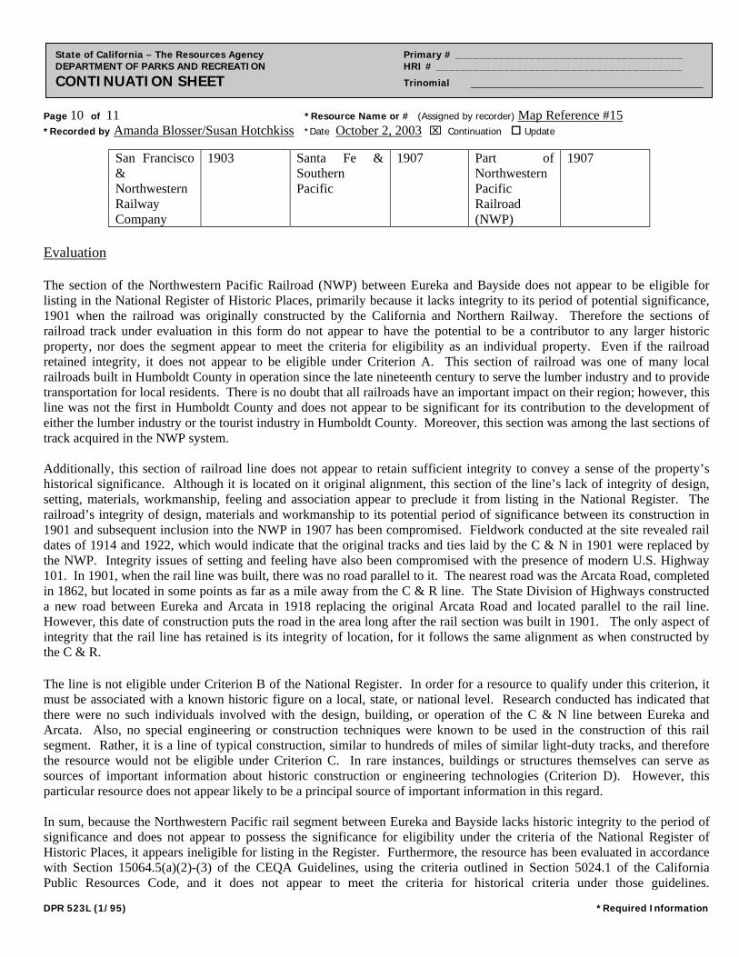
Page 10 of 11 *Resource Name or # (Assigned by recorder) Map Reference #15 *Recorded by Amanda Blosser/Susan Hotchkiss *Date October 2, 2003 Continuation Update
State of California – The Resources Agency Primary # _____________________________________ DEPARTMENT OF PARKS AND RECREATION HRI # ________________________________________ CONTINUATION SHEET Trinomial ____________________________________________
San Francisco & Northwestern Railway Company
1903 Santa Fe & Southern Pacific
1907 Part of Northwestern Pacific Railroad (NWP)
1907
Evaluation The section of the Northwestern Pacific Railroad (NWP) between Eureka and Bayside does not appear to be eligible for listing in the National Register of Historic Places, primarily because it lacks integrity to its period of potential significance, 1901 when the railroad was originally constructed by the California and Northern Railway. Therefore the sections of railroad track under evaluation in this form do not appear to have the potential to be a contributor to any larger historic property, nor does the segment appear to meet the criteria for eligibility as an individual property. Even if the railroad retained integrity, it does not appear to be eligible under Criterion A. This section of railroad was one of many local railroads built in Humboldt County in operation since the late nineteenth century to serve the lumber industry and to provide transportation for local residents. There is no doubt that all railroads have an important impact on their region; however, this line was not the first in Humboldt County and does not appear to be significant for its contribution to the development of either the lumber industry or the tourist industry in Humboldt County. Moreover, this section was among the last sections of track acquired in the NWP system. Additionally, this section of railroad line does not appear to retain sufficient integrity to convey a sense of the property’s historical significance. Although it is located on it original alignment, this section of the line’s lack of integrity of design, setting, materials, workmanship, feeling and association appear to preclude it from listing in the National Register. The railroad’s integrity of design, materials and workmanship to its potential period of significance between its construction in 1901 and subsequent inclusion into the NWP in 1907 has been compromised. Fieldwork conducted at the site revealed rail dates of 1914 and 1922, which would indicate that the original tracks and ties laid by the C & N in 1901 were replaced by the NWP. Integrity issues of setting and feeling have also been compromised with the presence of modern U.S. Highway 101. In 1901, when the rail line was built, there was no road parallel to it. The nearest road was the Arcata Road, completed in 1862, but located in some points as far as a mile away from the C & R line. The State Division of Highways constructed a new road between Eureka and Arcata in 1918 replacing the original Arcata Road and located parallel to the rail line. However, this date of construction puts the road in the area long after the rail section was built in 1901. The only aspect of integrity that the rail line has retained is its integrity of location, for it follows the same alignment as when constructed by the C & R. The line is not eligible under Criterion B of the National Register. In order for a resource to qualify under this criterion, it must be associated with a known historic figure on a local, state, or national level. Research conducted has indicated that there were no such individuals involved with the design, building, or operation of the C & N line between Eureka and Arcata. Also, no special engineering or construction techniques were known to be used in the construction of this rail segment. Rather, it is a line of typical construction, similar to hundreds of miles of similar light-duty tracks, and therefore the resource would not be eligible under Criterion C. In rare instances, buildings or structures themselves can serve as sources of important information about historic construction or engineering technologies (Criterion D). However, this particular resource does not appear likely to be a principal source of important information in this regard. In sum, because the Northwestern Pacific rail segment between Eureka and Bayside lacks historic integrity to the period of significance and does not appear to possess the significance for eligibility under the criteria of the National Register of Historic Places, it appears ineligible for listing in the Register. Furthermore, the resource has been evaluated in accordance with Section 15064.5(a)(2)-(3) of the CEQA Guidelines, using the criteria outlined in Section 5024.1 of the California Public Resources Code, and it does not appear to meet the criteria for historical criteria under those guidelines.
DPR 523L (1/95) *Required Information
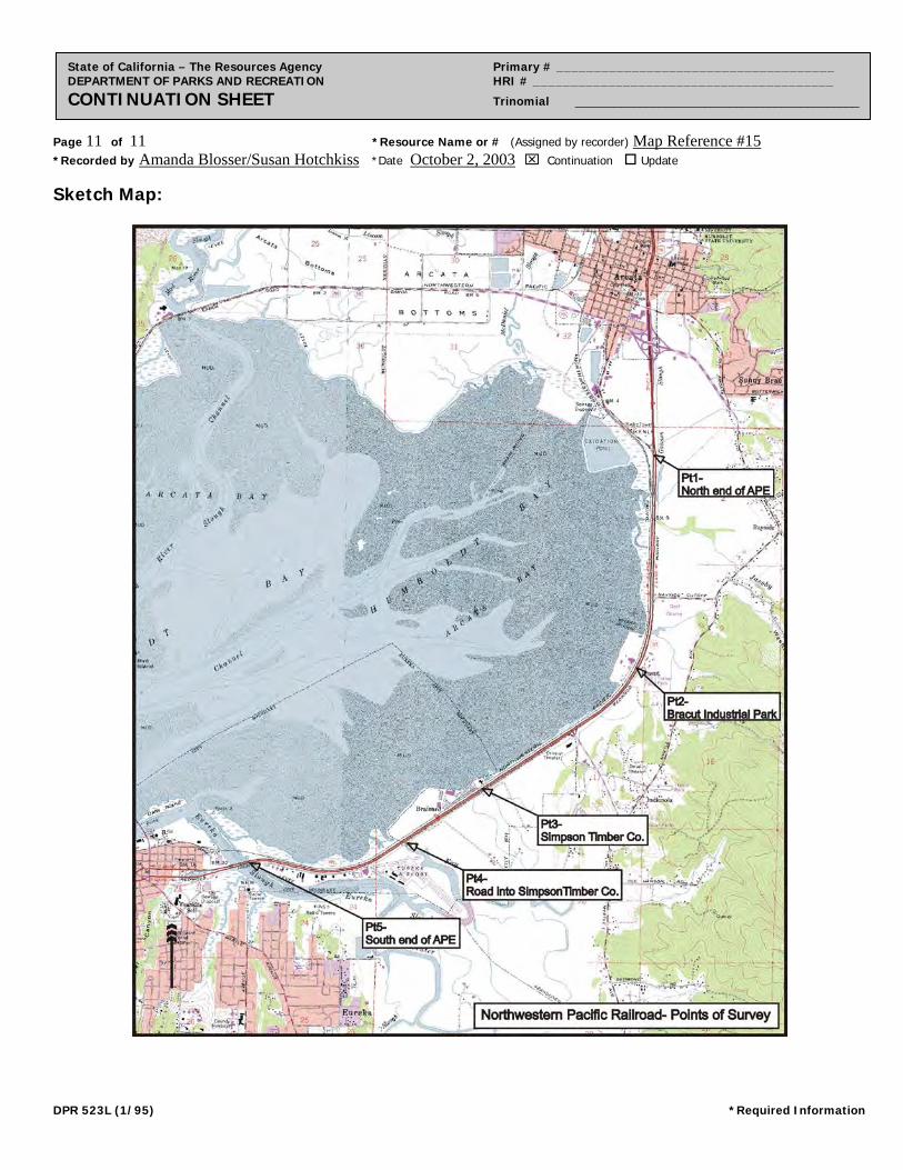
Page 11 of 11 *Resource Name or # (Assigned by recorder) Map Reference #15 *Recorded by Amanda Blosser/Susan Hotchkiss *Date October 2, 2003 Continuation Update
State of California – The Resources Agency Primary # _____________________________________ DEPARTMENT OF PARKS AND RECREATION HRI # ________________________________________ CONTINUATION SHEET Trinomial ____________________________________________
Sketch Map:
DPR 523L (1/95) *Required Information
JRP Historical Consulting Services 7/16/2004
34
APPENDIX C: CALTRANS MEMORANDUM REGARDING PROPERTIES CONSTRUCTED AFTER 1957