route management and development
TRANSCRIPT
a. Channelization: Channelization refers to the use of one or more traffic control devices to direct or channelize traffic into the locations for which they are intended to travel. This is generally used at, or in advance of, an intersection to direct traffic through an intersection. Types of channelization that may be used for this purpose include: markings, signs, diverter islands, curb extensions, delineators, and lane striping. b. Installation of Traffic Control Devices: The installation of traffic control devices, such as traffic signals, roundabouts, markings, and signs are used to regulate, warn, and/or guide traffic. These devices are primarily used at intersections to facilitate the flow of traffic at and through intersections on SR 273. In the future, traffic signals and other traffic control devices will be utilized when appropriate to respond to increased demand due to specific development projects, and/or as traffic volumes increase. c. Maintain / Expand Signal Coordination: Signal coordination is the establishment of timed relationships between adjacent traffic control signals. This strategy is typically seen in urban areas where the signals are close enough to each other to allow for appropriate timing of the signals involved. This coordinated timing improves efficiency by enhancing traffic flow, reducing delays, and lowering vehicle emissions. At this time, signals in downtown Redding (Segments 9A, 9B and 10) are coordinated. The signal timing plan in the couplet (particularly northbound) will continue to be monitored and adjusted as conditions warrant. As new signals are contemplated outside of downtown Redding, Caltrans will consider the effectiveness of utilizing coordinated signal timing with the new signal(s). Challenges to consider are the distance between signals, most notably in the area between the Cities of Anderson and Redding, and the need to serve traffic approaching SR 273 on side streets along the route. The District will partner with local agencies on the route to coordinate signal timing at intersections where feasible. Specific studies would need to be undertaken to determine where application of this technology may be appropriate. d. Adaptive Signal Control Technology (ASCT): Adaptive Signal Control Technology (ASCT) uses real-time traffic information to reduce congestion. By receiving and processing data from strategically placed sensors, ASCT can determine which lights should be red and which should be green to accommodate changing traffic patterns and ease traffic congestion. This improves the quality of service that travelers experience by reducing unnecessary delays and enabling traffic to move more quickly and smoothly. The main benefits of ASCT over conventional signal systems are that it can:
• Continuously distribute green light time equitably for all traffic movements • Improve travel time reliability by progressively moving vehicles through green lights • Reduce congestion by creating smoother flow • Prolong the effectiveness of traffic signal timing
SR 273 TCR Page 54
This technology could be particularly beneficial for the northbound couplet when LOS declines in the future. In fact, ASCT may have the potential to achieve better operations in the couplet than the existing fixed signal timing plans. e. Signal Preemption: The use of preemptive traffic signals will also be considered. The 2009 edition of the Manual on Uniform Traffic Control Devices (MUTCD) defines traffic signal preemption as “the transfer of normal operation of a traffic control signal to a special control mode of operation.” Preemptive control is typically given to trains, boats, emergency vehicles, and light rail transport. Per Section 4D.27 of the 2009 edition of the MUTCD, examples of preemption control include the following:
A. The prompt displaying of green signal indications at signalized locations ahead of fire vehicles, law enforcement vehicles, ambulances, and other official emergency vehicles;
B. A special sequence of signal phases and timing to expedite and/or provide additional clearance time for vehicles to clear the tracks prior to the arrival of rail traffic; and
C. A special sequence of signal phases to display a steady red indication to prohibit turning movements toward the tracks during the approach or passage of rail traffic.
Signal preemption is commonly used for fire engines because the size of their vehicles makes them less able to move through traffic without the aid of preemption. Signal preemption controls the movement of traffic that is of greater importance than general vehicle and pedestrian traffic. Preemptive control is necessary to avoid collisions (e.g., trains versus automobiles) and/or give right of way to vehicles in an emergency situation (e.g., fire engines responding to an emergency). There are currently seven signal locations with railroad preemption and 17 signal locations with Emergency Vehicle Preemption (EVP). Additional preemption devices at both existing signal locations as well as at new signal installations may be implemented in the future. f. Vehicle Detection Systems: There are various forms of vehicle detection technologies available which can detect vehicles at intersections such as microwaves, cameras, radars, and in-pavement loops. In-pavement loop detection consists of a loop of wire, imbedded in a groove below the surface of the pavement, which is able to detect the presence of a vehicle at the point where this detection device has been installed. In District 2’s experience, in-pavement loop detection is more reliable than other forms of detection and typically lasts the life of the pavement in which it is installed. District 2 will emphasize use of this technology in the future, but other detection systems may be considered in certain situations. g. Coordination with Trip Generators: There are a number of large trip generators (i.e. substantial traffic generators) on the route. This list includes uses such as schools, large employers (government offices, hospitals, commercial and/or industrial areas), shopping centers, and casinos. Caltrans will work with the appropriate entities involved to mitigate the impact of large traffic generators or implement travel demand management strategies by:
SR 273 TCR Page 55 June 2013
• Staggering start times (schools and/or businesses) • Encouraging and accommodating alternative modes of transportation • Ride sharing and/or carpooling • Adding new transit stop(s)
An example of where this has been successful on the route is Turtle Bay Elementary School. This school, located north of downtown Redding, experiences traffic delays during school drop-off and pick-up times due to the high volume of vehicles that drive into and out of the school during these times. This results in the backup of traffic onto SR 273. The school has implemented a program they call “Avoid the Loop” (for more on this, see the pedestrian section below). 3. Intelligent Transportation Systems (ITS) Intelligent Transportation Systems (ITS) will be utilized to assist highway users in making informed decisions regarding use of the route. By displaying current road, traffic, and weather conditions, for instance, or displaying notification of a road or weather hazard, the user has the option to choose a different route to their destination in order to avoid a travel delay. Table 2.2 lists nine potential ITS elements for the 20-year horizon in the SR 273 corridor. As Table 2.2 indicates, there are seven possible locations identified for Closed Circuit Television (CCTV) on SR 273. The installation of CCTV, like at the intersection of SR 273 and Lake Boulevard, allows the District to monitor roadway and weather conditions from its Transportation Management Center (TMC). Highway users utilize CCTV to provide visual verification of traffic and weather conditions and to make informed travel decisions about what time to leave, or what route to take, before heading out on the road. Changeable Message Signs (CMS), like the two possible on SR 273, play an increasingly important role in contributing to improved operations and the use of existing facilities. CMS’s are large electronic signs capable of displaying messages of up to three lines of text, and can provide advanced warning of highway incidents, weather and road conditions, and other critical information to travelers. As mentioned in the Route Elements section of this report, the Redding Area Fiber Plan calls for installing fiber along SR 273 from the City of Anderson to the route’s junction with I-5 in the northern portion of the City of Redding. The fiber would be used for Transportation Management Systems (TMS) communications back to the TMC in Redding. 4. Transit Though District 2 does not directly operate transit systems, it will continue to cooperate with RABA and SRTA to identify opportunities to improve or modify bus routes where SR 273 is utilized as a portion of their route. Caltrans will continue to cooperate as RABA works to meet the community’s transit needs, while also working to increase ridership and fare box revenue.
SR 273 TCR Page 56 June 2013
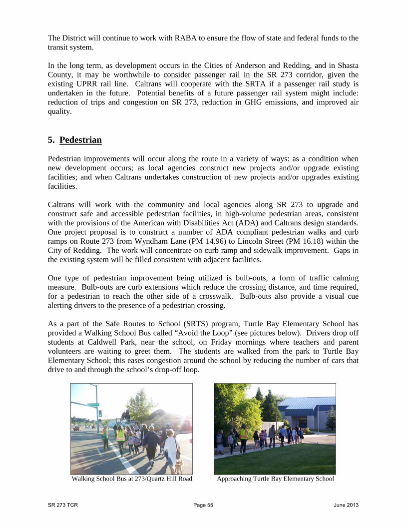
The District will continue to work with RABA to ensure the flow of state and federal funds to the transit system. In the long term, as development occurs in the Cities of Anderson and Redding, and in Shasta County, it may be worthwhile to consider passenger rail in the SR 273 corridor, given the existing UPRR rail line. Caltrans will cooperate with the SRTA if a passenger rail study is undertaken in the future. Potential benefits of a future passenger rail system might include: reduction of trips and congestion on SR 273, reduction in GHG emissions, and improved air quality. 5. Pedestrian Pedestrian improvements will occur along the route in a variety of ways: as a condition when new development occurs; as local agencies construct new projects and/or upgrade existing facilities; and when Caltrans undertakes construction of new projects and/or upgrades existing facilities. Caltrans will work with the community and local agencies along SR 273 to upgrade and construct safe and accessible pedestrian facilities, in high-volume pedestrian areas, consistent with the provisions of the American with Disabilities Act (ADA) and Caltrans design standards. One project proposal is to construct a number of ADA compliant pedestrian walks and curb ramps on Route 273 from Wyndham Lane (PM 14.96) to Lincoln Street (PM 16.18) within the City of Redding. The work will concentrate on curb ramp and sidewalk improvement. Gaps in the existing system will be filled consistent with adjacent facilities. One type of pedestrian improvement being utilized is bulb-outs, a form of traffic calming measure. Bulb-outs are curb extensions which reduce the crossing distance, and time required, for a pedestrian to reach the other side of a crosswalk. Bulb-outs also provide a visual cue alerting drivers to the presence of a pedestrian crossing. As a part of the Safe Routes to School (SRTS) program, Turtle Bay Elementary School has provided a Walking School Bus called “Avoid the Loop” (see pictures below). Drivers drop off students at Caldwell Park, near the school, on Friday mornings where teachers and parent volunteers are waiting to greet them. The students are walked from the park to Turtle Bay Elementary School; this eases congestion around the school by reducing the number of cars that drive to and through the school’s drop-off loop.
Walking School Bus at 273/Quartz Hill Road Approaching Turtle Bay Elementary School
SR 273 TCR Page 57 June 2013
Improvement of pedestrian circulation in the vicinity of SR 273 will require planning for and implementing projects both directly within the highway corridor itself as well as other local facilities. The “City of Redding Pedestrian Safety Assessment” (ITS - Berkeley, April 2010) identified a number of possible pedestrian improvements; however, it was “conceptual in nature” and acknowledged that “more detailed studies or further analysis” would be needed to “refine or discard the suggestions in this report.” Toward this end, District 2 supports the recommendation in the assessment for coordination between the City of Redding and Caltrans in development of pedestrian studies. Understanding pedestrian flow on both SR 273 and adjacent city streets would allow for identification and prioritization of projects that would best meet the needs of pedestrians, whether directly on the highway or not. 6. Bicycle SR 273 is designated as the north-south bicycle route from the City of Anderson to north of the City of Redding (as Interstate 5 is closed to bicycles where it parallels SR 273). At present, however, specific facilities for bicycles are limited on SR 273. A key goal of this TCR is to establish a common vision to guide development of bicycle facilities on SR 273 in the future. Toward this end, the Regional Transportation Plan, and applicable General and Bicycle Transportation Plans, were reviewed. Caltrans met with the public works and planning staff of City of Anderson, City of Redding, and Shasta County. Bicycle specific outreach was also conducted (for additional information see Appendix H). From this effort, a clear consensus emerged regarding future bicycle facilities on SR 273: a Class II facility from the City of Anderson to north of the City of Redding. The development of a continuous Class II facility will be accomplished over time through:
• Incorporating bicycle elements into highway improvement projects, when feasible • Working with local agencies and developers to incorporate bicycle elements into
development projects • Cooperating with development of local plans and projects to enhance bicycle travel and
facilities • Ensuring that as projects on the route are developed, they account for the vision of
developing a continuous Class II facility on SR 273 It is clear that it will take time and cooperative efforts between Caltrans and local partners to develop a continuous Class II facility on SR 273. 7. Community Enhancement Caltrans recognizes that SR 273 is an integral part of the local communities through which it passes, and that the route can have an impact on their economic and social well-being, and quality of life. Caltrans uses “Context Sensitive Solutions” as an approach to plan, design, construct, maintain, and operate the state transportation system. These solutions use innovative and inclusive approaches that balance community, aesthetic, historic, and environmental values with transportation safety, maintenance, and performance goals. Caltrans utilizes this process to
SR 273 TCR Page 58 June 2013
ensure that transportation projects are in harmony with communities, and that intrinsic qualities are enhanced and preserved. Caltrans will coordinate with local agencies, project developers, local communities, and other project sponsors when they present ideas for enhancements on SR 273, balancing the need to meet the first two management objectives. The Downtown Redding Specific Plan (DRSP) was adopted by the City Council in January 2001. In it, the vision for downtown Redding is to see it become the social, cultural, and specialty retail center of the community. The overall goal of the DRSP is “to create a revitalized Downtown Redding that is attractive, safe, economically vibrant, respectful of historical and natural resources, and integrated with shops, housing, workplaces, parks, and civic facilities that are pedestrian-oriented and inviting to residents and visitors alike.” A number of projects in the downtown area of the City of Redding have been completed since the adoption of the DRSP. Among them are improvements along SR 273 at the intersections of: Eureka Way; Shasta Street; and Tehama Street. These projects serve to improve both vehicle and pedestrian circulation, while working to coordinate with the overall goal of the DRSP. Other improvements that have taken place in the downtown area of the City of Redding include: roof removed from the Market Street Promenade (formerly Redding Downtown Mall); Downtown Parking Structure improvements; Greyhound facility relocated to Redding Downtown Transit Center; and Refurbishment of the Cascade Theatre and Hotel Redding (senior housing). Caltrans will coordinate with the Cities of Redding and Anderson, and Shasta County, as the DRSP and other local plans are updated and implemented. In particular, the District is committed to working with the City of Redding when the DRSP is updated to evaluate possible pedestrian, bicycle, parking, and landscape enhancements in the downtown couplet area. 8. Right of Way The following will take place with regard to right of way in the SR 273 corridor:
• The state will retain its existing access control and operating right of way width along the SR 273 corridor
• New operating right of way may be acquired to implement the expansion to six lanes between Canyon Road and South Bonnyview Road, or at spot locations when intersections are modified in the corridor
• Currently unutilized “frontage road” parcels acquired in the 1950’s will be disposed of
SR 273 TCR Page 59 June 2013