~roved of~ a 35archives.slc.ca.gov/meeting_summaries/1995_documents/10-17-95/... · chevron u.s.a....
TRANSCRIPT
A 35
s 18
...
MINUTE ITEM
85
MINUTE ITEM This Calendar Item No.85
was ff ~roved as Minute Item-. No. by the State Lands ComroJsslon by a vote of~ to~Of lts /(J./1z/95 meeting·~ l 0117195
w 40550
APPROVE PROGRAM OF SUBSEA WELL ABANDONMENTS AND FLOWLINE ABAN°DONMENTSIREMOV ALS ON ·
EXISTING STATE OIL AND GAS LEASES IN THE. . · . sANTA BARBARA cHANNEL,·
Walker Gonzalez
SANTA-BARBARA COUNTY
Calendar Item C85 was moved from Consent to Regular and approved as presented,
CALENDAR PAGE~ JS-£ ~ MINUTE PAGE -J;.d.A.J-~-:;..;:;..----1

A 35
s 18
CALENDAR ITEM
C85 10117195 w 40550 Walker Gonzalez
APPROVE PROGRAM OF SUBSEA WELL ABANDONMENTS AND FLOWLINE ABANDONMENTS!REMOV ALS ON ·
EXISTING STA TE OIL AND GAS tEASES IN THE .. ·SANTA BARBARA CHANNEL,.
SANTABARBARA COUNTY
LESSEE: Uniort Oil Company of California Attn: Hugh Herndon P.10. Box 6176 Ventura, California 93006
CalResources, LLC Attn: Terry Enders P.O. Box 1116 Bakersfield, California 93389-1164
ARCO Oil and Gas Company Attn: M. L. Hagood P.O. Box 147 Bakersfield, California 93302
Chevron U.S.A. Production Company Attn: K. D. Howell
· P. 0. Box 6917 Ve!1tura, Californi~- 93006 ..
Texaco Exploration & Production Company Attn: Roger Johnson P. 0. Box 206 Ventura, California 93002
Phillips Petroleum Company 6330 West Loop South Bellaire, Texas 77401
" .
-1-
CALENDAR PAGE 386
MINUTE PAGE 2.L55. /

CALENDAR ITEM NO. C85 (CONT'D) .
AlIBA, TYPE LAND AND LOCATION: Existing State offshore oil and gas leases PRC 1824 (5,500 acres), PRC 2199 (3~840 acres),PRC 2726 (4,250 acres), PRC 2793 (4,250 acres), PRC 2879 (5,653 acres), PRC
. 2894 (4,250), PRC 2920 (4,250 acres) and PRC 2933 (4,250 acres) are located in the. Santa Barbara Channel along the coast from Carpinteria to Point Conception in· Santa · Barbara County. Twenty-three(23) oil and gas wells with associated flow control valves and production and hydraulic flowlines to shore are located within these leases. The oil and gas resources for which the wells were drilled are depleted and no longer economic to produce.
PROGRAM BACKGROUND: Six State oil and gas Lessees, including ARCO Oil and Gas Company (ARCO), Chevron U.S.A. Production Company (Chevron), CalResources, LLC (formerly Shell), Phillips Petroleum Company (Phillips), Texaco Exploration and Production Inc. (Texaco) and Union Oil Company of California (Union) proposed the abandonment of the 23 wells described above. The Program also included the proposed removal, through the surf zone, of the production and control flowlines associated with the wells to be abandoned. Both oil and/or gas wells which were remotely controlled with· Hydraulic lines are affected. The lines were used to open and close wellhead valves which controlled the well flow. The wellhead structures presently extend from 4 feet to 135 feet above the ocean floor. These wells have been shut-in for many years and have no economic production potential; therefore, full abandonment is required.
The State Lands Commission (Commission) staff, in cooperation·with the respective Lessees devel0pe~ a joint, cooperative well abandonment program that will use a single drilling· rig to abandon the respective wells sequentially. A jack-up rig, if available, is proposed to dq the wellhead removal and well abandonment work.
PROGRAM IMPLEMENTATION: A cantilevered independent leg offshore jack-up drilling platform type rig will be employed for the subsea well abandonment. This type of rig is towed to the well site where the independent legs are lowered until they rest on the seafloor. The hull/deck is subsequently raised from 25 to 50 feet above the surface of the ocean. Four anchors are set to stabilize the rig. After installing blow-out prevention equipment on the wellhead; the well bore is re-entered and the appropriate geologic zones cemented and sealed. The wellheads, associated base plates, and other production equipment will be removed and the well casings cut off below the mudline. This procedure will leave the ocean floor unobstructed. The rig then withdraws from the former well site and is towed and
-2-
CALENDAR PAGE 387
MINUTE PAGE L 25(o

. .
CALENDAR ITEM NO. C85 <CONT'D)
positioned again a described above at the next well in the abandonment sequence.
Additional vessels, such as crew and supply boats, are used during the abandonment and removal process to provide logistical support and transportation for. persq1U1el. T.he · · · .
. removal of flowlines from the Intertidal and shallow subtidal zone ·as proposed by ARCO; Phillips and CalResources at PRCs 2793; 2933, and 2920 will involve a work boat or derrick barge positioned offshore to locate, prepare, purge and cap the flowlines. Onshore, a tracked excavator, a truck with recovery winch, a front end loader, flat bed and four-wheel drive assist vehicles will retrieve and transport the recovered lines.
PROGRAM ENVIRONMENTAL AND PERMIT REVIEW: As Lead Agency under the provisions of the California Environmental Quality Act (CEQA), the Commission, acting through its staff, caused an environmental impact report (EIR) to be prepared for eighteen wells on six leases within the proposed Well and Flowline Abandonment Program. Abandonment of five additional wells by Chevron on leases PRC 2199 and PRC 2894 in the Gaviota area and the associated environmental documentati<;>n were previously approved by the Commission in November 1991.
SLC EIR No. 663 (SCH 94121042) was prepared by the consulting firm of Continental Shelf Associates, Inc. and copies were circulated for review and comment to Responsible and Trustee Agencies and the public in accordance with the requirements of the CEQA. As part of the public review process, the Commission's staff held a public hearing on February 13, 1995, in Santa Barbara for the purpose of receiving comments on the draft EIR. A final EIR, responding to all the comments received on the draft, was prepared and was mailed to all of the individuals, groups and governmental agencies that received and commented on the draft. EIR.
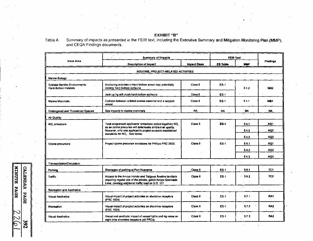
The Program description for tlie environmental analysis proposes use of a single rig to minimize the environmental and socio:economiC impacts to the affected coastal areas. The EIR identifies the potential impacts of the proposed Program and proposes mitigation measures in response to such impacts. Summary Tables A-C (Exhibit "B") enumerate such impacts and suggested mitigation measures.
The Program is composed of six (6) individual projects (lessees), each of which will be required to apply for and receive all necessary permits or authorizations from Responsible Agencies, e.g. the Coastal Commission, prior to the initiation of activities on its lease area. Accordingly, each of the lease abandonments was analyzed for its potential impacts and mitigation developed as necessary. The potential cumulative impacts of the Program were also addressed in the EIR. As a consequence, some mitigation measures apply to all leases while others are site specific. Exhibit
-3-
CALENDAR PAGE 388 ··
MINUTE PAGE L 2.5 7

CALENDAR ITEM NO. C85 (CONT'D)
"C", attached hereto, provides an enumeration and brief description of recommended mitigation measures and the Lessee/lease to which each applies, i.e., to all or to only one Lease. Adopted mitigation measures will be monitored pursuant to the provisions of the proposed Mitigation Monitoring Plan as contained in Exhibit "D''., attached hereto. STATUTORY AND OTHER REFERENCES:
A. Public Resomces Code: Div. 6, Parts 1and2; Div; 13. B. Cal. Code Regs.: Title 3, Div. 3; Title 14, Div. 6.
AB 884: NIA
OTHER PERTINENT INFORMATION: 1. · This activity involves lands identified as possessing significant environmental
values pursuant to Public Resources Code Section 6370, et seq. Based upon the staff's consultation with the persons nominating such lands and through the CEQA review process, it is the staff's opinion that the project, as proposed, is consistent with its use classification.
2. Pursuant to the Commission's delegation of authority and the State CEQA Guidelines (14 Cal. Code REGS .. 15025), the staff has caused to be prepared an EIR identified as EIR 663, State Clearinghouse No. 94121042. Such EIR was prepared and circulated for public review pursuant to the provisions of the CEQA.
Findings, made in conformance with Section 15091 of the State CEQA Guidelines, are contained in Exhibit "D" attached hereto. The Mitigation Monitoring Plan, developed in confomiance with Section '21081,6 of the CEQA, is contained in Exhibit "E" a~ched hereto. A Statement of Overriding Considerations, made in conformance with Section i5093 of the State CEQA Guidelines, is contained in Exhibit "F", attached hereto.
EXHIBITS: A. Location Map B. Summary Table A C. . Mitigation Measure By Lease and Lessee D. CEQA Findings E. Mitigation Monitoring Plan.(Tables Band C) F. Statement of Overiding Considerations
-4-
CALENDAR PAGE 389
.. MINUTE PAGE 2 2-5
=

CALENDAR ITEM NO. C85 <CONT'D)
IT is RECOMMENDED THAT THE COMMISSION 1. CERTIFY THAT AN EIR, NO. 663, STATE CLEARINGHOUSE NO.
94121042, WAS PREPARED FORTHIS PROJECT PURSUANT TO THE PROVISIONS OF THE CEQA AND THAT THE COMMISSION HAS REVIEWED· ·AND CONSIDERED THE INFORMATION CONTAINED THEREIN.
2. ADOPT THE FINDINGS, MADE IN CONFORMANCE WITH SECTION 15091 OF THE STATE CEQA GUIDELINES, AS CONTAINED IN EXHIBIT "D", ATTACHED HERETO.
3. ADOPT THE MITIGATION MONITORING PLAN FOR THE PROJECT, AS CONTAINED IN EXHIBIT "E", A TT ACHED HERETO, TO ENSURE COMPLIANCE WITH THE REQUIRED MITIGATION MEASURES.
4. ADOPT THE STATEMENT OF OVERRIDING CONSIDERATIONS, MADE IN CONFORMANCE WITH SECTION 15093 OF THE STATE CEQA GUIDELINES, AS CONTAINED IN EXHIBIT "F".
5. FIND THAT THE COMMISSION HAS ELIMINATED OR SUBSTANTIALLY LESSENED ALL SIGNIFICANT EFFECTS ON THE ENVIRONMENT WHERE FEASIBLE AS SHOWN IN EXHIBIT "D", AND DETERMINED THAT ANY POTENTIALLY SIGNIFICANT EFFECTS REMAINING ARE ACCEPT ABLE DUE TO OVERRIDING CONCERNS ENUMERATED IN EXHIBIT F;
6. FIND THAT THE ACTIVITY IS CONSISTENT WITH THE USE CLASSIFICATION . DESlGNA TED FOR THE LAND PURSUANT TO PUBLIC RESOURCES CODE _SE<:;:TION 6370, ET SEQ.
7. APPROVE, IN THE MANNER DESCRIBED IN THE EIR, THE PROGRAM FOR THE ABANDONMENT OF THE SUBSEA WELL COMPLETIONS AND REMOVAL OF THE ASSOCIATED WELLHEAD EQUIPMENT AND ABANDONMENTS/REMOVALS OF THE PRODUCTION AND CONTROL LINES.
8. AUTHORIZE COMMISSION STAFF TO TAKE ALL ACTIONS NECESSARY TO IMPLEMENT THIS'PROGRAM CONSISTENT WITH (I) THE COMMISSION'S RULES AND REGULATIONS;(2) SOUND ENGINEERING PRACTICES;(3) MAXIMUM FEASIBLE MITIGATION AS SPECIFIED IN EXHIBITS "B"-"D" TO PROTECT THE ENVIRONMENT; AND 4) PRIOR AUTHORIZATION OF THE COMMISSION.
-5-
CALENDAR PAGE 390
MINUTE PAGE L 2..5

N
PT. CONCEPTION ~
.. 272
I I I TEXACO
~ I "d lllJ )'
N N
Gl lllJ
51~
ARCO
SUBSEA WELL ABANDONMENT AND FLOWLINE* REMOVAL
·PROJECT
\I CHEVRON
W-40550
SANTA BARBARA
EXHIBIT "A"
...........
I
YENTURA /
I
:c n H ~ ~ lzJ
! lzJ
ttj )' Gl ttj lzJ )'
Gl lzJ
I N N.w
\C
--~
EXHIBIT "B" Table A Summary of impacts as presented in the FEIR text, including the Executive Summary and Mitigation Monitoring Plan (MMP),
and CEQA Findings documents.
Summarv of lmoacts FEIRText Issue Area Findings
Description of Impact lmoactt1 .. 1 ES Table MMP
ROUTINE, PROJECT·RELA TED ACTIVITIES
Marine Bioloav:
Sublidal Benthic Environments: Anchoring activities in hard bottom areas may potentially Class II ES-1 Hard-Bottom Habitats destrov hard-bottom eoifauna 5. 1.2 MB2
Jack-uo ho will crush hard-bottom eoifauna Class II ES-1
Marine Mammals Collision between a listed marine mammal and a support Class II ES-1 5.1.1 MB1 vessel.
Endanaered and Threatened SMcies See imiiacts to marine mammals NA NA . NA NA ..
Air Quality:
NO. emissions Total program(all applicants' emissions added together) NO, Class II ES.1 5.4.1 A01 as an !>zone precursor will deteriorate ambient air quality. However, only one applicant's project exceeds established 5.4.2 A02 standards for NO, . See below.
li.4.3 AQ3
Ozone precursors Project qzone precursor emissions for Phillips PRC 2933. Class II ES-1 5.4.1 AQ1
5.4.2 AQ2
5.4.3 AQ3
Transpartalion/Circulation:
Parkina Shortages of parking at Port Hueneme Class II ES-1 5.8.1 TC1
Traffic Access to the Arroyo Hondo and Tajiguas ftowline landfalls Class II ES-1 5.8.2 TC2 requiring regular use of the private, gated Arroyo Ouemada Lane. crealino additional traffic load on U.S. 101
.. Recreation and Aesthetics:
Visual Aesthetics Visual impact of project activities on shoreline receptors Class II ES-1 5.7.1 RA1 <PRC 1824)
Recreation Visual impact of project activities on shoreline receptors Class II ES-1 5.7.2 RA2 CPRC 1824)
Visual Aesthetics Visual and aesthetic impact of vessel lights and rig noise on Class II ES-1 5:7.3 RA3 niaht time shoreline receptors fall PRCsl

Table A (Continued)
Summary of Impacts FEIR Text . Issue Area Findings
Description of Impact lmoactClass ES Tabla MMP
Prehistoric Archaeological Siles' Al lhe Texaco Gaviota Marine Terminal easl of Canada Clasall ES-1 -~.9.3 CR3 Alcatraz (bluff area). indirect Impacts may occur as lhe result of Increased access lo Iha site during lhe project
Al the Texaco ·Gavlola Marine Terminal easl of Canada Class II ES-1 Alcatraz (quarry location), indirect Impacts may occur as a result of lncrl!ased access lo lhe site during the protect 5.9.2 CR2
Al the Texaco Gavlola Marine Terminal east of Canada Class II ES-1 Alcatraz (beach, above high tide), direct and indirect Impacts to Intact and redeposited prehistoric cultural remains )iia use of access routes nol presently constructed
Historic Resources. Onshore At the Molino Gas Processing Facility at Canada de la Class II ES-1 5.9.4 CR4 11u~rta (Arroyo Hondo). direct and Indirect Impacts lo both buried and redeposited prehistoric cultural remains
Historic Resources. Offshore In lhe shallow subtldal zone at Texaco Gaviota Marine Class II ES-1 ·5.9.1 CR1 Tefflllnal (PRC 2199), Alcatraz Pier debris could realize direct and Indirect Impacts from ftowline removal
Native American Concerns Impacts to hislorically-ldenlified villages, mortuary sites, Class II ES-1 5.9.2 CR2 human remains. and burial associated artifacts
. 5.9.3 CR3
5.9.4 CR4
5.9.5 CR5
ACCIDENTS/UPSETS
~ n H ~ ~ ~ ti;I
'ti ~ tl 'ti ti;I >'
Svslem Safetv and Reliabilitv:
OBA 02 - Impact of Anchor on Adjacent Oil Pipelines During Class II ES'· 5.3.1b SSR1 Well Abandonment Ooerallons 5.3.2•.d SSR2
OBA 06 - Impact of an Anchor on Adjacent Oil Pipelines Class II ES-5 . 5.3.1b SSR1 During Flowllne Abandonment and Removal Ooeratlons 5.3.t'·d SSR2
Cil ti;I
I N \'0 ~,w ~ ~ •·
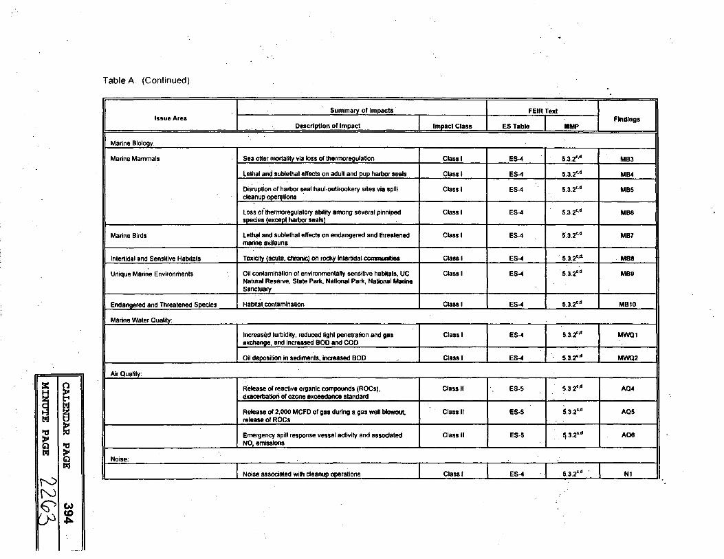
Table A (Continued).
Summary of Impacts FEIR Texl Issue Area Findings
Description of Impact Impact Class ES Table MMP
Marine Biology:
Marine Mammals Sea otter mortality via loss of thermorl!Qulation Class I ES-4 5.3.2•.d MB3
lethal and sublelhal effects on adult and pup harbor seals Class I ES-4 5.3.2c.d MB4
Disruption of harbor seal haul-out/rookery sites via spill Class I ES-4 5.3.2c.d MB5 cle11nuli ooerations
Loss ofthermoregulatory ability among several pinniped Class I ES-4 5.3.2c.d MB8 soecies (except harbor sealsl
Marine Birds Lethl!f and sublethal effects on endangered and threatened Class I ES-4 ·s.3.2c.d MB7 marine avifauna
Intertidal and Sensitive Habitats Toxicii:y (acute, chronic) on rockv lntertldal communities Class I ES-4 . 5.3.2•.ct. M88
Unique Marine Environments Oil contamination of environmentally sensitive habitats, UC Class I ES-4 . 5.3.2c.d MB9 Natural Reserve. State Park, National Park, National Marine Sanctuary
Endangered and Threatened Soecies Habitat contamination Class I ES-4 5.3.2°·d MB10
Marine Water Quality:
Increased turbidity, reduced light penetration and gas Class I ES-4 5.3.2""' MWQ1 exchange, and increased BOD and COD
Oil deoosilion in sediments, increased BOD .. Class I ES-4 5.3.2c.d MWQ2
Air Quality:
~ ~ -~ ~ : t ~ ~
Release of reactive organic compounds (ROCs), Class II ES-5 5.3.2c.d AQ4 exacerbation of ozone exceedance standard
Release of 2,000 MCFD of gas during a gas well blowout, Class II ES-5 5.3.2•.d AQ5 release of ROCs
Emergency spill response vessel activity and associated Class II ES-5 !j.3.2c.d AQ8 NO, emissions
~ Noise:
I Noise associated with cleanup ooerations Class I ES-4 . 5.3.2c.d . N1
r-0 N ~I~
~

Table A. (Continued).
Summary of Impacts FEIRText Issue Area Findings
Description of Impact Impact Class ES Table MMP
Transportation/Circulation:
.Cleanup operations (shoreline between Pt Conception and Class II ES-5 5.3.2c,d TC3 Gaviola) using narrow, restricted roads on the Bixby Cojo Ranch and Hollister Ranch
Recreation and Aesthetics:
Fouling of scenic shorelines, closure of public beach from a Class I ES-4 5.3.2c.d RA4 spill and subseauent cleanup
Reduced access to park and beach areas from an oil spill, Class I ES-4 · 5.3.2c,d RAS loss of tourism revenues
Fouling of .scenic shorelines and ocean surface within Class I ES-4 5.3.2c,d RA6 sceOic vieWsheds
Commercial and Recreational Fisheries:
Coating of catch (lowering commercial value) and set gear Class I ES-4 5.3.2•.d CRF1 (diminished catch etriclencvl
Loss of available nshing grounds due to oil contamination Class I ES-4 5.3.2c.d CRF2 and/or cleanup operations
Cultural Resources:
Damage or destrudion of unidentified cultural resources or Class II ES-5 5.3.2"·d CR6 nearby archaeological resources
Masking of unidentified cultural resources Class II ES-5 .'. 5.3.2c,d CR7
:( n H ~ ~ lzJ
~ lzJ
ttj ~ )t Cil ttj lzJ )t
Cil lzJ
Footnotes: a - onshore activity in the vicinity of the Phillips Tajiguas ftowline landfall (e.g., bluff area immediately above the ftowline landfall) has been eliminated with revisions to the projed description, as prompted by DEIR review comments. Should onshore adivity be required, such activity will be restricted to existing access routes already construded or In use. If these conditions cannot be met, monitoring shall be implemented per MMP Impact 5.9.5, consistent with mitigation components noted previously for tmpacf CR2 (MMP lmpad 5.9.2).
b- mitigation measures designed to further diminish the possibility of an oil spill are similar to those encompassed under hard-bottom avoidance miliga~ measures (e.g., site-specific anchoring plans, use of precision navigation, modified anchor handling techniques). as noted In the MMP;
c- system safety and reliability analyses identified operational steps where accidents might occur; operational procedures have been modified to ii')Crease oil spill response capability, including use of a dedicated oil spill response vessel and associated Increase in spill containment and cleanup equipment on-site, and producing a concomitant increase in the applicants' ability lo proled sensitive resources and partially or completely mitigate the effecis of a spill; · ·
d- mitigation effectiveness and residual impacts vary with soill resoonse capability and containment and clean-up effectiveness.
I 1N N -- I w
co en

EXHIBITC
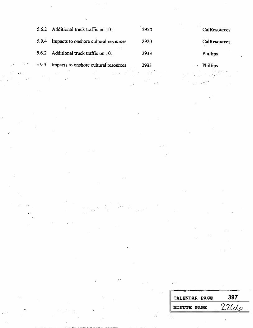
Mitigation Monitoring Plan -- By Parcel and Applicarit
Mitigation Description · Paraeel Number
5.1.1 Vessel collision with marine mammals All
-5.1.2 Crushing of hard bottom substrate All
5.3.2 Oil Spill contingency All
5.4.3 Nox emmissions from standby boat All
5.6.l Traffic/parking at Port Hueneme All
5.7.1 Night-time glare from jack-up rig All
5.4.1 NOx emmissions from program (All applicants)
5.4.2 NOx emmissions from program (All applicants)
5.3.1 Anchors near operataing.oil lines . 1824
. 5.4.1 NOx emmission5 from project equipment 2933
5.4.2 NOx emmissions from project equipment 2933
5.7.2 Visual impacts 1824
5.3.1 Anchors near operating oil lines 2793
5.9.1 Impacts to offshore cultural resources 2894,2199
5.9.2 Impacts to onshore cultural resources 2199
5.9.3 Impacts to onshore cultural resources 2199
''
Applicant
All.
All
All
All
All
All
All
All
Chevron
Phillips
Phillips
Chevron
Arco
Arco
Arco
Texaco
CALENDAR PAGE 396
MINUTE PAGE 2_2fc£
CALENDAR PAGE 397
MJ:NUTE PAGE 2._ 2Gr.o

EXHIBIT D
SUBSEA WELL ABANDONMENT AND FLOWLINE ABANDONMENT/REMOVAL PROGRAM
CEQA FINDINGS
Herein are presented the findings made by the State of California State Lands Commission (SLC) on the proposed Subsea.Well Abandonment and Flowline . Abandonment/Removal Program Final Environmental Impact Report (FEIR): pursuant to ·section.-15091, Title 14, California Administrative Code .. All significant impaCts.(i.e., designated as Class I or Class II; see FEIR Executive Summary, Tables ES-1, ES-4, and ES-5) of the proposed program'cor project), as identified in the EIR, are summarized within the 39 findings outlined within the following pages.
Table A provides a summary of potentially significant impacts, as presented in the FEIR (i.e., Executive Summary, Tables ES-1, ES-4, and ES-5; Mitigation Monitoring Plan, Section 5) and within this findings document.
CEQA findings have been assigned a unique alphanumeric designation, with associated impacts organized and designated by resource affected (e.g., AQ: air quality; CRF: commercial and recreational fisheries; CR: cultural resources; MB: marine biology; MWQ: marine water quality: N: noise; RA: recreation and aesthetics; SSR: system safety and reliability; and TC: transportation/circulation). CEQA findings have also been separated on the basis of whether the impact is expected from routine, project-related activities or via potential accident/upset as follows:
Resource Routine, Affected Project-Related Accidents/Upsets
(Issue Area) Activities
Air Quality AQ1 through AQ3 AQ4 through AQ6
Commercial ;;1nd - CRF1 and CRF2 Recreational Fisheries
_. Cultural- Resi;>urces CR1 through CRS - CR6 through CR7
Marine Biology MB1 and MB2 MB3 through MB10
Marine Water Quality - MWQ1 and MWQ2
Noise - N1
Recreation and Aesthetics RA 1 through RA3 RA4 through RAS
System Safety and Reliability - SSR 1 and. SSR2
Transportation/Circulation TC1 and TC2 TC3
1 CALENDAR PAGE 398
MINUTE PAGE ..

Tables B and C summarize each impact, impact significance before mitigation, feasible mitigation measures. mitigation measure timing, mitigation measure monitoring responsibility, and impact significance following mitigation for routine, project-related impacts and accident/upset impacts, respectively. For routine. project-related activities (Table B), a total of 15 potentially significant impacts have been identified, all of which can be mitigated to insignificance. For accidents/upsets (Table C), a total of 24 potentially significant impacts have been noted, several of which can be mitigated to insignificance. Accident/upset impacts that remain potentially significant following mitigation are highly dependent upon oil spill response capabilities. Further. the effectiveness of such mitigation measures is dependant upon several factors. incll:lding type of product spilled, wind and oceanographic conditions at the time of the spill, r~sponse time, and ·containme·nt and cleanup equipment effectiveness. · ·
Tables .A, B. and C present potentially significant impacts in a sequence which mirrors their presentation in the FEIR. ·
For each significant impact, and pursuant to Section 15091, a finding has been made of one or more of the following, as appropriate:
a) Changes or alterations have been required in, or incorporated into, the project which mitigate or avoid the significant environmental effect as identified in the completed environmental impact report.
b) Such changes or alterations are within the responsibility and jurisdiction of another public agency and such changes have been adopted by such other agency, or can and should be adopted by such other agency (agency designated).
Finding b) appears whenever a separate agency has partial jurisdiction (in conjunction with the SLC) over select aspects of the proposed project. Accordingly, these agencies would have the responsibility to adopt, implement, and enforce the mitigation outlined in this findings determination.
A Statement of Overriding Considerations, as required by Sections 15092 and f5093, Title ~4. California Administrative Code, is attached as Exhibit C. This Statement applies to all impacts which, even after the adoption of the maximum feasible mitigation measures, cannot be reduced to a level of insignificance.
· Following each finding, the. facts supporting that finding are summarized in narrative . form.· Where appropriate. specific mitigation measures are hated, consistent with their description
· In Section 5 (Mitigation Monitoring Plan, MMP) of the FEIR. The MMP will be overseen by the Commission.
. .
Pursuant to Section 21081.6 of the Public Resources Code, the SLC, its designate, and/or the appropriate public agency should adopt a reporting or monitoring program which identifies and tracks changes to the project which it has required or mitigation measures which have been adopted. The program should be designed to ensure compliance. The MMP has been attached as Exhibit D.
6 CALENDAR PAGE 399
MINUTE PAGE 22GB ..

ROUTINE, PROJECT-RELATED ACTIVITIES
19 CALENDAR PAGE 400 ·· ·
MINUTE PAGE Z. 2(00
Subsea Well Abandonment and Flowline Abandonment/Removal Program
CEQA FINDING NO. MB1
MARINE BIOLOGY: Support vessel activity, all phases.
Impact:
··Finding:
Collision between a listed marine mammal and a support vessel (MMP Impact No. 5.1.1).
a) ·changes or.alterations have beenre·qulred in, or incorporated into,' the ·project which mitigate or avoid the significant environmental effect as identified in the completed environmental impact report. · ·
b) Such changes or alterations are within the responsibility and jurisdiction of another public agency and such changes have been adopted by such other agency, or can and should be adopted by such other agency (California Department of Fish and Game, U.S. Fish and Wildlife Service).
FACTS SUPPORTING THE FiNDING:
Background
All marine mammals are protected against harassment, injury, or taking by the Marine Mammal Protection Act of 1972. Additional protection is afforded to listed species by the Endangered Species Act of 1973.
For vessel collisions with a listed marine mammal (i.e., one which is listed as endangered, threatened, rare) which results in serious injury or death, the U.S. Fish and Wildlife Service has indicated that such an impact represents a "take" and is, therefore, significant. Federally listed marine mammals (i.e., endangered) which could occur in the project area (in decreasing order of abundance) include the humpback whale (Megaptera novaeangliae), blue whale (Balaenoptera musculus), fin whale (8. musculus), and right whale (Ba/aena g/acialis), (FEIR Section 3.1.1.4). Federally lis~~d pinnipeds (e.g., threatened) which are not expected in the project area and, thus, are not expected to be affected by routine vessel activities include the threatened Guadalupe fur seal (Arctocephalus townsendt), threatened Steller sea lion (Eumetapiasjubatus), and protected northern.fur seal (Callorhinus ursinus). Threatened southern
· sea otters (Enhydra lutrls nereis) may be present in nearshore waters at the western end of the · Santa Barbara Channel (e.g., Cojo Bay anchorage), however, these animals are considered rare in this area and tend to stay close to shore, in and amongst kelp beds. Limitations on species distribution (e.g., coastal waters, pelagic, etc.) are discussed in FElR Section 3.1.1.4.
A determination of significant impact from vessel collision is based on the perceived loss of an individual from a population already at risk (i.e., underscoring the susceptibility of such species). as well as a recognition of the fundamental protection afforded by the Marine Mammal Protection Act and the Endangered Species Act. There is no doubt that such collisions, when resulting in serious injury or death, are deemed "a significant impacf' on listed species.
Given that the significance of such an accident is established, the question becomes one of proper impact classification under CEQA (i.e., Class I or Class II). Accordingly, the questions of 1) probability of collision, 2) available mitigation measures, and 3) mitigation effectiveness, must be addressed. Prior environmental assessments (e.g., Aspen Environmental Group, 1992; Continental Shelf Associates. Inc., 1993) have vari~~!@!!:!!·~~~!a:~~Q,Q,,e§:==
20 CALENDAR PAGE 401
MINUTE PAGE 2-270

..
. •'
either a Class I or Class Ill impact. either in spite of or because of the low probability of species occurrence and/or the low probability of vessel collision.
Mitigation Measure(s)
At present, the most i!ffective mitigation measures include 1) trained crew avoidance. which ensures that vessel operators are cognizant of the protected species expected in the project area and their: seasonal presence, abundance, migration habits, behaviors. and activities; 2) adherence to recognized traffic corridors and use of observers aboard the vessel, and vessel avoidance whenever possible, and 3) completion of a Marine Wildlife Contingency Plan.
· .SUMMARY: Given the already low probability that such an accident ~ill occur, coupled with' implementation of effective mitigation measures noted above, a Class II impact desigr\ation as been established for vessel collisions with a listed marine mammal species.
Residual impact: Class II, adverse but not significant following mitigation.
21 CALENDAR PAGE 402
MINUTE PAGE 2_2. t l · ...
..
Subsea Well Abandonment and Flowline Abandonment/Removal. Program
CEQA FINDING NO. MB2
MARINE BIOLOGY: . Well abandonment and flowline abandonment/removal activities: Jack-up
Impact:·
Finding:
· rig placement and maneuvering anchor placement for rig and support vessels.
Crushing of hard bottor:n substrate· and associated biota through :{jack UP). rig leg ·. . (spud can) placement or rig or work boat anchor placement (MMP ·impact No. 5.1.2).
a) Changes or alterations have been required in. or incorporated into, the project which mitigate or avoid the significant environmental effect as identified in the completed environmental impact report.
FACTS SUPPORTING THE FINDING:
Background
Hard-bottom areas are relatively stable rocky substrates which provide habitat for a diverse group of plants and animals to settle, attach, and grow. The species composition of hard-bottom communities is largely dependent on substrate characteristics (e.g .. size, texture, and relief), degree of exposure to waves and currents, as well as light and nutrient availability. The amount of sediment cover is a major factor influencing the biological assemblages in hardbottom habitats. Excessive siltation typically results in poor SPEtCies diversity and abundance (Ambrose et al .. 1989).
In nearshore waters, hard-bottom also provides potential attachment substrate for various kelp species (e.g., Macrocystis), typically from the edge of the surfzone to depths of 100 ft (30 m). Kelp-forest communities providing food and shelter for a diverse assemblage of plants and animals. Young fishes seek refuge in kelp-bed communities (Ebeling and Laur, 1985). The giant brown kelp, M. pyrifera. provides a vertical structure and a large surface area for attachment of sessile invertebrates along the entire length of the alga including the highly convoluted holdfast which is typically attached to hard bottom. Kelp is also an important economic resource (e.g., harvesting ofalgin for cosmetics. toothpaste, ice cream, 111ariculture operations). Drift kelp is an important food source for abalone and sea urchins and is a significant contributor to detritus-based food chains. · · ·
··Wellhead abandonment and flowline removal operations have the potential to significantly affect hard bottom communities via smothering and crushing of benthic organisms during: 1) rig leg placement; and 2) placement of maneuvering anchors (i.e., during both jack-up rig [well abandonment] and work vessel [flowline abandonment/removal] placement).
Rig Leg Placement
The candidate jack-up rig for wellhead abandonment is the Glomar Adriatic VIII, with an overall length and beam of 243 ft (74 m) and 200.5 ft (61 m), respectively. The areal extent of impact from jack-up rig placement is directly related to the areal coverage of each of rig's three legs (the base or foot of which is termed the spud can). Each jack-up spud can measures 46 feet in diameter (r = 23 ft; area = nf). For each leg, the areal footprint amounts to 1,662 ft2; during a single set of the jack-up rig, the total area affected by all three legs·amounts to 4,986 ft2 (463 m2;
0.11 acre). The orientation of each leg and its respecti~e impact~!!.!:· :§:::!~W·~~~~~!i&;!~==
22 CALENDAR PAGE 403
MINUTE PAGE 7-272-

. .
drilling location (i.e., positioned over the wellhead) has been provided in Appendix.a, Figure 8.1. Relative to the wellheads to be abandoned, the areas of concern from rig leg and anchor placement are as follows:
Impact Agent
Stem Spud Cans (2) Bow Spud Can (1)
Maneuvering Anchors (4) ··
Distance from Wellhead
97-143 ft 200-246 ft
=6x the water depth
During development of tne·.anchoring ptan ror each site, hard bottom should l,)e avoided along three segments of seafloor: 1) in a 46-ft .wide band located 97 to 143 ft from the wellhead; 2) in a 46-ft wide band located 200 to 246 feet from the wellhead; and 3) at distances approximating six times the water depth, using a four-point anchoring pattern (FEIR Figure 2.19).
Rig and Support Vessel Anchoring
Maneuvering anchors associated with jack-up rig positioning, if required, will be deployed in a four-point pattern at each of 14 wellhead locations. Four 10,800-lb anchors will be positioned within the four-point anchor pattern. Estimated impact radii for the jack-up rig employing anchors is dependant upon water depth; impact radii range between 378 and 1,650 ft.
During proposed flowline removal operations, work boats will be positioned 500-600 ft (152-183 m) from shore in about 15 ft (4.6 m) of water for the flowline removal activities. Up to four anchors will be deployed in the ftowline abandonment project area with a required scope of 6:1 (distance from vessel to anchor: depth of water). Anchoring activities in hard bottom areas may potentially destroy hard-bottom epifauna.
Hard Bottom Distribution
Natural hard bottom habitat loss will not occur at PRC 2973 (Well No. 1) and PRC 2726 (Jade East Well No. 1 ), given that both wellsites lie within extensive areas of significant sediment overburden; no nard bottom is evident either at the wellhead or within the potential impact radius. In addition, hard bottom loss is not expected at Well Nos. 1-6 and 3-6, PRC 2879, as these wells sit atop sandy sediments.
Other wellhead location~ either sit among or atop hard bottom outcroppings. On PRC 2879, Well Nos. 5-6, 6-6, 8-6,: and H-1 are located- amidst intermittent or continuous rock outcrops, based on results of a survey conducted in May 1994 using a remotely operated vehicle (ROV) (Appendix H, Figures H.6 and H.8), as well as earlier field investigations (e.g., CSA, 1989d). -
On PRC 2933, the area surrounding Well Nos. 2 and 4A, as well as other wells to be abandoned in PRCs 2920 and 2933 (i.e., PRC 2920, Well Nos. 5 and 8; PRC 2933, Well Nos. 2, 3, 4A, 7, and 8) is comprised of intermittently exposed, low- to medium-relief bedrock outcroppings which are alternately (and-seasonally) exposed and buried by a thin sediment .. veneer, with the possible exception of medium-relief structures found scattered within shelf depths. Results of the May 1994 ROV survey indicated that the percentage and nature of exposed hard bottom was variable in this region (i.e., typically less than 30% and predominantly low relief). The interpretation of Shell California Production Inc. (1985) is a continuous band of geophysically-defined hard bottom, with survey lines ending just east of PRC 2933, Well No. 2.
Based on more recent geophysical investigations (e.g., Sachse Engineering Assodates, Inc., 1989, 1991), the region encompass!n.g PRC ~9~:!!!!:!:!!!::!!~~!!!:!::~========
23 CALENDAR PAGE 404
MINUTE PAGE 2-2.13 ''

characterized by the seasonal and intermittent presence of low-relief rock outcroppings. Storm activities and currents are known to erode and accrete nearshore sediment deposits on a · seasonal basis. Predominantly low relief was evident in the 1994 ROV survey of the wellheads. Geophysical interpretations and ROV/manned submersible activities conducted in State waters of the Santa Barbara Channel have also indicated the presence of discontinuous, intermittent bedrock outcrops in similar water depths east and west of the Tajiguas Gas Field.
Separate maps indicating geophysically-defined hard bottom (and flowlines in the vicinity of each well) and spud can and anchor placement have been included in the FEtR. Appendix H identifies possible anchor deployment patterns which have ~n designed to avoid hard bottom and proximal flowlines.- · ·
Spud leg placement on hard bottom is unavoidable only.at four of 18 wells (i.e., Well No. H-1 [PRC 2879], Well No. 5 [PRC 2920), and Well Nos. 2 and 4A [PRC 2933]). With a total of four rig sets at these locations, total maximum hard bottom loss from spud can placement amounts to 0.44 acre.
For those wellheads which sit atop hard bottom, underlying natural hard bottom beneath the wellhead and associated structures will be exposed. No natural hard bottom loss is expected directly at any of the wellheads. Flowlines to be abandoned and left in pf ace will provide additional anthropogenic, low-relief hard bottom (when exposed) between the ARCO, Phillips, and CalResources wellsites and the shallow subtidal region near each flowline landfall.
FEIR Appendix H (Attachment 1, Figures H1.1 through H1.6) identify possible anchor deployment patterns which have been designed to avoid hard bottom. An initial approximation of the estimated loss of hard bottom habitat to be realized through the removal of wellhead and wellhead associated structures has also been summarized in the FEIR (e.g., see Table H1.2).
Mitigation Measure(s)
Each applicant will carefully review geophysical records, develop a site-specific anchoring plan (i.e., anchor deployment pattern; hard bottom avoidance during anchor chairi deployment and retrieval; avoidance of pipelines/flowlines)', and use precision navigation during jack-up rig placement and anchor deployment to avoid all hard bottom features.
Ancho(placement patterns may be adjusted, giving proper consideration to safety limitations and concerns; adjustments to the general anchoring pattern can be made in one or mare·ways, inctuding: 1) rotation of-the 4-point anchor pattern; 2) variation in the anchor lead distance (e.g., adjustment of scope from 6:1 anchor radius to water.depth); and 3) lateral anchor flexibility .(i.e., maximum 5° shift in either direction off the midline). Using this approach, hard bottom areas within. the potential impact area for anchors can and will be avoided.
The applicants have identified the completion of post-abandonment inspection surveys in the vicinity of each wellsite (e.g., via ROV) as a final step in wellhead abandonment, as noted both in the FEIR (Appendix A) and within the application (Morton Associates, Inc., 1994). Surveys at each wellsite, intended to verify that each project area is free of anthropogenic debris following wellhead abandonment, should also be designed to assure:
1) in areas where hard bottom was not expected, that no hard bottom substrates were affected by leg or anchor placement or anchor chain handling; and
24 CALENDAR PAGE
MINUTE PAGE ..
405
2-2.14
2) assure, in areas where hard bottom was expect~d. that hard bottom effects :were localized to the spud can imprint. ·
SUMMARY: Residual impact: Class II, adverse but not significant following mitigation.
25 CALENDAR PAGE 406 · ·
MINUTE PAGE L 2 7 5

Subsea Well Abandonment and Flowline Abandonment/Removal Program
CEQA FINDING NO. AQ1
AIR QUALITY: Well abandonment and flowline abandonment/removal activities.
Impact:
Finding:
Emission increases from abandonment equipment (i.e., total program NO. as an ozone precursor) will deteriorate ambient_ air quality (MMP lmr:>act No._ f?.4.1 ).
Key Criteria: >25 tons NO. for total emissions (ali"applica~ts) and for Phillips · · PRC2933.·
a) Changes or alterations have been required in, or incorporated into, the project which mitigate or avoid the significant environmental effect as identified in the completed environmental impact report.
b) Such changes or alterations are within the responsibility and jurisdiction of another public agency and such changes have been adopted by such other agency, or can and should be adopted by such other agency (Santa Barbara County Air Pollution Control District).
FACTS SUPPORTING THE FINDING: . ·
Background .
The Federal government and the State of California have established ambient air quality standards to protect public health from the effects of several airborne pollutants, including ozone (03), carbon monoxide (CO), nitrogen dioxide (N02), sulfur dioxide (S02), particulate matter (PM, generally defined as particulates <10 microns, PM,0), and others. In general, California's . standards are more stringent than Federal standards for most air pollutants. Santa Barbar~ . County air quality exceeds or violates a California or Federal health standard for two pollutants: ozone and inhalable particulate matter (PM,0 ). Analysis of the air quality measurements collected throughout the County during the most recent valid data year (1992) reveals that although 27 days exceeded the California and five days exceeded the Federal health standards for ozone, on average, the air quality was good to moderate (Santa Barbara County Air Pollution Control District [APCD], 1992).
Within the County, there have been no measured exceedances of the applicable air quality standards for sulfur dioxide ($02), nitrogen dioxide (N02), hydrogen sulfide (H2S), or carbon monoxide (CO) in the past three years. The County is designated as being in attainment for these pollutants which have not exceeded ambient standards for several years (Santa Barbara County APCD, 1994).
In 1992, the District operated 28 Prevention of Significant Deterioration or PSD stations (those stations sited near a new or modified stationary source specifically to monitor preconstruction, construction, and post~construction/operation emission impacts associated with the source) and six State and Local Air Monitoring Stations or SLAMS (those stations sited to monitor general effects on the ambient air quality and to establish general ambient background concentration levels). The local study area south of the Santa Ynez mountains has 17 PSD and three SLAMS stations. Well abandonment activity will take place generally in four local study area locations: Pt Conception area, Gaviota area, Coal OU-Pt. area, and Carpinteria area (Santa Barbara County p_PCD, 1994).
26 CALENDAR PAGE 407
MINUTE PAGE LL 7 ~
--------~-- ---···

On a County-wide basis, ozone concentrations measured throughout the County exceeded the California c;me-hour standard (0.09 ppm) at several sites and the Federal one-hour standard (0.12 ppm) at only nine sites. In 1992, the maximum ozone concentration recorded was 0.140 ppm at Vandenberg Air Force Base STS Power Plant with similar levels recorded at Carpinteria (0.138 ppm) and Las Flores Canyon.Site 1 (0.137 ppm). The California standard was exceeded most frequently at Las Flores Canyon Site 1 ( 15 days) followed by Paradise Road ( 12 days), Carpinteria (9 days), and to a lesser degree at GTC Site C (9 days), Gaviota West (8 days), and Goleta (8 days). Several stations exceeded the one-hour California standard for ozone on 6 days or less (Santa Barbara County APCD, 1994).
.. Existing air quality in the.four project areas was been characterized.by examining .· . three years of data from the monitoring station reporting the worst case ambient air quality data. These monitoring sites are as follows: Pt. Conception area - Government Pt. (PSD), Gaviota area - Exxon Site 1 (PSD), Coal Oil Pt. - Goleta (SLAMS), and Carpinteria area - Carpinteria (PSD). Monitoring data from these four sites are shown in FEIR Table 3.29. Violations of the Federal and State ozone standard were recorded at nearly all the sites and violations of the State PM1~ standard were recorded at the Government Pt. station (Santa Barbara County APCD, 1994).
Because of the short duration of project activities which involve mainly portable sources, the analysis of air quality impacts conducted within the EIR, in part, reflected criteria similar to that used to evaluate the transitory emission impacts from onshore construction projects.
Santa Barbara County APCD ·Rule 202.C.2.g exempts from permit requirements engines on work-over rigs when used for the repair, work-over, maintenance or abandonment of wells. As outlined in the FEIR, the Santa Barbara County APCD.had previously indicated it would not require permits to operate for the engines used on the we{I abandonment portion of the. project. Santa Barbara County APCD Rule 202.C.3 exempts engines used in construction projects from APCD permit requirements. However, in order to mitigate short term air quality degradation, the Rule states that if cumulative construction equipment emissions have the potential to exceed 25 tons of any pollutant, except carbon monoxide, in a 12-month period, the owner of the source under construction (in the case of this project, one or more of the six project applicants) shall provide offsets as required by the Santa Barbara County APCD and shall demonstrate that no ambient air quality standard would be violated.
Rule 202 is, as of July 1995, undergoing potentially significant revision which may . change the requirements and exemptions of Rule 202.C; each applicant will be required to discuss individual emission inventories, total emissions· for the abandonment program, and current permit requirements·directly with the Santa Barbara County APCD following EIR certification and program authorization by the State Lands Commission.
Santa Barbara Counfy is a non-attainment area for ozone. All project activities will emit pollutants on or within a close proximity to shore. Because of the coastal meteorological characteristics of south Santa Barbara County, project emissions of ozone precursors (i.e., NO. and ROC) released from these project nearshore locations will largely impact onshore. No inert or photochemical modeling was conducted to quantify these project impacts. However, without conducting modeling, the 1991 Air Quality Attainment Plan concluded that offshore ozone precursor emissions deteriorate onshore air quality and "the best way to improve ozone air quality is to reduce the pollution that causes the air quality problem (ROG and NO.)." Release of NO. exacerbates existing violations of State and Federal ambient air quality ozone standards. Therefore, pursuant to CEQA requirements, project emissions of NO. must be mitigated to a level of no significance.
27 CALENDAR PAGE 408
MINUTE PAGE .2..217

..
As emphasized within the EIR, emission totals noted in impact analY,ses were derived from the formal application to the SLC (Morton Associates, Inc., 1994), wherein average power consumption rates (e.g., kw-hrs/day, KWD) for the designated jack-up rig Glomar Adriatic VIII were used. In the event a different drilling rig or support vessels are selected, emissions inventories will need to be recalculated. It is also possible that parcel- or well-specific emission totals may be recalculated using more precise power consumption factors to further refine the emissions total for individual applicants. For the purposes of the impact assessment, however, the emissions inventories presented in Morton Associates, Inc. (1994) were employed. (Within the FEIR, Tables 2.4 through 2.9, Tables 2.15 through 2.17, and Tables 3.30 through 3.34 provide a summary of emissions for NO", CO; ROC, 502, and PM,0). Project by project emission totals combining well abandonment and ·flowline abandOnment and removal emissions .are as · ·
.·follows:. · . ·
• Unocal PRC 2879 - 19.0 tons NO", 6.7 tons CO, 1.6 tons ROC, 0.5 ton S02,
2.9 tons PM,0;
• Texaco PRC 2726 - 3.3 tons NO., 1.2 tons CO, 0.3 ton ROC, 0.1 ton S02,
0.5 ton PM10;
• ARCO PRC 2793 - 5.6 tons NO", 1.9 tons CO, 0.5 ton ROC, 0.1 ton 802,
0.8 ton PM10;
• CalResources PRC 2920 - 10.1 tons NO", 3.1 tons CO, 1.3 tons ROC, 0.2 ton 802 , 1.5 tons PM,0;
• Phillips PRC 2933 - 25.2 tons NO", 8.8 tons CO, 2.5 tons ROC, O. 7 ton 802,
4.0 tons PM,0; • •
• Chevron PRC 1824 - 9.2 tons NO •. 3.3 tons CO, 0.7 ton ROC, 0.3 ton 802 ,
1.5 tons PM10.
Total program emissions for CO, ROC, 802, and PM10 equal 25.0 tons, 6.9 tons, 1.9 tons, and 11.2 tons, respectively.
These location pollutant totals for each applicant and totals for all applicants fall below the significance limits set by the requirements of Rule 202.C.3. However, the NO. emissions from the Phillips parcel (PRC 2933) equals. 25.2 tons and the p~ogram, i.e., all six projects added together NO. emmissions equa.172.3 tens which. far.exceeds the 25 tons per 12-month threshold established by Rule 2·02.C.3. Therefore, it was determined that program NO. emmissions as a precursor to ozone formation will deteriorate ambient air quality, a significant but mitigable impact.
Mitigation Measure(s) ·
Available mitigation measures include the use of emission offsets. · Mitigation fees and pollutant-specific mitigation techniques are outlined in CEQA Finding Nos. AQ2 and AQ3, respectively. The requirements of CEQA Finding No. AQ1 and its respective mitigation measure should be considered in conjunction with other available mitigation measures (i.e., mitigation fees, pollutant specific mitigation techniques).
Emission Offsets
Technique: General practice identifies securing emission reduction credits (ERCs) to offset project emissions of a quantity of NO. associated with this project as an accepted method to completely mitigate project net emission increases. Applicants w ·
28 CALENDAR PAGE 409
MINUTE PAGE Z2 78
emissions from other equipment or activities in Santa Barbara County arid apply all or a portion of those reductions to balance project emission increases. Emission impacts eligible for mitigation with this measure include NO,.
Effectiveness: Project emissions may be reduced to pre-project levels. Historically, the feasibility and cost effectiveness of mitigating project emissions in this manner has been diminished by the scarcity of emission reduction credits in Santa Barbara County that may be available and used for such offsets.
. Mitigation Measure: An applicant shall enter into, if required by the Santa Barbara .County APCD under its existing Rules and Regulations, a legally binding contract in which .the · applicant incorporates into the contract the source and quantity of sufficient bona fide ERCs to · offset project emissions. Should the owner of the ERC equipment be an entity other than the applicant, the contract shall include a separate agreement between the applicants and the ERC owner to shutdown or modify the equipment This shutdown or modification shall be conducted under a valid Santa Barbara County APCD permit, if applicable. Emission reduction credits must be real, quantifiable, enforceable, surplus {as defined by the EPA), and secured to the project in compliance with provisions of the Santa Barbara County APCD Rules and Regulations.
Timing: Modifications to permits issued by the Santa Barbara County APCD must be issued to establish ERC amounts, where applicable, and any legally binding offset agreement(s) or contracts consummated prior to the beginning of project activities.
SUMMARY: Residual impact: Class II, adverse but not significant following mitigation.
29 CALENDAR PAGE 410 MINUTE PAGE 2-2 70

Subsea ·well Abandonment and Flowline Abandonment/Removal Program
CECA FINDING NO. AQ2
AIR QUALITY: Well abandonment and flOwtine abandonment/removal activities.
Impact:
Finding:
Program emission increases from abandonment equipment (i.e., total program NO. as an ozone precursor) will deteriorate ambient air quality (MMP Impact No. 5.4.2) .
. · . . . . ' .'.· . . .
Key Criteria: >25 tons .NO, for total emissions (all applicants) and for Phiilips (PRC2933).
a) Changes or alterations have been required in, or incorporated into, the project which mitigate or avoid the significant environmental effect as identified in the completed environmental impact report.
b) Such changes or alterations are within the responsibility and jurisdiction of another public agency and such changes have been adopted by such other agency, or can and should be adopted by such other agency (Santa Barbara County Air Pollution Control District).
FACTS SUPPORTING THE FINDING:
Background
See air quality background discussion in CECA Finding No. AQ1. Single location and cumulative pollutant totals fall below the significance limits set by the requirements of Rule 202.C.3. However, the NOx emissions from the Phillips parcel equals 25.2 tons and the program, i.e., all six projects added together, NOx emmissions equal 72.3 tons which far exceeds the 25 tons per 12-month threshold established by Rule 202.C:3. Therefore, it was determined that No. em missions as a precursor to ozone formation will deteriorate ambient air quality, a significant but mitigable impact. ·
Mitigation Measure(s)
Available mitigation measures include the use.of mitigation fees. Emission offsets and pollutant-specific mitigation techniques are outlined in CECA Finding Nos. AQ1 and AQ3, respectively. The requirements of CECA Finding No. AQ2 and its respective mitigation measure should be considered in conjunction with other available mitigation measures (i.e., emission • offsets, pollutant specific mitigation techniques).
Mitigation Fee
Technique: A fee would be paid to the SLC or to a designated third party (e.g., Santa Barbara County APCD) in order to fund a study or other activity directly related to emission reductions. Fees would be restricted to the creation of "real" emission reductions, such as by shutdowns of existing permitted facilities, further controls on heretofore uncontrolled equipment, institution of mobile source controls, and funding of innovative air pollution control demonstration projects. Emission impacts eligible ~or mitigation with this measure include NO •.
Effectiveness: Depending on the program disbursement of the fee, project emissions may be mitigated to pre-project levels. However, this m.itigation
30 CALENDAR PAGE 411
MINUTE PAGE 1{_ 2.80

considered if the project applicant can demonstrate to the SLC that all project-related equipment has been controlled to the· maximum extent feasible. The SLC may wish to restrict the approval of this measure until the applicants show that sufficient offsets are not reasonably available.
Mitigation Measure(s): An applicant shall enter into, if required by the.Santa Barbara County APCD under its existing Rules and Regulations, a legally binding contract by which an agreed upon mitigation fee is paid by the applicants to the Santa Barbara County APCD to fund a program, field.demonstration, C?r study which will result in emission reductions to mitigate some or all project emission increases. Though the mitigation-fee-funded program or study may result in emission reductions which extend beyond the fixed timeframe of the project, only emission reductions that occur simultaneously with the project emission inc~eases should .l;)e considered.in deeming this measure as an appropriate mitigation, unless approved otherwise by the SLC or a designated third party.
Timing: The mitigation fee may be applied to existing air quality enhancement programs. Any negotiations with third parties (such as Santa Barbara County APCD) and the signing of a legally binding mitigation fee contract must be concluded. prior to project startup.
SUMMARY: Residual impact: Class 11, adverse but not significant following mitigation.
31 CALENDAR PAGE 412 MINUTE PAGE 2-2.B l
Subsea Well Abandonment and Flowline Abandonment/Removal P.rogram
CEQA FINDING NO. AQ3
AIR QUALITY: Well abandonment and flowfine abandonment/removal activities.
Impact:
.Finding:
NO. emission increases from standby boat (MMP Impact No. 5.4.3).
a) Changes or alterations _have been required in, or incor?or_ated.into,.the · project which mitigate or avoid the significant environmental effect as · · . -identified in the completed environmental impact report.
b) Such changes or alterations are within the responsibility and jurisdiction of another public agency and such changes have been adopted by such other agency, or can and should be adopted by such other agency (Santa Barbara County Air Pollution Control District).
FACTS SUPPORTING THE FINDING:
Background
See air quality background discussion in CEQA Finding No. AQ1. Single location and cumulative pollutant totals fall below the significance limits set by the requirements of Rule 202.C.3. However, the N01 emissions from the Phillips parcel equals 25.2 tons and the total project NO. far exceeds the 25 tons per 12-month threshold esfablished by Rule 202.C.3. Total project NO. equals 72.3 tons. Therefore, it was determined that project N01 as a precursor to ozone formation will deteriorate ambient air quality, a significant but mitigable impact.
Mitigation Measure(s)
Available mitigation measures include the use of pollutant-specific mitigation techniques. Emission offsets and mitigation fees are outlined in CEQA Finding Nos. AQ1 and AQ2, respectively. The requirements qf CEQA Finding No. AQ3 and its ·respective mitigation measure should be considered in conjunction with other available mitigation measures (i.e., emissiOTI offsets, mitigation fees).
,
Polluta.nt-Speclfic Mitigation Techniques
Technique: N01 mitigation measures to be utilized to reduce emissions from diesel engines include:
1 ) turbocharging; 2) intake air intercooling; and 3) engine-timing retard. ·
Effectiveness: Work boats dedicated to the project possess NO. controls in the form of turbocharging, intercooling, and 4 ° ·engine-timing retard. However, the standby vessel (MN Buccaneer) engines are uncontrolled. A reduction of a total project N01 emission burden of approximately 1.3 tons would be realized through the implementation of this mitigation measure.
Mitigation Measure(s): For the main engines of the standby boat (e.g., MN Buccaneer or equivalent) that do not possess NO. emission controls im lementation of 4 °
32 CALENDAR PAGE 413
M:INOTE PAGE 2 26 L
-------------
' ''
engine-timing retard, turbocharging, and enhanced engine air-intake intercooling will decrease NO. emissions by 40% (e.g., a project reduction of approximately 1.3 tons of NO.).
Timing: Engine modifications must be conducted and verified by the SLC or it's designated enforcement agent prior to the use of such boats for project activities. These vessels will be dedicated to the project. Boats of equal or lesser sized engines with the control scheme described above may be substituted during the course of the project with the approval of the SLC or it's designated enforcement agent.
SUMMARY: Residual impact: Class Ii, adverse but not significant following mitigation.
33 CALENDAR PAGE 414
' '' MJ:NUTE PAGE 22S3

Subsea Well Abandonment and Flowline Abandonment/Removal ~rogram
CECA FINDING NO. TC1
TRANSPORTATION/CIRCULATION: Well abandonment and flowline abandonment/removal activities.
Impact:
Finding:
Parking shortages and traffic congestion at Port Hueneme; competition with recreational users for available parking spaces (MMP Impact ·No:· 5~6.1 ), . . . : · ·
a) Changes or alterations .have been required in, or incorporated into, the project which mitigate or avoid the significant environmental effect as identified in the completed environmental impact report.
FACTS SUPPORTING THE FINDING:
Background
The proposed offshore components of well abandonment activities are expected to require an employment of 50 personnel offshore at any one time, with abandonment activities conducted on a 24-hr basis with a 28-day rotation. Two crews of 25 personnel each will work 12-hr shifts with shift change-out every 14 days. Crew boats are projected to make 10 trips per month, or one trip for every three days on station.
Additional personnel providing well abandonment support services will arrive at offshore locations aboard supply boats and helicopters. Supply boats are anticipated to make 8 to 1 O trips per month, or one trip per three days on station. Crew and supply boats supporting well abandonment activities are proposed to originate from either Port Hueneme in Ventura County or from the Chevron Carpinteria Pier in Santa Barbara County.
Activities related to flowline bundle abandonment would require a maximum of 26 personnel for offshore operations, 19 personnel associated with onshore purging, and 20 personnel associated with onshore removal. Work would be performed on 12-hr shifts. Crews would be rotated once offshore operations reach 14 days (Morton Associates, Inc., 1994).
Surface streets provide the principal access to the Port of Hueneme, located south of Oxnard in the City·of Port Hueneme. The port is located approximately five miles south of U.S. 1O1 and two miles southeast of State Route 1 (SR 1 ). The principal entrance for the port facility is from the east at Hueneme Road, west of its intersection with Ventura Road. Traffic counts for Hueneme Road in the port area (i.e'.,.west of Saviers Road) numbered 11,400 average daily traffic (ADT), with a morning peak hour of 930 vehicles and an afternoon peak hour of 1,070 vehicles, in 1992. Other 1992 traffic counts for port area roads include 25,400 ADT, a 1,350-vehicle morning peak hour, and a 2, 140-vehicle afternoon peak hour for Channel Islands Boulevard (east of Ventura Road) and 15,000 ADT, a 1,120-vehicle morning peak hour, and a 1,350-vehicle afternoon peak hour for Pleasant Valley Road (west of Saviers Road; County of Ventura, 1994; City of Port Hueneme, 1994).
Parking facilities at Port Hueneme number about 350 spaces, most of which typically are occupied by personnel associated with offshore oil activities or people engaged in sportfishing. The port currently offers no long term or satellite parking. The port does own about 20 acres located two miles east of the port (at Arcturas Avenue) which eventually could be utilized for satellite parking. Current observations indicate that. many per ·
34 CALENDAR PAGE 415
MINUTE PAGE 2264
=

.·
are given rides to the port in order to avoid any parking shortages. Chevron, Unocal, and Texaco each have offices at the port; in the past. expediters for both Chevron and Unocal have been reported to have arranged offsite parking and shuttle services to the port for employees.
Limited parking capacity and availability at Port Hueneme has been a concern raised by the Oxnard Harbor District. Most of the 350 parking spaces available at Port· Hueneme typically are occupied by personnel of offshore oil activities or people engaged in sportfishing. The port currently offers no long term or satellite parking. If all project personnel were to park at the port while on-duty offshore, shortages of parking could result.
Mitigat;on Measure(s) ". .· ·
The potentially significant impact is mitigable to an insignificant level by using shuttle service$ and by scheduling crew shift changes to avoid weekends and holidays.
Timing
Applicant should prepare a transportation and parking plan describing shuttle bus services to Port Hueneme. The crew schedule and shuttle service plan should be submitted to and approved by responsible agencies prior to commencement of offshore project activities.
SUMMARY: Residual impact: Class II, adverse but not significant following mitigation.
35 CALENDAR PAGE 416
MINUTE PAGE 2285

Subsea Well Abandonment and Flowline Abandonment/Removal Program
CEQA FINDING NO. TC2
TRANSPORTATION/CIRCULATION: Well abandonment and flowline abandonment/removal activities.
Impact:
Finding:
Disruption of circulation and traffic flow on U.S. 101 and Arroyp Quemada Lane due to truck traffic and heavy equipment movement associated with flowline abandonmen_t and removal operations (MMP Impact No. 5.6;2). ·
a) Changes or alterations have been required in, or incorporated into, the project which mitigate or avoid the significant environmental effect as identified in the completed environmental impact report.
FACTS SUPPORTING THE FINDING:
Background
Activities related to flowline bundle abandonment would require a maximum of 26 personnel for offshore operations, 1'9 personnel associated with onshore purging, and 20 personnel associated with onshore removal. Work would be performed on 12-hr shifts. Crews would be rotated once offshore operations reach 14 days (Morton Associates, Inc., 1994).
Vessels with personnel and supplies associated with offshore flowline abandonment activities would originate from Port Hueneme or the Carpinteria Pier. Onshore personnel are projected to travel to Santa Barbara from the Ventura, Santa Barbara, and Santa Maria areas. U.S. 101 provides the quickest and most direct access from Santa Barbara, Santa Maria, and Ventura to the flowline bundle landfall sites. U.S. 101 is a four-lane divided highway near the landfall sites between Gaviota and Ellwood and becomes a six-lane limited access freeway in Goleta and Santa Barbara. Traffic counts in 1992 for U.S. 101 at Gaviota were 25,500 average daily traffic (ADT) and at El Capitan State Beach (east of Tajiguas) were 28,000 ADT.
Th.e flowline bundle from PRC 2793 (ARCO) makes landfall at the Texaco Gaviota Marine Terminal. Access to this landfall would be via U.S .. 101 and the Texaco Gaviota Marine Terminal access road. A fuli interchange with U.S. 101 at Mariposa Reina enables safe and easy access between the~ highway and the private marine terminal facility from either direction. All ·parking and staging of vehicles and ·equipment would occur on marine terminal property. Access to the remaining flowline landfall locations (i.e., PRC. 2920 [CalResources] at Arroyo Hondo; PRC 2933 (Phillips) west of Tajiguas Beach, near the abandoned Tajiguas Gas Plant is limited, as outlined below.
PRC 2920 (Ca/Resources)
Landfall of flowlines from PRC 2920 (CalResources) is at Arroyo Hondo; access to this site would be via U.S. 101 and an existing facility access road at Canada de la Huerta. Beach access is limited in the immediate landfall vicinity; approach from the Arroyo Quemado beach access to the east is proposed. Arroyo Quemado beach is located at the end of a private, gated road (Arroyo Quemada Lane) that has an unmarked and blind entrance from southbound U.S. 101 with no tum lane; no access is available from northbound U.S. 101. To reach Arroyo Quemada Lane from northbound lanes, vehicles either must perform U-tums where permitted-or travel to the full interchange at Mariposa Reina-and re~um sout ·
36 CALENDAR PAGE 417
MINUTE PAGE 2 25<o
=

..
A total of 216 personnel/equipment transport vehicle trips .(with a ma~imum of 15 per day and 216 per mont.h) and no waste transport vehicle trips are estimated from.the PRC 2·920 flowline abandonment site (Morton Associates. Inc .. 1994). Personnel/equipment transport activity, therefore, from the PRC 2920 flowline abandonment site would last one month or less.
PRC 2933 (Phillips)
Flowline bundles from PRC 2933 (Phillips) make landfall west of Tajiguas Beach near the abandoned Tajiguas Gas Plant. .Access to this landfall is made via U.S. 101 and an existing frontage road aligned between U.S. 101 and the ocean. The intersection between the frontage road and U.S. 101 is marked from b.otli.directions and has a left-tum lane from northbou.nd U.S."
. 101. Beach access is proposed from Arroyo Quemacio beach to the west, using permitted access through the Arroyo Quemado community. An alternative access road exists from the. Tajiguas frontage .road through the abandoned Gas Plant property, which currently is gated.
A total of 216 personnel/equipment transport vehicle trips (with a maximum ·of 15 per day and 216 per month) and no waste transport vehicle trips are estimated from the PRC 2933 flowline abandonment site (Morton Associates, Inc .. 1994). Personnel/equipment transport activity, therefore, from the PRC 2933 flowline abandonment site would last one month or less.
Such regular vehicular activity may impede traffic flow on U.S. 101 in the Arroyo Quemado area; however, the impact is mitigable to an insignificant level with the employment of traffic mitigation measures.
Mitigation Measure(s)
In order to minimize any potential impacts to traffic flow and circulation along U.S. 1O1, personnel and equipment vehicle trips could be scheduled for non-peak traffic hours. If Arroyo Quemada Lane is used for access to either the Arroyo Hondo (PRC 2920, CalResources) or Tajiguas (PRC 2933, Phillips) flowline bundle landfalls, clear intersection markings or signs for caution, slow-moving vehicles, and construction equipment should be emplaced to facilitate smooth and safe traffic flow. Vehicle U-tums required from northbound U.S. 101 to access Arroyo Quemada Lane should be mandated either for the full interchange at Mariposa Reina or at a rightturn intersection (requiring that vehicles make a separate and subsequent left-tum re-entry to southbound traffic) and not the cross-traffic tum lanes along U.S. 101. This would help ensure smooth and safe traffi~ flow.
Timing
Applicant(s) should submit plans and receive approval from responsible agencies prior to commencement of flowline abandonment and removal operations. Mitigation procedures should be implemented at the onset of flowline abandonment and removal operations at Arroyo Hondo and Tajiguas project locations.
SUMMARY: Residual impact: Class 11, adverse but not significant following mitigation.
37 CALENDAR PAGE 418
M:CNUTE PAGE 2-2 B 7

Subsea Well Abandonment and Flowline Abandonment/Removal Program
CEQA FINDING NO. RA 1
RECREATION AND AESTHETICS: Well abandonment and flowline abandonment/removal activities.
Impact:
Finding:
Visual impact of project activities on shoreline receptors (PRC 1824) a~d effects on visual aesthetics (MMP l_mpact No. 5. 7 .1 }. · · · ·
a) . Changes or alterations have been required in, or incorporated into, the project which mitigate or avoid the significant environmental effect as identified in the completed environmental impact report.
FACTS SUPPORTING THE FINDING:
Background
The scenic and recreational resources of Santa Barbara County are important to the local population, tourists, and recreationists. The mostly rural landscape along U.S. Highway 101 (U.S. 101) between Gaviota and Carpinteria is complemented by sweeping views across the Santa Barbara Channel toward the Channel Islands, ranging from 19 to 48 km (12 to 30 mi) from the coast. Views across the Channel presently include a scattering of approximately 17 oil and gas platforms. Approximately half of the 72 km (45 mi) of U.S. 101 between the Ventura County line and Gaviota are generally within view of the Pacific Oceal'\.
These areas where there are views from U.S. 101 to the ocean are given special protection in the Santa Barbara County Coastal Plan with the View Corridor Overlay designation. All but two miles of U.S. 101 between Gaviota and El Capitan, and much of the area along U.$. 101 between Santa Barbara and Carpinteria, is designated as a View Corridor.
The main viewing population in the project area would consist of motorists on U.S. 101, Amtrak passengers, coastal residents, surfers, and users of coastal recreational facilities, such as the Gaviota and Refugio State Parks, and the Summerland beaches.
PRC 1824 is located off ·the Santa Barbara south coast between Montecito and · Carpinteria. Except for the city of Summerland most of the area between Montecito and
Carpinteria is used for agriculture. The coastline includes bluffs, sandy beaches, and an estuary. There are about 150 homes along the shoreline in this area, primarily located in the three residential neighborhoods of Sandyland Cove, Sandy Point, and Padaro Lane. Approximately 100 homes in the foothills of Summerland also would have views of the project site. Lookout Beach County Park, which provides parking, beach access, picnic, and other facilities, is the primary recreational facility in Summerland (County of Santa Barbara, 1992b).
Carpinteria State Beach, in the city of Carpinteria, is the major developed recreational facility in the area. Just west of the city of Carpinteria is the Carpinteria Marsh (El Estero Slough), a large wetlands area on the coast. A private community, Sandy Point, extends the full length of the wetlands area and has commanding views of the shoreline. To the west is an informal local beach fronting Santa Claus Lane, and a long stretch of residential development along Padaro Lane, with parking and access for Loon Point Beach provided at the western end (County of Santa Barbara, 1992b).
38 CALENDAR PAGE 419
MINUTE PAGE 2.2.f> f3
=

Butterfly Beach along Channel Drive is the most commonly used waterfront area in Montecito. The shoreline along Channel Drive (between the Santa Barbara Cemetery and Olive Mill Road) is Montecito's primary scenic resource. Further west, past the cemetery, is the city of Santa Barbara's East Beach. Volleyball is a popular activity at the eastern end of East Beach, where the many volleyball courts are in constant .use during warm summer weekends. A snack bar, beach equipment rental concession, public bathhouse, and arts center are housed in the Cabrillo Pavilion at East Beach (City of Santa Barbara, 1981).
Scenic views of the ocean, the Channel Islands, and the mountains can be seen from U.S. 101 and the railroad, between Sheffield Drive (Ortega Hill) and the city of Carpinteria. · Offshore a dozen oil platforms are vi$ible to the south and southeast. Two platforms are jocated ·
. relatively close to shore, Hilda and Hazel, about 3.5 and 5 km (2 and .3 mi),· respectively, south of Summerland.
Visual impacts are considered significant if they affect a large viewing population, are relatively close to the affected viewing population, remain for a long period of time, or present a substantial degree of change inconsistent with the existing viewshed.
The visual resources impact area (VRIA) for PRC 1824 contains about 250 residences (including about 150 shoreline and 100 foothill residences). Park attendance projections for the area in 1995 total about 560,000, which equates to average daily attendance of 1,534. At Padaro Lane, 66,000 average daily trips were counted on U.S. 101 in 1992. Although the viewing population would be high, motorists would have a limited project viewing time of less than one minute.
Abandonment of the three wells on PRC 1824 would· require the jack-up rig to remain 1.5 km (1 mi) offshore for 30 days. The degree of change is judged to be moderate because of
· the proximity of two existing platforms: Hilda and Hazel withfn 3.5 km (2 mi) of the proposed well abandonment site. Well abandonment operations on PRC 1824 are of short duration and are intended to last one month. However, the overall impact on visual and recreational resources is considered to be significant but mitigable.
Mitigation Measure(s)
By scheduling operations during the off-season of peak tourist and beach use (i.e., June through August), the overall impact on visual and recreational resources is considered to be mitigable.
Timing··;
Schedule should be prepared and approved prior to commencement of project activities.
SUMMARY: Residual impact: Class II, adverse but not significant following mitigation.
39 CALENDAR PAGE 420
MINUTE PAGE 2 ZBC)
Subsea Well Abandonment and Flowline Abandonment/Remova~ Program
CEQA FINDING NO. RA2
RECREATION AND AESTHETICS: Wen abandonment and flowline abandonmenUremoval activities.
Impact: . Visual impact of project activities on shoreline receptors (PRC 1824) and effects on
Finding:
recreation (MMP lmpa.ct No, 5.7.2): · · ·
a) Changes or alterations have been required in, or incorporated 1nto, the project which mitigate.or avoid the significant environmental effect as identified in the completed environmental impact report.
FACTS SUPPORTING THE FINDING:
Background
See recreation and aesthetics background discussion in CEQA Finding No. RA 1.
Recreational impacts are significant if they cause long-term interference with coastal access or a recreational use, or long-term degradation of a significant recreational resource.
Abandonment of the three wells on PRC 1824 would require the jack-up rig to remain 1.5 km (1 mi) offshore for 30 days. The degree of change is ju9ged to be moderate because of the proximity of two existing platforms: Hilda and Hazel within 3.5 km (2 mi) of the proposed well abandonment site. Well abandonment operations on PRC 1824 are of short duration and are intended to last one month. However, the overall impact on visual and recreational resources is considered to be significant but mitigable.
Mitigation Measure(s)
By scheduling operations during the off-season of peak tourist and beach use (i.e., June through August), the overall impact on visual and recreational resources is considered to be mitigable.
Timing
Schedule should be prepared and approved prior to commencement of project activities.
SUMMARY: Residual impact: Class 11, adverse but not significant following mitigation.
40 CALENDAR PAGE 421
MINUTE PAGE 2..2 Q_j()
=

Subsea Well Abandonment and Flowline Abandonment/Removal Program
CECA FINDING NO. RA3
RECREATION AND AESTHETICS: Well abandonment and flowline abandonment/removal activities.
Impact:
Finding:
Visual and aesthetic impact of vessel lights and rig noise on nighttime shoreline receptors (all PRCs) and effect on visual aesthetics (MMP Impact No. 5.7.3) .. ·
a) Changes or alterations have been required in, c;>r incorporated into, the project which mitigate or avoid the significant environmental effect as identified in the completed environmental impact report.
FACTS SUPPORTING THE FINDING:
Background
The scenic and recreational resources of Santa Barbara County are important to the local population, tourists, and recreationists. The mostly rural landscape along U.S. "Highway 101 (U.S. 101) between Gaviota and Carpinteria is complemented by sweeping views across the Santa Barbara Channel toward the Channel Islands, ranging from 19 to 48 km (12 to 30 mi) from the coast. Views across the Channel presently include a scattering of approximately 17 oil and gas platforms. Approximately half of the 72 km (45 mi) of U.S. 101 between the Ventura County line and Gaviota are generally within view of the Pacific Ocean.
The main viewing population in the project area would consist of motorists on U.S. 101, Amtrak passengers, coastal residents, surfers, and users of coastal recreational facilities, such as the Gaviota and Refugio State Parks, and the Summerland beaches.
pt_ Conception Area
The coastline around Pt. Conception and Government Pt. is rural in quality. with the exception of two small oil and gas facilities. The coastal region is characterized by steep bluffs and a broad coastal terrace with panoramic views of the coast. The coastal land between Gaviota State Park and Jalama Co"unty Beach is largely. undeveloped open space ranchland and is essentially inaccessible to the public from the shore. The primary receptors of views of the well ·abandonment operations on PRC 2879 would be employees of the.Bixby Cojo Ranch, residents of the westernmost oceanfront lots, surfers, and beachgoers at Hollister Ranch, and passengers on the Southern Pacific Railroad.
Pt. Conception to Gaviota
The shore between Gaviota and Pt. Conception is characterized by a broad co.astal terrace bisected by occasional perennial streams and scenic canyons. The coastal land west of Gaviota lies within the Hollister and Bixby Cojo ranches, and is not accessible to the public. Residents of the oceanfront lots of the Hollister Ranch, as well as users of the Ranch's private beach and park area, and travelers on the Southern Pacific Railroad, would be the primary receptors of views of the jack-up rig and abandonment operations on PRCs 2726 and 2793.
Gaviota to Capitan
41 CALENDAR PAGE 422
MINUTE PAGE 2_2_ g \
From Gaviota to El Capitan State Beach, which is about 19 km (12 mi) east of Gaviota, the coastline is a rural landscape, with the exception of several oil production, treatment, and storage facilities. and a few residences. Most oil facilities and residences are well-screened from the view of highway travelers. However, the Gaviota consolidated oil and gas processing facility on the north side of U.S. 101 is a visually prominent feature of the area.
There are approximately 200 residents in the vicinity of PRCs 2920 and 2933. However, Gaviota and Refugio State Parks would be the primary view receptor areas. Over 320,000 people visited Gaviota and Refugio State Parks in 1993. Travelers on U.S. 101 and the Southern Pacific Railroad also would be primary receptors of views of the abandonment ·o.peratioris off the Gaviota shore. An average of 26,000 to 28,000 people per day drove along the stretch of U.S: 101 between Gaviota State Park and El Capitan· State Beach in 1992 (A. Ingram, California Department of Transportation, 1994, pers. comm.).· AM1RAK operates its Coast Starlight train once per day in each direction between Santa Barbara and San Luis Obispo. In 1993; approximately 150 train passengers traveled this route daily (S. Taubenkeibel, AMTRAK, 1994, pers. comm.).
Montecito to Carpinteria
PRC 1824 is located off the Santa Barbara south coast between Montecito and Carpinteria. Except for the city of Summerland most of the area between Montecito and Carpinteria is used for agriculture. The coastline includes bluffs, sandy beaches, and an estuary. There are about 150 homes along the shoreline in this area, primarily located in the three residential neighborhoods of Sandyland Cove, Sandy Point, and Padaro Lane. Approximately 100 homes in the foothills of Summerland also would have views of the project site.
Structure Ughts at All Project Locations
USCG regulations state that obstruction lights for Class "A" structures shall be of sufficient candlepower as to be visible at a distance of at least 9.3 km (5.8 mi), 90 percent of the nights of the year. In the 11th USCG District waters, this translates to a requirement for at least 6,500 candela. Although 6,500 candela would not create an inordinate amount of light onshore, it would nevertheless appear quite brilliant on the nighttime horizon. Because of structure size· and proximity to shore, lights from the jack-up rig would be quite obvious and may be distracting to shoreline residences for the duration of well abandonment activities:
Noise·
Noise iri residential or other noise-sensitive settings is often more disturbing during· · · the night than the day. At night, background noise levels outdoors are generally lower than those
occurring during the day; also, activity in most households decreases at night, lowering internally generated noise levels. Individual noise events, therefore, are more intrusive at night, since they contrast more sharply against the background noise, or ambient noise, than during the day. Ambient noise (background noise) is the composite of noise from all sources which affect a given location and is considered the normally existing noise environment at a particular place. Ambient noise levels are measured using weighted noise measurement systems (e.g., Day-Night Average · Level [LoNl and Community Noise Equivalent Level [CNEL]; County of Santa Barbara, 1986).
LoN and (CNEL) are noise indexes that incorporate differences in intrusiveness between observed day and night noise. LoN and CNEL values result from the averaging of hourly sound levels for a 24-hr period, with a weighting factor applied to evening and nighttime values. These two common time-weighted noise measures are virtually equivalent under most conditions and are used interchangeably in this EIR. Both indexes weight noise observed between 1900 and
42 CALENDAR PAGE 423
.. MINUTE PAGE 2-2 CJ 2
=
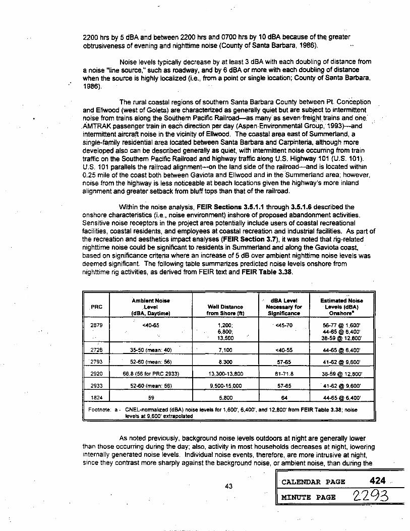
2200 hrs by 5 dBA and between 2200 hrs and 0700 hrs by 10 dBA because of th~ greater obtrusiveness of evening and nighttime noise (County of Santa Barbara. 1986).
Noise levels typically decrease by at least 3 dBA with each doubling of distance from a noise "line source," such as roadway, and by 6 dBA or more with each doubling of distance when the source is highly localized (i.e., from a point or single location; County of Santa Barbara, 1986).
The rural coastal regions of southern Santa Barbara County between Pt. Conception and Ellwood (west of Goleta) are characterized as generally quiet but are subject to intermittent noise from trains along the Southern Pacific Railroad-as many as seven·freig.ht trains and one.·
. AMTRAK passenger train· .in each direction per day (Aspen· Environmental Group, 1993 )-and intermittent aircraft noise in the vicinity of Ellwood. The coastal area east of Summerland. a single-family residential area located between Santa Barbara and Carpinteria, although more developed also can be described generally as quiet, with intermittent noise occurring from train traffic on the Southern Pacific Railroad and highway traffic along U.S. Highway 101 (U.S. 101). U.S. 101 parallels the railroad alignment-on the land side of the railroad-and is located within 0.25 mile of the coast both between Gaviota and Ellwood and in the ·summerland area; however, noise from the highway is less noticeable at beach locations given the highway's more inland alignment and greater setback from bluff tops than that of the railroad.
Within the noise analysis, FEIR Sections 3.5.1.1 through 3.5.1.6 described the onshore characteristics (i.e., noise environment) inshore of proposed abandonment activities. Sensitive noise receptors in the project area potentially include users of coastal recreational facilities, coastal residents, and employees at coastal recreation and industrial facilities. As part of the recreation and aesthetics impact analyses (FEIR Section 3~7), it was noted that rig-related nighttime noise could be significant to residents in Summerland and along the Gaviota coast, based on significance criteria where an increase of 5 dB over ambient nighttime noise levels was deemed significant. The following table summarizes predicted noise levels onshore from nighttime rig activities, as derived from FEIR text and FEIR Table 3.38.
.. Ambient Noise dBA Level Estimated Noise
.PRC .Level Well Distance Necessary for Levels (dBA) (dBA, Daytime) from Shore (ft) Significance Onshore•
2879 <40-65 1,200; <45-70 56-77 @ 1,600' 6,800; 44-65 @ 6,400'
.. 13,500 38-59@ 12,800' ..
2726 35-50 (mean: 40) 7,100 <40-55 44-65 @ 6,400'
·2793 52-60 (mean: 56) 8.300 57-65 41-62@ 9.600'
2920 66.8 (56 for PRC 2933) 13,300-13,800 61-71.8 38-59 @ 12,800'
2933 52-60 (mean: 56) 9,500-15,000 57-65 . 41-62@ 9,600'
1824 59 5.800 64 44-65 @ 6,400'
Footnote a- CNEL-normalized (dBA) noise levels for 1,600', 6,400', and 12,800' from FEIR Table 3.38; noise levels at 9.600' extrapolated
As noted previously, background noise levels outdoors at night are generally lower than those occurring during the day; also, activity in most households decreases at night, lowering internally generated noise levels. Individual noise events, therefore, are more intrusive at night, since they contrast more sharply against the background noise, or ambient noise, than during the
43 CALENDAR PAGE 424 ..
MINUTE PAGE 2-2 9 3

day. In spite of only limited, site-specific noise data being available (aU of which measured daytime noise levels), it was projected that nighttime noise levels associated with rig activities· would be significant to onshore receptors.
Mitigation Measure(s)
This potentially significant impact to aesthetics can be mitigated to an insignificant level with the use of sound baffles and light shielding on the jack-up rig.
Timing
Shields and baffles should be installed by the apprieant(s), and inspected and·· · approved by the SLC or another responsible party, prior .to commencement of offshore project activities.
SUMMARY: Residual impact: Class II, adverse but not significant following mitigation.
44 CALENDAR PAGE 425
MINUTE PAGE 22C14
::

Subsea Well Abandonment and Flowline Abandonment/Removal Program
CEQA FINDING NO. CR1
CULTURAL RESOURCES: Flowline abandonment/removal activities.
Impact: Disturbance of potential offshore prehistoric archeological sites and historic resources in PRC 2894 and 2199 (Gaviota) (MMP Impact No. 5.9.1).
Changes or alterations have been required in, or incorporated into,.the project which mitigate or. avoid the significant environmental effect as identified in the completed environmental impact report.
FACTS SUPPORTING THE FINDING:
Background
Cultural resources consist of places or objects important for scientific, historical, and religious reasons to cultures, communities, and individuals. Cultural resources include archeological sites, architectural remains, shipwrecks, and other artifacts that provide evidence of past human activities. They may also include places of importance to the traditions of societies and religions.
Shallow subtidal and intertidal flowline abandonme.nt/removal activities have the potential to significantly impact cultural resources in the vicinity of GTC Gaviota, the landfall location (PRC 2199) for flowlines from ARCO Well No. 1 ori PRC 2793.
Prehistoric Archeoloqical Sites - GTC Gaviota/ARCO flowline landfall area. See cultural resources discussion in CEQA Finding No. CR2.
Historic Resources - GTC Gaviota/ARCO flowline landfall area. In 1542, Cabrillo anchored his two vessels off of a village he called "Pueblo.de las Sardinas." Bolton (1976) believes this to be Gaviota Pass, apP.roximately one-mile to the west of the flowline landfall. Cabrillo referred to this village as a port, probably due to the large numbers of tomols found there. Late in 1769, the Portola expedition camped in the valley at Gaviota. (Crespi says that he "called this place Sari Luis, King·of France, and the soldiers knew it as La Gaviota, because they killed a. seagull [Gaviota] there" [Gudde, 1969). The name Gaviota first appears as the Cajon de la Gabiota [for the Canyon] on the diseno of the Rancho Nuestra Senora del Refugio, dated 1838).
The Gaviota Landing nearby was a natural embarcadero and was used as such by the Mission Santa Ines (c. 1804). It was first noted as a Chumash maritime locality (tomol village of "Onomo) by Cabrillo (Paez, 1968). After 70 years of service as a beach landing, the Gaviota wharf (Santa Barbara Historical Society Site 53) was built by Hollister and Dibblee in 1875 (Hillgard, 1882). Gaviota served as the port for a major supply route serving the Santa Ynez Valley from the Mission Period to about 1880. The wharf was used for transport of passengers, cattle, and grain. Vessels travelling between San Pedro and San Francisco stopped there. In the late 1870s and 1880s, a small inn for travelers operated on the site. The wharf is associated with the small community of Las Cruces located about one mile up the canyon. The wharf has been rebuilt numerous times.
One mile east of the flowline landfall is a place that the Chumash called Walapmu, meaning "landing place" (Applegate, 1975), assumably referringJa,Je.i;!Q.i.!;. !.a§,.Ql.~!YQ;!.9§9=======
45 CALENDAR PAGE 426
MINUTE PAGE 2_2l35 ' '' ' . '
watercraft. By virtue of this association, Macko (in ACT, Inc., 1984) suggests t~at the project landfall may also hav~ been a landing place for tomols. given the position of the village sites above and its location between two major maritime centers.
The Alcatraz area had no permanent structures until to tum-of-the-century when the wharf and other petroleum support facilities were built (Tompkins, 1974). The Alcatraz landing and wharf (1901-1930) was located in the immediate vicinity of the flowline landfall. In 1897, the Alcatraz Company obtained a franchise from the County of Santa Barbara for a pier 1.5 miles east of Gaviota. Alcatraz Wharf was used to load asphaltum for shipment to San Francisco. The Alcatraz Company lost title to the wharf through foreclosure in 1905 and the Pier and property was sold to the Associated Oil Company, which also acquired an assignment for the wharf. franchise, Associated Oil Company was subsequently merged to Getty-Oil Company. The pier was . . operated until it burned in 1930~ The Tidewater Associated Oil Company replaced the pier with two marine loading lines. There is no surface trace of the original pier. Buried remains of the Alcatraz Pier may be present in the beach area but were not visible. FEIR Figure 2.25 indicates the location of visible pier debris in the shallow intertidal area of the flowline corridor near landfall.
The Alcatraz Wharf was an important historic element in the County's early petroleum development. The original wharf was burned and removed, however, Morton Associates, Inc. ( 1994) indicate the presence of piping and debris from the old pier as present in the shallow intertidal area of the ARCO Alegria flowline corridor.
Although the archaeological remains of the wharf appears to·have retained some integrity of location, its main structural elements are no longer present onshore. It is unknown if original pilings are present offshore, as Morton Associates, Inc. (1994) indicated only the presence of "debris." It also remains unknown if removal of this debris will be necessary for flowline removal. As no report of the underwater archaeological diver surveys mentioned by WESTEC Services, Inc. (1988) is extant. it remains unknown if the site has been previously evaluated by a qualified marine archaeologist. Without further information on the nature and extent of the debris documented, the site cannot be evaluated in terms of National Register or CEQA criteria. Without further information, the site must be evaluated as potentially significant. Direct and indirect impacts, therefore, may occur as a result of the proposed project.
Mitigation Measure(s)
Avoidance of impacts is the recommended mitigation for all potentially significant cultural· resources. If avoidance is not possible, further study in the form of a Phase 2 evaluation is recommended for this location.
A qualified archaeologist shall conduct a limited investigation to evaluate the nature of the Alcatraz Pier remains, document and evaluate the potential significance of the resource, and recommend appropriate further mitigation measures (including avoidance of significant resources and/or data recovery).
Timing
Mitigation measures should be implemented in advance of the initiation of project activities.
SUMMARY: Residual impact: Class II, adverse but not significant following mitigation.
46 CALENDAR PAGE 427
MINUTE PAGE 2., 2 0 (o
=

. ·
Subsea Well Abandonment and Flowline Abandonment/Removal Program
CEQA FINDING NO. CR2
CULTURAL RESOURCES: Flowline abandonment/removal activities.
Impact: Disturbance of potential prehistoric archeological sites at the flowline landfall located on the sandy beach above the high tide line, at the Texaco Gaviota Marine · Terminal/ARCO Alegria· Production Facility (MMP Impact No. 5.9.2) .
Finding: . a) Changes or alterations have bee.n required in, or incorporated i.nto, the project which mitigate or avoid the significant environmental effect as identified in the completed environmental impact report.
FACTS SUPPORTING THE FINDING:
Background
Cultural resources consist of places or objects important for scientific, historical, and religious reasons to cultures, communities, and individuals. Cultural resources include archeological sites, architectural remains, shipwrecks, and other artifacts that provide evidence of past human activities. They may also include places of importance to the traditions of societies and religions.
Shallow subtidal and intertidal flowline abandonment/removal activities have the potential to significantly impact cultural resources in the vicinity of GTC Gaviota, the landfall location (PRC 2199) for flowlines from ARCO Well No. 1 on PRC 2793.
Prehistoric Archaeological Sites - GTC Gaviota/ARCO flowline landfall area. Previous cultural resource investigations identify subsurface archaeological resources in disturbed soil contexts throughout the flowline route onshore {WESTEC Services, Inc., 1988; Macko, in ACT, Inc., 1984). Site records at the University of California, Sarita Barbara {UCSB) document portions of seven archaeological sites recorded.at the Gaviota facility: CA-SBA-94, CA-SBA-95, CA-SBA-1555H, CA-SBA-1870, CA-SBA-2028, CA-SBA-2189 and CA-SBA-2190 {Rogers, 1929; Wendorf and Greenwood, 1980; WESTEC Services, Inc:, 1983; Macko, 1984; WESTEC Services, Inc., .1988). Of these sites, only .. CA~SBA-94,.CA-SBA-95, and CA-SBA-1870 are documented south of U$ 101. Froni abo1:1t 1977 to 1982, members of the Chumash Brotherhood of the Tomol resided in Canada del Cementario, adjacent to the present facility north of U.S. 101. Because this area was a center of religious ceremony and social function for the Brotherhood and other groups, this locality is of modem ethnographic sensitivity.
CA-SBA-94 and CA-SBA-95 were once thought to be the ethnographic village site of Legpew (Woodward-Clyde, 1984; Macko, in ACT, Inc., 1984). Applegate (1975) notes Legpew to be a "village at Canada de Cementario, east of Gaviota." Whitehead and Hoover (1975), however, map the location of Legpew at the Cariada de Cementario located near Pt. Conception. Archival research by John Johnson (Archaeologist, Santa Barbara Museum of Natural History) has identified that Legpew, meaning ,;white clay" is not a village name but refers to a natural feature in the vicinity of Cariada del Cementario near Gaviota {Macko, in ACT, Inc., 1984). CASBA-94 and CA-SBA-95 are both located west of Canada Alcatraz and will not be affected by the proposed project.
47 CALENDAR PAGE 428
MINUTE PAGE 2 Lg 7

CA-SBA-1870 was originally documented by Rogers (1929) as being located on !he bluff east of CA-SBA-94 and CA-SBA-95. Rogers identified the site as a stone-tool manufacturing component of the two primary habitation sites. CA-SBA-94 and CA-SBA-95 and designated the site "Alcatraz East." CA-SBA-1870 is located on the east bluff overlooking the confluence of Cementario and Alcatraz Creeks. The site is bounded by the cliff edge above the Pacific Ocean on the south; artifacts are infrequent in railroad grade but occur in moderate density in the area between the railroad and existing tank farm. Random and systematic surface and subsurface sampling in 1984 confirmed Rogers (1929) original interpretation, that a quarry area on the beach below the site was the principal source of chert found at the site (Rogers. 1929). As Rogers suspected, chert nodules were carried up to the top of the bluffs where core reduction was conducted. The reduced blanks were taken.elsewhere, presumably CA-SBA-94 and CA-SBA-95, for further reduction and tool manufacture. Artifacts at the site include ground stone, metate and bowl fragments, projectile points, utilized flakes, drills, hammerston~s. burnt rocks, and cores. The prehistoric component was the former location of two to three wooden structures associated with the Alcatraz Wharf and the early petroleum development (cf., 1929 and 1943 Fairchild aerial photos). Other historic features include a brick wall remnant, metal pipes, and an abandoned road bed. Site maps indicate an historic brick drain located in the vicinity of the flowline landfall. Macko (in ACT, Inc., 1984) also reports that the sea cliff has eroded over 50 ft in the last 30 years. This rate of cliff retreat has been documented in aerial photographs of the area.
Macko (in ACT, Inc., 1984) indicates that the nature of the artifact distribution in combination with documented natural (bioturbation) and man-made disturbances suggests there is little structural integrity remaining in the deposit. Onshore flowline segments which are exposed between the bluff and the facility are located within CA-SBA-1870. These segments, however, will be removed as part of a separate onshore facility abandonment project. Where flowlines exist the bluff they will be cut and capped and abandoned in place.
No intact prehistoric archaeological resources are identified at the flowline landfall; however, given the nature of the shoreline environment (i.e., rocky intertidal with documented areas of high relief rock outcrop) and presence of documented redeposition of cultural remains due to cliff retreat, there is a recogniZed potential for preservation of intact and redeposited prehistoric cultural remains associated with rocky and sandy intertidal areas shoreward of high relief rock outcrop, talus slopes below cliffs, and sandy beach areas above the high tide line· (cf. Masters, in Masters and Flemming, 1983). Preservation of intact and redeposited cultural remains within the sandy beach (below the high tide line) is not expected to be poor due to seasonal sand. removal and replenishment in that area. · ·
Morton Associates, Inc: (1994) indicate that existing staging areas and access routes are adequate to aceommodate equipment needed for flowllne rem(>val within the intertidal and
·sandy beach area (i.e., via tracked excavator, front end loader, and flat bed trucks). Removal of intertidal segments is expected to require the use of a small backhoe or excavator to facilitate excavation of the lines within the sandy beach area. Lines will be cut in 40 ft sections, loaded for transport and disposed of offsite. The existing staging area and access routes are adequate to accommodate a tracked excavator, front end load, and flat bed truck. No direct impacts to CASBA-1870, therefore, are anticipated to occur as a result of the proposed project. However, indirect impacts may occur as the result ·of increased access to the site during the project. As this impact can be mitigated to insignificant levels, it is considered a Class II impact.
Native American Concerns
In general, local Native Americans place a high value on things and places associated with their past history, including archeological sites and artifacts. Of particular importance are historically-identified villages to which many people can trace their ancestry through mission register genealogies, and on mortuary sites, human remains, an ..,,.p;..,1 - · _ _.,,., __ L_
CALENDAR PAGE 429 48
MINUTE PAGE 22.0~ ..

. .
Native American concerns are centered on the loss of ancestral sites ~nd sacred places, and the impact on Native Am~rican cultural values resulting from disturbance or destruction of sites and artifacts.
It has been documented (Munoz, in WESTEC Services, Inc., 1982; Woodman and O'Connor, 1984; Chambers Group, Inc., 1986; John Ruiz, United Chumash Band, 1992, personal communication) that the Chumash, as the descendants of the area's first inhabitants, feel a special obligation to watch over the cultural and natural resources of the area. While not claiming ownership, they consider themselves ·guardians of the land and sea. Native Americans were the first people to make use of local petroleum products of the area, and continue to use asphaltum. Contemporary Native Americans feel.strongly thatthe natural environment should not be alter~d ..
. They feel the protection of the natural environment is a traditional Native American role. They feel· the government planners should include representatives of their culture·in the management of their own cultural resources during all phases of a development in order to minimize impacts and contemporary Native American values.
Native American concerns generally involve the following:
• Participation in identification, documentation, and data recovery programs at cultural sites;
• Protection of ancestral sites by avoidance, especially mortuary sites, human burials in residential sites, and other sacred sites;
• Protection of plan and animal communities, and other resource areas; • Participation in determination of the importance of sites.
Although local .Native Americans consider all resources significant, they have identified certain types of resources as more important than others. For example, a burial generates greater concern than an isolated artifacts, just as a ethnohistoric village site is considered more sensitive than a scatter of lithic flakes. Resources and their evaluation can be found in Woodman and O'Connor (1984) and the County of Santa Barbara EIR/EIS for Phase I of the SCE Transmission Line between Goleta and Gaviota (County of Santa Barbara, 1991 ). Additional information can also be found in the California Public Utilities Commission EIR for the Pacific Pipeline (Science Applications International Corporatiqn, 1992).
Consultation with Native Americans during preparation of the archaeological assessment resulted in a determination by the contacted individuals and groups that any disturbance to .important Native American sites would be a significant adverse impact. They did ·not consider that archaeological excavation and·data recovery of a significant site would represent sufficient mitigatic:irt Avoidance of the affected sites to the maximum extent feasible, monitoring, and adherence to state burial remains legislation would reduce potential impacts and would be the only acceptable measure to mitigate a significant impact to an insignificant level (Class II).
Mitigation Measure(s)
A qualified archaeologist shall monitor all terrestrial surface disturbances within archaeological sites and sensitive areas, consistent with relevant Federal, State, and local guidelines in case archaeological remains are discovered. Should an emergency discovery of previously unrecorded cultural resour~es occur during the monitoring phase of work, the archaeologist shall stop operations to evaluate the resources. If the remains prove significant, Phase 3 data collection, excavations, or other standard archaeological or historic procedures shall be implemented to mitigate impacts.
Native American monitoring will be conducted for all project-related activities in potentially sensitive areas that could potentially disturb the surfa~~~~~~~::!:!!:!=========
49 CALENDAR PAGE 430
MINUTE PAGE L 2 C>p;

archaeological site. Monitoring and consultation on impacts and mitigations shall be coordinated among all interested local Native American groups with monitoring experience. Curate any · artifacts retrieved at a local, qualified facility that provides access to Native Americans.
In the event human remains are discovered, procedures specified in CEQA (Appendix K, Section VII) should be implemented. Security measures shall be implemented to ensure that burials are not vandalized until the decision of burial deposition has been made by the applicant, and most likely, descendants (pursuant to §7050.5, Health and Safety Code and §5097.98, Public Resources Code).
An educationalworkshop shall be·condueted, coordinated.by a·qualifieci and··. . approved archaeologist and including potential Native Americiln Monitors, to inform construction
workers of the prohibited activities (e.g., vehicle use in sensitive areas, unauthorized collecting of artifacts) that can result in impacts on cultural resources. Workers shall not be allowed in the project area during off hours.
Timing
Mitigation measures should be implemented in advance of the initiation of project activities.
SUMMARY: Residual impact: Class 11, adverse but not significant following mitigation.
50 CALENDAR PAGE 431
MINUTE PAGE 2300 1
Subsea Well Abandonment and Flowline Abandonment/Removal Program
CEQA FINDING NO. CR3
CULTURAL RESOURCES: Flowline abandonment/removal activities.
Impact: Disturbance of potential archeological resources onshore at the Texaco Gaviota Marine Terminal/ARCO Alegria Production Facility (bluff area and quarry location, . near Canada Alcatraz) (MMP Impact No. 5.9.3). · · ·
Finding: a) Changes or alterations have been required in, or incorporated into, the project which mitigate or avoid the significant environmental effect as identified in the completed environmental impact report.
FACTS SUPPORTING THE FINDING:
Background
Cultural resources consist of places or objects important for scientific, historical, and religious reasons to cultures, communities, and individuals. Cultural resources include archeological sites, architectural remains, shipwrecks, and other artifacts that provide evidence of past human activities. They may also include places of importance to the traditions of societies and religions.
Shallow subtidal and intertidal flowline abandonment/removal activities have the potential to significantly impact cultural resources in the vicinity of GTC Gaviota, the landfall location (PRC 2199) for flowlines from ARCO Well No. 1 on PRC 2793. See the cultural resources background discussion in CECA Finding No: CR2 for a detailed summary of archeological resources and historic sites in the Gaviota area. Background information pertinent . · to Native American concerns is also outlined in CECA Finding No. CR2.
Archaeological resources are located on the bluffs above landfall and to the east and west of the landfall. There is a potential tor direct and indirect impacts to archaeological resources should access routes not presently constructed and in use be required {i.e., use of
.. existing access routes will mitigate ~e .potential impacts). As both direct and indirect impacts can be mitigated ·to an insignificant level, they are considered a Class II impact.
Mitigation Measure(s)
A qualified archaeologist shall monitor all terrestrial surface disturbances within archaeological sites and sensitive areas. Monitoring efforts should be focused on shoreline areas above the high tide line and, due to the sensitivity of the shoreline, should include all proposed access routes not presently constructed and in use to access landfall sites. Monitoring shall be consistent with mitigation components noted previously for CEQA Finding No. CR2.
Timing
Mitigation measures should be implemented in advance of the initiation of project activities.
SUMMARY: Residual impact: Class 11, adverse but not significant following mitigation.
51 CALENDAR PAGE 432
MINUTE PAGE 230\
Subsea Well Abandonment and Flowline Abandonment/Removal. Program
CEQA FINDING NO. CR4
CULTURAL RESOURCES: Flowline abandonment/removal activities.
Impact:
Finding:
Disturbance of potential onshore archeological resources at CalRe~ources Molino Offshore Gas flowline landfall (MMP Impact No. 5.9.4). ·
a) Changes or alt~rations have been required in, or incorporated into~ the project which mitigate or avoid the significant environmental effect as identified in the completed environmental impact report.
FACTS SUPPORTING THE FINDING:
Background
Cultural resources consist of places or objects important for scientific, historical, and religious reasons to cultures, communities, and individuals. Cultural resources include archeological sites, architectural remains, shipwrecks, and other artifacts that provide evidence of past human activities. They may also include places of importance to the traditions of societies and religions. ·
Shallow subtidal and intertidal flowline abandonment/removal activities have the potential to significantly impact cultural resources in the vicinitY, of Arroyo Hondo, the landfall location (PRC 2933) for flowlines from CalResources wells on PRC 2920.
Molino Gas Processing Facility at Canada de la Huerta (Arroyo Hondo)
Three sites have been identified at the abandoned Molino Gas Processing Facility location (CA-SBA-1204, CA-SBA-1979, and CA-SBA-1151). CA-SBA-1204 is documented near the flowline landfall. CA-SBA-1979 is located along the onshore pipeline route to the former gas plant site. The historic Arroyo Hondo Bridge is located west of the pipeline corridor.
CA-SBA-1151 is located .on the ocean bluff overlooking and just west of the mouth of Arroyo Hondo, south of·the Southern Pacific Railroad tracks. The site consists of a low density scatter.of shell and medium to.low.density scatter of Monterey chert chipping detritus. The Chumash placename for the site is tuxmu' and has been identified with a "village of Arroyo Hondo (Applegate; 1975; Johnson, 1980; Osland, 1982). Johnson (1980) reports that the visible portion of the site may be the fringe of a larger habitation area which has either been destroyed or covered by railroad and highway construction. The site is located on the bluffs west of Arroyo Hondo. Existing parking and access roads are located north of the site. No direct or indirect impacts on CA-SBA-1151 are anticipated as a result of the proposed project.
CA-SBA-1204 is located at the mouth of Arroyo Hondo Canyon, on the terrace above and east of the creek. It is situated primarily between the Southern Pacific Railroad (SPRR) corridor and the sea cliff, although a potentially related feature was located in the road cut above the northern edge of the U.S. 101 southbound lanes. The site consists of a low density scatter of shellfish and chipped stone, and a separate, but potentially related millingstone cairn. The site has been previously impacted by bridge replacement and construction of U.S. 101 and the SPRR. Three shallow-basin sandstone metate fragments and several small flakes were found in situ in the sea cliff. A historic wall feature composed of tabul~r Montere shale was foun al
52 CALENDAR PAGE 433
MINUTE PAGE 2302
=

creek bank above the seawall. Shellfish present includes Mytilus spp . .and Haliotis spp. The remaining portions of the site are largely covered by rubble associated with the SPRR (Wiant, 1981; Erlandson, 1981; Osland, 1982). CA-SBA-1979 is located north of U.S. 101. The site is located on the bluffs overlooking the project area. No direct or indirect impacts on CA-SBA-1204 and CA-SBA-1979 are anticipated to result from the proposed project.
Morton Associates, Inc. (1994) indicate that the onshore work area will be established above the mean high tide line east of Arroyo Hondo for the flowline removal program. This area is directly below the bluffs on which SBA:..1104 is located. Morton Associates, Inc. (1994) indicate that only minimal work will be conducted in the landfan area due to the poor access and proximity· to ·and sensitivity of Arroyo Hondo.·. The ·access route to the landfa.11 location is via ArroyQ·
· .Quemado and the intertidal beach between Arroyos Quemado and Hondo". It is recommended · that should other access to the project site prove necessary, that th~ route avoid both CA-SBA-1204 and CA-SBA-1151 localities. ·
Flowlines will be excavated, cut, and removed through the beach area to a point about 50 ft above the mean high tide line. Buried portions of each flowline will be capped and abandoned in place. Trenched areas will be refilled with native soils stockpiled during excavation. Removal of the intertidal flowline segments will require the use of a wheeled or tracked excavator and hand tools (Morton Associates, Inc., 1994). No intact prehistoric archaeological resources are identified at the flowline landfall; however, given the nature of the shoreline environment (i.e., rocky intertidal with documented areas of parallel shale ridges separated by sand channels) and presence of documented redeposition of cultural remains due to cliff retreat, there is a recognized potential for both buried and redeposited prehistoric cultural remains to occur both within the intertidal and sandy beach areas above the high tide line. Preservation of intact and redeposited cultural remains within the sandy beach below the high tide line is ·not expected to be poor due to seasonal sand removal and replenishment in that area. Direct and indirect adverse impacts may occur to these as yet undocumented resources should they be encountered during the project. As both direct and indirect impacts can be mitigated to insignificant levels, they are considered a Class II impact.
Native American Concerns
Background information pertinent to Native American concerns is outlined in CEQA Finding No. CR2."
Mitigation Mea~ure(s).
A qualified archaeologist shall monitor all terrestrial surface disturbances within · archaeological sites and sensitive areas. Monitoring efforts should. be focused on shoreline areas above the high tide line and, due to the sensitivity of the shoreline, should include all proposed access routes not .presently constructed and in use to access landfall sites. Monitoring shall be consistent with mitigation components noted previously for CEQA Finding No. CR2.
SUMMARY: Residual impact: Class II, adverse but not significant following mitigation.
53 CALENDAR PAGE 434
MINUTE PAGE 2303

Subsea Well Abandonment and Flowline Abandonment/Removal Program
CECA FINDING NO. CR5
CULTURAL RESOURCES: Flowline abandonment/removal activities.
Impact: Disturbance of potential onshore archeological resources at Phillips Tajiguas landfall by use of access routes not previously constructed or in use (l\1MP Impact No. 5.9.5).
Finding: a)
. . . . . .
Changes or alterations have been required in, or incorporated into, the . project which mitigate or avoid the. significant ~nvironmental effect as
identified in the completed environmental impact report.
FACTS SUPPORTING THE FINDING:
Background
Cultural resources consist of places or objects important for scientific, historical, and religious reasons to cultures, communities, and individuals. Cultural resources include archeological sites, architectural remains, shipwrecks, and other artifacts that provide evidence of past human activities. They may also include places of importance to the traditions of societies and religions.
Support operations for shallow subtidal and intertidal flowline abandonment/removal activities have the potential to significantly impact cultural resources in the vicinity of Tajiguas, the landfall location for flowlines from Phillips wells on PRC 2933:
Phillips Tajiguas
The only certain placename in Chumash for Tajiguas still surviving is taxiwas "leak," which Applegate (1974) indicates refers to Tajiguas Creek and is said to be named for a dripping rock. ·
One archaeological site has been identified at Tajiguas (CA-SBA-1766) (Stickel, in SLC; 1982). SBA:-1766 is located 011 the sea-bluff slope 9irectly above the flowline landfall and below the site of the former Phillips Gas Plant at Tajiguas. Pipes rest on shale and part of the site midden. The·site contained shell midden and associated artifacts· including Monterey chert chipping detritus, utilized flakes, mano fragment, ochre chunks, arid miscellaneous historic materials (e.g., ceramic, metal and glass fragments). Historic materials include chinese ceramics. One Spanish glass trade bead and a bead blank was also located. Only a remnant of the site is exposed, the rest of the site was removed during construction of the Phillips facility. Stickel indicates that much of the site was pushed over onto the slope below the sea cliff during construction of the original facility. Similar materials were identified in the area of present revegetation at the base of the cliff during the walkover survey. This material represents redeposited material from the slope above. The site was investigated by Stickel (in Jacobs Engineering Group, 1982) and found to be severely disturbed. The site was subsequently monitored by Stickel and a Native American monitor during pipeline installation.
Also located on the sea cliff above the pipeline landfall is a site that appears to be contiguous with SBA-1766. The site, designated CA-SBA-1900, is an extensive lithic scatter which appears to extend from north of U.S. 101 to the site of the former Phillips facility.
54 CALENDAR PAGE 435
MINUTE PAGE 2.304 ..
The shoreline at the landfall site at Tajiguas is composed primarily of .shallow sandy beach backed by coastal terrace (i.e., Quaternary terrace alluvium) and a man-made seawall. Wave-eroded marine platforms are located at the base of the coastal terrace (Morton Associates, Inc .. 1994 ). Flowlines from Well Nos. 1, 2, 3, and 4A were buried through the surfzone in four excavated ditches measuring 30 inches in depth. Onshore, flowlines extend below the beach surface and remain buried until they reach a point 130 ft from the seawall, above the intertidal zone. No cultural materials were visible on the beach south of the seawall. There appear to be no intervening landforms offshore of Tajiguas and preservation conditions for both buried and redeposited cultural remains is considered poor. The potential for intact and redeposited · archaeological resources buried in the sand is considered unlikely at this location. No direct or ·indirect impacts tq cultural resources-.are anticipated to occur at this location a~ a result .o.f the . ·
. proposed project. However, archaeological resources are located on the bluffs above landfall· ·and to the east and west of landfail. There is a potential for direct and indirect impacts to. archaeological resources should access routes not presently constructed and in use be required.
Native American Concerns
Background information pertinent to Native American concerns is outlined in CEQA Finding No. CR2.
Mitigation Measure(s)
Preclusion of any staging activity on the bluffs above the Tajiguas landfali should mitigate any potential impacts to archaeological resources. Onshore activity in the vicinity of the Phillips Tajiguas flowline landfall (e.g., bluff area immediately above the flowline landfall) has been eliminated with revisions to the project description, as prompted by DEIR review comments. Should dnshore activity be required, such activity will be restricted to existing access routes
· already constructed or in use. If these conditions cannot be met, monitoring shall be implemented, consistent with mitigation components noted previously for CEQA Finding No. CR2. This represents a conditional mitigation measure.
Timing
Mitigation measures should be implemented in ·advance of the initiation of project activities.
SUMMARY_: .Residual impact: C!a~s U, adverse· but not ~ignificant following mitigation.
55 CALENDAR PAGE 436
MINUTE PAGE 2305
ACCIDENTS/UPSETS .
=
56 CALENDAR PAGE 437 ·
MINUTE PAGE 2__30fo
Subsea Well Abandonment and Flowline Abandonment/Removal Program
CEQA FINDING NO. SSR1
· · SYSTEM SAFETY AND RELIABILITY: Accident/Upset.
Impact: Impact of an anchor on adjacent oil pipelines during either well abandonment or flowline removal operations (MMP Impact Nos. 5.3.1 and 5.3.2).
-Finding: .· a) · Changes or alterations have been required in, or incorporated into, the · project which mitigate or avoid the significant e.nvironmental effect.as identified in the completed environmental impact report
b) Such changes or alterations are within the responsibility and jurisdiction of another public agency and such changes have been adopted by such other agency, or can and should be adopted by such other agency (California Department of Fish and Game, OSPR).
FACTS SUPPORTING THE FINDING:
Background
For purposes of the system safety analysis, the proposed project consists of two phases, including: 1) a subsea well abandonment phase; and 2) a subsea flowline abandonment and removal phase. The subsea well abandonment phase entails the proposed removal of -16 subsea wells from six State leases located within the Santa Barbara Channel. The subsea well abandonment phase will be coordinated by employing a single jack-up drilling vessel (or rig) for abandoning subsea wells in a sequential manner. The subsea flowline abandonment and removal phase, in general, represents a two-step process whereby flowlines are flushed and plugged, . while nearshore segments (i.e., within the intertidal zone and subtidally to approximately 15 ft water depth, 500-600 ft offshore) are cut and removed.
Based upon the activities. of a subsea well abandonment and flowline removal operation, poter.itial hazards associated with the project were identified and evaluated within the
. FEIR. In general, .there are three types of hazard that may exist, including personal injury/fatality, environmental pollution, and/or equipment damage .. During the project there exists the potential, .
· irrespective oMikelibood, that' certain hazards could be realized. However, each particular task of ·the project may encompass specific hazards (i.e., not necessarily all three types of hazard occur within each task).
It was the objective of the hazards identification task to determine which hazards are associated with each step of the project. It should be noted that the system safety and reliability analysis is only concerned with accidents that could potentially have an impact on the environment or pose harm to the public. Within the FEIR, Table 3.23 outlined the project tasks and the corresponding potential hazards.
The determination of project adverse effects was determined using pre-defined risk criteria. The risk associated with a potential accident (i.e., those that might occur during routine conduct of the proposed project) is the product of the likelihood and severity of the accident. There could be several potential accidents that are assumed to occur during the course of the project. Under these circumstances, the total risk is the sum of individual accident risks.
57 CALENDAR PAGE 438
MINUTE PAGE 2.:30 7 ... ,· ''

The environmental risk (i.e., impact) classification in the system safety analysis was defined as follows:
• Class I - Accidents that pose significant potential threat of environmental impact because: 1) the risk of injury or death to the public cannot be mitigated sufficiently (e.g., removed); and/or 2) the likelihood of occurrence of the accident cannot be reduced to virtually impossible;
• Class II - Accidents that pose significant potential environmental impact, however, the risk of injury or death to the public can be mitigated sufficiently to remove that risk-or to reduce its.likelihood to virtually impossible;
The potential for Class Ill (adverse but not significant impact) and Class V impacts (beneficial impact) was also evaluated.
Likelihood and severity are defined in each of five categories. FEIR Tables 3.20 and 3.21 outline and describe the classifications for accident likelihood an9 severity, respectively. Likelihood categories range from virtually impossible (i.e., less than once in more than one million years) to virtually certain (i.e., more frequent than once a year). Severity classifications extend from negligible (i.e., oil spill of 10 bbl or less) to disastrous (i.e., oil spill >36,000 bbl).
The likelihood versus severity matrix appears as follows:
Likelihood
• Virtually Certain
Likely
Unlikely
Rare
Virtually Impossible
Severity-
Negligible Minor Major
Note: Sh.ading indicates D~ with significant impact
Based on an evaluation of the various tasks and steps involved in the well abandonment and flowline removal project, a series of potential design basis accidents (DBAs) were developed and presented in the FEIR. Each OBA was summarized on the basis of the scope of the accident, its severity, and its likelihood. The latter two factors dictated whether a particular accident was significant from a system safety perspective, as outlined in the following table.
58 CALENDAR PAGE 439
MINUTE PAGE 2308
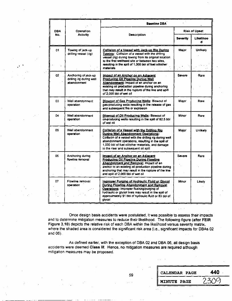
. .
Baseline OBA
OBA Operation Risk of Upset No. Activity Description
Severity Llkellhoo d
01 Towing of jack-up Cglli1i2n 2f a Ve1111 with Jack:YR Big During Major Unlikely drilling vessel (rig) !m!'!i.!!9: Collision of a vessel with the drilhng
vessel (ng) during towing from its original location to the first wellhead site or·between two sites, resulting in the spill of 1,000 bbl of fuel oiVother ' . materials
02 Anchoring of jack-up lmlli!Ji.;J of an Anch2r 2n an Al;jjacent Severe ·Rare drilling iig during well P!:!l;!us;i!]g Qll eimline Qyrl!]g Wgll abandonment Aband2!Jment: Impact of an anchor on an
existing oil production pipeline during anchoring that may result in the rupture of the line and spill of 2,000 bbl of wet oil
03 Well abandonment ~lgwout of Ga1 Proguci!]g Well1: Blowout of Major Rare operation gas-producing wells resulting in the release of gas
and subsequent fire or explosion
04 Well abandonment Blowoyl 2f Qll Prodys;ing ~!II§: Blowout of Minor Rare operation oil-producing wells resulting in the spill of 82.5 bbl
of wet oil
05 Well abandonment ~1:11111i2a of a Vt1HI wilt! lb! 12c!lliog Big Major Unlikely operation Quang Well A!2!nd2ameal QRf!ra112as:
Collision of a vessel with the drilling rig during well abandonment operations, resulting in the spill of 1,000 bbl of fuel oil/other materials, and damage to the riser and subsequent oil spill
06 Anchoring during l!!!li!IC! 2f gn Ans;hor 2n an Al:!li!1<!nt Severe Rare flowline removal Pr2$!uclag Qil PiR!lin! During FlmrtliO!
A!lli!Jdonment 1nd Removal: Impact of an anchor to an existing oil production pipeline during anchoring that may result in the rupture of the line and spill of 2,000 bbl of wet oil
. 07 Flowline removal l!!!RCQR!r Puaiing of Hitgraylic Flulg 2r ~litcol Minor Likely
operation C!!.!!:i!!e F12wli!J! At!gndonm1n1 i!asf R!!m!:!DI 'QPlrations: Improper flushing/purging of hydraulic or glycol lines may result in the spill of approximately 91 bbl of hydraulic fluid or 83 bbl of glycol
Once design basis accidents were postulated, it was possible to assess their impacts and to determine mitigation measures to reduce their likelihood. The following figure (after FEIR Figure 3.10) depicts the relative risk of each OBA within the likelihood versus severity matrix, where the shaded area is considered the significant risk area (i.e., significant impacts for OBAs 02 and 06)
As defined earlier, with the exception of OBA 02 and OBA 06, all design basis accidents were deemed Class Ill. Hence, no mitigation measures are required although mitigation measures may be proposed.
59 CALENDAR PAGE
MINUTE PAGE
440.
2,300

Likelihood l
Virtually Certain
Likely
Unlikely
Rare
Virtually Impossible
Severity-
Negligible Minor Major
DBA07
DBA01 OBA OS
DBA04 DBA03
Note: Shading indicates OBA with significant impact
It is also very important to note that the potential occurrence of each OBA is not universal {i.e., the occurrence each OBA at all project sites is not possible). A summary of OBAs by operator, phase of the project, and parcel number is provided in CEQA Finding No. SSR2.
OBAs 02 and 06, the only two significant impacts associated with potential accidents/upset, pertain to the accidental impact of a maneuvering anchor on an adjacent oil pipeline. Each OBA is detailed below:
OBA 02: Impact of Anchor on Adjacent 011 Pipelines During Well Abandonment Operations
Accident Oescriotion. In order to more precisely position the jack-up drilling vessel over the wellhead, positioning (or maneuvering) anchors may be employed using a 6:1 ratio of anchor radius to water depth (see FEIR Section 2.2.5.5). Anchoring in one of the lease tracts (PRC 1824) may result in a damage to existing, adjacent producing oil flowlines. This may also result in rupture of a pipeline and the subsequent spillage of oil into the·water.
Based on a review of agency maps (e.g., SLC, OOGGR, MMS) which reflect the location of pipelines/flowlines in close proximity to the proposed subsea well abandonment, it has been determined that·none of the oil or gas production lines from adjacent oper:ations pass within the potential impact radius of any of the wells to be abandoned. However, given the remote possibHity of navigational error during maneuvering ~nchor placement, it remains possible (although unlikely) that an anchor could be dropped accidentally on adjacent production lines. The candidate pipeline for this accident scenario includes the Platforms Grace/Hope pipeline which comes ashore at Carpinteria (i.e., crossing PRC 3150, east of PRC 1824); this pipeline is approximately 3 miles from proposed abandonment operations on PRC 1824 (see FEIR Appendix J, Figure J.3).
Severity. Pipeline rupture shut-off valves which are typically installed on submarine pipelines can be activated within a few minutes following the detection of a spill. ·These valves help to reduce the amount of product released into the environment. The estimated amount of oil spilled will depend on several factors, including: 1) size of the pipeline ruptured, 2) production rate, 3) time required to activate the shut-off valves, and 4) the length of the pipeline. None of this information is presently available upon which an educated estimate of total spill volume can be made. For the purposes of this analysis, it is assumed that an 8" pipeline is ruptured and the rate
60 CALENDAR PAGE 441
MINUTE PAGE 2.310 ... i
[
' '
of oil production via this line is approximately 1,500 bbl per day. The amount of ~ii spilled due to this accident could be up to 2,000 bbl. This amount falls in the category of Severe.
Likelihood. There are no historical data to provide a basis for estimating the frequency of this event The likelihood of this event occurring on a particular lease tract is projected to be in the range of one occurrence in 1,000 years to one occurrence in 100 years.
Based on a review of SLC maps depicted existing. operational offshore pipelines. this event concerns only one of the project parcels (i.e., PRC 1824). The likelihood of this OBA is c?nsidered to be very low, falling into the category of Rare.
OBA 06: Impact of an Anchor on Adjacent on Pipelines·ouring Flowline Abandonment and Removal Operations
Accident Description. Deploying anchors is a necessary step in the abandonment and removal of flowlines. The placement and positioning of a support vessel over a flowline or flowline bundle requires anchoring, the latter of which may result in damage to existing producing oil pipelines adjacent to flowlines being abandoned. This may also result in rupture of a pipeline and subsequent spillage of oil into the water.
Based on a review of agency maps (e.g., SLC, DOGGR, MMS) which reflect the location of pipelines/flowlines in close proximity to the proposed flowline removal, it has been determined that none of the oil or gas production lines from adjacent operations pass within the potential impact radius of any of the wells to be abandoned. However, given the remote possibility of navigational error during maneuvering anchor placement, it remains possible (although unlikely) that an anchor could be dropped accidentally on adjacent production lines. Candidate pipelines for this accident scenario include the Gaviota Marine Terminal loading lines at Gaviota, the latter of which are located approximately 0.25 mile from proposed nearshore flowline abandonment and removal operations for the ARCO 2793 lines (see FEIR Figures 2.23 and 2.24).
Severity. The 30" loading line is approximately 3,500 ft long. The line is idle (i.e., ~ow rate= O bbl/day). The volume of the idle line is approximately 3,000 bbl. Based on an estimated loss of 65-70%-of line volume, approximately 2,000 bbl of oil_(i.e., 1,950 bbl to 2, 100 bbl) could be released. This amount falls into the category of Severe. · ·
Likelihood. Vessel positioning for flowline abandonment and removal will be required in.three parcels .. Only one parcel {PRC 2199), however, contains non-project related lines (see FEIR Figure 2.24) which· could potentially be_ affected by anchoring operations. Although
· anchoring is a required step in the flowline abandonment and removal. phase of the project, the applicant will have extensive control over this operation. The likelihood of this event, therefore, is in the range of OBA 02, which is Rare.
Mitigation Measure(s)
The applicants or their agent will be required to document the precise location and orientation of adjacent pipelines or flowlines relative to the wellheads to be abandoned on PRC 1824 and the flowlines to be removed in PRC 2199 (ARCO 2793 flowlines to Gaviota, landfall in PRC 2199). The applicants should prepare and adhere to a site-specific anchoring plan (see CEQA Finding No. MB2). Precision ·navigation shall be used to place anchors during anchor deployment operations.
In addition, the State of California Department of Fish and Game, Office of Oil Spill Prevention and Response (OSPR), under the mandate of SB 2040,·will require the applicants (or their agent[s]) to prepare or secure the following: 1} an oil spill co1.i;;w!·~~~!leJ;;!JQY.!;~~m§!b====
61 CALENDAR PAGE 442
' ' MINUTE PAGE 231 l

Adriatic VIII (or equivalent drilling rig), as well as any project-related spill response vessel(s) •. sµch as the MN Buccaneer, and 2) a financial responsibility certificate. Issuance of the financial responsibility certificate is coordinated by and administered through OSPR. The vessel oil spill contingency plan(s) must be approved by OSPR prior to commencement of operations; see CEQA Finding No. SSR2.
Timing
activities. Mitigation measures should be implemented in advance of the init.iation of project
SUMMARY: Residual impact: Class II, adverse but not signifieant following mitigation.·
62 CALENDAR PAGE 443
MINUTE PAGE 23l2-..1
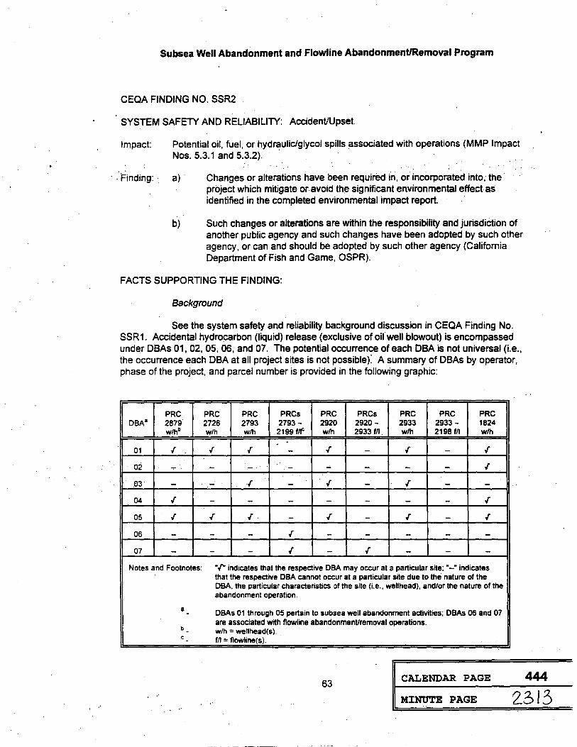
Subsea Well Abandonment and Flowline Abandonment/Removal Program
CEQA FINDING NO. SSR2
SYSTEM SAFETY AND RELIABILITY: Accident/Upset.
Impact: Potential oil, fuel, or hydraulic/glycol spills associated with operations {MMP Impact Nos. 5.3.1 and 5.3.2). ·
· . Finding: ·. a) · Changes or alte.rations have been required in, or incorporated into; the· project which mitigate or.avoid the significant environmentaJ effect as identified in the completed environmental impact report.
b) Such changes or alterations are within the responsibility and jurisdiCtion of another public agency and such changes have been adopted by such other agency, or can and should be adopted by such other agency {California Department of Fish and Game, OSPR).
FACTS SUPPORTING THE FINDING:
Background
See the system safety and reliability background discussion in CEQA Finding No. SSR1. Accidental hydrocarbon (liquid) release (exclusive of oifwell blowout) is encompassed under DBAs 01, 02, 05, 06, and 07. The potential occurrence of each OBA is not universal (Le., the occurrence each OBA at all project sites is not possiblef A summary of DBAs by operator, phase of the project, and parcel number is provided in the following graphic:
PRC PRC PRC PR Cs PRC PR Cs PRC PRC PRC DBA8 2879 2726 2793 2793- 2920 2920 - 2933 2933- 1824
w/hb w/h w/h 2199 f/f w/h 2933 f/I w/h 2198 f/I w/h
01 .[ .[ .[ - .[ - .[ - .[
o2 ..,. - - . - ..;. - - - .[
.EJ3 - .. - .[ - .[ - .[ - -04 .[ - - - - - - - .[
05 .[ .[ .[ . - .[ - .[ - .[
06 - - - .[ - - - - -07 - - - . .[ - .[ - - -
Notes and Footnotes: "I" indicates that the respective DBA may occur at a particular site;"-" indicates that the respective DBA cannot occur at a particular site due to the nature of the OBA. the particular characteristics of the site (i.e., wellhead), and/or the nature of the abandonment operation.
a DBAs 01 through 05 pertain to subsea well abandonment activities; DBAs 06 and 07 -are associated with flowline abandonment/removal operations.
b - w/h = wellhead(s). c - f/I = flowline(s).
63 CALENDAR PAGE 444
' .. MINUTE PAGE 2313 ' "

Mitigation measures designed to reduce the probability of occurrence for DBAs 02 and 06 are encompassed under CECA Finding No. SSR1. In the event a OBA occurs resulting in the release of oil, diesel fuel, or hydraulic fluid/glycol into the marine environment, additional mitigation measures are warranted.
Mitigation Measure(s)
As part of the proposed project, the applicants have noted the prepositioning of oil spill response equipment at the site of operations (i.e., a dedicated offshore oil spill response vessel). In addition, the State of California Department of Fish and Game, Office of Oil Spill Prevention and Response (OSPR), under the mandate of SB 2040, will require the applicants (or their agent[s]) to prepare or secure the following: 1) an oil spill contingency plan for the 'Glomar Adriatic Vl/J (or equivalent drilling rig) and flowline abandonment/removal work boat , as well as any project-related spill response vessel(s), such as the MN Buccaneer, and 2) a .financial responsibility certificate. Issuance of the financial responsibility certificate is coordinated by and administered through OSPR. The viessel oil spill contingency plan(s) must be approved by OSPR prior to commencement of operations.
Through a site-specific Oil Spill Contingency Plan (OSCP), adequate containment and cleanup equipment and crews will be available. The adequacy of on-site oil spill containment and cleanup equipment will be determined as part of the OSPR OSCP review and approval process. The applicants or their agents shall hold routine and unannounced oil spill drills to familiarize operational crews on proper procedures, use of equipment, and chain of command.
Timing
activities. Mitigation measures should be implemented in ~d'(ance of the initiation of project
SUMMARY: Residual impact: Class II, adverse but not significant following mitigation.
64 CALENDAR PAGE 445
MINUTE PAGE 2 314
Subsea Well Abandonment and Flowline Abandonment/Remov~.1 Program
CEQA FINDING NO. MB3
MARINE BIOLOGY: Accident/Upset: Accidental release of oil (2,000 bbl maximum. subsurface release, PRCs 2199 and 1824 only) or diesel fuel (1.000
Impact'.
Finding:
bbl maximum, surface release, all PRCs). ·
Sea otter mortality via. loss of thermoregulation (MMP. Impact No. 5.3.2). . . . . ... ..
a) Changes or alterations have been required in, or 'ncorporated into, the project which mitigate or avoid the significant environmental effect as identified in the completed environmental impact report.
b) Such changes or alterations are within the responsibility and jurisdiction of another public agency and such changes have been adopted by such other agency, or can and should be adopted by such other agency (California Department of Fish and Game, U.$; Fish and Wildlife Service).
FACTS SUPPORTING THE FINDING:
Background
See the system safety and reliability background discussion in CEQA Finding No. SSR2 for a detailed explanation of possible design basis accidents (DBAs) including oil, diesel fuel, and/or hydraulic fluid/glycol releases.
The California sea otter (Enhydra lutris) population is isolated from the Alaska population and received threatened status under the Endangered Species Act because it was considered restricted in both numbers and range. Since observations of 100-150 individuals (resulting in an estimate of 300 individuals) off Bixby Creek in Monterey County in 1938, the California population expanded in both numbers and range until 1976. There were indications of a reduction in population size between 1 ~76 and 1982 attributed, in part, to entanglement mortality arising from commercial gill net activity. With increasing restrictions placed upon gill netters since 1982, coupled with a· series of mild winters, there has been a marked increase in the number of independent sea otters sighted. According to tbe rangewide mainland census completed by the California Department of Fish and Game in Spring 1994, there were 2,076 independent individuals and 283 pups, for a total of 2,359 individuals.
Although the southern boundary of the presently recognized sea otter range is drawn at the Santa Maria River mouth (approximately 61 km (33 nmi) in a direct course north of Pt. Conception), individual and small groups of sea otters occasionally travel to and below the Pt. Conception area. Four to five individuals have been regularly sighted in Cojo Bay anchorage, located just east of Pt. Conception. They have also been occasional unconfirmed reports of individual otters off Gaviota, Santa Barbara, and San Miguel Island. Individual wandering animals could possibly transit the project area; however, no breeding population is expected in close proximity to proposed operations.
Oil may induce sublethal or lethal effects in marine organisms through exposure and accumulation of toxic oil components or through coating and smothering. Risk from exposure to toxic oil components is more significant during the early stages of a spHI due to the degradation processes the oil undergoes in the marine environment. Mortalitiil$es==d=ue:::to:E::l!5l!i:!!!:!:!:!il:~!:!!!::=======
65 CALENDAR PAGE 446
MINUTE PAGE L 3 \ 5
smothering are a major concern from oil washing ashore in intertidal areas and/or where birds and marine mammals are present. ·
Sea otters are very susceptible to impacts from oil spills, however this marine mammal is transient only in the western Santa Barbara Channel region (i.e., in the vicinity of PRC 2879). If an otter is unable to avoid contact with a slick and its pelage is oiled, it could die of exposure within hours. Unlike other marine mammals, sea otters lack a protective blubber layer and rely only on dense fur for insulation. This dense fur, coupled with the animal's physiology (i.e., large liver in proportion to other mammals), allows sea otters to maintain the highest metabolic heat production for its size among mammals. If the fur is soiled Qr matted by oil, the insulating air lay1:1r cannot be maintained and the 'fur ·loses its thermoregulative proi:>erties. A clean coat of fur is essential to otter survival, and sea otters spend a· large part of each day grooming. It is likely that if only a small portion (<30%) of the otter's pelt were oiled, the animal would be able to clean it and avoid death by exposure (Siniff et al., 1982). Oil fouling of more than 30% of an otter's fur (i.e., surface area) will result in death via pneumonia or hypothermia. Once an animal's fur comes in contact with oil, an increase in grooming activity normally follows, however, this cleaning activity may also jeopardize the otter. If the oil contains large amounts of light aromatic hydrocarbons, the otter may ingest levels toxic enough to induce illness or death. Hubbs Marine Research Institute (1986) developed a safe and effective procedure to clean and rehabilitate oiled otters. Because the present breeding range of sea otters is kilometers north of Pt. Conception and extralimital sea otters traveling and inhabiting areas south of this point are rare, it is unlikely that the perpetuation of the California sea otter population would be threatened by the unlikely event of an oil spill from operations at Pt. Conception. However, should a major oil spill result in sea otter mortality, impacts would be significant.
Mitigation Measure(s)
Identified mitigation measures include: 1) prepositioning of oil spill response equipment (i.e., a dedicated offshore oil spill response vessel) at each site throughout well abandonment and flowline abandonment/removal operations; 2) development of a site-specific Oil Spill Contingency Plan (OSCP) which outlines adequate containment and cleanup equipment and available manpower; and 3) conduct of routine and unannounced oil spill drills to familiarize applicants and operational crews on proper notification and response procedures, the use of equipment, chain of command procedures, and sensitive resources potentially at risk.
All operations are to be conducted with diligent concern for worker safety and protection of the environment. In ~he event of an acciden~l.release, project operations (i.e .. prepositioning of oil spill response equipment; use of a ·dedicated offshore oil spill response vessel at the site of operations) ·and the existence and implementation of an approved OSCP should serve to reduce the level of impact on sensitive resources by significantly improving oil spill response.time. See system safety and reliability mitigation measures discussion under CEQA Finding No. SSR2.
The effectiveness of oil spill mitigation measures, however, is dependant upon several factors, including type of product spilled, wind and oceanographic conditions present at the time of the spill, response time (i.e., sufficient equipment and manpower to the site), anp containment and cleanup equipment effectiveness. The possibility remains that spilled hydrocarbons could affect this sensitive resource.
SUMMARY: Residual impact: Class I, potentially significant and unavoidable following mitigation. No residual impact if mitigation measures are completely effective and the spill does not reach sea otter habitat or individual otters; otherwise, residual impact would range from significant to adverse.
66 CALENDAR PAGE 447
MI:NUTE PAGE 2310 ..
=

Subsea Well Abandonment and Flowline Abandonment/Removal Program
CEQA FINDING NO. MB4
MARINE BIOLOGY: Accident/Upset: Accidental release of oil (2,000 bbl maximum. subsurface release, PRCs 2199 and 1824 only) or diesel fuel (1.000
·l~pact:
Finding:
bbl maximum. surface release, all PRCs). ·
Leth~I and sublethal effectS on adult and pup harbor seals (MMP .Impact No, 5.3.2).
a) Changes or.alterations have been required in, ?r incorporated into, the project which mitigate or avoid the significant environmental effect as identified in the completed environmental impact report.
b) Such changes or alterations are within the responsibility and jurisdiction of another public agency and such changes have been adopted by such other agency, or can and should be adopted by such other agency (California · Department of Fish and Game, U.S. Fish and Wildlife Service).
FACTS SUPPORTING THE FINDING:
Background
See the system safety and reliability background discussion in CEQA Finding No. SSR2 for a detailed explanation of possible design basis accidents (DBAs) including oil, diesel fuel, and/or hydraulic fluid/glycol releases.
Harbor seal (Phoca vituJina) is one of the most common and widely distributed pinnipeds in the world. This species is divided into five subspecies according to their distribution.· The only subspecies that occurs in the project area is the eastern Pacific harbor seal (Phoca vitulina richarr;Js1) which ranges along the Pacific coast from Alaska to Baja California. Approximately 23,000 individuals have been noted in California (Hanan et al., 1992). Although these animals are common and widely distributed, they do not form large groups. Pacific harbor seal maintain small (U!\!Ually <100), stable, local populations at haul-out sites scattered along the mainland and islan·d coastlines. U,nlike all the other pinnipeds occurring off southern California, harbor seal maintain haul-Out sites on the-mainland on ·which they pup and breed. These seals . are cb·mmonly obser\ied on and along the mainland coast. There are .at least six continuously inhabited haul-out sites from Pt. Conception to Pt. Dume, and probably 12 more used as occasi.onal haul-out sites. Harbor seal are also observed resting or foraging beneath offshore production platforms, but they rarely haul out like sea lions.
Upon initial contact, harbor seal are extremely wary of human activity and are easily . disturbed. Although this species is sensitive to and easily disturbed by human activities, once these wary animals no longer feel threatened, they resume their normal behavior and continue to inhabit their historical haul-out sites.
Seasonally, more seals appear to come ashore during spring, an observation which may relate to pupping which takes place from March to May. Haul-out behavior is also related to tidal height, weather conditions, time of day, and human activity levels. Along the mainland coast of the Santa Barbara Channel, between Pt. Conception and Ventura, a total of 11 harbor seal hauling and/or rookery sites have been identified from annual aerial· and ground surveys conducted by the California Department of Fish and _Game since 1981. The location of harbor
67 CALENDAR PAGE 448
MINUTE PAGE ·-23 \7

seal haul out sites inshore of the proposed subsea well abandonment and flowline abandonment/removal activities are provided in the FEIR (Appendix I, Figures 1.34 through l.'36). In terms of abundance, the most prominent haul-out sites along the mainland coast of the project area are currently located at or near Pt. Conception and in the vicinity of Carpinteria, based on the most recent census information available (Hanan et al., 1993). In the Carpinteria area, harbor seal abundance estimates were considerably lower than in the Pt. Conception region.
Hauf out or-rookery sites are varying distances from proposed abandonment activities (Appendix I, Table 1.5). Due to the proximity of several harbor seal haul-out or rookery sites to abandonment operations, a medium-sized oil spill arising from abandonment would have a serious; deleterious effect on harbor seals that might be present. Adults .and sub-adults (incfu~ing pups) would be exposed to recently released and refatively-unweathered oil, containing a higher percentage of volatile and toxic components. Under these conditions, with susceptible pups present, impacts on harbor seals would be significant and not mitigable to an insignificant level.
Mitigation Measure(s)
Identified mitigation measures include: 1) prepositioning of oil spill response equipment (i.e., a dedicated offshore oil spill response vessel) at each site throughout well abandonment and flowline abandonment/removal operations, equipped with sufficient containment and cleanup equipment; 2) development of a site-specific Oil Spill Contingency Plan (OSCP) which outlines adequate containment and cleanup equipment and available manpower; and 3) conduct of routine and unannounced oil spill drills to familiarize applicants and operational crews on proper notification and response procedures, the use of equipment, chain of command procedures, and sensitive resources potentially at risk.
All operations are to be conducted with diligent con.cem for worker safety and protection of the environment. In the event of an accidental release, project operations (i.e., prepositioning of oil spill response equipment; use of a dedicated offshore oil spill response vessel at the site of operations) and the existence and implementation of an approved OSCP should serve to reduce the level of impact on sensitive resources by significantly improving oil spill response time. See system safety and reliability mitigation measures discussion under CEQA Finding No. SSR2. . .
The effectiveness of oil spill mitigation measures, however, is dependant upon several factors, including type of product spilled, wind and oceanographic conditions present at the. time of the spill, response time (i,.e., sufficient equipment and manpower to the site), and containment and cleanup.equipment effectiveness. The possibility remains that spilled hydro~arbons could affect this sensitive resource.
SUMMARY: Residual impact: Class I, potentially significant and unavoidable following mitigation. No residual impact if mitigation measures are completely effective and the spill does not reach harbor seals or their haul out/rookery sites; otherwise, residual impact would range from significant to adverse. ·
68 CALENDAR PAGE 449.
M:INUTE PAGE Z.318

Subsea Well Abandonment and Flowline Abandonment/Removal Program
CEQA FINDING NO. MBS
MARINE BIOLOGY: Accident/Upset: Accidental release of oil (2,000 bbl maximum, subsurface release, PRCs 2199 and 1824 only) or diesel fuel (1,000 bbl maximtJm, surface release, all PRCs).
. !~pact:
Finding:
Disruption of harbor seal haul-o.ut/rookery sites via spill cleanup ope.rations. (MMP · ... Impact No. 5.3;2).
a) Changes or alterations have been required in, ·or incorporated into, the project which mitigate or avoid the significant environmental effect as identified in the completed environmental impact report.
b) Such changes or alterations are within the responsibility and jurisdiction of another public agency and such changes have been adopted by such other agency, or can and should be adopted by such other agency (California Department of Fish and Game, U.S. Fish and Wildlife Service).
FACTS SUPPORTING THE FINDING:
Background
See the system safety and reliability background discussion in CEQA Finding No. SSR2 for a detailed explanation of possible design basis accidents (DBAs) including oil, diesel fuel, and/or hydraulic fluid/glycol releases.
See the marine biology (harbor seal) background discussion in CEQA Finding No: MB4. Due to the proximity of several harbor seal haul-out or rookery sites to abandonment operations, a medium-sized oil spill arising from abandonment would have a serious, deleterious effect on harbor seals that might be present. Onshore cleanup would be extremely disruptive, resulting in impacts which would be s~gnificant and not mitigable to an insignificant level.
Mitigation Measure(s) .
. . ldentifi~d mitigation measures iriclude: ·1) prepositioning of oil spill response ·equipment (i.e., a dedicated offshore oil spill response vessel) at each site throughout well abandonment and flowline abandonment/removal operations, equipped with sufficient containment and cleanup equipment; 2) development of a site-specific Oil Spill Contingency Plan (OSCP) which outiines adequate containment and cleanup equipment and available manpower; and 3) conduct of routine and unannounced oil spill drills to familiarize applicants and operational crews on proper notification and response procedures, the use of equipment, chain of command procedures, and sensitive resources potentially at risk.
All operations are to be conducted with diligent concern for worker safety and protection of the environment. In the event of an accidental release, project operations (i.e., prepositioning of oil spill response equipment; use of a dedicated offshore oil spill response vessel at the site of operations) and the existence and implementation of an approved OSCP should serve to reduce the level of impact on sensitive resources by significantly improving oil spill response time. See system safety and reliability mitigation measures -discussion under CEQA Finding No .. SSR2.
69 CALENDAR PAGE 450
MINUTE PAGE Z3 \C)

The effectiveness of oil spill mitigation measures, however, is dependant upon several factors, including type of product spilled, wind and oceanographic conditions present at the time of the spill, response time (i.e., sufficient equipment and manpower to the site), and containment and cleanup equipment effectiveness. The possibility remains that spilled hydrocarbons could affect this sensitive resource.
SUMMARY: Residual impact: Class I, potentially significant and unavoidable following mitigation. No residual impact if. mitigation measures are completely effective and the spill does not reach harbor seal haul out sites, prompting onshore cleanup activity; otherwise, residual impact would range from significant to adverse. ·
..
70 CALENDAR PAGE 451
MINUTE PAGE 2320
=

Subsea Well Abandonment and Flowline Abandonment/Removal ~rogram
CEQA FINDING NO. MB6
MARINE BIOLOGY: Accident/Upset: Accidental release of oil (2,000 bbl maximum. subsurface release, PRCs 2199 and 1824 only) or diesel fuel (1,000 bbl maximu·m, surface release, all PRCs). ·
Impact Loss of thermoregulatory _ability among several pinniped species (except ~arbor . . seals) (MMP Impact No. 5.3.2). . . · · · ·· ·· · · · · ·
Finding: . a) Changes or alterations ·have been required in, or incorporated fnto, the project which mitigate or avoid the significant environmental effect as
b)
identified in the completed environmental impact report. ·
Such changes or alterations are within the responsibility and jurisdiction of another public ager.icy and such changes have been adopted by such other agency, or can and should be adopted by such other agency (California Department of Fish and Game, U.S. Fish and Wildlife Service).
FACTS SUPPORTING THE FINDING:
Background
See the system safety and reliability background discussion in CECA Finding No. SSR2 for a detailed explanation of possible design basis accidents (DBAs) including oil, diesel fuel, and/or hydraulic fluid/glycol releases.
A summary of the abundance, distribution, and status of California pinnipeds was presented in FEIR Table 3.9. Five pinniped (seals, sea lions) species have been recorded north of Pt. Conception, while all six species have been noted in southern California waters. Of the species listed in Table 3.9, four are eared seals and sea lions (Otariidae) and two are earless seals (Phocidae). Otariidae is represerited by Guadalupe fur seal (Arctocephalus townsendt), northern fur seal (Cal/orhinus ursinus), Steller (or Northern) sea lion (Eumetopias jubatus), and California sea lion (Zalophus califomianus). Remaining species are phocids, including Pacific harbor seal, Phoca vitulina tichardsi, and northern elephant seal (Mirounga angustirostris). San Miguel Island, located approximately 41 km (22 nmi) south of Pt. Conception, serves as rookery sites for all of the above mentioned pinnipeds except the Guadalupe fur seal and Steller sea lion. The remainder of the Channel Islands serve in varying capacities as rookery sites for other pinniped species (see Table 3.9).
The entire population of at least 7,000 animals of Guadalupe fur seal (Arctocephalus townsend1) presently breeds on Isla Guadalupe, an island 225 km (121 nmi) off the central Baja California coast (Fleischer, 1987; Gallo, 1994). Their range before being hunted to near extinction for their fur extended from the Channel Islands off southern California to the Revillagigedo Islands off Mexico. Although their present recorded range is San Miguel Island (41 km [22 nmi] south of Pt. Conception) to Cedros Island, Baja California, only a few Guadalupe fur seals have been sighted at San Miguel and San Nicolas Islands in recent years. The vast majority of the population is found on Isla Guadalupe, with sightings of Guadalupe fur seals off California's coast being rare or uncommon. The Guadalupe fur seal is presently listed as a threatened species (USDOI, USFWS, 1994). Guadalupe fur seal do not occur nor are they expected to transit through the nearshore Channel waters of the project area.
71 CALENDAR PAGE 452.
MINUTE PAGE 2.32-1
The northern fur seal ( Callorhinus ursinus), a relative of the Guadalupe fur seal; is the most abundant otarid in the north Pacific. These seals are the most oceanic of pinnipeds and · rarely come ashore except during the breeding season. At sea, northern fur seal are found individually or in small groups of two or three, preferring the continental slope waters (especially waters west of San Miguel Island). Few are seen within 28 km (15 nmi) of shore (Haley, 1978). An estimated total population of over one million range along the North Pacific Ridge from the Commander Islands to San Miguel Island. A local breeding population of approximately 3,600 animals was documented on San Miguel Island by Bonnell et al. (1983), while other syntheses have noted population peaks of 4,000 in summer (Bonnell and Dailey, 1993); this rookery is at the southernmost edge of their range (Dohl in CSA, 1985). The major rookery .areas on or near San Miguel .Island inclu~e Adams Cove (south of Pt. Bennett) and Castle Rock (northwest of tt:le ·island proper). Members of the breeding population are visible onshore at these sites from May·through October. Woodhouse (in CSA1989e) notes that this species·atso uses Adams Cove and Castle Rock as hauling grounds, with their presence extending into fall and winter during recent years. Like Guadalupe fur seal, northern fur seal generally occur offshore and are not expected to transit the nearshore waters of the project area. During the MMS-sponsored surveys of the Bight, no northern fur seals were observed at sea within the Channel during summer and autumn. Several atypical sightings were noted by Bonnell et al. (1980; 1981) during winter and spring in the vicinity of San Miguel Island and off of Pt. Conception. ·
As with northern fur seal, San Miguel Island served (until recently) as the southernmost rookery for Steller sea lion (Eumetopias jubatus). Although this species ranges from Baja to Japan with an estimated established world population of 95,000 to 122,000, this species is considered an uncommon visitor to southern California waters. Because of the species relatively low numbers and the location of proposed activities in nearshore waters of the Channel, Steller sea lion are not expected to occur or transit within waters of the project area.
By far the most abundant eared seal in the Southern California Bight is the California sea lion. On a worldwide basis, two distinct populations exist and each has been designated as a separate subspecies. The California subspecies, Zalophus c. califomianus, breeds along the west coast from Baja to the Farallon Islands off San Francisco and ranges as far north as Vancouver, British Columbia. Like Steller sea lion, California sea lion are opportunistic feeders, foraging on fishes (e.g., clupeid and engraulid species, rockfish, salmon) and squid. These seals are less pelagic than the fur seals and use the island shelves as foraging grounds and the offshore islands for resting and breeding. It is estimated that there are between 74,000 and 87,000 animals in southern California alone (CSA, 1985; Bonnell and Dailey, 1993). Although there are no mainland rookeries in ~alifornia, the· Judith Rock area, Adams Cove, and Castle Rock are used as rookery sites. CaHfomia sea lion do haul out to rest on the mainland. They are commonly observed in transit through the Channel individually and in groups. This is the only pinniped off California that regularly uses man-made structures such as docks, buoys, oil and gas structures; and even slow moving vessels on which to haul out. California sea lion are expected to occur within tlie project area and at times may use mooring buoys and support vessels as haul-out sites on which to rest between foraging bouts.
Two species of earless seals (Phocidae) live and breed within the Southern California Bight: northern elephant seal and Pacific harbor seal. Northern elephant seal (Mirounga angustirostris) range from Alaska to Baja and breed on offshore islands from the Farallon Islands off San Francisco to San Benito Island off Baja California (Haley, 1978). These animals usually remain offshore and forage in deep water, typically only returning to shore during the breeding season and for a short time in summer months when they haul out in small groups to molt. Some researchers, however, have sighted northern fur seals ashore (on San Miguel Island) at times other than during breeding or molting (Woodhouse, 1994, pers. comm.). Bonnell et al. (1980; 1981) reported only four aerial at-sea observations of northern elephant seal in the Santa Barbara Channel, three of which were in close proximity to Sa~ Miguel Island. ·
72 CALENDAR PAGE 453
' .. MINUTE PAGE .2322.
=
(Bonnell et al., 1983) conducted in the winter of 1982 resulted in the censusing of !llOre than 15,000 individuals on S~m Miguel Island.
Harbor seal (Phoca vitulina) is one of the most common and widely distributed pinnipeds in the world. This species is divided into five subspecies according to their distribution. The only subspecies that occurs in the project area is the eastern Pacific harbor seal (Phoca vitulina richardst) which ranges along the Pacific coast from Alaska to Baja California. See CEQA Finding Nos. MB4 and MB5 for a more detailed discussion of impacts to harbor seals.
Oil spill (slick) detection· abilities amongst pinniped species has been variably researched and reported upon in the scientific literature. Geraci and $rnith (1977) have indicat~d
· .that pinnipeds cannot detect an oil $pill, however, this group does possess a refined sense Of · . ·. smell and could detect the odor of an oil spill .. According to USDOI, MMS (1983) in a contrasting statement, seals have the ability to detect and avoid oil slicks. However, Cowell (1"979) found that breeding male and female seals swam through oil to reach rookery beaches during the breeding season. Davis and Anderson (1976) found no measurable differences in the growth and mortality of oiled and unoiled grey seal pups. LeBoeuf (1971) reported similar results on oiled and unoiled elephant seal pups during the Santa Barbara blowout. In fact, no deaths to any marine mammals could be linked to the Santa Barbara blowout (Brownell, 1971; Geraci and Smith, 1977). Geraci and Smith ( 1977) reported that surface contact with oil has a much greater effect on seals than absorption of the petroleum. Controlled experiments in which seals were exposed to floating oil resulted in reversible eye damage. Srief periods of exposure in clean seawater eliminated all indications of irritation and/or damage to sensitive eye tissues.
Fur seal, which rely in part on their pelage for insulation, would be subject to an increase in metabolism if. their pelts become fouled with oil. This increase in metabolic rate could cause enough additional stress to al11eady stressed or weak animals to cause death (USDOI, MMS, 1983). Physical stress could also be caused by the ingestion or respiration of toxic hydrocarbons.
Secondary impacts to seals could result from man's response activities following C! spill. Delong (1975) found that seals disturbed on San Miguel Island retreated into the sea and
· did not return for one to several days. Such impacts could ~ significant behavioral disturbances during the breeding season (Davis and Anderson, 1976). Abandonment of historic harbor seal hauling or rookery sites would be ex~cted with the level of human disturbance associated with oil spill cleanup activities _in the Pt. Conception area.
For the pinnipeds that rely on fur tor metabolic heat retention (exclusive of harbor · seal; ·see CEQA Findi~g Nos. MB4 amd MBS), impacts from oiling would also be significant and not mitigable to an insignificant level (Class I) in spite of their very rare occurrence in the project area and the expected oil spill trajectory away from favored hauling grounds at San Miguel Island.
Mitigation Measure(s)
Identified mitigation measures include: 1) prepositioning of oil spill response equipment (i.e., a dedicated offshore oil spill response vessel) at each site throughout well abandonment and flowline abandonmenUremoval operations, equipped with sufficient containment and cleanup equipment; 2) development of a site-specific Oil Spill Contingency Plan (OSCP) which outlines adequate containment and cleanup equipment and available manpower; and 3) conduct of routine and unannounced oil spill drills to familiarize applicants and operational crews on proper notification and response procedures, the use of equipment, chain of command procedures, and sensitive resources potentially at risk.
73 CALENDAR PAGE 454
MINUTE PAGE 2.~23
All operations are to be conducted with diligent concern for_ worker safety and protection of the environment. In the event of an accidental release, project operations (i.e.1
.. prepositioning of oil spill response equipment; use of a dedicated offshore oil spill response vessel at the site of operations) and the existence and implementation of an approved OSCP should serve to reduce the level of impact on sensitive resources by significantly improving oil spill response time. See system safety and reliability mitigation measures discussion under CEQA Finding No. SSR2.
The effectiveness of oil spill mitigation measures, however, is dependant upon several factors, including type of product spilled, wind and oceanographic conditions present at the.time of the spill, response time (i.e., sufficient equipment and manpowerfo the site), and containment and cleanup equipment effectiveness. The possibility remains that spilled hydrocarbons coul_d affect this sensitive resource.
SUMMARY: Residual impact: ·class I, potentially significant and unavoidable following mitigation. No residual impact if mitigation measures are completely effective and the spill does not reach susceptible pinnipeds; otherwise, residual impact would range from s.ignificant to adverse.
74 CALENDAR PAGE 455 ·
MINUTE PAGE -232-4
=
Subsea Well Abandonment and Flowline Abandonment/Removal Program
CEQA FINDING NO. MB7
MARINE BIOLOGY: Accident/Upset: Accidental release of oil (2,000 bbl maximum, subsurface release, PRCs 2199 and 1824 only), diesel fuel (1,000 bbl ma~imum, surface release, all PRCs), or hydraulic fluid/glycol (<100 bblmaximum, subsurface, PRCs 2793 .. 2199 and 2920 -
Impact:
Finding:
. 2933) .....
Lethal and sublethal effects on endangered and threaten~d marine avifauna (MMP Impact No. 5.3.2).
a) Changes or alte.rations have been required in, or incorporated into, the project which mitigate or avoid the significant environmental effect as identified in the completed environmental impact report.
b) Such changes or alterations are within the responsibility and jurisdiction of another public agency and such changes have been adopted by such other agency, or can and should be adopted by such other agency (California Department of Fish and Game, U.S. Fish and Wildlife Service).
FACTS SUPPORTING THE FINDING:
Background ·
See the system safety and reliability background discussion in CEQA Finding No. SSR2 for a detailed explanation of possible design basis accidents (DBAs) including oil, diesel fuel, and/or hydraulic fluid/glycol releases.
Th~ brown pelican and the California least tern, two species of endangered avifauna present within the project area, may suffer some mortality in the event of an oil spill. As an offshore forager, brown pelican is highly .susceptible to oil ingestion ar:id fouling. Effects of oil contamination oo the population coulcfbe significant as the population is still recovering from the effects of DDT contamination, the species is sensitive to disturbance, and the breeding success of t)1e species is highly variable. The California l~ast tern, as a coastal inhabitant and offshore ·
. forager, is similarly· s-usceptible because its reeding behavior includes skimming over the ocean surface for prey accompanied by occasional diving. ·
Should an oil spill reach the tern's coastal marsh habitat, however, significant mortality could be realized. This would also be evident for the endangered Belding's savannah sparrow and light-footed clapper rail, other marsh or tidal estuary inhabitants. The threatened western snowy plover could also be adversely affected by an oil spill, particularly if cleanup activities were to occur on nesting beaches.
Nesting locations for the endangered California least tern within Santa Barbara County are limited to four North Coast sites and possibly Carpinteria Marsh (El Estero); the Santa Barbara Channel mainland coast may also have migrant summer visits by least terns. Santa Barbara County nesting locations for the endangered light-footed clapper rail include Carpinteria Marsh, with historic sightings at Goleta Slough. Endangered brown pelicans nest on the northern Channel Islands, with no mainland coast nestings ever recorded. For the threatened (State listed) California black rail, there are no nesting locations noted in Santa Barbara Coun . m acts on
75 CALENDAR PAGE 456
MINUTE PAGE 232.5

endangered/threatened marine avifauna arising from oil contact would. be significant and not mitigable to an insignificant level (Class I).
Impacts on terrestrial avifauna, including those currently listed as endangered, are unlikely. Due to the foraging habits of the peregrine falcon and southern bald eagle, individuals of these two species should not come in contact with oil. However, results of studies evaluating the effects of the Exxon Valdez oil spill indicated that birds of prey are vulnerable to the effects of oiling (USDOC, NOAA; 1991). Given their low population densities in the Santa Barbara Channel region, coupled with their typical foraging habits, it is unlikely that either species would encounter spilled oil. However, any spill-related mortality would constitute a significant impact (Class I) on .local populations. ·
Mitigation Measure(s)
Identified mitigation measures include: 1) prepositioning of oil spill response equipment (i.e., a dedicated offshore oil spill response vessel) at each site throughout well abandonment and flowline abandonment/removal operations, equipped with sufficient containment and cleanup equipment; 2) development of a site-specific Oil Spill Contingency Plan (OSCP) which outlines adequate containment and cleanup equipment and available manpower; and 3) conduct of routine and unannounced oil spill drills to familiarize applicants and operational crews on proper notification and response procedures, the use of equipment, chain of command procedures, and sensitive resources potentially at risk.
All operations are to be conducted with diligent concern for worker safety and protection of the environment. In the event of an accidental release, project operations (i.e., prepositioning of oil spill response equipment; use of a dedicated offshore oil spill response vessel at the site of operations) and the existence and implementatior:i of an approved OSCP should serve to reduce the level of impact on sensitive resources by significantly improving oil spill response time. See system safety and reliability mitigation measures discussion under CEQA Finding No. SSR2.
The effectiveness of oil spill mitigation measures, however, is dependant upon several factors, including type of product spilled, wind and oceanographic conditions present at the _time of the spill, response time (i.e., sufficient equipment and manpower to the site), and containment and cleanup equipment effectiveness. The possibility remains that spilled hydrocarbons could affect this sensitive resource.
SUMMARY: Residual impact: Class I, potentially significant and unavoidable following mitigation. No residual impact if mitigation measures are completely effective and the spill does not reach· susceptible endangered or threatened marine avifauna or their critical habitat; otherwise, residual impact would range from significant to adverse.
76 CALENDAR PAGE 457
MINUTE PAGE 232(o
:::

Subsea Well Abandonment and Flowline Abandonment/Removal .~rogram
CEQA FINDING NO. MB8
MARINE BIOLOGY: Accident/Upset: Accidental release of oil (2,000 bbl maximum, subsurface release, PRCs 2199 and 1824 only), diesel fuel (1,000 bbl ma~irtnim, surface release, all PRCs), or hydraulic fluid/glycol (<100 bbl maximum, subsurface, PRCs 2793 - 2199 and 2920 -
Impact
Finding:
2933)... ... . . . . ...
Toxicity (acute, chronic) on roc_l,<y. intertidal communities (MMP Impact No. 5:3.2).
a) Changes or alterations have been required in, or incorporated into, the project which mitigate or avoid the significant environmental effect as identified in the completed environmental impact report.
b) Such changes or alterations are within the responsibility and jurisdiction of another public agency and such changes have been adopted by such other agency, or can and should be adopted by such other agency (California Department of Fish and Game, U.S. Fish and Wildlife Service).
FACTS SUPPORTING THE FINDING:
Background .
See the system safety and reliability background discussion in CEQA Finding No. SSR2 for a detailed explanation of possible design basis accidents (DBAs) including oil, diesel fuel, and/or hydraulic fluid/glycol releases.
Intertidal substrates in the project area consists of sand, rock, boulder, and/or cobble. The substrate type is an important factor in determining the species that colonize and occur in intertidal environments. Boulders and rocky benches are large, stable substrates which are colonized by epifauria such as barnacles, mollusks, and algae. Gravel and cobble substrates are relatively unstable substrates with few epifaunal or infauna! organisms able to live among them. Sand beach habitats offer fine g_rain habitats that can be colonized by infauna such as worms, crustaceans, and clams·(ADL,,1985). Many rock and boulder beaches are covered with sand in summer and exposed during winter storms. Sandy beaches are more frequently disturbed than rocky intertidal areas and tend to recover from disturbances more quickly than rocky intertidal areas. Recovery of rocky intertidal areas is dependent on larval settlement and growth which may take up to 1 O years (Vesco and Gillard, 1980). Physical factors such as wave exposure and impact. substrate composition, slope and texture of substrate, desiccation, water temperature a·nd light as well as biological factors (e.g., predation and competition) influence the distribution and abundance of intertidal organisms.
Rocky intertidal organisms could be smothered by oil if a spill were to occur as a result of wellhead abandonment/flowline removal activities. Exposure to volatile toxic chemicals released from the oil is also possible, ·particularly if oil reaches the shore in a matter of hours. Recovery times for rocky intertidal areas damaged by oil varies with the vertical level of the intertidal zones that are impacted. The upper barnacle zone and certain seaweeds would recover in approximately a year, while mussel bed assemblages may require up to 1 O years for full recovery (USDOI, MMS, 1984). Impacts of oil spills on rocky intertidal and sensitive habitats is considered to be significant and not mitigable to an insignificant l''f.!!:!:!::!.:~5'!!i!!:::!S:==========
77 CALENDAR PAGE 458
MINUTE PAGE 2327
Mitigation Measure(s)
Identified mitigation measures include: 1) prepositioning of oil spill response equipment (i.e., a dedicated offshore oil spill response vessel) at each site throughout well abandonment and flowline abandonment/removal operations, equipped with sufficient containment and cleanup equipment; 2) development of a site-specific Oil Spill Contingency Plan (OSCP) which outlines adequate containment and cleanup equipment and available manpower; and 3) conduct of routine and unannounced oil spill drills to familiarize applicants and operational crews on proper notification and response procedures, the use of equipm~nt; chain of command procedures, and ~ensitive resources potentially at risk. · · · · ·
All operations are to be conducted with dilig.ent concern for worker safety and protection of the environment. In the event of an accidental release, project operations (i.e., prepositioning of oil spill response equipment use of a dedicated offshore oil spill response vessel at the site of operations) and the existence and implementation of an approved OSCP should serve to reduce the level of impact on sensitive resources by significantly improving oil spill response time. See system safety and reliability mitigation measures discussion under CEQA Finding No. SSR2. .
The effectiveness of oil spill mitigation measures, however, is dependant upon several factors, including type of product spilled, wind and oceanographic conditions present at the time of the spill, response time (i.e., sufficient equipment and manpower to the site), and containment and cleanup equipment effectiveness. The possibility remains that spilled hydrocarbons could affect this sensitive resource.
SUMMARY: Residual impact: Class I, potentially significant ~nd unavoidable following mitigation. No residual impact if mitigation measures are completely effective and the spill does not reach rocky intertidal communities; otherwise, residual impact would range from significant to adverse.
78 CALENDAR PAGE 459
MINUTE PAGE ... 2.323

Subsea Well Abandonment and Flowline Abandonment/Removal Pr:ogram
CEQA FINDING NO. MB9
MARINE BIOLOGY: Accident/Upset: Accidental release of oil (2,000 bbl maximum, subsurface release, PRCs 2199 and 1824 only), diesel fuel (1._000 bbl maximum, surface release, all PRCs). ·
Oil contamination -of envir.Onmentally sensitive habitats, UC Natura.I Reserve .. State. · Park, National Park, National Marine Sanctuary (MMP Impact No. 5.3.2).
Finding:. a) Changes or alterations have been required in, or incorp0rated into, the project which mitigate or avoid the significant environmental effect as identified in the completed environmental impact report.
b) Such changes or alterations are within the responsibilitY and jurisdiction of another public agency and such changes have been adopted by such other agency, or can and should be adopted by such other agency (California Department of Fish and Game, U.S. Fish and Wildlife Service).
FACTS SUPPORTING THE FINDING:
Background
See the system safety and reliability background discussion in CECA Finding No. SSR2 for a detailed explanation of possible design basis accidents (DBAs) including oil, diesel fuel, and/or hydraulic fluid/glycol releases.
Various local, State, and Federal agencies, as well as one international entity, employ a complex mixture of classifications to identify biologically significant habitat(s). Ambrose et al. · ( 1989) identify 1 S designation categories to protect coastal m?irine environments from deleterious impacts to habitats and/or resources. · ·
At .the inte.mational level, UNESCO identifies International Biosphere Reserves as . centers for species·preservation, e~ogical research, and education. According to Aspen. Envir~nmental Group (1982), no resource protection ·is·afforded through this designation .
.. . . At the Federal level, the Departments of Interior and Commerce establish National
Parks (National Park Service) and National Marine Sanctuaries (NOAA). In national parks, consumptive activities (e.g., hunting, mining) are typically prohibited, whereas commercial and sport harvests of invertebrates and fish are allowed (except where specifically prohibited). The California Department of Fish and Game (CDFG) manages all marine life in coastal areas of national parks. National marine sanctuaries have been established by NOAA for the preservation or restoration of ecological resources, or for their recreational or aesthetic value. According to Aspen Environmental Group (1992), marine mammals and birds are the only biota specifically protected within national marine sanctuaries; oil and gas operations, ship movement, dumping, dredging, and removal of cultural resources are also restricted.
During the preparation of previous EISs for proposed lease sales off southern California, the USDOI established two additional categories to classify important biological environments, including: 1) unique biological areas (UBA); and 2) biologically sensitive areas
79 CALENDAR PAGE
M:INOTE PAGE
460
2.320

(BSA). Although not legally defined, these classifications include areas that have been . determined to be potentially biologically sensitive to oil and gas activities (USDOI, MMS, 1984).
The State of California has established several categories for those areas within the State which are of special concern due to their biological importance. These categories include: 1) ecological reserves; 2) marine life refuges; 3) marine reserves; 4) marine. preserves; 5) State parks and underwater parks; and 6) areas of special biological significance (ASBS).
State Ecological Reserves, State Marine Life Refuges, and State Marine Reserves are administered by the CDFG. Select intertidal and subtidal communities were.aff9rded protection via reserve or refuge stattlJs, State ecological reserves were establishea to protect all marine life. State ecological reserves, State marine life refuges, and State marine reserves have been maintained to protect marine resources previously threatened by human disturbance and the indiscriminant collection of organisms. Marine life refuges (including clam preserves and fish and game refuges) were intended to provide natural areas for marine-related research. Marine reserves were conceived to protect specific marine species in a given area. Regulations are complex and inconsistent, tending to be reserve- or refuge-specific ..
In addition, State Parks and State Underwater Parks have been established to balance recreational use with ecological, scientific, natural, historic, and scenic values (Aspen Environmental Group, 1992). State parks are terrestrial, with offshore boundaries at the tide line. The Department of Parks and Recreation manages parks, while the CDFG manages the marine life of underwater parks. Limited commercial and recreational harvesting of invertebrates and fish is allowed.
Areas of special biological significance are those areas designated by the State Water Resources Control Board (1975) which contain biological communities of such extraordinary, although unquantifiable, value that no risk of change in their environment resulting from man's activities can be acceptable; this concept was conceived to protect ecologically unique communities from wastewater discharges.
Local coastal plans also provide a mechanism for the identification of unique environments at the county or city level. The Santa Barbara Coastal Plan (County of Santa· · Barbara, 1982) defines environmental sensitive habitat areas as any area in which plant or animal life or their habitats are either rare or ,especially valuable because of their special nature or role in an ecosystem and which could be easily disturbed or degraded by human activities and developments. Environmentally sen.sitive habitat areas that occur in the Santa Barbara County coastal zone include threatened and endangered species habitats. wetlands, streams, nearshore reefs, tidepools, offshore rocks, native plant communities, dunes, kelp beds, harbor seal rookeries and haul-out grounds, and seabird roosting and nesting areas.
The University of California has designated Natural Reserves to protect areas representative of the State's ecological diversity. Underwater Areas are being considered as future State Underwater Parks. As noted by Aspen Environmental Group (1992), most underwater areas are offshore extensions of State beaches, State parks, or other protected coastal areas. ·
Between Morro Bay and Pt. Conception, two State-designated Ecological Reserves or Preserves have been identified, including Morro Bay/Morro Rock and Pismo Beach. In addition, both areas are also considered marine life refuges. These are located well beyond the influence of project activities and are not considered further. The Pt. Arguello to Pt. Conception region may contain, at times, extralimital sea otter in nearshore waters. Offshore, migrating whales (e.g., gray whale) seasonally transit the area. Along the mainland coast and, particularly, on the northern Channel Islands, several avifauna sp~cies breed~!Q,J!Qg~!,d·~~~!9'Y~gf§===
80 CALENDAR PAGE 461
PAGE 23?:{)

•I
Pinnipeds are known to haul out and occasionally pup at several sites between Pt. Arguello and Pt. Conception, as well as several locations in the Santa Barbara Channel (e.g., at Ellwood Pier). At numerous locations along the northern Channel Islands, rookeries and hauling grounds for several pinniped species are heavily utilized.
There are 9 ecological reserves, 9 marine life refuges, and 13 ASBS between Pt. Conception and the U.S.-Mexican border (USDOI, MMS, 1984). For the Pt. Arguello to Pt. Conception and Santa Barbara Channel regions, the unique marine environments have been summarized in FEIR Table 3.13 and graphically presented in FEIR Figure 3.4. Of particular note are the estuaries, salt marshes, sloughs, and river mouths listed in FEIR Table 3.13. ·These
. areas are considered to be exceptionally productive biological habitats, providing oreeding, · · . ·nesting, and foraging sites for a varietY of tauna, including several endangered, threatened, ~nd/or rare species. · · ·
Research and teaching programs conducted by faculty and staff of academic institutions (e.g., UCSB) extensively utilize the Channel, particularly the nearshore and offshore waters in the vicinity of Coal Oil Pt. and Goleta Pt. Ongoing research programs, sponsored by Federal (e.g., MMS), State, and local agencies and industry, also utilize the waters of the Channel and southern Santa Maria Basin. Although these research and teaching areas are removed from proposed activities of the abandonment program, recognition of this research was considered necessary within the FEIR (see FEIR Table 3.14). Of particular importance are the intertidal monitoring programs being conducted at historic mainland and insular sites within the Channel.
An episodic event such as an oil spill could potentially affect unique marine environments in the Pt. Conception and Santa Barbara Channel area, depending upon the size of the spill and the wind and wave conditions present Results of the oil spill trajectory analysis were summarized in FEIR Appendix I. Under the worst case scenario, oil could reach shore is less than an hour. The most likely areas of shoreline impact extend from the Pt. Arguello-Pl Conception area east to Capitan, from Santa Barbara to Ventura, and the northern shorelines of the northern Channel Islands. Areas include the environmentally sensitive habitat areas designated by Santa Barbara County from Pl Arguello to Pl Conception and from Govemment. . . Pt. to Ellwood. The shoreline between Pt. Arguello and Pt. Conception varies from rocky marine terraces at the northern edge of this coastal segment to narrow, steep, sandy beaches as tne coast turns south. The Pt. Conception area consists of steep sandy beaches with submerged rocks. The shoreline from Pl Concept!on to Las Flores Canyon is primarily narrow cobble beaches with some sandy areas. Bluffs and cliffs back the beaches except at stream entrances. Some beach areas are complete!Y S!Jbmerged at high tide. Oil spill impacts on unique marine environments are deemed significant and.not_ mitig~ble to an insignificant level (Class I).
Mitigation Measure(s) ·
Identified mitigation measures include: 1) prepositioning of oil spill response equipment (i.e., a dedicated offshore oil spill response vessel) at each site throughout well abandonment and flowline abandonment/removal operations, equipped with sufficient containment and cleanup equipment; 2) development of a site-specific Oil Spill Contingency Plan (OSCP) which outlines adequate containment and cleanup equipment and available manpower; and 3) conduct of routine and unannounced oil spill drills to familiarize applicants and operational crews on proper notification and respoi:ise procedures, the use of equipment, chain of command procedures, and sensitive resources potentially at risk.
All operations are to be conducted with diligent concern for worker safety and protection of the environment. In the event of an accidental release, project operations (i.e .• prepositioning of oil spill response equipment; use of a dedicated offshore oil spill response vessel at the site of operations) and the existence and implementation of an a roved OSCP should
81 CALENDAR PAGE 462
' I M:IN'OTE PAGE 233\ 'I
. ,
:
serve to reduce the level of impact on sensitive resources by significantly improving oil spill response time. See system safety and reliability mitigation measures discussioh under CEQA Finding No. SSR2. .
The effectiveness of oil spill mitigation measures, however, is dependant upon several factors, including type of prtoduct spilled, wind and oceanographic conditions present at the time of the spill, response time (i.e., sufficient equipment and manpower to the site), and containment and cl~anup equipment effectiveness. The possibility remains that spilled hydrocarbons could affect this sensitive resource.
SUMMARY: Residual impact:: Class I, Potentially significant and unavoidSble following mitigatipn. · No residual impact if mitigation measures are completely effective and .the spill doe_s ript reach · environmentally sensitive habitats; otherwise, residual impact would range from significant to adverse.
..
82 CALENDAR PAGE 463
M:INOTE PAGE L.3 32..
=

Subsea Well Abandonment and Flowline Abandonmenf!Removal ~rogram
CEQA FINDING NO. MB10
MARINE BIOLOGY: Accident/Upset Accidental release of oil (2, 000 bbl maximum, subsurface release, PRCs 2199 and 1824 only), diesel fuel (1.000 bbl maxim\Jm, surface release, all PRCs). or hydraulic fluid/glycol (<100 bbl maximum, subsurface, PRCs 2793 - 2199 and 2920 - , 2933) .. : . . . .
Impact: Habitat contamination:for endangered and threatened (listed) species (MMP Impact No. 5.3.2). . . .
Finding: a) Changes. or alterations have been required in, or incorporated into, the project which mitigate or avoid the significant environmental effect as identified in the completed environmental impact report.
b) Such changes or alterations are within the responsibility and jurisdiction of another public agency and such changes have been adopted by such other agency, or can and should be adopted by such other agency (California Department of Fish and Game, U.S. Fish and Wildlife Service).
FACTS SUPPORTING THE FINDING:
Background
See the system safety and reliability background discussion in CECA Finding No. SSR2 for a detailed explanation of possible design basis accidents (DBAs) including oil, diesel fuel, and/or hydraulic fluid/glycol releases.
A total of 32 endangered, threatened, or rare species have been identified as either residents or visitors to the southern and southern central California coastal region and the waters of the Southern California Bight, indluding waters of the Santa Barbara Channel. These species, their status, and their distribution have been summarized in FEIR Table 3.12. Detailed discussions for each species can aso be found in respective FEIR sections for marine mammals arid marine birds. ·. · ·
The. official Califom.ia listing of endangered or threatened fauna is contained in the . California Code of Regulations, Title 14, Section 670.5. The official Federal listing of endangered and threatened fauna is published ih the Federal Register, 50 CFR 17 .11. Animals that are candidates for State listing and animals that have been proposed for Federal listing are routinely included in the listing of endangered and threatened animals issued by the State.· A State candidate species is one that the Fish and Game Commission has formally recognized as being under review and consideration by the Catifornia Department of Fish and Game for addition to the State list. A Federal proposed species is one for which a proposed regulation has been published in the Federal Register (California Department of Fish and Game, 1994a).
For native plants, State listing is pursuant to Section 1904 (Native Plant Protection Act of 1977) and Sections 2074.2 and 2075.5 (California Endangered Species Act of 1984) of the Fish and Game Code. Federal listing is pursuant with the Federal Endangered Species Act of 1973, as amended (California Department of Fish and Game, 1994b) ..
83 CALENDAR PAGE 464
MINUTE PAGE . 2333

Listed or candidate terrestrial plant species have been listed in FEIR Table 3.12 even though onshore activities (i.e., flowline removal through the surf zone) are very limited and no impacts to terrestrial communities are anticipated from routine, project-related activities. The very slim possibility exists, however, that accidents will prompt additional shoreline activity.
Impacts on endangered or threatened species arising from oil contamination (oil spill, habitat contamination) would be significant and not mitigable to an insignificant level (Class I), long term, and of regional magnitude to the affected species.
Mitigation Measure(s) .. . ·
Identified mitigation measures include: 1) prepositioning of oil spill response equipment (i.e., a dedicated offshore oil spill response vessel) at each site throughout well abandonment and flowline abandonment/removal operations, equipped with sufficient containment and cleanup equipment; 2) development of a site-specific Oil Spill Contingency Plan (OSCP) which outlines adequate containment and cleanup equipment and available manpower; and 3) conduct of routine and unannounced oil spill drills to familiarize applicants and operational crews on proper notification and response procedures, the use of equipment, chain of command procedures, and sensitive resources potentially at risk.
All operations are to be conducted with diligent concern for worker safety and protection of the environment In the event of an accidental release, project operations (i.e., prepositioning of oil spill response equipment; use of a dedicated offshore oil spill response vessel at the site of operations) and the existence and implementation of an approved OSCP should serve to reduce the level of impact on sensitive resources by significantly improving oil spill response time. See system safety and reliability mitigation measures discussion under CECA Finding No. SSR2.
The effectiveness of oil .spill mitigation measures, however, is dependant upon several factors, including type of product spilled, wind and oceanographic conditions present at the time of the spill, response time (i.e., sufficient equipment and manpower to the site), and containment and cleanup equipment effectiveness. The possibility remains that spilled hydrocarbons could affect this sensitive resource.
SUMMARY: Residual impact: Class I, potentially significant and unavoidable following mitigation. No residual in:ipact if mitigation measures are completely effective and the spill does not contaminate habitat for endangered. and threatened (listed) species; otherwise, residual impact would range from significant to adverse ..
84 CALENDAR PAGE 46&
MINUTE PAGE . 2334 ....
=

Subsea Well Abandonment and Flowline Abandonment/Removal Program
CECA FINDING NO. MWQ1
MARINE WATER QUALITY:
Impact:
Finding: a) Changes or alterations have tieen required in, or incorporated into, the project which mitigate or avoid the significant environmental effect as identified in the completed environmental impact report.
b) Such changes or alterations are within the responsibility and jurisdiction of another public agency and such changes have been adopted by such other agency, or can and should be adopted by such other agency (California Department of Fish and Game, U.S. Fish and Wildlife Service).
FACTS SUPPORTING THE FINDING:
Background
See system safety and reliability background discussion in CECA Finding No. SSR2 for a detailed explanation of possible design basis accidents (OBAs) including oil, diesel fuel, and/or hydraulic fluid/glycol releases.
Spilled oil may produce several different types of water quality impacts. These impacts are greatly dependent on the type and quantity of product spilled. Three types of spills ass·ociated with proposed activities could include fuel (i.e., diesel) spills, and subsurface and surface crude oil spill~. When these"products are released on the ocean's surface, weathering pro~esses immediately begin to alter. their physical and chemical properties. The extent of spreading of "surface spills· is affected by wind, wav~s .. and currents, as well as the physical and chemical nature of the:spillecl ·product (National Academy of Sciences, 1975). Surface slicks · could produce reductions in light penetration and gas exchange. 0Xygen concentrations in subsurface waters could be reduced as a result of the decreased exchange with the atmosphere. The spilled oil may increase water c11>lumn turbidity, biological oxygen demand (BOO), and chemical oxygen demand (COO). Toxic hydrocarbons may be released into the water column and sediments. The general trend is an increase in acute toxicity as the molecular weight of the spilled product increases (Dailey et al.,· 1993). Fates and effects of possible oil spills associated with the proposed activities are discussed in greater detail in FEIR Section 3.1.2.3. Weathering · of surface oil slicks could produce tar balls, which may eventually be widely dispersed in the water column and sediments and ingested by marine pelagic and benthic biota with adver5e effects.
Water column effects, s1i1ch as turbidity, reduced light penetration and gas exchange, and increased BOD and COD would persist in the area of an oil spill for various lengths of time depending on the size of the spill, the physical and chemical characteristics of the oil, and the action of various physical, chemical, and biological dispersive and degradative processes. Substantial departures from baseline conditions would .be expecte~gm1Q,J~~!i:S~ggyy1======
85 CALENDAR PAGE 466 .
MINUTE PAGE 23 3 5
medium sized spill (1,000 bbl). Although a surface slick could be dispersed within hours of release under sufficiently severe physical conditions, the impact could as easily persist for lgn·ger periods. The impact is categorized as Class I (significant impact not mitigable to an insignificant level).
Mitigation Measure(s)
Identified mitigation measures include: 1) prepositioning of oil spill response equipment (i.e., a dedicated offshorie oil spill response vessel) at each site throughout well abandonment and flowline abandonment/removal operations, equipped with sufficient . containment and cleanup equipment; 2) development of a site-specific .on Spi~I Contingency Plan (OSCP) which outlines adequate containment and cleanup equipment' and available manpower;· and 3) conduct of routine and unannounced oil spill drills to familiarize applicants and operational crews o.n proper notification and response procedures, the use of equipment, chain of command procedures, and sensitive resources potentially at risk.
All operations are to be conducted with diligent concern for worker safety and protection of the environment. In the event of an accidental release, project operations (i.e .. prepositioning of oil spill response equipment; use of a dedicated offshore oil spill response vessel
· at the site of operations) and the eXlistence and implementation of an approved OSCP should serve to reduce the level of impact on sensitive resources by significantly improving oil spill response time. See system safety and reliability mitigation measures discussion under CECA Finding No. SSR2.
The effectiveness of oil spili mitigation measures, however, is dependant upon several factors, including type of product spilled, wind and oceanographic conditions present at the time of the spill, response time (i.e., sufficient equipment and manpower to the site}, and containment and cleanup equipment effectiveness. The possibility remains that spilled hydrocarbons could affect this sensitive resource.
SUMMARY: Residual impact: Class I, potentially significant and unavoidable following mitigation, however, mitigation measures would localize the impacts. ·
86 CALENDAR PAGE 467
M:CNOTE PAGE
.-
::

. \
Subsea Well Abandonment and Flowline Abandonment/Removal Program
CECA FINDING NO. MWQ2
MARINE WATER QUALITY: Accident/Upset: Accidental release of oil (2,000 bbl maximum, subsurface release. PRCs 2199 and 1824 only). diesel fuel (1,000 bbl maximum. surface release, all PRCs), or hydraulic fluidfglycol (<100 bbl ma~imum, subsurface, : P_RCs 2793 ~ 2199 and 2920 -2933}: · ·· ·
Impact: Oil deposition in sediments, increased BOD (MMP Impact No. 5.3;2).
Finding: a) Changes or alterations have been required in, or incorporated into, the project which mitigate or avoid the significant environmental effect as identified in the completed environmental impact report
b) Such changes 1or alterations are within the responsibility and jurisdiction of another public agency and such changes have been adopted by such other agency, or can and should be adopted by such other agency (California Department of Fish and Game, U.S. Fish and Wildlife Service). ·
FACTS SUPPORTING THE FINDING:
Background .. ·
See system safety and reliability background discussion in CECA Finding No. SSR2 for a detailed explanation of possible design basis accidents (DBAs) including oil, diesel fuel, and/or hydraulic fluid/glycol releases. See marine water quality background discussion in CECA Finding No. MWQ1.
Sediment impacts would most likely occur if the spilled oil moved onshore rather than offshore. Modeling results presented in FEIR Appendix I indicate that oil spilled in the project area would be most likely to contact th~ coastal segments: 1) Pt. Arguello-Pt. Conception to Capitan; 2) Santa Barbara to Ventura; and 3) northern shorelines of the northern Channel Islands .
. · Once: oil was deposited in subtid~I or intertidal sediments, it could persist for time periods of days . to years depending on various disj>ersive and degradative processes. Both physically and chemically, the oil reaching sediment$ could present a significant-hazard to marine biota for a considerable time period. This impact is also evaluated as Class I (significant impact not mitigable to insignificant levels).
Mitigation Measure(s)
Identified mitigation measures include: 1) prepositioning of oil spill response equipment (i.e., a dedicated offshore oi~ spill response vessel) at each site throughout well abandonment and flowline abandonment/removal operations, equipped with sufficient containment and cleanup equipment; 2), development of a site-specific Oil Spill Contingency Plan (OSCP) which outlines adequate containment and cleanup equipment and available manpower, and 3) conduct of routine and unannounced oil spill drills to familiarize applicants and operational crews on proper notification and resJl>Onse procedures, the use of equipment. chain of command procedures, and sensitive resources potentially at risk.
87 CALENDAR PAGE 468
'I MINUTE PAGE 2337 . '
All operations are to be conducted with diligent concern for worker safety and protection of the environment . tn the event of an accidental release, project operations (i.e., prepositioning of oil spill response equipment; use of a dedicated offshore oil spill response vessel at the site of operations) and the existence and implementation of an approved OSCP should serve to reduce the level of impact on sensitive resources by significantly improving oil spill response time. See system safety and reliability mitigation measures discussion under CECA Finding No. SSR2.
The effectiveness of.oil $Pill mitigation measures, however, is dependant upon several factors, including type of prroduct spilled, wind and oceanographic conditions present at the time of the spill, response.time (i.e .• sufficient equjpment and manpower to the site), and · containment and cleanup equipment effectiveness. The possibility remains ttiat spilled · · · · hydrocarbons could affect this sensitive resource. · · · ·
SUMMARY: Residual impact: Class I, potentially significant and unavoidable following mitigation, however, mitigation measures would localize the impacts.
•'
88 CALENDAR PAGE 469
M:INOTE PAGE 2.33~
=

Subsea Well Abandonment and Flowline Abandonmen~emoval Program
CEQA FINDING NO. AQ4
AIR QUALITY: Accident/Upset Accidental release of oil (2,000 bbl maximum, subsurface· release, PRCs 2199 and 1824 only) or diesel fuel (1,000 bbl maximum. surface relea~e. an PRCs).
Impact.
Finding:
. . Release of reactive organic compounds (ROCs), exacerbation of ozone exf:eedance standard (MMP Impact No. 5.3.2). · · ·
a) Changes or alterations have been required in, or incorporated into, the project which mitigate or avoid the significant environmental effect as. identified in the completed environmental impact report. ·
b) Such changes or alterations are within the responsibility and jurisdiction of another public agency and such changes have been adopted by such other agency, or can and should be adopted by such other agency (Santa Barbara County Air Pollution Control District).
FACTS SUPPORTING THE FINDING:
Background
See the system safety and reliability background discussion in CEQA Finding No. ·ssR2 for a detailed explanatipn of possible design basis accidents (DBAs) including oil, diesel fuel, and/or hydraulic fluid/glycol accidents. The postulated DBAs (also identified in FEIR Section 3.3.2.5, System Safety and Reliability) would release hydrocarbons that could have an adverse impact on air quality.
The most severe air quality impact considered for this project would result from the discharge of crude oil as described in OBA 02 (Impact of an Anchor on an Adjacent Producing Oil Pipeline During Well Abandonment; relea~e of 2,000 bbl of wet crude oil) and OBA 06 (Impact of an Anchor on an Adjacent Producing Oil Pipeline During Flowline Abandonment and Removal; release·of 2,000 bbl of wet crude oil). Weathering of spilled oil may allow 40 to 50% (by weight) of the volatile hydrQcarbQns to be released into the atmosphere. Light ends in the crude oil
" evaporate rapidly and. can ciontribute to ozone formation in the atmosphere. Such.release of re~ctive orga~ic ~mpounds (ROCs) is considered significant but mitigable (Class II).
Because of the diminislf'led volume of crude oil released, air quality impacts from OBA. 04 (Blowout of Oil Producing Wells; release of 82.5 bbl of wet crude oil) is considered negligible. Low volatility vapor pressure characteristics coupled with the diminished release volunie of diesel fuel oil, hydraulic fluid, and glycol would also render OBA 01 (Collision of a Vessel with Jack-up Rig During Towing), OBA 05 (Collision ofa Vessel with the Drilling Rig During Well Abandonment Operations), and OBA 07 (Improper Purging of Hydraulic Fluid or Glycol During Flowline · Abandonment and Removal Operations; release of less than 100 bbl of hydraulic fluid or glycol) as a negligible air quality impact (Class Ill).
Mitigation Measure(s)
Identified mitigation measures include: 1) prepositioning of oil spill response equipment (i.e., a dedicated offshore oil spill response vessel) at ~!!!:!::!i!:!i·~~!YW:!b!Y!:!!::!!!e===========
89 CALENDAR PAGE 470
M:INtJTE PAGE 2330
abandonment and flowline abandonment/removal operations. equipped with sufficient containment and cleanup equipment; 2) development of a site-speciffc Oil Spill Contingency Plan {OSCP) which outlines adequate containment and cleanup equipment and available manpower; and 3) conduct of routine and unannounced oil spill drills to familiarize applicants and operational crews on proper notification and response procedures, the use of equipment. chain of command procedures, and sensitive resources potential!Y at risk.
All operations are to be conducted with diligent concern for worker safety and protection of the environment. In the event of an accidental release, project operations (i.e .• prepositioning of oil spill response equipment· use of a dedicated offshore.oil spill response vessel at the site of operations) and the eK.istenee and·implementation of an approved OSCP sho.uld ·
. serve to re.duce "the level of impact on sensitive resources by significantly i..nproving oil "spill response time. See system safety and reliability mitigation measures discussion under CEQA Finding No. SSR2. .
The effectiveness of oil spill mitigation measures, however, is dependant upon several factors, including type of product spilled, wind and oceanographic conditions present at the time of the spill, response time {i.e., sufficient equipment and manpower to the site). and containment and cleanup equipment effectiveness. The possibility remains that spilled hydrocarbons could affect this sensitive resource.
SUMMARY: Residual impact: Class II, adverse but not significant following mitigation.
90 CALENDAR PAGE 471
.... MINUTE PAGE 2340
=

..
Subsea Well Abandonment and Flowline Abandonment/Removal Program
CECA FINDING NO. ACS
AIR QUALITY: Accident/Upset Accidental release via well blowout of 2,000 MCFD (thousand dry cubic feet/day) of natural gas (PRCs 2793, 2920, and ~933).
Impact Release of 2,000 MCFD of gas during a gas well blowout. release of reaCtive organic compounds (ROCs) (MMP Impact No. 5.3.2).
Finding: · a) Changes or alterations have been required in, ~r incorporated into, the project which mitigate or avoid the significant-environmental effect as identified in the completed environmental impact report.
b) Such. changes or alterations are within the responsibility and jurisdiction of another public agency and such changes have been adopted by such other agency, or can and should be adopted by such other agency (Santa Barbara County Air Pollution Control District).
FACTS SUPPORTING THE FINDING:
Background
See the system safety and reliability background discussion in CECA Finding No . . SSR2 for a detailed explanation of possible design basis accidents (DBAs) including natural gas blowouts (OBA 03).
OBA 03 (Blowout of Gas Producing Wells; release of 2,000 MCFD) may contribute to short term, ambient air quality standard violations. Produced gas is typically 80 to 90% methane, defined by the Santa Barbara County APCD as a non-reactive volatile organic gas. However, the remaining portion of the large quantity of gas predicted for release may result in a significant emission of reactive organic compounds (Class II). '
. All.operations are to be conducted with diligent concern for worker safety and pro~ection of ttie environment. All operating procedures ~n the rig, whether automated or controlled by Glomar personnel, are specifical'y de~igned to prevent a loss of well control. The . . p.rimary meth.od of w.ell control is based on the use of hydrostatic pres~ure exerted by a column of ·drilling mud of sufficient density to· prevent an undesired flow of formation fluid into the well bore. In case .of the primary control failure, the blowout prevention equipment (BOPE) is used as the secondary control mechanism.
Mitigation Measure(s)
The complete prevention of an atmospheric release during an accident or upset .. cannot be achieved. Nevertheless, the standard operating procedures to be employed ori all wells, as outlined in FEIR Section 3.3 (System Safety and Reliability) and Appendix A, will serve to reduce the probability of well blowout. Other air quality mitigation measures (CECA Finding Nos. AQ1 and AQ2; emission offsets and mitigation fees) might also apply a posteriori.
SUMMARY: Residual impact: Class II, adverse but not significant following mitigation.
91 CALENDAR PAGE 472
M:INUTE PAGE 2.34-1

Sub&ea Well Abandonment and Flowline Abandonment/Removal Program
CECA FINDING NO. AQ6
AIR QUALITY: Accident/Upset Accidental release of oil (2,000 bbl maximum, subsurface release, PRCs 2199 and 1824 only), diesel fuel (1,000 bbl maximum. surface release, all PRCs), or hydraulic fluid/glycol (<100 bbl maximum, subsurface, PRCs 2793 - 2199 and 2920 - 2933).
Impact
Finding:
Emergency spill response vessel activity and -~ssociated NO. emi&sions (MMP Impact No. 5.3.2). ·
a) Changes or alterations have been required in, or incorporated into, the project which mitigate or avoid the significant environmental effect as identified in the completed environmental impact. report
b) ·Such changes or alterations are within the responsibility and jurisdiction of another public agency and such changes have been adopted by such other agency, or can and should be adopted by such other agency (Santa Barbara County Air Pollution Control District).
FACTS SUPPORTING THE FINDING:
Background
See the system safety and reliability background discussion in CEQA Finding No. SSR2 for a detailed explanation of fl>OSSible design basis accidents (DBAs) including the accidental release of oil, diesel fuel, and/or hydraulic fluid/glycol.
Emissions would be realized from emergency spill response vessels (e.g., Clean · Seas) deployed to conduct spill herding, booming, and cleanup operations. These response· boats.are approximately the size of the Alberta Tide (Workboat #1; as cited in the application, Morton Associates; Inc., 1994) and generally release emissions without any NO. exhaust control (Santa Barbara County APCD, 199Gb;c). Such emergency spill response vessel activity, based on increased.NO. emissions, would create a significant but mitigable impact (Class II).
MitigatioR Measure(s). ··
Identified mitigation measures include: 1) prepositioning of oil spill response equipment (i.e., a dedicated offshore oil spill response vessel) at each site throughout well abandonment and flowline abandonment/removal operations, equipped with sufficient containment and cleanup equipment; 2) development of a site-specific Oil Spill Contingency Plan (OSCP) which outlines adequate containment and cleanup equipment and available manpower; and 3) conduct of routine and unannounced oil spill drills to familiarize applicants and operational crews on proper notification and re~ponse procedures, the use of equipment, chain of command procedures, and sensitive resources potentially at risk.
All operations are to be conducted with diligent concern for worker safety and protection of the environment. In the event of an accidental release, project operations (i.e., prepositioning of oil spill response equipment; use of a dedicated offshore oil spill response vessel at the site of operations) and the existence and implementation of an approved OSCP should serve to reduce the level of impact on sensitive resources by significant! i · · ·
92 CALENDAR PAGE 473
MI:NtJTE PAGE 234 '2.
response time. See system safety and reliability mitigation measures discussion under CECA Finding No. SSR2. . .
SUMMARY: Residual impact: Class 11, adverse but not significant following mitigation.
93 CALENDAR PAGE 474
MI:NOTE PAGE 2343 ' I • I '
Subsea Well Abandonment and Flowline Abandonment/Removal Program
CEQA FINDING NO. N1
NOISE: Accident/Upset Accidental release of oil (2,000 bbl maximum, subsurface release, PRCs 2199 ·and 1824 c1mly), diesel fuel (1,000 bbl maximum. surface release. all PRCs),' or hydraulic fluid/glycol (<100 bbl maximum, subsurface, PRCs 2793 - 2199 and 2920 - 2933) .
. · impact: · Noise associated with clea.nup operations (MMP lmpa~t No.· 5.3:2).
Finding: a) . .
Changes oi' alterations·have been required in, or incorporated into; the project which mitigate or avoid the significant environmental effect as identified in the completed environmental impact report
b) Such changes or alterations are within the responsibility and jurisdiction of another public agency and such changes have been adopted by such other agency, or can and should be adopted by such other agency (California Department of Fish and Game, OSPR).
FACTS SUPPORTING THE FINDING:
Background
See. the system safety and reliability background djscussion in CECA Finding No. SSR2 for a detailed explanation of possible design basis accidents (DBAs) including oil, diesel fuel, hydraulic fluid/glycol accidents, and/or blowouts.
The rural coastal regions of southern Santa Barbara County between Pt. Conception and Ellwood (west of Goleta) are characterized as generally quiet but are subject to intermittent noise from trains along the Southem Pacific Railroad - as many as seven freight trains and one AMTRAK passenger train in each direction per day (Aspen Environmental Group, 1992) - and intermittent aircraft noise in the vicinity of Ellwood. The coastal area east of Summerland; a single-family residential area locate~ between Santa Barbara and Carpinteria, although more developed mso can be described generally as quiet, with intermittent noise occurring from train
traffic on the Southern P.acific Railroad and highway traffic along U.S. Highway 101 (U.S. 101). U.S. 101 parallels. the railroad· alignment-on the land side of the railroad-and is located within· · · 0.25 mile of the coast both between Gaviota and Ellwood and in the Summertand area; however, noise from the highway is less noticeable at beach locations given the highway's more inland alignment and greater setback froni 'bluff tops than that of the railroad.
Noise in residential or other noise-sensitive settings is often more disturbing during the night than the day. At night, background noise levels outdoors are generally lower than those occurring during the day; also, activity. in most households decreases at night, lowering internally generated noise levels. Individual noise events, therefore, are more intrusive at night, since they contrast more sharply against the bac~ground noise, or ambient noise, than during the day. Ambient noise (background noise) is the composite of noise from all sources which affect a given location and is considered the normally existing noise environment at a particular place. Ambient noise levels are measured using weighted noise measurement systems (e.g., Day-Night Average Level [LON] and Community Noise Ecquivalent Level [CNEL]; County of Santa Barbara, 1986).
94 CALENDAR PAGE 475
MJ:NtJTE PAGE 2.344
=

. . .
Impact analyses presented in the FEIR considered project- and accid~nt-generated noise, the reduction in noise level as a function of distance, and the existing land use and noise environment of the rece.ptor area. The degree of impact was evaluated for the resultant LON at the receptor with the addition of project-related noise. The California Office of Noise Control (CONC) has recommended guidelines for ewaluating land use compatibility with different noise environments; these have been adapted by the County.of Santa Barbara in its Comprehensive Plan's Noise Element (County of S$nta Barbara, 1986; see FEIR Table 3.35). These guidelines categorize community noise exposure levels into normally acceptable, conditionally acceptable. normally unacceptable, and clearly unacceptable for various land uses. Potential impacts of project noise. levels were evaluated with regard to guidelines established by .the California Offic;:e . of. N0,ise Control (U.S.· Environmental .Protection Agency·, 197 4, 1981; Califo~i.a. Office of. Noise · _Control, 1982; U.S. Department of Housing and Urban Oeyelopment .. 1985) .. · · · ·
The ranges of acceptability for the most sensitive land use category-tow density residential-are presented in Table 3.35, with an ~ value of 70 dBA representing a threshold between the conditionally acceptable and the normally unacceptable range. CONC .has ·also developed correction factors that ate used to adjust or "normalize" noise source levels based on time of day, seasonal influences, nature of the noise environment, previous exposure and community attitudes, and character of the noise.
Although noise associated with routine, project-related activities was determined to be adverse but not significant for all project sites (with the exception of nighttime operations, see CEQA Finding No. RA3), potentially significant noise impacts related to an oil spill would arise from the use of boats and heavy equipment implemented to contain arid mitigate the effects of a spill. Thus, the mitigation of a spill, rather than the spill itself, would create noise impacts. The two principal noise sources that potentially would be present to mitigate a spill would be: 1) boats operating day or night at various distances from shore; and 2) tieavy earthmoving equipment operating during daylight and possibly during nighttime along the beach.
No data are readily avalilable on noise levels generated by specialty clean-up vessels, but these noise levels likely are similar to noise levels produced by supply boats (approximately 92 dBA at 50 ft). Typical noise levels generated by ground vehicles, all at 50 ft. are 72 dBA for light pickup trucks, 87 dBA for bulldozers, and 88 dBA for dump trucks (CSA, 1987a). Clean-up boats could operate within a few hundred yards of coastal residents at the Hollister Ranch or Summerland residential areas, and vehicles could operate as close as 100 ft in some locations, depending on the extent of a potential spill. Resulting noise levels could exceed 80 dBA during the day and 70 dBA at night. If continued over a long period, this would represent a significant impact not mitigable tq an-insignificant level (Class I). ·
Mitigation Measure(s)
Identified mitigation measures include: 1) prepositioning of oil spill response equipment (i.e., a dedicated offshore oil spill response vessel) at each site throughout well. abandonment and flowline abandonment/removal operations, equipped with.sufficient containment and cleanup equipment; 2) development of a site-specific Oil Spill Contingency Plan (OSCP) which outlines adequate containment and cleanup equipment and available manpower; and 3) conduct of routine and unannounced oil spill drills to familiarize applicants and operational crews on proper notification and response procedures, the use of equipment, chain of command procedures, and sensitive resources potentially at risk.
All operations are to be conducted with diligent concern for worker safety and protection of the environment. In the event of an accidental release, project operations (i.e., prepositioning of oil spill response equipment; use of a dedicated offshore oil spill response vessel at the site of operations) and the existence and implementation of·~bil~~~~~~!QYjg..=========
95 CALENDAR PAGE 476.
MINUTE PAGE 2o45
-------------·--------· ---~"- --·------------
serve to reduce the level of impact on sensitive resources by signifi~ntly improving oil spill response time. See system safety and reliability mitigation measures discussion under CECA Finding No. SSR2.
The effectiveness of oil spill mitigation measures, however, is dependant upon several factors, including type of product spilled, wind and oceanographic conditions present at the time of the spill, response time (i.e., sufficient equipment and manpower to the site), and containment and cleanup equipment effectiveness. The possibility remains that spilled hydrocarbons and the subsequent cleanup operations could significantly affect sensitive noise receptors ~nshore.
SUMMARY: Residual impact: Cla~s I, potentially signmcant and unavoidable fullmving'mitigation.· however; mitigation measures would localize the impacts.
96 CALENDAR PAGE 477
... Ml:NtJTE PAGE 2340
=

Subsea Well Abandonment and Flowline Abandonment/Removal Program
CEQA FINDING NO. TC3
·· TRANSPORTATION/CIRCULATION: Accident/Upset: Accidental release of oil (2,000 bbl
Impact:
maximum. subsurface release. PRC 2199 only), diesel fuel (1,000 bbl maximum, surface release, ~II PRCs), or hydraulic fluid/glycol (<100 bbl maximum, subsurface, .
. · · · PRCs 2793 -·2199 and 2920 -.:2933) ..
Cleanup operations (shore~ne between Pt. Conception and·Gaviota) using narrow. restricted roads on the Bixby Cojo Ranch and Hollister Ranch (MMP ·Impact No. 5.3.2).
Finding: a) Changes or alterations have been required in, or incorporated into, the project which mitigate or avoid the significant environmental effect as identified in the completed environmental impact report.
b) Such changes or alterations are within the responsibility and jurisdiction of another public agency and such changes have been adopted by such other agency, or can and should be adopted by such oth~r agency (California Department of Fish and Game, OSPR).
FACTS SUPPORTING THE FINDING:
Background
See the system safety and reliability background discussion in CEQA Finding No. SSR2 for a detailed explanation of possible design basis accidents (DBAs) including oil, diesel fuel, and/or hydraulic fluid/glycol accidents. ·
In the event of a major oil spill at a well abandoriment site, the movement of cleanup crews and equipment could affect traffic anywhere along the Santa Barbara County coast between Pt. Coru:eptio.n and Refugio· State Beach or in the Summerland area, depending from wh.ich well tti~ spill originates ..
. · · Access to.the shoreline from PRCs 2879 (Unocal), 2726 (Texaco). or 2793 (ARCO) between Pt. Conception and Gaviota is possible only using narrow. restricted roads on the Bixby Cojo Ranch and Hollister Ranch. Tltansportation of cleanup crews and equipment over these private roads would need to be coordinated with ranch personnel to avoid potentially significant (Class II) impacts on the movement of residents in any affected areas.
Mitigation Measure(s)
In the event of an oil spill, coordination of clean-up operations with local and State agencies would facilitate the response to an oil spill and minimize the potential disruption to the transportation system. ~oordination with appropriate ranch personnel should also be described in the Oil Spill Contingency Plan.
Identified mitigation measures include: 1) prepositioning of oil spill response equipment (i.e., a dedicated offshore oil spill response vessel) at each site throughout well abandonment and flowline abandonment/removal ope~tions, equlJl· ~~[:!m:.§Yl~gQ!-===========
97 CALENDAR PAGE 478.
MI:NtJTE PAGE

containment and cleanup equipment; 2) development of a site-specific Oil Spill Contingency Plan (OSCP) which outlines adequate containment and cleanup equipment and available manpowe~ and 3) conduct of routine and unannounced oil spill drills to familiarize applicants and operational crews on proper notification and response procedures. the use of equipment. chain of command procedures, and sensitive resources potentially at risk.
All operations are to be conducted with diligent concern for worker safety and protection of the environment. In the event of an accidental release, project operations (i.e .. prepositioning of oil spill response equipment; use of a dedicated offshore oil spill response vessel at the site of operations) and the existence and implementation of an approved OSCP should serve to reduce the level· of impact Cl>n sensitive resources by significan~ impr:oving ·oil spill response time. See system safety and reliability mitigatior:i measures discussion under CECA Finding No. SSR2 ...
The effectiveness of oil spill mitigation measures, however, is dependant upon several factors, including type of product spilled, wind and oceanographic conditions present at the time of the spill, response time (i.e., sufficient equipment and manpower to the site). and containment and cleanup equipment effectiveness. The possibility· remains that spilled hydrocarbons could affect this sensitive resource.
SUMMARY: Residual impact: Class II, adverse but not significant following mitigation.
98 CALENDAR PAGE 479.
MI:NUTE PAGE ·2345
=

Subsea Well Abandonment and Flowline Abandonment/Removal Program
CECA FINDING NO. RA4
RECREATION AND AESTHETICS: Accident/Upset Accidental release of oil (2,000 bbl maximum, subsurface release, PRCs 2199 and 1824 only}, diesel fuel (1,000 bbl maximum, surface release, all PRCs), or hydraulic fluid/glycol (<100 bbl maximum,
· . subsurface, PRCs 2793 - 2199.arid 2920· - 2933). · · ..
Impact: Fouling.of scenic shorelines, closure of public beach from a spill and subsequent cleanup (MMP Impact No. 5.3.2).
Finding: a) Changes or alterations have been required in, or incorporated into, the project which mitigate or avoid the significant environmental effect as identified in the completed environmental imp~ct report.
b) Such changes or alterations are within the responsibility and jurisdiction of another public agency and such changes have been adopted by such other agency, or can and should be adopted by such other agency (California Department of Fish and Game, OSPR).
FACTS SUPPORTING THE FINDING:
Background
See recreation and aesthetics background discussion in CECA Finding No. RA 1.
See the system safety and reliability background discussion in CECA Finding No. SSR2 for a detailed explanation of possible design basis accidents (DBAs) including oil, diesel fuel, and/or hydraulic fluid/glycol accidents.
Oil spills that never reaeh the shore would have a negligible to moderate impact on viewers, depending on the size of the spill and how close the oil actually comes to shore. A moqerate impact would be associated.with a major spill that spreads to within one mile of the
· · shore.· A discoloration of the wat~r surface woul.d ·be visible and the seascape would be ·interrupted by clean-up vessels ·and equipment Oil spills that wash ashore would have mod~rate . to severe impacts on visual and recreational resources, depending upon the extent of beach contamination. If a major oil spill reached.landfall and contaminated a scenic area or an important beach park or parks, significant and unavoidable (Class I) impacts would occur. The view of the natural landscape would be degraded by the appearance of black tar onshore and by the presence of earthmoving and other equipment operating on the beach. Beachgoers would be displaced to other local beaches, recreational opportunities would be diminished, and tourism would likely decline.
Based on the spill trajectories modelled for the proposed project, a spill released within any of the parcels has the potential to significantly Impact scenic and recreational resources. Gaviota State Park could be affected by a spill released within PRC 2793 and PRCs 2920 and 2933. Spills within PRCs 2920 and 2933 would have the potential to contaminate other public beaches as well, including Tajiguas and Refugio State Park beaches. Also, scenic vistas from U.S. 101 and the Southern Pacific Railroad would·be degraded. .
99 CALENDAR PAGE 480
'" MJ:NUTE PAGE 2.340

In the event of an accident within PRC 2879 or PRC 2726, no public parks on the coast are projected to be affected, however residents of Hollister Ran.ch; surfer5, and travelers on the Southern Pacific Railroad woulel! have views of the ocean and beaches that could include areas degraded by the oil spill or disturbed by clean-up activities.
A spill originating from PRC 1824 has the potential to impact several imJ)ortant public beaches, recreational parks, and sensitive visual areas concentrated in this coastal area from the City of Santa Barba.ra to the City of San Buenaventura. The Santa Barbara/Summerland/Carpinteria area is relatively heavily populated and traveled in contrast to the other project sites, and is one visited by substantial numbers of touris~. An oil spill within PRC 1824 could have significant impactS on recreation· and aesthetics within _24 hrs of its release. . . . ·. . . . .. · ,·. .
The northe~n Channel l1slands (San Miguel, Santa Rosa, Santa Cruz, ari~ .Anacapa Islands) are at risk of contamination to va,Ying degrees from a spill originating at any offshore project location, assuming the spill remains uncontained after 98 hrs. Such an eventuality would result in significant recreation and aesthetic impacts, given the importance of the Channel Islands as a scenic and recreational resource of statewide value. In addition, recreational boating would be affected by a spill that spreads south or southeast across the Santa Barbara Channel and impedes or obstructs ocean access to the Islands and along the coast.
Oil spill-related impacts to tourism revenues and fouling of scenic shorelines and the ocean surface within scenic viewsheds are presented in CEQA Findings Nos. RAS and RAS.
Mitigation Measure(s)
Identified mitigation measures include: 1) prepositioning of oil spill response equipment (i.e., a dedicated offshore oil spill response vessel) a~ each site throughout well abandonment and flowline abandonment/removal operations, equipped with sufficient containment and cleanup equipment; 2) development of a site-specific Oil Spill Contingency Plan (OSCP) which outlines adequate containment and cleanup equipment and available manpower; and 3) conduct of routine and unannounced oil spill drills to familiarize applicants and operational. crews on proper notification and response procedures, the use of equipment, chain of command procedures, and sensitive resources potentially at risk.
All operations are to be conducted with diligent concern .for·worker safety and protection of the environment. In the event of an accidental release, project operations (i.e., preP.ositioning of oil spill response ee)tuipment; use of a dedicated offshore oil spill response vessel at.the site of operations) and the exi$tence and implementation of an approved OSCP should · serve to reduce the level of impact on sensitive resources by significantly improving oil spill . response time. See system safety and reliability mitigation measures discussion under CECA Finding No. SSR2.
The effectiveness of oil spill mitigation measures, however, is dependant upon several factors, including type of product spilled, wind and oceanographic conditions present at the time of the spill, response time (i.e., sufficient equipment and manpower to the site), and containment and cleanup equipment effectiveness. The possibility remains that spilled hydrocarbons could affect this sensitive resource.
SUMMARY: Residual impact: Class I.° potentially significant and unavoidable following mitigation. No residual impact if mitigation measures are completely effective and the spill does not reach scenic shorelines or force closure of public beaches; otherwise, residual impact would range from significant to adverse.
100 C_ALENDAR PAGE 481
MINUTE PAGE Z3SO
----r-~--- ---·----~---,·---
=
...
Subsea Well Abandonment and Flowline Abandonment/Removal ~rogram
CEQA FINDING NO. RAS
RECREATION AND AESTHETICS: . Accident/Upset Accidental release of oil (2,000 bbl maximum, subsurface release, PRCs 2199 and 1824
· 'only), diesel fuel (1,000 bbl maximum. surface release. all pRCs), or hydraulic fluid/glycol (<100 bbl maximum, . .
Impact
. · · sub~urface, PRCs 2793 - 2199 .and 2920 -. 2~33.). · .. · . . . •.
Reduced aecess to panic and be_ach areas from an oil spill, loss of tourism revenues (MMP Impact No. 5.3.2).
Finding: a) Changes or alterations have been required in, or incorporated into; the project which mitigate or avoid the significant environmental effect as identified in the completed environmental impact report.
· b) Such changes or alterations are within the responsibility and jurisdiction of another public agency and such changes have been adopted by such other agency, or can and should be adopted by such other agency (California Department of Fish and Game, OSPR).
FACTS SUPPORTING THE FINDING:
Background
See recreation and aesthetics background discussion in CECA Finding No. RA 1.
See the system safety and reliability background discussion in CECA Finding No. SSR2 for a detailed explanation of possible design basis accidents (DBAs) including oil, diesel fuel. and/or hydraulic fluid/glycol accidents.
See recreation and aesthetics background discussion in CEQA Finding No. RA4 .
. In the event that one or more beaches ·are closed due to an oil spill, tourism levels are ··likely to decline. Redu~d·tourism· results in reduced spending in the local area, an impact that can lead to fewer job Opportl.lnities aind lower overall income for area residents. Although the probability of a project-related oil spill occurring is extremely low, the consequences of such an .event could be ·significant and unavoidable. Class I impacts to recreation and aesthetics could be realized following a spill through reduced access to park and beach areas and loss of tourism revenues.
Mitigation Measure(s)
Identified mitigation measures include: 1) prepositioning of oil spill response equipment (Le., a dedicated offshore oil spill response vessel) at each site throughout well abandonment and flowline abandonment/removal operations. equipped with sufficient containment and cleanup equipment; 2) development of a site-specific Oil Spill Contingency Plan (OSCP) which outlines adequate containment and cleanup equipment and available manpower; and 3) conduct of routine and unannounced oil spill drills to familiarize applicants and operational crews on proper notification and resi>onse procedures, the use of.equipment, chain of command procedures, and sensitive resources potentially at risk.
101 CALENDAR PAGE 482
M:INOTE PAGE z3-
All operations are to be conducted with diligent concern ~r worker safety and protection of the environment. In the event of an accidental release, project operations (i.e., prepositioning of oil spill response equipment; use of a dedicated offshore oil spill response vessel at the site of operations) and the existence and implementation of an approved OSCP should serve to reduce the level of impact on sensitive resources by significanUy improving oil spill response time. See system safety and reliability mitigation measures discussion under CECA Finding No. SSR2.
The effectiveness of oil spill mitigation measures, however, is dependant upon several factors, including type of prtoduct spilled, wind and oceanographic conditions present at
. the ti~· of the spill, response time (i.e.·, si.ifficient equipment and manpow~r to the site}, and · containment and cleanup equipment effectiveness. The possibility remains.that spilled· hydrocarbons could affect this sensitive resour.ce. ·
SUMMARY: Residual impact: Class I, potentially significant and unavoidable following mitigation. No residual impact if mitigation measures are completely effective and the spill does not reach park or beach areas or force closure of same; otherwise, residual impact would range from significant to adverse.
102 CALENDAR PAGE 483
... M:INOTE PAGE .2352
=
S.ubsea Well Abandonment and Flowline Abandonment/Removal Program
CECA FINDING NO. RA6
RECREATION AND AESTHETICS: Accident/Upset: Accidental release of oil (2,000 bbl maximum, subsurface release. PRCs 2199 and 1824 only), diesel fuel (1,000 bbl maximum, surfac;:e release, all PRCs), or hydraulic fluid/glycol (<100 bbl maximum, subsurface, PRCs 2793 - 2199 and 2920 - 2933). ·
· Impact:
. ' '
Fouling of scenic shorelines and ocean surface Within sc;enic viewsheds (MMP Impact No. 5.3.2).
Finding:. a} Changes or alterations have been required in, or incorporated into, the project which mitigate or avoid the significant environmental effect as identified in the completed environmental impact report.
b} Such changes or alterations are within the responsibility and jurisdiction of another public .agency and such changes have been adopted by such other agency, or can and should be adopted by such other agency (Califomia Department of Fish and Game, OSPR}.
FACTS SUPPORTING THE FINDING:
Background
See recreation and aesthetics background discussion in CECA Finding No. RA1 for text pertaining to scenic shorelines and viewsheds within the project area.
See the system safety and reliability background discussion in CECA Finding No. SSR2 for a detailed explanation of ll>OSSible design basis accidents (DBAs} including oil, diesel fuel, and/or hydraulic. fluid/glycol accidents. · · ·
~ee recr~~tion and aesthetics background discussion in CECA Finding No. RA4.
In· the event that one or more beaches .are affected by an oil spill, the fouling of scenic . shorefines and the ocean surfaee within the scenic viewsheds of the project area would be realized. ·Although the probability ofa project-related oil spill occurring is extremely low, the consequences of such an event could be significant and unavoidable. Class I impacts to scenic shorelines and viewsheds could be 1realized. ·
Mitigation Measure(s)
Identified mitigation. measures include: 1) prepositioning of oil spill response equipment (i.e., a dedicated offshore oil spill response vessel) at each site throughout weir abandonment and flowline abandonment/removal operations, equipped with sufficient containment and cleanup equipment; 2) development of a site-specific Oil Spill Contingency Plan (OSCP) which outlines adequate containment and cleanup equipment and available manpower; and 3) conduct of routine and unannounced oil spill drills to familiarize applicants and operational crews on proper notification and response procedures, the use of equipment, chain of command procedures, and sensitive resources potentially at risk.
103 CALENDAR PAGE 484.
MJ:NOTE PAGE 2.353

All operations are to be conducted with diligent concern for worker safety and protection of the environment. In the event of an accidental release, project operations (i.e.; · prepositioning of oil spill response equipment: use of a dedicated offshore oil spill response vessel at the site of operations) and the existence and implementation of an approved OSCP should serve to reduce the level of impact on sensitive resources by significantly improving oil spill response time. See system safety and reliability mitigation measures discussion under CEQA Finding No. SSR2.
The effectiveness of oil spill mitigation measures, however, is dependant upon several factors, including type of product spilled, wind and oceanographic condition~ present at . the time of the spill, response time (ILe., sufficient equipment and manpower to.the site), and containment and cleanup equipment effectiveness. The pc;>ssibllity remains that spilled hydrocarbons could affect this sensitive resource.
SUMMARY: Residual impact: Class I, potentially significant and unavoidable following mitigation. No residual impact if mitigation measures are completely effective and the spill does not reach scenic shorelines or ocean surface oil contamination is very limited; otherwise, residual impact would range from significant to adverse. ·
104 CALENDAR PAGE 485.
MINUTE PAGE 2~5:+
=

Subsea Well Abandonment and Flowline Abandonment/Removal Program
CECA FINDING NO. CRF1
COMMERCIAL AND RECREATIONAL FISHERIES: Accident/Upset Accidental release of oil (2,000 bbl maximum. subsurface release, PRCs 2199 and 1824 only) or diesel fuel (1,ooo bbl maximum, surface release, all. PRCs) ..
Impact: Coating.of catch (lowering commercial value) and set gear (diminished catch efficiency) (MMP Impact No. 5.3.2). ·
Finding: a) Changes or alterations have been required in, or incorporated into, the project which mitigate or avoid the significant environmental effect as identified in the completed environmental impact report.
b) Such changes or alterations are within the responsibility and jurisdiction of another public agency and such changes have been adopted by such other agency, or can and should be adopted by such other agency (California Department of Fish and Game, OSPR).
FACTS SUPPORTING THE FINDING:
Background
Commercial and recreational fisheries of the study area were characterized within the FEIR at two spatial levels. A regional level description considered fisheries of the Santa Barbara Channel proper and surrounding waters. This was followed by a second, local-level discussion. . . encompassing mainland Santa Barbara Channel from Pt. Conception to Port Hueneme, including the actual wellheads slated for abandonment and their surrounding impact areas. ·
Commercial Fisheries
LandiRgs data obtained fr.om CaJifomia Department of Fish and Game (CDFG) provided the primary information base for.charadef\zation of regional and local fisheries. Data ·fr0m·primary area ports (where catch is landed)and CDFG fisheries blocks (where catch was .·
. actually made) were used to provide landings and economic summaries of commercial fishing. Landings data from the ports of Santa Barbara, Ventura, Oxnard, and Port Hueneme were reviewed and summarized to describe regional commercial fishing. The CDFG block data provided better site-specific resolution for the local .fisheries description. These blocks consist of 1 O' latitude by 1 O' longitude cells of a larger grid system used to track fisheries catches throughout California's coastal and offshore waters. The total area of an individual block is 214 km2 (83 nmi2). Commercial landings and recreational party boat catch data were obtained from Blocks 657 to 652, encompassing the area from Pt. Conception to Ventura (FEIR Figure 3.16). Project wellsites a're found within Blocks 657, 656, 655, .~54. and 652.
The variety of marine habitats in the Santa Barbara Channel region support diverse and valuable harvests. Fishers woirking from Santa Barbara Channel ports engage in fisheries ranging from diving for sea urchin and abalone to harpooning swordfish. Much of the finfish and shellfish landed from the Santa Barbara Channel is .marketed locally to restaurants and seafood retailers (Aspen Environmental Group, 1992). Nevertheless, so ~~~-~.§Y!;;Qdi!§.:l~:§gib:==========
105 CALENDAR PAGE 486
MJ:NtJTE PAGE 2.355 . " ' " ...
..
urchin and sea cucumber are shipped primarily to markets in Japan. Principal gear employed in the region include purse seine, trawl, trap, diving, gill net. and hook and .tine. The· use of set or drift gill nets in Califomia State waters was prohibited with the passing of Proposition 132 in 1993.
Regional landings data 1reflect a multi-species fishery consisting of inver:tebrates and finfish with an average annual dock$ide or ex-vessel value exceeding $24 million. · During 1992, Santa Barbara, Ventura, Oxnard, and Port Hueneme collectively landed 30 million pounds valued at over $25 million. yvhen compared with the 60 top producing ports in the United States. three of the four local harbors (i.e., Ventura, Qxnard, Port Hueneme) collectively ranked 22nd in pounds landed and 30th in terms of dockside dollar value during 1993. The port of Santa Barbara ranked 59th in pounds landed and 32nd in Cllollai's (O'Bannon,· :1994 ). The dockside value of 1. 993 · · :
·1andings ranged from $15.8 million at' Santa Barbara to $10.3 million at Port Huenenie .. bxnard, · and Ventura. ·
Data from CDFG Blocks 652 through 657 was used to charaderize local fisheries potentially affeded by the proposed project All blocks are within State waters, obviating the need to include fisheries from adjacent Federal waters (i.e. gill netting). Catch composition of local fisheries largely mirrored the trends observed in the regional area. Average catches of principal species from the local fisheries blocks were presented in FEIR Table 3.41. The primary species caught across all blocks from 1988 to 1992 were sea urchin, Pacific bonito, rock crab, Pacific mackerel, Pacific sardine, red rockfish, sea cucumber, and California halibut The average catch from each block varied over time, and Blocks 657, 656, and 655 consistently averaged more pounds than the other three blocks over the five-year period. Sea urchin, Pacific bonito, Pacific sardine, Pacific mackerel, rock crab, yellowfin tuna, skipjack tuna, and red rockfish (?Sebastes spp.) accounted for more than 95% of the weight caught in the six blocks.
Average dockside value of catches from the six bl~ks are given in FEIR Table 3.41. Most valuable species reported included sea· urchin, rock crao, Pacific bonito, California spiny lobster. red rockfish, California halibut, red abalone, and yellowfin tuna. Dockside value of catches for 1992 showed an increase in the importance of Pacific sardine and Pacific mackerel, while the remaining top species were very similar to the five-year averages presented in FEIR Table 3.42. As was noted for the regional catch data, sea urchin proved to be consistently near the top of the lists from aH blocks. Some species groups (e.g., rockfishes) were mostly caught within a single block (Block 657). The blocks consistently producing high catches of less valuable species (e.g., bonito, mackerel, and sardine) showed high value simply because of large volumes of individual catches.
Recreational.Fisheries. · ·
Data concerning recreational fisheries are difficult to obtain, as noted in the FEIR. The National. Marine Fisheries Servi¢e (NMFS) maintains the Marine Recreational Fisheries Statistical Survey (MRFSS) which·c611eds information on recreational fishing through stratified random telephone interviews and intercept surveys (Wrtzig et al., 1992). The MRFSS provides adequate data for charaderizing large geographical regions (i.e. southern California), but cannot be stratified to the scale of regional or local (i.e., project-specific) areas without a loss of statistical validity (M. Golden. NMFS. Long Beach,· 1994, pers. comm.). CDFG coiled data on party boat catches (i.e .• numbers of fish) and effort (i.e., angler hours) from the fisheries blocks. These data provide some information on monthly catch composition by recreational anglers fishing aboard party boats in the local area. ·
Within the FEIR, a summary cf recreational fishing in the southern California subregion (from the Mexican border north to Pt. Conception) was derived from MRFSS data contained in Witzig et al. (1992). An average of 1.1 million southern California residents participated in recreational fishing from 1987 to 1989, making 4.9 million marine recreational
106 CALENDAR PAGE 487
M:INtJTE PAGE 235(o
=

fishing trips during this period. In-state trips by southern California residents acco~nted for 90% of the total number of trips made within the region. The estimated number of trips made off _southern California represented over 50% of all trips made along the entire Pacific coast (northern California, Oregon, and Washington) combined in 1986.
Of the three fishing m<1>des (i.e., shore, private/rental, and charter/party boats) recorded in the MRFSS data base for 1987 to 1989, the highest number of marine recreational fishing trips taken off southern California were from private/rental boats followed by shore and charter/party modes. About 36 to 48% of the southern California recreational catch was taken from private or rental boats from 1987 to 1989. Another 27% of the recreational catch was taken from s.hore, not including inland water.s. ·Fish caught from· vessels fishing in.~ Exclusiv~ · ·
, Economic Zone (3 to 200 .mi) comprised 24% of the· 1987 to 1989 recreational ·catch. The most · fish caught off southern California during this period were from private vessels fishing within three miles of shore. ·From 29 to 37% of catches by weight were taken greater than three miles from shore. Many recreational anglers chartered fishing vessels operated by professional captains to fish offshore waters of the area. Success rate (measured as average number of fish per trip) was highest for the charter/party boat category, the latter of which averaged 6: 1 fish per trip for the 1987 to 1989 period.
Species composition of the southern California recreational catch is very similar to the commercial catch. As a group, the rockfishes were most frequently caught by anglers fishing from private and charter/party vessels. From 1987 to 1989, 20% of the total catch in numbers were attributed to chub mackerel. Dominant species in the recreational catch (by number) during 1987 to 1989 included barred sand bass, white croaker, kelp bass, Pacific bonito, and California halibut.
Party boat catches from the fisheries blocks sl')ow that rockfishes, kelp bass (Paralabrax clathratus), Pacific mackerel, halfrnoon (Medialuna. califomiensis), and barred sand bass (P. nebulifer) accounted for most of the catch during the 1988 to 1992 period. Monthly catches of these species were consistent with some species, particularly white croaker (Genyonemus lineatus), showing seasonal (monthly) peaks of occurrence (see FEIR Table 3.44). Block 652 produced the highest catches of all fishes averaged over the five-year period. The other blocks yielded similar number of fish, considerably less than the average for Block 652. As of July 1994, the party boat fleet was largest in Ventura where 17 vessels were docked,.followed by Santa Barbara and Port Hueneme with 6 vessels each and Oxnard with 3 vessels (R. Ally, Califomia Department of Fish and Game, Long Beach, 1994, pers. c6mm.).
Kelp and Kelp Harvesting
The giant kelp, Macrooystis pyrifera, is the largest known marine plant and is an ecologically and economically important resource in coastal southern California. Extensive nearshore kelp.beds line the Southern California Bight, providing habitat and food for a variety of invertebrates and fishes. Kelp has been harvested in California since 1910, primarily for potash to . make gunpowder during the early years and mQre recently for alginate products (Neushul Mariculture Inc., 1981). The biology of kelp beds in California has been described in a review monograph edited by North (1971) and more recently in a community profile by Foster and Schiel (1985).
The area between Pt. Conception and Santa Barbara is relatively sheltered by the Channel Islands from storm damage and has historically supported the highest and most stable kelp coverage in southern California (North, 1971; Hodder and Mel, 1978; Neushul Mariculture Inc., 1981).
. . . Kelp beds are leased and harvests monitored by the California Department of Fish
and Game, which also conducts periodic surveys of kelp abundance. For leasin and
107 CALENDAR PAGE 488.
MI:NtJTE PAGE 2357

purposes, the coastline of the Southern California Bight is divided into numbered kelp beds. Maps indicating the historic presence of kelp beds in the project area were provided in FEIR Appendix I.
See the system safety and reliability beckground discussion in CECA Finding No. SSR2 for a detailed explanation of possible design basis accidents (DBAs) including oil, diesel fuel, and/or hydraulic fluid/glycol accidents.
The duration of oil spill containment and cleanup activities prompted by an ~ccidental release of oil is expected to be shollt-term, with fishing operations expected to return to pre-spill conditions within a short period after cleanup oi:>erations are concluded. ·
Impacts to the commercial and recreational fisheries of the area arising from an accidental release of oil could be expected, although no quantitative·data on the impacts of crude oil on the fisheries in the area are known. In a conservative analysis,. these impacts are judged to be significant and not mitigable to an insignificant level (Class I). Impacts to commerciat fishing in the 1969 Santa Barbara oil spill wene related to the closure of the harbor. Under the present impact analysis, coating of commercial catch (e.g., commercial fish and invertebrates, harvested kelp) with oil could reduce its commercial value, while coating of set gear could reduce efficiency in catching fish. Impacts to both are expected to be significant (Class I; significant impacts not mitigable to insignificant levels). The probability of such spills are unlikely, and accident/upset mitigation measures have been implemented to accelerate response time to an oil spill incident.
Mitigation Measure(s)
Identified mitigation measures include: 1) prepositioning of oil spill response equipment (i.e., a dedicated offshore oil spill response vessel) at each site throughout well abandonment and flowline abandonment/removal operations, equipped with sufficient containment and cleanup equipment; 2) development of a site-specific Oil Spill Contingency Plan (OSCP) which outlines adequate containment and cleanup equipment and available manpower; and 3) conduct of routine and unannounced oil spill drills to familiarize applicants and operational crews on proper notification and response procedures, the use of equipment, chain of command procedures, and sensitive resources potentially at risk.
·All operations are to be conducted with diligent concern for worker safety and protection of the environment. In the event of an accidental release, project operations (i.e., prepositioning of oil.spill response equ.ipment; .use of a dedicated offshore oil spill response vessel at the site of· operations) and ttie existence and implementation of an approved OSCP should serve. to reduce th~·leve1 of impact on sensitive resources by significantly improving oil spill res.ponse time. See ·system safety and reliability mitigation measures discussion under CECA Finding ~o. SSR2 ..
The effectiveness of oil spill mitigation measures, however, is dependant upon several factors, including type of product spilled, wind and oceanographic conditions present at the time of the spill, response time (i.e., sufficient equipment and manpower to the site), and containment and cleanup equipment effectiveness. The possibility remains that spilled hydrocarbons could affect this sensitive resource.
SUMMARY: Residual impact: Class I, potentially significant and unavoidable following mitigation, however, mitigation measures would localize the impact.
108 CALENDAR PAGE 489
... MINUTE PAGE 235?;
=

Subsea Well Abandonment and Flowline Abandonment/Removal Program
CECA FINDING NO. CRF2
COMMERCIAL ANO RECREATIONAL FISHERIES: Accident/Upset: Accidental release of oil (2,000 bbl maximum. subsurface release. PRCs 2199 and 1824 only), diesel.fuel (1,000 bbl maximum, surface release, all PRCs), or hydraulic: fluid/glycol (<100 bbl maximum, subsurface; PRCs 2793. ~ 2199 · and 2920- 29~3),
Impact
Finding:
Loss of available fishifllg grounds due to oil contamination and/or cleanup operations (MMP Impact No. 5.3.2).
a) Changes or alterations have been required in, or incorporated into, the project which mitigate or avoid the significant environmental effect as identified in the completed environmental impact report.
b) Such changes or alterations are within the responsibility and jurisdiction of another public agency and such changes have been adopted by such other agency, or cafll and should be adopted by such other agency (California Department of Fish and Game, OSPR).
FACTS SUPPORTING·THE FINDllNG:
Background
See the commercial and recreational fisheries background discussion in CEQA Finding No. CRF1 for a detailed summary of commercial and recreational fishing activities in the
· project area.
See the system safety and reliability background discussion in CEQA Finding No. SSR2 for a de~Ued explanation of possible design basis accidents (DBAs) including oil, diesel fu~I. and/or 'hyc;iraulic· fluid/glycol aocjdemts.
. : · ·· .The du~ti0ri c:>f oil spill containment and cleanup activities _prompted by an accidental° reiease of oil is expected to be short~term, with fishing operations exPected to retum to pre-spill · conditions within a short period after cleanup operations are concluded. Avoidance of affected areas by both sport and commercial operations is expected to be a major impact, but should occur only while oil and cleanup equipment are present. Containment and cleanup operations will result in a loss of area available for fishing and reduce the access to harbors where cleanup operations are based (Class I; significant and .unmitigable impact).
Mitigation Measure(s)
Identified mitigation measures include: 1) prepositioning of oil spill response equipment (i.e., a dedicated offshore oil spill response vessel) at each site throughout well abandonment and flowline abandonment/removal operations, equipped with sufficient containment and cleanup equipment; 2) development of a site-specific Oil Spill Contingency Plan (OSCP) which outlines adequate containment and cleanup equipment and available manpower; and 3) conduct of routine and unannounced oil spill drills to familiarize a licants and o rational
109 CALENDAR PAGE 490
M:INtTTE PAGE Z3 5g
crews on proper notification and response procedures, the use of equipment, chain of commanp procedures, and sensitive resources potentially at risk. - ·
All operations are to be conducted with diligent concern for worker safety and protection of the environment In the event of an accidental release, project operations (i.e., prepositioning of oil spill response equipment; use of a dedicated offshore oil spill response vessel at the site of operations) and the existence and implementation of an approved OSCP should serve to reduce the level of impact on sensitive resources by significantly improving oil spill response time. See system safety and reliability mitigation measures discussion under CEQA Finding No. SSR2.
The effectiveness of oil s·pm mitigation measu~es; h0wever, is dePendant upon · · several factors, inCluding type of product spilled, wind and oceanographic conditions present at the time. of the spill, response time (i.e., sufficient equipment and manpower to the site), and containment and cleanup equipment effectiveness. The possibility remains that spilled hydrocarbons could affect this sensitive resource.
SUMMARY: Residual impact: Class I, potentially significant and unavoidable following mitigation. No residual impact if mitigation measures are completely effective and spill containment is localized; otherwise, residual impact would range from significant to adverse.
110 CALENDAR PAGE 491.
MINUTE PAGE . 2?:lo0
=

Subsea Well Abandonment and Flowline Abandonment/Removal Program
CECA FINDING NO. CR6
CULTURAL RESOURCES: Accident/Upset Accidental release of oil (2,000 bbl maximum, subsurface release, PRCs 2199 and 1824 only), diesel fuel (1,000 bbl maximum, surface release, all PRCs), or hydraulic fluid/glycol (<100 bbl maximum, subsurface, PRCs 2793 ~ 2199 and 2920 - . 2933). . . .
Impact: Damage or destruction of unidentified cultural resources or nearby arctiaeological resources (MMP lmpaci No. 5.3.2). · · ·
Finding: a) Changes or alterations have been required in, or incorporated into, the project which mitigate or avoid the significant environmental effect as identified in the completed environmental impact report.
b) Such changes or alterations are within the responsibility and jurisdiction of another public agency and such changes have been adopted by such other agency, or can and should be adopted by such other agency (California Department of Fish and Game, OSPR).
FACTS SUPPORTING THE FINDING:
Background
See the cultural resourc:es background discussion in CEQA Finding No. CR1 and CR2 for a detailed summary of archeological resources and historic sites in the GTC Gaviota -ARCO flowline landfall area. Background information pertinent to Native American concerns is . . . outlined in CEQA Finding No. CR2. ·
Molino Gas Processing Facility at Ca/Jada de la Huerta (Arroyo Hondo)
Three sites have been identified at the Molino Gas Processing Facility . (CA-SBA-1204, CA-SBA-1979, and CA-SBA-1151). CA-SBA-1204 is documented nearthe flowiine landfall. CA-SBA-1979 is.1a6atecj along .. the onshore pipeline route to the Gas Plant. The historic Arroyo Hondo Bridge js located west of the pipeline corridor.
CA-SBA-1151 is located on the ocean bluff overlooking and just west of the mouth of Arroyo Hondo, south of the Southern Pacific Railroad tracks. The site consists of a low density scatter of shell and medium to low density scatter of Monterey chert chipping detritus. The Chumash placename for the site is tuxmu' and has been identified with a "village of Arroyo Hondo (Applegate, 1975; Johnson, 1980; Osland, 1982). Johnson (1980) reports that the visible portion of the site may be the fringe of a large~ .habitation area which has either been destroyed or covered by· railroad and highway construction. The site is located on the bluffs west of Arroyo Hondo. Existing parking and access roads are located north of the site. No direct or indirect impacts are anticipated as a result- of the proposed project.
CA-SBA-1204 is locateelj at the mouth of Arroyo Hondo Canyon, on the terrace above and east of the creek. It is situated primarily between the Southern Pacific Railroad (SPRR) corridor and the sea cliff, although a potentially related.feature was-located in the road cut above the northern edge of the U.S. 101 southbound lanes. The site consists of a low dens· scatter of
111 CALENDAR PAGE 492
,. ' MINUTE PAGE 2_3(o )
---·~-------~---~~---·-
shellfish and chipped stone, and a separate, but potentially related millingstone cairn. The site has been previously impacted by bridge replacement and construction of U.S. 101 and the SPRR. Three shallow-basin sandstone metate fragments and several small flakes were found in situ in the sea cliff. A historic wall feature composed of tabular Monterey shale was found along the Creek bank above the seawall. Shellfish present includes Mytilus spp. and Haliotis_spp. The remaining portions of the site are largely covered by rubble associated with the.SPRR (Wiant, 1981; Erlandson, 1981; Osland, 1982). CA-SBA-1979 is located north of U.S. 101. The site is located on the blu~ overlooking the project area. No direct or indirect impacts are anticipated to result from the proposed project.
. As noted.in·CEQA Finding No. CR5, theacicess route to the CalResources flowlili~ · landfall location is via Arroyo Quemado·and the intertidal beach between Arroyos aue:rtlado and·
Hondo; this route may also be utilizled in the event of a spill. It is recommended that should other access to the project site prove necessary, 'that the route avoid both CA-SBA-1204 and CA-SBA-1151 localities. ·
No intact prehistoric archaeological resources are identified at the flowline landfall; however, given the nature of the shoreline environment {i.e., rocky intertidal with documented areas of parallel shale ridges separated by sand channels) and presence of documented redeposition of cultural remains due to cliff retreat, there is a recognized potential for both buried and redeposited prehistoric cultural remains to occur both within the intertidal and sandy beach areas above the high tide line. Preservation of intact and redeposited cultural remains within the sandy beach below the high tide line is not expected to be poor due to seasonal sand removal and replenishment in that area. Direct and indirect adverse impacts may occur to these as yet undocumented resources should they be encountered during the project. As both direct and indirect impacts can be mitigated to insignificant levels, they are considered a Class II impact .
. . Phillips Tajiguas
The only certain placename in Chumash for Tajiguas still surviving is taxiwas "leak," which Applegate (1974) indicates refers to Tajiguas Creek and is said to be named for a dripping. rock.
One archaeological site has been identified at Tajiguas {CA-SBA-1766) {Stickel, in SLC, 1982). SBA-1766 is located on the sea-bluff slope directly above the flowline landfall and below the former Phillips gas plant location at Tajiguas. Pipes rest on shale and part of the site midc;fen. · The site contained sheU midden and associated artifacts, including Monterey chert chipping detritus, utilized flakes, mane fragment, .ochre chunks and miscellaneous historic materials (e.g., ceramic, metal· and glass fragments). Historic materials include chinese ceramics·. · One Spanish glass trade bead and a bead blank was also located. Only a remnant of the site is exposed,. the rest of the site was removed during construction of the Phillips facility. Stickel indicates that much of the site was pushed over onto the slope below the sea cliff during construction of the original facility. Similar materials were identified in the area of present revegetation at the base of the cliff during the walkover survey. This material represents redeposited material from the slope above. The site was investigated by Stickel {in Jacobs Engineering Group, 1982) and founCll to be severely disturbed. The site was subsequently monitored by Stickel and a Native American monitor during pipeline installation.
Also located on the sea cliff above the pipeline landfall is a site that appears to be contiguous with SBA-1766. The site designated CA-SBA-1900 is an extensive lithic scatter which appears to extend from north of U.S. 101 to the Phillips facility.
The shoreline at the landfall site at Tajiguas is composed primarily of shallow sandy beach backed by coastal terrace {i.e., Quaternary terrace alluvium and a man-made seawall.
112 CALENDAR PAGE 493
M:INUTE PAGE 23(o2_
=

. .
Wave-eroded marine platforms are located at the base of the coastal terrace (M~rton Associates, Inc., 1994). Flowlines from Well Nos. 1, 2, 3, and 4Awere buried ~rtSugh the surfzone in four excavated ditches measuring 30 inches in depth. Onshore, flowlines extend below the beach surface and remain buried until they reach a point 130 ft from the seawall, above the intertidal zone. No cultural materials were visible on the beach south of the seawall. There appear to be no intervening landforms offshore of Tajiguas and preservation conditions for both buried and redeposited cultural remains is considered poor. The potential for intact and redeposited archaeological resources buried in the sand is considered unlikely at this location. No direct or indirect impacts to cultural resources are anticipated to occur at this location as a result of the proposed project. Archaeological resources are located on the bluffs above landfall and to the. east and west of landfall. There is a. potential for direct and indirect impacts to arChaeologjcaJ · resources should access routes not presently constiucteci and in use t;>e required. ·Preclusion of · any staging activity on the bluffs abct>ve the Tajiguas landfall should mitigate any ~otential impacts to archaeological resources.
The historic Ortega Wharf is reported at Tajiguas (Ogden, 1941) and is lqcated in the vicinity of the project area. No impacts to the landing site are anticipated to occur as a result of the proposed project.
See the system safety and reliability background discussion in CECA Finding No. SSR2 for a detailed explanation of possible design basis accidents (DBAs) including oil, diesel fuel, and/or hydraulic fluid/glycol accidents.
Oil spills and/or cleanup operations after an oil spill could have an adverse and significant impact on as yet unidentified resources or nearby archaeological resources. Oil spill containment activities, removal of cci>ntaminated soils, movement ·of machinery, and disposal of materials could severely affect sites and are considered potenti.ally significant (Class II).
Mitigation Measure(s)
Use of existing roads (i.e., routes presently constructed and in use), recognition of sensitive cultural resource sites, and limitations on onshore activity in sensitive areas should reduce impacts to unidentified cultural and archeological resources.
Identified mitigation measures include: 1) prepositioning of oil spi11 response equipment (i.e .• a dedicated offshore oil spill response vessel) at each site throughout well abandonment and flowline abandonment/removal operations, equipped with sufficient
· containment and clean\JJ) equipment;· 2) ·development of"a site-sPecific Oil Spill Contingency Plan (OSCP) which outlines· adequate containment and cleanup equipment and available manpower; · and 3) conduct of routine and unannounced oil spill drills to familiarize applicants and operational .crews on proper notification and re~ponse procedures, the use ·of equipment, chain of command procedures, and sensitive resource$ potentially at risk.
All operations are to be conducted with diligent concern for worker·safety and protection of the environment. In the event of an accidental release, project operations (i.e., prepositioning of oil spill response equipment; use of a dedicated offshore oil spill response vessel at the site of operations) and the existence and implementation of an approved OSCP should serve to reduce the level of impact en sensitive resources by significantly improving oil spill response time. See system safety and reliability mitigation measures discussion under CECA Finding No. SSR2.
The effectiveness of oil spill mitigation measures, however, is dependant upon several factors, including type of product spilled, wind and oceanc;>graphic conditions present at the time of the spill, response time (i.e .. sufficient_ equipment and man ower to the site and
113 CALENDAR PAGE 494
MJ:NOTE PAGE . 2.303

containment and cleanup equipment effectiveness. The possibility remains that spilled hydrocarbons and subsequent cleanup activities could affect this sensitive resource.
A qualified local archaeologist. pursuant to relevant County of Santa Barbara Cultural Resource Guidelines, shall be included in designing·the oil spill response plan (Oil Spill Contingency Plan, OSCP) to ensure that site impacts can be avoided or minimized during containment or cleanup. The OSCP shall include provisions for contacting a qualified local archaeologist when an oil spill response is required.
SUMMARY: Residual impact: Class II, adverse but not significant followil)g. mitigation.
114 CALENDAR PAGE 495
' .. MINtJTE PAGE :2.3Co4
=

"
Subsea Well Abandonment and Flowline Abandonment/Removal Program
CEQA FINDING NO. CR7
CULTURAL RESOURCES: Accident/Upset: Accidental release of oil (2,000 bbl maximum, subsurface release. PRCs 2199 and 1824 only). diesel fuel (1,000 bbl maximum, surface release, all PRCs), or hydraulic flt:Jid/glycol ( <100 bbl maximum. subsurface, PR Cs 2793 - 2199 and 2920 -2933).· · ..
Impact: Masking of unidentified cultural resources (MMP Impact_ No. 5.3.2).
Finding: a) Changes or alterations have been required in, or incorporated into, the project which mitigate or avoid the significant environmental effect as identified in the completed environmental impact report.
b) Such changes or alterations are within the responsibility and jurisdiction of another public agency and such changes have been adopted by such other agency, or can and should be adopted by such other agency (California Department of Fish and Game, OSPR).
FACTS SUPPORTING THE FINDING:
Background
See the cultural resources and Native American concerns discussions presented in CEQA Finding Nos. CR1, CR2, and CR6.
See the system safety and reliability background discussion in CEQA Finding No. SSR2 for a detailed explanation of possible design basis accidents (DBAs) including oil, diesel
· fuel, and/or hydraulic fluid/glycol accidents.
Offshore accidents that could potentially adversely affect offshore resources include oil spills, vessel collisions, or accidental loss of equipment from work and crew vessels in transit and. the depo~ition of ferromagnetic or other debris on the ~eafloor which could mask as yet unidentified resources (Class II). ·
.. . Mitigation Measure(s) · ·
Identified mitigation measures include: 1) prepositioning of oil spill response equipment (i.e., a dedicated offshore oil spill response vessel) at each site throughout well abandonment and flowline abandonment/removal operations, equipped with sufficient containment and cleanup equipment; 2) development of a site-specific Oil Spill Contingency Plan (OSCP) which outlines adequate containment and cleanup equipment and available manpower. and 3) conduct of routine and unannounced oil spill drills to familiarize applicants and operational crews on proper notification and response procedures, the use of equipment, chain of command procedures, and sensitive resources potentially at risk.
All operations are to be conducted with diligent concern for worker safety and protection of the environment. In the event of an accidental release, project operations (i.e .. prepositioning of oil spill response equipment; use of a dedicated offshore oil spill response vessel at the site of operations) and the existence and implem~ntation of an a roved OSCP should
115 CALENDAR PAGE 496
MINO'l'E PAGE 2_3(o5
serve to reduce the level of impact on sensitive resources by significantly improving oil spill response time. See system safety and reliability mitigation measures discussion under CEQI\ · Finding No. SSR2. .
The effectiveness of oil spill mitigation measures, however, is dependant upon several factors, including type of product spilled, wind and oceanographic conditions present at the time of the spill, response time (i.e., sufficient equipment and manpower to the site), and containment and cleanup equipment effectiveness. The possibility remains that containment and recovery of spilled hydrocarbons would increase the probability of equipment loss and subsequent masking of unidentified cultural resources.
. A qualified local archaeologist, pursuant to rel~van·t Count>' ·of Santa Barbara Cultural Resource Guidelines, shall be inclucijed in designing the oil .spill response plan (Oil Spill. Contingency Plan, OSCP) to ensure that site impacts can be avoided or minimized· during containment or cleanup. The OSCP shall include provisions for contacting a qualified local archaeologist when an oil spill response is required.
SUMMARY: Residual impact: Class II, adverse but not significant foilowing mitigation.
116 CALENDAR PAGE 497
MINUTE PAGE '23w0
=
: .. · ..
' I
. \
EXHIBIT "E" MITIGATION MONITORING PLAN
(TABLES BAND C)
CALENDAR PAGE 498
' I MINUTE PAGE L 3(o 7

3: ~ H
·~ I llll
"d
t ~ llll <il llll
I tv l)) 1.si. ~~
II
Table B. Summary of impacts arising from routine, project-related activities associated with the Subsea Well Abandonment and Flowline AbandonmenURemoval Program and identified mitigation procedures, monitoring requirements, and residual impacts.
Impact Number Significance Significance and Before Mitigation Procedure and Monitoring Following
Description MltlgatlOn Mitigation
MARINE BIOLOGY
lmpactMB1 s Mitigation Measure(s): Boat operators and crew are to be educaled as lo marine _mammal life A Sb (MMP lmpacl 5.1.1 )8 hlslory and behavior, emphasizing lisled species. Trained crew avoidance (e.g., recognilion of
migralory seasons; abilily lo Identify various resldenl or migranl marine mammals sj>ecles), use Collision between a lisled of vessel lraffic corridors and an onboard observer, and developmenl of a wildlife conllngency ·. marine mammal and a support plan are lo be used lo further diminish lhe probabilily of an accident vessel.
nmlng: Training programs should begin lmmedlalely upon projecl approval. Adherence lo vessel lraffic corridors and use of an onboard observer musl be lmplemenled during project operalions. Development of a wildlife contingeAcy plan should eeeur before project Implementation.
Monitoring Responsibility: SLC (or designate) monitors to verify that conditions are met.
lmpactMS2 s Mitigation Measure(s): Development of a site-specific anchoring plan to avoid hard bottom Ase
(MMP lmpacl 5.1.2) ·. features. Use of precision navigation while setting rig and all anchors. Modify anchor ..
placement and retrieval techniques to avoid dragging anchors and/or anchor chains across Crushing of hard bottom hard bottom features. Post-abandonment surveys should Include lrispecllon oflhe seafloor in substrate and associated biota lhe vicinity of each wellsile (e.g., via ROV) as a final step In wellhead abandqnment; surveys at lhrough Oack up) rig leg (spud each wellsile, Intended to verify that each projecl area Is free of anlhropogenlc debris following can) placement or rig or work wellhead abandonment, should also be designed to assure: 1) In areas where hard bottom was boat anchor placement not expected, that no hard bpttom substrates were affecled by leg or anchor placement or
anchor chain handling; and 2} In areas where hard bottom was expecled, lhat hard bottom effecls were localized to the spud can imprint.
nmlng: Development of a Sile-specific anchoring plan should occur before Individual projecl implementation. The use of precision navigation and modified anchor placement' and retrieval techniques must be implemented during project operations. . ..
Monltorlno Resaonslbllltv: SLC (or desianate) monitors to verify that conditions. are met.

~ ~ a ~ ~ ~
't1
~ tlJ
~
~18 '9
Table B. (Continued)
Impact Number Significance and Before.
Description Mitigation
/mpactAQ1 s (MMP Impact 5.4.1)
Emission increases from abandonment equipment (i.e., total project NO, as an ozone precursor) will deteriorate ambient air quality.
Key Criteria: >25 tons NO, for total program emissions (all applicants) and for Phillips PRC2933.
lmpactAQ2 s (MMP Impact 5.4.2)
Program (all apllicants) emission increases from abandonment equipment (i.e., total NO, as an ozone precursor) will deteriorate ambient air quality.
Significance Mitigation Procedure and Monitoring Following
Mitigation
AIR QUALITY
Mitigation Measure(s): Emission offsets. An applicant shall enter into, if required by the Santa AS Barbara County APCD under its existing Rules and Regulations, a legally binding contract with, in which the applicant incorporates into the contract the source and quantity Of sufficient bona fide ERCs to offset project emissions. Should the owner of the ERC equipment be an entity
. other than the applicant, the contract shall include a separate agreement between the applicants and the ERC owner to shutdown or modify the equipment. This shutdown or modification shall be conducted under a valid Santa Barbara County APCO permit, if applicable. Emission reduction credits must be real, quantifiable, enforceable, surplus (as defined by the EPA), and secured to the project in compliance with provisions of the Santa Barbara County APCD Rules and Regulations.
Timing: Modifications to permits issued by the Santa Barbara County APCD must be Issued to establish ERC amounts, where applicable, and any legally binding offset agreement(s)"or contracts consummated prior to the beginning of project activities.
Monitoring Responslbl/lty:Santa Barbara County APCD monitors to verify that conditions are met.
Mitigation Measure(s): Mitigation Program. An applicant shall enter into, if required by the AS Santa Barbara County APCD under its existing Rules and Regulations, a legally.binding contract with, in which the applicant incorporates into the contract with the SLC or it's · designated enforcement agent, by which an agreed upon mitigation fee Is paid by .the applicant to the SLC or to a designated third. party (e.g., Santa Barbara County APCD) to fund a program, field demonstration, or study which will result in emission reductions to mitigate some or all project emission increases. Though the mitigation-fee-funded program or study may result in emission reductions which extend beyond the fixed timeframe Qf the project, only emission reductions that occur simultaneously with the project emission increases should be considered in deeming this measure as an appropriate mitigation, unless approved otherwise by ~he SLC or a designated third party.
Timing: The mitigation fee may be applied to existing air quality enhancement programs. Any negotiations with third parties (such as Santa Barbara County APCO) and the signing·9f a legally binding mitigation fee contract must be concluded prior to project startup.
Monitoring Responsibillty:Santa Barbara County APCD monitors to verify that conditions are met.
Befor-. Mitigation: S • SIQnlficant

~ ~ a ~ ~ I;;
~ f0 (.}.)
c5 CJ"I 0 ~
II
Table 8. (Continued).
Impact Number Significance and Before
Description Mitigation
Impact AQ3 s (MMP Impact 5.4.3)
NO, emission increases from standby boat
Impact TC1 s (MMP Impact 5.6.1)
Parking shortages and traffic congestion at Port Hueneme; competition with recreational users for available parking spaces.
Impact TC2 s (MMP Impact 5.6.2)
Disruption of circulation and traffic flow on U.S. 101 and Arroyo Quemada Lane due to truck traffic and heavy equipment movement associated with flowline abandonment and removal operations.
Mitigation Procedure and Monitoring Significance
Following Mitigation
Mitigation Measure(s): Pollutant specific mitigation techniques. For the maln engine11 of the AS standby boat (e.g., MN Buccaneer or equivalent) that do not possess NO, emission controls, implementation of 4° engine-timing retard, lurbocharging, and enhanced engine air-Intake
.inlercooling will decrease NO, emissions by 40% (e.g., a project reduction of approxlmalely 1.3 tons of NO,).
Timing: Engine modifications must be conducted and verified by the SLC or it's designated enforcemei:it agent prior to lhe use of such boats for project activities. These vessels will be dedicated to the project. Boats of equal or lesser sized engines with the control scheme described above may be substituted during the course of the project with the approval of the SLC or it's designated enforcement agent
Monitoring Resaonslbll/ty: SLC (or designate) monitors to verify that conditions are met
TRANSPORTATION/CIRCULATION
Mitigation Measure(s): Provide shuttle services to the port for offshore personnel.. Schedule AS crew shift-changes to avoid weekends and holidays.
nmlng: Applicant should prepare a transportation and parking plan describing shuttle bus services to Port Hueneme. The crew schedule and shuttle service plan should be su~mitted to and approved by responsible agencies prior to commencement of offshore project activities.
Monitoring Resoonslblllty: SLC (or designate) monitors to verify that conditions are met
Mitigation Measure(s): Minimize a~verse impacts by placing clear Intersection merkers and AS caution signs (for slow moving vehicles and construction equipment) on U.S. 101 and Arroyo Quemada lane. For access to Arroyo Quemada Lane from northbound U.S. 101, require trucks, equipment, and other vehicles to execute necessary U-turns al the Mariposa Reina interchange or nearest right-tum Intersection, rather than using cross-traffic left turn lanes on U.S. 101. Applicant should prepare and Implement slgnage and traffic plans. . nmlng: Applicant(s) should submit plans and receive approval from responsible iig"'1cle• prior to commencement of flowline abandonment and removal operations. Mitig(ltlon procedures should be implemented at the onset of flowline abandonment and removal operations al Arroyo Hondo and Tajiguas project locations.
Monitoring Responslblllty: SLC (or designate) monitors lo verify that conditions are met
""''"'r• u1u,., ... tr ..... .-i• ~ -":r._.
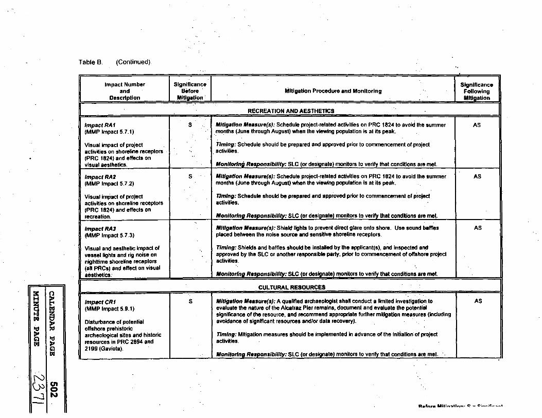
~
~ i
~
I "ti
~
c;lg -JN
Table B. (Continued).
Impact Number and
Description
lmpactRA1 (MMP Impact 5.7.1)
Visual impact of project activities on shoreline receptors (PRC 1824) and effects on visual aesthetics.
lmpactRA2 (MMP Impact 5.7.2)
Visuaf imPact of project actlvHies on shoreline receptors (PRC 1824) and effects on recreation.
lmpactRA3 (MMP Impact 5.7.3)
Visual and aesthetic impact of vessel lights and rig noise on nighttime shoreline receptors (all PRCs) and effect on visual aesthetics.
lmpactCR1 (MMP Impact 5.9.1)
Disturbance of potential offshore prehistoric archeological sites and historic resources in PRC 2894 and 2199 (Gaviota).
Significance Significance Before Mitigation Procedure and Monitoring Following
Mltlaatlon · Mitigation
RECREATION AND AESTHETICS
s Mitigation Measure(s): Schedule project-related activities on PRC 1824 to avoid the summer AS .. months (June through August) when the viewing population is al its peak.
Timing: Schedule should be prepared and approved prior to commencement of project activilies. .. Monltorlnri Resoonslbllfty: SLC tor designate) monitors to verify that conditions are met.
s Mitigation Measure(s): Schedule project-related activities on PRC 1824 to avoid the summer AS months (June through August) when the viewing population is at its peak.
11mlng: Schedule should be prepared and approved prior to commencement of project activHies.
Monitor/no Resoonslbllftv: SLC tor desianalel monitors lo verify that condHions are met. ..
Mitigation Measure(s): Shield lights to prevent direct glare onto shore. Use sound baffles AS placed between the noise source and sensitive shoreline receptors.
Timing: Shields and baffles should be installed by the applicant(s), and inspected all!i approved by the SLC or another responsible party, prior lo commencement of offshore project activities.
Monltorfna Resoonslbllitv: SLC (or desianatel monHors to verify that conditions are met.
CULTURAL RESOURCES
s Mitigation Measure(s): A qualified archaeologist shall conduct a limited investigation to evaluate the nature of the Alcatraz Pier remains, document and evaluate the potentlil
AS
significance of the resource, and recommend appropriate further mHlgatlon measures (Including avoidance of significant resources and/or data recovery).
Timing: Mitigation measures should be implemented in advance of the iniiiation of project activHies.
Monltorlna Resaonslbllity: SLC (or desianate) monitors lo verify that condHions are met. ·.
s:tafnr• Ultln~tl"n• «::' - ~; ...... ;r.,..~ ..... •

~ ~ ~ ~ ~ ~
~ £'(.) (jJ -1 N
(II 0 w
II
Table B (Continued)
Impact Number Significance and Before .
Description Mitigation .
Impact CR2 s (MMP Impact 5.9.2)
Disturbance of potential prehistoric archeological sites al the flowline landfall located on the sandy beach above the high tide line, al the Texaco Gaviola Marine Terminal/ARCO Alegria Production Facility.
lmpactCR3 s (MMP Impact 5.9.3)
Disturbance of potential archeologlcal resources onshore al the Texaco Gaviola Marine Terminal/ARCO Alegria Production Facility (bluff area and quarry location, near Canada Alcatraz).
Significance Mitigation Procedure and Monitoring Following
Mitigation
Mitigation Measure(s): A qualified archaeologist shall monitor all terrestrial surface AS disturbances within archaeological sites and sensitive areas, consistent with relevant Federal, Stale, and local guidelines in case archaeological remains are discovered. Should an emergency discovery of previously unrecorded cultural resources occur during the monitoring phase of work, the archaeologist shall stop operations lo evaluate the resources. If the remains prove significant, Phase 3 data collection, excavations, or other standard archaeological or historic procedures shall be Implemented to mitigate Impacts. Native American monitoring will be conducted for all project-related activities in potentially sensitive areas that could potentially disturb the surface or subsurface of an archaeological site. Monitoring and consultation on impacts and mitigations shall be coordinated among all Interested local Native American groups with monitoring experience. Curate artifacts at a local, qualified facility that provides access to Native Americans. Implement procedures specified In CEQA (Appendix K, Section VII) if human remains are discovered. Security measures shaU be imptemented lo 9ASUl'8 lhal burials ate not vandalized until the decision of burial deposition has been made by the applicant, and most likely, descendants (pursuant to §7050.5, Health and Safety Code and §5097.98, Public Resources Code). Conduct an educational workshop, coordinated by a qualified and approved archaeologist and including potential Native American Monitors, to Inform construction workers of the prohibited activities (e.g., vehicle use in sensitive areas, unauthorized collecting of artifacts) that can result in impacts on c41tural resources. Workers shall not be allowed In the project area during off hours. A qualified local archaeologist, pursuant to relevant County of Santa Barbara Cultural Resource Guidelines, shall be Included In designing the oil spill · response plan (Oil Spill Contingency Plan, OSCP) to ensure that site Impacts can be avoided or minimized during containment or cleanup. The OSCP shall include provisions for contacting a qualified_local archaeologist when an oil spill response Is required.
nmlng: Mitigation measures should be implemented In advance of the Initiation o; project activities.
Monltorlno Resoonslbllltv: SLC (or desianate) monitors lo vea:ify that conditions. are met.
Mitigation Measure(s): A qualified archaeologist shall monitor all terrestrial surface . AS disturbances within archaeological sites and sensitive areas. Monitoring efforts should. be focused on shoreline areas above the high tide line and, due lo the sensitivity of ttie st:ioreline, should include all proposed access routes not presently constructed and In use to access landfall sites. Monitoring shall be consistent with mitigation components noted previously for Impact CR2 (MMP Impact 5.9.2).
nmlng: Mitigation measures should be implemented in advance of the Initiation of project activities. ·
Monltorlna Resaonsfbilitv: SLC tor desianalel monitors to verifv that conditions are met.
n .... r .... ~- ••u1 .... -u .... -. ,.. - f"'I':. ·r
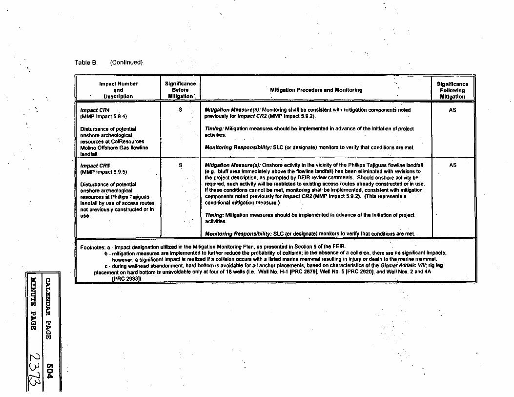
II~ ~
·i ~ t = i ls.I
r'J OJ I en -:--J g us
Table 8. (Continued).
Impact Number and
Description
Significance Befote I Mitigation Procedure and Monitoring
Mitigation ·.
Significance Following Mitigation
lmpactCR4 (MMP Impact 5.9.4)
Disturbance of po_tential onshore archeologlcal resources at Cal~esources Molino Offshore Gas flowline landfall.
lmpactCR5 (MMP Impact 5.9.5)
Disturbance of potential onshore ar.cheolog!cal resources at Phillips Tajiguas landfall by use of access routes not previously constructed or In use.
$ I Mitigation Measure(s): Monitoring shall be consistent with mitigation components noted
s
previously for Impact CR2 (MMP Impact 5.9.2).
Timing: Mitigation measures should be implemented in advance of the initiation of project activities.
Monitoring Responsibility: SLC (or designate) monitors to verify that conditions are met.
Mitigation Measure(s): Onshore activity In the vicinity of the Phillips Tajlguas flowline landfall (e.g., bluff area immediately above the flowline landfall) has been eliminated with reviSions lo the project description, as prompted by DEIR review comments. Should onshore activity be required, such adivity wiU be restrlGted te eiffstlAg aceess routes already constructed or in use. If these conditions cannot be met, monitoring shall be Implemented, consistent with mitigation CO(npOnents noted previously for Impact CR2 (MMP Impact 5.9.2). (This represenisa conditional mitigation measure.) ·
Timing: Mitigation measures should be implemented In advance of the Initiation of project activities.
Monitoring Responsibility: SLC (or designate) monitors to verify that conditions are met.
Footnotes: a - impact designation utilized iri the Mitigation Monitoring Plan, as presented in Section 5 of the FEIR. b - mitigation measures are implemented to further reduce the probability of collision; In the absence of a collision, there are. no significant impacts;
however, a significant impact Is realized if a collision occurs with a listed marine mammal resulting in injury or death to the marine mammal. c - during wellhead abandonment, hard bottom is avoidable for all anchor placements, based on characteristics of the Glomai Adriatic VIII; rig leg
placement on hard bottom is unavoidable only at four of 18 wells (I.e., Well No. H-1 [PRC 2879), Well No. 5 (PRC 2920), and Well Nos. 2 and 4A (PRC 2933)). .
AS
AS

a: ~ H
-~ lllJ
~ lllJ
i 'ti
~ lllJ
I f') (j.J en -.) 0 ~ en
II
·,
Table C. Summary of impacts arising from potential accidents associated with the Subsea Well Abandonment and Flowline AbandonmenURemoval Program and identified mitigation procedures, monitoring requirements, and residual impacts.
Significance Impact Number and Before Mitigation Procedure and Monitoring
Description Mitigation
SYSTEM SAFETY AND RELIABILITY
lmpactSSR1 s Mitigation Measure(s}: Document the precise location and orientation of adjacent pipelines or flowlines (MMP Impact 5.3.1 )8 . relative to the wellheads to be abandoned on PRC 1824 and the flowlines to be removed in PRC 2199
·.(ARCO 2793 flowlines to Gaviota, landfall In PRC 2199). Preparation of and adherence to a site-specific Impact of an anchor anchoring plan. Use precision navigation to place anchors during operations. on adjacent oil
ninlng: Mitigalion measures should be Implemented in advance of the Initiation of project activities. pipelines during either well abandonment or flowline removal Monitoring Responslblllty: SLC (or designate) monitors to verify that conditions are met. operations.
tmpactSSRZ s· Mitigation Measure(s): Preposition oil spm response equipment (i.e., a dedicated offshore ail spill . (MMP Impact 5.3.2') respohse vessel) at the site of operations. Through a site-specific Oil Spill Contingency Plan _(OSCP),
provide adequate containment and cleanup equipment and crews. Hold routine and unannounced oil Potential oil, fuel, or · spill drills to familiarize applicants and operational crews on proper procedures, use of equipment, and hydraulic/glycol spills chain of command. associated with operations. nmtng: Mitig~tion measures should be implemented in advance of the Initiation of program activities.
Monitoring Responslblllty: SLC (or designate) monitors to verify that conditions are met.
MARINE BIOLOGYb
lmpactMB3 s . Mitigation Measure(s}: Preposition oB..spill response equipment (I.e., a dedicated offshore oil spill response vessel) at the site of operations; provide adequate containment and cleanup equipment and
Sea otter mortality via crews throuQh a site-specific OSCP; hold routine and unannounced oil spill drills. loss of lherrnoregulation: nmlng: Mitigation measures should be Implemented in advance of the initiation of projgramactivities.
.. Monitoring Responslblllty: SLC (or designate) monitors to verify that conditions are met.
lmpactMB4 s Mitigation Measure(s}: Same as above.
Lethal and sublethal nmtng: Mitigation measures should be Implemented in advance of the initiation of projgram activities effects on adult and .. pup harbor seals. Monitoring Responslblllty: SLC (or designate) monitors to verify that condiiions are met. . '.
Slgnmcance Following Mitigation
AS
AS
SU
SU
R,.,,,,. 1Affl,..1tt"". ~ - <":,., ... :r,,..""' .... '
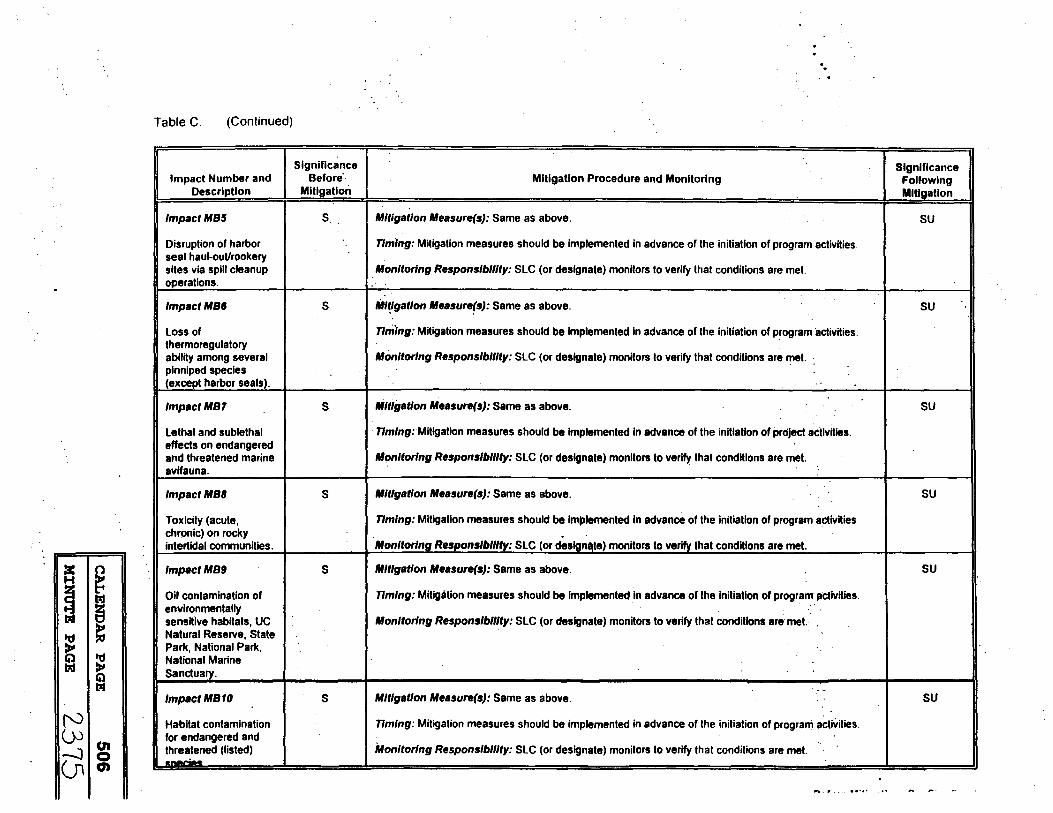
Table C. (Continued).
Significance Impact Number and Before··
Description Mitigation
lmpactMB5 s
Disruption of harbor seal haul-out/rookery sites via spill cleanup operations.
lmpactMB6 s
Loss of thermoregulatory ability among several plnniped species {except harbor seals).
lmpactMBT s
Lethal and sublethal effects on endangered and threatened marine avifauna.
lmpactMBB s
Toxicity (acute, chronic) on rocky intertidal communities.
:c ~ H
~ lsJ
~ llll
t ~ "d l7il )I
Cil
lmpactMB9 s
Oil contamination of environmentally sensitive habitats, UC Natural Reserve, State Park, National Park, National Marine Sanctuary.
lsJ
I lmpactMB10 s (') Habitat contamination
()>I°' -.J 0 (Jl en
for endangered and threatened (listed) .__,..;...
Mitigation Procedure and Monitoring
Mitigation Measure(s}: Same as above.
. .
nmlng: Mitigation measures should be implemented in advance of the initiation of program activities.
Monitoring Responslblllty: SLC (or designate) monitors to verify that conditions are met.
Mi~lgatlon Measure(sJ: Same as above.
nming: Mitigation measures should be implemented in advance of the initiation of program activities.
Monitoring Responslblllty: SLC (or designate) monitors to verify that conditions are met. .
..
Mitigation Measure(s}: Same as above.
nmlng: Mitigation measures should be implemented in advance of the initiation of project activities.
Monitoring Responsibility: SLC (or designate) monitors to verity that conditions are met.
Mitigation Measure(s}: Same as above.
nmlng: Mitigation measures should be Implemented In advance of the initiation of program activities.
Monitoring Responsibility: SLC (or deslanate) monitors to verify that conditions are met.
Mitigation Measure(s}: Same as above.
nmlng: Mitigation measures should be implemented in advance of the initiation of program 11ctivlties. ..
Monitoring Responslblllty: SLC (or designate) monitors to verify that conditions are mel.· · .
. -Mitigation Measure(s}: Same as above.
nmlng: Mitigation measures should be implemented in advance of the initiation of prograni activities.
Monitoring Responsibility: SLC (or designate) monitors to verify that conditions are met.
Significance Following Mitigation
SU
SU
SU
SU
SU
SU
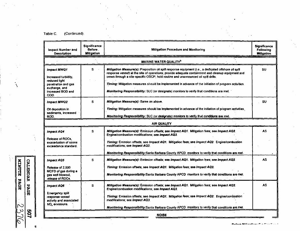
Table C. (Continued).
Significance Significance Impact Number and Before. Mitigation Procedure and Monitoring Following
Description Mitigation Mitigation
MARINE WATER QUALITYb
lmpactMWQ1 s Mitigation Measure(s}: Preposition oil spill response equipment (i.e., a dedicated offshore oil spill SU
Increased turbidity, · response vessel) at the site of operations; provide adequate containment and cleanup equl~ment and crews through a site-specific OSCP; hold routine and unannounced oil spi!I drills.
reduced light penetration and gas :T!mlng: Mitigation measures should be implemented in advance of the initiation of program activities. exchange, and increased BOD and Monitoring Responsibility: SLC (or designate) monitors to verify that conditions are met. · COD.
lmpactMWQ2 s Mitigation Measure(s}: Same as above. SU
Oit deposition in nmln.g: Mitigation measures should be Implemented in advance of the initiation of program ·a.ctivities .. sediments, increased BOD. Monitoring Responslbllltv: SLC (or deslanate) monitors to verify that conditions are met.
AIR QUALITY
lmpactAQ4 s Mitigation Measure(s}: Emission offsets; see Impact AQ1. Mitigation fees; see Impact AQ2. AS El)gine/combustion modifications; see Impact AQ3.
Release of ROCs, exacerbation of ozone nmlng: Emission offsets; see Impact AQ1. Mitigation fees; see Impact AQ2. Engine/combustion exceedance standard. modifications; see Impact AQJ.
Monitoring Resoonslblllty:Sanla Barbara Counlv APCD monitors lo verify that conditions are met. . a:
~ H
~ lzJ
lzJ ! t 'ti lzJ >'
Q lzJ
I f'0 .
lmpactAQ5 s Mitigation Measure(s}: Emission offsets; see Impact AQ1. Mitigation fees; see lmp11ct AQ2. AS '
Release of 2,000 nmlng: Emission offsets; see Impact AQ1. Mitigation fees; see Impact AQ2. MCFD of gas during a
..
gas well blowout, Monitoring Responslblllty:Sanla Barbara County APCD monitors to verify lhal coriditions are met. release of ROCs.
lmpactAQ6 · s Mitigation Measure(s}: Emission offsets; see Impact AQ1. Mitigation fees; see Impact AQ2. AS Engine/combustion modifications; see Impact AQJ.
Emergency spill ninlng: Emission offsets; see Impact AQ1. Mitigation fees; see Impact AQ2: Engine/combustion response vessel
activity and associated modifications; see Impact AQJ. · · NO. emissions.
Monltorlna Resoonslbllltv:Sanla Barbara County APCD monitors lo verify that conditions are .met. (II 0 .... NOISE
= """'t'\•f' ••r•t rot"" ......... r- - r-'. .. ~ .,.
II

~ ~ a B ~ = ~
r0 (.}) -J -J
~ (JI c 00
Table C. (Continued).
Significance. Impact Number and Before
Description Mitigation
lmpactN1 s
Noise associated with cleanup operations.
I Impact TC3 s
Cleanup operations (shoreline between Pt. Conception and Gaviola) using narrow, reslricled roads on the Bixby Cojo Ranch and Hollister Ranch.
Significance Mitigation Procedure and Monitoring Following
-· Mitigation ..
Mitigation Measure(s): Use of noise attenuation barriers and noise mufflers on boats and heavy SU equipment could reduce noise levels associated with lhe clean-up of a spill. ·
· .nmlng: Applicants should evaluate feasibility of such measures prior to commencement of. operations. Where deemed feasible, installation of barriers and mufflers should occur prior to commencement of
· operations. : "M.onltorlna Responslbllltv: SLC (or designate) monitors lo verify Iha! conditions are mel.
TRANSPORTATION/CIRCULA TIONb I . Mitigation Measure(s): Preposition oil spill response equipment (i.e., a dedicated offshore oil spill AS
response vessel) al lhe site of operations; provide adequate containment and cleanup equipment and crews through a site-specific OSCP; hold routine and unannounced oil spill drills; OSCP identifl~tlon and coordination with appropriate ranch personnel, as well as coordination wilh local and Slate agencies.
·1Jmlng: Mitigation measures should be implemented in advance of the initiation of program activities.
Monitoring Responsibility: SLC (or designate) monitors lo verify lhal cenditlons are mel.
"-•- ..... t•:•:~ ... •f- -·.""
~ ~ ~ E lzJ ~
~ i N (_)-j I c.n -.J 0 en co
II
Table C (Conltnued)
Impact Number and Description
lmpactRA4
Fouling of scenic shorelines, closure of public beach from a spill and subsequent cleanup.
lmpactRA5
Reduced access to park and beach areas from an oil spill, loss of tourism revenues.
Impact RAil
Fouling of scenic shorelines and ocean surface within scenic viewsheds.
lmpactCRF1
Coating of catch (lowering commercial value) and set gear (diminished catch efficiency).
Impact CRF2 .
Loss of available fishing grounds due to oil contamination and/or cleanup operations.
Significance Significance Before Mitigation Procedure and Monitoring Following
Mitigation .. Mitigation
RECREATION AND AESTHETICSb
s Mitigation Measure(s): Preposition oil spill response equipment (i.e., a dedicated offshore oil spill SU response vessel) at the site of operations; provide adequate containment and cleanup equipment and crews through a site-specific OSCP; hold routine and unannounced oil spill drills.
· nmlng: Mitigation measures should be implemented in advance of the initiation of program activities.
Monitor/no Resaonslbllltv: SLC (or deslanate) monitors to verify that conditions are met.
s Mlt~gatlon Measure(s): Same as above. SU
-. nmlng: Mitigation measures should be implemented in advance of the initiation of program activities.
ftfonltorln(I Responsibility: SLC (or designate) monitors to verify that conditions are met.
s Mitigation Measure(s): Same as above. SU
Timing: Mitigation measures should be Implemented In advance of the initiation of program activities.
Moflltorlng Responsibility: SLC (or designate) monitors to verify that conditions are met.
COMMERCIAL AND RECREATIONAL FISHERIESb
s Mitigation Measure(s): Preposition oil spill response equipment (i.e., a dedicated offshore oil spill SU response vessel) at the site of operations; provide adequate containment and cleanup equipment and crews through a site-specific OSCP; hold routine and unannounced oil spill drills.
nmlng: Mitigation measures should be Implemented· in advance of the initiation of program activities.
Monitor/no Resaonslbliltv: SLC (or deslanate) monitors to verify that conditions are met. ..
s Mitigation Measure(s): Same as above. SU
nmlng: Mitigation measures should be implemented in advance of the initiation of program activities.
Monitoring Responsibility: SLC (or designate) monitors to verify that conditions are met.
Q,,_f,..rA ••tff"...,tl .... -· ~ .... ~·-· .,.
'.
·~ ~ a ~ td. ~
~
rv ~ -.)
~
i en ~
0
-
Table C. (Continued).
Significance . Significance Impact Number and Before Mitigation Procedure and Monitoring Foll owing
Description Mitigation Mitigation
CULTURAL RESOURCESb
lmpactCR6 s . Mltlgat(on Measure(s}: Preposition oil spill response equipment (i.e., a dedicated offshore 011 spill AS response vessel) at the site of operations; provide adequate containment and cleanup equipment and
Damage or destruction crews.through a site-specific OSCP; hold routine and unannounced oil spill drills; site avoidance of unidentified cultural · whenever possible. resources or nearby archaeological nmlng: Mitigation "'!easures should be implemented in advance of the initiation of program activities. resources.
· Monitoring Responsibility: SLC (or destQnate) monitors to verify that conditions are met. ..
Impact CRT s Mitigation Measure(s}: Same as above. AS
Masking of ·~:Mitigation measures should be Implemented in advance of the initiation of program activities. unidentified. cultural
. . .
resources. Monltorlng'Responslbl/lty: SLC (or designate) monitors to verify that conditions are met.
Footnotes: a - impact designation utilized in !h~ Mitigation Monitoring Plan, as presented in Section 5 of the FEIR. b - operations to be conducted with diligent concern for worker safety and protection of the environment. In the event of an accldental release, project
operations (i.e., prepositioning of oil spill response equipment; use of a dedicated offshore oil spill response v~ssel at the site of operations) and the existence and implementation of an approved oil spill contingency plan should serve to reduce the level of impact on sensitive. resources. The effectiveness of such mitigation measures is dependant upon several factors, including type of product spilled, wind and oceanographic conditions al the time of the spill, resoonse time, and containment and cleanup equipment effectiveness.
Before Mitl11aUon: S • SiQnificant

EXHIBITF
STATEMENT OF OVERRIDING CONSIDERATIONS
The State Lands Commissioh. ~dopts this Statement of Overriding Considerations with respect to po~eiltially unavoidable impacts identified in the Final EIR (EIR) that cannot be reduced, with available mitigation, to a level of insignific~ce. The proposed Program, and its individual . · : projects," would not result in significa.11t impacts under 'normal operations~. As shown. in·:system Safety.and Reliability, Table A, however, there are potentially significant impacts associated with possible accidents/upsets that cannot be fully mitigated to a level of insignificance.
Although the possibility of such accidents/upsets is very low, each could result in the release of petroleum products into the open ocean. Such spills would result in significant impacts to marine mammals, marine birds, sensitive shoreline habitats and unique marine environments.
The State Lands Commission finds that all practical preventative measures have been incorporated into each of the projects within this Program to reduce the probability of occurrence of such accidental spills. The projects also include all feasible mitigation measures which would facilitate containment and clean up of such spills if they occur.
The State Lands Commission further finds that not proceeding .with the Program poses an even greater risk to these same environments. If the sub-sea wellheads and associated flowlines are left in place, they will eventually corrode and fail, a circumstance that will also release oil and gas into the ocean; The only way to prevent such failure is to remove all of the equipment and seal the wells.
Based on the above and the information contained in the EIR, the State .Lands Commission finds that the benefits of the proposed Program outweigh the unavoidable potentially adverse effects, and considers the risks of potential accidents/upsets and their impacts acceptable.
CALENDAR PAGE 511
.·
M:CNT,JTE PAGE 2.3 00