rpt of work jim lake showing · 42fmne0001 2.16234 loken lake 010 noranda mining and exploration...
TRANSCRIPT

42FMNE0001 2.16234 LOKEN LAKE 010
NORANDA MINING AND EXPLORATION INC.
REPORT OF WORK -1994-85
JIM LAKE SHOWING
N.T.S. 42F/4
WEST PRECAMBRIAN DISTRICT
PROJECT NO. 366 THUNDER BAY. ONTARIO AUGUST 1995
MICHAEL MACISAAC PROJECT GEOLOGIST
16234
S .

l42F04NE0001 2 16234 LOKEN LAKE
Table of01OC
Page
1.0 INTRODUCTION ..............................................................................................................1
2.0 LOCATION AND ACCESS......................................................................................................... 1
3.0 PROPERTY DESCRIPTION AND GRID..................................................................................... 1
4.0 PREVIOUS WORK .............................................................................................................. 1
5.0 PERSONNEL ..............................................................................................................1
6.0 GEOLOGY ..............................................................................................................2
6.1 REGIONAL GEOLOGY..................................................................................................2
6.2 PROPERTY GEOLOGY................................................................................................^
7.0 DIAMOND DRILL PROGRAM..................................................................................................... 2
8.0 GEOPHYSICS ..............................................................................................................3
8.1 INSTRUMENTATION AND THEORY.............................................................................3
8.2 INTERPRETATION.......................................................................................................^
9.0 CONCLUSIONS AND RECOMMENDATIONS............................................................................ 5
STATEMENT OF EXPENDITURES
REFERENCES
Figure 1
Figure 2
Figured
Figure 4
Table l Table II
List of Attachments
Location Map
Claim l Trench Map - Jim Lake Area
Regional Geology
Property Geology and Compilation
List of Tables
Jim Lake Claims1994 HLEM. MAG and DEEPEM Survey Areas
Scale
1:300,000
(approx.) 1:80,000
(approx.) 1:100.000
(approx.) 1:20000
16
Map1
Map 2
Map 3
Map 4
Maps
Map 6
List of Maps (Back Pocket)
HLEM Survey - 440 Hz. - Jim Lake Grid
HLEM Survey -1760 Hz. - Jim Lake Grid
DEEPEM X Component - Jim lake Grid
DEEPEM Z Component - Jim Lake Grid
MAG SURVEY (posted data and profiles) - Jim Lake Grid
MAG SURVEY (contours) - Jim Lake Grid
Scale
1:5000
1:5000
1;5000
1:5000
1:5000
1:5000
i

List of Appendices
Appendix l Drill Logs
Appendix II Drill Cross Sections

1.0 INTRODUCTION
This report summarizes the exploration program conducted on the Jim Lake claim group in the Manitouwadge area in Northwestern Ontario during 1994 and 1995. This work consisted of linecutting. geophysical surveys (ground HLEM. deepem and mag surveys), diamond drilling and regional and detailed geological mapping. The objective of this exploration program was to evaluate a small area of previously untested AEM. conductors which occur along the projected trend of the favourable mine stratigraphy along the north limb of the Geco synform. The initial work resulted in the discovery of the Jim Lake base metal occurrence and the subsequent detailed program to evaluate the extent and potential of the mineralization.
Linecutting was completed during Jury 17-30,1994. The DEEPEM, MAG and HLEM were done from August 10-25 of 1994. Drilling was performed in the period from March 12-22.1995.
2.0 LOCATION AND ACCESS
The proppety is located approximately 27 km notheast of Manitouwadge (figure 1). Access is gained via logging roads which transect the western portion of the property. Access to the eastern portion of the property can be gained by an old drill road which is only passable by foot or by sU-doo in the winter.
3.0 PROPERTY DESCRIPTION AND GRID
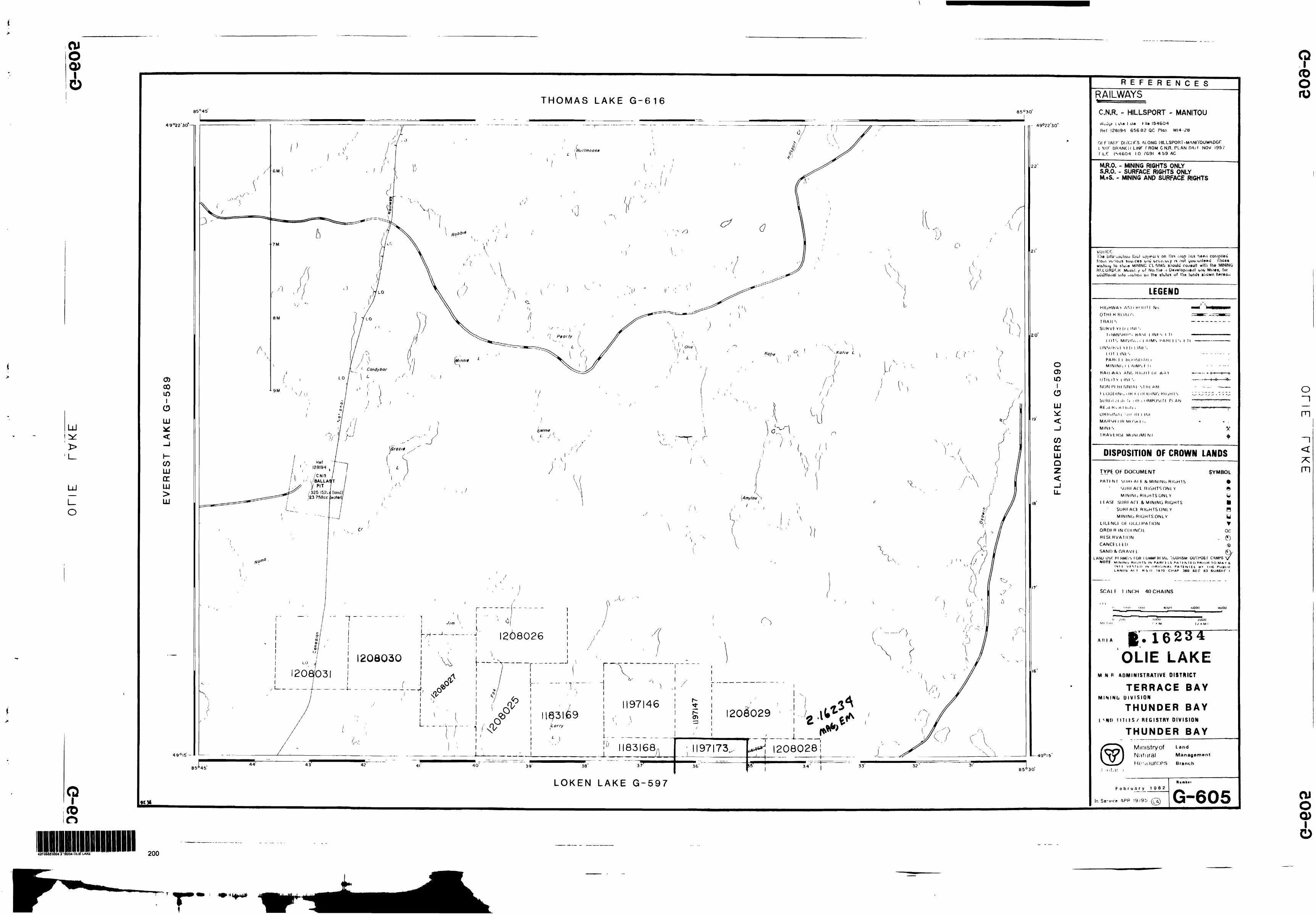
The Jim Lake property (fig. 2) encompasses 15 unpatented and contigous mining claims (148 units) totalling 2336 hectares. These claims are located within Olie Lake and Loken Lake area in the ThunderBay Mining District Table 1 below lists the claims and their recording dates.
Table 1: Jim Lake Claims
Claim NumbersTB 1.145.129TB 1,183.168TB 1.197.147TB 1,208.029TB 1.209.499
Recorded11/18/9310/13/9412/12/9404/10/9508/10/94
Claim NumbersTB 1.145.130TB 1.183.169TB 1,197.173TB 1.208.089FB 1.209.500
Recorded11/18/9310/13/9412/12/9304/10/9408/10/94
Claim NumbersFB 1.183.167FB 1.197.146TB 1,208,028TB 1.208.090TB 1.209.501
Recorded10/13/9412/12/9304/10/9504/1079508/10/94
The property is wholly owned by Noranda Mining and Exploration Inc.
One grid was cut. the Jim Lake Grid(fig.5) covering two separate anomalies. A total of 18.05 kms of line was cut on the Jim Lake Grid.
4.0
results.
PREVIOUS WORK
1983: Prospecting and mapping of favourable stratigraphy with subsequent drilling. No significant
1989: Geco Airborne covering Manitouwadge area including Jim Lake claim block.

LAKE
SUPE
RIO
R

••••
••••
••••
••••
t
//-/
57
30
••••
••••
••••
••••
••••
•••t
JIM
SH
OW
ING
TR
ENC
H
LOCA
TIO
N
SKET
CH
5.0 PERSONNEL ~
Linecutting was conducted by Vytyl Exploration Services. HLEM. Mag and DEEPEM was done by John Maclsaac, Doug Hancock and Dave Maclean all of whom were employed by Noranda Mining 6 Exploration Inc. at the time the survey was conducted.
Drilling was conducted by Northwest Geophysics out of ThunderBay and was supervised by Michael Maclsaac also of Noranda Mining ft Exploration Inc. in ThunderBay.
6.0 GEOLOGY
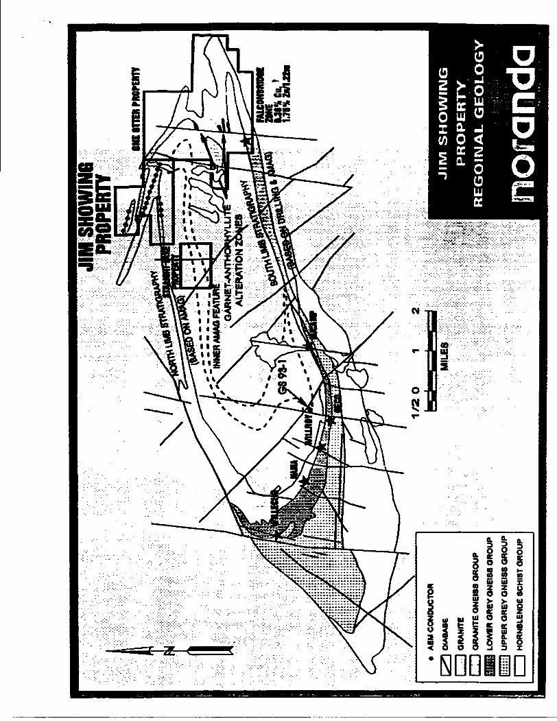
6.1 REGIONAL GEOLOGY (Figure 3)
The Jim Lake Property lies within the Manitouwadge Greenstone Ben of the Wawa subprovince. Regional metamorphism is of the upper amphibolite facies and the degree of deformation is high. The be* itself is a synformal structure in the form of a basin with the fold axis bending approximately east-west and plunging to the east. Geology of the area is made up of folded metagreywackes with metavolcanics intruded and bound by tonalite and granitic bathoTiths. Economic mineralization appears to be resticted to the metavolcanics (ie. sericite schist) and related overlying iron formation horizons.
6.2 PROPERTY GEOLOGY(Figure 4)
The Jim Lake property is underlain by roughly east-west trending metavolcanics with dips predominently to the south in the order of 65-70 degrees. These volcanics are made up of metamorphosed mafic and felsic volcanics with interbedded iron formation. The volcanics are bound to the north and south by granitic intrusions causing a high grade of metamorphism. Mineralization consists of stringer to semi- massive pyrite-pyrmoute within hydrothermally altered rocks. Minor amounts of base metal mineralization was observed in drill core.
7.0 DIAMOND DRILL PORGRAM(figure 4)
A two hole 386m drill program was carried out during march of 1995. Drilling was completed by Northwest Geophysics Ltd. of ThunderBay using a JKS Boyles 300 drill which extracted BDBQM sized(thinwall BQ) core.
Drill hole locations have been provided on fig.4. The stratigraphy encountered in each hole is detailed on drill sections (Appendix 10 and in drill logs (Appendix O- A brief summary of each hole is given below.
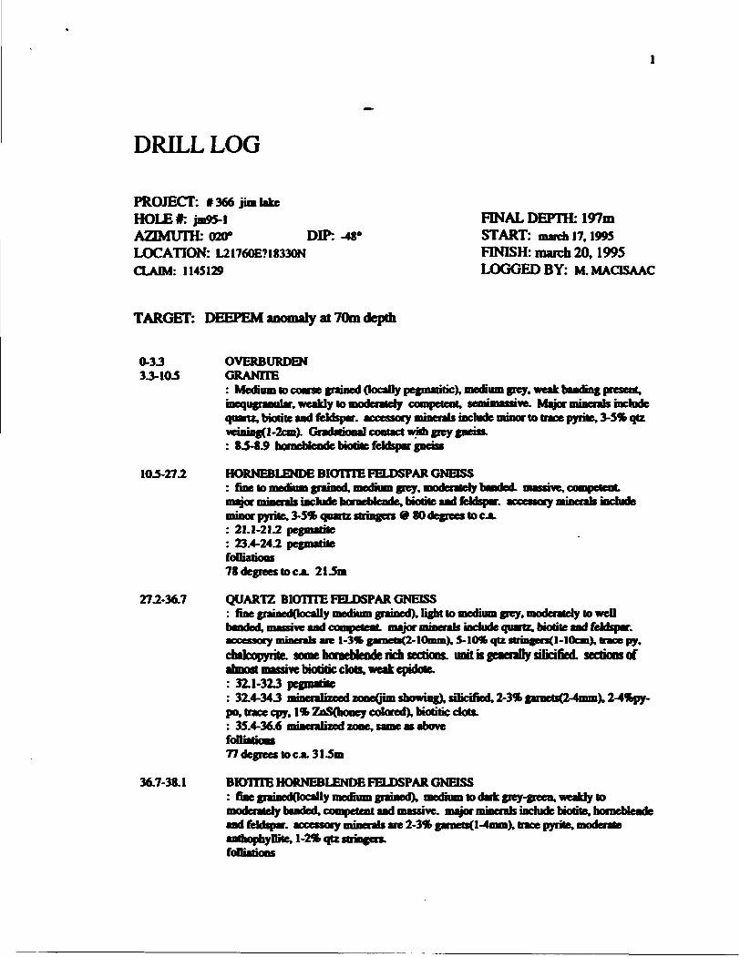
Hole JS95-1
Hole JS-95-1 was drilled in the central portion of the of the claim block. Its purpose was to explain an untested HLEM and DEEPEM conductor with associated Cu. Zn mineralization. The hole was collared at 21775E/18335N with as azimuth of 20 degrees and a dip of -48 degrees. This hole was drilled to a depth of 197m.
The hole intersected two zones of mineralization with the first consisting of 42 meters of 2- 4(X)pyrne-pyrrtiotite. trace chalcopyrite and upto 11fc sphalerite. This zone was hosted in a Quartz Feldspar Biotite Gneiss with 2-3** garnets. Assays returned values upto Q.58% Zn over 1.1m. A second mineralized zone was intersected from 127.9-134m consisting mainly of 1-20* pyrite-pynhotite. trace chalcopyrite and
JIM
SHO
WIN
G PR
OPER
TYON
E IT
IBl P
ROPE
RTY
INN
ER A
MAQ
PEA
GA
RN
ET
-AN
TH
OH
HY
LL
I A
LT
ER
AT
ION
MLC
Orn
MO
OE
ZONE
f
MB
* ah
JOB
AE
M C
ON
DU
CTO
R
DIA
BA
SE
GR
AN
ITE
GR
AN
ITE
GN
EIS
S G
RO
UP
LOW
BR
GR
EY
GN
EIS
S G
RO
UP
- U
PP
ER
GR
EY
GN
EIS
S G
RO
UP
l j
HO
RN
BLE
ND
E S
CH
IST
GR
OU
P
JIM
S
HO
WIN
G
PR
OP
ER
TY
RE
GO
INA
L G
EO
LO
GY
:;''::
. i r
. -.
;:
nora
rida

SHOW
ING
#1
, 0.5
%Cu
SHOW
ING f 2
7.0%
Zn, 0
.6e7o
Cu
Gra
nit
e
Bio
tite
- H
orn
ble
nd
e G
neis
s B
lotlt
lc Q
uar
tzit
e * s
ll'd
Bio
Gne
iss
Iron
For
mat
ion
(Pro
ject
ed)
A.E
.M C
on
du
cto
r
H.L
.E.M
. Co
nd
uct
or
~ -
Faul
t

life magnetite. Strong VMS style alteration is present both footwall and hanging wall with the host rock consisting of a Quartz Feldspar Biotite Gneiss. No significant assays were returned from the lower zone.
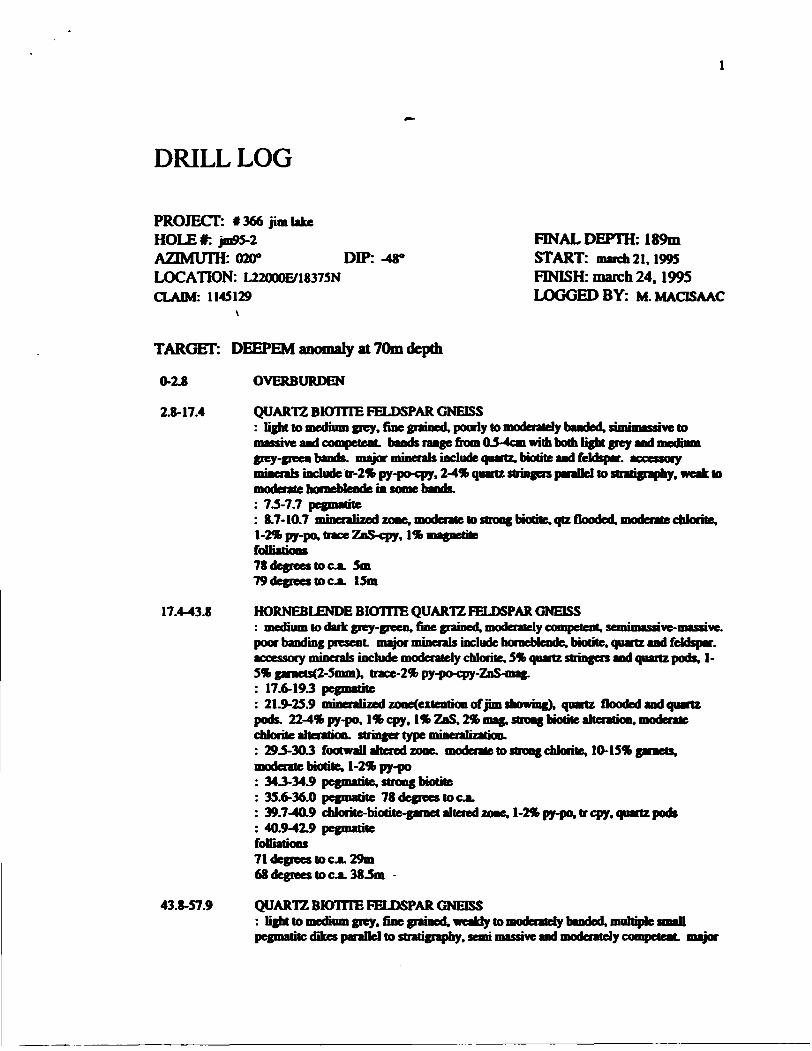
JS95-2
Hole JS-95-2 was also drilled in the central portion of the claim block. Its purpose was to evaluate an untested HLEM and DEEPEM conductor. The hole was collared at 22000E/18375N with as azimuth of 20 degrees and a dip of-48 degrees. This hole was drilled to a depth of 189m.
Mineralization was encountered from 110.9-115.9 consisting of semi-massive sulfides including ID- 25% py-po, trace sphalerite and pods of graphite. This unit is also highly silidous with pods of chlorite. Moderate VMS style alteration is present footwall to the mineralization consisting of chlorite and garnet with stringer mineralization(5-7*py-po) along with intense silicification. No significant assays were returned.
9.9 Geophysics
In 1994 geophysical (HLEM. MAG and DEEPEM) surveys were conducted on the Jim Lake grid area to follow up previously defined airborne anomaly trends. The HLEM survey consisted of two frequencies (440 and 1760 Hz.) with a 200m coil separation. The primary goal of this survey was to generate favourable drill targets. Coverage is summarised in Table II. Data are plotted on Maps 1-5.
Table 2.1994 HLEM. MAG and DEEPEM
Grid
Jim Lake Grid
HLEM Survey (km)
18.05
MAG
18.05
DEEPEM
4.3
8.1 Instrumentation
An Apex Parametrics MaxMin l horizontal loop electromagnetic unit was used. In-phase and quadrature readings are measured as a percentage of the primary transmitted field. The readings represent characteristics of the secondary induced field. They are recorded at a phase separation of 90 degrees to provide maximum information. The readings are normalised to the primary field using a cable which connects the transmitter to the receiver. Readings can be read to +I- 0.2 percent although they are usually only accurate to +A1 percent For this survey readings were taken at a 25 meter interval along the cut Hne. a coil separation of 150 meters was used and readings were recorded at frequencies of 1760 and 440 hertz.
A Scintrex IGS proton procession magnetometer system was used. Total magnetic field readings are taken with a precision of 0.2nT of Gammas, although the accuracy is generally +A 5nT. Readings are corrected for diurnal variations using an identical recording unit set up as a base station in a non anomolous area. Base station readings are taken every 30 seconds unless large or rapid variations are anticipated, at which point readings are taken more frequently.For this survey, base staion readings were taken every 30 seconds. Survey readings were recorded at 12.5m intervals along the line.
THE LARGE LOOP PROFILING PULSE ELECTROMAGNET1C(DEEPEM) SURVEY TECHNIQUE: Theory:
Current flowing through a continous wire loop will generate an electromagnetic field that is commonly referred to as the primary field. This field will generate current flow in conductive material within the area of influence of that loop. The currents flowing in the conductive material will generate their own electromagnetic fields and these are commonly referred to as the secondary fields. The secondary fields can be used to provide information about the location, size, conductivity and orientation of the conductive material.
Using the pulse or time domain etectromagnetic(PEM OR IDEM) survey technique secondary fields are measured in the absence of primary fields. This is accomplished by shutting off the primary field at regular intervals( typically measured is milliseconds). The secondary field strength is then measured with a

receiving coil at selected times( typically measured in microseconds) after the primary is shut off. The decay rate and initial amplitude of the primary-field provide information about the quality and proximity (conductivity and depth) of the conductor. To establish location, size and orientation of the conductor orthogonal components of the secondary field can be measuredfx, y and z), and the secondary field can be measured at different spatial tocations( station locations along a given grid line, and on different grid lines).
Instrumentation:A crone datalogger 8 channel PBM receiver was used with a chrone 2000 watt PEM transmitter and
a Honda 2 KW motor generator. The vertical or Z component in plane perpendicular or X components of the secondary field were measured using the standard chrone receiving coil.
The transmitter has a peak output current of 20 amps, but smaller currents are generally used. Two current on times(10.8 and 21.6ms). and 3 current shut off ramps(0.5.1 and 1.5 msec) are available.
The Receiver has the following channel specifications listed in tables l and i
table): 10.87ms Time Base
CHANNEL MIDPOINT(microseconds) WIDTH(microseconds) GAINPP -50 100 11 150 100 12 300 200 1.393 550 300 1.034 900 400 2.685 1450 700 3.736 2400 1200 5.187 4000 2000 128 6400 2800 10
table ii: 21,6ms Time Base
CHANNEL MIDPOINT(microseconds) WIDTH(microseconds) GAINPP -100 200 11 300 200 12 600 400 1.393 1100 600 1.934 1800 800 2.685 2900 1400 3.736 4800 2400 5.187 8000 4000 128 12800 5600 10
The standard receiver coil(antenna) consists of a ferrite copper wire coil with a preamplifier that provides 20db of amplification.
Synchronization between the tranmitter and receiver occurs via radio or cable fink, in this case aH synchronization occurred through radio link. Sensitivity is adjusted using a ten turn potentiometer mounted on the face of the instrument Our usual survey procedures employ a constant gain setting of 800.a31.6msec time base and a 1 msec shut off ramp. The actual values used are recorded on the final plots.
Conventions and Assumptions
1) The primary field inside the loop is positive, outside the loop is negative.2) There is no secondary influence on the primary field.

8.2 INTERPRETAION
An HLEM conductor trend was delineated along entire length of the survey area ranging from 18300N on line 21000E to 18625N on line 22800E (fig. 3). The strongest response is interpreted to be located @ 21300E/18325N. The Data indicated several weak responses in the center of the grid thus leading us to believe that there is a down dip entent to these previously defined anomalies. Deepem was subsequently used to help determine the depth extent of these anomalies. It was demonstrated that these anomalies do increase with depth in conparing the anomaly on line 22000E/18500N with that of the HLEM response in the same location. These anomalies were found to have a correlating mag high response.
9.0 CONCLUSIONS AND RECOMMENDATIONS
Geophysics and drilling demonstrated the presence of mineralization with VMS style alteration. Even though only small amounts of base metal mineralization was encountered in drilling, the area stB holds excellent opportunities for the discovery of new showings. Untested AEM anomalies stB exist as we! as the presence of VMS style alteration in both boulder trains and hi outcrop. These units should be followed up. The Jim Lake Grid should be extended both to the east and west of the current showings. A re- evaluation of the areas AEM anomalies should be done to determine how thouroughly these conductors have been evaluated. Finally more prospecting should be done in discovering new showings similar of that of the Jim Showing in which the spalerite is almost entirely on its own thus giving X a very subtle response if one at all.
Respectfully submitted.
NORANDA MINING AND EXPLORATION INC.
Michael MaclsaacThunder Bay. Ontario Project Geologist August 28.1995 West Precambrian District

STATEMENT OF EXPENDITURES (SEPTEMBER-1994 to APRIL 1995)
DRILLING
Meters(386m) 28465.00
Labour (10 days @ 350/day) 3500.00
Supplies 325.52
Food and Lodging 700.00
SUBTOTAL S 32.990.52
GEOPHYSICS
Labour(3 men@250Vday over 10 days(30 man days) 7500.00
ContractorsflJnecutting Q 5325/km) 5820.00
Food and Lodging(2 men/14 days/ISOSper day) 2100.00
Supplies 213.32
SUB-TOTAL S 15.633.32
GRAND TOTAL S48.623.84

REFERENCES
Zeleski. E.. Peterson. V.L.. Lockwood. H., van Breemen. O.. 1995Geology. Structure and Age Relationships of the Manitouwadge Greenstone Belt and the Wawa-QueticoSubprovince Boundary. Northwestern Ontario.

APPENDIX l
DRILL LOGS
DRILL LOG
PROJECT: f 366 jim lakeHOLE*: jm95-lAZIMUTH: 020* DIP: -48*LOCATION: L21760E718330NCLAIM: 1145129
FINAL DEPTH: 197m START: match 17,1995 FINISH: march 20,1995 LOGGED B Y: M.MACISAAC
TARGET: : anomaly at 70m depth
0-3.3 3J-10.S
10.5-27.2
27.2-36.7
36.7-38.1
OVERBURDENGRANITE: Medium to coarse grained (tocaDy pegmatitic), medium grey, weak banding present.inequgnnular. weakly to moderately competent, semimassive. Major minerals includequartz, biotite and feldspar, accessory minerals include minor to trace pyrite, 3-5* qtzveining(l-2cm). Gndatkwal contact win grey gneiss.: 83-8.9 bornebJcnde biome feldspar gneiss
HORNEBLENDE BIOTITE FELDSPAR GNEISS: fine lo medium grained, medium grey, moderately handed massive, competent.
jyor minerals include homeMende, biotite and feldspar, accessory minenis includeminor pyrite. S-5% : 21.1-21.2
rtz stringers 0 80 degrees to ea.
: 23.4-24.2 pegmatitefoDiations78 degrees lo c JL 21.5m
QUARTZ BIOTITE FELDSPAR GNEISS: fine grainedQocally medium grained), light to medium grey, moderately to well banded, massive and competent, major minerals include quartz, biotite and feldspar. accessory minerals are t-3% gamets(2-lOmmX S-10*. qtz strin(en(l-10cm). trace py.chalcopyrite, some horaebfende rich sections, unit is generally silicified, sections ofalmost massive biotitic clots, weak epidote.: 32.1-32J pegmatite: 3X4-343 mmenlnetd zoneQim showing), silicified. 2-3% garaets(2-4mmX 2-4%py-po. trace cpy. Ilk ZoS(oooey colored), biotitic clots.: 35.4-36.6 mineralized zone, same as abovefoOii77 degrees lo c JL 31 -5m
BKHTTE HORNEBLENDE FELDSPAR GNEISS: fine grained(locally medium grained), medium to dark grey-green. weaUy tomoderately banded, competent and massive, major minerals include biotite, borneMendeand feldspar, accessory minerals are 2-3*b gatnets(l-4mmX trace pyrite, moderateanthophyllite, 1-24& qtz stringers.foOiadons

75 degrees to c A 373m ^
38.1-47.1
47.1-SS.8
33.8-824
82.2-101.4
101.4-110.7
110.7-1275
BIOTITE ANTHOPHYLLITE-GARNET GNEISS: medium to dark green, fine grained(locally medium grained), well foUialed, weakbanding and competent major minerals are biotite, anthophyllite, chlorite, quartz andfeldspar, accessory minerals include 2-5* quartz veins(l-3cm) 9 73 degrees to CA.trace py. 5-7* chlorite porphyroblasts(2-5mm). 5-7* gamets(4-6mm). minor epidotealong fractures.foOiatkms79 degrees lo c .a. 40.4m76 degrees ot cJL 43.0m banding
QUARTZ BfOTTTE FELDSPAR GNEISS: light grey, fine gnunedOocaDyinediumgnunedX moderately to weO banded.and competent major minerals include quartz, biotite awl feldspar.are 1-2* gamets(2-3mm), minor cpy, trace py. several chloritk bands(l-2cm), muhiplepegmatitic dikes(2-3cm) parallel to stratigraphy.foiliations73 degrees to ea. 73m
BfOTTTE HORNEBLENDE FELDSPAR GNEISS: fine grained (locally medium grained), dark green, no banding, massive and
clude brodie, homcWcodc and feldspar, accessoryminerals are weak chlorite along fractures, small sections of moderately anthophyllile in matrix, trace py, cpy, partial migmatization with many small pegmatitic dikes(2-10cm) throughout unit
60.1-60.4 pegmatiteitazed gneiss
silicified, strong biotite, l* py^pygranitized gneiss
63.7-663 quartz biotitic zou 67.7-68.073.8-743 pegmatite73.0-733 pegmatite
foOiations70 degrees to c*. 79mQUARTZ BIOTITE HORNEBLENDE GNEISS: light to medium grey-green, fine grainedOocally medium grained), moderately banded- foDiated. weakly competent to moderately competent major minerals include quartz, biotite. horneUende and feldspar, accessory minerals include hematite, trace py.cpy. weak epidote and chlorite along fractures, bom light grey A medium grey-green bands
: 90.0-90.6 broken, ground core: 91.8-92.7 broken, ground core: 993-993 pegmatite: 100. l-100.6 pegmatitefoUiations69 degrees to ea. 87.9m
HORNEBLENDE FELDSPAR GNEISS i fine to medhnn grained, dark green. ivei no
gabbroic in nature, major minerab are nornebfende and feldspar, accessory minerab are trace py, moderate epidole both in groundmass and along fractures.
QUARTZ BKHTTE FELDSPAR GNEISStntf grameH(lnony m^Biim grMnui) light tn mattinm gp-y ymiiffayTJvg ^rnnpj^^
and weakry banded, muhiple 10cm wide pegmatitk dikes, major minerals include

127.9-134.0
134.0-197.0
biotite, quartz and feldspar, accessory minerals are tr-1% py(diss). weak epidote alongfractures. 2-3"fc qtz stringers parallel to stratigraphy.: 110.7-115.0 granitized quartz biotite feldspar gneissfolliations78 degrees to c.a. 123.8m
MINERALIZED QUARTZ BIOTITE FELDSPAR GNEISS: light to medium grey, fine grainedQocally medium grained), moderately banded-foUiated. strongly altered, semimassive to massive, competent major minerals includequartz, chlorite, lS-23% garnets, biotite and feldspar, accessory minerals include 1-20* py-po. tr-1% cpy. Ir ZnS. 1ft magnetite, weak anthophyllite and epidote, some quartzflooding.: 127.9-129.05 lS-20% py-po. tr-1% ZnS.tr cpy. quartz flooded, small Sem slug ofmassive sulfide.: 131.0-133 J S-7% py-po. tr ZnS. tr cpy. banded, silicified.foOia66 degrees to COL 132m
GRANITE: coarse grained, light grey, moderately fractured, pegmatitic sections, weakly to moderately competent major minerals include quartz, biotite and feldspar with accessory epidote, trace py.
197.0 end of hole
DRILL LOG
PROJECT: * 366 jim lakeHOLE*: jm95-2AZIMUTH: 020" DIP: -WLOCATION: L22000E/18375NCLAIM: 1145129
FINAL DEPTH: 189m START: march 21.1995 FINISH: march 24,1995 LOGGED B Y: M.MACISAAC
TARGET:
0-2.8
2.8-17.4
17.4-43.8
43.8-57.9
[ anomaly at 7Qm depth
OVERBURDEN
QUARTZ BIOTITE FELDSPAR GNEISS: light to medium grey, fine grained, poorly to moderately banded, sunimassive tomassive and competent, bands range fiom(L5-4cm with both light grey and mediumgrey-green bands, major i elude quartz, biotite and feldspar, accessoryminerals include tr-2% py-po-cpy, 2-4* quartz stringen parallel to stratigraphy, weak lomoderate horneblende in some bands.: 73-7.7 pegmatite: 8.7-10.7 mineralized zone, moderate lo strong bratite,qtz flooded, moderate chlorite,1-2* py-po, trace ZnS-cpy, l** magnetitefollii78 degrees to c JL 5m79 degrees to CA 15m
HORNEBLENDE BIOTITE QUARTZ FELDSPAR GNEISS medium lo dark grey-green, fine grained, moderately compete ive.
poor banding present major minerals include horneblende. biotite, quartz and feldspar.accessory minerals include moderately chlorite. 5* quartz stringen and quartz pods, 1-5* gamets(2-Smm). trace-2% py-po-cpy-ZnS-mag.: 17.6-19.3 pegmatite: 21.9-25.9 mineralized zone(exiention of jim showing), quartz flooded and quartzpods. 22-4* py-po, lib cpy, lib ZnS. 2* mag, strong biotite alteration, moderatechlorite alteration, stringer type mineralization.: 29.5-30.3 footwall altered zone, moderate to strong chlorite. tO-15% garnets,moderate biotite. 1-2* py-po: 343-34.9 pegmatite, strong biotite: 35.6-36.0 pegmatite 78 degrees to c JL: 39.7-40.9 chlorite-biotite-garnet altered zone, 1-2* py-po. tr cpy. quartz pods: 40.9-42.9 pegmatitefolliations71 degrees to CJL 29m68 degrees to COL 383m -
QUARTZ BIOnTE FELDSPAR GNEISS: light to medium grey, fine grained, weakly to moderately banded, multiple smaOpegmatite dikes parallel to stratigraphy, semi massive and moderately competent, major

57.9-85.1
85.1-91.6
91.6-1033
1033-110.9
110.9-115.9
115.9-118.7
minerals include quartz, biotite and feldspar, accessory minerals are tr-1% pyrite, l*garnets(2-3mm): 47.2-47.4 pegmatite: 48.8-49.1 pegmatitefoOiations80 degrees to c.a. 51.479 degrees to c.a. 57.1
QUARTZ BIOTITE HORNEBLENDE FELDSPAR GNEISS: medium to dark grey-green, fine grained, relatively little banding, semimassive andmoderately competent major minerals include quartz, biotite, homeblende and feldspar.accessory minerals are tr-1 % py. sections of strong chlorite, biotite and anthophyllitealteration. 2-3 % quartz stringers(random orientation), some light grey bands present(2-4cm).
58.2-63.5 chkrile-biotite-anthophyllite altered zone65-65.6 quartz flooded zone, trpy66.5-67.2 gnnitized borocbtcode-brotite-quartz-feldspar gneiss.673-68.0 chlorite-biotite-anthoDhyllite altered zone73.1-73.4 pegmatite763-77.7 gnnitized homeblende biotite quartz feldspar gneiss.78.4-79.0 broken, ground core
foOiations78 degrees to aa. 67m79 degrees to ixa. 78m
GRANTTTZED QUARTZ BIOTITE FELDSPAR GNEISS : medium lo coarse grained, light grey, massive, no banding minerals are quartz, biotite and feldspar, accessory minerals 0 76 degrees to c JL, trace pyrite.
rtzstri
QUARTZ BIOTITE HORNEBLENDE FELDSPAR GNEISS: medium to dark grey-green, fine grained, weakly to mederatery banded-foOiated,moderately competenL major minerals include homeblende. biotite, quartz and feldspar.2-3% quartz stringers, minor pods of pegmatite.foUiations75 degrees to c A 97m
ALTERED QUARTZ BIOTTTE FELDSPAR GNEISS
major minenk iodude quartz, biotheand feldspar, accessory minerals are 2-3% quartz stringers. ID-15% chloritk-oiotitic clots(5-10mm). trace-1% garnets, trace pyrite, minor pegmatite sections.
MINERALIZED ZONE: highly silicions, 10-25%py-po, trace sphalerite, pods of graphite, strong chloritealteration, brecciated, sulphides mainly found in the matrix of as stringer mineralimall Mcrion* mth afta W*, py-f". *Mni magging nwnVnt^ly cnrnpi-tMit chlorite
alteration is patchy.foUiations74 degrees to ea. IHAn
fine grained, light to medium grey, weakly to moderately banded, some convoluted banding, major minerals include horneUendeJiiotite. quartz and feldspar, accessoryminerals include S-7% py-po, t-2% magnetite, mn nasstnnger

mineralization. intense silicification in sections. S-5% biotite-chlorite clots(7-9inm), 1-2% garnets, some brecciation present with feldspathic clasts. py-po and quartz inmatrix, emerald green mineral (S-7mm). possibly gahnite, some granitzation presentfoUiations70 degrees to COL
118.7-189.0 GRANITE: coane graioed, light grey, semimassi ve lo massive, competent major minerals include4-Wb quartz stringers, trace py, chlorite clots associated with pegmatitic zones, uppetcontact is gncatkmaL1293-130.3 horneblende-chlorite altered zone, irregular contact177-178.3 pegmatite182.9-183.5
189.0 end of hole

DRILL SECTIONS
Ministry 01Northern Developmentand Mines
Ontario
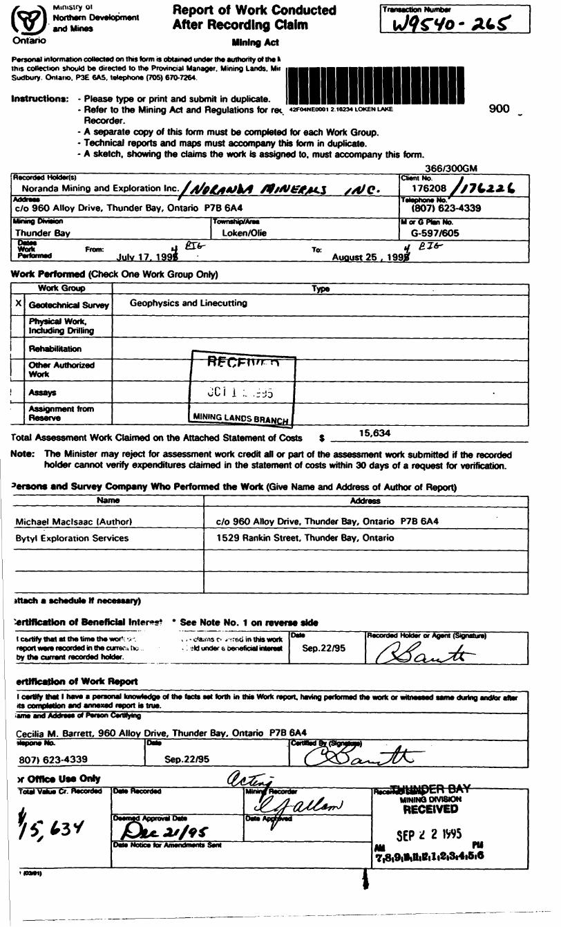
Report of Work Conducted After Recording Claim
Mining Act
Transaction Number
Personal information collected on this form is obtained under the authority of the fc this collection should be directed to the Provincial Manager. Mining Lands. Mil Sudbury. Ontario. P3E 6A5. telephone (705) 670-7264.
Instructions: - Please type or print and submit in duplicate.- Refer to the Mining Act and Regulations for ree. WOWEOOOI 21004 LOKEN LAKE
Recorder.- A separate copy of this form must be completed for each Work Group.- Technical reports and maps must accompany this form in duplicate.- A sketch, showing the claims the work is assigned to, must accompany this form.
900
366/300GMRecorded Holders)
Noranda Mining and Exploration Inc./yf^t**JkA 0*Addreas fc/o 960 Alloy Drive, Thunder Bay, Ontario P7B 6A4
MtninQ DwiSvQn Thunder Bay-son —————————— ^irWork Front! *T *—B*P F*- toJJft*J Julv 1 7. 1 998
Township/AreaLoken/OKe
Work Performed (Check One Work Group Only)
•f^f^j x/e/e.Client No. l
176208 S/ 7 L2.* LTelephone No/
(807) 623-4339M or G Plan No.
G-597/605
To- V Zlfr'Auoust25. 199^
WorkGroup
X Geotechnical SurveyPhysical Work, Including Drilling
Rehabilitation
Other Authorized Work
Assays
Assignment from Reserve
TypeGeophysics and Linecutting
RFCFM" --n "
JCi i ;. ,r-j5
J^lNJNGLANDSBRANrw
-
Total Assessment Work Claimed on the Attached Statement of Costs 15,634
Note: The Minister may reject for assessment work credit all or part of the assessment work submitted if the recorded holder cannot verify expenditures claimed in the statement of costs within 30 days of a request for verification.
9ersons and Survey Company Who Performed the Work (Give Name and Address of Author of Report)Name
Michael Maclsaac (Author)
Bytyl Exploration Services
Address
c/o 960 Alloy Drive, Thunder Bay, Ontario P7B 6A4
1 529 Rankin Street, Thunder Bay, Ontario
attach a schedule H necessary)
*rttftcation of Beneficial Inter*?*l certify that at the time the wor1 report war* recorded in the curran to by tha currant recorded holder.
ertlffeatlon of Work Report
* See Note No. 1 on reverse skfe--reci in this work
: ?tt under t beneficial interest Sep.22/95Recorded Holder or Agent (Signature)
l cartfy that l hw* a personal knowledge of tt* facts sst forth in this Work report, having performed the work or 1its completion end •nnexed report is trm,iama and Address of Penon Certifying————————————————————————————————"
i during andfcr after
Cecilia M. Barren. 960 Alloy Drive, Thunder Bay. Ontario P7B 6A4HaponeNo.
807) 623-4339 Sep.22/95
H* Office Use OnlyTotal Value Cr Recorded" Date Recorded
Dale Notice for Amendments Sent
DIVISIONRECEIVED
SEP 'i 2 1VV5
7,8i9ililliBili2i3i4i5i6

Details for Work Report 0 366-300gm-gp 2.16234work Report* for Applying Reserve
-.i/-
,
Claim Number (see note 2)
TB .164.344
.164.345
.164.346
.164.347
|j. .164.349
J .164.350
.164.738
.164,739
.164,744
.164.745
1.145.129
1.145.130
1.164.342
1.164.343
1.164,740
1.164.741
1.164,742
1.164.743
1.166.351
1.166.352
1.166.431
1,166,432
1.166.433
1.166.434
1.183.167
1.197.173
1.209.499
1.209,500
f Of Claim Units
10
4
16
16
8
8
29
Total Hunter of Claims
Value of Assesment Work Done
on this Claim
0.00
0.00
0.00
0.00
0.00
0.00
0.00
0.00
0.00
0.00
12.819.00
825.00
0.00
0.00
0.00
0.00
0.00
0.00
0.00
0.00
0.00
0.00
0.00
0.00
0.00
922.00
480.00
588.00
0.00
Value Applied to this Claim
400.00
400.00
400.00
400.00
400.00
400.00
400.00
400.00
384.00
384.00
400.00
400.00
400.00
384.00
384.00
384.00
400.00
400.00
384.00
384.00
384.00
384.00
6.400.00
578.00
Total Value work Done
Total Value work Applied
Values Assigned fro* this Clcia
12.819.00
825.00
922.00
588.00
Re*erve:Work to bel Claimed at i
a Future Date '
i
———————————
15.634.00 l15.634.00 l 15,154.00 l 0.00
Total Assigned Fro*
Total Reserve
Credits you are claimirig in'th:- report may be cut t-^ck. In order to minimize the adverse affects of such deletions, please indicate from which c'.aii^-. vcu Kish to P- : orize the deletion of credits. Please mark (x) one of the following:
1.1 l Credits are to be cut back starting with the claims listed last, working backwards.
2.li Credits are to be cut back equally over all claims contained in this report of work.
'-D Credits are to be cut back as prior i zed on the attatched appendix.
4.x Credits are to be cut back starting with the claims that have reserve credits.
In the event that you have not specified your choice of priority, option one will be implemented.
Note 1: Examples of beneficial Interest are unrecorded transfers, option payments, memorandum of agreements, etc.,with respect to the mining claims.
Mote 2: If work has been performed on patented or leased land, please complete the following:
1 certify that the recorded holder had a beneficial interest in the patented or leased land at the time the work was performed.
Signature
s^s^} 2~^*^vkDate

Ministry ofNorthern Development
CntanoMimsteredu Oevetoppement du Nord el des mines
Statement of Costs for Assessment Credit•ttat des couts aux fins du credit devaluation
Mining Act/Loi sur les mines
Transaction NoJN* d* transaction
2.16234Personal information collected on this form is obtained under the authority of the Mining Act. This information will be used to maintain a record and ongoing status of the mining claimfs). Questions about this collection should be directed to the Provincial Manager. Minings Lands. Ministry of Northern Development and Mines. 4th Floor, 159 Cedar Street. Sudbury. Ontario P3E 6A5. telephone (705) 670-7264.
Les renseignements personnels contenus dans la presente formule sent recueiflis en vertu de la Lol sur les mines et serviront A tenir d jour on reg stre des concessions mmieres. Adresser toute question sur la ccflece Ce ces renseignements au chef provincial des terrains miniers. mimstere du Devetoppement du Nord et des Mines. 159. rue Cedar. 4* Mage. Sudbury (Ontario) P3E 6A5. telephone (705) 670-7264. ____________________ 366
1. Direct Costs/CoQts directs
Type
Wage*
Contractor's and ConeuHanfs
Draft** I'entiepieiieur et da I'expert-
SuepHes Ueed Fournltures
Rental Location da materiel
Description
Labour Main-d'oeuvreReW Supervision Supervision sur le terrain
Type Linecutting
""Field Supplies
Type
Amount Montant
7.500
5,820
214
Total Direct Costs Total des coOts directs
Totals Total global
7.50C
5,82(
21'
13.53'
2. Indirect Costs/Couts indirects* * Note: When claiming Rehabilitation work Indirect costs are not
allowable as assessment work. Pour to remboursement des travaux de rehabilitation, tes couts indirects ne sont pas admissbfes en tant que travaux d'evaluation.
Type
y- Mai*aiM*i iijM*i ranSfionaiKHi Transport
Food and Lodging NounttureetvieDergeffiefnjjoblllyatlon and Demobilization Mobilisation et
Description
Type
Amount Montant
2.100
Sub Total of Indirect Costs Total partlel des couts Indirects
Amount Allowable (not greater than MM of Dtr Montant admisaMe (n'excedant pas 20 H des i
(Total of Direct and Allowable d'evaluatto
act Costs) toOtft directs)toducred*. nJta* ^B^A^^M
Totals Total global
2.100
2.100
2.706
15.634
Note: The recorded hoMer will be required to verify expenditures claimed in this statement of costs within 30 days of a request for verification. If verification is not made, the Minister may reject for assessment work aH or part of the assessment work submitted.
Note : LetHulaireeniegistreseratenudevenfferlesdBpeftsesdemandeescans le present etat des coOts dans les 30 jours suivant une dernande i eel effet. Si la verification n'est pas effectuee. le ministre peut rejeter tom oo une partie des travaux d'evaluation presentes.
Hling Discounts
1. Work filed within two years of completion is claimed at KXMfe of the above Total Value of Assessment Credit.
Remises pour depot
1. Les travaux deposes dans tes deux ans suivant tour achievement sont rembourses a 100 *b de la vatour totate susmentemte du ere* d'evatux en.
2. Work filed three, four or five years -'fter completion is claimed at 504* of the above Total Vaiuo .r Assessment Credit. See calculations below:
Total Value of Assessment CredlT Total Assessment Claimedx 0.50
2. Les travaux deposes trois, quatre ou cinq ans apres tour acnevement sont rembourses a 50 * de la valeur totate du credit d'evaluation susmentionne. Voir les calculs ci-dessous.
Valeur totato du credit d'evaluationx 0.50
Evaluation mala demandee
Certification Verifying Statement of Costs
l hereby certify:that the amounts shown are as accurate as possible and these costs were incurred white conducting assessment work on the lands shown on the accompanying Report of Work form.
Lands Administrator that as _________________——(Recorded HoMer. Agent Position m Company)
to make this certification
l am authorized
Attestation de I'etat des coOts
J'atteste par la presente:que les montants indiques sont le plus exact possMe et que ces depenses ont ete engagees pour effectuer les travaux d'evaluation sur les terrains indiques dans la formule de rapport de travail ci-joint.
Etqu'atitrede. je suis autoriseIre. representant. post* occupe dam li compagme)
a faire cette attestation.
Signature
O212I04A1)
Sep.22/95
Note : Dans cette formule. tonqu'l destgne des personnel, le ntascukn eel utMse au sens neutre

OntarioMinistry of Ministeredu Geoscience Aoorovals OfficeNorthern Development Developpement du Nord 93? Ramsev Se Roadand Mines et des Mines J J* J™? La)ce Road
Sudbury, Ontario P3E 6B5
Telephone: (705) 670-5853 Fax: (70S) 670-5863
Our File: 2.16234 Transaction /W9540.00265
December 19, 1995
Mining RecorderMinistry of Northern Development fc MinesSuite B003 435 James Street SouthThunder Bay, OntarioP7E 6E3
Dear Mr. Weirmeir:
SUBJECT: APPROVAL OF ASSESSMENT WORK CREDITS OH MIMING CLAIMS 1164344 ET AL. IM OLIE LAKE AREA
Assessment work credits have been approved as outlined on the original report of work forms for this submission.
MOTE: Information obtained, within the technical report and from telephone communication with Noranda, confirms the year the work was performed was 1994 and not 1995. We have corrected the dates on the Report of Work form sent to this office.
The credits have been approved under Section 14, Geophysics (MAG,EM), Mining Act Regulations.
The approval date is December 18, 1995. Please indicate this approval on the claim record sheets.
/2
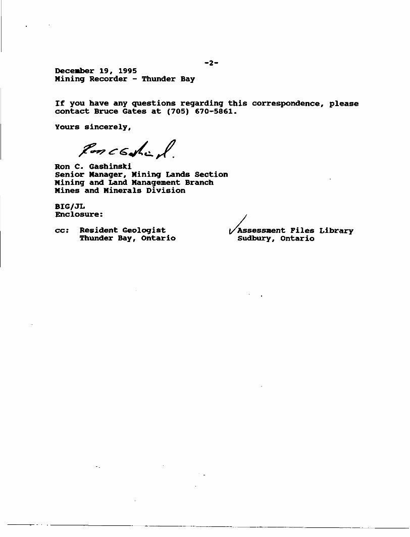
December 19, 1995Mining Recorder - Thunder Bay
-2-
If you have any questions regarding this correspondence, please contact Bruce Gates at (705) 670-5861.
Yours sincerely,
Ron C. GashinslciSenior Manager, Mining Lands Section Mining and Land Management Branch Mines and Minerals Division
BIG/JL Enclosure:
cc: Resident GeologistThunder Bay, Ontario
'Assessment Files Library Sudbury, Ontario
V **
.
oriE
I~V
KE
N)
O
O
5 l*
O
^ m m O i 01 CD
EV
ER
ES
T
LA
KE
G
-58
9
OD
i——
---
——
' VJ^
aa
01
- o J*
en
GO m O l 05
O)
O)
CD
o (31
FLA
ND
ER
S
LA
KE
G
-59
0
O (SJ ro
w"
O
co
a "D
-Q a
s z •3SO
o O)
O en
-l
^ H
i
C r;
co c
Q) q-
OD
2—
—
^
5 5 3 A
m E
a
lm
-*
m3D
2
30o
gni
wCD
^
DO
O)
S
m i
-I-
* 10 09m
-w
T 5
Zg
^
O
Z
O
Se
i
**
^
3)
:?Ei I
" i
i
c i c z
- z
• s ft
i -
jCx
z -
- -
n^-2
=
5
^S
>
Z
"
^f^
, -^
s *
- "K
. *^
~
~ C
O o l
—
C.>
I
—.
—(—
crt
Si
CO o
R j —
tr
2 r
r a-
5
Z
H
2
?1/1
Z
^
H
?C
r-
C
-o 5
^
C I
u m
^ f
m ^
O
JK^~
Sn"
?5(D
~
C
/*u-
i -l
en -
-, o
C
O f
O !DC
3 B
C O
CO K 2 OD O
O o
- s
s x
Z
0 z
ir
-^
z
c
D
,.
Z
~
X - i ? -
5-
Z
x -
^
Z I
~
c w
5 -
r l
T ^
i ^
v'
- Z
^
3 s i
~
-H
OI
~ x i
-r,
>
i*
"^
5 v
x —
i. •c —
X
\ i
v ' : i
l
mils
BO
-^O
r c o
s ir
-*- w
^
X
E^lS
?o
-^
Z a
E.
c c
l z
n r ^
" ^o
~r
C"po
— i
. c
—
***:i
.?
-g n
o.f
.5?
— 5T
'
I' z
2 a
" ^ S
f-
o
3
SLa
c-"
C
.
OP ^
en
o
ii l- 3
> -
t li si < * -
C*
CO O
'C?
-i-
*
w
^
U)
o
- T
)0
w
Oi lg
O)
S^w 1
rv (E
m
TI
m 3J m z o H CO
e-eo
e3
)iA
J
3IJ
Oao
a-o

N)
O
i l
lM
AN
ITO
UW
AD
GE
LA
KE
G
-600
ve
o O ZD m O i O
) o fO
\•4
'
\
s -^
y0
——
' - —
- —
——
——
——
——
——
——
— " —
——
——
——
——
——
——
'
* M e O w' o
" '
j
Of
VI
(O •sK
M
J
g f-5
" g
|l-
o ""
*?
9 ^
r tf
Mfi ^
TERRA
MINING
DIVISION
THUND
LAND
TITLES/
Rf
6
UT
THUND IH -
* ffi
"~ O
03 2
a
m
> 1
*
><
K
<
j*
X
V\
^v
\^
*^-
*-
o no
m
l t3
-—
,
f
^ 1
~ -
) *
v '
\
~ '
' J
li-
FOC
H
LA
KE
G
-59
^AREA
LOKENMN
R
ADMINISTRA
TE
0 *Z m
ir
~ C 1
C o
o r-
m
1 i
W , *
5i
n ^^ z
b)I to |CO
s
>
^
jJcZ
zW
om
:
' ^
: ."''^
OO
*2
—
w5
X' z
X ^
S
i
OJ?P
: '
' .^
qJq
z^
* "*
6 ^
• ~
* :
' '*
*c
mc
5 '
i-Ic
E"
' m
p -*
r
* ^
-^
x-*
JP-^ ^e^o^B
HB
C**
r-
|
DISPOSITION
01 ^ S | O M
1
Ul II.M T 1 IIMtb
NON
PbRbNNIAl
STHbAfyl
F
1
OODINQ OR
F
L
OODlNb
NSUBDIVISION ORroMpu?.ii
RFSt
RVATiONfi
ORIGINAL
SHOHKINF
MARSH
OH
MUSK f
O
MlNbS
TRAVfRSF
MONUMtNf
i ?
S
-C
r
i i i x
-
; 1 S
- '
^-
""r
5
z Iv ^
t 1
-\ \
j ' i
i '
if
iV
I
1 t t t
1 ' 1 i ;
i ! ' 1
'1
IJ
t t
*l -c
o
\ -d
. ,
.~i
- —
c "*
'i ^
i O
r is Ln ^
l(R I
f! 1
m d in o
t
Improvement District
o Gemmel
' Q
Gertrude
Tw m
5 f
I
1*
o li wo 0 A
NORTHERN
DEVELOP
MFNT
AND
MINES, FOR
AD
DITION
AI INFORMATION
ON
THE
SIAIUS
OF
IHb
LANDS SHOWN
HEREON
f
S
^
FROM
VARIOI)', SOIIR(
1 S
AND
ACCURACY
1!,
KOI
GUARANTEED
IHOSl
WISHING
TO
STAKE MIN
INO
CLAIMS
SHOULD
CON
SUIT
WITH
THF
MINING
RI
CORDEN. MINISTR
Y OF
. i
^ 0) 01.
3) 0
5 Z
S
e
m
O
5 3)
c*
O
-^
m
S
D3j
o-3
?"H
i
S f
sil
f a
1f
1
Ml
*
S
'ZH
J
X
3D m m a m z o ra
9
i

h l c")L J O
C vi
t )C xj
c *i
1
K) (A
l J
l lii
l i i i i
i )
i l
1 MOOON
18800N
l 8GOON
1840ON ~
18200N
1 8 f") O O N
h i U lt ll lL J
111 11 111C J c J
220
*i
11 i i i
i t
If '
1 1 1 i i i iU)
l 880UN
HOhMN
, KirjnN 1*16234
8.M)h(|
Depth-m Cond.-S
intruinent Al l X MXMN l
I't ntilc 'M ulo 1 (1/J/cMi
In ph'ist (kit)
l ri,l ,(i,,, mg /(Id
In ri) n s e ____II Li
(tnetors)
//M LAKE IIHLEM SURVEY
440HzJIM l Aki NUMHfK
liAr,l UNh A/IMUIH Kjfi il,-n
VI r HY NOI-a X lilt IMIIJIM
noranda

C -J
11 l ( ) l JL J•i
t J
'U
l ll i
i i i i i ( i IX l i-'l l J
1KfiOON
1 P, t in ON
1H400N^
1H(jfjON
c -J C J
230
l l:A i
*v 1
T liJ. *I. ' U\ i•i 1 J *mi f itikl i ii
r 1
: 'ivf '/l 1
1 ( It 1 14
1
'
1
' (' ) ' V-1 .Hi 1 li
, . ,
;{:,' :\U.1&-l\Bl. 1 ~^i
i
Vl/f1
*l-yf'rii i
V
1iti
1' ^ 'j ' -k ',/•' x x 'i 1 i i
in
* \ V|\ '
' i
'
\\ 'f1 h"4 ' t*
'
1 j'li:
1 'H' '1^1i ' 4
11 ' 4
4 1 'X ( -i n
* m l 1
'P '
"l '
li - 1
f'
li 1 11
'f ' '
1 '
i . *
|
* 4
, 1 ,
1 'y' n 1 i| . , ) ' 'V
' ^ ' 'lv lv" M ' ^ \ , v !*W~\ 'V" \
r * ' 'A ' */L * -* ' rr— " fn* '
\ l'* *...^
4 1 t *i 1 li ' ly ' 'i 7 i j *j \ n i i, t ,/, )4 ,4 /;. f -i .
/li 1 - V l"\ 1 \ , ' 1 t \ M t 1 Wl t 4
i ' h11
1
1
r" i',fV[ , v ,k . 4 ' 4- ,\II r l
1 1V '.1..
1n t i
iAt~* 1
A
f '
l ll ll Jl l
M V 1 (
'W ' l1
( ^
'h'1 M i
11•r '
i i * i
4,,:i, i y* i
'fl' *t'f f" l1 "
::
li*
o20 ' ' (T] l' ' '
' 1 ' ' a
l l li
l - II
i r li
l t II
l '- l'
t ' H
h * II
4 II fi
iIll t'
i,;
l l ll Jl l
l l l
l 4jt l
•i, 4
i r '4,
lifct i
•l,, i•V'k
1 C-
it
ii i i
ri t l
\'fi
it
l l,l
l1 tl-1l
l.
l
W
l l
(A
MHJU
MO
l ft I00r 16234pepth-m Cond.-S
Instrument AIM X MXMN l
I'rotile '...ult 103/un
In phciifl (left)
QiiQcJl olm c, (nqhl)
l. ml '-.pu i ir) 4 4?nf)
In -Hhuie B —
Quadrature
b o o(meter*)
'KOJ
JIM LAKE IIHLEM SURVEY
1760Hz- JIM lAKrHASH INI A/IMUIH Hill
NT 1 . . LiY ' NOK^X
III
norandatxplor ulctin Company ltd
l 1
^J

21700E 21 BODE 21900E 22000E——r 22100E — i—— 22200E 22300E——i—— 22400E 22500E 22600E22700E
oO)
z o o ffi00
z o o co00
z o o NOD
o o(O 00
z o o in oo
Zo o oo
o ofO 00
Z Oo(M OOi—
Zo o00
16234 LOOP 1
125
42F068E0004 2 16234 OUIE LAKE
l
240
L- . _ ..
(21600E21700E 21BOOE 21900E"T2000E 22100E 22200Ei ~2230~OE 22400E 22500E" '22660E 22700C
mKl (^5 O
00
o o
tj
- S
soGcole 1:5000
50 100 150 200 230 .100
(m*Ura)
Channel l Cnonnel 2 Cnonnel 3 Chonnel 4 Cnqnnel 5 Channel 6 Channel / Cnannel B
jlM LAKE GKID-2DEEPEM SURVEY
X ComponentProject: Jim Lake; Number 316; NTS: 42-F/4
Profile Scale; 1cm^20 Crone UnitsInst: Crone Analog 8; Time Base 20 ma; Romp 1 ma
August. 1994
"~~N'ORANDA EXPLO'RATION~COMPANY

21600E21700E 21800E 21900E /22000E ?2100E 22200E 22300E '.."24001: 22500E 726QOE227GOEZ o ofO ft)
f .J
O' i c '
ffi1-;
, O io,oen
o oCT) CO
o .0000
LOOP 1
l 623 4
125.
2
250
1600E21700E"2"i800E*'2"l90bE 22000E 22H)OE* 22200E "2?30~OE
t yj'O. l 1
in •^
22500E 22600E22700E '
C ond - ^
oi-ale 1 fjj\ion
Channel J hanntl 4
Channel 1) E 7 f!
N i ir
f 'LD CM /..JKVD
jno
-X
t. Jim Lak^; rJijmt-er 3K. rJl F'rntile S. .ale: 1 .m--7.0 i. rone
In-t Oone Analog R. lime Base 21 ms; Komp 1 rns
NORANDA EXPLORATION r

18800N
1R400N\
18200N
1P.OOON
;
\(\/'-\
\
jJ
(
•••vrmi ]Dillni) tUM.JVIBM \IMII \mn
UII \IUI l NIIU 1DIMIMl 1nu 1ni) iDI lMl 1m.in* inil 1IINIin iIM
m. jni i ,n'* 1in (in JIMl (iu i \ut* inil ('mi
\ v
LI t jf, j
r\j
l l l
l l
l l
'J
l l
.m i
.Ml 1It) JIII 1nilil' \in i \144 1 \Ml 1 \m iUl 1o* 'm t tiin i )mi i ('mi 'iiii inn i t-.-1
iiii '•lil 'tljjljHiVi*~\MM, l \IMI.I \IMl 1 \ml 1 1ilM l
- IIU 1Illl JIlll 1 \Illl * \Ml 1 )Illl ^IU *mi *(irti i \nn i.in i.rU lnn iIlM t.Ml 1illl 1
UII 1Illl 1IIM 1nnnn iIH4Illl 1Ul 1Ml 1 'in i cMil 1 VIlll 1 ,nn t )mi i ,Ml 1 (Ml 1 \
MMnn * lUM 1 j1*11 1 l II') 1 7 IIM ('IIM lilll 1nilIMl 1llU 1
mi imi iMlIIIMlIIIIIIIIIIII1111)1 IIIIU
.MlMlMlmi iDI4iiUII 1t*U(liiu-in i•w tiru t11*1IIMmi.nn.miIMIMniIUinIMIUIMIIIIIMmi rUIIUII 1nn iIUImi iUN tnnnnnil lnn ini) iIM)tin iIUIin* i
r 'II 1.Ml 1no iIMl 1III 1ni iMl) 1nn iMil 1illl inu ,nu inn iIMJ l '
ni) i IIM
1
\
J
\
k
(/
(
}
\J
UMIlll11)1 Ml l IIIIM 'IMIU111ruHIinIUIlllIMlIUI*n\AVf)1N|i*n"*iMD
1 nnII ""I ""
U on| IUIItai.il MM.l 11*1- Jl INI1 Ul t(n*4-IM 1t 111 J4 in i
KM!f m.*/A,M,fc
^MllIIMtinUIIUIIminnminnDIIU 11)11 ( III) IU IIMUMnnIMl
liltIII 1IIMIIMIM)1)11
1 1)111141miminnIIMi***.114
\
^
\'
(^
^
l
x
\
\\\\v\
'
1 ~\1
l
\
)l'\ ()
^1\
(\\
IM lm iMl 1111 1n ^III 1 x111 1 'Itl 1 l
.111,1fi) 1lin *(ill tnnnu ,nu inil v,'iii'n.11*.MlMilIlllIII)IIU.nw.IIUINIni iIM tni ^Ml \fll )11 1IIIIlll )11)1ill! 1nn ;nil i.IIMDMnuIlllIlllIlll ,Illl ,IIM )III) .'in i k-in i im i (III* 1 S,ut) iIM 1in iW lni inilIt*).Mlmimimi.inint (.mnnii)iin*mi
i "'l:-1t "'i |Mi in i1 mir "*
::;l";T "MH ""T ""{ ill)
f li!)IfOjMl)DI)IlllIUIinin41'1linnnM
IMlM1.IIU 1in iinm iMil
fi "" T n"T '**r ""n ")lII IMlT 1*M
n "**K "Ml mi1 Ml 1D |MI
T 1UI4 il)i{ mi\ UM[f UMn ""
IMlll'lIU 1IU 1111 1IM 1IlllIN 1lilIM 1II* 1Illlin iIMlIMJIIM
.*
i1
j
1
j1
i
\
-
':;)
(1
1 ,\1
1
1
: (r s
Mtl
•liIIIIlllIIIlitIII111MlIII11*1nn
1 IMli Illli Illll III*} Illl f I'll{ nnr II|F1 '"'1 ""1 in '
milinI'l•ttIIIIIImMl
f "'1 ii^iI lilInnIr Ml1 1 "M it " M1 '"'\ lUl4 tinj .ml I'M
III*Ml •IItil11)Hi IIIMlninlIDminmnvin*Ml•iininin*MlMlIII.njmi .inMMIM
i
1
tt1 ,' )1 '
l
/ll vt11i1r
t1 l
it l 1li1 x
111l
' l
C
l.1
111
111
C\l C si
noc j
111 1Ml 1llil 1nu l.In lMM lMl 1II) 1Ml lHi 1
illl
nunnMl 11*1 1.•tt1*11IM)Illlilll.IIIMilIIUIIUlltlMi 1HI 11*1 lMl 'it iin iMl l)M Jm i
•IIH.Ilit!Illl 1Illl tnn tnuiin iin iii ri inil iMl 1nn '
nn tnn inn lIUI inu tnu inn imi )nn imi imi nu imiMM * Illl 1 Mil 1nn i.in*IIM t.m illU lnil inil lill* 1
\
l
1
\
j
'
f1
(j
\.\
1
^
l1
1
UMIml tmi i nn t lil i in l in i mi.) miMil ' Illl l Illl 1 ll'l ' 111 t III l III l•It l nil
t IN. Illl lill .III Illl• MItl111IIIli*III111hiIIIIU lIM lIMl lUII lIUI lIlll lIIUJMlMlMIIIli'lIII111ll'ltilllinIUIIlllIMlIlllIlll111 lIMlUIIin*miKllnn uii 11*1Hll lil)nil IIM linIlll lill 11*1nil IIM i iti mi
MI iui imimimimimimiitn*i.inonnn.in.innnmil Ml
l
Ml lit111 IIIIWm /itMl 111 111* IM l UII l IIH l MM*'
il*i l
iiniMlnil.1.1.IIInumi
) 1 III 1
A;;;;W !M
tt"'B ""(kim
1
i
•)(
t
N
iHM.Ml.runilnnminilnilMilnuininunnilMIMHIIIIIMIIIIIItilMlril••iUlruilll inilm.t(in iMl 'III)IlllIlllIlMnitnuIlllIII*
nnIU l
V n** 11 IM 1
Mil[*M
Illl lIlll l III*
' M) ill) l IIM l IUI lnu ' H*, t nn i MD i
V
lill l 111 llil l Illl l li li tIlll lIIIIIIMlril IM til•it til III Di In HI '•i 1' III Mi141 111 DI IMlil lIMl i
1•1
11l'l
\11
J)
f1
\!
)
IM'II' MMl Ml,kill f fit.1 "SIUInnni* .11*.U.
. tin
. .1).
. mi' no
.1.1nilminnnn!n'i
ilMnililll
IHIVIII111lil
Til111HiMlIIIIIIMlMlliltnnnnnn
MMIMl
•MFn-nnnMl1*1MMlruIMIU Ml.IMMIXn* HIMl11H\IIIIII.III.IMMiltilIIIII.Ul
1t
1
tt
\\\
t\
\1t1r
c1'1
,
j1
l
J1' ;
ii
\l \\
i\V
~""
,
IJJJ-JI*MIlll 'Illl 'Kll 1 .nn \Kll111)MMIIUnnnnIMl
nitnnlinnnnilmiill*ill. lit i in *inIM111MI14*111IIII.III*I.II.IMlIlll 'III 1MlII) '1*1 1IUI 1Illl 1nw iUK 1
- nn i fMl 1
nn 'mi iIIH 1nn inil i
•mi iHi iUl) lMl* 1 fIUI 1 VI4H iIlll 1 7IIU tDM l\UIIIlll 1 lKll 1nn i 'IMl 1IMl 'Illl 1It'! 1
l i l l l t j( u l l
"- i in i
•IIinIN IIIni litMlHI MlIlllMlilllillllllIMDIl'4III
fll
Itl lfll t•MI nn imi tm i nn i nn i in i in i in i nn inil l illl l nn(Ml l llll ill* l llll l ivll l
nu i nu . in tnn
iMi l
1)1) nn mi nuMilDMIIM III' III* 111*UIIllllIIUlit) mi nu nu in i nil in i in i m t HI i HI i'•i i in i MI i 'M i4*1 411
111 l 111 1 IU lIII l III lII. l III lIII1114ID *D**nru•uinn*Ml.in.in iu inIM Ml)UiinMlIII III III III III II* III IM. Ml
lil IMIN*.*
H") O Of x|
IX'
n n n N
. 16234
8 Of j f)N
III
Instrument SUNfREX Mh'
Protilo '.cole
Reduced Profile Vul*
PrnMe Uene Value SOD
Dntiim
l, M-} l e l-Ti o 1)0 ion i c,n ,-nn
(meter*)
//A/ L4JTI? 77MAGNETIC SURVEY
TOTALPROJIVr . JIM l AKt NUMUh'K
BASLIINL A/IMUFH - 100 doi
DAfL - AUtiUSr/um NT 1., 4^ l -4 '..URVLY BY : NORLX
MIL : M5H..HM
norqndaExploration Company ltd
mH)bt.LUUU4 ^ Ol It l AKt 260

i i
i iii
l A
~ - -^ ja.,_. -.- '.A
"j ON
1P.8HON
18 60(1 [v|
184DON --
l A l A
42F06KFOO(M 2 1B214 f)| IF l AKF 270
lu'i'l l.ii. i ( ITl 1,1 f M'
' -l.l' l II l l'l l 'l ' ' l I1 II l .1 l' ' l '
ci.. "(J
MAGNETIC SURVEYTOTAL
!M : Aki li'liJI.i u
AU 1 , 'J 1 , F 1'1'M' ll!^ Vi V RV
!!h M
•' l 'l
noranda