rransit oriented ansit oriented development acting as a catalyst for private investment and...
TRANSCRIPT

Transit Oriented Development (TOD) is a walkable, mixed use form of development focused around a transit station. Concentrating higher density development near the station makes transit convenient and encourages ridership.
This Best Practices Handbook introduces the key planning principles behind successful TOD. It summarizes some of the current practices for designing and implementing transit oriented development. In this handbook, you will find information on the following:
• Why plan for land use around transit stations?• Where does TOD occur?• Why is TOD important for Calgary?• What are current Calgary policies for TOD?• What are the TOD “Best Practices”? • Where is TOD being built?• How are cities implementing TOD?• Where can you find out more about TOD?
This Best Practices Handbook is not a policy document. It is intended as an information resource for Council, developers, builders, planners, urban designers, communities and the general public. Its purpose is to explain TOD, its characteristics, its benefits and its challenges. It will serve as a background document for future City of Calgary policies which will guide TOD land uses, urban design and implementation strategies at LRT stations. The Handbook will also help stimulate creative thinking and discussion, and ultimately facilitate the smart development of lands around Calgary’s LRT stations.
January 2004... for smart development around transit stations
Best Practices Handbook
TTransit Oriented ransit Oriented Development Development


3
Why Plan for Land Use Around Transit Stations?
Calgary City Council has endorsed Advancing Smart Growth as a key priority in its 2002-2004 mandate. Smart Growth recommends a balanced approach to municipal development by supporting economic development, a healthy environment and strong communities.
The wise use of land around LRT stations and high volume bus stops is one approach to help Calgary achieve its smart growth objectives. Strategically planned station areas help promote the economic, social, and environmental well-being of a city by:
• Highlighting transportation alternatives and increasing transit ridership
• Taking advantage of non-peak direction transit capacity• Decreasing auto dependency and exhaust emissions• Using serviced land efficiently to help create a more compact urban
form• Making better connections between jobs and housing• Revitalizing commercial corridors and older communities• Providing market housing in a variety of forms and price ranges• Creating opportunities for affordable housing• Providing increased neighbourhood and travel options for those not
owning cars• Making identifiable and walkable neighbourhoods• Creating more street activity and a safer station environment• Acting as a catalyst for private investment and development• Increasing assessment values of vacant and underused land
The desire to coordinate the planning of land use and transit investment is a growing trend across North America. Many cities and regions are promoting better use and intensification of land around major transit facilities as a means to achieve a number of their broader planning goals.

4
A Transit Village is “a compact, mixed-use community centered around the transit station that, by design, invites residents, workers and shoppers to drive their cars less and ride mass transit more”.
Bernick & Cervero, Transit Villages, 1997
“Transit-supportive development enables citizens to choose an alternative to the automobile for at least one or more of their daily trips between home, work, shopping, school or services.”
MARC Principles of Transit Supportive
Development2001
Where does TOD occur?
Transit riders start and end their trips as pedestrians. Whether riders arrive on foot or via bus, private vehicle or even bicycle, every transit trip has a walking component. Creating a pedestrian environment which makes the transit trip easier and more enjoyable is therefore paramount in planning for a successful station area.
The distance that a person is willing to walk to take transit defines the primary area within which TOD should occur. This distance is equivalent to roughly a 5 minute walk, or 400 to 600 metres. At these radii around a station, there is potential for 125 to 250 acres of land for transit oriented development.
“Transit-oriented Development (TOD) is moderate to higher-density development, located within an easy walk of a major transit stop, generally with a mix of residential, employment and shopping opportunities designed for pedestrians without excluding the auto. TOD can be new construction or redevelopment of one or more buildings whose design and orientation facilitate transit use.”
State of California Statewide TOD Study 2003
Chinook Station, Calgary, AB _showing 600m radius circle

Why is TOD important in Calgary?
To date, The City of Calgary has invested over $628 million in LRT infrastructure, which includes 32.7 km of operational track on three lines. There are 33 stations including 11 downtown platforms. In 2002, Calgary Transit carried 31 million LRT passengers. It has the highest LRT ridership in North America.
By 2004, a further $148 million will have been invested to add three new stations and 5.6 km of track to the system. With this significant investment in the network and current ridership success, TOD can become an important component of Calgary’s future growth and traffic management strategies.
Calgary’s Policies for TOD
The Calgary Plan (1998) is The City’s municipal plan that establishes a long term vision for the type of city Calgarians want to live in. It forms the cornerstone of the City’s transportation and growth management strategies by proposing increased mobility options, reduced reliance on the automobile and increased transit use. Increasing the number of jobs and housing near LRT stations is central to achieving these objectives. Key policies in The Calgary Plan that support TOD include:
2-2B Encourage appropriate new office development to locate in transit supportive areas through the amendment of land use classifications, and the provision of infrastructure, etc.
2-2F Promote greater land use efficiency and convenience by encouraging new housing close to transit facilitiesand within mixed-use centres to suppedestrian mobility choices.
2-2H Support the utility and vibranLRT stations by actively encouragingpublic and private sector developmeintegration of a full range of compalands uses (residential, employmentcommercial activities) at designatedsites.
History of LRT in Calgary
1966 Rapid Transit concept first approved in the downtown development plan.
1975 Approval of the south LRT alignment.
1978 Construction began on the South LRT line between Downtown and Anderson Station.
1981 South line opens.
1985 Northeast LRT service completed to Whitehorn Station.
1987 Northwest service completed to University Station.
1990 Northwest line extended to Brentwood Station.
2001 South line extended to Fish Creek/Lacombe Station.
2003 Construction underway to extend the South line to Somerset Bridlewood Station and the Northwest line to Dalhousie Station.

6
The LRT South Corridor Land Use Study (1981) was approved in conjunction with the first leg of the LRT. The study established a vision of intensified land uses around Calgary’s first seven stations, while protecting the stability of existing communities. It also included a plan for automobile and pedestrian circulation, and improvements to facilitate long term development of the station areas. Density bonusing was provided as an incentive to encourage residential and mixed-use developments and high quality pedestrian connections.
The Employment Centre Strategy (1999)identifies many LRT station areas as “secondaryemployment centres.” These are nodes with potential to accommodate future employment activity near to suburban residential growth corridors and transit facilities. The station areas are also identified as good sites for a range of supporting services such as shopping, recreation and residential uses, to be developed in the context of the site and adjacent communities.
nsit Friendly Design Guide (1995) provides design principles and policies to encourage both lity and the vibrancy of LRT stations. The Guide mmends mixed use development around all transitdes, higher densities near stations, friendly pedestrian nvironment and passenger amenities to make transitmore convenient.
7
Key TOD Components
A review of practices from cities across North America indicates that TOD is a unique form of urban development. No two stations are the same. How a station area is planned and developed will depend on the particular attributes of that station and surrounding community. However, the following key components are commonly found to be critical to the success of any transit oriented development.
• Get the Land Uses Right
• Promote Density
• Create Convenient Pedestrian Connections
• Ensure Good Urban Design
• Create Compact Development Patterns
• Manage Parking
• Make Each Station a “Place”
The following Best Practices expand on these concepts.

8
Get the Land Uses Right
Ensure transit supportive usesTransit supportive uses are high pedestrian generators that directly promote greater transit ridership. They also provide opportunities for multi-purpose trips that can be made as a pedestrian. Medium to high density residential, offices, high schools and colleges are significant transit supportive uses. Appropriate retail, restaurants, personal service and civic functions will support these major uses and generate activity in both peak and off-peak hours.
Discourage non-transit supportive usesNon-transit supportive uses generate little or no ridership. They consume large areas of land, or create bleak or unsafe environments for pedestrians. They are often dependent upon a vehicle for transporting goods, or require significant land areas for low intensity development and parking. Large format wholesale stores, warehouse storage, car dealerships, auto service centres and regional sports fields are examples of uses that are not transit supportive.
Encourage a mix of usesA mix of residential, office and supporting services in station areas can generate transit trips throughout the day. It provides opportunities for people to live closer to their jobs or to take advantage of reverse flow transit capacities. Workers can run daily errands within walking distance of their jobs; transit riders can access convenient services while at the station. Residents and visitors can continue a variety of activities in off-peak times.
Locate the uses as close to the LRT station as possibleLocating a majority of transit-supportive uses within a 400 to 600 m walking distance of the LRT station makes transit the most convenient and attractive travel mode for the site.
Multi-dwelling residential Affordable housingSmall lot single-family Offices HotelsHealth care facilitiesMedical clinicsHigh schools and collegesDaycare facilitiesCultural institutionsAthletic/recreational facilitiesHealth ClubsPersonal servicesRetail shopsRestaurantsGrocery StoresCoffee shopsLocal pubsOutdoor cafesFinancial institutionsDry cleanersEntertainment facilitiesNeighbourhood oriented businesses
Automotive sales & display Automotive services & repairCar washesLarge format/warehouse retailLarge format food storesDrive-in/drive-through servicesWarehouse distributionOutdoor storageRegional parksFuneral homesLarge format faith facilitiesParking lotsLow density single-family housingLow intensity industrial uses
non-
transit
suppor
tive
land
uses
transit
supp
ortiv
e lan
d use
s
best practices

9
Promote Density
Promote densityDevelopment densities are “as great as possible” within the context of a particular station and surrounding community. Minimum residential densities around rail stations are high enough to support higher frequency transit service and to foster lively, walkable communities. Housing forms include townhouse, walk-up apartment and high-rise buildings. Minimum employment densities are established in station areas to create a destination which generates transit trips. Below are some examples of minimum densities being used in LRT station areas by other jurisdictions.
Housing Jobs Santa Clara County CA 25 - 45 upa 1.0 FAR Puget Sound, WA 10 - 20 upa 50 jobs/acre Denver, CO 25 - 30 upa 0.75 FAR
Density concentration and transitionThe highest densities are ideally located closest to the station, to optimize transit rider convenience. This includes high-density housing and offices. Intensity of development can taper off away from the station, to create an appropriate transition and interface with the surrounding community.
Plan for densityPlans for areas around LRT stations should address the ability to increase density over time. Vacant lots, surface parking lots and existing low intensity uses present opportunities for future infill development. A phasing plan that demonstrates how the station area can intensify over time offers flexibility to meet changing community needs and provides a vision for this transition.
best practices

Pedestrian Route Design Considerations:• short• continuous• direct
=Convenient
Walking distances are shortPedestrian routes between the station and key destinations are short and direct. Key destinations are located within a 400 to 600 meter radius of the station. Circuitous routes are avoided.
Pedestrian connections are continuousSidewalks and pathways are continuous routes that are easy to find and follow. Major connections to the station for pedestrians and bicycles are constructed at the outset. Routes are universally accessible to wheelchairs, strollers, scooters and other mobility aids.
Access is directSidewalks connect directly to the entrances of the station and buildings. Bus stops are located as close as possible to building entrances. Walking distances from the station to the nearest bus stop are generally shorter than the distance to the nearest parking space.
People are at street levelPedestrian routes are at ground level, with minimal stairs and grade changes. Adjacent buildings provide “eyes on the street” and informal security here. Pedestrian routes are located on public streets unless there are good opportunities to tie in to a safe, existing above-grade system (e.g. Plus-15).
Separate vehicular and pedestrian functionsVehicular and pedestrian ways are designed to minimize points of conflict. Sidewalk and pathway routes have as few driveway or parking lot crossings as possible.
Direct and visible walkway link between parking and retail space-West Market Square, Calgary
Clearly marked crosswalks identify space for the pedestrian. Brentwood Skytrain Station, Burnaby, BC
Clearly marked crosswalks identify space for the pedestrian. _West Market Square,Calgary.
b-
CfS
CfC
Create Convenient Pedestrian Connections
best practices
11
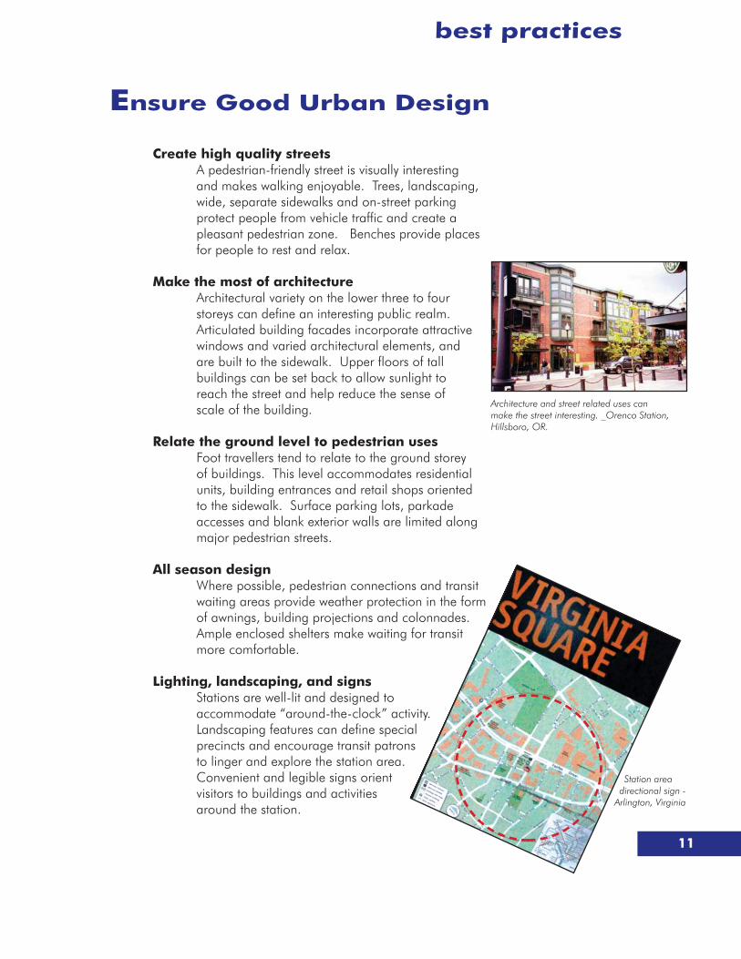
Ensure Good Urban Design
Create high quality streets A pedestrian-friendly street is visually interesting and makes walking enjoyable. Trees, landscaping, wide, separate sidewalks and on-street parking protect people from vehicle traffic and create a pleasant pedestrian zone. Benches provide places for people to rest and relax.
Make the most of architectureArchitectural variety on the lower three to four storeys can define an interesting public realm. Articulated building facades incorporate attractive windows and varied architectural elements, and are built to the sidewalk. Upper floors of tall buildings can be set back to allow sunlight to reach the street and help reduce the sense of scale of the building.
Relate the ground level to pedestrian usesFoot travellers tend to relate to the ground storey of buildings. This level accommodates residential units, building entrances and retail shops oriented to the sidewalk. Surface parking lots, parkade accesses and blank exterior walls are limited along major pedestrian streets.
All season designWhere possible, pedestrian connections and transit waiting areas provide weather protection in the form of awnings, building projections and colonnades. Ample enclosed shelters make waiting for transit more comfortable.
Lighting, landscaping, and signsStations are well-lit and designed to accommodate “around-the-clock” activity. Landscaping features can define special precincts and encourage transit patrons to linger and explore the station area. Convenient and legible signs orient visitors to buildings and activities around the station.
Station area directional sign -
Arlington, Virginia
Architecture and street related uses can make the street interesting. _Orenco Station, Hillsboro, OR.
best practices

12
Compact Street NetworkFrequent, interconnected streets increase the efficiency of transit circulation and offer more choices for pedestrians. Blocks of 100 to 150m in length keep walking distances short and provide alternative route options. A grid-based street pattern offers multiple accesses to the station and forms the overall development framework for long term transit supportive uses.
Cluster buildings Buildings that are grouped together, or clustered, offer a “one-stop” opportunity to conveniently access a variety of destinations on foot. Clustered buildings can frame distinct character areas and create an easily navigable walking environment.
Leave room to growBuildings can be thoughtfully sited on a property to accommodate future intensification. Placing buildings to one side of a parcel, instead of in the centre, leaves sufficient land that can be developed later. This will allow an initially low density area around an LRT station to intensify over time.
Commercial Core
Arterial
Transit Stop
Connector
Park
Not This
Pedestrian Discouraged from Walking to Adjacent Buildings
Sidewalks do not Connect to Buildings
Oversized Parking LotsSeparate Commercial Buildings from Streets
Isolated Development
Buildings too far from street, resulting in long walks through parking areas.
Calthorpe, 1994
This
New Development Continuesto Build to Street
Density and Location of Buildings Support Public Transit Parking located
behind buildings
A “clustered” environment
Orienting buildings along the street helps establish a “park once” environment where people are encouraged to walk between buildings.
best practices
Create Compact Development Patterns

13
Manage Parking
Accommodate the automobileBy design, TOD lessens the need for automobile use in a station area. However, accommodating vehicles is still critical to the success of a vibrant TOD district. Convenient parking and drop-off zones need to be planned for in all station area plans.
Parking - enough, but not too much!TOD provides an opportunity to reduce the amount of parking in the station area through increased transit riderships, reduced residential vehicle ownership and shared off-peak parking at public Park & Ride sites. Setting both minimum and maximum parking standards can help ensure the success of a station area as well as optimize transit ridership.
Locate parking to the rear and sides of buildingsParking lots are located at the periphery of the station area and to the rear or sides of buildings. This keeps the station and building entrances oriented to the sidewalk and to pedestrian users.
Smaller parking lotsSurface parking areas do not overwhelm a station area. Larger parking lots can be divided into smaller lots and separated by landscaped walkways. These smaller lots also create an internal movement network and establish a framework for longer term intensification.
Phased parking from surface lots to structuresStructured parking consumes less land than surface parking and allows maximum development. Station areas are designed to allow for the evolution of parking from surface lots to parking structures. If parking structures are located along key walking routes, they can enhance the public environment with pedestrian-friendly facades.
Bicycle parkingBicycles can extend the local commuting range beyond the typical 600 m. Ample, convenient and secured bicycle storage locations are provided at each station, close to the entrance of the transit station.
Parking areas can be located behind buildings to keep the street oriented to pedestrians.
Orenco station, Hillsboro, OR
Provide spaces for bicycles, Germany
best practices
14
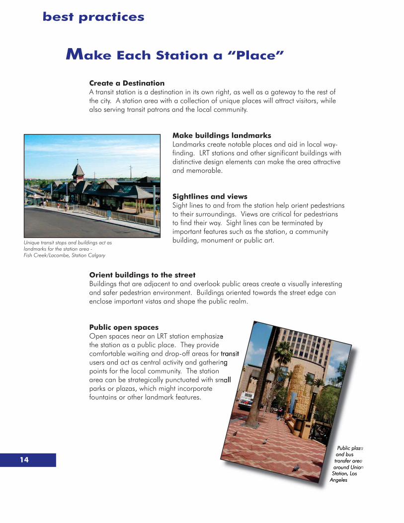
Make Each Station a “Place”
Create a DestinationA transit station is a destination in its own right, as well as a gateway to the rest of the city. A station area with a collection of unique places will attract visitors, while also serving transit patrons and the local community.
Make buildings landmarksLandmarks create notable places and aid in local way-finding. LRT stations and other significant buildings with distinctive design elements can make the area attractive and memorable.
Sightlines and viewsSight lines to and from the station help orient pedestrians to their surroundings. Views are critical for pedestrians to find their way. Sight lines can be terminated by important features such as the station, a community building, monument or public art.
Orient buildings to the streetBuildings that are adjacent to and overlook public areas create a visually interesting and safer pedestrian environment. Buildings oriented towards the street edge can enclose important vistas and shape the public realm.
Public open spacesOpen spaces near an LRT station emphasizethe station as a public place. They provide comfortable waiting and drop-off areas for users and act as central activity and gatherinpoints for the local community. The station area can be strategically punctuated with smparks or plazas, which might incorporate fountains or other landmark features.
Unique transit stops and buildings act as landmarks for the station area - Fish Creek/Lacombe, Station Calgary
a
a n
best practices

15
Where is TOD being built?
Cities across North America have incorporated TOD around their transit stations as a means of achieving a variety of fiscal, social and environmental objectives. Despite the interest and activity, it has often been a slow process to see results on the ground. Nonetheless, TOD successes are being made and station areas are starting to develop as higher intensity, pedestrian friendly urban places. Some commonly cited station developments, which demonstrate how TOD has been used for a variety of objectives, are referenced below.
Townhousing development at Whisman Station - Mountview, CA.
Mockingbird Station Dallas, TX
Town Center at Orenco StationHillsboro, OR
• Fruitvale Station (Oakland, CA) - a 24 acre redevelopment of a declining commercial strip. TOD is being promoted around a new rapid transit station as a catalyst for community revitalization. Plans include the provision of low income housing, retail, employment and social development opportunities for the community.
• Orenco Station (Hillsboro, OR) - a new residential mixed-use community developing on a greenfield site around a suburban LRT station. A mixed-use town centre near the station is the urban focus. It has been developed with a variety of loft apartment, townhouse and live/work units. Lands beyond the town centre are predominantly low density, single detached housing with large, high tech industry on the periphery.
• Mountain View, CA- developed an award winning TOD vision and detailed “Precise Plans” to promote development around its four commuter rail stations. TOD projects include residential redevelopment on an aging retail mall site, a medium density residential subdivision on a former industrial site, and housing intensification at its downtown stations.
• Mockingbird Station (Dallas, Texas) – a privately planned and financed 10 acre redevelopment project located between a suburban LRT station and university campus. Features include a public plaza, 250,000 SF office component, 211 loft apartments, retail, entertainment centre and structured parking.
16
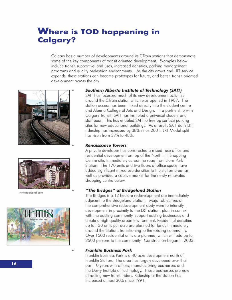
Where is TOD happening in Calgary?
Calgary has a number of developments around its CTrain stations that demonstrate some of the key components of transit oriented development. Examples below include transit supportive land uses, increased densities, parking management programs and quality pedestrian environments. As the city grows and LRT service expands, these stations can become prototypes for future, and better, transit oriented development across the city.
www.apexland.com
• Southern Alberta Institute of Technology (SAIT) SAIT has focussed much of its new development activities
around the CTrain station which was opened in 1987. The station access has been linked directly into the student centre and Alberta College of Arts and Design. In a partnership with Calgary Transit, SAIT has instituted a universal student and staff pass. This has enabled SAIT to free up surface parking sites for new educational buildings. As a result, SAIT daily LRT ridership has increased by 38% since 2001. LRT Modal split has risen from 37% to 48%.
• Renaissance Towers A private developer has constructed a mixed -use office and
residential development on top of the North Hill Shopping Centre site, immediately across the road from Lions Park Station. The 170 units and two floors of office space have added significant mixed use densities to the station area, as well as provided a captive market for the newly renovated shopping centre below.
• “The Bridges” at Bridgeland Station The Bridges is a 12 hectare redevelopment site immediately
adjacent to the Bridgeland Station. Major objectives of the comprehensive redevelopment study were to intensify development in proximity to the LRT station, plan in context with the existing community, support existing businesses and create a high quality urban environment. Residential densities up to 130 units per acre are planned for lands immediately around the Station, transitioning to the existing community. Over 1500 residential units are planned, which will add up to 2500 persons to the community. Construction began in 2003.
• Franklin Business Park Franklin Business Park is a 40 acre development north of
Franklin Station. The area has largely developed over that past 10 years with offices, manufacturing businesses and the Devry Institute of Technology. These businesses are now attracting new transit riders. Ridership at the station has increased almost 30% since 1991.
17
How are cities implementing TOD?
Many cities, counties and state/federal agencies across Canada and United States are achieving TOD in their jurisdictions, using a variety of implementation tools. A number of implementation “best practices” have emerged, which are outlined below.
Eliminate RoadblocksTOD is a unique and emerging form of urban development. It is one that many developers are not willing to risk. Often cited reasons for this uncertainty are difficulty in obtaining financing, lack of clear policy direction, lengthy approvals processes and NIMBY-ism. Municipalities help reduce this risk by ensuring planning policies, zoning and approvals processes are in place to eliminate roadblocks and reduce timelines.
Provide a vision for TODA comprehensive, strategic vision establishes TOD as a key element of a City’s overall land use and mobility plan. The vision encompasses broader city-wide land use and development goals, as well as performance expectations for future development around transit stations.
Build Community SupportA broad understanding and acceptance of TOD is important. Community wide information and education programs should be promoted. Planning processes that involve neighbourhoods, elected officials, land owners and the development industry can create a TOD program that is supported and will be implemented.
Identify priority transit station areasWherever there is an LRT station there is an opportunity for TOD. However, the market is not limitless. Identify priority stations where there is market interest, sufficient land and a reasonable opportunity for success. Focus attention at these priority stations to ensure early TOD projects are successes.
Station Area PlansIndividual stations need specific plans that recognize local market strengths, site opportunities and community interests. These plans will outline clear goals for TOD at the individual station and provide guidelines for land use, density, public systems, urban design and parking management.
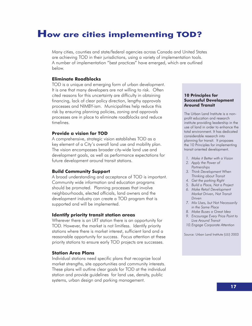
10 Principles for Successful Development Around Transit
The Urban Land Institute is a non-profit education and research institute providing leadership in the use of land in order to enhance the total environment. It has dedicated considerable research into planning for transit. It proposes the 10 Principles for implementing transit oriented development.
1. Make it Better with a Vision2. Apply the Power of
Partnerships3. Think Development When
Thinking about Transit4. Get the parking Right5. Build a Place, Not a Project6. Make Retail Development
Market Driven, Not Transit Driven
7. Mix Uses, but Not Necessarily in the Same Place
8. Make Buses a Great Idea9. Encourage Every Price Point to
Live Around Transit10. Engage Corporate Attention
Source: Urban Land Institute (ULI) 2003

18
How are cities implementing TOD?
Ensure TOD plans are market responsive TOD plans will only be implemented if they can entice the local real estate market
to build. Development industry participation in preparing station area plans, land use mixes and marketing strategies is essential. Station area plans need to provide flexibility to allow the market to evolve, adapt to this new form and ultimately flourish.
Public and private participation The participation of both the private sector and local government is important in
reducing project risk. Foremost, it is governments and transit authorities that will encourage supportive land use policies that facilitate TOD. Secondly, there are typically large public land holdings around transit stations. These lands can be leveraged to reduce developer risk, speed development timing and ensure other public benefits are achieved through TOD.
Financing and Incentive Strategies TOD and mixed use development provide financing challenges. Creative solutions
have often been needed to make it happen. In many U.S. jurisdictions federal grants, tax incremental financing, public-private partnerships, joint ventures and “Location Efficient Mortgages” have been used to encourage development. Local governments also provide density bonusing, key public infrastructure and reduced approval timelines as incentives for TOD.
Interim Development Establish guidelines for “interim” developments that will maintain the long term
vision for the station area. Interim development can be used to provide key public infrastructure, identify future development patterns and establish quality pedestrian environments. Interim uses that prematurely fragment land or create negative external impacts that discourage TOD opportunities are avoided.
Keep focused on the long term vision Full build out of many station areas may take decades to complete. A commitment
to the long term vision is necessary. However, timely plan re-assessments may be needed to facilitate small, incremental development opportunities which still contribute to long term goals.
Celebrate success!New and successful TOD plans and projects should be promoted to the community and development industry as examples to be emulated.

19
Further TOD informationA number of excellent resources were reviewed in preparing the “Best Practices“ handbook. For those wanting to learn more about Transit Oriented Development, these resources are available at The City of Calgary Information Centre and/or via the internet.
Books Bernick, Michael S. and Cervero, Robert B., Transit Villages in the 21st Century, New York, NY, McGraw
- Hill, 1997.
Calthorpe, Peter, The Next American Metropolis: Ecology, Community, and Planning, Princeton, NJ , Princeton Architectural Press, 1994.
Comprehensive TOD Publications & Best Practices DocumentsCalifornia Department of Transportation, Statewide Transit-Oriented Development Study - Factors for
Success in California, 2002.
Mid-America Regional Council (MARC), Transit Supportive Development Guidebook, 2001.
New Jersey Transit, Planning for Transit-Friendly Land Use: A Handbook for New Jersey Communities, 1994.
Ontario Ministry of Transportation, Ministry of Municipal Affairs, Transit Supportive Land Use Planning Guidelines, 1992.
Puget Sound Regional Council, Creating Transit Station Communities in the Central Puget Sound Region: A Transit-Oriented Development Workbook, Seattle, WA, 1999.
Santa Clara (California) Valley Transit Authority, Community Design & Transportation: A Manual of Best Practices for Integrating Transportation and Land Use (2003)
Toronto, Development and Rapid Transit Stations, 2002
United States Federal Transportation Authority (FTA), The Role of Transit in Creating Livable Metropolitan Communities, 1997
Professional Associations and Interest Group PublicationsAmerican Planning Association,
Creating Transit Supportive Land-Use Regulations, 1996.Transportation & Land Use Innovations: When you can’t pave your way out of congestion,
1997.
Brookings Institution Center on Urban and Metropolitan Policy and The Great Station Foundation, Transit Oriented Development: Moving from Rhetoric to Reality, 2002.
Mineta Transportation Institute, A New Planning Template for Transit-Oriented Development, 2001.
Urban Land Institute, Light Rail Transit Phoenix, Arizona: Economic Development along the Planned Light-Rail Line, 2001.Ten Principles for Successful Development Around Transit, 2003Developing Around Transit: Strategies and Solutions that Work to be released in 2004)
Web-based Data Sources and Organizations promoting Transit Oriented Development and Smart Growth
Center for Transit Oriented Development www.reconnectingamerica.org
Smart Growth Network www.smartgrowth.org
Congress for the New Urbanism www.CNU.org
Transit Villages www.transitvillages.org
Urban Land Institute www.uli.org
