rural lands planning proposal - february 2016 · (rawlin~h:\pln\ww\lep - keep\planning...
TRANSCRIPT
(rawlin~H:\PLN\WW\LEP - KEEP\PLANNING PROPOSALS\Rural Lands Planning Proposal – February 2016)
PLANNING PROPOSAL
RURAL LANDS
February 2016
(rawlin~H:\PLN\WW\LEP - KEEP\PLANNING PROPOSALS\Rural Lands Planning Proposal – February 2016)
CONTENTS BACKGROUND PART 1 - OBJECTIVES OR INTENDED OUTCOMES PART 2 - EXPLANATION OF THE PROVISIONS PART 3 - JUSTIFICATION Section A - Need for the planning proposal Section B - Relationship to strategic planning framework Section C - Environmental, social and economic impact Section D - State and Commonwealth interests PART 4 - COMMUNITY CONSULTATION APPENDICES Appendix A - Location Map Appendix B – Suggested HLEP Provisions Appendix C - State Environmental Planning Policy Checklist Appendix D – Local Direction Checklist
(rawlin~H:\PLN\WW\LEP - KEEP\PLANNING PROPOSALS\Rural Lands Planning Proposal – February 2016)
BACKGROUND
The rural areas of Hornsby Shire include Rural, Environmental Protection and Residential zoned lands and comprise the suburbs of Wisemans Ferry, Laughtondale, Singletons Mill, Canoelands, Maroota, Forest Glen, Fiddletown, Glenorie, Arcadia, Berrilee, Middle Dural, Galston, Dural and Glenhaven. The land use planning controls for the rural areas of Hornsby Shire have principally been informed by the former Metropolitan Strategies for Sydney and Council’s previous Local Planning Studies.
The current Metropolitan Strategy – A Plan for Growing Sydney sets the strategic direction for the Sydney over the next 20 years. The Strategy identifies the rural area of Hornsby Shire as part of the “Metropolitan Rural Area” and part of an “agricultural cluster”. The Metropolitan Strategy will be supported by a series of subregional strategies that are currently being prepared, including one for the North Subregion that will provide more detailed strategic direction for eleven LGAs, including Hornsby. It is anticipated that the North Subregional Strategy will be released later this year.
The Metropolitan Strategy provides the opportunity to introduce additional development opportunities in the rural areas of the Shire where consistent with the strategic frameworks relating to protection of important agricultural lands and the yet to be released land release policy.
Council’s approach to guiding development within the rural areas of the Shire has to date been informed by previous studies such as the Rural Lands Study 1995, Rural Resource Study 2006 and Rural Lands Planning Provisions 2009. In summary, the studies all recognised the value of agriculture in Hornsby Shire and that further fragmentation of rural land may reduce the ability of the land to support potentially productive agricultural land uses in the future.
The Hornsby Local Environmental Plan (HLEP) 2013 and Hornsby Development Control Plan (HDCP) 2013 are Council’s principal land use and development control documents and are based on the previous rural lands planning studies. Of note, the HLEP establishes minimum 2 and 10 hectare lot sizes on rural zoned lands and minimum 40 hectare lot sizes on various environmental zoned lands.
Since the making of the HLEP and HDCP, Council has received numerous representations from ratepayers in the rural areas of the Shire suggesting that various planning controls should be reviewed to improve development outcomes and opportunities to allow new innovative developments whilst maintaining rural character. The following planning issues reflect these representations:
Reducing minimum lot sizes in rural and environmental zoned land;
Introducing an alternate methodology for calculating lot size for split zone lots;
Introducing rural cluster subdivision as a permissible land use;
(rawlin~H:\PLN\WW\LEP - KEEP\PLANNING PROPOSALS\Rural Lands Planning Proposal – February 2016)
Allowing larger secondary dwellings;
Introducing attached dual occupancies as a permissible land use; and
Allowing larger roadside stalls that sell local produce.
In April 2014, Council resolved to undertake a survey to identify the community’s vision for the rural areas and attitudes to a number of planning controls and development opportunities. Accordingly, in June 2014, Council invited a total of 6,430 landowners in the Shire to participate in an on-line survey. Council received a total of 1,398 responses. An analysis of the responses to the Rural Lands Planning Issues Survey was undertaken and summarised in a report. In summary, the Summary of Responses Report identified there is general support for permitting larger granny flats, introducing attached dual occupancies as a permissible land use, permitting larger roadside stalls that sell local produce and introducing rural cluster subdivision as a permissible form of development. Analysis of the responses also identified there is support for including environmental zoned land when calculating lot size but there is no clear direction for a reduction in lot size. In November 2014, Council considered a report in relation to the Summary of Responses Report and resolved to hold a Councillor briefing to discuss the preparation of a strategy that responds to the Survey findings prior to a report being presented to Council for its consideration. In April and June 2015, Councillor briefings were held to discuss the Survey results and options for progressing a planning response. It was agreed that a report presenting a planning proposal and HDCP amendments should be presented for Council’s consideration. In September 2015, Council considered a report presenting a Planning Proposal and HDCP Amendments that seek to introduce new development opportunities in the rural lands consistent with the findings of the Rural Lands Planning Issues Survey. The draft Plans seek to provide the opportunity for secondary dwellings up to 33% of the size of the principal dwelling, attached dual occupancy up to 200sq.m, roadside stalls up to 40sq.m and split zone lots with a component of rural zoned land equal to or greater than 20% of the lot size for that land. Council resolved to endorse the Rural Lands Planning Proposal for forwarding to the Department of Planning and Environment (DP&E) for Gateway Determination and that draft HDCP amendments be exhibited concurrently with the Proposal.
(rawlin~H:\PLN\WW\LEP - KEEP\PLANNING PROPOSALS\Rural Lands Planning Proposal – February 2016)
PART 1 - OBJECTIVES OR INTENDED OUTCOMES To provide additional development opportunities that take better advantage of the capacity of the rural lands for rural/residential accommodation, better promote agri-tourism based development opportunities and generally align with the community’s vision for the rural lands. More specifically, to promote:
Larger secondary dwellings and the opportunity to encourage a diversity of affordable housing opportunities;
Attached dual occupancies as an alternate housing form (to that of secondary dwellings) which is not limited by a size restriction based on the size of the principal dwelling;
Larger roadside stalls to sell agricultural or hand crafted goods and thus enhance economic return from the rural property; and
Rural subdivision on environmentally constrained lots where the burden of managing the constrained land is equally shared between all property owners.
PART 2 - EXPLANATION OF THE PROVISIONS Amendment of the Hornsby Local Environmental Plan 2013 (HLEP) by: 1. Amending the “controls relating to miscellaneous permissible uses” to
permit a “secondary dwelling” up to 33% of the total floor area of the principal dwelling on the property (see Appendix B for suggested HLEP provisions);
2. Introducing “attached dual occupancies” as a land use that is permitted
with development consent in the RU1 Primary Production, RU2 Rural Landscape and RU4 Primary Production Small Lots zones and requiring that:
they are located on lots equal to or greater than the minimum lot
size requirement identified in the Lot Size Map for those lands by inclusion of additional “minimum lot sizes for the erection of dual occupancies (attached) on land in certain rural zones” controls; and
one of the dwellings that forms an attached dual occupancy should not have a gross floor area greater than 200 square metres by inclusion of additional “maximum gross floor area of dual occupancies (attached) on land in certain in rural zones” (see Appendix B for suggested HLEP provisions);
(rawlin~H:\PLN\WW\LEP - KEEP\PLANNING PROPOSALS\Rural Lands Planning Proposal – February 2016)
3. Amending the “controls relating to miscellaneous permissible uses” to permit a “roadside stall” to have a gross floor area up to 40 square metres (see Appendix B for suggested HLEP provisions); and
4. Amending the “minimum lot size for certain split zone lots” controls to
permit additional lots on part environmental zoned land where:
the total area of any lot resulting from the subdivision complies with the minimum lot size identified on the Lot Size Map for the rural zoned land component of the property; and
any lot resulting from the subdivision has a component of rural zoned land that is at least 20% of the minimum lot size identified on the Lot Size Map for that land (see Appendix B for suggested HLEP provisions).
PART 3 - JUSTIFICATION
Section A - Need for the planning proposal 1. Is the planning proposal a result of any strategic study or report?
No. However, a community survey was conducted to test community attitudes to various rural land planning issues, including the introduction of additional development opportunities in the rural areas of the Shire. The Planning Proposal has been prepared in response to the findings of the survey which identified that there is community support for the introduction of additional development opportunities by way of permitting new development forms or increasing the size and/or density of existing development forms. The Planning Proposal has been prepared having regard to the review of various development models from other councils and the appropriateness of their application in Hornsby Shire. Furthermore, the Rural Lands Planning Proposal has been prepared having regard to the opportunities and constraints for development and recommended land management provisions identified in previous rural land planning studies, including:
Rural Lands Study 1995; Rural Resource Study 2006; and Rural Lands Planning Provisions Review 2009.
2. Is the planning proposal the best means of achieving the
objectives or intended outcomes, or is there a better way?
(rawlin~H:\PLN\WW\LEP - KEEP\PLANNING PROPOSALS\Rural Lands Planning Proposal – February 2016)
Yes. The Planning Proposal is the best means of achieving the intended outcome of permitting new development forms or increasing the size and/or density of existing development forms. The HLEP establishes the land use strategy for Hornsby Shire and specifies development standards, including minimum subdivision lot size and controls relating to miscellaneous permissible uses which can only be amended by means of progression of a planning proposal.
3. Is there a net community benefit?
Yes. The Planning Proposal will deliver a net community benefit by providing:
A diversity of affordable housing choices and opportunity for additional accommodation for family members or rental accommodation by allowing larger secondary dwellings;
An alternate housing form (to that of a secondary dwelling) which is not limited by the principal dwelling size by introducing attached dual occupancies as a permissible use in various rural zoned lands;
Opportunity for enhanced economic return from rural properties by permitting larger roadside stalls which sell agricultural or hand crafted goods; and
Subdivision standards which equally value rural and environmentally constrained land whilst retaining the rural landscape character.
Section B - Relationship to strategic planning framework 4. Is the planning proposal consistent with the objectives and
actions contained within the applicable regional or sub-regional strategy (including the Sydney Metropolitan Strategy and exhibited draft strategies)?
Yes. The Planning Proposal is not inconsistent with the objectives of the Metropolitan Strategy – A Plan for Growing Sydney. The Strategy identifies the rural area of Hornsby Shire as part of the “Metropolitan Rural Area” and part of an “agricultural cluster”.
The following goals, directions and actions from the Metropolitan Strategy are of particular relevance:
Action 2.4.2 identifies that the Government will develop a framework for the identification of new Growth Centres that considers a range of matters, including the sustainability of Sydney’s agricultural and resource sectors. The Action states that the framework will be prepared in tandem with the
(rawlin~H:\PLN\WW\LEP - KEEP\PLANNING PROPOSALS\Rural Lands Planning Proposal – February 2016)
preparation of a strategic framework for the Metropolitan Rural Area and it is anticipated to provide a new methodology for evaluating rural land for its suitability for urban subdivision.
The Planning Proposal will likely be consistent with any strategic framework for the Metropolitan Rural Area released as it does seek to release rural land for urban subdivision. Permitting the subdivision of split zoned land where the environmental zoned component is included in the calculation would still require compliance with the minimum 2 hectare or 10 hectare rural zone lot sizes.
Action 4.1.2 identifies that the Government will prepare a strategic framework for the Metropolitan Rural Area to enhance and protect its broad range of environmental, economic and social assets. The framework will assist decision making by establishing a range of criteria, including criteria to minimise the adverse economic impacts on existing primary industry and productive agriculture.
The Planning Proposal does not adversely impact on existing primary industry and productive agricultural land as it does not result in further fragmentation of rural land or reduce the ability of the land to support potentially productive agricultural land uses in the future.
Permitting larger secondary dwellings and attached dual occupancies only marginally increases development potential and in the case of attached forms, restricts development to already occupied areas of land therefore maintaining significant plots for agriculture. Permitting larger roadside stalls would support agricultural undertakings on rural properties. Permitting the subdivision of split zoned land where lots meet the minimum rural zone lot size and include a minimum rural zone parcel of at least 20% the minimum rural zone lot size would, in the case of the 10 hectare minimum (i.e. 2 hectare parcels), retain adequate lands for viable agricultural undertakings or, in the case of the 2 hectare minimum (i.e. 1 acre parcels), promote rural/residential development on lands that already have limited potential for agricultural undertakings.
5. Is the planning proposal consistent with the local council’s
Community Strategic Plan or other local strategic plan?
Yes. The Planning Proposal is consistent with the Hornsby Shire Community Plan 2013 – 2023. The Community Plan outlines that Council’s Strategic Direction in looking to the future will focus on sustainability, community wellbeing and the provision of quality infrastructure, services and facilities. Of particular relevance, the Plan seeks to:
(rawlin~H:\PLN\WW\LEP - KEEP\PLANNING PROPOSALS\Rural Lands Planning Proposal – February 2016)
Protect and enhance biodiversity by planning and managing future land use; and
Promote a harmonious natural and built environment by monitoring and reviewing existing planning controls to ensure quality outcomes for the long term benefit of the Shire.
The Planning Proposal is consistent with Council’s relevant local rural lands planning strategies, namely: the Rural Lands Study 1995, Rural Resource Study 2006 and Rural Lands Planning Provisions Review 2009. The Planning Proposal still recognises the value of agriculture in Hornsby Shire and does not promote fragmentation of rural land that may reduce the ability of the land to support potentially productive agricultural land uses in the future.
6. Is the planning proposal consistent with applicable state
environmental planning policies?
Yes. The Planning Proposal is consistent with relevant State Environmental Planning Policies (SEPPs) and deemed SEPPs. See Appendix C for details.
7. Is the planning proposal consistent with applicable Ministerial
Directions (s.117 directions)?
Yes. The Planning Proposal is not inconsistent with applicable s117 Ministerial Directions, it being noted that the following Directions are relevant: 1.2 Rural Zones 1.3 Mining, Petroleum and Extractive Industries 2.1 Environmental Protection Zones 2.3 Heritage Conservation 4.3 Flood Prone Land 4.4 Planning for Bushfire Protection 7.1 Implementation of a Plan for Growing Sydney
See Appendix D for details Section C - Environmental, social and economic impact 8. Is there any likelihood that critical habitat or threatened species,
populations or ecological communities, or their habitats, will be adversely affected as a result of the proposal?
The Planning Proposal does not seek to rezone environmentally sensitive lands to permit more intense development types or amend the Terrestrial Biodiversity provisions or mapping in the HLEP 2013. Development applications lodged for consideration will still be considered on their merits having regards to best practice flora and fauna conservation principles. Accordingly, it is unlikely that critical
(rawlin~H:\PLN\WW\LEP - KEEP\PLANNING PROPOSALS\Rural Lands Planning Proposal – February 2016)
habitat or threatened species or ecological communities or their habitats will be adversely affected by the Planning Proposal.
9. Are there any other likely environmental effects as a result of the
planning proposal and how they are proposed to be managed?
The new land uses, subdivision standards and the sizes and locations promoted for the land uses identified in the Planning Proposal have been chosen having regard to the identified opportunities and constraints of the rural lands. The changes promoted by the Planning Proposal will be supplemented by proposed amendments to the HDCP 2013. In summary, they are to include the following new provisions:
To ensure secondary dwellings do not covertly evolve into a larger dwelling, they should have a maximum of 2 car parking spaces and not be attached to farm/outbuildings;
To limit the bulk and scale of attached dual occupancies, they should have a front elevation which is not greater than 50% of the property width and, where only attached by a roof, have dwelling walls that are no greater than 6 metres apart;
To promote a larger roadside stall that is compatible with rural
character, structures should be constructed in a form and of materials that are of a rural character; and
To promote orderly subdivision where all lots include environmental zoned land, subdivision layout should generally provide for equal sized split zone lots with regular division lines.
10. How has the planning proposal adequately addressed any social
and economic effects?
The Planning Proposal has been prepared having regard to relevant social and economic planning issues, namely: Permitting larger secondary dwellings may provide environmental
and economic benefits as it potentially enables existing dwellings to be retained as a secondary dwelling rather than knocked down or reduced in size to facilitate a new larger principal dwelling;
Permitting larger secondary dwellings and attached dual occupancies provides more affordable housing by way of allowing larger rental accommodation more likely to meet market demands in the rural areas of the Shire;
Permitting larger roadside stalls from 20 to 40 square metres
doubles the space (equivalent to that of a double garage) owners
(rawlin~H:\PLN\WW\LEP - KEEP\PLANNING PROPOSALS\Rural Lands Planning Proposal – February 2016)
have to sell agricultural or hand crafted goods and thus potentially enhances economic return from the rural property;
Permitting environmental zoned land to be included in the area calculation for split zone lots provides for additional subdivision potential and the associated opportunity for housing and economic return for owners of properties with limited agricultural potential.
Section D - State and Commonwealth interests 11. Is there adequate public infrastructure for the planning proposal?
In summary, the additional development potential (and therefore resident population) likely to be generated by the Planning Proposal is marginal and will be able to be accommodated by existing public infrastructure. It is estimated that the revised method of calculating area for “split zone lots” would only result in an increase in development potential of up to 100 lots. Permitting larger secondary dwellings and attached dual occupancies in the rural lands will not increase dwelling yields above that currently available. However, as the change would facilitate larger rental accommodation that caters for family needs and likely market demands, the change may result in increased take up rates. Further, with larger dwellings permitted, there may be an increase in occupancy rates.
12. What are the views of State and Commonwealth public authorities
consulted in accordance within this gateway determination?
Consultation will occur with relevant public authorities identified as part of the gateway determination.
(rawlin~H:\PLN\WW\LEP - KEEP\PLANNING PROPOSALS\Rural Lands Planning Proposal – February 2016)
PART 4 - COMMUNITY CONSULTATION Council is committed to undertaking comprehensive community consultation as part of the progression of the Planning Proposal. At a minimum, consultation will include: Public Authorities Notification letters and a copy of the Planning Proposal will be sent to relevant public authorities. Advertisement in local newspapers An advertisement will be placed in local newspapers to identify the purpose of the Planning Proposal and where the Planning Proposal can be viewed.
Advertisement on the Council website The Planning Proposal will be exhibited on the Council website (www.hornsby.nsw.gov.au) under My Council – Noticeboard - On Exhibition. Council’s libraries have access to the website. Letters to affected property owners and previous survey respondents A letter will be sent to affected property owners and previous survey respondents advising of the exhibition of the Proposal and inviting submissions. Letters to community and industry groups A letter will be sent to the relevant community and industry groups (including those listed below) advising of the exhibition of the Proposal and inviting submissions. Hornsby Rural Areas Association Inc Sydney Agricultural Rural and Public Lands Trust Galston Area Residents Association Galston Chamber of Commerce Dural and Round Corner Chamber of Commerce Displays at the Council Administration Building and local libraries The Planning Proposal will be displayed at the Council Administration Centre, 296 Peats Ferry Road, Hornsby and the following libraries: Hornsby Library Galston Library Berowra Library
(rawlin~H:\PLN\WW\LEP - KEEP\PLANNING PROPOSALS\Rural Lands Planning Proposal – February 2016)
Pennant Hills Library Referrals to other Divisions/Branches A copy of the Planning Proposal will be forwarded to relevant Divisions/Branches of Council for comment. Review of Consultation Strategy Where submissions warrant, the consultation strategy may be reviewed to extend the exhibition period and/or the methods of consultation. This may occur where a submission provides reasonable justification for a request for an extension to the exhibition period or where Council is of the opinion an amendment to the consultation strategy would facilitate greater feedback on the draft Plan. Following the exhibition period, a report on submissions will be presented to Council for its consideration.
(rawlin~H:\PLN\WW\LEP - KEEP\PLANNING PROPOSALS\Rural Lands Planning Proposal – February 2016)
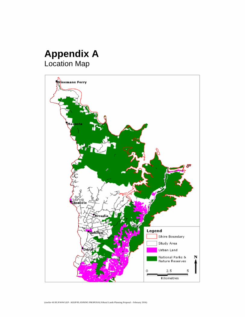
Appendix A Location Map
(rawlin~H:\PLN\WW\LEP - KEEP\PLANNING PROPOSALS\Rural Lands Planning Proposal – February 2016)
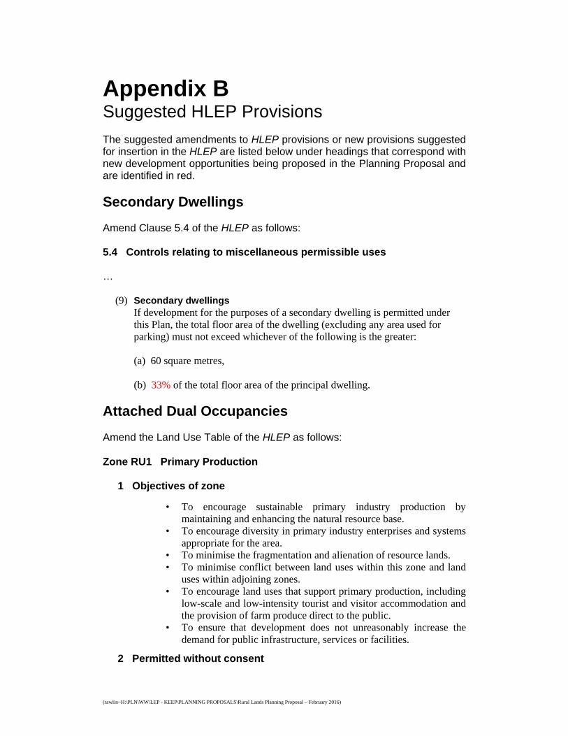
Appendix B Suggested HLEP Provisions The suggested amendments to HLEP provisions or new provisions suggested for insertion in the HLEP are listed below under headings that correspond with new development opportunities being proposed in the Planning Proposal and are identified in red.
Secondary Dwellings Amend Clause 5.4 of the HLEP as follows: 5.4 Controls relating to miscellaneous permissible uses …
(9) Secondary dwellings
If development for the purposes of a secondary dwelling is permitted under this Plan, the total floor area of the dwelling (excluding any area used for parking) must not exceed whichever of the following is the greater:
(a) 60 square metres, (b) 33% of the total floor area of the principal dwelling.
Attached Dual Occupancies
Amend the Land Use Table of the HLEP as follows:
Zone RU1 Primary Production
1 Objectives of zone
• To encourage sustainable primary industry production by maintaining and enhancing the natural resource base.
• To encourage diversity in primary industry enterprises and systems appropriate for the area.
• To minimise the fragmentation and alienation of resource lands. • To minimise conflict between land uses within this zone and land
uses within adjoining zones. • To encourage land uses that support primary production, including
low-scale and low-intensity tourist and visitor accommodation and the provision of farm produce direct to the public.
• To ensure that development does not unreasonably increase the demand for public infrastructure, services or facilities.
2 Permitted without consent
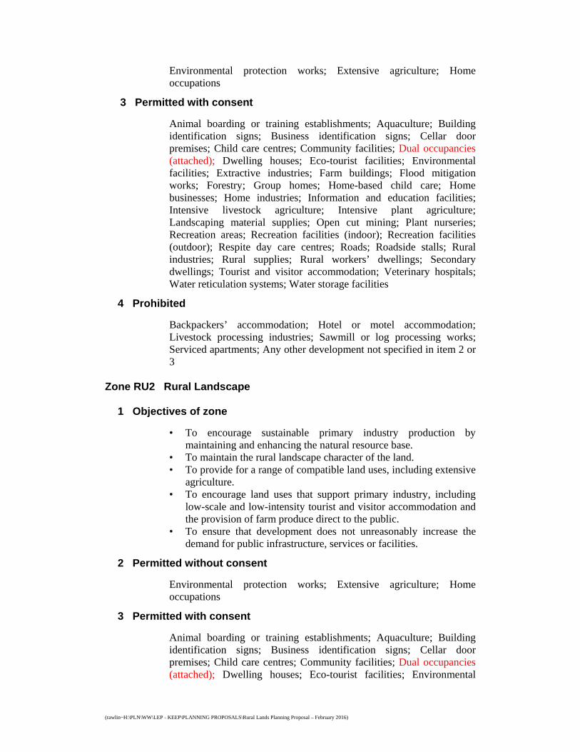
(rawlin~H:\PLN\WW\LEP - KEEP\PLANNING PROPOSALS\Rural Lands Planning Proposal – February 2016)
Environmental protection works; Extensive agriculture; Home occupations
3 Permitted with consent
Animal boarding or training establishments; Aquaculture; Building identification signs; Business identification signs; Cellar door premises; Child care centres; Community facilities; Dual occupancies (attached); Dwelling houses; Eco-tourist facilities; Environmental facilities; Extractive industries; Farm buildings; Flood mitigation works; Forestry; Group homes; Home-based child care; Home businesses; Home industries; Information and education facilities; Intensive livestock agriculture; Intensive plant agriculture; Landscaping material supplies; Open cut mining; Plant nurseries; Recreation areas; Recreation facilities (indoor); Recreation facilities (outdoor); Respite day care centres; Roads; Roadside stalls; Rural industries; Rural supplies; Rural workers’ dwellings; Secondary dwellings; Tourist and visitor accommodation; Veterinary hospitals; Water reticulation systems; Water storage facilities
4 Prohibited
Backpackers’ accommodation; Hotel or motel accommodation; Livestock processing industries; Sawmill or log processing works; Serviced apartments; Any other development not specified in item 2 or 3
Zone RU2 Rural Landscape
1 Objectives of zone
• To encourage sustainable primary industry production by maintaining and enhancing the natural resource base.
• To maintain the rural landscape character of the land. • To provide for a range of compatible land uses, including extensive
agriculture. • To encourage land uses that support primary industry, including
low-scale and low-intensity tourist and visitor accommodation and the provision of farm produce direct to the public.
• To ensure that development does not unreasonably increase the demand for public infrastructure, services or facilities.
2 Permitted without consent
Environmental protection works; Extensive agriculture; Home occupations
3 Permitted with consent
Animal boarding or training establishments; Aquaculture; Building identification signs; Business identification signs; Cellar door premises; Child care centres; Community facilities; Dual occupancies (attached); Dwelling houses; Eco-tourist facilities; Environmental
(rawlin~H:\PLN\WW\LEP - KEEP\PLANNING PROPOSALS\Rural Lands Planning Proposal – February 2016)
facilities; Extractive industries; Farm buildings; Flood mitigation works; Forestry; Garden centres; Group homes; Home-based child care; Home businesses; Home industries; Information and education facilities; Intensive livestock agriculture; Intensive plant agriculture; Landscaping material supplies; Open cut mining; Places of public worship; Plant nurseries; Recreation areas; Recreation facilities (indoor); Recreation facilities (outdoor); Respite day care centres; Roads; Roadside stalls; Rural industries; Rural supplies; Rural workers’ dwellings; Secondary dwellings; Tourist and visitor accommodation; Veterinary hospitals; Water reticulation systems; Water storage facilities
4 Prohibited
Backpackers’ accommodation; Hotel or motel accommodation; Livestock processing industries; Sawmill or log processing works; Serviced apartments; Stock and sale yards; Any other development not specified in item 2 or 3
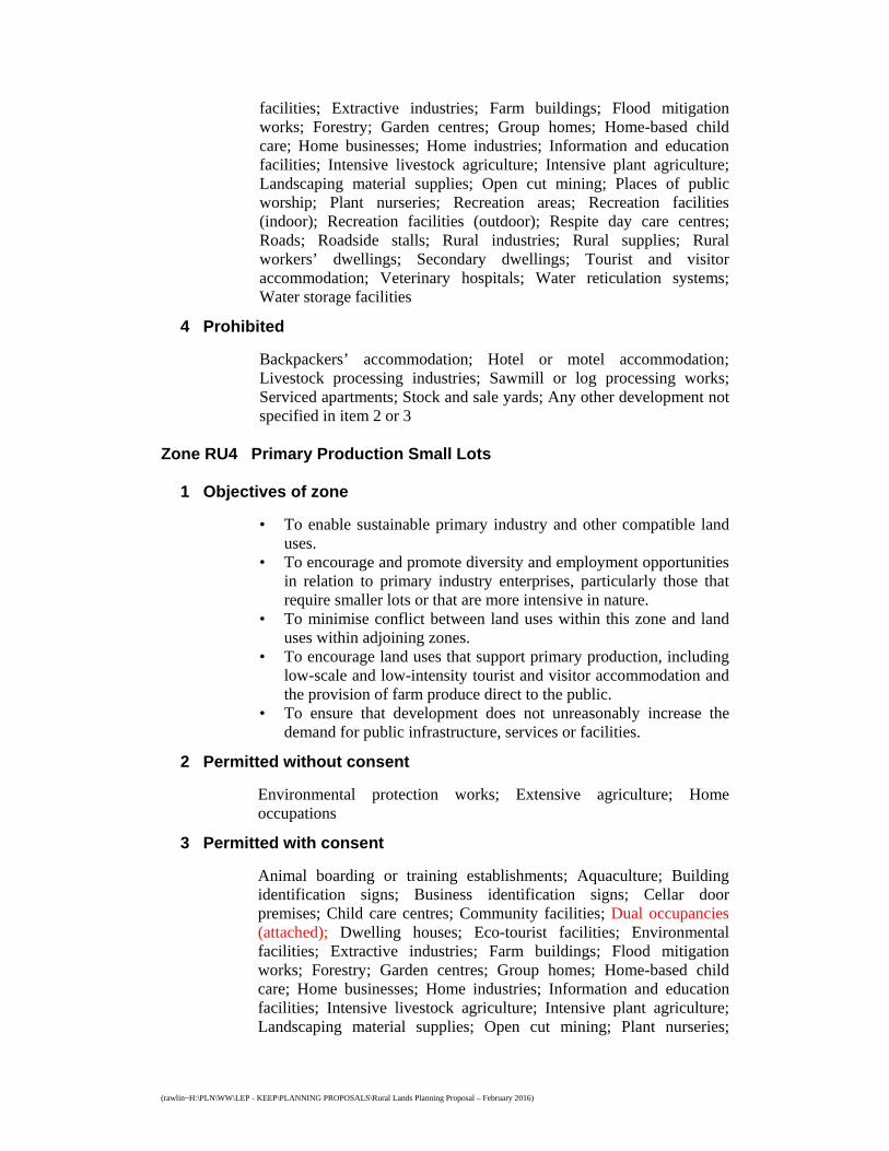
Zone RU4 Primary Production Small Lots
1 Objectives of zone
• To enable sustainable primary industry and other compatible land uses.
• To encourage and promote diversity and employment opportunities in relation to primary industry enterprises, particularly those that require smaller lots or that are more intensive in nature.
• To minimise conflict between land uses within this zone and land uses within adjoining zones.
• To encourage land uses that support primary production, including low-scale and low-intensity tourist and visitor accommodation and the provision of farm produce direct to the public.
• To ensure that development does not unreasonably increase the demand for public infrastructure, services or facilities.
2 Permitted without consent
Environmental protection works; Extensive agriculture; Home occupations
3 Permitted with consent
Animal boarding or training establishments; Aquaculture; Building identification signs; Business identification signs; Cellar door premises; Child care centres; Community facilities; Dual occupancies (attached); Dwelling houses; Eco-tourist facilities; Environmental facilities; Extractive industries; Farm buildings; Flood mitigation works; Forestry; Garden centres; Group homes; Home-based child care; Home businesses; Home industries; Information and education facilities; Intensive livestock agriculture; Intensive plant agriculture; Landscaping material supplies; Open cut mining; Plant nurseries;
(rawlin~H:\PLN\WW\LEP - KEEP\PLANNING PROPOSALS\Rural Lands Planning Proposal – February 2016)
Recreation areas; Recreation facilities (indoor); Recreation facilities (outdoor); Respite day care centres; Roads; Roadside stalls; Rural industries; Rural supplies; Rural workers’ dwellings; Secondary dwellings; Tourist and visitor accommodation; Veterinary hospitals; Water reticulation systems; Water storage facilities
4 Prohibited
Backpackers’ accommodation; Hotel or motel accommodation; Livestock processing industries; Sawmill or log processing works; Serviced apartments; Stock and sale yards; Any other development not specified in item 2 or 3
Insert Clause 4.2B into the HLEP as follows:
4.2B Minimum lot sizes for the erection of dual occupancies (attached) on land in certain rural zones
(1) The objective of this clause is to minimise unplanned rural residential development.
(2) This clause applies to land in the following zones:
(a) Zone RU1 Primary Production, (b) Zone RU2 Rural Landscape, (c) Zone RU4 Primary Production.
(3) Development consent must not be granted for the erection of a dual occupancy
(attached) on land to which this clause applies unless the land is a lot that is at least the minimum lot size shown on the Lot Size Map in relation to that land.
Insert Clause 6.8 into the HLEP as follows:
6.8 Maximum gross floor area of dual occupancies (attached) on land in certain in rural zones
(1) The objective of this clause is to limit the gross floor area of dual occupancies (attached) to ensure such rural residential development maintains rural character.
(2) This clause applies to land in the following zones:
(a) Zone RU1 Primary Production, (b) Zone RU2 Rural Landscape, (c) Zone RU4 Primary Production.
(3) Development consent must not be granted to development for the purposes of
a dual occupancy (attached) on land to which this clause applies unless the gross floor area of at least one of the dwellings is not more than 200 square metres.

(rawlin~H:\PLN\WW\LEP - KEEP\PLANNING PROPOSALS\Rural Lands Planning Proposal – February 2016)
Roadside Stalls Amend Clause 5.4 of the HLEP as follows: 5.4 Controls relating to miscellaneous permissible uses …
(8) Roadside stalls If development for the purposes of a roadside stall is permitted under this Plan, the gross floor area must not exceed 40 square metres.
Split Zone Lot Controls Amend Clause 4.1B of the HLEP as follows:
4.1B Minimum lot size for certain split zone lots
(1) The objectives of this clause are as follows: (a) to provide for the subdivision of lots that are within more than one zone
but cannot be subdivided under clauses 4.1, 4.1AA or 4.1A, (b) to ensure that the subdivision occurs in a manner that promotes suitable
land use and development.
(2) This clause applies to each lot (an original lot) that contains: (a) land in a rural, residential, business, industrial, special purpose or
recreation zone, and (b) land in Zone E2 Environmental Conservation or Zone E3 Environmental
Management.
(3) Despite clauses 4.1, 4.1AA and 4.1A, development consent may be granted to subdivide an original lot to create other lots (the resulting lots) if: (a) each resulting lot containing land only in Zone RU1 Primary Production,
RU2, Rural Landscape or Zone RU4 Primary Production Small Lots will have an area that is not less than the minimum size shown on the Lot Size Map in relation to that land, and
(b) each resulting lot containing land only in Zone E3 Environmental Management will have an area that is not less than the minimum lot size shown on the Lot Size Map in relation to that land, and
(c) each resulting lot containing land in both Zone RU1 Primary Production, RU2, Rural Landscape or Zone RU4 Primary Production Small Lots and Zone E3 Environmental Management will have: (i) at least 20% of the land in the lot in Zone RU1 Primary Production,
RU2, Rural Landscape or Zone RU4 Primary Production Small Lots, and
(ii) an area that is not less than the minimum size shown on the Lot Size Map in relation to the land in Zone RU1 Primary Production, RU2, Rural Landscape or Zone RU4 Primary Production Small Lots.
(rawlin~H:\PLN\WW\LEP - KEEP\PLANNING PROPOSALS\Rural Lands Planning Proposal – February 2016)
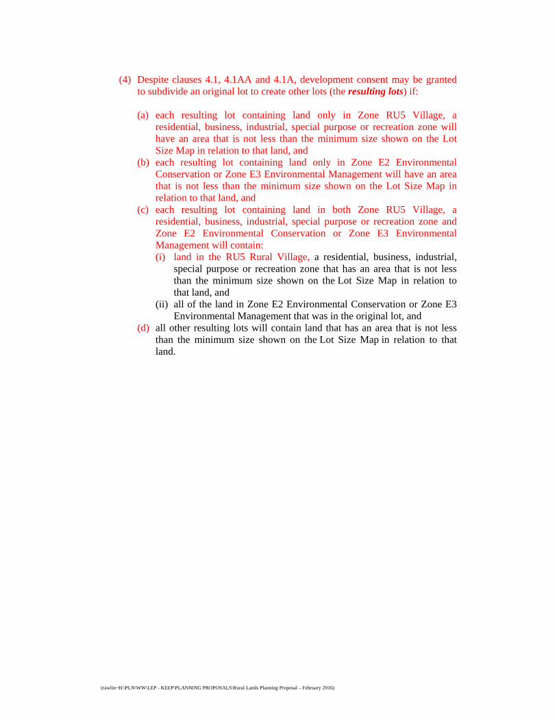
(4) Despite clauses 4.1, 4.1AA and 4.1A, development consent may be granted
to subdivide an original lot to create other lots (the resulting lots) if: (a) each resulting lot containing land only in Zone RU5 Village, a
residential, business, industrial, special purpose or recreation zone will have an area that is not less than the minimum size shown on the Lot Size Map in relation to that land, and
(b) each resulting lot containing land only in Zone E2 Environmental Conservation or Zone E3 Environmental Management will have an area that is not less than the minimum size shown on the Lot Size Map in relation to that land, and
(c) each resulting lot containing land in both Zone RU5 Village, a residential, business, industrial, special purpose or recreation zone and Zone E2 Environmental Conservation or Zone E3 Environmental Management will contain: (i) land in the RU5 Rural Village, a residential, business, industrial,
special purpose or recreation zone that has an area that is not less than the minimum size shown on the Lot Size Map in relation to that land, and
(ii) all of the land in Zone E2 Environmental Conservation or Zone E3 Environmental Management that was in the original lot, and
(d) all other resulting lots will contain land that has an area that is not less than the minimum size shown on the Lot Size Map in relation to that land.
(rawlin~H:\PLN\WW\LEP - KEEP\PLANNING PROPOSALS\Rural Lands Planning Proposal – February 2016)
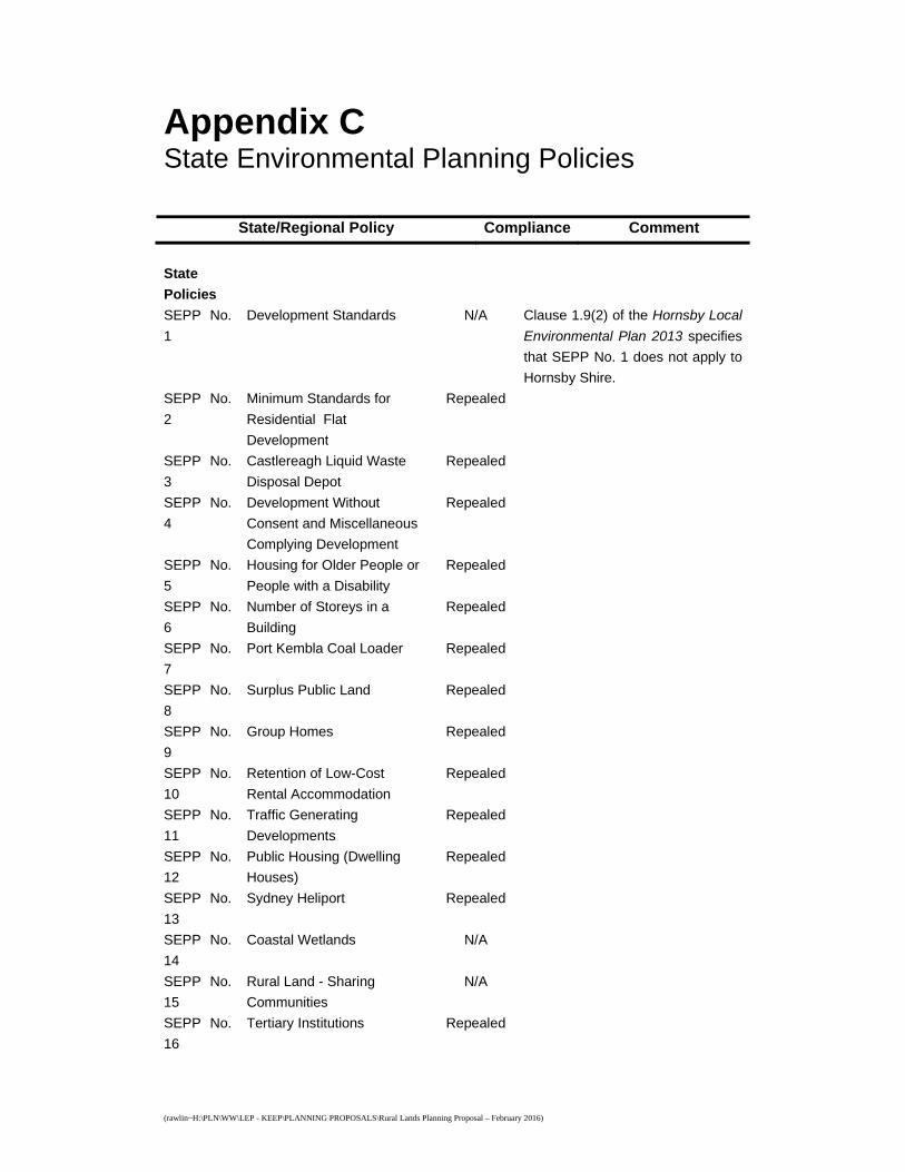
Appendix C
State Environmental Planning Policies
State/Regional Policy Compliance Comment
State
Policies
SEPP No.
1
Development Standards N/A Clause 1.9(2) of the Hornsby Local
Environmental Plan 2013 specifies
that SEPP No. 1 does not apply to
Hornsby Shire.
SEPP No.
2
Minimum Standards for
Residential Flat
Development
Repealed
SEPP No.
3
Castlereagh Liquid Waste
Disposal Depot
Repealed
SEPP No.
4
Development Without
Consent and Miscellaneous
Complying Development
Repealed
SEPP No.
5
Housing for Older People or
People with a Disability
Repealed
SEPP No.
6
Number of Storeys in a
Building
Repealed
SEPP No.
7
Port Kembla Coal Loader Repealed
SEPP No.
8
Surplus Public Land Repealed
SEPP No.
9
Group Homes Repealed
SEPP No.
10
Retention of Low-Cost
Rental Accommodation
Repealed
SEPP No.
11
Traffic Generating
Developments
Repealed
SEPP No.
12
Public Housing (Dwelling
Houses)
Repealed
SEPP No.
13
Sydney Heliport Repealed
SEPP No.
14
Coastal Wetlands N/A
SEPP No.
15
Rural Land - Sharing
Communities
N/A
SEPP No.
16
Tertiary Institutions Repealed
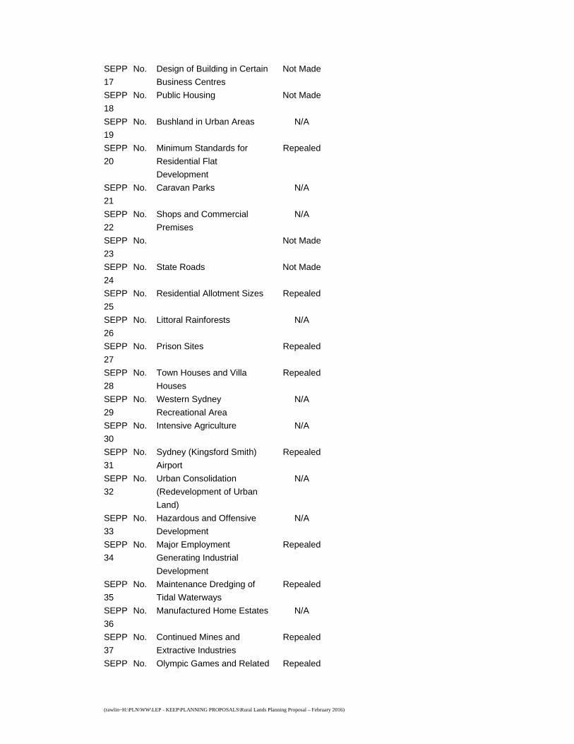
(rawlin~H:\PLN\WW\LEP - KEEP\PLANNING PROPOSALS\Rural Lands Planning Proposal – February 2016)
SEPP No.
17
Design of Building in Certain
Business Centres
Not Made
SEPP No.
18
Public Housing Not Made
SEPP No.
19
Bushland in Urban Areas N/A
SEPP No.
20
Minimum Standards for
Residential Flat
Development
Repealed
SEPP No.
21
Caravan Parks N/A
SEPP No.
22
Shops and Commercial
Premises
N/A
SEPP No.
23
Not Made
SEPP No.
24
State Roads Not Made
SEPP No.
25
Residential Allotment Sizes Repealed
SEPP No.
26
Littoral Rainforests N/A
SEPP No.
27
Prison Sites Repealed
SEPP No.
28
Town Houses and Villa
Houses
Repealed
SEPP No.
29
Western Sydney
Recreational Area
N/A
SEPP No.
30
Intensive Agriculture N/A
SEPP No.
31
Sydney (Kingsford Smith)
Airport
Repealed
SEPP No.
32
Urban Consolidation
(Redevelopment of Urban
Land)
N/A
SEPP No.
33
Hazardous and Offensive
Development
N/A
SEPP No.
34
Major Employment
Generating Industrial
Development
Repealed
SEPP No.
35
Maintenance Dredging of
Tidal Waterways
Repealed
SEPP No.
36
Manufactured Home Estates N/A
SEPP No.
37
Continued Mines and
Extractive Industries
Repealed
SEPP No. Olympic Games and Related Repealed

(rawlin~H:\PLN\WW\LEP - KEEP\PLANNING PROPOSALS\Rural Lands Planning Proposal – February 2016)
38 Development Proposals
SEPP No.
39
Spit Island Bird Habitat N/A
SEPP No.
40
Sewerage Works Not Made
SEPP No.
41
Casino/Entertainment
Complex
Repealed
SEPP No.
42
Multiple Occupancy and
Rural Land (Repeal)
Repealed
SEPP No.
43
New Southern Railway Repealed
SEPP No.
44
Koala Habitat Protection Consistent The Planning Proposal does not
detrimentally impact on core koala
habitat areas as it does not remove
or modify environmental protection
zones and/or controls. Any
development application resultant
of the development opportunities
introduced by the Planning
Proposal would need to be
considered by Council having
regard to the SEPP prior to
consent being granted.
SEPP No.
45
Permissibility of Mining Repealed
SEPP No.
46
Protection and Management
of Native Vegetation
Repealed
SEPP No.
47
Moore Park Showground N/A
SEPP No.
48
Major Putrescible Landfill
Sites
Repealed
SEPP No.
49
Tourism Accommodation in
Private Homes
Repealed
SEPP No.
50
Canal Estate Development N/A
SEPP No.
51
Eastern Distributor Repealed
SEPP No.
52
Farm Dams and Other
Works in Land and Water
Management Plan Areas
N/A
SEPP No.
53
Metropolitan Residential
Development
Repealed
SEPP No.
54
Northside Storage Tunnel Repealed
SEPP No.
55
Remediation of Land Consistent The Planning Proposal would not
effect a change in the use of the
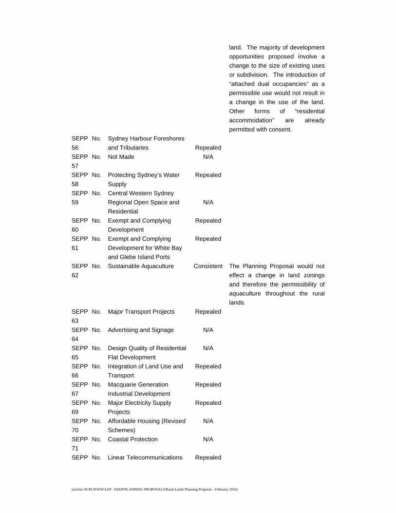
(rawlin~H:\PLN\WW\LEP - KEEP\PLANNING PROPOSALS\Rural Lands Planning Proposal – February 2016)
land. The majority of development
opportunities proposed involve a
change to the size of existing uses
or subdivision. The introduction of
“attached dual occupancies” as a
permissible use would not result in
a change in the use of the land.
Other forms of “residential
accommodation” are already
permitted with consent.
SEPP No.
56
Sydney Harbour Foreshores
and Tributaries
Repealed
SEPP No.
57
Not Made N/A
SEPP No.
58
Protecting Sydney’s Water
Supply
Repealed
SEPP No.
59
Central Western Sydney
Regional Open Space and
Residential
N/A
SEPP No.
60
Exempt and Complying
Development
Repealed
SEPP No.
61
Exempt and Complying
Development for White Bay
and Glebe Island Ports
Repealed
SEPP No.
62
Sustainable Aquaculture Consistent The Planning Proposal would not
effect a change in land zonings
and therefore the permissibility of
aquaculture throughout the rural
lands.
SEPP No.
63
Major Transport Projects Repealed
SEPP No.
64
Advertising and Signage N/A
SEPP No.
65
Design Quality of Residential
Flat Development
N/A
SEPP No.
66
Integration of Land Use and
Transport
Repealed
SEPP No.
67
Macquarie Generation
Industrial Development
Repealed
SEPP No.
69
Major Electricity Supply
Projects
Repealed
SEPP No.
70
Affordable Housing (Revised
Schemes)
N/A
SEPP No.
71
Coastal Protection N/A
SEPP No. Linear Telecommunications Repealed
(rawlin~H:\PLN\WW\LEP - KEEP\PLANNING PROPOSALS\Rural Lands Planning Proposal – February 2016)
72 Development – Broadband
SEPP No.
73
Kosciusko Ski Resorts N/A
SEPP No.
74
Newcastle Port and
Employment Lands
N/A
SEPP
2004
Seniors Living Repealed
SEPP
2004
Housing for Seniors or
People with a Disability
N/A
SEPP
2004
Building Sustainability Index:
BASIX
N/A
SEPP
2004
ARTC Rail Infrastructure Repealed
SEPP
2004
Sydney Metropolitan Water
Supply
Repealed
SEPP
2005
Development on Kurnell
Peninsula
N/A
SEPP
2005
Major Development N/A
SEPP
2005
State Significant
Development
Repealed
SEPP
2006
Sydney Region Growth
Centres
N/A
SEPP
2007
Mining, Petroleum
Production and Extractive
Industries
Consistent The Planning Proposal would not
effect a change in land zonings
and therefore the permissibility of
open cut mining and/or extractive
industries throughout the rural
lands.
SEPP
2007
Temporary Structure and
Places of Public
Entertainment
Repealed
SEPP
2007
Infrastructure Consistent The Planning Proposal would not
effect a change in land zonings
and therefore the permissibility of
any development permitted by the
Infrastructure SEPP throughout the
rural lands.
SEPP
2007
Kosciuszko National Park -
Alpine Resorts
N/A
SEPP
2008
Rural Lands N/A
SEPP
2008
Exempt and Complying
Development Codes
Consistent The Planning Proposal would not
effect a change in land zonings
and therefore the permissibility of
any development permitted by the

(rawlin~H:\PLN\WW\LEP - KEEP\PLANNING PROPOSALS\Rural Lands Planning Proposal – February 2016)
Exempt and Complying
Development Codes SEPP
throughout the rural lands.
SEPP
2009
Western Sydney Parklands N/A
SEPP
2009
Affordable Rental Housing N/A
SEPP
2009
Western Sydney
Employment Area
N/A
SEPP Sewerage Works Repealed
SEPP Subdivision Repealed
SEPP
2004
Application of Development
Standards
Repealed
Regional
Plans
(deemed
SEPPs)
SREP No.
1
Dual Occupancy Repealed
SREP No.
2
Dual Occupancy Repealed
SREP No.
3
Kurnell Peninsula Repealed
SREP No.
4
Homebush Bay Repealed
SREP No.
5
Chatswood Town Centre Repealed
SREP No.
6
Gosford Coastal Areas Repealed
SREP No.
7
Multi-Unit Housing - Surplus
Government Sites
Repealed
SREP No.
8
Central Coast Plateau Areas N/A
SREP No.
9
Extractive Industry (No. 2) Consistent The Planning Proposal would not
effect a change in the permissibility
of “extractive industries” or matters
for consideration for extractive
industry development proposals
throughout the Maroota Sandstone
Resource Area. The Planning
Proposal would not effect a change
in the minimum 10ha lot sizes of
rural zoned lands in the Maroota
Sandstone Resource Area. Split
zoned lots, including part Rural and
part E3 Environmental
(rawlin~H:\PLN\WW\LEP - KEEP\PLANNING PROPOSALS\Rural Lands Planning Proposal – February 2016)
Management zoned lands in the
Maroota Sandstone Resource Area
will still need to achieve a minimum
total 10ha lot size. Accordingly,
consistent with the SREP, the
Planning Proposal would not
change subdivision controls to
necessitate a residential building to
be constructed within 50 metres of
a road providing access to a
quarry. Any subdivision proposal
would be considered on its merits
at the development application
stage.
SREP No.
10
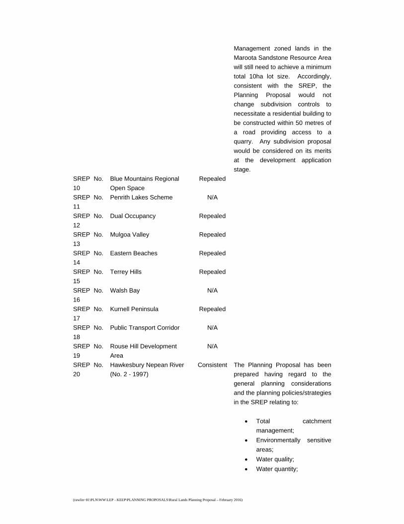
Blue Mountains Regional
Open Space
Repealed
SREP No.
11
Penrith Lakes Scheme N/A
SREP No.
12
Dual Occupancy Repealed
SREP No.
13
Mulgoa Valley Repealed
SREP No.
14
Eastern Beaches Repealed
SREP No.
15
Terrey Hills Repealed
SREP No.
16
Walsh Bay N/A
SREP No.
17
Kurnell Peninsula Repealed
SREP No.
18
Public Transport Corridor N/A
SREP No.
19
Rouse Hill Development
Area
N/A
SREP No.
20
Hawkesbury Nepean River
(No. 2 - 1997)
Consistent The Planning Proposal has been
prepared having regard to the
general planning considerations
and the planning policies/strategies
in the SREP relating to:
Total catchment
management;
Environmentally sensitive
areas;
Water quality;
Water quantity;
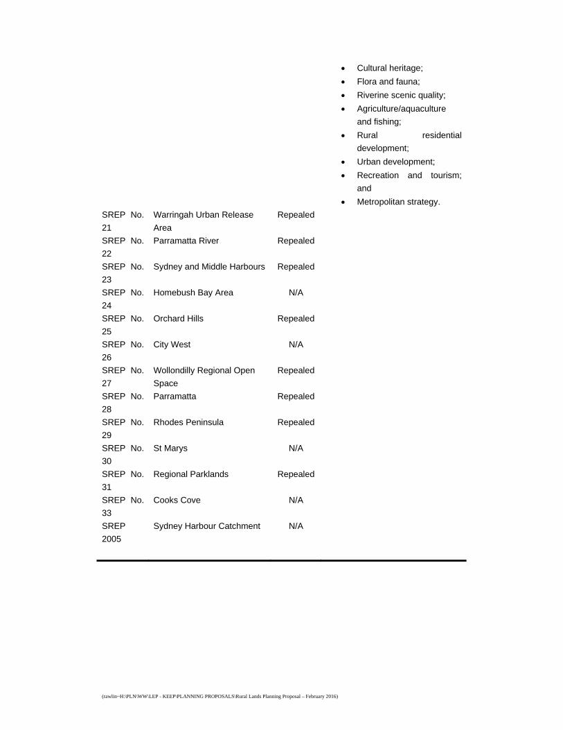
(rawlin~H:\PLN\WW\LEP - KEEP\PLANNING PROPOSALS\Rural Lands Planning Proposal – February 2016)
Cultural heritage;
Flora and fauna;
Riverine scenic quality;
Agriculture/aquaculture
and fishing;
Rural residential
development;
Urban development;
Recreation and tourism;
and
Metropolitan strategy.
SREP No.
21
Warringah Urban Release
Area
Repealed
SREP No.
22
Parramatta River Repealed
SREP No.
23
Sydney and Middle Harbours Repealed
SREP No.
24
Homebush Bay Area N/A
SREP No.
25
Orchard Hills Repealed
SREP No.
26
City West N/A
SREP No.
27
Wollondilly Regional Open
Space
Repealed
SREP No.
28
Parramatta Repealed
SREP No.
29
Rhodes Peninsula Repealed
SREP No.
30
St Marys N/A
SREP No.
31
Regional Parklands Repealed
SREP No.
33
Cooks Cove N/A
SREP
2005
Sydney Harbour Catchment N/A
(rawlin~H:\PLN\WW\LEP - KEEP\PLANNING PROPOSALS\Rural Lands Planning Proposal – February 2016)
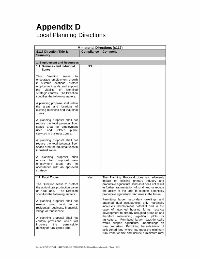
Appendix D Local Planning Directions
Ministerial Directions (s117) S117 Direction Title & Summary
Compliance Comment
1. Employment and Resources 1.1 Business and Industrial
Zones This Direction seeks to encourage employment growth in suitable locations, protect employment lands and support the viability of identified strategic centres. The Direction specifies the following matters. A planning proposal shall retain the areas and locations of existing business and industrial zones. A planning proposal shall not reduce the total potential floor space area for employment uses and related public services in business zones. A planning proposal shall not reduce the total potential floor space area for industrial uses in industrial zones. A planning proposal shall ensure that proposed new employment areas are in accordance with an approved strategy.
N/A
1.2 Rural Zones The Direction seeks to protect the agricultural production value of rural land. The Direction specifies the following matters. A planning proposal shall not rezone rural land to a residential, business, industrial, village or tourist zone. A planning proposal shall not contain provisions which will increase the permissible density of rural zoned land.
Yes The Planning Proposal does not adversely impact on existing primary industry and productive agricultural land as it does not result in further fragmentation of rural land or reduce the ability of the land to support potentially productive agricultural land uses in the future.
Permitting larger secondary dwellings and attached dual occupancies only marginally increases development potential and in the case of attached housing forms, restricts development to already occupied areas of land therefore maintaining significant plots for agriculture. Permitting larger roadside stalls would support agricultural undertakings on rural properties. Permitting the subdivision of split zoned land where lots meet the minimum rural zone lot size and include a minimum rural
(rawlin~H:\PLN\WW\LEP - KEEP\PLANNING PROPOSALS\Rural Lands Planning Proposal – February 2016)
zone parcel of at least 20% the minimum rural zone lot size would, in the case of the 10 hectare minimum (i.e. 2 hectare parcels), retain adequate lands for viable agricultural undertakings and in the case of the 2 hectare minimum (i.e. 1 acre parcels), promote rural/residential development on lands that already have limited potential for agricultural undertakings.
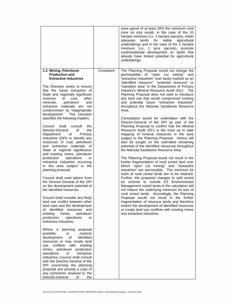
1.3 Mining, Petroleum
Production and Extractive Industries
The Direction seeks to ensure that the future extraction of State and regionally significant reserves of coal, other minerals, petroleum and extractive materials are not compromised by inappropriate development. The Direction specifies the following matters. Council shall consult the Director-General of the Department of Primary Industries (DPI) to identify any resources of coal, petroleum and extractive materials of State or regional significance and existing mines, petroleum production operations or extractive industries occurring in the area subject to the planning proposal. Council shall seek advice from the Director-General of the DPI on the development potential of the identified resources. Council shall consider any likely land use conflict between other land uses and the development of identified resources and existing mines, petroleum production operations or extractive industries. Where a planning proposal prohibits or restricts development of identified resources or may create land use conflicts with existing mines, petroleum production operations or extractive industries, Council shall consult with the Director-General of the DPI concerning the planning proposal and provide a copy of any comments received to the Director-General of the
Consistent The Planning Proposal would not change the permissibility of “open cut mining” and “extractive industries” over lands marked as an “identified resource”, “potential resource” or “transition area” in the Department of Primary Industry’s Mineral Resource Audit 2011. The Planning Proposal does not seek to introduce any land use that would compromise existing and potential future “extractive industries” throughout the Maroota Sandstone Resource Area. Consultation would be undertaken with the Director-General of the DPI as part of the Planning Proposal to confirm that the Mineral Resource Audit 2011 is the most up to date mapping of mineral resources in the area subject to the Planning Proposal. Advice will also be sought on the estimated remaining potential of the identified resources throughout the Maroota Sandstone Resource Area. The Planning Proposal would not result in the further fragmentation of rural zoned land over which “open cut mining” and “extractive industries” are permissible. The minimum lot sizes of rural zoned lands are to be retained. Further, the proposed changes to split zoned lot controls to include E3 Environmental Management zoned lands in the calculation will not reduce the underlying minimum lot size of rural zoned lands. Accordingly, the Planning Proposal would not result in the further fragmentation of resource lands and therefore restrict the development of identified resources or create land use conflicts with existing mines and extractive industries.
(rawlin~H:\PLN\WW\LEP - KEEP\PLANNING PROPOSALS\Rural Lands Planning Proposal – February 2016)
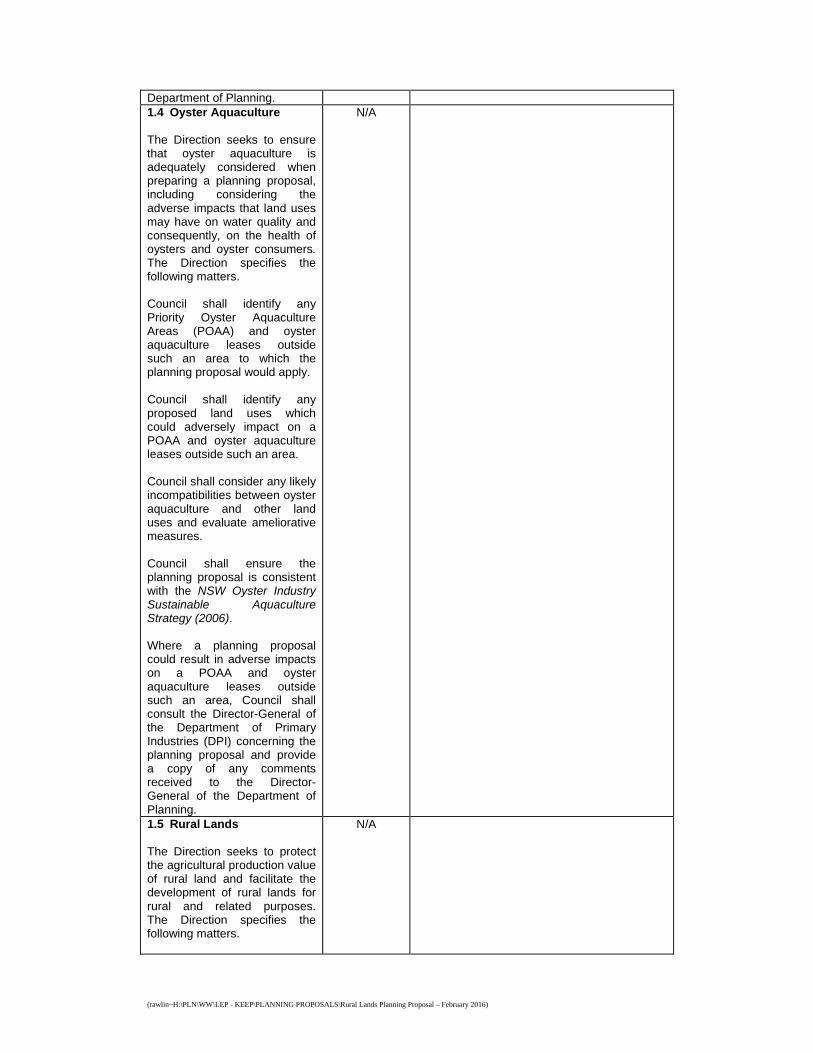
Department of Planning. 1.4 Oyster Aquaculture The Direction seeks to ensure that oyster aquaculture is adequately considered when preparing a planning proposal, including considering the adverse impacts that land uses may have on water quality and consequently, on the health of oysters and oyster consumers. The Direction specifies the following matters. Council shall identify any Priority Oyster Aquaculture Areas (POAA) and oyster aquaculture leases outside such an area to which the planning proposal would apply. Council shall identify any proposed land uses which could adversely impact on a POAA and oyster aquaculture leases outside such an area. Council shall consider any likely incompatibilities between oyster aquaculture and other land uses and evaluate ameliorative measures. Council shall ensure the planning proposal is consistent with the NSW Oyster Industry Sustainable Aquaculture Strategy (2006). Where a planning proposal could result in adverse impacts on a POAA and oyster aquaculture leases outside such an area, Council shall consult the Director-General of the Department of Primary Industries (DPI) concerning the planning proposal and provide a copy of any comments received to the Director-General of the Department of Planning.
N/A
1.5 Rural Lands The Direction seeks to protect the agricultural production value of rural land and facilitate the development of rural lands for rural and related purposes. The Direction specifies the following matters.
N/A
(rawlin~H:\PLN\WW\LEP - KEEP\PLANNING PROPOSALS\Rural Lands Planning Proposal – February 2016)
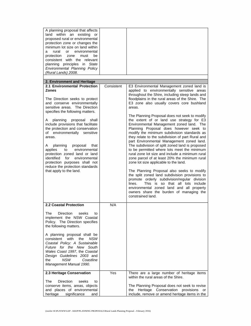
A planning proposal that affects land within an existing or proposed rural or environmental protection zone or changes the minimum lot size on land within a rural or environmental protection zone must be consistent with the relevant planning principles in State Environmental Planning Policy (Rural Lands) 2008. 2. Environment and Heritage 2.1 Environmental Protection Zones The Direction seeks to protect and conserve environmentally sensitive areas. The Direction specifies the following matters. A planning proposal shall include provisions that facilitate the protection and conservation of environmentally sensitive areas. A planning proposal that applies to environmental protection zoned land or land identified for environmental protection purposes shall not reduce the protection standards that apply to the land.
Consistent E3 Environmental Management zoned land is applied to environmentally sensitive areas throughout the Shire, including steep lands and floodplains in the rural areas of the Shire. The E3 zone also usually covers core bushland areas. The Planning Proposal does not seek to modify the extent of or land use strategy for E3 Environmental Management zoned land. The Planning Proposal does however seek to modify the minimum subdivision standards as they relate to the subdivision of part Rural and part Environmental Management zoned land. The subdivision of split zoned land is proposed to be permitted where lots meet the minimum rural zone lot size and include a minimum rural zone parcel of at least 20% the minimum rural zone lot size applicable to the land. The Planning Proposal also seeks to modify the split zoned land subdivision provisions to promote orderly subdivision/regular division lines. This is so that all lots include environmental zoned land and all property owners share the burden of managing the constrained land.
2.2 Coastal Protection The Direction seeks to implement the NSW Coastal Policy. The Direction specifies the following matters. A planning proposal shall be consistent with the NSW Coastal Policy: A Sustainable Future for the New South Wales Coast 1997, the Coastal Design Guidelines 2003 and the NSW Coastline Management Manual 1990.
N/A
2.3 Heritage Conservation The Direction seeks to conserve items, areas, objects and places of environmental heritage significance and
Yes There are a large number of heritage items within the rural areas of the Shire. The Planning Proposal does not seek to revise the Heritage Conservation provisions or include, remove or amend heritage items in the
(rawlin~H:\PLN\WW\LEP - KEEP\PLANNING PROPOSALS\Rural Lands Planning Proposal – February 2016)
indigenous heritage significance. The Direction specifies the following matters. A planning proposal shall contain provisions to facilitate the conservation of items, places, buildings, works, relics, moveable objects or precincts of environmental heritage significance. A planning proposal shall contain provisions that facilitate the conservation of areas, places, landscapes and objects identified of being of Aboriginal heritage significance.
HLEP.
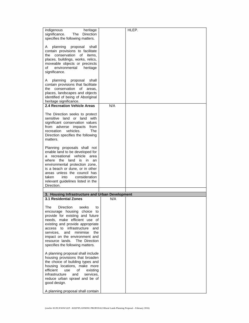
2.4 Recreation Vehicle Areas The Direction seeks to protect sensitive land or land with significant conservation values from adverse impacts from recreation vehicles. The Direction specifies the following matters. Planning proposals shall not enable land to be developed for a recreational vehicle area where the land is in an environmental protection zone, is a beach or dune, or in other areas unless the council has taken into consideration relevant guidelines listed in the Direction.
N/A
3. Housing Infrastructure and Urban Development 3.1 Residential Zones The Direction seeks to encourage housing choice to provide for existing and future needs, make efficient use of existing and provide appropriate access to infrastructure and services, and minimise the impact on the environment and resource lands. The Direction specifies the following matters. A planning proposal shall include housing provisions that broaden the choice of building types and housing locations, make more efficient use of existing infrastructure and services, reduce urban sprawl and be of good design. A planning proposal shall contain
N/A
(rawlin~H:\PLN\WW\LEP - KEEP\PLANNING PROPOSALS\Rural Lands Planning Proposal – February 2016)
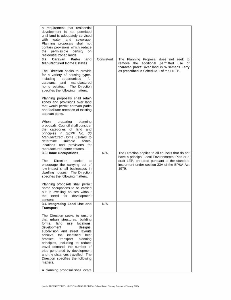
a requirement that residential development is not permitted until land is adequately serviced with water and sewerage. Planning proposals shall not contain provisions which reduce the permissible density on residential zoned lands. 3.2 Caravan Parks and Manufactured Home Estates The Direction seeks to provide for a variety of housing types, including opportunities for caravans and manufactured home estates. The Direction specifies the following matters. Planning proposals shall retain zones and provisions over land that would permit caravan parks and facilitate retention of existing caravan parks. When preparing planning proposals, Council shall consider the categories of land and principles in SEPP No. 36 Manufactured Home Estates to determine suitable zones, locations and provisions for manufactured home estates.
Consistent The Planning Proposal does not seek to remove the additional permitted use of “caravan parks” over land in Wisemans Ferry as prescribed in Schedule 1 of the HLEP.
3.3 Home Occupations The Direction seeks to encourage the carrying out of low-impact small businesses in dwelling houses. The Direction specifies the following matters. Planning proposals shall permit home occupations to be carried out in dwelling houses without the need for development consent.
N/A The Direction applies to all councils that do not have a principal Local Environmental Plan or a draft LEP, prepared pursuant to the standard instrument under section 33A of the EP&A Act 1979.
3.4 Integrating Land Use and Transport The Direction seeks to ensure that urban structures, building forms, land use locations, development designs, subdivision and street layouts achieve the identified best practice transport planning principles, including to reduce travel demand, the number of trips generated by development and the distances travelled. The Direction specifies the following matters. A planning proposal shall locate
N/A
(rawlin~H:\PLN\WW\LEP - KEEP\PLANNING PROPOSALS\Rural Lands Planning Proposal – February 2016)
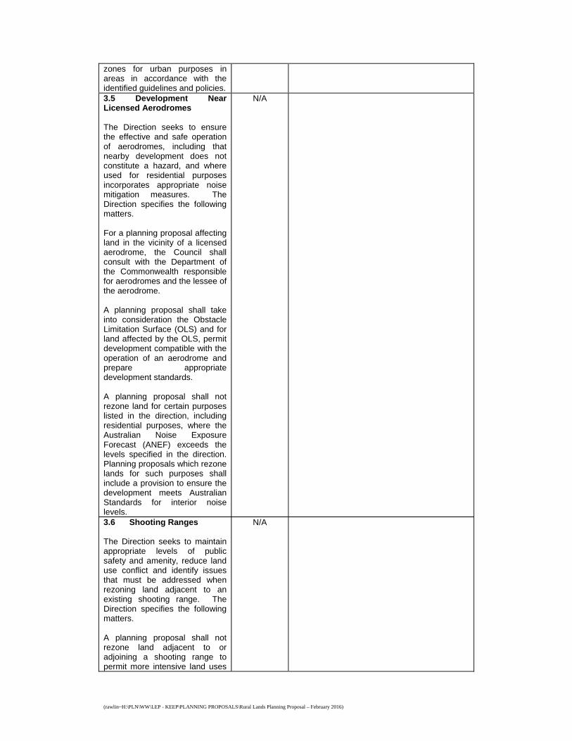
zones for urban purposes in areas in accordance with the identified guidelines and policies. 3.5 Development Near Licensed Aerodromes The Direction seeks to ensure the effective and safe operation of aerodromes, including that nearby development does not constitute a hazard, and where used for residential purposes incorporates appropriate noise mitigation measures. The Direction specifies the following matters. For a planning proposal affecting land in the vicinity of a licensed aerodrome, the Council shall consult with the Department of the Commonwealth responsible for aerodromes and the lessee of the aerodrome. A planning proposal shall take into consideration the Obstacle Limitation Surface (OLS) and for land affected by the OLS, permit development compatible with the operation of an aerodrome and prepare appropriate development standards. A planning proposal shall not rezone land for certain purposes listed in the direction, including residential purposes, where the Australian Noise Exposure Forecast (ANEF) exceeds the levels specified in the direction. Planning proposals which rezone lands for such purposes shall include a provision to ensure the development meets Australian Standards for interior noise levels.
N/A
3.6 Shooting Ranges The Direction seeks to maintain appropriate levels of public safety and amenity, reduce land use conflict and identify issues that must be addressed when rezoning land adjacent to an existing shooting range. The Direction specifies the following matters. A planning proposal shall not rezone land adjacent to or adjoining a shooting range to permit more intensive land uses
N/A
(rawlin~H:\PLN\WW\LEP - KEEP\PLANNING PROPOSALS\Rural Lands Planning Proposal – February 2016)
than those which are permitted under the existing zone, or that are incompatible with the noise emitted by the existing shooting range. 4. Hazard and Risk 4.1 Acid Sulfate Soils The Direction seeks to avoid significant adverse environmental impacts from the use of land that has a probability of containing acid sulphate soils. The Direction specifies the following matters. Council shall consider the Acid Sulfate Soils Planning Guidelines adopted by the Director-General of the Department of Planning when preparing a planning proposal that applies to any land identified on the Acid Sulfate Soils Planning Maps as having a probability of acid sulphate soils being present. Planning proposals that regulate works in acid sulfate soils shall be consistent with the Acid Sulfate Soils Model LEP or such other provisions provided by the Director-General of the Department of Planning. Council shall not prepare a planning proposal that intensifies land uses on land having a probability of containing acid sulfate soils unless an acid sulfate soils study has been undertaken and considered.
Consistent Lands identified as having a probability of containing Acid Sulfate Soils are located in a number of locations within the rural areas of the Shire in or adjacent the Hawkesbury River, Berowra Creek and their tributaries. These lands are zoned either an Environmental or Recreation zone under the HLEP. The Planning Proposal does not seek to modify the extent or land use strategy for these zones.
4.2 Mine Subsidence and Unstable Land The Direction seeks to prevent damage to life, property and the environment on land identified as unstable or potentially subject to mine subsidence. The Direction specifies the following matters. Where the land is subject to mine subsidence, council shall consult the Mine Subsidence Board to ascertain if the Board has any objection to the draft Plan and the appropriateness of the development for the potential level of subsidence.
N/A The Direction applies to all councils that contain a mine subsidence district proclaimed pursuant to section 15 of the Mine Subsidence Compensation Act 1961 or that contain unstable land. Clarification was sought from the Department of Planning in late 2005 as to the meaning of ‘unstable land’. A formal response has not been received. However, a Department representative advised by email 29 November 2005 that unstable land is land that is subject to land slip because of slope and soil/ geological conditions.
(rawlin~H:\PLN\WW\LEP - KEEP\PLANNING PROPOSALS\Rural Lands Planning Proposal – February 2016)
A planning proposal shall only permit development on land within a mine subsidence district of a scale, density and type that is approved by Mine Subsidence Board. A planning proposal shall not permit development on unstable land. 4.3 Flood Prone Land The Direction seeks to ensure that development of flood prone land is consistent with relevant policy and guidelines and that the provisions of a LEP on flood prone land are commensurate with the hazard. The Direction specifies the following matters. A planning proposal shall include provisions that give effect to the NSW Flood Prone Land Policy and are consistent with the Floodplain Development Manual 2005. A planning proposal shall not rezone land within the flood planning areas from Special Use, Special Purpose, Recreation, Rural or Environmental Protection Zones to a Residential, Business, Industrial, Special Use or Special Purpose Zone. A planning proposal shall not permit development in floodway areas, permit development that will significantly impact on other properties, permit a significant increase in development, result in a substantial increase in the need for government spending on flood mitigation or permit development (other than agriculture, roads or exempt development) without the need for consent. A planning proposal shall not impose flood related development controls above the flood planning level for residential development. In preparing a planning proposal, Council shall not determine a flood planning level that is inconsistent with the Floodplain Development Manual 2005.
Consistent Lands in the rural area of the Shire identified as being in the “Flood Planning Area” in the Flood Planning Map of the HLEP are located in the suburbs of Wiseman’s Ferry, Laughtondale, Singleton’s Mill and Canoelands. These lands are zoned either an Environmental or Recreation zone under the HLEP. The Planning Proposal does not seek to rezone or modify the extent of or land use strategy for these zones.
(rawlin~H:\PLN\WW\LEP - KEEP\PLANNING PROPOSALS\Rural Lands Planning Proposal – February 2016)
4.4 Planning for Bushfire Protection The Direction seeks to protect life, property and the environment from bush fire hazards by discouraging incompatible land uses in, and encouraging sound management of, bushfire prone areas. The Direction specifies the following matters. Council shall consult with the Commissioner of the NSW Rural Fire Service in the preparation of any planning proposal following receipt of a gateway determination and prior to undertaking community consultation and take into account any comments made. A planning proposal shall have regard to Planning for Bushfire Protection 2006, avoid permitting inappropriate development in hazardous areas and ensure that hazard reduction is not prohibited in the asset protection zone (APZ). A planning proposal shall, where development is proposed, comply with specified provisions (including incorporating an APZ with inner and outer protection areas) to minimise bushfire hazard risk, as appropriate.
Yes A significant proportion of land within the rural areas of the Shire is classified as “Bush Fire Prone Land”. The Planning Proposal does not seek to introduce any new land use forms not already permitted, it being noted that “attached dual occupancies” are not dissimilar to “secondary dwellings” which are already permitted on rural zoned land. The Planning Proposal does however seek modify the way minimum lot size is calculated on split zone lots to realise the full development potential for rural/residential subdivision on environmentally constrained lots. The capacity of land to support subdivision and associated development would still be considered at the development application stage and include consideration of bushfire risk management issues. In accordance with this Direction, the Commissioner of the Rural Fire Service will be consulted following receipt of gateway determination and prior to community consultation.
5. Regional Planning 5.1 Implementation of Regional Strategies The Direction seeks to promote the vision, land use strategy, policies, outcomes and actions contained in regional strategies. The Direction specifies the following matters. A planning proposal shall be consistent with a regional strategy released by the Minister for Planning.
N/A
5.2 Sydney Drinking Water Catchments The Direction seeks to protect water quality in the Sydney drinking water catchment. The
N/A
(rawlin~H:\PLN\WW\LEP - KEEP\PLANNING PROPOSALS\Rural Lands Planning Proposal – February 2016)
Direction specifies the following matters. A planning proposal shall be prepared in accordance with the general principle that water quality within the Sydney hydrological catchment must be protected and in accordance with specified principles. When preparing a planning proposal that applies to land within the Sydney hydrological catchment, Council, shall ensure the proposal is consistent with SEPP (Sydney Drinking Water Catchment) 2011, any strategic land and water capability assessment is considered, lands owned or controlled by the Sydney Catchment Authority (SCA) are zoned in accordance with specified zones and the SCA are consulted. 5.3 Farmland of State and Regional Significance on the NSW Far North Coast The Direction seeks to ensure the best agricultural land will be available for food production and reduce land use conflicts arising from non-agricultural use of farmland. The Direction specifies the following matters. A planning proposal shall not rezone land identified as “State Significant Farmland”, “Regionally Significant Farmland” or “significant non-contiguous farmland” for urban or rural residential purposes.
N/A
5.4 Commercial and Retail Development along the Pacific Highway, North Coast The Direction seeks to manage commercial and retail development along the Pacific Highway by employing specified employment land planning principles. The Direction specifies the following matters. A planning proposal that applies to land “within town” shall provide that new commercial or retail development shall be
N/A
(rawlin~H:\PLN\WW\LEP - KEEP\PLANNING PROPOSALS\Rural Lands Planning Proposal – February 2016)
concentrated within distinct centres rather than spread along the Pacific Highway. A planning proposal that applies to land “out of town” shall provide that new commercial or retail development shall not be established near the Pacific Highway. Development with frontage to the Pacific Highway shall consider the impact the development has on the safety and efficiency of the Highway. A planning proposal shall limit the establishment of highway service centres to those locations specified in the Direction. 5.5 Development in the vicinity of Ellalong, Paxton and Millfield (Cessnock LGA))
Revoked
5.6 Sydney to Canberra Corridor
Revoked
5.7 Central Coast
Revoked
5.8 Sydney Second Airport: Badgerys Creek The Direction seeks to avoid incompatible development in the vicinity of any future second Sydney Airport at Badgerys Creek. The Direction specifies the following matters. Planning proposals shall not contain provisions that enable development which could hinder the potential for development of a Second Sydney Airport.
N/A
5.9 North West Rail Link Corridor Strategy The Direction seeks to promote transit oriented development and manage growth around the NWRL stations consistent with the Corridor Strategy and Precinct Structure Plans. The Direction specifies the following matters. Planning proposals shall be consistent with the NWRL Corridor Strategy, including the growth projections and proposed future character for the NWRL precincts.
N/A
(rawlin~H:\PLN\WW\LEP - KEEP\PLANNING PROPOSALS\Rural Lands Planning Proposal – February 2016)
6. Local Plan Making 6.1 Approval and Referral Requirements The Direction seeks to ensure that LEP provisions encourage the efficient and appropriate assessment of development. The Direction specifies the following matters. A planning proposal shall minimise provisions requiring concurrence, consultation or referral of development applications to a Minister or public authority. A planning proposal shall not include concurrence, consultation or referral provisions, or identify development as designated development unless Council can satisfy the Director-General that such is warranted.
N/A
6.2 Reserving Land for Public Purposes The Direction seeks to facilitate the provision of public services and facilities by reserving land for public purposes and removing reservations where land is no longer required for public purposes. The Direction specifies the following matters. A planning proposal shall not create, alter or reduce existing reservations or zonings of land for public open space without the approval of the relevant public authority and the Director General. When a Minister or public authority requests a Council to reserve land for a public purpose, include provisions relating to the use of land reserved for a public purpose, rezone and/or remove a reservation, the council shall accede to the request.
Consistent The Planning Proposal does not seek to include, alter or remove public purpose reservations or zonings.
6.3 Site Specific Provisions The Direction seeks to discourage unnecessarily restrictive site specific planning controls. The Direction specifies the following matters.
N/A

(rawlin~H:\PLN\WW\LEP - KEEP\PLANNING PROPOSALS\Rural Lands Planning Proposal – February 2016)
A planning proposal that amends another LEP to allow a particular development to be carried out shall either: * allow that land use to be
carried out in the zone; or * rezone the site to an existing
zone without imposing any additional development standards or requirements applying to that zone; or
* allow that land use on the land without imposing any development standards in addition to those already contained in the principal LEP being amended.
A planning proposal shall not contain or refer to drawings that show details of the development proposal. 7. Metropolitan Planning 7.1 Implementation of a Plan for Growing Sydney The Direction seeks to give legal effect to the planning principles, directions, priorities for subregions, strategic centres and transport gateways contains in A Plan for Growing Sydney. The Direction specifies the following matters. A planning proposal shall be consistent with the NSW Government’s A Plan for Growing Sydney published in December 2014.
Yes The Planning Proposal is consistent with the Plan for Growing Sydney. The Strategy identifies the rural area of Hornsby Shire as part of the “Metropolitan Rural Area” and part of an “agricultural cluster”. The following goals, directions and actions from the Metropolitan Strategy are of particular relevance:
Action 2.4.2 identifies that the
Government will develop a framework for the identification of new Growth Centres that considers a range of matters, including the sustainability of Sydney’s agricultural and resource sectors. The Action states that the framework will be prepared in tandem with the preparation of a strategic framework for the Metropolitan Rural Area and it is anticipated to provide a new methodology for evaluating rural land for its suitability for urban subdivision.
The Planning Proposal will likely be consistent with any strategic framework for the Metropolitan Rural Area released as it does seek to release rural land for urban subdivision. Permitting the subdivision of split zoned land where the environmental zoned component is included in the calculation would still require compliance with the minimum 2 hectare or 10 hectare rural zone lot sizes.
Action 4.1.2 identifies that the
(rawlin~H:\PLN\WW\LEP - KEEP\PLANNING PROPOSALS\Rural Lands Planning Proposal – February 2016)
Government will prepare a strategic framework for the Metropolitan Rural Area to enhance and protect its broad range of environmental, economic and social assets. The framework will assist decision making by establishing a range of criteria, including criteria to minimise the adverse economic impacts on existing primary industry and productive agriculture.
The Planning Proposal does not adversely impact on existing primary industry and productive agricultural land as it does not result in further fragmentation of rural land or reduce the ability of the land to support potentially productive agricultural land uses in the future.
Permitting larger secondary dwellings and attached dual occupancies only marginally increases development potential and in the case of attached housing forms, restricts development to already occupied areas of land therefore maintaining significant plots for agriculture. Permitting larger roadside stalls would support agricultural undertakings on rural properties. Permitting the subdivision of split zoned land where lots meet the minimum rural zone lot size and include a minimum rural zone parcel of at least 20% the minimum rural zone lot size would, in the case of the 10 hectare minimum (i.e. 2 hectare parcels), retain adequate lands for viable agricultural undertakings or, in the case of the 2 hectare minimum (i.e. 1 acre parcels), promote rural/residential development on lands that already have limited potential for agricultural undertakings.