rural landscapes - bathnes · rural landscapes of bath and north ... extend the assessment to...
TRANSCRIPT

Rural Landscapes of Bath and North East Somerset
A Landscape Character AssessmentA Landscape Character AssessmentA Landscape Character AssessmentA Landscape Character AssessmentA Landscape Character AssessmentSupplementary Planning Guidance
PLAN
NIN
G SERV
ICES

Rural Landscapes of Bath and North East Somersetof Bath and North East Somersetof Bath and North East Somersetof Bath and North East Somersetof Bath and North East Somerset
A Landscape Character AssessmentA Landscape Character AssessmentA Landscape Character AssessmentA Landscape Character AssessmentA Landscape Character Assessment
April 2003April 2003April 2003April 2003April 2003
Supplementary Planning Guidance

Acknowledgements and Attributions
Front cover Untitled view of Cotswold Woodland, by Dominic Thomas,
Chalford, Gloucestershire. 01453 887306
Aerial photograph by UK Perspectives
Chapter 6 - Cultural Perceptions of the Landscape Untitled view of Cotswold Valley by Dominic Thomas
Mural in Saltford Hall by Alan Durman
Film Poster from ‘The Titfield Thunderbolt’ Ealing Films 1952 courtesy of Simon Castens ‘Titfield Thunderbolt’ Bookshop
All photographs in the document by Planning Services, Bath and North East Somerset Council unless stated otherwise
All images are copyright protected by the authors unless otherwise stated
Maps are reproduced from the Ordnance Survey material with the permission of Ordnance Survey on behalf of the Controller of Her Majesty’s Stationery Office © Crown copyright. Unauthorised reproduction infringes Crown copyright and may lead to prosecution or civil proceedings. Bath and North East Somerset Council Licence No.LA 09054L 2003
The Ordnance Survey mapping included within this document is provided by Bath and North East Somerset Council under licence from the Ordnance Survey in order to fulfil its public function to make available Council held public domain information. Persons viewing these maps should contact Ordnance Survey copyright for advice where they wish to licence Ordnance Survey mapping/map data for their own use. The OS web site can be found at www.ordsvy.gov.uk
ISBN 1-903602-05-X
BATH & NORTH EAST SOMERSET
Produced by Bath & North East Somerset’s Planning Services, Trimbrisge House, Trim Street, Bath BA1 2DP Published by Bath & North East Somerset’s Linear Way Industries, Dartmouth Avenue, Oldfield Park, Bath BA2 1AS
DP 2609 April 2003
i i

CONTENTS Page
Acknowledgements & Attribution (ii)
Contents (iii)
List of Tables, Maps and Illustrations (iv)
1. Introduction 1
2. Landscape Context 5
3. Physical Influences 9
4. Historical Development of the Landscape 13
5. Ecological/Wildlife Characteristics 17
6. Cultural Perceptions of the Landscape 19
7. The Landscape Character Area Descriptions 22
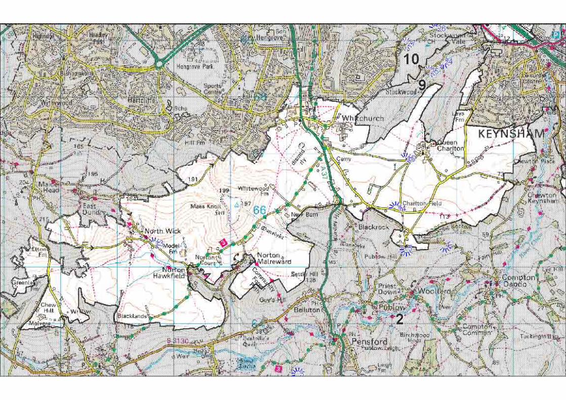
1 Thrubwell Farm Plateau 23
2 Chew Valley 26
3 Upper Chew and Yeo Valleys 30
4 Mendip Slopes 34
5 Dundry Plateau 38
6 Hinton Blewett and Newton St Loe Plateau Lands 42 7 Hollow Marsh 47 8 Farrington Gurney Farmlands 50
9 Stockwood Vale 53
10 Hicks Gate 56
11 Bickley Wood Gorge 59
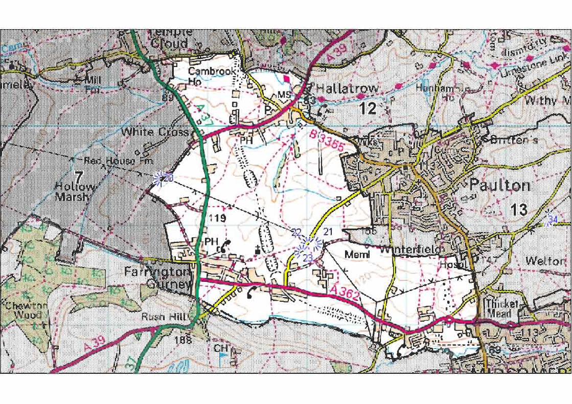
12 Cam and Wellow Brook Valleys 62
13 Paulton and Peasedown St John Ridge 66
14 Avon Valley 70
15 Norton Radstock Southern Farmlands 74
16 Cotswolds Plateaux and Valleys 77
17 Hinton Charterhouse and Baggridge Plateaux 81
18 Bathford and Limpley Stoke Valley 84
8. Landscape Change 88
9. Conclusion 91
Glossary 92
References 94
Bibliography 95
Appendix 1 Sample survey form and sketch 96
Appendix 2 Key development plan policies to which this document is 99 Supplementary Planning Guidance
Appendix 3 Detailed Landscape Character Area Maps 101
iii

List of Tables, Maps and Illustrations
Table 1 Character Areas in Relation to the Character of England Map Areas Page 6
Table 2 Summary of Geological Succession within Bath and North East Somerset Page 9
Map 1 Statutory Designations Page 4
Map 2 Geology Page 8
Map 3 Topography and drainage Page 10
Map 4 Landscape Character Areas Page 22
Map 5-22 Detailed Landscape Character Area Maps Appendix 3
Illustration 1 Cotswold View by Dominic Thomas Page 19
Illustration 2 Saltford Hall Mural by Alan Durman Page 20
Illustration 3 Movie Poster for ‘ The Titfield Thunderbolt’ Page 20
i v

1. Introduction 1.1 Scope and Status of Document 1.1.1 This document identifies and describes the component features and characteristics of the landscape within Bath and North East Somerset. This has been done through a landscape character assessment which is the process of dividing up the landscape into parcels of land with common characteristics. These characteristics are many and varied and will be different for each area. They include natural physical influences and human processes but can also include the cultural values that are placed upon an area.
1.1.2 This assessment recognises that development is an integral component of the landscape and is a key influence in contributing to landscape character and local distinctiveness. The design and location of new development is therefore an important factor in enhancing or contributing to landscape character. The assessment, however, excludes the city of Bath and the towns of Keynsham, Midsomer Norton and Radstock at this stage although it is planned to extend the assessment to include these areas in the future. Other settlements have been included in as far as they are part of the landscape but the assessment does not include an assessment of the built form from within the settlements.
1.1.3 Landscape assessment is an important tool in the planning process. It has been promoted by the Countryside Commission (now the Countryside Agency) from the late 1980’s. It has backing from central government in for example Planning Policy Guidance Note 7 1997 (PPG 7)(1), which encourages planning authorities to undertake comprehensive landscape assessments of their areas as part of the local plan process.
1.1.4 This assessment is also intended to be a guide to the landscapes of Bath and North East Somerset for the whole community including schools, developers, local interest groups, environmental bodies, walkers, tourists etc. In these pages is information about the way that the diverse landscapes have formed by natural and human processes, it touches on how each landscape is made up and what elements are most important to each area and culturally how the landscape has been perceived.
1.1.5 This assessment was consulted on between 27 May and 5 July 2002. The responses were analysed and comments were taken into account in the preparation of this document. A statement of the consultation undertaken is available on request. The document was approved as Supplementary Planning Guidance (SPG) to the Development Plan on 17 February 2003. A list of the key development plan policies which this document supplements are listed in Appendix 2. This document is a material consideration which will be taken into account in deciding planning applications. This assessment will be of use to the community as a whole in guiding the activities that impact upon the landscape, whether they are developers, environmental interest groups, landscape managers or individual householders.
1.1.6 This assessment does not seek to label areas as attractive or unattractive, high or low quality. However, all areas have features that contribute to or detract from their character or quality. Many of the features themselves may be in need of improvement so that they might have a more positive impact.
1.1.7 It is planned that this document will be used as a starting point for a number of further studies and guidelines. These may include detailed guidelines focused upon individual character areas or other defined areas or may include guidelines on specific issues. Complementary studies of the urban landscapes would complete the assessment of all the outdoor spaces within the area.
1.1.8 This assessment is a base-line survey of the character and condition of the landscape of the area in 2002. If reviewed on a 5 or 10 year cycle perhaps focusing on key indicators, sample areas or areas where there may be particular issues then a detailed picture of the change in landscape of the area will be built up. This would be most valuable for assessing sustainability, quality of life and biodiversity indicators for the years to come.
1.1.9 Chapter 2 gives the context of this assessment in relation to the national picture and other assessments carried out within and bordering the area. Chapters 3, 4 and 5 of this document give an overview of the physical
1

influences, historical development and nature conservation • Final character areas were reviewed and further habitats across the area as a whole. Chapter 6 draws out fieldwork was carried out to check their some of the perceptions of the area by visitors and local boundaries. residents. These are intended as an introduction to the individual character areas, which are described in detail in • Analysis of the landscape character and analysis chapter 7. Chapter 8 is an analysis of change across the of landscape change with reference to the First area drawing out some of the key issues. Edition Ordnance Survey Maps (surveyed
1.2 Methodology
1.2.1 The assessment was undertaken following the Countryside Commission guidelines published in 1987 and 1993 and the draft guidelines of the Countryside Agency(2-
4). These draft guidelines are based upon the earlier guidelines and have been updated to include the experience of several years practice around the country and to incorporate more fundamental proposals for stakeholder participation. The draft guidelines have formed the basis for new guidance published in 2002(5).
1.2.2 The assessment was undertaken in the following stages: • A desk top study was carried out to define
initial character areas based upon map information about geology, soils, landform, drainage pattern, land use, vegetation, field pattern and settlement pattern. The research also included historical and cultural development and perceptions of the landscape.
• Fieldwork was carried out between 1999 and 2000 to further refine the character areas based upon observations about landform, land use, vegetation, field boundaries, openness, enclosure, scale, visual relationships, features and building materials. An example of the survey form is found in Appendix 1.
1881-1889) and aerial photos taken between 1946 and 1999.
1.2.3 Boundaries have been drawn between character areas as a single clear line following distinct features such as field boundaries. In reality however the change between one character area and another is not always so clear-cut. In most cases the drawn line must be considered to be at the changeover point where the characteristics of one area outweigh those of the next. In essence the lines should be seen as a mid-point of a transition zone rather than a hard and fast cut-off point.
1.3 Aims and Objectives 1.3.1 The landscape is continually evolving. Some changes are planned and some occur incidentally resulting from other decisions. These changes whether gradual or sudden can have significant impacts on both the quality and character of the landscape. This assessment has as its overarching objective the maintenance and enhancement of landscape character and local distinctiveness. A summary of ways it is planned to be used is listed below.
• To aid formulation of planning policies, to inform development control decisions, to contribute to allocation of land for development and to provide a baseline for more detailed assessments such as local community-led assessments and those required to support planning applications and to contribute to environmental impact assessments.
• To guide landscape change such as informing decisions about the location and design of new woodland. One of the most pressing challenges is the change affecting farming. Traditional family farms and their farming practices are under threat and at the same time there is recognition that the countryside offers a wider resource than just for intensive food production. This recognition provides opportunities for giving greater emphasis to other objectives such as habitat enhancement, management for greater species diversity, opportunities for improved access to the countryside, diversified use of farm buildings and developing local produce for local markets.
2

• To contribute to identifying landscape management priorities.
• To provide a baseline for future guidelines on specific issues such as development at the edges of settlements.
• To provide a baseline for monitoring change and the condition of the landscape. The measurement of indicators is under development but includes issues such as biodiversity, tranquillity, heritage and landscape character. While components of the landscape such as hedges, stone walls and ponds can be measured; indicators for protection of the wider landscape are less easily measurable. This character assessment can be seen as contributing to the process of defining and recording local indicators.
3


2. Landscape Context 2.1 Introduction 2.1.1 The area has a rich and diverse range of landscapes. Between the extremes of the high wold of the Cotswold plateau and the flat floodplains of the River Avon there are contrasting small enclosed landscapes of winding lanes, well ‘treed’ hedgerows and scattered small woodlands, and open rolling landscapes of neat square fields with clipped hedges, straight lanes and parcels of woodland. There are modern landscapes constantly changing with the needs of the local population and those where the fields, hedges and lanes have remained the same since before the Norman Conquest. Most landscapes are a combination of old and new.
2.1.2 All of the landscapes of the area are cherished. Some like the Cotswolds and Mendip Hills are recognised as being of national importance and are granted the status of Areas of Outstanding Natural Beauty (AONB). Others though they lack this status and protection are no less loved by those who live, work and play in them. Most of the rural parts of the area are within the Bristol/Bath Green Belt which is an important control in maintaining the open character of these areas. The Forest of Avon is also a significant designation with one of its objectives to increase woodland cover to 30% of its area. Each character area is closely related to the evolution of agriculture, communications, industry and settlement within the landscape. All are living working landscapes and as such they change and develop according to the demands placed upon them.
2.1.3 The city of Bath has international significance as a World Heritage Site in recognition of its architecture, town planning, landscape, archaeological remains and its role in social history. The encircling hills and green valleys
provide a dramatic backdrop and are an integral part of the city which grew up around the river. The landscape both enhances the city and is responsible for shaping it. As a result it is of great significance in contributing to the unique character of the city.
2.2 Assessment Context 2.2.1 This assessment has been undertaken within the context of the Countryside Character Initiative of the Countryside Agency (formerly the Countryside Commission). Their standard methodology has been adopted in order to maintain compatibility with the agency’s work and other assessments. Their work has led to the classification of the whole of the English countryside into 159 separate character areas which together is known as the Character of England map. The Bath and North East Somerset area includes parts of three of the national landscape character areas: the Mendip Hills, the Cotswolds and Bristol, Avon Valleys and Ridges(6). This assessment at the intermediate / local authority scale reflects these distinctions and adds more detail and further subdivision. The only significant variation from the Character of England map occurs with the Paulton and Peasedown St John Ridge and the Cam and Wellow Brook Valleys character areas which both straddle the Cotswolds and Bristol, Avon Valleys and Ridges national map areas.
2.2.2 A total of 18 distinct landscape character areas are identified. These range in size from Bickley Wood Gorge at less than 1sq km to Chew Valley at 67sq km. The variations in size are dictated by the extent of the features and characteristics which make up the character areas. The correlation between the national assessment and this assessment is shown in Table 1.
5

Character ofCharacter ofCharacter ofCharacter ofCharacter of Bath and NorthBath and NorthBath and NorthBath and NorthBath and NorthEnglandEnglandEnglandEnglandEngland East SomersetEast SomersetEast SomersetEast SomersetEast SomersetMap AreasMap AreasMap AreasMap AreasMap Areas Character AreasCharacter AreasCharacter AreasCharacter AreasCharacter Areas
Mendip Hills Mendip Slopes Upper Chew and Yeo Valleys
Cotswolds Cotswolds Plateaux and Valleys
Bathford and Limpley Stoke Valley
Hinton Charterhouse and Baggridge Plateaux
Paulton and Peasedown St John Ridge (part of)
Cam and Wellow Brook Valleys (part of)
Bristol, Paulton and Peasedown Avon Valleys St John Ridge (part of) and Ridges Chew Valley
Norton Radstock Southern Farmlands
Cam and Wellow Brook Valleys (part of)
Hicks Gate
Bickley Wood Gorge
Hinton Blewett and Newton St Loe Plateau Lands
Avon Valley
Farrington Gurney Farmlands
Hollow Marsh
Dundry Plateau
Stockwood Vale
Thrubwell Farm Plateau
TTTTTable 1 Character Areas in Relation to theable 1 Character Areas in Relation to theable 1 Character Areas in Relation to theable 1 Character Areas in Relation to theable 1 Character Areas in Relation to theCharacter of England Map AreasCharacter of England Map AreasCharacter of England Map AreasCharacter of England Map AreasCharacter of England Map Areas
By maintaining compatibility with the Character of England map we are able to provide a view of our landscape that is consistent with the national picture. Comparisons with other landscape assessments are easier and in turn our assessment can support regional and national work. The development of standard national landscape types is currently in progress and therefore landscape types for each character area have not been identified separately in this assessment. This is likely to form part of any future revisions.
2.3 Previous Local Assessments 2.3.1 The area has been assessed, in part or in whole, by no less than five other local landscape assessments. These are listed below. • Avon Landscape Strategy – Avon County
Council (1988) • Cotswold AONB Landscape Assessment
and Environmental Guidelines – Agricultural Development Advisory Service (ADAS) (1994)
• Bristol and Avon Community Forest Plan – Bristol and Avon Community Forest (1995)
• Wansdyke Nature Conservation and Landscape Strategy 1995 – Wildlife Trust for Bristol, Bath and Avon (1995)
• The Mendip Hills AONB – Countryside Commission (1997)
Each of these assessments was undertaken for very specific reasons and none is directly comparable with this assessment.
2.3.2 The Avon County Council assessment specifically focuses upon the selection of high and low quality landscapes for the purpose of enhancement and conservation with an emphasis on areas suitable for tree planting.
2.3.3 The methodology for the Wansdyke Nature Conservation and Landscape Strategy was based upon the Avon landscape assessment and it also included nature conservation. It is the only other assessment that covers the same area as this one. The characterisation created useful distinctions between character areas which are often mirrored in the areas included in this assessment.
2.3.4 The Community Forest assessment is also significant as it was undertaken using the Countryside Commission’s methodology. The character areas are again similar to those identified by this assessment. However it only looks at a small part of the assessment area and again its objectives for landscape management are aimed largely at tree planting as well as enhancing agricultural landscapes.
2.3.5 The Cotswold assessment undertaken by ADAS for the Countryside Commission uses ADAS’s methodology and is very focused towards geophysical distinctions. It deliberately omits historical and archaeological data along with other cultural references. It creates a map of landscape types rather than character areas.
6

2.3.6 The Mendip AONB assessment(1) by Chris Blandford Associates for the Countryside Commission uses up-to-date methodologies and is a useful document but is limited to the south-western part of the area.
2.4 Landscape Character Assessments of the Surrounding Areas. 2.4.1 There are eight local authorities that share a boundary with the area. These are Somerset and Wiltshire County Councils, Mendip, West Wiltshire and North Wiltshire District Councils, and Bristol, South Gloucestershire and North Somerset unitary authorities. Of these only Mendip District Council has completed a comprehensive landscape character assessment(2) though someothers are at various stages of doing so. The Mendip assessment was undertaken by Chris Blandford Associates in 1997 and follows the Countryside Commission’s 1993 Guidelines.
7


3. Physical Influences 3.1 Geology 3.1.1 Geologically the area is significant because it marks the western limit of the typical English lowland landscape characterised by scarps and gently undulating flat topped hills and broad clay valleys. The older formations of Wales and land to the south-west by contrast are characterised by gnarled and rugged scenery all intensely folded and faulted. These older formations are represented, for example, by the Carboniferous Limestone of the Avon Gorge at Clifton which is outside the area and the Mendip Hills, of which only a narrow strip to the far south-west is within the area.
3.1.2 Drift geology of the Quaternary period is represented within the area by alluvium, terrace loams and gravels, and head. Alluvium consists of accumulated river born materials which have been deposited in earlier valley systems. The terrace deposits were laid down at higher levels than the alluvium. The head deposits are locally derived poorly sorted materials from nearby slopes. They can include silty sand, loamy limestone gravel or clayey loams depending on the parent material.
3.1.3 The cover of younger rocks, Triassic Sandstones, and Jurassic Clays (Fuller’s Earth) and Limestones (Oolitic and Lias), largely dictate the characteristics of the geology within Bath and North East Somerset. They are only gently folded or tilted with near horizontal strata which, on the Cotswolds, gives relatively unbroken crestlines. Oolitic Limestone is particularly significant forming the Cotswold Hills. The Oolitic Limestone has been eroded back to the existing scarp slope over geological time revealing the older contorted rocks of the coal measures of the Carboniferous period. In places it survives as outliers such as at the Dundry Hills, The Sleight near Timsbury and Stantonbury.
3.1.4 Lias Clays underlie the Jurassic Limestones. They make a poor foundation and landslips are characteristic for example at Bath and on the Dundry Hill slopes. The Lias Clays lie on top of the Lias Limestone and are exposed in the valley floors of the Cam, Wellow and Newton Brooks. The Lias Limestone gives rise to characteristic plateaux above the underlying Penarth Group clays and shales and Mercia Mudstones of the Triassic period. There is a distinction between the Lower White Lias which was quarried and used
Valley Lake and give rise to the characteristic red soils and generally low relief.
3.1.5 Finally, the oldest formations in the area are the Carboniferous series which through erosion of the younger formations are exposed in two sections of the central area. They are between Hallatrow and Clutton and between Pensford and Compton Dando. The Carboniferous Limestone of the Mendip Hills has been referred to earlier. In the central areas the geology is characterised by sandstones, shales and mudstones banded with coal seams. The coal seams have been economically important to the area and have a strong present day influence on the culture and landscape. Pennant Sandstone which forms part of this series had to be excavated in order to reach the coal measures but was also quarried in its own right as a building material, for example at Temple Cloud.
Geological Strata Geological Period and Age (million years ago)
Alluvium Quaternary (1.8 to present
Terrace Loam and Gravel Head Great Oolite Limestone Fuller’s Earth Inferior Oolite Limestone Jurassic (210-144) Midford Sands Lower Lias Clay White and Blue Lias Limestone Penarth Group Shale and Mudstone
Triassic (245-210)Mercia Mudstone Dolomitic Conglomerate Upper Coal Measures
Carboniferous Pennant Sandstone Lower Coal Measures (360-286) Carboniferous Limestone
for building to the south of the area and the Blue Lias found above which was quarried around Keynsham and yields numerous fossils including the locally characteristic ammonites. The Triassic formations, including the Mercia Mudstones (formerly referred to as Keuper Marls), make up much of the western area such as around the Chew
9
TTTTTable 2 Summary of Geological Succession withinable 2 Summary of Geological Succession withinable 2 Summary of Geological Succession withinable 2 Summary of Geological Succession withinable 2 Summary of Geological Succession withinBath and North East SomersetBath and North East SomersetBath and North East SomersetBath and North East SomersetBath and North East Somerset


3.1.6 This range and diversity not only helps to characterise different parts of the area but also provides features of significant interest and importance including sites which show special geological sequences, sites which show unique ammonite and bivalve fauna and sites with important fossiliferous Pleistocence gravels. There are currently 11 geological sites of national importance which are designated as Sites of Special Scientific Interest (SSSI) and 47 sites of local importance, which are designated as Regionally Important Geological Sites (RIGS).
3.1.7 No reference to the geology of the area would be complete without reference to William Smith, ‘The Father of English Geology’. Whilst engaged in surveying the Somersetshire Coal Canal in 1792-95 he discovered the principle of stratigraphy; the regular succession of rock strata and their fossils. He created the first geological maps of the area and popularised the term Fuller’s Earth to describe the clay between the top of the Inferior Oolite and the base of the Great Oolite.
3.1.8 Reference should also be made to the hot springs at Bath. Although they are not within the area covered by the assessment they have been a major factor in the development and importance of Bath since and even before Roman times. The hot springs and their influence on development can therefore be seen as an important influence on the landscape character of much of the area covered by this assessment.
3.2 Drainage Pattern 3.2.1 The principal river system is the Avon and its tributaries. The river enters the area from the south-east corner at Freshford and flows northwards through the deep Limpley Stoke Valley before taking a sharp turn to the west near Bathford and Batheaston. It flows westwards through Bath and then north-westwards leaving the area just west of Keynsham. Constrained by geology for much of its journey the River Avon generally has a narrow valley floor through the area. It only widens out to a broader flood plain for a relatively small stretch between Saltford and Keynsham where it passes through softer sands and clays.
3.2.2 A number of tributaries within the area feed into the River Avon. Most of these flow into the river on its southern or western side and have had a pronounced effect on the development of the topography.
3.2.3 The largest tributary is the River Chew which enters the Avon at Keynsham. Next are the Wellow and Cam Brooks which merge at Midford and continue eastwards as the Midford Brook to join the Avon east of Monkton Combe. Other tributaries joining the Avon from
the south are the Newton and Corston Brooks which meet the Avon west of Bath.
3.2.4 Joining the River Avon from the north or east are the Lam Brook, St Catherine’s Brook and the By Brook. Only very short lengths of the By Brook lie within the area.
3.2.5 A very small part of the catchment of the River Yeo, which drains westwards directly to the Severn estuary, lies within the area to the south-west. The Yeo was dammed early in the 20th century to form Blagdon Lake, part of which lies within the area.
3.2.6 There are two other man-made features within the area which contribute to a picture of the drainage pattern. These are Chew Valley Lake and the Kennet and Avon Canal. Chew Valley Lake was created in the 1950’s by the damming of the River Chew at Chew Stoke. The lake is some 3.5km long and 2.5km wide and forms a major feature in the landscape. The Kennet and Avon Canal runs parallel to the River Avon from Freshford where it enters the area and continues through to join the River Avon at Widcombe.
3.3 Topography 3.3.1 The complexity of the underlying geology and the nature of the drainage pattern are the principal determinants of the varied topography within the area. Man has had a smaller but nevertheless distinctive additional influence on the topography through coal mining activities. These have resulted in some significant man-made “hills” such as at Old Mills just to the west of Midsomer Norton.
3.3.2 The topography is characterised by hills and plateaux dissected by river valleys. However this description suggests a simple topography which is far from the case. The hills range from extensive land masses over 200m in height such as the Cotswolds and Mendips through to small, rounded outliers such as Stantonbury Hill and Barrow Hill which rise out of plateau areas at around 180m in height. The plateaux range from the high and exposed tops of the Cotswolds to the lower and rather more undulating Lias Limestone plateau between Newton St Loe and Clutton which averages100-150m in height. The river valleys range from the gentle, shallow-sided Chew south west of Pensford to the steep sided Wellow and Cam. The River Avon, the dominant factor in the drainage pattern, alternates rather incongruously from dramatic gorge-like stretches such as the Limpley Stoke Valley and Hanham Valley to open flood-plain between Keynsham and Saltford.
11

3.3.3 The Valleys The vast majority of the area lies to the south of the River Avon and here the three principal tributaries of the Avon the River Chew and the Cam and Wellow Brooks, flow roughly parallel to each other. They have given a pronounced west to east or south-west to north-easterly grain to the topography. Furthest to the west the River Chew rises in the Mendip Hills and then runs across the soft Mercia Mudstones to form a broad valley narrowing down-stream of Pensford where the underlying rocks are harder. The Cam and Wellow Brooks lie close together and are separated from the River Chew by the Lias Limestone plateau. Both the Cam and Wellow Brooks flow through distinctive steep-sided valleys as they cut through harder Lias and Oolitic Limestones except in their upper reaches where the rocks are softer. To the north of the River Avon its tributaries cut down into the hard Oolitic Limestone of the Cotswolds to form steep-sided valleys generally running north-south.
3.3.4 The Hills and High Plateaux The parts of the Mendips and Cotswolds and, to a lesser extent, Dundry Hill within the area are small parts of rather more extensive hill ranges. Only a very small part of the Mendip Hills lies within the area, a section of steep scarp slope between Ubley and Hinton Blewett, although the prominence of the slope and ridgeline is felt over a much wider area. Slightly more of the Cotswolds lies within the area to the north and east, encircling Bath and again the skyline is prominent from views over a much wider area. Here, however, the scarp slope is less of a feature, whilst the plateau and incised valleys are of greater landscape significance. Dundry Hill is an Oolitic Limestone outlier of the Cotswolds on the south-eastern edge of Bristol, reaching some 210m in height. Again only a very small part of the hill lies within the area to the north-west around Whitchurch, Queen Charlton and Norton Malreward, from where there are some spectacular views over much of the area.
3.3.5 The Rolling Lias Plateaux Much of the central area is Lias Limestone plateau. A much smaller and more isolated part of the area at Nempnett Thrubwell is part of another plateau which extends outside the area westwards to Felton and Lulsgate. The large central plateau area is much lower than the Cotswolds and more gently undulating and the plateau is less continuous in nature. It has some distinctive, rounded hills of Oolitic Limestone rising up out of it and is dissected by a series of valleys.
3.4 Soils 3.4.1 The main soils within the area are described below by reference to the main geological formations from which they are derived.
3.4.2 The main soil type derived from drift deposits of the Quaternary period is clayey with a high organic content. It typically results in poorly drained land and is traditionally under permanent grass used for summer grazing and hay. Within the study area it is found mostly immediately south of Chew Valley Lake and around Hollow Marsh. It also occurs along parts of the Avon Valley.
3.4.3 There are two soil types particularly characteristic of the Jurassic formations. The first are shallow, well drained calcareous soils found on the Lias and Oolitic Limestone plateaux. They are used for cereals and grassland for dairy and stock rearing. The second are slowly permeable calcareous clayey soils. They are found on the slopes and often on locally irregular terrain. They are used for grassland for dairy and stock rearing and also for winter cereals.
3.4.4 There are likewise two particularly characteristic soils on the Triassic formations. The first are the reddish loamy soils found in the area north of the Chew Valley Lake. The soils are used for cereal growing as well as potatoes and sugar beet and grassland. They include much of the highest grade agricultural land in Bath and North East Somerset. The second are the seasonally waterlogged fine loam clayey soils which are also reddish in colour and are found to the south-west of the Chew Valley Lake. The land is used for grassland for dairying and stock rearing as well as for winter cereals.
3.4.5 The two most characteristic soils on the Carboniferous formations are slowly permeable clayey soils and, on the Pennant Sandstone, well drained fine loamy soils such as at Temple Cloud.
12

4. Historical Development of the Landscape 4.1 Introduction 4.1.1 The landscape that we see today is largely the product of three major historical influences, the enclosure of common ‘open’ fields from around the 14th/15th to the late 17th centuries, the growth of settlement, particularly urban, and the consequences of industrialization from the 18th century to the present day. Each of these has played a major part in setting the character of both the physical landscape and our perceptions of it. Although not so obviously influential, these processes, as we shall see, have their origins in much earlier periods.
4.2 Early Origins 4.2.1 Peel away these layers formed largely over the past 2,000 years and the actual physical structure of the region, the hills, plateaux, valleys and slopes have been witness to another set of influences. This physical template was laid down during past ice ages, particularly the last two, the Anglian (around 450,000 years ago) and the Devensian (around 20,000 years ago). During these periods and intervening warm episodes the actions of ice, frost, warm and cold climatic changes had affected the landscape in a variety of ways, not least the formation of our present river systems, particularly the Avon Valley, one of the most dominant features in the region and one which has acted as a gateway for the movement of human populations since approximately 500,000 years ago.
4.2.2 Whilst it is relatively easy to visualize an agricultural landscape of 2,000 years ago, trying to comprehend a landscape of 500,000 years ago is not so easy particularly as many of the animals that inhabited the area such as the scimitar toothed cat are no longer with us. This period saw the arrival of the first humans into the region exemplified by finds from a cave at Westbury-sub-Mendip. Here human remains were found in association with the bones of horse, deer, hyena, rhinoceros and scimitar toothed cat suggesting a very temperate climate. Indeed these animals together with elephant, hippopotamus, bears and cave lions would not have been uncommon in the area; the carnivores feeding on herds of wild cattle, bison, deer and horse, and the environment a mixture of forest and open savanna.
4.2.3 Essentially, the landscape of the region remained natural and the small human population of the time had little impact on the environment until post-glacial times (around 10,000 years ago) when we begin to find
much more evidence of human activity, usually in the form of flint artifacts and the waste from their manufacture which occurs throughout the region. Some particularly interesting collections from possible habitation sites have been located on the hills to the north of Bath at Lansdown and Charmy Down. These Mesolithic hunter gatherer populations lived in small groups and moved within relatively large territories exploiting both animal and plant communities. Organized clearance of natural vegetation began in earnest during the early Neolithic period, around 6,000 years ago when the management of domesticated animals and the growing of food crops such as wheat and barley begins to be recognised in the archaeological record. These first farmers almost certainly co-existed with other human groups who still practiced the more traditional hunting and gathering economy that had dominated human subsistence over the previous 6,000 years. However, to what extent these early farmers manipulated and changed the landscape in the area is difficult to determine and hunting and gathering probably still continued. Evidence from the Somerset Levels prehistoric timber trackways dating to the early Neolithic suggests by this time forest stands were already of varying ages and that the natural ‘wild woods’ of any substance may well be quite rare. Analysis of the timbers used to make up these trackways also indicates a high level of carpentry skill and woodland management. For instance, much of the roundwood derived from coppiced stools.
4.2.4 Settlement sites of this period are extremely rare, the only possible house site, a round timber framed structure about 3m across was excavated at Chew Park Farm in the 1950’s, now beneath the waters of Chew Lake. As the period advances however, new types of monuments are found in the landscape expressing symbolic relationships both between the living and the dead and between the living and their environment. Really good examples of this relationship are found at Stanton Drew and Stony Littleton. At Stanton Drew, the stone circles of the late Neolithic/ early Bronze Age which is a Scheduled Monument of national importance and an associated earlier earth bank and timber enclosure sited by the River Chew are clearly visible from the hills around. There is strong evidence to suggest that this visibility was apparent at the time and that landscape features themselves may have had special significance to these prehistoric human groups. The idea that the dead can ‘watch’ over the living has strong currency in the archaeological literature and the Neolithic long barrow (burial chamber) of Stony Littleton, another Scheduled Monument, is a clear example of this. Located on a ridge overlooking the Cam Valley this impressive prehistoric monument seems deliberately sited to be viewed from surrounding hill-tops and ridges, also implying that these more upland areas had been substantially cleared of scrub and woodland. This positioning of burial places and
13
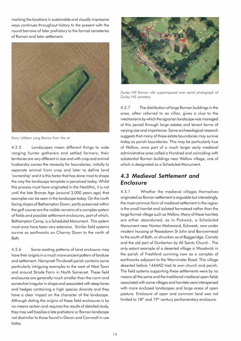
marking the locations in sustainable and visually impressive ways continues throughout history to the present with the round barrows of later prehistory to the formal cemeteries of Roman and later settlement.
Stony Littleton Long Barrow from the air
4.2.5 Landscapes mean different things to wide ranging hunter gatherers and settled farmers; their territories are very different in size and with crop and animal husbandry comes the necessity for boundaries, initially to separate animal from crop and later to define land ‘ownership’ and it is this factor that has done most to shape the way the landscape template is perceived today. Whilst this process must have originated in the Neolithic, it is not until the late Bronze Age (around 3,000 years ago) that examples can be seen in the landscape today. On the north facing slopes of Bathampton Down, partly preserved within the golf course are the visible remains of a complex system of fields and possible settlement enclosures, part of which, Bathampton Camp, is a Scheduled Monument. This system must once have been very extensive. Similar field systems survive as earthworks on Charmy Down to the north of Bath.
4.2.6 Some existing patterns of land enclosure may have their origins in a much more ancient pattern of landuse and settlement. Nempnett Thrubwell parish contains some particularly intriguing examples to the west of West Town and around Strode Farm in North Somerset. These field enclosures are generally much smaller than the norm and somewhat irregular in shape and associated with deep lanes and hedges containing a high species diversity and they have a clear impact on the character of the landscape. Although dating the origins of these field enclosures is by no means certain and requires the results of detailed study, they may well fossilize a late prehistoric or Roman landscape not dissimilar to those found in Devon and Cornwall in use today.
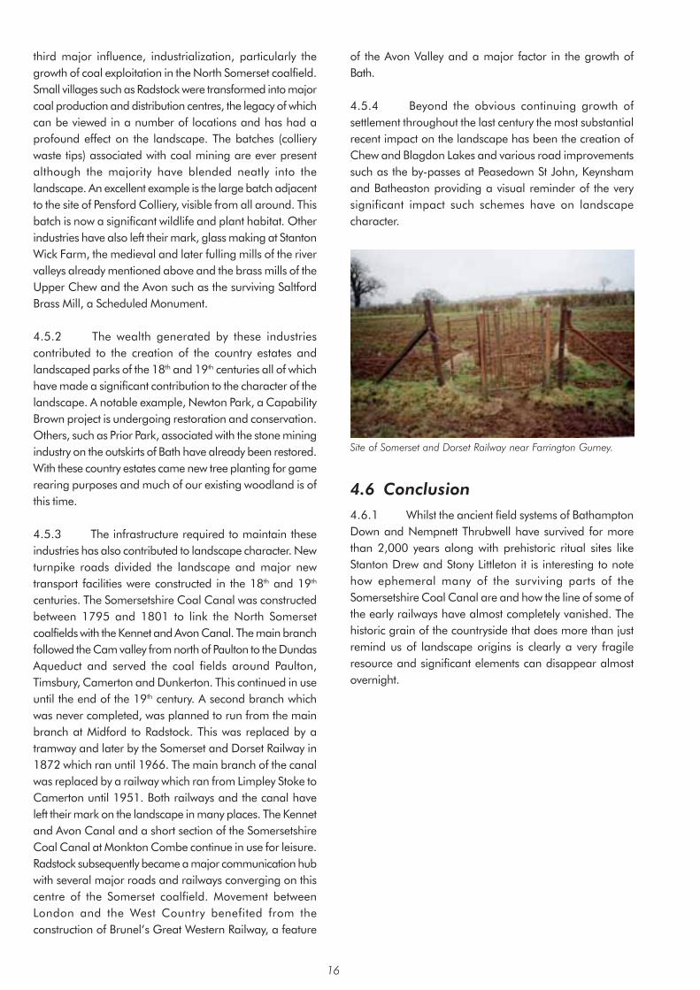
Durley Hill Roman villa superimposed over aerial photograph of Durley Hill cemetery
4.2.7 The distribution of large Roman buildings in the area, often referred to as villas, gives a clue to the mechanisms by which the agrarian landscape was managed at this period through large estates and tenant farms of varying size and importance. Some archaeological research suggests that many of these estate boundaries may survive today as parish boundaries. This may be particularly true of Wellow, once part of a much larger early medieval administrative area called a Hundred and coinciding with substantial Roman buildings near Wellow village, one of which is designated as a Scheduled Monument.
4.3 Medieval Settlement and Enclosure 4.3.1 Whether the medieval villages themselves originated as Roman settlement is arguable but interestingly, the most common form of medieval settlement in the region is the small hamlet and isolated farmstead rather than the large formal village such as Wellow. Many of these hamlets are either abandoned, as in Pickwick, a Scheduled Monument near Norton Malreward, Eckweek, now under modern housing at Peasedown St John and Barrowmead to the south of Bath, or shrunken as at Baggeridge, Camely and the old part of Dunkerton by All Saints Church . The only extant example of a deserted village is Woodwick in the parish of Freshford surviving now as a complex of earthworks adjacent to the Warminster Road. This village deserted before 1444AD had its own church and parish. The field systems supporting these settlements were by no means all the same and the traditional medieval open fields associated with some villages and hamlets were interspersed with more enclosed landscapes and large areas of open pasture. Enclosure of open and common land was not limited to 18th and 19th century parliamentary enclosure.
14

Excavations of Medieval Farm at Eckweek (courtesy Avon Archaeological Unit)
4.3.2 Late medieval enclosure of open land, usually achieved through local agreement has handed on to us some of the finest hedged pasture landscapes in this part of the south-west, preserving the line of earlier strip-field boundaries and headlands, forming around 30% of the area. This landscape supports significant numbers of species rich hedgerows, a large proportion of which were created from locally derived shrubs growing wild, rather than through nursery plantation more common in later enclosure episodes. Although this historic landscape category is by no means confined to the west of the area, the most interesting and informative examples can be found around Chew Stoke and Hinton Blewett. Land immediately north of Hollow Marsh Lane in the south of Hinton Blewett parish provides an excellent visual demonstration of the processes at work. The lane itself, now an un-surfaced bridleway and footpath, runs below hedged fields within which the earth bank remnants of earlier strip fields can be clearly seen running down the slope. In two locations terracing into the hillside betray the locations of the type of medieval farm referred to earlier and associated with these fields.
Early and later medieval landscapes to the north of Chew Stoke.
4.4 The Growth of Settlement 4.4.1 The second major influence on the landscape, the growth of settlement has already been touched on in relation to changes in the agrarian landscape but it is with the growth of towns and cities that this influence is most apparent, particularly Bath and Keynsham in the Roman and medieval periods and Midsomer Norton and Radstock in the 18th and 19th centuries. The earliest major urban centres such as Cirencester had a major administrative and economic function that transformed the relationship between countryside and settlement, although in the case of Bath this role is rather enigmatic. The existence of the hot springs led to quite a different sort of urban development focused on religion and international tourism, the legacy of which is still with us today. These urban centres supported relatively large populations and acted as regional markets. To facilitate these functions a network of major and minor roads was created linking settlements and isolated farms. Some survive today as major routeways such as the A367 from Bath through to Shepton Mallet, part of the Roman road known as The Fosse Way.
4.4.2 Whilst Bath and Cirencester continued as successful urban centres, other smaller settlements such as Camerton to the west of Peasedown St John did not. Keynsham itself shifted onto higher ground overlooking the Hams, site of a Roman settlement. Keynsham became a successful market town in the medieval period dominated by the Augustinian Abbey. By the 16th century wool was the dominant industry, the demands of which involved the management of large areas of pasture. Associated activity had an impact on the nature of both the countryside and villages. Pensford saw significant growth at this time and became large enough to have its own market. The Chew Valley, particularly from Keynsham to Chew Magna retained a number of large fulling mills, some of which survive today albeit altered and added to in the 18th and 19th centuries. Interestingly, woad, used for dying wool, appears to have been a significant cash crop in the Keynsham area. Mills were established throughout the area for a variety of purposes and are now in various states of preservation and their associated features of leats, weirs, millponds and stream diversions form important features of the landscape.
4.5 Industrialization 4.5.1 In the 1840’s the extent of built up areas in the rural environment probably differed little from the medieval period and it is only with the City of Bath that substantial growth is recognised. Overall, the built up areas represented 2.4% of the area’s landscape more than doubling by the 1880’s to 5% and substantially increasing to 11.6% by the 1950’s. Much of this expansion was connected with the
15
third major influence, industrialization, particularly the growth of coal exploitation in the North Somerset coalfield. Small villages such as Radstock were transformed into major coal production and distribution centres, the legacy of which can be viewed in a number of locations and has had a profound effect on the landscape. The batches (colliery waste tips) associated with coal mining are ever present although the majority have blended neatly into the landscape. An excellent example is the large batch adjacent to the site of Pensford Colliery, visible from all around. This batch is now a significant wildlife and plant habitat. Other industries have also left their mark, glass making at Stanton Wick Farm, the medieval and later fulling mills of the river valleys already mentioned above and the brass mills of the Upper Chew and the Avon such as the surviving Saltford Brass Mill, a Scheduled Monument.
4.5.2 The wealth generated by these industries contributed to the creation of the country estates and landscaped parks of the 18th and 19th centuries all of which have made a significant contribution to the character of the landscape. A notable example, Newton Park, a Capability Brown project is undergoing restoration and conservation. Others, such as Prior Park, associated with the stone mining industry on the outskirts of Bath have already been restored. With these country estates came new tree planting for game rearing purposes and much of our existing woodland is of this time.
4.5.3 The infrastructure required to maintain these industries has also contributed to landscape character. New turnpike roads divided the landscape and major new transport facilities were constructed in the 18th and 19th
centuries. The Somersetshire Coal Canal was constructed between 1795 and 1801 to link the North Somerset coalfields with the Kennet and Avon Canal. The main branch followed the Cam valley from north of Paulton to the Dundas Aqueduct and served the coal fields around Paulton, Timsbury, Camerton and Dunkerton. This continued in use until the end of the 19th century. A second branch which was never completed, was planned to run from the main branch at Midford to Radstock. This was replaced by a tramway and later by the Somerset and Dorset Railway in 1872 which ran until 1966. The main branch of the canal was replaced by a railway which ran from Limpley Stoke to Camerton until 1951. Both railways and the canal have left their mark on the landscape in many places. The Kennet and Avon Canal and a short section of the Somersetshire Coal Canal at Monkton Combe continue in use for leisure. Radstock subsequently became a major communication hub with several major roads and railways converging on this centre of the Somerset coalfield. Movement between London and the West Country benefited from the construction of Brunel’s Great Western Railway, a feature
of the Avon Valley and a major factor in the growth of Bath.
4.5.4 Beyond the obvious continuing growth of settlement throughout the last century the most substantial recent impact on the landscape has been the creation of Chew and Blagdon Lakes and various road improvements such as the by-passes at Peasedown St John, Keynsham and Batheaston providing a visual reminder of the very significant impact such schemes have on landscape character.
Site of Somerset and Dorset Railway near Farrington Gurney.
4.6 Conclusion 4.6.1 Whilst the ancient field systems of Bathampton Down and Nempnett Thrubwell have survived for more than 2,000 years along with prehistoric ritual sites like Stanton Drew and Stony Littleton it is interesting to note how ephemeral many of the surviving parts of the Somersetshire Coal Canal are and how the line of some of the early railways have almost completely vanished. The historic grain of the countryside that does more than just remind us of landscape origins is clearly a very fragile resource and significant elements can disappear almost overnight.
16

5.1
5. Ecological / Wildlife Characteristics
Landscape and wildlife are intimately linked. The underlying influence upon local wildlife is the combination of climate, geology, soils and topography. This controls the broad range of habitat types that can occur in an area. Detailed habitat characteristics are then shaped and refined by land use and land management activities. It is these habitat characteristics that determine the wildlife around us, and which help to shape, structure, and enliven the landscape.
5.2 The richest and ecologically most important habitats are typically those associated with the least intervention and manipulation. These are classified as ‘semi-natural’ habitats and include semi-natural ancient woodlands, broadleaved woodlands, species-rich hedgerows, species-rich grasslands, river corridors, ponds and lakes. These habitats tend to support the highest diversities of native plant and animal species and can be critical to the continued survival and propagation of many rare and scarce species. It is from these habitats that the sound of most bird song, and buzzing insects will be heard, where the fragrance of wild ramsons or honeysuckle will be smelt, where the sights of spring and summer flowers will be seen, and where the freedom of circling buzzards will be felt. So, as well as being ecologically important, these features also help to enliven our landscapes and to make them special.
5.3 At first glance it can appear that the landscape of the area is still a rich wildlife resource, comprising a tapestry of green fields, hedgerows, woodlands and river corridors. Closer inspection however reveals a very poor
and fragmented distribution of good semi-natural habitats. Studies published back in 1990 indicate that only 6% of the area is characterised with semi-natural habitat of high wildlife value. This is quite low compared with the national average and very low compared with the rest of Europe. The semi-natural habitats that do remain are typically small and are often isolated from each other. This tends to reduce their wildlife value and viability since it is harder for most species to survive and flourish in small isolated sites.
5.4 Farming is the main land use and land management activity in the area and so exerts a major influence upon the local ecology and landscape character. As elsewhere, farming here has responded to consumer demands and European subsidies, resulting in the adoption of modern and intensive farming techniques. So fields that were once used to produce hay or were kept as permanent pasture and which sustained a whole variety of wildlife from harebells to barn owls, have been converted to silage or arable crops that often support little wildlife.
Chew Valley Lake Special Protection Area – an internationally important site for migratory birds
5.5 Inorganic fertilisers, herbicides and field drainage systems have been introduced which further reduce wildife interest and habitat quality. Fields have been amalgamated and traditional field boundaries have been removed or are neglected, and changes to traditional grazing regimes have resulted in both over-grazing of some pastures and under-grazing of many hillside pastures. These changes have significantly reduced opportunities for our wildlife to thrive. However, where sensitive farming regimes have been sustained, important areas for wildlife remain and can be particularly important for farmland birds such as yellow hammers, grey partridge and corn bunting which have all suffered declines nationally. The areas around Keynsham, Corston and Marshfield also remain important for a number of rare arable weeds, which have suffered significant declines nationally.
5.6 Farming is not the only influence upon the quality and viability of wildlife habitat. The decline of traditional woodland management has resulted in the reduction and
17

loss of many woodland species, and increased pressures from urbanisation and recreation have taken their toll. The increase in horse and pony paddocks has been particularly significant in some areas where grazing pressures have reduced the natural diversity of grasslands.
5.7 Of the good semi-natural habitats that do remain, the key components include semi-natural ancient woodlands such as Peppershells Wood in Compton Dando, neutral grasslands such as those near North Hill Farm in Chew Stoke, calcareous grasslands of the Cotswolds, some of the river corridors particularly the Avon and its tributaries, the remaining network of ancient species-rich hedgerows such as those at Priston, East Harptree, Compton Dando and Nempnett Thrubwell, the standing waters of Blagdon and Chew Valley Lake and post-industrial sites such as the coal batches of the Somerset coalfields and the stone mines at Combe Down at the edge of Bath. Many of these features are designated as Sites of Nature Conservation Importance (SNCIs), and reflect a great variety of habitat types and landscape characteristics
5.8 A number of these sites are also of national or international importance. The calcareous grasslands make an important contribution to the national calcareous grassland resource, and three different calcareous grasslands are designated as SSSIs. The Combe Down stone mine complex and Monkton Farleigh mines, which includes Brown’s Folly, are of international importance, designated as Candidate Special Areas of Conservation (cSACs). These hibernation sites for Greater and Lesser Horseshoe bats, and the mixed pastoral landscape around the south of Bath provides important feeding grounds and access
routes for the bats. Brown’s Folly is also important as a hibernation site for at least nine other bat species, making it one of the most diverse bat sites in the country.
5.9 Chew Valley Lake is of international importance, designated as a Ramsar site (under the Ramsar Convention) and Special Protection Area (SPA) for migratory birds; and Blagdon Lake is a nationally important wetland site (designated as an SSSI). A number of semi-natural ancient woodlands are of national importance (designated as SSSIs), including Cleaves Wood and Long Dole Wood. There are also key areas of mixed habitats of national importance (designated as SSSIs) including Harptree Combe and Monkswood Valley.
5.10 So the range of landscape features across the area has the potential to support a rich diversity of wildlife. However, the viability and integrity of habitats present depends upon land use and land management, and has been significantly reduced in recent times. The rich habitats that remain are fragile and vulnerable to further change.
Exploring wildlife in the landscape
5.11 Measures are therefore needed to help protect and enhance the habitats and species that remain, and in some areas habitat creation and restoration may be required. The maintenance and creation of habitat links and wildlife corridors will be particularly important. Careful stewardship of all these features is essential if we are to sustain wildlife-rich landscapes into the future.
18

6. Cultural Perceptions of the Landscape 6.1 Introduction 6.1.1 The cultural perception of the area’s landscapes has been dominated by two principal areas, the Cotswolds and the Mendips. These areas have attracted writers and travellers for centuries. The River Avon and its valley has generally been celebrated to a lesser extent.
6.1.2 The Cotswolds have a huge reputation for the quality of its landscape; soft and romantic, the warm stone and gentle undulations of the plateau lands creates an image that is the very epitome of the English shires. Consequently there is much that celebrates this valued area.
6.1.3 The Mendip Hills has an image that is quite different with its dramatic limestone features and remote plateau that breaks to wooded slopes that flow down to the surrounding valleys. It too is celebrated, especially by the 19th century ‘romantics’ who appreciated the rugged and wild aspects. However it is the valley around Cheddar and the gorge itself that attracts most cultural attention not the part within the area.
6.1.4 Other areas are less frequently recognised. The Radstock valleys for example are very much more industrial and so historically have not attracted the same response. In these areas, records of the landscape are mainly by local amateur artists and writers.
6.2 Literature 6.2.1 John Betjeman in his poem ‘Bristol’ (1) wrote of the Avon: “Green upon the flooded Avon shone the after-storm-wet-sky
Quick the struggling withy branches let the leaves of autumn fly”
“And an undersong to branches dripping into pools and wells. Out of multitudes of elm trees over leagues of hills and dells”
6.2.2 Much of what has been written to celebrate the landscapes of the area is in the form of walking and other tour guides or ‘coffee table’ books of pictures. Again these are dominated by the Cotswolds and to a lesser extent the Mendips.
6.2.3 A 1973 guide to the Cotswold Way by Mark B. Richards (2) describes the landscape: “The walks along woodland ways, the following of enchanting paths in the company of the escarpment with its far reaching views over valley and plain”
“the delights of rural scenes and quiet villages, the song of the birds and the rustle of leaves reflecting the peace and tranquillity of a lovely countryside …”
6.2.4 The north Somerset landscape was described by H. V. Morton, the journalist and travel writer, in his travelogue “In Search of England”(3). It was written in the early days of the motor car. The landscape described typified the landscape of much of the area west of Bath across to the Chew Valley.
“Whenever I hear men boast of hills, I will rise up in praise of the hills of North Somerset, the Devon hills are fair and woody, the Cornish hills are wild and craggy, but the hills of Somerset rise up to the sky clothed in the cloth of heaven”.
“Somerset hills lift up to the sky fields which are among the loveliest in England. Seen from a distance they are squared patchwork of gold, sage-green, apple-green and red; the gold is mustard, the apple-green is wheat, the sage-green is barley and the rich red-brown is ploughed soil. When the sun is over them the cloud shadows moving like smoke, the scent of warm hay in the air and larks holding up the blue sky with their little wings, …”
6.2.5 Another rich source of written description is found in the many books on the countryside; a popular genre especially in its heyday of the 1950s. As always the Cotswolds are a popular subject. “Nowhere in all England is there such a lack of stridency. The colours; the gray of the stonewalls which over much of the land do duty as hedges, and of the cottages and the manor houses. The green and pale gold of pasture and arable field seem softly blended. The landscape is a watercolour” (4)
19

6.2.6 There are some poems influenced by the Cotswold countryside. These include Ivor Gurney’s ‘In Flanders Field’ (about a soldier in the trenches of the First World War who is dreaming of the Cotswold countryside) and ‘The High Hills’. Another notable example is Walter Savage Landor’s ‘Widcombe Churchyard’
“The place where soon I think to lie, in its old creviced wall hard by”
6.2.7 A visitor to Combe Hay in the 18th century described the Cam valley landscape as follows.
“Yet bounteous nature here, with lavish hand, Has poured her artless charms o’er hill and dale; Pindaric
Hills, Arcadia all the vale.”
6.3 Art 6.3.1 As with the other cultural activities the Cotswolds and the Mendips are the most celebrated landscapes of the study area. Other parts are recorded by local artists; one notable example is Alan Durman from Saltford. Three of his works are on display in Saltford Community Hall. A large mural, which celebrates the community, shows the landscape as a backdrop to dancing locals. The other two paintings show, in one, the view across Kelston village to Kelston Round Hill, a local landmark, and in the other a typical view of the River Avon.
6.3.2 Somerset has generally been known for its gentle rural scenes, and images have been used in advertising that are typical of the undulating landscape of the Chew Valley. A good example is the 1948 poster for British Rail simply titled ‘Somerset’ painted by Jack Merrion.
6.3.3 The Ealing Comedy ‘The Titfield Thunderbolt’ from 1952 was filmed on location in the Cam Valley. It used the station at Camerton and the old coal railway that ran from Paulton to Dundas Basin taking advantage of the picturesque landscape.
6.4 Music “Cold blows the wind on Costall, In winter, snow and storm, But the heart of England’s in Costall, And the hearts of England’s warm: “(5)
6.4.1 Somerset has a particularly strong tradition for folk music. The great collector of folk music, Cecil Sharp, travelled widely through the west country and collected some of the verses to ‘The Holly and the Ivy’ from West Harptree. Sharp’s collections also formed the basis of Gustav Holst’s ‘Somerset Rhapsody’ and ‘Songs of the West’ as well as Vaughan Williams’ ‘March from Somerset’ in his English Folk Song Suite.
6.4.2 The landscape itself has been an inspiration. Once again this is particularly true of the Cotswolds. Holst, born in Cheltenham, held a deep love of the Cotswold Hills and like Elgar, who famously drew inspirations from the Malverns, used this to great effect in his writings. His Symphony in F ‘The Cotswolds’ (1900) was an early piece that helped establish him as a major composer. Ralph Vaughan Williams was also born in Gloucestershire and again drew upon his early experience of walking in the Cotswold Hills for his Pastoral Symphony and his ‘Cotswold Romance’; a cantata from his opera ‘Hugh the Drover’.
6.4.3 In more recent times composer and performer Peter Gabriel drew inspiration from Solsbury Hill in the song of the same title. The song reflects the mystical nature of the landscape, derived in part from the Iron Age hill fort, and mentions the view towards the city of Bath at night.
“Climbing up on Solsbury Hill I could see the City light Wind was blowing, time stood still “(6)
6.4.4 Acker Bilk is a jazz legend. Born in Pensford in 1929 he became famous in the 1950s and 1960s for his trad jazz hits such as ‘Stranger on the Shore’. His
20

instrumental piece Summer Set reflects his Somerset background. He continues to maintain a house in Pensford but lives in London where he is still much in demand on the jazz circuit. Acker Bilk also played an important part in the growth of the Wurzels as a Somerset music phenomenon. Wurzels songs colourfully depict the agricultural and social details of country living of the area. Songs of particular local significance include ‘When the Common Market comes to Stanton Drew’ and ‘The Chew Magna Cha Cha’.
21


Area 1: Thrubwell Farm Plateau Summary of Landscape Character • Clipped hedges which are often ‘gappy’ and supplemented by sheep netting
• Late 18th and early 19th century rectilinear field layout at north of area
• Occasional groups of trees
• Geologically complex
• Well drained soils
• Flat or very gently undulating plateau
• A disused quarry
• Parkland at Butcombe Court straddling the western boundary
• Minor roads set out on a grid pattern
• Settlement within the area consists of isolated farms and houses
For detailed Character Area map see Appendix 3
23

Context Introduction 7.1.1 The character area consists of a little over 1sq km of high plateau to the far west of the area. The plateau extends beyond the Bath and North East Somerset boundary into North Somerset and includes Felton Hill to the north and Bristol airport to the west. The southern boundary is marked by the top of the scarp adjoining the undulating and generally lower lying Chew Valley to the south.
Geology, Soils and Drainage 7.1.2 Geologically the area is complex though on the ground this is not immediately apparent. The larger part to the north of the area consists of the Harptree Beds which incorporate silicified clay, shale and Lias Limestone. Clifton Down Limestone, which includes Calcite and Dolomitic Mudstones of the Carboniferous period, is found in the adjoining central band and Dolomitic Conglomerate of the Triassic period occupies a band across the southern part of the area.
7.1.3 There are two main soil types, both generally well-drained. The northern part has silty soils that are typical of the Mendips and broadly coincide with the Harptree Beds. The southern part has a loamy soil.
Major Planning Designations 7.1.4 The whole of the developed area is within the Bristol/Bath Green Belt.
1 Arable Field near Kingsdown
Description Landform and Drainage Pattern 7.1.5 The landscape consists of a relatively flat or very gently undulating plateau above 150 metres. The flat topography has been taken advantage of in the location of
Bristol airport on the plateau outside the area to the west.
Land-uses 7.1.6 The land is mainly under pasture and is also used for silage making. There is some arable land towards the north of the area. Part of Butcombe Court parkland falls within the area to the west of Thrubwell Lane.
Fields, Boundaries and Trees 7.1.7 Fields are enclosed by hedges that are generally trimmed and often contain few trees. Tall untrimmed hedges are less common. Hedges are typically ‘gappy’ and of low species diversity and are often supplemented with sheep-netting where fields are used for sheep grazing. Some hedges are more diverse such as along the north side of Green Lane. The fields are mainly rectangular in shape, the predominant field size medium with some small. The area to the north has a rectilinear field pattern that is typical of late 18th and early 19th century parliamentary enclosure.
7.1.8 There are localised groups of trees particularly around Thrubwell Farm and along Thrubwell Lane, New Road and Green Lane.
2 Green Lane and Thrubwell Lane Junction
Settlement and Communications 7.1.9 There are only minor roads within the immediate area, which are set out on a grid pattern. Settlement within the area consists of isolated farms and houses. Domestic buildings are generally of local Lias Limestone or render with clay-tiled roofs whilst agricultural barns are generally of modern industrial materials.
24

Landscape Characteristics 7.1.10 The landscape is open in appearance with views to the Mendip scarp. Clipped hedges generally contain near views.
7.1.11 The landscape has few detractors that are generally restricted to minor elements such as telegraph poles and overhead cables. Other features of the landscape include a small disused quarry and occasional ponds usually marked by a small group of willow trees.
Landscape Change and Condition 7.1.12 The landscape is generally in good condition. The principal change has resulted from the requirements of modern agriculture leading to amalgamation of fields, loss of hedges and associated features, reliance on mechanical trimming of hedges and less dependence on farm ponds. Many hedges are now ‘gappy’ and ponds are generally becoming neglected.
25
Area 2: Chew Valley Summary of Landscape Character • Low lying and undulating valley of the River Chew
• Slowly permeable soils
• Disused coal mines and distinctive spoil heaps
• Mainly grassland with patches of arable land-use
• Characteristic small regular fields of late medieval enclosure
• Less common irregular fields created on slopes by medieval enclosure of woodland
• Large woodland areas such as Lord’s Wood, Hunstrete Plantation and Common Wood
• Characteristic woodland on slopes and hillsides
• Patches of bracken in hedges and in areas of rough grazing
• Main settlements often on lower slopes
• Farm buildings and settlements often nestled into the valley sides and often amongst trees
• Occasional smaller groups of more recent housing in more elevated locations
• Rich variety of traditional building materials reflecting local availability
• Extensive views across Chew and Yeo Valleys
• Tributary valleys have intimate character enclosed by hedges, trees and side slopes
• Views to Blagdon and Chew Valley Lakes
• Sunken lanes
• Buildings and chimneys associated with Bristol Waterworks
• Disused North Somerset Railway and viaduct at Pensford
• Standing stones at Stanton Drew
For detailed Character Area map see Appendix 3
26

Context Introduction 7.2.1 This is the largest character area of some 67sq km and extends from the western boundary of the area eastwards to Burnett and Marksbury. The landscape consists of the valley of the River Chew and is generally low-lying and undulating. It is bounded by higher ground which includes the Dundry Plateau and the Hinton Blewett and Newton St Loe Plateau Lands character areas to the north and east respectively. The boundary generally follows the top of the scarp slopes except at the southern boundary where the landscape changes to the characteristically flat Upper Chew and Yeo Valleys.
3 Near Upper Stanton Drew
Geology, Soils and Drainage 7.2.2 The oldest geological formation is the Supra-Pennant Measures of the Carboniferous period. It is a significant feature towards the north-eastern part of the area and is represented by the Pensford Syncline coal basin. It is a complex formation containing coal seams and is made up of clay and shales. The landscape is typically undulating and includes outcrops of sandstone.
7.2.3 Mercia Mudstones are the main geological outcrop represented throughout the area although less widespread in the north-eastern section east of Pensford. The Mercia Mudstones consist of red siltstone and mudstone of the Triassic desert basins resulting in the underlying characteristic of the gently rolling valley landscape. Bands of Butcombe Sandstone of the Triassic period occur as outcrops within the Mercia Mudstones. They generally form minor ridges or shelves, as for example through Nempnett Thrubwell towards Chew Stoke, that contribute to the undulating character of the area.
7.2.4 Outcrops of Lias Limestone from the Jurassic period occur to the west of Chew Valley Lake giving rise to shelves of higher ground such as to the north and east of Nempnett Thrubwell, east of Butcombe and around Breach Hill Farm.
7.2.5 There are also more recent alluvial deposits beside the course of the River Chew.
7.2.6 Most of the western part of the area and around Stanton Drew have neutral to acid red loamy soils with slowly permeable subsoils. They mainly occur on the Mercia Mudstones. Soils to the eastern part of the area are slowly permeable clayey and fine silty soils. They are found on Carboniferous clay and shales typical of the Supra-Pennant Measures. They are frequently waterlogged where the topography dictates. They tend towards being acid and are brown to grey brown in colour.
Major Planning Designations 7.2.7 Only a small part near the Chew Valley Lake falls within the Mendips AONB. Most of the undeveloped area is within the Bristol/Bath Green Belt.
Description Landform and Drainage Pattern 7.2.8 The principal characteristic of the area is the gently undulating landform of the broad Chew Valley. The tributary valleys of the River Chew and, in the extreme south-west, tributaries of the River Yeo dissect the landscape leaving occasional hills. The old coal spoil heap at Pensford has modified the local landform in a dramatic way.
Land-uses 7.2.9 The land is mainly under grass and occasionally in places is used for cereals particularly eastwards from Chew Valley Lake and south of Keynsham. Horticulture is rarer and is found for example at Byemills Farm near Belluton. In the past apple orchards were common around the settlements as was typical throughout the area.
7.2.10 There are several historic parks that include Stanton Drew, Hunstrete, Stowey House and Sutton Court.
Fields, Boundaries and Trees 7.2.11 The medium and small fields are generally bounded by hedges and occasionally by tree belts and woodland. The hedges are typically trimmed and mostly contain trees. Mature oak and ash trees are characteristic of the area with occasional groups of Scots Pine particularly around the Chew Valley Lake. Many elm trees have been lost in this area and dead / dying elms are evident across much of the area. The hedges generally contain a diverse range of species.
27

4 Publow Hill
7.2.12 The small fields in the western part of the character area are particularly characteristic of the Chew Valley and date back to the most evident period of enclosure of earlier open fields which took place in the late medieval period. Fields of this category are generally small in size, regular in outline and often the boundaries preserve the outlines of the earlier strip field system. Regional variations in field size and pattern do occur. For example there is evidence of medieval clearance of woodland on the slopes around Nempnett Thrubwell, south of Bishop Sutton and west and south of Chelwood. The resultant fields are irregular or organic in form; the smaller fields being more typical of piecemeal clearance and the larger and more regular fields characteristic of organised clearance.
7.2.13 Woodlands form an important component of the landscape and are particularly evident on the hills and slopes. There are many small woods giving the landscape a well-wooded appearance. Towards the east of the area there are a number of large woods such as at Lord’s Wood,
Hunstrete Plantation and Common Wood.
Settlement and Communications 7.2.14 The area is well served by a dense network of mainly minor routes. The major routes are the north to south A37 linking Bristol and Shepton Mallet via Pensford and the west to east A368 linking Weston Super Mare and Bath. Numerous footpaths criss-cross the area including the north-south aligned Three Peaks Walk and the west-east aligned Two Rivers Way which cross near Chew Magna.
7.2.15 Chew Stoke, Chew Magna and Pensford are the main settlements. Each is located on the lower valley slopes at the junction of several routes. There are also several moderate to small villages such as Stanton Drew and Chelwood and a few distinctive smaller groups of mainly more recent houses arranged along a single road in elevated positions.
7.2.16 The traditional building material is white Lias Limestone; sometimes incorporating red sandstone or conglomerate, with red clay tiled roofs. Red Sandstone buildings are characteristic of the villages north of Chew Valley Lake such as Chew Magna. Many dwellings are also painted or rendered in shades of white, grey and cream. Historically houses were also built of Pennant Sandstone where it was locally available, such as in the area of Stanton Wick.
5 View from Slate Lane
28
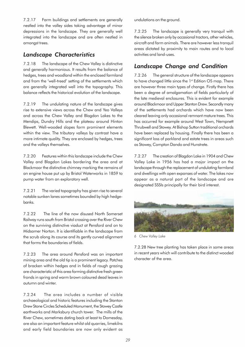
7.2.17 Farm buildings and settlements are generally nestled into the valley sides taking advantage of minor depressions in the landscape. They are generally well integrated into the landscape and are often nestled in amongst trees.
Landscape Characteristics 7.2.18 The landscape of the Chew Valley is distinctive and generally harmonious. It results from the balance of hedges, trees and woodland within the enclosed farmland and from the ‘well-treed’ setting of the settlements which are generally integrated well into the topography. This balance reflects the historical evolution of the landscape.
7.2.19 The undulating nature of the landscape gives rise to extensive views across the Chew and Yeo Valleys and across the Chew Valley and Blagdon Lakes to the Mendips, Dundry Hills and the plateau around Hinton Blewett. Well-wooded slopes form prominent elements within the view. The tributary valleys by contrast have a more intimate quality. They are enclosed by hedges, trees and the valleys themselves.
7.2.20 Features within this landscape include the Chew Valley and Blagdon Lakes bordering the area and at Blackmoor the distinctive chimney marking the remains of an engine house put up by Bristol Waterworks in 1859 to pump water from an exploratory well.
7.2.21 The varied topography has given rise to several notable sunken lanes sometimes bounded by high hedge-banks.
7.2.22 The line of the now disused North Somerset Railway runs south from Bristol crossing over the River Chew on the surviving distinctive viaduct at Pensford and on to Midsomer Norton. It is identifiable in the landscape from the scrub along its course and its gently curved alignment that forms the boundaries of fields.
7.2.23 The area around Pensford was an important mining area and the old tip is a prominent legacy. Patches of bracken within hedges and in fields of rough grazing are characteristic of this area forming distinctive fresh green fronds in spring and warm brown coloured dead leaves in autumn and winter.
7.2.24 The area includes a number of visible archaeological and historic features including the Stanton Drew Stone Circles Scheduled Monument, the Stowey Castle earthworks and Marksbury church tower. The mills of the River Chew, sometimes dating back at least to Domesday, are also an important feature whilst old quarries, limekilns and early field boundaries are now only evident as
undulations on the ground.
7.2.25 The landscape is generally very tranquil with the silence broken only by occasional tractors, other vehicles, aircraft and farm animals. There are however less tranquil areas dictated by proximity to main routes and to local activities and land-uses.
Landscape Change and Condition 7.2.26 The general structure of the landscape appears to have changed little since the 1st Edition OS map. There are however three main types of change. Firstly there has been a degree of amalgamation of fields particularly of the late medieval enclosures. This is evident for example around Blackmoor and Upper Stanton Drew. Secondly many of the settlements had orchards which have now been cleared leaving only occasional remnant mature trees. This has occurred for example around West Town, Nempnett Thrubwell and Stowey. At Bishop Sutton traditional orchards have been replaced by housing. Finally there has been a significant loss of parkland and estate trees in areas such as Stowey, Compton Dando and Hunstrete.
7.2.27 The creation of Blagdon Lake in 1904 and Chew Valley Lake in 1956 has had a major impact on the landscape through the replacement of undulating farmland and dwellings with open expanses of water. The lakes now appear as a natural part of the landscape and are designated SSSIs principally for their bird interest.
6 Chew Valley Lake
7.2.28 New tree planting has taken place in some areasin recent years which will contribute to the distinct wooded character of the area.
29

Area 3: Upper Chew and Yeo Valleys Summary of Landscape Character • Flat landscape, gently sloping in parts
• Red soils associated with mudstone outcrops
• Spring line villages of West Harptree, East Harptree, Compton Martin and Ubley with harmonious use of traditional building materials in older buildings
• Isolated farms, many very old including a medieval moated farmhouse
• Small regular fields surrounded by clipped hedges
• Arable and pastoral land cover
• Frequent hedgerow trees and large belts of trees giving the impression of being well-wooded
• Few small woods, conifer or willow and poplar plantations around the edges of the lakes and others consist of oak and ash
• Wide tree belt follows the River Yeo
• Views to surrounding hills but limited views within the area
• Straight roads well enclosed by landform and/or hedges
• Generally quiet and peaceful away from the A368 corridor
• Roman road
• Tumulus north of Blagdon Lake
• Chew Valley lake and associated features
For detailed Character Area map see Appendix 3
30

Context Introduction 7.3.1 The Upper Chew and Yeo Valleys character area covers nearly 18sq km. It is a flat or gently sloping area between the Mendip Slopes character area to the south and the Chew Valley character area to the north. The boundary incorporates part of the Blagdon and Chew Valley Lakes. It then extends south-eastwards to the area boundary at Coley taking in the villages of East and West Harptree at the foot of the northern Mendip slopes. The edges of the character area are generally at the point at which the valley sides become significantly steeper and at the shores of the two lakes.
Geology, Soils and Drainage 7.3.2 The predominant formation is the Mercia Mudstones of the Triassic period. Dolomitic Conglomerate of the same period is found above the mudstones on the higher parts of the area. There are also more recent drift deposits on the lower parts of the area adjacent to the Chew Valley Lake.
7.3.3 The mudstones give rise to fertile silty clay soils that are a dull dusky red colour because of their high iron content. The clay content means that where unimproved they easily become waterlogged when wet, and hard with cracks and fissures during dry periods. The Dolomitic Conglomerate, which is a complex of limestone fragments, gives rise to thinner freely draining soils. These soils are stony and can be slightly acidic on the surface.
7.3.4 The soils over the drift deposits are similar to those derived from the mudstones but they have more silt and sand within the matrix which makes them more freely draining.
Major Planning Designations 7.3.5 The whole of the area is within the Mendips AONB and the whole of the undeveloped area is within the Bristol/Bath Green Belt.
Description Landform and Drainage Pattern 7.3.6 This area is flat or gently sloping. There are significant slopes only on the southern edge. It is about 50m at its lowest point near Blagdon Lake and about 100m at its highest where it rises to meet the spring line villages of West Harptree, Compton Martin and Ubley. The springs occur along the Dolomitic Conglomerate exposures. The area includes the tributaries and upper reaches of both the River Yeo, which flows westwards from Compton Martin, and the River Chew, which flows northwards from Coley.
Land-uses 7.3.7 The land is used for arable crops and ley pasture on the better-drained and flatter areas such as on the alluvial soils; and for permanent pasture on the wetter, stonier and more sloping parts particularly on the Dolomitic Conglomerates and parts of the Mercia Mudstones. These latter areas also traditionally supported orchards. Generally pasture is the predominant land-use throughout the area.
7.3.8 Fields, Boundaries and Trees The fields are small and medium sized and predominantly rectangular, others irregularly shaped. The field pattern results from the enclosure in the late medieval period into single ownership units from the open fields that surrounded the spring line villages. Neatly trimmed hedges frequently edge the fields and generally are in reasonable condition, though some are ‘gappy’. Many are supplemented by post and wire fencing where stock proofing is required. There
7 Near South Widcombe
31

are frequent hedgerow trees consisting mainly of oak and ash generally in good condition.
7.3.8 There are only a few small woods which are either remnant plantations or semi-scrub woodlands. There are a variety of types, those around the edges of the lakes are conifer or willow and poplar plantations, others consist of oak and ash. The area has the impression of being well wooded created in part by the frequent hedgerow trees and tree belts. The tree belts are found between fields, along the roads, around settlements and a thick belt follows the River Yeo.
8 Widcombe Common
Settlement and Communications 7.3.9 The main settlements in the area are the medieval spring line villages at the foot of the Mendip slopes. They are distinctive because of the trees in their vicinity and the larger houses and buildings such as the churches. Generally they fit in well with their landscape setting because of their organic pattern and the muted traditional building materials. The other forms of settlement include farms, some of which also clearly date back to at least medieval times. The moat at Moat Farm to the west of Chew Valley Lake for example is 14th century.
7.3.10 There is a well-developed pattern of roads withinthe area and they range from ‘A’ roads to unclassified lanes. They are nearly all enclosed by the hedges on the roadside and some are sunk below the surrounding field level. They are noticeably straight and at least one is Roman. There is an interesting road from New Manor Farm to South Widcombe with a wide grassland verge that may well have been common land or a drove road. This road follows the base of the indented scarp slope and so has many twists and turns.
Landscape Characteristics 7.3.11 In all places there are fine views to the surrounding hills. The flat terrain and trees commonly limit near views. The hedges are too low to have any significant enclosing effect. These factors help to create a feeling that
is open but not too exposed. The lack of excessive traffic noise and other urban intrusions create a peaceful atmosphere only broken by occasional aircraft and traffic on the A368. This is further enhanced by very noticeable bird song and the noise from tractors and other farm equipment.
7.3.12 This area displays many features that show continual use for thousands of years, from the tumulus north of Blagdon Lake which dates back 3000 years to the Roman road and the medieval moated farm house which was a nunnery in 1881. More modern features include the two lakes dating from the early to mid 20th century. These are now designated as SSSIs. There are few detractors in the area. Locally a line of electricity pylons south of Chew Valley Lake detracts from the view.
Landscape Change and Condition 7.3.13 The most significant change to this landscape character area has been the construction of the two lakes. Blagdon Lake was created in 1904 and Chew Valley Lake was completed in 1956. Both have obviously changed the valley considerably just by their presence but clearly they have covered land that was once an integral part of the area and that contributed to its character. The lakes themselves have added an additional element; that of open water and the peripheral planting. The activities on the lake such as the presence of sailing boats add to the changes. And finally the consequential changes to the local road infrastructure have altered the old pattern of roads, lanes and footpaths. The wide road of the outfall dam and other strips of road around the lake have further modified their immediate vicinity with the fencing, balustrades and buildings associated with the water control mechanisms.
9 Southwest of Chew Valley Lake
7.3.14 Other changes include hedgerow loss. Original hedge lines are now often visible only from local undulations and by rows of oak trees retained within the fields. In addition there has been a huge decrease in the amount of orchard. In 1884 all of the spring-line villages had many adjacent fields under orchard and most of the farms had some as well, today there is very little. Aerial photos taken in 1946 show many still evident and so removal has largely, though not consistently, been undertaken since then. Many of the orchards have been built upon, as they were located close
32

to the villages. The landscape has a ‘well-treed’ appearance which would have been even more evident prior to the onset of Dutch elm disease. There appears to be little evidence of new tree planting / regeneration in the hedgerows.
33

Area 4: Mendip Slopes Summary of Landscape Character • Dolomitic Conglomerate is the principal rock formation
• Gentle to steeply sloping edge to the Mendip Hills with local undulations and rock outcrops
• Slopes incised with minor valleys or combes which are often wooded
• Ancient semi-natural woodland on steeper slopes
• Most agricultural land is grassland including both rough grazing and cultivated and re-seeded grassland
• Field boundaries typically marked by tall hedges and more rarely walls towards the upper slopes
• Fields are generally small, irregular on the upper slopes indicating medieval woodland clearance and regular on the lower slopes indicating enclosure of open fields in the late medieval period
• Settlements of Ubley, East Harptree, Compton Martin and West Harptree located at the foot of the slope along the springline have strong visual connection with character area
• Houses generally have clay-tiled roofs; many painted or rendered white. Mixture of natural building materials i ncluding Carboniferous Limestones and red sandstone
• Extensive views across Chew Valley
• Area well served by minor roads and public rights of way including the Limestone Link long distance footpath
• Features include disused quarries and lime-kilns, shafts along the line of the Bristol Water Works supply pipe and remnants of orchards
• Noise along A368 corridor otherwise generally quiet and peaceful
For detailed Character Area map see Appendix 3
34

Context Introduction 7.4.1 The Mendip Slopes character area is at the south-west boundary of the area. It covers nearly 7sq km. The character area comprises a single landscape type; a scarp slope at 75m to 235m. This forms the transition between the gently sloping landscape of the Upper Chew and Yeo Valleys character area and the open landscape of the Mendip Hills plateau. The northern boundary follows the bottom of the scarp slope with its characteristic local undulations. The southern boundary runs along the break of slope at the top of the scarp.
Geology, Soils and Drainage 7.4.2 The predominant formation is Dolomitic Conglomerate of the Triassic period. It formed as a result of desert erosion and weathering of the scarp slopes. It takes the form of rock fragments mainly derived from older Carboniferous Limestone cemented together by lime and sand which hardened to sometimes give the appearance of concrete. The resultant land is characteristically irregular.
10 Rock outcrop near Ridge
7.4.3 Carboniferous Limestone, which is a major influence on the characteristic form of the Mendips, extends only a small amount into the area. It is represented by Hotwells Limestone straddling the area boundary and an outcrop of Clifton Down Limestone east of Morgan’s Lane near East Harptree.
7.4.4 Mercia Mudstones are found to the south of East Harptree typically on the lower slopes of the Mendip Hills beyond the Dolomitic Conglomerate. They consist of red siltstone and mudstone of the Triassic desert basins.
7.4.5 There are two main soil types that correspond to the underlying geology. The principal soils are found on the Dolomitic Conglomerate. These are shallow well-drained reddish loamy neutral to acid soils over rubbly subsoils. The other main soil types are found on the Mercia
Mudstones. They are fertile, slowly permeable reddish clayey neutral to acid soils over mudstone.
Major Designations 7.4.6 The whole area is within the Mendip Hills AONB.
Description Landform and Drainage Pattern 7.4.7 The north-east facing slope falls dramatically from the edge of the Mendip Hills and is moderate to steeply sloping. The steepest slopes occur towards the west of the area where the Dolomitic Conglomerate outcrop is narrower such as to the west of Compton Martin with slopes of about 25º. Where the Dolomitic Conglomerate outcrop is wider such as around East Harptree the slopes are gentler at about 4º to 8º. The land is characteristically undulating with occasional rock outcrops. Rocky combes or gorges such as Compton Combe above Compton Martin and Harptree Combe near East Harptree typically incise the Mendip Slopes. The former is a dry valley and the latter is occupied by the Molly Brook.
Land-uses 7.4.8 The land is generally suitable for a range of agricultural uses. Cultivation however is limited in places by the steepness of the slopes. In these areas the land has been left as woodland or used as rough grazing for dairy and beef cattle and typically has bracken and thorn scrub. Rocky outcrops have also hampered cultivation even on shallower slopes and such land was often planted with orchards and used for winter grazing. The more gentle slopes particularly to the east of the area have allowed cultivation to take place and include ley pasture.
Fields, Boundaries and Trees 7.4.9 Tall hedges containing trees generally enclose the fields. Walls are more characteristic of the Mendip Hills plateau but occasionally extend onto the Mendip Slopes. Where there are walls they have generally been neglected and have become overgrown with scrub. Historically most of the fields on the upper slopes were enclosed during the Middle Ages by piecemeal clearance of woodland and
35

rough pasture. This gave rise to small irregular fields. The fields on the lower slopes by contrast were enclosed from open fields during the late Middle Ages. The resultant fields are typically small, with some medium, and regular in outline following the natural lie of the land. A distinctly different field pattern occurs at The Wrangle to the south of Compton Martin where the small-scale rectilinear field pattern is characteristic of late 18th or early 19th century enclosure of remaining heathland. A small settlement developed around the edge during the 19th century.
7.4.10 The steep slopes and incised valleys have given rise to significant woods or groups of trees, as at Harptree Hill, where cultivation was not possible. Many of the woods including Ubley Wood, Compton Wood, Harptree Combe, The Grove and Lady/Buckley Wood are ancient semi-natural woods. They form prominent features viewed from the Chew Valley. The nature conservation value of the woodlands is recognised by their designation as SNCIs and in the case of Harptree Combe a Site of Special Scientific Interest. Occasional groups of old knarled apple trees indicate the remnants of old apple orchards.
Settlement and Communications 7.4.11 Settlement principally comprises individual houses and farms scattered along lanes running north-south up the scarp slope. There are two hamlets at the Wrangle and Ridge. The villages of Ubley, East Harptree, Compton Martin and West Harptree are located at the bottom of the Mendips Slope on the spring line. Whilst actually situated in the Upper Chew and Yeo Valleys character area, these villages have a strong visual connection to the Mendip Slopes, nestling as they do into the base of the scarp. Buildings within the area are typically roofed with clay tiles and include many white painted or rendered houses. Traditional building materials include Carboniferous Limestone and red sandstone.
7.4.12 There are a surprisingly large number of generally minor roads within the area perhaps reflecting the historical significance of the area for mining and agriculture. The greatest density of roads is around West and East Harptree where the slopes are gentler. The ancient route of the A368 west of West Harptree generally follows the foot of the Mendips Slopes and is the major road within the area. It lies within the Upper Chew and Yeo Valleys character area but effectively marks the boundary between the two character areas. Several minor roads such as Highfield Lane, Harptree Hill and Smitham Hill ascend the slopes generally following the gentler inclines. Some roads originated as droveways to open pasture. They have straight and winding sections, are sunken and frequently bounded by tall banks and tall hedges which overhang the road, creating a strong localised sense of enclosure.
12 A Green Lane near Eastwood Manor
7.4.13 A long distance footpath, the Limestone Link, passes through both Compton Martin and West Harptree on its way from the Mendips to the Cotswolds.
11 South of Ubley
36

Landscape Characteristics 7.4.14 The Mendip Slopes are visible over a wide area stretching northwards to the Dundry Hills and conversely they offer spectacular views over the Chew Valley. The landscape, however, has an unexpected intimate quality provided by the incised valleys or combes, the local undulations in the topography and the tall hedges and woodland blocks. The A368 and adjoining uses such as garages generate a significant amount of noise. This contrasts with the generally peaceful atmosphere outside the road corridor.
7.4.15 There are many features of interest such as the shafts located along the line of the Bristol Waterworks supply pipes passing to the south and west of West and East Harptree. Small quarries and lime-kilns were also a feature of the landscape now often only marked by undulations on the ground. The position of the pound to the south of West Harptree is also evident.
Landscape Change and Condition 7.4.17 The landscape generally appears to be in good condition. One of the most noticeable changes is the decline in the area of orchards. The First Edition OS map shows orchards all around the springline villages. These have rarely survived to the present time and often the only visible evidence is the occasional group of distinctive old knarled apple trees.
7.4.18 The field pattern largely remains intact althoughover the years it is apparent that several of the smaller fields enclosed from the open field system have been amalgamated. There has also been some rationalisation and enlargement of some of the more irregular fields. Stone walls are generally in disrepair and are often overgrown with scrub.
7.4.19 Other significant changes include some creep ofthe springline villages up the scarp slope during the 20th
century and construction of large modern barns often in prominent locations within the landscape.
37

Area 5: Dundry Plateau Summary of Landscape Character • Dundry Hill of Oolitic Limestone and lower shelf/plateau of Lias Limestone
• Open windswept landscape
• Indented valleys at edges of area
• Landslips at junction of limestone and clay
• Norton Court parkland with parkland trees
• Small woods and tree belts in valleys and around settlement
• Prominent modern farm buildings on higher ground (pig and poultry units)
• Buildings either in small groups or isolated cottages or farmsteads – typically of Lias Limestone often rendered or painted
• High species diversity in hedges
• Iron age hill fort at Maes Knoll and strip lynchets indicating late medieval enclosure of steep-sided slopes
• Wansdyke linear earthwork
• Disused North Somerset Railway marked by trees, scrub and field boundaries
• Landmarks include Maes Knoll hillfort and Norton Malreward church tower
• Urban fringe problem of tipping along Whitchurch Lane
For detailed Character Area map see Appendix 3
38

Context Introduction 7.5.1 The Dundry Plateau character area covers an area of 18sq km of higher ground. It extends from the south-western edge of Keynsham westwards to the area boundary near Chew Hill north of Chew Magna. It rises to a number of significant hills including Maes Knoll at 197m and Dundry Hill, beyond the area boundary, at 202m. The boundary generally follows the top of the distinct scarp slopes. This typically marks the junction between the Lias Limestone of the plateau and the Mercia Mudstones typical of the lower lying Chew Valley to the south. The character area of Stockwood Vale and Charlton Bottom abuts to the north at the eastern end.
Geology, Soils and Drainage 7.5.2 The most significant geological formation is the Inferior Oolite of the Jurassic period found on the higher ground including Maes Knoll. This overlays the Lower Lias Clay found on the adjoining slopes. The clays make a poor foundation and landslips are characteristic on the slopes. This area was once connected to the Cotswolds. The intervening land has subsequently been eroded leaving this outlier with many of the characteristics of the Cotswold Plateau.
7.5.3 Equally characteristic is a lower shelf or plateau formed of white and blue Lias Limestone of the Lower Lias period. This is typically edged with clay and shale of the Penarth Group.
7.5.4 The soils within this area are often clayey. On the hills and plateaux the soils are over limestone and are
generally well drained. The soils of the upper slopes by contrast are more silty and are prone to seasonal waterlogging.
Major Designations 7.5.5 The whole of the undeveloped area is within the Bristol/Bath Green Belt and the whole area is within the Forest of Avon Community Forest area.
Description Landform and Drainage Pattern 7.5.6 The most characteristic feature of the landscape is Dundry Hill which forms the highest ground surrounded by a steep scarp leading to a lower shelf or plateau. The land is generally flat or gently sloping except for the more dramatic steeply sloping scarp slopes at the edge of the Oolitic Limestone Dundry Hill and the edge of the Lias Limestone lower plateau. The landscape is sculpted by a series of watercourses which arise from this area including those occupying Charlton Bottom, the valley at Queen Charlton and numerous tributaries of the River Chew such as those through Norton Hawkfield and Norton Malreward. These provide the characteristically indented edge to the character area. The evocative names of Publow Hill, Hursley Hill, Settle Hill, Guy’s Hill, Chew Hill and Limeburn Hill reflect the significance of the landform. The routes through this landscape have often become eroded over time resulting in dramatic sunken lanes.
Land-uses 7.5.7 The land is used both for pasture and cereal production. Arable predominates in areas such as to the
13 View Towards Maes Knoll
39

west of Maes Knoll while pasture predominates further east in the area north of Gibbet Lane.
7.5.8 There are remnants of a significant park at Norton Court including a number of giant redwood trees. Many of the parkland trees shown on the 1st Edition OS map have been lost, however the park appears to be fairly well preserved around the buildings of Norton Malreward Court.
Fields, Boundaries and Trees 7.5.9 Fields are mainly enclosed by well-trimmed hedges with high species diversity; some appear quite wide and are trimmed to an A-shape. Less frequently hedges are unclipped such as to the south of Whitchurch. Fields are predominantly medium in size, with small and large fields also, the large ones concentrated in the western part of the area. The fields feature few trees. The landscape is open in appearance with only occasional but very significant trees within the hedges. There are also occasional scattered small woods and tree belts. The most significant are located within the valleys such as around Norton Hawkfield, Norton Malreward and North Wick. Other wooded parts include Queen Charlton and Queen Charlton Lane, beside the old railway near New Barn Farm and the steeper slopes north of Maes Knoll.
14 Charlton Field
Settlement and Communications 7.5.10 A network of minor roads follow the indented valleys such as the roads through Norton Malreward, Norton Hawkfield and North Wick or follow higher ground avoiding the steepest slopes. Settlement generally takes the form of isolated farms or cottages or ribbon development such as along Gibbet Lane and at Lypiatt. It generally avoids the highest ground though East Dundry just outside the area exceptionally is located on higher ground on Dundry Hill. Villages are typically located around the boundaries of the area on or at the foot of the surrounding scarp slopes
15 Edge of Queen Charlton
7.5.11 Local buildings are traditionally constructed of Lias Limestone, some with a painted or rendered finish, with slate or clay tiled roofs. More recent post-war ribbon development such as in Lypiatt and Gibbet Lane has an assortment of materials including brick, reconstituted stone and rendering.
Landscape Characteristics 7.5.12 The landscape is open and windswept. The elevated character of the area gives extensive views taking in the settlements of Bristol, Keynsham, Saltford and Bath as well as the Chew Valley and Mendip Hills. Conversely the hills of the Dundry plateau are visible over a wide area forming a backdrop to many views.
7.5.13 The outline of isolated trees, and more rarely small woods or tree belts, on the skyline are typical of the area. Two of the most significant historical features within the area are the late prehistoric hill fort at Maes Knoll and the Wansdyke which is a later, possibly post Roman linear earthwork which starts at the hill fort and runs to Horsecombe Vale to the south-west of Bath. Both these sites are Scheduled Monuments. The fort is triangular in shape taking advantage of the natural topography of the hill. The existing scarp slopes were steepened and a large rampart and ditch were built on the north-west side. There are also remnants of medieval strip lynchets on the slopes around Maes Knoll. There is no clear evidence about the origin or purpose of the Wansdyke however it forms a significant feature consisting of a substantial bank and ditch on its northern side. This section from Maes Knoll to Cottles within the Chew Valley character area is well preserved.
7.5.14 The now disused North Somerset Railway passed through this area south of Whitchurch. Its course is evident through remaining earthworks and surviving hedge boundaries. Other landmarks include the church tower at Norton Malreward. The deserted medieval hamlet of Pickwick, a Scheduled Monument and its probable successor, the 19th century Model Farm to the north of Norton Hawkfield are of interest to this area.
40

7.5.15 In the northern part of the character area, along Whitchurch Lane, typical urban fringe problems of damage to gates and fences, tipping and car burning are evident in gateways, lay-bys and passing places – the appearance markedly contrasting with the otherwise well cared for appearance of the character area.
Landscape Change and Condition 7.5.16 The landscape appears to be in good condition. There has generally been little change to the landscape structure since the 1st edition OS map of 1884. Rarely larger fields have been created by hedge removal such as to the east of Norton Malreward. Generally only a few hedges have been removed largely to rationalise smaller fields which were created based on the medieval strip field system layout.
7.5.17 Changes in agriculture locally have broughtsignificant change. Of particular significance is the erosion in the extent of the parkland at Norton Court. Other more subtle changes include increasing pressure on remaining trees through agricultural activity with little evidence of replacement planting. There have however been some recent areas of new tree planting which will in time form significant features in the landscape. The construction of large agricultural buildings and adding to existing farm buildings is also having a significant impact on views within the area.
41
Area 6: Hinton Blewett and Newton St Loe Plateau Lands Summary of Landscape Character • Undulating open valley and plateau landscape
• Well trimmed hedges
• Narrow enclosed lanes/green lanes
• Rounded hills as at Farmborough Common, Priest Barrow, Nap Hill, The Sleight and Mearns Hill
• Tree lined Cam, Newton, Conygre and Corston Brooks
• Extensive areas of arable farmland
• Newton Park and other historic parks
• Small batches and other evidence of past coal mining
• Walls within and at edges of villages and hamlets
• Villages generally located within valleys
• Traditional buildings constructed of Oolitic or Lias Limestone and many houses rendered or painted
• Wansdyke - well preserved at Englishcombe
• Stantonbury Hill
• Priston Mill
• Earthworks of Culverhay Castle at Englishcombe
For detailed Character Area map see Appendix 3
42

Context Introduction 7.6.1 This is the second largest character area covering nearly 64sq km. It has a varied character marked by an undulating, much eroded Oolitic and Lias Limestone plateau with tributary valleys of the River Avon and a number of notable rounded hills. The area extends in a south-west to north-east band across the centre of the area from Hinton Blewett in the south-west to the edge of Bath in the north-east. The boundaries are defined by the edge of the plateau before it falls away except for the eastern boundary which abuts the edge of Bath and a small part of the Cotswolds Plateaux and Valleys character area. It borders the character areas of Chew Valley, Avon Valley and Cam and Wellow Brook Valleys to the west, north and south respectively as well as the smaller Hollow Marsh and Farrington Gurney Farmlands character areas.
Geology, Soils and Drainage 7.6.2 The most characteristic geological formation is Lias Limestone which occupies two main areas from Hinton Blewett to Red Hill and the area north of a line from Barrow Vale and Farmborough through Stanton Prior to Newton Park. It also occurs as bands from Timsbury to Priston. Lias Clay occupies much of the remaining area where it abuts the Lias Limestone. Mercia Mudstones also occur particularly towards the west of the area and there is a band of Supra-Pennant Measures from Clutton to High Littleton.
7.6.3 Oolitic Limestone outcrops towards the east of the area near Wilmington and from Tunley to the edge of Bath. There are also a number of more isolated outcrops of Oolitic Limestone forming distinctive rounded hills such as at Stantonbury Hill and Winsbury Hill.
7.6.4 There are notable areas of Fuller’s Earth which is a clay found between the top of the Inferior Oolite and the base of the Great Oolite or Forest Marble. It was extracted commercially in Englishcombe parish.
7.6.5 In the south and south east of the area there are coal measures which are sufficiently near the surface for coal mining to have taken place at Clutton, High Littleton, Timsbury and Tunley.
7.6.6 The principal soils associated with the Lias and Oolitic Limestone and Lias Clay are shallow well-drained calcareous clays and clay loams. They typically support both cereals and grassland. Other soil types are represented relating to changes in the geology. Reddish fine loamy or clayey soils are found over the Mercia Mudstones to the west of the area. Silty soils are found along a band following the Conygre and Newton Brooks. There is a band of clayey and fine loamy soils over clay along a narrow band over the Supra-Pennant Measures.
Principal Planning Designations 7.6.7 The whole of the rural area is within the Bristol/ Bath Green Belt. A very small part of the Bristol-Avon Community Forest extends into the area to the south of Saltford.
Description 7.6.8 Landform and Drainage Pattern This area comprises an undulating mainly Lias and in part Oolitic Limestone plateau. It is at its highest towards the south and south-west where it reaches 200m and at its lowest towards the north and north-east at 80-100m. The plateau generally rises quite sharply from the surrounding
16 Towards Newton Brook Valley
43

valleys and lower-lying land. Exceptions occur at the northern edge of the plateau, which rises gently out of the River Avon Valley, and the eastern corner, which is almost level with the southern end of the Cotswold plateau.
7.6.9 Although this is undoubtedly a plateau in terms of overall landform, it has been very heavily eroded to form a complex undulating plateau and valley landscape with some very notable conical or rounded hills protruding out of the plateau. Extensive, exposed, flat plateau tops are not really characteristic and it therefore contrasts quite strongly with the Cotswold plateau.
7.6.10 The area divides very roughly into two landform patterns. In the west around Clutton, High Littleton, Farmborough and Timsbury the landform is very undulating and has the majority of the distinctive rounded hills as at Farmborough Common, Priest Barrow, Nap Hill, The Sleight and Mearns Hill. In the east the incised valleys of the Conygre, Newton and Corston Brooks within the area and the Cam Valley immediately outside the area, give rise to two particularly distinctive wide ridge lines. The most northerly is at Wilmington and the southerly ridge is between Tunley and Longhouse.
7.6.11 The area has two main drainage systems. The Cam Brook and tributaries originate to the west passing through the Mercia mudstones before continuing their easterly course in the Cam and Wellow Brook Valleys character area. The Newton, Conygre and Corston Brooks and their tributaries originate to the west and follow a generally north-easterly course to join the River Avon west of Bath. They generally pass through the Lias Clay.
Land-use 7.6.12 Much of the arable land in the area is found within this character area, such as around Corston, Wilmington and Englishcombe, forming a patchwork within areas of grassland. Generally the arable land is on the flatter or gently sloping plateau land whilst the grassland is on the more undulating, steeply sloping land.
7.6.13 Most of the villages have characteristic areas of horse paddock around them, often fenced or sub-divided by white tape.
7.6.14 There are several areas of parkland and estate farms, which have given rise to distinct landscapes. Newton St Loe, Englishcombe and Kingwell Hall are examples. At Newton St Loe, Newton Park is a grade II registered park designed by Capability Brown. There is a management plan in place here to restore the landscape.
17 Newton Park College
7.6.15 There is very little landscape evidence remaining of the previous mining activities around Clutton, Temple Cloud, High Littleton and Timsbury. There are a few small batches at Clutton, east of Radford Hill and at Greyfields, High Littleton.
Fields, Boundaries and Trees 7.6.16 Field hedges are mostly regularly trimmed, except in some of the steeper valley areas. Many are ‘welltreed’ except for the more exposed plateau tops such as south of Corston and around Hinton Blewett. The condition of hedges and hedgerow trees is very variable with particularly poor hedges around arable fields. There were no survey points where particularly good hedgerow management was noted and only two recently planted hedges were noted, both suffering from poor establishment management. The area features a variety of field sizes, medium predominating, with large fields on plateaux or gentler slopes and smaller fields on steeper slopes and around some villages. Most fields are irregular in shape and pattern. This is often associated with late medieval enclosure of the open field system and in more recent times with amalgamation of smaller fields to form more easily worked units.
18 Kilkenny Lane
7.6.17 Fencing is not common except around settlements. Walls are typically found around the edges and within villages and hamlets, for example at Stanton Prior. Nearby at Wilmington there is a walled field boundary, the
44
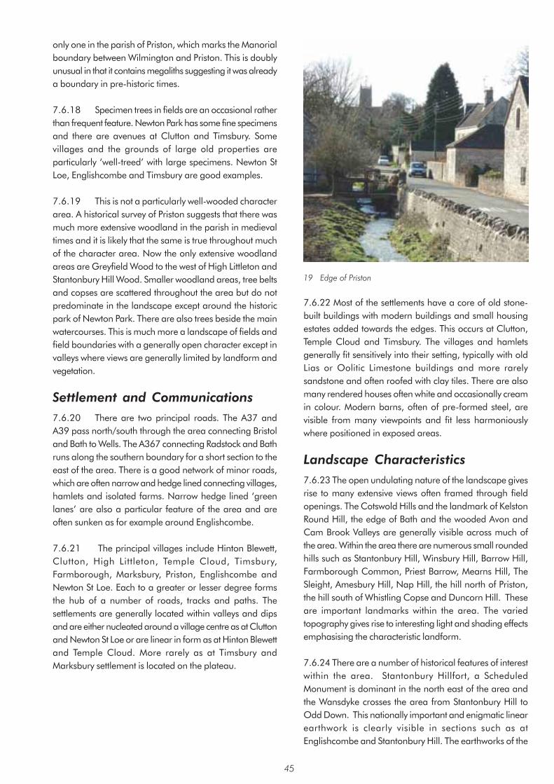
only one in the parish of Priston, which marks the Manorial boundary between Wilmington and Priston. This is doubly unusual in that it contains megaliths suggesting it was already a boundary in pre-historic times.
7.6.18 Specimen trees in fields are an occasional rather than frequent feature. Newton Park has some fine specimens and there are avenues at Clutton and Timsbury. Some villages and the grounds of large old properties are particularly ‘well-treed’ with large specimens. Newton St Loe, Englishcombe and Timsbury are good examples.
7.6.19 This is not a particularly well-wooded character area. A historical survey of Priston suggests that there was much more extensive woodland in the parish in medieval times and it is likely that the same is true throughout much of the character area. Now the only extensive woodland areas are Greyfield Wood to the west of High Littleton and Stantonbury Hill Wood. Smaller woodland areas, tree belts and copses are scattered throughout the area but do not predominate in the landscape except around the historic park of Newton Park. There are also trees beside the main watercourses. This is much more a landscape of fields and field boundaries with a generally open character except in valleys where views are generally limited by landform and vegetation.
Settlement and Communications 7.6.20 There are two principal roads. The A37 and A39 pass north/south through the area connecting Bristol and Bath to Wells. The A367 connecting Radstock and Bath runs along the southern boundary for a short section to the east of the area. There is a good network of minor roads, which are often narrow and hedge lined connecting villages, hamlets and isolated farms. Narrow hedge lined ‘green lanes’ are also a particular feature of the area and are often sunken as for example around Englishcombe.
7.6.21 The principal villages include Hinton Blewett, Clutton, High Littleton, Temple Cloud, Timsbury, Farmborough, Marksbury, Priston, Englishcombe and Newton St Loe. Each to a greater or lesser degree forms the hub of a number of roads, tracks and paths. The settlements are generally located within valleys and dips and are either nucleated around a village centre as at Clutton and Newton St Loe or are linear in form as at Hinton Blewett and Temple Cloud. More rarely as at Timsbury and Marksbury settlement is located on the plateau.
45
19 Edge of Priston
7.6.22 Most of the settlements have a core of old stone-built buildings with modern buildings and small housing estates added towards the edges. This occurs at Clutton, Temple Cloud and Timsbury. The villages and hamlets generally fit sensitively into their setting, typically with old Lias or Oolitic Limestone buildings and more rarely sandstone and often roofed with clay tiles. There are also many rendered houses often white and occasionally cream in colour. Modern barns, often of pre-formed steel, are visible from many viewpoints and fit less harmoniously where positioned in exposed areas.
Landscape Characteristics 7.6.23 The open undulating nature of the landscape givesrise to many extensive views often framed through field openings. The Cotswold Hills and the landmark of Kelston Round Hill, the edge of Bath and the wooded Avon and Cam Brook Valleys are generally visible across much of the area. Within the area there are numerous small rounded hills such as Stantonbury Hill, Winsbury Hill, Barrow Hill, Farmborough Common, Priest Barrow, Mearns Hill, The Sleight, Amesbury Hill, Nap Hill, the hill north of Priston, the hill south of Whistling Copse and Duncorn Hill. These are important landmarks within the area. The varied topography gives rise to interesting light and shading effects emphasising the characteristic landform.
7.6.24 There are a number of historical features of interestwithin the area. Stantonbury Hillfort, a Scheduled Monument is dominant in the north east of the area and the Wansdyke crosses the area from Stantonbury Hill to Odd Down. This nationally important and enigmatic linear earthwork is clearly visible in sections such as at Englishcombe and Stantonbury Hill. The earthworks of the
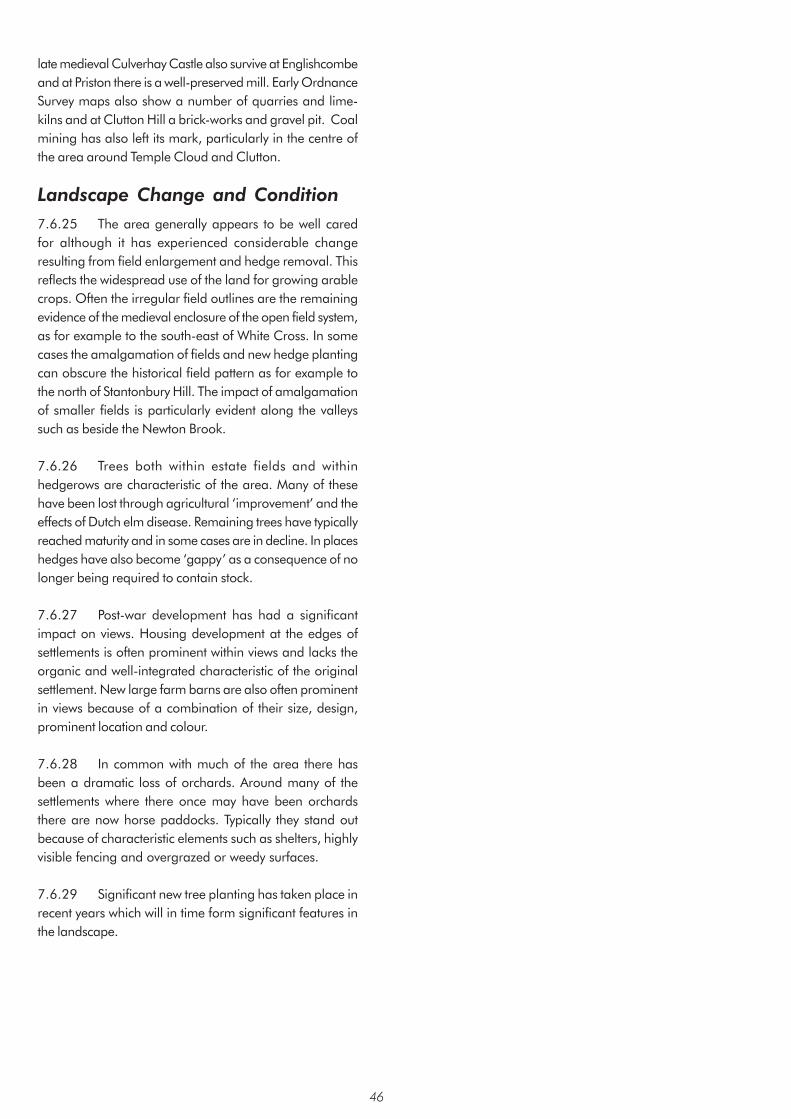
late medieval Culverhay Castle also survive at Englishcombe and at Priston there is a well-preserved mill. Early Ordnance Survey maps also show a number of quarries and limekilns and at Clutton Hill a brick-works and gravel pit. Coal mining has also left its mark, particularly in the centre of the area around Temple Cloud and Clutton.
Landscape Change and Condition 7.6.25 The area generally appears to be well cared for although it has experienced considerable change resulting from field enlargement and hedge removal. This reflects the widespread use of the land for growing arable crops. Often the irregular field outlines are the remaining evidence of the medieval enclosure of the open field system, as for example to the south-east of White Cross. In some cases the amalgamation of fields and new hedge planting can obscure the historical field pattern as for example to the north of Stantonbury Hill. The impact of amalgamation of smaller fields is particularly evident along the valleys such as beside the Newton Brook.
7.6.26 Trees both within estate fields and within hedgerows are characteristic of the area. Many of these have been lost through agricultural ‘improvement’ and the effects of Dutch elm disease. Remaining trees have typically reached maturity and in some cases are in decline. In places hedges have also become ‘gappy’ as a consequence of no longer being required to contain stock.
7.6.27 Post-war development has had a significant impact on views. Housing development at the edges of settlements is often prominent within views and lacks the organic and well-integrated characteristic of the original settlement. New large farm barns are also often prominent in views because of a combination of their size, design, prominent location and colour.
7.6.28 In common with much of the area there has been a dramatic loss of orchards. Around many of the settlements where there once may have been orchards there are now horse paddocks. Typically they stand out because of characteristic elements such as shelters, highly visible fencing and overgrazed or weedy surfaces.
7.6.29 Significant new tree planting has taken place in recent years which will in time form significant features in the landscape.
46

Area 7: Hollow Marsh Summary of Landscape Character • Geologically estuarine alluvium with Mercia Mudstones at edges of area
• Grey clayey alluvial soils with reddish loamy soils on the mudstones
• Wide flat/gently sloping valley floor
• Drainage channels drain towards the tributary of the Cam Brook
• Mainly permanent pasture with areas of arable
• Late medieval enclosure of open field system
• Regular rectilinear field pattern
• Clipped hedges with occasional trees
• Tranquil open landscape with views to neighbouring areas
• Few isolated buildings in Lias Limestone
For detailed Character Area map see Appendix 3
47

Context Introduction 7.7.1 Hollow Marsh forms a secluded and generally flat area of a little over 3sq km. It is located along the southern boundary of the area between the higher ground of the Hinton Blewett and Newton St Loe Plateau Lands and Farrington Gurney Farmlands character areas to the west and east respectively. In terms of topography and field pattern it has many of the characteristics of parts of the Upper Chew and Yeo Valleys character area. The boundary of the area is located where the land starts to rise significantly into the slopes of the adjoining areas.
Geology, Soils and Drainage 7.7.2 The majority of the area consists of estuarine alluvium reflecting the low-lying character of the area. This overlays the Mercia Mudstones which occur towards the west and east of the area.
7.7.3 The main soil is a dark grey stoneless clayey soil found on the alluvium of this typically flat landscape. The land naturally has poor drainage and so is drained by a series of ditches and drains. Rushes are characteristic where drainage has become impeded. Towards the eastern part of the area soils are reddish loamy soils which are associated with the Mercia Mudstones.
Major Planning Designations 7.7.4 It is outside any Green Belt or AONB designation.
Description 7.7.5 Landform and Drainage Pattern The principal characteristic is the flat to gently sloping wide dished valley landform at 90m to 120m which rises gently towards the west, south and east. Drainage channels join the tributary of the Cam Brook that flows through the area in a south-west to north-east direction.
Land-uses 7.7.6 The land is primarily under permanent pasture used for rearing stock particularly on the slopes towards the edges of the area. There are also significant areas of arable land.
Fields, Boundaries and Trees 7.7.7 The area has a distinct regular field pattern with small to medium sized broadly rectangular fields aligned down the slopes towards the brook. Fields are enclosed by clipped hedges, occasionally containing trees. Much of
the area was enclosed during the late medieval period from the open field system. The hedge alignment often reflects the outline of the old open field strips. The flattish landform with numerous clipped hedges and occasional trees gives the impression of a reasonably ‘well-treed’ landscape despite its open character. The principal trees within the hedgerows include oak and ash. There is a considerable cover of woodland at Chewton, Hengrove and Eaton Woods to the south which influences the character of the area but it lies outside both the character area and the area of this assessment.
20 View From Green Lane
Settlement and Communication 7.7.8 The settlements of Farrington Gurney, Temple Cloud and Cameley and several isolated farms are located just outside the area. There are only two farms, Brick House Farm and Red House Farm, within the area. The buildings in the area are traditionally constructed of white Lias Limestone with clay tiles. Relatively recent ribbon development has taken place along the Cameley Road near the northern boundary and the A37 near the eastern boundary. The only other routes within the area are footpaths and ‘green lanes’.
Landscape characteristics 7.7.9 The area has a very distinct quality resulting from its open character within a flat or gently sloping bowl with views to the surrounding hills and landmarks. The name Hollow Marsh reminds us of its historically marshy nature and the characteristic field pattern and drainage channels are legacies of the land drainage that occurred. It has an isolated, tranquil and harmonious character without any significant detracting elements. The main detractor is the piecemeal ribbon development beside the A37 adjoining the area.
Landscape Change and Condition 7.7.10 There has been some removal of hedges to enlargefields but generally the enclosed pattern of the landscape appears to have changed very little since the 1st edition OS map was surveyed. There has been some loss of trees unusually located within the fields themselves as well as from the hedgerows. The remaining trees are typically reaching maturity to old age. In places the hedges are
48

showing signs of thinning. One of the most significant changes has been the gradual and broken ribbon development beside the A37 which is prominent within the context of the otherwise remote character of this area.
49

Area 8: Farrington Gurney Farmlands Summary of Landscape Character • Gently undulating landscape
• Red soils
• Numerous minor brooks and tributaries
• Distinctive angular field pattern of late medieval enclosure
• Historical wet meadowlands along the Cam and Wellow Brook Valleys
• Historical core to settlements of Hallatrow and Farrington Gurney
• Distinct ‘treed’ setting of Farrington Gurney and Hallatrow
• Lias Limestone and Pennant Sandstone buildings with some painted and rendered houses
• Open landscape
• Views to surrounding ridges and distant churches
• Disused Farrington, Old Mills and Springfield Collieries now used for a variety of uses
• Disused North Somerset Railway passes through the area
• Distinctive local Pennant Sandstone stiles
• Many detractors such as modern barns and pylons and development at Old Mills
For detailed Character Area map see Appendix 3
50

Context Introduction 7.8.1 Farrington Gurney Farmlands character area is a little over 5sq km located towards the centre of the southern boundary of the area. It is a gently undulating landscape linking the upper reaches of the Cam Brook to the north, and Wellow Brook to the south. It is bounded by the Hollow Marsh, Hinton Blewett and Newton St Loe Plateau Lands, the Cam and Wellow Brook Valleys and the Paulton and Peasedown St John Ridge character areas.
Geology, Soils and Drainage 7.8.2 Mercia Mudstones are the main geological outcrop found throughout the area except for the north central section south of Hallatrow. The Mercia Mudstones consist of red siltstone and mudstone of the Triassic desert basins resulting in the underlying characteristic of the gently rolling valley landscape. The central northern section south of Hallatrow consists of Supra-Pennant Measures which includes the upper coal measures and outcrops of sandstone.
7.8.3 The soils are generally reddish and are loamy and more rarely clayey in nature. The reddish soils are mainly found in association with the Mercia Mudstones.
Major Planning Designations 7.8.4 It is outside any Green Belt or AONB designation.
Description Landform and Drainage Pattern 7.8.5 The area is crossed by tributaries of the Cam
Brook, which flows through the northern part of the site and tributaries of the Wellow Brook towards the southern part of the area. This drainage pattern has given rise to its distinctive gently undulating character.
Land-uses 7.8.6 The land is used both for pasture and arable.
Fields, Boundaries and Trees 7.8.7 There is a roughly equal mix of small and medium sized fields, typically angular and irregular in form. They are generally enclosed by clipped hedges generally with few trees. There are very few trees or woods within the area. Most trees are located along the watercourses and at the edges of the settlements. Enclosure took place during the late medieval period as evidenced by the remaining pattern of relatively small regular and often rectilinear fields. The enclosed areas of rich, wet grassland along the Cam and Wellow Brook Valleys are also of particular note. Historically these areas of meadowland provided early seasonal growth of grass.
Settlement and Communications 7.8.8 Farrington Gurney and Hallatrow are the main settlements in the area. The older cores of the settlements were linear in form but each has been extended around the edges during the 20th century. Paulton abuts the area to the east. Elsewhere there are occasional isolated farms. The traditional buildings are of Lias Limestone with clay tile roofs. Cream coloured rendering and Pennant Sandstone is also evident. Farrington Gurney church, an important landmark, is constructed of both Pennant Sandstone and Lias Limestone. The main settlements of Farrington Gurney and Hallatrow are both set within a ‘well-treed’ setting.
21 View Across Farmland
51

7.8.9 Three major routes radiate from Farrington Gurney including the A39 Glastonbury to Bath Road, the A37 Shepton Mallet to Bristol Road and the A362 running eastwards to Midsomer Norton and Radstock. There is also a secondary road to Paulton.
22 View from Paulton Road
Landscape Characteristics 7.8.10 The landscape has an open character giving some long distance views for example to the churches at Ston Easton and Chilcompton and Downside Abbey. Otherwise views are typically contained by surrounding ridges that are often clothed with hedges with occasional trees and broken lines of trees.
7.8.11 The relicts of the industrial past are very evident within the area. Of particular note is the widely visible and distinct conical shape of the Old Mills batch with its generally unvegetated surface. There are at least three disused collieries in the area, which have subsequently been developed for light industry, a depot and a superstore. The buildings and associated features are widely visible as a result of the scale of the developments. The line of the North Somerset Railway that once crossed the area is now evident from scrub along its course and its gently curved alignment that now forms field boundaries. Pennant Sandstone was locally available and was used to make the curved stones of the distinctive local stiles.
7.8.12 There are several detracting elements within the landscape such as pylons, modern barns and commercial development at the edge of the settlements which dominate some views into and within the area.
Landscape Change and Condition 7.8.13 In places the landscape has a distinct and cohesive character with a wealth of features such as characteristically curved Pennant Sandstone stiles and local landmarks such as Farrington Gurney church. There has however been significant loss of hedges since the 1st edition OS map through amalgamation of smaller fields. There has also been a parallel loss of larger trees both within hedges and within fields. Part of the loss can be attributed to Dutch elm disease which has affected elm trees since the late nineteen sixties. The combination of various changes and the presence of detracting elements have in places resulted in erosion of the cohesive and distinct character of the landscape.
7.8.14 The disused collieries within the area are now typically used for depots and light industry which are often visible over a wide area. The North Somerset Railway, which was important for coal mining in the area, is now disused.
23 Stile
52

Area 9: Stockwood Vale Summary of Landscape Character • Oolitic Limestone of adjoining higher ground gives way to clay and shales on the valley sides and mudstones on
the valley floor
• Generally clayey soils with shallow better drained soils on upper slopes
• Two relatively narrow and steeply sloping valleys
• Tributaries of the River Avon flow in a north-easterly direction
• Land mainly grassland with some ‘horsiculture’ and horticulture
• Generally unclipped hedges except beside roads
• Trees within hedges and bordering the streams
• Woods and some scrub on upper slopes
• Generally tranquil valley floors
For detailed Character Area map see Appendix 3
53

Context 7.9.1 Introduction Stockwood Vale is one of the smaller character areas at just under 2sq km. It consists of two tributary valleys of the River Avon bounded by development at Stockwood to the west and Keynsham to the east. The area borders the higher ground of the Dundry Plateau character area to the west, south and east and Hicks Gate and the Avon Valley character areas to the north. The boundary is generally defined by the top of the valley slopes where they merge into adjoining plateaux except to the north where it borders the Avon Valley.
Geology, Soils and Drainage 7.9.2 The main formation is the Mercia Mudstones, which occupy most of the valley floor and sides. These originated in the Triassic desert basins. Lias Limestone of the Jurassic period is found on the higher ground continuous with the Lias Limestone of the neighbouring Hicks Gate and Dundry Plateau character areas. The other main formation within the area is the Penarth Group which consists of a band of clays and shale between the Lias Limestone and the Mercia Mudstones. It is prone to landslips where it is overlain by limestone. Alluvium is found along the valley floor within a narrow band beside the tributaries that flow through the valleys.
7.9.3 The soils across the area are clayey. Within the valleys over the Mercia Mudstones they are reddish in colour and slowly permeable, favouring grassland. On the upper slopes over limestones they are shallow and better drained and are therefore suitable for cereals as well as grassland.
Major Planning Designations 7.9.4 The whole of the undeveloped area is within the Bristol/Bath Green Belt and the whole area is within the Forest of Avon Community Forest.
Description Landform and Drainage Pattern 7.9.5 The valleys are relatively narrow and steeply sloping rounding off at the base and top of slopes. The valley floors are more gently sloping and become wider towards the northern end. The land ranges in height from 15m at the northern end to 88m at the far south-western end. Both valleys are occupied by tributaries of the River Avon, which flow in a north-easterly direction. They join the River Avon to the north of Keynsham.
Land-uses 7.9.6 The land is primarily used for pasture and for hay or silage production. Many of the fields are used as horse paddocks reflecting the proximity of the area to nearby settlements at Keynsham and Stockwood. Part towards the north of the area is used for horticulture.
24 View towards Keynsham
Fields, Boundaries and Trees 7.9.7 Fields are predominantly small, or medium sized enclosed by unclipped hedges of hazel, hawthorn, blackthorn and field maple with many trees. Hedges beside the roads through the area however are generally trimmed. In some parts scrub is characteristic of the grassland. The fields are typically angular and irregular in shape. Enclosure appears to have taken place in a variety of ways and at different times. At the western part fields were enclosed from open heathland in the medieval period or later. The valley sides were enclosed for cultivation during the latter Middle Ages. The valley floors were enclosed in the Middle Ages or earlier for pasture to provide grass early in the year.
7.9.8 The streams through the valleys are bordered by trees. Elsewhere there are a number of small woods, such as Wood Covert at Stockwood Vale, and scrubland on the upper slopes.
Settlement and Communications 7.9.9 The two valleys have an isolated character bounded by Stockwood, Queen Charlton and Keynsham. Minor routes are concentrated at the northern end with routes to Stockwood, Keynsham and links to the A4. Otherwise there is just one minor road, which runs along the valley floor at Charlton Bottom. There is one byway and a network of footpaths, which both cross and follow the valleys including ones linking Whitchurch and Charlton Bottom with Keynsham and Queen Charlton. Dwellings are located beside the roads particularly along Charlton Bottom/ Stockwood Vale. Many of these are suburban in character reflected for example in the diversity and individual styles of front garden enclosures and gateways. Farms are typically located on the upper slopes outside this area.
54

25 View along Charlton Bottom
Landscape Characteristics 7.9.10 The landscape generally has an open character with views across the valleys. Longer views, however, are contained by the ridges and adjoining plateaux. Views to the skyline are therefore important incorporating tall hedges often with dead or dying elm trees and in places the urban edge of Keynsham and Stockwood. Locally the character can be quite enclosed for example within the lanes, byways and smaller fields. The more intimate valley bottoms are relatively tranquil though noise from activities occurring around the urban fringes occasionally intrude into the area
Landscape Change and Condition 7.9.11 The area is subject to a number of diverse pressuresfor change. Some hedge and tree removal has taken place particularly on the slopes to enlarge fields to suit modern agricultural practices. This was largely halted towards the end of the 20th century. Over this period there has also been a small increase in woodland such as Wood Covert on land that was previously farmed in the latter 19th century. Over the same period the expansion of Stockwood to the west and the westward expansion of Keynsham to the east has resulted in intrusion into some views and increased urban fringe pressures. This has most recently been evident in the use of several fields as horse paddocks with associated features such as post and rail fencing and field shelters. The golf course in the adjacent Hick’s Gate character area influences the character of this area being prominent in some views. Since the late 1960’s Dutch elm disease has had a significant effect through loss of prominent trees and the ongoing infection resulting in dead and dying elm trees within many of the hedgerows. There is also a tendency towards suburbanisation evident in personalisation of property frontages without reference to local traditions or materials.
55

Area 10: Hicks Gate Summary of Landscape Character • Lias Limestone on ridge line and Mercia Mudstones on the lower land
• Low ridge forms backbone to area with slopes down to the Avon Valley and Stockwood Vale
• Urban fringe elements such as golf course, ‘horsiculture’, and presence of litter
• A diverse and discordant landscape heavily influenced by busy roads and adjacent urban areas
• Small or medium sized fields of irregular shape surrounded by hedges of varying condition
• Hedges generally trimmed on higher ground and unclipped on lower slopes
• Open landscape with broad views to distant areas
• Very little woodland
For detailed Character Area map see Appendix 3
56

Context Introduction 7.10.1 This small character area covering just 1.8sq km is located at the far north-western edge of the area. It consists of rising ground and a ridge above Stockwood Vale and the Avon Valley. It is heavily influenced by the built up areas of Keynsham and Bristol and the A4 trunk road that connects the two and contains many features typical of urban fringe landscapes. It adjoins the character areas of Stockwood Vale to the south, Avon Valley to the east and the Bickley Wood Gorge to the north.
Geology, Soils and Drainage 7.10.2 The highest part of the ridge is topped with a layer of Lower Lias Clay but most of the area of the ridges is Blue Lias Limestone. This is the stone most commonly used for building in the area and has a distinctive dark grey-blue colour. This limestone band sits on top of a belt of Penarth Group clays and shales that run around the slopes of the ridge. The lowest part of the area consists of Mercia Mudstones that extend south into Charlton Bottom and north into the Avon Valley.
7.10.3 The soils of the Blue Lias Limestone and the Lias Clay are shallow, brashy, calcareous clays that are freely draining. They support arable farming on the areas above the Blue Lias and more pastoral farming on the Lias Clays that tend to be less freely draining. The soils of the Penarth Group clays and shales are non-calcareous clays and tend to be slowly permeable. They support mainly permanent and short-term pasture. The Mercia Mudstones give rise to a thick reddish coloured slowly permeable clayey soil. Here the farming is pastoral, both short term and permanent.
Major Planning Designations 7.10.4 The whole of the undeveloped area is within the Bristol/Bath Green Belt and the whole area is within the Forest of Avon Community Forest.
Description Landform and Drainage 7.10.5 The principal feature is a low ridge which extends in an east-north-easterly direction from Stockwood at the western boundary of the area. The area incorporates the slopes of the western part of the Avon Valley and the upper slopes of Stockwood Vale. The lowest point is 20m at the eastern end and rises to 80m at the western end.
7.10.6 A tributary of the River Avon passes along the edge of the area along Scotland Bottom and continues past
Hicks Gate to join the Avon at the eastern end of the area.
Land-uses 7.10.7 Part of the area is taken up by a golf course to the south of the lane leading to Stockwood. The remainder is mainly arable and pastoral farmland with arable and grassland on the ridge top and grassland on the lower slopes. Some of the land around Oakleaze Farm is used for horses. There is also a horticultural business to the north of the lane.
26 View towards Hicks Gate
Fields, Boundaries and Trees 7.10.8 This area features a mix of small and medium sized fields. They are mostly of an irregular pattern and are nearly always bounded by hedges. The hedges on the higher ground tend to be well clipped to about 1.5-2.0m in height. On the lower slopes by contrast the hedges are taller. Most of these hedges are reinforced by post and wire fencing. The golf course still retains the original hedgerow lines but much has been removed to allow for the fairways and greens.
7.10.9 There is very little woodland in the area and relatively few hedgerow trees and this creates a very open landscape. The woodland is narrow and little more than a very thick hedgerow, however it does help to create structure in the landscape. The golf course has supplemented the existing vegetation with ornamental trees and shrubs and some new tree planting on the periphery of the course.
Settlement and Communications 7.10.10 There are pockets of settlement and other varied buildings including offices at Durley Park and a small industrial estate on the flatter land beside the River Avon, accessed via a single-track road. There are also isolated farms and groups of properties at Stockwood Farm, Oakleaze Farm and Hicks Gate and wooden club buildings at the golf course. Stockwood Farm has recently been converted into a number of separate dwellings. The buildings of Stockwood Farm date back to the 19th century. Oakleaze Farm is post 1881.
57
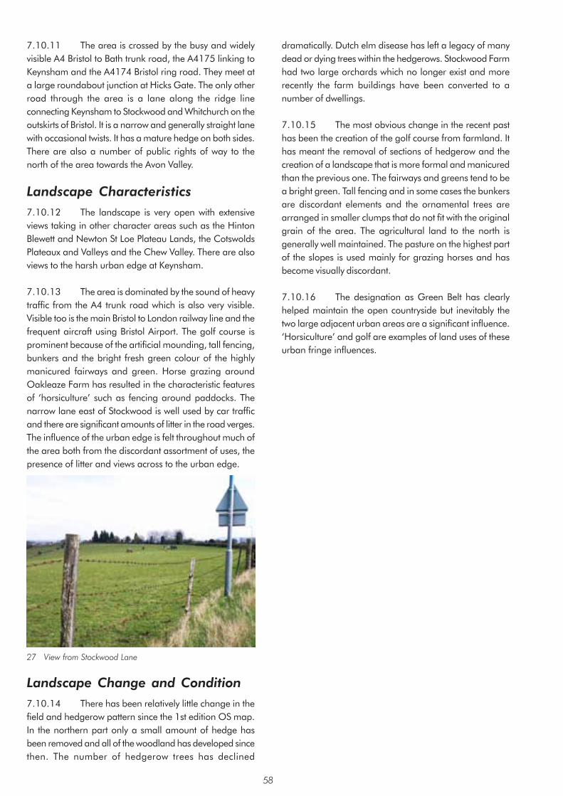
7.10.11 The area is crossed by the busy and widely visible A4 Bristol to Bath trunk road, the A4175 linking to Keynsham and the A4174 Bristol ring road. They meet at a large roundabout junction at Hicks Gate. The only other road through the area is a lane along the ridge line connecting Keynsham to Stockwood and Whitchurch on the outskirts of Bristol. It is a narrow and generally straight lane with occasional twists. It has a mature hedge on both sides. There are also a number of public rights of way to the north of the area towards the Avon Valley.
Landscape Characteristics 7.10.12 The landscape is very open with extensive views taking in other character areas such as the Hinton Blewett and Newton St Loe Plateau Lands, the Cotswolds Plateaux and Valleys and the Chew Valley. There are also views to the harsh urban edge at Keynsham.
7.10.13 The area is dominated by the sound of heavy traffic from the A4 trunk road which is also very visible. Visible too is the main Bristol to London railway line and the frequent aircraft using Bristol Airport. The golf course is prominent because of the artificial mounding, tall fencing, bunkers and the bright fresh green colour of the highly manicured fairways and green. Horse grazing around Oakleaze Farm has resulted in the characteristic features of ‘horsiculture’ such as fencing around paddocks. The narrow lane east of Stockwood is well used by car traffic and there are significant amounts of litter in the road verges. The influence of the urban edge is felt throughout much of the area both from the discordant assortment of uses, the presence of litter and views across to the urban edge.
27 View from Stockwood Lane
Landscape Change and Condition 7.10.14 There has been relatively little change in the field and hedgerow pattern since the 1st edition OS map. In the northern part only a small amount of hedge has been removed and all of the woodland has developed since then. The number of hedgerow trees has declined
dramatically. Dutch elm disease has left a legacy of many dead or dying trees within the hedgerows. Stockwood Farm had two large orchards which no longer exist and more recently the farm buildings have been converted to a number of dwellings.
7.10.15 The most obvious change in the recent past has been the creation of the golf course from farmland. It has meant the removal of sections of hedgerow and the creation of a landscape that is more formal and manicured than the previous one. The fairways and greens tend to be a bright green. Tall fencing and in some cases the bunkers are discordant elements and the ornamental trees are arranged in smaller clumps that do not fit with the original grain of the area. The agricultural land to the north is generally well maintained. The pasture on the highest part of the slopes is used mainly for grazing horses and has become visually discordant.
7.10.16 The designation as Green Belt has clearly helped maintain the open countryside but inevitably the two large adjacent urban areas are a significant influence. ‘Horsiculture’ and golf are examples of land uses of these urban fringe influences.
58
Area 11: Bickley Wood Gorge Summary of Landscape Character • Sheer gorge-like rock face and steeper valley sides to west becoming broader and shallower eastwards
• Flat river margins along central section
• Railway with multi-arched red brick support crosses western end of area and tunnel at western end
• Woodland on steep slopes and pasture on lower gentle slopes
• Few hedges, no longer stockproof
• Sandstone retaining walls along part of river bank
• Visible outcrops of Pennant Sandstone along valley sides
• The A4174 crosses the valley locally introducing noise into otherwise tranquil landscape
• Pylons to south of area dominate from certain viewpoints
For detailed Character Area map see Appendix 3
59

Context Introduction 7.11.1 This is the smallest of the character areas at 1.6 km long by 0.2 km at its widest point. It is characterised by the indented gently to steeply sloping hillsides, or sheer cliff, which form a small straight narrow valley of the River Avon cut into an undulating pennant sandstone plateau. It is located in the extreme north-west of the area south of Hanham. It forms part of a more extensive area beyond the River Avon to the north and to the east including Cleeve Wood and the wooded gorge within the Bristol City boundary to the north-west. The boundary to the south is located where the top of the wooded slopes meets with the pastoral land on the undulating plateau landscape of the Hicks Gate character area.
Geology, Soils and Drainage 7.11.2 The characteristic geological formation is Pennant Sandstone through which the River Avon passes in a gorge. The course of the River Avon developed on younger rocks that have subsequently been eroded. This would explain why the river now takes this apparently unlikely course through the hard sandstone. More recent alluvium occupies the narrow floodplain through the area.
Principal Planning Designations 7.11.3 The whole of the undeveloped area is within the Bristol/Bath Green Belt and the whole area is within the Forest of Avon Community Forest.
Description Landform and Drainage Pattern 7.11.4 This area comprises the north facing side of a narrow valley containing the River Avon. It varies in profile along the length of the character area. The land rises from a level of 10m adjacent to the river up to 50m at the top of the sheer rock face at the southern edge of the character area. The valley is gorge-like at the western end, featuring a sheer rock face and steeper valley side and becomes broader and shallower eastwards where it meets the River Avon flood plain. The railway cuts diagonally through the western end of the area at a point where the landform drops from the dramatic cliff face to moderate slopes. The shelved appearance of the lower landform at the western end has been created to accommodate the railway line at the required grade. The shallow to moderate slopes are undulating and indented by small dry valleys. Some of the characteristically indented landform of the hillside results from periods of quarrying in the past. Mid-way along the character area a very narrow flat margin at the river edge
broadens out before narrowing again at the eastern end where it is contained between the steep but low valley side and the River Avon and floodplain.
28 River Avon to Bickley Wood
Land-uses 7.11.5 The steeper parts of the character area are covered in woodland. Fields on the gentler slopes down to the river edge are used for grazing. A wider margin at the river edge on the eastern half is owned by British Waterways Board who have a building adjacent to the lock. Part of this neglected pasture is used for ad hoc storage of materials. The valley historically provided a source of pennant stone that was used in building and was conveniently located for transporting it along the river.
Fields, Boundaries and Trees 7.11.6 The majority of the area is under woodland cover. Its character varies throughout the area. The steeper western half comprises a mix of young and middle aged trees; the gentler slopes contain scrub and small trees with occasional large mature to over mature oaks. The predominant species is ash and other deciduous trees include oak and beech. No evergreen trees were noted. Towards the west of the area Fox’s Woods is registered as ancient semi-natural woodland.
7.11.7 The fields are bounded on the northern side by an unmanaged hedge that is no longer stock-proof. Scrub is colonising the pasture and the sloping grassed areas west of the road-bridge. Some significant lengths of a dry sandstone wall are evident at the base of the slopes of the middle part of the character area, becoming less evident further eastwards. Parts of the river edge have also been retained by local sandstone retaining walls. The small and irregularly shaped fields originate from the 17th century enclosure of medieval deer parks for cultivation.
Settlement and Communications 7.11.8 Until the construction of the A4174 in recent years this character area was quite isolated from the road network. A single track ‘no through road’ at Durley Park
60

that passes under the A4 and railway ended at the eastern end of the character area. There is no public vehicular access into the area. Access is limited to private moorings and to British Waterways Board who are responsible for the lock. Farm access appears to be from the small industrial area adjacent to Chandos Lodge at the end of Durley Park. The A4174 spans the valley and allows glimpses of the dramatic gorge and the more open landscape of the River Avon to the east. The design of the bridge is simple. The horizontal section and the supports are fairly slender so the structure is not overly dominant and an open view is maintained along the valley beneath the bridge. Public rights of way within the character area are limited to a footpath entering at the eastern end of the area by the river and some 200 metres along the riverside rising up the hillside and out of the area again.
7.11.9 The main railway line from London to Bristol cuts diagonally through the western end of the character area between the sheer rock face and the lower land, and then follows the alignment of the river supported by a multi-arched red brick bridge. 300 metres from the boundary it enters a tunnel. Trains are fairly regular, but they do not detract from the tranquil experience of the valley, and apart from the bridge, which is an interesting and distinct feature, other railway paraphernalia is generally not visible from public rights of way.
7.11.10 The only building within the character area is the British Waterways Board building at the lock. The wider area is rural, surrounded by Keynsham and the suburbs of Bristol and features clusters of traditional buildings, scattered farms and large properties, converted to nursing homes or offices. Traditional buildings are mainly constructed in the local Pennant Sandstone with red clay roof tiles. Some buildings have been rendered. The road-bridge is constructed in concrete, however part of the steep banks beneath the bridge have been surfaced using the local stone.
Landscape Characteristics 7.11.11 The dramatic hanging woods of the gorge, the rock outcrops and features along the riverside such as the small settlement at Hanham Weir and evidence of the mill including a lock and other former industrial associations create a very strong sense of place to this character area. Public rights of way on the north bank close to river level and at varying heights within the woodland afford characteristic views of the River Avon and its dramatic woodland setting. The brick arched railway support at the river edge is an interesting feature within the wooded valley landscape. Large pylons just within the adjacent character area to the south are discordant elements in the landscape when seen from the higher level paths, but are less so from viewpoints lower within the valley where trees dominate the views and partly screen the structures.
7.11.12 The landform combined with meanders in the river and woodland valley sides creates a strong sense of enclosure across much of the character area. As the valley broadens the views become more extensive across the floodplain to the Cotswold hills in the distance. The A4174 Bristol Ring Road has brought traffic noise to the area, however the general impression is that it does not detract from the tranquil experience enjoyed from public footpaths at the river edge and within the woodland on the north side of the river, a major recreational route in the area.
Landscape Change and Condition 7.11.14 The area has had periods of intense quarrying activity in the past. The scars have now healed over with woodland cover. The landscape generally appears to be in good condition although in detail there are signs of neglect. Throughout the western end of the character area, skyline trees are prominent, but they appear sparse and rather neglected. None of the wooded areas appear to be under management and ivy can be seen extending close to the tops of the tree canopies. Some of the pasture is being invaded with scrub and some of the hedges are ‘gappy’ and no longer stockproof.
29 Towards Hanham Lock
61

Area 12: Cam and Wellow Brook Valleys Summary of Landscape Character • Moderately wide and steep river valleys, striking landform
• Undulating valley sides
• Freely meandering brooks across the floodplains
• Arable and pastoral land cover in roughly equal measure
• Small or medium size irregular fields
• Building materials traditionally Oolitic Limestone to the east of the area and Lias Limestone towards the west with red clay tiles or slate
• Frequent woods, large and small, especially at the top of slopes
• Hedges, clipped and unclipped, are very common with frequent hedgerow trees
• Thick lines of trees follow both the brooks
• Roads follow valley floor and others rise up valley sides connecting to farms and settlements
• Small villages in the valleys
• Farms and isolated houses on the slopes
• A well-preserved section of the Fosse Way Roman road
• Disused railway, line of the Somersetshire Coal Canal and batches provide evidence of the past importance of the area for coal mining
• Pill-boxes and tank traps near Shoscombe Vale and Stony Littleton provide evidence of second world war antitank defences
• Valley has intimate enclosed character provided by topography, trees within hedges and tree belts along brook and field boundaries
• Open upper slopes
• Generally has a quiet and peaceful quality away from major road corridors
For detailed Character Area map see Appendix 3
62

Context Location of Area 7.12.1 The Cam and Wellow Brook Valleys is one of the larger character areas at approximately 30sq km. It consists of the river valleys of the Cam and Wellow Brooks, which run from west to east. They are separated by the Paulton and Peasedown St John Ridge character area. The brooks merge at Midford to become the Midford Brook. This then flows into the Avon at Monkton Combe near the Dundas Aqueduct, within the Bathford and Limpley Stoke character area. The Wellow Valley section starts to the north of Midsomer Norton with Welton Vale and Clandown Bottom and re-emerges to the east of the built up area of Radstock while the Cam Valley section starts further west to the north of Paulton. The higher ground of the Hinton Blewett and Newton St Loe Plateau Lands and Cotswolds Plateaux and Valleys character areas are found to the north and the Hinton Charterhouse and Baggridge Plateaux character area is to the south. The boundaries of the area generally follow the top of the valley sides before they level off or merge with the adjoining plateau landscape.
Geology, Soils and Drainage 7.12.2 The underlying geology is principally from the Jurassic period. Oolitic and Lias Limestone occurs at the top of the valley sides. Midford Sands are found locally below this in the Combe Hay to Midford area. Lias Clay and Limestone and clay and shales of the Penarth Group are found generally on the valley sides. Fuller’s Earth occurs locally between the Inferior and Great Oolite and was mined commercially at Wellow, South Stoke, Combe Hay and Dunkerton. Older outcrops of the Triassic period particularly Mercia Mudstones are found along the upper reaches of each brook. There is a narrow band of more recent alluvium alongside the brooks.
7.12.3 The soils above the Upper Lias and Inferior Oolitic Limestones are thin brashy calcareous clays. They
support short term or permanent pasture, though on the more gentle slopes some arable is found. In the base of the valleys the soils are slowly permeable silts and loams. These can be waterlogged and support mainly permanent pasture.
Major Planning Designations 7.12.4 The eastern part including Combe Hay and Wellow lies within the Cotswold AONB. The Bristol/Bath Green Belt extends further west towards Peasedown St John and beyond around to the north of the village.
31 Upper Radford
Description Landform and Drainage Pattern 7.12.5 The valleys are both moderately steep and wide. The Oolitic Limestone has generally given rise to steeper upper slopes and the Lias Clays to the more gentle slopes. The sides of the valleys are rounded and undulating through both erosion and occasional slippage due to the softer clays. Many springs issue from the valley sides. The resultant streams are often lined with trees. The junction of the valley sides with the base is usually gentle and rounded and the valley floors are narrow but flat with the brooks meandering freely across their flood plain. The brooks are quite deep in places and they frequently have steep sides, which was taken advantage of in making anti-tank defences along the Wellow Brook in 1940. The valleys range in height from the lowest point near Midford at 30m to high points of 146m north of Dunkerton and 156m north of Combe Hay.
30 View across Wellow Brook Valley
63

Land-uses 7.12.6 The land-use is a mixture of arable and short term and permanent pasture. There is generally an equal proportion of arable to pasture. The arable tends to be in localised blocks on the more gentle slopes where soil conditions are better. Conversely the pasture is on the steeper slopes and poorer soils.
Fields, Boundaries and Trees 7.12.7 Fields are of small and medium size and irregularly shaped, larger ones located on higher less steep slopes are more regular in shape. Hedges are the dominant boundary and these may be low and clipped or tall and quite mature. Added to this are frequent hedgerow trees, belts of trees and, most significantly, thick lines of trees that follow the brooks for much of their length. This tree pattern produces an enclosing effect within much of the valleys.
7.12.8 There is a significant amount of woodland especially on the steeper slopes such as Underdown, Cleaves and Hang Woods, which are registered as ancient semi-natural woodland. The woods sometimes extend down to the valley bottom. The woodlands are either deciduous or mixed plantations and they vary considerably in size from less than 0.5ha. to Cleaves Wood at over 20ha. They are varied in form from small and regular to large and irregular or compact and linear. The old coal batches are generally covered in mixed plantations with much sycamore and Scots pine.
Settlement and Communications 7.12.9 The settlement pattern is quite dense and diverse. Villages generally follow the valley floors. Camerton, Dunkerton, Combe Hay and Midford are located in the Cam Valley and Shoscombe, Stony Littleton and Wellow are located in the Wellow Valley. The village of South Stoke is a notable exception located on the upper slopes of the Cam Valley and it extends beyond the character area boundary to the plateau forming the southern outlier of the Cotswold Plateau and Valleys Character Area. Mills and their associated features are also an important part of the landscape. There are also smaller hamlets and individual farms and houses that are more isolated and generally higher up the slopes. The urban areas of Midsomer Norton and Radstock are adjoining and are widely visible from the character area. Though they are outside the area of the landscape assessment they are closely connected with this area. They developed along the valleys where coal was mined and the valleys accommodated the associated works and railways, which serviced the coal mines. The predominant building material of this area is Oolitic or white Lias Limestone, mainly to the east and west of the area
respectively, with a small number of properties in a rendered finish. Limestone walls within and at the edge of settlements are characteristic. Roofs are predominantly red clay tiles with some slate, and fewer with concrete tiles, usually on more modern buildings. The traditional farm buildings are of Oolitic or white Lias Limestone, and the modern ones noted are constructed in asbestos or concrete.
32 Combe Hay
7.12.10 The principal road is the A367 Bath to Radstock road that crosses the Cam Brook Valley. There is a road that links all the valley bottom villages in each valley but they do not connect at Midford, the road east from Wellow runs up the slope and to Hinton Charterhouse. Other roads connect the valley road to the surrounding higher villages and these usually run straight up the valley sides in deep-set cuttings resulting in characteristic sunken lanes and old hedge banks. With tall hedges on either side these minor roads are very enclosed and concealed. Part of the disused railway line is now part of the long distance footpath, the Limestone Link. This route runs the entire length of the Cam Valley to Midford. The intimate character of the landscape and the many features of interest make this area a popular area for walking, riding and cycling.
Landscape Characteristics 7.12.11 The Cam and Wellow brooks are the key features of the area. They are both relatively small rivers that are deeply set into the valley floor with high banks. They meander freely and are generally lined with alder and willow trees. Oak and ash are also often present. Views are mostly contained within the valley by the taller hedges, the trees lining the brooks and the undulating landform. The upper slopes are generally quite open, giving views of the strong valley landform while in places, such as the Combe Hay area, the wooded skyline is an important characteristic.
7.12.12 The field pattern reflects medieval settlement with the brook sides having early or pre-medieval
64

characteristics and the upper slope of a later and post medieval one. Earthworks around All Saint’s Church, Dunkerton are an example of a shrunken medieval village which has survived within later enclosed land and good examples of medieval fields can be seen around Radford. There is a well-preserved section of the Fosse Way Roman road through Dunkerton parish. The dominant features however are the remnants of the coal mining industry from the 18th-20th centuries. In both valleys there are frequent shafts and batches together with the remains of the railway and tram lines that connected the mines to the Avon Valley. Remains of the Somersetshire Coal Canal are also significant reminders of this coal mining history. Midford Aqueduct at Midford is a powerful architectural survival of this canal that is still a significant feature today. Stone mining and Fuller’s Earth extraction were also carried out in the Southstoke/Midford area and an example of a 19th century Fuller’s Earth processing plant survives in Combe Hay parish, near Odd Down. The villages along the valleys housed the workers in coal mining and associated employment. The line of the Wellow Brook was part of Stop Line Green; an anti-tank defence line set up to protect Bristol during the Second World War. There are the remains of pill-boxes and tank traps near Shoscombe Vale and Stony Littleton constructed as part of this defence.
7.12.13 The valley generally has a peaceful, tranquil quality. This is disturbed along the major road corridors such as the A367.
33 Stile and Gate at Writhlington
Landscape Change and Condition 7.12.14 The most dramatic change of the past 100 years has been due to the end of coal mining in the area. Once quite industrial areas have gradually reverted back to a
more rural and wilder state. This is particularly apparent along the railway lines where thickets of sycamore and blackthorn scrub have developed in many places.
7.12.15 There has been relatively little in the way of more recent development but changes in agricultural practice have left a less manicured landscape. Consequently the condition of the landscape may be regarded as rather unkempt in places but this has given it a wilder and more ‘natural’ quality. There is occasional evidence of work being carried out to enhance the long-term health of the hedges such as hedge-laying carried out at Upper Radford.
7.12.16 Where arable farming is more intense the landscape is more open and managed but nowhere is the landscape in poor condition. There has been significant hedgerow removal in many parts of the area but most noticeably on the upper northern slopes of the Cam Valley and where arable farming is mostly practised. Where this has occurred on the upper slopes of the valleys it has effectively opened up the landscape giving wide views across and along the valleys. A much more enclosed and intimate landscape is experienced on the lower slopes and valley floors where there are plenty of trees and hedges. However even on the valley floors there has been some amalgamation of smaller pastoral fields. On the steeper more wooded slopes the fields and hedges are much as they were in 1884.
7.12.17 The impact of Dutch elm disease has also had a significant effect in reducing the number of hedgerow trees and giving some hedgerows a rather unkempt look due to the number of dead or dying elm suckers. The amount of woodland cover however has generally increased, with many woods being larger than in 1884 and with some new ones developing partly as a result of changes in management of the land. There has been a large reduction in the amount of orchard. Wellow in particular had extensive areas under orchard. Some, near to the village centre have been built upon while many further away and on farms have been grubbed up.
65

Area 13: Paulton and Peasedown St John Ridge Summary of Landscape Character • A fairly flat limestone plateau/ridge with gentle undulations
• Shallow well-drained clay soils on higher ground
• Most farmland is arable with more grassland in the western part
• Open landscape with wide views to surrounding areas
• Fields usually enclosed by low clipped hedges
• Unclipped hedges though less common are found more towards the west of the area
• Large fields that are regular in shape
• Infrequent small woodlands that are often regularly shaped
• Woodland on batches often containing a proportion of coniferous trees
• Small roads that run along the ridge or straight across it
• Fosse Way runs diagonally across the ridge
• Large prominent villages of Peasedown St John and Paulton with coal mining history
• 20th century expansion of Peasedown St John and Paulton widely visible
• 19th century farms often with prominent modern buildings
For detailed Character Area map see Appendix 3
66

Context Location of Area 7.13.1 The Paulton and Peasedown St John Ridge character area is nearly 17 sq km in area. It includes Paulton at the western end, Peasedown St John near the middle and Upper and Middle Twinhoe at the eastern end. It is about 2 km across at its widest point near Peasedown St John. It is a limestone ridge that separates the Cam and Wellow Brook Valleys character area and also abuts the Farrington Gurney Farmlands character area at the western end. The boundary is typically defined as the top of the adjoining valley sides.
Geology, Soils and Drainage 7.13.2 Geologically the area can be divided into two. To the east of Peasedown St John greater Oolitic Limestone forms the capping layer giving way to bands of limestone and Fuller’s Earth on the lower slopes. Below the Fuller’s Earth there is a band of inferior Oolitic Limestone which comes to the surface on the edge of the ridge. To the west of Peasedown St John the capping geology consists of inferior Oolitic Limestone which is above upper Lias Clay followed by Lias Limestones and clays and shales of the Penarth Group.
7.13.3 The soils are generally shallow, well-drained, calcareous brashy clays. Where the Fuller’s Earth and Lias Clays are found they are more slowly draining and thicker though still calcareous in nature with patches of brashy material. On both soil types cereal crops and permanent or short-term pasture is common.
7.13.4 Principal Planning Designations The extreme eastern section is within the Cotswold AONB eastwards from Bath Hill between Wellow and Combe Hay.
The Bristol/Bath Green Belt includes the eastern part of the area eastwards from Peasedown St John.
Description Landform and Drainage Pattern 7.13.5 This is a simple landscape that consists of a relatively flat plateau with shallow undulations. It ranges in height from about 100 m to high points of 164 m at Camerton Farm and 168 m at White Ox Mead Knoll. The area is above the spring line of the ridge and so open water is absent. However there are springs along the edges of the area and most farms have a well.
Land-uses 7.13.6 The land is mainly used for arable crops but in the western part up to half the area is grassland.
Fields, Boundaries and Trees 7.13.7 Hedges are the most common boundary though in places fences have replaced them. The hedges are usually low and well clipped. In the western half there are also characteristically unclipped and taller hedges. Where stock is farmed the hedges are generally supplemented with post and wire fences. Trees in the hedgerows are common but not abundant and are mostly oak or ash. The fields are medium to large and regular in shape reflecting the field pattern of late medieval times. There are infrequent woodlands that are usually less than one hectare in size. These are also regular in shape and fit easily with the grain and texture of this landscape. The woodlands are mostly broadleaf consisting of mainly oak and ash, with a proportion of sycamore. Many woods have a small conifer element but this is not universal. The batches at Camerton, Braysdown and Tyning have a higher proportion of conifers in common
34 Fields East of Paulton
67
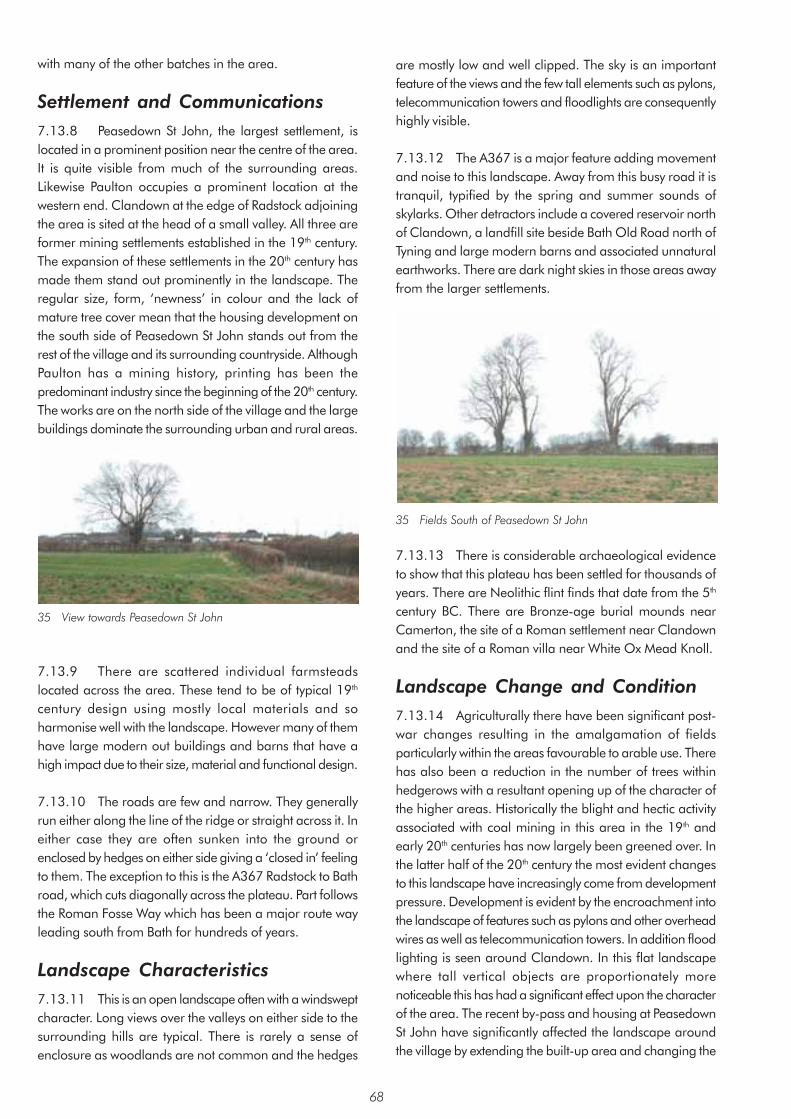
with many of the other batches in the area.
Settlement and Communications 7.13.8 Peasedown St John, the largest settlement, is located in a prominent position near the centre of the area. It is quite visible from much of the surrounding areas. Likewise Paulton occupies a prominent location at the western end. Clandown at the edge of Radstock adjoining the area is sited at the head of a small valley. All three are former mining settlements established in the 19th century. The expansion of these settlements in the 20th century has made them stand out prominently in the landscape. The regular size, form, ‘newness’ in colour and the lack of mature tree cover mean that the housing development on the south side of Peasedown St John stands out from the rest of the village and its surrounding countryside. Although Paulton has a mining history, printing has been the predominant industry since the beginning of the 20th century. The works are on the north side of the village and the large buildings dominate the surrounding urban and rural areas.
35 View towards Peasedown St John
7.13.9 There are scattered individual farmsteads located across the area. These tend to be of typical 19th
century design using mostly local materials and so harmonise well with the landscape. However many of them have large modern out buildings and barns that have a high impact due to their size, material and functional design.
7.13.10 The roads are few and narrow. They generally run either along the line of the ridge or straight across it. In either case they are often sunken into the ground or enclosed by hedges on either side giving a ‘closed in’ feeling to them. The exception to this is the A367 Radstock to Bath road, which cuts diagonally across the plateau. Part follows the Roman Fosse Way which has been a major route way leading south from Bath for hundreds of years.
Landscape Characteristics 7.13.11 This is an open landscape often with a windswept character. Long views over the valleys on either side to the surrounding hills are typical. There is rarely a sense of enclosure as woodlands are not common and the hedges
are mostly low and well clipped. The sky is an important feature of the views and the few tall elements such as pylons, telecommunication towers and floodlights are consequently highly visible.
7.13.12 The A367 is a major feature adding movement and noise to this landscape. Away from this busy road it is tranquil, typified by the spring and summer sounds of skylarks. Other detractors include a covered reservoir north of Clandown, a landfill site beside Bath Old Road north of Tyning and large modern barns and associated unnatural earthworks. There are dark night skies in those areas away from the larger settlements.
35 Fields South of Peasedown St John
7.13.13 There is considerable archaeological evidence to show that this plateau has been settled for thousands of years. There are Neolithic flint finds that date from the 5th
century BC. There are Bronze-age burial mounds near Camerton, the site of a Roman settlement near Clandown and the site of a Roman villa near White Ox Mead Knoll.
Landscape Change and Condition 7.13.14 Agriculturally there have been significant postwar changes resulting in the amalgamation of fields particularly within the areas favourable to arable use. There has also been a reduction in the number of trees within hedgerows with a resultant opening up of the character of the higher areas. Historically the blight and hectic activity associated with coal mining in this area in the 19th and early 20th centuries has now largely been greened over. In the latter half of the 20th century the most evident changes to this landscape have increasingly come from development pressure. Development is evident by the encroachment into the landscape of features such as pylons and other overhead wires as well as telecommunication towers. In addition flood lighting is seen around Clandown. In this flat landscape where tall vertical objects are proportionately more noticeable this has had a significant effect upon the character of the area. The recent by-pass and housing at Peasedown St John have significantly affected the landscape around the village by extending the built-up area and changing the
68

character of the interface between the built-up area and the countryside. The realigned A367 road and the associated noise attenuation bund has resulted in a strong barrier between the settlement and the surrounding landscape. Land to the south-east is designated as employment land. This will result in significant changes along the southern boundary of the village.
69

Area 14: Avon Valley Summary of Landscape Character • Meandering tree lined River Avon
• Wide open valley with a generally flat valley floor
• Generally steeply sloping valley sides often with undulating lower slopes
• Generally clayey soils but also well-drained loamy soils on the river gravels
• Patchwork of arable and grassland
• Land use for sports pitches, ‘horsiculture’, light industry and utilities within and bordering the area
• Prominent railway line and A4 Bristol to Bath road
• Line of disused railway line now the well-used tree-lined Bristol and Bath Railway Path’
• Generally small to medium sized fields enclosed by fences and hedges
• Walls generally found nearer farms and dwellings
• Several small woods
• Prominent settlements within and adjoining the area
• Traditional building materials include Oolitic and Lias Limestone with clay tile roofs
• Landmarks include the Cadbury factory at Keynsham and Kelston Round Hill
• Much of area has noise from road traffic and passing trains
• Seasonal flooding
For detailed Character Area map see Appendix 3
70

Context Introduction 7.14.1 The Avon Valley character area is approximately 12sq km in area. It comprises the meandering River Avon, its valley floor and the lower valley slopes especially where they are significantly influenced by the presence of the railway and major road which are so prominent in the valley. It extends from the western edge of Bath to the area boundary north of Keynsham where the Cadbury factory complex at Somerdale separates off a smaller area to the west. The area is bounded by the Cotswold Plateaux and Valleys character area to the east and the Hinton Blewett and Newton St Loe Plateau Lands to the south as well as shorter sections of other areas west of Keynsham.
Geology, Soils and Drainage 7.14.2 Drift deposits are an important component of the surface geology throughout the area with alluvium typically found through the floodplain as well as smaller outcrops of river gravel and head. There are also a variety of solid formations including Pennant Sandstone in the area of Corston, Lias Limestone from Saltford to Kelston Park with visible outcrops for example at Mead Lane, Saltford and Lias Clay from Keynsham to Kelston to the north of the limestone.
37 Rock outcrop at Mead Lane, Saltford
7.14.3 Soils are generally clayey in nature ranging from being well-drained in the limestone areas to being slowly permeable or at risk of flooding such as beside the Avon. There are also some well-drained fine loamy soils found over the river gravels, for example to the east of Keynsham.
Principal Planning Designations 7.14.4 The northern part falls within the Cotswold AONB with the boundary following the River Avon. The southern part following a line along the River Avon, around the edge of Corston, along the A4 and along the western edge of Keynsham falls within the Forest of Avon community forest. The whole of the rural area is also within the Bristol/Bath Green Belt.
Description Landform and Drainage Pattern 7.14.5 The landscape consists primarily of the meandering River Avon and its wide valley with a generally flat or gently sloping valley floor. Here the land is low-lying rarely exceeding 50m in height. The valley sides where they are included range from moderately steeply sloping around Corston, Newton St Loe and Kelston to gently sloping as for example between Keynsham and Saltford. The lower slopes are often undulating. The main line railway has had a significant effect on the topography. Where it runs across the flood plain it has been raised up in places on steeply sloping embankments with other sections at grade or in cutting. It has the effect of isolating parts of the flood plain landscape from the River Avon.
Land-uses 7.14.6 Land-use within the area is varied, often giving a patchwork of arable and grassland. Arable fields are found particularly north of Saltford and around Corston to the edge of Bath. There is also some horticultural use north east of Keynsham. The reasonably level land close to urban areas favours the use of the land for sports pitches such as near to the edge of Keynsham and Corston. There is also ‘horsiculture’ in places particularly to the north of Saltford and significant areas are in light industrial or business use, including a substantial sewage works at Saltford Mead.
Fields, Boundaries and Trees 7.14.7 The field boundaries are particularly varied. Fences are used extensively. Hedges are also characteristic and varied across the area with both clipped and unclipped hedges, some with and some without trees. Walls tend to be localised and mostly associated with farm buildings. In areas of intensive horse grazing visually discordant white tape is used to divide fields.
7.14.8 Fields are generally medium in size, with some small and occasionally large fields, and are typically angular in shape. Historically much of the area was enclosed during the later Middle Ages from the earlier open fields. Of particular note are the areas of rich, wet grassland beside the River Avon such as at Keynsham Hams and north of Newton St Loe, which were enclosed in the medieval period as areas of meadowland, providing early seasonal growth of grass.
7.14.9 Much of the area has few trees but the landscape is punctuated by a number of scattered small woods. Tennant’s Wood and Kelston Park Wood are of particular note. They are both registered as ancient semi-natural
71

woodland. There are trees lining the River Avon and also beside the Bristol and Bath Railway Path and beside the main line railway. During the 1990’s there was considerable woodland planting under the aegis of the Community Forest to the east of Keynsham. Development of this community resource is ongoing.
Settlements and Communications 7.14.10 The Avon Valley is an important transport corridor. The river was at one time an important means of transport and is now primarily used for recreational purposes. The A4 Bristol to Bath road passes through the corridor with connections to each side of the valley. The Bristol to London mainline railway also runs through the valley.
7.14.11 The area is bounded by Keynsham and Bath. Keynsham is widely visible from within the area, whereas Bath tends to be less prominent because of the topography of the city. Saltford is the main settlement within the area. It is located on the south-western slopes of the Avon Valley and is visible across much of the character area. The historical centre of the village is around the church on the north-east side. There has been subsequent 19th century development towards the river and the bulk of the village is 20th century. Corston is the only other village and is also located on the south-western slopes of the valley. The southern part around the church is the historical centre. The village expanded to the north in the 19th century and has two small areas of 20th century development on the northern side. Other settlement includes a group of houses at Durley Park and ribbon development between Saltford and Keynsham. There are also isolated farms and properties above the floodplain. Traditional building materials include
Oolitic and Lias Limestone often with red clay tiled roofs. More recently brick and rendered houses with brown concrete roofs have been built on the edges of Keynsham and at Saltford.
Landscape Characteristics 7.14.12 The landscape has a generally open character with views across the wide valley floor to the valley sides and the hills and plateaux beyond. Kelston Round Hill and Lansdown for example can appear very dramatic under certain conditions such as when under low cloud. Occasionally longer views are restricted by adjoining settlements, tall hedges, trees or the railway on embankment.
39 West Side of Saltford
7.14.13 The flat open nature of the landscape gives prominence to features that otherwise might be lost in a more enclosed landscape. Goal posts and buildings associated with the sports fields are often major components of the view. Likewise large mature trees and groups of trees, often including willow and poplar, are also important elements of many views. The course of the river edged by trees is a particularly important feature throughout the area. Seasonal flooding can have a pronounced effect on the character across the flood plain.
38 Kelston Mill and Weir near Saltford
72
7.14.14 Development at the edges of the settlements is often a major component of views especially around and between Keynsham and Saltford. The Cadbury factory at Keynsham with its prominent red brick construction is an important landmark from many views. Likewise the Kelston Round Hill on the Cotswold ridge to the north east with its group of trees is another important landmark.
7.14.15 The noise from both road traffic and trains is apparent across much of the area reinforcing the importance of the valley as a transport corridor.
Landscape Change and Condition 7.14.16 There have been agricultural changes locally leading to amalgamation of fields as well as a reduction in the number of hedgerow trees. Most recent changes have come about as a result of urban fringe pressures. This is indicated by the presence of utility works, sports pitches and locally the use of fields as horse paddocks.
7.14.17 Phytophthora disease has resulted in dead and dying alders beside the river and is having a significant impact on many views along this river valley landscape.
73

Area 15: Norton Radstock Southern Farmlands Summary of Landscape Character • Limestone plateau surrounded on three sides by river valleys
• Relatively steep river valleys
• Small irregular shaped fields in valley and rectilinear shaped fields on the plateau
• Fields enclosed by clipped hedges on plateau with unclipped hedges in the valleys
• Industrial past evident from remains of railway and colliery spoil heaps
• Core of coal mining village of Haydon built in Lias Limestone with small scale modern in-fill development,
• Some individual farmsteads
• Prominent 20th century industrial and residential development
• Few individual hedgerow trees but large areas of hawthorn scrub, scrub woodland and new plantation
• Open landscape on higher plateau with wide views
• Older buildings built from Lias Limestone with slate roofs. New buildings are brick with concrete tile roofs
For detailed Character Area map see Appendix 3
74

Context Introduction 7.15.1 This small character area of just over 3sq km lies between the southern boundary of the area and the built-up areas of Midsomer Norton and Radstock. The character of this area results from its relationship to the built-up area and the associated coal mining heritage. It is divided into three separate areas and includes several tributary valleys of the Wellow Brook including the River Somer, Snail’s Bottom and Kilmersdon Brook. The position of the boundaries is mainly dictated by the urban edge and the administrative boundary of the area.
40 West of Haydon
Geology, Soils and Drainage 7.15.2 The floors of Somer Valley and Snail’s Bottom are Mercia Mudstones. The base of the Kilmersdon Valley, however, is of alluvium deposits. Above this on both sides of all of the valleys is a band of shales and clays from the Penarth Group. These rocks are from the Triassic period. The majority of the remaining upland is Lias Limestone (white and blue) while the very highest part above 130m, south of Haydon, is a small outcrop of Inferior Oolitic Limestone. This part of the plateau is virtually a small western outlier of the Cotswolds that has been separated by erosion of the intervening area. All these limestones are from the Jurassic period. The steepest slopes of both the Kilmersdon and Snail’s Bottom Valleys have frequently slipped. Below all of the area is the coal bearing Carboniferous strata.
7.15.3 The soils of the valleys and valley slopes are generally derived from the Mercia Mudstones and are slowly permeable, reddish and clayey. The remaining higher land has shallow, well-drained calcareous soil derived from the limestones.
Principal Planning Designations 7.15.4 The area is outside any Green Belt or AONB designation.
Description Landform and Drainage Pattern 7.15.5 The two smallest parts of the character area lie to the west of the A367 and comprise principally the upper steep slopes of the River Somer Valley. The lower slopes and part of the valley floor are developed mainly for housing. The largest part of the character area lies to the east of the A367. The dominating landform characteristic here derives from the high Oolitic Limestone central plateau area around Haydon which is bounded by two steep-sided tributaries of the Wellow Brook; Snail’s Bottom to the west and Kilmersdon Brook to the east. The tributaries curve around the plateau to the north and merge at the Radstock Railway Lands. To the south west of Snail’s Bottom is a small part of a lower, more undulating Lias Limestone plateau and in this area the Snail’s Bottom Valley is more asymmetrical. The western valley side is very shallow and the eastern valley side is steep where it abuts the Oolitic Limestone plateau. The lowest point of the area at the Radstock railway lands is about 75m. The highest point is 136m above Haydon.
7.15.6 T he tributaries of the Wellow Brook through the area have several minor tributaries such as those flowing from Redhouse Farm to the stream along Snail’s Bottom and from Foxhills to the stream from Kilmersdon. They are fed from numerous springs that issue from the point where the Lias Limestones meet the Penarth Group shales and clays. The frequency of springs particularly east of Haydon gives a marshy character to this part of the valley.
Land-uses 7.15.7 The land on the plateau is mainly used for arable with some short-term pasture. In the valleys by contrast the land is mainly used for permanent and short-term pasture with some scrub and woodland on the steeper slopes.
Fields, Boundaries and Trees 7.15.8 The field pattern is angular but irregular and the fields are medium and small in size. The steeper slopes tend to have the smaller more irregular fields. The hedges of both the higher and the lower plateau areas tend to be low and well clipped but with very few trees within, giving a very open character. In the valleys the hedges are commonly unclipped but are also sometimes clipped and they tend to be quite ‘gappy’. In places scrub merges with the hedges and as a result the boundaries of fields are often quite indistinct.
75

7.15.9 Grove Wood to the west of Haydon is one of the most distinct areas of woodland in the area and is registered as ancient semi-natural woodland. There is considerable scrub along the stream sides and upper slopes of the valleys and some scrubby woodland on the spoil heap by the colliery tramway at Haydon. Newly planted areas are found adjacent to Grove Wood and along the upper slopes of the Kilmersdon Valley. The scrub consists mainly of hawthorn and bramble with course grasses. A more open scrub is found on the disused workings west of Haydon where the spoil cannot support larger species.
Settlement and Communications 7.15.10 Haydon is the main settlement in the area. It is a compact village of mining terraces in Lias Limestone with concrete and slate roofs. There is also some more modern in-fill development. Other buildings are stone farmhouses with a mixture of outbuildings and barns in both traditional and modern materials. The former colliery site is now an industrial estate to the east of Haydon.
7.15.11 The principal roads through the area are aligned north to south connecting settlements to the south with Midsomer Norton and Radstock. The most important is the A367, which is the Roman road the Fosse Way. A smaller road connects Haydon to Kilmersdon across the high point of the area. The line of the disused railway follows the floor of the valley north of Kilmersdon.
Landscape Characteristics 7.15.12 The valleys give an enclosed feel to the landscape in contrast to the plateaux with their open views. The tower of Downside Abbey is visible across the plateau to the south. The strongest elements of this landscape are the remains of the coal mining industry and the close proximity of the built-up area both residential and industrial which influence almost all views and brings with it pressures for recreational use. The large new warehouses at the Westfield Industrial Estate are an unsightly and dominating influence in the Snail’s Bottom area. Snail’s Bottom, the old Haydon tip and Kilmersdon Valleys are particularly well used for casual recreation.
7.15.13 Haydon itself is an outlier of Radstock and was built to house the miners for the local pit. The disused railway line and inclined railway at Haydon form important elements within the Kilmersdon valley east of Haydon.
7.15.14 There is a tumulus to the north of Haydon and the land around it is of archaeological significance. There is a quarry nearby which would have provided Lias Limestone for local buildings and is now designated a SSSI.
Landscape Change and Condition 7.15.17 The landscape has changed in the last 150 years from a rural scene to an industrial one dominated by the coal industry and back to a rural scene. The modern landscape has a less maintained and ‘rougher’ character and texture than neighbouring agricultural areas. This is caused in the main by the remnants of the coal industry and its infrastructure and changes in agricultural management. The disturbance caused by coal mining and the railways and the subsequent ending of mining and disuse of the railways has created valuable habitats of nature conservation interest. The plateau is well maintained as a traditional rural landscape. As such it has changed relatively little compared to the Haydon Valleys.
7.15.18 Since the 1st edition OS map considerably more woodland and scrub has been allowed to develop along the valley sides and by the streams. Further planting has increased the rate of this change. However hedgerow trees are fewer in number as indeed are the hedgerows themselves. This is consistent throughout the area but most noticeable on the plateau areas. There used to be a few scattered small orchards across the plateau and its slopes, few of these exist today.
41 Southern Edge of Radstock
76

Area 16: Cotswolds Plateaux and Valleys Summary of Landscape Character • Steep west-facing scarp with outcrops of Oolitic Limestone
• Open high Oolitic Limestone plateaux enclosed by dry stone walls and few trees
• Fields on valley sides enclosed by often untrimmed hedges with trees
• Thin well-drained loam soils on plateaux and deeper slowly permeable clayey soils on lower valley sides and floor
• Arable and pastoral farmland on plateaux
• Pasture and woodland on valley sides
• Narrow steeply sided valleys that cut into the plateaux
• Larger fields on plateaux and smaller more irregular fields on valley sides
• Villages and isolated farms follow foot of slopes close to the spring lines
• Warm coloured Oolitic Limestone buildings and walls
• Straight roads on the plateaux
• Narrow sunken winding lanes along the valley sides
• Broadleaf woods along scarp and upper slopes
• Open landscape on plateaux and more enclosed and intimate landscape within valleys
• Many historical and archaeological features including the late prehistoric site at Solsbury Hill, the Fosse Way Roman road at Bannerdown and Second World War airfield at Charmy Down
• Many locally well-known landmarks and beauty spots and Cotswolds Way national trail
For detailed Character Area map see Appendix 3
77
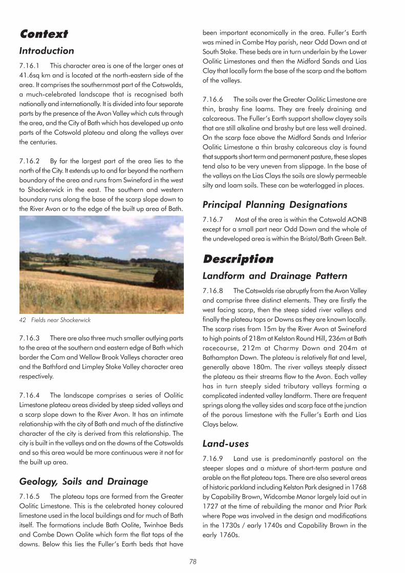
Context Introduction 7.16.1 This character area is one of the larger ones at 41.6sq km and is located at the north-eastern side of the area. It comprises the southernmost part of the Cotswolds, a much-celebrated landscape that is recognised both nationally and internationally. It is divided into four separate parts by the presence of the Avon Valley which cuts through the area, and the City of Bath which has developed up onto parts of the Cotswold plateau and along the valleys over the centuries.
7.16.2 By far the largest part of the area lies to the north of the City. It extends up to and far beyond the northern boundary of the area and runs from Swineford in the west to Shockerwick in the east. The southern and western boundary runs along the base of the scarp slope down to the River Avon or to the edge of the built up area of Bath.
42 Fields near Shockerwick
7.16.3 There are also three much smaller outlying parts to the area at the southern and eastern edge of Bath which border the Cam and Wellow Brook Valleys character area and the Bathford and Limpley Stoke Valley character area respectively.
7.16.4 The landscape comprises a series of Oolitic Limestone plateau areas divided by steep sided valleys and a scarp slope down to the River Avon. It has an intimate relationship with the city of Bath and much of the distinctive character of the city is derived from this relationship. The city is built in the valleys and on the downs of the Cotswolds and so this area would be more continuous were it not for the built up area.
Geology, Soils and Drainage 7.16.5 The plateau tops are formed from the Greater Oolitic Limestone. This is the celebrated honey coloured limestone used in the local buildings and for much of Bath itself. The formations include Bath Oolite, Twinhoe Beds and Combe Down Oolite which form the flat tops of the downs. Below this lies the Fuller’s Earth beds that have
been important economically in the area. Fuller’s Earth was mined in Combe Hay parish, near Odd Down and at South Stoke. These beds are in turn underlain by the Lower Oolitic Limestones and then the Midford Sands and Lias Clay that locally form the base of the scarp and the bottom of the valleys.
7.16.6 The soils over the Greater Oolitic Limestone are thin, brashy fine loams. They are freely draining and calcareous. The Fuller’s Earth support shallow clayey soils that are still alkaline and brashy but are less well drained. On the scarp face above the Midford Sands and Inferior Oolitic Limestone a thin brashy calcareous clay is found that supports short term and permanent pasture, these slopes tend also to be very uneven from slippage. In the base of the valleys on the Lias Clays the soils are slowly permeable silty and loam soils. These can be waterlogged in places.
Principal Planning Designations 7.16.7 Most of the area is within the Cotswold AONB except for a small part near Odd Down and the whole of the undeveloped area is within the Bristol/Bath Green Belt.
Description Landform and Drainage Pattern 7.16.8 The Cotswolds rise abruptly from the Avon Valley and comprise three distinct elements. They are firstly the west facing scarp, then the steep sided river valleys and finally the plateau tops or Downs as they are known locally. The scarp rises from 15m by the River Avon at Swineford to high points of 218m at Kelston Round Hill, 236m at Bath racecourse, 212m at Charmy Down and 204m at Bathampton Down. The plateau is relatively flat and level, generally above 180m. The river valleys steeply dissect the plateau as their streams flow to the Avon. Each valley has in turn steeply sided tributary valleys forming a complicated indented valley landform. There are frequent springs along the valley sides and scarp face at the junction of the porous limestone with the Fuller’s Earth and Lias Clays below.
Land-uses 7.16.9 Land use is predominantly pastoral on the steeper slopes and a mixture of short-term pasture and arable on the flat plateau tops. There are also several areas of historic parkland including Kelston Park designed in 1768 by Capability Brown, Widcombe Manor largely laid out in 1727 at the time of rebuilding the manor and Prior Park where Pope was involved in the design and modifications in the 1730s / early 1740s and Capability Brown in the early 1760s.
78

Fields, Boundaries and Trees 7.16.10 The fields are small and medium and quite irregular on the steeper valley sides and scarp slopes which is typical of the piecemeal clearance of wooded landscape that occurred from the Bronze Age through to Saxon times. The fields on the plateau areas by contrast are larger and more regular resulting from the gradual enclosure of common land and the development of large estates during the 16th to 18th centuries. The fields on the steeper slopes are usually enclosed by hedges which are often untrimmed and ‘gappy’ and occasionally are enclosed by walls. The plateau areas are distinguished by the long lines of drystone walls.
7.16.11 Woodlands are an important feature of this landscape and are most common on the steeper slopes especially on the upper slopes. These woodlands are quite variable in size, ranging from small clumps to large woodlands many hectares in size. Most are irregular in shape. They are mainly broadleaf and beech is common. There are frequent lines of trees, sometimes these are of Scots pine. Individual trees such as ash trees are more common in the hedge lines of the valley slopes. The relative lack of individual trees on the plateau areas reinforces the very open nature of the landscape.
43 Batheaston
Settlement and Communications 7.16.12 The settlement pattern and form is dictated by the landform. The villages run along the valley sides frequently close to the spring line. Other settlements are isolated farms and hamlets that are evenly spread along the slopes closely associated with the springs. The plateau areas have no natural water bodies and consequently settlements here are much less common. One of the major unifying elements of this landscape is the use of the local Oolitic Limestone in buildings and walls. The traditional building style has many features that are also very characteristic. These include steep-sided roofs using limestone tiles and the detailing around windows and doors designed to shed water away from the stonework are typical of the ‘Cotswold style’.
7.16.13 The roads are divided between two types. The larger roads across the plateaux, for example the A46, The Fosse Way and Lansdown Road, tend to be straight, wide and open. By contrast the smaller lanes that connect the villages tend to be winding and narrow and are typically sunken, enclosed by high hedgebanks. The straighter roads are either Roman in origin as is the case of the Fosse Way or date from the 18th and 19th century enclosure of the plateau areas and consequently reflect the regular layout of this part of the landscape. The winding lanes developed with the villages and the clearance of woodland and so in places could date back to prehistoric times. There are numerous well-used public rights of way including the Limestone Link, part of the Cotswold Way National Trail and the Bath Skyline Walk to the east of Bath. This reflects the importance of the area for casual recreation.
Landscape Characteristics 7.16.14 There are expansive views over the wider countryside and over the city of Bath from the plateaux and the scarp that give an open exposed character while the smaller valleys are more enclosed and can feel quite cut off from surrounding areas. The overall character area is unified by the common occurrence of the broadleaf woodlands, the frequent dry stone walls and the building style in the local Oolitic Limestone.
7.16.15 The presence of historic and prehistoric monuments and features are an integral part of the character of this landscape. There are many Bronze Age burial mounds in the area, particularly on Landsdown, Charmy Down and Banner Down. The area also contains some of the most impressive prehistoric and Romano-British earthwork monuments in the District. The Scheduled Monuments of Solesbury Hill Fort and Little Down Camp are two of the most visible and influential of these. The Fosse Way Roman road links Bath and Cirencester. The valley slopes were enclosed in the late medieval times and are characterised by smaller more regular outlines with frequent ‘dog leg’ angles where adjoining strips meet. The steeper slopes were also enclosed in the later medieval period but here they have a more distinctive form due to the ‘strip lynchets’ and other methods used to reclaim productive land on such gradients. Many of these earthworks are still visible today and in some locations such as Bathampton Down and Charmy Down the earthwork remains of prehistoric or Romano-British field systems and enclosures are clearly visible. The plateau tops were enclosed in the 18th and 19th centuries by Parliamentary Enclosure Acts. These tend to have large rectilinear fields bounded by stone walls. Many of the lanes and roads though straight are remnants from an earlier landscape and may be old drove roads. A large memorial marks the civil war battlefield site on Lansdown. There are historic parks and
79

estates from the 18th century such as Kelston Park, St Catherine’s Court and Prior Park. More recently there is the now disused airfield on Charmy Down, a remnant from the Second World War.
7.16.16 There are a number of locally well-known landmarks, beauty spots and features and places of interest some of which are listed below:
Kelston Round Hill – a landmark viewed from miles around to the south, east and west
Beckford’s Tower – A folly built in 1827 on the Lansdown Ridge and a prominent landmark
Kelston Park – The mansion at Kelston Park is a prominent landmark in the Avon Valley, jutting out on a lower level plateau into the valley
Solsbury Hill Fort, a Scheduled Monument – Late prehistoric hill fort east of Swainswick
Lansdown Race Course – on the Lansdown ridge
Prospect Stile – Well known viewpoint on the western edge of the Lansdown plateau
Battlefields Monument – Civil war monument at northern end of Lansdown plateau
Charmy Down – prominent disused airfield. Bathampton telecommunication mast Sham Castle on the edge of Bathampton Down
St Catherine’s Court – Historic house and garden in the St Catherine’s Valley, itself a well-known beauty spot
Prior Park – National Trust Historic Garden.
Landscape Change and Condition 7.16.19 Planning controls in the latter part of the 20th
century such as the AONB designation and Green Belt status of the area have been effective in maintaining the distinct character of the area. In addition the high profile nationally has led to enhanced upkeep of the landscape features. Grants for walling and hedgerow maintenance can be seen to have had some localised effect. Pressures from built development have been more localised such as the provision of park and ride on Lansdown and the spread of housing from Bath. Increasingly aspirations for enlargement of the University of Bath result in pressures for further development. The widely visible Batheaston bypass has had a significant impact on the landscape and intrudes into the setting of this edge of Bath. Other development such as telecom towers have also affected some views. The generally good condition of the landscape reflects the value placed upon it.
7.16.20 New tree planting has taken place in some areas in recent years which will contribute to the distinct wooded character of some of the area.
44 Lyncombe Vale from Perrymead
80
Area 17: Hinton Charterhouse and Baggridge Plateaux Summary of Landscape Character • Undulating Oolitic Limestone plateau mostly above 100 m.
• Generally clayey soils with thinner stony light coloured free-draining soils on the limestone
• Mixture of pasture and arable land
• Open landscape with wide views to surrounding areas
• Medium or large fields that are regular and angular in shape
• Fields surrounded by hedges or occasionally walls
• Small woodlands
• Tree belts and frequent hedgerow trees
• Fairly straight roads
• Small village of Hinton Charterhouse and hamlet of Pipehouse that harmonise well with landscape
• 19th century farms often with prominent modern buildings
• Features include water tower at Pipehouse and 2nd world war defences at Hog Wood
• 18th century parkland with specimen trees at Hinton House
For detailed Character Area map see Appendix 3
81

Context Location of Area 7.17.1 This character area is 11.4sq km in size and is located at the south-eastern corner of the area. It consists of a gently undulating limestone plateau. The boundaries are located where the edge of the plateau meets the steeper slopes of the surrounding valleys. The Norton Brook Valley, which is part of the Cam and Wellow Brook Valleys character area, divides the area into two parts. The area is bordered by the Cam and Wellow Brook Valleys character area to the north and the Bathford and Limpley Stoke Valley character area to the east. The southern edge follows the area boundary.
Geology, Soils and Drainage 7.17.2 The geology of the character area consists of the upper portions of the Great Oolite series. The highest points consist of Cornbrash, a loose, brown limestone rock that contains many shell fossils. Below this and covering the majority of the area is a layer of Forest Marble. This is a brown clay with conspicuous cream coloured limestone that consists of large amounts of shell detritus. Below the Forest Marble is the Great Oolite, which forms the fringes of the plateau.
7.17.3 The soils are typically light or mid-brown thin clay with considerable brashy limestone debris. Drainage can be impeded in places where the clay is thicker. Over the Oolitic Limestone the soils are very thin and stony with a matrix of fine or course loam. The quantity of stone makes them appear light in colour. These soils are freely draining.
Principal Planning Designations 7.17.4 The whole of the undeveloped area is within the Bristol/Bath Green Belt. The northern half of the eastern part, broadly the part north of Hinton Charterhouse, is within the Cotswold AONB.
Description Landform and Drainage Pattern 7.17.5 This area comprises a gently undulating limestone plateau ranging in height from 70m to 150m. Most of the area is above 100m. There are no significant natural drainage features because of the flat nature of the landform and the porous geology.
Land-uses 7.17.6 The land cover consists of arable and pastoral fields, in roughly equal measure. The higher parts on the soils derived from the Cornbrash are ideal for growing
cereal crops as the name implies. At the time of survey there was some conspicuous extensive pig farming and there was plentiful evidence of pheasant rearing around Hassage Wood.
45 Fields West of Hinton Charterhouse
7.17.7 There is 18th century parkland at Hinton House. There is also a small limestone quarry north of Pipehouse.
Fields, Boundaries and Trees 7.17.8 The fields are of medium and occasionally large size and these are generally regular or angular in shape. Hedges usually enclose these fields. Occasionally there are dry limestone walls, especially around the settlements or along the roads. There are several types of fencing such as post and rail and post and wire. This latter type is frequently used to divide larger fields for different uses or crops. The hedges are very varied. In places they are tall and unclipped and in others they are low and clipped or very rarely layed. A few hedges have been allowed to develop as belts of trees and these can give a misleading impression of there being more woodland than there really is. There are frequent mature trees in the hedges and some in the fields themselves. These are mostly oaks with a smaller number of ash, sycamore and occasionally beech. There are a few small woodlands generally between 2 and 5 ha. in size. Littleton Wood is an exception at approximately 20 ha. The woodlands consist of mixed deciduous and coniferous trees. They are regular in shape and generally reflect the field shapes.
Settlement and Communications 7.17.9 There are two significant settlements; the village of Hinton Charterhouse and the hamlet of Pipehouse. Both are typical rural settlements associated with agriculture. Hinton Charterhouse is at the hub of a number of roads. Both are set high on the plateau at the centre of farmland. There are also individual farms that are spread evenly across the plateau. Upper Baggridge Farm is of particular note positioned at the centre of a number of routes including a byway.
82
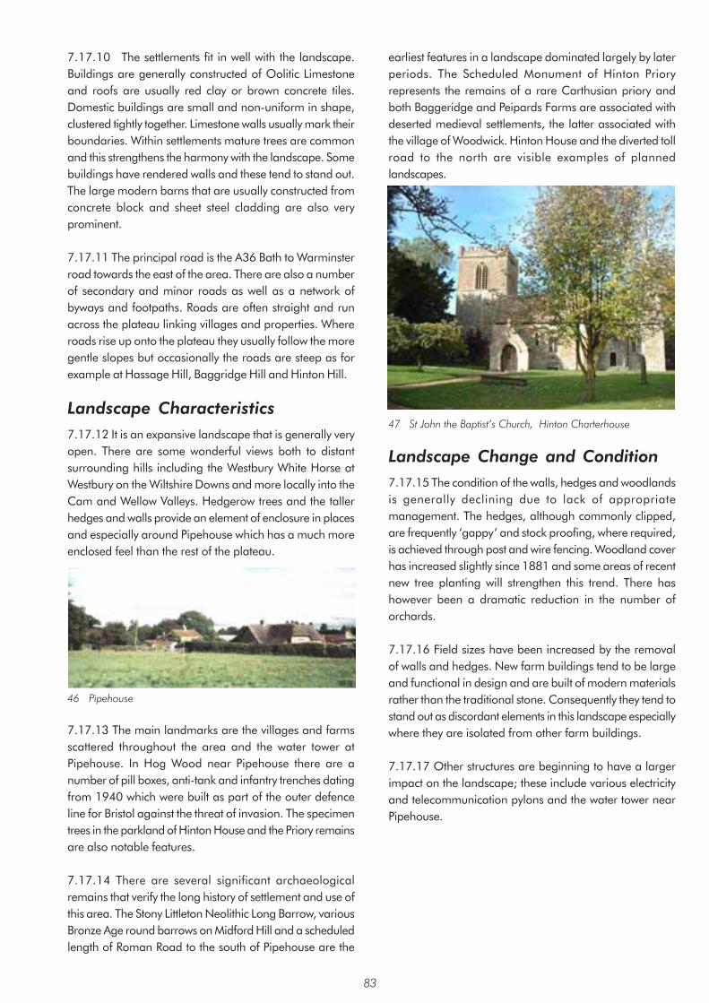
7.17.10 The settlements fit in well with the landscape. Buildings are generally constructed of Oolitic Limestone and roofs are usually red clay or brown concrete tiles. Domestic buildings are small and non-uniform in shape, clustered tightly together. Limestone walls usually mark their boundaries. Within settlements mature trees are common and this strengthens the harmony with the landscape. Some buildings have rendered walls and these tend to stand out. The large modern barns that are usually constructed from concrete block and sheet steel cladding are also very prominent.
7.17.11 The principal road is the A36 Bath to Warminster road towards the east of the area. There are also a number of secondary and minor roads as well as a network of byways and footpaths. Roads are often straight and run across the plateau linking villages and properties. Where roads rise up onto the plateau they usually follow the more gentle slopes but occasionally the roads are steep as for example at Hassage Hill, Baggridge Hill and Hinton Hill.
Landscape Characteristics 7.17.12 It is an expansive landscape that is generally veryopen. There are some wonderful views both to distant surrounding hills including the Westbury White Horse at Westbury on the Wiltshire Downs and more locally into the Cam and Wellow Valleys. Hedgerow trees and the taller hedges and walls provide an element of enclosure in places and especially around Pipehouse which has a much more enclosed feel than the rest of the plateau.
46 Pipehouse
7.17.13 The main landmarks are the villages and farmsscattered throughout the area and the water tower at Pipehouse. In Hog Wood near Pipehouse there are a number of pill boxes, anti-tank and infantry trenches dating from 1940 which were built as part of the outer defence line for Bristol against the threat of invasion. The specimen trees in the parkland of Hinton House and the Priory remains are also notable features.
7.17.14 There are several significant archaeologicalremains that verify the long history of settlement and use of this area. The Stony Littleton Neolithic Long Barrow, various Bronze Age round barrows on Midford Hill and a scheduled length of Roman Road to the south of Pipehouse are the
earliest features in a landscape dominated largely by later periods. The Scheduled Monument of Hinton Priory represents the remains of a rare Carthusian priory and both Baggeridge and Peipards Farms are associated with deserted medieval settlements, the latter associated with the village of Woodwick. Hinton House and the diverted toll road to the north are visible examples of planned landscapes.
47 St John the Baptist’s Church, Hinton Charterhouse
Landscape Change and Condition 7.17.15 The condition of the walls, hedges and woodlandsis generally declining due to lack of appropriate management. The hedges, although commonly clipped, are frequently ‘gappy’ and stock proofing, where required, is achieved through post and wire fencing. Woodland cover has increased slightly since 1881 and some areas of recent new tree planting will strengthen this trend. There has however been a dramatic reduction in the number of orchards.
7.17.16 Field sizes have been increased by the removalof walls and hedges. New farm buildings tend to be large and functional in design and are built of modern materials rather than the traditional stone. Consequently they tend to stand out as discordant elements in this landscape especially where they are isolated from other farm buildings.
7.17.17 Other structures are beginning to have a largerimpact on the landscape; these include various electricity and telecommunication pylons and the water tower near Pipehouse.
83

Area 18: Bathford and Limpley Stoke Valley Summary of Landscape Character • Broad open valley of the River Avon in places dramatic and gorge-like
• Narrower Frome River and Midford and By Brook Valleys
• Steep generally wooded valley sides
• Meandering course of Rivers Avon, Frome and the Midford and By Brooks edged with groups of alder and willow
• Important transport corridors
• Settlements on valley sides
• Extensive views across and along the valleys
• Views contained by ridges and woodland each side of the valleys
• Generally hedged field boundaries, some clipped and some unclipped
• Several fields enclosed by walls
• Impressive houses and smaller farmhouses usually of characteristic golden Oolitic Limestone on valley sides in wooded or parkland setting
• Distinctive canal architecture including Dundas Aqueduct and bridges
• Mill buildings and associated features such as mill races
• Second World War pill boxes
• Brown’s Folly
For detailed Character Area map see Appendix 3
84

Context Location of Area 7.18.1 The character area covers nearly 15sq km. It consists of the valley floor and the steep and often well-wooded slopes of the Rivers Frome and Avon and the Midford and By Brooks. It is generally bounded by hills and plateaux and, in the context of this assessment, also by development and the area boundary. It follows the Avon Valley east of Bath from the edge of Batheaston to the north around to the Midford Brook Valley near Monkton Combe to the south. It includes a branch westwards along the Midford Brook and Horsecombe Brook Valleys and eastwards along the By Brook Valley at Bathford. The River Avon continues southwards beyond the area boundary into West Wiltshire. The character area also has an isolated section to the south incorporating part of the River Frome Valley.
Geology, Soils and Drainage 7.18.2 The sides of the rivers and brooks contain drift geology of alluvium, gravel and occasionally head such as below Warleigh Lodge Farm. Typically the valley sides consist of Fuller’s Earth and Lias Clays which are overlain with Oolitic Limestone on the high ground. Landslips are a feature throughout the valleys resulting from limestone above unstable clays.
7.18.3 The main soils are calcareous clayey soils typically used for grazing and occasionally for arable use. Fine well-drained calcareous loamy soils occur over the limestone towards the boundaries of the area and typically support a more diverse range of agricultural uses. Well-drained soils are also found towards the north of the area in the vicinity of the Bathampton Meadows.
Principal Planning Designations 7.18.4 All the area falls within the Cotswold AONB except at the two extremes; the Bathampton meadows at the northern end and the Farleigh Plain and Iford plantation at the southern end are outside the AONB. All the undeveloped part also falls within the Bristol/Bath Green Belt.
Description Landform and Drainage Pattern 7.18.5 The River Avon occupies a comparatively broad but steep sided valley. The steepness of the valley sides in relation to the breadth of the valley gives a dramatic almost gorge-like feel to the landform in places. The River Frome and Midford and By Brooks by contrast occupy narrow valleys
also with steep sides. The floor of each valley is generally flat or gently sloping, gradually increasing in steepness higher up the valley sides. The present form of the Avon Valley with its markedly undulating side slopes has to a large extent resulted from the instability of the Oolitic Limestone over clay leading to landslips along the section east of Bath.
48 Bathford Viewed from across the Avon Valley
Land-uses 7.18.6 The land is principally used for grazing. Only part is in arable use such as to the south of Bathford. There are sports pitches north of Bathampton and along the By Brook and Midford Brook Valleys. There are also areas of parkland with mature specimen trees at Claverton Manor, now the American Museum, and at Warleigh Manor, now converted to smaller housing units.
Fields, Boundaries and Trees 7.18.7 Much of the field pattern throughout the valleys reflect relatively modern adjustment of earlier enclosures. There are however areas of medieval enclosure of rich wet grassland such as alongside the River Frome and By Brook and alongside the River Avon between Claverton and Bathford. There is evidence of late medieval enclosure of steep sided cultivation in some areas such as below Warleigh Wood. The medium sized fields are generally enclosed by hedgerows; some are well trimmed and others are tall and unclipped. The hedges often contain mature oaks and other trees. Walls are also present but are less common.
85

49 Drung (enclosed footway) above Monkton Combe
7.18.8 The valley sides are typically well-wooded. Most of the larger areas of woodland are registered as ancient semi-natural woodland. As well as native woodland there are also characteristic parkland trees including copper beech and redwood trees as for example at Claverton Manor and Warleigh Manor. There is often also a transition to patchy scrub on the more gentle lower slopes. View from survey point 73
Settlement and Communications 7.18.9 Throughout history the area has been important as a communication corridor. The Avon Valley contains not only the river, but also the Kennet and Avon Canal, the railway, the A4 Batheaston Bypass and the A36 Warminster Road, and a number of public footpaths all of which make use of the comparative convenience of the valley floor. The Kennet and Avon Canal was important for moving stone but is now important for recreation. The Somersetshire Coal Canal joined it at Dundas and a short remaining section can still be seen near the aqueduct. The Camerton branch of the railway once followed the Midford Brook Valley. This was made famous in the film ‘The Titfield Thunderbolt’. The A36 was originally built in 1830 as a turnpike road by Macadam. The A363 Bradford Road climbs the eastern valley side. The Rivers Frome and Avon and the Midford and By Brooks were commercially important giving rise to a number of mills which constitute important features in the landscape. The area also contains a network of minor routes following the valley and rising up the valley sides. These are often narrow and enclosed by hedges.
7.18.10 The main settlements include Bathford, Claverton, Monkton Combe, Limpley Stoke and Freshford. They each occupy sloping ground on the sides of the valleys. There are also several farms and large properties, many of
Georgian origin, which characteristically occupy strategic positions on the upper slopes overlooking the valleys. Examples include Warleigh and Claverton Manors.
Landscape Characteristics 7.18.11 The landscape is open providing extensive views both along and across the valley. Views are contained or framed by the ridges and dense woodland on each side and wider views beyond the valley are rare. In places the valley sides are so steep and well-wooded that they give a dramatic and gorge-like feeling to the valley whilst the overall scale of the landscape maintains a sense of openness. The course of the rivers and brooks is marked by groups of willow and alder trees. Although the lower slopes and valley floor of the River Avon are occupied by busy main roads and the railway, much of the area has a remarkably tranquil quality. Similarly the River Frome and Midford and By Brook Valleys are all to a greater or lesser extent transport corridors, but taking less traffic they have a more tranquil character similar to the quieter parts of the Avon Valley.
50 River Avon from the Dundas Aquaduct
7.18.12 Impressive houses and smaller farm houses located on the valley sides, often nestled into woodland or within parkland on the upper slopes, are distinctive features within the landscape. The traditional building material is Oolitic Limestone with clay tile and sometimes slate roofs. Reconstituted stone is now widely used often with dark coloured concrete tile roofs.
7.18.13 There are distinctive structures associated with the canal, river and railway. The A36 viaduct and Dundas Aqueduct near Monkton Combe are particularly distinctive, as are the smaller bridge structures such as the one over the canal near Claverton. There are numerous other features such as Claverton Pumping Station built in 1813 to pump water from the river to the canal; mills or evidence of mills at Freshford, Bathford and Tucking Mill; Brown’s Folly above Bathford and remnants of the Second World War defences known as the Outer Bristol Defences which pass through the area in the vicinity of Freshford Mill. The
86

most evident features of these defences are a series of pill boxes such as the one at Woodside near Freshford.
7.18.14 Significant detractors within the landscape include traffic on the A4 and A36, pylons, communication masts and some new development by virtue of its scale, location and/or design.
51 Iford Bridge
Landscape Change and Condition 7.18.15 The area is generally in good condition and maintains its distinct harmonious character. There are however signs of creeping changes which could have implications on the long term cohesiveness and health of the landscape. Since the 1st Edition OS map was surveyed hedges have often been taken out to enlarge fields as for example to the west of Bathford Hill. Remaining hedges have often become ‘gappy’ and there has been a reduction in the number of trees in the hedges and within the fields. The extent of woodland appears to be relatively constant though factors such as clear-felling and replanting and storm damage have influenced its appearance. Reduction in the areas that are grazed has resulted in some newer areas of woodland. More recently Phytophthora disease has resulted in dead and dying alders beside the river affecting many views. 7.18.16 Development in the form of new housing for example at Bathford and to a lesser extent at Monkton Combe; larger shed type buildings and associated car parking and lighting located on the valley floor such as at Manor Farm, Bathampton and Freshford Mill; and development on or close to the skyline, for example at the University of Bath have all had varying degrees of impact on the character and cohesion of the landscape.
7.18.17 In general the landscape appears to be in good health and relatively robust in maintaining its distinct character. The effect of a combination of the above changes has however resulted in degrading the character and
cohesion of the landscape in places. The valley with its river, canal and public rights of way network is an important area for recreation. This can influence landscape character through for example the demand for playing fields. Other pressures on the landscape include demands for utility structures such as masts and pylons.
87

8. Landscape Change 8.1 Introduction 8.1.1 The character of the landscape has evolved and been influenced by developments in agriculture, communications and industry and by settlement within the landscape. There have been periods when change has been particularly rapid and periods where there has been little change. The purpose of this chapter is to summarise the changes that have generally taken place across the area as a whole and to assess the current issues now facing the landscape.
8.1.2 Historically mining and quarrying and the development of the transport infrastructure have been important influences in the area particularly towards the end of the 19th century. They have left their legacies in different ways. The most significant changes in recent times have occurred since the start of World War II. These changes can broadly be summarised under three headings as follows:
• Agricultural changes • Natural processes • Development
8.2 Agricultural and Other Changes 8.2.1 The wartime and post-war drive to improve agricultural yields aided by new crop varieties, larger machines and increased use of pesticides and inorganic fertilisers has resulted in a raft of changes; some very obvious and others more subtle and longer term.
Field EnlargementField EnlargementField EnlargementField EnlargementField Enlargement8.2.2 Many hedges were removed in order to improve efficiency and to accommodate larger machines. This has occurred fairly consistently across the area but only rarely has resulted in the complete loss of the historic grain or character of the landscape. The rate of hedge removal has progressively declined over the last 15 years or so culminating in the introduction of controls through the Hedgerow Regulations in 1997. Hedgerow removal has usually also involved removal of trees though occasionally trees have been left within the enlarged fields.
Loss of OrchardsLoss of OrchardsLoss of OrchardsLoss of OrchardsLoss of Orchards8.2.3 Historically most settlements and farms had orchards nearby for cider production. These are no longer required and as a result orchards have often been ploughed up, left to deteriorate or in several cases because of their position at the edges of villages have been developed for housing. Remaining orchards are a link to the past and are
a reminder of the historic character which was once typical across the area.
LLLLLoss of Historic Poss of Historic Poss of Historic Poss of Historic Poss of Historic Parklandarklandarklandarklandarkland8.2.4 Parkland was an important part of the working landscape in the 17th and 18th centuries. Many of these have declined in area or disappeared as more land was ploughed up for arable production or short-term pasture.
LLLLLoss of Toss of Toss of Toss of Toss of Trees and Habitatsrees and Habitatsrees and Habitatsrees and Habitatsrees and Habitats8.2.5 The impact of greater agricultural intensification on the landscape has included both loss of diverse habitats and loss of trees. The decline of herb–rich limestone grassland has been particularly marked. Likewise the number of trees within fields and along field boundaries has declined. Trees lost through disease or old age are often not replaced.
Reduced DiversityReduced DiversityReduced DiversityReduced DiversityReduced Diversity8.2.6 The emphasis on greater efficiency and increased production has also tended to create a less diverse landscape. There is a tendency for larger areas of single crops in contrast to the diverse landscape of different crops in adjoining fields described by author H.V. Morton(1) in 1927 as a ‘squared patchwork of gold, sage-green, apple-green and red’.
Management of Field BoundariesManagement of Field BoundariesManagement of Field BoundariesManagement of Field BoundariesManagement of Field Boundaries8.2.7 The high cost of traditional intensive hedge maintenance has resulted in the widespread use of mechanical hedge trimming. This is a convenient method and achieves a neat result relatively quickly. The downside has been the tendency for hedges to become ‘gappy’ over time. They cease to be stock proof and as a result fences are often erected against hedges to deter the escape of stock particularly sheep. Conversely in places hedges have been allowed to grow tall and also tend to become ‘gappy’.
8.2.8 Where walls mark the field boundaries there has also been a tendency for them to deteriorate, particularly where arable crops are grown and where they are no longer required to contain stock.
Modern BarnsModern BarnsModern BarnsModern BarnsModern Barns8.2.9 The requirements of modern farming to overwinter large numbers of stock, store their feed-stuffs and store and maintain a variety of large machinery has led to a proliferation of large, modern barns. Inevitably there has also been deterioration of traditional, smaller barns or their conversion to residential use.
8.2.10 The large, modern barns are often very prominent and unsightly in the countryside. Prominent
88

locations are part of the problem but modern materials, pre-fabrication techniques, unsympathetic industrial design and earth modelling are the key factors.
8.2.12 Traditionally barns are built using local materials and locally distinctive designs and even when sited in prominent locations away from the main farm complex, they sit sympathetically in the landscape.
Horse PHorse PHorse PHorse PHorse Paddocksaddocksaddocksaddocksaddocks8.2.13 Horse ownership has increased enormously since the 1970s resulting in constant demand for horse paddocks particularly on the edges of settlements. Horse paddocks are distinctive in appearance with fields often being sub-divided into smaller units by a variety of forms of fencing. The most common form of fencing today appears to be white tape which is particularly visible and discordant. In addition paddocks are frequently over-grazed resulting in unsightly weedy or churned up ground and loss of ecological value.
WWWWWoodland Plantingoodland Plantingoodland Plantingoodland Plantingoodland Planting8.2.14 There are significant opportunities for tree planting. This is generally desirable given the existing low percentage of woodland across the area as a whole and can contribute significantly to landscape character provided the location and species planted are appropriate. Conversely tree planting carried out inappropriately can have a negative impact on landscape character.
VVVVVerge Maintenanceerge Maintenanceerge Maintenanceerge Maintenanceerge Maintenance8.2.15 Reduced or lack of cutting of wider verges has locally had significant nature conservation impacts and has affected the character of some roads resulting from colonisation by scrub. Likewise timing of cuts within the one metre strip adjacent to the road surface can be significant if for example it involves cutting of characteristic species such as cow parsley or meadow crane’s-bill when flowering is at a peak.
ArchaeologyArchaeologyArchaeologyArchaeologyArchaeology8.2.16 Archaeological remains whether buried or surviving as structures and earthworks are an important aspect of landscape character and are highly vulnerable to agricultural change. Both earthworks and buried sites can be irreversibly damaged or destroyed through tree planting, ploughing of ancient pasture and the creation of fishing lakes and even wildlife ponds. Much of this will be the result of farm diversification through organic reversion and afforestation. The English Heritage Monuments at Risk Programme published in 1995 recognised that agriculture was the biggest threat to the continued survival of archaeological remains outside the urban environment.
89
8.3 Natural Processes Dutch Elm DiseaseDutch Elm DiseaseDutch Elm DiseaseDutch Elm DiseaseDutch Elm Disease8.3.1 The disease has affected the area since the late 1960s with the resultant loss of a large number of very prominent field and hedgerow trees which epitomised the enclosed rural English landscape. Even today the disease continues to affect suckering elms which start to die out when they grow large enough to become infected. The loss of elms has had a dramatic effect on views both within villages and across the open agricultural landscape. The loss of elms and the impact of dead and dying trees has been referred to in some character areas where particularly evident as part of the survey and analysis. However elms appear to have been fairly well distributed in all but the higher plateau areas and therefore these references should not be taken to indicate either the only areas of elms or the most heavily affected areas.
Phytophthora Disease in AldersPhytophthora Disease in AldersPhytophthora Disease in AldersPhytophthora Disease in AldersPhytophthora Disease in Alders8.3.2 This water-born fungal disease has spread rapidly in recent years killing many riverside alders. This is having a significant impact affecting many river valley landscapes.
Storm DamageStorm DamageStorm DamageStorm DamageStorm Damage8.3.3 The loss of trees through the 1986 and 1990 storms has had a more localised effect noticeable in particular where trees have been lost on exposed ridges, leaving a ragged skyline with scattered remaining mature trees.
Invasive SpeciesInvasive SpeciesInvasive SpeciesInvasive SpeciesInvasive Species8.3.4 The introduction in Victorian times of ornamental exotic species has resulted in the spread of invasive species such as Japanese knotweed and Himalayan balsam. These crowd out native species affecting biodiversity as well as impacting on the visual characteristics of the landscape.
8.48.48.48.48.4 DevelopmentDevelopmentDevelopmentDevelopmentDevelopmentChew VChew VChew VChew VChew Valley Lalley Lalley Lalley Lalley Lakeakeakeakeake8.4.1 One of the most dramatic changes has been the damming of the River Chew in the 1950s to create the Chew Valley Lake to supply water for Bristol. This is now a major scenic and recreational resource and is also important for its nature conservation value.
New Housing and associated worksNew Housing and associated worksNew Housing and associated worksNew Housing and associated worksNew Housing and associated works8.4.2 Post-war housing development has taken place at the edges of many settlements. Use of modern materials, housing density and layout and the constraints placed upon design by building and highway standards as well as the homogenising effect of volume housing have resulted in the loss of precious local distinctiveness. In addition these

developments tend to have a very poorly designed interface with the countryside and their appearance is often jarring in views from the countryside. There are few examples where modern housing has enhanced or reflected local distinctiveness or local character. Likewise extensions, new boundaries and other works to existing properties are often implemented without reference to the local character in the design or materials used.
8.4.3 Perhaps the most recent example of visually significant large-scale housing is the 1990s development on the south side of Peasedown St John. As with a number of other developments this is very prominent in the landscape by virtue of its siting on a ridge-top, its density which has allowed virtually no space for large trees and green space amongst the housing and the combination of factors outlined above.
Commercial DevelopmentCommercial DevelopmentCommercial DevelopmentCommercial DevelopmentCommercial Development8.4.4 Likewise office buildings, industry and industrial units are often located at prominent locations at the edges of settlements causing extensive intrusion into the wider landscape as at Old Mills Midsomer Norton, the northern edge of Paulton and the Westfield Industrial Estate at Radstock.
TTTTTelecommunication Mastselecommunication Mastselecommunication Mastselecommunication Mastselecommunication Masts8.4.5 The rapid rise in the use of mobile phones has necessitated an ever-increasing demand for masts by a number of cell phone companies. They are located in prominent places to maximise coverage and therefore are inevitably widely visible and can have a significant detrimental impact on views. The pressure is likely to continue as the new generation of phones are introduced requiring ever greater numbers of masts.
Increased TIncreased TIncreased TIncreased TIncreased Trafficrafficrafficrafficraffic8.4.6 This is evidenced through not only the building of new sections of road such as the Peasedown St John bypass but also through more diffuse changes. These include removal of traditional hedges and widening of verges to improve sight lines and widening of roads, either planned or by default, resulting in the narrowing or removal of grass verges. Traffic jams are now a regular occurrence on previously quiet country lanes especially at morning and evening rush hour and at school pick-up times. A knock on effect of increased traffic is the effect of traffic noise which impacts on the tranquility of the countryside and unsightly muddy unplanned passing places on narrow lanes.
Increased Light SpillageIncreased Light SpillageIncreased Light SpillageIncreased Light SpillageIncreased Light Spillage8.4.7 With increased development has come increased light spillage from settlements, from road junctions and street lighting and from floodlighting of sport
pitches. The park and ride car park on the sky-line at Odd Down is a recent example.
RecreationRecreationRecreationRecreationRecreation8.4.8 Recreational use of the countryside has mixed blessings for landscape character. At least in theory more people using the countryside for leisure activities brings much needed income to the countryside and increases awareness of the value of landscape encouraging sensitive conservation and management practices to protect and enhance the landscape.
8.4.9 Problems can occur where visitor pressure results in over-use. Countryside “honey-pots” in the area include Chew Valley Lake, the River Avon at Saltford, the Kennet and Avon Canal, the Cotswolds and the Mendips. Visitor and landscape management occurs actively at all these places.
8.4.10 Some leisure activities can cause significant problems in the landscape. In the late 1980s and early 1990s there was a national boom in proposals for golf courses. Because of their large size, very particular layout and need for ancillary buildings and car parking, golf courses can have a high negative impact on landscape character in the countryside. Within the area there are currently only four courses, Stockwood being the most rural and prominent in the countryside. Likewise demands for playing fields, particularly at the edge of developed areas, can have a significant impact on landscape character through for example regrading of the landform and provision of ancilliary equipment and buildings.
8.4.11 In recent years mountain biking and other activities such as trail biking and off-road driving have done significant damage to green lanes and other tracks and paths and areas of open countryside. These are also often very noisy and can therefore conflict with other activities in otherwise quiet countryside. Whilst some of these off-road activities have organisations which issue guidelines for responsible behaviour, others do not, or individuals choose not to join.
8.4.12 Horse riding can also have a detrimental effect on landscape character. The area has relatively few bridleways. This coupled with the ongoing increase in horse ownership puts enormous pressure on existing bridleways and often results in problems of erosion.
90

9. Conclusion9.1 This document has demonstrated the diversity of thearea ranging from the higher ground of the Mendip slopes and Cotswold plateau, through the undulating limestone hills and plateaux to the intimate valleys of the tributaries of the River Avon and the open floodplain of the River Avon. Much of the landscape can be understood in terms of the deposits of Jurassic Limestone and its subsequent variable erosion by the various river systems. The diversity is reflected in the subdivision of the area into 18 distinct landscape character areas. Approximately one third of the area is recognised to be of national significance through inclusion within either the Mendip Hills AONB or the Cotswolds AONB. In addition the majority of the rural parts of the area also fall within the Bristol/Bath Green Belt. This designation is important in safeguarding the countryside from encroachment. This document seeks to recognise the valued characteristic of each landscape regardless of any designation.
9.2 This assessment recognises the way the landscape hasevolved and the way it needs to change and adapt to meet developing requirements and expectations. It is clearly not possible to identify the pressures for change in the future although climate change is likely to be one. It is now widely recognised that climate change is likely to exert powerful and inevitable pressure for change in the next 50 years. What is less clear is quite how the changes will manifest in terms of local climate and its impact on the landscape and local agricultural economy.
9.3 Many landscape changes such as hedge removalresulting from agricultural change have slowed down in recent years, however it is clear that there are ongoing challenges and challenges that have yet to be identified. Whatever the source of change, it needs to be managed so as to conserve the valued and diverse character of the area and to ensure that future changes enhance rather than detract from that character.
9.4 The landscape character assessment is an importantmechanism for maintaining and enhancing the rich and varied landscape of Bath and North East Somerset. By documenting landscape character as it is now, we have a vital base-line which will help us assess future change and direct future projects. It is intended to prepare guidelines for specific issues such as development at the edge of settlements or strategies for specific areas such as priority areas for new tree planting. It is also intended that the assessment will provide a useful basis for local communities in carrying out more detailed assessments such as Parish Plans or Village Design Statements. This project may also be a useful vehicle for bringing together information on
the local landscape across the area as a whole. It will also provide an overview for detailed assessments by developers in support of planning applications.
91

Glossary BatchBatchBatchBatchBatch Local term for coal mining waste tips which are often characterised by steep sloping sides. The area
includes examples which have been planted with trees and examples where the tips remain bare and unvegetated.
BiodiversityBiodiversityBiodiversityBiodiversityBiodiversity The variety of wildlife and the habitats they occupy.
BrashyBrashyBrashyBrashyBrashy Term used to describe soils containing a high proportion of loose broken rock.
CharacterCharacterCharacterCharacterCharacter A distinct, recognisable and consistent pattern of elements in the landscape.
CharacteristicsCharacteristicsCharacteristicsCharacteristicsCharacteristics Those elements that in combination create the distinctive character of an area.
CharacterisationCharacterisationCharacterisationCharacterisationCharacterisation The process of identifying areas of similar character, classifying and mapping them and describing their character.
ConditionConditionConditionConditionCondition In the context of this assessment refers to the physical state of repair of the landscape and elements which make up the landscape character. This influences the integrity or completeness of the landscape character.
DetractorDetractorDetractorDetractorDetractor Elements of the view which compromise the character of the landscape.
DriftDriftDriftDriftDrift Geological term used to describe superficial deposited material, often brought by ice or glacial meltwater, and distinguished from solid geology.
FeatureFeatureFeatureFeatureFeature Elements of the landscape which form important components of the landscape. They are usually prominent or eye-catching like tree clumps, church towers, or wooded skylines.
Field patternField patternField patternField patternField pattern Angular Field pattern with fields mainly with right-angled corners but not necessarily creating a regular field pattern.
Irregular Field pattern of variable sized and variable shaped fields.
Rectilinear Field pattern with fields of a rectangular shape repeated across the landscape.
Regular Field pattern of fields of roughly the same size and shape repeated across the landscape.
Field sizeField sizeField sizeField sizeField size Field sizes have been analysed and described as small, medium and large within the context of the area using the following dimensions:
Small - up to 3.5 ha
Medium - between 3.6 and 13.5 ha
Large - greater than 13.5 ha
‘Gappy’‘Gappy’‘Gappy’‘Gappy’‘Gappy’ Term used to describe the thin character of hedges primarily resulting from the type of management used or from their overgrown nature. These hedges are not likely to be stock-proof without additional fencing.
Green LaneGreen LaneGreen LaneGreen LaneGreen Lane Grassed routes enclosed by hedges. Sometimes formed along estate boundaries or forming part of historic routes.
HeadHeadHeadHeadHead Geological term used to describe locally derived material deposited as a result of water carrying it from higher ground.
92

HorsicultureHorsicultureHorsicultureHorsicultureHorsiculture The use of land for keeping, stabling and exercising horses.
Ramsar SiteRamsar SiteRamsar SiteRamsar SiteRamsar Site Site identified under the Ramsar Convention on Wetlands of International Importance especially as Waterfowl Habitat. This requires the conservation of listed sites.
RIGSRIGSRIGSRIGSRIGS Regionally Important Geological Sites. Sites of local importance for geology designated for their scientific and educational value.
SAC or cSACSAC or cSACSAC or cSACSAC or cSACSAC or cSAC Special Area of Conservation or Candidate Special Area of Conservation. Sites of international importance intended to protect habitats of threatened species of wildlife identified under Article 3 of the EC Directive on the Conservation of Natural Habitats and of Wild Fauna and Flora (the Habitats Directive). These sites are also SSSIs under national legislation, however special considerations, as set out by the Habitats Directive, apply to development proposals in or likely to affect them.
ScheduledScheduledScheduledScheduledScheduled A nationally important archaeological site or monument included in the Secretary of State for Media, MonumentMonumentMonumentMonumentMonument Culture and Sport’s list of Ancient Monuments protected under the Ancient Monuments and Archaeological
Areas Act 1979.
ShrunkenShrunkenShrunkenShrunkenShrunken An existing village that was once larger than it is today with earlier buildings and garden plots usually medieval villagemedieval villagemedieval villagemedieval villagemedieval village visible as earthworks.
SNCISNCISNCISNCISNCI Site of Nature Conservation Importance. Sites of local importance for nature conservation designated for their scientific and community value.
SPASPASPASPASPA Special Protection Area. Sites of international importance classified under the EC Directive on the Conservation of Wild Birds. These sites are also SSSIs under national legislation, however special considerations, as set out by the Habitats Directive, apply to development proposals directly or indirectly affecting them.
SSSISSSISSSISSSISSSI Site of Special Scientific Interest notified under section 28 of the Wildlife and Countryside Act 1981. Development proposals in or likely to affect these must be subject to special scrutiny.
SPGSPGSPGSPGSPG Supplementary Planning Guidance. Planning Guidance which supplements the policies and proposals of the development plan, giving more detailed advice on a particular topic or site.
93

References 1. Introduction 1. Department of the Environment, Planning Policy Guidance Note 7, The Countryside – Environmental Quality and
Economic and Social Development (1997) 2 Countryside Commission, Landscape Assessment: a Countryside Commission approach, CCD18 (1987) 3 Countryside Commission, Landscape Assessment Guidance CCP 423 (1993) 4 Countryside Agency and Scottish Natural Heritage, Interim Landscape Character Assessment Guidance (1999) 5 Countryside Agency and Scottish Natural Heritage, Landscape Character Assessment Guidance for England and
Scotland, CAX 84 (2002) 6 Countryside Agency, Countryside Character, Volume 8, South West, CA 14 (1999)
2. Landscape Context 1. Countryside Commission, The Mendip Hills Landscape, CCP545 (1998) 2. Chris Blandford Associates, Landscape Assessment of Mendip District (1997)
6. Cultural Perceptions of the Landscape 1 Birkenhead, F.W.F.S. Earl, John Betjeman Collected Poems (1988). 2 Richards, M. B., The Cotswold Way - a walkers guide, Thornhill Press, Gloucester (1973) 3 Morton, H. V., In Search of England (1927) 4 Bryan, R., The British Countryside in Colour (1950) 5 Williams, R. V., A Cotswold Romance (1951) 6 Gabriel, P., Solsbury Hill (1977)
8. Forces for Change 1 Morton, H. V., In Search of England (1927)
94

Bibliography Agricultural Development Advisory Service (ADAS), Cotswold AONB Landscape Assessment and Environmental Guidelines
(1994) Aston, M. and Lewis, C. (Ed.), The Medieval Landscape of Wessex (1994) Avon County Council, Avon Landscape Strategy (1988) Avon County Council, Historic Landscape Characterisation Project (unpublished, part of Sites and Monuments Record) Birkenhead, F.W.F.S. Earl, John Betjeman Collected Poems (1988). Bristol and Avon Community Forest, Forest Plan (1995) Bryan, R., The British Countryside in Colour (1950) Countryside Agency and Scottish Natural Heritage, Interim Landscape Character Assessment Guidance (1999) Countryside Commission, Landscape Assessment Guidance CCP 423 (1993) Countryside Commission, Landscape Assessment: a Countryside Commission approach, CCD18 (1987) Countryside Commission, The Mendip Hills AONB (1997) Department of the Environment - Planning Policy Guidance (PPG) notes
PPG1 General Policy and Principles (1997) PPG15 Planning and the Historic Environment (1997) PPG7 The Countryside – Environmental Quality and Economic and Social Development (1997) Findlay, D.C., Soils of the Mendip District of Somerset (1965) Findlay, D.C., Soils of the Southern Cotswolds and Surrounding Country (1976) Green, G. W. and Welch, F. B. A., Geology of the Country around Wells and Cheddar (1977) Green, G.W., British Regional Geology - Bristol and Gloucester Region, HMSO 1992
Hardy, P., The Geology of Somerset, Ex Libris Press (1999) Kellaway G. A. (Ed.) and Bath City Council, Hot Springs of Bath – Investigations of the Thermal Waters of the Avon Valley
(1991) Lowry, B, (Ed.) 20th Century Defences in Britain (1996) Morton, H. V., In Search of England (1927) Ordnance Survey, 1st Edition OS maps 1884-1888
Richards, M. B., The Cotswold Way - a walkers guide, Thornhill Press, Gloucester (1973) Snowdon, P. Rivers, Villages and Valleys – A Journey through North East Somerset, Bristol and Bath (2000) Soil Survey of England and Wales Soils of England and Wales – Sheet 5 South West England (1983) Wansdyke District Council, Local Design Guide - External Building Materials
Wansdyke District Council, Wansdyke Local Plan Deposit Nov 1995 (1995) Wansdyke District Council, Wansdyke Nature Conservation and Landscape Strategy (1995) Whitton, J., Geology and Scenery in Britain, Chapman and Hall (1995) Winchester,S., The Map That Changed the World – The Tale of William Smith and the Birth of a Science (2001)
95

Appendix 1. Sample Survey Form and Sketch
96

97

98

Appendix 2. Key Development Plan Policies to which this document is Supplementary Planning Guidance
Joint Replacement Structure Plan (adopted September 2002)
Policy 3Policy 3Policy 3Policy 3Policy 3
Local Plans will:
• identify areas which exhibit common environmental characteristics or elements, following the characterisation approach supported by the Countryside Agency and English Nature, and identify in each area those characteristics and elements which make a significant contribution to local character or are of importance;
• contain a strategy for the conservation and enhancement of all environmental assets, including landscapes, nature conservation and the built and historic environment, which make a significant contribution to that character and distinctiveness as well as those which are already recognised as of local, national or international importance through prior designation;
• contain an urban renaissance strategy for their urban areas, which sets out an integrated approach towards the application of relevant policies and initiatives.
Policy 17Policy 17Policy 17Policy 17Policy 17
Within Local Plans, emphasis will be placed on ensuring the continued conservation and enhancement of the character and distinctiveness of the landscape, and where necessary the restoration or regeneration of degraded landscapes. Where development or land use change occurs and significant landscape impact cannot be avoided or mitigated, the creation of new landscape features or elements which contribute to the character of the locality may be considered.
Local Plans will identify landscape character areas using a common characterisation approach and planning authorities should seek to coordinate policy approaches for such areas across administrative boundaries. Within individual landscape character areas, those features and elements of the landscape which make a significant contribution to the character and distinctiveness of the locality should be identified and appropriate strategies applied to guide the continued conservation and enhancement of that particular area.
Within the Cotswolds and Mendip Hills Areas of Outstanding Natural Beauty the priority will be the conservation of their particular landscape character and distinctiveness, with due regard to the continued economic and social well-being of the area. Major industrial or commercial development within an AONB or which would adversely affect it by virtue of proximity, will not be permitted unless an exception is justified by proven national need and a lack of alternative sites.
Bath and North East Somerset Local Plan including minerals and waste policies, Deposit Draft 2002
Policy D.1Policy D.1Policy D.1Policy D.1Policy D.1
Development which does not either maintain or enhance the character of an area will not be permitted. Policy NE.1Policy NE.1Policy NE.1Policy NE.1Policy NE.1
Development which does not either conserve or enhance the character and local distinctiveness of the landscape will not be permitted.
99

Wansdyke Local Plan, Deposit Draft, November 1995 (as amended September 2000)
Policy GEN.2Policy GEN.2Policy GEN.2Policy GEN.2Policy GEN.2
In considering proposals for development the District Council will expect the development to:
(i) achieve a high standard of design, siting and site treatment which fully takes into account local environmental conditions;
(ii) respect the traditional character, form, relationship and materials of local buildings;
(iii) respect, conserve and where possible enhance the landscape setting of the proposal and significant views, both long and short distance, which might be affected;
(iv) retain and where possible enhance existing natural and man-made features of wildlife, landscape, historic and community value;
(v) incorporate a high standard of landscaping, where such measures are considered appropriate.
Policy LNC.1Policy LNC.1Policy LNC.1Policy LNC.1Policy LNC.1
Development in the countryside which detracts from the landscape character or quality or conflicts with policies LNC.9A, LNC.9B or LNC.9C, will not be permitted. The District Council will encourage the sympathetic management of features of the landscape which are of major importance for wild flora and fauna.
Bath Local Plan adopted, June 1997
Policy L.20Policy L.20Policy L.20Policy L.20Policy L.20
In preparing proposals for development, consideration should be given to landscape setting and landscape design. This should allow for the appropriate protection and incorporation of existing trees, hedges and shrubs and other natural features on, or adjacent to the site, and for the detailed design of hard and soft landscape areas of the site.
Policy C.2Policy C.2Policy C.2Policy C.2Policy C.2
The City Council will require development to be a high standard of design, and sensitive to and compatible with the scale, height, bulk and character of the surroundings.
100
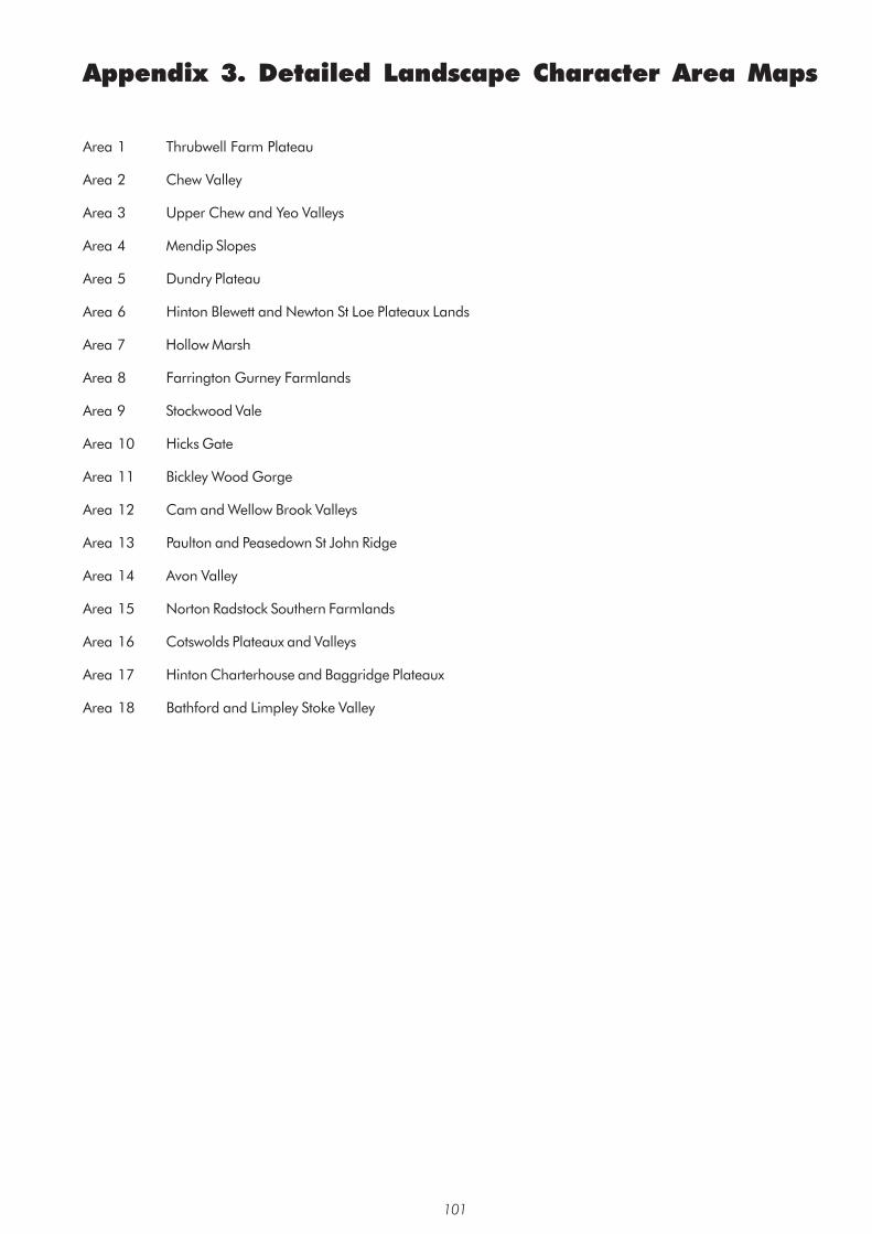
Appendix 3. Detailed Landscape Character Area Maps
Area 1 Thrubwell Farm Plateau
Area 2 Chew Valley
Area 3 Upper Chew and Yeo Valleys
Area 4 Mendip Slopes
Area 5 Dundry Plateau
Area 6 Hinton Blewett and Newton St Loe Plateaux Lands
Area 7 Hollow Marsh
Area 8 Farrington Gurney Farmlands
Area 9 Stockwood Vale
Area 10 Hicks Gate
Area 11 Bickley Wood Gorge
Area 12 Cam and Wellow Brook Valleys
Area 13 Paulton and Peasedown St John Ridge
Area 14 Avon Valley
Area 15 Norton Radstock Southern Farmlands
Area 16 Cotswolds Plateaux and Valleys
Area 17 Hinton Charterhouse and Baggridge Plateaux
Area 18 Bathford and Limpley Stoke Valley
101