rural livelihood and social infrastructure around mount ... · pdf filearound mount cameroon...
TRANSCRIPT
1
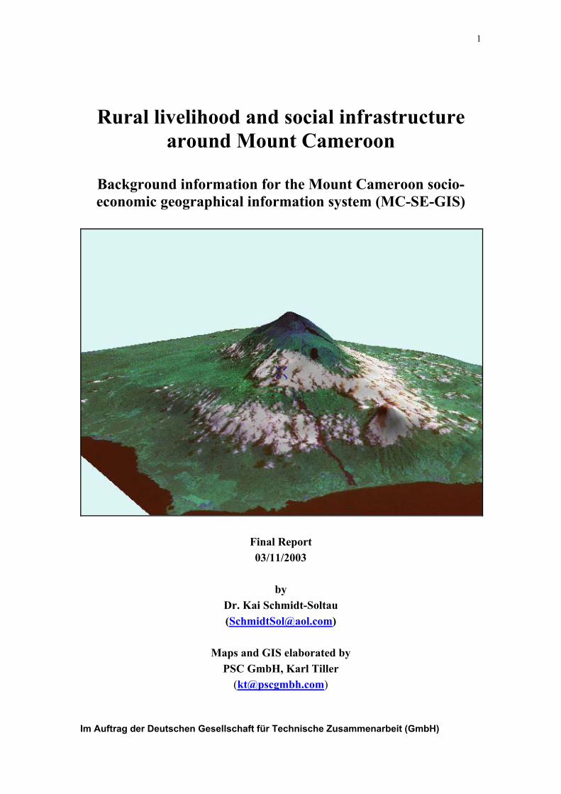
Rural livelihood and social infrastructure
around Mount Cameroon
Background information for the Mount Cameroon socio-
economic geographical information system (MC-SE-GIS)
Final Report
03/11/2003
by
Dr. Kai Schmidt-Soltau
Maps and GIS elaborated by
PSC GmbH, Karl Tiller
Im Auftrag der Deutschen Gesellschaft für Technische Zusammenarbeit (GmbH)
Schmidt-Soltau: Rural livelihood and social infrastructure around Mt. Cameroon - Final Report 2
Table of content
Executive Summary.......................................................................................................... 4
1. Introduction .......................................................................................................... 6
2. Methodology and study design................................................................................. 6
2.1. Type of information collected .......................................................................... 6
2.2. Survey team ...................................................................................................... 7
2.3. Sample units and sample size ........................................................................... 7
2.4. Methodology..................................................................................................... 7
2.5. Data analysis..................................................................................................... 8
2.6. Constrains ......................................................................................................... 8
3. Findings ................................................................................................................ 9
3.1. Demography ..................................................................................................... 9
2.2. Livelihood....................................................................................................... 16
2.3. Social infrastructure........................................................................................ 21
2.4. Relevance for biodiversity conservation and relation with MCP................... 26
4. Bibliography ........................................................................................................... 28
Maps
1. Overview: Survey villages and roads
2. Demography
3. Ethnic composition
4. Source of livelihood: Farming
5. Source of livelihood: Labour and trading
6. Source of livelihood: Fishing
7. Source of livelihood: Hunting and NTFP-gathering
8. Major farming system
9. Alternative income generating activities: General assessment
10. Alternative income generating activities: Beekeeping
11. Alternative income generating activities: Livestock rearing
12. Alternative income generating activities: Fuel wood harvesting and logging
13. Markets
14. Education: Kindergartens and nursery schools
15. Education: Primary schools
16. Education: Secondary schools
17. Health facilities
18. Water supply
19. Electric supply
20. Administrative buildings: MINEF
21. Administrative buildings: MINAGRI
22. Utilisation and utilisation rights of the Bomboko forest reserve
23. Number of MCP activities per village
Schmidt-Soltau: Rural livelihood and social infrastructure around Mt. Cameroon - Final Report 3
Appendices
Appendix 1: Terms of reference
Appendix 2: Itinerary
Appendix 3: Legend for village mapping
Appendix 4: Questionnaire
Appendix 5: Interview guideline
Appendix 6: Individual questionnaire (Census)
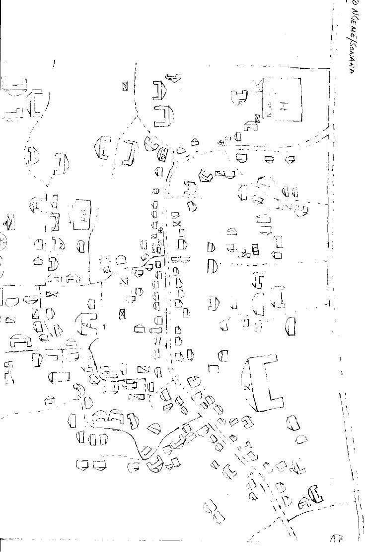
Appendix 7: The village map of Mokinda (Sokolo) Part 1
Schmidt-Soltau: Rural livelihood and social infrastructure around Mt. Cameroon - Final Report 4
Executive Summary
The Mount Cameroon region is one of the 25 global biodiversity hotspots. It is home for
250,000 people. The Mount Cameroon Project, an integrated conservation and
development project, commissioned a socio-economic study, to establish an end-of-
project-picture and to achieve a reliable basis for further planning, monitoring and
evaluation.
136 settlements along or within the circle of the ‘Mt. Cameroon ring-road’ (Mutengene-
Muyuka-Munyenge-Idenau-Limbe-Mutengene) were surveyed. ‘Settlements’ are defined
as having at least 3 buildings and a clearly defined demarcation. 96% of the settlements
participated in the research.
Five methods were used to gather information: village mapping, focus group interviews,
individual interviews, literature review and GPS-mapping.
Demography: Number of houses, estimated population & distribution of ethnic groups;
The number of functioning houses (completed and not broken down) in the research
region is 30,824. A high number of houses is under construction (6%). Almost all
houses are covered with iron sheets and/or tiles (99%).
A house (personal infrastructure under one roof) in the research region is inhabited on
average by 7.9 people. The total population is estimated to be 254,606 people. 92% of
the population live in village type settlements, while 8% live in plantation camps.
The autochthon population (Bakweri, Bomboko) represents 23% of the total population.
Livelihood: Source of income, major farming system, major crops produced, special
economic features & marketing;
Food crop farming is the most important source for the livelihood of the population around
Mt. Cameroon. The forest as direct source of income and subsistence through hunting
and gathering is not very important for the overall population.
18% settlements are plantation camps and 10% of settlements were of the view that
plantation and small scale farming are equally important as farming systems.
Plantains, cocoyam and cassava are the most important agricultural products and
contribute more than twice as much as cocoa and coffee to the livelihood.
On average the surveyed settlements are engaged in 3.7 alternative income generating
activities, but beside of the various forms of livestock rearing, only beekeeping, cassava
processing and fuel wood harvesting have any relevance for the rural population.
Muea was considered by all respondents as main food crop market in the region, but
Mutengene has more market stands. 29 settlements have markets, most of them bi-
weekly.
Schmidt-Soltau: Rural livelihood and social infrastructure around Mt. Cameroon - Final Report 5
Social infrastructure: Education, health services, water supply, electricity, access to
governmental services, administrative setting & existence of common initiative groups;
There are 259 educational facilities in the area – ranging from kindergartens to
university - with a total enrolment of 87,858 pupils. The average teacher-pupil ratio is
36.13 and on average 51.6 pupils are attending school in one classroom. The standard of
the buildings is in many cases low. More than half of the schools in the region are run
by private institution and the various missions. Private schools have more teachers and
more classrooms per child and the standard of infrastructure is also better than in
governmental schools. Mission schools offer the best infrastructure, while they have even
more pupils per teacher than any other school.
The research region has a significant higher number of physicians (19 per 100,000
people) than the overall country (7 per 100,000 people) but thir services are limited to the
towns (area around Buea, Limbe, Muyuka). The buildings of village health centres are
mostly in good conditions, but do not have much staff and are often purely equipped.
Problems in the governmental health care system have resulted in a high number of
private health facilities, but their staff situation and infrastructure does not differ from
state owned or mission hospitals. Apart from formal health facilities offer in most
settlements traditional healers their services.
About 9.2% of the surveyed settlements did not have any water supply at all. Pipe born
water is available in 57% of the villages, but the standard is very low.
About 51% of the settlements are connected to the national grid.
Outside the town the access to administrative infrastructure is very limited.
The 136 villages are located in 2 divisions and 6 councils/ sub-divisions.
About 19% of the settlements have common initiative groups.
Relevance for biodiversity conservation and relation with MCP.
31 settlements (24%) were of the view, that some of their inhabitants are utilising the
land demarcated as forest reserve. 11 of them have traditional rights to hunt, gather, fish
and farm within the Bomboko forest reserve.
These settlements with an estimated population of 35,459 people (14% of the overall
population) are significantly more dependent on the forest. They have significantly less
social infrastructure (schools, health facilities, water, electricity) than the other
settlements in the area.
MCP targeted their work towards population that is utilising the natural resources of the
Bomboko forest reserve. MCP has worked with 84% of the Bomboko forest reserve area
settlements and with 28% of the other settlements. The average number of activities per
village is also higher in this area.
Schmidt-Soltau: Rural livelihood and social infrastructure around Mt. Cameroon - Final Report 6
1. Introduction
The Mount Cameroon region is one of the 25 global biodiversity hotspots (Conservation
International 2003) with several endangered species and a unique landscape. It is home
for 250,000 people.1 Following the guiding principles of international politics (sustainable
development = poverty reduction & biodiversity conservation) Mount Cameroon Project
is an integrated conservation and development project (ICDP) to link biodiversity
conservation and the development needs of the rural population. The basic belief behind
the ICDP approach is the notion that conservation is doomed to fail as long as local
people are not compensated for income losses resulting from conservation. Literature
describes a number of interventions to achieve that the rural population at least accepts the
conservation measures carried out on land traditionally owned and utilised by them:
1. Establishment of buffer zones;
2. Promotion of alternative natural resource management interventions in the fields
of agriculture and forestry;
3. Promotion of alternative sources of income to replace existing income-generating
activities, which are perceived as contra-productive to the conservation goals;
4. Reinforcement of existing forest management strategies and distribution of the
benefits directly resolving from sustainable forest use;
5. Provision of benefits such as roads, communal infrastructure and social services;
6. Distribution of benefits arising from conservation such as income from tourism
and biological prospecting (Wells et al 1990, Ghimire and Pimbert 1997).
The Mount Cameroon Project (MCP) has worked with village-based organisations
living and working around Mount Cameroon since 1995. It is believed, that
organisational development, introduction of sustainable agriculture and forestry
methods, ecotourism and other activities had a positive impact on the wellbeing of the
populace. Nevertheless, these impacts could in the past - due to the absence of baseline
data – neither be verified nor quantified. To establish an end-of-project-picture and to
achieve a reliable basis for further planning, monitoring and evaluation, MCP
commissioned a socio-economic study to collect data will be fed into a geographical
information system (Appendix 1). The result is a geospatial socio-economic database.
2. Methodology and study design
2.1. Type of information collected
Data were collected on:
Demography: Number of houses, estimated population & distribution of ethnic groups;
Livelihood: Source of income, major farming system, major crops produced, special
economic features & marketing;
Social infrastructure: Education, health services, water supply, electricity, access to
governmental services, administrative setting & existence of common initiative groups;
Relevance for biodiversity conservation and relation with MCP.
1 Data from this survey.
Schmidt-Soltau: Rural livelihood and social infrastructure around Mt. Cameroon - Final Report 7
2.2. Survey team
The socio-economic and spatial data were collected in two fieldwork phases by a team
(Mr. Pary-Cao Arrey Agbortar, Mr. James Eban Takem, Ms. Elive Rose Ewune & Ms.
Frida Nanyongo Luma) under the supervision of Dr. Kai Schmidt-Soltau, while Mr.
Ngenge Vefonge established a comprehensive list of common initiative groups active in
the research region. All data were entered into an ACCESS database established by the
Project Service Consultant GmbH (PSC) and Dr. Kai Schmidt-Soltau. Dr. Kai Schmidt-
Soltau analysed the data, while PSC linked the analysed data to satellite images and
topographical maps.
2.3. Sample units and sample size
‘Settlement’ was chosen as basic unit (entity) for the data gathering. ‘Settlements’ are
defined as having at least 3 buildings and a clearly defined demarcation, separating
them from other ‘settlements’.
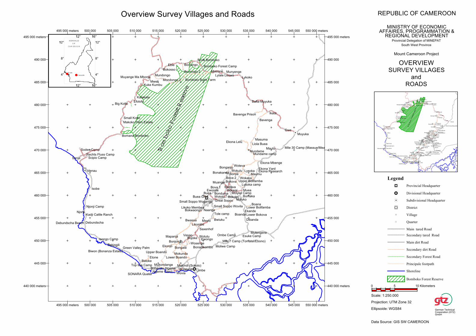
It was decided, that the research region is demarcated by the ‘Mt. Cameroon ring-road’
(Mutengene-Muyuka-Munyenge-Idenau-Limbe-Mutengene – see map 1). 136 settlements
along or within this circle were surveyed (Appendix 2) of which 131 will be assessed in
the following. The infrastructure of Bomana Bomboko, Mweli, Bomboko Bush Farm,
Mondongo 2 and Sonara quarter could not been assessed. For all other settlements,
complete data sets are available (beside of missing census data for Bavenga Prison).
2.4. Methodology
Five methods were used to gather information: village mapping, focus group interviews,
individual interviews, literature review and GPS-mapping.
The village mapping was carried out by teams of two people (one permanent assistant
and one village helper, selected by the chief and/or traditional council). Following the
guidelines for village mapping (see Appendix 3), the permanent assistants mapped all
buildings of all settlements indicating its state (functional, under construction,
collapsed), size (houses, compounds - which have more than one individual house under
one roof -, blocks - structures in plantation camps and ‘towns’, which comprise several
apartments - and storey buildings), composition (indicating the roofing: zinc/tiles or
other material) and function (individual or social such as: schools, health and water
facilities, communal, governmental and religious buildings) (an example is provided in
Appendix 7). Photocopies of all maps were returned to the surveyed villages, while the
originals remained in the MCP office in Buea and are as a scanned version accessible
through the database.
With the help of a structured questionnaire (Appendix 4) and data collection guideline
(Appendix 5) socio-economic information (livelihood and social infrastructure) were
gathered in focus group interviews with chiefs/quarter heads, councils and/or the
interested public. Detailed information like the enrolment and number of staff was
gathered from the headmasters, principals, chief of posts etc. or their representatives.
The state of buildings was assessed on the ground following criteria outlined in the data
collection guideline.
Schmidt-Soltau: Rural livelihood and social infrastructure around Mt. Cameroon - Final Report 8
With the help of an individual questionnaire (Appendix 6) - administered to one of the
people present in the focus group discussion – census data of one individual house per
settlement was collected. The census data contain information on age, sex, profession
and family relation of each person living permanently in the selected building to the
different household heads.
On the basis of literature available in the MCP library, a comprehensive list of common
initiative groups active in the research region was established and integrated into the
general database.
From the various provincial delegations in Buea (in charge of the entire research region)
the research team collected information on the status of roads, educational statistics,
information on health infrastructure and demography. Based on the assumption, that
field data is preferable to office materials, those data were only used, if no other data
were available.
The geospatial location of all settlements and motorable roads within the research
region were assessed with the help of a Trimble Geo-Explorer 3 GPS receiver.
2.5. Data analysis
The data were entered and stored in an Access XP database. For the statistical analysis
SPSS 10.5 was utilised and TNTmips 6.8 was used to establish the MC-SE-GIS.
2.6. Constrains
Most respondents received the team with open hands and minds and participated
actively in the interviews and mapping exercise, but local attitudes to expatriate and
bilateral projects are inevitably ambivalent in the Mt. Cameroon region (Sharp 1997). In
two villages (Mweli & Bomana-Bomboko), two plantation camps (Bomboko bush farm,
Mondongo 2) and one factory camp (Sonara), the population and rural administration
refused to participate in the survey and prohibited the team from carrying out data
collection. Due to the villagers’ request, this report does not contain any detailed
information.
In some other cases, the data presented and analysed might have been affected by the
fear of the respondents that the team is out to collect information for taxation and/or to
identify illegal activities for future prosecution.

Schmidt-Soltau: Rural livelihood and social infrastructure around Mt. Cameroon - Final Report 9
3. Findings
3.1. Demography
Number of houses per village:
The number of functioning houses (completed and not broken down) in the research
region is 30,824 (Table 1).
Name of settlement Total Functional Under
construction
Broken
down
Under
Construction (in
Broken Down
(in %)
Growing settlements with a high number of buildings under construction
Wonjava 7 4 3 0 42.86 0
Small Soppo Woganga 280 233 39 8 13.93 3.43
Bomaka 386 333 53 0 13.73 0
Boanda 15 12 2 1 13.33 8.33
Ngeme 210 180 28 2 13.33 1.11
Botaland 243 208 32 3 13.17 1.44
Bokosso 42 36 5 1 11.90 2.78
Isobe 17 15 2 0 11.76 0
Katakata 27 24 3 0 11.11 0
Mautu 128 114 14 0 10.94 0
Declining settlements with a high number of broken down buildings
Mundame 7 4 0 3 0 75.00
Lower Boando 7 4 0 3 0 75.00
Kadji Cattle Ranch 11 8 0 3 0 37.50
Mundame camp 19 14 0 5 0 35.71
Bavenga 8 6 0 2 0 33.33
Bavenga Prison 14 11 0 3 0 27.27
Bulu 5 4 0 1 0 25.00
Etone 13 11 0 2 0 18.18
Small Soppo Likoko 32 27 1 4 3.13 14.81
Molyko Camp 40 35 0 5 0 14.29
Wosenge 8 7 0 1 0 14.29
Total/Average 33,010 30,824 1,808 378 5.48 1.15
Tab.1: Settlements with a very high ratio of new (under construction) or broken down houses
A high number of houses is under construction (5.9%). Further, almost all houses are
covered with iron sheets and/or tiles (99%, Table 2). These two findings could lead to
the conclusion that the Mt. Cameroon region, having superb agricultural land, is
comparatively rich. However, the recent national household survey (ECAM 2) does not
support this assumption.
House Classes Functioning Under Construction Broken Down Total %
Personal house zinc/tiles roof 27,110 1,747 365 29,222 88.5
Personal house roof of other material 216 5 1 222 0.7
Personal compound zinc/tiles roof 3,408 56 10 3,474 10.5
Personal compound roof of other material 90 0 2 92 0.3
Total 30,824 1,808 378 33,010 100
Tab.2: Number of individual houses and compounds in the research region with/without iron sheet roofs
The ratio between functional houses and houses under construction/broken down give
some idea on the dynamics and the poverty of a village. More detailed statements are
not possible, since the household survey data (ECAM) can not be aggregated on
settlement level.
Schmidt-Soltau: Rural livelihood and social infrastructure around Mt. Cameroon - Final Report 10
Table 3 shows the number of other infrastructure facilities in the research region. Note
that there are more churches than schools. The high number of administrative buildings
is attributed to the fact, that the provincial capital, one divisional and three sub-
divisional headquarters are located within the research region.
Other Infrastructure FunctioningUnder
Construction
Broken
downOther Infrastructure
Functio
ning
Under
Construction
Broken
down
Tap stand 459 0 28 Hotel 47 0 0
Church 262 6 4 Market 30 2 0
School 256 2 1 Water Tank 17 1 0
Other Administrative 107 0 0 Bank/Credit Union 10 0 0
Other communal 91 2 3 Well 4 0 0
Health Post/Hospital/ 70 0 0 Ad. Building MINEF 4 0 0
Pharmacy/Drugstores 55 5 0 Ad. Building MINAGRI 3 0 1
Total 1,367 18 37
Tab.3: Overall number of social infrastructures in the research region
Population:
A house in the research region is inhabited on average by 7.85+4.84 people (Table 4).2
Settlement
pattern3
N Mean Std. Deviation Std. Error of
Mean 4
Minimum Maximum
Camp 23 10.739 7.436 1.551 5 39
Village 107 7.234 3.855 0.373 1 19
Total 130 7.854 4.842 0.425 1 39
Tab. 4: Statistics on number of people per house in the research region5
The age and sex ratio of the surveyed 1021 people (table 5) compares well with the national
average (Statistisches Bundesamt 1992, UNDP 2002)
Age Groups Female Male Total
0-15 years 22.4 18.1 40.5
16-30 years 15.2 14.8 30.0
31-45 years 7.7 6.7 14.4
46-60 years 3.8 5.0 8.8
> 60 years 1.7 4.6 6.3
Total 50.8 49.2 100.0
Tab.5: Age and sex of people living in the sampled houses in percent
The average household6
size of the sampled population (for village type settlements
5.63+3.02) compares well with the figure (5.59+3.71, Schmidt-Soltau 2001) established on
2 The selected sample method (one person from a focus group discussion with village representatives) might have influenced
the estimate to be at the upper limit, since village officials in other areas tend to have more household members than the
average villager: The households of chiefs and councillors of more that 2000 surveyed household in the Akwaya
subdivision had on average 6.04 +2.32 members in contrast to an overall average household size of 5.59+3.71 (Schmidt-
Soltau 2001:63).3 The following camps were considered as villages (reason in brackets): Biwon Bonanza Estate, Kadji Cattle Ranch, Makoko
Palm Estate (the houses in these private estates are small individual houses and not the normal camp-blocks), Mile 7 Camp
Tomatal/Ebongo, Debundscha (in these two camps, the field assistants – which are the managers of the camps and provided
with individual houses - insisted to be selected for census.4 The low sampling size (130 houses out of 30,824 functional houses and compounds = 0.41%) resulted in a high standard
error, but the limited time (25 days of fieldwork for 136 settlements) and the fact that within the next month a national
census will provide exact figures contributed to the selected rapid population assessment. Nevertheless, the data have to be
considered as the most accurate data available, since the data are based on the factual number of houses in the researched
settlements, which is a quite precise figure. 5 ANOVA F=10.667, p=0.001. 6 The sampled 130 houses contain 167 households.
Schmidt-Soltau: Rural livelihood and social infrastructure around Mt. Cameroon - Final Report 11
the basis of 2827 households in one of the most detailed household survey in the South-
West Province and the national household survey (ECAM 2 = 5.61+3.89)
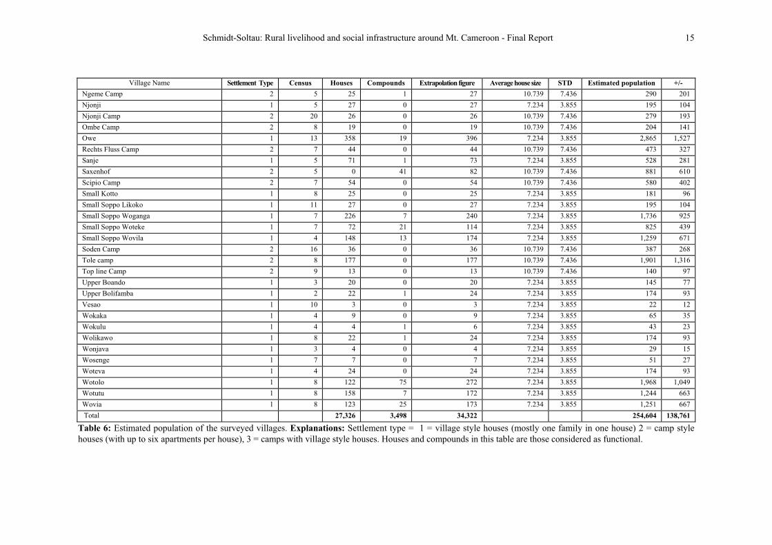
The total population is estimated to be 254,606 people (Table 6).7 One might be
surprised, that a huge settlement like Limbe is inhabited only by 45,000 people, but the
detailed mapping documented not more than 4,833 individual houses and 698
compounds/story buildings. Buea, which is a conglomerate of several settlements and
villages is inhabited by around 53,000 people.
92% (234,370) of the population live in village type settlements, while 8% (20,234) live
in plantation camps. Map 2 documents the spatial distribution of these villages and the
population figures provided in full detail in table 7. It becomes obvious that the south
east of the study region is the most heavily populated region.
7 Utilising the well justified differentiation (camp/village), the average number of people per building was than extrapolated
by the number of all functional living houses (excluding those under construction or collapsed) to compute an estimate of
people per village/camp. Compounds (more than one building under one roof) and storey buildings were counted as 2
individual houses.

Schmidt-Soltau: Rural livelihood and social infrastructure around Mt. Cameroon - Final Report 12
Village Name Settlement Type Census Houses Compounds Extrapolation figure Average house size STD Estimated population +/-
Bafia-Muyuka 1 59211 23 638 7.234 3.855 4,615 2,459
Bakingili 1 795 0 79 7.234 3.855 571 305
Batoke 1 3759 26 427 3.8557.234 3,089 1,646
Bavenga 1 68 0 6 7.234 3.855 43 23
Bavenga Prison 2 11 0 11 10.739 7.436 118 82
Big Kotto 1 14 51 1 53 7.234 3.855 383 204
Biwon (Bonanza Estate) 3 2 1 0 1 7.234 3.855 7 4
Boana 1 7 99 7 113 3.8557.234 817 436
Boanda 1 104 2 14 3.8557.234 101 54
Bobende 1 1203 17 154 7.234 3.855 1,114 594
Bojoke 1 2314 3 29 3.8557.234 210 112
Bokoko 1 29119 84 459 7.234 3.855 3,320 1,769
Bokosso 1 3511 1 37 7.234 3.855 268 143
Bokova 1 379 18 73 7.234 3.855 528 281
Bokwai 1 1302 24 178 7.234 3.855 1,288 686
Bokwaongo 1 2268 55 336 7.234 3.855 2,431 1,295
Bomaka 1 3204 13 346 7.234 3.855 2,503 1,334
Bomboko Forest Camp 2 15 6 0 6 10.739 7.436 64 45
Bonadikombo 1 1,0564 249 1,554 7.234 3.855 11,242 5,991
Bonakanda 1 18411 19 222 7.234 3.855 1,606 856
Bonduma 1 2538 36 325 7.234 3.855 2,351 1,253
Bongala 1 85 0 8 7.234 3.855 58 31
Bonganjo 1 91 0 9 7.234 3.855 65 35
Bonjia 1 42 0 4 3.8557.234 29 15
Bonjongo 1 16210 13 188 7.234 3.855 1,360 725
Botaland 1 19013 18 226 7.234 3.855 1,635 871
Bova 1 1 4 77 10 97 7.234 3.855 702 374
Bova 2 1 12 157 6 169 7.234 3.855 1,223 651
Bova Bomboko 1 5 101 37 175 7.234 3.855 1,266 675
Boviongo 1 293 1 31 7.234 3.855 224 120
Boviongo 2 2 14 0 11 22 10.739 7.436 236 164
Buea 1 8 48969 1,065 3.8557.234 7,704 4,106
Buea GRA 1 5 326 0 326 7.234 3.855 2,358 1,257
Bulu 1 11 04 4 3.8557.234 29 15

Schmidt-Soltau: Rural livelihood and social infrastructure around Mt. Cameroon - Final Report 13
Village Name Settlement Type Census Houses Compounds Extrapolation figure Average housesize STD Estimated population +/-
Bwassa 1 806 96 272 3.8557.234 1,968 1,049
Bwiteva 1 533 3 59 7.234 3.855 427 227
Bwitingi 1 257 7 39 7.234 3.855 282 150
Bwiuku 1 3905 16 422 7.234 3.855 3,053 1,627
Debundscha 3 573 1 59 7.234 3.855 427 227
Debundscha Beach 1 5 62 5 72 7.234 3.855 521 278
Dibanda 1 28113 4 289 7.234 3.855 2,091 1,114
Ebie 1 6 11123 145 3.8557.234 1,049 559
Efolofo 1 297 4 37 3.8557.234 268 143
Ekande 1 95 0 9 3.8557.234 65 35
Ekona Lelu 1 2 52 10 72 7.234 3.855 521 278
Ekona Mbenge 1 10 1,002 58 1,118 7.234 3.855 8,088 4,310
Ekona Research 2 9 39 22 83 10.739 7.436 891 617
Ekona Yard 2 5 158 0 158 10.739 7.436 1,697 1,175
Ekonjo 1 244 0 24 3.8557.234 174 93
Esuke New Camp 2 7 17 0 17 10.739 7.436 183 126
Etone 1 5 11 0 11 3.8557.234 80 42
Ewonda 1 186 7 32 7.234 3.855 231 123
Ewongo 1 717 2 75 7.234 3.855 543 289
Great Soppo 1 19 1,590 291 2,172 7.234 3.855 15,712 8,373
Green Valley Palm Estate 2 6 6 0 6 10.739 7.436 64 45
Idenau 2 36510 98 561 7.43610.739 6,025 4,172
Ikata 1 5 13353 379 3.8557.234 2,742 1461
Isobe 1 3 015 15 3.8557.234 109 58
Isongo Camp 2 39 18 0 18 10.739 7.436 193 134
Kadji Cattle Ranch 3 4 8 0 8 7.234 3.855 58 31
Karata Camp 2 12 41 0 41 10.739 7.436 440 305
Katakata 1 248 0 24 7.234 3.855 174 93
Kie 1 7 231 35 3.8557.234 253 135
Kuke Kumbu 1 13 23 0 23 7.234 3.855 166 89
Likoko Membea 1 11 319 164 647 7.234 3.855 4,680 2,494
Likombe 1 656 5 75 7.234 3.855 543 289
Limbe 1 4,8337 698 6,229 3.8557.234 45,061 24,013
Limbola 1 1047 4 112 7.234 3.855 810 432
Schmidt-Soltau: Rural livelihood and social infrastructure around Mt. Cameroon - Final Report 14
Village Name Settlement Type Census Houses Compounds Extrapolation figure Average housesize STD Estimated population +/-
Liola Buea 1 9 8 0 8 7.234 3.855 58 31
Lower Boando 1 12 4 0 4 7.234 3.855 29 15
Lower Bokova 1 9 43 5 53 7.234 3.855 383 204
Lower Bolifamba 1 13 669 109 887 7.234 3.855 6,417 3,419
Lykoko 1 2996 36 371 7.234 3.855 2,684 1,430
Lylale Leowo 1 16 88 3 94 7.234 3.855 680 362
Lysoka 1 3144 10 334 3.8557.234 2,416 1288
Lysoka camp 2 12 66 0 66 10.739 7.436 709 491
Makoko Palm Estate 3 5 4 0 4 7.234 3.855 29 15
Mapanja 1 967 2 100 7.234 3.855 723 386
Masone 1 142 0 14 7.234 3.855 101 54
Masuma 1 101 0 10 7.234 3.855 72 39
Maumu 1 1405 8 156 7.234 3.855 1,129 601
Mautu 1 9516 19 133 3.8557.234 962 513
Mevio 1 368 0 36 3.8557.234 260 139
Mile 30 Camp (Massue/Meanja) 2 6 54 0 54 10.739 7.436 580 402
Mile 7 Camp (Tomatal/Ebongo) 3 4 51 0 51 7.234 3.855 369 197
Mokindi (Sokolo) 1 7 314 142 598 7.234 3.855 4,326 2,305
Mokunda 1 1128 0 112 7.234 3.855 810 432
Moliwe Camp 2 7 205 13 231 10.739 7.436 2,481 1,718
Molyko 1 1,26516 62 1,389 7.234 3.855 10,048 5,355
Molyko Camp 2 15 35 0 35 10.739 7.436 376 260
Muangai 1 83 0 8 7.234 3.855 58 31
Muea 1 8 83959 1,125 3.8557.234 8,138 4,337
Mukondange 1 1287 8 144 7.234 3.855 1,042 555
Mundame 1 47 0 4 7.234 3.855 29 15
Mundame camp 2 5 14 0 14 10.739 7.436 150 104
Mundongo 1 10213 8 118 7.234 3.855 854 455
Munyenge 1 8168 155 1,126 7.234 3.855 8,145 4,341
Mutengene 1 2,1557 80 2,315 7.234 3.855 16,747 8,924
Muyange Ma Mbonje 1 6 100 3 106 7.234 3.855 767 409
Muyuka 1 5659 253 1,071 7.234 3.855 7,748 4,129
Naanga 1 3029 11 324 3.8557.234 2,344 1,249
Ngeme 1 1484 32 212 3.8557.234 1,534 817
Schmidt-Soltau: Rural livelihood and social infrastructure around Mt. Cameroon - Final Report 15
Village Name Settlement Type Census Houses Compounds Extrapolation figure Average housesize STD Estimated population +/-
Ngeme Camp 2 5 25 1 27 10.739 7.436 290 201
Njonji 1 5 27 0 27 3.8557.234 195 104
Njonji Camp 2 20 26 0 26 10.739 7.436 279 193
Ombe Camp 2 8 19 0 19 10.739 7.436 204 141
Owe 1 13 19358 396 3.8557.234 2,865 1,527
Rechts Fluss Camp 2 7 44 0 44 10.739 7.436 473 327
Sanje 1 5 171 73 3.8557.234 528 281
Saxenhof 2 05 41 82 10.739 7.436 881 610
Scipio Camp 2 7 54 0 54 10.739 7.436 580 402
Small Kotto 1 8 25 0 25 7.234 3.855 181 96
Small Soppo Likoko 1 11 27 0 27 7.234 3.855 195 104
Small Soppo Woganga 1 7 226 7 240 7.234 3.855 1,736 925
Small Soppo Woteke 1 7 72 21 114 7.234 3.855 825 439
Small Soppo Wovila 1 4 148 13 174 7.234 3.855 1,259 671
Soden Camp 2 16 36 0 36 10.739 7.436 387 268
Tole camp 2 8 177 0 177 10.739 7.436 1,901 1,316
Top line Camp 2 9 13 0 13 10.739 7.436 140 97
Upper Boando 1 3 20 0 20 7.234 3.855 145 77
Upper Bolifamba 1 2 22 1 24 7.234 3.855 174 93
Vesao 1 10 3 0 3 3.8557.234 22 12
Wokaka 1 94 0 9 7.234 3.855 65 35
Wokulu 1 44 1 6 7.234 3.855 43 23
Wolikawo 1 228 1 24 7.234 3.855 174 93
Wonjava 1 43 0 4 7.234 3.855 29 15
Wosenge 1 77 0 7 7.234 3.855 51 27
Woteva 1 244 0 24 3.8557.234 174 93
Wotolo 1 1228 75 272 3.8557.234 1,968 1,049
Wotutu 1 1588 7 172 3.8557.234 1,244 663
Wovia 1 1238 25 173 3.8557.234 1,251 667
Total 27,326 3,498 34,322 254,604 138,761
Table 6: Estimated population of the surveyed villages. Explanations: Settlement type = 1 = village style houses (mostly one family in one house) 2 = camp style
houses (with up to six apartments per house), 3 = camps with village style houses. Houses and compounds in this table are those considered as functional.
Schmidt-Soltau: Rural livelihood and social infrastructure around Mt. Cameroon - Final Report 16
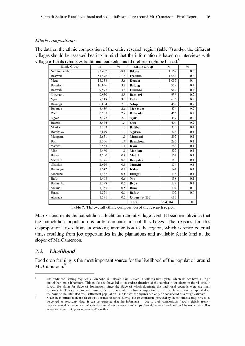
Ethnic composition:
The data on the ethnic composition of the entire research region (table 7) and/or the different
villages should be assessed bearing in mind that the information is based on interviews with
village officials (chiefs & traditional councils) and therefore might be biased.8
Ethnic Group N % Ethnic Group N %
Not Assessable 73,402 28.8 Bikom 1,167 0.5
Bakweri 54,576 21.4 Ewondo 1,064 0.4
Meta 14,338 5.6 Douala 1,017 0.4
Bamiliki 10,036 3.9 Balong 959 0.4
Banwah 9,977 3.9 Eshimbi 919 0.4
Nigerians 9,950 3.9 Bamingi 636 0.2
Ngie 8,318 3.3 Oshe 636 0.2
Bayangi 6,864 2.7 Ndop 482 0.2
Balondo 6,459 2.5 Menchum 474 0.2
Wum 6,205 2.4 Babamki 453 0.2
Ngwo 5,772 2.3 Njari 437 0.2
Bakossi 3,474 1.4 Oku 404 0.2
Menka 3,363 1.3 Batibo 373 0.1
Bomboko 2,849 1.1 Ngikwa 326 0.1
Mongamo 2,651 1.0 Mundani 297 0.1
Bali 2,556 1.0 Bamukom 286 0.1
Yamba 2,553 1.0 Kom 263 0.1
Mbo 2,460 1.0 Mankon 222 0.1
Bassa 2,200 0.9 Mokili 163 0.1
Nkambe 2,176 0.9 Bangolan 163 0.1
Ghanian 2,026 0.8 Munchi 154 0.1
Bamongo 1,942 0.8 Kaka 142 0.1
Mbembe 1,487 0.6 Insugni 138 0.1
Bafut 1,408 0.6 Nso 138 0.1
Bamumbu 1,398 0.5 Beba 129 0.1
Mukuru 1,355 0.5 Bum 104 0.0
Hausa 1,271 0.5 Bafaw 102 0.0
Akwaya 1,271 0.5 Others (n<100) 613
Total 254,604 100
Table 7: The overall ethnic composition of the research region
Map 3 documents the autochthon-allochthon ratio at village level. It becomes obvious that
the autochthon population is only dominant in uphill villages. The reasons for this
disproportion arises from an ongoing immigration to the region, which is since colonial
times resulting from job opportunities in the plantations and available fertile land at the
slopes of Mt. Cameroon.
2.2. Livelihood
Food crop farming is the most important source for the livelihood of the population around
Mt. Cameroon.9
8 The traditional setting requires a Bomboko or Bakweri chief - even in villages like Lylale, which do not have a single
autochthon male inhabitant. This might also have led to an underestimation of the number of outsiders in the villages to
favour the claim for Bakweri domination, since the Bakweri which dominate the traditional councils were the main
respondents. To estimate overall figures, their estimate of the ethnic composition of their settlement was extrapolated on
the basis of the estimated total settlement population. Due to that, the figures can only be considered as a rough estimate. 9 Since the information are not based on a detailed household survey, but on estimations provided by the informants, they have to be
perceived as secondary data. It can be expected that the informants – due to their composition (mostly elderly men) -
underestimated the importance of activities carried out by women and crops planted, harvested and marketed by women as well as
activities carried out by young men and/or settlers.
Schmidt-Soltau: Rural livelihood and social infrastructure around Mt. Cameroon - Final Report 17
Source of income and subsistence
Based on the assumption, that the researchers are - as part of Mt. Cameroon Project -
out to ban hunting and/or to identify hunters for future legal prosecution, the informants
in a good number of villages tried to establish the view that they do neither trap nor hunt
at all. Only after the intervention of the research supervisor, they agreed that they have
at least some traps in their farms, but it can be expected that they still did not give a
factual account of the level of hunting carried out in the villages, especially in the area
around the Bomboko forest reserve. This might be the reason, why the figures for the
importance of hunting and gathering for the livelihood are quite low. It could also be
that the high pressure on the natural resources does no longer offer enough benefits to
attract people to hunt and gather NTFPs at least in the dense populated areas. A third
option, which was not supported by the informants, could be that conservation measures
such as law enforcement etc. prohibit people to hunt and gather. Nevertheless, the data
collected on the importance of hunting and gathering for the livelihood of the rural
population are significant lower than those published earlier (SOWEDA 1998).
That farming is considered to contribute less than 50% to the overall livelihood (map 4)
has to be seen in the light, that 8% of the overall population is living as labourers in
plantation camps and are not in control of their production (table 8). Nevertheless, it is
important to remember that a significant part of the livelihood – also reflected in table 9,
which outlines the main occupations of the people assessed in the census - is not
generated through productive work, but through petit trading, labour, etc. (map 5) and that
nearly 50% of the population are due to the age distribution not contributing to the income
of their families.
Source of livelihood N %
Farming 124,316 48.8
Trading 52,023 20.4
Labour 46,434 18.2
Fishing 18,451 7.2
Hunting 8,036 3.2
NTFP-Gathering 5,344 2.2
Total 254,604 100
Tab.8: Source of livelihood in people depending on it (in N and %)
Tab. 8 & 9 shows that the forest as direct income source is not very important for the
overall population (Hunting and NTFP-Gathering = 5.4%; map 7), but the dependence
on forests is related to the location of the village. Fishing occurs as major source of
income only along the cost, since the mountainous nature of the research region does
not offer a habitat for eatable fish species (map 6). While labour is the main source of
income for the plantation camps, the main villages (Limbe, Muyuka, Mutengene and the
settlements along the Lower Bolifamba-Buea road) are depending heavily on a
combination of labour and trading (map 5).

Schmidt-Soltau: Rural livelihood and social infrastructure around Mt. Cameroon - Final Report 18
Profession Female Male Total
Pupil/Student 21.3 18.1 39.4
Farmer 15.7 11.3 27.0
Infant 5.0 3.5 8.5
Unskilled labourer 1.5 6.0 7.5
Skilled labourer 1.2 2.7 3.9
Business 2.5 1.2 3.7
Retired 0.1 2.1 2.2
Civil servant 0.7 1.3 2.0
Dependent 1.4 0.4 1.8
Apprentice 0.6 0.9 1.5
Applicant 0.4 0.6 1.0
Fisherfolk 0.0 0.8 0.8
Gatherer of NTFPs 0.4 0.3 0.7
Total 50.8 49.2 100
Tab.9: The profession of the people in the census’ houses in %
Major farming system
Since the German colonial time, the area around Mt. Cameroon is dominated by
plantations.10
CDC (Cameroonian Development Cooperation), CTE (Cameroon Tea
Estate) and private plantations dominate the landscape along the Mt. Cameroon ring
road and 23 out of 131 settlements surveyed were plantation camps (see map 8), but
have only 8% of the overall population. This stands in contrast to earlier surveys
(Ardener 1960, Konings 1993) and could be a result of the decline of CDC.11
According to an MCP publication, CDC and CTE have leased around 60,000 ha, of which
only 1/3 is covered with plantations, while 2/3 is utilised for small scale agriculture by
plantation workers and the rural population (Forbes & Besong 2002). While CDC and
CTE are cultivating in the research region mostly oil palms, rubber, bananas and tea,
private plantations are cultivating cocoa, coffee, oil palms and plantains. 17.7%
settlements are plantation camps and 9.2% of settlements were of the view that plantation
and small scale farming are equally important. An assessment of the factual land use
pattern of the region, indicating the surface area under cultivation, is scheduled to take
place in 2004 within the elaboration of village development plans.
Major crops produced
Based on the livelihood approach of the research, only crops with relevance for the
livelihood of the local population were assessed. Therefore crops, which were grown in
the major plantations of CDC are not included here.
Crops N % Crops N %
Plantain 45,128 17.73 Paw-Paw 2,423 0.95
Cocoyam 32,364 12.71 Beans 1,869 0.73
Cassava 20,534 8.07 Sweet Yam 1,677 0.66
Yams 17,921 7.04 Ginger 1,063 0.42
Maize 16,525 6.49 Coconut 696 0.27
Cocoa 15,527 6.10 Soya Beans 387 0.15
10 The names of some settlements and plantations still reflect their German origin (Rechts Fluss Camp, Soden Camp,
Saxenhof, etc.).11 One indicator in this survey is the high number of broken down houses in several camps (see table 2) and the fact that a
significant part of the inhabitants of the CDC camps are earning their living from others sources than CDC.
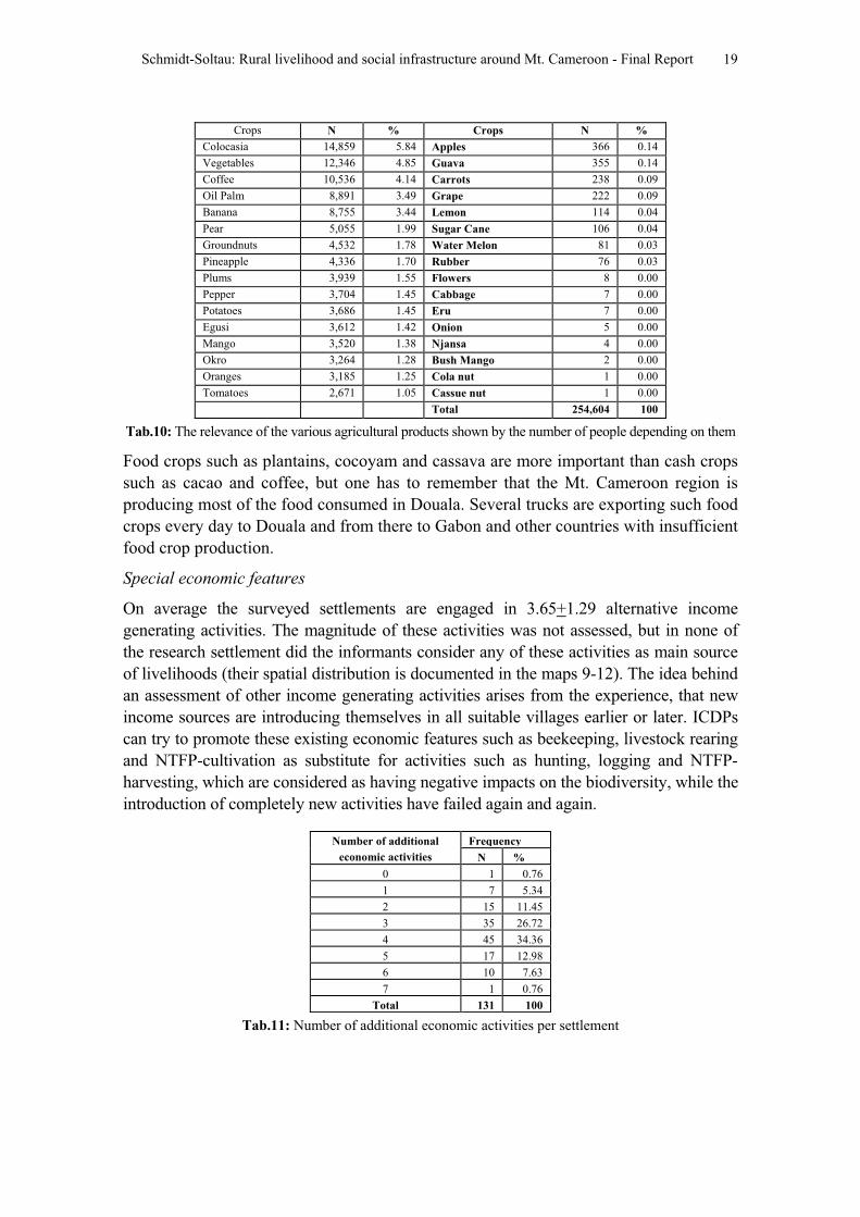
Schmidt-Soltau: Rural livelihood and social infrastructure around Mt. Cameroon - Final Report 19
Crops N % Crops N %
Colocasia 14,859 5.84 Apples 366 0.14
Vegetables 12,346 4.85 Guava 355 0.14
Coffee 10,536 4.14 Carrots 238 0.09
Oil Palm 8,891 3.49 Grape 222 0.09
Banana 8,755 3.44 Lemon 114 0.04
Pear 5,055 1.99 Sugar Cane 106 0.04
Groundnuts 4,532 1.78 Water Melon 81 0.03
Pineapple 4,336 1.70 Rubber 76 0.03
3,939 1.55 Flowers 8 0.00
Pepper 3,704 1.45 Cabbage 7 0.00
Potatoes 3,686 1.45 Eru 7 0.00
Egusi 3,612 1.42 Onion 5 0.00
Mango 3,520 1.38 Njansa 4 0.00
Okro 3,264 1.28 Bush Mango 2 0.00
Oranges 3,185 1.25 Cola nut 1 0.00
Tomatoes 2,671 1.05 Cassue nut 1 0.00
Total 254,604 100
Plums
Tab.10: The relevance of the various agricultural products shown by the number of people depending on them
Food crops such as plantains, cocoyam and cassava are more important than cash crops
such as cacao and coffee, but one has to remember that the Mt. Cameroon region is
producing most of the food consumed in Douala. Several trucks are exporting such food
crops every day to Douala and from there to Gabon and other countries with insufficient
food crop production.
Special economic features
On average the surveyed settlements are engaged in 3.65+1.29 alternative income
generating activities. The magnitude of these activities was not assessed, but in none of
the research settlement did the informants consider any of these activities as main source
of livelihoods (their spatial distribution is documented in the maps 9-12). The idea behind
an assessment of other income generating activities arises from the experience, that new
income sources are introducing themselves in all suitable villages earlier or later. ICDPs
can try to promote these existing economic features such as beekeeping, livestock rearing
and NTFP-cultivation as substitute for activities such as hunting, logging and NTFP-
harvesting, which are considered as having negative impacts on the biodiversity, while the
introduction of completely new activities have failed again and again.
FrequencyNumber of additional
economic activities N %
0 1 0.76
1 7 5.34
2 15 11.45
3 35 26.72
4 45 34.36
5 17 12.98
6 10 7.63
7 1 0.76
Total 131 100
Tab.11: Number of additional economic activities per settlement
Schmidt-Soltau: Rural livelihood and social infrastructure around Mt. Cameroon - Final Report 20
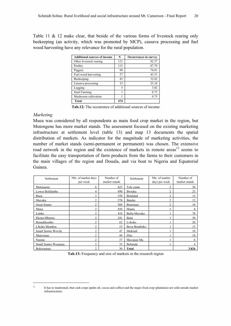
Table 11 & 12 make clear, that beside of the various forms of livestock rearing only
beekeeping (an activity, which was promoted by MCP), cassava processing and fuel
wood harvesting have any relevance for the rural population.
Additional sources of income N Occurrences in survey
Other livestock rearing 121 92.37
Poultry 115 87.79
Piggery 98 74.81
Fuel wood harvesting 57 43.51
Beekeeping 43 32.82
Cassava processing 33 25.18
Logging 5 3.82
Snail Farming 1 0.75
Mushroom cultivation 1 0.75
Total 474
Tab.12: The occurrence of additional sources of income
Marketing
Muea was considered by all respondents as main food crop market in the region, but
Mutengene has more market stands. The assessment focused on the existing marketing
infrastructure at settlement level (table 13) and map 13 documents the spatial
distribution of markets. As indicator for the magnitude of marketing activities, the
number of market stands (semi-permanent or permanent) was chosen. The extensive
road network in the region and the existence of markets in remote areas12
seems to
facilitate the easy transportation of farm products from the farms to their customers in
the main villages of the region and Douala, and via boat to Nigeria and Equatorial
Guinea.
Settlement Nbr. of market days
per week
Number of
market standsSettlement Nbr. of market
days per week
Number of
market stands
Mutengene 6 625 Tole camp 2 30
Lower Bolifamba 4 490 Bwiuku 2 25
Buea 3 350 Botaland 2 15
Muyuka 2 570 Batoke 2 12
Great Soppo 2 560 Bonjongo 2 10
Muea 2 450 Mautu 2 8
Limbe 2 410 Bafia-Muyuka 1 78
Ekona Mbenge 2 241 Ikata 1 30
Bonadikombo 2 62 Lykoko 1 20
Likoko Membea 2 53 Bova Bomboko 1 15
Small Soppo Wovila 2 47 Mokindi 1 10
Munyenge 2 44 Ebie 1 10
Ngeme 2 37 Muyange Ma 1 6
Small Soppo Woganga 2 35 Bobende 1 4
Bokwaongo 2 30 Total 3,826
Tab.13: Frequency and size of markets in the research region
12 It has to mentioned, that cash crops (palm oil, cocoa and coffee) and the major food crop (plantains) are sold outside market
infrastructures.
Schmidt-Soltau: Rural livelihood and social infrastructure around Mt. Cameroon - Final Report 21
2.3. Social infrastructure
Education
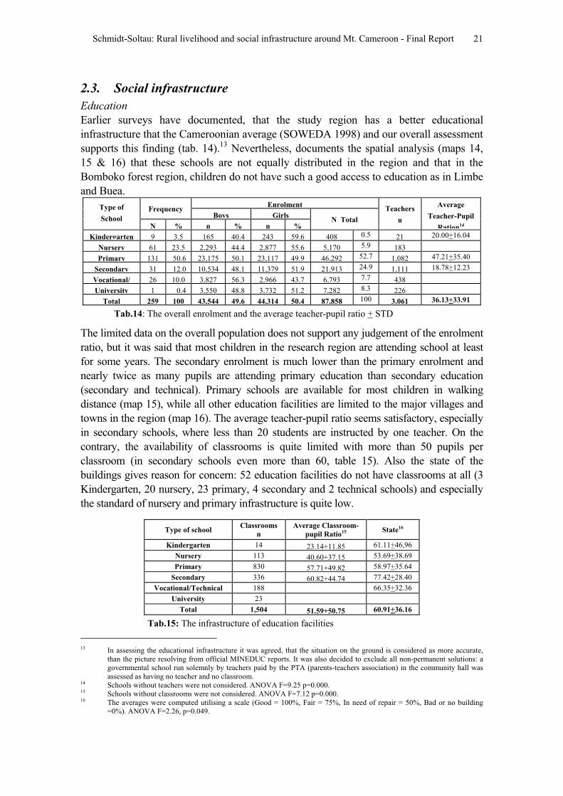
Earlier surveys have documented, that the study region has a better educational
infrastructure that the Cameroonian average (SOWEDA 1998) and our overall assessment
supports this finding (tab. 14).13
Nevertheless, documents the spatial analysis (maps 14,
15 & 16) that these schools are not equally distributed in the region and that in the
Bomboko forest region, children do not have such a good access to education as in Limbe
and Buea.Enrolment
FrequencyBoys Girls
Type of
SchoolN % n % n %
N Total
Teachers
n
Average
Teacher-Pupil
Ration14
Kindergarten 9 3.5 165 40.4 243 59.6 408 0.5 21 20.00+16.04
Nursery 61 23.5 2,293 44.4 2,877 55.6 5,170 5.9 183
Primary 131 50.6 23,175 50.1 23,117 49.9 46,292 52.7 1,082 47.21+35.40
Secondary 31 12.0 10,534 48.1 11,379 51.9 21,913 24.9 1,111 18.78+12.23
Vocational/ 26 10.0 3,827 56.3 2,966 43.7 6,793 7.7 438
University 1 0.4 3,550 48.8 3,732 51.2 7,282 8.3 226
Total 259 100 43,544 49.6 44,314 50.4 87,858 100 3,061 36.13+33.91
Tab.14: The overall enrolment and the average teacher-pupil ratio + STD
The limited data on the overall population does not support any judgement of the enrolment
ratio, but it was said that most children in the research region are attending school at least
for some years. The secondary enrolment is much lower than the primary enrolment and
nearly twice as many pupils are attending primary education than secondary education
(secondary and technical). Primary schools are available for most children in walking
distance (map 15), while all other education facilities are limited to the major villages and
towns in the region (map 16). The average teacher-pupil ratio seems satisfactory, especially
in secondary schools, where less than 20 students are instructed by one teacher. On the
contrary, the availability of classrooms is quite limited with more than 50 pupils per
classroom (in secondary schools even more than 60, table 15). Also the state of the
buildings gives reason for concern: 52 education facilities do not have classrooms at all (3
Kindergarten, 20 nursery, 23 primary, 4 secondary and 2 technical schools) and especially
the standard of nursery and primary infrastructure is quite low.
Type of school Classrooms
n
Average Classroom-
pupil Ratio15 State16
Kindergarten 14 23.14+11.85 61.11+46,96
Nursery 113 40.60+37.15 53.69+38.69
Primary 830 57.71+49.82 58.97+35.64
Secondary 336 60.82+44.74 77.42+28.40
Vocational/Technical 188 66.35+32.36
University 23
Total 1,504 51.59+50.75 60.91+36.16
Tab.15: The infrastructure of education facilities
13 In assessing the educational infrastructure it was agreed, that the situation on the ground is considered as more accurate,
than the picture resolving from official MINEDUC reports. It was also decided to exclude all non-permanent solutions: a
governmental school run solemnly by teachers paid by the PTA (parents-teachers association) in the community hall was
assessed as having no teacher and no classroom.14 Schools without teachers were not considered. ANOVA F=9.25 p=0.000. 15 Schools without classrooms were not considered. ANOVA F=7.12 p=0.000.16 The averages were computed utilising a scale (Good = 100%, Fair = 75%, In need of repair = 50%, Bad or no building
=0%). ANOVA F=2.26, p=0.049.
Schmidt-Soltau: Rural livelihood and social infrastructure around Mt. Cameroon - Final Report 22
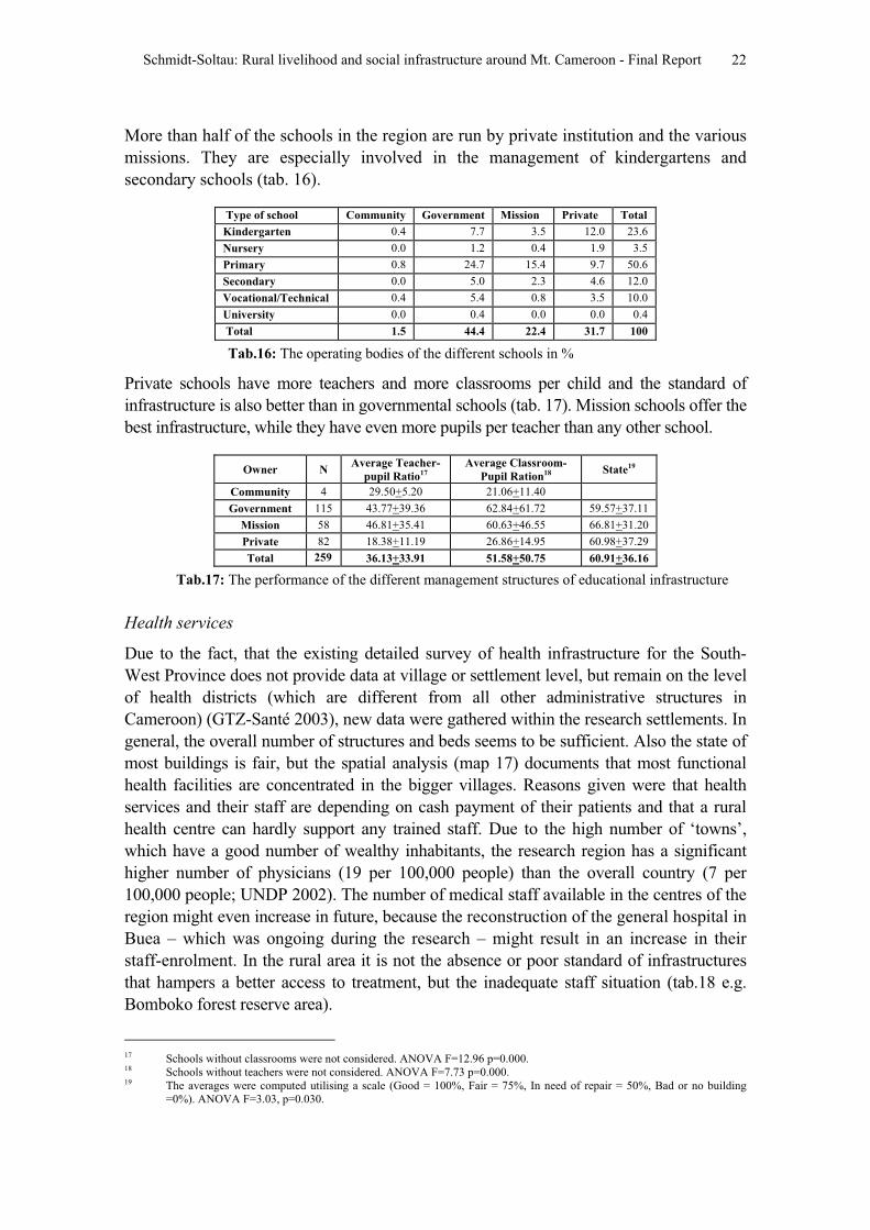
More than half of the schools in the region are run by private institution and the various
missions. They are especially involved in the management of kindergartens and
secondary schools (tab. 16).
Type of school Community Government Mission Private Total
Kindergarten 0.4 7.7 3.5 12.0 23.6
Nursery 0.0 1.2 0.4 1.9 3.5
Primary 0.8 24.7 15.4 9.7 50.6
Secondary 0.0 5.0 2.3 4.6 12.0
Vocational/Technical 0.4 5.4 0.8 3.5 10.0
University 0.0 0.4 0.0 0.0 0.4
Total 1.5 44.4 22.4 31.7 100
Tab.16: The operating bodies of the different schools in %
Private schools have more teachers and more classrooms per child and the standard of
infrastructure is also better than in governmental schools (tab. 17). Mission schools offer the
best infrastructure, while they have even more pupils per teacher than any other school.
Owner NAverage Teacher-
pupil Ratio17
Average Classroom-
Pupil Ration18 State19
Community 4 29.50+5.20 21.06+11.40
Government 115 43.77+39.36 62.84+61.72 59.57+37.11
Mission 58 46.81+35.41 60.63+46.55 66.81+31.20
Private 82 18.38+11.19 26.86+14.95 60.98+37.29
Total 259 36.13+33.91 51.58+50.75 60.91+36.16
Tab.17: The performance of the different management structures of educational infrastructure
Health services
Due to the fact, that the existing detailed survey of health infrastructure for the South-
West Province does not provide data at village or settlement level, but remain on the level
of health districts (which are different from all other administrative structures in
Cameroon) (GTZ-Santé 2003), new data were gathered within the research settlements. In
general, the overall number of structures and beds seems to be sufficient. Also the state of
most buildings is fair, but the spatial analysis (map 17) documents that most functional
health facilities are concentrated in the bigger villages. Reasons given were that health
services and their staff are depending on cash payment of their patients and that a rural
health centre can hardly support any trained staff. Due to the high number of ‘towns’,
which have a good number of wealthy inhabitants, the research region has a significant
higher number of physicians (19 per 100,000 people) than the overall country (7 per
100,000 people; UNDP 2002). The number of medical staff available in the centres of the
region might even increase in future, because the reconstruction of the general hospital in
Buea – which was ongoing during the research – might result in an increase in their
staff-enrolment. In the rural area it is not the absence or poor standard of infrastructures
that hampers a better access to treatment, but the inadequate staff situation (tab.18 e.g.
Bomboko forest reserve area).
17 Schools without classrooms were not considered. ANOVA F=12.96 p=0.000.18 Schools without teachers were not considered. ANOVA F=7.73 p=0.000. 19 The averages were computed utilising a scale (Good = 100%, Fair = 75%, In need of repair = 50%, Bad or no building
=0%). ANOVA F=3.03, p=0.030.
Schmidt-Soltau: Rural livelihood and social infrastructure around Mt. Cameroon - Final Report 23
Staff StateType of
health
service
NNumber
of beds Doctors Nurses Others Total Good Fair In need
of repair
Bad Average +
STD20
Hospital 14 647 36 182 38 256 3 10 1 0 76.79+18.25
Health Centre 29 417 8 158 69 235 13 13 2 1 80.17+25.34
1st Aid Post 21 77 4 52 13 69 1 14 6 0 61.90+24.52
Maternity 1 19 1 8 1 10 0 1 0 0 -
Health Post 5 2 0 9 0 9 0 3 2 0 55.00+27.39
Total 70 1162 49 409 121 579 17 41 11 1 72.14+25.02
Number of
people per unit3637 219 5196 623 2104 440
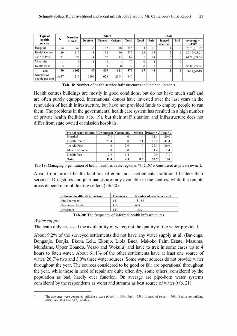
Tab.18: Number of health service infrastructures and their equipments
Health centres buildings are mostly in good conditions, but do not have much staff and
are often purely equipped. International donors have invested over the last years in the
renovation of health infrastructure, but have not provided funds to employ people to run
them. The problems in the governmental health care system has resulted in a high number
of private health facilities (tab. 19), but their staff situation and infrastructure does not
differ from state owned or mission hospitals.
Type of health institute Government Community Mission Private % Total %
Hospital 7.1 0 1.4 11.4 20.0
Health Centre 21.4 0 7.1 12.9 41.4
1st Aid Post 0 2.9 0 27.1 30.0
Maternity home 0 0 0 1.4 1.4
Health Post 2.9 1.4 0 2.9 7.1
Total 31.4 4.3 8.6 55.7 100
Tab 19: Managing organisation of health facilities in the region in % (CDC is considered as private owner).
Apart from formal health facilities offer in most settlements traditional healers their
services. Drugstores and pharmacies are only available in the centres, while the remote
areas depend on mobile drug sellers (tab.20).
Informal health infrastructure Frequency Number of people per unit
Pro-Pharmacy 14 18,186
Traditional Healer 419 608
Drugstore 147 1,732
Tab.20: The frequency of informal health infrastructures
Water supply
The team only assessed the availability of water, not the quality of the water provided.
About 9.2% of the surveyed settlements did not have any water supply at all (Bavenga,
Bonganjo, Bonjia, Ekona Lelu, Ekonjo, Liola Buea, Makoko Palm Estate, Masuma,
Mundame, Upper Boando, Vesao and Wokulu) and have to trek in some cases up to 4
hours to fetch water. About 61.1% of the other settlements have at least one source of
water, 26.7% two and 3.0% three water sources. Some water sources do not provide water
throughout the year. The sources considered to be good or fair are operational throughout
the year, while those in need of repair are quite often dry, some others, considered by the
population as bad, hardly ever function. On average are pipe-born water systems
considered by the respondents as worst and streams as best source of water (tab. 21).
20 The averages were computed utilising a scale (Good = 100%, Fair = 75%, In need of repair = 50%, Bad or no building
=0%). ANOVA F=2.547, p=0.048.
Schmidt-Soltau: Rural livelihood and social infrastructure around Mt. Cameroon - Final Report 24
Type N Good Faire In need of repair Bad Average + STD21
Pipe-born water 92 8 48 26 10 54.67+31.38
Spring 40 9 21 2 8 63.13+35.80
Stream/River 24 5 14 4 1 68.75+27.83
Well with pump 2 0 2 0 0 -
Well without pump 4 1 2 0 1 -
Total 162 23 87 32 20 59.32+32.33
Tab. 21: The various water sources and their perception
Water committees are considered as the best manager of water sources, while the former
state-own SNEC is perceived worse (tab. 22). Asked about the reason, the respondents
stated, that SNEC does not react to customers complains and do not reinvest their
income from public consumption. Water is quite a critical source in the mountainous
research region (Page: 2000), since permanent streams and rivers are quite rare and pipe
born water not equally available throughout the region (map 18).
Type N Good Faire In need of repair Bad Average + STD22
Community 99 16 51 19 13 59.60+33.06
Individual 31 5 17 5 4 61.29+32.81
Nobody 4 0 2 0 2 -
SNEC 20 0 13 6 1 55.26+27.10
Water committee 8 2 4 2 0 68.75+29.12
Total 162 23 87 32 20 59.31+32.33
Tab.22: The various water source management units and their perception
Electricity
About 51.1% of the settlements are connected to the national grid (tab. 23). The
electricity supply follows two main lines along the Mutengene-Limbe-Bakingili and the
Mutengene-Buea-Muyuka roads. Nevertheless, some villages and camps along the lines
were not connected to the national grid (SONEL), because the inhabitants were unable
to pay for this connection (see map 19). In some cases, the inhabitants ‘tapped’
electricity from somebody in a neighbouring settlement, but this system only works as
long as no SONEL control team is assessing the area. Due to that, the research team did
not consider ‘tapped’ electricity as connection to the national grid.
FrequencyType of electric supply
N %
National Grid (SONEL) 67 51.14
Generator owned by a company 11 8.40
Personal generator 20 15.27
No electricity at all 33 25.19
Total 131 100
Tab.23: Electric supply available in settlements
Access to governmental services
The centralised governmental services results in the fact, that ministries like MINEF
(with more than 10,000 civil servants, map 20) and MINAGRI (with around 14,000
civil servants, map 21) are not present outside their provincial (Buea), divisional
21 The averages were computed utilising a scale (Good = 100%, Fair = 75%, In need of repair = 50%, Bad or no building
=0%). ANOVA F=2.431, p=0.032. 22 The averages were computed utilising a scale (Good = 100%, Fair = 75%, In need of repair = 50%, Bad or no building
=0%). ANOVA F=2.431, p=0.032.
Schmidt-Soltau: Rural livelihood and social infrastructure around Mt. Cameroon - Final Report 25
(Limbe) and sub-divisional delegations (Muyuka, Buea).23
This may change in future,
since several national programmes (PNVRA, PSFE, PNDP, etc.) within the PRSP-
process are promoting the (re)establishment of decentralised extension services of
MINAGRI, MINEF, MINEPIA and MINEPAT. MINAGRI has quite a good number of
extension posts in the settlements of the research area, but hardly any of these posts has
an official building. MINEF has only one forestry post in the entire region, which
makes it difficult for MINEF to carry out its duty (tab. 24).
Type of administrative structure N Number
of staff
Good Faire In need of
repair
Bad or no
building
MINAGRI Prov. Delegation 1 20 0 1 0 0
MINAGRI Divisional Delegation 1 5 0 1 0 0
MINAGRI Subdiv. Delegation 1 2 0 1 0 0
MINAGRI Extension Post 12 12 1 1 0 10
Veterinary 3 4 0 0 0 3
Community Development 1 2 0 1 0 0
MINEF Prov. Delegation 1 10 0 1 0 0
MINEF Divisional Delegation 1 4 0 1 0 0
MINEF Subdiv. Delegation 1 2 0 1 0 0
Forestry Post 1 3 0 1 0 0
Police Station 7 121 1 3 1 2
Post Office 4 34 0 2 1 1
Prison 2 20 0 1 1 0
Military Base 1 300 0 1 0 0
CRTV 1 92 1 0 0 0
IRGM (Vulcan surveys) 1 16 0 1 0 0
Total 39 647 3 17 3 16
Tab.24: The various administrative structures in the research region
Administrative setting
While at the present stage all decisions are in the hands of the central administration in
Yaoundé and their local representatives (Governor, SDO, DO), the ongoing decentralisation
in Cameroon might increase the importance of the lowest administrative structure (councils,
tab. 25).
Division Council
Number of
villages in the
survey region
Fako Buea Rural Council 59
Fako Limbe Urban Council 21
Fako Muyuka Rural Council 20
Meme Mbonge Rural Council 18
Fako Idenau Rural Council 15
Fako Tiko Rural Council 3
Two Divisions Six Councils 136 villages
Tab.25: The administrative setting of the research region
23 We did not assess those services, which do not exist in the field at all (such as MINEPIA, MINEPAT, MINAS, etc.) but
those, which have at least one or two extension posts such as MINEF and MINAGRI.
Schmidt-Soltau: Rural livelihood and social infrastructure around Mt. Cameroon - Final Report 26
Common initiative groups
26 villages (19.1%) have common initiative groups, which represent the civil society part of
the pluralistic structure sustaining the intervention of MCP. The report ‘Evaluation of
elements of the pluralistic structure by partner institutions/organisations of the Mt. Cameroon
Project’ (MCP 2002) provides a detailed analysis of their sustainability; their ability to act
without external support and in accordance with the concept of sustainable development,
outlined in the participatory biodiversity conservation strategy for the Mt. Cameroon region.
2.4. Relevance for biodiversity conservation and relation with MCP
The relevance for biodiversity conservation was assessed only for the Bomboko forest
reserve area through focus group discussions. It also has to be taken into consideration,
that the data was gathered in a rapid assessment (without much time to establish mutual
confidence) and within the setting of a conservation project (using a MCP vehicle, a
MINEF authorisation, etc.). This all might have reduced the willingness of the
respondents to confess, that villagers break the law by hunting, gathering and/or
farming within the forest reserve. Nevertheless, 31 settlements (23.7%) were of the
view, that some of their inhabitants are utilising the land demarcated as forest reserve
(tab. 26, see map 22). 11 of them have traditional rights to hunt, gather, fish and farm
within the Bomboko forest reserve (Decree Bomboko Forest Reserve).
Settlement utilising the
Bomboko FR Traditional rights to do
so
Settlement utilising the
Bomboko FR
Traditional rights to
do so
Bavenga Kuke Kumbu X
Big Kotto X Likoko Membea
Bokosso X Likombe
Bokwaongo Lykoko
Bomboko Forest Camp Lylale Leowo
Bonakanda Makoko Palm Estate
Bova 2 Mapanja
Bova Bomboko X Masone
Boviongo X Mundongo X
Boviongo 2 X Munyenge
Bwassa Muyange Ma Mbonje
Ebie X Rechts Fluss Camp
Efolofo X Scipio Camp
Ekona Lelu Small Kotto X
Ikata Soden Camp
Katakata X 31 Settlements 10 Settlements
Tab. 26: Utilisation of land protected as Bomboko forest reserve24
The 31 settlements of the Bomboko forest reserve region with an estimated overall
population of 35,459 people (13.9% of the overall population) are significantly more
dependent on the forest than other settlements. While they are depending on average to
14.39+6.85% on hunting and gathering, the other villages only depend to 5.66+5.64 on
these activities.25 It can be assumed, that they are even more dependent on the reserve,
since quite some of their agricultural areas are located in the reserve.
24 It has to be mentioned that 4 of the settlements, which refused cooperation (Bomana Bomboko, Mweli, Bomboko Bush
Farm and Mondongo 2) might also use the Bomboko forest reserve as source of their livelihood.25 To establish averages, the following hunting villages outside the Bomboko forest reserve area were excluded (Bonganjo,
Bonjia, Ekonjo, Etone, Ewongo, Upper Boando, Upper Bolifamba, Woteva) ANOVA F=48.37 p=0.000.
Schmidt-Soltau: Rural livelihood and social infrastructure around Mt. Cameroon - Final Report 27
Those villages have significantly less social infrastructure than the other settlements in
the area: While the other settlements have on average 2.26+2.15 schools per settlement,
the Bomboko reserve area settlements have on average 1.06+1.01 schools.26
The same
is true for the health infrastructure: While 57% of the settlements outside the area have
health infrastructures including all hospitals, only 42% of the settlements in the
Bomboko area have health services at village level.
With regards to water supply, 79% of the other settlements have pipe born water in the
village, only 42% of the settlements depending on the natural resources of the Bomboko
forest reserve have these facilities. Concerning electricity the picture is similar: While
61% of the other settlements are connected to the national grid (SONEL), only 19% of
the Bomboko forest reserve area settlements have access to permanent electric supply.
MCP targeted their work towards population that is utilising the natural resources of the
Bomboko forest reserve consequently are 26 of the 54 settlements, which mentioned in
their interviews past activities carried out by MCP at village level, are located in the
Bomboko forest reserve area. In other words, MCP has worked with 83.9% of the
Bomboko forest reserve area settlements and with 28% of the other settlements. The
average number of activities per village (tab. 27) underlines this finding and shows that
MCP focused their activities on the Bomboko forest reserve area (see also map 23).
Using the Bomboko forest
reserve
Average + STD number of
activities
Yes 3.5+1.9
No 2.5+1.6
Total 2.98+1.81
Tab. 27: Frequency of different activities carried out by MCP in the villages27
Whether the activities outlined in table 28 were successful instruments to compensate
the rural population for their income losses resulting from the protection of the
Bomboko forest reserve was not assessed, but it has to be mentioned that none of these
activities were considered as main source of income.
Activity N Occurrence in
visited settle-
ments in %
Activity N Occurrence in
visited settle-
ments in %
Introduction of sustainable beekeeping 33 61.11 Introduction of soap making 4 7.41
Introduction of sustainable wildlife 18 33.33 Wildlife Domestication 3 5.56
General awareness raising 16 29.63 Joint Forest Reserve 3 5.56
Introduction of sustainable Prunus 14 25.93 Introduction of gender balance 3 5.56
Introduction of community forest 14 25.93 Eru cultivation 3 5.56
Facilitation of group formation 13 24.07 Logistics/Infrastructural 2 3.70
Livestock Rearing 8 14.81 Improved Farming 2 3.70
Introduction of Eco-tourism 7 12.96 Joint control activities 1 1.85
Data Collection 6 11.11 Fuel Wood Production 1 1.85
Introduction of mushroom cultivation 5 9.26 Bio-monitoring 1 1.85
Reforestation 4 7.41 Total 161
Wildlife Domestication 3 5.56
Tab. 27: MCP activities in the visited 54 villages
26 To establish averages, villages with more than 20 schools were excluded. ANOVA: F=3.121 p=0.046.27 ANOVA: F=4.123 p=0.021.
Schmidt-Soltau: Rural livelihood and social infrastructure around Mt. Cameroon - Final Report 28
4. Bibliography
Ardener, E. & Warmington, W.A.1960. Plantations and villages in the Cameroons.
London: Oxford University Press.
Conservation International 2003. (http://www.biodiversityhotspots.org/xp/Hotspots)
ECAM 1(1995) 2(2002) Enquête camerounaise auprès des ménages – Unpublished data.
Forbes, A. & Besong, J. 2002. Participatory biodiversity strategy for Mt. Cameroon:
Striving to demonstrate a ‘win-win’ situation for biodiversity and poverty
reduction. Limbe: MCBCC.
Ghimire, K. B. & Pimbert, M. P. (Eds.) 1997. Social Change and Conservation -
Environmental politics and impacts of National Park and Protected Areas.
London: Earthscan.
GTZ-Santé 2003. Health Infrastructure in the South West Province of Cameroon. GTZ-
Consultancy Report.
Konings, P. 1993. Labour resistance in Cameroon: Managerial strategies & labour
resistance in the agro-industrial plantations of the Cameroon Development
Corporation. London: James Currey.
MCP 2002. Evaluation of elements of the pluralistic structure by partner institutions
organisations of the Mt. Cameroon Project. Workshop Report. Buea.
MINEPAT 2001. South west regional master plan for sustainable development. Limbe.
Page, Ben 1999. A priceless commodity: The production of water in Anglophone
Cameroon 1916-1999 Oxford: PhD-Thesis.
Schmidt-Soltau, K. 2001. Human Activities in and around the Takamanda Forest
Reserve: Socio-economic Baseline Survey. GTZ-Consultancy report.
Sharpe, B. 1997 First the Forest: Conservation, community and participation in South-
West Cameroon. In: Africa 1:.25-45
SOWEDA 1998. Basic socio-economic indicators of the south west province. Yoaundé.
Statistisches Bundesamt 1992. Länderbericht Kamerun 1992. Wiesbaden: Metzler &
Poeschel.
UNDP 2002. Human development report 2002. Deepening democracy in a fragmented
world. New York: UNDP-Press.
Wells, M. & Brandon, K. & Hannah, L. 1990. People and Parks: Linking Protected area
management with Local Communities. Washington: World Bank.
Schmidt-Soltau: Rural livelihood and social infrastructure around Mt. Cameroon - Final Report
Maps
1. Overview: Survey villages and roads
2. Demography
3. Ethnic composition
4. Source of livelihood: Farming
5. Source of livelihood: Labour and trading
6. Source of livelihood: Fishing
7. Source of livelihood: Hunting and NTFP-gathering
8. Major farming system
9. Alternative income generating activities: General assessment
10. Alternative income generating activities: Beekeeping
11. Alternative income generating activities: Livestock rearing
12. Alternative income generating activities: Fuel wood harvesting and logging
13. Markets
14. Education: Kindergartens and nursery schools
15. Education: Primary schools
16. Education: Secondary schools
17. Health facilities
18. Water supply
19. Electric supply
20. Administrative buildings: MINEF
21. Administrative buildings: MINAGRI
22. Utilisation and utilisation rights of the Bomboko forest reserve
23. Number of MCP activities per village
Bom
boko Forest Reserve
Sanje
Soden Camp
Debundscha Beach
Njonji
Debundscha
Kadji Cattle Ranch
Idenau
Rechts Fluss Camp
Njonji Camp
Scipio Camp
Isobe
Isongo Camp
Bakingili
Bomana Bomboko
Green Valley PalmBiwon (Bonanza Estate)
Makoko Palm Estate
Small Kotto
Big KottoEfolofo
Katakata
Batoke
Kuke Kumbu
Etone
Mweli
Muyange Ma Mbonje
Top line Camp
SONARA Quater
Mundongo
Mukondange
Mondongo 2
Bokosso
Bobende
Lower Boando
Upper Boando
Ngeme
Ebie
Ekonjo
Ngeme Camp
Mokunda
Wovia
Mokindi (Sokolo)
Mapanja
Botaland
Bonjongo
Boviongo
Boviongo 2
Bomboko Bush Farm
Bongala
Bojoke
Wosenge
Likombe
Vesao
Limbe
Bwassa
Bova Bomboko
Wotutu
Saxenhof
Ewongo
Bokwaongo
Bomboko Forest Camp
Bonadikombo
NaangaLikoko Membea
Buea GRA
Mevio
Buea
Small Soppo Woganga
Small Soppo Wovila
Tole camp
Bwiuku
Moliwe Camp
Ewonda
Great Soppo
Bova 1
Mile 7 Camp (Tomatel/Ebono)
Masone
WotoloBonduma
Muangai
Bova 2
Munyenge
Bokwai
Bokoko
Bonakanda
Bwiteva
Bokova
Wokulu
Molyko Camp
BonganjoWoteva
Lylale Leowo
Ombe Camp
Molyko
Upper Bolifamba
Bonjia
Wokaka
Lysoka camp
Lykoko
Esuke Camp
Ekona Lelu
Bomaka
Muea
Lysoka
Ekande
Dibanda
Boanda Lower Bokova
Lower Bolifamba
Mundame
Mutengene
Maumu
Boana
Bafia-Muyuka
Liola Buea
Mundame camp
Masuma
Bavenga Prison
Ekona ResearchEkona Yard
Bavenga
Ekona Mbenge
Ikata
Mautu Mile 30 Camp (Massue/Mea
Owe
Muyuka
440 000 meters
445 000
450 000
455 000
460 000
465 000
470 000
475 000
480 000
485 000
490 000
495 000 meters
495 000 meters 500 000 505 000 510 000 515 000 520 000 525 000 530 000 535 000 540 000 545 000 550 000 meters
440 000 meters
445 000
450 000
455 000
460 000
465 000
470 000
475 000
480 000
485 000
490 000
495 000 meters
495 000 meters 500 000 505 000 510 000 515 000 520 000 525 000 530 000 535 000 540 000 545 000 550 000 meters
Bom
boko Forest R
eserve
Sanje
Soden Camp
Debundscha Beach
Njonji
Debundscha
Kadji Cattle Ranch
Idenau
Rechts Fluss Camp
Njonji Camp
Scipio Camp
Isobe
Isongo Camp
Bakingili
Bomana Bomboko
Green Valley PalmBiwon (Bonanza Estate)
Makoko Palm Estate
Small Kotto
Big KottoEfolofo
Katakata
Batoke
Kuke Kumbu
Etone
Mweli
Muyange Ma Mbonje
SONARA Quater
Mundongo
Mukondange
Mondongo 2
Bokosso
Bobende
Lower Boando
Upper Boando
Ngeme
Ebie
Ekonjo
Mokunda
Wovia
Mokindi (Sokolo)
Mapanja
BotalandKie
Bonjongo
Boviongo
Boviongo 2
Bomboko Bush Farm
Bongala
Bojoke
Wosenge
Likombe
Vesao
Limbe
Bwassa
Bova Bomboko
Wotutu
Saxenhof
Ewongo
Bokwaongo
Bomboko Forest Camp
Bonadikombo
Naanga
Likoko Membea
Buea GRA
Mevio
Buea
Small Soppo WogangaSmall Soppo Wovila
Tole camp
Bwiuku
Moliwe Camp
Great Soppo
Bova 1
Mile 7 Camp (Tomatel/Ebono)
Masone
WotoloBonduma
Bova 2
Munyenge
Bokwai
Bokoko
Bonakanda
Bwiteva
Limbola
Bokova
Wokulu
Bwitingi
Bonganjo
Woteva
Lylale Leowo
Ombe Camp
Molyko
Upper Bolifamba
Bonjia
Wokaka
Lysoka camp
Lykoko
Esuke Camp
Ekona Lelu
Bomaka
Muea
Lysoka
Ekande
Dibanda
Boanda Lower Bokova
Lower Bolifamba
Mundame
Mutengene
Maumu
Boana
Bafia-Muyuka
Liola Buea
Mundame camp
Masuma
Bavenga Prison
Ekona ResearchEkona Yard
Bavenga
Ekona Mbenge
Ikata
Mautu Mile 30 Camp (Massue/Mea
Owe
Muyuka
4°
8°
112°
112° 116°
4°
8°
112°
112° 116°REPU BLIC
O F
CA M ERO O N
Buea
Y aounde
Legend
Provincial Headquarter
Divisional Headquarter
Subdivisional Headquarter
District
Village
Quarter
Main tared Road
Secondary tared Road
Main dirt Road
Secondary dirt Road
Secondary Forest Road
Principale footpath
Shoreline
Bomboko Forest Reserve
Overview Survey Villages and Roads REPUBLIC OF CAMEROON
MINISTRY OF ECONOMICAFFAIRES, PROGRAMMATION &
REGIONAL DEVELOPMENTProvincial Delegation of MINEPAT
South West Province
Mount Cameroon Project
OVERVIEWSURVEY VILLAGES
and
ROADS
Scale: 1:250.000
Projection: UTM Zone 32
Ellipsoide: WGS84
Data Source: GIS SW CAMEROON
0 5 10 Kilometers
German TechnicalCooperation (GTZ)GmbH
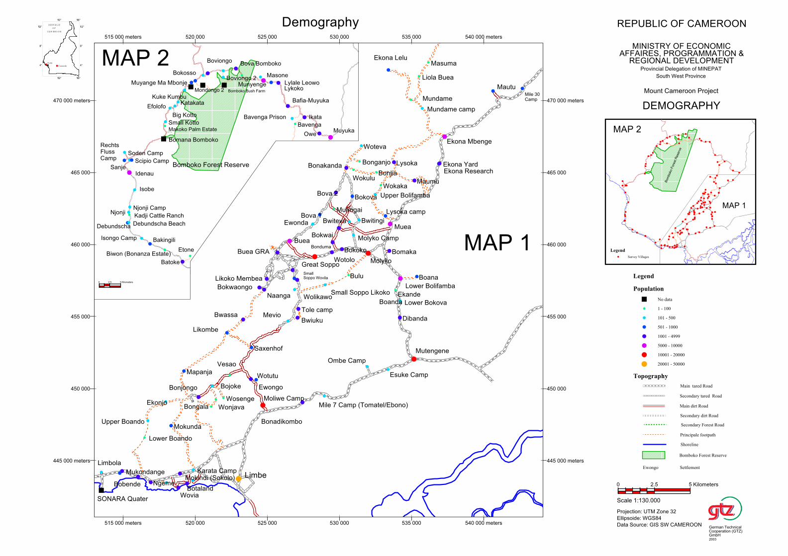
Biwon (Bonanza Estate)
Makoko Palm Estate
Small Kotto
Big Kotto
Muyange Ma Mbonje
Mondongo 2
Bafia-Muyuka
Bomboko Bush Farm
EfolofoKatakata
Bova Bomboko
Ikata
Owe
Batoke
Lykoko
Sanje
Soden Camp
Munyenge
Debundscha Beach
Bavenga Prison
Njonji
Debundscha
Kadji Cattle Ranch
Boviongo 2
Idenau
RechtsFlussCamp
Njonji Camp
Lylale Leowo
Scipio Camp
Kuke Kumbu
Isobe
Bavenga
Isongo Camp
Bokosso
Muyuka
Bakingili
Boviongo
Etone
Bomana Bomboko
Masone
Bomboko Forest Reserve
0 2.5 5 Kilometers
Maumu
Wotutu
Saxenhof
Ombe Camp
Molyko
Ewongo
Bokwaongo
Boana
Bonadikombo
Naanga
Likoko Membea
Liola Buea
Upper Bolifamba
Buea GRA
Bonjia
Mundame camp
Wokaka
Mevio
Buea
Mutengene
Wolikawo
Lysoka camp
SmallSoppo Wovila
Tole camp
Bwiuku
Moliwe Camp
Mautu
Esuke Camp
Ekona Lelu
Ewonda
Great Soppo
Bomaka
Muea
Bova 1
Ekona Mbenge
Mile 7 Camp (Tomatel/Ebono)
Small Soppo Likoko
Lysoka
Limbe
Wotolo
Bonduma
Muangai
Ekande
Bova 2
Masuma
Dibanda
Bokwai
SONARA Quater
Bokoko
Bonakanda
Boanda
Bulu
Bwiteva
Lower Bokova
Mukondange
Bobende
Lower Boando
Upper Boando
Ngeme
Limbola
Bokova
Wokulu
Ekonjo
Bwassa
Mokunda
Molyko Camp
Wovia
Mokindi (Sokolo)
Mapanja
Botaland
Karata Camp
Lower Bolifamba
Mile 30Camp
Bonjongo
Bwitingi
Bongala
Bojoke
Bonganjo
Wonjava
Ekona Research
Woteva
Wosenge
Ekona Yard
Likombe
Vesao
Mundame
445 000 meters
450 000
455 000
460 000
465 000
470 000 meters
515 000 meters 520 000 525 000 530 000 535 000 540 000 meters
445 000 meters
450 000
455 000
460 000
465 000
470 000 meters
515 000 meters 520 000 525 000 530 000 535 000 540 000 meters
MAP 2
MAP 1
Bom
boko
Fore
st R
ese
rve
MAP 1
MAP 2
4°
8°
112°
112° 116°
4°
8°
112°
112° 116°
REPU BLIC
O F
CA M ERO O N
Buea
Y aounde
Legend
Survey Villages
Legend
Population
No data
1 - 100
101 - 500
501 - 1000
1001 - 4999
5000 - 10000
10001 - 20000
20001 - 50000
Topography
Main tared Road
Secondary tared Road
Main dirt Road
Secondary dirt Road
Secondary Forest Road
Principale footpath
Shoreline
Bomboko Forest Reserve
Ewongo Settlement
Demography REPUBLIC OF CAMEROON
MINISTRY OF ECONOMICAFFAIRES, PROGRAMMATION &
REGIONAL DEVELOPMENTProvincial Delegation of MINEPAT
South West Province
Mount Cameroon Project
DEMOGRAPHY
Scale 1:130.000
Projection: UTM Zone 32
Ellipsoide: WGS84
Data Source: GIS SW CAMEROON
0 2.5 5 Kilometers
German TechnicalCooperation (GTZ)GmbH2003
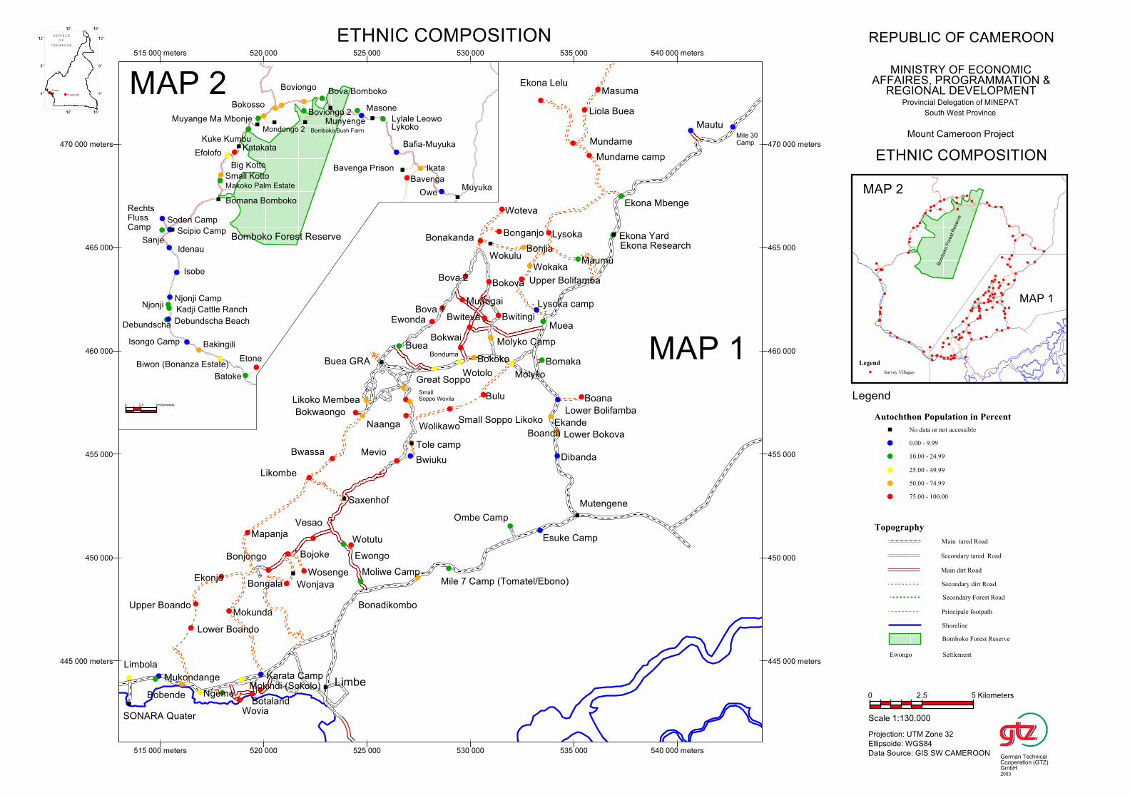
Biwon (Bonanza Estate)
Makoko Palm Estate
Small Kotto
Big Kotto
Muyange Ma Mbonje
Mondongo 2
Bafia-Muyuka
Bomboko Bush Farm
EfolofoKatakata
Bova Bomboko
Ikata
Owe
Batoke
Lykoko
Sanje
Soden Camp
Munyenge
Debundscha Beach
Bavenga Prison
Njonji
Debundscha
Kadji Cattle Ranch
Boviongo 2
Idenau
RechtsFlussCamp
Njonji Camp
Lylale Leowo
Scipio Camp
Kuke Kumbu
Isobe
Bavenga
Isongo Camp
Bokosso
Muyuka
Bakingili
Boviongo
Etone
Bomana Bomboko
Masone
Bomboko Forest Reserve
0 2.5 5 Kilometers
Maumu
Wotutu
Saxenhof
Ombe Camp
Molyko
Ewongo
Bokwaongo
Boana
Bonadikombo
Naanga
Likoko Membea
Liola Buea
Upper Bolifamba
Buea GRA
Bonjia
Mundame camp
Wokaka
Mevio
Buea
Mutengene
Wolikawo
Lysoka camp
SmallSoppo Wovila
Tole camp
Bwiuku
Moliwe Camp
Mautu
Esuke Camp
Ekona Lelu
Ewonda
Great Soppo
Bomaka
Muea
Bova 1
Ekona Mbenge
Mile 7 Camp (Tomatel/Ebono)
Small Soppo Likoko
Lysoka
Limbe
Wotolo
Bonduma
Muangai
Ekande
Bova 2
Masuma
Dibanda
Bokwai
SONARA Quater
Bokoko
Bonakanda
Boanda
Bulu
Bwiteva
Lower Bokova
Mukondange
Bobende
Lower Boando
Upper Boando
Ngeme
Limbola
Bokova
Wokulu
Ekonjo
Bwassa
Mokunda
Molyko Camp
Wovia
Mokindi (Sokolo)
Mapanja
Botaland
Karata Camp
Lower Bolifamba
Mile 30Camp
Bonjongo
Bwitingi
Bongala
Bojoke
Bonganjo
Wonjava
Ekona Research
Woteva
Wosenge
Ekona Yard
Likombe
Vesao
Mundame
445 000 meters
450 000
455 000
460 000
465 000
470 000 meters
515 000 meters 520 000 525 000 530 000 535 000 540 000 meters
445 000 meters
450 000
455 000
460 000
465 000
470 000 meters
515 000 meters 520 000 525 000 530 000 535 000 540 000 meters
MAP 2
MAP 1
Bom
boko
Fore
st R
ese
rve
MAP 1
MAP 2
4°
8°
112°
112° 116°
4°
8°
112°
112° 116°
REPU BLIC
O F
CA M ERO O N
Buea
Y aounde
Legend
Survey Villages
Topography
Main tared Road
Secondary tared Road
Main dirt Road
Secondary dirt Road
Secondary Forest Road
Principale footpath
Shoreline
Bomboko Forest Reserve
Ewongo Settlement
Autochthon Population in Percent
No data or not accessible
0.00 - 9.99
10.00 - 24.99
25.00 - 49.99
50.00 - 74.99
75.00 - 100.00
Legend
REPUBLIC OF CAMEROON
MINISTRY OF ECONOMICAFFAIRES, PROGRAMMATION &
REGIONAL DEVELOPMENTProvincial Delegation of MINEPAT
South West Province
Mount Cameroon Project
ETHNIC COMPOSITION
ETHNIC COMPOSITION
Scale 1:130.000
Projection: UTM Zone 32
Ellipsoide: WGS84
Data Source: GIS SW CAMEROON
0 2.5 5 Kilometers
German TechnicalCooperation (GTZ)GmbH2003
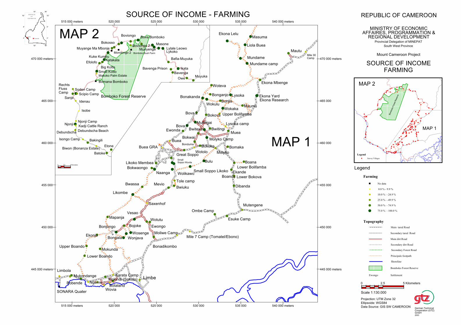
Biwon (Bonanza Estate)
Makoko Palm Estate
Small Kotto
Big Kotto
Muyange Ma Mbonje
Mondongo 2
Bafia-Muyuka
Bomboko Bush Farm
EfolofoKatakata
Bova Bomboko
Ikata
Owe
Batoke
Lykoko
Sanje
Soden Camp
Munyenge
Debundscha Beach
Bavenga Prison
Njonji
Debundscha
Kadji Cattle Ranch
Boviongo 2
Idenau
RechtsFlussCamp
Njonji Camp
Lylale Leowo
Scipio Camp
Kuke Kumbu
Isobe
Bavenga
Isongo Camp
Bokosso
Muyuka
Bakingili
Boviongo
Etone
Bomana Bomboko
Masone
Bomboko Forest Reserve
0 2.5 5 Kilometers
Maumu
Wotutu
Saxenhof
Ombe Camp
Molyko
Ewongo
Bokwaongo
Boana
Bonadikombo
Naanga
Likoko Membea
Liola Buea
Upper Bolifamba
Buea GRA
Bonjia
Mundame camp
Wokaka
Mevio
Buea
Mutengene
Wolikawo
Lysoka camp
SmallSoppo Wovila
Tole camp
Bwiuku
Moliwe Camp
Mautu
Esuke Camp
Ekona Lelu
Ewonda
Great Soppo
Bomaka
Muea
Bova 1
Ekona Mbenge
Mile 7 Camp (Tomatel/Ebono)
Small Soppo Likoko
Lysoka
Limbe
Wotolo
Bonduma
Muangai
Ekande
Bova 2
Masuma
Dibanda
Bokwai
SONARA Quater
Bokoko
Bonakanda
Boanda
Bulu
Bwiteva
Lower Bokova
Mukondange
Bobende
Lower Boando
Upper Boando
Ngeme
Limbola
Bokova
Wokulu
Ekonjo
Bwassa
Mokunda
Molyko Camp
Wovia
Mokindi (Sokolo)
Mapanja
Botaland
Karata Camp
Lower Bolifamba
Mile 30Camp
Bonjongo
Bwitingi
Bongala
Bojoke
Bonganjo
Wonjava
Ekona Research
Woteva
Wosenge
Ekona Yard
Likombe
Vesao
Mundame
445 000 meters
450 000
455 000
460 000
465 000
470 000 meters
515 000 meters 520 000 525 000 530 000 535 000 540 000 meters
445 000 meters
450 000
455 000
460 000
465 000
470 000 meters
515 000 meters 520 000 525 000 530 000 535 000 540 000 meters
MAP 2
MAP 1
Bom
boko
Fore
st R
ese
rve
MAP 1
MAP 2
4°
8°
112°
112° 116°
4°
8°
112°
112° 116°
REPU BLIC
O F
CA M ERO O N
Buea
Y aounde
Legend
Survey Villages
Topography
Main tared Road
Secondary tared Road
Main dirt Road
Secondary dirt Road
Secondary Forest Road
Principale footpath
Shoreline
Bomboko Forest Reserve
Ewongo Settlement
Farming
No data
0.0 % - 9.9 %
10.0 % - 24.9 %
25.0 % - 49.9 %
50.0 % - 74.9 %
75.0 % - 100.0 %
Legend
REPUBLIC OF CAMEROON
MINISTRY OF ECONOMICAFFAIRES, PROGRAMMATION &
REGIONAL DEVELOPMENTProvincial Delegation of MINEPAT
South West Province
Mount Cameroon Project
SOURCE OF INCOME - FARMING
SOURCE OF INCOMEFARMING
Scale 1:130.000
Projection: UTM Zone 32
Ellipsoide: WGS84
Data Source: GIS SW CAMEROON
0 2.5 5 Kilometers
German TechnicalCooperation (GTZ)GmbH2003
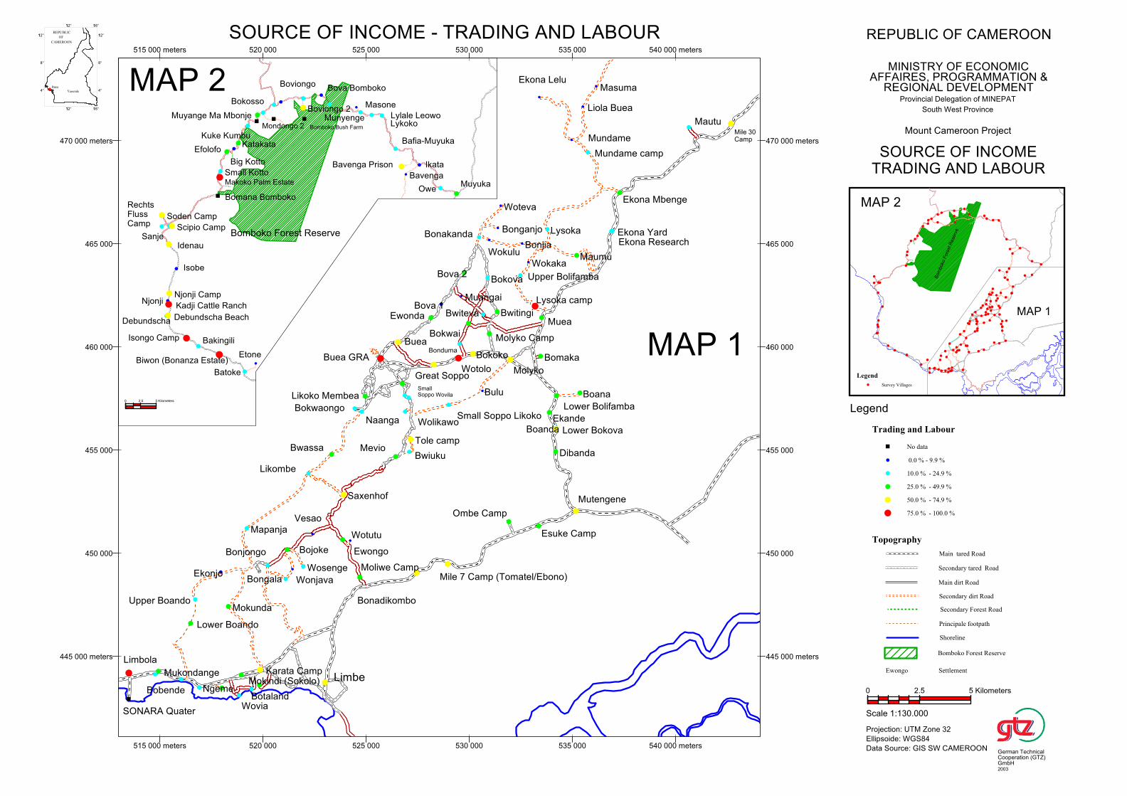
Biwon (Bonanza Estate)
Makoko Palm Estate
Small Kotto
Big Kotto
Muyange Ma Mbonje
Mondongo 2
Bafia-Muyuka
Bomboko Bush Farm
EfolofoKatakata
Bova Bomboko
Ikata
Owe
Batoke
Lykoko
Sanje
Soden Camp
Munyenge
Debundscha Beach
Bavenga Prison
Njonji
Debundscha
Kadji Cattle Ranch
Boviongo 2
Idenau
RechtsFlussCamp
Njonji Camp
Lylale Leowo
Scipio Camp
Kuke Kumbu
Isobe
Bavenga
Isongo Camp
Bokosso
Muyuka
Bakingili
Boviongo
Etone
Bomana Bomboko
Masone
Bomboko Forest Reserve
0 2.5 5 Kilometers
Maumu
Wotutu
Saxenhof
Ombe Camp
Molyko
Ewongo
Bokwaongo
Boana
Bonadikombo
Naanga
Likoko Membea
Liola Buea
Upper Bolifamba
Buea GRA
Bonjia
Mundame camp
Wokaka
Mevio
Buea
Mutengene
Wolikawo
Lysoka camp
SmallSoppo Wovila
Tole camp
Bwiuku
Moliwe Camp
Mautu
Esuke Camp
Ekona Lelu
Ewonda
Great Soppo
Bomaka
Muea
Bova 1
Ekona Mbenge
Mile 7 Camp (Tomatel/Ebono)
Small Soppo Likoko
Lysoka
Limbe
Wotolo
Bonduma
Muangai
Ekande
Bova 2
Masuma
Dibanda
Bokwai
SONARA Quater
Bokoko
Bonakanda
Boanda
Bulu
Bwiteva
Lower Bokova
Mukondange
Bobende
Lower Boando
Upper Boando
Ngeme
Limbola
Bokova
Wokulu
Ekonjo
Bwassa
Mokunda
Molyko Camp
Wovia
Mokindi (Sokolo)
Mapanja
Botaland
Karata Camp
Lower Bolifamba
Mile 30Camp
Bonjongo
Bwitingi
Bongala
Bojoke
Bonganjo
Wonjava
Ekona Research
Woteva
Wosenge
Ekona Yard
Likombe
Vesao
Mundame
445 000 meters
450 000
455 000
460 000
465 000
470 000 meters
515 000 meters 520 000 525 000 530 000 535 000 540 000 meters
445 000 meters
450 000
455 000
460 000
465 000
470 000 meters
515 000 meters 520 000 525 000 530 000 535 000 540 000 meters
MAP 2
MAP 1
Bom
boko
Fore
st R
ese
rve
MAP 1
MAP 2
4°
8°
112°
112° 116°
4°
8°
112°
112° 116°
Legend
Survey Villages
Topography
Main tared Road
Secondary tared Road
Main dirt Road
Secondary dirt Road
Secondary Forest Road
Principale footpath
Shoreline
Bomboko Forest Reserve
Ewongo Settlement
Trading and Labour
No data
0.0 % - 9.9 %
10.0 % - 24.9 %
25.0 % - 49.9 %
50.0 % - 74.9 %
75.0 % - 100.0 %
Legend
REPUBLIC OF CAMEROON
MINISTRY OF ECONOMICAFFAIRES, PROGRAMMATION &
REGIONAL DEVELOPMENTProvincial Delegation of MINEPAT
South West Province
Mount Cameroon Project
SOURCE OF INCOME - TRADING AND LABOUR
SOURCE OF INCOMETRADING AND LABOUR
Scale 1:130.000
Projection: UTM Zone 32
Ellipsoide: WGS84
Data Source: GIS SW CAMEROON
0 2.5 5 Kilometers
German TechnicalCooperation (GTZ)GmbH2003
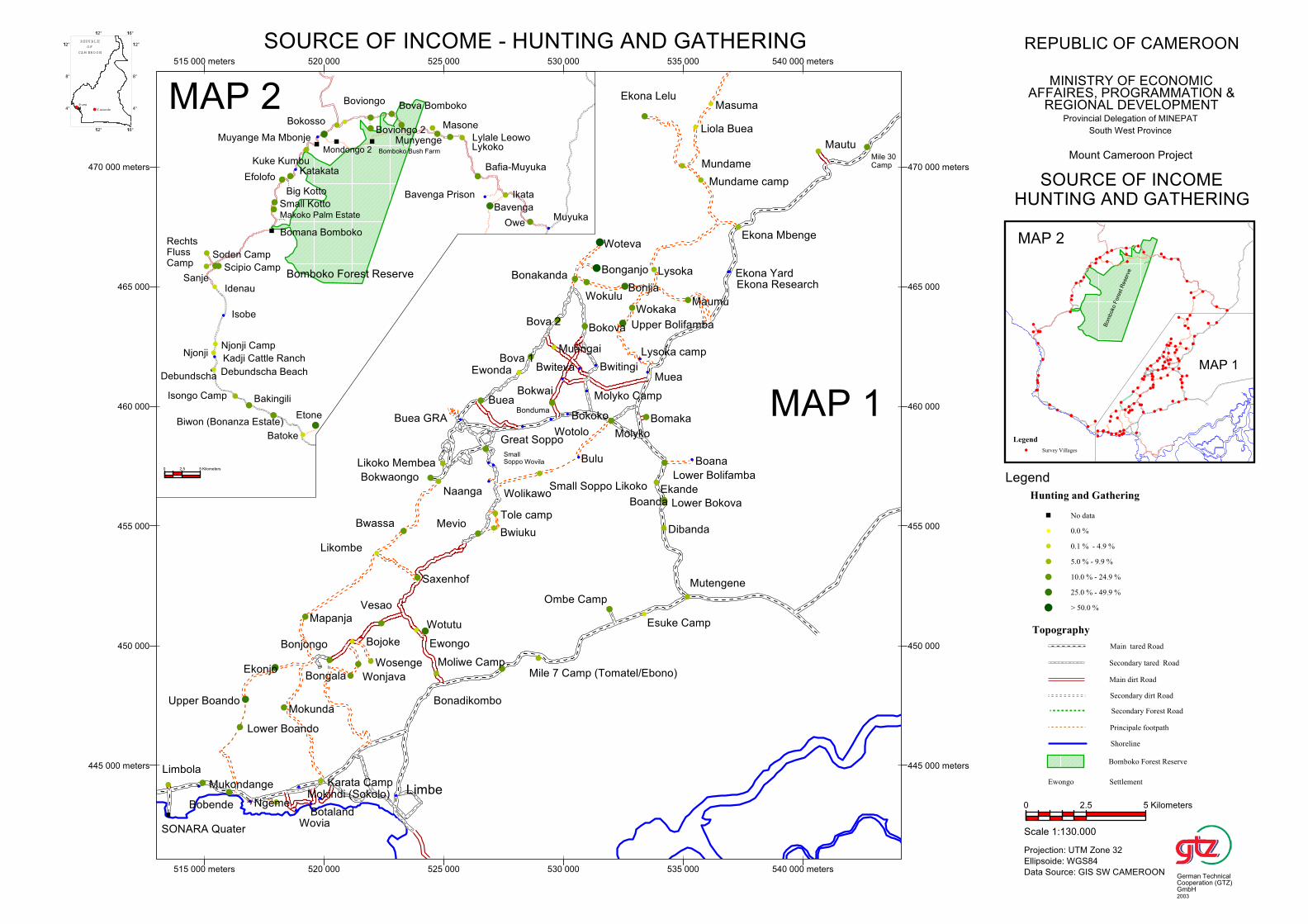
Biwon (Bonanza Estate)
Makoko Palm Estate
Small Kotto
Big Kotto
Muyange Ma Mbonje
Mondongo 2
Bafia-Muyuka
Bomboko Bush Farm
EfolofoKatakata
Bova Bomboko
Ikata
Owe
Batoke
Lykoko
Sanje
Soden Camp
Munyenge
Debundscha Beach
Bavenga Prison
Njonji
Debundscha
Kadji Cattle Ranch
Boviongo 2
Idenau
RechtsFlussCamp
Njonji Camp
Lylale Leowo
Scipio Camp
Kuke Kumbu
Isobe
Bavenga
Isongo Camp
Bokosso
Muyuka
Bakingili
Boviongo
Etone
Bomana Bomboko
Masone
Bomboko Forest Reserve
0 2.5 5 Kilometers
Maumu
Wotutu
Saxenhof
Ombe Camp
Molyko
Ewongo
Bokwaongo
Boana
Bonadikombo
Naanga
Likoko Membea
Liola Buea
Upper Bolifamba
Buea GRA
Bonjia
Mundame camp
Wokaka
Mevio
Buea
Mutengene
Wolikawo
Lysoka camp
SmallSoppo Wovila
Tole camp
Bwiuku
Moliwe Camp
Mautu
Esuke Camp
Ekona Lelu
Ewonda
Great Soppo
Bomaka
Muea
Bova 1
Ekona Mbenge
Mile 7 Camp (Tomatel/Ebono)
Small Soppo Likoko
Lysoka
Limbe
Wotolo
Bonduma
Muangai
Ekande
Bova 2
Masuma
Dibanda
Bokwai
SONARA Quater
Bokoko
Bonakanda
Boanda
Bulu
Bwiteva
Lower Bokova
Mukondange
Bobende
Lower Boando
Upper Boando
Ngeme
Limbola
Bokova
Wokulu
Ekonjo
Bwassa
Mokunda
Molyko Camp
Wovia
Mokindi (Sokolo)
Mapanja
Botaland
Karata Camp
Lower Bolifamba
Mile 30Camp
Bonjongo
Bwitingi
Bongala
Bojoke
Bonganjo
Wonjava
Ekona Research
Woteva
Wosenge
Ekona Yard
Likombe
Vesao
Mundame
445 000 meters
450 000
455 000
460 000
465 000
470 000 meters
515 000 meters 520 000 525 000 530 000 535 000 540 000 meters
445 000 meters
450 000
455 000
460 000
465 000
470 000 meters
515 000 meters 520 000 525 000 530 000 535 000 540 000 meters
MAP 2
MAP 1
Bom
boko
Fore
st R
ese
rve
MAP 1
MAP 2
4°
8°
112°
112° 116°
4°
8°
112°
112° 116°
REPU BLIC
O F
CA M ERO O N
Buea
Y aounde
Legend
Survey Villages
Topography
Main tared Road
Secondary tared Road
Main dirt Road
Secondary dirt Road
Secondary Forest Road
Principale footpath
Shoreline
Bomboko Forest Reserve
Ewongo Settlement
Hunting and Gathering
No data
0.0 %
0.1 % - 4.9 %
5.0 % - 9.9 %
10.0 % - 24.9 %
25.0 % - 49.9 %
> 50.0 %
Legend
REPUBLIC OF CAMEROON
MINISTRY OF ECONOMICAFFAIRES, PROGRAMMATION &
REGIONAL DEVELOPMENTProvincial Delegation of MINEPAT
South West Province
Mount Cameroon Project
SOURCE OF INCOME - HUNTING AND GATHERING
SOURCE OF INCOMEHUNTING AND GATHERING
Scale 1:130.000
Projection: UTM Zone 32
Ellipsoide: WGS84
Data Source: GIS SW CAMEROON
0 2.5 5 Kilometers
German TechnicalCooperation (GTZ)GmbH2003
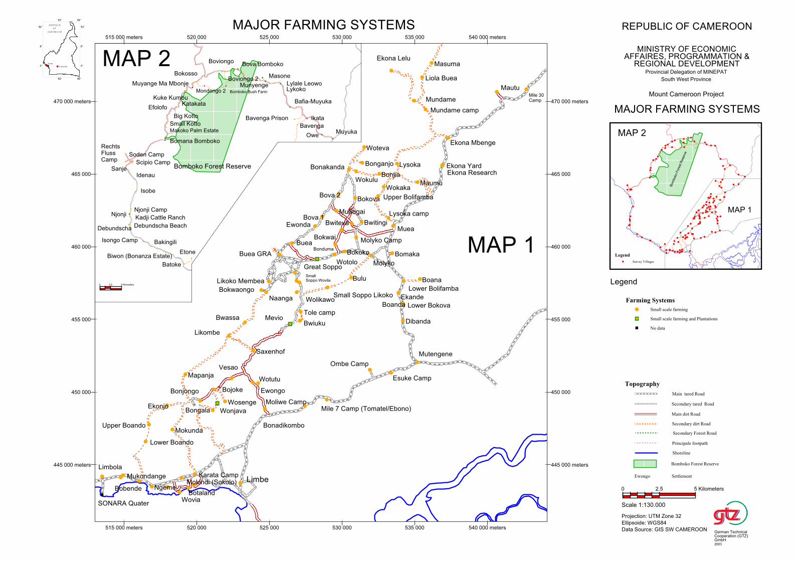
Biwon (Bonanza Estate)
Makoko Palm Estate
Small Kotto
Big Kotto
Muyange Ma Mbonje
Mondongo 2
Bafia-Muyuka
Bomboko Bush Farm
EfolofoKatakata
Bova Bomboko
Ikata
Owe
Batoke
Lykoko
Sanje
Soden Camp
Munyenge
Debundscha Beach
Bavenga Prison
Njonji
Debundscha
Kadji Cattle Ranch
Boviongo 2
Idenau
RechtsFlussCamp
Njonji Camp
Lylale Leowo
Scipio Camp
Kuke Kumbu
Isobe
Bavenga
Isongo Camp
Bokosso
Muyuka
Bakingili
Boviongo
Etone
Bomana Bomboko
Masone
Bomboko Forest Reserve
0 2.5 5 Kilometers
Maumu
Wotutu
Saxenhof
Ombe Camp
Molyko
Ewongo
Bokwaongo
Boana
Bonadikombo
Naanga
Likoko Membea
Liola Buea
Upper Bolifamba
Buea GRA
Bonjia
Mundame camp
Wokaka
Mevio
Buea
Mutengene
Wolikawo
Lysoka camp
SmallSoppo Wovila
Tole camp
Bwiuku
Moliwe Camp
Mautu
Esuke Camp
Ekona Lelu
Ewonda
Great Soppo
Bomaka
Muea
Bova 1
Ekona Mbenge
Mile 7 Camp (Tomatel/Ebono)
Small Soppo Likoko
Lysoka
Limbe
Wotolo
Bonduma
Muangai
Ekande
Bova 2
Masuma
Dibanda
Bokwai
SONARA Quater
Bokoko
Bonakanda
Boanda
Bulu
Bwiteva
Lower Bokova
Mukondange
Bobende
Lower Boando
Upper Boando
Ngeme
Limbola
Bokova
Wokulu
Ekonjo
Bwassa
Mokunda
Molyko Camp
Wovia
Mokindi (Sokolo)
Mapanja
Botaland
Karata Camp
Lower Bolifamba
Mile 30Camp
Bonjongo
Bwitingi
Bongala
Bojoke
Bonganjo
Wonjava
Ekona Research
Woteva
Wosenge
Ekona Yard
Likombe
Vesao
Mundame
445 000 meters
450 000
455 000
460 000
465 000
470 000 meters
515 000 meters 520 000 525 000 530 000 535 000 540 000 meters
445 000 meters
450 000
455 000
460 000
465 000
470 000 meters
515 000 meters 520 000 525 000 530 000 535 000 540 000 meters
MAP 2
MAP 1
Bom
boko
Fore
st R
ese
rve
MAP 1
MAP 2
4°
8°
112°
112° 116°
4°
8°
112°
112° 116°
REPU BLIC
O F
CA M ERO O N
Buea
Y aounde
Legend
Survey Villages
Topography
Main tared Road
Secondary tared Road
Main dirt Road
Secondary dirt Road
Secondary Forest Road
Principale footpath
Shoreline
Bomboko Forest Reserve
Ewongo Settlement
Farming Systems
Small scale farming
Small scale farming and Plantations
No data
Legend
MAJOR FARMING SYSTEMS REPUBLIC OF CAMEROON
MINISTRY OF ECONOMICAFFAIRES, PROGRAMMATION &
REGIONAL DEVELOPMENTProvincial Delegation of MINEPAT
South West Province
Mount Cameroon Project
MAJOR FARMING SYSTEMS
Scale 1:130.000
Projection: UTM Zone 32
Ellipsoide: WGS84
Data Source: GIS SW CAMEROON
0 2.5 5 Kilometers
German TechnicalCooperation (GTZ)GmbH2003
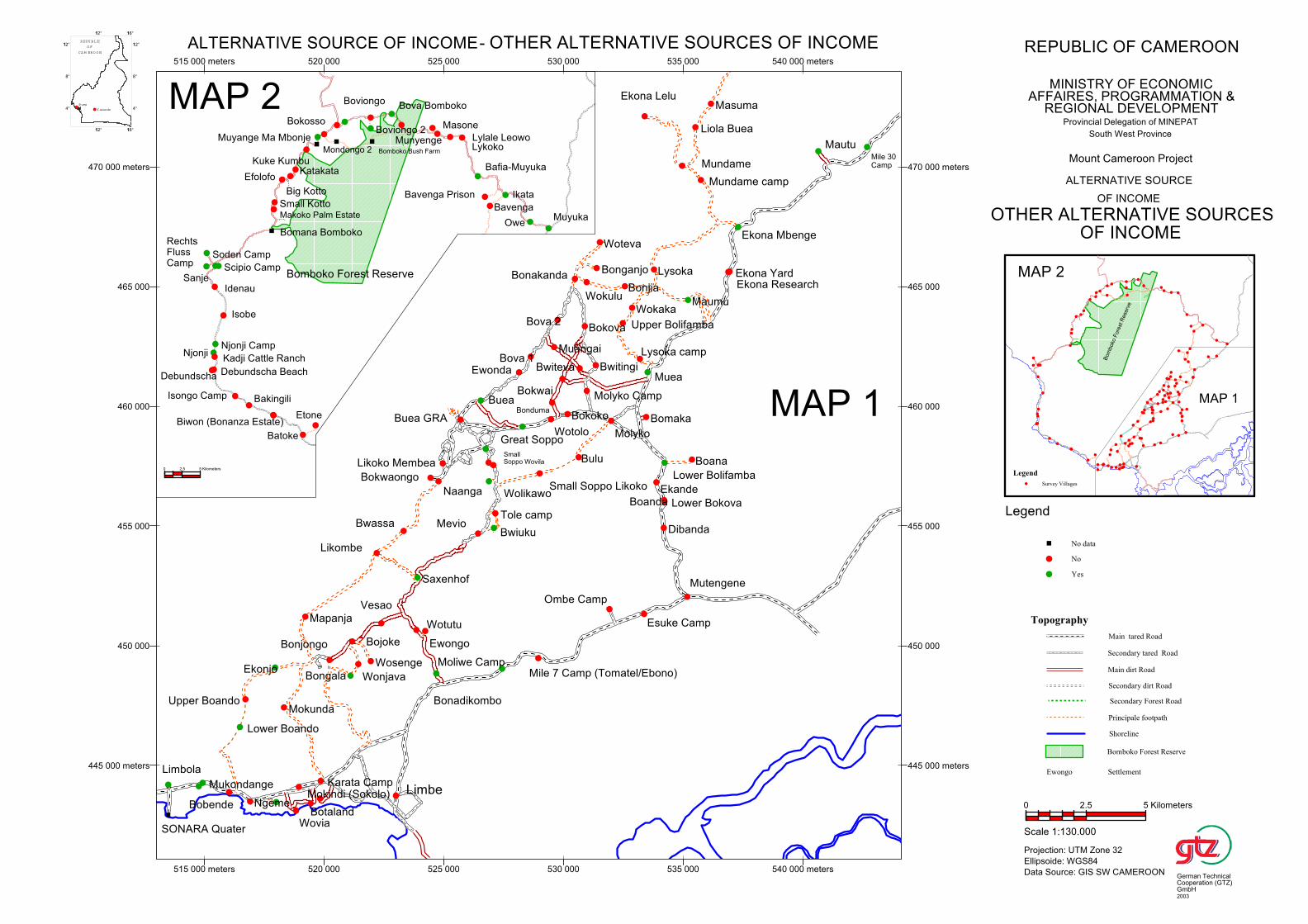
Biwon (Bonanza Estate)
Makoko Palm Estate
Small Kotto
Big Kotto
Muyange Ma Mbonje
Mondongo 2
Bafia-Muyuka
Bomboko Bush Farm
EfolofoKatakata
Bova Bomboko
Ikata
Owe
Batoke
Lykoko
Sanje
Soden Camp
Munyenge
Debundscha Beach
Bavenga Prison
Njonji
Debundscha
Kadji Cattle Ranch
Boviongo 2
Idenau
RechtsFlussCamp
Njonji Camp
Lylale Leowo
Scipio Camp
Kuke Kumbu
Isobe
Bavenga
Isongo Camp
Bokosso
Muyuka
Bakingili
Boviongo
Etone
Bomana Bomboko
Masone
Bomboko Forest Reserve
0 2.5 5 Kilometers
Maumu
Wotutu
Saxenhof
Ombe Camp
Molyko
Ewongo
Bokwaongo
Boana
Bonadikombo
Naanga
Likoko Membea
Liola Buea
Upper Bolifamba
Buea GRA
Bonjia
Mundame camp
Wokaka
Mevio
Buea
Mutengene
Wolikawo
Lysoka camp
SmallSoppo Wovila
Tole camp
Bwiuku
Moliwe Camp
Mautu
Esuke Camp
Ekona Lelu
Ewonda
Great Soppo
Bomaka
Muea
Bova 1
Ekona Mbenge
Mile 7 Camp (Tomatel/Ebono)
Small Soppo Likoko
Lysoka
Limbe
Wotolo
Bonduma
Muangai
Ekande
Bova 2
Masuma
Dibanda
Bokwai
SONARA Quater
Bokoko
Bonakanda
Boanda
Bulu
Bwiteva
Lower Bokova
Mukondange
Bobende
Lower Boando
Upper Boando
Ngeme
Limbola
Bokova
Wokulu
Ekonjo
Bwassa
Mokunda
Molyko Camp
Wovia
Mokindi (Sokolo)
Mapanja
Botaland
Karata Camp
Lower Bolifamba
Mile 30Camp
Bonjongo
Bwitingi
Bongala
Bojoke
Bonganjo
Wonjava
Ekona Research
Woteva
Wosenge
Ekona Yard
Likombe
Vesao
Mundame
445 000 meters
450 000
455 000
460 000
465 000
470 000 meters
515 000 meters 520 000 525 000 530 000 535 000 540 000 meters
445 000 meters
450 000
455 000
460 000
465 000
470 000 meters
515 000 meters 520 000 525 000 530 000 535 000 540 000 meters
MAP 2
MAP 1
Bom
boko
Fore
st R
ese
rve
MAP 1
MAP 2
4°
8°
112°
112° 116°
4°
8°
112°
112° 116°
REPU BLIC
O F
CA M ERO O N
Buea
Y aounde
Legend
Survey Villages
Topography
Main tared Road
Secondary tared Road
Main dirt Road
Secondary dirt Road
Secondary Forest Road
Principale footpath
Shoreline
Bomboko Forest Reserve
Ewongo Settlement
No data
No
Yes
Legend
REPUBLIC OF CAMEROON
MINISTRY OF ECONOMICAFFAIRES, PROGRAMMATION &
REGIONAL DEVELOPMENTProvincial Delegation of MINEPAT
South West Province
Mount Cameroon Project
ALTERNATIVE SOURCE OF INCOME- OTHER ALTERNATIVE SOURCES OF INCOME
ALTERNATIVE SOURCE
OF INCOME
OTHER ALTERNATIVE SOURCESOF INCOME
Scale 1:130.000
Projection: UTM Zone 32
Ellipsoide: WGS84
Data Source: GIS SW CAMEROON
0 2.5 5 Kilometers
German TechnicalCooperation (GTZ)GmbH2003
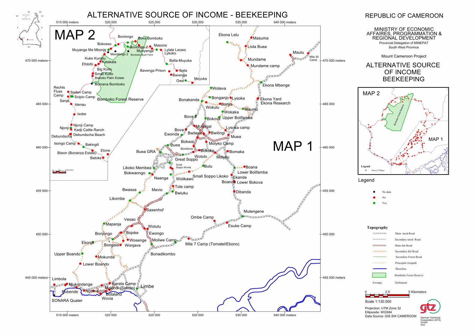
Biwon (Bonanza Estate)
Makoko Palm Estate
Small Kotto
Big Kotto
Muyange Ma Mbonje
Mondongo 2
Bafia-Muyuka
Bomboko Bush Farm
EfolofoKatakata
Bova Bomboko
Ikata
Owe
Batoke
Lykoko
Sanje
Soden Camp
Munyenge
Debundscha Beach
Bavenga Prison
Njonji
Debundscha
Kadji Cattle Ranch
Boviongo 2
Idenau
RechtsFlussCamp
Njonji Camp
Lylale Leowo
Scipio Camp
Kuke Kumbu
Isobe
Bavenga
Isongo Camp
Bokosso
Muyuka
Bakingili
Boviongo
Etone
Bomana Bomboko
Masone
Bomboko Forest Reserve
0 2.5 5 Kilometers
Maumu
Wotutu
Saxenhof
Ombe Camp
Molyko
Ewongo
Bokwaongo
Boana
Bonadikombo
Naanga
Likoko Membea
Liola Buea
Upper Bolifamba
Buea GRA
Bonjia
Mundame camp
Wokaka
Mevio
Buea
Mutengene
Wolikawo
Lysoka camp
SmallSoppo Wovila
Tole camp
Bwiuku
Moliwe Camp
Mautu
Esuke Camp
Ekona Lelu
Ewonda
Great Soppo
Bomaka
Muea
Bova 1
Ekona Mbenge
Mile 7 Camp (Tomatel/Ebono)
Small Soppo Likoko
Lysoka
Limbe
Wotolo
Bonduma
Muangai
Ekande
Bova 2
Masuma
Dibanda
Bokwai
SONARA Quater
Bokoko
Bonakanda
Boanda
Bulu
Bwiteva
Lower Bokova
Mukondange
Bobende
Lower Boando
Upper Boando
Ngeme
Limbola
Bokova
Wokulu
Ekonjo
Bwassa
Mokunda
Molyko Camp
Wovia
Mokindi (Sokolo)
Mapanja
Botaland
Karata Camp
Lower Bolifamba
Mile 30Camp
Bonjongo
Bwitingi
Bongala
Bojoke
Bonganjo
Wonjava
Ekona Research
Woteva
Wosenge
Ekona Yard
Likombe
Vesao
Mundame
445 000 meters
450 000
455 000
460 000
465 000
470 000 meters
515 000 meters 520 000 525 000 530 000 535 000 540 000 meters
445 000 meters
450 000
455 000
460 000
465 000
470 000 meters
515 000 meters 520 000 525 000 530 000 535 000 540 000 meters
MAP 2
MAP 1
Bom
boko
Fore
st R
ese
rve
MAP 1
MAP 2
4°
8°
112°
112° 116°
4°
8°
112°
112° 116°
REPU BLIC
O F
CA M ERO O N
Buea
Y aounde
Legend
Survey Villages
Topography
Main tared Road
Secondary tared Road
Main dirt Road
Secondary dirt Road
Secondary Forest Road
Principale footpath
Shoreline
Bomboko Forest Reserve
Ewongo Settlement
No data
No
Yes
Legend
REPUBLIC OF CAMEROON
MINISTRY OF ECONOMICAFFAIRES, PROGRAMMATION &
REGIONAL DEVELOPMENTProvincial Delegation of MINEPAT
South West Province
Mount Cameroon Project
ALTERNATIVE SOURCE OF INCOME - BEEKEEPING
ALTERNATIVE SOURCE OF INCOME BEEKEEPING
Scale 1:130.000
Projection: UTM Zone 32
Ellipsoide: WGS84
Data Source: GIS SW CAMEROON
0 2.5 5 Kilometers
German TechnicalCooperation (GTZ)GmbH2003

Biwon (Bonanza Estate)
Makoko Palm Estate
Small Kotto
Big Kotto
Muyange Ma Mbonje
Mondongo 2
Bafia-Muyuka
Bomboko Bush Farm
EfolofoKatakata
Bova Bomboko
Ikata
Owe
Batoke
Lykoko
Sanje
Soden Camp
Munyenge
Debundscha Beach
Bavenga Prison
Njonji
Debundscha
Kadji Cattle Ranch
Boviongo 2
Idenau
RechtsFlussCamp
Njonji Camp
Lylale Leowo
Scipio Camp
Kuke Kumbu
Isobe
Bavenga
Isongo Camp
Bokosso
Muyuka
Bakingili
Boviongo
Etone
Bomana Bomboko
Masone
Bomboko Forest Reserve
0 2.5 5 Kilometers
Maumu
Wotutu
Saxenhof
Ombe Camp
Molyko
Ewongo
Bokwaongo
Boana
Bonadikombo
Naanga
Likoko Membea
Liola Buea
Upper Bolifamba
Buea GRA
Bonjia
Mundame camp
Wokaka
Mevio
Buea
Mutengene
Wolikawo
Lysoka camp
SmallSoppo Wovila
Tole camp
Bwiuku
Moliwe Camp
Mautu
Esuke Camp
Ekona Lelu
Ewonda
Great Soppo
Bomaka
Muea
Bova 1
Ekona Mbenge
Mile 7 Camp (Tomatel/Ebono)
Small Soppo Likoko
Lysoka
Limbe
Wotolo
Bonduma
Muangai
Ekande
Bova 2
Masuma
Dibanda
Bokwai
SONARA Quater
Bokoko
Bonakanda
Boanda
Bulu
Bwiteva
Lower Bokova
Mukondange
Bobende
Lower Boando
Upper Boando
Ngeme
Limbola
Bokova
Wokulu
Ekonjo
Bwassa
Mokunda
Molyko Camp
Wovia
Mokindi (Sokolo)
Mapanja
Botaland
Karata Camp
Lower Bolifamba
Mile 30Camp
Bonjongo
Bwitingi
Bongala
Bojoke
Bonganjo
Wonjava
Ekona Research
Woteva
Wosenge
Ekona Yard
Likombe
Vesao
Mundame
445 000 meters
450 000
455 000
460 000
465 000
470 000 meters
515 000 meters 520 000 525 000 530 000 535 000 540 000 meters
445 000 meters
450 000
455 000
460 000
465 000
470 000 meters
515 000 meters 520 000 525 000 530 000 535 000 540 000 meters
MAP 2
MAP 1
Bom
boko
Fore
st R
ese
rve
MAP 1
MAP 2
4°
8°
112°
112° 116°
4°
8°
112°
112° 116°
REPU BLIC
O F
CA M ERO O N
Buea
Y aounde
Legend
Survey Villages
Topography
Main tared Road
Secondary tared Road
Main dirt Road
Secondary dirt Road
Secondary Forest Road
Principale footpath
Shoreline
Bomboko Forest Reserve
Ewongo Settlement
No data
No
Yes
Legend
REPUBLIC OF CAMEROON
MINISTRY OF ECONOMICAFFAIRES, PROGRAMMATION &
REGIONAL DEVELOPMENTProvincial Delegation of MINEPAT
South West Province
Mount Cameroon Project
ALTERNATIVE SOURCE OF INCOME - LIVESTOCK REARING
ALTERNATIVE SOURCE OF INCOME
LIVESTOCK REARING
Scale 1:130.000
Projection: UTM Zone 32
Ellipsoide: WGS84
Data Source: GIS SW CAMEROON
0 2.5 5 Kilometers
German TechnicalCooperation (GTZ)GmbH2003
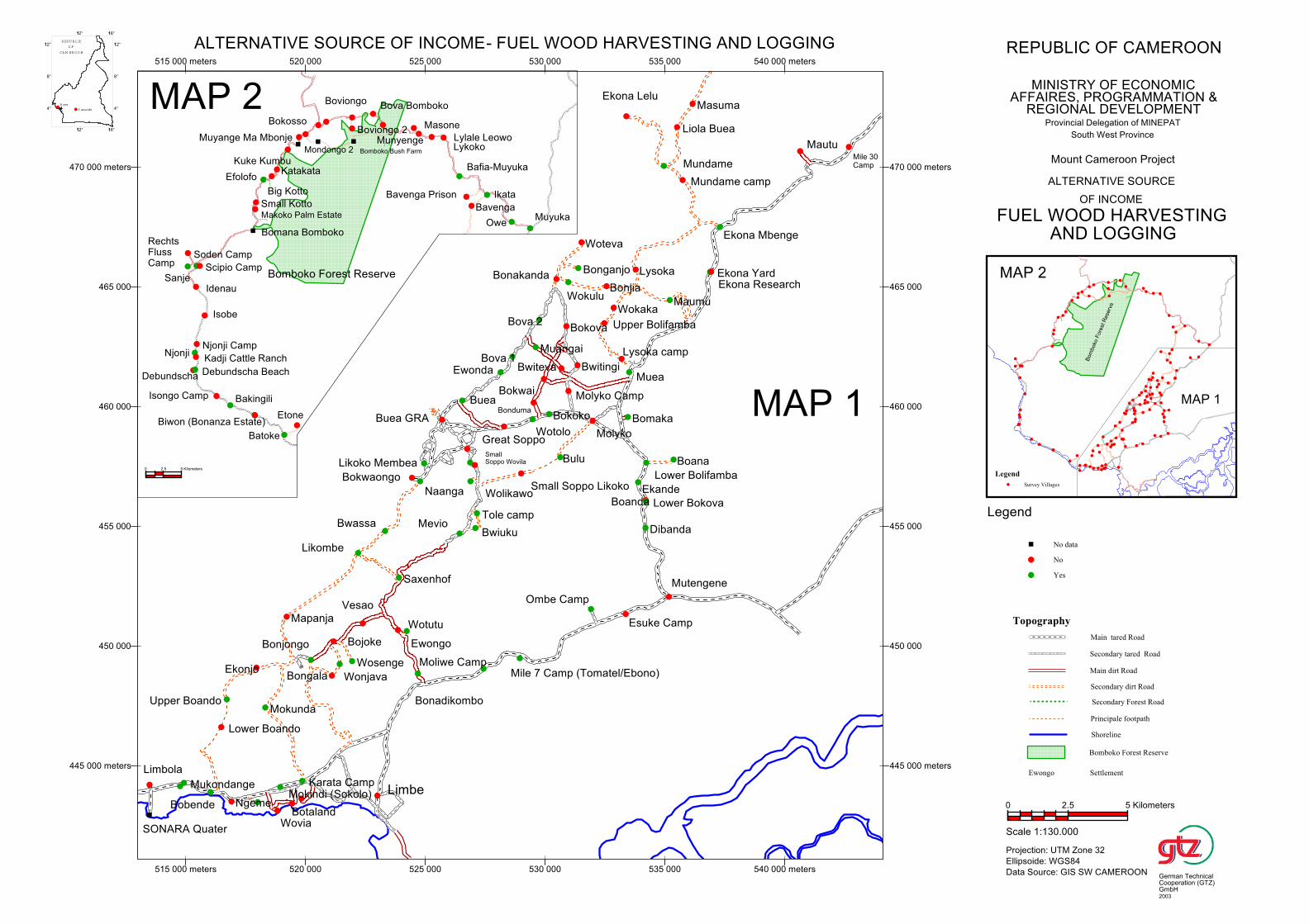
Biwon (Bonanza Estate)
Makoko Palm Estate
Small Kotto
Big Kotto
Muyange Ma Mbonje
Mondongo 2
Bafia-Muyuka
Bomboko Bush Farm
EfolofoKatakata
Bova Bomboko
Ikata
Owe
Batoke
Lykoko
Sanje
Soden Camp
Munyenge
Debundscha Beach
Bavenga Prison
Njonji
Debundscha
Kadji Cattle Ranch
Boviongo 2
Idenau
RechtsFlussCamp
Njonji Camp
Lylale Leowo
Scipio Camp
Kuke Kumbu
Isobe
Bavenga
Isongo Camp
Bokosso
Muyuka
Bakingili
Boviongo
Etone
Bomana Bomboko
Masone
Bomboko Forest Reserve
0 2.5 5 Kilometers
Maumu
Wotutu
Saxenhof
Ombe Camp
Molyko
Ewongo
Bokwaongo
Boana
Bonadikombo
Naanga
Likoko Membea
Liola Buea
Upper Bolifamba
Buea GRA
Bonjia
Mundame camp
Wokaka
Mevio
Buea
Mutengene
Wolikawo
Lysoka camp
SmallSoppo Wovila
Tole camp
Bwiuku
Moliwe Camp
Mautu
Esuke Camp
Ekona Lelu
Ewonda
Great Soppo
Bomaka
Muea
Bova 1
Ekona Mbenge
Mile 7 Camp (Tomatel/Ebono)
Small Soppo Likoko
Lysoka
Limbe
Wotolo
Bonduma
Muangai
Ekande
Bova 2
Masuma
Dibanda
Bokwai
SONARA Quater
Bokoko
Bonakanda
Boanda
Bulu
Bwiteva
Lower Bokova
Mukondange
Bobende
Lower Boando
Upper Boando
Ngeme
Limbola
Bokova
Wokulu
Ekonjo
Bwassa
Mokunda
Molyko Camp
Wovia
Mokindi (Sokolo)
Mapanja
Botaland
Karata Camp
Lower Bolifamba
Mile 30Camp
Bonjongo
Bwitingi
Bongala
Bojoke
Bonganjo
Wonjava
Ekona Research
Woteva
Wosenge
Ekona Yard
Likombe
Vesao
Mundame
445 000 meters
450 000
455 000
460 000
465 000
470 000 meters
515 000 meters 520 000 525 000 530 000 535 000 540 000 meters
445 000 meters
450 000
455 000
460 000
465 000
470 000 meters
515 000 meters 520 000 525 000 530 000 535 000 540 000 meters
MAP 2
MAP 1
Bom
boko
Fore
st R
ese
rve
MAP 1
MAP 2
4°
8°
112°
112° 116°
4°
8°
112°
112° 116°
REPU BLIC
O F
CA M ERO O N
Buea
Y aounde
Legend
Survey Villages
Topography
Main tared Road
Secondary tared Road
Main dirt Road
Secondary dirt Road
Secondary Forest Road
Principale footpath
Shoreline
Bomboko Forest Reserve
Ewongo Settlement
No data
No
Yes
Legend
REPUBLIC OF CAMEROON
MINISTRY OF ECONOMICAFFAIRES, PROGRAMMATION &
REGIONAL DEVELOPMENTProvincial Delegation of MINEPAT
South West Province
Mount Cameroon Project
ALTERNATIVE SOURCE OF INCOME- FUEL WOOD HARVESTING AND LOGGING
ALTERNATIVE SOURCE
OF INCOME
FUEL WOOD HARVESTING AND LOGGING
Scale 1:130.000
Projection: UTM Zone 32
Ellipsoide: WGS84
Data Source: GIS SW CAMEROON
0 2.5 5 Kilometers
German TechnicalCooperation (GTZ)GmbH2003
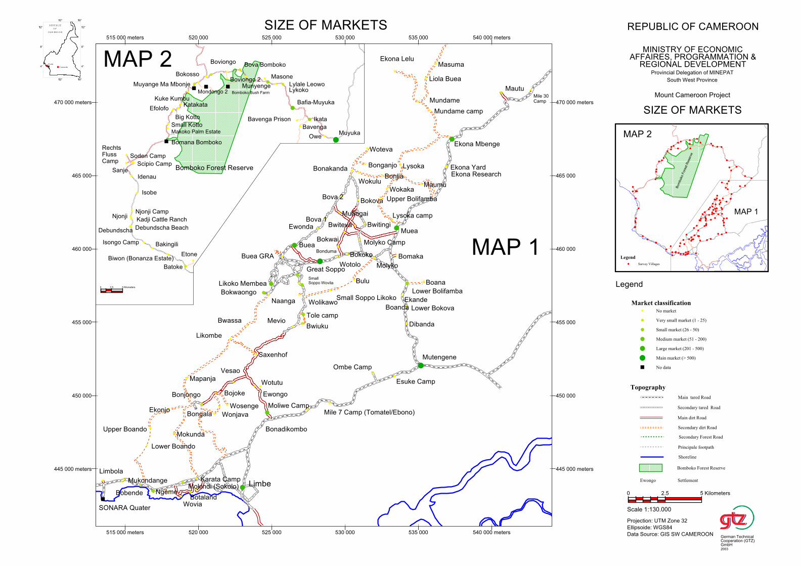
Biwon (Bonanza Estate)
Makoko Palm Estate
Small Kotto
Big Kotto
Muyange Ma Mbonje
Mondongo 2
Bafia-Muyuka
Bomboko Bush Farm
EfolofoKatakata
Bova Bomboko
Ikata
Owe
Batoke
Lykoko
Sanje
Soden Camp
Munyenge
Debundscha Beach
Bavenga Prison
Njonji
Debundscha
Kadji Cattle Ranch
Boviongo 2
Idenau
RechtsFlussCamp
Njonji Camp
Lylale Leowo
Scipio Camp
Kuke Kumbu
Isobe
Bavenga
Isongo Camp
Bokosso
Muyuka
Bakingili
Boviongo
Etone
Bomana Bomboko
Masone
Bomboko Forest Reserve
0 2.5 5 Kilometers
Maumu
Wotutu
Saxenhof
Ombe Camp
Molyko
Ewongo
Bokwaongo
Boana
Bonadikombo
Naanga
Likoko Membea
Liola Buea
Upper Bolifamba
Buea GRA
Bonjia
Mundame camp
Wokaka
Mevio
Buea
Mutengene
Wolikawo
Lysoka camp
SmallSoppo Wovila
Tole camp
Bwiuku
Moliwe Camp
Mautu
Esuke Camp
Ekona Lelu
Ewonda
Great Soppo
Bomaka
Muea
Bova 1
Ekona Mbenge
Mile 7 Camp (Tomatel/Ebono)
Small Soppo Likoko
Lysoka
Limbe
Wotolo
Bonduma
Muangai
Ekande
Bova 2
Masuma
Dibanda
Bokwai
SONARA Quater
Bokoko
Bonakanda
Boanda
Bulu
Bwiteva
Lower Bokova
Mukondange
Bobende
Lower Boando
Upper Boando
Ngeme
Limbola
Bokova
Wokulu
Ekonjo
Bwassa
Mokunda
Molyko Camp
Wovia
Mokindi (Sokolo)
Mapanja
Botaland
Karata Camp
Lower Bolifamba
Mile 30Camp
Bonjongo
Bwitingi
Bongala
Bojoke
Bonganjo
Wonjava
Ekona Research
Woteva
Wosenge
Ekona Yard
Likombe
Vesao
Mundame
445 000 meters
450 000
455 000
460 000
465 000
470 000 meters
515 000 meters 520 000 525 000 530 000 535 000 540 000 meters
445 000 meters
450 000
455 000
460 000
465 000
470 000 meters
515 000 meters 520 000 525 000 530 000 535 000 540 000 meters
MAP 2
MAP 1
Bom
boko
Fore
st R
ese
rve
MAP 1
MAP 2
4°
8°
112°
112° 116°
4°
8°
112°
112° 116°
REPU BLIC
O F
CA M ERO O N
Buea
Y aounde
Legend
Survey Villages
Topography
Main tared Road
Secondary tared Road
Main dirt Road
Secondary dirt Road
Secondary Forest Road
Principale footpath
Shoreline
Bomboko Forest Reserve
Ewongo Settlement
Market classification
No market
Very small market (1 - 25)
Small market (26 - 50)
Medium market (51 - 200)
Large market (201 - 500)
Main market (> 500)
No data
Legend
REPUBLIC OF CAMEROON
MINISTRY OF ECONOMICAFFAIRES, PROGRAMMATION &
REGIONAL DEVELOPMENTProvincial Delegation of MINEPAT
South West Province
Mount Cameroon Project
SIZE OF MARKETS
SIZE OF MARKETS
Scale 1:130.000
Projection: UTM Zone 32
Ellipsoide: WGS84
Data Source: GIS SW CAMEROON
0 2.5 5 Kilometers
German TechnicalCooperation (GTZ)GmbH2003
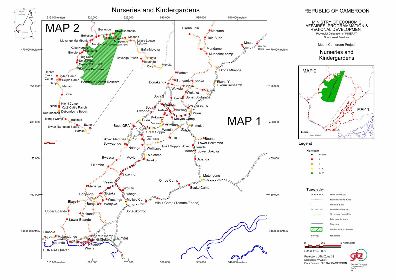
Biwon (Bonanza Estate)
Makoko Palm Estate
Small Kotto
Big Kotto
Muyange Ma Mbonje
Mondongo 2
Bafia-Muyuka
Bomboko Bush Farm
EfolofoKatakata
Bova Bomboko
Ikata
Owe
Batoke
Lykoko
Sanje
Soden Camp
Munyenge
Debundscha Beach
Bavenga Prison
Njonji
Debundscha
Kadji Cattle Ranch
Boviongo 2
Idenau
RechtsFlussCamp
Njonji Camp
Lylale Leowo
Scipio Camp
Kuke Kumbu
Isobe
Bavenga
Isongo Camp
Bokosso
Muyuka
Bakingili
Boviongo
Etone
Bomana Bomboko
Masone
Bomboko Forest Reserve
0 2.5 5 Kilometers
Maumu
Wotutu
Saxenhof
Ombe Camp
Molyko
Ewongo
Bokwaongo
Boana
Bonadikombo
Naanga
Likoko Membea
Liola Buea
Upper Bolifamba
Buea GRA
Bonjia
Mundame camp
Wokaka
Mevio
Buea
Mutengene
Wolikawo
Lysoka camp
SmallSoppo Wovila
Tole camp
Bwiuku
Moliwe Camp
Mautu
Esuke Camp
Ekona Lelu
Ewonda
Great Soppo
Bomaka
Muea
Bova 1
Ekona Mbenge
Mile 7 Camp (Tomatel/Ebono)
Small Soppo Likoko
Lysoka
Limbe
Wotolo
Bonduma
Muangai
Ekande
Bova 2
Masuma
Dibanda
Bokwai
SONARA Quater
Bokoko
Bonakanda
Boanda
Bulu
Bwiteva
Lower Bokova
Mukondange
Bobende
Lower Boando
Upper Boando
Ngeme
Limbola
Bokova
Wokulu
Ekonjo
Bwassa
Mokunda
Molyko Camp
Wovia
Mokindi (Sokolo)
Mapanja
Botaland
Karata Camp
Lower Bolifamba
Mile 30Camp
Bonjongo
Bwitingi
Bongala
Bojoke
Bonganjo
Wonjava
Ekona Research
Woteva
Wosenge
Ekona Yard
Likombe
Vesao
Mundame
445 000 meters
450 000
455 000
460 000
465 000
470 000 meters
515 000 meters 520 000 525 000 530 000 535 000 540 000 meters
445 000 meters
450 000
455 000
460 000
465 000
470 000 meters
515 000 meters 520 000 525 000 530 000 535 000 540 000 meters
MAP 2
MAP 1
Bom
boko
Fore
st R
ese
rve
MAP 1
MAP 2
4°
8°
112°
112° 116°
4°
8°
112°
112° 116°
Legend
Survey Villages
Topography
Main tared Road
Secondary tared Road
Main dirt Road
Secondary dirt Road
Secondary Forest Road
Principale footpath
Shoreline
Bomboko Forest Reserve
Ewongo Settlement
Numbers
No data
0
1
2 - 5
6 - 20
Legend
REPUBLIC OF CAMEROON
MINISTRY OF ECONOMICAFFAIRES, PROGRAMMATION &
REGIONAL DEVELOPMENTProvincial Delegation of MINEPAT
South West Province
Mount Cameroon Project
Nurseries and Kindergardens
Nurseries andKindergardens
Scale 1:130.000
Projection: UTM Zone 32
Ellipsoide: WGS84
Data Source: GIS SW CAMEROON
0 2.5 5 Kilometers
German TechnicalCooperation (GTZ)GmbH2003
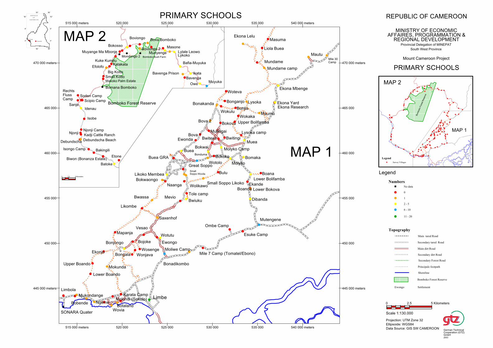
Biwon (Bonanza Estate)
Makoko Palm Estate
Small Kotto
Big Kotto
Muyange Ma Mbonje
Mondongo 2
Bafia-Muyuka
Bomboko Bush Farm
EfolofoKatakata
Bova Bomboko
Ikata
Owe
Batoke
Lykoko
Sanje
Soden Camp
Munyenge
Debundscha Beach
Bavenga Prison
Njonji
Debundscha
Kadji Cattle Ranch
Boviongo 2
Idenau
RechtsFlussCamp
Njonji Camp
Lylale Leowo
Scipio Camp
Kuke Kumbu
Isobe
Bavenga
Isongo Camp
Bokosso
Muyuka
Bakingili
Boviongo
Etone
Bomana Bomboko
Masone
Bomboko Forest Reserve
0 2.5 5 Kilometers
Maumu
Wotutu
Saxenhof
Ombe Camp
Molyko
Ewongo
Bokwaongo
Boana
Bonadikombo
Naanga
Likoko Membea
Liola Buea
Upper Bolifamba
Buea GRA
Bonjia
Mundame camp
Wokaka
Mevio
Buea
Mutengene
Wolikawo
Lysoka camp
SmallSoppo Wovila
Tole camp
Bwiuku
Moliwe Camp
Mautu
Esuke Camp
Ekona Lelu
Ewonda
Great Soppo
Bomaka
Muea
Bova 1
Ekona Mbenge
Mile 7 Camp (Tomatel/Ebono)
Small Soppo Likoko
Lysoka
Limbe
Wotolo
Bonduma
Muangai
Ekande
Bova 2
Masuma
Dibanda
Bokwai
SONARA Quater
Bokoko
Bonakanda
Boanda
Bulu
Bwiteva
Lower Bokova
Mukondange
Bobende
Lower Boando
Upper Boando
Ngeme
Limbola
Bokova
Wokulu
Ekonjo
Bwassa
Mokunda
Molyko Camp
Wovia
Mokindi (Sokolo)
Mapanja
Botaland
Karata Camp
Lower Bolifamba
Mile 30Camp
Bonjongo
Bwitingi
Bongala
Bojoke
Bonganjo
Wonjava
Ekona Research
Woteva
Wosenge
Ekona Yard
Likombe
Vesao
Mundame
445 000 meters
450 000
455 000
460 000
465 000
470 000 meters
515 000 meters 520 000 525 000 530 000 535 000 540 000 meters
445 000 meters
450 000
455 000
460 000
465 000
470 000 meters
515 000 meters 520 000 525 000 530 000 535 000 540 000 meters
MAP 2
MAP 1
Bom
boko
Fore
st R
ese
rve
MAP 1
MAP 2
4°
8°
112°
112° 116°
4°
8°
112°
112° 116°
REPU BLIC
O F
CA M ERO O N
Buea
Y aounde
Legend
Survey Villages
Topography
Main tared Road
Secondary tared Road
Main dirt Road
Secondary dirt Road
Secondary Forest Road
Principale footpath
Shoreline
Bomboko Forest Reserve
Ewongo Settlement
Numbers
No data
0
1
2 - 5
6 - 10
11 - 20
Legend
REPUBLIC OF CAMEROON
MINISTRY OF ECONOMICAFFAIRES, PROGRAMMATION &
REGIONAL DEVELOPMENTProvincial Delegation of MINEPAT
South West Province
Mount Cameroon Project
PRIMARY SCHOOLS
PRIMARY SCHOOLS
Scale 1:130.000
Projection: UTM Zone 32
Ellipsoide: WGS84
Data Source: GIS SW CAMEROON
0 2.5 5 Kilometers
German TechnicalCooperation (GTZ)GmbH2003
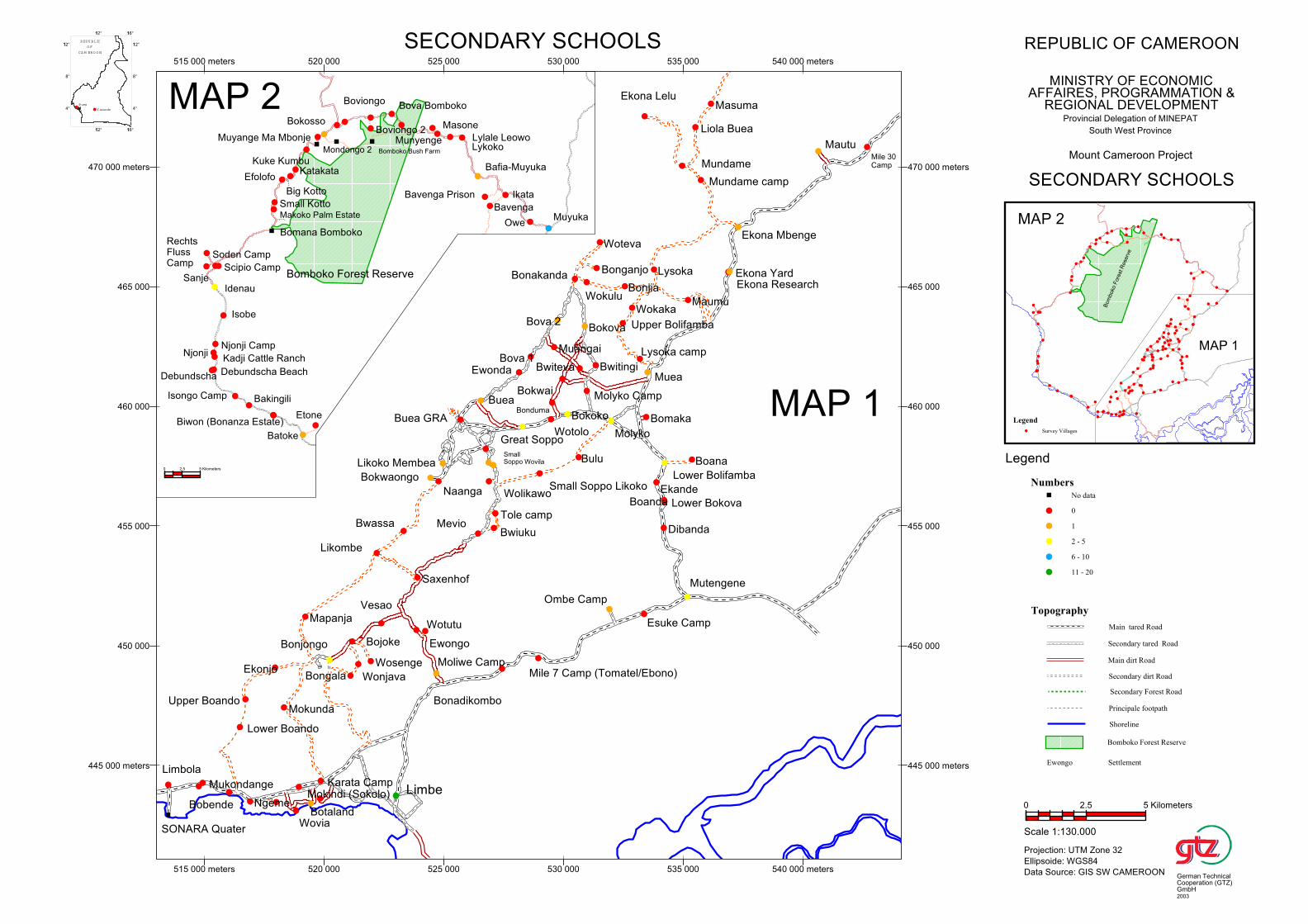
Biwon (Bonanza Estate)
Makoko Palm Estate
Small Kotto
Big Kotto
Muyange Ma Mbonje
Mondongo 2
Bafia-Muyuka
Bomboko Bush Farm
EfolofoKatakata
Bova Bomboko
Ikata
Owe
Batoke
Lykoko
Sanje
Soden Camp
Munyenge
Debundscha Beach
Bavenga Prison
Njonji
Debundscha
Kadji Cattle Ranch
Boviongo 2
Idenau
RechtsFlussCamp
Njonji Camp
Lylale Leowo
Scipio Camp
Kuke Kumbu
Isobe
Bavenga
Isongo Camp
Bokosso
Muyuka
Bakingili
Boviongo
Etone
Bomana Bomboko
Masone
Bomboko Forest Reserve
0 2.5 5 Kilometers
Maumu
Wotutu
Saxenhof
Ombe Camp
Molyko
Ewongo
Bokwaongo
Boana
Bonadikombo
Naanga
Likoko Membea
Liola Buea
Upper Bolifamba
Buea GRA
Bonjia
Mundame camp
Wokaka
Mevio
Buea
Mutengene
Wolikawo
Lysoka camp
SmallSoppo Wovila
Tole camp
Bwiuku
Moliwe Camp
Mautu
Esuke Camp
Ekona Lelu
Ewonda
Great Soppo
Bomaka
Muea
Bova 1
Ekona Mbenge
Mile 7 Camp (Tomatel/Ebono)
Small Soppo Likoko
Lysoka
Limbe
Wotolo
Bonduma
Muangai
Ekande
Bova 2
Masuma
Dibanda
Bokwai
SONARA Quater
Bokoko
Bonakanda
Boanda
Bulu
Bwiteva
Lower Bokova
Mukondange
Bobende
Lower Boando
Upper Boando
Ngeme
Limbola
Bokova
Wokulu
Ekonjo
Bwassa
Mokunda
Molyko Camp
Wovia
Mokindi (Sokolo)
Mapanja
Botaland
Karata Camp
Lower Bolifamba
Mile 30Camp
Bonjongo
Bwitingi
Bongala
Bojoke
Bonganjo
Wonjava
Ekona Research
Woteva
Wosenge
Ekona Yard
Likombe
Vesao
Mundame
445 000 meters
450 000
455 000
460 000
465 000
470 000 meters
515 000 meters 520 000 525 000 530 000 535 000 540 000 meters
445 000 meters
450 000
455 000
460 000
465 000
470 000 meters
515 000 meters 520 000 525 000 530 000 535 000 540 000 meters
MAP 2
MAP 1
Bom
boko
Fore
st R
ese
rve
MAP 1
MAP 2
4°
8°
112°
112° 116°
4°
8°
112°
112° 116°
REPU BLIC
O F
CA M ERO O N
Buea
Y aounde
Legend
Survey Villages
Topography
Main tared Road
Secondary tared Road
Main dirt Road
Secondary dirt Road
Secondary Forest Road
Principale footpath
Shoreline
Bomboko Forest Reserve
Ewongo Settlement
Numbers
No data
0
1
2 - 5
6 - 10
11 - 20
Legend
REPUBLIC OF CAMEROON
MINISTRY OF ECONOMICAFFAIRES, PROGRAMMATION &
REGIONAL DEVELOPMENTProvincial Delegation of MINEPAT
South West Province
Mount Cameroon Project
SECONDARY SCHOOLS
SECONDARY SCHOOLS
Scale 1:130.000
Projection: UTM Zone 32
Ellipsoide: WGS84
Data Source: GIS SW CAMEROON
0 2.5 5 Kilometers
German TechnicalCooperation (GTZ)GmbH2003

Biwon (Bonanza Estate)
Makoko Palm Estate
Small Kotto
Big Kotto
Muyange Ma Mbonje
Mondongo 2
Bafia-Muyuka
Bomboko Bush Farm
EfolofoKatakata
Bova Bomboko
Ikata
Owe
Batoke
Lykoko
Sanje
Soden Camp
Munyenge
Debundscha Beach
Bavenga Prison
Njonji
Debundscha
Kadji Cattle Ranch
Boviongo 2
Idenau
RechtsFlussCamp
Njonji Camp
Lylale Leowo
Scipio Camp
Kuke Kumbu
Isobe
Bavenga
Isongo Camp
Bokosso
Muyuka
Bakingili
Boviongo
Etone
Bomana Bomboko
Masone
Bomboko Forest Reserve
0 2.5 5 Kilometers
Maumu
Wotutu
Saxenhof
Ombe Camp
Molyko
Ewongo
Bokwaongo
Boana
Bonadikombo
Naanga
Likoko Membea
Liola Buea
Upper Bolifamba
Buea GRA
Bonjia
Mundame camp
Wokaka
Mevio
Buea
Mutengene
Wolikawo
Lysoka camp
SmallSoppo Wovila
Tole camp
Bwiuku
Moliwe Camp
Mautu
Esuke Camp
Ekona Lelu
Ewonda
Great Soppo
Bomaka
Muea
Bova 1
Ekona Mbenge
Mile 7 Camp (Tomatel/Ebono)
Small Soppo Likoko
Lysoka
Limbe
Wotolo
Bonduma
Muangai
Ekande
Bova 2
Masuma
Dibanda
Bokwai
SONARA Quater
Bokoko
Bonakanda
Boanda
Bulu
Bwiteva
Lower Bokova
Mukondange
Bobende
Lower Boando
Upper Boando
Ngeme
Limbola
Bokova
Wokulu
Ekonjo
Bwassa
Mokunda
Molyko Camp
Wovia
Mokindi (Sokolo)
Mapanja
Botaland
Karata Camp
Lower Bolifamba
Mile 30Camp
Bonjongo
Bwitingi
Bongala
Bojoke
Bonganjo
Wonjava
Ekona Research
Woteva
Wosenge
Ekona Yard
Likombe
Vesao
Mundame
445 000 meters
450 000
455 000
460 000
465 000
470 000 meters
515 000 meters 520 000 525 000 530 000 535 000 540 000 meters
445 000 meters
450 000
455 000
460 000
465 000
470 000 meters
515 000 meters 520 000 525 000 530 000 535 000 540 000 meters
MAP 2
MAP 1
Bom
boko
Fore
st R
ese
rve
MAP 1
MAP 2
4°
8°
112°
112° 116°
4°
8°
112°
112° 116°
REPU BLIC
O F
CA M ERO O N
Buea
Y aounde
Legend
Survey Villages
Topography
Main tared Road
Secondary tared Road
Main dirt Road
Secondary dirt Road
Secondary Forest Road
Principale footpath
Shoreline
Bomboko Forest Reserve
Ewongo Settlement
Number of medical staff
No data
No health facility
Health facilities without staff
Health facilities with 1 staff
Health facilities with 2 - 9 staff
Health facilities with 10 - 19 staff
Health facilities with 20 - 50 staff
Health facilities with more than 50 staff
Legend
REPUBLIC OF CAMEROON
MINISTRY OF ECONOMICAFFAIRES, PROGRAMMATION &
REGIONAL DEVELOPMENTProvincial Delegation of MINEPAT
South West Province
Mount Cameroon Project
MEDICAL STUFF
MEDICAL STUFF
Scale 1:130.000
Projection: UTM Zone 32
Ellipsoide: WGS84
Data Source: GIS SW CAMEROON
0 2.5 5 Kilometers
German TechnicalCooperation (GTZ)GmbH2003
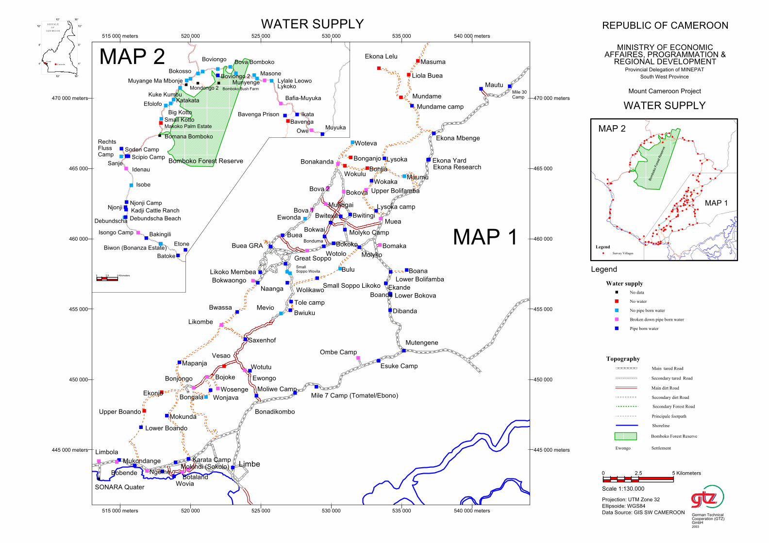
Biwon (Bonanza Estate)
Makoko Palm Estate
Small Kotto
Big Kotto
Muyange Ma Mbonje
Mondongo 2
Bafia-Muyuka
Bomboko Bush Farm
EfolofoKatakata
Bova Bomboko
Ikata
Owe
Batoke
Lykoko
Sanje
Soden Camp
Munyenge
Debundscha Beach
Bavenga Prison
Njonji
Debundscha
Kadji Cattle Ranch
Boviongo 2
Idenau
RechtsFlussCamp
Njonji Camp
Lylale Leowo
Scipio Camp
Kuke Kumbu
Isobe
Bavenga
Isongo Camp
Bokosso
Muyuka
Bakingili
Boviongo
Etone
Bomana Bomboko
Masone
Bomboko Forest Reserve
0 2.5 5 Kilometers
Maumu
Wotutu
Saxenhof
Ombe Camp
Molyko
Ewongo
Bokwaongo
Boana
Bonadikombo
Naanga
Likoko Membea
Liola Buea
Upper Bolifamba
Buea GRA
Bonjia
Mundame camp
Wokaka
Mevio
Buea
Mutengene
Wolikawo
Lysoka camp
SmallSoppo Wovila
Tole camp
Bwiuku
Moliwe Camp
Mautu
Esuke Camp
Ekona Lelu
Ewonda
Great Soppo
Bomaka
Muea
Bova 1
Ekona Mbenge
Mile 7 Camp (Tomatel/Ebono)
Small Soppo Likoko
Lysoka
Limbe
Wotolo
Bonduma
Muangai
Ekande
Bova 2
Masuma
Dibanda
Bokwai
SONARA Quater
Bokoko
Bonakanda
Boanda
Bulu
Bwiteva
Lower Bokova
Mukondange
Bobende
Lower Boando
Upper Boando
Ngeme
Limbola
Bokova
Wokulu
Ekonjo
Bwassa
Mokunda
Molyko Camp
Wovia
Mokindi (Sokolo)
Mapanja
Botaland
Karata Camp
Lower Bolifamba
Mile 30Camp
Bonjongo
Bwitingi
Bongala
Bojoke
Bonganjo
Wonjava
Ekona Research
Woteva
Wosenge
Ekona Yard
Likombe
Vesao
Mundame
445 000 meters
450 000
455 000
460 000
465 000
470 000 meters
515 000 meters 520 000 525 000 530 000 535 000 540 000 meters
445 000 meters
450 000
455 000
460 000
465 000
470 000 meters
515 000 meters 520 000 525 000 530 000 535 000 540 000 meters
MAP 2
MAP 1
Bom
boko
Fore
st R
ese
rve
MAP 1
MAP 2
4°
8°
112°
112° 116°
4°
8°
112°
112° 116°
REPU BLIC
O F
CA M ERO O N
Buea
Y aounde
Legend
Survey Villages
Topography
Main tared Road
Secondary tared Road
Main dirt Road
Secondary dirt Road
Secondary Forest Road
Principale footpath
Shoreline
Bomboko Forest Reserve
Ewongo Settlement
Water supply
No data
No water
No pipe born water
Broken down pipe born water
Pipe born water
Legend
REPUBLIC OF CAMEROON
MINISTRY OF ECONOMICAFFAIRES, PROGRAMMATION &
REGIONAL DEVELOPMENTProvincial Delegation of MINEPAT
South West Province
Mount Cameroon Project
WATER SUPPLY
WATER SUPPLY
Scale 1:130.000
Projection: UTM Zone 32
Ellipsoide: WGS84
Data Source: GIS SW CAMEROON
0 2.5 5 Kilometers
German TechnicalCooperation (GTZ)GmbH2003
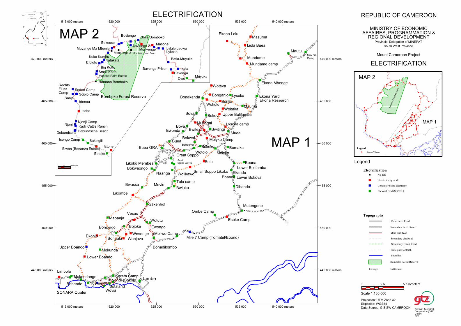
Biwon (Bonanza Estate)
Makoko Palm Estate
Small Kotto
Big Kotto
Muyange Ma Mbonje
Mondongo 2
Bafia-Muyuka
Bomboko Bush Farm
EfolofoKatakata
Bova Bomboko
Ikata
Owe
Batoke
Lykoko
Sanje
Soden Camp
Munyenge
Debundscha Beach
Bavenga Prison
Njonji
Debundscha
Kadji Cattle Ranch
Boviongo 2
Idenau
RechtsFlussCamp
Njonji Camp
Lylale Leowo
Scipio Camp
Kuke Kumbu
Isobe
Bavenga
Isongo Camp
Bokosso
Muyuka
Bakingili
Boviongo
Etone
Bomana Bomboko
Masone
Bomboko Forest Reserve
0 2.5 5 Kilometers
Maumu
Wotutu
Saxenhof
Ombe Camp
Molyko
Ewongo
Bokwaongo
Boana
Bonadikombo
Naanga
Likoko Membea
Liola Buea
Upper Bolifamba
Buea GRA
Bonjia
Mundame camp
Wokaka
Mevio
Buea
Mutengene
Wolikawo
Lysoka camp
SmallSoppo Wovila
Tole camp
Bwiuku
Moliwe Camp
Mautu
Esuke Camp
Ekona Lelu
Ewonda
Great Soppo
Bomaka
Muea
Bova 1
Ekona Mbenge
Mile 7 Camp (Tomatel/Ebono)
Small Soppo Likoko
Lysoka
Limbe
Wotolo
Bonduma
Muangai
Ekande
Bova 2
Masuma
Dibanda
Bokwai
SONARA Quater
Bokoko
Bonakanda
Boanda
Bulu
Bwiteva
Lower Bokova
Mukondange
Bobende
Lower Boando
Upper Boando
Ngeme
Limbola
Bokova
Wokulu
Ekonjo
Bwassa
Mokunda
Molyko Camp
Wovia
Mokindi (Sokolo)
Mapanja
Botaland
Karata Camp
Lower Bolifamba
Mile 30Camp
Bonjongo
Bwitingi
Bongala
Bojoke
Bonganjo
Wonjava
Ekona Research
Woteva
Wosenge
Ekona Yard
Likombe
Vesao
Mundame
445 000 meters
450 000
455 000
460 000
465 000
470 000 meters
515 000 meters 520 000 525 000 530 000 535 000 540 000 meters
445 000 meters
450 000
455 000
460 000
465 000
470 000 meters
515 000 meters 520 000 525 000 530 000 535 000 540 000 meters
MAP 2
MAP 1
Bom
boko
Fore
st R
ese
rve
MAP 1
MAP 2
4°
8°
112°
112° 116°
4°
8°
112°
112° 116°
REPU BLIC
O F
CA M ERO O N
Buea
Y aounde
Legend
Survey Villages
Topography
Main tared Road
Secondary tared Road
Main dirt Road
Secondary dirt Road
Secondary Forest Road
Principale footpath
Shoreline
Bomboko Forest Reserve
Ewongo Settlement
Electrification
No data
No electricity at all
Generator based electricity
National Grid (SONEL)
Legend
REPUBLIC OF CAMEROON
MINISTRY OF ECONOMICAFFAIRES, PROGRAMMATION &
REGIONAL DEVELOPMENTProvincial Delegation of MINEPAT
South West Province
Mount Cameroon Project
ELECTRIFICATION
ELECTRIFICATION
Scale 1:130.000
Projection: UTM Zone 32
Ellipsoide: WGS84
Data Source: GIS SW CAMEROON
0 2.5 5 Kilometers
German TechnicalCooperation (GTZ)GmbH2003
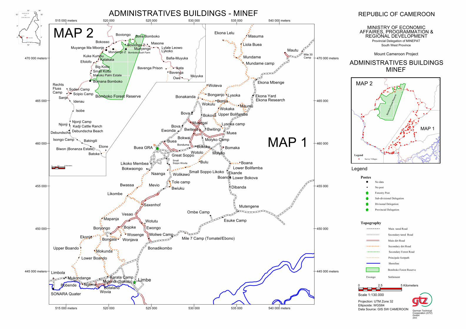
Biwon (Bonanza Estate)
Makoko Palm Estate
Small Kotto
Big Kotto
Muyange Ma Mbonje
Mondongo 2
Bafia-Muyuka
Bomboko Bush Farm
EfolofoKatakata
Bova Bomboko
Ikata
Owe
Batoke
Lykoko
Sanje
Soden Camp
Munyenge
Debundscha Beach
Bavenga Prison
Njonji
Debundscha
Kadji Cattle Ranch
Boviongo 2
Idenau
RechtsFlussCamp
Njonji Camp
Lylale Leowo
Scipio Camp
Kuke Kumbu
Isobe
Bavenga
Isongo Camp
Bokosso
Muyuka
Bakingili
Boviongo
Etone
Bomana Bomboko
Masone
Bomboko Forest Reserve
0 2.5 5 Kilometers
Maumu
Wotutu
Saxenhof
Ombe Camp
Molyko
Ewongo
Bokwaongo
Boana
Bonadikombo
Naanga
Likoko Membea
Liola Buea
Upper Bolifamba
Buea GRA
Bonjia
Mundame camp
Wokaka
Mevio
Buea
Mutengene
Wolikawo
Lysoka camp
SmallSoppo Wovila
Tole camp
Bwiuku
Moliwe Camp
Mautu
Esuke Camp
Ekona Lelu
Ewonda
Great Soppo
Bomaka
Muea
Bova 1
Ekona Mbenge
Mile 7 Camp (Tomatel/Ebono)
Small Soppo Likoko
Lysoka
Limbe
Wotolo
Bonduma
Muangai
Ekande
Bova 2
Masuma
Dibanda
Bokwai
SONARA Quater
Bokoko
Bonakanda
Boanda
Bulu
Bwiteva
Lower Bokova
Mukondange
Bobende
Lower Boando
Upper Boando
Ngeme
Limbola
Bokova
Wokulu
Ekonjo
Bwassa
Mokunda
Molyko Camp
Wovia
Mokindi (Sokolo)
Mapanja
Botaland
Karata Camp
Lower Bolifamba
Mile 30Camp
Bonjongo
Bwitingi
Bongala
Bojoke
Bonganjo
Wonjava
Ekona Research
Woteva
Wosenge
Ekona Yard
Likombe
Vesao
Mundame
445 000 meters
450 000
455 000
460 000
465 000
470 000 meters
515 000 meters 520 000 525 000 530 000 535 000 540 000 meters
445 000 meters
450 000
455 000
460 000
465 000
470 000 meters
515 000 meters 520 000 525 000 530 000 535 000 540 000 meters
MAP 2
MAP 1
Bom
boko
Fore
st R
ese
rve
MAP 1
MAP 2
4°
8°
112°
112° 116°
4°
8°
112°
112° 116°
REPU BLIC
O F
CA M ERO O N
Buea
Y aounde
Legend
Survey Villages
Topography
Main tared Road
Secondary tared Road
Main dirt Road
Secondary dirt Road
Secondary Forest Road
Principale footpath
Shoreline
Bomboko Forest Reserve
Ewongo Settlement
Postes
No data
No post
Forestry Post
Sub-divisional Delegation
Divisonal Delegation
Provincial Delegation
Legend
REPUBLIC OF CAMEROON
MINISTRY OF ECONOMICAFFAIRES, PROGRAMMATION &
REGIONAL DEVELOPMENTProvincial Delegation of MINEPAT
South West Province
Mount Cameroon Project
ADMINISTRATIVES BUILDINGS - MINEF
ADMINISTRATIVES BUILDINGSMINEF
Scale 1:130.000
Projection: UTM Zone 32
Ellipsoide: WGS84
Data Source: GIS SW CAMEROON
0 2.5 5 Kilometers
German TechnicalCooperation (GTZ)GmbH2003

Biwon (Bonanza Estate)
Makoko Palm Estate
Small Kotto
Big Kotto
Muyange Ma Mbonje
Mondongo 2
Bafia-Muyuka
Bomboko Bush Farm
EfolofoKatakata
Bova Bomboko
Ikata
Owe
Batoke
Lykoko
Sanje
Soden Camp
Munyenge
Debundscha Beach
Bavenga Prison
Njonji
Debundscha
Kadji Cattle Ranch
Boviongo 2
Idenau
RechtsFlussCamp
Njonji Camp
Lylale Leowo
Scipio Camp
Kuke Kumbu
Isobe
Bavenga
Isongo Camp
Bokosso
Muyuka
Bakingili
Boviongo
Etone
Bomana Bomboko
Masone
Bomboko Forest Reserve
0 2.5 5 Kilometers
Maumu
Wotutu
Saxenhof
Ombe Camp
Molyko
Ewongo
Bokwaongo
Boana
Bonadikombo
Naanga
Likoko Membea
Liola Buea
Upper Bolifamba
Buea GRA
Bonjia
Mundame camp
Wokaka
Mevio
Buea
Mutengene
Wolikawo
Lysoka camp
SmallSoppo Wovila
Tole camp
Bwiuku
Moliwe Camp
Mautu
Esuke Camp
Ekona Lelu
Ewonda
Great Soppo
Bomaka
Muea
Bova 1
Ekona Mbenge
Mile 7 Camp (Tomatel/Ebono)
Small Soppo Likoko
Lysoka
Limbe
Wotolo
Bonduma
Muangai
Ekande
Bova 2
Masuma
Dibanda
Bokwai
SONARA Quater
Bokoko
Bonakanda
Boanda
Bulu
Bwiteva
Lower Bokova
Mukondange
Bobende
Lower Boando
Upper Boando
Ngeme
Limbola
Bokova
Wokulu
Ekonjo
Bwassa
Mokunda
Molyko Camp
Wovia
Mokindi (Sokolo)
Mapanja
Botaland
Karata Camp
Lower Bolifamba
Mile 30Camp
Bonjongo
Bwitingi
Bongala
Bojoke
Bonganjo
Wonjava
Ekona Research
Woteva
Wosenge
Ekona Yard
Likombe
Vesao
Mundame
445 000 meters
450 000
455 000
460 000
465 000
470 000 meters
515 000 meters 520 000 525 000 530 000 535 000 540 000 meters
445 000 meters
450 000
455 000
460 000
465 000
470 000 meters
515 000 meters 520 000 525 000 530 000 535 000 540 000 meters
MAP 2
MAP 1
Bom
boko
Fore
st R
ese
rve
MAP 1
MAP 2
4°
8°
112°
112° 116°
4°
8°
112°
112° 116°
REPU BLIC
O F
CA M ERO O N
Buea
Y aounde
Legend
Survey Villages
Topography
Main tared Road
Secondary tared Road
Main dirt Road
Secondary dirt Road
Secondary Forest Road
Principale footpath
Shoreline
Bomboko Forest Reserve
Ewongo Settlement
Numbers
No data
No post
Non-functional extension post
Staffed extension post
Sub-division Delegation
Divisional Delegation
Provincal Delegation
Legend
REPUBLIC OF CAMEROON
MINISTRY OF ECONOMICAFFAIRES, PROGRAMMATION &
REGIONAL DEVELOPMENTProvincial Delegation of MINEPAT
South West Province
Mount Cameroon Project
ADMINISTRATIVES BUILDINGS - MINAGRI
ADMINISTRATIVES BUILDINGSMINAGRI
Scale 1:130.000
Projection: UTM Zone 32
Ellipsoide: WGS84
Data Source: GIS SW CAMEROON
0 2.5 5 Kilometers
German TechnicalCooperation (GTZ)GmbH2003
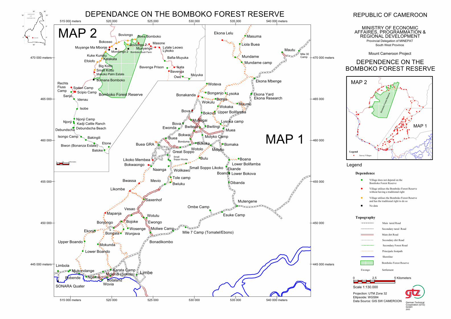
Biwon (Bonanza Estate)
Makoko Palm Estate
Small Kotto
Big Kotto
Muyange Ma Mbonje
Mondongo 2
Bafia-Muyuka
Bomboko Bush Farm
EfolofoKatakata
Bova Bomboko
Ikata
Owe
Batoke
Lykoko
Sanje
Soden Camp
Munyenge
Debundscha Beach
Bavenga Prison
Njonji
Debundscha
Kadji Cattle Ranch
Boviongo 2
Idenau
RechtsFlussCamp
Njonji Camp
Lylale Leowo
Scipio Camp
Kuke Kumbu
Isobe
Bavenga
Isongo Camp
Bokosso
Muyuka
Bakingili
Boviongo
Etone
Bomana Bomboko
Masone
Bomboko Forest Reserve
0 2.5 5 Kilometers
Maumu
Wotutu
Saxenhof
Ombe Camp
Molyko
Ewongo
Bokwaongo
Boana
Bonadikombo
Naanga
Likoko Membea
Liola Buea
Upper Bolifamba
Buea GRA
Bonjia
Mundame camp
Wokaka
Mevio
Buea
Mutengene
Wolikawo
Lysoka camp
SmallSoppo Wovila
Tole camp
Bwiuku
Moliwe Camp
Mautu
Esuke Camp
Ekona Lelu
Ewonda
Great Soppo
Bomaka
Muea
Bova 1
Ekona Mbenge
Mile 7 Camp (Tomatel/Ebono)
Small Soppo Likoko
Lysoka
Limbe
Wotolo
Bonduma
Muangai
Ekande
Bova 2
Masuma
Dibanda
Bokwai
SONARA Quater
Bokoko
Bonakanda
Boanda
Bulu
Bwiteva
Lower Bokova
Mukondange
Bobende
Lower Boando
Upper Boando
Ngeme
Limbola
Bokova
Wokulu
Ekonjo
Bwassa
Mokunda
Molyko Camp
Wovia
Mokindi (Sokolo)
Mapanja
Botaland
Karata Camp
Lower Bolifamba
Mile 30Camp
Bonjongo
Bwitingi
Bongala
Bojoke
Bonganjo
Wonjava
Ekona Research
Woteva
Wosenge
Ekona Yard
Likombe
Vesao
Mundame
445 000 meters
450 000
455 000
460 000
465 000
470 000 meters
515 000 meters 520 000 525 000 530 000 535 000 540 000 meters
445 000 meters
450 000
455 000
460 000
465 000
470 000 meters
515 000 meters 520 000 525 000 530 000 535 000 540 000 meters
MAP 2
MAP 1
Bom
boko
Fore
st R
ese
rve
MAP 1
MAP 2
4°
8°
112°
112° 116°
4°
8°
112°
112° 116°
REPU BLIC
O F
CA M ERO O N
Buea
Y aounde
Legend
Survey Villages
Topography
Main tared Road
Secondary tared Road
Main dirt Road
Secondary dirt Road
Secondary Forest Road
Principale footpath
Shoreline
Bomboko Forest Reserve
Ewongo Settlement
Dependence
Village does not depend on the
Bomboko Forest Reserve
Village utilises the Bomboko Forest Reserve
without having a traditional right
Village utilises the Bomboko Forest Reserve
and has the traditional right to do so
No data
Legend
REPUBLIC OF CAMEROON
MINISTRY OF ECONOMICAFFAIRES, PROGRAMMATION &
REGIONAL DEVELOPMENTProvincial Delegation of MINEPAT
South West Province
Mount Cameroon Project
DEPENDANCE ON THE BOMBOKO FOREST RESERVE
DEPENDENCE ON THEBOMBOKO FOREST RESERVE
Scale 1:130.000
Projection: UTM Zone 32
Ellipsoide: WGS84
Data Source: GIS SW CAMEROON
0 2.5 5 Kilometers
German TechnicalCooperation (GTZ)GmbH2003
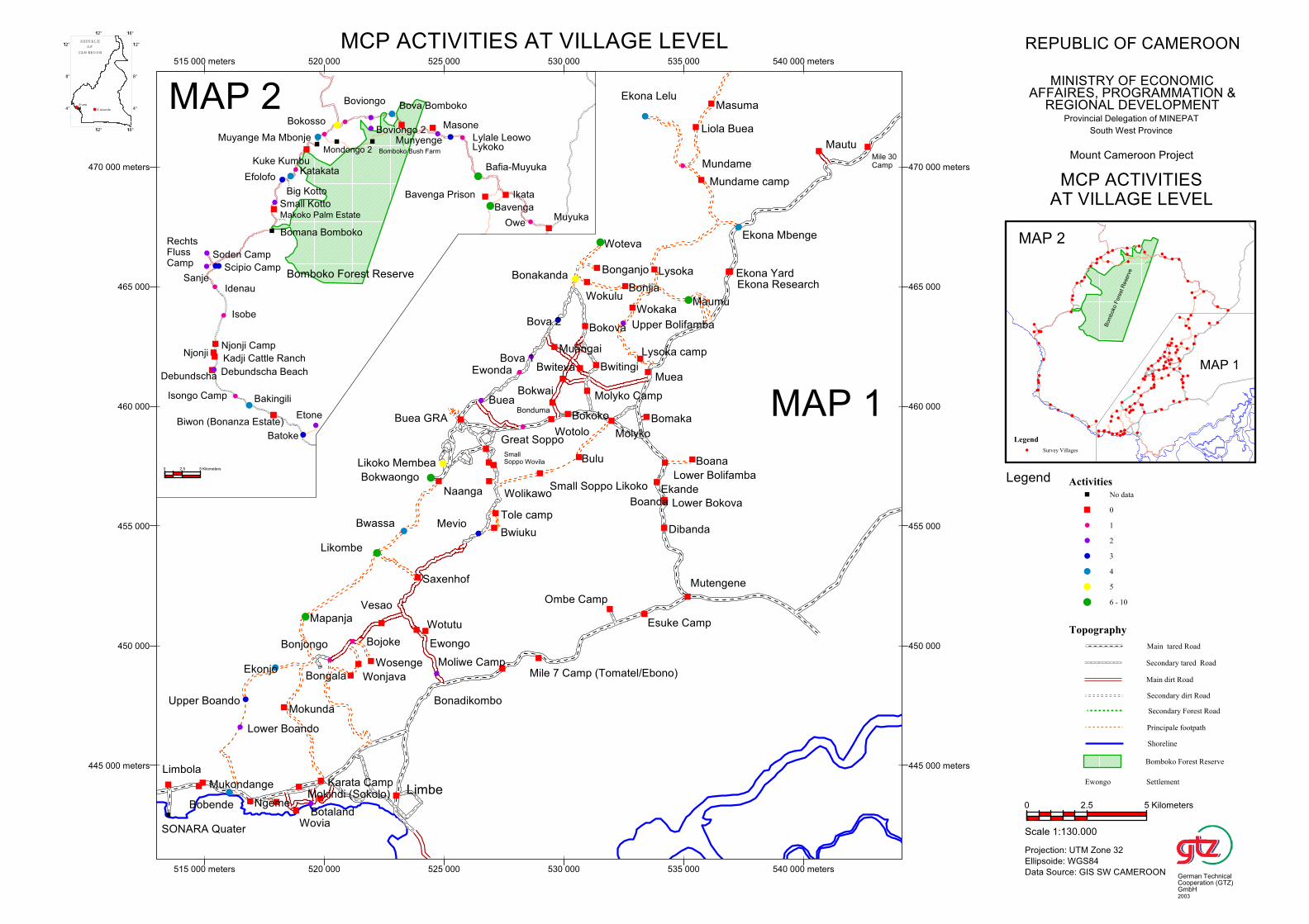
Biwon (Bonanza Estate)
Makoko Palm Estate
Small Kotto
Big Kotto
Muyange Ma Mbonje
Mondongo 2
Bafia-Muyuka
Bomboko Bush Farm
EfolofoKatakata
Bova Bomboko
Ikata
Owe
Batoke
Lykoko
Sanje
Soden Camp
Munyenge
Debundscha Beach
Bavenga Prison
Njonji
Debundscha
Kadji Cattle Ranch
Boviongo 2
Idenau
RechtsFlussCamp
Njonji Camp
Lylale Leowo
Scipio Camp
Kuke Kumbu
Isobe
Bavenga
Isongo Camp
Bokosso
Muyuka
Bakingili
Boviongo
Etone
Bomana Bomboko
Masone
Bomboko Forest Reserve
0 2.5 5 Kilometers
Maumu
Wotutu
Saxenhof
Ombe Camp
Molyko
Ewongo
Bokwaongo
Boana
Bonadikombo
Naanga
Likoko Membea
Liola Buea
Upper Bolifamba
Buea GRA
Bonjia
Mundame camp
Wokaka
Mevio
Buea
Mutengene
Wolikawo
Lysoka camp
SmallSoppo Wovila
Tole camp
Bwiuku
Moliwe Camp
Mautu
Esuke Camp
Ekona Lelu
Ewonda
Great Soppo
Bomaka
Muea
Bova 1
Ekona Mbenge
Mile 7 Camp (Tomatel/Ebono)
Small Soppo Likoko
Lysoka
Limbe
Wotolo
Bonduma
Muangai
Ekande
Bova 2
Masuma
Dibanda
Bokwai
SONARA Quater
Bokoko
Bonakanda
Boanda
Bulu
Bwiteva
Lower Bokova
Mukondange
Bobende
Lower Boando
Upper Boando
Ngeme
Limbola
Bokova
Wokulu
Ekonjo
Bwassa
Mokunda
Molyko Camp
Wovia
Mokindi (Sokolo)
Mapanja
Botaland
Karata Camp
Lower Bolifamba
Mile 30Camp
Bonjongo
Bwitingi
Bongala
Bojoke
Bonganjo
Wonjava
Ekona Research
Woteva
Wosenge
Ekona Yard
Likombe
Vesao
Mundame
445 000 meters
450 000
455 000
460 000
465 000
470 000 meters
515 000 meters 520 000 525 000 530 000 535 000 540 000 meters
445 000 meters
450 000
455 000
460 000
465 000
470 000 meters
515 000 meters 520 000 525 000 530 000 535 000 540 000 meters
MAP 2
MAP 1
Bom
boko
Fore
st R
ese
rve
MAP 1
MAP 2
4°
8°
112°
112° 116°
4°
8°
112°
112° 116°
REPU BLIC
O F
CA M ERO O N
Buea
Y aounde
Legend
Survey Villages
Topography
Main tared Road
Secondary tared Road
Main dirt Road
Secondary dirt Road
Secondary Forest Road
Principale footpath
Shoreline
Bomboko Forest Reserve
Ewongo Settlement
Activities
No data
0
1
2
3
4
5
6 - 10
Legend
REPUBLIC OF CAMEROON
MINISTRY OF ECONOMICAFFAIRES, PROGRAMMATION &
REGIONAL DEVELOPMENTProvincial Delegation of MINEPAT
South West Province
Mount Cameroon Project
MCP ACTIVITIES AT VILLAGE LEVEL
MCP ACTIVITIESAT VILLAGE LEVEL
Scale 1:130.000
Projection: UTM Zone 32
Ellipsoide: WGS84
Data Source: GIS SW CAMEROON
0 2.5 5 Kilometers
German TechnicalCooperation (GTZ)GmbH2003
Schmidt-Soltau: Rural livelihood and social infrastructure around Mt. Cameroon - Final Report
Appendices
Appendix 1: Terms of reference
Appendix 2: Itinerary
Appendix 3: Legend for village mapping
Appendix 4: Questionnaire
Appendix 5: Interview guideline
Appendix 6: Individual questionnaire (Census)
Appendix 7: The village map of Mokinda (Sokolo) Part 1
Schmidt-Soltau: Rural livelihood and social infrastructure around Mt. Cameroon Final Report - Appendix 1
Appendix 1:
Terms of Reference
1
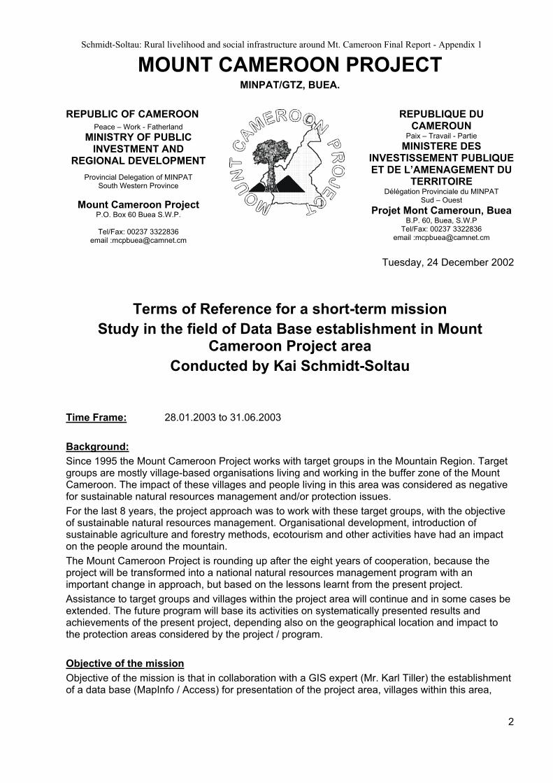
Schmidt-Soltau: Rural livelihood and social infrastructure around Mt. Cameroon Final Report - Appendix 1
MOUNT CAMEROON PROJECT MINPAT/GTZ, BUEA.
REPUBLIC OF CAMEROONPeace – Work - Fatherland
MINISTRY OF PUBLICINVESTMENT AND
REGIONAL DEVELOPMENT
Provincial Delegation of MINPATSouth Western Province
Mount Cameroon ProjectP.O. Box 60 Buea S.W.P.
Tel/Fax: 00237 3322836email :[email protected]
REPUBLIQUE DU CAMEROUN
Paix – Travail - Partie
MINISTERE DES INVESTISSEMENT PUBLIQUE ET DE L’AMENAGEMENT DU
TERRITOIREDélégation Provinciale du MINPAT
Sud – Ouest
Projet Mont Cameroun, BueaB.P. 60, Buea, S.W.P
Tel/Fax: 00237 3322836email :[email protected]
Tuesday, 24 December 2002
Terms of Reference for a short-term mission
Study in the field of Data Base establishment in Mount Cameroon Project area
Conducted by Kai Schmidt-Soltau
Time Frame: 28.01.2003 to 31.06.2003
Background:
Since 1995 the Mount Cameroon Project works with target groups in the Mountain Region. Targetgroups are mostly village-based organisations living and working in the buffer zone of the Mount Cameroon. The impact of these villages and people living in this area was considered as negative for sustainable natural resources management and/or protection issues.
For the last 8 years, the project approach was to work with these target groups, with the objectiveof sustainable natural resources management. Organisational development, introduction of sustainable agriculture and forestry methods, ecotourism and other activities have had an impact on the people around the mountain.
The Mount Cameroon Project is rounding up after the eight years of cooperation, because the project will be transformed into a national natural resources management program with an important change in approach, but based on the lessons learnt from the present project.
Assistance to target groups and villages within the project area will continue and in some cases beextended. The future program will base its activities on systematically presented results and achievements of the present project, depending also on the geographical location and impact to the protection areas considered by the project / program.
Objective of the mission
Objective of the mission is that in collaboration with a GIS expert (Mr. Karl Tiller) the establishment of a data base (MapInfo / Access) for presentation of the project area, villages within this area,
2
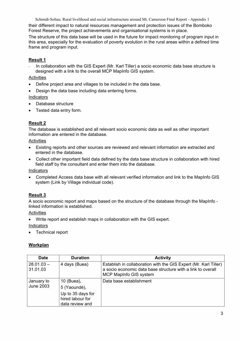
Schmidt-Soltau: Rural livelihood and social infrastructure around Mt. Cameroon Final Report - Appendix 1
their different impact to natural resources management and protection issues of the BombokoForest Reserve, the project achievements and organisational systems is in place.
The structure of this data base will be used in the future for impact monitoring of program input in this area, especially for the evaluation of poverty evolution in the rural areas within a defined time frame and program input.
Result 1
- In collaboration with the GIS Expert (Mr. Karl Tiller) a socio economic data base structure is designed with a link to the overall MCP MapInfo GIS system.
Activities
Define project area and villages to be included in the data base.
Design the data base including data entering forms.
Indicators
Database structure
Tested data entry form.
Result 2
The database is established and all relevant socio economic data as well as other important information are entered in the database.
Activities
Existing reports and other sources are reviewed and relevant information are extracted and entered in the database.
Collect other important field data defined by the data base structure in collaboration with hired field staff by the consultant and enter them into the database.
Indicators
Completed Access data base with all relevant verified information and link to the MapInfo GIS system (Link by Village individual code).
Result 3
A socio economic report and maps based on the structure of the database through the MapInfo -linked information is established.
Activities
Write report and establish maps in collaboration with the GIS expert.
Indicators
Technical report
Workplan
Date Duration Activity
28.01.03 – 31.01.03
4 days (Buea) Establish in collaboration with the GIS Expert (Mr. Karl Tiller)a socio economic data base structure with a link to overall MCP MapInfo GIS system
January to June 2003
10 (Buea),
5 (Yaoundé),
Up to 35 days for hired labour fordata review and
Data base establishment
3

Schmidt-Soltau: Rural livelihood and social infrastructure around Mt. Cameroon Final Report - Appendix 1
4
input.
January to June 2003
25 days,
Up to 100 days of field work by hired labour.
Data collection with hired field staff in the defined project area.
June 2003 4 days Report writing including maps established with the GIS expert.
Presentation of the results
The results will be presented through a technical report (1 bounded hard copy, 1non bounded hard copy and one soft copy on CD).
Intermediate results after field trips and decision making meeting will be presented by minutes.
At the end of the mission a 1 hour presentation to project and partner staff will be made.
K.Schmidt-CorsittoProject Adviser
Schmidt-Soltau: Rural livelihood and social infrastructure around Mt. Cameroon Final Report - Appendix 2
Appendix 2: Itinerary
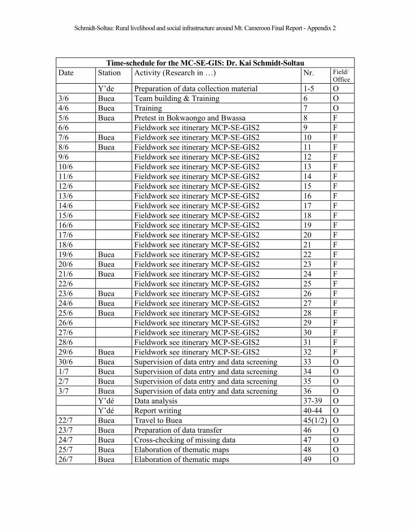
Schmidt-Soltau: Rural livelihood and social infrastructure around Mt. Cameroon Final Report - Appendix 2
Time-schedule for the MC-SE-GIS: Dr. Kai Schmidt-Soltau
Date Station Activity (Research in …) Nr. Field/
Office
Y’de Preparation of data collection material 1-5 O
3/6 Buea Team building & Training 6 O
4/6 Buea Training 7 O
5/6 Buea Pretest in Bokwaongo and Bwassa 8 F
6/6 Fieldwork see itinerary MCP-SE-GIS2 9 F
7/6 Buea Fieldwork see itinerary MCP-SE-GIS2 10 F
8/6 Buea Fieldwork see itinerary MCP-SE-GIS2 11 F
9/6 Fieldwork see itinerary MCP-SE-GIS2 12 F
10/6 Fieldwork see itinerary MCP-SE-GIS2 13 F
11/6 Fieldwork see itinerary MCP-SE-GIS2 14 F
12/6 Fieldwork see itinerary MCP-SE-GIS2 15 F
13/6 Fieldwork see itinerary MCP-SE-GIS2 16 F
14/6 Fieldwork see itinerary MCP-SE-GIS2 17 F
15/6 Fieldwork see itinerary MCP-SE-GIS2 18 F
16/6 Fieldwork see itinerary MCP-SE-GIS2 19 F
17/6 Fieldwork see itinerary MCP-SE-GIS2 20 F
18/6 Fieldwork see itinerary MCP-SE-GIS2 21 F
19/6 Buea Fieldwork see itinerary MCP-SE-GIS2 22 F
20/6 Buea Fieldwork see itinerary MCP-SE-GIS2 23 F
21/6 Buea Fieldwork see itinerary MCP-SE-GIS2 24 F
22/6 Fieldwork see itinerary MCP-SE-GIS2 25 F
23/6 Buea Fieldwork see itinerary MCP-SE-GIS2 26 F
24/6 Buea Fieldwork see itinerary MCP-SE-GIS2 27 F
25/6 Buea Fieldwork see itinerary MCP-SE-GIS2 28 F
26/6 Fieldwork see itinerary MCP-SE-GIS2 29 F
27/6 Fieldwork see itinerary MCP-SE-GIS2 30 F
28/6 Fieldwork see itinerary MCP-SE-GIS2 31 F
29/6 Buea Fieldwork see itinerary MCP-SE-GIS2 32 F
30/6 Buea Supervision of data entry and data screening 33 O
1/7 Buea Supervision of data entry and data screening 34 O
2/7 Buea Supervision of data entry and data screening 35 O
3/7 Buea Supervision of data entry and data screening 36 O
Y’dé Data analysis 37-39 O
Y’dé Report writing 40-44 O
22/7 Buea Travel to Buea 45(1/2) O
23/7 Buea Preparation of data transfer 46 O
24/7 Buea Cross-checking of missing data 47 O
25/7 Buea Elaboration of thematic maps 48 O
26/7 Buea Elaboration of thematic maps 49 O
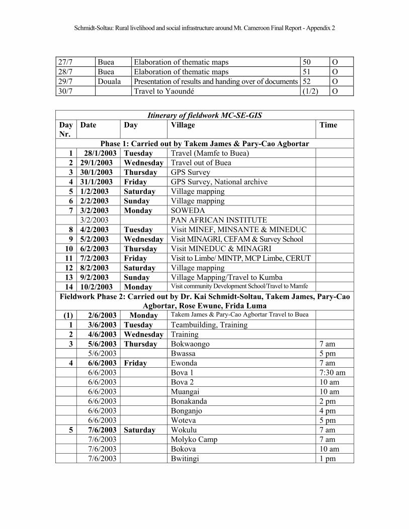
Schmidt-Soltau: Rural livelihood and social infrastructure around Mt. Cameroon Final Report - Appendix 2
27/7 Buea Elaboration of thematic maps 50 O
28/7 Buea Elaboration of thematic maps 51 O
29/7 Douala Presentation of results and handing over of documents 52 O
30/7 Travel to Yaoundé (1/2) O
Itinerary of fieldwork MC-SE-GIS
Day
Nr.
Date Day Village Time
Phase 1: Carried out by Takem James & Pary-Cao Agbortar
1 28/1/2003 Tuesday Travel (Mamfe to Buea)
2 29/1/2003 Wednesday Travel out of Buea
3 30/1/2003 Thursday GPS Survey
4 31/1/2003 Friday GPS Survey, National archive
5 1/2/2003 Saturday Village mapping
6 2/2/2003 Sunday Village mapping
7 3/2/2003 Monday SOWEDA
3/2/2003 PAN AFRICAN INSTITUTE
8 4/2/2003 Tuesday Visit MINEF, MINSANTE & MINEDUC
9 5/2/2003 Wednesday Visit MINAGRI, CEFAM & Survey School
10 6/2/2003 Thursday Visit MINEDUC & MINAGRI
11 7/2/2003 Friday Visit to Limbe/ MINTP, MCP Limbe, CERUT
12 8/2/2003 Saturday Village mapping
13 9/2/2003 Sunday Village Mapping/Travel to Kumba
14 10/2/2003 Monday Visit community Development School/Travel to Mamfe
Fieldwork Phase 2: Carried out by Dr. Kai Schmidt-Soltau, Takem James, Pary-Cao
Agbortar, Rose Ewune, Frida Luma
(1) 2/6/2003 Monday Takem James & Pary-Cao Agbortar Travel to Buea
1 3/6/2003 Tuesday Teambuilding, Training
2 4/6/2003 Wednesday Training
3 5/6/2003 Thursday Bokwaongo 7 am
5/6/2003 Bwassa 5 pm
4 6/6/2003 Friday Ewonda 7 am
6/6/2003 Bova 1 7:30 am
6/6/2003 Bova 2 10 am
6/6/2003 Muangai 10 am
6/6/2003 Bonakanda 2 pm
6/6/2003 Bonganjo 4 pm
6/6/2003 Woteva 5 pm
5 7/6/2003 Saturday Wokulu 7 am
7/6/2003 Molyko Camp 7 am
7/6/2003 Bokova 10 am
7/6/2003 Bwitingi 1 pm

Schmidt-Soltau: Rural livelihood and social infrastructure around Mt. Cameroon Final Report - Appendix 2
7/6/2003 Bwiteva 1 pm
7/6/2003 Bokwai 2 pm
7/6/2003 Upper Bolifamba 4 pm
7/6/2003 Bonduma 5 pm
6 8/6/2003 Sunday Muea 7 am
8/6/2003 Lysoka Camp 7 am
8/6/2003 Wokaka 12 am
8/6/2003 Bonjia 1 pm
8/6/2003 Lysoka 2 pm
8/6/2003 Maumu 3 pm
7 9/6/2003 Monday Ekona Yard 7 am
9/6/2003 Ekona Mbenge 7 am
9/6/2003 Ekona Research 1 pm
9/6/2003 Mundame Camp 3 pm
9/6/2003 Mundame 5 pm
8 10/6/2003 Tuesday Ekona Lelu 7 am
10/6/2003 Mautu 7 am
10/6/2003 Liola Buea 7 am
10/6/2003 Masuma 10 am
10/6/2003 Mile 30 Camp 3 pm
10/6/2003 Muyuka 3 pm
9 11/6/2003 Wednesday Owe 7 am
11/6/2003 Ikata 2 pm
11/6/2003 Bavenga Native 2 pm
11/6/2003 Bavenga Prison 5 pm
10 12/6/2003 Thursday Bafia - 7 am
12/6/2003 Lykoko 7 am
12/6/2003 Lilale 2 pm
12/6/2003 Munyenge 4 pm
11 13/6/2003 Friday Bomboko Forest Camp 7 am
13/6/2003 Bova Bomboko 7 am
13/6/2003 Masone 9 am
13/6/2003 Boviongo 10 am
13/6/2003 Boviongo II 11 am
13/6/2003 Ebie 3 pm
13/6/2003 Bokosso 5 pm
12 14/6/2003 Saturday Mundongo 7 am
14/6/2003 Munyange 7 am
14/6/2003 Mweli 11 am
14/6/2003 Kuke Kumbo 11 am
14/6/2003 Katakata 2 pm
14/6/2003 Efolofo 2 pm
14/6/2003 Big Kotto 4 pm
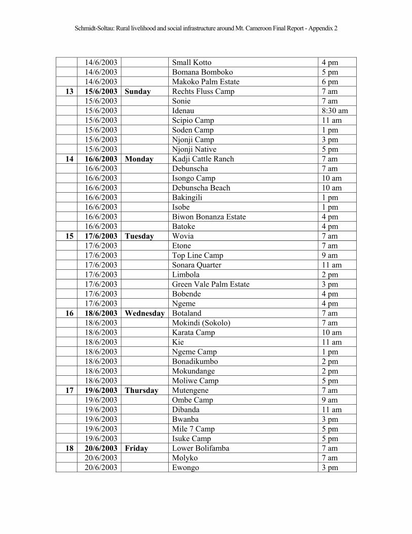
Schmidt-Soltau: Rural livelihood and social infrastructure around Mt. Cameroon Final Report - Appendix 2
14/6/2003 Small Kotto 4 pm
14/6/2003 Bomana Bomboko 5 pm
14/6/2003 Makoko Palm Estate 6 pm
13 15/6/2003 Sunday Rechts Fluss Camp 7 am
15/6/2003 Sonie 7 am
15/6/2003 Idenau 8:30 am
15/6/2003 Scipio Camp 11 am
15/6/2003 Soden Camp 1 pm
15/6/2003 Njonji Camp 3 pm
15/6/2003 Njonji Native 5 pm
14 16/6/2003 Monday Kadji Cattle Ranch 7 am
16/6/2003 Debunscha 7 am
16/6/2003 Isongo Camp 10 am
16/6/2003 Debunscha Beach 10 am
16/6/2003 Bakingili 1 pm
16/6/2003 Isobe 1 pm
16/6/2003 Biwon Bonanza Estate 4 pm
16/6/2003 Batoke 4 pm
15 17/6/2003 Tuesday Wovia 7 am
17/6/2003 Etone 7 am
17/6/2003 Top Line Camp 9 am
17/6/2003 Sonara Quarter 11 am
17/6/2003 Limbola 2 pm
17/6/2003 Green Vale Palm Estate 3 pm
17/6/2003 Bobende 4 pm
17/6/2003 Ngeme 4 pm
16 18/6/2003 Wednesday Botaland 7 am
18/6/2003 Mokindi (Sokolo) 7 am
18/6/2003 Karata Camp 10 am
18/6/2003 Kie 11 am
18/6/2003 Ngeme Camp 1 pm
18/6/2003 Bonadikumbo 2 pm
18/6/2003 Mokundange 2 pm
18/6/2003 Moliwe Camp 5 pm
17 19/6/2003 Thursday Mutengene 7 am
19/6/2003 Ombe Camp 9 am
19/6/2003 Dibanda 11 am
19/6/2003 Bwanba 3 pm
19/6/2003 Mile 7 Camp 5 pm
19/6/2003 Isuke Camp 5 pm
18 20/6/2003 Friday Lower Bolifamba 7 am
20/6/2003 Molyko 7 am
20/6/2003 Ewongo 3 pm

Schmidt-Soltau: Rural livelihood and social infrastructure around Mt. Cameroon Final Report - Appendix 2
20/6/2003 Wotutu 4:30 pm
19 21/6/2003 Saturday Lower Bokova 7 am
21/6/2003 Bokoko 7 am
21/6/2003 Ekande 9 am
21/6/2003 Wotolo 1 pm
20 22/6/2003 Sunday Small Soppo Wovilla 7 am
22/6/2003 Tole Camp 7 am
22/6/2003 Biuku 9 am
22/6/2003 Small Soppo Likoko 10 am
22/6/2003 Small Soppo Woteke 11 am
22/6/2003 Wolikawo 11 am
22/6/2003 Mevio 1 pm
22/6/2003 Saxenhof 5 pm
22/6/2003 Boana 5 pm
22/6/2003 Vesao 5 pm
22/6/2003 Bonjongo 7 pm
21 23/6/2003 Monday Ekonjo 7 am
23/6/2003 Bongala 7 am
23/6/2003 Upper Boando 9 am
23/6/2003 Wosenge 9 am
23/6/2003 Lower Boando 11 am
23/6/2003 Bojoke 11 am
23/6/2003 Wanjava 1 pm
23/6/2003 Mokunda 1 pm
23/6/2003 Mapanja 4 pm
23/6/2003 Likombe 5 pm
22 24/6/2003 Tuesday Likoko Membea 7 am
24/6/2003 Bulu 11 am
24/6/2003 Small Soppo Woganga 1 pm
24/6/2003 Buea 1 pm
23 25/6/2003 Wednesday Great Soppo 7 am
25/6/2003 Bomaka 11 am
24 26/6/2003 Thursday Naanga 1 pm
26/6/2003 Buea Governmental area
25 27/6/2003 Friday Limbe
27/6/2003 Bomboko Bush Farm
27/6/2003 Mundongo 2
26 28/6/2003 Saturday Limbe
27 29/6/2003 Sunday Limbe - Data entry
28 30/6/2003 Monday Data entry
29 1/7/2003 Tuesday Data entry
30 2/7/2003 Wednesday Data entry
(2) 3/7/2003 Thursday Takem James & Pary-Cao Agbortar: Travel to Mamfe
Schmidt-Soltau: Rural livelihood and social infrastructure around Mt. Cameroon Final Report - Appendix 3
Appendix 3: Legend for village mapping
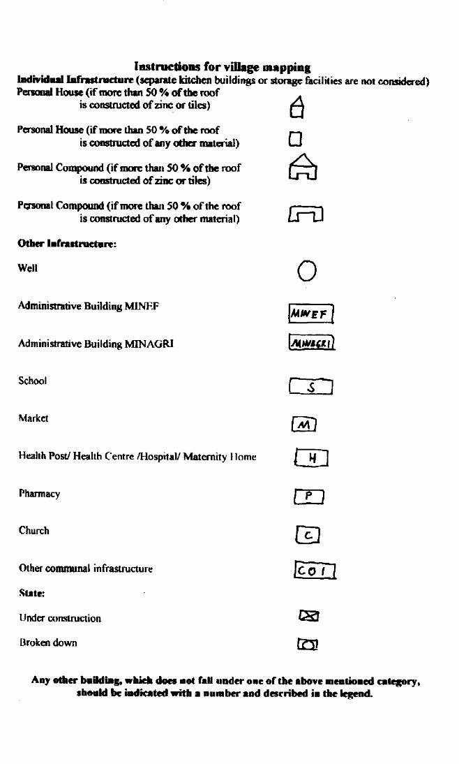

Schmidt-Soltau: Rural livelihood and social infrastructure around Mt. Cameroon Final Report - Appendix 4
Appendix 4: Questionnaire
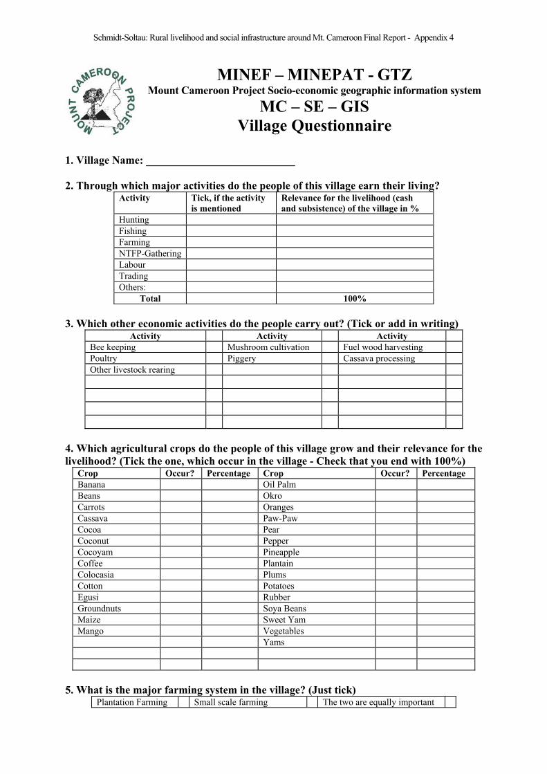
Schmidt-Soltau: Rural livelihood and social infrastructure around Mt. Cameroon Final Report - Appendix 4
MINEF – MINEPAT - GTZ Mount Cameroon Project Socio-economic geographic information system
MC – SE – GIS
Village Questionnaire
1. Village Name: ___________________________
2. Through which major activities do the people of this village earn their living? Activity Tick, if the activity
is mentioned
Relevance for the livelihood (cash
and subsistence) of the village in %
Hunting
Fishing
Farming
NTFP-Gathering
Labour
Trading
Others:
Total 100%
3. Which other economic activities do the people carry out? (Tick or add in writing)Activity Activity Activity
Bee keeping Mushroom cultivation Fuel wood harvesting
Poultry Piggery Cassava processing
Other livestock rearing
4. Which agricultural crops do the people of this village grow and their relevance for the
livelihood? (Tick the one, which occur in the village - Check that you end with 100%)Crop Occur? Percentage Crop Occur? Percentage
Banana Oil Palm
Beans Okro
Carrots Oranges
Cassava Paw-Paw
Cocoa Pear
Coconut Pepper
Cocoyam Pineapple
Coffee Plantain
Colocasia Plums
Cotton Potatoes
Egusi Rubber
Groundnuts Soya Beans
Maize Sweet Yam
Mango Vegetables
Yams
5. What is the major farming system in the village? (Just tick) Plantation Farming Small scale farming The two are equally important
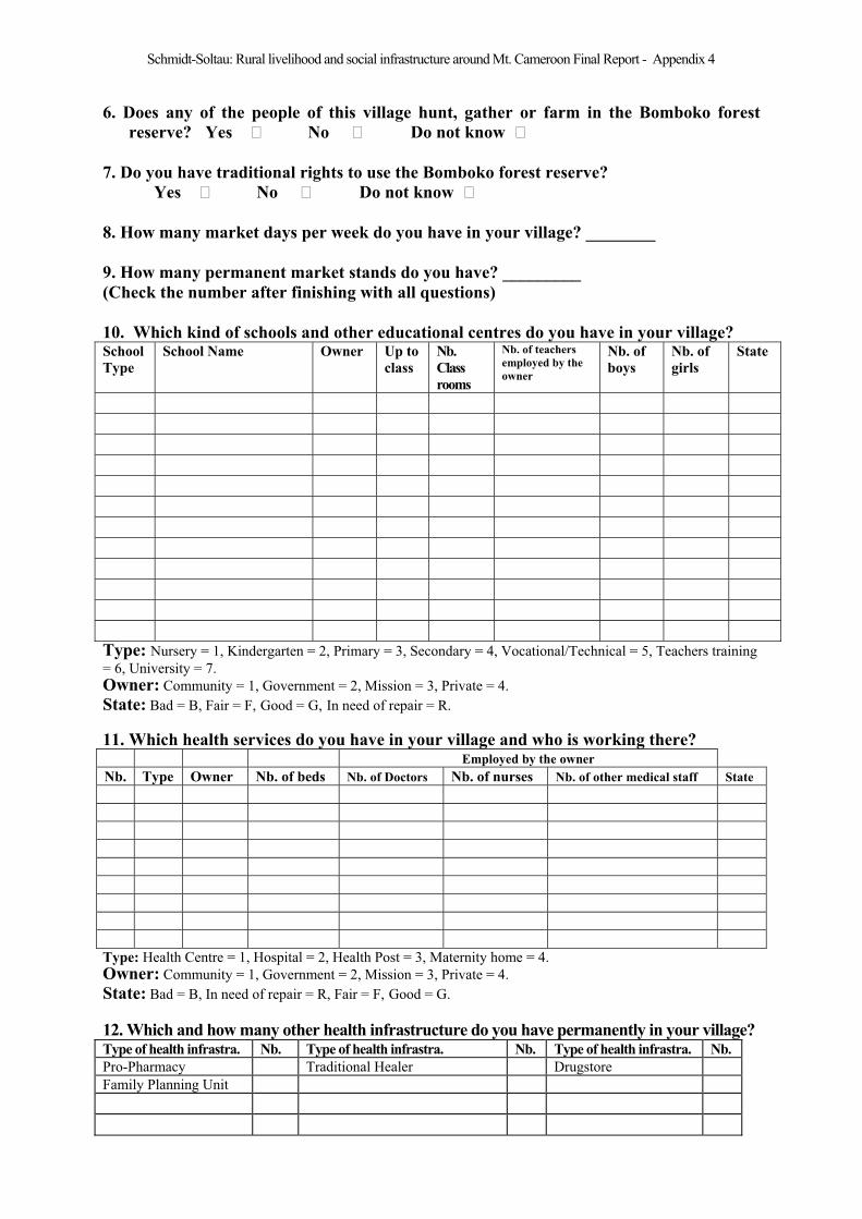
Schmidt-Soltau: Rural livelihood and social infrastructure around Mt. Cameroon Final Report - Appendix 4
6. Does any of the people of this village hunt, gather or farm in the Bomboko forest
reserve? Yes No Do not know
7. Do you have traditional rights to use the Bomboko forest reserve?
Yes No Do not know
8. How many market days per week do you have in your village? ________
9. How many permanent market stands do you have? _________
(Check the number after finishing with all questions)
10. Which kind of schools and other educational centres do you have in your village? School
Type
School Name Owner Up to
class
Nb.
Class
rooms
Nb. of teachers
employed by the
owner
Nb. of
boys
Nb. of
girls
State
Type: Nursery = 1, Kindergarten = 2, Primary = 3, Secondary = 4, Vocational/Technical = 5, Teachers training
= 6, University = 7.
Owner: Community = 1, Government = 2, Mission = 3, Private = 4.
State: Bad = B, Fair = F, Good = G, In need of repair = R.
11. Which health services do you have in your village and who is working there? Employed by the owner
Nb. Type Owner Nb. of beds Nb. of Doctors Nb. of nurses Nb. of other medical staff State
Type: Health Centre = 1, Hospital = 2, Health Post = 3, Maternity home = 4.
Owner: Community = 1, Government = 2, Mission = 3, Private = 4.
State: Bad = B, In need of repair = R, Fair = F, Good = G.
12. Which and how many other health infrastructure do you have permanently in your village? Type of health infrastra. Nb. Type of health infrastra. Nb. Type of health infrastra. Nb.
Pro-Pharmacy Traditional Healer Drugstore
Family Planning Unit

Schmidt-Soltau: Rural livelihood and social infrastructure around Mt. Cameroon Final Report - Appendix 4
13. Where do you get your water from and who is managing this water source? Nb. Type Manager State
Type: Stream/River = 1, Well without pump = 2, Well with pump = 3, Pipe-borne Water = 4, Spring = 5.
Manager: Water committee = 1, Community = 2, SNEC = 3, Individual = 4, Nobody = 5.
State: Bad = B, In need of repair = R, Fair = F, Good = G.
14. Where do you get your electricity from? Type of main electric infrastructure Occur?
National Grid (SONEL)
Community owned generator
Personal generator
State: Bad = B, In need of repair = R, Fair = F, Good = G.
15. Which other governmental buildings do you have in your village? Nr. Type (code below) Nb. of permanent technical staff State
Typ: MINEF Prov. Delegation = 2, MINEF Subdiv. Delegation = 3, MINEF Divisional Delegation = 4,Forestry Post = 5, MINAGRI Prov. Delegation = 6, MINAGRI Subdiv. Delegation = 7, MINAGRI Divisonal
Delegation = 8, MINAGRI Extension Post = 9,
State: Bad = B, In need of repair = R, Fair = F, Good = G.
16. Which kind of activities did the Mt. Cameroon Project carry out in your village? ID_ACT Activity Tick
1 Introduction of sustainable Prunus management
2 Introduction of sustainable wildlife management
3 Introduction of beekeeping
4 Introduction of soap making
5 Introduction of mushroom cultivation
6 General awareness raising
7 Facilitation of group formation
8 Introduction of community forest
9 Joint control activities
10 Introduction of gender balance
11 Introduction of Eco-tourism
12 Joint Forest Reserve management
99 None
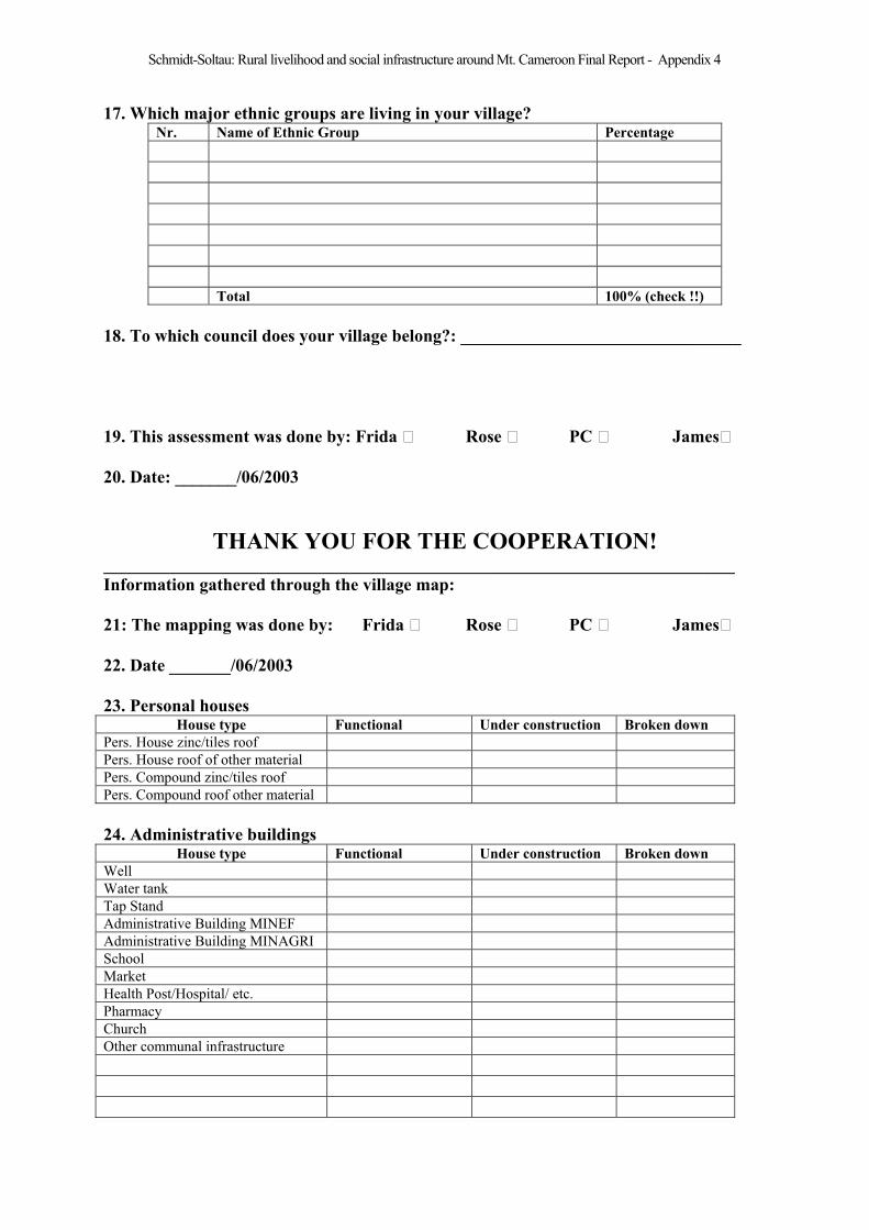
Schmidt-Soltau: Rural livelihood and social infrastructure around Mt. Cameroon Final Report - Appendix 4
17. Which major ethnic groups are living in your village? Nr. Name of Ethnic Group Percentage
Total 100% (check !!)
18. To which council does your village belong?: ________________________________
19. This assessment was done by: Frida Rose PC James
20. Date: _______/06/2003
THANK YOU FOR THE COOPERATION! ________________________________________________________________________
Information gathered through the village map:
21: The mapping was done by: Frida Rose PC James
22. Date _______/06/2003
23. Personal houses House type Functional Under construction Broken down
Pers. House zinc/tiles roof
Pers. House roof of other material
Pers. Compound zinc/tiles roof
Pers. Compound roof other material
24. Administrative buildings House type Functional Under construction Broken down
Well
Water tank
Tap Stand
Administrative Building MINEF
Administrative Building MINAGRI
School
Market
Health Post/Hospital/ etc.
Pharmacy
Church
Other communal infrastructure

Schmidt-Soltau: Rural livelihood and social infrastructure around Mt. Cameroon Final Report - Appendix 5
Appendix 5: Interview Guideline
1
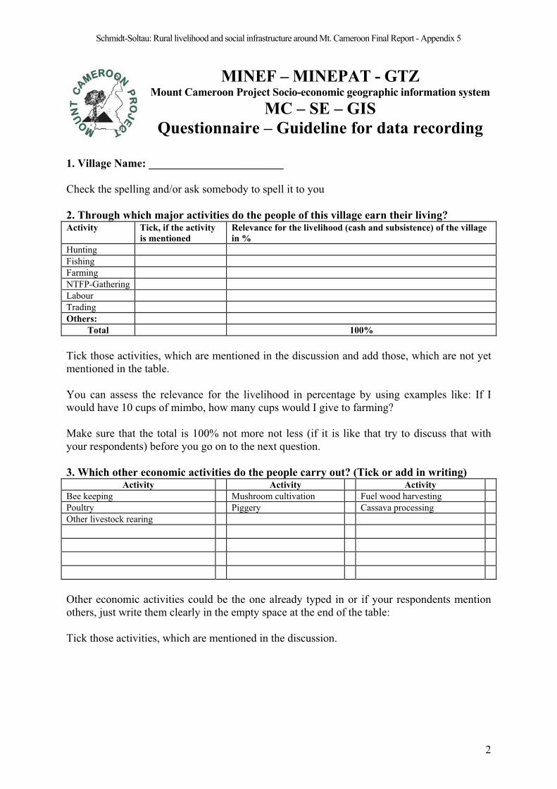
Schmidt-Soltau: Rural livelihood and social infrastructure around Mt. Cameroon Final Report - Appendix 5
MINEF – MINEPAT - GTZ Mount Cameroon Project Socio-economic geographic information system
MC – SE – GIS
Questionnaire – Guideline for data recording
1. Village Name: ________________________
Check the spelling and/or ask somebody to spell it to you
2. Through which major activities do the people of this village earn their living? Activity Tick, if the activity
is mentioned
Relevance for the livelihood (cash and subsistence) of the village
in %
Hunting
Fishing
Farming
NTFP-Gathering
Labour
Trading
Others:
Total 100%
Tick those activities, which are mentioned in the discussion and add those, which are not yet
mentioned in the table.
You can assess the relevance for the livelihood in percentage by using examples like: If I
would have 10 cups of mimbo, how many cups would I give to farming?
Make sure that the total is 100% not more not less (if it is like that try to discuss that with
your respondents) before you go on to the next question.
3. Which other economic activities do the people carry out? (Tick or add in writing)Activity Activity Activity
Bee keeping Mushroom cultivation Fuel wood harvesting
Poultry Piggery Cassava processing
Other livestock rearing
Other economic activities could be the one already typed in or if your respondents mention
others, just write them clearly in the empty space at the end of the table:
Tick those activities, which are mentioned in the discussion.
2
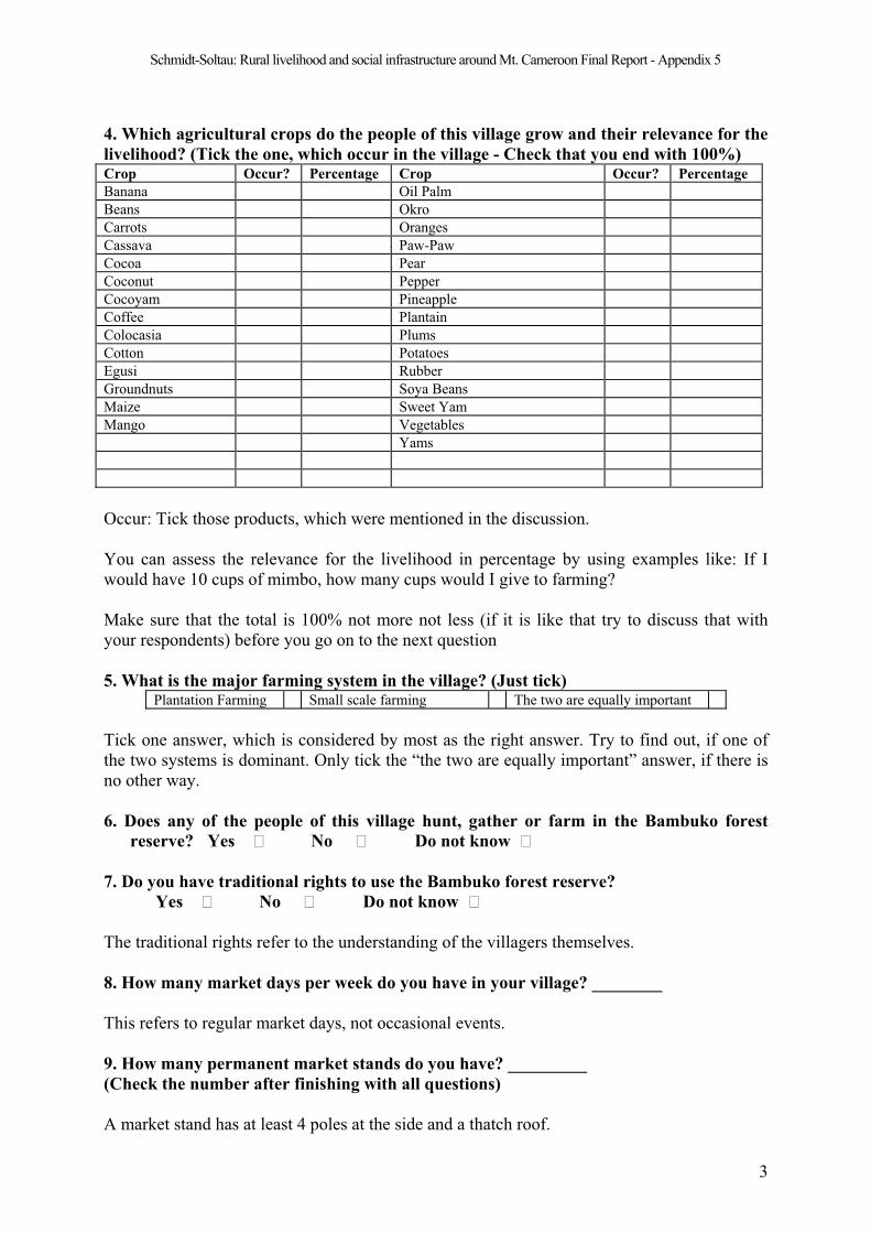
Schmidt-Soltau: Rural livelihood and social infrastructure around Mt. Cameroon Final Report - Appendix 5
4. Which agricultural crops do the people of this village grow and their relevance for the
livelihood? (Tick the one, which occur in the village - Check that you end with 100%)Crop Occur? Percentage Crop Occur? Percentage
Banana Oil Palm
Beans Okro
Carrots Oranges
Cassava Paw-Paw
Cocoa Pear
Coconut Pepper
Cocoyam Pineapple
Coffee Plantain
Colocasia Plums
Cotton Potatoes
Egusi Rubber
Groundnuts Soya Beans
Maize Sweet Yam
Mango Vegetables
Yams
Occur: Tick those products, which were mentioned in the discussion.
You can assess the relevance for the livelihood in percentage by using examples like: If I
would have 10 cups of mimbo, how many cups would I give to farming?
Make sure that the total is 100% not more not less (if it is like that try to discuss that with
your respondents) before you go on to the next question
5. What is the major farming system in the village? (Just tick) Plantation Farming Small scale farming The two are equally important
Tick one answer, which is considered by most as the right answer. Try to find out, if one of
the two systems is dominant. Only tick the “the two are equally important” answer, if there is
no other way.
6. Does any of the people of this village hunt, gather or farm in the Bambuko forest
reserve? Yes No Do not know
7. Do you have traditional rights to use the Bambuko forest reserve?
Yes No Do not know
The traditional rights refer to the understanding of the villagers themselves.
8. How many market days per week do you have in your village? ________
This refers to regular market days, not occasional events.
9. How many permanent market stands do you have? _________
(Check the number after finishing with all questions)
A market stand has at least 4 poles at the side and a thatch roof.
3

Schmidt-Soltau: Rural livelihood and social infrastructure around Mt. Cameroon Final Report - Appendix 5
10. Which kind of schools and other educational centres do you have in your village?School
Type
School Name Owner Up to
class
Nb.
Class
rooms
Nb. of teachers
employed by the
owner
Nb. of
boys
Nb. of
girls
State
School Type refers to the highest definition of a single infrastructure. Utilise for eachinstitution a separate data set.
Typ of Education
OCODE TypEducationInstitution
CM_5311p Nursery
CM_5312p Kindergarden
CM_5313p Primary
CM_5314p Secondary
CM_5316p Vocational/Technical
CM_5317p Teachers training
CM_5318p University
CM_9998 Not applicable
CM_9999 Not available
As owner of an infrastructure, we consider the body, which had paid – according to the village interview - more than 50 % of the running costs of the institution in 2002.
Owner of infrastructure
ID_EO Owner
1 Community
2 Government
3 Mission
4 Privat
Education up to class x, refers to the highest class, which has is operational in the academicyear 2002/2003.
Education up to class
ID_CLASS UpToClass
1 1
2 2
3 3
4 4
5 5
6 6
7 7
8 Form 1
9 Form 2
10 Form 3
11 Form 4
12 Form 5
13 Lower Six
14 Upper Six
15 Not appl.
4

Schmidt-Soltau: Rural livelihood and social infrastructure around Mt. Cameroon Final Report - Appendix 5
The number of class rooms refers to single rooms separated from each other by a wall even if this wall is not permanent (ply-wood). A room like the Ekpe hall or the community hall, which is used as class room is not considered as such in the questionnaire. We only countthose class rooms, which were constructed for that porpose.
The number of teachers employed by the owner refers to fulltime teachers in the academicyear 2002/2003. PTA teachers are counted in community schools, but not in governmentalschools.
The enrolment refers to the academic year 2002/2003 and differentiates between male and female.
State of infrastructure
ID_ST Status
B Bad means that less than 10 % of the above mentioned items are without obvious failure and that the state
of infrastructure prohibits the functioning of the infrastructure
R In need of repair means that either between 10 and 50 % of the above mentioned items are in need of
repair and/or that the functioning of the building is seriously hindered by the problems.
F Fair means that more than half of the above mentioned items are without obvious failure and that none of
the existing problems hinder the smooth functioning of the infrastructure
G Good means that the roofs, walls, floor, doors, windows, furniture (tables and chairs, black boards),
facilities (electricity, toilet, locks, etc.) and the surrounding (garden, veranda, etc.) of the building are all
without obvious failures or needs of repair
11. Which health services do you have in your village and who is working there? Employed by the owner
Nb. Typ Owner Nb. of beds Nb. of Doctors Nb. of nurses Nb. of other medical staff State
Type of health infrastructure refers to the highest definition of a single infrastructure. Utilise
for each institution a separate data set.
Type of Health Institutions
OCODE HealthInstitute
CM_5321 Health Center
CM_5322 Hospital
CM_5323p Health Poste
CM_5324p Maternity home
CM_9999 No Information
As owner of an infrastructure, we consider the body, which had paid – according to the
village interview - more than 50 % of the running costs of the institution in 2002.
Owner of infrastructure
ID_EO Owner
1 Community
2 Government
3 Mission
4 Privat
The number of beds refers to a complete bed frame with a mattress and bed sheets.
5
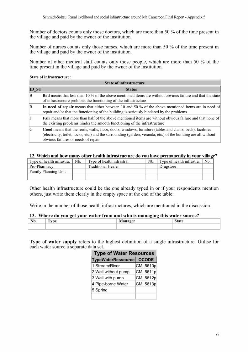
Schmidt-Soltau: Rural livelihood and social infrastructure around Mt. Cameroon Final Report - Appendix 5
Number of doctors counts only those doctors, which are more than 50 % of the time present inthe village and paid by the owner of the institution.
Number of nurses counts only those nurses, which are more than 50 % of the time present in the village and paid by the owner of the institution.
Number of other medical staff counts only those people, which are more than 50 % of thetime present in the village and paid by the owner of the institution.
State of infrastructure:
State of infrastructure
ID_ST Status
B Bad means that less than 10 % of the above mentioned items are without obvious failure and that the state
of infrastructure prohibits the functioning of the infrastructure
R In need of repair means that either between 10 and 50 % of the above mentioned items are in need of
repair and/or that the functioning of the building is seriously hindered by the problems.
F Fair means that more than half of the above mentioned items are without obvious failure and that none of
the existing problems hinder the smooth functioning of the infrastructure
G Good means that the roofs, walls, floor, doors, windows, furniture (tables and chairs, beds), facilities
(electricity, toilet, locks, etc.) and the surrounding (garden, veranda, etc.) of the building are all without
obvious failures or needs of repair
12. Which and how many other health infrastructure do you have permanently in your village?Type of health infrastra. Nb. Type of health infrastra. Nb. Type of health infrastra. Nb.
Pro-Pharmacy Traditional Healer Drugstore
Family Planning Unit
Other health infrastructure could be the one already typed in or if your respondents mention
others, just write them clearly in the empty space at the end of the table:
Write in the number of those health infrastructures, which are mentioned in the discussion.
13. Where do you get your water from and who is managing this water source? Nb. Type Manager State
Type of water supply refers to the highest definition of a single infrastructure. Utilise foreach water source a separate data set.
Type of Water Resources
TypeWaterRessource OCODE
1 Stream/River CM_5610p
2 Well without pump CM_5611p
3 Well with pump CM_5612p
4 Pipe-borne Water CM_5613p
5 Spring
6
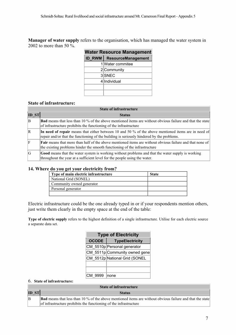
Schmidt-Soltau: Rural livelihood and social infrastructure around Mt. Cameroon Final Report - Appendix 5
Manager of water supply refers to the organisation, which has managed the water system in
2002 to more than 50 %.
Water Resource Management
ID_RWM ResourceManagement
1 Water commitee
2 Community
3 SNEC
4 Individual
State of infrastructure:
State of infrastructure
ID_ST Status
B Bad means that less than 10 % of the above mentioned items are without obvious failure and that the state
of infrastructure prohibits the functioning of the infrastructure
R In need of repair means that either between 10 and 50 % of the above mentioned items are in need of
repair and/or that the functioning of the building is seriously hindered by the problems.
F Fair means that more than half of the above mentioned items are without obvious failure and that none of
the existing problems hinder the smooth functioning of the infrastructure
G Good means that the water system is working without problems and that the water supply is working
throughout the year at a sufficient level for the people using the water.
14. Where do you get your electricity from?Type of main electric infrastructure State
National Grid (SONEL)
Community owned generator
Personal generator
Electric infrastructure could be the one already typed in or if your respondents mention others,
just write them clearly in the empty space at the end of the table:
Type of electric supply refers to the highest definition of a single infrastructure. Utilise for each electric source
a separate data set.
Type of Electricity
OCODE TypeElectricity
CM_5510p Personal generator
CM_5511p Community owned gene
CM_5512p National Grid (SONEL
CM_9999 none
6. State of infrastructure:
State of infrastructure
ID_ST Status
B Bad means that less than 10 % of the above mentioned items are without obvious failure and that the state
of infrastructure prohibits the functioning of the infrastructure
7
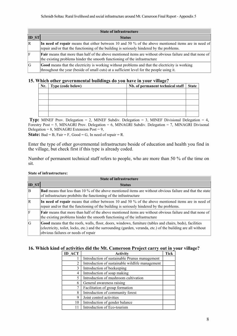
Schmidt-Soltau: Rural livelihood and social infrastructure around Mt. Cameroon Final Report - Appendix 5
State of infrastructure
ID_ST Status
R In need of repair means that either between 10 and 50 % of the above mentioned items are in need of
repair and/or that the functioning of the building is seriously hindered by the problems.
F Fair means that more than half of the above mentioned items are without obvious failure and that none of
the existing problems hinder the smooth functioning of the infrastructure
G Good means that the electricity is working without problems and that the electricity is working
throughout the year (beside of small cuts) at a sufficient level for the people using it.
15. Which other governmental buildings do you have in your village?Nr. Type (code below) Nb. of permanent technical staff State
Typ: MINEF Prov. Delegation = 2, MINEF Subdiv. Delegation = 3, MINEF Divisional Delegation = 4,Forestry Post = 5, MINAGRI Prov. Delegation = 6, MINAGRI Subdiv. Delegation = 7, MINAGRI Divisonal
Delegation = 8, MINAGRI Extension Post = 9,
State: Bad = B, Fair = F, Good = G, In need of repair = R.
Enter the type of other governmental infrastructure beside of education and health you find in the village, but check first if this type is already coded.
Number of permanent technical staff refers to people, who are more than 50 % of the time on sit.
State of infrastructure:
State of infrastructure
ID_ST Status
B Bad means that less than 10 % of the above mentioned items are without obvious failure and that the state
of infrastructure prohibits the functioning of the infrastructure
R In need of repair means that either between 10 and 50 % of the above mentioned items are in need of
repair and/or that the functioning of the building is seriously hindered by the problems.
F Fair means that more than half of the above mentioned items are without obvious failure and that none of
the existing problems hinder the smooth functioning of the infrastructure
G Good means that the roofs, walls, floor, doors, windows, furniture (tables and chairs, beds), facilities
(electricity, toilet, locks, etc.) and the surrounding (garden, veranda, etc.) of the building are all without
obvious failures or needs of repair
16. Which kind of activities did the Mt. Cameroon Project carry out in your village?ID_ACT Activity Tick
1 Introduction of sustainable Prunus management
2 Introduction of sustainable wildlife management
3 Introduction of beekeeping
4 Introduction of soap making
5 Introduction of mushroom cultivation
6 General awareness raising
7 Facilitation of group formation
8 Introduction of community forest
9 Joint control activities
10 Introduction of gender balance
11 Introduction of Eco-tourism
8
Schmidt-Soltau: Rural livelihood and social infrastructure around Mt. Cameroon Final Report - Appendix 5
9
12 Joint Forest Reserve management
99 None
Here more than one answer is possible. Do not ask directly, but try to relate the answers of the
villagers to the topics mentioned here.
17. Which major ethnic groups are living in your village? Nr. Name of Ethnic Group Percentage
Total 100% (check !!)
Major ethnic groups do not refer to individuals but to significant groups (more than 5 % of the
overall village population).
Cross-check the answers, since the chief and his council might be biased in this
question.
18. To which council does your village belong?: ________________________________
Schmidt-Soltau: Rural livelihood and social infrastructure around Mt. Cameroon Final Report - Appendix 6
Appendix 6: Individual Questionnaire (Census)

Schmidt-Soltau: Rural livelihood and social infrastructure around Mt. Cameroon Final Report - Appendix 6
MINEF – MINEPAT - GTZ Mount Cameroon Project Socio-economic geographic information system
MC – SE – GISCensus sheet for individual infrastructure
- Ask the heads of the households living inside the selected building
Village Name: __________________________________________/
1. What is your name? __________________________________________/
2. Please give us some details about those, who live with you permanently in this building:
Sex Age Main Occupation Family Position
3. Please give us some details about those, who are staying here normally, but who are absent at the moment:
Sex Age Main Occupation Family
Position
Place of Stay Reason Do you think they will
live here in the future
Sex: female = 1; male = 2
Age: 0 – 15 = 1; 16 – 30 = 2 ; 31 - 45 = 3; 46 – 60 = 4 ; > 60 = 5
Profession: Farmer = 1, Hunter = 2, Fisherman = 3, Gathering of NTFP = 4, Pupil/Student = 5, Unskilled labourer = 6, Skilled
labourer = 7; Civil servant = 8, Business=9; Retired =10. Other (specify in writing).
Family Position: Household head (hhh)=1; wife/husband of hhh =2; son/daughter of hhh=3; sister/brother of hhh=4; father/mother of
hhh or his wife=5; Grandchildren of hhh=6; Niece/Nephew of hhh=7; aunt/uncle of hhh=8; others = specify!
Place of stay: Cameroon: SW = 11; NW = 12; W = 13; Litt = 14; Centr. = 15; S = 16; E = 17; North = 18; Nigeria = 20;
Africa =30; Europe = 40; USA = 50; others: specify!
Reason: school = 1; university = 2; unskilled labour = 3; other forms of training = 4.
Comeback: yes =1; no=2; Don't know=3
4. This assessment was done by: Frida Rose PC James
5. Date: _______/06/2003

Schmidt-Soltau: Rural livelihood and social infrastructure around Mt. Cameroon Final Report - Appendix 7
Appendix 7: The village map of Mokinda (Sokolo) Part 11
1 The map has 2 parts, each of them covering several pages of which one is presented here. The map
shows the houses on the left side of the Limbe-Ngeme road