ruta de los castillos the castle tour - turismosevilla.org · testigos de la reconquista witnesses...
TRANSCRIPT

Ruta de los Castillos Testigos de la ReconquistaThe Castle Tour Witnesses of the Reconquest
Naturaleza y Tradición

RU
TA D
E L
OS
CA
STIL
LO
S / R
OUTE
OF
THE
CAST
LES
�

Ruta de los Castillos Testigos de la ReconquistaThe Castle Tour Witnesses of the Reconquest

La Ruta de los Castillos, Testigos de la Reconquista, es el Es-cenario inédito por el que transcurre esta propuesta de ocio y cultura, con una cuidada recopilación de datos documentados de interés y leyendas rescatadas de la sabiduría popular, mediante la cual tendremos la oportunidad de descubrir los Castillos del territorio del Consorcio Vía Verde; en la serranía sur de Sevilla y norte de la provincia de Cádiz.
A pocos kilómetros de distancia unos de otros, encontraremos los Castillos descritos en la presente Ruta, jalonados por los hi-tos que representan los acontecimientos y batallas acaecidos en los mismos, con numerosos vestigios de Cartagineses, Romanos, Visigodos, Musulmanes y Cristianos, que tras periodos de gue-rras y paz adaptaron el orden político, social y económico que fue sucediendo a lo largo de los siglos.
El itinerario enlaza los Castillos de El Coronil, Montellano, Olvera, Pruna y Morón de la Frontera, testigos de su historia, batallas y leyendas, ubicados en pueblos acogedores y con los impresionantes paisajes de la Sierra Sur Sevillana y del Norte de la provincia de Cádiz.
La Ruta de los Castillos, Testigos de la Reconquista, es hoy tes-timonio de la riqueza patrimonial de nuestros municipios, he-rencia de siglos de ocupaciones y liberaciones.
Prólogo / Foreword
The Castles Route, Witnesses of the Spanish Reconquest, is the inedited scenery for this new cultural proposal which includes a meticulous compilation of interesting historical dates, documents and legends recovered from popular wis-dom, offering us the opportunity to discover the Castles in the area of the Consorcio Vía Verde; in the Serranía Sur of the province of Seville and the north of the province of Cadiz.
At distances of only few kilometres we can find the various Castles described in this Route, marked by milestones such as battles and historical events that took place in them. The castles offer the visitor many remains of the Carthaginians, Romans, Visigoths, Moors and Christians, who marked the political, social and economic order after periods of war and peace in the course of various centuries.
The itinerary links the Castles of El Coronil, Montellano, Ol-vera, Pruna and Morón de la Frontera, witnesses of their his-tory, battles and legends, situated in friendly villages and the impressive landscapes of the Sierra Sur of Seville and the north of the province of Cadiz.
Nowadays, the Castles Route, Witnesses of the Spanish Re-conquest, illustrates the rich cultural heritage of our villages, the result of centuries of occupations and liberations.

Testigos de la Reconquista Witnesses of the Reconquest. 6
Ruta de los castillos Route of the Castles 8
Elementos que conforman el castillo Elements which form the Castle. 9
La Banda Morisca The Moorish Strip 10
La orden del Temple The Templar Order 11
Castillo de las Aguzaderas The Aguzaderas Castle 12
Castillo de Cote The Cote Castle. 16
Castillo de Morón de la Frontera Castle of Morón de la Frontera. 22
Castillo del Hierro The Del Hierro Castle. 26
Fortaleza Medieval de Olvera Medieval Fortress of Olvera. 30
Fiestas y eventos de interés Festivities and events of interest. 34
Alojamientos Accomodations. 36
Oficinas de turismo Tourism Office. 37
Con qué se puede combinar Possibilities to combination. 37
Índice / Index

RU
TA D
E L
OS
CA
STIL
LO
S / R
OUTE
OF
THE
CAST
LES
� Las comarcas de la Sierra Sur de Sevilla y la Sierra Norte de Cádiz, con multitud de siglos de historia, han sido lugar de trán-sito obligado para pueblos y culturas diversas, de manera que han dejado un portentoso legado histórico que destaca por sus impresionantes castillos medievales.Este espacio geográfico está marcado en la historia de Andalucía por su carácter fronterizo, que lo ha hecho atesorar un vasto patrimonio cultural a lo largo de su dilatado devenir de siglos; fronteras abiertas que han sido testigos de la evolución histórica y de esas distintas influencias culturales que han hecho de An-dalucía una tierra singular. El admirable patrimonio monumen-tal que posee es herencia directa de la época de la Reconquista cristiana, producto de las continuas luchas entre cristianos y mu-sulmanes por el dominio definitivo de Al-Andalus, una tierra desde el principio de los tiempos codiciada por todas las civili-zaciones con las que ha tenido contacto.El establecimiento de la frontera más occidental entre el Reino de Castilla y León y el Reino de Granada en nuestras sierras (s. XIII), permitirá a éstas adquirir un inusual protagonismo hasta el último momento de la Reconquista. Es en esta época cuando nuestro territorio juega su papel más importante en la Historia, y durante un largo período de tiempo (s. XIII-¬XV) surgirán o se consolidarán la mayoría de los pueblos de estas comarcas, al amparo de las fortalezas construidas por los musulmanes y que
Testigos de la ReconquistaWitnesses of the Reconquest
The regions of the south sierra of Seville and the north sierra of Cadiz with a multitude of centuries of history have been an obligated transiting area for peoples of diverse cultures and places. These travellers have contributed to an extraordinary historic legacy as evidenced by the impressive medievel cas-tles existing in the region.This geographic area is marked in Andalusia’s history by its frontier which has contributed to its vast cultural patrimony during centuries; open frontiers which have been witnessed the historic and and diverse cultural influence making Anda-lucia an exceptional region.The admirable monumental patrimony which has its direct inheritence from the Christian Reconquest, produced by the continual battles between christians and muslims for the do-mination of Al-Andaluz from the beginning, is a regionwhich has been coveted by all. The establishment of the westernmost frontier between the Kingdom of Castille and Leon and the Kingdom of Granada, in the sierra permited this region to become widely promi-nent up to the moment of the Reconquest. It is during this time in history that this territory plays its major role and so during a long period of time (.XIII-XV centuries) the majority of these villages emerge and consolidate protected by the fortresses constructed by the Muslims which were gradually

�
RU
TA D
E L
OS C
AST
ILLO
S / ROUTE OF TH
E CASTLES
irán tomando paulatinamente los castellanos.Reflejo de ese protagonismo y testigos de la Historia que ha acontecido en este territorio, son las cinco fortalezas que encon-tramos a lo largo de esta ruta.La ruta “Testigos de la Reconquista” recorre los municipios de El Coronil, Montellano, Morón de la Frontera, Pruna y Olvera, mostrando el dominio y poder que sus baluartes ejercieron du-rante siglos y rememorando la esencia de aquella época histórica que se vivió en las comarcas de la Sierra Sur de Sevilla y la Sierra Norte de Cádiz.Además, la importancia que estas cinco fortalezas cobraron du-rante la Edad Media realzó todos los recursos de la comarca.
to be taken over by the Castilians.Evidence of the eminence which occurred in this terrirtory and as witnessed by history, are the five fortresses found on this route.The route “Witnesses of the Reconquest” follows the mu-nicipalities of El Coronil, Montellano, Morón de la Frontera, Pruna and Olvera, demostrating the dominance and power their fortresses exercised during centuries which recalls the essence of the historic era which was lived in the south sierra of Seville and the north sierra of Cadiz .The significance that these five fortresses had during the Middle ages enhanced all the resources of the region.
La ruta rememora la esencia de aquella época histórica que se vivió en estas comarcas
The route recalls the essence of the historic era
which was lived in these regions

RU
TA D
E L
OS
CA
STIL
LO
S / R
OUTE
OF
THE
CAST
LES
� El territorio que engloba esta ruta se encuentra enclavado entre el sudeste de la provincia de Sevilla y el norte de la provincia de Cádiz, zona definida por el tránsito de las campiñas del Valle del Guadalquivir hacia las primeras estribaciones de la Subbética Sevillana y Gaditana.”La ruta de los castillos: testigos de la reconquista”, tiene un trazado de 80 kms., que se extienden entre los municipios de El Coronil, Montellano, Morón de la Frontera, Pruna y Olvera respectivamente.Para recorrer, conocer y así poder disfrutar la Ruta de los Cas-tillos se precisan al menos tres días, tiempo estimado para que el viajero pueda disfrutar de todos los recursos existentes en las localidades citadas, así como de su exquisita gastronomía, arrai-gadas tradiciones, multitudinarias fiestas y el carácter acogedor de sus gentes.Iniciamos nuestra andadura a través de la carretera A-376 hacia el término municipal de El Coronil, donde encontramos el cas-tillo de las Aguzaderas, en el km. 52,800. El recorrido continúa hacia Montellano por la misma carretera durante 9,500 kms., y sigue por la A-8126 durante 1 km. Cuando llegamos a Mon-tellano nos dirigimos por la A-8127 hacia Coripe, y una vez recorridos 3,5 kms. nos encontramos a la izquierda el castillo de Cote. La A-361, nos conduce al término municipal de Morón de la Frontera, a 19 kms., hallando el castillo de Morón en el
The territory which comprises this route is situated between the southwest of the Seviile province and the north of the province of Cadiz, area defined by the countryside of the Guadalquivir Valley to the foothills of the Seville Subbetica and Cadiz. ”The Route of the Castles: Witnesses of the Reconquest, is an 80 kilometer route, which extends from the municipality of El Coronil, Montellano, Morón de la Frontera, Pruna and Olvera respectively.In order to travel, get to know and enjoy the Route of the Castles, at least three days are required, estimated period of time for the traveller to enjoy all the existing resources at the cited places, its exquisite gastronomy, deep-seated tra-ditions, many local festivities and the hospitable character of its people.We initiate our journey by the A-376 road towards El Co-ronil, where we can find the Aguzaderas castle, at km. 52,800. The trip continues to Montellano by the same road to km. 9,500 and continues on by the A-8126 road for one kilometer. Upon arriving at Montellano we go towards the A-8127 road towards Coripe, and once we have travelled for 3,5 kms. We can find the Cote Castle to the left. Road A-361, will take us to Morón de la Frontera, and at 19 kms., we can find the Castle of Morón in the center of the town
La ruta de los CastillosRoute of the Castles
SITUACIÓN COORDENADAS GOOGLE EARTHSITUATION COORDINATES GOOGLE EARTH
Castillo de las AguzaderasEl Coronil.37º 3’ 7” N5º 37’ 36” O
Castillo árabeMorón de la Frontera.37º 7’ 13” N5º 26’ 57”O
Castillo de CoteMontellano36º 59’ 49” N5º 31’ 38” O
Fortaleza MedievalOlvera36º 56’ 10” N5º 16’ 4” O
Castillo del HierroPruna36º 58’ 0” N5º 13’ 56” O

�
RU
TA D
E L
OS C
AST
ILLO
S / ROUTE OF TH
E CASTLEScentro de su casco urbano, y aquí nos situamos en el ecuador de nuestra ruta, desde donde partimos hacia Pruna a través de la A-406 y enlazando con la A-363 (33 kms.), visitando el castillo del Hierro que se alza sobre un cerro rocoso al lado del pueblo; a través de la misma vía y a 7,5 kms. finalizamos la Ruta Testigos de la Reconquista, en Olvera, ya localidad gaditana, donde visi-tamos su fortaleza medieval. Este itinerario puede comenzarse desde cualquier castillo, según la procedencia del viajero.
and thus we are in the middle of our route, where we then go on to Pruna along road A-406 and turning on to A-363 (33 kms.), we can visit the Castle del Hierro which stands above a rocky cliff next to the town; along the same road at 7,5 kms. We finish the Route Witnesses of the Reconquest in Olvera, in Cadiz where we can visit its medieval fortress. The itinerary can be started from any of the castles, depen-ding on the point of departure.
Castillo: Lugar fuerte, cercado de mura-
llas, baluartes, fosos y otras fortificaciones
Muralla: Muro u obra defensiva que rodea
una plaza fuerte o protege un territorio.
Generalmente transitable por su adarve.
De trecho en trecho, se intercalan en la
muralla cubos o torreones que permiten
defender mejor.
Adarve: Camino situado en lo alto de una
muralla, detrás de las almenas.
Almena: Cada uno de los prismas que co-
ronan los muros de las antiguas fortalezas
para resguardarse en ellas los defensores.
Merlón: Cada uno de los trozos de parape-
to que hay entre cañonera y cañonera.
Barbacana: Se llama así a una fortifica-
ción de defensa adicional, en el lado más
avanzado del foso, y aislada para defender
puertas de plazas, cabezas de puente, etc.
Patio de armas: Espacio central, entorno
al cual se distribuyen las estancias.
Aljibe: Generalmente construido bajo tie-
rra para almacenar el agua.
Castle: Sronghold, wall enclosure, bas-tions, moats and other fortifications. Defensive Enclosure Walls: Walls or defensive structure surrounding an in-ner ward. Generally transitable by the battlemented parapet. At short distan-ces battlements and towers are built for better defense.Battlemented parapet: Walkway situated on top of a wall behind the battlements.Battlements: Each of the prisms which crown the walls of the ancient fortresses to protect the defenders.Merlon: Each of the single parapets bet-ween each bastion.Barbacana: Fortification containing addi-tional defensive methods, at the side towards the moat and isolated to defend entrances, bridge accesses, etc. Inner bailey: Central area from which all habitats are distributed.Cistern: Generally constructed under-ground for the purpose of storing water.
Elementos que conforman el castillo
Elements of the Castle

RU
TA D
E L
OS
CA
STIL
LO
S / R
OUTE
OF
THE
CAST
LES
10
La expresión banda morisca (tierra de nadie) que hoy emplea-mos para designar un sector muy concreto de frontera entre Andalucía y el Reino de Granada, debió acuñarse bien entrado el s. XV. Desde el siglo anterior toda la franja de separación entre cristianos y granadinos se llamó simplemente la frontera y, hasta la Frontera, con mayúscula, como así se conocía fuera de la región todo el territorio que en la época se llamaba Andalu-cía y que correspondía a los antiguos reinos de Jaén, Córdoba y Sevilla, nacidos de las conquistas de Fernando III y Alfonso X “El Sabio”.Así pues, la llamada banda morisca era una parte de esa larga frontera que discurría, como se decía en los tratados de treguas con Granada, desde Lorca hasta Tarifa: concretamente el sector fronterizo del Reino de Sevilla. Probablemente, desde la con-quista de Antequera a comienzos del siglo XV, la Banda Moris-ca pudo corresponderse con el tramo de frontera comprendido entre los ríos Guadalorce y Guadalete. Con más exactitud, la Banda Morisca fue el conjunto de territorios fronterizos que dependieron de la jurisdicción de Sevilla: Morón, Cote (Monte-llano) y Osuna, en algún momento del s. XIII.
The expression moorish strip (no-man’s land) is used today to designate a very concrete area between the frontier of An-dalucia and the Kingdom of Granada, originated during the XV century. Beginning in the previous century the frontier of separation between christians and the inhabitants from Gra-nada was called simply the frontier, even, The Frontier in ca-pital letters. All the territory was known outside the region as Andalucia, which corresponded to all the ancient kingdoms of Jaén, Córdoba y Seville, originating from the conquests of King Fernando III y Alfonso X “The Wise One”.Thus the so called Moorish Strip was a part of this long fron-tier which went from, as stated in the truce treaties with Gra-nada, from Lorca to Tarifa: specifically the frontier strip of the Kingdom of Seville. In all probability, since the conquest of Antequera in the beginning of the XV century, the Moorish Strip could have corresponded with the section of frontier betwen the rivers Guadalorce y Guadalete. Specifically, the Moorish Strip was the joint frontier territories which were un-der the jurisdiction of Seville: Morón, Cote (Montellano) and Osuna, at some moment during the XIII century.
La Banda Morisca durante los siglos XIII, XIV y XVThe Moorish Strip during The XIII, XIV and XV Centuries

11
RU
TA D
E L
OS C
AST
ILLO
S / ROUTE OF TH
E CASTLES
Hace siete siglos, en la primera mitad del s. XIV, monjes guerre-ros cristianos huían camuflados buscando refugio en territorios lejanos, habitados por los que también eran sus hermanos.En su clandestino tránsito por estas tierras, contaron con el apo-yo de los pobladores de los castillos de Cote, El Coronil, las Aguzaderas, Olvera e Hierro. Eran caballeros templarios que, habiendo resistido hasta el final en la fortaleza de Jerez, reco-rrieron estas tierras en el profundo conocimiento de su trascen-dencia, con el Shem Shemaforash de los turdetanos como guía; con los lugares sagrados de la comarca como punto de referencia y con la frontera musulmana como destino para confirmar las secretas razones de la existencia de la propia Orden del Temple.
FUENTE: PROTOHISTORIA, HISTORIA E HISTORIAS EN TORNO A LA VÍA
VERDE DE LA SIERRA. EMILIO CARRILLO BENITO
La orden del Temple y los lugares sagradosThe Order of the Templar Knights and The Sacred Places.
Seven centuries ago, in the first half of the XIV century, christian Knights Templar fled, camoflaged seeking refuge in faraway te-rritories, inhabited by those of their brethren.During their secret transition through this region, they had the su-pport of the inhabitants of the Cote Castles, the El Coronil castle, the Aguzaderas castle, the fortress at Olvera and the del Hierro Castle. These were the Templar Knights, who had resisted to the end at the Jerez fortress. Wandering this region with the profund knowledge of their influence, with the aid of Shem Shemaforash of the turdetanos as a guide; with the sacred places of the region as point of reference and with the Muslim frontier as a destination, to confirm the secret reasons of the existence of the Templar Order.
SOURCE: PROTOHISTORIA, HISTORIA E HISTORIAS EN TORNO A LA VÍA
VERDE DE LA SIERRA. EMILIO CARRILLO BENITO

RU
TA D
E L
OS
CA
STIL
LO
S / R
OUTE
OF
THE
CAST
LES
1�
Ubicado a 3 kilómetros de El Coronil, (en la A-376, dirección Montellano) es de origen musulmán, aprovechando cimenta-ciones anteriores. Destaca por su gran belleza y su perfecto estado de conservación, que lo convierten en uno de los prin-cipales de la comarca.
Situated at 3 kilometers from El Coronil, (road A-376, towards Montellano) is this castle of Muslim origin, which makes use of the previous foundations. Majestic, due to its great beauty and its perfect state of conservation, it is considered one of the most important castles in the region.
El castillo de Las AguzaderasThe Castle of The Aguzaderas

13
RU
TA D
E L
OS C
AST
ILLO
S / ROUTE OF TH
E CASTLES
Esta fortaleza debe su origen a la estratégica ubicación geo-gráfica en la que fue enclavada, la llamada Banda Morisca, es decir, la zona fronteriza con el Reino de Granada, y su nombre a que, según la tradición, los jabalíes de los bosques cercanos aguzaban sus colmillos en la superficie rocosa sobre la que está construida. En 1383 el castillo fue restaurado por Ruy Pérez de Esquivel. Cuenta con recinto cuadrangular con cuatro torres en las esqui-nas y dos semicirculares en medio de dos de sus murallas, ade-más de una imponente torre del homenaje con dos espaciosas habitaciones. Podemos comprobar que algunos de sus gruesos muros tienen más de 3 metros de espesor. Esta fortaleza posee un recinto adosado para proteger el pozo que existía en la zona, el manantial (Fuente de las aguzaderas)
This fortress owes its origin to the strategic geographic loca-tion where it is situated, the so called Moorish Strip, which was the frontier with the Kingdom of Granada, and its name, which according to tradition, the wild boars from the nearby forests sharpened their fangs on the rocky surface on which it is erected. In 1383 the castle was restored by Ruy Pérez de Esquivel. This fortress has an enclosure which forms a quadrangle with four turrets, one in each corner and two semicircles in the middle of two of its walls apart from an imposing keep with two spacious rooms. We can see that some of its walls are over three meters thick. This fortress possesses an enclosure built to protect the water well which existed at the time, the most important

RU
TA D
E L
OS
CA
STIL
LO
S / R
OUTE
OF
THE
CAST
LES
14
más importante de toda la campiña, y que justifica la ubicación del castillo en terreno llano y no elevado, de manera que pudiera ser fácilmente defendible.Sobre el castillo de las Aguzaderas se cuentan numerosas le-yendas que nacen en las continuas reyertas propias de una zona fronteriza en constante conflicto con el Reino de Granada. Son historias arraigadas en la tradición oral andaluza, historias se-ductoras, dramáticas, que hablan de tesoros escondidos y amores imposibles. Se cuenta que en este castillo puede verse a media noche la sombra de un guerrero haciendo la ronda por el adarve, aguardando eternamente el retorno de un amor perdido para siempre, y otra leyenda cuenta que hay un tesoro escondido en sus muros, cuya ubicación se desvelará únicamente a quien sea capaz de comer una granada, sin desperdiciar un solo grano, sentado en lo alto de la torre del homenaje, a las doce en punto, en una Noche de San Juan.
spring water source (Source of the Aguzaderas) in all of the countryside, which justifies the location of the castle on flat terrain instead of elevated, so it could be easily defended.Numerous legends originating from the continuous batt-les inherent to a frontier area in constant conflict with the Kingdom of Granada surround the Aguzaderas Castle. The-se stories are told in the Andalucian tradition, by word of mouth and are seductive, dramatic stories bespeaking of hidden treasures and impossible love affairs. It is said that in this castle the shadow of a warrior can be seen making the rounds along the parapet eternally awaiting the return of a lost love forever. Another legend tells of a hidden treasure in its walls of which the location will be revealed to the one who eats a granada without wasting one single grain, while sitting on top of the keep (donjon) at twelve o’clock on a night of St. John.

15
RU
TA D
E L
OS C
AST
ILLO
S / ROUTE OF TH
E CASTLES
Sobre el castillo de las Aguzaderas se cuentan numerosas leyendas que nacen en las
continuas reyertas Numerous legends originating from the continuous
battles sorround The Aguzaderas Castle

RU
TA D
E L
OS
CA
STIL
LO
S / R
OUTE
OF
THE
CAST
LES
1�
El castillo de CoteThe Cote Castle
Saliendo de Montellano hacia Coripe (por la carretera A- 8127), aparece a la izquierda la silueta del castillo gótico de Cote, aproximadamente a 526 metros sobre el nivel del mar, lo que explica su relevancia geo-estratégica, en el lugar que los árabes llamaron Mont Aqut. Por sus características arquitectónicas se considera único en España, existiendo uno similar en Francia y otro en Inglaterra.El castillo de Cote es un buen ejemplo de la construcción militar fronteriza del siglo XIII. Estaba situado en la primera línea de-fensiva y de intercomunicaciones de la frontera cristiano-nazarí, de aquí su importancia dentro de la denominada Banda Moris-ca, zona estratégica que formaba un potente triángulo defensivo con el castillo de las Aguzaderas y la torre de Lopera, defendien-do el acceso por el río Guadalete.Según Estrabón, geógrafo e historiador griego de en torno al año 63 a.C., junto al castillo de Cote había una montaña de piedra de imán que los fenicios explotaron por considerar a ésta muy valiosa contra el mal de ojo de los hechizos, por lo que puede ser una opción verosímil fijar el origen del castillo en un torreón edificado por éstos para guardar la mina desde lo alto del pico que la domina. Momentos claves en su devenir histórico fueron los del emirato de Abd Allah y Abd al- Rahman III (finales del s. IX y princi-pios del s. X) y en la etapa de los reinos taifas (s. X).
Leaving Montellano and going towards Coripe (by road A- 8127), the silhoutte of the gothic Cote Castle appears to the left, at approximately 526 meters over sea level, which explains its geo-strategic relevance, with which the Arabs denominated Mont Aqut. Due to its arquitectural characte-ristics this castle is considered unique in Spain, there being a similar one in France and another in England.The Cote Castle is a good example of military frontier cons-truction of the XIII century. It was located on the first de-fensive and intercommunication line of the Christian-Nazari frontier denoting its importance in the denominated Moorish Strip which formed a triangular stronghold along with the Aguzaderas Castle and the tower of Lopera, thus defending the access by way of the river Guadalete. In accordance to Estrabón, Greek geographer and histo-rian, approximately 63 b.c., near the Cote Castle there was a mountain of magnetic rock that the phoenicians exploited as they considered this rock very valuable against the evil eye spells, so it is probable that the origin of the castle was sited by a tower constructed for the purpose of protecting the mine from the top of the peak which dominated it.Key moments during its history were the Abd Allah y Abd al- Rah-man III emirates (final of the IX century and the beginning of the X century) and during the times Taifas Kingdoms ( X century).

1�
RU
TA D
E L
OS C
AST
ILLO
S / ROUTE OF TH
E CASTLES
RU
TA D
E L
OS
CA
STIL
LO
S / R
OUTE
OF
THE
CAST
LES
1�
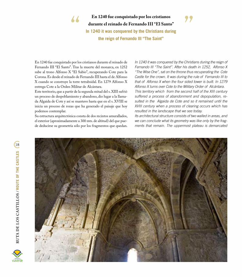
En 1240 fue conquistado por los cristianos durante el reinado de Fernando III “El Santo”. Tras la muerte del monarca, en 1252 sube al trono Alfonso X “El Sabio”, recuperando Cote para la Corona. Es desde el reinado de Fernando III hasta el de Alfonso X cuando se construye la torre tetrabsidal. En 1279 Alfonso X entrega Cote a la Orden Militar de Alcántara.Este territorio, que a partir de la segunda mitad del s. XIII sufrió un proceso de despoblamiento y abandono, dio lugar a la llama-da Algaida de Cote y así se mantuvo hasta que en el s. XVIII se inicia un proceso de rozas que ha generado el paisaje que hoy podemos contemplar.Su estructura arquitectónica consta de dos recintos amurallados, el exterior (aproximadamente a 300 mts. de altitud) del que pue-de deducirse su geometría sólo por los fragmentos que quedan.
In 1240 it was conquered by the Christians during the reign of Fernando III “The Saint”. After his death in 1252, Alfonso X “The Wise One”, sat on the throne thus recuperating the Cote Castle for the crown. It was during the rule of Fernando III to that of Alfonso X when the four sided tower is built. In 1279 Alfonso X turns over Cote to the Military Order of Alcántara.This territory which from the second half of the XIII century suffered a process of abandonment and depopulation, re-sulted in the Algaida de Cote and so it remained until the XVIII century when a process of clearing occurs which has resulted in the landscape that we see today. Its architectural structure consists of two walled in areas, and we can conclude what its geometry was like only by the frag-ments that remain. The uppermost plateau is demarcated
En 1240 fue conquistado por los cristianos durante el reinado de Fernando III “El Santo”
In 1240 it was conquered by the Christians during
the reign of Fernando III “The Saint”

1�
RU
TA D
E L
OS C
AST
ILLO
S / ROUTE OF TH
E CASTLES
La meseta superior está delimitada por la muralla interior, en la que se sitúa la torre-capilla, de planta central y doble simetría formada por cuatro ábsides adosados (cuadrilombulada), catalo-gada como donjon tetrabsidal y, sin duda, el elemento más des-tacable de la fortaleza, con sus bóvedas de crucería y único en Europa por sus especiales características arquitectónicas.
FUENTES: MAGDALENA VALOR PIECHOTTA. UN ENCLAVE EN LA BANDA
MORISCA: COTE y SU ENTORNO. EMILIO CARRILLO BENITO. PROTOHISTO-
RIA, HISTORIA E HISTORIAS EN TORNO A LA VÍA VERDE DE LA SIERRA.
by the interior wall where the tower chapal is located, with a central plant and double symmetry formed by four semi-de-tached apses and catalogued as a donjon keep and without a doubt the most outstanding element of the fortress, with its crosspiece vaults and unique in Europe due to its special architectural characteristics.
SOURCE: MAGDALENA VALOR PIECHOTTA. UN ENCLAVE EN LA BANDA
MORISCA: COTE y SU ENTORNO. EMILIO CARRILLO BENITO. PROTOHISTO-
RIA, HISTORIA E HISTORIAS EN TORNO A LA VÍA VERDE DE LA SIERRA.

RU
TA D
E L
OS
CA
STIL
LO
S / R
OUTE
OF
THE
CAST
LES
�0
La torre-capilla es, sin duda, el elemento más destacable de la fortaleza
The tower chapal is without a doubt the most
outstanding element of the fortress

�1
RU
TA D
E L
OS C
AST
ILLO
S / ROUTE OF TH
E CASTLES
Como es sabido, el Imperio visigodo terminó trágicamente en el año 711. Don Rodrigo ocupó el trono visigodo contra el mejor derecho de los hijos del difunto rey Witiza. Ante el atropello, los partidarios de éstos, encabezados por el obispo de Sevilla, don Oppas, y con la complicidad del conde don Julián, gober-nador de Ceuta, reclamaron la ayuda de las tropas musulmanas del norte de África a cambio de una sustanciosa recompensa económica.Los musulmanes desembarcaron en Gibraltar y, bajo el mando de Muza, derrotaron a las tropas de don Rodrigo en la batalla del Guadalete. ¿En qué lugar exacto del río? La respuesta a esta pregunta obliga a dejar la historia para dar paso a la leyenda. Hay quien afirma que fue en la Junta de los Ríos (Montellano) en plena Vía Verde de la Sierra. y una leyenda popular sos-tiene que fue en la hacienda Morejón (Montellano), donde se encuentra la Vega de los Caballeros, el lugar donde aconteció la indicada contienda.La leyenda añade que don Rodrigo, durante el transcurso de la batalla, no halló un sitio más seguro donde resguardar a su mujer que el castillo de Cote. y en verdad fue segu- ro, pues ella salvó la vida a diferencia del rey, quien desapareció en la batalla. Un año después, tras la conquista de Sevilla por parte de Abdelaziz, hijo de Muza, Egilona, viuda de don Rodrigo, se convirtió en su esposa, hecho que le costó la vida al príncipe islámico, pues los ulemas, temiendo que la boda con una cristiana pudiera perjudicar a la religión coráni-ca y resucitara la monarquía goda, lo denuncia-ron ante el califa de Damasco, que ordenó a dos primos de Abdelaziz que acabaran con su vida, cosa que hicieron en la mezquita de Sevilla en el año 716.
FUENTE: EMILIO CARRILLO BENITO. PROTOHISTORIA,
HISTORIA E HISTORIAS EN TORNO A LA VÍA VERDE
DE LA SIERRA.
La Batalla de Guadalete. MontellanoThe Battle of Guadalete. Montellano.
As it is known, the Visigothic Empire tragically ended in the year 711. Don Rodrigo occupied the Visigoth throne against the rights of the legitimate heirs, the children of the decea-sed King Witiza. Due to this outrage, their supporters led by the bishop of Seville, Don Oppas and with the complicity of Count Don Julian, governor of Ceuta, claimed the help of the muslim troops from the north of Africa in exchange for a substancial economic reward. The muslims landed in Gibraltar and under the orders of Muza, defeated the troops of Don Rodrigo in the battle of Guadalete. At which exact location in the river? The answer to this question forces us to leave history and makes way for legend. There are those that profess that it was at the Joining of the Rivers (Montellano) in the sierra countryside and others who attest that it was at the Hacienda Morejón (Montellano), where the Vega de los Caballeros is located.The legend goes on to to say that Don Rodrigo could not find a safer place to protect his wife during the battle than the Cote Castle. The truth was that it was secure as she survived but the King did not, who disappeared during the
battle. A year later, after the conquest of Seville by Abdelaziz, son of Muza, Egi-
lona, widow of Don Rodrigo, became his wife which cost the Islamic prince his life
because the ulemas, who feared that a wedding with a Christian could damage the Qur’an religion and re-
surrect the Goth king, denounced him to the caliph in Damasco who ordered
two cousins of Abdelaziz to end his life, to which they complied at the mosque
in Seville in the year 716.
SOURCE: EMILIO CARRILLO BENITO. PROTOHIS-
TORIA, HISTORIA E HISTORIAS EN TORNO A LA VÍA
VERDE DE LA SIERRA.

RU
TA D
E L
OS
CA
STIL
LO
S / R
OUTE
OF
THE
CAST
LES
��
El castillo de Morón de la FronteraThe Castle of Morón de la Frontera.
Es uno de los vestigios arquitectónicos más antiguos que con-serva esta localidad, y recuerda su gloriosa y noble existencia histórica. Se encuentra situado en el centro del municipio, so-bre un cerro elevado, desde donde se divisa la Campiña y la Sierra Sur.Fue en época romana cuando se construyó una pequeña cerca de piedra para proteger a los pocos habitantes que en aquella época poblaban la zona, aunque estudios arqueológicos afirman que también hubo asentamientos tartesios, e incluso anteriores. Pero son los árabes los que en 711 empiezan a reforzar los restos de murallas romanas y visigodas exis-tentes, convirtiendo la capital en una cora.Es en el siglo XI cuando Morón, tras el desmem-bramiento del Califato de Córdoba, se convierte en reino de taifa (desde 1018 a 1066) y el castillo alcanza su mayor impor-tancia. Fue reconquista-do por los cristianos del
The castle of Moron is one of the most ancient architectural vestiges in this location and recalls its noble and glorious his-toric existence. It is located in the center of the county, on an elevated hill, from where the countryside and the southern Sierra can be seen.It was during the Roman era that a small rock enclosure was built to protect the few inhabitants in the area, although ar-chaeological studies confirm that there also existed Tartessos settlements, and even previous settlements. But it was the Ara-
bs who in 711 began to reinforce the remains of the existing Roman and Visigoth walls, converting the capital in a county. In the X century when Morón, after the dis-memberment of the Caliphate of Córdo-ba, is converted in the kingdom of Taifa, (from 1018 to 1066) and the castle reaches its major prominence. It was then reconquered by King

�3
RU
TA D
E L
OS C
AST
ILLO
S / ROUTE OF TH
E CASTLES
rey Fernando III “El Santo” el 22 de Julio de 1240, tras un largo asedio, y repoblado con nobles castellanos.Bajo el reinado de Sancho IV es entregado a la Orden de Al-cántara para su custodia a lo largo de los siglos XIII y XIV. A partir de mediados del siglo XVI hacen del castillo su resi-dencia habitual, sucesivamente, los condes de Ureña, los duques de Osuna y los señores de Morón, adaptando sus viejas fun-ciones a las nuevas. Con motivo de estos cambios, el castillo sufrió numerosas modificaciones, especialmente en su torre del homenaje, denominada “Torre Gorda”. Así, se crearon estancias y salones de enorme riqueza, con mármoles y artesonados.
La leyenda cita la toma de Morón por los cristianos el 22 de julio de 1240, en la que parece ser que el caballo del ada-lid del castillo se desbocó, tras ser de-rrotado éste por el infanzón Rodríguez Gallinato, y al quedar libre de su amo, se dirigió a la puerta principal del cas-tillo, por lo que la abrieron los moros. Los de Fernando III aprovecharon ese momento para penetrar en él y derrocar a la fuerza de intramuros.
The legend cites the takeover of Mo-ron by the Christians the 22nd of July 1240, where the castle leader’s horse bolted, after being defeated by the in-fante Rodríguez Gallinato, and being free of its master, ran to the main door of the castle which was opened by the moors. The troops of Fernando III took advantage of the situation to penetrate in the castle and demolish the forces inside.
Leyenda del caballo de Morón
The Legend of the Horse of Moron
Fernando III “The Saint” on 22 July 1240, after a long siege and it was repopulated with noble Castilians.Under the reign of Sancho IV the castle was turned over to the Order of Alcántara for custodianship during the XIII and XIV centuries. From the middle of the XVI century the castle was inhabi-ted as a habitual residence in turn by the Counts of Ureña, The Dukes of Osuna and the nobility of Moron adapting its previous service to new functions. Due to these changes, the castle suffered numerous modifications, especially its keep called the “Fat Tower”. Consequently rooms and luxurious salons using marble and coffered ceilings were created.
RU
TA D
E L
OS
CA
STIL
LO
S / R
OUTE
OF
THE
CAST
LES
�4
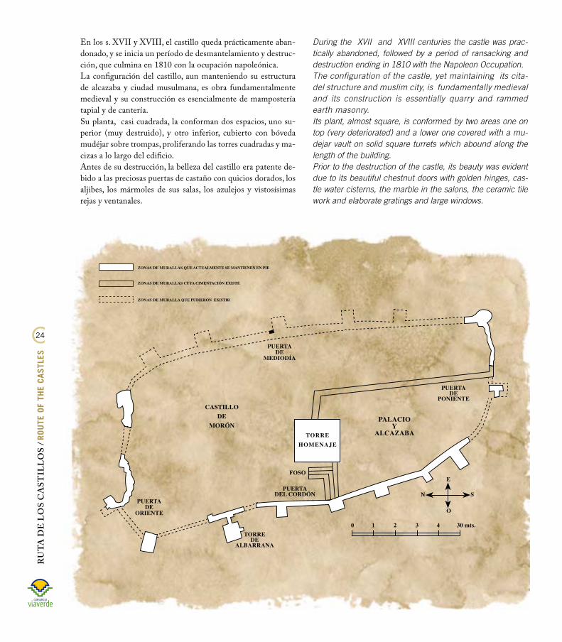
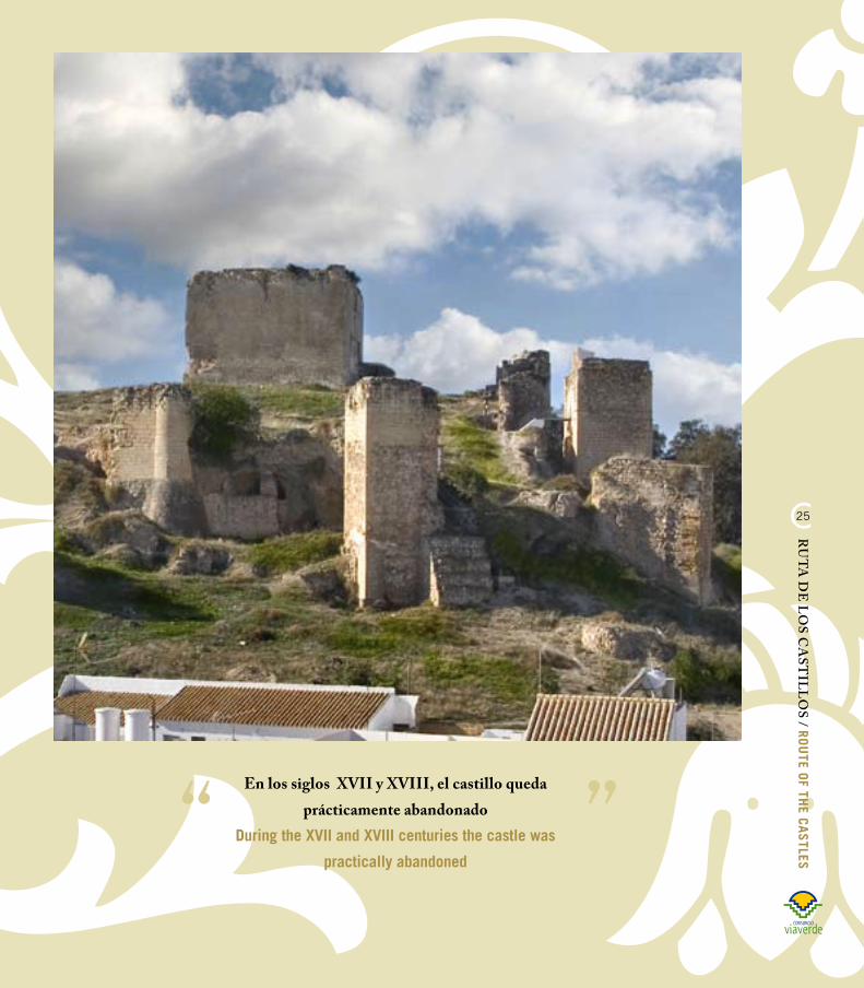
En los s. XVII y XVIII, el castillo queda prácticamente aban-donado, y se inicia un período de desmantelamiento y destruc-ción, que culmina en 1810 con la ocupación napoleónica.La configuración del castillo, aun manteniendo su estructura de alcazaba y ciudad musulmana, es obra fundamentalmente medieval y su construcción es esencialmente de mampostería tapial y de cantería.Su planta, casi cuadrada, la conforman dos espacios, uno su-perior (muy destruido), y otro inferior, cubierto con bóveda mudéjar sobre trompas, proliferando las torres cuadradas y ma-cizas a lo largo del edificio.Antes de su destrucción, la belleza del castillo era patente de-bido a las preciosas puertas de castaño con quicios dorados, los aljibes, los mármoles de sus salas, los azulejos y vistosísimas rejas y ventanales.
During the XVII and XVIII centuries the castle was prac-tically abandoned, followed by a period of ransacking and destruction ending in 1810 with the Napoleon Occupation.The configuration of the castle, yet maintaining its cita-del structure and muslim city, is fundamentally medieval and its construction is essentially quarry and rammed earth masonry. Its plant, almost square, is conformed by two areas one on top (very deteriorated) and a lower one covered with a mu-dejar vault on solid square turrets which abound along the length of the building.Prior to the destruction of the castle, its beauty was evident due to its beautiful chestnut doors with golden hinges, cas-tle water cisterns, the marble in the salons, the ceramic tile work and elaborate gratings and large windows.
�5
RU
TA D
E L
OS C
AST
ILLO
S / ROUTE OF TH
E CASTLES
En los siglos XVII y XVIII, el castillo queda prácticamente abandonado
During the XVII and XVIII centuries the castle was
practically abandoned

RU
TA D
E L
OS
CA
STIL
LO
S / R
OUTE
OF
THE
CAST
LES
��
El castillo del HierroThe Del Hierro Castle
Localizado en Pruna, (carretera A-360 Pruna-Olvera Km. 1,5) se encuentra situado en lo alto de una base rocosa que lo hacía prácticamente inexpugnable en los periodos de guerra. Debido a su situación elevada, posee una gran riqueza paisajística, no sólo por la con-templación de la fortaleza en sí, sino tam-bién por las incomparables vistas que se pueden disfrutar desde ella. El primer asentamiento estable parece corresponder a los túrdulos, un pueblo íbero que funda un poblado llamado Callet donde ahora se levanta el castillo. Posteriormente fue uno de los primeros campamentos romanos en las constantes luchas por la dominación de Hispania.En el período de la Reconquista cristiana, Pruna estaba situada en plena Banda Morisca (junto con El Coronil y Mon-tellano), zona muy comprometida hasta el final de este período. Por ello, la atalaya (torre de vigilancia) fue reforzada por los musulmanes con una pequeña muralla para defenderse del ataque de las tropas castellanas.
The del Hierro Castle is located in Pruna, (road A-360 Pruna-Olvera Kilometer 1,5) at the top of a rocky cliff
which made it practically steadfast during periods of war. Due to its elevated location, it possesses
magnificent views, not only upon contem-plating of the fortress but also due to the
incomparable country views to be en-joyed from it. The first stable settlement appears to be of the Túrdulos, an ibero peoples who founded a town called Callet where at the present time is the castle. Later on, it became one of the first Roman en-campments in the continuous battles for the domination of Hispania. During the period of the Christian Recon-
quest, Pruna was situated right in the Moorish Strip (next to El Coronil and Montellano) an area which was highly
compromised until the end of this pe-riod. That is why, the watchtower was
reinforced by the Muslims with a small parapet to defend themselves from the attack of the Castilian troops.

��
RU
TA D
E L
OS C
AST
ILLO
S / ROUTE OF TH
E CASTLES
Debido a su situación elevada, posee una gran riqueza paisajística
Due to its elevated location, it possesses
magnificent views

RU
TA D
E L
OS
CA
STIL
LO
S / R
OUTE
OF
THE
CAST
LES
��
Bajo el dominio árabe, se convierte en una alquería o aldea que dependía administrativamente de la kora de Xilibar.La fortaleza sufre modificaciones con motivo de la conquista castellana. Tras la victoria definitiva de los cristianos en 1407, el rey Alfonso X “El Sabio” entrega la localidad de Pruna a los caballeros de la Orden de Calatrava. En 1457, el rey Enrique IV concede su custodia al caballero Rodrigo de Ribera. El nuevo señor de Pruna refuerza las murallas, reconstruye el castillo y re-puebla la aldea. En 1482, es vendida a Rodrigo Ponce de León, pasando a depender del ducado de Arcos hasta la abolición de los señoríos en el s. XIX.Del castillo del Hierro sólo quedan tramos de lienzos de muralla y la torre del homenaje.
En la crónica del rey castellano Juan II, se describe la reconquista definitiva de Pruna por los cristianos. Esta crónica nos dice cómo fue liberada del Imperio de la Media Luna con la colaboración de los cristianos de Olvera, que a pe-sar de su proximidad geográfica había sido reconquistada mucho más de un siglo antes. La misma nos informa y describe que la conquista fue posible gracias a que un árabe habitante de la villa se convierte al cristianismo y re-vela el secreto de la magnífica defensa que poseía.FUENTE: JOSé ZAMUDIO. CRONISTA OFICIAL
DE PRUNA.
In the chronicles of the Castilian King Juan II, the final reconquest of Pru-na by the christians is narrated. This narrative tells us how the Empire of the Half Moon was liberated with the collaboration of the christians of Olve-ra which in spite of their geographic proximity had been reconquered over a century ago. The narrative descri-bes that the conquest was possible thanks to an arab inhabitant of the villa converted to christianity who reveals the secret of the magnificent defense method he possesses.SOURCE: JOSé ZAMUDIO. CRONISTA OFICIAL
DE PRUNA.
La Reconquistra
definitiva de PrunaThe Final Reconquest
of Pruna
Under Arab dominance, the castle is converted to farmstead or village which depended administratively from the county of Xilibar.The fortress suffered various modifications due to the Cas-tilian Reconquest. After the final victory of the Christians in 1407, King Alfonso X “The Wise One” turns over Pruna to the Knights of the Order of Calatrava. In 1457, King Enrique IV concedes its custody to the noble Rodrigo de Ribera. The new lord of Pruna reinforces the walls, reconstructs the cas-tle and repopulates the village. In 1482, it is sold to Rodrigo Ponce de León, depending now upon the dukedom of Arcos up to the abolition of the feudal estates in the XIX century.The remains that can be seen of the del Hierro Castle are only sections of walls and the keep.

��
RU
TA D
E L
OS C
AST
ILLO
S / ROUTE OF TH
E CASTLES
Existe una tradición o leyenda transmi-tida de padres a hijos en la cual se dice que los cristianos, al no poder hacerse con la villa debido a la gran resistencia de los moros, se retiraron hacia el monte de Los Alcornocales y allí se hicieron de machos cabríos a cuyos cuernos ataron antorchas, llevándolos al pie del casti-llo, donde éstas fueron encendidas. Los machos cabríos, azuzados por el fuego prendido en sus astas, subieron enlo-quecidos por las peñas e irrumpieron de noche en el castillo incendiando todo lo que hallaban a su paso. Los moradores huyeron despavoridos al lado opuesto de la fortaleza, donde se despeñaron por un imponente tajo que da a un arroyuelo denominado “Sanguino”. y dice la leyenda que fue tanta la sangre vertida aquella noche en las aguas del Sanguino, que su curso se tiñó de rojo, siendo conocido desde entonces por ese nombre.FUENTE: JOSé ZAMUDIO. CRONISTA OFICIAL
DE PRUNA.
There exists a tradition or legend transmitted from father to son which tells of how the Christians, who were unable to conquer the villa due to the great resistance of the moors, went to the Los Alcornocales hills and there they captured he-goats and tied tor-ches to their horns, taking these goa-ts to the foot of the castle where they lit the torches. The goats frightened by the fire on their horns, ran madly up the cliff and entered the castle at night burning everything they found on their way. The dwellers fled terri-fied to the other side of the castle, where they jumped off an impressi-ve gorge into a stream denominated ““Sanguino”. The legend says that there was so much blood spilt into the waters of the Sanguino, that its course turned red as it is known until this day.
SOURCE: JOSé ZAMUDIO. CRONISTA OFICIAL
DE PRUNA.
La leyenda del Sanguino
Leyend of the Sanguino

RU
TA D
E L
OS
CA
STIL
LO
S / R
OUTE
OF
THE
CAST
LES
30
Fortaleza Medieval de OlveraMedieval Fortress of Olvera
Se asienta sobre el peñón más alto de la ciudad (623 metros de altura). Su planta es por ello muy irregular, a la manera de un triángulo alargado que se adapta a la forma misma de la peña, estableciéndose una única puerta de acceso, protegida por una barbacana y rematada con un escudo.Este castillo se formó en torno a la ciudad medieval, siendo par-te del sistema defensivo del reino nazarí de Granada. Fue cons-truido a finales del s. XII, por los cristianos sobre una fortaleza árabe, después de su reconquista por Alfonso XI tras un duro asedio en 1327. Una vez finalizada la Guerra de Granada (1492) y perdido su valor militar, el castillo dejó de ejercer su función defensiva.éste posee evidentes rasgos cristianos en su construc-ción, producto de las nume-rosas remodelaciones que sufrió desde su conquista por las tropas castellanas.En la parte sur se alza la to-rre del homenaje, de planta rectangular y vértices re-dondeados, que constituye el elemento principal del
It is located on the highest cliff of the city (623 meters in altitud) Its plant is very irregular, resembling an enlogated triangle adapting to the very shape of the cliff, with one sole access door protected by a barbican and finished off with a shield.This castle was formed round the medieval city being part of the defensive system of the Nazari Kingdom of Granada. It was constructed at the end of the XII century by the christians over an arab fortress after its reconquest by Alfonso XI after a siege in 1327. Once the War of Granada ended (1492) and
lost its military value, the castle ceased to exercise its defensive function. The castle possesses evi-dent christian characte-ristics in its construction, product of the numerous modifications it suffered during its conquest by the Castilian troops.On the south part, the keep tower rises, with a rectangular plant and rounded apex, with cons-

31
RU
TA D
E L
OS C
AST
ILLO
S / ROUTE OF TH
E CASTLES
Este castillo se formó en torno a la ciudad medieval, siendo parte del sistema defensivo del reino nazarí de Granada
This castle was formed round the medieval city being part of
the defensive system of the Nazari Kingdom of Granada

RU
TA D
E L
OS
CA
STIL
LO
S / R
OUTE
OF
THE
CAST
LES
3�
La búsqueda de tesoros fue una práctica olvereña, largamente mantenida en el tiempo. Estuvo motivada por la creen-cia de que los musulmanes habían de-jado escondidos en el castillo y murallas diversos tesoros que no estimaron pro-cedente llevar consigo al abandonar la localidad, tras su rendición al monarca castellano Alfonso XI, por el duro ase-dio a que la sometiera en julio de 1327.Tan falsa creencia llegó incluso a con-vertirse en una tradición local pero sin resultado práctico alguno. FUENTE: PEDRO RODRÍGUEZ PALMA. CRO-
NISTA OFICIAL DE OLVERA.
The hunt for hidden treasure has been widely practiced for a long pe-riod of time in Olvera. This is motiva-ted by the belief that the moors had left diverse treasures hidden in the castle and its walls which they consi-dered they could not take with them upon abandoning the location, after surrendering to the Castilian King Al-fonso XI, due to the long seige in July 1327. This false belief has been con-verted in a local tradition without any practical result. SOURCE: PEDRO RODRÍGUEZ PALMA. CRO-
NISTA OFICIAL DE OLVERA.
Los Buscadores de tesoros
The Treasure Hunters
dispositivo defensivo del castillo. Su arquitectura muestra unos volúmenes macizos, sencillos y de gran pureza. Está construida en mampostería, con hiladas de piedras irregulares unidas con argamasa. La torre del homenaje cuenta con dos plantas, ambas cubiertas con bóvedas de cañón. El lienzo de la muralla conserva restos de dos torres, una semicircular y otra pentagonal, así como dos cubos semicirculares.
titutes the main element of the defensive devices of the cas-tle. Its architecture indicates solid volumes, simplicity and great purity. It is constructed of masonry, with rows of irre-gular stones joined with mortar. The keep is two stories high, both covered with cannon vaults. The sections of the walls conserve remains of the two turrets, one semicircular and the other pentagonal, as well as two semicircular cubes.
1. TORRE DEL HOMENAJE.2. PATÍN DE TAMBOR.3. PUERTA DE RECODO.4. ACCESO AL ALJIBE SUBTERRÁNEO.5. ALJIBE.6. CUBOS DE FLANqUEO.

33
RU
TA D
E L
OS C
AST
ILLO
S / ROUTE OF TH
E CASTLES
Ubicado en la Casa de la Cilla, se inauguró en el verano de 1.999. Este museo dedica-do a la Frontera y los Castillos es pionero en toda Andalucía en el tratamiento de la frontera en la época de la reconquista cris-tiana. Consta de dos salas: SALA I Las Fronteras de la Península Ibérica. Presenta la evolución de las fronteras de Al-Andalus y los reinos cristianos desde el siglo VIII al siglo XV. Las Fronteras de Andalucía. Formación de la Frontera entre Casti-lla y el reino nazarí de Granada entre los siglos XIII y XV. La Frontera de la Sierra. El ámbito geográfico en que se sitúa Olvera. Los castillos de Andalucía y los castillos de la sierra. La conquista de Olvera por Alfonso XI Olvera en el señorío: los Pérez de Guzmán, los Stúñiga, los Girón. SALA II De inmediata apertura, se basa en elementos escenográficos y ambientaciones históricas. La sala se divide en dos partes: Sala A: La Frontera como espacio de guerra. Recreación de un trozo de muralla y de castillo además de un módulo interpretativo donde se describen los elementos más ca-racterísticos de estas construcciones. Por otro lado habrá un módulo dedicado a los personajes de la época ( cautivo, ballestero, alfaqueque, etc, y otro en el que se exhibirán reproducciones de las armas más frecuentes, lanzas, escudos, flechas, yelmos, etc. Sala B: La vida civil en la Frontera. Se expondrán varias escenografías relacionadas con la vida civil de la época, en la que predominaban una sociedad rural y con una economía de subsistencia. Los elementos más destacables serán: la vivienda, el mercado y el taller artesanal.
Museo “La Frontera y los Castillos”The Frontier and the Castles Museum
Situated in the Casa de la Cilla, inaugura-ted in the summer of 1999. This museum dedicated to the Fron-tier and the Castles is a pioneer in Andalusia dealing with the fron-tier during the Chris-tian Reconquest. It consists of two halls: HALL 1
The Frontiers of the Iberian Peninsula. The contents of this hall represent the evo-lution of the frontiers of Al-Andalus and the
Christian Kingdoms from the 8th up to the 15th century. The Frontiers of Andalusia. Formation of the Frontier between Castile and
the Nazari Kingdom of Granada between the 8th and the 15th century.
The Frontier of the Sierra. The geographic area where Olvera is situated.
The castles of Andalusia and the castles of the Sierra.
The conquest of Olvera by Alfonso XI
Olvera in the feudal estate: the Pérez de Guzmán, the Stúñiga, the Girón.
HALL 2
Will soon be opened, the contents of this hall are based on histo-rical elements and scenery. The hall is divided in two parts: Hall A: The Frontier as a war scene.
This hall recreates part of the wall and the castle including an interpretation in which the characteristic elements of this type of constructions are described. There will also be a module dedicated to some typical figures of that period (captive, crossbowman, redeemer, etc.) and a third module showing reproductions of the most frequently used arms lances, shields, arrows, helmets, etc. Hall B: Civil life at the Frontier.
Various sceneries related to civil life of the era focussing on two dominant characteristic elements: rural society and subsisten-ce economy. Its most significant elements will be: the typical home, the market and the craftsman’s workshop.
UBICACIóN: PLAZA DE LA IGLESIA. DENTRO DEL EDIFICIO CULTURAL “LA CILLA” HORARIO DE VISITAS: MAñANAS: DE 10.30 A 14 H. TARDES: DE 16.30 A 18.30 HVISITAS DE MARTES DE DOMINGO (LUNES CERRADO)
SITUATION: PLAZA DE LA IGLESIA, IN THE CULTURAL CENTRE “LA CILLA”VISITING HOURS:MORNINGS: FROM 10.30 TO 2.00 PM AFTERNOONS: FROM 4.30 PM TO 6.30 PMEXHIBITION OPEN FROM TUESDAy TO SUNDAy (CLOSED ON MONDAyS)

RU
TA D
E L
OS
CA
STIL
LO
S / R
OUTE
OF
THE
CAST
LES
34
El Coronil:• Segundo domingo de mayo: Romería.• Primer fin de semana de agosto: Festival Flamenco de El Coronil.• 15 de Agosto : Feria de El Coronil, durante cuatro días.• Último fin de semana de septiembre: Feria Agroturística y de la Tapa.
Montellano:• Primera semana de mayo: Feria Agroturística y Ganadera.• Domingo posterior al 15 de mayo: Romería de San Isidro Labrador. Fiesta de Interés Turístico Nacional.• Último fin de semana de julio: Festival Flamenco de Jóvenes no Consagrados.• Primer fin de semana de julio: Festival de Música Alternativa El Alternador.• Primer fin de semana de agosto : “JUBILEO” Feria de Montellano.
Morón de la Frontera:• Segunda semana de marzo: Feria Agroturística y Comercial de Muestras.• Junio: Mercado Medieval.• Agosto: Festival Flamenco “EL GAZPACHO”.• Tercer fin de semana de septiembre: Feria.• Primer fin semana posterior al 7 de octubre: Romería de la Virgen de Gracia.• 8 de diciembre: Salida en procesión de la Inmaculada Concepción. Patrona de Morón.
Pruna:• 6 de mayo: Romería.• Primer fin de semana posterior al 15 de agosto: Feria de Pruna.
Olvera:• Segundo lunes posterior al Domingo de Resurrección : Romería del Lunes de quasimodo.• Mediados de mayo: Feria Agroturística y Comercial.• 15 de agosto: Día de Ntra. Sra. de los Remedios. Patrona de Olvera.
Coripe:• Domingo de Resurrección: quema del Judas.• Segundo domingo de Mayo: Romería• Ultimo fin de semana de Junio: Feria en honor al Patrón San Pedro.
Algámitas:• Tercer fin de semana de enero: Feria en conmemoración al Dulce Nombre de Jesús.• Domingo de Resurrección: Día del Huerto• Segundo domingo de Mayo: Romería• 25 y 26 de julio: Feria en honor a Santiago y Santa Ana.
Puebla de Cazalla:• 5 de enero: Singular celebración Cabalgata de Reyes Magos.• 3 de febrero: Día de San Blas.• 19 de marzo: Festividad de San José.• Primer fin de semana de mayo: Romería.• Julio: Reunión de Cante Jondo.• 15 de agosto: Procesión de la Asunción de la Virgen.• Primer fin de semana septiembre: Feria
El Saucejo:• 19 de marzo: Festividad de San José.• 25 de abril: Festividad de San Marcos.• 3 de mayo: Romería.• Principios de Agosto: Cante Grande Antonio Álvarez.• Segundo fin de semana de agosto: Feria.• 7 de octubre: Fiesta en honor a la Virgen del Rosario.• 22 de noviembre: Día de la Música, Santa Cecilia.
Puerto Serrano:• 1 de enero: Suelta del Toro del Aguardiente.• Tercer domingo de julio: Romería.• 22 de julio: Día de la patrona, Sta. Mª Magdalena.• Tercer fin de semana de agosto, coincidiendo con el 15: Feria.
Algodonales:• Primer fin de semana de mayo: Recreación batalla contra los franceses.• 25 de mayo: Romería.• Julio: Fiestas del Carmen en La Muela (pedanía)• 25 y 26 de julio: Feria en honor a Santiago y Santa Ana.
Fiestas y Eventos de interés Festivities and Special Interest Events

35
RU
TA D
E L
OS C
AST
ILLO
S / ROUTE OF TH
E CASTLES

RU
TA D
E L
OS
CA
STIL
LO
S / R
OUTE
OF
THE
CAST
LES
3�
Hoteles, Hostales y PensionesHotels, Hostels and Pensions
• Hostal Mara´s. C/ Sol, 14. Telf: 955 836 154. El Coronil.• Hotel Don Juan. C/ Del Bosque, 2. Telf. 955830233. El Coronil.• Hostal Restaurante Deli. C/ Jerez, 2. Telf: 954 875 110.Montellano.• Hostal Viñita. Plaza de Andalucía, 12. Telf: 954 875 004. Montellano.• Hostal Bobi. C / Ronda, s/n. ( Ctra. Montellano-Coripe). Montellano. • Hotel La Posada. C/ Sevilla, 93. Telf: 955 831 046. Montellano.• Gran Hotel Morón. Ctra. Morón-Sevilla, km.1,5. Telf: 955 856 152. Morón Fra.• Hostal Morón. C/ Sierra de Montegil, 1. Telf: 954 852 366. Morón Fra.• H** Fuente del Pino. Ctra. Jerez-Cartagena, km. 102. Telf: 956 130 309. Olvera.• H** Sierra y Cal. Avda. Ntra. Sra. los Remedios, 2. Telf: 956 130 303. Olvera.• P* Maqueda. C/ Calvario, 35. Telf: 956 130 733. Olvera.• P* Medina. C/ Sepúlveda, 6. Telf: 956 130 173. Olvera.• Hotel Estación de Olvera. (Vía Verde). Telf: 661 463 207. Olvera.
Alojamientois ruralesRural Lodging
• Casa Rural La Fábrica. Ctra. Pruna-Olvera. (Vía Verde) Telf: 954 858 504. Pruna.• Casa Rural de Cat. Superior, El Huerto. Ctra. Montellano-El Coronil, km.2. Telf: 955 831 201. Montellano.
Alojamientos del resto de municipios Lodging in other villages
Algámitas:Complejo Turístico Rural El Peñón: Telf: 955853308 - Ctra. Pruna-Algámitas km. 3.5
Coripe:Hotel Estación de Coripe: Telf: 620013708 - Ctra. Coripe- Algodonales km.2Hostal Pastor: Telf: 955858569 - C/ Cádiz, 20
El Saucejo:Hostal Aragón Telf: 955824112 - C/ Doctor Alcalá, 12
Algodonales:Al-qutun: Telf: 956137882 - C/ Zahara de la SierraGanterfly: Telf: 956137400 - C/ Arco, 13El Cortijo: Telf: 956138136 - Ctra. Jerez- Antequera, km. 82Hostal Alameda Telf: 956137229 - Avd. Constitución, 9Hostal Sierra de Lijar: v956137065 - C/ Ronda, 5Casa Buitrera: Telf: 650740434 - La MuelaLa Antigua Abacería: Telf: 676459321 - C/ Díaz Crespo, 2
Alojamientos Accomodations

3�
RU
TA D
E L
OS C
AST
ILLO
S / ROUTE OF TH
E CASTLESOficinas de TurismoTourism Offices
Oficina de Turismo de MontellanoTelf: 954 875 010.e-mail: [email protected].
Oficina de Turismo de Morón de la FronteraC/ Pozo Nuevo, 47. Telf: 955 854 821. Fax: 955 854 744.e-mail: [email protected]
Oficina de Turismo de OlveraPlaza de la Iglesia, s/n.Telf: 956 120 816.Fax: 956 120 816.e-mail: [email protected]
Oficina de Turismo de La Puebla de CazallaC/ San José, 1 (Pol. Ind. Corbones)Telf: 955843553Fax: 955843553e-mail: [email protected]
Oficina de información turística de AlgodonalesTelf: 956138534e-mail: [email protected]
Oficina de información del Plan TurísticoC/ Maternidad, s/n (1º planta) MontellanoTelf: 954876940Fax: 954876941e-mail: [email protected]
Con qué se puede combinar.Possibilities to combination
- Ruta del flamenco.- Rutas de senderismo.- Ruta de los miradores.- Ruta de los Museos.
Bibliografía.Bibliography
• Olvera en la Baja Edad Media. Siglos XIV-XV. Ed. Diputación Provincial de Cádiz.• Centro Cultual La Cilla. La Frontera y sus Castillos. Ed. Diputación Provincial de Cádiz.• Monumentos de Morón. Ramón Castellano de Torres. Colección Morón/2.

RU
TA D
E L
OS
CA
STIL
LO
S / R
OUTE
OF
THE
CAST
LES
3�
Créditos Credits
Fotografía y coordinación Photography & Coordination: Tres FotógrafosDiseño y maquetación Design & Layout: Oficina de ArteImprime Print: Escandón Impresores

3�
RU
TA D
E L
OS C
AST
ILLO
S / ROUTE OF TH
E CASTLES

C/ Maternidad s/n, 1ª planta - 41770 Montellano (Sevilla)Tel. 954 87 69 40 Fax 954 87 69 41
Algámitas - Algodonales - Coripe - El Coronil - Montellano - Morón de la Frontera - Olvera - La Puebla de Cazalla - Puerto Serrano - Pruna - El Saucejo
www.consorcioviaverde.org
Naturaleza y Tradición