rv belgica cruise 2013/26abc - mumm | bmm | · pdf filerv belgica cruise 2013/26abc ... dr....
TRANSCRIPT

Operational Directorate Natural Environment
RV BELGICA CRUISE 2013/26abc
Subscribers:
Dr. Kris Hostens, Liesl Sneyers, Koen Degrendele, Dr. Olga Lopera, Marnick Lelong/Yves Van Peteghem, Philippe Jouk
Institutes:
Institute for Agricultural and Fisheries Research, Animal Sciences Unit – Fisheries (ILVO) Belgian Nuclear Research Centre, Low‐level radioactivity measurements (SCK•CEN) FPS Economy, SMEs, self‐employed and Energy, Continental Shelf Service (FPS‐CSS) Belgian Ministry of Defence ‐ Naval Component ‐ DGMR ‐ Mine Counter Measure (DGMR) Koninklijke Maatschappij voor Dierkunde – Aquarium (KMDA)
Addresses:
ILVO: Ankerstraat 1, B‐8400 Ostend SCK•CEN : Boeretang 200, B‐2400 Mol FPS‐CSS: NGII ‐ Koning Albert II laan 16 , B‐1000 Brussels DGMR‐BXL: Royal Military Academy, Renaissancelaan 30, B‐1000 Brussels DGMR‐ZB: Naval Base Zeebrugge, Graaf Jansdijk 1, B‐8380 Zeebrugge KMDA: Koningin Astridplein 26, B‐2018 Antwerp
Telephone:
+32(0)59/569848 (KH); +32(0)14/332133 (LS); +32(0)2/2778411 (KD); +32(0)2/7426666 (OL); +32(0)50/558368 (ML/YVP); +32(0)3/2024553 (KMDA)
Email: [email protected]; [email protected]; [email protected]; [email protected]; [email protected]/[email protected]; [email protected]
Monitoring/Geology: 23/09/2013 ‐ 11/10/2013 ___________________________________________________________________
1. General form RV Belgica 2013 2. List of participants 3. Scientific objectives 4. Research area – Sampling stations 5. Operational course 6. Occupation of laboratories 7. Use of Infrastructure and instrumentation 8. Sampling – On board analysis 9. Automatic data acquisition: ODASIII continuous measurements
10. Chemicals

OD NATURE is an operational directorate of the Royal Belgian Institute of Natural Sciences 2
1. GENERAL FORM RV BELGICA 2013
1. Cruise number
2013/26abc
2. Date/time Zeebrugge ETD Zeebrugge ETA Zeebrugge ETD Zeebrugge ETA Zeebrugge ETD Zeebrugge ETA Zeebrugge ETD Zeebrugge ETA
23/09/2013 – 10h30 24/09/2013 – 07h30 24/09/2013 – 12h00 (or earlier) 27/09/2013 – 14h00 30/09/2013 – 10h30 04/10/2013 – 14h00 07/10/2013 – 10h30 11/10/2013 – 14h00
3. Chief scientist Participating institutes
Dr. Kris HostensSubstitute onboard: MSc. Hans Hillewaert ILVO, SCK•CEN , CSS, DGMR
4. Geographical area DIPCLEAR necessary
Belgian part of the North Sea No
5. Scientific personnel 2013/26a1: 102013/26a2: 10 2013/26b: 13 2013/26c: 9 (13)
6. Intervention required of: ‐ Navy divers ‐ Navy medical assistance ‐ Pilot
No No No
7. Necessary infrastructure onboard or on the quay to embark or disembark equipment. Mobilization: 20/09 on arrival (end of Research Cruise 13/25)
Demobilization/Mobilization 24/09 at 07h30 – 12h00
Demobilization: 27/09 afternoon
Demobilization: 11/10 afternoon
RV Belgica crane + Large crane Material DGMR (shadow, cable, pole, container) Mounting of multibeam and Shadows (IXSEA) Cages and material for ILVO Disembarkation material DGMR (cable, shadow; if possible also container and pole) Large crane + man basket/transport 8 m beam trawl Cages and material for ILVO RV Belgica crane Large crane: Material DGMR (container, pole) if not disembarked on 24/09. Large crane + man basket /transport 8 m beam trawl RV Belgica crane

OD NATURE is an operational directorate of the Royal Belgian Institute of Natural Sciences 3
8 Logistic assistance OD Nature ‐ MSO ? SCTD, data‐acquisition (ODAS) or else
Start‐up ODASIII AUMS start‐up Initialize RS232 in wet lab for NMEA0183 output to Transas (format $GPGGA or $GPVTG)
9. Remarks :
1. ILVO:KH: A complete TRANSAS‐addinfo file with the exact location and naming of the sampling points will be provided. This one will replace all previous 'layers' of ILVO‐HOSTENS
2. SCK•CEN:LS and KMDA:PJ are not participating physically in the campaign. The samples for this institute are taken by ILVO.
3. A brief return to port is needed on Tuesday morning 24 September to disembark DGMR team and to embark ILVO team.
Chief scientist : Dr. Kris Hostens Date and signature : i.o. signed 17/Sep/2013
General remarks c/o MUMM ‐ Measurement Services Ostend:
i) There are only basic blankets, sheets and a pillow slips available on board, no towels. Every scientist/student can bring his/her bed linen when desired.
ii) All scientists involved in deck operations are to wear appropriate safety clothing such as safety shoes/boots, gloves etc. Only safety helmets are available on board.
iii) Please note that scientists are invited to bring their own GSM. The RV Belgica GSM shall be made available only in exceptional circumstances such as communications related to operational aspects of the ongoing cruise (e.g. calls to MUMM concerning ODASIII) and in case of an emergency.
iv) All participants are requested to settle their account (daily meal fee, drinks) aboard in Euro (small bills please). Checks are no longer accepted, and neither credit cards nor proton facilities are available.
v) Following governmental regulations, as from January 1st 2006 smoking inside the ship is entirely prohibited. Please refer to the information posted on the message board inside the ship for the dedicated smoking areas on the outer decks.
vi) Each scientist has an email account aboard. This should mainly be used for work related to the campaign.
vii) The AUMS screen in the wet lab can only be used for visualization of the AUMS parameters and can’t be used for any other purpose! Please report abuse to Coordinator RV Belgica.
For approval OD NATURE: 17/09/2013 Update 19/09/2013 L. NAUDTS, Dr.‐Adviseur Coordinator RV BELGICA

OD NATURE is an operational directorate of the Royal Belgian Institute of Natural Sciences 4
2. LIST OF PARTICIPANTS
Institute NAME Gender Email 26a1 26a2 26b 26c
23‐24/09 24‐27/09 30/9‐4/10 07‐11/10
ILVO Kris HOSTENS M sc01* X X X
Hans HILLEWAERT M sc02* X X X X
Jan WITTOECK M sc03* X X
Karen BEKAERT F sc04* X
Annelies DE BACKER F sc05* X X
Naomi BREINE 4 F sc03* X
Gert VAN HOEY M sc04* X
Sofie VANDENDRIESSCHE F sc06* X
Karl VANGINDERDEUREN M sc06* (X)3
Jan RANSON M sc07* X X X
Mick VIEREN 1 M sc04* X
Lisa DEVRIESE F sc08* X
Bavo DEWITTE M sc05* X
Stephan HOFFMAN M sc06* X
Sara MAES F sc08* X
Hannelore TEETHAERT F sc08* X
Mattias BOSSAER M sc09* X
Kevin VANHALST M sc10* X X
Lode JACOBS M sc10* X
Norbert VANCRAEYNEST M sc11* X X X
CSS Lies DE MOL F sc12* X (X)2
Koen DEGRENDELE M sc13* X (X)2
Marc ROCHE M sc14* X (X)2
DGMR Yves VAN PETEGHEM 1 M sc15* X
Ives REGENT 1 M sc14* X
Filip MARGOT 1 M sc12* X
Laurent MATTIO 1 M sc11* X
Renauld HOCK 1 M sc10* X
Marnick LELONG M sc13* X
Olga LOPERA F sc09* X
Sonia PAPILI F sc08* X
10 10 13 9(13)
8M+2F 6M+4F 10M+3F 7(10)M+2(3)F
1 New participants on RV Belgica campaign: permission for embarkation requested 2 Participation of CSS depends on the success of their campaign the second week (26b). 3 To be confirmed 4 Vegetarian * = @mumm.ac.be Assignment of the cabins by the Chief‐Scientist at the start of the campaign. Gender of participants has been taken, into consideration.

OD NATURE is an operational directorate of the Royal Belgian Institute of Natural Sciences 5
3. SCIENTIFIC OBJECTIVES
ILVO:KH
During the sampling campaigns of ILVO:KH, the quality of the marine environment of the Belgian Continental Shelf is
monitored, in the framework of different international conventions (OSPAR, JAMP, CEMP, ICES) and mandated by
several governmental and private institutions. More specifically, the biological, chemical and biochemical effects of
several anthropogenic activities on the benthic ecosystem are investigated.
The ecological program of ILVO:KH comprises several parts (Annexes 1 & 2). Within the biological part, the macro‐
endobenthos, epibenthos and demersal fish fauna of the BCS are investigated. Secondly, the occurrence of external
fish diseases and parasites, and the general health status will be evaluated in fish. Within the chemical part,
concentrations and trends in heavy metals, PCBs, OCPs and PAKs in the sediment and in biota are studied. Next to
this, the grain‐size distribution, mud concentration and TOC of the sediment are analysed, the lipid content of biota is
analysed while temperature and salinity in the water column are measured.
Besides the continuous and extended monitoring programs on the sand extraction zones and the dredge dumping
sites, several epibenthos/fish samples will be taken with respect to the different windmill concessions (in close
collaboration with the sector, taking into account all safety procedures).
Plastic marine litter will be collected for the assessment of the chemical and microbial load. Several biota samples are
collected for assessment of ingested litter and microplastics.
SCK•CEN:LS
Fish samples are taken from 15 beam trawl samples (from the ILVO:KH program), to supervise the radiological
influence of aquatic releases from foreign nuclear sites on the marine environment as determined by national and
international commitments.
Radiological monitoring on the Belgian part of the North Sea in the frame of national and international obligations.
Survey in the vicinity of the Franco‐Belgian border; influence of aquatic releases from foreign nuclear sites on the
marine environment; influence on the food chain. Radioactivity measurements on 25 fishes, 20 water samples
(five areas, four times a year) and 20 sediment samples (five areas, four times a year). Measurements: alpha
spectrometry (fish), gamma spectrometry (fish, water and sediment), alpha‐ and beta‐activity, K‐40 (water).
Programme in the frame of the Belgian Federal Agency of Nuclear Control. (FANC). Only the fish samples are taken
during this campaign.
CSS:KD
Implementation of the continuous investigation laid down in section 3, §2, subsection 3, of the law of June 13th 1969,
concerning the exploration and exploitation of non living resources on the Belgian Continental Shelf, and the
concession decisions.
The follow up of the repercussions of the sand extraction on the stability of the sand banks en surrounding area in the
exploitation zones, in order to formulate policies concerning the exploitation in the concession zones on a scientific
base. The sediments of the Belgian continental shelf will be investigated in order to:
1. Establish the impact of sand extraction on the sand budget and seabed sediments.
2. Survey the sand winning sites to detect significant changes of the seabed sediments and the morphology of the
seabed and sand banks in order to guarantee the availability of sand to extract in the future.
DGMR:OL
MRN09 & MRN10 – Detection and classification of mines using high resolution SAS images
Those projects aim to determine the limits for the detection and classification of seabed objects, in particular mines.
In the frame of the Long Term Critical Requirement 21 (Fast detection and neutralization of a minefield) and following
the development of autonomous underwater vehicles (AUV), it is necessary to develop classification procedures. This
work will focus on two points: first, the study of synthetic aperture sonar (SAS) images to validate SAS image
processing algorithms, which will be developed; second, the study of magnetometer data to detect sea‐bottom
targets. Data (high resolution SAS images and magnetometer data) will be collected using the available equipment

OD NATURE is an operational directorate of the Royal Belgian Institute of Natural Sciences 6
(modern mine hunters and sensors from the Mine Warfare Data Center) during the measurement campaigns that will
be planned in collaboration with the study of ML.
DGMR:ML
Collection of bathymetric seabed information of the Belgian EEZ with the use of the systems of project MRN09,
MRN010 and multi beam (MBES) surveys in areas with priority 1 for the Naval Mine Warfare Mission Support Center.
Meanwhile fine tuning of software and development of procedures for use of the systems of the Mine Warfare Data
Center (MWDC) is done. Most of our clients, Belgian and Dutch minehunters as well as our NATO partners, exercise in
these areas. Therefore the intention is to procure a picture of all the possible items which can be encountered within
these waters. The information is also used to produce AML’s.
KMDA:PJ
Collection of living fishes and invertebrates to restock/complete the existing aquarium collection of the Antwerp Zoo.
OD NATURE‐AUMS
The AUMS (Autonomous Underway Measurement System) project is inspired by the success of similar systems
deployed on various ships of opportunity in the framework of the European Union FerryBox project
(www.ferrybox.org). The instrumentation will greatly enhance the continuous oceanographic measurements made by
RV Belgica by taking advantage of the significant technological improvements since the design of the existing (salinity,
temperature, fluorescence) systems. In particular, many new parameters can now be measured continuously
including important ecosystem parameters such as nitrate, ammonia, silicate, dissolved oxygen and CO2, turbidity,
alkalinity and phytoplankton pigments. In addition, the new equipment allows automatic acquisition and preservation
of water samples, rendering RV Belgica operations significantly more efficient by reducing onboard human resources.
Data will be available in near real‐time via OD Nature’s public web site and following quality control, from the Belgian
Marine Data Centre.
ESA
For the European Space Agency continuous GNSS (Global Navigation Satellite system) data is autonomously acquired
in the maritime environment for performance evaluation under different conditions.

OD NATURE is an operational directorate of the Royal Belgian Institute of Natural Sciences 7
4. AREA OF INVESTIGATION AND SAMPLING LOCATIONS
4.1. ILVO:KH
The areas of investigation are the dredge dumping zones, the sand exploitation zones, windmill farms and some long‐
term monitoring locations spread over the BCS. The sampling locations for SCK•CEN are part of the ILVO‐monitoring
sites spread over the BCS. Maps of the study area with indication of Van Veen, Bongonet sampling locations and beam trawl tracks (ILVO:KH)
Fig. 1: Overview of all Van Veen samples and bongonet samples of ILVO:KH on the BCS

OD NATURE is an operational directorate of the Royal Belgian Institute of Natural Sciences 8
Fig. 2: Eastern part of the BCS with Van Veen samples.

OD NATURE is an operational directorate of the Royal Belgian Institute of Natural Sciences 9
Fig. 3: Western part of the BCS with Van Veen samples.

OD NATURE is an operational directorate of the Royal Belgian Institute of Natural Sciences 10
Fig. 4: Northern part of the BCS with Van Veen samples.

OD NATURE is an operational directorate of the Royal Belgian Institute of Natural Sciences 11
Fig. 5: Overview of all Beam trawl samples of ILVO:KH on the BCS (samples for SCK•CEN:LS are taken from 15 of these samples)

OD NATURE is an operational directorate of the Royal Belgian Institute of Natural Sciences 12
Fig. 6: Eastern part of BCS with beam trawl samples
OD NATURE is an operational directorate of the Royal Belgian Institute of Natural Sciences 13
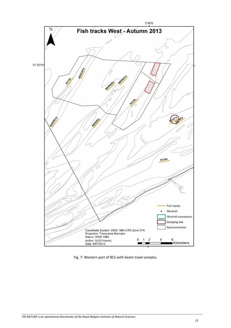
Fig. 7: Western part of BCS with beam trawl samples.

OD NATURE is an operational directorate of the Royal Belgian Institute of Natural Sciences 14
Fig. 8: Northern part of BCS with beam trawl samples.

OD NATURE is an operational directorate of the Royal Belgian Institute of Natural Sciences 15
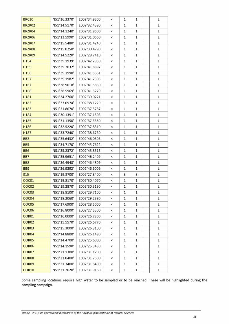
Table 1: Van Veen locations
Station Name Longitude Latitude ODASIIIVan Veen
total Macro 6 l life/fixed
115 N51°09.3628' E002°36.3548' × 4 3 1 L
120 N51°11.0998' E002°42.0705' × 6 3 3 L1‐0.5
130 N51°16.2502' E002°54.3002' × 1 1
140bis N51°20.5303' E003°01.9751' × 6 3 3 L1‐0.5
150bis N51°24.8520' E003°19.2754' × 4 3 1 L
230 N51°18.4999' E002°50.9996' × 4 3 1 L1‐0.5
330 N51°25.9999' E002°48.4995' × 4 3 1 L1‐0.5
340 N51°29.9998' E002°59.9801' × 6 3 3 L
415 N51°23.9998' E002°20.2502' × 4 3 1 L1‐0.5
421 N51°28.8300' E002°27.0002' × 4 3 1 L
435 N51°34.8398' E002°47.4199' × 4 3 1 L1‐0.5
780 N51°28.2700' E003°03.4796' × 4 3 1 L1‐0.5
820 N51°35.3700' E002°21.5998' × 4 3 1 L
830 N51°42.5400' E002°27.0304' × 4 3 1 L1‐0.5
840 N51°44.2202' E002°39.2903' × 4 3 1 L1‐0.5
ZG03 N51°15.7001' E002°40.0000' × 4 3 1 L
B031 N51°25.9502' E003°12.4204' × 4 3 1 L
B041 N51°25.9502' E003°15.9203' × 6 3 3 L
ZEB N51°21.4369' E003°09.0926' × 4 3 1 L
ZVL N51°22.5311' E003°13.3369' × 6 3 3 L1‐0.5
LNP.01 N51°14.9240' E002°43.8140' × 3 3 L
LNP.03 N51°14.7270' E002°44.1320' × 3 3 L
LNP.06 N51°15.1590' E002°43.5100' × 3 3 L
LNP.08 N51°14.7750' E002°42.9920' × 3 3 L
LNP.11 N51°15.0830' E002°44.6370' × 3 3 L
LOO.01 N51°16.9798' E002°55.2776' × 4 1 3 L
LOO.02 N51°16.8161' E002°54.9020' × 4 1 3 L
LOO.03 N51°16.7008' E002°55.0520' × 1 1 L
LOO.04 N51°16.7032' E002°55.2953' × 1 1 L
LOO.05 N51°17.2702' E002°55.2463' × 1 1 L
LOO.06 N51°17.2352' E002°55.4923' × 4 1 3 L
LOO.07 N51°17.1619' E002°55.6421' × 1 1 L
LOO.08 N51°16.6750' E002°54.5668' × 1 1 L
LOO.09 N51°16.4989' E002°54.8872' × 4 1 3 L
LOO.10 N51°16.4441' E002°55.3088' × 1 1 L
LOO.11 N51°17.4838' E002°55.2570' × 1 1 L
LOO.12 N51°17.4560' E002°55.6838' × 4 1 3 L
LOO.13 N51°17.3110' E002°55.9475' × 1 1 L
LOO.14 N51°16.9798' E002°56.0599' × 1 1 L
LOO.15 N51°16.6802' E002°55.8202' × 1 1 L
LOO.16 N51°17.2901' E002°54.7300' × 1 1 L
LOO.17 N51°16.9798' E002°54.5198' × 1 1 L
LS1.01 N51°27.3290' E003°02.0060' × 4 1 3 L
LS1.02 N51°27.3229' E003°01.3567' × 1 1 L
LS1.03 N51°27.5930' E003°01.3568' × 1 1 L

OD NATURE is an operational directorate of the Royal Belgian Institute of Natural Sciences 16
LS1.04 N51°27.4582' E003°00.9829' × 1 1 L
LS1.05 N51°27.1880' E003°00.9827' × 1 1 L
LS1.06 N51°27.0540' E003°01.3573' × 4 1 3 L
LS1.07 N51°27.3230' E003°02.6520' × 4 1 3 L
LS1.08 N51°27.5932' E003°02.6522' × 1 1 L
LS1.09 N51°27.4582' E003°03.0260' × 1 1 L
LS1.10 N51°27.1879' E003°03.0257' × 1 1 L
LS1.11 N51°27.0532' E003°02.6516' × 1 1 L
LS1.17 N51°27.3218' E003°00.4913' × 1 1 L
LS1.18 N51°27.0499' E003°00.4982' × 1 1 L
LS1.19 N51°26.7640' E003°00.5164' × 4 1 3 L
LS1.20 N51°27.8620' E003°03.5248' × 4 1 3 L
LS1.21 N51°27.6052' E003°03.5254' × 1 1 L
LS1.22 N51°27.3259' E003°03.5190' × 1 1 L
LS1.23 N51°26.7298' E003°03.2402' × 1 1 L
LS1.24 N51°26.3800' E003°02.3903' × 1 1 L
LS1.25 N51°26.4499' E003°01.3303' × 1 1 L
LS1.26 N51°28.2002' E003°02.6398' × 1 1 L
LS1.27 N51°28.2700' E003°01.5800' × 1 1 L
LS1.28 N51°27.9244' E003°00.7445' × 1 1 L
LS2.01 N51°25.9502' E003°08.4188' × 1 1 L
LS2.02 N51°26.1289' E003°07.3560' × 1 1 L
LS2.03 N51°26.1418' E003°07.8748' × 1 1 L
LS2.04 N51°26.3708' E003°07.6399' × 4 1 3 L
LS2.05 N51°26.1340' E003°09.3940' × 1 1 L
LS2.06 N51°26.1388' E003°08.9884' × 4 1 3 L
LS2.07 N51°26.3750' E003°09.1652' × 4 1 3 L
LS2.08 N51°26.3668' E003°06.7316' × 4 1 3 L
LS2.09 N51°25.8140' E003°07.6408' × 1 1 L
LS2.10 N51°26.3710' E003°10.0241' × 4 1 3 L
LS2.11 N51°25.8182' E003°09.1598' × 1 1 L
LS2.12 N51°26.5102' E003°08.0398' × 1 1 L
LS2.13 N51°26.5900' E003°08.4200' × 1 1 L
LS2.14 N51°26.5103' E003°08.8100' × 1 1 L
LS2.15 N51°26.7698' E003°07.8101' × 1 1 L
LS2.16 N51°26.7700' E003°09.0101' × 1 1 L
LZO.01 N51°22.8461' E003°15.7540' × 4 1 3 L
LZO.02 N51°22.9999' E003°15.2970' × 1 1 L
LZO.03 N51°22.8538' E003°15.2282' × 1 1 L
LZO.04 N51°22.7111' E003°15.3281' × 4 1 3 L
LZO.05 N51°23.0190' E003°16.1818' × 4 1 3 L
LZO.06 N51°22.8412' E003°16.3031' × 1 1 L
LZO.07 N51°22.6838' E003°16.1825' × 1 1 L
LZO.08 N51°23.1191' E003°15.0080' × 1 1 L
LZO.09 N51°22.8448' E003°14.8643' × 1 1 L
LZO.10 N51°22.6009' E003°14.9777' × 4 1 3 L
LZO.11 N51°23.1341' E003°16.4749' × 4 1 3 L

OD NATURE is an operational directorate of the Royal Belgian Institute of Natural Sciences 17
LZO.12 N51°22.8452' E003°16.6273' × 1 1 L
LZO.13 N51°22.5758' E003°16.4749' × 1 1 L
LZO.14 N51°22.3702' E003°15.3401' × 1 1 L
LZO.15 N51°22.3300' E003°15.7200' × 1 1 L
LZO.16 N51°22.3898' E003°16.1704' × 1 1 L
LZO.17 N51°23.3203' E003°15.3298' × 1 1 L
LZO.18 N51°23.3801' E003°15.8002' × 1 1 L
LZO.19 N51°23.3203' E003°16.2896' × 1 1 L
STP.01 N51°23.2350' E003°04.0399' × 3 3 L
TB07 N51°30.8700' E002°46.5200' × 1 1 L
TB08 N51°31.1500' E002°47.7500' × 1 1 L
TB11 N51°31.9700' E002°51.4300' × 1 1 L
TB12 N51°32.2600' E002°52.6600' × 1 1 L
TB15 N51°30.0700' E002°47.0800' × 1 1 L
TB16 N51°30.3500' E002°48.3100' × 1 1 L
TB19 N51°31.1800' E002°51.9900' × 1 1 L
TB20 N51°31.4600' E002°53.2200' × 1 1 L
TB21 N51°31.6303' E002°54.3056' × 1 1 L
TB23 N51°29.2600' E002°47.6400' × 1 1 L
TB24 N51°29.5400' E002°48.8600' × 1 1 L
TB28 N51°30.6500' E002°53.7710' × 1 1 L
TB29 N51°30.9300' E002°55.0000' × 1 1 L
TB38 N51°29.3000' E002°45.8900' × 1 1 L
TB39 N51°30.2500' E002°49.6700' × 1 1 L
TB40 N51°30.7800' E002°51.9200' × 1 1 L
TB41 N51°31.7200' E002°52.4400' × 1 1 L
BRN10 N51°18.8240' E002°36.5210' × 1 1 L
BRN11 N51°18.5180' E002°36.1300' × 1 1 L
BRN12 N51°18.3120' E002°35.6050' × 1 1 L
BRN13 N51°18.7200' E002°36.1860' × 1 1 L
BRN14 N51°18.6220' E002°36.4210' × 1 1 L
BRN15 N51°18.4830' E002°35.6750' × 1 1 L
BRN16 N51°18.3440' E002°35.8980' × 1 1 L
BRN17 N51°18.1780' E002°34.6040' × 1 1 L
BRN18 N51°17.5440' E002°33.5890' × 1 1 L
BRN19 N51°17.8790' E002°34.0200' × 1 1 L
BRN20 N51°18.2120' E002°34.1370' × 1 1 L
BRN21 N51°18.0280' E002°34.3730' × 1 1 L
BRN22 N51°17.9720' E002°34.7460' × 1 1 L
BRN23 N51°18.3020' E002°34.9830' × 1 1 L
BRNR01 N51°20.5440' E002°38.1310' × 1 1 L
BRNR02 N51°20.7300' E002°36.6600' × 1 1 L
BRNR03 N51°20.3700' E002°37.3400' × 1 1 L
BRNR04 N51°20.9520' E002°37.7840' × 1 1 L
BRC07 N51°15.9310' E002°34.3590' × 1 1 L
BRC08 N51°16.9030' E002°35.6100' × 1 1 L
BRC09 N51°18.0610' E002°36.8450' × 1 1 L
OD NATURE is an operational directorate of the Royal Belgian Institute of Natural Sciences 18
BRC10 N51°16.3370' E002°34.9300' × 1 1 L
BRZR02 N51°14.5170' E002°32.4590' × 1 1 L
BRZR04 N51°14.1240' E002°31.8600' × 1 1 L
BRZR06 N51°13.5990' E002°31.0660' × 1 1 L
BRZR07 N51°15.5480' E002°31.4240' × 1 1 L
BRZR08 N51°15.0250' E002°30.4790' × 1 1 L
BRZR09 N51°14.5220' E002°29.7410' × 1 1 L
H154 N51°39.1939' E002°42.2930' × 1 1 L
H155 N51°39.2032' E002°41.8897' × 1 1 L
H156 N51°39.1990' E002°41.5661' × 1 1 L
H157 N51°39.1982' E002°41.2305' × 1 1 L
H167 N51°38.9018' E002°41.5830' × 1 1 L
H168 N51°38.5969' E002°41.5279' × 1 1 L
H181 N51°34.2760' E002°39.0221' × 1 1 L
H182 N51°33.0574' E002°38.1229' × 1 1 L
H183 N51°31.8670' E002°37.5787' × 1 1 L
H184 N51°30.1391' E002°37.1503' × 1 1 L
H185 N51°31.1350' E002°37.3350' × 1 1 L
H186 N51°32.5220' E002°37.8310' × 1 1 L
H187 N51°33.7240' E002°38.6730' × 1 1 L
BB2 N51°35.6432' E002°46.0303' × 1 1 L
BB5 N51°34.7170' E002°45.7622' × 1 1 L
BB6 N51°35.2372' E002°45.8513' × 1 1 L
BB7 N51°35.9651' E002°46.2409' × 1 1 L
BB8 N51°36.4948' E002°46.4809' × 1 1 L
BB9 N51°36.9392' E002°46.6009' × 1 1 L
315 N51°19.3700' E002°27.8400' × 3 3 L
ODC01 N51°19.8170' E002°30.4070' × 1 1 L
ODC02 N51°19.2870' E002°30.3190' × 1 1 L
ODC03 N51°18.8100' E002°29.7100' × 1 1 L
ODC04 N51°18.2060' E002°29.2380' × 1 1 L
ODC05 N51°17.6900' E002°28.5000' × 1 1 L
ODC06 N51°16.8000' E002°27.5500' × 1 1 L
ODR01 N51°16.0000' E002°26.7300' × 1 1 L
ODR02 N51°15.5570' E002°26.6770' × 1 1 L
ODR03 N51°15.3000' E002°26.3100' × 1 1 L
ODR04 N51°14.8800' E002°26.1480' × 1 1 L
ODR05 N51°14.4700' E002°25.6000' × 1 1 L
ODR06 N51°14.1590' E002°25.3430' × 1 1 L
ODR07 N51°21.1300' E002°31.1200' × 1 1 L
ODR08 N51°21.0400' E002°31.7600' × 1 1 L
ODR09 N51°21.3400' E002°31.6400' × 1 1 L
ODR10 N51°21.2020' E002°31.9160' × 1 1 L
Some sampling locations require high water to be sampled or to be reached. These will be highlighted during the sampling campaign.

OD NATURE is an operational directorate of the Royal Belgian Institute of Natural Sciences 19
Table 2: Beam trawl locations
Station Lat Long ODASSIII Bio Chem SCK Stomachs Pathology Plastics Health
ft120s N51°10.9393' E002°41.5675' × × × × × × ×
N51°11.1278' E002°43.1348' ×
ft1401s N51°16.6663' E002°54.7984' × × × × × ×
N51°17.1210' E002°56.2223' ×
ft1402s N51°16.0093' E002°56.0010' × × × × × ×
N51°16.4770' E002°57.4136' ×
ft140biss N51°20.7517' E003°02.6885' × × × × ×
N51°20.2873' E003°01.2707' ×
ft215s N51°16.1230' E002°37.2645' × × × × ×
N51°16.8542' E002°38.3555' ×
ft2251s N51°14.5669' E002°43.1603' × × × × × ×
N51°15.1009' E002°44.5102' ×
ft2252s N51°14.4935' E002°44.0707' × × × × ×
N51°15.0820' E002°45.3622' ×
ft230s N51°18.1256' E002°50.3510' × × × × × × ×
N51°18.7832' E002°51.5557' ×
ft315s N51°17.9895' E002°27.7065' × × × × × ×
N51°18.8025' E002°28.6370' ×
ft330s N51°25.5985' E002°47.6392' × × × × × × ×
N51°26.0395' E002°49.0785' ×
ft340s N51°29.6173' E002°59.4253' × × × × × ×
N51°30.2005' E003°00.7305' ×
ft415s N51°23.6108' E002°19.6763' × × × × ×
N51°24.4202' E002°20.6306' ×
ft421s N51°29.0498' E002°28.2077' × × × × ×
N51°28.1310' E002°27.5737' ×
ft7001s N51°22.8005' E003°14.9572' × × × × × ×
N51°22.9403' E003°16.5435' ×
ft7002s N51°23.5978' E003°14.9201' × × × × × ×
N51°23.7574' E003°16.5026' ×
ft7101s N51°25.7876' E003°07.5752' × × × × ×
N51°26.4131' E003°08.8260' ×
ft7102s N51°26.3816' E003°06.5910' × × × × × ×
N51°26.9614' E003°07.8970' ×
ft7802s N51°27.9062' E003°03.1301' × × × × ×
N51°28.6195' E003°04.2553' ×
ft7803s N51°27.2479' E003°00.8895' × × × × × ×
N51°27.9500' E003°02.0323' ×
ft7804s N51°26.7653' E003°01.5679' × × × × ×
N51°27.4750' E003°02.6987' ×
ft820s N51°34.6357' E002°21.1817' × × × ×

OD NATURE is an operational directorate of the Royal Belgian Institute of Natural Sciences 20
Station Lat Long ODASSIII Bio Chem SCK Stomachs Pathology Plastics Health
N51°35.5294' E002°21.9043' ×
ft830s N51°42.2585' E002°26.4964' × × × × × × ×
N51°43.0673' E002°27.4451' ×
ft840s N51°44.0965' E002°38.6719' × × × × ×
N51°44.2565' E002°40.2660' ×
ftB03s N51°25.3942' E003°12.2546' × × × ×
N51°25.4884' E003°13.8508' ×
ftB04s N51°26.6018' E003°13.3565' × × × ×
N51°26.8340' E003°14.9170' ×
ftB07s N51°25.8971' E003°18.5600' × × × ×
N51°25.7458' E003°16.9747' ×
ftBRN01s N51°18.1820' E002°35.7019' × × × × ×
N51°18.9022' E002°36.8111' ×
ftBRN02s N51°18.3217' E002°34.9195' × × × × ×
N51°17.6207' E002°33.7790' ×
ftBRZRs N51°14.1430' E002°31.7659' × × × ×
N51°14.9060' E002°32.7949' ×
ftBZN1s N51°36.1450' E002°52.4057' × × × ×
N51°36.7802' E002°53.6500' ×
ftHB10s N51°33.6817' E002°38.9483' × × × ×
N51°32.7872' E002°38.2290' ×
ftHB11s N51°32.0284' E002°37.8347' × × × × ×
N51°32.0284' E002°37.8347' ×
ftHB6s N51°37.9120' E002°35.2820' × × × ×
N51°36.9223' E002°35.0483' ×
ftHB8s N51°37.9918' E002°34.5263' × ×
N51°36.9955' E002°34.3935' ×
ftHB9s N51°40.5820' E002°36.2272' × ×
N51°41.5789' E002°36.3608' ×
ftMIC 3 N51°26.4000' E002°35.5000' × × × × ×
N51°30.2170' E002°42.8980' ×
ftMIC 4 N51°33.1000' E002°28.5000' × × × × ×
N51°38.1410' E002°33.6940' ×
ftODC01s N51°18.7213' E002°29.8192' × × ×
N51°19.6322' E002°30.4808' ×
ftODR01s N51°14.1688' E002°25.5607' × × ×
N51°15.0079' E002°26.4304' ×
ftSTP01s N51°22.7020' E003°03.4460' × × ×
N51°23.3210' E003°04.7090' ×
ftTB1s N51°29.6445' E002°47.3989' × × × ×
N51°30.0478' E002°48.8690' ×
ftTrack2 N51°32.8586' E002°54.3160' × × ×
N51°32.3579' E002°55.2667' ×

OD NATURE is an operational directorate of the Royal Belgian Institute of Natural Sciences 21
Station Lat Long ODASSIII Bio Chem SCK Stomachs Pathology Plastics Health
ftTrack3 N51°32.8777' E002°55.2589' × × ×
N51°32.4080' E002°56.2676' ×
ftTrack5 N51°33.7588' E002°58.9433' × ×
N51°34.3882' E002°59.9780' ×
ftTrack6 N51°33.7220' E002°57.9484' × ×
N51°34.3490' E002°58.9747' ×
ftWBB01s N51°34.1389' E002°46.1972' × × × × ×
N51°34.8515' E002°47.3263' ×
ftWBB02s N51°34.1771' E002°44.6422' × × × × ×
N51°35.0572' E002°45.4063' ×
ftWBB03s N51°34.7432' E002°43.9022' × × ×
N51°35.6205' E002°44.6740' ×
ftWBB04s N51°38.3801' E002°50.9888' × ×
N51°39.2632' E002°51.7457' ×
ftWBB05s N51°38.6458' E002°49.2475' × ×
N51°39.6275' E002°49.5542' ×
ftWBB06as N51°38.8870' E002°47.9545' × × × ×
N51°39.8245' E002°48.5150' ×
ftWBB06bs N51°41.1326' E002°48.4975' × × × ×
N51°40.1945' E002°47.9389' ×
ftWBB07s N51°39.7303' E002°46.8238' × ×
N51°40.6733' E002°47.3600' ×
ftWBB08s N51°39.5978' E002°45.5182' × ×
N51°40.5118' E002°46.1719' ×
ftWG2s N51°27.1700' E002°50.6698' × ×
N51°27.6248' E002°52.0993' ×
ftWOH01s N51°35.0762' E002°41.7715' × × ×
N51°36.0520' E002°42.1211' ×
ftWOH02s N51°37.2251' E002°41.1922' × ×
N51°36.2398' E002°40.9157' ×
ftWOH03s N51°37.9219' E002°40.2823' × ×
N51°36.9349' E002°40.0277' ×
ftWT10s N51°33.5640' E002°54.2405' × ×
N51°33.1340' E002°52.9653' ×
ftWT11s N51°31.8640' E002°58.1667' × ×
N51°31.2900' E002°56.9091' ×
ftWT1biss N51°30.7537' E002°54.5978' × × × ×
N51°30.3478' E002°53.1298' ×
ftWT2BISs N51°31.8148' E002°53.8630' × × × × ×
N51°31.4017' E002°52.3963' ×
ftWT3s N51°31.5818' E002°50.0978' × × ×
N51°31.9534' E002°51.5903' ×
ftWT7s N51°32.4622' E002°59.2802' × × × × ×

OD NATURE is an operational directorate of the Royal Belgian Institute of Natural Sciences 22
Station Lat Long ODASSIII Bio Chem SCK Stomachs Pathology Plastics Health
N51°33.1166' E003°00.4967' ×
ftWT9s N51°33.8242' E002°56.8163' × ×
N51°34.4785' E002°58.0320' ×
Table 3: Bongo net plankton (fish larvae) sample locations
Station Lat (WGS84) Lon (WGS84) Zooplankton
WFL1 N51°32.1200’ E002°52.3900’ x
WFL2 N51°31.7330' E002°53.8000' x
WFL3 N51°31.0500' E002°54.8500' x
WFL4 N51°32.3595' E002°57.0290' x
WFL5 N51°32.6250' E002°56.2785' x
WFL6 N51°32.8170' E002°55.5500' x
OD NATURE is an operational directorate of the Royal Belgian Institute of Natural Sciences 23
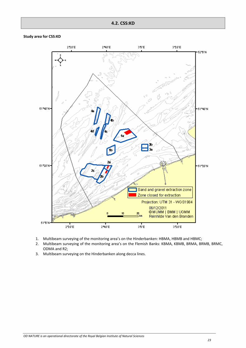
4.2. CSS:KD
Study area for CSS:KD
1. Multibeam surveying of the monitoring area’s on the Hinderbanken: HBMA, HBMB and HBMC; 2. Multibeam surveying of the monitoring area’s on the Flemish Banks: KBMA, KBMB, BRMA, BRMB, BRMC,
ODMA and R2; 3. Multibeam surveying on the Hinderbanken along decca lines.

OD NATURE is an operational directorate of the Royal Belgian Institute of Natural Sciences 24
4.3. DGMR:OL
Study area for DGMR:OL
Figure Measurement areas DGMR‐OL

OD NATURE is an operational directorate of the Royal Belgian Institute of Natural Sciences 25
The Shadows recording will be performed in 2 different areas around 2 wrecks: Kilmore and LCT 457 A small description of both measurements is given below. LCT 457 Measurements (2 tests) around wreck LCT 457: Between 02°43’720 E and 02°44’307 E Between 51°23’920 N and 51°24'670 N Test 1: Four lines at 50 meters distance from the contact have to be surveyed with different orientation. Table 2: Coordinates of the recording lines
Lines Long Lat
AA start 51° 23,931’N 2° 44,352’E
AA end 51° 23,897’N 2° 44,298’E
BB start 51° 23,916’N 2° 44,267’E
BB end 51° 23,951’N 2° 44,321’E
CC start 51° 23,885’N 2° 44,334’E
CC end 51° 23,925’N 2° 44,264’E
DD start 51° 23,906’N 2° 44,364’E
DD end 51° 23,945’N 2° 44,292’E
The four lines will be recorded twice with different sonar settings. First lines set is the default setting: PL 0%; res: 30 cm; Range 300m Second lines set is: PL 10%; res 10cm; Range 100m. Test 2: Planar SAS sea trial Table 3: Track ID & Track Points
Track ID/Direction Point Name Latitude Longitude
1/60°
A1 51°23.9351’ 2°44.4427’
B1 51°23.9864’ 2°44.3949’
C1 51°23.9049’ 2°44.1713’
D1 51°23.8536’ 2°44.2191’
2/60°
A2 51°23.9327’ 2°44.4448’
B2 51°23.9887’ 2°44.3928’
C2 51°23.9073’ 2°44.1692’
D2 51°23.8513’ 2°44.2212’
3/60°
A3 51°23.9304’ 2°44.447’
B3 51°23.991’ 2°44.3906’
C3 51°23.9096’ 2°44.167’
D3 51°23.849’ 2°44.2234’
4/60°
A4 51°23.9281’ 2°44.4492’
B4 51°23.9933’ 2°44.3884’
C4 51°23.9119’ 2°44.1648’
D4 51°23.8467’ 2°44.2256’
5/330°
A5 51°24.0049’ 2°44.2829’
B5 51°23.975’ 2°44.2009’
C5 51°23.8351’ 2°44.3311’
D5 51°23.865’ 2°44.4131’
6/330°
A6 51°24.0062’ 2°44.2866’
B6 51°23.9737’ 2°44.1972’
C6 51°23.8338’ 2°44.3274’
D6 51°23.8663’ 2°44.4168’
7/330° A7 51°24.0076’ 2°44.2904’
B7 51°23.9723’ 2°44.1935’
C7 51°23.8324’ 2°44.3236’
D7 51°23.8677’ 2°44.4205’

OD NATURE is an operational directorate of the Royal Belgian Institute of Natural Sciences 26
Track ID/Direction Point Name Latitude Longitude
8/330°
A8 51°24.0089’ 2°44.2941’
B8 51°23.9709’ 2°44.1897’
C8 51°23.8311’ 2°44.3199’
D8 51°23.8691’ 2°44.4243’
1) track‐direction‐60‐1, 50 meters from the wreckage, 60 Deg. Direction angle 2) track‐direction‐60‐2, 55 meters from the wreckage, 60 Deg. Direction angle 3) track‐direction‐60‐3, 60 meters from the wreckage, 60 Deg. Direction angle 4) track‐direction‐60‐4, 65 meters from the wreckage, 60 Deg. Direction angle 5) track‐direction‐330‐1, 50 meters from the wreckage, 330 Deg. Direction angle 6) track‐direction‐330‐2, 55 meters from the wreckage, 330 Deg. Direction angle 7) track‐direction‐330‐3, 60 meters from the wreckage, 330 Deg. Direction angle 8) track‐direction‐330‐4, 65 meters from the wreckage, 330 Deg. Direction angle Kilmore Measurements around wreck Kilmore: Wreck position: 02°29’790 E 51°23’730 N Four lines at 50 meters distance from the contact have to be surveyed with different orientation (to be defined during campaign). The four lines will be recorded twice with different sonar settings. Settings for first lines set are the default setting: PL 0%; res: 30 cm; Range 300m Settings for second lines set are: PL 10%; res 10cm; Range 100 m.
4.4. DGMR:ML
Study area for DGMR:ML
Figure 2: measurements areas for MB (DGMR‐ML)

OD NATURE is an operational directorate of the Royal Belgian Institute of Natural Sciences 27
Table 5
Region ID Longitude Latitude
WA AA 2° 41.75 E 51° 29.20 N
Westhinder area BB 2° 50.00 E 51° 29.20 N
CC 2° 50.00 E 51° 27.50 N
DD 2° 41.75 E 51° 27.50 N
Table 6
Region ID Longitude Latitude
GBA BB 002° 50’.00 E 51° 29’.20 N
Gootebank area CC 002° 50’.00 E 51° 27’.50 N
DD 002° 55’.00 E 51° 27’.50 N
EE 002° 55’.00 E 51° 29’.20 N

OD NATURE is an operational directorate of the Royal Belgian Institute of Natural Sciences 28
5. OPERATIONAL COURSE
All times are given in local time. All coordinates in WGS84. Tentative program; priority or observations may change according to tidal and weather conditions and/or technical constraints. Throughout the campaign, measurements are made with the AUMS system.
Monday 23/09/2013
08h30‐09h30 Embarkation of personnel DGMR + ILVO (2 persons) 10h30: recording/tests with shadow during day time (place to be decided by DGMR)
multibeam during evening/night time (place to be decided by DGMR)
The operational course will be established daily by ILVO in agreement with the commanding officer and the other scientific teams.
ILVO:KH
Biological samples may only be collected between sunrise and sunset to minimize the variation due to the day‐night
rhythm of many benthic organisms (both vertebrates and invertebrates). Samples for the chemical analyses can be
taken at night‐time, although it is aimed for a complete sampling during daytime for ILVO.
All coordinates are placed in one TRANSAS layer by ILVO. This layer will be updated by ILVO prior to departure.
An 8 metre beam trawl and a rinsing/sieving machine are used for the epibenthos and the demersal fish fauna, a Van
Veen grab and 1�mm (and 0.5�mm) sieve and sieving table for the sediment and the macro‐endobenthos, a CTD for
the environmental parameters in the water column, a Niskin bottle for water samples, and a bongo net for plankton
samples on a limited number of stations.
The monitoring program of ILVO has changed substantially (mainly in spring campaign) according to the previous
years. The few Van Veen macrobenthos samples will be sieved alive on board, partly on a 1�mm and some extra on a
0.5�mm sieve. For most projects the Van Veen grabs must be taken as exactly as possible (<�30�m), certainly when
4 or more samples are taken at 1 sampling point.
The beam trawl samples in the new BACI design have been halved in time and length (to be more representative for
the impacted zones), which means a ‘short’ track of 15 minutes at approx. 4 knots with the currents. The fish tracks on
the Transas system are 1�NMiles long. To have enough time to release the net and the beam trawl, the ship must be
placed in the direction of the track already 0.5 mile before the real starting point in agreement with the skipper. The
exact positions of all samples are given on the Transas layer.
For the windmill project also a number of plankton (fish larvae) samples will be taken with a bongo net. Therefore
oblique hauls from bottom to top are taken, which means: lowering the net to the bottom and dependent on the
currents, slowly moving while hauling the net to the sea surface. These samples are located at least 250�m from the
piles as agreed upon with the concession holders. Also secchi disk measures are needed at these points and CTD
profiles on the 2 top‐locations.
Within this campaign also fish samples for SCK‐CEN:LS and life fish and invertebrates for KMDA:PJ are taken. For the
collection of live material, a number of aquaria are taken along..
It will be aimed at having the least amount of transit time between the sampling locations of the different programs,
although the whole planning will depend on the weather forecast.
For ILVO:KH the following samples must be completed as best as possible:
1. Windmill project locations on Thorntonbank, Blighbank and Lodewijckbank 2. Dredge dumping sites (S1, Zeebrugge Oost, Oostende, S2 and Nieuwpoort) 3. Sand extraction zones on the Kwintebank, Buitenratel, Oostdyck, Thorntonbank,
Hinderbanken 4. Long‐term monitoring points and other reference points
CSS:KD The program of CSS:KD is normally carried out between sunset and sunrise, including some transit time after the day program of ILVO:KH.

OD NATURE is an operational directorate of the Royal Belgian Institute of Natural Sciences 29
DGMR:ML
To increase operational efficiency areas are chosen with the least transit time to start up registrations. If problems
occur with multi‐beam (MB) of MWDC component, or sea state does not permit to use the pole on which the MB is
attached, MB of RV Belgica will be used.
6. OCCUPATION OF THE LABORATORIES
Bridge: AUMS visualization, CSS, ILVO, ESA, DGMR
Wet lab: ILVO, CSS
Microbiology Lab: ILVO
Chemistry Lab: ILVO
Fish Lab: ILVO
Biology Lab: AUMS, ILVO
Rear Deck: ILVO, DGMR (*) Necessary alterations specified on board.
7. USE OF THE INFRASTRUCTURE ON BOARD
Underway measurements ‐ Thermosalinograph SCTD‐SBE21 ‐ Turner fluorimeter ‐ Sub‐surface seawater pump ‐ Non toxic water supply for Seabird thermo‐salinometer ‐ Friedrichs meteo‐system including solarimeter ‐ STD SeaBird model SBE 21
Fishing ‐ Fishing winch (main starboard winch) ‐ Net winch ‐ Back end A‐frame ‐ Fisheries control panel + 1 monitor, Bridge ‐ EA 400 single beam echo sounding system ‐ Freezer fish lab ‐ Cold storage room fish lab ‐ Seawater circuit ‐ Seawater supply for aquaria (from lab‐pump in wet lab) ‐ Pressed air circuit ‐ Davit with adjusted net block ‐ Quick release cutting device ‐ 8�m beam trawl, nets and net block (provided by ILVO:KH)
Seabed sampling ‐ Oceanographic winch (side winch) ‐ sideway A‐frame ‐ basin for Van Veen grab (already onboard) ‐ 2 Van Veen's (provided by ILVO:KH) ‐ Autosiever (provided by VLIZ through ILVO:KH) ‐ Seawater supply (2 ‘firemen’ or comparable hoses with high pressure and volume) for cleaning the deck (near
side winch and at the back) and for sieving the macrobenthos samples (small tube and 1 of the ‘firemen’)
Plankton sampling ‐ Bongo net (provided by VLIZ through ILVO:KH)
Laboratory equipment ‐ incubator + 1 refrigerator (Microbiology lab) ‐ refrigerator (wet lab)

OD NATURE is an operational directorate of the Royal Belgian Institute of Natural Sciences 30
‐ monitor (wet lab) ‐ Freezer and refrigerator in wet lab and fish lab for storage of samples ‐ Milli RO/ milli Q system
Multibeam data acquisition ‐ Simrad EM 3002D multibeam echosounder ‐ Seacat (as backup for the Sound velocity profiler) ‐ Sound velocity profiler
AUMS
Navigation/Meteorology ‐ Standard meteorological instruments (wind, atmospheric pressure, PAR, water temp., air temp., salinity, RH.),
ship heading, speed and geo‐coordinates from ODASIII.
Ship’s crane
MWDC (NAVLOG) (DGMR:ML) ‐ Workstations ‐ Pole + MB ‐ Winch ‐ SHADOWS ‐ GAPS ‐ sound velocity prove (SVP)
8. ONBOARD MEASUREMENTS
‐ ODASIII continuous measurements (0.5 and 10 seconds): the ODAS data‐acquisition needs during the measurements are: (Thales Aquarius) GPS position and UTC time, GIRO, ship heading and speed, water depth, wind speed and direction, atmospheric pressure, PAR, sea temperature, salinity, air temperature wet & dry, humidity, heave, and fluorescence. (digital data underway for all partners).
‐ Traject‐plots and listing of navigation parameters per 10 minutes; for fish tracks per 10 seconds ‐ SCTD, navigation and meteorological parameters per sampled station ‐ RS‐232 connection for Transas on laptop in wet lab with registration of the GPS signal in NMEA‐0183 format
$GPGGA or $GPVTG. ‐ Epibenthos identification, counting and weighing ‐ Demersal fish identification, counting and weighing ‐ Fish pathology ‐ Litter identification and categorization

OD NATURE is an operational directorate of the Royal Belgian Institute of Natural Sciences 31
9. AUTOMATIC DATA ACQUISITION: ODASIII continuous measurements
Instrument ODASIIINr Parameter Data acquisition rate ID ODASIII standard extra
10 sec. 10 min. 1 sec. 0.5 sec.
THALES AQUARIUS‐02
LRK DGPS receiver
271 DGPS LAT.N/S X X X272 DGPS LON.E/W X X X273 DGPS HG MSL X274 DGPS UTCTIME X X X275 DGPS SPEED X X X276 DGPS COURSE X X X277 DGPS QUALITY X X X278 DGPS DSTA X X X279 DGPS DRMS X X X
FURUNO GP90 DGPS 385 FURUNO LAT X X X386 FURUNO LON X X X
ANSHUTZ GYRO STD20 36 SHIP HEADING X X X
CONSILIUM SAL 860T doppler log
387 PT/ST SPEED X X388 DEPTH SAL860 X X 389 FO/AF SPEED X X
Kongsberg EA400 echosounder 465 EA DEPTH 38 X X X466 EA DEPTH 210 X X X467 EA DEPTH 33 X X X
FRIEDRICHS meteostation
243 R. WINDDIR SB X X244 R. WINDSPD SB X X 245 ATM PRESSURE X X 246 AIRTEMP. DRY X X 247 AIRTEMP. WET X X 266 SOL RAD X X 375 R. WINDSPPB X X 376 R. WINDDIR PB X X 487 SOL RAD X X 488 ATM PRESSURE 2 X x
SEA‐BIRD SBE21 thermosalinograph
191 SBE21 TEMP. X X X192 SBE21 SALIN. X X X193 SBE21 SIGTH. X X 194 SBE21 S.VEL. X X 216 SBE21 I‐TEMP X X 217 SBE21 COND. X X
SEA‐BIRD SBE38 temperature 242 SBE38 TEMP. X XVALEPORT HM SVP 559 VALEPORT SV X X
VALEPORT 106 CM currentmeter
382 CURR. I‐VEL383 CURR. I‐DIR 384 CM DEPTH
MARELEC small A‐frame
206 LENGTH W1 X X207 SPEED W1 208 MEANTRAC W1 X X 209 PEAKTRAC W2
MARELEC oceanographic winch
210 LENGTH W2 X X211 SPEED W2 212 MEANTRAC W2 X X 213 PEAKTRAC W2
pump status 377 SEAWATERPUMP X X378 SEWAGE PUMP X X 489 SW PUMP FLOW X X
AUMS OceanPackEndress+Hauser 506 EH TURBIDITY L X X
508 EH TURBIDITY H X X Campbell OBS3+ 510 OBS LOW X X
511 OBS HIGH X X SEA‐BIRD SBE45 500 SBE45 SALINITY X XTrios Microflu 512 CHLOROPHYLL X X
513 BLUE ALGAE X X 514 CDOM X X
Aanderaa optode 501 OPTODE O2 X XMeinsberg 504 pH X XTurner Designs 515 FLUORESCENCE X XOceanPack MK2 518 pCO2 X XLi‐Cor LI‐190SA 530 PAR X X

OD NATURE is an operational directorate of the Royal Belgian Institute of Natural Sciences 32
10. LIST OF EMBARKED CHEMICALS
chemical products needed for benthos research (ILVO:KH)
40�l (ILVO:KH) formaldehyde 40% – afterdeck
5�l aceton (for cleaning) – wet lab
2�l pure ethanol (for taxonomic samples) – chemistry lab