s north carolina department of transportation yancey... · north carolina department of...
TRANSCRIPT

STATE OF NORTH CAROLINA
DEPARTMENT OF TRANSPORTATIONROY COOPER JAMES H. TROGDON, III
GOVERNOR SECRETARY
Mailing Address: NC DEPARTMENT OF TRANSPORTATION ENVIRONMENTAL ANALYSIS UNIT 1598 MAIL SERVICE CENTER RALEIGH NC 27699-1598
Telephone: (919) 707-6000 Fax: (919) 212-5785
Customer Service: 1-877-368-4968
Website: www.ncdot.gov
Location: 1020 BIRCH RIDGE DRIVE
RALEIGH NC 27610
November 13, 2017
MEMORANDUM TO: Mr Jay Swain, P.E. Division 13 Engineer
FROM: Philip S. Harris, III, P.E., Manager Environmental Analysis Unit
SUBJECT: Yancey County; Replacement of Bridge No. 3 on SR 1128 (Possumtrot Rd) over Possumtrot Creek; Federal Aid No. BRZ-1128(1); WBS 38618.1.1; TIP B-4848.
Attached are the US Army Corps of Engineers Nationwide Permit and N.C. Division of Water Resources (NCDWR) Water Quality Certification for this project. All environmental permits have been received for the construction of this project.
A copy of this permit package will be posted on the NCDOT website at: https://connect.ncdot.gov/resources/Environmental/Pages/default.aspx Quick Links>Permit Documents> Issued Permits.
cc: w/o attachment (see website for attachments)
Mr. Ron Davenport, P.E. Contracts Management Mr. Roger Bryan, Division 13 Environmental Officer Dr. Majed Al-Ghandour, P.E., Programming and TIP Mr. Carl Barclay, P.E., Utilities Unit Mr. Stephen Morgan, P.E., Hydraulics Mr. Brian Hanks, P.E., Structures Management Unit Mr. Mark Staley, Roadside Environmental Mr. Lamar Sylvester, P.E., State Roadway Construction Engineer Mr. Derrick Weaver, P.E., Project Delivery
B-4848 Permit Greensheet November 2017 Page 1 of 2
PROJECT COMMITMENTS
T.I.P Project No. B-4848 Replacement of Bridge No. 3 over Possumtrot Creek
on SR 1128 (Possum Trot Road) Yancey County
Federal Aid Project No. BRZ-1128(1) WBS Element 38618.1.1
COMMITMENTS FROM PROJECT DEVELOPMENT AND DESIGN
All Design Groups/Division 13 Resident Construction Engineer
The NCWRC has identified Possumtrot Creek in the study area as trout waters. Based on the NCWRC’s designation as trout waters, a mandatory trout moratorium on all water work will be present from October 15 to April 15 of any given year, for Possumtrot Creek along with all other tributaries in the project study area.
NCDOT will implement Guidelines for Construction of Highway Improvements Adjacent to or Crossing Trout Waters in North Carolina in the design and construction of this project. This condition is not longer applicable.Additionally, NCDOT’s Best Management Practices for Protection of Surface Waters (March 1997) will be followed throughout the design and construction of the project.
All Design Groups/Division Resident Construction Engineer
NCDWRC has designated this stream as trout waters and therefore Design Standards for Sensitive Watersheds will be incorporated.
Project Development and Environmental Analysis Unit / Project Development and Environmental Analysis Unit – Natural Environment Section / Division 13 / FHWA
The proposed project involves the replacement of a bridge over Possum Trot Creek which flows into Bald Creek before discharging into the Cane River. Designated critical habitat for Appalachian elktoe is found 3.45 miles downstream of the project area. No freshwater bivalves were found during surveys, and impacts are unlikely to occur, but cannot be completely discounted. NCDOT will request concurrence from USFWS on a May Affect, Not Likely to Adversely Affect biological conclusion, once final designs are available. However, due to the projected limited impacts from the construction of this project, a non-jeopardy biological opinion is anticipated. Strict adherence to erosion control standards should minimize the potential for any adverse impacts to occur. Construction authorization will not be requested until consultation with USFWS is completed.
In a letter dated April 19, 2017, the USFWS concurred with the May Affect, Not Likelyto Adversely Affect Biological Conclusion for the Appalachian elktoe with the
B-4848 Permit Greensheet November 2017 Page 2 of 2
recommendation that sediment and erosion control measures adhere to the Design Standards in Sensitive Watersheds. Therefore, the requirements under Section 7(c) of the Act are fulfilled. However, obligations under Section 7 of the Act must be reconsidered if: (1) new information reveals impacts of this identified action that may affect listed species or critical habitat in a manner not previously considered, (2) this action is subsequently modified in a manner that was not considered in this review, or (3) a new species is listed or critical habitat is determined that may be affected by the identified action.
Hydraulic Unit
The Hydraulics Unit will coordinate with the NC Floodplain Mapping Program (FMP), to determine status of project with regard to applicability of NCDOT’S Memorandum of Agreement, or approval of a Conditional Letter of Map Revision (CLOMR) and subsequent final Letter of Map Revision (LOMR).
Division Construction
This project involves construction activities on or adjacent to FEMA-regulated stream(s). Therefore, the Division shall submit sealed as-built construction plans to the Hydraulics Unit upon completion of project construction, certifying that the drainage structure(s) and roadway embankment that are located within the 100-year floodplain were built as shown in the construction plans, both horizontally and vertically.
Structure Design
The proposed project is located in the Tennessee Valley Authority’s (TVA) Land Management District. The project will require approval under Section 26a of the TVA Act.
COMMITMENTS FROM PERMITTING
Division Construction
USACE 404 Permit Special Condition #1: All recommendations in the Memo from the North Carolina Wildlife Resources Commission dated 9/25/2017, are hereby incorporated as special conditions of this permit.
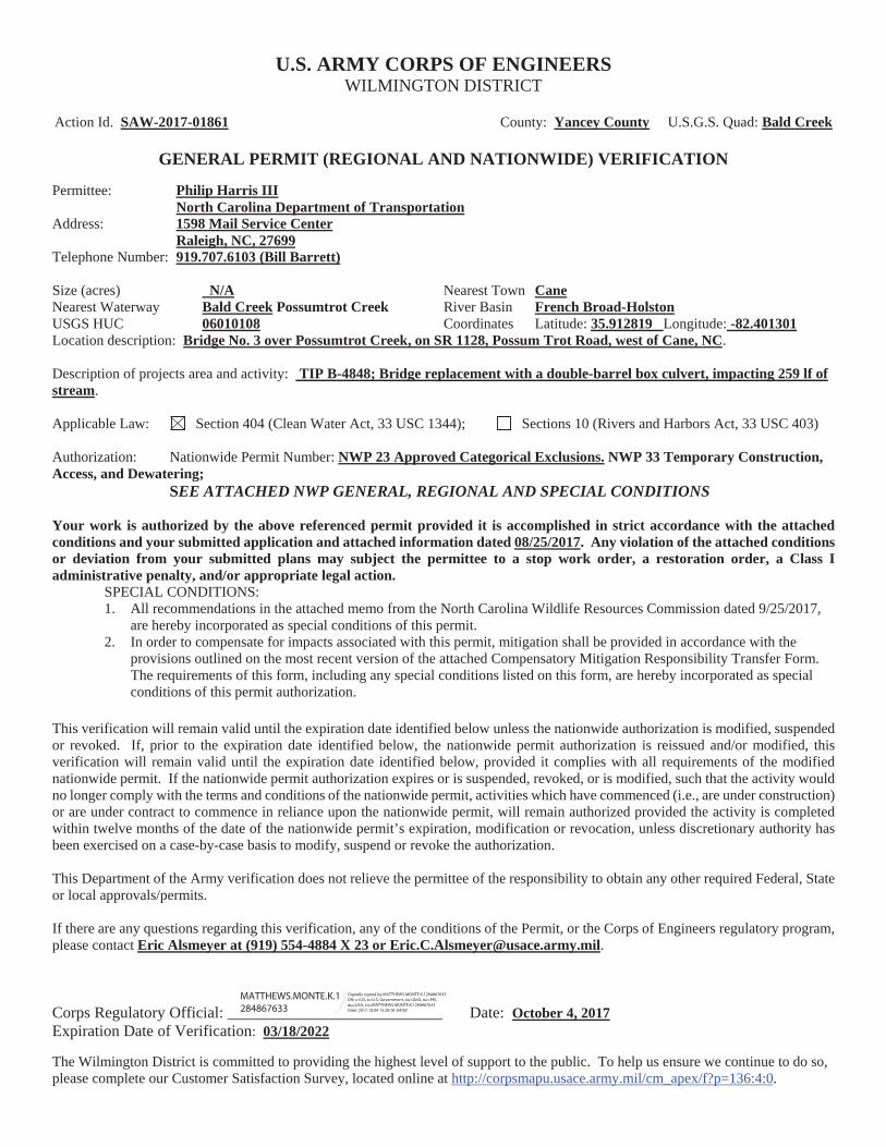
U.S. ARMY CORPS OF ENGINEERSWILMINGTON DISTRICT
Action Id. SAW-2017-01861 County: Yancey County U.S.G.S. Quad: Bald Creek
GENERAL PERMIT (REGIONAL AND NATIONWIDE) VERIFICATION
Permittee: Philip Harris IIINorth Carolina Department of Transportation
Address: 1598 Mail Service CenterRaleigh, NC, 27699
Telephone Number: 919.707.6103 (Bill Barrett)
Size (acres) N/A Nearest Town CaneNearest Waterway Bald Creek Possumtrot Creek River Basin French Broad-HolstonUSGS HUC 06010108 Coordinates Latitude: 35.912819 Longitude: -82.401301Location description: Bridge No. 3 over Possumtrot Creek, on SR 1128, Possum Trot Road, west of Cane, NC.
Description of projects area and activity: TIP B-4848; Bridge replacement with a double-barrel box culvert, impacting 259 lf of stream.
Applicable Law: Section 404 (Clean Water Act, 33 USC 1344); Sections 10 (Rivers and Harbors Act, 33 USC 403)
Authorization: Nationwide Permit Number: NWP 23 Approved Categorical Exclusions. NWP 33 Temporary Construction, Access, and Dewatering;
SEE ATTACHED NWP GENERAL, REGIONAL AND SPECIAL CONDITIONS
Your work is authorized by the above referenced permit provided it is accomplished in strict accordance with the attached conditions and your submitted application and attached information dated 08/25/2017. Any violation of the attached conditions or deviation from your submitted plans may subject the permittee to a stop work order, a restoration order, a Class I administrative penalty, and/or appropriate legal action.
SPECIAL CONDITIONS:1. All recommendations in the attached memo from the North Carolina Wildlife Resources Commission dated 9/25/2017,
are hereby incorporated as special conditions of this permit.2. In order to compensate for impacts associated with this permit, mitigation shall be provided in accordance with the
provisions outlined on the most recent version of the attached Compensatory Mitigation Responsibility Transfer Form. The requirements of this form, including any special conditions listed on this form, are hereby incorporated as special conditions of this permit authorization.
This verification will remain valid until the expiration date identified below unless the nationwide authorization is modified, suspended or revoked. If, prior to the expiration date identified below, the nationwide permit authorization is reissued and/or modified, this verification will remain valid until the expiration date identified below, provided it complies with all requirements of the modified nationwide permit. If the nationwide permit authorization expires or is suspended, revoked, or is modified, such that the activity would no longer comply with the terms and conditions of the nationwide permit, activities which have commenced (i.e., are under construction) or are under contract to commence in reliance upon the nationwide permit, will remain authorized provided the activity is completed within twelve months of the date of the nationwide permit’s expiration, modification or revocation, unless discretionary authority has been exercised on a case-by-case basis to modify, suspend or revoke the authorization.
This Department of the Army verification does not relieve the permittee of the responsibility to obtain any other required Federal, State or local approvals/permits.
If there are any questions regarding this verification, any of the conditions of the Permit, or the Corps of Engineers regulatory program, please contact Eric Alsmeyer at (919) 554-4884 X 23 or [email protected].
Corps Regulatory Official: ___________________________ Date: October 4, 2017 Expiration Date of Verification: 03/18/2022
The Wilmington District is committed to providing the highest level of support to the public. To help us ensure we continue to do so, please complete our Customer Satisfaction Survey, located online at http://corpsmapu.usace.army.mil/cm_apex/f?p=136:4:0.
MATTHEWS.MONTE.K.1284867633
Digitally signed by MATTHEWS.MONTE.K.1284867633 DN: c=US, o=U.S. Government, ou=DoD, ou=PKI, ou=USA, cn=MATTHEWS.MONTE.K.1284867633 Date: 2017.10.04 15:20:18 -04'00'
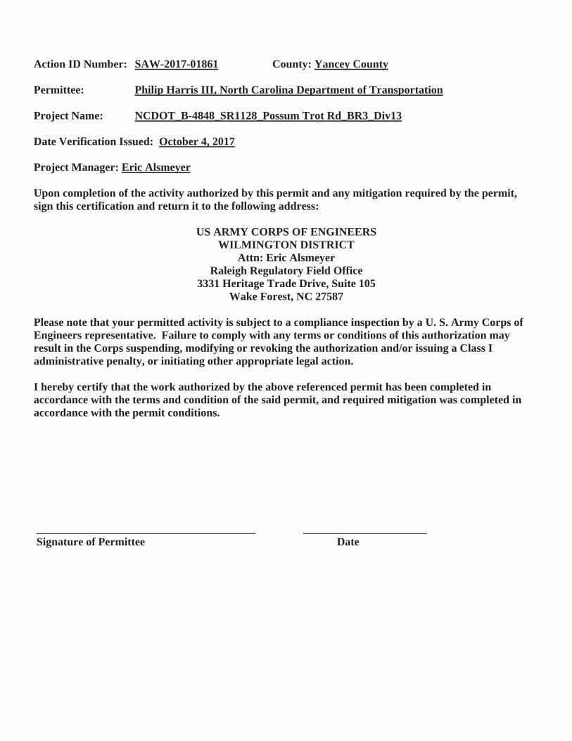
Action ID Number: SAW-2017-01861 County: Yancey County
Permittee: Philip Harris III, North Carolina Department of Transportation
Project Name: NCDOT_B-4848_SR1128_Possum Trot Rd_BR3_Div13
Date Verification Issued: October 4, 2017
Project Manager: Eric Alsmeyer
Upon completion of the activity authorized by this permit and any mitigation required by the permit, sign this certification and return it to the following address:
US ARMY CORPS OF ENGINEERSWILMINGTON DISTRICT
Attn: Eric AlsmeyerRaleigh Regulatory Field Office
3331 Heritage Trade Drive, Suite 105Wake Forest, NC 27587
Please note that your permitted activity is subject to a compliance inspection by a U. S. Army Corps of Engineers representative. Failure to comply with any terms or conditions of this authorization may result in the Corps suspending, modifying or revoking the authorization and/or issuing a Class I administrative penalty, or initiating other appropriate legal action.
I hereby certify that the work authorized by the above referenced permit has been completed in accordance with the terms and condition of the said permit, and required mitigation was completed in accordance with the permit conditions.
_______________________________________ ______________________Signature of Permittee Date
North Carolina Wildlife Resources Commission Gordon Myers, Executive Director
Mailing Address: Habitat Conservation • 1721 Mail Service Center • Raleigh, NC 27699-1721 Telephone: (919) 707-0220 • Fax: (919) 707-0028
September 25, 2017
M E M O R A N D U M
TO: Lori Beckwith, Regulatory Project Manager Asheville Regulatory Field Office, USACE
FROM: Marla Chambers, Western NCDOT Coordinator Habitat Conservation Program, NCWRC
SUBJECT: Review of NCDOT’s application for Section 404 and 401 permits to replace Bridge No. 3 over Possumtrot Creek on SR 1128 (Possum Trot Road), Yancey County, North Carolina. TIP No. B-4848.
The North Carolina Department of Transportation has submitted an application to obtain a Section 404 Permit from the U.S. Army Corps of Engineers and a 401 Water Quality Certification from the NC Division of Water Resources. Staff biologists with the North Carolina Wildlife Resources Commission have reviewed the information provided. These comments are provided in accordance with the provisions of the state and federal Environmental Policy Acts (G.S. 113A-1through 113-10; 1 NCAC 25 and 42 U.S.C. 4332(2)(c), respectively), the Clean Water Act of 1977 (33 U.S.C. 466 et seq.), the Endangered Species Act (16 U. S. C. 1531-1543; 87 Stat 884), and the Fish and Wildlife Coordination Act (48 Stat. 401, as amended; 16 U.S.C. 661-667d), as applicable.
The NCDOT proposes to replace Bridge No. 3 over Possumtrot Creek on SR 1128 (Possum Trot Road) with a double barrel RCBC, measuring 2 @ 13’ x 5’, upstream of the existing structure. The culvert will be placed on a 3.2% slope. The low flow barrel will include sills and baffles. Permanent stream impacts include 89 linear feet for the culvert and 140 lf for channel improvements. Temporary impacts total 30 lf. Possumtrot Creek supports Brown and Rainbow Trout in the project area; therefore, a moratorium prohibiting in-stream work and land disturbance within the 25-foot trout buffer should apply from October 15 to April 15 to protect the egg and fry stages of trout. Sediment and erosion control should adhere to the Design Standards in Sensitive Watersheds. Tree removal should be minimized.
BRIDGE NO. 3, SR 1128 2 SEPTEMBER 25, 2017 POSSUMTROT CR., YANCEY CO.
NCWRC does not object to the issuance of the Section 404 and 401 permits provided that the following conditions are implemented:
1. In-stream work and land disturbance within the 25-foot wide buffer zone are prohibitedduring the trout spawning seasons of October 15 through April 15 to protect the egg andfry stages of trout.
2. Sediment and erosion control measures shall adhere to the Design Standards in SensitiveWatersheds and be strictly maintained until project completion.
3. Herbaceous vegetation shall be planted on all bare soil as soon as possible following thecompletion of permanent or temporary ground disturbing activities to provide appropriatelong-term erosion control.
4. Tall fescue and straw mulch shall not be used in riparian areas. We encourage NCDOTto utilize onsite vegetation and materials for bank stabilization when practicable. Erosioncontrol matting shall be used on steep slopes and for establishing permanent vegetation inriparian areas. The matting shall be well anchored with staples or wooden stakes and,whenever possible, include live stakes of native trees. Matting in riparian areas shouldnot contain plastic mesh, which can entangle and trap small animals.
5. Storm water should be directed to buffer areas or retention basins and should not berouted directly into the waterway.
6. The natural dimension, pattern, and profile of the waterway above and below the crossingshould not be modified by widening the channel or changing the depth of the waterway.
7. Removal of vegetation in riparian areas should be minimized. Native trees and shrubsshould be planted along the banks, as appropriate to the setting, to reestablish the riparianzone and to provide long-term erosion control.
8. Grading and backfilling should be minimized, and tree and shrub growth should beretained, if possible, to ensure long term availability of shoreline cover for fish andwildlife.
9. Where practicable, riprap placed for bank stabilization should be limited to the banksbelow the high water mark, and vegetation should be used for stabilization above the highwater elevation.
10. If concrete will be used during construction, work must be accomplished so that wet(uncured) concrete does not contact surface waters. This will lessen the chance ofaltering the water chemistry and causing a fish kill.
11. Discharging hydroseeding mixtures and washing out hydroseeders and other equipmentin or adjacent to surface waters is prohibited.
BRIDGE NO. 3, SR 1128 3 SEPTEMBER 25, 2017 POSSUMTROT CR., YANCEY CO.
12. Heavy equipment should be operated from the bank rather than in the channel wheneverpossible in order to minimize sedimentation and reduce the likelihood of introducingother pollutants into the waterway. All mechanized equipment operated near surfacewaters should be inspected and maintained regularly to prevent contamination of surfacewaters from fuels, lubricants, hydraulic fluids or other toxic materials.
Thank you for the opportunity to review and comment on this project. If you have any questions regarding these comments, please contact me at [email protected] or (704) 244-8907.
cc: Kevin Barnett, NCDWR
1
NATIONWIDE PERMIT 23DEPARTMENT OF THE ARMY
CORPS OF ENGINEERSFINAL NOTICE OF ISSUANCE AND MODIFICATION OF NATIONWIDE PERMITS
FEDERAL REGISTERAUTHORIZED MARCH 19, 2017
Approved Categorical Exclusions. Activities undertaken, assisted, authorized, regulated, funded, or financed, in whole or in part, by another Federal agency or department where:
(a) That agency or department has determined, pursuant to the Council onEnvironmental Quality's implementing regulations for the National Environmental Policy Act(40 CFR part 1500 et seq.), that the activity is categorically excluded from the requirement toprepare an environmental impact statement or environmental assessment analysis, because itis included within a category of actions which neither individually nor cumulatively have asignificant effect on the human environment; and
(b) The Office of the Chief of Engineers (Attn: CECW-CO) has concurred with that agency’s or department’s determination that the activity is categorically excluded and approved the activity for authorization under NWP 23.
The Office of the Chief of Engineers may require additional conditions, including pre-construction notification, for authorization of an agency’s categorical exclusions under this NWP.
Notification: Certain categorical exclusions approved for authorization under this NWPrequire the permittee to submit a pre-construction notification to the district engineer prior tocommencing the activity (see general condition 32). The activities that require pre-construction notification are listed in the appropriate Regulatory Guidance Letters. (Authorities: Sections 10 and 404)
Note: The agency or department may submit an application for an activity believed to becategorically excluded to the Office of the Chief of Engineers (Attn: CECW-CO). Prior toapproval for authorization under this NWP of any agency's activity, the Office of the Chief ofEngineers will solicit public comment. As of the date of issuance of this NWP, agencies withapproved categorical exclusions are: the Bureau of Reclamation, Federal Highway Administration, and U.S. Coast Guard. Activities approved for authorization under this NWPas of the date of this notice are found in Corps Regulatory Guidance Letter 05-07, which isavailable at: http://www.usace.army.mil/Portals/2/docs/civilworks/RGLS/rgl05-07.pdf. Anyfuture approved categorical exclusions will be announced in Regulatory Guidance Letters andposted on this same web site.
1
NATIONWIDE PERMIT 33 DEPARTMENT OF THE ARMY
CORPS OF ENGINEERS FINAL NOTICE OF ISSUANCE AND MODIFICATION OF NATIONWIDE PERMITS
FEDERAL REGISTER AUTHORIZED MARCH 19, 2017
Temporary Construction, Access, and Dewatering. Temporary structures, work, and discharges, including cofferdams, necessary for construction activities or access fills or dewatering of construction sites, provided that the associated primary activity is authorized by the Corps of Engineers or the U.S. Coast Guard. This NWP also authorizes temporary structures, work, and discharges, including cofferdams, necessary for construction activities not otherwise subject to the Corps or U.S. Coast Guard permit requirements. Appropriate measures must be taken to maintain near normal downstream flows and to minimize flooding. Fill must consist of materials, and be placed in a manner, that will not be eroded by expected high flows. The use of dredged material may be allowed if the district engineer determines that it will not cause more than minimal adverse environmental effects. Following completion of construction, temporary fill must be entirely removed to an area that has no waters of the United States, dredged material must be returned to its original location, and the affected areas must be restored to pre- construction elevations. The affected areas must also be revegetated, as appropriate. This permit does not authorize the use of cofferdams to dewater wetlands or other aquatic areas to change their use. Structures left in place after construction is completed require a separate section 10 permit if located in navigable waters of the United States. (See 33 CFR part 322.) Notification: The permittee must submit a pre-construction notification to the district engineer prior to commencing the activity if the activity is conducted in navigable waters of the United States (i.e., section 10 waters) (see general condition 32). The pre- construction notification must include a restoration plan showing how all temporary fills and structures will be removed and the area restored to pre-project conditions. (Authorities: Sections 10 and 404)
3
NATIONWIDE PERMIT GENERAL CONDITIONS The following General Conditions must be followed in order for any authorization by a NWP to be valid:
1. Navigation. (a) No activity may cause more than a minimal adverse effect on navigation.
(b) Any safety lights and signals prescribed by the U.S. Coast Guard, through regulations or otherwise, must be installed and maintained at the permittee's expense on authorized facilities in navigable waters of the United States.
(c) The permittee understands and agrees that, if future operations by the United States require the removal, relocation, or other alteration, of the structure or work herein authorized, or if, in the opinion of the Secretary of the Army or his authorized representative, said structure or work shall cause unreasonable obstruction to the free navigation of the navigable waters, the permittee will be required, upon due notice from the Corps of Engineers, to remove, relocate, or alter the structural work or obstructions caused thereby, without expense to the United States. No claim shall be made against the United States on account of any such removal or alteration.
2. Aquatic Life Movements. No activity may substantially disrupt the necessary life cycle movements of those species of aquatic life indigenous to the waterbody, including those species that normally migrate through the area, unless the activity's primary purpose is to impound water. All permanent and temporary crossings of waterbodies shall be suitably culverted, bridged, or otherwise designed and constructed to maintain low flows to sustain the movement of those aquatic species. If a bottomless culvert cannot be used, then the crossing should be designed and constructed to minimize adverse effects to aquatic life movements.
3. Spawning Areas. Activities in spawning areas during spawning seasons must be avoided to the maximum extent practicable. Activities that result in the physical destruction (e.g., through excavation, fill, or downstream smothering by substantial turbidity) of an important spawning area are not authorized.
4. Migratory Bird Breeding Areas. Activities in waters of the United States that serve as breeding areas for migratory birds must be avoided to the maximum extent practicable.
5. Shellfish Beds. No activity may occur in areas of concentrated shellfish populations, unless the activity is directly related to a shellfish harvesting activity authorized by NWPs 4 and 48, or is a shellfish seeding or habitat restoration activity authorized by NWP 27.
6. Suitable Material. No activity may use unsuitable material (e.g., trash, debris, car bodies, asphalt, etc.). Material used for construction or discharged must be free from toxic pollutants in toxic amounts (see section 307 of the Clean Water Act).
4
7. Water Supply Intakes. No activity may occur in the proximity of a public water supply intake, except where the activity is for the repair or improvement of public water supply intake structures or adjacent bank stabilization.
8. Adverse Effects From Impoundments. If the activity creates an impoundment of water, adverse effects to the aquatic system due to accelerating the passage of water, and/or restricting its flow must be minimized to the maximum extent practicable.
9. Management of Water Flows. To the maximum extent practicable, the pre- construction course, condition, capacity, and location of open waters must be maintained for each activity, including stream channelization, storm water management activities, and temporary and permanent road crossings, except as provided below. The activity must be constructed to withstand expected high flows. The activity must not restrict or impede the passage of normal or high flows, unless the primary purpose of the activity is to impound water or manage high flows. The activity may alter the pre-construction course, condition, capacity, and location of open waters if it benefits the aquatic environment (e.g., stream restoration or relocation activities).
10. Fills Within 100-Year Floodplains. The activity must comply with applicable
FEMA-approved state or local floodplain management requirements. 11. Equipment. Heavy equipment working in wetlands or mudflats must be placed
on mats, or other measures must be taken to minimize soil disturbance. 12. Soil Erosion and Sediment Controls. Appropriate soil erosion and sediment
controls must be used and maintained in effective operating condition during construction, and all exposed soil and other fills, as well as any work below the ordinary high water mark or high tide line, must be permanently stabilized at the earliest practicable date. Permittees are encouraged to perform work within waters of the United States during periods of low-flow or no-flow, or during low tides.
13. Removal of Temporary Fills. Temporary fills must be removed in their entirety
and the affected areas returned to pre-construction elevations. The affected areas must be revegetated, as appropriate.
14. Proper Maintenance. Any authorized structure or fill shall be properly
maintained, including maintenance to ensure public safety and compliance with applicable NWP general conditions, as well as any activity-specific conditions added by the district engineer to an NWP authorization.
15. Single and Complete Project. The activity must be a single and complete
project. The same NWP cannot be used more than once for the same single and complete project.
16. Wild and Scenic Rivers. (a) No NWP activity may occur in a component of the National Wild and Scenic River System, or in a river officially designated by Congress as a “study river” for possible inclusion in the system while the river is in an official study status,
5
unless the appropriate Federal agency with direct management responsibility for such river, has determined in writing that the proposed activity will not adversely affect the Wild and Scenic River designation or study status.
(b) If a proposed NWP activity will occur in a component of the National Wild and Scenic River System, or in a river officially designated by Congress as a “study river” for possible inclusion in the system while the river is in an official study status, the permittee must submit a pre-construction notification (see general condition 32). The district engineer will coordinate the PCN with the Federal agency with direct management responsibility for that river. The permittee shall not begin the NWP activity until notified by the district engineer that the Federal agency with direct management responsibility for that river has determined in writing that the proposed NWP activity will not adversely affect the Wild and Scenic River designation or study status.
(c) Information on Wild and Scenic Rivers may be obtained from the appropriate Federal land management agency responsible for the designated Wild and Scenic River or study river (e.g., National Park Service, U.S. Forest Service, Bureau of Land Management, U.S. Fish and Wildlife Service). Information on these rivers is also available at: http://www.rivers.gov/.
17. Tribal Rights. No NWP activity may cause more than minimal adverse effects on tribal rights (including treaty rights), protected tribal resources, or tribal lands.
18. Endangered Species. (a) No activity is authorized under any NWP which is likely to directly or indirectly jeopardize the continued existence of a threatened or endangered species or a species proposed for such designation, as identified under the Federal Endangered Species Act (ESA), or which will directly or indirectly destroy or adversely modify the critical habitat of such species. No activity is authorized under any NWP which “may affect” a listed species or critical habitat, unless ESA section 7 consultation addressing the effects of the proposed activity has been completed. Direct effects are the immediate effects on listed species and critical habitat caused by the NWP activity. Indirect effects are those effects on listed species and critical habitat that are caused by the NWP activity and are later in time, but still are reasonably certain to occur.
(b) Federal agencies should follow their own procedures for complying with the requirements of the ESA. If pre-construction notification is required for the proposed activity, the Federal permittee must provide the district engineer with the appropriate documentation to demonstrate compliance with those requirements. The district engineer will verify that the appropriate documentation has been submitted. If the appropriate documentation has not been submitted, additional ESA section 7 consultation may be necessary for the activity and the respective federal agency would be responsible for fulfilling its obligation under section 7 of the ESA.
(c) Non-federal permittees must submit a pre-construction notification to the district engineer if any listed species or designated critical habitat might be affected or is in the vicinity of the activity, or if the activity is located in designated critical habitat, and shall not begin work on the activity until notified by the district engineer that the requirements of the ESA have been satisfied and that the activity is authorized. For activities that might affect Federally-listed endangered or threatened species or designated critical habitat, the pre-construction notification must include the name(s) of the endangered or threatened species that
6
might be affected by the proposed activity or that utilize the designated critical habitat that might be affected by the proposed activity. The district engineer will determine whether the proposed activity “may affect” or will have “no effect” to listed species and designated critical habitat and will notify the non- Federal applicant of the Corps’ determination within 45 days of receipt of a complete pre- construction notification. In cases where the non-Federal applicant has identified listed species or critical habitat that might be affected or is in the vicinity of the activity, and has so notified the Corps, the applicant shall not begin work until the Corps has provided notification that the proposed activity will have “no effect” on listed species or critical habitat, or until ESA section 7 consultation has been completed. If the non-Federal applicant has not heard back from the Corps within 45 days, the applicant must still wait for notification from the Corps.
(d) As a result of formal or informal consultation with the FWS or NMFS the district engineer may add species-specific permit conditions to the NWPs.
(e) Authorization of an activity by an NWP does not authorize the “take” of a threatened or endangered species as defined under the ESA. In the absence of separate authorization (e.g., an ESA Section 10 Permit, a Biological Opinion with “incidental take” provisions, etc.) from the FWS or the NMFS, the Endangered Species Act prohibits any person subject to the jurisdiction of the United States to take a listed species, where "take" means to harass, harm, pursue, hunt, shoot, wound, kill, trap, capture, or collect, or to attempt to engage in any such conduct. The word “harm” in the definition of “take'' means an act which actually kills or injures wildlife. Such an act may include significant habitat modification or degradation where it actually kills or injures wildlife by significantly impairing essential behavioral patterns, including breeding, feeding or sheltering.
(f) If the non-federal permittee has a valid ESA section 10(a)(1)(B) incidental take permit with an approved Habitat Conservation Plan for a project or a group of projects that includes the proposed NWP activity, the non-federal applicant should provide a copy of that ESA section 10(a)(1)(B) permit with the PCN required by paragraph (c) of this general condition. The district engineer will coordinate with the agency that issued the ESA section 10(a)(1)(B) permit to determine whether the proposed NWP activity and the associated incidental take were considered in the internal ESA section 7 consultation conducted for the ESA section 10(a)(1)(B) permit. If that coordination results in concurrence from the agency that the proposed NWP activity and the associated incidental take were considered in the internal ESA section 7 consultation for the ESA section 10(a)(1)(B) permit, the district engineer does not need to conduct a separate ESA section 7 consultation for the proposed NWP activity. The district engineer will notify the non-federal applicant within 45 days of receipt of a complete pre-construction notification whether the ESA section 10(a)(1)(B) permit covers the proposed NWP activity or whether additional ESA section 7 consultation is required.
(g) Information on the location of threatened and endangered species and their critical habitat can be obtained directly from the offices of the FWS and NMFS or their world wide web pages at http://www.fws.gov/ or http://www.fws.gov/ipac and http://www.nmfs.noaa.gov/pr/species/esa/ respectively.
19. Migratory Birds and Bald and Golden Eagles. The permittee is responsible for ensuring their action complies with the Migratory Bird Treaty Act and the Bald and Golden Eagle Protection Act. The permittee is responsible for contacting appropriate local office of the U.S. Fish and Wildlife Service to determine applicable measures to reduce impacts to migratory
7
birds or eagles, including whether “incidental take” permits are necessary and available under the Migratory Bird Treaty Act or Bald and Golden Eagle Protection Act for a particular activity.
20. Historic Properties. (a) In cases where the district engineer determines that the
activity may have the potential to cause effects to properties listed, or eligible for listing, in the National Register of Historic Places, the activity is not authorized, until the requirements of Section 106 of the National Historic Preservation Act (NHPA) have been satisfied.
(b) Federal permittees should follow their own procedures for complying with the requirements of section 106 of the National Historic Preservation Act. If pre-construction notification is required for the proposed NWP activity, the Federal permittee must provide the district engineer with the appropriate documentation to demonstrate compliance with those requirements. The district engineer will verify that the appropriate documentation has been submitted. If the appropriate documentation is not submitted, then additional consultation under section 106 may be necessary. The respective federal agency is responsible for fulfilling its obligation to comply with section 106.
(c) Non-federal permittees must submit a pre-construction notification to the district engineer if the NWP activity might have the potential to cause effects to any historic properties listed on, determined to be eligible for listing on, or potentially eligible for listing on the National Register of Historic Places, including previously unidentified properties. For such activities, the pre-construction notification must state which historic properties might have the potential to be affected by the proposed NWP activity or include a vicinity map indicating the location of the historic properties or the potential for the presence of historic properties. Assistance regarding information on the location of, or potential for, the presence of historic properties can be sought from the State Historic Preservation Officer, Tribal Historic Preservation Officer, or designated tribal representative, as appropriate, and the National Register of Historic Places (see 33 CFR 330.4(g)). When reviewing pre-construction notifications, district engineers will comply with the current procedures for addressing the requirements of section 106 of the National Historic Preservation Act. The district engineer shall make a reasonable and good faith effort to carry out appropriate identification efforts, which may include background research, consultation, oral history interviews, sample field investigation, and field survey. Based on the information submitted in the PCN and these identification efforts, the district engineer shall determine whether the proposed NWP activity has the potential to cause effects on the historic properties. Section 106 consultation is not required when the district engineer determines that the activity does not have the potential to cause effects on historic properties (see 36 CFR 800.3(a)). Section 106 consultation is required when the district engineer determines that the activity has the potential to cause effects on historic properties. The district engineer will conduct consultation with consulting parties identified under 36 CFR 800.2(c) when he or she makes any of the following effect determinations for the purposes of section 106 of the NHPA: no historic properties affected, no adverse effect, or adverse effect. Where the non-Federal applicant has identified historic properties on which the activity might have the potential to cause effects and so notified the Corps, the non-Federal applicant shall not begin the activity until notified by the district engineer either that the activity has no potential to cause effects to historic properties or that NHPA section 106 consultation has been completed.
8
(d) For non-federal permittees, the district engineer will notify the prospective permittee within 45 days of receipt of a complete pre-construction notification whether NHPA section 106 consultation is required. If NHPA section 106 consultation is required, the district engineer will notify the non-Federal applicant that he or she cannot begin the activity until section 106 consultation is completed. If the non-Federal applicant has not heard back from the Corps within 45 days, the applicant must still wait for notification from the Corps.
(e) Prospective permittees should be aware that section 110k of the NHPA (54 U.S.C. 306113) prevents the Corps from granting a permit or other assistance to an applicant who, with intent to avoid the requirements of section 106 of the NHPA, has intentionally significantly adversely affected a historic property to which the permit would relate, or having legal power to prevent it, allowed such significant adverse effect to occur, unless the Corps, after consultation with the Advisory Council on Historic Preservation (ACHP), determines that circumstances justify granting such assistance despite the adverse effect created or permitted by the applicant. If circumstances justify granting the assistance, the Corps is required to notify the ACHP and provide documentation specifying the circumstances, the degree of damage to the integrity of any historic properties affected, and proposed mitigation. This documentation must include any views obtained from the applicant, SHPO/THPO, appropriate Indian tribes if the undertaking occurs on or affects historic properties on tribal lands or affects properties of interest to those tribes, and other parties known to have a legitimate interest in the impacts to the permitted activity on historic properties.
21. Discovery of Previously Unknown Remains and Artifacts. If you discover any previously unknown historic, cultural or archeological remains and artifacts while accomplishing the activity authorized by this permit, you must immediately notify the district engineer of what you have found, and to the maximum extent practicable, avoid construction activities that may affect the remains and artifacts until the required coordination has been completed. The district engineer will initiate the Federal, Tribal, and state coordination required to determine if the items or remains warrant a recovery effort or if the site is eligible for listing in the National Register of Historic Places.
22. Designated Critical Resource Waters. Critical resource waters include, NOAA-
managed marine sanctuaries and marine monuments, and National Estuarine Research Reserves. The district engineer may designate, after notice and opportunity for public comment, additional waters officially designated by a state as having particular environmental or ecological significance, such as outstanding national resource waters or state natural heritage sites. The district engineer may also designate additional critical resource waters after notice and opportunity for public comment.
(a) Discharges of dredged or fill material into waters of the United States are not authorized by NWPs 7, 12, 14, 16, 17, 21, 29, 31, 35, 39, 40, 42, 43, 44, 49, 50, 51, and 52 for any activity within, or directly affecting, critical resource waters, including wetlands adjacent to such waters.
(b) For NWPs 3, 8, 10, 13, 15, 18, 19, 22, 23, 25, 27, 28, 30, 33, 34, 36, 37, 38, and 54, notification is required in accordance with general condition 32, for any activity proposed in the designated critical resource waters including wetlands adjacent to those waters. The district engineer may authorize activities under these NWPs only after it is determined that the impacts to the critical resource waters will be no more than minimal.
9
23. Mitigation. The district engineer will consider the following factors when determining appropriate and practicable mitigation necessary to ensure that the individual and cumulative adverse environmental effects are no more than minimal:
(a) The activity must be designed and constructed to avoid and minimize adverse effects, both temporary and permanent, to waters of the United States to the maximum extent practicable at the project site (i.e., on site).
(b) Mitigation in all its forms (avoiding, minimizing, rectifying, reducing, or compensating for resource losses) will be required to the extent necessary to ensure that the individual and cumulative adverse environmental effects are no more than minimal.
(c) Compensatory mitigation at a minimum one-for-one ratio will be required for all wetland losses that exceed 1/10-acre and require pre-construction notification, unless the district engineer determines in writing that either some other form of mitigation would be more environmentally appropriate or the adverse environmental effects of the proposed activity are no more than minimal, and provides an activity-specific waiver of this requirement. For wetland losses of 1/10-acre or less that require pre-construction notification, the district engineer may determine on a case-by-case basis that compensatory mitigation is required to ensure that the activity results in only minimal adverse environmental effects.
(d) For losses of streams or other open waters that require pre-construction notification, the district engineer may require compensatory mitigation to ensure that the activity results in no more than minimal adverse environmental effects. Compensatory mitigation for losses of streams should be provided, if practicable, through stream rehabilitation, enhancement, or preservation, since streams are difficult-to-replace resources (see 33 CFR 332.3(e)(3)).
(e) Compensatory mitigation plans for NWP activities in or near streams or other open waters will normally include a requirement for the restoration or enhancement, maintenance, and legal protection (e.g., conservation easements) of riparian areas next to open waters. In some cases, the restoration or maintenance/protection of riparian areas may be the only compensatory mitigation required. Restored riparian areas should consist of native species. The width of the required riparian area will address documented water quality or aquatic habitat loss concerns. Normally, the riparian area will be 25 to 50 feet wide on each side of the stream, but the district engineer may require slightly wider riparian areas to address documented water quality or habitat loss concerns. If it is not possible to restore or maintain/protect a riparian area on both sides of a stream, or if the waterbody is a lake or coastal waters, then restoring or maintaining/protecting a riparian area along a single bank or shoreline may be sufficient. Where both wetlands and open waters exist on the project site, the district engineer will determine the appropriate compensatory mitigation (e.g., riparian areas and/or wetlands compensation) based on what is best for the aquatic environment on a watershed basis. In cases where riparian areas are determined to be the most appropriate form of minimization or compensatory mitigation, the district engineer may waive or reduce the requirement to provide wetland compensatory mitigation for wetland losses.
(f) Compensatory mitigation projects provided to offset losses of aquatic resources must comply with the applicable provisions of 33 CFR part 332.
(1) The prospective permittee is responsible for proposing an appropriate compensatory mitigation option if compensatory mitigation is necessary to ensure that the activity results in no more than minimal adverse environmental effects. For the NWPs, the preferred mechanism for providing compensatory mitigation is mitigation bank credits or in-
10
lieu fee program credits (see 33 CFR 332.3(b)(2) and (3)). However, if an appropriate number and type of mitigation bank or in-lieu credits are not available at the time the PCN is submitted to the district engineer, the district engineer may approve the use of permittee-responsible mitigation.
(2) The amount of compensatory mitigation required by the district engineer must be sufficient to ensure that the authorized activity results in no more than minimal individual and cumulative adverse environmental effects (see 33 CFR 330.1(e)(3)). (See also 33 CFR 332.3(f)).
(3) Since the likelihood of success is greater and the impacts to potentially valuable uplands are reduced, aquatic resource restoration should be the first compensatory mitigation option considered for permittee-responsible mitigation.
(4) If permittee-responsible mitigation is the proposed option, the prospective permittee is responsible for submitting a mitigation plan. A conceptual or detailed mitigation plan may be used by the district engineer to make the decision on the NWP verification request, but a final mitigation plan that addresses the applicable requirements of 33 CFR 332.4(c)(2) through (14) must be approved by the district engineer before the permittee begins work in waters of the United States, unless the district engineer determines that prior approval of the final mitigation plan is not practicable or not necessary to ensure timely completion of the required compensatory mitigation (see 33 CFR 332.3(k)(3)).
(5) If mitigation bank or in-lieu fee program credits are the proposed option, the mitigation plan only needs to address the baseline conditions at the impact site and the number of credits to be provided.
(6) Compensatory mitigation requirements (e.g., resource type and amount to be provided as compensatory mitigation, site protection, ecological performance standards, monitoring requirements) may be addressed through conditions added to the NWP authorization, instead of components of a compensatory mitigation plan (see 33 CFR 332.4(c)(1)(ii)).
(g) Compensatory mitigation will not be used to increase the acreage losses allowed by the acreage limits of the NWPs. For example, if an NWP has an acreage limit of 1/2-acre, it cannot be used to authorize any NWP activity resulting in the loss of greater than 1/2-acre of waters of the United States, even if compensatory mitigation is provided that replaces or restores some of the lost waters. However, compensatory mitigation can and should be used, as necessary, to ensure that an NWP activity already meeting the established acreage limits also satisfies the no more than minimal impact requirement for the NWPs.
(h) Permittees may propose the use of mitigation banks, in-lieu fee programs, or permittee-responsible mitigation. When developing a compensatory mitigation proposal, the permittee must consider appropriate and practicable options consistent with the framework at 33 CFR 332.3(b). For activities resulting in the loss of marine or estuarine resources, permittee-responsible mitigation may be environmentally preferable if there are no mitigation banks or in-lieu fee programs in the area that have marine or estuarine credits available for sale or transfer to the permittee. For permittee-responsible mitigation, the special conditions of the NWP verification must clearly indicate the party or parties responsible for the implementation and performance of the compensatory mitigation project, and, if required, its long-term management.
(i) Where certain functions and services of waters of the United States are permanently adversely affected by a regulated activity, such as discharges of dredged or fill
11
material into waters of the United States that will convert a forested or scrub-shrub wetland to a herbaceous wetland in a permanently maintained utility line right-of-way, mitigation may be required to reduce the adverse environmental effects of the activity to the no more than minimal level.
24. Safety of Impoundment Structures. To ensure that all impoundment structures are safely designed, the district engineer may require non-Federal applicants to demonstrate that the structures comply with established state dam safety criteria or have been designed by qualified persons. The district engineer may also require documentation that the design has been independently reviewed by similarly qualified persons, and appropriate modifications made to ensure safety.
25. Water Quality. Where States and authorized Tribes, or EPA where applicable,
have not previously certified compliance of an NWP with CWA section 401, individual 401 Water Quality Certification must be obtained or waived (see 33 CFR 330.4(c)). The district engineer or State or Tribe may require additional water quality management measures to ensure that the authorized activity does not result in more than minimal degradation of water quality.
26. Coastal Zone Management. In coastal states where an NWP has not previously received a state coastal zone management consistency concurrence, an individual state coastal zone management consistency concurrence must be obtained, or a presumption of concurrence must occur (see 33 CFR 330.4(d)). The district engineer or a State may require additional measures to ensure that the authorized activity is consistent with state coastal zone management requirements.
27. Regional and Case-By-Case Conditions. The activity must comply with any
regional conditions that may have been added by the Division Engineer (see 33 CFR 330.4(e)) and with any case specific conditions added by the Corps or by the state, Indian Tribe, or U.S. EPA in its section 401 Water Quality Certification, or by the state in its Coastal Zone Management Act consistency determination.
28. Use of Multiple Nationwide Permits. The use of more than one NWP for a
single and complete project is prohibited, except when the acreage loss of waters of the United States authorized by the NWPs does not exceed the acreage limit of the NWP with the highest specified acreage limit. For example, if a road crossing over tidal waters is constructed under NWP 14, with associated bank stabilization authorized by NWP 13, the maximum acreage loss of waters of the United States for the total project cannot exceed 1/3-acre.
29. Transfer of Nationwide Permit Verifications. If the permittee sells the property
associated with a nationwide permit verification, the permittee may transfer the nationwide permit verification to the new owner by submitting a letter to the appropriate Corps district office to validate the transfer. A copy of the nationwide permit verification must be attached to the letter, and the letter must contain the following statement and signature: “When the structures or work authorized by this nationwide permit are still in existence at the time the property is transferred, the terms and conditions of this nationwide permit, including any special conditions, will continue to be binding on the new owner(s) of the property. To
12
validate the transfer of this nationwide permit and the associated liabilities associated with compliance with its terms and conditions, have the transferee sign and date below.”
(Transferee)
(Date)
30. Compliance Certification. Each permittee who receives an NWP verification letter from the Corps must provide a signed certification documenting completion of the authorized activity and implementation of any required compensatory mitigation. The success of any required permittee-responsible mitigation, including the achievement of ecological performance standards, will be addressed separately by the district engineer. The Corps will provide the permittee the certification document with the NWP verification letter. The certification document will include:
(a) A statement that the authorized activity was done in accordance with the NWP authorization, including any general, regional, or activity-specific conditions;
(b) A statement that the implementation of any required compensatory mitigation was completed in accordance with the permit conditions. If credits from a mitigation bank or in-lieu fee program are used to satisfy the compensatory mitigation requirements, the certification must include the documentation required by 33 CFR 332.3(l)(3) to confirm that the permittee secured the appropriate number and resource type of credits; and
(c) The signature of the permittee certifying the completion of the activity and mitigation.
The completed certification document must be submitted to the district engineer within 30 days of completion of the authorized activity or the implementation of any required compensatory mitigation, whichever occurs later.
31. Activities Affecting Structures or Works Built by the United States. If an NWP
activity also requires permission from the Corps pursuant to 33 U.S.C. 408 because it will alter or temporarily or permanently occupy or use a U.S. Army Corps of Engineers (USACE) federally authorized Civil Works project (a “USACE project”), the prospective permittee must submit a pre-construction notification. See paragraph (b)(10) of general condition 32. An activity that requires section 408 permission is not authorized by NWP until the appropriate Corps office issues the section 408 permission to alter, occupy, or use the USACE project, and the district engineer issues a written NWP verification.
32. Pre-Construction Notification. (a) Timing. Where required by the terms of the NWP, the prospective permittee must notify the district engineer by submitting a pre- construction notification (PCN) as early as possible. The district engineer must determine if the PCN is complete within 30 calendar days of the date of receipt and, if the PCN is determined to be incomplete, notify the prospective permittee within that 30 day period to request the additional information necessary to make the PCN complete. The request must specify the information needed to make the PCN complete. As a general rule, district engineers will request additional information necessary to make the PCN complete only once. However, if the
13
prospective permittee does not provide all of the requested information, then the district engineer will notify the prospective permittee that the PCN is still incomplete and the PCN review process will not commence until all of the requested information has been received by the district engineer. The prospective permittee shall not begin the activity until either:
(1) He or she is notified in writing by the district engineer that the activity may proceed under the NWP with any special conditions imposed by the district or division engineer; or
(2) 45 calendar days have passed from the district engineer’s receipt of the complete PCN and the prospective permittee has not received written notice from the district or division engineer. However, if the permittee was required to notify the Corps pursuant to general condition 18 that listed species or critical habitat might be affected or are in the vicinity of the activity, or to notify the Corps pursuant to general condition 20 that the activity might have the potential to cause effects to historic properties, the permittee cannot begin the activity until receiving written notification from the Corps that there is “no effect” on listed species or “no potential to cause effects” on historic properties, or that any consultation required under Section 7 of the Endangered Species Act (see 33 CFR 330.4(f)) and/or section 106 of the National Historic Preservation Act (see 33 CFR 330.4(g)) has been completed. Also, work cannot begin under NWPs 21, 49, or 50 until the permittee has received written approval from the Corps. If the proposed activity requires a written waiver to exceed specified limits of an NWP, the permittee may not begin the activity until the district engineer issues the waiver. If the district or division engineer notifies the permittee in writing that an individual permit is required within 45 calendar days of receipt of a complete PCN, the permittee cannot begin the activity until an individual permit has been obtained. Subsequently, the permittee’s right to proceed under the NWP may be modified, suspended, or revoked only in accordance with the procedure set forth in 33 CFR 330.5(d)(2).
(b) Contents of Pre-Construction Notification: The PCN must be in writing and include the following information:
(1) Name, address and telephone numbers of the prospective permittee; (2) Location of the proposed activity; (3) Identify the specific NWP or NWP(s) the prospective permittee wants to use
to authorize the proposed activity; (4) A description of the proposed activity; the activity’s purpose; direct and indirect
adverse environmental effects the activity would cause, including the anticipated amount of loss of wetlands, other special aquatic sites, and other waters expected to result from the NWP activity, in acres, linear feet, or other appropriate unit of measure; a description of any proposed mitigation measures intended to reduce the adverse environmental effects caused by the proposed activity; and any other NWP(s), regional general permit(s), or individual permit(s) used or intended to be used to authorize any part of the proposed project or any related activity, including other separate and distant crossings for linear projects that require Department of the Army authorization but do not require pre-construction notification. The description of the proposed activity and any proposed mitigation measures should be sufficiently detailed to allow the district engineer to determine that the adverse environmental effects of the activity will be no more than minimal and to determine the need for compensatory mitigation or other mitigation measures. For single and complete linear projects, the PCN must include the quantity of anticipated losses of wetlands, other special aquatic sites, and other waters for each single and complete crossing of those wetlands, other special aquatic sites, and other waters.
14
Sketches should be provided when necessary to show that the activity complies with the terms of the NWP. (Sketches usually clarify the activity and when provided results in a quicker decision. Sketches should contain sufficient detail to provide an illustrative description of the proposed activity (e.g., a conceptual plan), but do not need to be detailed engineering plans);
(5) The PCN must include a delineation of wetlands, other special aquatic sites, and other waters, such as lakes and ponds, and perennial, intermittent, and ephemeral streams, on the project site. Wetland delineations must be prepared in accordance with the current method required by the Corps. The permittee may ask the Corps to delineate the special aquatic sites and other waters on the project site, but there may be a delay if the Corps does the delineation, especially if the project site is large or contains many wetlands, other special aquatic sites, and other waters. Furthermore, the 45 day period will not start until the delineation has been submitted to or completed by the Corps, as appropriate;
(6) If the proposed activity will result in the loss of greater than 1/10-acre of wetlands and a PCN is required, the prospective permittee must submit a statement describing how the mitigation requirement will be satisfied, or explaining why the adverse environmental effects are no more than minimal and why compensatory mitigation should not be required. As an alternative, the prospective permittee may submit a conceptual or detailed mitigation plan.
(7) For non-Federal permittees, if any listed species or designated critical habitat might be affected or is in the vicinity of the activity, or if the activity is located in designated critical habitat, the PCN must include the name(s) of those endangered or threatened species that might be affected by the proposed activity or utilize the designated critical habitat that might be affected by the proposed activity. For NWP activities that require pre-construction notification, Federal permittees must provide documentation demonstrating compliance with the Endangered Species Act;
(8) For non-Federal permittees, if the NWP activity might have the potential to cause effects to a historic property listed on, determined to be eligible for listing on, or potentially eligible for listing on, the National Register of Historic Places, the PCN must state which historic property might have the potential to be affected by the proposed activity or include a vicinity map indicating the location of the historic property. For NWP activities that require pre-construction notification, Federal permittees must provide documentation demonstrating compliance with section 106 of the National Historic Preservation Act;
(9) For an activity that will occur in a component of the National Wild and Scenic River System, or in a river officially designated by Congress as a “study river” for possible inclusion in the system while the river is in an official study status, the PCN must identify the Wild and Scenic River or the “study river” (see general condition 16); and
(10) For an activity that requires permission from the Corps pursuant to 33 U.S.C. 408 because it will alter or temporarily or permanently occupy or use a U.S. Army Corps of Engineers federally authorized civil works project, the pre-construction notification must include a statement confirming that the project proponent has submitted a written request for section 408 permission from the Corps office having jurisdiction over that USACE project.
(c) Form of Pre-Construction Notification: The standard individual permit application form (Form ENG 4345) may be used, but the completed application form must clearly indicate that it is an NWP PCN and must include all of the applicable information required in paragraphs (b)(1) through (10) of this general condition. A letter containing the required information may also be used. Applicants may provide electronic files of PCNs and
15
supporting materials if the district engineer has established tools and procedures for electronic submittals.
(d) Agency Coordination: (1) The district engineer will consider any comments from Federal and state agencies concerning the proposed activity’s compliance with the terms and conditions of the NWPs and the need for mitigation to reduce the activity’s adverse environmental effects so that they are no more than minimal.
(2) Agency coordination is required for: (i) all NWP activities that require pre- construction notification and result in the loss of greater than 1/2-acre of waters of the United States; (ii) NWP 21, 29, 39, 40, 42, 43, 44, 50, 51, and 52 activities that require pre-construction notification and will result in the loss of greater than 300 linear feet of stream bed; (iii) NWP 13 activities in excess of 500 linear feet, fills greater than one cubic yard per running foot, or involve discharges of dredged or fill material into special aquatic sites; and (iv) NWP 54 activities in excess of 500 linear feet, or that extend into the waterbody more than 30 feet from the mean low water line in tidal waters or the ordinary high water mark in the Great Lakes.
(3) When agency coordination is required, the district engineer will immediately provide (e.g., via e-mail, facsimile transmission, overnight mail, or other expeditious manner) a copy of the complete PCN to the appropriate Federal or state offices (FWS, state natural resource or water quality agency, EPA, and, if appropriate, the NMFS). With the exception of NWP 37, these agencies will have 10 calendar days from the date the material is transmitted to notify the district engineer via telephone, facsimile transmission, or e-mail that they intend to provide substantive, site-specific comments. The comments must explain why the agency believes the adverse environmental effects will be more than minimal. If so contacted by an agency, the district engineer will wait an additional 15 calendar days before making a decision on the pre-construction notification. The district engineer will fully consider agency comments received within the specified time frame concerning the proposed activity’s compliance with the terms and conditions of the NWPs, including the need for mitigation to ensure the net adverse environmental effects of the proposed activity are no more than minimal. The district engineer will provide no response to the resource agency, except as provided below. The district engineer will indicate in the administrative record associated with each pre-construction notification that the resource agencies’ concerns were considered. For NWP 37, the emergency watershed protection and rehabilitation activity may proceed immediately in cases where there is an unacceptable hazard to life or a significant loss of property or economic hardship will occur. The district engineer will consider any comments received to decide whether the NWP 37 authorization should be modified, suspended, or revoked in accordance with the procedures at 33 CFR 330.5.
(4) In cases of where the prospective permittee is not a Federal agency, the district engineer will provide a response to NMFS within 30 calendar days of receipt of any Essential Fish Habitat conservation recommendations, as required by section 305(b)(4)(B) of the Magnuson-Stevens Fishery Conservation and Management Act.
(5) Applicants are encouraged to provide the Corps with either electronic files or multiple copies of pre-construction notifications to expedite agency coordination.
DISTRICT ENGINEER’S DECISION
1. In reviewing the PCN for the proposed activity, the district engineer will determine whether the activity authorized by the NWP will result in more than minimal
16
individual or cumulative adverse environmental effects or may be contrary to the public interest. If a project proponent requests authorization by a specific NWP, the district engineer should issue the NWP verification for that activity if it meets the terms and conditions of that NWP, unless he or she determines, after considering mitigation, that the proposed activity will result in more than minimal individual and cumulative adverse effects on the aquatic environment and other aspects of the public interest and exercises discretionary authority to require an individual permit for the proposed activity. For a linear project, this determination will include an evaluation of the individual crossings of waters of the United States to determine whether they individually satisfy the terms and conditions of the NWP(s), as well as the cumulative effects caused by all of the crossings authorized by NWP. If an applicant requests a waiver of the 300 linear foot limit on impacts to streams or of an otherwise applicable limit, as provided for in NWPs 13, 21, 29, 36, 39, 40, 42, 43, 44, 50, 51, 52, or 54, the district engineer will only grant the waiver upon a written determination that the NWP activity will result in only minimal individual and cumulative adverse environmental effects. For those NWPs that have a waivable 300 linear foot limit for losses of intermittent and ephemeral stream bed and a 1/2-acre limit (i.e., NWPs 21, 29, 39, 40, 42, 43, 44, 50, 51, and 52), the loss of intermittent and ephemeral stream bed, plus any other losses of jurisdictional waters and wetlands, cannot exceed 1/2-acre.
2. When making minimal adverse environmental effects determinations the district
engineer will consider the direct and indirect effects caused by the NWP activity. He or she will also consider the cumulative adverse environmental effects caused by activities authorized by NWP and whether those cumulative adverse environmental effects are no more than minimal. The district engineer will also consider site specific factors, such as the environmental setting in the vicinity of the NWP activity, the type of resource that will be affected by the NWP activity, the functions provided by the aquatic resources that will be affected by the NWP activity, the degree or magnitude to which the aquatic resources perform those functions, the extent that aquatic resource functions will be lost as a result of the NWP activity (e.g., partial or complete loss), the duration of the adverse effects (temporary or permanent), the importance of the aquatic resource functions to the region (e.g., watershed or ecoregion), and mitigation required by the district engineer. If an appropriate functional or condition assessment method is available and practicable to use, that assessment method may be used by the district engineer to assist in the minimal adverse environmental effects determination. The district engineer may add case-specific special conditions to the NWP authorization to address site- specific environmental concerns.
3. If the proposed activity requires a PCN and will result in a loss of greater than 1/10-acre of wetlands, the prospective permittee should submit a mitigation proposal with the PCN. Applicants may also propose compensatory mitigation for NWP activities with smaller impacts, or for impacts to other types of waters (e.g., streams). The district engineer will consider any proposed compensatory mitigation or other mitigation measures the applicant has included in the proposal in determining whether the net adverse environmental effects of the proposed activity are no more than minimal. The compensatory mitigation proposal may be either conceptual or detailed. If the district engineer determines that the activity complies with the terms and conditions of the NWP and that the adverse environmental effects are no more than minimal, after considering mitigation, the district engineer will notify the permittee and
17
include any activity-specific conditions in the NWP verification the district engineer deems necessary. Conditions for compensatory mitigation requirements must comply with the appropriate provisions at 33 CFR 332.3(k). The district engineer must approve the final mitigation plan before the permittee commences work in waters of the United States, unless the district engineer determines that prior approval of the final mitigation plan is not practicable or not necessary to ensure timely completion of the required compensatory mitigation. If the prospective permittee elects to submit a compensatory mitigation plan with the PCN, the district engineer will expeditiously review the proposed compensatory mitigation plan. The district engineer must review the proposed compensatory mitigation plan within 45 calendar days of receiving a complete PCN and determine whether the proposed mitigation would ensure the NWP activity results in no more than minimal adverse environmental effects. If the net adverse environmental effects of the NWP activity (after consideration of the mitigation proposal) are determined by the district engineer to be no more than minimal, the district engineer will provide a timely written response to the applicant. The response will state that the NWP activity can proceed under the terms and conditions of the NWP, including any activity-specific conditions added to the NWP authorization by the district engineer.
4. If the district engineer determines that the adverse environmental effects of the proposed activity are more than minimal, then the district engineer will notify the applicant either: (a) that the activity does not qualify for authorization under the NWP and instruct the applicant on the procedures to seek authorization under an individual permit; (b) that the activity is authorized under the NWP subject to the applicant’s submission of a mitigation plan that would reduce the adverse environmental effects so that they are no more than minimal; or (c) that the activity is authorized under the NWP with specific modifications or conditions. Where the district engineer determines that mitigation is required to ensure no more than minimal adverse environmental effects, the activity will be authorized within the 45-day PCN period (unless additional time is required to comply with general conditions 18, 20, and/or 31, or to evaluate PCNs for activities authorized by NWPs 21, 49, and 50), with activity-specific conditions that state the mitigation requirements. The authorization will include the necessary conceptual or detailed mitigation plan or a requirement that the applicant submit a mitigation plan that would reduce the adverse environmental effects so that they are no more than minimal. When compensatory mitigation is required, no work in waters of the United States may occur until the district engineer has approved a specific mitigation plan or has determined that prior approval of a final mitigation plan is not practicable or not necessary to ensure timely completion of the required compensatory mitigation.
FURTHER INFORMATION
1. District Engineers have authority to determine if an activity complies with the terms and conditions of an NWP.
2. NWPs do not obviate the need to obtain other federal, state, or local permits, approvals, or authorizations required by law.
3. NWPs do not grant any property rights or exclusive privileges. 4. NWPs do not authorize any injury to the property or rights of others. 5. NWPs do not authorize interference with any existing or proposed Federal
project (see general condition 31).
18
DEFINITIONS
Best management practices (BMPs): Policies, practices, procedures, or structures implemented to mitigate the adverse environmental effects on surface water quality resulting from development. BMPs are categorized as structural or non-structural.
Compensatory mitigation: The restoration (re-establishment or rehabilitation), establishment (creation), enhancement, and/or in certain circumstances preservation of aquatic resources for the purposes of offsetting unavoidable adverse impacts which remain after all appropriate and practicable avoidance and minimization has been achieved.
Currently serviceable: Useable as is or with some maintenance, but not so degraded as to essentially require reconstruction.
Direct effects: Effects that are caused by the activity and occur at the same time and place.
Discharge: The term “discharge” means any discharge of dredged or fill material into waters of the United States.
Ecological reference: A model used to plan and design an aquatic habitat and riparian area restoration, enhancement, or establishment activity under NWP 27. An ecological reference may be based on the structure, functions, and dynamics of an aquatic habitat type or a riparian area type that currently exists in the region where the proposed NWP 27 activity is located. Alternatively, an ecological reference may be based on a conceptual model for the aquatic habitat type or riparian area type to be restored, enhanced, or established as a result of the proposed NWP 27 activity. An ecological reference takes into account the range of variation of the aquatic habitat type or riparian area type in the region.
Enhancement: The manipulation of the physical, chemical, or biological characteristics of an aquatic resource to heighten, intensify, or improve a specific aquatic resource function(s). Enhancement results in the gain of selected aquatic resource function(s), but may also lead to a decline in other aquatic resource function(s). Enhancement does not result in a gain in aquatic resource area.
Ephemeral stream: An ephemeral stream has flowing water only during, and for a short duration after, precipitation events in a typical year. Ephemeral stream beds are located above the water table year-round. Groundwater is not a source of water for the stream. Runoff from rainfall is the primary source of water for stream flow.
Establishment (creation): The manipulation of the physical, chemical, or biological characteristics present to develop an aquatic resource that did not previously exist at an upland site. Establishment results in a gain in aquatic resource area.
High Tide Line: The line of intersection of the land with the water’s surface at the maximum height reached by a rising tide. The high tide line may be determined, in the absence of actual data, by a line of oil or scum along shore objects, a more or less continuous deposit of fine shell or debris on the foreshore or berm, other physical markings or characteristics, vegetation lines, tidal gages, or other suitable means that delineate the general height reached by a rising tide. The line encompasses spring high tides and other high tides that occur with periodic frequency but does not include storm surges in which there is a departure from the normal or predicted reach of the tide due to the piling up of water against a coast by strong winds such as those accompanying a hurricane or other intense storm.
Historic Property: Any prehistoric or historic district, site (including archaeological site), building, structure, or other object included in, or eligible for inclusion in, the National
19
Register of Historic Places maintained by the Secretary of the Interior. This term includes artifacts, records, and remains that are related to and located within such properties. The term includes properties of traditional religious and cultural importance to an Indian tribe or Native Hawaiian organization and that meet the National Register criteria (36 CFR part 60).
Independent utility: A test to determine what constitutes a single and complete non-linear project in the Corps Regulatory Program. A project is considered to have independent utility if it would be constructed absent the construction of other projects in the project area. Portions of a multi-phase project that depend upon other phases of the project do not have independent utility. Phases of a project that would be constructed even if the other phases were not built can be considered as separate single and complete projects with independent utility.
Indirect effects: Effects that are caused by the activity and are later in time or farther removed in distance, but are still reasonably foreseeable.
Intermittent stream: An intermittent stream has flowing water during certain times of the year, when groundwater provides water for stream flow. During dry periods, intermittent streams may not have flowing water. Runoff from rainfall is a supplemental source of water for stream flow.
Loss of waters of the United States: Waters of the United States that are permanently adversely affected by filling, flooding, excavation, or drainage because of the regulated activity. Permanent adverse effects include permanent discharges of dredged or fill material that change an aquatic area to dry land, increase the bottom elevation of a waterbody, or change the use of a waterbody. The acreage of loss of waters of the United States is a threshold measurement of the impact to jurisdictional waters for determining whether a project may qualify for an NWP; it is not a net threshold that is calculated after considering compensatory mitigation that may be used to offset losses of aquatic functions and services. The loss of stream bed includes the acres or linear feet of stream bed that are filled or excavated as a result of the regulated activity. Waters of the United States temporarily filled, flooded, excavated, or drained, but restored to pre- construction contours and elevations after construction, are not included in the measurement of loss of waters of the United States. Impacts resulting from activities that do not require Department of the Army authorization, such as activities eligible for exemptions under section 404(f) of the Clean Water Act, are not considered when calculating the loss of waters of the United States.
Navigable waters: Waters subject to section 10 of the Rivers and Harbors Act of 1899. These waters are defined at 33 CFR part 329.
Non-tidal wetland: A non-tidal wetland is a wetland that is not subject to the ebb and flow of tidal waters. Non-tidal wetlands contiguous to tidal waters are located landward of the high tide line (i.e., spring high tide line).
Open water: For purposes of the NWPs, an open water is any area that in a year with normal patterns of precipitation has water flowing or standing above ground to the extent that an ordinary high water mark can be determined. Aquatic vegetation within the area of flowing or standing water is either non-emergent, sparse, or absent. Vegetated shallows are considered to be open waters. Examples of “open waters” include rivers, streams, lakes, and ponds.
Ordinary High Water Mark: An ordinary high water mark is a line on the shore established by the fluctuations of water and indicated by physical characteristics, or by other appropriate means that consider the characteristics of the surrounding areas.
Perennial stream: A perennial stream has flowing water year-round during a typical year. The water table is located above the stream bed for most of the year. Groundwater is the
20
primary source of water for stream flow. Runoff from rainfall is a supplemental source of water for stream flow.
Practicable: Available and capable of being done after taking into consideration cost, existing technology, and logistics in light of overall project purposes.
Pre-construction notification: A request submitted by the project proponent to the Corps for confirmation that a particular activity is authorized by nationwide permit. The request may be a permit application, letter, or similar document that includes information about the proposed work and its anticipated environmental effects. Pre-construction notification may be required by the terms and conditions of a nationwide permit, or by regional conditions. A pre-construction notification may be voluntarily submitted in cases where pre-construction notification is not required and the project proponent wants confirmation that the activity is authorized by nationwide permit.
Preservation: The removal of a threat to, or preventing the decline of, aquatic resources by an action in or near those aquatic resources. This term includes activities commonly associated with the protection and maintenance of aquatic resources through the implementation of appropriate legal and physical mechanisms. Preservation does not result in a gain of aquatic resource area or functions.
Protected tribal resources: Those natural resources and properties of traditional or customary religious or cultural importance, either on or off Indian lands, retained by, or reserved by or for, Indian tribes through treaties, statutes, judicial decisions, or executive orders, including tribal trust resources.
Re-establishment: The manipulation of the physical, chemical, or biological characteristics of a site with the goal of returning natural/historic functions to a former aquatic resource. Re-establishment results in rebuilding a former aquatic resource and results in a gain in aquatic resource area and functions.
Rehabilitation: The manipulation of the physical, chemical, or biological characteristics of a site with the goal of repairing natural/historic functions to a degraded aquatic resource. Rehabilitation results in a gain in aquatic resource function, but does not result in a gain in aquatic resource area.
Restoration: The manipulation of the physical, chemical, or biological characteristics of a site with the goal of returning natural/historic functions to a former or degraded aquatic resource. For the purpose of tracking net gains in aquatic resource area, restoration is divided into two categories: re-establishment and rehabilitation.
Riffle and pool complex: Riffle and pool complexes are special aquatic sites under the 404(b)(1) Guidelines. Riffle and pool complexes sometimes characterize steep gradient sections of streams. Such stream sections are recognizable by their hydraulic characteristics. The rapid movement of water over a course substrate in riffles results in a rough flow, a turbulent surface, and high dissolved oxygen levels in the water. Pools are deeper areas associated with riffles. A slower stream velocity, a streaming flow, a smooth surface, and a finer substrate characterize pools.
Riparian areas: Riparian areas are lands next to streams, lakes, and estuarine- marine shorelines. Riparian areas are transitional between terrestrial and aquatic ecosystems, through which surface and subsurface hydrology connects riverine, lacustrine, estuarine, and marine waters with their adjacent wetlands, non-wetland waters, or uplands. Riparian areas provide a variety of ecological functions and services and help improve or maintain local water quality. (See general condition 23.)
21
Shellfish seeding: The placement of shellfish seed and/or suitable substrate to increase shellfish production. Shellfish seed consists of immature individual shellfish or individual shellfish attached to shells or shell fragments (i.e., spat on shell). Suitable substrate may consist of shellfish shells, shell fragments, or other appropriate materials placed into waters for shellfish habitat.
Single and complete linear project: A linear project is a project constructed for the purpose of getting people, goods, or services from a point of origin to a terminal point, which often involves multiple crossings of one or more waterbodies at separate and distant locations. The term “single and complete project” is defined as that portion of the total linear project proposed or accomplished by one owner/developer or partnership or other association of owners/developers that includes all crossings of a single water of the United States (i.e., a single waterbody) at a specific location. For linear projects crossing a single or multiple waterbodies several times at separate and distant locations, each crossing is considered a single and complete project for purposes of NWP authorization. However, individual channels in a braided stream or river, or individual arms of a large, irregularly shaped wetland or lake, etc., are not separate waterbodies, and crossings of such features cannot be considered separately.
Single and complete non-linear project: For non-linear projects, the term “single and complete project” is defined at 33 CFR 330.2(i) as the total project proposed or accomplished by one owner/developer or partnership or other association of owners/developers. A single and complete non-linear project must have independent utility (see definition of “independent utility”). Single and complete non-linear projects may not be “piecemealed” to avoid the limits in an NWP authorization.
Stormwater management: Stormwater management is the mechanism for controlling stormwater runoff for the purposes of reducing downstream erosion, water quality degradation, and flooding and mitigating the adverse effects of changes in land use on the aquatic environment.
Stormwater management facilities: Stormwater management facilities are those facilities, including but not limited to, stormwater retention and detention ponds and best management practices, which retain water for a period of time to control runoff and/or improve the quality (i.e., by reducing the concentration of nutrients, sediments, hazardous substances and other pollutants) of stormwater runoff.
Stream bed: The substrate of the stream channel between the ordinary high water marks. The substrate may be bedrock or inorganic particles that range in size from clay to boulders. Wetlands contiguous to the stream bed, but outside of the ordinary high water marks, are not considered part of the stream bed.
Stream channelization: The manipulation of a stream’s course, condition, capacity, or location that causes more than minimal interruption of normal stream processes. A channelized stream remains a water of the United States.
Structure: An object that is arranged in a definite pattern of organization. Examples of structures include, without limitation, any pier, boat dock, boat ramp, wharf, dolphin, weir, boom, breakwater, bulkhead, revetment, riprap, jetty, artificial island, artificial reef, permanent mooring structure, power transmission line, permanently moored floating vessel, piling, aid to navigation, or any other manmade obstacle or obstruction.
Tidal wetland: A tidal wetland is a jurisdictional wetland that is inundated by tidal waters. Tidal waters rise and fall in a predictable and measurable rhythm or cycle due to the gravitational pulls of the moon and sun. Tidal waters end where the rise and fall of the water
22
surface can no longer be practically measured in a predictable rhythm due to masking by other waters, wind, or other effects. Tidal wetlands are located channelward of the high tide line.
Tribal lands: Any lands title to which is either: 1) held in trust by the United States for the benefit of any Indian tribe or individual; or 2) held by any Indian tribe or individual subject to restrictions by the United States against alienation.
Tribal rights: Those rights legally accruing to a tribe or tribes by virtue of inherent sovereign authority, unextinguished aboriginal title, treaty, statute, judicial decisions, executive order or agreement, and that give rise to legally enforceable remedies.
Vegetated shallows: Vegetated shallows are special aquatic sites under the 404(b)(1) Guidelines. They are areas that are permanently inundated and under normal circumstances have rooted aquatic vegetation, such as seagrasses in marine and estuarine systems and a variety of vascular rooted plants in freshwater systems.
Waterbody: For purposes of the NWPs, a waterbody is a jurisdictional water of the United States. If a wetland is adjacent to a waterbody determined to be a water of the United States, that waterbody and any adjacent wetlands are considered together as a single aquatic unit (see 33 CFR 328.4(c)(2)). Examples of “waterbodies” include streams, rivers, lakes, ponds, and wetlands.
23
FINAL 2017 REGIONAL CONDITIONS NOTICE ABOUT WEB LINKS IN THIS DOCUMENT: The web links (both internal to our Wilmington District and any external links to collaborating agencies) in this document are valid at the time of publication. However, the Wilmington District Regulatory Program web page addresses, as with other agency web sites, may change over the timeframe of the five-year Nationwide Permit renewal cycle, in response to policy mandates or technology advances. While we will make every effort to check on the integrity of our web links and provide re-direct pages whenever possible, we ask that you report any broken links to us so we can keep the page information current and usable. We apologize in advanced for any broken links that you may encounter, and we ask that you navigate from the Regulatory home page (Regulatory Permit Program Wetlands and Streams) of the Wilmington District Corps of Engineers, to the “Permits” section of our web site to find links for pages that cannot be found by clicking directly on the listed web link in this document. Final 2017 Regional Conditions for Nationwide Permits (NWP) in the Wilmington District
1.0 Excluded Waters The Corps has identified waters that will be excluded from the use of all NWP’s during certain timeframes. These waters are: 1.1 Anadromous Fish Spawning Areas Waters of the United States identified by either the North Carolina Division of Marine Fisheries (NCDMF) or the North Carolina Wildlife Resources Commission (NCWRC) as anadromous fish spawning areas are excluded during the period between February 15 and June 30, without prior written approval from the Corps and either NCDMF or NCWRC. 1.2 Trout Waters Moratorium Waters of the United States in the designated trout watersheds of North Carolina are excluded during the period between October 15 and April 15 without prior written approval from the NCWRC, or from the Eastern Band of Cherokee Indians (EBCI) Fisheries and Wildlife Management (FWM) office if the project is located on EBCI trust land. (See Section 2.7 for information on the designated trout watersheds). 1.3 Sturgeon Spawning Areas as Designated by the National Marine Fisheries Service (NMFS) Waters of the United States designated as sturgeon spawning areas are excluded during the period between February 1 and June 30, without prior written approval from the NMFS.
24
2.0 Waters Requiring Additional Notification The Corps has identified waters that will be subject to additional notification requirements for activities authorized by all NWPs. These waters are: 2.1 Western NC Counties that Drain to Designated Critical Habitat For proposed activities within waters of the United States that require a Pre-Construction Notification (PCN) and are located in the sixteen counties listed below, permittees must provide a copy of the PCN to the U.S. Fish and Wildlife Service (USFWS), 160 Zillicoa Street, Asheville, North Carolina 28801. This PCN must be sent concurrently to the U.S. Fish and Wildlife Service and the Corps Asheville Regulatory Field Office. Please see General Condition 18 for specific notification requirements related to the Endangered Species Act and the below website for information on the location of designated critical habitat. Counties with tributaries that drain to designated critical habitat that require notification to the Asheville U.S. Fish and Wildlife Service: Avery, Cherokee, Forsyth, Graham, Haywood, Henderson, Jackson, Macon, Mecklenburg, Mitchell, Stokes, Surry, Swain, Transylvania, Union and Yancey. Website and office addresses for Endangered Species Act Information: The Wilmington District has developed the following website for permittees which provides guidelines on how to review linked websites and maps in order to fulfill NWP General Condition 18 requirements: http://www.saw.usace.army.mil/Missions/RegulatoryPermitProgram/AgencyCoordination/ESA.aspx Permittees who do not have internet access may contact the appropriate U.S. Fish and Wildlife Service offices listed below or Corps at (910) 251-4633: Asheville U.S. Fish and Wildlife Service Office counties: All counties west of and including Anson, Stanly, Davidson, Forsythe and Stokes Counties. U.S. Fish and Wildlife Service Asheville Field Office 160 Zillicoa Street Asheville, NC 28801 Telephone: (828) 258-3939 Raleigh U.S. Fish and Wildlife Service Office counties: all counties east of and including Richmond, Montgomery, Randolph, Guilford, and Rockingham Counties. U.S. Fish and Wildlife Service Raleigh Field Office Post Office Box 33726
25
Raleigh, NC 27636-3726 Telephone: (919) 856-4520 2.2 Special Designation Waters Prior to the use of any NWP, except NWP 3, that involves a discharge of dredged or fill material in any of the following identified waters and/or adjacent wetlands in North Carolina, permittees shall submit a PCN to the District Engineer prior to commencing the activity (see General Condition 32). The North Carolina waters and wetlands that require additional notification requirements are: “Outstanding Resource Waters” (ORW) or “High Quality Waters” (HQW) as designated by the North Carolina Environmental Management Commission; “Primary Nursery Areas” (PNA), including inland PNA, as designated by the North Carolina Marine Fisheries Commission and the NCWRC; or wetlands adjacent to these waters. Definitions of ORW, HQW and PNA waters can be found in the North Carolina State Administrative Code, Title 15A, Subchapters 2B and 10C (15A NCAC 02B, 15A NCAC 10C) and at the following World Wide Web page: http://reports.oah.state.nc.us/ncac.asp?folderName=\Title%2015A%20-%20Environmental%20Quality&lookUpError=15A%20NCAC%20000%20. Surface water classifications for waters in North Carolina can be viewed at the North Carolina Division of Water Resources website or at the following World Wide Web Page: https://deq.nc.gov/about/divisions/water-resources/planning/classification-standards/classifications Permittees who do not have internet access may contact the Corps at (910) 251- 4633. 2.3 Coastal Area Management Act (CAMA) Areas of Environmental Concern Non-federal permittees for any NWP in a designated “Area of Environmental Concern” (AEC) in the twenty (20) counties of Eastern North Carolina covered by the North Carolina Coastal Area Management Act (CAMA) must also obtain the required CAMA permit. Development activities for non-federal projects may not commence until a copy of the approved CAMA permit is furnished to the appropriate Wilmington District Regulatory Field Office (Wilmington Field Office – 69 Darlington Avenue, Wilmington, NC 28403, (910) 251-4802 or Washington Field Office – 2407 West 5th Street, Washington, NC 27889, (910) 251-4610). 2.4 Barrier Islands Prior to the use of any NWP on a barrier island of North Carolina, permittees must submit a PCN to the District Engineer prior to commencing the activity (see General Condition 32). 2.5 Mountain or Piedmont Bogs Prior to the use of any NWP in a Bog, as classified by the North Carolina Wetland Assessment Methodology (NCWAM), permittees shall submit a PCN to the District Engineer prior to commencing the activity (see General Condition 32). The latest version of NCWAM can be
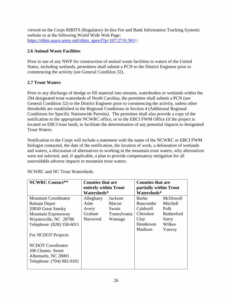
26
viewed on the Corps RIBITS (Regulatory In-lieu Fee and Bank Information Tracking System) website or at the following World Wide Web Page: https://ribits.usace.army.mil/ribits_apex/f?p=107:27:0::NO::: 2.6 Animal Waste Facilities Prior to use of any NWP for construction of animal waste facilities in waters of the United States, including wetlands, permittees shall submit a PCN to the District Engineer prior to commencing the activity (see General Condition 32). 2.7 Trout Waters Prior to any discharge of dredge or fill material into streams, waterbodies or wetlands within the 294 designated trout watersheds of North Carolina, the permittee shall submit a PCN (see General Condition 32) to the District Engineer prior to commencing the activity, unless other thresholds are established in the Regional Conditions in Section 4 (Additional Regional Conditions for Specific Nationwide Permits). The permittee shall also provide a copy of the notification to the appropriate NCWRC office, or to the EBCI FWM Office (if the project is located on EBCI trust land), to facilitate the determination of any potential impacts to designated Trout Waters. Notification to the Corps will include a statement with the name of the NCWRC or EBCI FWM biologist contacted, the date of the notification, the location of work, a delineation of wetlands and waters, a discussion of alternatives to working in the mountain trout waters, why alternatives were not selected, and, if applicable, a plan to provide compensatory mitigation for all unavoidable adverse impacts to mountain trout waters. NCWRC and NC Trout Watersheds: NCWRC Contact** Counties that are
entirely within Trout Watersheds*
Counties that are partially within Trout Watersheds*
Mountain Coordinator Balsam Depot 20830 Great Smoky Mountain Expressway Waynesville, NC 28786 Telephone: (828) 558-6011 For NCDOT Projects: NCDOT Coordinator 206 Charter. Street Albemarle, NC 28001 Telephone: (704) 982-9181
Alleghany Ashe Avery Graham Haywood
Jackson Macon Swain Transylvania Watauga
Burke Buncombe Caldwell Cherokee Clay Henderson Madison
McDowell Mitchell Polk Rutherford Surry Wilkes Yancey
27
*NOTE: To determine notification requirements, contact the Corps Asheville Regulatory Field Office at (828) 271-7980 or view maps for each County at the following World Wide Web page: http://www.saw.usace.army.mil/Missions/Regulatory-Permit-Program/Agency-Coordination/Trout/. **If a project is located on EBCI trust land, submit the PCN in accordance with Section 3.14. Contact the Corps Asheville Regulatory Field Office at (828) 271-7980 with questions. 2.8 Western NC Waters and Corridors The permittee shall submit a PCN (see General Condition 32) to the District Engineer prior to commencing the activity in waters of the United States if the activity will occur within any of the following identified waters in western North Carolina, within 0.5 mile on either side of these waters, or within 0.75 mile of the Little Tennessee River, as measured from the top of the bank of the respective water (i.e., river, stream, or creek): Brasstown Creek Burningtown Creek Cane River Caney Fork Cartoogechaye Creek Chattooga River Cheoah River Cowee Creek Cullasaja River Deep Creek Ellijay Creek French Broad River Garden Creek Hiwassee River Hominy Creek Iotla Creek Little Tennessee River (within the river or within 0.75 mile on either side of this river) Nantahala River Nolichucky River North Fork French Broad River North Toe River Nottley River Oconaluftee River (portion not located on trust/EBCI land) Peachtree Creek Shooting Creek Snowbird Creek South Toe River Stecoah Creek Swannanoa River Sweetwater Creek
28
Tuckasegee River (also spelled Tuckaseegee or Tuckaseigee) Valley River Watauga Creek Watauga River Wayah Creek West Fork French Broad River To determine notification requirements, contact the Corps Asheville Regulatory Field Office at (828) 271-7980 or view maps for all corridors at the following World Wide Web page: http://www.saw.usace.army.mil/Missions/Regulatory-Permit-Program/Agency-Coordination/Designated-Special-Waters.aspx 3.0 List of Corps Regional Conditions for All Nationwide Permits The following conditions apply to all Nationwide Permits in the Wilmington District: 3.1 Limitation of Loss of Stream Bed NWPs may not be used for activities that may result in the loss or degradation of more than 300 total linear feet of stream bed, unless the District Engineer has waived the 300 linear foot limit for ephemeral and intermittent streams on a case-by-case basis and has determined that the proposed activity will result in minimal individual and cumulative adverse impacts to the aquatic environment. Waivers for the loss of ephemeral and intermittent streams must be in writing and documented by appropriate/accepted stream quality assessments*. This waiver only applies to the 300 linear feet threshold for NWPs. This Regional Condition does not apply to NWP 23 (Approved Categorical Exclusions). *NOTE: Permittees should utilize the most current methodology prescribed by Wilmington District to assess stream function and quality. Information can be found at: https://ribits.usace.army.mil/ribits_apex/f?p=107:27:0::NO::: 3.2 Mitigation for Loss of Stream Bed For any NWP that results in a loss of more than 150 linear feet of stream, the permittee shall provide a mitigation proposal to compensate for more than minimal individual and cumulative adverse impacts to the aquatic environment. For stream losses of 150 linear feet or less that require a PCN, the District Engineer may determine, on a case-by-case basis, that compensatory mitigation is required to ensure that the activity results in minimal adverse effect on the aquatic environment. 3.3 Pre-construction Notification for Loss of Streambed Exceeding 150 Feet Prior to use of any NWP for any activity which impacts more than 150 total linear feet of perennial stream, intermittent or ephemeral stream, the permittee shall submit a PCN to the District Engineer prior to commencing the activity (see General Condition 32). This applies to
29
NWPs that do not have specific notification requirements. If a NWP has specific notification requirements, the requirements of the NWP should be followed. 3.4 Restriction on Use of Live Concrete For all NWPs which allow the use of concrete as a building material, live or fresh concrete, including bags of uncured concrete, may not come into contact with the water in or entering into waters of the United States. Water inside coffer dams or casings that has been in contact with wet concrete shall only be returned to waters of the United States after the concrete is set and cured and when it no longer poses a threat to aquatic organisms. 3.5 Requirements for Using Riprap for Bank Stabilization For all NWPs that allow for the use of riprap material for bank stabilization, the following measures shall be applied: 3.5.1. Where bank stabilization is conducted as part of an activity, natural design, bioengineering and/or geoengineering methods that incorporate natural durable materials, native seed mixes, and native plants and shrubs are to be utilized to the maximum extent practicable. 3.5.2. Filter cloth must be placed underneath the riprap as an additional requirement of its use in North Carolina waters. The placement of filter fabric is not required if the riprap will be pushed or “keyed” into the bank of the waterbody. A waiver from the specifications in this Regional Condition may be requested in writing. The waiver will only be issued if it can be demonstrated that the impacts of complying with this Regional Condition would result in greater adverse impacts to the aquatic environment. 3.5.3. The placement of riprap shall be limited to the areas depicted on submitted work plan drawings. 3.5.4. The riprap material shall be clean and free from loose dirt or any pollutant except in trace quantities that would not have an adverse environmental effect. 3.5.5. It shall be of a size sufficient to prevent its movement from the authorized alignment by natural forces under normal conditions. 3.5.6. The riprap material shall consist of clean rock or masonry material such as, but not limited to, granite, marl, or broken concrete. 3.6 Requirements for Culvert Placement 3.6.1 For all NWPs that involve the construction/installation of culverts, measures will be included in the construction/installation that will promote the safe passage of fish and other aquatic organisms. The dimension, pattern, and profile of the stream above and below a pipe or culvert should not be modified by altering the width or depth of the stream profile in connection with the construction activity. The width, height, and gradient of a proposed culvert should be
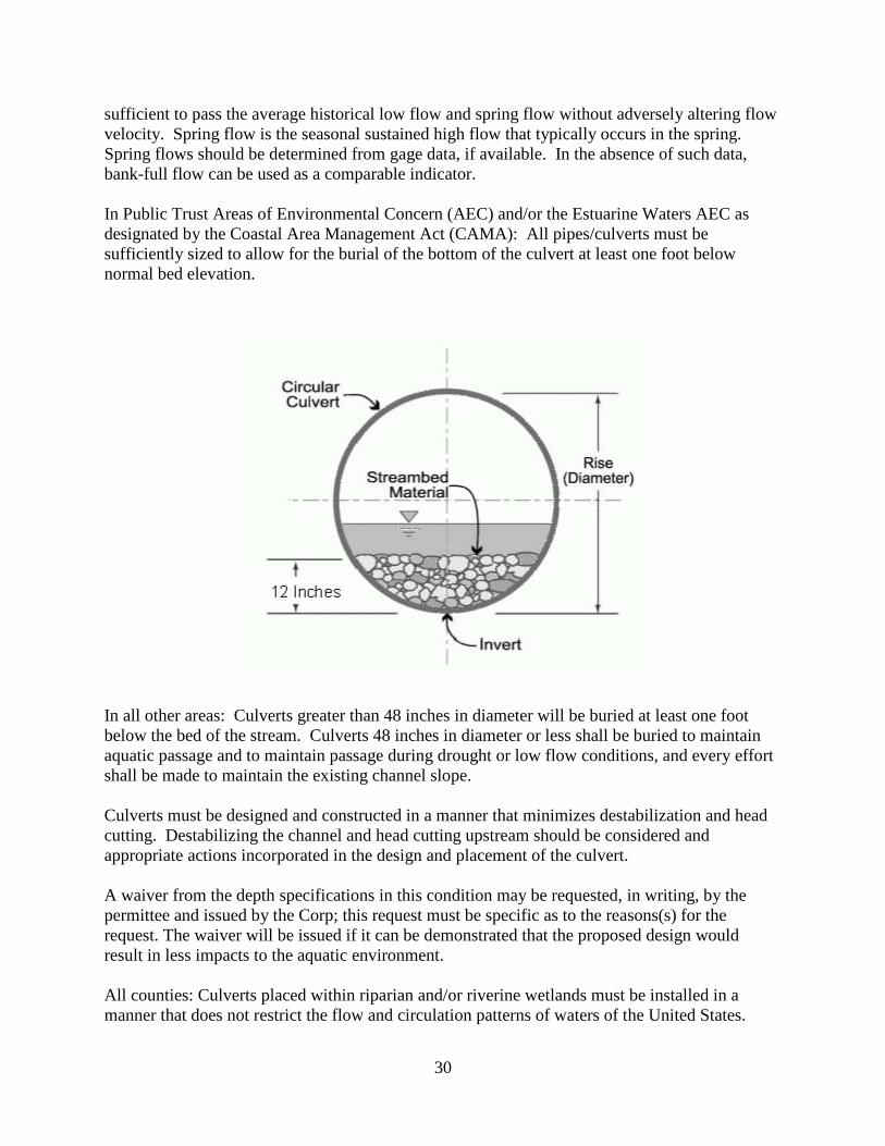
30
sufficient to pass the average historical low flow and spring flow without adversely altering flow velocity. Spring flow is the seasonal sustained high flow that typically occurs in the spring. Spring flows should be determined from gage data, if available. In the absence of such data, bank-full flow can be used as a comparable indicator. In Public Trust Areas of Environmental Concern (AEC) and/or the Estuarine Waters AEC as designated by the Coastal Area Management Act (CAMA): All pipes/culverts must be sufficiently sized to allow for the burial of the bottom of the culvert at least one foot below normal bed elevation.
In all other areas: Culverts greater than 48 inches in diameter will be buried at least one foot below the bed of the stream. Culverts 48 inches in diameter or less shall be buried to maintain aquatic passage and to maintain passage during drought or low flow conditions, and every effort shall be made to maintain the existing channel slope. Culverts must be designed and constructed in a manner that minimizes destabilization and head cutting. Destabilizing the channel and head cutting upstream should be considered and appropriate actions incorporated in the design and placement of the culvert. A waiver from the depth specifications in this condition may be requested, in writing, by the permittee and issued by the Corp; this request must be specific as to the reasons(s) for the request. The waiver will be issued if it can be demonstrated that the proposed design would result in less impacts to the aquatic environment. All counties: Culverts placed within riparian and/or riverine wetlands must be installed in a manner that does not restrict the flow and circulation patterns of waters of the United States.
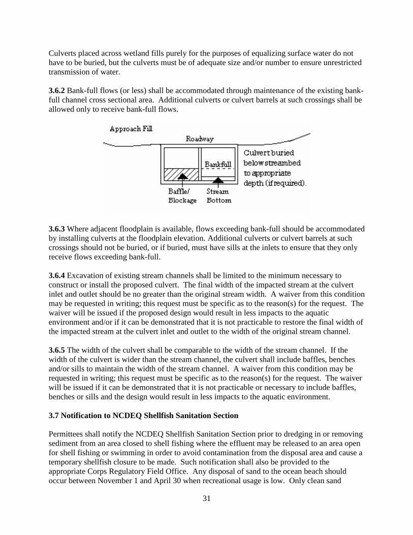
31
Culverts placed across wetland fills purely for the purposes of equalizing surface water do not have to be buried, but the culverts must be of adequate size and/or number to ensure unrestricted transmission of water. 3.6.2 Bank-full flows (or less) shall be accommodated through maintenance of the existing bank-full channel cross sectional area. Additional culverts or culvert barrels at such crossings shall be allowed only to receive bank-full flows.
3.6.3 Where adjacent floodplain is available, flows exceeding bank-full should be accommodated by installing culverts at the floodplain elevation. Additional culverts or culvert barrels at such crossings should not be buried, or if buried, must have sills at the inlets to ensure that they only receive flows exceeding bank-full. 3.6.4 Excavation of existing stream channels shall be limited to the minimum necessary to construct or install the proposed culvert. The final width of the impacted stream at the culvert inlet and outlet should be no greater than the original stream width. A waiver from this condition may be requested in writing; this request must be specific as to the reason(s) for the request. The waiver will be issued if the proposed design would result in less impacts to the aquatic environment and/or if it can be demonstrated that it is not practicable to restore the final width of the impacted stream at the culvert inlet and outlet to the width of the original stream channel. 3.6.5 The width of the culvert shall be comparable to the width of the stream channel. If the width of the culvert is wider than the stream channel, the culvert shall include baffles, benches and/or sills to maintain the width of the stream channel. A waiver from this condition may be requested in writing; this request must be specific as to the reason(s) for the request. The waiver will be issued if it can be demonstrated that it is not practicable or necessary to include baffles, benches or sills and the design would result in less impacts to the aquatic environment. 3.7 Notification to NCDEQ Shellfish Sanitation Section Permittees shall notify the NCDEQ Shellfish Sanitation Section prior to dredging in or removing sediment from an area closed to shell fishing where the effluent may be released to an area open for shell fishing or swimming in order to avoid contamination from the disposal area and cause a temporary shellfish closure to be made. Such notification shall also be provided to the appropriate Corps Regulatory Field Office. Any disposal of sand to the ocean beach should occur between November 1 and April 30 when recreational usage is low. Only clean sand
32
should be used and no dredged sand from closed shell fishing areas may be used. If beach disposal were to occur at times other than stated above or if sand from a closed shell fishing area is to be used, a swimming advisory shall be posted, and a press release shall be issued by the permittee. 3.8 Submerged Aquatic Vegetation Impacts to Submerged Aquatic Vegetation (SAV) are not authorized by any NWP, except NWP 48, unless EFH Consultation has been completed pursuant to the Magnuson-Stevens Fisheries Conservation and Management Act (Magnuson-Stevens Act). Permittees shall submit a PCN (See NWP General Condition 32) to the District Engineer prior to commencing the activity if the project would affect SAV. The permittee may not begin work until notified by the Corps that the requirements of the Magnuson-Stevens Act have been satisfied and that the activity is authorized. 3.9 Sedimentation and Erosion Control Structures and Measures All PCNs will identify and describe sedimentation and erosion control structures and measures proposed for placement in waters of the United States. The structures and measures should be depicted on maps, surveys or drawings showing location and impacts to jurisdictional wetlands and streams. 3.10 Restoration of Temporary Impacts to Stream Beds Upon completion of work that involves temporary stream impacts, streambeds are to be restored to pre-project elevations and widths using natural streambed material such that the impacted stream reach mimics the adjacent upstream and downstream reach. The impacted area shall be backfilled with natural streambed material to a depth of at least 12 inches or to the bottom depth of the impacted area if shallower than 12 inches. An engineered in-stream structure or material can be used to provide protection of a buried structure if it provides benefits to the aquatic environment and can be accomplished by a natural streambed design. A permittee may request a waiver of this condition if it is determined a buried structure needs significant physical protection beyond those provided in this condition. This condition does not apply to NWP 27 – Aquatic Habitat Restoration, Enhancement, and Establishment Activities. 3.11 Restoration of Temporary Impacts to Stream Banks Upon completion of work involving temporary stream bank impacts, stream banks are to be restored to pre-project grade and contours or beneficial grade and contours if the original bank slope is steep and unstable. Natural durable materials, native seed mixes, and native plants and shrubs are to be utilized in the restoration. Natural designs which use bioengineered and/or geo-engineered methods are to be applied. An engineered structure or material can be used to provide protection of a buried structure if it provides benefits to the stream bank environment, provided it is not in excess of the minimum amount needed for protection and does not exceed an average of one cubic yard per running foot placed along the bank below the plane of the ordinary high water mark. A permittee may request a waiver of this condition if it is determined a buried structure
33
needs significant physical protection beyond those provided in this condition. This condition does not apply to NWP 27 – Aquatic Habitat Restoration, Enhancement, and Establishment Activities. 3.12 Federal Navigation Channel Setbacks and Corps Easements 3.12.1 Authorized structures and fills located in or adjacent to Federally authorized waterways will be constructed in accordance with the latest setback criteria established by the Wilmington District Engineer. You may review the setback policy at http://www.saw.usace.army.mil/Missions/Navigation/Setbacks.aspx. This general permit does not authorize the construction of hardened or permanently fixed structures within the Federally Authorized Channel Setback, unless the activity is approved by the Corps. The permittee shall submit a PCN (see General Condition 32) to the District Engineer prior to the construction of any structures or fills within the Federally Authorized Channel Setback. 3.12.2 The permittee shall obtain a Consent to Cross Government Easement from the Wilmington District’s Land Use Coordinator prior to any crossing of the Corps easement and/or prior to commencing construction of any structures, authorized dredging or other work within the right-of-way of, or in proximity to, a federally designated disposal area. The Land Use Coordinator may be contacted at: CESAW-OP-N, 69 Darlington Avenue, Wilmington, North Carolina 28403-1343, email: [email protected] 3.13 Northern Long-eared Bat – Endangered Species Act Compliance The Wilmington District, U.S. Army Corps of Engineers has consulted with the United States Fish and Wildlife Service (USFWS) in regards to the threatened Northern long-eared bat (NLEB) (Myotis septentrionalis) and Standard Local Operating Procedures for Endangered Species (SLOPES) have been approved by the Corps and the USFWS. This condition concerns effects to the NLEB only and does not address effects to other federally listed species and/or federally designated critical habitat.
A. Procedures when the Corps is the lead federal* agency for a project:
The permittee must comply with (1) and (2) below when: • the project is located in the western 41 counties of North Carolina, to include non-
federal aid North Carolina Department of Transportation (NCDOT) projects, OR; • the project is located in the 59 eastern counties of North Carolina, and is a non-
NCDOT project. *Generally, if a project is located on private property or on non-federal land, and the project is not being funded by a federal entity, the Corps will be the lead federal agency due to the requirement to obtain Department of the Army authorization to impact waters of the United States. If the project is located on federal land, contact the Corps to determine the lead federal agency.
34
(1) A permittee using a NWP must check to see if their project is located in the range of the NLEB by using the following website: http://www.fws.gov/midwest/endangered/mammals/nleb/pdf/WNSZone.pdf. If the project is within the range of the NLEB, or if the project includes percussive activities (e.g., blasting, pile driving, etc.), the permittee is then required to check the appropriate website in the paragraph below to discover if their project:
• is located in a 12-digit Hydrologic Unit Code area (“red HUC” - shown as red areas on the map), AND/OR;
• involves percussive activities within 0.25 mile of a red HUC.
Red HUC maps - for the western 41 counties in NC (covered by the Asheville Ecological Services Field Office), check the project location against the electronic maps found at: http://www.fws.gov/asheville/htmls/project_review/NLEB_in_WNC.html. For the eastern 59 counties in NC (covered by the Raleigh Ecological Services Field Office), check the project location against the electronic maps found at: https://www.fws.gov/raleigh/NLEB_RFO.html.
(2) A permittee must submit a PCN to the District Engineer, and receive written authorization from the District Engineer, prior to commencing the activity, if the activity will involve any of the following:
• tree clearing/removal, construction/installation of wind turbines in a red HUC,
AND/OR;
• bridge removal or maintenance, unless the bridge has been inspected and there is no evidence of bat use, (applies anywhere in the range of the NLEB), AND/OR:
• percussive activities in a red HUC, or within 0.25 mile of a red HUC.
The permittee may proceed with the activity without submitting a PCN to either the Corps or the USFWS, provided the activity complies with all applicable NWP terms and general and regional conditions, if the permittee’s review under A.(1) and A.(2) above shows that the project is:
• located outside of a red HUC (and there are no percussive activities), and the
activity will NOT include bridge removal or maintenance, unless the bridge has been inspected and there is no evidence of bat use, OR;
• located outside of a red HUC and there are percussive activities, but the percussive activities will not occur within 0.25-mile of a red HUC boundary, and the activity will NOT include bridge removal or maintenance, unless the bridge has been inspected and there is no evidence of bat use, OR;
35
• located in a red HUC, but the activity will NOT include: tree clearing/removal; construction/installation of wind turbines; bridge removal or maintenance, unless the bridge has been inspected and there is no evidence of bat use, and/or; any percussive activities.
B. Procedures when the USACE is not the lead federal agency:
For projects where another federal agency is the lead federal agency - if that other federal agency has completed project-specific ESA Section 7(a)(2) consultation for the NLEB, and has (1) determined that the project would not cause prohibited incidental take of the NLEB, and (2) completed coordination/consultation that is required by the USFWS (per the directions on the respective USFWS office’s website), that project may proceed without notification to either the USACE or the USFWS, provided all General and Regional Permit Conditions are met.
The NLEB SLOPES can be viewed on the USACE website at the following World Wide Web Page: http://www.saw.usace.army.mil/Missions/Regulatory-Permit-Program/Agency-Coordination/ESA/. Permittees who do not have internet access may contact the USACE at (910) 251- 4633. 3.14 Work on Eastern Band of Cherokee Indians Land All PCNs submitted for activities in waters of the United States on Eastern Band of Cherokee Indians (EBCI) trust land (i.e., Qualla Boundary and non-contiguous tracts of trust land), must comply with the requirements of the latest MOU between the Wilmington District and the Eastern Band of Cherokee Indians. 4.0 Additional Regional Conditions for Specific Nationwide Permits 4.1 NWP #13 – Bank Stabilization 4.1.1 Unanchored trees, treetops, or debris may not be used as stream bank stabilization material. 4.1.2 Properly anchored and cabled structural stabilization techniques, such as timber crib structures, revetments, and root wads, are acceptable materials to stabilize stream banks. 4.1.3 If riprap stabilization is needed, it should be placed only on the stream banks, or, if it is necessary to be placed in the stream bed, the finished top elevation of the riprap should not exceed that of the original stream bed. 4.1.4 In designated trout watersheds, PCN is not required for impacts to a maximum of 100 linear feet (150 linear feet for temporary dewatering) of streams or waterbodies for bank stabilization activities not adjoining, adjacent to, or in the relative vicinity of existing stabilization structures. Materials for the stabilization structure(s) and design of the project must be constructed to withstand normal and expected high stream flows. In designated trout waters, the permittee shall submit a PCN (see Regional Condition 2.7 and General Condition 32) to the District Engineer prior to commencing the activity if 1) impacts (other than temporary
36
dewatering to work in dry conditions) to streams and waterbodies exceed 100 linear feet; 2) temporary impacts to streams or waterbodies associated with dewatering to work in dry conditions exceed 150 linear feet; or 3) the activity will be constructed during the trout waters moratorium (October 15 through April 15). 4.1.5 The permittee shall submit a PCN to the District Engineer prior to commencing the activity if the activity will involve the discharge of dredged or fill material into more than 150 linear feet of stream channel for the construction of temporary access fills and/or temporary road crossings. The PCN must include a restoration plan that thoroughly describes how all temporary fills will be removed, describes how pre-project conditions will be restored, and includes a timetable for all restoration activities.
34
located in a red HUC, but the activity will NOT include: tree clearing/removal; construction/installation of wind turbines; bridge removal or maintenance, unless the bridge has been inspected and there is no evidence of bat use, and/or; any percussive activities.
B. Procedures when the USACE is not the lead federal agency:
For projects where another federal agency is the lead federal agency - if that other federal agency has completed project-specific ESA Section 7(a)(2) consultation for the NLEB, and has (1) determined that the project would not cause prohibited incidental take of the NLEB, and (2) completed coordination/consultation that is required by the USFWS (per the directions on the respective USFWS office’s website), that project may proceed without notification to either the USACE or the USFWS, provided all General and Regional Permit Conditions are met.
The NLEB SLOPES can be viewed on the USACE website at the following World Wide Web Page: http://www.saw.usace.army.mil/Missions/Regulatory-Permit-Program/Agency-Coordination/ESA/. Permittees who do not have internet access may contact the USACE at (910) 251- 4633.
3.14 Work on Eastern Band of Cherokee Indians Land
All PCNs submitted for activities in waters of the United States on Eastern Band of Cherokee Indians (EBCI) trust land (i.e., Qualla Boundary and non-contiguous tracts of trust land), must comply with the requirements of the latest MOU between the Wilmington District and the Eastern Band of Cherokee Indians.
4.0 Additional Regional Conditions for Specific Nationwide Permits
4.1 NWP #23 - Approved Categorical Exclusions
4.1.1 The discharge of dredged or fill material associated with this NWP must not cause the loss of greater than 1 acre of waters of the United States or 500 linear feet of stream bed for each single and complete project.
4.1.2 No development activities authorized by this NWP may begin until the permittee obtains a consistency concurrence or a CAMA permit from the North Carolina Division of Coastal Management, if either is required.
34
• located in a red HUC, but the activity will NOT include: tree clearing/removal;construction/installation of wind turbines; bridge removal or maintenance, unlessthe bridge has been inspected and there is no evidence of bat use, and/or; anypercussive activities.
B. Procedures when the USACE is not the lead federal agency:
For projects where another federal agency is the lead federal agency - if that other federal agency has completed project-specific ESA Section 7(a)(2) consultation for the NLEB, and has (1) determined that the project would not cause prohibited incidental take of the NLEB, and (2) completed coordination/consultation that is required by the USFWS (per the directions on the respective USFWS office’s website), that project may proceed without notification to either the USACE or the USFWS, provided all General and Regional Permit Conditions are met.
The NLEB SLOPES can be viewed on the USACE website at the following World Wide Web Page: http://www.saw.usace.army.mil/Missions/Regulatory-Permit-Program/Agency-Coordination/ESA/. Permittees who do not have internet access may contact the USACE at (910) 251- 4633.
3.14 Work on Eastern Band of Cherokee Indians Land
All PCNs submitted for activities in waters of the United States on Eastern Band of Cherokee Indians (EBCI) trust land (i.e., Qualla Boundary and non-contiguous tracts of trust land), must comply with the requirements of the latest MOU between the Wilmington District and the Eastern Band of Cherokee Indians.
4.0 Additional Regional Conditions for Specific Nationwide Permits
4.1 NWP #33 – Temporary Construction, Access, and Dewatering
4.1.1 The permittee shall submit a PCN to the District Engineer prior to commencing the activity if the activity will involve the discharge of dredged or fill material into more than 1/10-acre of wetlands or 150 linear feet of stream channel for the construction of temporary access fills and/or temporary road crossings.
4.1.2 For activities that require a PCN, the PCN must include a restoration plan that thoroughly describes how all temporary fills will be removed, describes how pre-project conditions will be restored, and includes a timetable for all restoration activities.
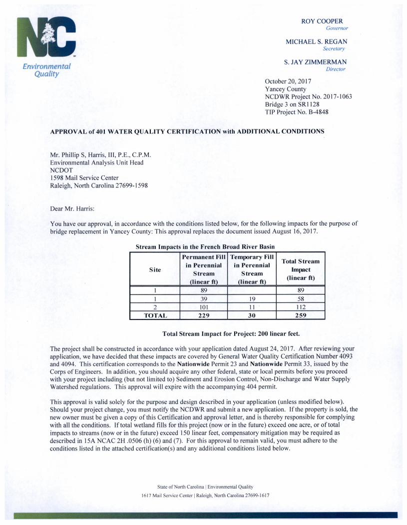
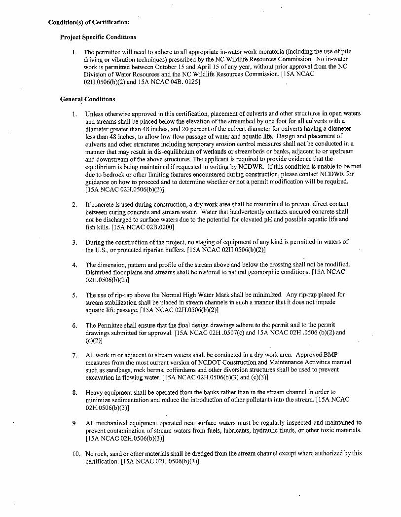
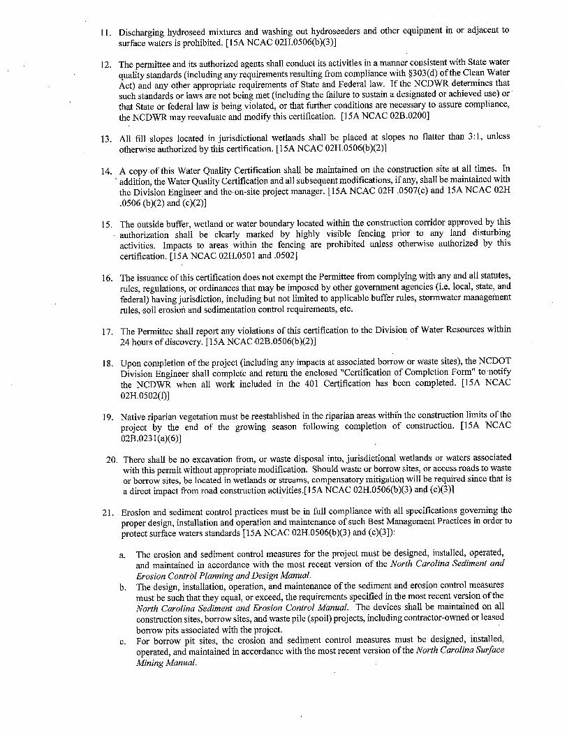
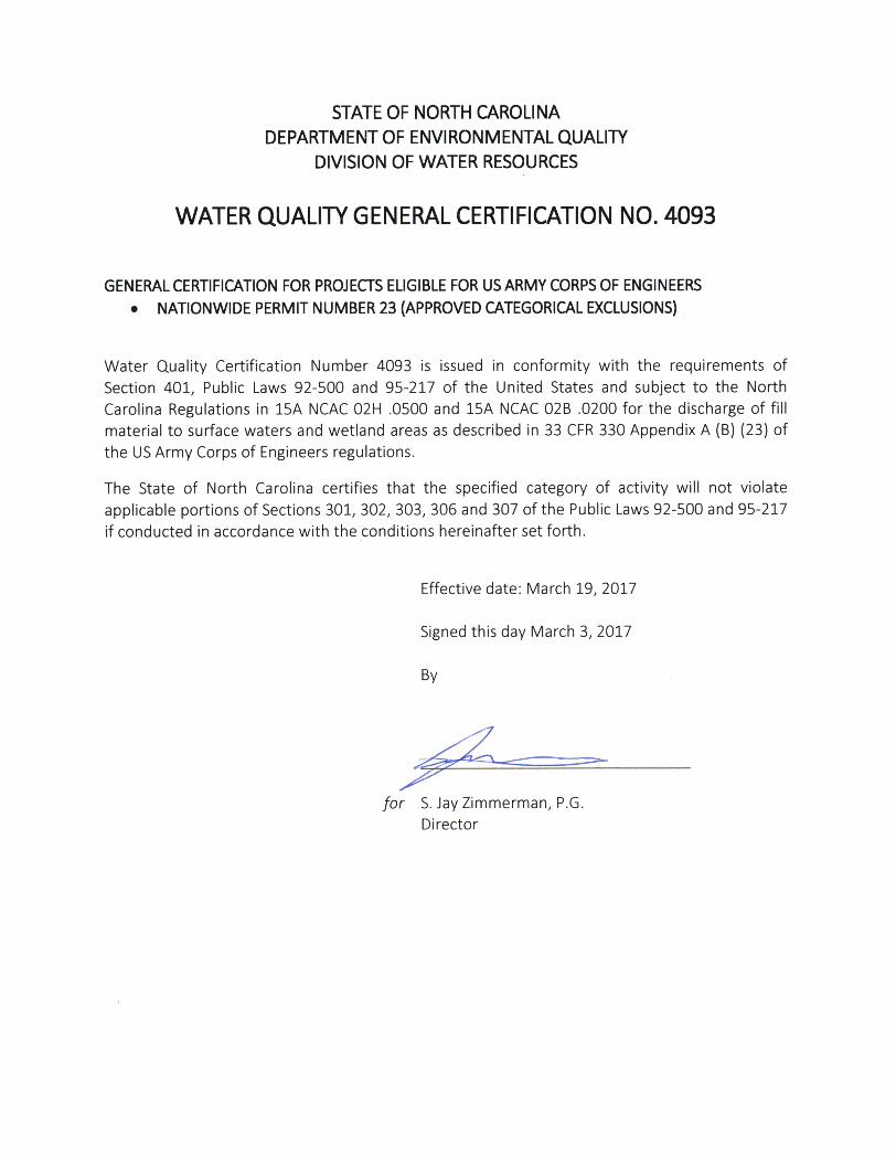


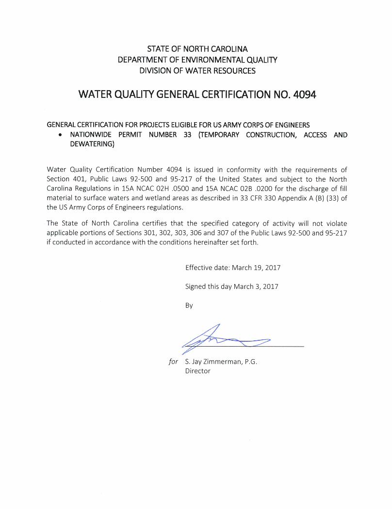
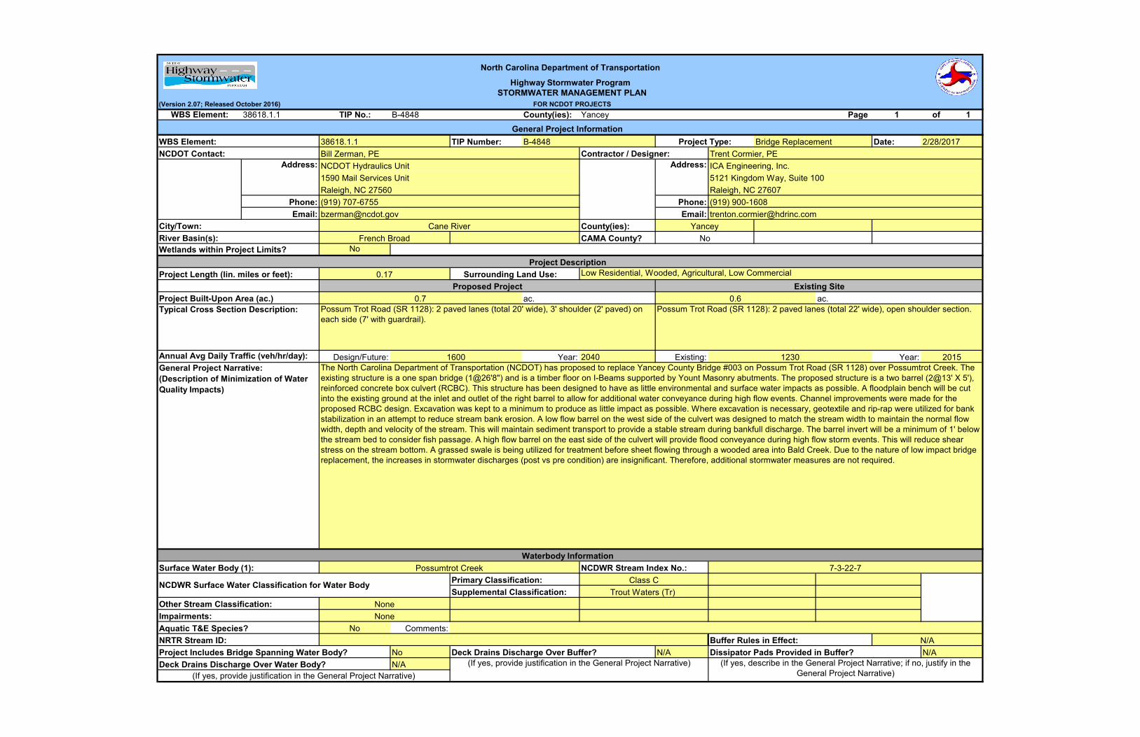
(Version 2.07; Released October 2016)
38618.1.1 TIP No.: B-4848 County(ies): Yancey Page 1 of 1
TIP Number: Date:
Phone: Phone:
Email: Email:
County(ies):
CAMA County?
No
Design/Future: Year: 2040 Existing: Year:
Aquatic T&E Species? No Comments:
No N/A
N/A
Trout Waters (Tr)
None
Supplemental Classification:
N/ABuffer Rules in Effect:
Wetlands within Project Limits?
Bill Zerman, PE
1590 Mail Services Unit
WBS Element:
Bridge ReplacementWBS Element:
Trent Cormier, PENCDOT Contact:
(919) 707-6755
5121 Kingdom Way, Suite 100
Raleigh, NC 27607
Contractor / Designer:
(919) 900-1608
ICA Engineering, Inc.
Low Residential, Wooded, Agricultural, Low Commercial
Possumtrot Creek 7-3-22-7
0.6
0.17
Project Description
Proposed Project
French BroadRiver Basin(s):
City/Town:
0.7
Typical Cross Section Description:
Surrounding Land Use:
General Project Narrative:
(Description of Minimization of Water
Quality Impacts)
No
North Carolina Department of Transportation
Highway Stormwater Program
STORMWATER MANAGEMENT PLAN
FOR NCDOT PROJECTS
Project Type:
NCDOT Hydraulics Unit Address:
General Project Information
B-484838618.1.1
Impairments:
Other Stream Classification:
Primary Classification:
Project Built-Upon Area (ac.)
The North Carolina Department of Transportation (NCDOT) has proposed to replace Yancey County Bridge #003 on Possum Trot Road (SR 1128) over Possumtrot Creek. The
existing structure is a one span bridge (1@26'8") and is a timber floor on I-Beams supported by Yount Masonry abutments. The proposed structure is a two barrel (2@13' X 5'),
reinforced concrete box culvert (RCBC). This structure has been designed to have as little environmental and surface water impacts as possible. A floodplain bench will be cut
into the existing ground at the inlet and outlet of the right barrel to allow for additional water conveyance during high flow events. Channel improvements were made for the
proposed RCBC design. Excavation was kept to a minimum to produce as little impact as possible. Where excavation is necessary, geotextile and rip-rap were utilized for bank
stabilization in an attempt to reduce stream bank erosion. A low flow barrel on the west side of the culvert was designed to match the stream width to maintain the normal flow
width, depth and velocity of the stream. This will maintain sediment transport to provide a stable stream during bankfull discharge. The barrel invert will be a minimum of 1' below
the stream bed to consider fish passage. A high flow barrel on the east side of the culvert will provide flood conveyance during high flow storm events. This will reduce shear
stress on the stream bottom. A grassed swale is being utilized for treatment before sheet flowing through a wooded area into Bald Creek. Due to the nature of low impact bridge
replacement, the increases in stormwater discharges (post vs pre condition) are insignificant. Therefore, additional stormwater measures are not required.
None
1230
Possum Trot Road (SR 1128): 2 paved lanes (total 20' wide), 3' shoulder (2' paved) on
each side (7' with guardrail).
Waterbody Information
2015
NCDWR Stream Index No.:
Raleigh, NC 27560
Address:
2/28/2017
NRTR Stream ID:
Annual Avg Daily Traffic (veh/hr/day):
Existing Site
Project Length (lin. miles or feet):
ac.
Surface Water Body (1):
Class CNCDWR Surface Water Classification for Water Body
ac.
Possum Trot Road (SR 1128): 2 paved lanes (total 22' wide), open shoulder section.
1600
Project Includes Bridge Spanning Water Body? Deck Drains Discharge Over Buffer? Dissipator Pads Provided in Buffer?
YanceyCane River
N/A
Deck Drains Discharge Over Water Body? (If yes, provide justification in the General Project Narrative) (If yes, describe in the General Project Narrative; if no, justify in the
General Project Narrative)(If yes, provide justification in the General Project Narrative)
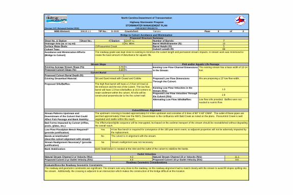
(Version 2.07; Released October 2016)38618.1.1 TIP No.: B-4848 County(ies): Yancey Page 2 of 2
Sheet No.: 4 Station: 13+07 -L-Sq. Miles
Barrel Height (ft):Culvert Length (ft)
%%
Natural Stream Channel 2-yr Velocity (ft/s): 4.2Outlet Velocities
Evaluate/Describe Roadway Geometric Constraints:The roadway and geometric constraints are significant. The stream runs very close to the roadway, so the roadway alignment had to match closely with the stream to avoid fill slopes spilling into the stream. Additionally, the crossing is adjacent to an intersection which makes the construction of the bridge difficult at this location.
Proposed Culvert 2-yr Outlet Velocity (ft/s): 6.6Natural Stream Channel 10-yr Velocity (ft/s): 11.1Proposed Culvert 10-yr Outlet Velocity (ft/s): 8.6
Roadway Geometric Considerations
Stream Realignment Necessary? (provide justification)
No Stream reallignment was not necessary.
Bank Stabilization: Bank Stabilization is needed at the inlet and the outlet of the culvert to stabilize the banks.
Stream Patterns Upstream and Downstream of the Culvert that Could Affect Fish Passage and Bank Stability:
The upstream crossing is located approximately 0.2 miles upstream and consistes of 3 lines of 80" X 60" CMAP. The outlet of these pipes are perched approximately 3 feet over the NWS. Downstream is the confluence with Bald Creek as noted on the plans. Possumtrot Creek is well vegetated and stable within this reach.
Bed Forms Impacted by Culvert (riffles, pools, glides, etc.):
The riffle/run/pool/glide sequence will be interuppted, but based on the sedimet transport of the stream should be reestablished without degrading the overall reach.
Bends at Inlet/Outlet?(describe culvert alignment with stream)
No The culvert is in alignment with the stream.
Existing Streambed Material: Silt and Sand mixed with Gravel and Cobble
Low Flow Floodplain Bench Required? (provide justification)
Yes A low flow bench is required for conveyance of the 100 year storm event, so adjacent properties will not be adversely impacted by the replacement.
We are proposing a 13' low flow width.
Proposed Sills/Baffles: The high flow barrel will have a 1.5 foot sill inset at the entrance and the exit of the culvert. The low flow barrel will have 1.0 foot sills/baffles at 16.9 centers to retain sediment within the culvert. All sills will be constructed perpendicular to the the culvert wall.
Existing Low Flow Velocities in the Stream (ft/s): 1.3
Proposed Low Flow Velocities Through the Culvert (ft/s): 2.8
Alternating Low Flow Sills/Baffles: Low flow sills provided. Baffles were not needed to restrict flow.
Proposed Low Flow Dimensions Through the Culvert:
Culvert/Stream Alignment
Avoidance and Minimization Efforts:(Bridge to Culvert)
The roadway grade was kept close to existing to minimize the culvert length and permanent stream impacts. In stream work was minimized to create the least amount of disturbance for aquatic life.
Stream Slope Fish and/or Aquatic Life PassageExisting Average Stream Slope (%): 3.70 Existing Low Flow Channel Dimensions
in the Stream:The existing stream has a base width of 12-14 feet.Proposed Culvert Slope (%): 3.20
Culvert BurialProposed Culvert Burial Depth (ft): 1
Surface Water Body: (1)Possumtrot Creek89Culvert Type:5
Proposed Structure SummarySheet No. & StationDrainage Area (ac or sq mi): 3
Number of Barrels: 2Barrel Width/Diameter (ft): 13
Bridge to Culvert Avoidance and Minimization
North Carolina Department of Transportation
Highway Stormwater ProgramSTORMWATER MANAGEMENT PLAN
FOR NCDOT PROJECTSWBS Element:

ENGLISH
WETLAND AND SURFACE WATER IMPACTS PERMIT
R:\
5.0 PR
OJE
CT D
EVELO
PM
EN
T\5.2
Work in Pro
gress\Hydra
ulics\
PER
MIT
S_Environ
mental\
Dra
win
gs\
B4848_hyd_prm
_wet_tsh.d
gn
ICA
EN
GIN
EERIN
G, IN
C.
3/2
8/2
017
SITE 1
SHEET 1 OF 6PERMIT DRAWING
T
V
=
=
=
=
=
%
%
MPH
ADT
ADT
% *
0
0
0
PROFILE (HORIZONTAL)
38618.1.2
BRZ-1128(7)
PROJECT LENGTH
RIGHT OF WAY DATE:
LETTING DATE:
STATE STATE PROJECT REFERENCE NO.
STATE PROJ. NO. F. A. PROJ. NO. DESCRIPTION
NO.TOTALSHEETS
N.C.SHEET
1
DESIGN DATA Prepared in the Office of:
SIGNATURE:
SIGNATURE:
P.E.
P.E.
DIVISION OF HIGHWAYS
2012 STANDARD SPECIFICATIONS
PROJECT ENGINEER
PROJECT DESIGN ENGINEER
PLANS
PROFILE (VERTICAL)
HYDRAULICS ENGINEER
ENGINEER
ROADWAY DESIGN
LOCATION:
TYPE OF WORK:
09/08/99
DIVISION OF HIGHWAYSSTATE OF NORTH CAROLINA
0
00
1000 Birch Ridge Dr., Raleigh NC, 27610
CO
NT
RA
CT:
C203726
AR
TM
E
N
N
A
S
O H
DE
P
TOF TRA
SPO
RT
TIO
N
TA
TE
OF N RTC
A
RO
LIN
A
B-4848
4
YANCEY COUNTY
REPLACE BRIDGE 3 OVER POSSUM TROT CREEK
ON SR 1128
GRADING, PAVING, DRAINAGE AND STRUCTURE
25 50 10050
25 50 10050
5 10 2010
D
=
10
2040
DUAL 9%TTST 1%
FUNC CLASS =LOCAL
SUBREGIONAL TIER
38618.1.1 PEBRZ-1128(7)
GRAPHIC SCALES
B-4848
KEVIN E. MOORE, PE
STEVEN D. KENDALL, PE
19
19W
19 %E
19
.81
1.5
0 %19W
B-4848
PROJECT
1127
1129
1130
1126
1122
1121
11191136
1117
1118
11371136
1126
1454
1453
1392
13911394
VICINITY MAP
END TIP PROJECT B-4848
BEGIN TIP PROJECT B-4848
4
DOCUMENT NOT CONSIDERED FINAL
UNLESS ALL SIGNATURES COMPLETED
TIP P
ROJE
CT:
JANUARY 16, 2018
*
BALD
CREEK
TO BURNSVILLE, NC
TO MARS HILL, NC
POSS
UM
TR
OT
CR
EE
K
POS
SU
M
TR
OT
CR
EE
K
-L- STA. 10+50.00
-DRV1- STA. 10+75.00
BEGIN CONSTRUCTION
-DRV2- PC STA. 10+21.09BEGIN CONSTRUCTION
-L- SR 1128 (POSSUM TROT RD.)
K
55
10
= 0.008 MILELENGTH OF STRUCTURE TIP NO. B-4848
TOTAL LENGTH OF TIP NO. B-4848
LENGTH OF ROADWAY TIP NO. B-4848
19
1128
1128
-L- STA. 19+25.00
-L- STA. 12+78.37
BEGIN CULVERT
-L- STA. 13+23.70
END CULVERT
= 0.166 MILE
= 0.158 MILE
1600
12442016
DO NOT USE FOR CONSTRUCTIONPRELIMINARY PLANS
25
R/W & UTILITIES
CLEARING ON THIS PROJECT SHALL BE PREFORMED TO THE LIMITS ESTABLISHED BY METHOD II .THIS PROJECT IS NOT WITHIN ANY MUNICIPAL BOUNDARYTHIS IS NOT A CONTROL OF ACCESS PROJECT
JANUARY 26, 2017
See Sheet 1A For Index of Sheets
See Sheet 1B For Conventional Symbols
CANE RIVER
See Sheet 1C-1 & 1C-2 For Survey Control Sheets
NA
D 83/ 2
011
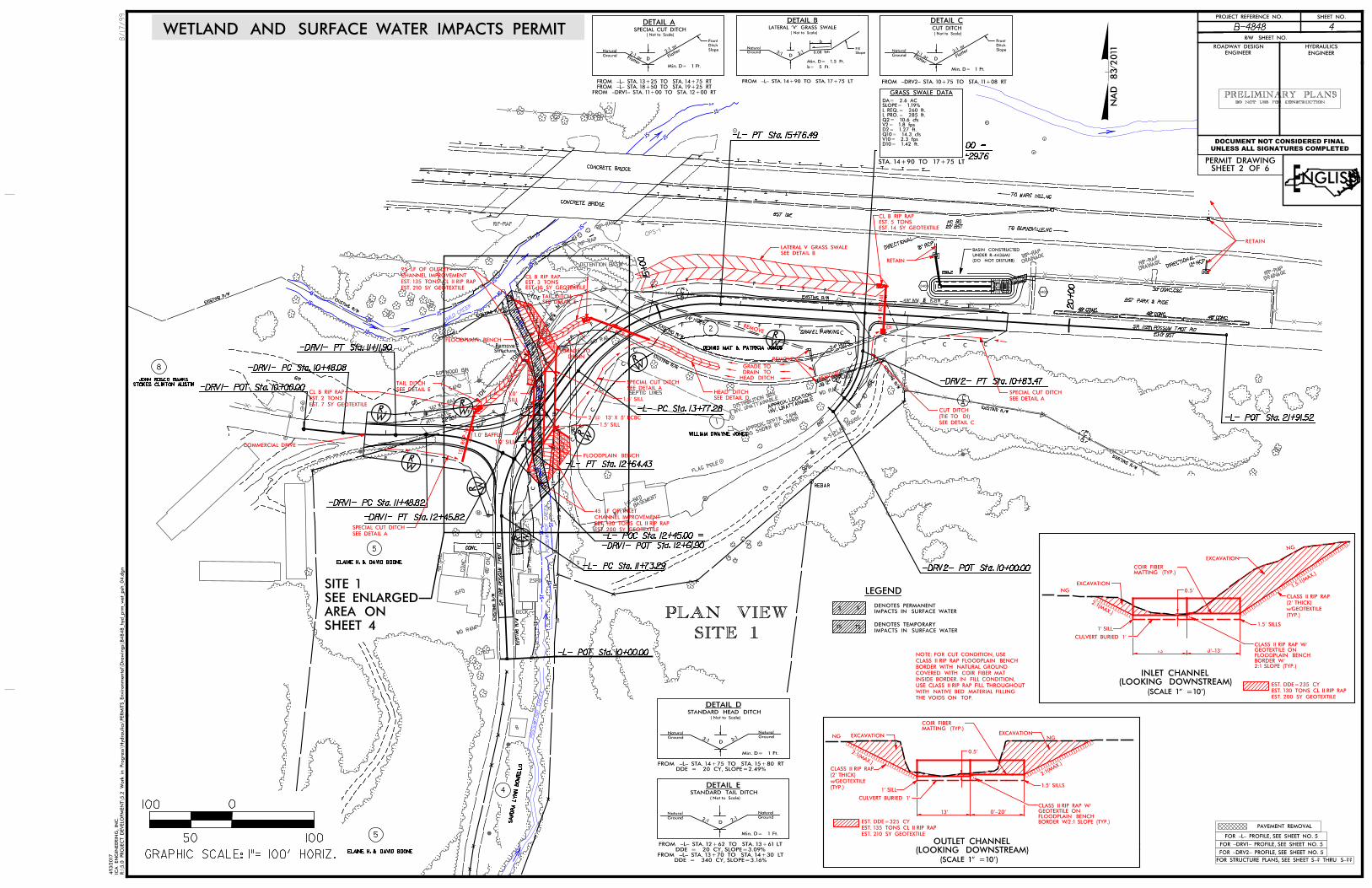
24" HDPE
18" RCP
12" RCP
BALD
CREEK
DETENTION BASIN
AS SHOWN
BY OWNER
APPROX.
SEPTIC T
ANK
SEPTIC LINES
SEP
TIC
TA
NK
SEP
TIC
LIN
ES
RIP-RAP
12" CMP
22’BST
22’ BST
NC 80
BST PARK & RIDE
EXISTING R/W
EXISTING R/W
EXIS
TIN
G
R/
W
EXISTING R/W
EXISTING R/W
EXISTING R/W
EXISTIN
G R/
WEXISTING R/W
EXIS
TIN
G R/
W
EXISTING R/W
EXISTING R/W
EXIS
TIN
G
R/
W
BST
W
FLAG POLE
2-S-
PLAY HOUSE
48" WW & 1SBW
BST 19E
CONCRETE BRIDGE
CONCRETE BRIDGE
TO BURNSVILLE, NC
TO MARS HILL, NC
RIP-RAPRIP
-RAP
W/FULL
BASEMENT
1-S-B
KD
BS
T
WD RAIL
MTL
S
B
WD RAMP
1SFD
CO
NC
48"
CH
L
48"
CH
L
CONC.
W
GR
GR
MTL GATE
36" W
D RAIL
60" WOOD BIN
SAND
SOIL
DECK
24" HDPE
WD RAIL
30" CONC. C&G
48" CONC.48" CONC.
48" CONC.
EXIS
TIN
G
R/
W
JB
INV. UNATTAIN
ABLE
APPROX. LOCATIO
N
DRAINAGERIP
-RAP
DRAINAGERIP
-RAP
DRAINAGERIP
-RAP
DIRECTIO
NAL
DIRECTIO
NAL
INV. UNATTAIN
ABLE
DISTRIB
UTION
BOX
GPS-1
;
;
;
2SFD
GRAVEL PARKING
SR 1128 P
OS
SU
M
TR
OT
RD
POSS
UM
TR
OT
CR
EE
K
POS
SU
MT
RO
T
CR
EE
K
23.0’ BST
SR 1128 POSSUM TROT RD
EIP
REBAR
SA
ND
RA
LY
NN
BO
NIE
LL
O
4
5
2
5
WILLIAM DWAYNE JONES
DENNIS MAT & PATRICIA JONES
STOKES CLINTON AUSTIN
JOHN ROSCO BANKS
8
1
ELAINE H. & DAVID BOONE
ELAINE H. & DAVID BOONE
WETLAND AND SURFACE WATER IMPACTS PERMIT
SHEET 2 OF 6PERMIT DRAWING
ENGLISH
LEGEND
IMPACTS IN SURFACE WATER
DENOTES PERMANENTSS
IMPACTS IN SURFACE WATER
DENOTES TEMPORARY TS TS
R:\
5.0 PR
OJE
CT D
EVELO
PM
EN
T\5.2
Work in Pro
gress\Hydra
ulics\
PER
MIT
S_Environ
mental\
Dra
win
gs\
B4848_hyd_prm
_wet_
psh
_04.d
gn
ICA
EN
GIN
EERIN
G, IN
C.
4/13/2
017
GRASS SWALE DATA
STA. 14+90 TO 17+75 LT
D10= 1.42 ft.V10= 2.3 fpsQ10= 14.3 cfsD2= 1.27 ft.V2= 1.8 fpsQ2= 10.6 cfsL PRO.= 285 ft.L REQ.= 260 ft.SLOPE= 1.19%DA= 2.6 AC
SITE 1PLAN VIEW
0
10050
100
GRAPHIC SCALE: 1"= 100’ HORIZ.
SHEET 4
AREA ON
SEE ENLARGED
SITE 1
20+00
15+00
-L- PC Sta. 13+77.28
-L- PC Sta. 11+73.29
-DRV1- PC Sta. 10+48.08
-DRV1- PT Sta. 11+11.90
-DRV1- POT Sta. 10+00.00
-DRV1- PC Sta. 11+48.82
-DRV1- PT Sta. 12+45.82
-DRV1- POT Sta. 12+61.90
-L- POC Sta. 12+45.00 =
-DRV2- POT Sta. 10+00.00
-L- PT Sta. 15+76.49
-L- POT Sta. 17+52.00 =
-DRV2- POT Sta. 11+29.76
-DRV2- PT Sta. 10+83.47
-L- POT Sta. 21+91.52
-L- PT Sta. 12+64.43
-L- POT Sta. 10+00.00
StructureRemove
DI
24" RC
P-III
DRAIN
GRADE TO
18" RCP-III
15" RC
P-III
EST. 7 SY GEOTEXTILE
EST. 2 TONS
CL B RIP RAP
EST. 10 SY GEOTEXTILEEST. 3 TONSCL B RIP RAP
EST. 14 SY GEOTEXTILE
EST. 5 TONS
CL B RIP RAP
SEE DETAIL A
SPECIAL CUT DITCH
SEE DETAIL A
SPECIAL CUT DITCH
SEE DETAIL B
LATERAL V GRASS SWALE
LATERAL ’V’ GRASS SWALE( Not to Scale)
D3:1 3:
1
b
0.08 ft/ft
FROM -L- STA. 14+90 TO STA. 17+75 LT
b= 5 Ft.
Min. D= 1.5 Ft.
DETAIL B
Ground
Natural
Slope
Fill
3:1 3:1
D
( Not to Scale)
STANDARD HEAD DITCH
DDE = 20 CY, SLOPE=2.49%FROM -L- STA. 14+75 TO STA. 15+80 RT
Min. D= 1 Ft.
DETAIL D
Ground
NaturalGround
Natural
SEE DETAIL D
HEAD DITCHSEE DETAIL E
TAIL DITCHSEE DETAIL A
SPECIAL CUT DITCH
Flatter2:
1 or
DFlatter
2:1 or
( Not to Scale)
SPECIAL CUT DITCH
FROM -DRV1- STA. 11+00 TO STA. 12+00 RTFROM -L- STA. 18+50 TO STA. 19+25 RTFROM -L- STA. 13+25 TO STA. 14+75 RT
DETAIL A
Min. D= 1 Ft.
Ground
Natural Slope
Ditch
Front
Flatter3:
1 or
DFlatter
2:1 or
( Not to Scale)
CUT DITCH
FROM -DRV2- STA. 10+75 TO STA. 11+08 RT
Min. D= 1 Ft.
DETAIL C
Slope
Ditch
Front
Ground
Natural
EST. 200 SY GEOTEXTILE
EST. 130 TONS CL II RIP RAP
CHANNEL IMPROVEMENT
45 LF OF INLET
SEE DETAIL C
(TIE TO DI)
CUT DITCH
SEE DETAIL ETAIL DITCH
RETAIN
REMOVE
REMOVE
REMOVE
2:1 2:1
D
( Not to Scale)
STANDARD TAIL DITCH
DDE = 340 CY, SLOPE=3.16%FROM -L- STA. 13+70 TO STA. 14+30 LT
DDE = 20 CY, SLOPE=3.09%FROM -L- STA. 12+62 TO STA. 13+61 LT
Min. D= 1 Ft.
DETAIL E
Ground
NaturalGround
Natural
RETAIN
2 @ 13’ X 5’ RCBC
COMMERCIAL DRIVE
EST. 210 SY GEOTEXTILE
EST. 135 TONS CL II RIP RAP
CHANNEL IMPROVEMENT
95 LF OF OUTLET
EXCAVATION
NG
NG
(LOOKING DOWNSTREAM)INLET CHANNEL
(SCALE 1" =10’)
MATTING (TYP.)COIR FIBER
1’ SILL
0’-13’13’
2:1(MAX.)
EXCAVATION
1.5:1(
MAX.)
0.5’
MATTING (TYP.)COIR FIBER
EXCAVATION
2:1(MAX.)
1’ SILL
0’-20’
EXCAVATION
0.5’
EST. 200 SY GEOTEXTILE
EST. 130 TONS CL II RIP RAP
EST. DDE=235 CY
(LOOKING DOWNSTREAM)OUTLET CHANNEL
(SCALE 1" =10’)
NG
13’
NG
2:1(M
AX.)
THE VOIDS ON TOP.
WITH NATIVE BED MATERIAL FILLING
USE CLASS II RIP RAP FILL THROUGHOUT
INSIDE BORDER. IN FILL CONDITION,
COVERED WITH COIR FIBER MAT
BORDER WITH NATURAL GROUND
CLASS II RIP RAP FLOODPLAIN BENCH
NOTE: FOR CUT CONDITION, USE
EST. 210 SY GEOTEXTILE
EST. 135 TONS CL II RIP RAP
EST. DDE=325 CY
1.5’ SILL
1.0’ SILL
1.0’ BAFFLE
1.5’ SILLSILL
1.0’
(TYP.)
w/GEOTEXTILE
(2’ THICK)
CLASS II RIP RAP
CULVERT BURIED 1’
1.5’ SILLS
BORDER W/2:1 SLOPE (TYP.)FLOODPLAIN BENCH GEOTEXTILE ON CLASS II RIP RAP W/
2:1 SLOPE (TYP.)BORDER W/FLOODPLAIN BENCHGEOTEXTILE ON CLASS II RIP RAP W/
CULVERT BURIED 1’
(TYP.)
w/GEOTEXTILE
(2’ THICK)
CLASS II RIP RAP
1.5’ SILLS
FLOODPLAIN BENCH
FLOODPLAIN BENCH
HEAD DITCH
DRAIN TO
GRADE TO
HYDRAULICSROADWAY DESIGN
ENGINEER ENGINEER
R/W SHEET NO.
SHEET NO.PROJECT REFERENCE NO.
$$$$
US
ER
NA
ME$$$$
8/17/99
B-4848 4
DOCUMENT NOT CONSIDERED FINAL
UNLESS ALL SIGNATURES COMPLETED
NA
D 83/ 2
011
PAVEMENT REMOVAL
FOR STRUCTURE PLANS, SEE SHEET S-? THRU S-??
FOR -L- PROFILE, SEE SHEET NO. 5
FOR -DRV1- PROFILE, SEE SHEET NO. 5
FOR -DRV2- PROFILE, SEE SHEET NO. 5
DO NOT USE FOR CONSTRUCTIONPRELIMINARY PLANS
0401
x 2513.2
0402
D
(DO NOT DISTURB)
UNDER R-4436MJ
BASIN CONSTRUCTED
F
F
F
F
F
C
C
C
C
C
C
F
C
F
F F
F
F F
F
F
F
F
F
C
F
C C
C CC C C C
C
C
C
C
F
F
F
F
F
FF
C
FF F
F
F
F
FF
F
F
F
F
TS
S
SS
SS
S
S
S
S
S
S
SS
SS
SS
S
S
SS
SS
S
S
S
S
S
SS
TS
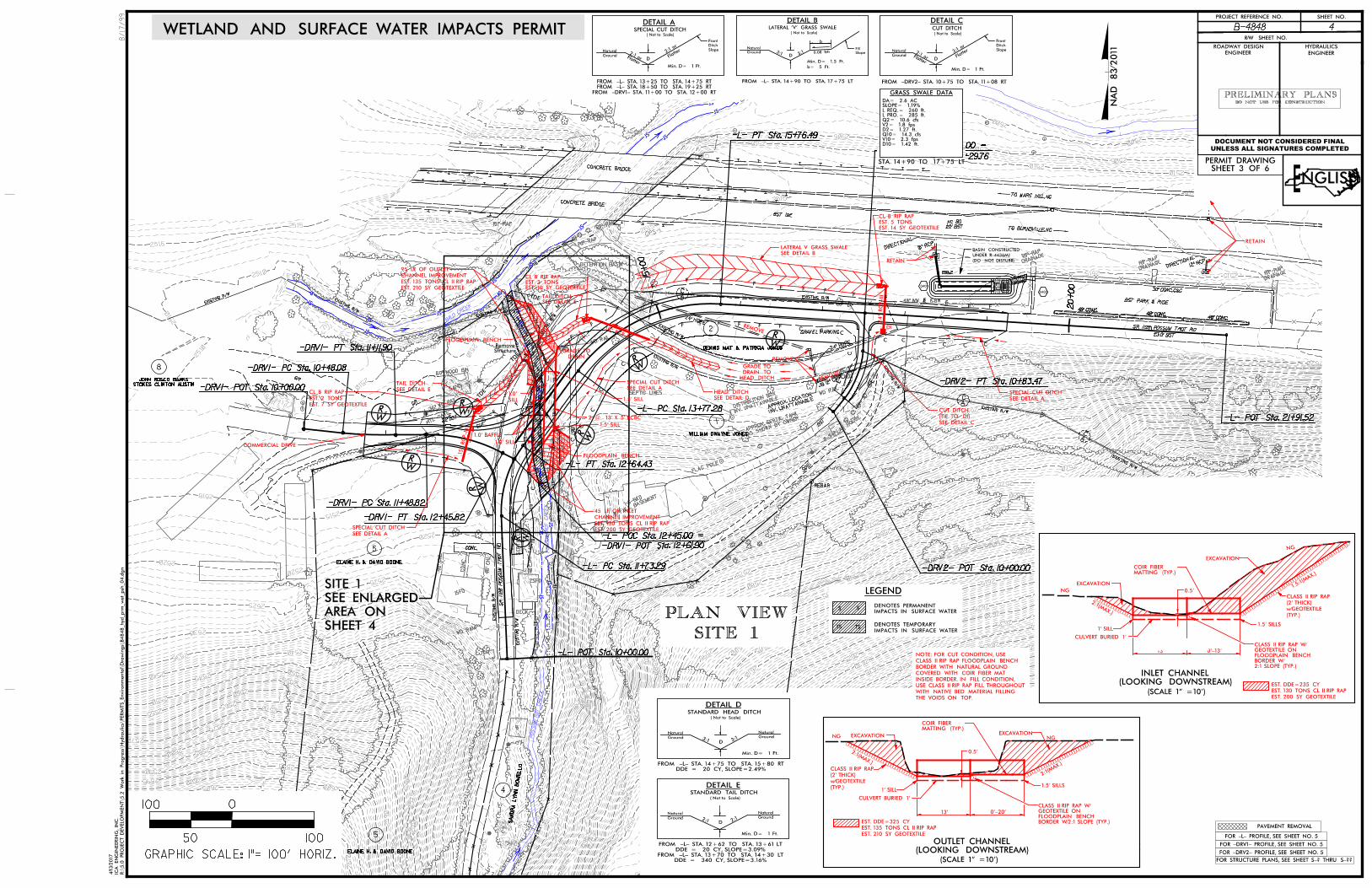
2500
2500
2505
2505
2505
2505
2505
2505
2505
25052505
2505
2505
2505
2505
2510
2510
2510
2510
2510
2510
2510
2510
2510
2510
2510
2510
2510
2510
2510
2510
2510
2510
2510
2510
2510
2510
2510
2510
2515
2515
25152515
2515
2515
2515
2515
2515
2515
2515
2515
2515
2515
2515
2515
2515
25152515
2515
2515
2515
2515
2515
2515
2515
2515
2515
2520
2520
2520
2520
2520
2520
25202520
2520
25202520
2520
2520
2525
2525
2525
2525
2525
2525
2525
2525
2525
2525 2525
2530
2530
2530
2530
2530
2530
2530
2530
2530
2530
2530 2530
2535
253525
35
2535
2535
2535
2535
2535
2535
2535
2535
2535
2535 2535
2540
2540
2540
2540
2540
2540
2540
2540
2540
2540
2540
2540
2540 2540
25402540
2540
2545
2545
2545
2545
2545
2545
2545
2545
2545
2545
2545 2545
2550
2550
2550
2550
2550
2550
2550
2550
2550
2550
25502550
2555
2555
2555
2555
2555
2555
2555
2555
2555
2555
2555
2555
2560
2560
2560
2560
2560
2560
2560
2560
2560
25602560
2565 2565
2565
2565
2565
2565
2565
2565
2565
25652565
2565
2570
2570 2570
2570
2570
2570
2570
2570
2570
2570
2570
2575 2575
2575
2575
2575
2575
2575
2575
2575
2575
2580
2580
2580
2580
2580
2580
2580
2580
2580
25802585
2585
2585
2585
2585
2585
2585
2590
2590
2590
2590
2590
2590
2590
2595
2595
2595
2595
2595
2595
2595
2600
2600
2600
2600
2600
2605
2605
2605
2605
2605
2605
2610
2610
2610
2610
2615
2620
2625
2625
2630
2630
2630
2635
2635 2640
2640
2645
2645
2650
2650
24" HDPE
18" RCP
12" RCP
BALD
CREEK
DETENTION BASIN
AS SHOWN
BY OWNER
APPROX.
SEPTIC T
ANK
SEPTIC LINES
SEP
TIC
TA
NK
SEP
TIC
LIN
ES
RIP-RAP
12" CMP
22’BST
22’ BST
NC 80
BST PARK & RIDE
EXISTING R/W
EXISTING R/W
EXIS
TIN
G
R/
W
EXISTING R/W
EXISTING R/W
EXISTING R/W
EXISTIN
G R/
WEXISTING R/W
EXIS
TIN
G R/
W
EXISTING R/W
EXISTING R/W
EXIS
TIN
G
R/
W
BST
W
FLAG POLE
2-S-
PLAY HOUSE
48" WW & 1SBW
BST 19E
CONCRETE BRIDGE
CONCRETE BRIDGE
TO BURNSVILLE, NC
TO MARS HILL, NC
RIP-RAPRIP
-RAP
W/FULL
BASEMENT
1-S-B
KD
BS
T
WD RAIL
MTL
S
B
WD RAMP
1SFD
CO
NC
48"
CH
L
48"
CH
L
CONC.
W
GR
GR
MTL GATE
36" W
D RAIL
60" WOOD BIN
SAND
SOIL
DECK
24" HDPE
WD RAIL
30" CONC. C&G
48" CONC.48" CONC.
48" CONC.
EXIS
TIN
G
R/
W
JB
INV. UNATTAIN
ABLE
APPROX. LOCATIO
N
DRAINAGERIP
-RAP
DRAINAGERIP
-RAP
DRAINAGERIP
-RAP
DIRECTIO
NAL
DIRECTIO
NAL
INV. UNATTAIN
ABLE
DISTRIB
UTION
BOX
GPS-1
;
;
;
2SFD
GRAVEL PARKING
SR 1128 P
OS
SU
M
TR
OT
RD
POSS
UM
TR
OT
CR
EE
K
POS
SU
MT
RO
T
CR
EE
K
23.0’ BST
SR 1128 POSSUM TROT RD
EIP
REBAR
SA
ND
RA
LY
NN
BO
NIE
LL
O
4
5
2
5
WILLIAM DWAYNE JONES
DENNIS MAT & PATRICIA JONES
STOKES CLINTON AUSTIN
JOHN ROSCO BANKS
8
1
ELAINE H. & DAVID BOONE
ELAINE H. & DAVID BOONE
WETLAND AND SURFACE WATER IMPACTS PERMIT
SHEET 3 OF 6PERMIT DRAWING
ENGLISH
LEGEND
IMPACTS IN SURFACE WATER
DENOTES PERMANENTSS
IMPACTS IN SURFACE WATER
DENOTES TEMPORARY TS TS
R:\
5.0 PR
OJE
CT D
EVELO
PM
EN
T\5.2
Work in Pro
gress\Hydra
ulics\
PER
MIT
S_Environ
mental\
Dra
win
gs\
B4848_hyd_prm
_wet_
psh
_04.d
gn
ICA
EN
GIN
EERIN
G, IN
C.
4/13/2
017
GRASS SWALE DATA
STA. 14+90 TO 17+75 LT
D10= 1.42 ft.V10= 2.3 fpsQ10= 14.3 cfsD2= 1.27 ft.V2= 1.8 fpsQ2= 10.6 cfsL PRO.= 285 ft.L REQ.= 260 ft.SLOPE= 1.19%DA= 2.6 AC
SITE 1PLAN VIEW
0
10050
100
GRAPHIC SCALE: 1"= 100’ HORIZ.
SHEET 4
AREA ON
SEE ENLARGED
SITE 1
20+00
15+00
-L- PC Sta. 13+77.28
-L- PC Sta. 11+73.29
-DRV1- PC Sta. 10+48.08
-DRV1- PT Sta. 11+11.90
-DRV1- POT Sta. 10+00.00
-DRV1- PC Sta. 11+48.82
-DRV1- PT Sta. 12+45.82
-DRV1- POT Sta. 12+61.90
-L- POC Sta. 12+45.00 =
-DRV2- POT Sta. 10+00.00
-L- PT Sta. 15+76.49
-L- POT Sta. 17+52.00 =
-DRV2- POT Sta. 11+29.76
-DRV2- PT Sta. 10+83.47
-L- POT Sta. 21+91.52
-L- PT Sta. 12+64.43
-L- POT Sta. 10+00.00
StructureRemove
DI
24" RC
P-III
DRAIN
GRADE TO
18" RCP-III
15" RC
P-III
EST. 7 SY GEOTEXTILE
EST. 2 TONS
CL B RIP RAP
EST. 10 SY GEOTEXTILEEST. 3 TONSCL B RIP RAP
EST. 14 SY GEOTEXTILE
EST. 5 TONS
CL B RIP RAP
SEE DETAIL A
SPECIAL CUT DITCH
SEE DETAIL A
SPECIAL CUT DITCH
SEE DETAIL B
LATERAL V GRASS SWALE
LATERAL ’V’ GRASS SWALE( Not to Scale)
D3:1 3:
1
b
0.08 ft/ft
FROM -L- STA. 14+90 TO STA. 17+75 LT
b= 5 Ft.
Min. D= 1.5 Ft.
DETAIL B
Ground
Natural
Slope
Fill
3:1 3:1
D
( Not to Scale)
STANDARD HEAD DITCH
DDE = 20 CY, SLOPE=2.49%FROM -L- STA. 14+75 TO STA. 15+80 RT
Min. D= 1 Ft.
DETAIL D
Ground
NaturalGround
Natural
SEE DETAIL D
HEAD DITCHSEE DETAIL E
TAIL DITCHSEE DETAIL A
SPECIAL CUT DITCH
Flatter2:
1 or
DFlatter
2:1 or
( Not to Scale)
SPECIAL CUT DITCH
FROM -DRV1- STA. 11+00 TO STA. 12+00 RTFROM -L- STA. 18+50 TO STA. 19+25 RTFROM -L- STA. 13+25 TO STA. 14+75 RT
DETAIL A
Min. D= 1 Ft.
Ground
Natural Slope
Ditch
Front
Flatter3:
1 or
DFlatter
2:1 or
( Not to Scale)
CUT DITCH
FROM -DRV2- STA. 10+75 TO STA. 11+08 RT
Min. D= 1 Ft.
DETAIL C
Slope
Ditch
Front
Ground
Natural
EST. 200 SY GEOTEXTILE
EST. 130 TONS CL II RIP RAP
CHANNEL IMPROVEMENT
45 LF OF INLET
SEE DETAIL C
(TIE TO DI)
CUT DITCH
SEE DETAIL ETAIL DITCH
RETAIN
REMOVE
REMOVE
REMOVE
2:1 2:1
D
( Not to Scale)
STANDARD TAIL DITCH
DDE = 340 CY, SLOPE=3.16%FROM -L- STA. 13+70 TO STA. 14+30 LT
DDE = 20 CY, SLOPE=3.09%FROM -L- STA. 12+62 TO STA. 13+61 LT
Min. D= 1 Ft.
DETAIL E
Ground
NaturalGround
Natural
RETAIN
2 @ 13’ X 5’ RCBC
COMMERCIAL DRIVE
EST. 210 SY GEOTEXTILE
EST. 135 TONS CL II RIP RAP
CHANNEL IMPROVEMENT
95 LF OF OUTLET
EXCAVATION
NG
NG
(LOOKING DOWNSTREAM)INLET CHANNEL
(SCALE 1" =10’)
MATTING (TYP.)COIR FIBER
1’ SILL
0’-13’13’
2:1(MAX.)
EXCAVATION
1.5:1(
MAX.)
0.5’
MATTING (TYP.)COIR FIBER
EXCAVATION
2:1(MAX.)
1’ SILL
0’-20’
EXCAVATION
0.5’
EST. 200 SY GEOTEXTILE
EST. 130 TONS CL II RIP RAP
EST. DDE=235 CY
(LOOKING DOWNSTREAM)OUTLET CHANNEL
(SCALE 1" =10’)
NG
13’
NG
2:1(M
AX.)
THE VOIDS ON TOP.
WITH NATIVE BED MATERIAL FILLING
USE CLASS II RIP RAP FILL THROUGHOUT
INSIDE BORDER. IN FILL CONDITION,
COVERED WITH COIR FIBER MAT
BORDER WITH NATURAL GROUND
CLASS II RIP RAP FLOODPLAIN BENCH
NOTE: FOR CUT CONDITION, USE
EST. 210 SY GEOTEXTILE
EST. 135 TONS CL II RIP RAP
EST. DDE=325 CY
1.5’ SILL
1.0’ SILL
1.0’ BAFFLE
1.5’ SILLSILL
1.0’
(TYP.)
w/GEOTEXTILE
(2’ THICK)
CLASS II RIP RAP
CULVERT BURIED 1’
1.5’ SILLS
BORDER W/2:1 SLOPE (TYP.)FLOODPLAIN BENCH GEOTEXTILE ON CLASS II RIP RAP W/
2:1 SLOPE (TYP.)BORDER W/FLOODPLAIN BENCHGEOTEXTILE ON CLASS II RIP RAP W/
CULVERT BURIED 1’
(TYP.)
w/GEOTEXTILE
(2’ THICK)
CLASS II RIP RAP
1.5’ SILLS
FLOODPLAIN BENCH
FLOODPLAIN BENCH
HEAD DITCH
DRAIN TO
GRADE TO
HYDRAULICSROADWAY DESIGN
ENGINEER ENGINEER
R/W SHEET NO.
SHEET NO.PROJECT REFERENCE NO.
$$$$
US
ER
NA
ME$$$$
8/17/99
B-4848 4
DOCUMENT NOT CONSIDERED FINAL
UNLESS ALL SIGNATURES COMPLETED
NA
D 83/ 2
011
PAVEMENT REMOVAL
FOR STRUCTURE PLANS, SEE SHEET S-? THRU S-??
FOR -L- PROFILE, SEE SHEET NO. 5
FOR -DRV1- PROFILE, SEE SHEET NO. 5
FOR -DRV2- PROFILE, SEE SHEET NO. 5
DO NOT USE FOR CONSTRUCTIONPRELIMINARY PLANS
0401
x 2513.2
0402
D
(DO NOT DISTURB)
UNDER R-4436MJ
BASIN CONSTRUCTED
F
F
F
F
F
C
C
C
C
C
C
F
C
F
F F
F
F F
F
F
F
F
F
C
F
C C
C CC C C C
C
C
C
C
F
F
F
F
F
FF
C
FF F
F
F
F
FF
F
F
F
F
TS
S
SS
SS
S
S
S
S
S
S
SS
SS
SS
S
S
SS
SS
S
S
S
S
S
SS
TS
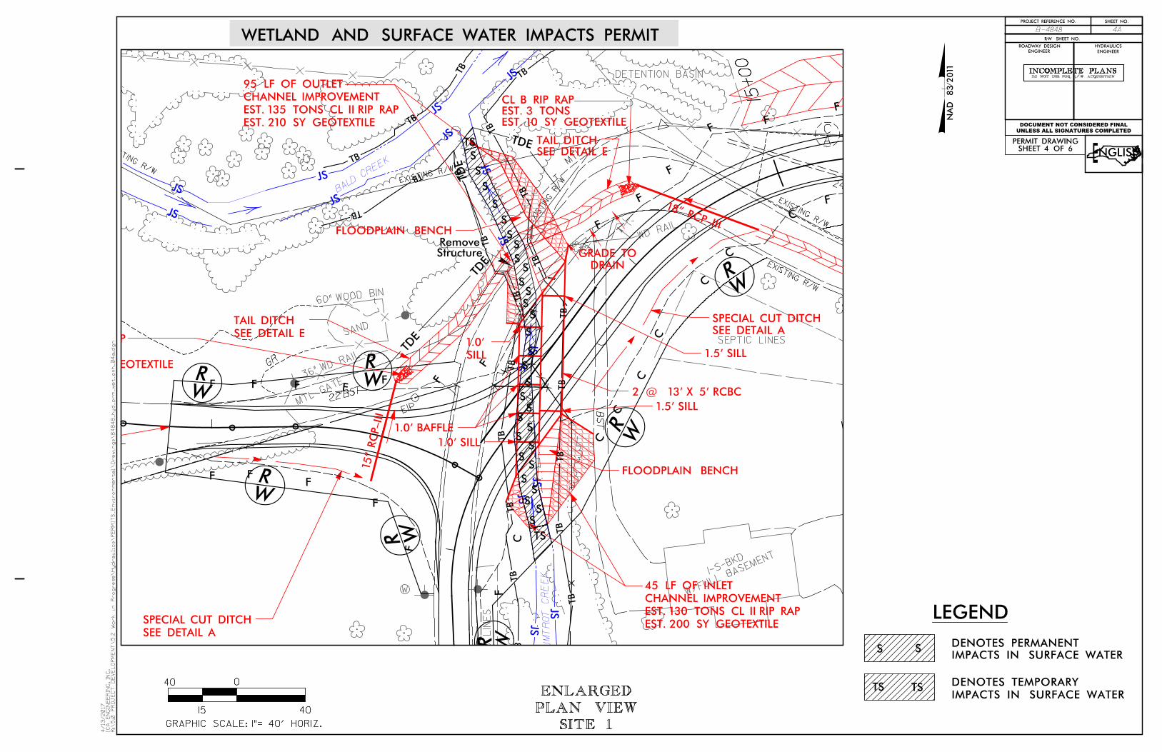
24" HDPEBAL
D CREEK
DETENTION BASIN
SEPTIC LINES
SEP
TIC
LIN
ES
22’BST
EXISTING R/W
EXISTING R/W
EXIS
TIN
G
R/
W
EXISTING R/W
EXISTING R/W
W/FULL
BASEMENT
1-S-B
KDB
ST
WD RAIL
MTL
W
GR
MTL GATE
36" W
D RAIL
60" WOOD BIN
SAND
;
POS
SU
MT
RO
T
CR
EE
K
EIP
WILLIAM DWAYNE JONES
WETLAND AND SURFACE WATER IMPACTS PERMIT
ENGLISH
R:\
5.0
PR
OJ
EC
T
DE
VE
LO
PM
EN
T\5.2
Work in
Progress\
Hydraulics\
PE
RMIT
S_
Environ
mental\
Dra
wings\
B4848_hyd_pr
m_
wet_psh_04a.d
gn
IC
A
EN
GIN
EE
RIN
G, IN
C.
4/13/2017
SITE 1PLAN VIEWENLARGED
LEGEND
IMPACTS IN SURFACE WATER
DENOTES PERMANENTSS
IMPACTS IN SURFACE WATER
DENOTES TEMPORARY TS TS
SHEET 4 OF 6PERMIT DRAWING
HYDRAULICSROADWAY DESIGN
ENGINEER ENGINEER
R/W SHEET NO.
SHEET NO.PROJECT REFERENCE NO.
INCOMPLETE PLANSDO NOT USE FOR R/W ACQUISITION
DOCUMENT NOT CONSIDERED FINAL
UNLESS ALL SIGNATURES COMPLETED
B-4848 4A
0
4015
40
GRAPHIC SCALE: 1"= 40’ HORIZ.
NA
D 83/ 2
011
15+00
StructureRemove
DRAIN
GRADE TO
18" RCP-III
15" RC
P-III
EST. 7 SY GEOTEXTILE
EST. 2 TONS
CL B RIP RAP
EST. 10 SY GEOTEXTILEEST. 3 TONSCL B RIP RAP
SEE DETAIL A
SPECIAL CUT DITCH
SEE DETAIL E
TAIL DITCHSEE DETAIL A
SPECIAL CUT DITCH
EST. 200 SY GEOTEXTILE
EST. 130 TONS CL II RIP RAP
CHANNEL IMPROVEMENT
45 LF OF INLET
SEE DETAIL ETAIL DITCH
2 @ 13’ X 5’ RCBC
EST. 210 SY GEOTEXTILE
EST. 135 TONS CL II RIP RAP
CHANNEL IMPROVEMENT
95 LF OF OUTLET
1.5’ SILL
1.0’ SILL
1.0’ BAFFLE
1.5’ SILLSILL
1.0’
FLOODPLAIN BENCH
FLOODPLAIN BENCH
F
F
F
F
F
C
C
C
C
C
C
F
C
F
F
F
F
F
F
F
F
C
F
F
F
F
F
F
TS
S
SS
SS
S
S
S
S
S
S
SS
SS
SS
S
S
SS
SS
S
S
S
S
S
SS
TS
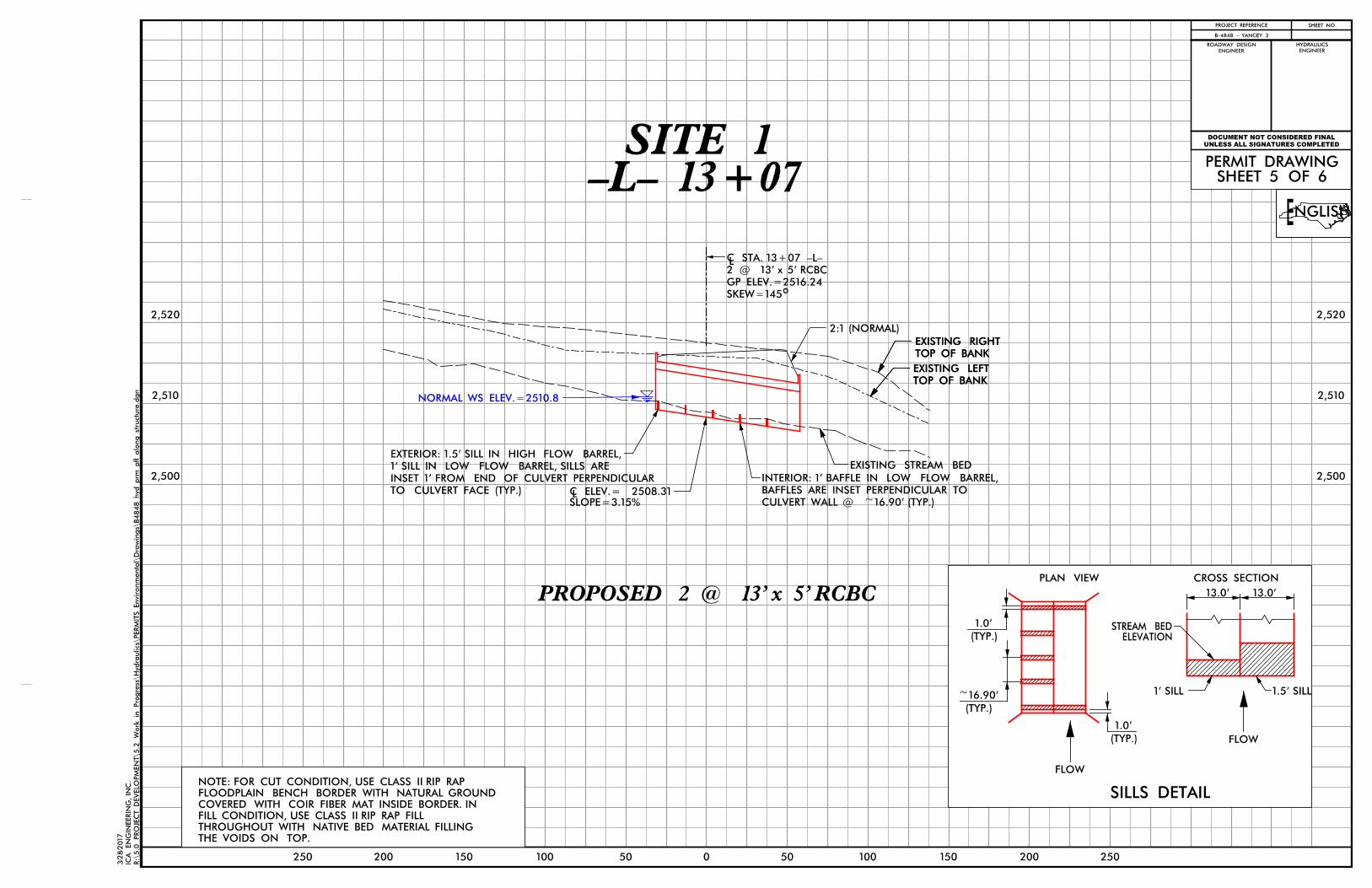
SHEET NO.
HYDRAULICSROADWAY DESIGN
ENGINEER ENGINEER
PROJECT REFERENCE
R:\
5.0 PR
OJE
CT D
EVELO
PM
EN
T\5.2
Work in Pro
gress\Hydra
ulics\
PER
MIT
S_Environ
mental\
Dr a
win
gs \
B4848_hyd_prm
_pfl_alo
ng_stru
cture.d
gn
ICA
EN
GIN
EERI N
G, IN
C.
3/2
8/2
017
250 150200
ENGLISH
SHEET 5 OF 6 PERMIT DRAWING
DOCUMENT NOT CONSIDERED FINAL
UNLESS ALL SIGNATURES COMPLETED
-L- 13+07SITE 1
0 50 100 150 200 25050100
L
o
EXISTING STREAM BED
2:1 (NORMAL)
TOP OF BANK
EXISTING RIGHT
TOP OF BANK
EXISTING LEFT
TOP OF BANK
EXISTING LEFT
TOP OF BANK
EXISTING RIGHT
SKEW=145
GP ELEV.=2516.24
2 @ 13’ x 5’ RCBC
C STA. 13+07 -L-
NORMAL WS ELEV.=2510.8
SLOPE=3.15%C ELEV.= 2508.31LTO CULVERT FACE (TYP.)
INSET 1’ FROM END OF CULVERT PERPENDICULAR
1’ SILL IN LOW FLOW BARREL, SILLS ARE
EXTERIOR: 1.5’ SILL IN HIGH FLOW BARREL,
2,520
2,510
2,500
2,520
2,510
2,500
B-4848 - YANCEY 3
PLAN VIEW CROSS SECTION
FLOW
FLOW
SILLS DETAIL
13.0’
(TYP.)
1.0’
1’ SILL
ELEVATIONSTREAM BED
13.0’
1.5’ SILL
(TYP.)
1.0’
(TYP.)
~16.90’
THE VOIDS ON TOP.
THROUGHOUT WITH NATIVE BED MATERIAL FILLING
FILL CONDITION, USE CLASS II RIP RAP FILL
COVERED WITH COIR FIBER MAT INSIDE BORDER. IN
FLOODPLAIN BENCH BORDER WITH NATURAL GROUND
NOTE: FOR CUT CONDITION, USE CLASS II RIP RAP
PROPOSED 2 @ 13’ x 5’ RCBC
CULVERT WALL @ ~16.90’ (TYP.)
BAFFLES ARE INSET PERPENDICULAR TO
INTERIOR: 1’ BAFFLE IN LOW FLOW BARREL,
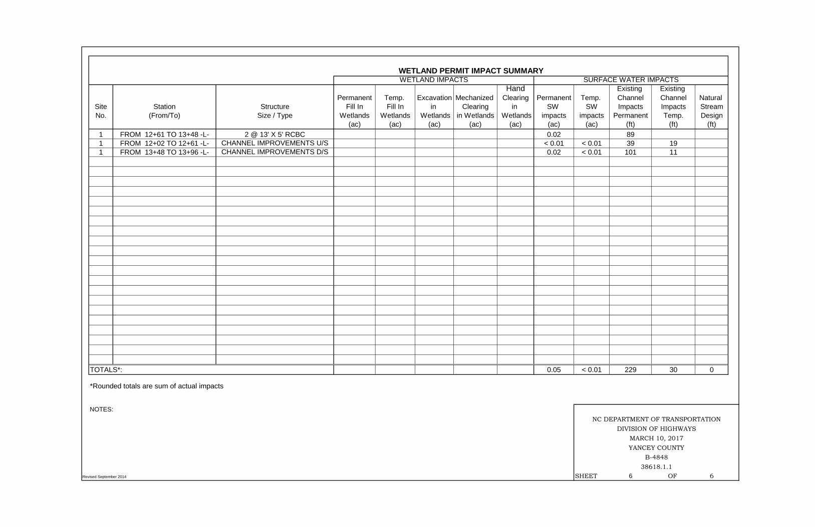
Hand Existing Existing Permanent Temp. Excavation Mechanized Clearing Permanent Temp. Channel Channel Natural
Site Station Structure Fill In Fill In in Clearing in SW SW Impacts Impacts StreamNo. (From/To) Size / Type Wetlands Wetlands Wetlands in Wetlands Wetlands impacts impacts Permanent Temp. Design
(ac) (ac) (ac) (ac) (ac) (ac) (ac) (ft) (ft) (ft)1 FROM 12+61 TO 13+48 -L- 2 @ 13' X 5' RCBC 0.02 89 1 FROM 12+02 TO 12+61 -L- CHANNEL IMPROVEMENTS U/S < 0.01 < 0.01 39 19 1 FROM 13+48 TO 13+96 -L- CHANNEL IMPROVEMENTS D/S 0.02 < 0.01 101 11
TOTALS*: 0.05 < 0.01 229 30 0
*Rounded totals are sum of actual impacts
NOTES:
Revised September 2014 SHEET 6 OF 6
WETLAND PERMIT IMPACT SUMMARYWETLAND IMPACTS SURFACE WATER IMPACTS
YANCEY COUNTYB-4848
38618.1.1
NC DEPARTMENT OF TRANSPORTATIONDIVISION OF HIGHWAYS
MARCH 10, 2017