sacog regional planning partnership · alternative 4 – transportation system management (tsm) •...
TRANSCRIPT

SACOG REGIONAL PLANNING PARTNERSHIPSACOG REGIONAL PLANNING PARTNERSHIP
PROJECT OF AIR QUALITY CONCERN (POAQC)PROJECT OF AIR QUALITY CONCERN (POAQC) DETERMINATION
APRIL 24, 2013

Project Location

SR 65 Southbound from Pleasant Grove Boulevard Overcrossing – AM Peak Hour

I‐80 Eastbound from Roseville Parkway Overcrossing – PM Peak Hour

SR 65 Northbound from Galleria Boulevard Overcrossing – PM Peak Hour

Project Background

POAQC Process to Date
• Preliminary traffic volumes from SACMET model and Caltrans truck percentagesCaltrans truck percentages
• POAQC Form submitted on November 26, 2012• Deadline for POAQC form to be submitted under 2006 Q
Guidelines was December 20, 2012• EPA provides comments on POAQC on December 21,
2012

h h h h f b f d lPOAQC Criteria
1. New highway projects that have a significant number of diesel vehicles, and expanded highway projects that have a significant increase in diesel vehicles
2. Projects affecting intersections that are at Level‐of‐Service D, E, or F with a significant number of diesel vehicles, or those that ill h t L l f S i D E F b f i dwill change to Level‐of‐Service D, E, or F because of increased
traffic volumes from a significant number of diesel vehicles related to the project

3 New bus and rail terminals and transfer points than have aPOAQC Criteria Continued
3. New bus and rail terminals and transfer points than have a significant number of diesel vehicles congregating at a single location
4. Expanded bus and rail terminals and transfer points that significantly increase the number of diesel vehicles congregating at a single locationat a single location
5. Projects in or affecting locations, areas, or categories of sites which are identified in the PM10 or PM2.5 applicable implementation plan or implementation plan submission, as appropriate, as sites of violation or possible violation
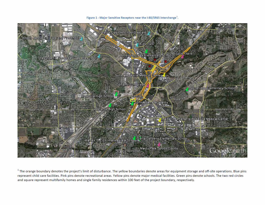

Surrounding Land Uses
Sensitive Receptor Location Parcel
Existing Distance (Feet)
Proposed Distance (Feet)
Single Family Residential
North of I‐80 (East of SR 65) 046‐191‐020 79 26
Creekside West of SR 65 ( h f ) 493‐010‐002 88 65Apartments (North of I‐80) 493 010 002 88 65
Hearthstone Apartments
East of SR 65 (North of I‐80) 015‐530‐004 70 48


Criteria 1 ‐ Submitted POAQC Form


Criteria 1 Draft Traffic Report ResultsCriteria 1 ‐ Draft Traffic Report ResultsExisting (2009) Year 2040 No Project Year 2040 With Project
With Project to No Project
Roadway Segment
(2009) Year 2040 No Project Year 2040 With Project No ProjectDaily Traffic Volume
Daily Traffic Volume
Daily Truck Volume
Truck % of Daily Volume
Daily Traffic Volume
Daily Truck Volume
Truck % of Daily Volume
Truck Volume Difference
Between Douglas Blvd and Eureka Rd 155,000 197,400 14,200 7.19% 204,200 14,300 7.00% 0.7%
I‐80
Between Douglas Blvd and Eureka Rd 155,000 197,400 14,200 7.19% 204,200 14,300 7.00% 0.7%
Between Eureka Rd and Taylor Rd 165,400 213,800 14,900 6.97% 217,800 14,800 6.80% ‐0.7%
Between Taylor Rd and SR 65 150,000 194,200 13,900 7.16% 213,000 14,300 6.71% 2.9%
Between SR 65 and Rocklin Rd 109,600 139,500 9,900 7.10% 137,300 9,700 7.06% ‐2.0%
SR 65
Between I‐80 and Galleria Blvd 106,100 151,500 6,000 3.96% 155,600 6,000 3.86% 0.0%
Between Galleria Blvd and Pleasant Grove Blvd 104,400 159,100 6,600 4.15% 154,800 6,300 4.07% ‐4.5%Blvd

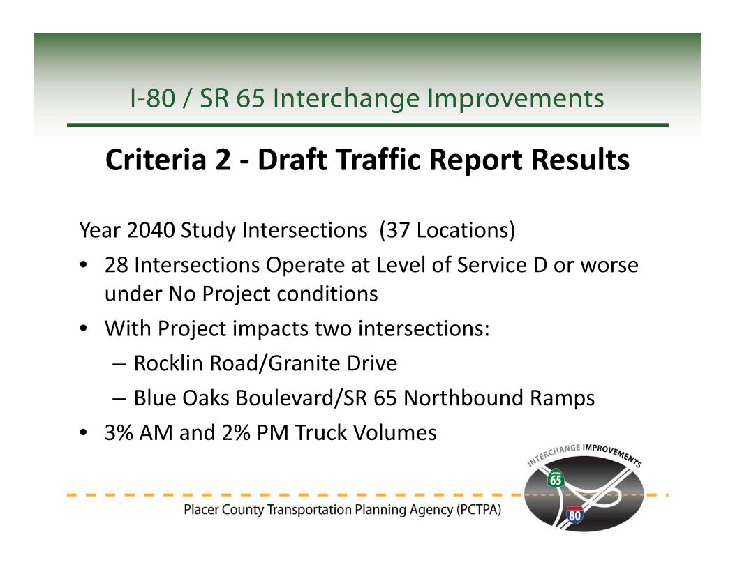
Criteria 2 ‐ Draft Traffic Report Results
Year 2040 Study Intersections (37 Locations)• 28 Intersections Operate at Level of Service D or worse
under No Project conditionsh• With Project impacts two intersections:
– Rocklin Road/Granite DriveBl O k B l d/SR 65 N hb d R– Blue Oaks Boulevard/SR 65 Northbound Ramps
• 3% AM and 2% PM Truck Volumes
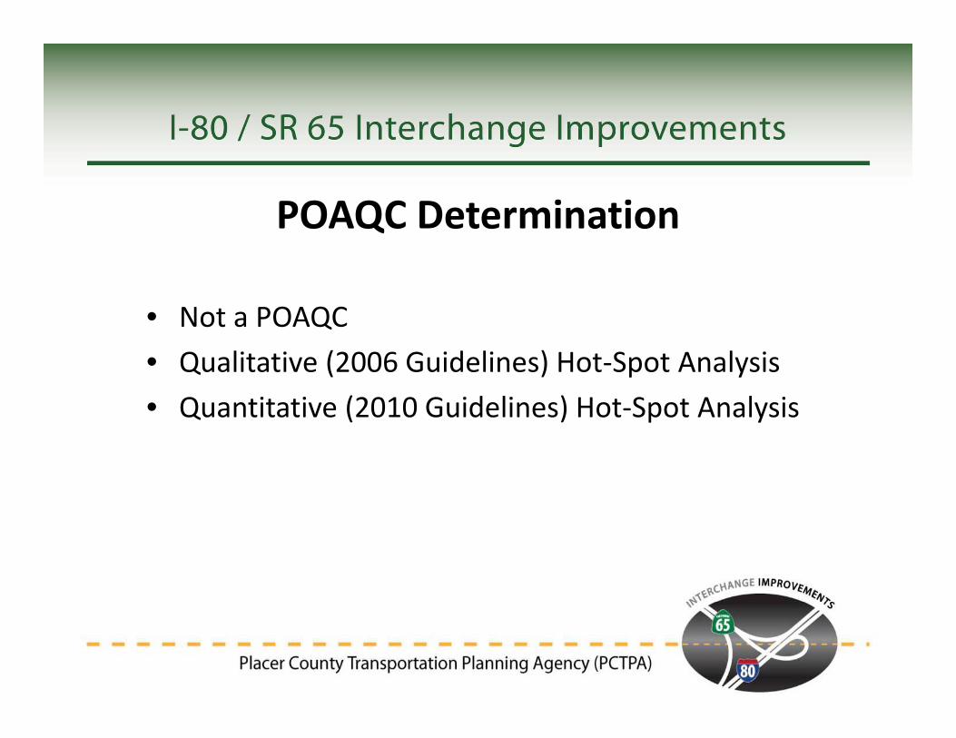
POAQC Determination
• Not a POAQC
Q
Not a POAQC• Qualitative (2006 Guidelines) Hot‐Spot Analysis• Quantitative (2010 Guidelines) Hot‐Spot AnalysisQuantitative (2010 Guidelines) Hot Spot Analysis

Discussion and Questions
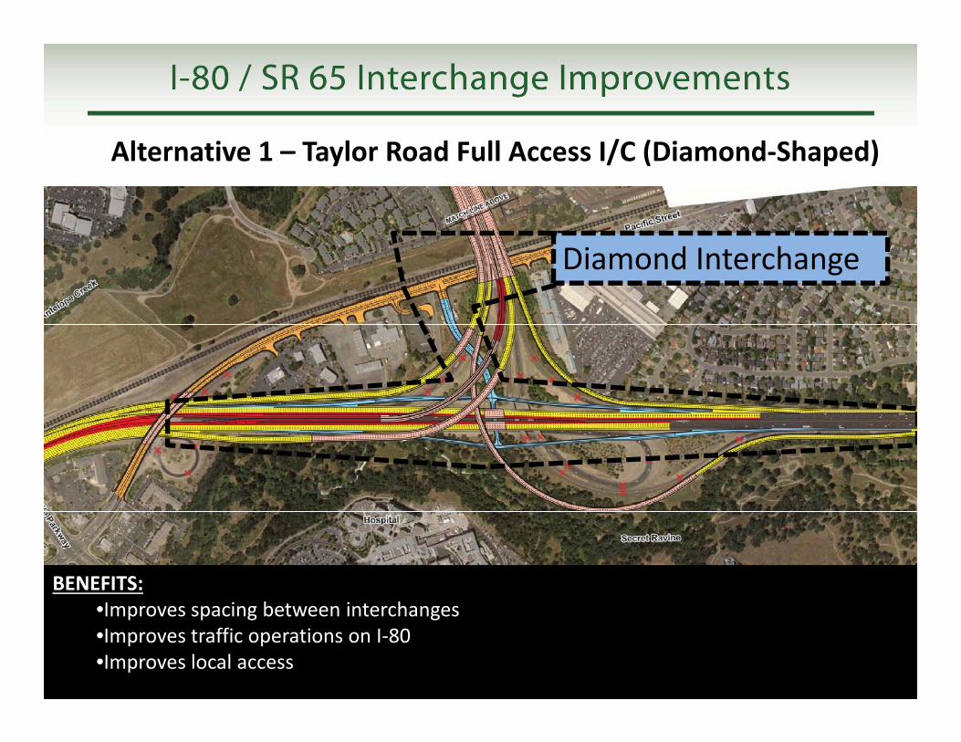
Alternative 1 – Taylor Road Full Access I/C (Diamond‐Shaped)
Diamond Interchange
BENEFITS:I i b t i t h
BENEFITS:I i b t i t h•Improves spacing between interchanges
•Improves traffic operations on I‐80•Improves local access
•Improves spacing between interchanges •Improves traffic operations on I‐80•Improves local access

Alternative 2 – Taylor Road Full Access I/C (Trumpet‐Shaped)
Trumpet Interchange
BENEFITS:I i b t i t h
BENEFITS:I i b t i t h•Improves spacing between interchanges
•Improves traffic operations on I‐80•Improves local access
•Improves spacing between interchanges •Improves traffic operations on I‐80•Improves local access

Al i 3 T l R d I h Eli i dAlternative 3 – Taylor Road Interchange Eliminated
BENEFITS:•Improves spacing between interchanges
BENEFITS:•Improves spacing between interchanges
CONCERNS:•Reduces number of access connections
CONCERNS:•Reduces number of access connections•Improves spacing between interchanges
•Improves traffic operations on I‐80•Improves spacing between interchanges •Improves traffic operations on I‐80
•Reduces number of access connections •Shifts local access to Eureka Rd, Galleria Blvd, and Rocklin Rd I/C’s
•Reduces number of access connections •Shifts local access to Eureka Rd, Galleria Blvd, and Rocklin Rd I/C’s

Alternative 4 – Transportation System Management (TSM)
• Ramp Metering (System and• Ramp Metering (System and On/Off Ramps)
• HOV Bypass LanesHOV Bypass Lanes• Changeable Message Signs (CMS)(CMS)
• Traffic Signal Coordination• Transit OptionsTransit Options• Bicycle and Pedestrian Facilities

Alternative 5 – No‐Build (No Project)
• “The Do Nothing Alternative”• Existing Facilities and Conditions Remain• Other Metropolitan Transportation Plan (MTP) Projects
• Required for Environmental Review