safeguarding territories, land, culture and natural … territories, land, culture and natural...
TRANSCRIPT

1
By Julius Muchemi and Giacomo Rambaldi
VOLUME 1
PARTICIPATORY 3-DIMENSIONAL MODELLING
AND MAPPING IN KENYA
Safeguarding Territories, Land, Culture and Natural Resources in Africa

2
PARTICIPATORY 3-DIMENSIONAL MODELLING AND MAPPING IN KENYA
By
And
Published by:
Citation:
ISBN:
Editors:
Disclaimer:
Photos:
Funding:
Web-based
reference site
Julius Muchemi Giacomo Rambaldi Environmental Research Mapping and information Systems in Africa (ERMIS Africa) Reproduction and Circulation of this publication and the
content for Education and development purpose is highly
encouraged
Muchemi, Julius and Rambaldi, Giacomo,. 2002.
Participatory 3-Dimensional Modelling and Mapping:
Safeguarding Territories, Land, Culture and Natural
Resources in Africa, Nairobi, Kenya
Upcoming
To be contacted: Professor Ayemba (University of
Nairobi), Professor Francis Wegulo (Egerton University),
Dr Gilbert Nduru (Moi University)
The views expressed are those of the authors and do not
necessarily represent any official view of the ERMIS
Africa, CTA, and the Universities mentioned herein.
The designation employed and the presentation of
material in this publication do not imply the expression of
any opinion whatsoever on the part of the publisher and
Authors concerning the legal status of any country or
territory, village, land, natural resources or concerning the
delimitation of its frontiers or boundaries.
Rambaldi Giacomo
CTA, IPACC, ESAPP
http://www.ermisafrica.org;
http://www.iapad.org

3
ACKNOWLEDGEMENTS
Trainings and Documentations are a product of enthusiasm, networking, communication and trust among all people involved in the process. In the spirit of seamless communication, synergies and empowerment are achieved at all levels. This document presents the first ever participatory 3-Dimensional Modelling and mapping exercise conducted at grassroot level with indigenous minority groups in Africa. It is therefore prudent to thank all individuals and organisations that joined hands to make it a success. At the height of the exercise are the hands of close of 100 villagers making up the 25 Ogiek clans in Eastern Mau whose efforts brought together development practitioners from 7 countries to learn a barefoot-type-of-mapping. Further acknowledgement goes to the numerous organizations and individuals for their different roles in making this workshop and the development of the Mau forest Participatory 3 Dimensional Model (P3DM) a reality and a very successful one. ERMIS Africa staff relentlessly dedicated one year on planning and preparing for the success of the project. In particular, contributing staff include Julius Muchemi (Director), Warren Njiru and Martha Waite (GIS specialists), Bancy Kubutha (Programme Administrator-Nakuru office) and Enos Mwangale (Program Manager –Eldoret office), Simon Muchemi (Web Master), Vincent Siriba (Programme Account) and Margaret Njeri (Programme Secretary). CTA, in addition to financial support, gave unremittingly support to the technical process of mapping process through Giacomo Rambaldi who has an outstanding record on the P3DM process around the world. The following organisations, networks and projects organised and/or contributed to the success of the initiative:
• ERMIS Africa • Ogiek Development Initiative (ODI) • CTA • IPACC • Gaia Foundation • Egerton University • ILC • ESAPP
Lastly, thanks to all the people and government of Kenya for the peace accorded to the area during the exercise.

4
Table of Contents 1 BACKGROUND TO MAU FOREST COMPLEX........................................................6
1.1 Introduction ............................................................................................................6 1.1.1 The Mau Forest Complex: An internationally critical watershed ....................6 1.1.2 Conservation Values......................................................................................6 1.1.3 The Ogiek Peoples ........................................................................................7 1.1.4 Threats to the Mau Forest’s Environment ......................................................7 1.1.5 Threats to the Ogiek Community ...................................................................7
2 COMMUNITY MAPPING INITIATIVES IN KENYA....................................................7 2.1 Photomapping by the Ogiek People ......................................................................7 2.2 Participatory 3 Dimensional Modelling and Mapping .............................................8
3 REGIONAL PGIS TRAINING WORKSHOP RATIONALE......................................10 3.1 Introduction ..........................................................................................................10 3.2 Goal .....................................................................................................................10 3.3 Project Purpose ...................................................................................................10 3.4 Project Specific Objectives ..................................................................................10
4 PROJECT IMPLEMENTATION ...............................................................................11 4.1 Phase 1 - PREPARATORY PHASE ....................................................................11
4.1.1 Identification of Project Area ........................................................................11 4.1.2 Sourcing of Data and Preparation of the Base Map.....................................11 4.1.3 Choosing the Mapping Scales (vertical and horizontal) ...............................13 4.1.4 Procurement of workshop inputs and their on-site delivery .........................14 4.1.5 Consulting and Mobilising Students and Stakeholders................................14 4.1.6 Selection of trainees: ...................................................................................14 4.1.7 Establishment of an organising committee ..................................................15 4.1.8 Consulting and mobilising students: ............................................................15 4.1.9 Preparation of the draft legend ....................................................................15 4.1.10 Workshop Logistics......................................................................................15
4.2 Outreach ..............................................................................................................16 4.2.1 Participants and Trainees ............................................................................16 4.2.2 Resource Persons .......................................................................................17
4.3 Phase II - Community mapping phase (Workshop no. 1) ....................................18 4.3.1 Day 1 – Tuesday, 8th August 2006..............................................................20 4.3.2 Day 2 - Wednesday, 9th August 2006 .........................................................20 4.3.3 Round of self –introduction of Trainees .......................................................20 4.3.4 Presentation on Cultural Mapping................................................................20 4.3.5 Orientation of Trainees ................................................................................20 4.3.6 Day 3 – Thursday, 10th August 2006 ..........................................................22 4.3.7 Day 4 & 5 – Friday, 11th to Saturday, 12th August 2006.............................24 4.3.8 Day 6 – Monday, 14th August 2006.............................................................25 4.3.9 DAY 7 – Tuesday, 15th August 2006............................................................27 4.3.10 DAY 8 – Wednesday, 16th 2006...................................................................28 4.3.11 DAY 9 – Thursday 17th to Friday, 18th August..............................................28 4.3.12 DAY 9 – Friday 18th August 2006.................................................................29
4.4 Phase III - Closing Ceremony..............................................................................29 5 GROUP DYNAMICS ................................................................................................30 6 MULTIMEDIA PROCESS DOCUMENTATION .......................................................31 7 COURSE EVALUATION..........................................................................................31

5
8 LESSONS LEARNT.................................................................................................31 9 POST WORKSHOP ACTIVITIES ............................................................................32
9.1 Geo-referencing of the Images ............................................................................32 9.2 Digital Data Capture ............................................................................................32 9.3 Thematic Map Creation .......................................................................................32 9.4 On-line Workshop Evaluation ..............................................................................33
10 CONCLUSION .........................................................................................................39 11 APPENDICES ..........................................................................................................40 List of Tables Table 1 Trainers, Resource Persons and Lead Facilitators.......................................... 17 List of Figures Figure 3 Eastern Mau Forest Mapping Exercise Summary Fact Sheet......................... 16 Figure 4 Actual Implementation schedule of Phases II - IV ........................................... 19 Figure 6: Ogiek Elders establishing spatial relations between 3D model and their real world:
Picture by Giacomo Rambaldi ......................................................................... 25 Figure 7: Legend generated by Ogiek Elders: Picture by Giacomo Rambaldi ...................... 26 Figure 8: Completed matrix with some information covered by elders to conceal sensitive
information: Picture by Giacomo Rambaldi ..................................................... 26 Figure 9: Ogiek Community Members posing behind the completed 3 D model: Picture by
Giacomo Rambaldi.......................................................................................... 29 Figure 10 Results of the on-line Workshop Assessment ................................................. 34 Table of Appendices Appendix 1: Training programme........................................................................................ 40 Appendix 2 Contact Details of the Resource Persons........................................................ 43 Appendix 3 Contact Details of the Lists of Trainees........................................................... 43 Appendix 4 List of the Student Participants........................................................................ 45 Appendix 5: List of Key Informants...................................................................................... 46 Appendix 6 Constraints during the manufacture of the blank model .................................. 48 Appendix 7 Day 1 - Trainees’ Frame of Mind at the Beginning of the Workshop ............... 49 Appendix 8 Day 4 – Trainees’ Mid-term Feedback – Friday August, 11, 2006................... 52 Appendix 9 Day 11 – Trainees’ Final Feedback – Friday August, 18 2006........................ 58 Appendix 10 3D Model Summary Sheet .............................................................................. 64 Appendix 11 Extraction of Data from the 3-D Model ............................................................ 66
List of Abbreviations CTA Technical Centre for Agricultural and Rural Cooperation IPACC Indigenous People of Africa Co-ordinating Committee UNEP United Nations Environmental Programme NRM Natural Resource Management ERMIS Africa Environmental Research, Mapping and Information Systems in Africa GIS Geographic Information Systems GPS Global Positioning Systems NGOs Non Government Organisations P3DM Participatory 3 Dimensional Model(ling) PGIS Participatory Geographic Information Systems OWC Ogiek Welfare Council UN United Nations

6
1 BACKGROUND TO MAU FOREST COMPLEX
1.1 Introduction The Mau Forest Complex runs along the Western side of Kenya’s Great Rift Valley. It is the largest remaining indigenous mountain forest in Eastern Africa. Several Ecosystems depend on water originating from it, including: Lake Nakuru (an international RAMSAR site), Lake Baringo, Lake Natron (in Tanzania), Lake Victoria (shared by Kenya, Uganda and Tanzania), and the world famous Maasai Mara game reserve. Some of these lakes are transboundary water bodies and hence call for international collaborative management.
LOCATION OF OGIEK ANCESTRAL TERRITORY
LOCATION OF IN KENYA
0 160 320 48080Km
0 20 40 6010Km
PROJECT AREA
´ ´Legend
Ogiek Ancestral Territory
Nakuru District
LegendDistricts
Nakuru District
1.1.1 The Mau Forest Complex: An internationally critical watershed The Mau Forest complex forms one of the country’s most important ranges in addition to Mt. Kenya, the Aberdares Range, Mt Elgon and Cherangany Hills. It hosts the upper catchments of all main rivers west of the Rift Valley, including: rivers Nzoia, Yala, Nyando, Sondu, Mara, Kerio, Molo, Ewaso Nyiro, Njoro, Nderit, Makalia, and Naishi.
1.1.2 Conservation Values The watershed of Mau forest forms major conservation areas which include: (i) South Turkana National Reserve, with scenic landscape and abundance of wildlife; (ii) the Kerio Valley and Kam Narok National Reserves; (iii) Lake Baringo; (iv) Lake Nakuru National Park, a RAMSAR site (1990), and an important bird area for the flamingo and about 450 other species; (v) Lake Natron which is the main breeding area for the flamingos in the Rift Valley; (vi) Maasai Mara National Reserve; (vii) Serengeti National Park, which is a heritage site, world famous for big game and migratory species; (viii) Kakamega Forest, which is the only remnant in Kenya of the Guineo-Congolian forest ecosystem with high biodiversity for birds, butterflies and plants

7
1.1.3 The Ogiek Peoples The Mau forest is the ancestral home for the Ogiek Peoples who numbers around 20,000. The Ogiek are the last largest hunter-gatherer community in Eastern Africa (V. Luling, 2002 and G. Yeman, 1933). The majority is found in Nakuru district while others live in Mt Elgon, Koibatek, Nandi, Samburu, and Narok in Kenya. One separate group lives in Tanzania. The Ogiek’s livelihood, health system and culture depend on natural resources found in the forest. The forest is source of food, shelter, medicinal herbs, cultural rituals, and spiritual anchorage. The Ogiek have characterised themselves as indigenous people, as defined in Article 1(b) of International Labor Organization Convention No. 169, 1 and the United Nations (UN) and are a recognized group by the African Commission on Human and Peoples' Rights.
The clan (Oret) constituted by several local groups, is the land holding unit, and the most important social unit. The Ogiek do not have centralized leadership institutions like chiefs or political councils.
1.1.4 Threats to the Mau Forest’s Environment The Mau forest complex includes 13 forest blocks gazetted as a forest reserve by the colonial government. The proclamation, enacted without the communities’ endorsement, prohibited anyone from residing in the forest or carrying out activities without Government’s authority. The forest reserve remained protected until 1992 and 2001 when approximately 67,000 hectares were excised through illegal alterations of forest boundaries and irregular allocation of the land to non-Ogiek people. The exercise led to a dramatic loss of forest cover and to the destruction of large forest ecosystems. The largest excision areas extended over the top of the Mau Escarpment (Eastern Mau Forest Reserve), impacting tremendously on water resources and altering the flow regime of major rivers feeding Lake Nakuru and Lake Natron, a trend threatening the stability of the lakes’ ecosystem. The impact is currently being felt by the ecosystems of Sondu river, Mara river, Lake Nakuru and Molo river catchments which are critical to key economic sectors, including Sondu-Miriu hydro-power plant, tea sector mainly tea estates in Kericho, Tourism and wildlife in lake Nakuru national park, Masai Mara National Reserve and Lake Baringo.
1.1.5 Threats to the Ogiek Community In an effort to conserve their territorial entitlements, which include natural resources and cultural heritage, the Ogiek Peoples has resisted the attempts of successive Governments to arbitrarily reallocate their ancestral domains. The pre-colonial and post colonial governments denied the Ogiek community the rights over their ancestral domains. In fact the Carter Land commission of 1933 aimed at assimilating the Ogiek People into the mainstream society; In 1992 the Government de-gazetted part of the forest reserve and supported the re-settlement of poor and landless households from other parts of the countries within Ogiek’s ancestral land; The initiative was politically motivated and was characterised by forced evictions; destruction and burning of livelihood sources.
In recent years, new settlers have moved to the Ogiek’s territories is search of farmland. This has lead to additional deforestation and pressure on fragile ecosystems. In addition, lack of a clear policy, the area has been omitted from the national development agenda.
2 COMMUNITY MAPPING INITIATIVES IN KENYA
2.1 Photomapping by the Ogiek People In pursuit of securing their territorial rights the Ogiek People have already embraced modern ITs in order to delineate their ancestral domains, inventory natural resources, analyse their trends, and develop natural resource management plans. The Ogiek strategy aims at obtaining extra-judicial resolutions over existing territorial disputes. Their strategy is supported by two key government pillars: (i) the high court judicial recommendation that

8
parties to the case seek extra-judicial mechanism to resolve conflicts surrounding Kenya forests and (ii) the Presidential Commission of enquiry into misallocations of public land that recommended the reconsideration of the claims made by the Ogiek People.
To guide the extra-judicial consensual conflict resolution process, several sets of information are required.
• Spatial based Negotiation: In May 2005, ERMIS Africa was invited by stakeholders in the ongoing environmental case to initiate a spatial-based negotiation process in an attempt to resolve the resource-based conflict facing the Mau Forest. A round-table workshop was held in Nakuru on 4th July 2005. The workshop was attended by 16 participants drawn from environmental groups [Kenya Land Alliance, Kenya Alliance of Resident Association, Kenya Forest Working Group, Environmental Liaison Commission, and Ogiek Welfare Council], the Ogiek community, beneficiary communities with their advocate and a Member of Parliament, and UNEP -as observers. This meeting was the first cordial encounter of the opposing parties outside the court and was welcomed by every group as an avenue for peaceful negotiation. The participants agreed that on the top of vested interests they had also common interests and that they would devote their time and efforts to build consensus upon these common interest which would lead to sustainable solutions.
• Pilot Mapping Using Aerial Photographs: In June 2005 ERMIS Africa carried out a pilot aerial photomapping exercise of the ancestral lands of the Kipsiron clan, one of the 21 clans that make up the Ogiek community in the Mau Forest. The mapping team, consisting of 21 clan members, delineated the clan’s territorial boundaries and identified the ancestral boundary landmarks. Elders from neighbouring clans confirmed the boundaries and the territory was further divided into two main family lineage units and finally into natural resource management units. Map attributes for indigenous spatial units and features were included using ancestral nomenclature. The information was translated into a GIS and overlaid with other information. A map showing the ancestral territory of the Kipsiron clan was produced. Currently, the Kipsiron elders have taken the map back to the clan for confirmation and eventual ratification. During a meeting at ERMIS Africa offices in July 2005 and once again in January, 2006, Ogiek elders of other clans have requested for the mapping of their entire ancestral territories. They also deliberated on the need to develop, publish and disseminate (to various government ministries, research and education institutions, and development organizations) a consolidated atlas consisting of the various ancestral maps of all Ogiek clans, the Ogiek People Ancestral Territories Atlas (OPAT Atlas).
2.2 Participatory 3 Dimensional Modelling and Mapping Experience emerging from interactions during the “Mapping for Change Conference, September, 2005”, and the two CTA supported PGIS trainings has revealed the interactive strength of Participatory 3D Mapping. The process is seemingly more participatory and offer better data and information generation, analysis, documentation, storage, retrieval, and update by the community as a new strategies for mapping territories, cultural and commonly shared resources. ERMIS Africa has trained two Ogiek community members through a local lobby group “Ogiek Welfare Council” on PGIS practices. As a follow up the Ogiek community has requested ERMIS to facilitate a Participatory 3D model as a basis for ancestral mapping, platform for planning and negotiation towards platform as sell as an educational platform for entire community to share traditional knowledge systems.
More importantly, unlike conventional (top-down) GIS applications, PGIS aims at placing control on access and use of culturally sensitive spatial data in the hands of those who generated these thereby protecting traditional knowledge and wisdom from external exploitation. Over the past 10 years a solid body of knowledge and extensive experience have been gained around the world in practicing PGIS in the contexts of collaborative
9
natural resource management and customary rights on resource tenure. In these contexts Participatory 3D modelling (P3DM) has been widely used in conjunction with GPS and GIS applications.
Over the past ten years a solid body of knowledge and extensive experience have been gained around the world in practicing Participatory GIS (PGIS) in the contexts of collaborative natural resource management and customary rights on resource tenure. In these contexts Participatory 3D modelling (P3DM) has been widely used in conjunction with Global Positioning Systems (GPS) and Geographic Information System (GIS) applications.
The regulatory, legal and cultural frameworks are supportive for native communities to take the lead in managing their resources. Nonetheless actual implementation depends on a number of contributing factors the occurrence of which is varied. Typically local knowledge is scattered and invisible or partially shared. Historic data on the occurrence of resources is transferred orally or in a manner, which is not conducive to systematic monitoring or detailed planning.
Data available at Government level often does not integrate traditional knowledge systems.. While some efforts have been made by Non Government Organisations (NGOs) and Government agencies to introduce participatory planning and monitoring methods, most village communities still rely on traditional gatherings where conversation is used as the main channel of communication.
The use of community-based geo-spatial information gathering and analysis tools to support informed decision making is still in its infancy. Local knowledge is scattered in the mind of individuals and rarely collated, geo-referenced and visualised in the form of maps. As mapping is a fundamental way for displaying spatial human cognition and for communicating on issues related to the territory, the lack of a best practice for producing community-generated maps hampers increased community involvement in decision-making, a critical entitlement when natural resources distributed over vast areas are at stake.
The choice of Mau Forest Complex as the project area has depended on on-going initiatives, a positive response from local community leaders, its unique cultural tangible and intangible heritage, the on-going destruction and dispossession of traditional territories of Ogiek community through politically schemed government resettlement projects.
Ogiek people has been recognised by the UN as an indigenous community whose marginalised from mainstream national agenda. Several organisations are in support of efforts towards preservation of intangible culture, conservation of environmentally fragile areas, and safeguarding of indigenous territories the Ogiek community has received minimal support in any to secure these entitlements. Such an initiative to of mapping the Ogiek entitlement is the beginning of advanced efforts to raising Government awareness on the community rights , attracting financial assistance and generating income for local communities for project towards self-determination Thus, the use of proper community mapping practices could help in raising awareness and developing community-owned and consensual management and development plans.
On a more practical note, Mau Forest is characterised by irregular topography with numerous drains and structure landscape and is well documented in terms of topographic data and elevation contours being essential inputs in a 3D modelling exercise.

10
3 REGIONAL PGIS TRAINING WORKSHOP RATIONALE
3.1 Introduction Considering the successful experiences gained around the world in practicing PGIS and specifically participatory 3D Modelling (P3DM) in the contexts of collaborative natural resource management and customary resource tenure, the current Project envisages introducing the practice in the region and strengthening an existing network.
Interest has been expressed by principally Ogiek community and later by other indigenous communities such as Yaaku, Endoroise and Swengwer; various organisations and projects including the SUMAWA, Porini Trust, Gaia, International Land Coalition, African Biodiversity Conservation and UNEP.
The Project served as a pilot intervention and concurrently as a training ground for practitioners in the region. Incorporating geo-accurate community-based mapping techniques in the planning process offers the opportunity to increase accuracy and relevance of local knowledge and stimulate increased sharing of knowledge among insiders and outsiders. Furthermore, the ownership of the management regimes resulting from the participatory planning process rest with the local communities who are responsible for their implementation. The more complete, accurate, visible and relevant (to the users) collated information on resource distribution and use is to facilitate a more effective decision-making process for the community and their development partners.
3.2 Goal The Overall Objective to which the project is intended to contribute is to contribute to equitable distribution and sustainable use of natural resources among rural and indigenous communities in Eastern, Central and Southern Africa.
3.3 Project Purpose The Project Purpose is to support the adoption and dissemination of sound Spatial Information Management and Communication practices in the region and it will be attained through the delivery of the following results:
3.4 Project Specific Objectives To introduce, showcase and document improved spatial information and communication management practices in the context of community-based spatial planning and to improve community-mapping skills among selected practitioners in the Eastern, Central and Southern Africa. In the process the Project will improve the ability of Ogiek Community in Eastern Mau Forest in developing and implementing an integrated management plan of their customary domains. The two objectives will be attained via the delivery of the following outputs:
The expected results from successful implementation of the project include:
Result 1 Showcased good PGIS practice in the Mau Forest and increased capacity at local and regional levels
Result 2 Validated and shared Ogiek Peoples’ action plan
Result 3 Multimedia process documentation produced and disseminated
Result 4 Initiated the establishment of a Regional Resource Centre within the premises of ERMIS-Africa
Result 5 Ogiek People Ancestral Territories Atlas (OPAT Atlas) published. (possible 2007/2008 component)

11
The Project has been conceived as a two prong approach. On one side the existing network will be strengthened via the establishment of a resource centre (Result 4) and on the other a field exercise will showcase the application of participatory spatial information management and communication methods and approaches (Result 1). The filed event will take place in the Mau forest (see Appendix 1 for more details). It will serve local needs and aspirations of marginalised communities (Result 3) and at the same time as a training ground for practitioners in the region (Result 1). In addition its full documentation (Result 3) will set the basis for wider information sharing and for tailoring the approach to local / regional circumstances.
4 PROJECT IMPLEMENTATION The project was implemented through the following phases: (i) preparatory, (ii) community mapping (workshop no. 1), (iii) handing over, (iv) data extraction and manipulation; and (v) planning (workshop no. 2).
The present report concerns activities implemented over the period 9th -20th August, 2006 and related to the delivery of Results 1, 2, 3 and 5 in the context of phases (i) to (iv).
4.1 Phase 1 - PREPARATORY PHASE This phase lasted three months. Activities undertaken included (i) consulting and mobilizing students and stakeholders, (ii) sourcing spatial data and preparing the base map, (iii) choosing the appropriate mapping scales (vertical and horizontal); (iv) procuring workshop materials, (v) selecting trainees and (vi) organizing the logistics.
4.1.1 Identification of Project Area The Ogiek community of Eastern Mau (Nessuit, Marioshoni and Sururu) was selected because of the following reasons: (i) a positive feedback from local community leaders and local organisations; (ii) its unique tangible and intangible cultural heritage; and (iii) the availability of topographic data terrestrial components.
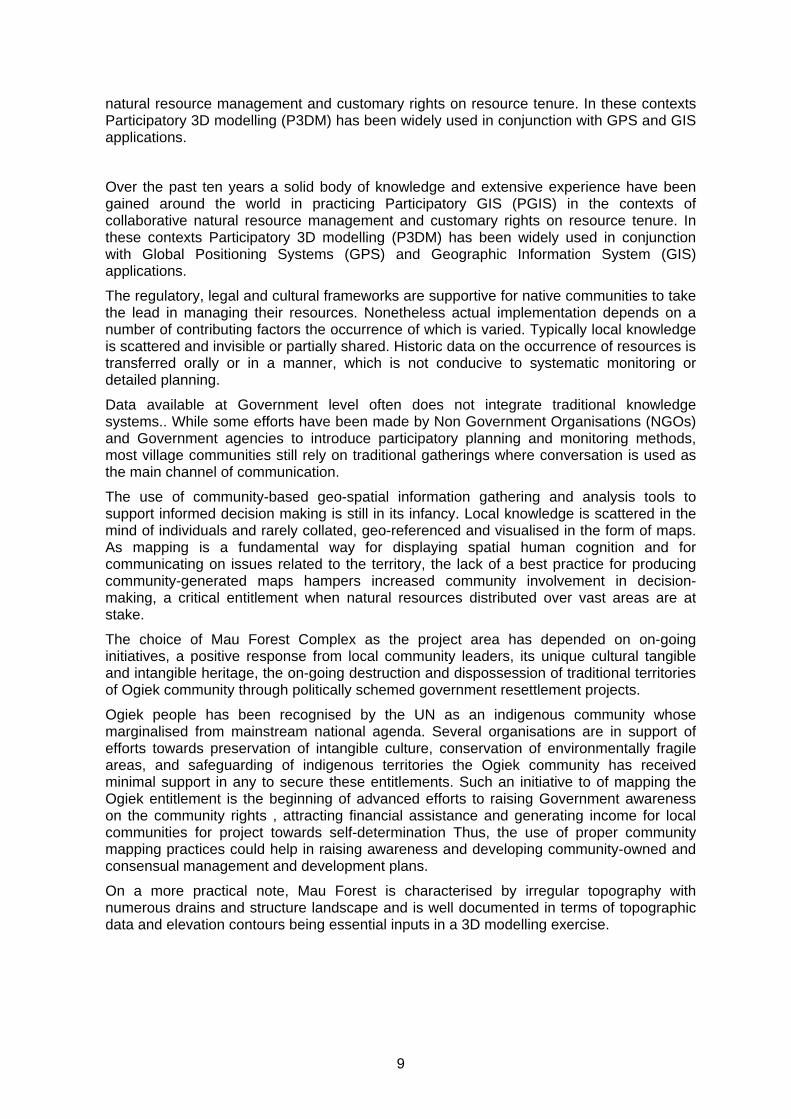
4.1.2 Sourcing of Data and Preparation of the Base Map Preparation of the base map featuring colour-coded contours (Figure 2) has been the responsibility of the GIS Unit of ERMIS Africa. It took approximately one and a half months (scattered inputs) to complete the task.
The topographic sheets from which contour digital data were derived were readily available at Surveyors of Kenya. The terrestrial contour interval is 20-m starting from 1660 to 3060 -m elevation.
This process involved scanning of the hardcopy using an A0 scanner, geo-referencing the digital image and digitizing the contours layer. Intervals of 20 metres depth contours were generated starting from 1660-m above sea level.
The following process for generating a base map was used as illustrated on the publication by Giacomo Rambaldi and Jasmin Callosa –TARR (2002):
• Scale 1: 5,000 to 1:10,000 • 20-m contour lines coloured in a recurrent sequence e.g. brown (100m), blue
(120m), green (140m), purple (160m), black (180m); brown (200m), blue, (220m), green (240m), purple 260m),etc.
• Format of the contour lines : 1pt., except for the “index contours” (100m, 200m, 300m, 400m, etc), which should be 2pt thick.
• 40-m contours are a valid alternative. The colour sequence could be the following: e.g. brown (0m), blue (40m), green (80m), purple (120m), black (160m); brown (200m), blue (240m), green (280m), purple (320m), etc.
12
• Elevation labels: mainly, to facilitate the identification of each contour during tracing. In addition, elevation labels should be placed at all hill - and mountaintops or bottoms of depressions.
• Grid (10cm = 1 km on the ground for a 1:10,000 scale model). Format: Solid line, black, 1pt.
• Contour line expressing the lowest elevation: to be identified with a mark, e.g. an arrow. This allows locating the first contour line to be traced and cut out.
The scale was calculated from the ground extent of the areas to be mapped and that of the model platform. The area was 24x24 km and the size of the model 2.4x2.4 meters, giving a model scale of 1 to 10000. The topographic map sheets were acquired from Survey of Kenya which is the government agency.
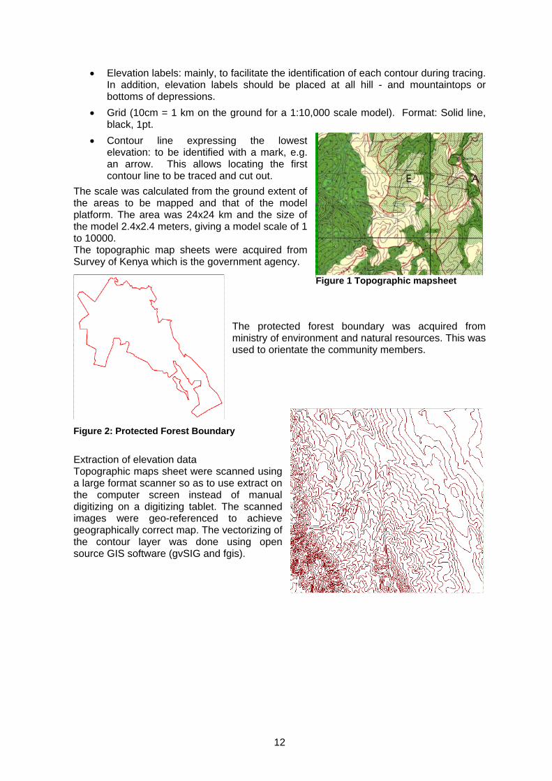
The protected forest boundary was acquired from ministry of environment and natural resources. This was used to orientate the community members.
Extraction of elevation data Topographic maps sheet were scanned using a large format scanner so as to use extract on the computer screen instead of manual digitizing on a digitizing tablet. The scanned images were geo-referenced to achieve geographically correct map. The vectorizing of the contour layer was done using open source GIS software (gvSIG and fgis).
Figure 1 Topographic mapsheet
Figure 2: Protected Forest Boundary

13
Attributing Editing
Grid Preparation A scale grid of 1:10000 was created using the project coordinates from the topographic sheets.
4.1.3 Choosing the Mapping Scales (vertical and horizontal) The area selected for the mapping exercise includes a portion of the ancestral domain of Ogiek community and measures 24 km by 24 km.
Sourcing spatial data and preparing the base maps. Elevation contours of Mau the Forest Complex and its adjacent environments will be obtained by the organisers from the Survey of Kenya (SOK). The preparation of two copies of the base map featuring colour-coded contours will be the responsibility of ERMIS Africa GIS Unit.
The scales are the following: 1:10,000 horizontal and 1:5,000 vertical. The larger vertical scale has been chosen taking into consideration the need to enhance the perception of slope and to meet the carton board thickness (4-mm) available on the local market. In view of its 1:10,000 scale, the model measures 240-cm x 240-cm and has been constructed using two base tables measuring each one 240-cm in length, 120-cm in width and 60-cm in height. Making two tables instead of one, has ensured easier access to the working space. The two tables and were joined every evening and on completion of the exercise.
14
The area selected for the mapping exercise includes a 24 km x 24 km mountainous portion of the Mau Forest Complex. The chosen horizontal scale will be 1:10,000 with a 1.5 vertical exaggeration. The vertical scale has been determined based on the need to enhance the perception of slope and dictated by limited choice of available carton board thicknesses (4 mm).
4.1.4 Procurement of workshop inputs and their on-site delivery The success of any Participatory 3D Modelling exercise heavily depends on the availability of all necessary inputs at the location where the event will take place. With the assistance of the ERMIS Africa, all items which were identified during the preparatory phase were procured. The inputs were delivered on site by a double cabin vehicle. The wooden base tables (two units) and carton boards were ordered according to the specifications resulting from scaling the subject area to the desired 1:10,000 scale.
The base table was custom made with a movable top (Figure 3) with dimension exactly matching those of the base map. The materials were ordered according to specifications listed in the handbook “Participatory 3-Dimensional Modelling: Guiding Principles and Applications” and in consultation with CTA. An updated supply list is available on the Internet at http://www.iapad.org/supplies/items.htm
4.1.5 Consulting and Mobilising Students and Stakeholders Representatives from 21 clans (4 from each clans) including traditional leaders, elders, hunter-gatherers and farmers, men and women, and youths attended the mapping exercise and contributed to the collation of the knowledge base which formed the basis for depicting resource distribution and use of the 3D model. In order to properly mobilise the villagers a member of the Organising Committee, ERMIS and the local lobby group OWC staff visited each village to meet with the village leaders and other community members. In each village the team introduced the planned workshops (mapping and planning), the importance of village involvement and selection of representatives and benefits deriving from villagers’ participation.
4.1.6 Selection of trainees: The project invited practitioners from English-speaking African countries to the exercise. A pre-selection of trainees was done in collaboration with Gaia Foundation, the Africa Biodiversity Network, and the Indigenous People Coordinating Committee (IPACC). The list was completed 3 months to the mapping session.
Representatives from 21 clans including traditional leaders, men and women, youths, and local university students attended the mapping exercise and contributed to the collation of knowledge which formed the basis for depicting current resource distribution and use on the 3D model. In order to properly mobilise the villagers a representative from the Organising Committee, a staff from the ERMIS Africa visited all villages where they met with the village headperson and other community members. In each village the team introduced the planned workshops (mapping and planning), the importance of village involvement, the criteria for selecting village representatives and the benefits which would derive from their participation. Local authorities in Nessuit were also informed of the forthcoming 3D modelling exercise.
In addition the team visited the Egerton University and the Nessuit Primary School, both playing a role in the construction of the relief model of the island. The team introduced the workshop and explained the students and teachers their role in mapmaking. An educational video on P3DM practice was shown to assist students and teachers in visualising their forthcoming tasks.
The Organising Committee informed local authorities in Mau Forest Complex on the planned exercises and extend invitations to concerned officials.

15
4.1.7 Establishment of an organising committee ERMIS-Africa facilitated the establishment of an Organising Committee including the Ogiek Welfare Council (OWC), the community elders, the local primary school headmaster and ERMIS.
4.1.8 Consulting and mobilising students: The Committee liaised with the district education office to offer the opportunity for primary, secondary, college and university students, teachers and lecturers to play an active role in the mapping exercise (workshop 1). The workshop was planned for 9th August 2006. The Organising Committee related to the students via their teachers.
4.1.9 Preparation of the draft legend Contrary to the plans, no draft legend1 was discussed during the preparatory field visit. Instead the draft legend was developed during the mapping process by a team consisting of Ogiek youths led by Dr Nigel. Prioritising and getting a consensus among mapmakers on which items are relevant and what should be featured on a map, is the first step in a participatory process aimed at addressing community-based issues related to the territory and its resources. Facilitators drafted a list of legend items at the onset of the mapping process. The list was a result of preparatory consultations held with concerned stakeholders, with the objective of identifying features of the landscape which are relevant and known to those who will take part in mapmaking.
4.1.10 Workshop Logistics The Organising Committee identified the venue for the workshop. Participants, trainees and facilitators were accommodated at the Egerton University Campus, 30 minutes drive from the venue. Adequate preparations for transport, catering and accommodation were completed before of the exercise.
1 Prioritising and getting a consensus among mapmakers on which items are relevant and what should be featured on a map, is the first step in a participatory process aimed at addressing community-based issues related to the territory and its resources.
16
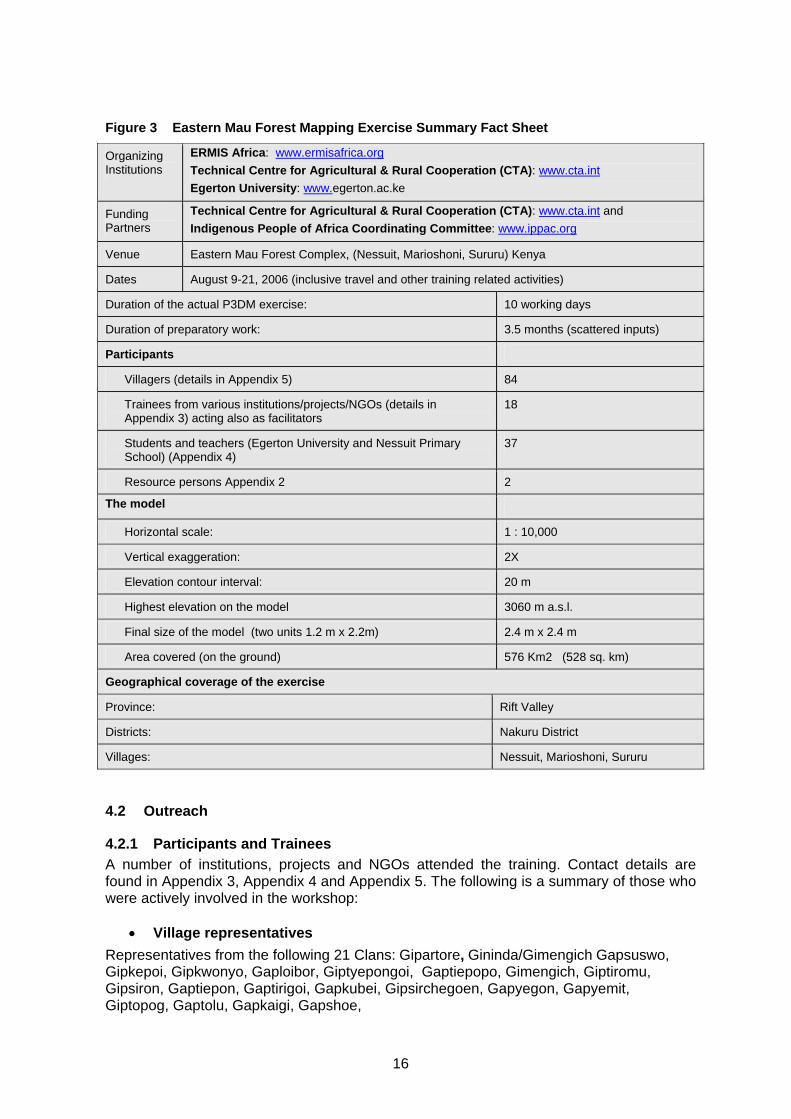
Figure 3 Eastern Mau Forest Mapping Exercise Summary Fact Sheet
Organizing Institutions
ERMIS Africa: www.ermisafrica.org Technical Centre for Agricultural & Rural Cooperation (CTA): www.cta.int Egerton University: www.egerton.ac.ke
Funding Partners
Technical Centre for Agricultural & Rural Cooperation (CTA): www.cta.int and Indigenous People of Africa Coordinating Committee: www.ippac.org
Venue Eastern Mau Forest Complex, (Nessuit, Marioshoni, Sururu) Kenya
Dates August 9-21, 2006 (inclusive travel and other training related activities)
Duration of the actual P3DM exercise: 10 working days
Duration of preparatory work: 3.5 months (scattered inputs)
Participants
Villagers (details in Appendix 5) 84
Trainees from various institutions/projects/NGOs (details in Appendix 3) acting also as facilitators
18
Students and teachers (Egerton University and Nessuit Primary School) (Appendix 4)
37
Resource persons Appendix 2 2
The model
Horizontal scale: 1 : 10,000
Vertical exaggeration: 2X
Elevation contour interval: 20 m
Highest elevation on the model 3060 m a.s.l.
Final size of the model (two units 1.2 m x 2.2m) 2.4 m x 2.4 m
Area covered (on the ground) 576 Km2 (528 sq. km)
Geographical coverage of the exercise
Province: Rift Valley
Districts: Nakuru District
Villages: Nessuit, Marioshoni, Sururu
4.2 Outreach
4.2.1 Participants and Trainees A number of institutions, projects and NGOs attended the training. Contact details are found in Appendix 3, Appendix 4 and Appendix 5. The following is a summary of those who were actively involved in the workshop:
• Village representatives Representatives from the following 21 Clans: Gipartore, Gininda/Gimengich Gapsuswo, Gipkepoi, Gipkwonyo, Gaploibor, Giptyepongoi, Gaptiepopo, Gimengich, Giptiromu, Gipsiron, Gaptiepon, Gaptirigoi, Gapkubei, Gipsirchegoen, Gapyegon, Gapyemit, Giptopog, Gaptolu, Gapkaigi, Gapshoe,

17
• Regional Agencies: Indigenous People Association Coordinating Council (IPACC)
• Non Government Organizations (NGOs) National and Regional Hadzabe representative), IPACC member, Yaeda Valley/Lake Eyasi forest,
Mongo wa Mono Village. ZAMBIA LAND ALLIANCE PLPD: Pat Luckin Planning & Development Association For Rural Advancement (AFRA) Letloa Trust, Land, Livelihood and Heritage Resource Centre Regional Advisory Information and Network Systems (RAINS) Ogiek Welfare Council Yiaku Peoples Association (Sengwer representative) IPACC member (NW Kenya) Porini Trust (funded by ABN & Gaia Foundation) ERMIS-Africa
• Educational Establishments Egerton University Nessuit Primary School
4.2.2 Resource Persons Resource persons were provided by CTA, ERMIS Africa and IPACC as shown in the Table below. Their contact details are found in Appendix 2. Table 1 Trainers, Resource Persons and Lead Facilitators
Resource person Topics
Mr. Giacomo Rambaldi, Programme Coordinator, Technical Center for Agricultural and Rural Cooperation, Wageningen, Netherlands
Participatory GIS, Participatory 3 Dimensional Modelling (P3DM), Facilitation Techniques
Mr Julius Muchemi, Executive Director, ERMIS Africa -Kenya
GIS applications including extraction of the information from the 3-D model and on-screen digitizing
Dr. Nigel Crawhall IPACC Project rationale, cultural settings, workshop dynamics
It is worthwhile noting that all trainees acted as co-facilitators and went through all roles necessary for learning good facilitation practice.

18
4.3 Phase II - Community mapping phase (Workshop no. 1) The preparatory phase was followed by the community mapping phase. All activities under this phase were carried out at the ERMIS Africa Nakuru Town of 10 calendar days and involved the following key activities:
(i) Introducing and orienting trainees on facilitation techniques and participatory 3D modelling;
(ii) Refreshing2 students, trainees and villagers on the scope the project and work schedule;
(iii) assembling the blank model; (iv) drafting and fine-tuning the map legend; (v) transposing cognitive maps; (vi) transferring data from and to the 3D model; (vii) extracting data using digital photography; (viii) Orienting trainees on data extraction and manipulation.
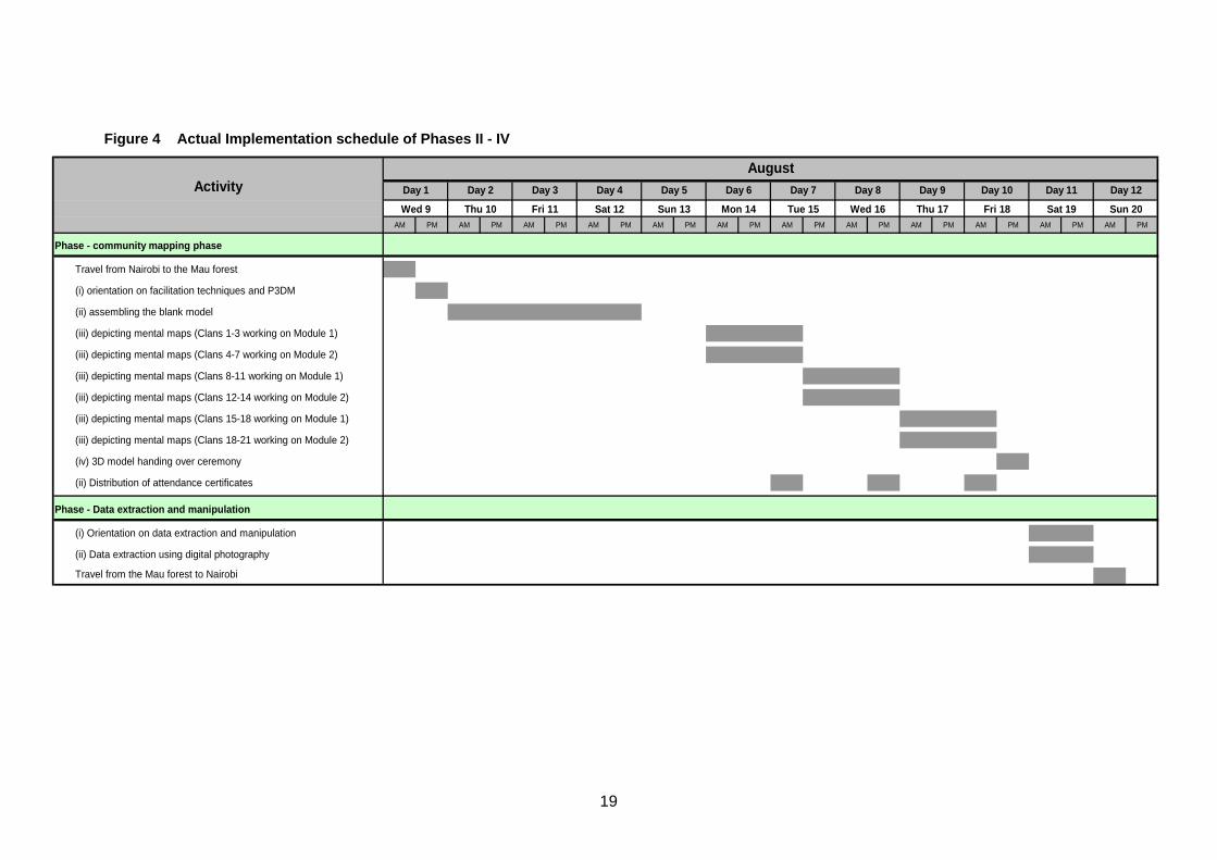
The activities unfolded as per workshop programme (Appendix 1) and according to the implementation schedule shown in Figure 5. This section of this report summarised the daily activities.
2 Trainees and participating organisations received a detailed description of the projects a couple of weeks ahead of the actual workshop.
19
Figure 4 Actual Implementation schedule of Phases II - IV
AM PM AM PM AM PM AM PM AM PM AM PM AM PM AM PM AM PM AM PM AM PM AM PM
Phase - community mapping phase
Travel from Nairobi to the Mau forest
(i) orientation on facilitation techniques and P3DM
(ii) assembling the blank model
(iii) depicting mental maps (Clans 1-3 working on Module 1)
(iii) depicting mental maps (Clans 4-7 working on Module 2)
(iii) depicting mental maps (Clans 8-11 working on Module 1)
(iii) depicting mental maps (Clans 12-14 working on Module 2)
(iii) depicting mental maps (Clans 15-18 working on Module 1)
(iii) depicting mental maps (Clans 18-21 working on Module 2)
(iv) 3D model handing over ceremony
(ii) Distribution of attendance certificates
Phase - Data extraction and manipulation
(i) Orientation on data extraction and manipulation
(ii) Data extraction using digital photography
Travel from the Mau forest to Nairobi
AugustDay 10 Day 11 Day 12Day 6 Day 7 Day 8 Day 9
Sat 19 Sun 20Thu 17Wed 16 Fri 18
Day 1 Day 2 Day 3ActivitySun 13 Mon 14 Tue 15Wed 9 Thu 10 Fri 11 Sat 12
Day 4 Day 5

20
4.3.1 Day 1 – Tuesday, 8th August 2006 The international participants arrived at Jomo Kenyatta international Airport in Nairobi and then picked and booked at Ambassador Hotel Nairobi. Some national participants from Nairobi and other nearby place joined the international participants in the hotel while other joined the team Wednesday morning. Registration and issuance of training kits was done at the hotel in the Evening. Participants from Narok, Kitale and Nakuru assembled at Nakuru town where ERMIS Africa is located.
4.3.2 Day 2 - Wednesday, 9th August 2006 The participants travelled from Nairobi to Nakuru and were accommodated at Egerton University Hostel, the venue for part of the training done Wednesday morning.
4.3.3 Round of self –introduction of Trainees Mr Julius Muchemi welcomed all the trainees to the training workshop and oriented them to the environment. He invited the participants to a self-introduction session. Mr Nigel made a elaborate presentation on the mandate and operation of IPACC to which Ogiek’s lobby group Ogiek Welfare Council was a member.
4.3.3.1 Introductory Presentations Mr. Julius Muchemi, the Executive Director of ERMIS Africa, introduced the project background, goal, objectives and phases. The project rationale was also presented and how trainees would be enabled to use acquired skills in their work. He further described the workshop process, planned activities and the expected roles of the trainees during the various phases of the mapmaking process.
4.3.4 Presentation on Cultural Mapping Dr. Nigel director of IPACC gave an overview presentation on the operations of IPACC secretariat. He pointed out that role of the secretariat is to coordinate the operations of indigenous peoples civil society in their endeavour to facilitate self-desert.
4.3.4.1 Exercises to Assess the Frame of Mind and Expectations of Trainees Mr. Rambaldi facilitated three exercises using “metacards” (Figure 7). The following instructions were given: “Please use the meta cards and the marker pens to summarise in a few words your expectations from this workshop. Please use one meta card per statement!” “Starting on day 4, villagers will map the physical, biological and cultural environments of Mau Forest Complex using what they store in memory. We will ask them to do it for their ancestral territories”. “What are your expectation in terms of resulting quality and accuracy of data?” “How do you see your role in the mapping process?” Please use one meta card per statement!”
The objectives of the exercises were to gauge the following (i) trainees’ expectations (ii) trainees’ perception of the value of community knowledge in terms of quality and accuracy, and (iii) perceived roles of trainees in the forthcoming mapping process.
The results of these exercises were taken into consideration by the trainers during the flow of the workshop. Details are found in Appendix 7 at page 49.
4.3.5 Orientation of Trainees Mr. Rambaldi delivered two PowerPoint presentations on “Participatory Spatial Information Management and Communication” and “Participatory 3D Modelling/Participatory GIS”. During a Question & Answer session, Mr. Rambaldi
21
explained the relationship between the selected scales (horizontal and vertical), the contour intervals and the procurement of the material.
Mr. Julius Muchemi, Environmental Systems Specialist, delivered a PowerPoint presentation illustrating in detail all steps in sourcing and enhancing spatial data in a GIS environment and in the preparation of the base maps (see Appendix 11).
4.3.5.1 Preparation for the Transposing Phase The trainees prepared a display of all coding means including coloured map and push pins, yarn and paint. All codes were neatly labelled, arranged and displayed close to the draft legends.
Mr. Rambaldi facilitated a recap of the entire process and discussed with the participants the various phases of the construction of the two models soliciting observations and lessons learned. Comments on what trainees noticed, discovered, felt and learned, and on what they would suggest are documented in Appendix 8.
In a follow-up focus group discussion the trainees expressed their view about the villagers’ ability to locate features on the models. There was a general consensus that with the help of the 3D model, village informants would be able to provide a high degree of accurate and quality information based on their knowledge of villages, land marks, land use and resource distribution. Accuracy and completeness of data would be higher within the individual domains of interest. It was deemed that informants would be less accurate and poorer in terms of quality when dealing with information outside their area of interest. The trainees anticipated that the villagers would input data according to their own individual interpretations.
Given the above-mentioned reasons, the model would contain more information than GIS maps or aerial photography. A trainee expressed her concern in terms of potential inaccuracy in terms of data such as history and distance. Others stated that what may be considered as accurate and quality information by the villagers may be considered poor by the trainees.
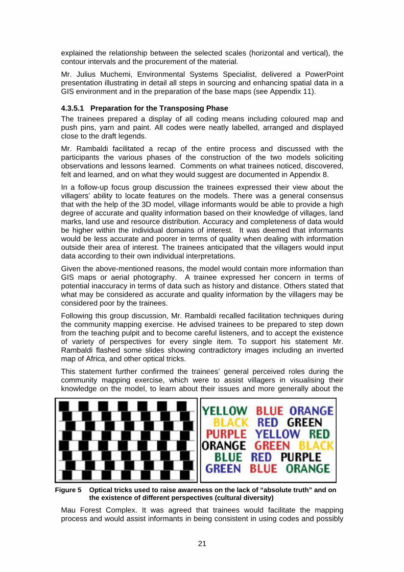
Following this group discussion, Mr. Rambaldi recalled facilitation techniques during the community mapping exercise. He advised trainees to be prepared to step down from the teaching pulpit and to become careful listeners, and to accept the existence of variety of perspectives for every single item. To support his statement Mr. Rambaldi flashed some slides showing contradictory images including an inverted map of Africa, and other optical tricks.
This statement further confirmed the trainees’ general perceived roles during the community mapping exercise, which were to assist villagers in visualising their knowledge on the model, to learn about their issues and more generally about the
Mau Forest Complex. It was agreed that trainees would facilitate the mapping process and would assist informants in being consistent in using codes and possibly
Figure 5 Optical tricks used to raise awareness on the lack of “absolute truth” and on the existence of different perspectives (cultural diversity)

22
accurate in terms of scaling3, in locating features which are relevant to them, contain if possible dominant participants and prevent these from mapping features outside their respective areas, avoid raising contentious issues like “boundaries” and allow villagers to physically access the model, by stepping back in order to avoid any village informant is left idle.
4.3.6 Day 3 – Thursday, 10th August 2006 The entire trainees were transferred to Nessuit primary school, the venue of the training. The participants spent the first part of the morning preparing the venue by positioning the working area for various groups of trainees performing the various mapping task.
4.3.6.1 Establishing an Enabling Environment for Eliciting Local Knowledge Considering the presence of foreigners and Mau outsiders, the facilitation team and the trainees met with local chief to discuss on how best to interact with the village informants. Emphasis was placed on observing traditional protocols, being respectful of local culture and diversity, maintaining a “learning attitude” and refraining from “teaching and/or preaching” and “correcting”.
Instead trainees and facilitators agreed on maximising their effort in speeding up the transfer of “intellectual ownership” of the exercise to the participating communities, and on acting as a catalyst in enhancing the analytical capacities of the informants.
There was general consensus on the fact that the key of success would rest in establishing an enabling environment where the elders, custodians of popular knowledge, would feel comfortable in sharing it openly.
The following strategy was developed:
(i) Villagers would join the workshop in three groups at different dates (please refer to the implementation schedule on page 20). The welcoming strategy would ensure a rapid transfer of intellectual ownership of the exercise to the community. This would occur as follows: The first introduction would be done by the local chief. He would benefit from his existing rapport and trust with the communities. Hereafter a village representative from Group 1 would introduce Group 2 to the purpose and mechanics of the exercise; and a villager from Group 2 would do the same for Group 3.
(ii) Technical matters would be introduced by Mr. Rambaldi and translated by one of the trainees (with technical knowledge) into the local language;
(iii) The trainees would assist villagers in their tasks, and would pay particular attention to ensuring that coding means be applied consistently and scaling be adhered to as much as possible;
(iv) Trainees were reminded that villagers would be in the forefront in determining what is relevant to them. Nonetheless facilitation should ensure that the distribution, use and access to terrestrial, coastal and marine resources be thoroughly discussed and visualised.
(v) Trainees would be individually assigned as co-facilitators to specific villages and would relate to the main facilitators in terms of overall coordination.
4.3.6.2 Welcome address by local authorities (Chief) Mr Julius Muchemi made welcome to trainees, students and teaches. He presented a request to the chief seeking of his favour and blessing on the workshop. He
3 Facilitators and informants were provided with Quick Reference Guides

23
accepted the workshop welcomed the initiative and emphasized the importance of timeliness especially in working with communities.
The meeting covered the following:
(i) Project background, goals, objectives, and project phases; (ii) Briefing on P3DM workshop; (iii) Follow up visit or workshop in October 2006 on resource management
planning; and (iv) An invitation to the handing over ceremony and the closure of the workshop.
Students, teachers and trainees kept on working on the construction of the model. Construction of the model continued on day 3. A group of students and trainees started working on the map legend.
4.3.6.3 Learning from Each Other Large sheets of paper were fixed on the walls of the meeting hall and participants were invited (on day 3 and later-on on day 11) to summarise using metacards what “they noticed, discovered, felt, learned”, and were asked to make suggestions on how to improve the process. The results of these exercises were duly recorded and are found in Appendix 9 and at page 52 and 57 respectively.
4.3.6.4 Orientation of Students Twenty eight Students from the Nessuit primary school and the Egerton University arrived in the afternoon. They were welcomed by Mr. Mr Muchemi who introduced the scope of the project and described the tasks ahead. Mr Rambaldi ran a 20 min video on P3DM and provided a technical introduction on how to manufacture of the blank model (Figure 8). After the introduction and a Question and Answer session, the students were divided into thee working groups. Trainees were assigned to different groups to supervise the students in the implementation of their tasks.
The groups consisted of students:
(i) Tracing the contours on 4-mm thick carton board; (ii) Cutting out the single contour layers; (iii) Gluing and pasting the layers one on the top of the other, and ensuring that
placement would occur correctly. The same group was responsible for consolidating the different layers using crepe paper.
24
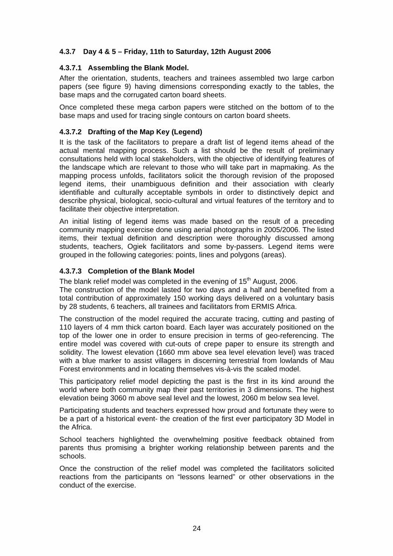
4.3.7 Day 4 & 5 – Friday, 11th to Saturday, 12th August 2006
4.3.7.1 Assembling the Blank Model. After the orientation, students, teachers and trainees assembled two large carbon papers (see figure 9) having dimensions corresponding exactly to the tables, the base maps and the corrugated carton board sheets.
Once completed these mega carbon papers were stitched on the bottom of to the base maps and used for tracing single contours on carton board sheets.
4.3.7.2 Drafting of the Map Key (Legend) It is the task of the facilitators to prepare a draft list of legend items ahead of the actual mental mapping process. Such a list should be the result of preliminary consultations held with local stakeholders, with the objective of identifying features of the landscape which are relevant to those who will take part in mapmaking. As the mapping process unfolds, facilitators solicit the thorough revision of the proposed legend items, their unambiguous definition and their association with clearly identifiable and culturally acceptable symbols in order to distinctively depict and describe physical, biological, socio-cultural and virtual features of the territory and to facilitate their objective interpretation.
An initial listing of legend items was made based on the result of a preceding community mapping exercise done using aerial photographs in 2005/2006. The listed items, their textual definition and description were thoroughly discussed among students, teachers, Ogiek facilitators and some by-passers. Legend items were grouped in the following categories: points, lines and polygons (areas).
4.3.7.3 Completion of the Blank Model The blank relief model was completed in the evening of 15th August, 2006. The construction of the model lasted for two days and a half and benefited from a total contribution of approximately 150 working days delivered on a voluntary basis by 28 students, 6 teachers, all trainees and facilitators from ERMIS Africa.
The construction of the model required the accurate tracing, cutting and pasting of 110 layers of 4 mm thick carton board. Each layer was accurately positioned on the top of the lower one in order to ensure precision in terms of geo-referencing. The entire model was covered with cut-outs of crepe paper to ensure its strength and solidity. The lowest elevation (1660 mm above sea level elevation level) was traced with a blue marker to assist villagers in discerning terrestrial from lowlands of Mau Forest environments and in locating themselves vis-à-vis the scaled model.
This participatory relief model depicting the past is the first in its kind around the world where both community map their past territories in 3 dimensions. The highest elevation being 3060 m above seal level and the lowest, 2060 m below sea level.
Participating students and teachers expressed how proud and fortunate they were to be a part of a historical event- the creation of the first ever participatory 3D Model in the Africa.
School teachers highlighted the overwhelming positive feedback obtained from parents thus promising a brighter working relationship between parents and the schools.
Once the construction of the relief model was completed the facilitators solicited reactions from the participants on “lessons learned” or other observations in the conduct of the exercise.

25
Figure 6: Ogiek Elders establishing spatial relations between 3D model and their real
world: Picture by Giacomo Rambaldi
4.3.8 Day 6 – Monday, 14th August 2006
4.3.8.1 Villagers at work The first group of villagers (community participants/key informants) reported to the venue on the evening of Sunday, 13th August 2006 to start working on Monday, 14th August 2006. Some participants carried their village sketch maps, eager to get to work. Mr. Julius Muchemi, welcomed the community participants and presented an overview of the project background, goals, objectives and the purpose. He also described the students’ role in the construction of the model. This was followed by Mr. Rambaldi’s orientation on the forthcoming activities and on the process of transposing cognitive maps on the relief models by the use of colour-coded yarn, paint and pins.
4.3.8.2 Development and fine-tuning of the Map Key (the Map Legend) Maps are media in cartographic or digital formats. Communication occurs mainly by way of symbols which need to be interpreted via the map legend and its graphic vocabulary. Lacking universal standards each map has its own visual language. This language has to be “common property” in order for communication of any kind to take place.
Mindful of this, participants were invited to review the draft legend and to suggest changes or integrations. By the end of the exercise the initial legend had expanded substantially to include a series of features, defined by the villagers themselves.
By the end of the exercise the initial legend had expanded substantially to include features, defined by the villagers themselves. The complete model displays a total of 41 different items including 9 different land uses and covers; 26 different point data and 6 different types of linear data as shown on the following figure
Consistency in the use of colour-coded pins, yarns and paints emerged as a clear necessity for properly displaying local knowledge on the model.

26
Figure 7: Legend generated by Ogiek Elders: Picture by Giacomo Rambaldi
Figure 8: Completed matrix with some information covered by elders to conceal
sensitive information: Picture by Giacomo Rambaldi
27
4.3.8.3 Transposing Mental Maps Upon familiarising themselves with the landscape of model (Figure 16), villagers started working with enthusiasm. They were asked to outline river courses and name mountain peaks
With great surprise of the facilitators the model started filling with labels and names. “It appears that every single stone has a name” was the comment of Mr. Rambaldi. This was of no surprise for Ogiek who knew that knowledge is traditionally orally transmitted. This led to the need for a name for everything. The names of fishes, trees, land are significant aspects of the indigenous Ogiek’s traditional identity. They are interlinked and inseparable
Considering the richness in names and the difficulty in depicting other features like land use and cover in the presence of too many labels, Mr. Rambaldi suggested to postpone the “naming phase” once other features would have been depicted on the model. This sequence was later on adopted also for Group 2 and 3.Colour coded yarns were used to outline land cover and use. Once these were located the areas were painted with appropriate colours. Informants were later assisted in locating point features like households, social infrastructure and others (Table 3), and linear features such as roads and trails. This was followed by labelling of features.
The facilitators assisted the informants in processing and displaying their knowledge (mental maps) in an organized and consistent manner4
Students kept on visiting the venue to follow up the work of the elders. An interesting relation developed among the different generations and the youth got increasingly interested in what was in many instances new to them: traditional knowledge.
During the mapping process, the two tables were kept separate to allow more villagers to work at the same time. In the evening and at lunch time the two tables were usually joined to allow participants to have a comprehensive bird’s eye view of the island and its surrounding coastal areas. In addition when the two units were connected, participants could check if the information displayed on the single units matched at the meeting edge.
The process had to be fine-tuned and facilitators met to discuss the problems encountered in facilitating the activities with Group 1.
There was general consensus on the fact that due to the insufficiently planned schedule of arrivals, too many informants came from adjacent villages. This led to all of them wanting to work on the same portion of the model at the same time. This resulted in overcrowding, making it impossible for all participants to work. In the spirit of good team work trainees/facilitators got some of the groups to discuss and list features present in their community, to prepare labels, codes, lines and points. A lesson learnt about the overcrowding was that during community selection and groupings, consideration has to be given to properly schedule arrivals of participants to ensure that only a few adjacent villages are present at the same time.
The second problem observed was that excited participants tended to neglect proper scaling, an issue anticipated by the trainer. The role of facilitators in ensuring scaling was considered as essential by all trainees.
4.3.9 DAY 7 – Tuesday, 15th August 2006 Group 1 continued with the transposing process and completed it in the afternoon. Thereafter villagers were asked to write on metacards a short statement on what they had 4 Displayed data have to be properly coded in order for later users to be able to decode, interpret and understand them by the use of the map key (legend).

28
learned, felt, discovered or noticed during their one-day and a half contribution. The results of the exercise were read out to all those present and translated into English. On completion of this exercise, all villagers received their attendance certificates. After lunch the second group of villagers arrived and was introduced to the forthcoming exercise by a representative from Group One. The presenter proudly introduced newcomers to their tasks and illustrated the achievements so far. He silently took ownership of the work, the venue and the model and praised exercise as a blessing from God and a ‘spiritual’ opportunity for the people of Ogiek to work together in unity to manage their natural resources for the health and wealth of Ogiek current and future generations
The two groups viewed a slide show of the work carried out by the students and by Group 1 and worked together to validate the information displayed on the model before Group 1 finally left.
4.3.10 DAY 8 – Wednesday, 16th 2006 The trainees continued the facilitation of the exercise jointly with the resource persons. The second group of informants completed their exercise on the morning of Thursday, 17th August, 2006. Participants were given the opportunity to provide their feedback on their experience via metacards. Results were displayed on a large sheet of paper fixed on the all and read out in vernacular and English. All villagers were awarded individual Certificates of Attendance.
The facilitators acknowledged the villagers’ efforts and emphasised that the model is their common property to use for their resource management planning and development. He said he was impressed by their knowledge and added that the model was a “living model” which needed regular updating. A village elder thanked the organizers, trainers and facilitators for the workshop and said it was an educational and enjoyable experience and invited workshop facilitators and trainees to visit his village. Formalities ended with a group photo session and villagers singing religious and traditional songs. A group of participants was invited to return on Monday to handover their work to Group 3.
4.3.11 DAY 9 – Thursday 17th to Friday, 18th August
4.3.11.1 Introduction of new group of participants Group 3 comprising 27 participants arrived and were introduced to the project by a representative from Group 2. In doing so the newcomers were reminded that the exercise would benefit them and their future generations, therefore full commitment was required from their part.
Upon completion of the handover, the informants were invited to locate mountain peaks, islets, water courses, roads, trails, social infrastructures and other features. Facilitators assisted participants to delineate with the use of colour-coded yarns, vegetation types, land use and other aspects they considered important to their environment.
On Friday, 18th, the last group of informants continued transposing their spatial knowledge. Once the entire model was completed informants were asked to express their opinions on the workshop. This activity was followed by the presentation of individual certificates and picture taking.
4.3.11.2 Transferring Data from/to the 3D Model Mr. Rambaldi oriented the trainees on how to transfer data between model and base map and vice versa. This process involved the placement of a scaled grid at 10-cm intervals. This corresponds to a 1-km on the ground for models at 1:10,000-scale.
29
The main purpose of the activity was to train participants in transferring data with simple tools like rulers and tape meters and making use of simple coordinates offered by the reference grid and letters and numbers placed on the X and Y axes of the model.
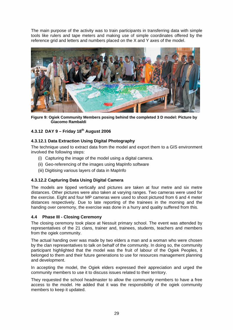
Figure 9: Ogiek Community Members posing behind the completed 3 D model: Picture by
Giacomo Rambaldi
4.3.12 DAY 9 – Friday 18th August 2006
4.3.12.1 Data Extraction Using Digital Photography The technique used to extract data from the model and export them to a GIS environment involved the following steps:
(i) Capturing the image of the model using a digital camera. (ii) Geo-referencing of the images using MapInfo software (iii) Digitising various layers of data in MapInfo
4.3.12.2 Capturing Data Using Digital Camera The models are tipped vertically and pictures are taken at four metre and six metre distances. Other pictures were also taken at varying ranges. Two cameras were used for the exercise. Eight and four MP cameras were used to shoot pictured from 6 and 4 meter distances respectively. Due to late reporting of the trainees in the morning and the handing over ceremony, the exercise was done in a hurry and quality suffered from this.
4.4 Phase III - Closing Ceremony The closing ceremony took place at Nessuit primary school. The event was attended by representatives of the 21 clans, trainer and, trainees, students, teachers and members from the ogiek community.
The actual handing over was made by two elders a man and a woman who were chosen by the clan representatives to talk on behalf of the community. In doing so, the community participant highlighted that the model was the fruit of labour of the Ogiek Peoples, it belonged to them and their future generations to use for resources management planning and development.
In accepting the model, the Ogiek elders expressed their appreciation and urged the community members to use it to discuss issues related to their territory.
They requested the school headmaster to allow the community members to have a free access to the model. He added that it was the responsibility of the ogiek community members to keep it updated.

30
The community representative shared the apprehension of some villagers that in depicting data on the model they could infringe on sensitive information. Mr Muchemi expressed his appreciation for the Participatory 3D Modelling method, which – according to the participating villagers - clearly revealed the existence of a wealth of traditional knowledge and strong ties existing among Ogiek community. Mr Francis a key ogiek youth in the mapping exercise expressed that the process had made the community to feel closer to each other. The ceremony was concluded with the presentation of certificates of attendance to the trainees by Mr Muchemi and Mr Giacomo.
5 GROUP DYNAMICS Careful attention was paid to the group dynamics during the exercise. The trainees, coming from different institutions, generally worked well as a team. The diverse educational background of the group (including GIS technicians, social scientists, community organisers and natural resource management (NRM) specialists. contributed to the success of the exercise. In fact it is good practice that any P3DM exercise is facilitated by a multidisciplinary group including at least 3 disciplines: cartography/GIS, community work and NRM.
In preparing trainees for the arrival of key informants, the “Do’s and Don’ts” of “facilitation” were discussed, enhancing the importance of “broadening the perspective” or “enhancing analytical skills” of key informants, rather than “correcting their mistakes”. Trainees were assigned villages to facilitate their mapping on the model.
The synergy between informants, trainees and facilitators was evident from the day the first the Group of villagers arrived and similarly for the two groups which followed. Facilitators were keen to practice facilitations skills, learn about the processes of transposing cognitive maps and more about Mau Forest Complex itself.
Informants were fascinated by the birds-eye view of the entire Mau Forest Complex landscape, inducing them to freely share information through lively discussions and depicting their spatial knowledge onto the relief model (Figure 6).
It is worthwhile noting that an interesting collaboration pattern developed amongst the elderly and the younger generations: The youth were tasked with manual assignments

31
(painting, writing labels, fixing yarns) while the elders were standing by advising on names, distribution of natural resources and harvesting grounds and places of historic and cultural significance. In several occasions the Elders started narrating stories and legends, generally associated with natural phenomena, features of the landscape, natural resources and people. The younger generations, the trainees and the trainers listen to these with great fascination.
The idea of getting the students to gather and write down all these stories was flagged with the School Headmasters. If done, it would offer the Ogiek people a unique chance to document both in terms of content and distribution of the islands intangible cultural heritage. It is worth noting that the Museum Kenya has not recorded any pre-historic sites on the Mau Forest Complex.
6 MULTIMEDIA PROCESS DOCUMENTATION The entire P3DM process (Phases I to V) was recorded on video for the purpose of preparing a multimedia orientation kit on P3DM and Participatory GIS practice in Africa. CTA hired a media consultant to produce a raw video footage documenting the mapping exercise (ten days) in Mau Forest Complex and the forthcoming planning workshop (three days).
All activities occurred from 9th to 21st August, 2006 were filmed. Additional shooting took place at ERMIS Africa to document the processes of on-screen digitizing and map plotting. The video will be used for educational purposes.
7 COURSE EVALUATION At the end of the exercise the trainees were asked to evaluate the course and make their recommendations for improving the P3DM method. Their feedback is found in page 34.
8 LESSONS LEARNT The following are some of the main lessons learnt in terms of mapmaking:
• The scheduling of informants participation to a 3D modelling exercise should take into consideration their geographical provenience to avoid overcrowding around specific edged of the model. The objective being that all participants have a space where to work on the model and at the same time be able to cross-fertilise and cross-check each others;
• One important task of the facilitators is to assist the informants in appropriately scaling data depicted on the model in order to possibly avoid excessive exaggeration. The use of the Quick Reference Guide should be promoted;
• The dimensions of base table, base map, corrugated carton board sheets and carbon paper need to be exactly the same;
• On the base map more elevation labels are entered along contour lines to facilitate the tracing of the contours;
• More care taken whilst cutting contour lines such as joining islets by drawing a bridge to larger areas.
• Ensure that no cut-outs of cardboard are discarded until all contour levels are pasted on the model;
• To ensure that weights used to gently compress contour layers are not too heavy to avoid collapse of corrugated carton board sheets. This would lead to errors in terms of elevation.

32
• Informants need to be well informed on the need to consistently refer to the legend items and associated symbols and colours before transposing their knowledge on the model;
• The use a quality high resolution camera is of paramount importance in the data extraction process;
• Pictures are taken at a standard distance from the model ensuring consistency of the images;
• When placing the tables for photography ensure they are perpendicular. The reason for this is to have better quality images with the least distortion
• When planning for this type of workshop, ensure that additional days are allocated to the GIS specialist to extract information from the model. Added time would compensate the large amount of textual information put on labels.
• Facilitators should be prepared to document stories and legends shared by Elders.
9 POST WORKSHOP ACTIVITIES
9.1 Geo-referencing of the Images This process took a while to complete because it involved stitching two images together. Initially, the two images were geo-referenced one at a time. However, they did not match on the upper portions of the tables.
To correct this, another method was tied using the Erdas software to separately geo-reference the two portions of the model using rubber sheeting. This was unsuccessful because there were inadequate controls on the areas where the two tables joined together resulting in skewing of the images and the true colours of the model did not turn out right adding to the problem of identifying the correct features with the correct legend.
Finally the two pictures were merged before geo-referencing. It was the selected option of geo-referencing multiple pictures of pieces of the models. After geo-referencing of the models, the different features were digitised.
9.2 Digital Data Capture Data capture started with the on-screen digitisation of the hydrology features. Land cover features were next with large polygons first (forest cover) then to the smaller polygons. Other features like improvements or terrestrial infrastructures were captured followed by all coastal and marine features. It was important that larger polygons were captured first because there were smaller ones of different use or cover within those big polygons posing a threat of clipping. It is important to note that additional visits had to be made to see the model itself to verify and digitise boundaries of features that could not be discerned on the digital image because of the large number of labels. These were hiding boundaries in many places.
9.3 Thematic Map Creation Thematic maps were produced after capturing all information from the model.
These maps are now ready for printing and use by communities (in addition to the 3D model) for the next workshop where participants are going to develop a resource use and management plan.

33
9.4 On-line Workshop Evaluation The workshop assessment has been conducted months after the completion of the Ogiek mapping workshop using the trainees list as vehicle for communication and www.surveymonkey.com as surveying instrument.

34
Figure 10 Results of the on-line Workshop Assessment
2. Your Background Information
1. What best describes the kind of organization you represent?
Response Percent
Response Total
Non-Governmental Organization/Civil Society 52.4% 11
Community-Based Organization 0% 0
International Organization 4.8% 1
Government Organization 0% 0
International Financial Institution 0% 0
Private Sector 4.8% 1
Educational/Think Tank/Research 28.6% 6
Other (please specify) 9.5% 2
Total Respondents 21
(skipped this question) 0
2. How would you define your role in development?
Response Percent
Response Total
Community activist 14.3% 3
Development researcher 14.3% 3
Development specialist 9.5% 2
GIS expert 9.5% 2
PGIS practitioner 19% 4
Participatory development practitioner 33.3% 7
Student 28.6% 6
Trainer 4.8% 1
Other (please specify) 9.5% 2
Total Respondents 21
(skipped this question) 0

35
3. How would you describe your previous experience in community mapping?
Response Percent
Response Total
I am new to the practice. 23.8% 5
I have some experience of participatory mapping exercises. 28.6% 6
I have read about participatory mapping and PGIS in the past but never practiced it. 28.6% 6
I am an experienced PGIS practitioner 4.8% 1
I have experience in mapping (cartography/GIS), but not in participatory mapping. 9.5% 2
Other (please specify) 4.8% 1
Total Respondents 21
(skipped this question) 0
3. About the Training in Nessuit
4. Please comment the following:
I agree
strongly I agree I disagree I disagree completely No comment Response
Total
Overall, I am satisfied with the workshop.
53% (10) 47% (9) 0% (0) 0% (0) 0% (0) 19
My initial expectations were met.
21% (4) 74% (14) 5% (1) 0% (0) 0% (0) 19
I acquired new knowledge useful for carrying out my job more effectively.
89% (17) 11% (2) 0% (0) 0% (0) 0% (0) 19
I acquired new contacts which will be useful for exchanging information and acquire new knowledge.
79% (15) 21% (4) 0% (0) 0% (0) 0% (0) 19
The outcome of the workshop has met the set objectives.
16% (3) 68% (13) 5% (1) 0% (0) 11% (2) 19
I have somehow changed my mind in terms of "who's knowledge counts".
37% (7) 53% (10) 5% (1) 0% (0) 5% (1) 19
Total Respondents 19
(skipped this question) 2

36
5. Please comment the workshop dynamics:
I agree strongly I agree I disagree I disagree completely No comment Response
Total
The interaction between participants, facilitator and resource person were rewarding.
47% (9) 53% (10) 0% (0) 0% (0) 0% (0) 19
The interaction between trainees and informants were rewarding.
42% (8) 58% (11) 0% (0) 0% (0) 0% (0) 19
Presentation methods were appropriate.
47% (9) 53% (10) 0% (0) 0% (0) 0% (0) 19
Presentations were clear.
32% (6) 63% (12) 0% (0) 0% (0) 5% (1) 19
The pace during the workshop was adequate .
21% (4) 68% (13) 0% (0) 0% (0) 11% (2) 19
Duration was adequate.
21% (4) 47% (9) 5% (1) 0% (0) 26% (5) 19
Intensity was satisfactory.
16% (3) 63% (12) 0% (0) 0% (0) 21% (4) 19
Total Respondents 19
(skipped this question) 2
6. If you found the interaction rewarding, what made them so?
Total Respondents 18
(skipped this question) 3
7. Which aspects of the programme, if any, were insufficiently treated?
Total Respondents 18
(skipped this question) 3

37
8. Please comment the logistics of the workshop:
I agree strongly I agree I disagree I disagree completely No comment Response
Total
Background information was timely and sufficient.
53% (10) 32% (6) 16% (3) 0% (0) 0% (0) 19
The organisation of your trip was satisfactory.
47% (9) 47% (9) 5% (1) 0% (0) 0% (0) 19
Accommodation was satisfactory.
37% (7) 37% (7) 16% (3) 0% (0) 11% (2) 19
In general, the working conditions were acceptable.
53% (10) 42% (8) 5% (1) 0% (0) 0% (0) 19
Workshop facilities were adequate (equipment, materials).
63% (12) 37% (7) 0% (0) 0% (0) 0% (0) 19
Catering conditions were satisfactory.
42% (8) 47% (9) 5% (1) 0% (0) 5% (1) 19
Total Respondents 19
(skipped this question) 2
4. About the exercise
9. In your opinion what has been the main impact on the participants in visualising their ancestral lands and indigenous spatial knowledge?
Total Respondents 19
(skipped this question) 2

38
5. Future Directions
10. If you were to put your acquired skills into practice how important would these facilities be to you?
Very Important Important Somewhat Important Not Important Response Total
On-line database on community mapping / PGIS featuring case studies
79% (15) 16% (3) 5% (1) 0% (0) 19
On-line contact database (PGIS experts and reference centers)
84% (16) 16% (3) 0% (0) 0% (0) 19
Community mapping training resource database
79% (15) 21% (4) 0% (0) 0% (0) 19
Community mapping / PGIS newsletter
63% (12) 26% (5) 11% (2) 0% (0) 19
Regional network of community mappers
74% (14) 26% (5) 0% (0) 0% (0) 19
Electronic discussion forum
53% (10) 47% (9) 0% (0) 0% (0) 19
Total Respondents 19
(skipped this question) 2
11. After attending this training, in which areas of work do you see yourself putting your acquired knowledge and contacts into practice?
Very Important Important Somewhat Important Not Important Response Total
Supporting collaborative planning and management of terrestial, coastal and marine natural resources.
74% (14) 26% (5) 0% (0) 0% (0) 19
Networking and communication (e.g. advocacy)
58% (11) 32% (6) 11% (2) 0% (0) 19
Asserting ancestral land and resource rights and entitlements.
47% (9) 37% (7) 16% (3) 0% (0) 19

39
Conducting collaborative research.
79% (15) 5% (1) 16% (3) 0% (0) 19
Managing and ameliorating conflicts amongst and between local community groups, and between communities and higher-level authorities or economic forces.
63% (12) 21% (4) 16% (3) 0% (0) 19
Supporting cultural heritage preservation and identity building among indigenous peoples and rural communities.
68% (13) 11% (2) 21% (4) 0% (0) 19
Supporting collaborative planning and management of social services (education, water, sanitation, health, communication, transport, etc.) and neighborhood development.
58% (11) 26% (5) 11% (2) 5% (1) 19
Total Respondents 19
(skipped this question) 2
6. Your Feedback
12. Please share additional thoughts and comments that you have about the event with us.
10 CONCLUSION The workshop was a success. These sentiments were echoed by the Ogiek community and by local and foreign trainees as evidenced in their individual evaluations. All have benefited from the exercise and realised the potential of Participatory 3-D modelling / spatial information management and communication as an effective method to address environmental and social concerns as well as to reinforce bottom up development and collective decision-making.
Trainees and other participants unanimously expressed recommendations for implementing similar exercises throughout Africa Region to assist communities and Governments in resource management and development planning.

40
11 APPENDICES
Appendix 1: Training programme
Tuesday, 8th August 2006 (Nairobi)
Pick up at airport (how are trainees getting to the Hotel meeting point)
Meeting at Ambassador Hotel (P.O.Box 43796 – 00100 NRB, Tel. 020-246615/6, Fax. 20-245517, Email: [email protected])
Evening Registration of participants and distribution of training kits (International trainees)
Wednesday, 9th August 2006 (Nairobi -> Egerton University Campus)
09:00-13:00 Travel from Nairobi to the Egerton University Campus (trainees)
14:00-14:15 Registration of participants and distribution of training kits (Local trainees)
14:15-14:25 Opening remarks on the Project by Julius Muchemi, ERMIS
14:25-14:55 Round of presentations – introductions
14:55-15:15 Introduction to the Project by Julius G. Muchemi ERMIS AFRICA
15:15-15:30 About IPACC and Cultural Mapping by Nigel Crawhall
16:00-16:45 Exercises on expectations and awareness raising facilitated by Giacomo Rambaldi, CTA
16:45-17:30 Orientation on facilitation techniques (ethics, attitudes and behaviours) and role of trainees by Giacomo Rambaldi, Julius Muchemi and Nigel Crawhall
17:30-17:45 Q&A
19:30–21:00 Assembling of base maps
Thursday, 10th August 2006 (Nessuit)
08:20-09:00 Transfer from Edgerton University Campus to Nessuit School
09:15-10:15 Orientation on Participatory 3-D Modelling (technical and organizational aspects), presentation by Giacomo Rambaldi, CTA
10:15-11:00 How to source data and prepare the base map, presentation by J.G. Muchemi , GIS Specialist, ERMIS Africa
11:00-12:30 Preparation of venue
12:30 Arrival of 28 students and 6 teachers to Nessuit Primary School
13:45-14:00 Welcome address by local authorities (Chief)
14:00-14:10 Welcome address by Julius Muchemi, ERMIS AFRICA
14:15-14:40 Projection of P3DM video for students and trainees
14:40-15:00 P3DM Exercise – Orientation of students on the construction of a 3D Model by Giacomo Rambaldi
15:00-18:30 Construction of the blank 3 Dimensional model (1760 to -3080 a.s.l)
19:00 – 20:00 Transfer from Nessuit to Egerton University Campus
Friday, 11th August 2006 (Nessuit)
08:30-09:00 Transfer from Egerton University Campus to Nessuit School
9.00-10:30 Construction of the blank 3D model (students and trainees)

41
11:00-12:30 Construction of the blank 3D model (students and trainees)
13:30-15:30 Construction of the blank 3D model (students and trainees)
16:00-18.00 Construction of the blank 3D model (students and trainees)
19:00: 20:00 Construction of the blank 3D model (students and trainees)
20.30 Transfer from Nessuit to Egerton University Campus
Saturday, 12th August 2006 (Nessuit)
08:30-09:00 Transfer from Egerton University Campus to Nessuit School
9.00-10:30 Construction of the blank 3D model (students and trainees)
11:00-12:30 Construction of the blank 3D model (students and trainees)
13:30-15:30 Construction of the blank 3D model (students and trainees)
16:00-18.00 Construction of the blank 3D model (students and trainees)
18:00 – 19:00 Transfer from Nessuit to Egerton University Campus
Sunday, 13th August 2006 (Tour to Lake Nakuru National Park)
Monday, 14th August 2006 (Nessuit)
9.00-10:30 Depicting mental maps (Clans 1-3 working on Module 1) Depicting mental maps (Clans 4-7 working on Module 2)
11:00-12:30 Depicting mental maps (Clans 1-3 working on Module 1) Depicting mental maps (Clans 4-7 working on Module 2)
13:30-15:30 Depicting mental maps (Clans 1-3 working on Module 1) Depicting mental maps (Clans 4-7 working on Module 2)
16:00-18.00 Depicting mental maps (Clans 1-3 working on Module 1) Depicting mental maps (Clans 4-7 working on Module 2)
19:00: 20:00 Depicting mental maps (Clans 1-3 working on Module 1) Depicting mental maps (Clans 4-7 working on Module 2)
Tuesday, 15th August 2006 (Nessuit)
9.00-10:30 Depicting mental maps (Clans 1-3 working on Module 1) Depicting mental maps (Clans 4-7 working on Module 2)
11:00-12:30 Depicting mental maps (Clans 1-3 working on Module 1) Depicting mental maps (Clans 4-7 working on Module 2)
13:30-15:30 Depicting mental maps (Clans 8-11 working on Module 1) Depicting mental maps (Clans 12-14 working on Module 2)
16:00-18.00 Depicting mental maps (Clans 8-11 working on Module 1) Depicting mental maps (Clans 12-14 working on Module 2)
19:00: 20:00 Depicting mental maps (Clans 8-11 working on Module 1) Depicting mental maps (Clans 12-14 working on Module 2)
Wednesday, 16th August 2006 (Nessuit)
9.00-10:30 Depicting mental maps (Clans 8-11 working on Module 1) Depicting mental maps (Clans 12-14 working on Module 2)
11:00-12:30 Depicting mental maps (Clans 8-11 working on Module 1) Depicting mental maps (Clans 12-14 working on Module 2)
13:30-15:30 Depicting mental maps (Clans 8-11 working on Module 1) Depicting mental maps (Clans 12-14 working on Module 2)
42
16:00-18.00 Depicting mental maps (Clans 8-11 working on Module 1) Depicting mental maps (Clans 12-14 working on Module 2)
19:00: 20:00 Depicting mental maps (Clans 8-11 working on Module 1) Depicting mental maps (Clans 12-14 working on Module 2)
Thursday, 17th August 2006 (Nessuit)
9.00-10:30 Depicting mental maps (Clans 15-18 working on Module 1) Depicting mental maps (Clans 19-21 working on Module 2)
11:00-12:30 Depicting mental maps (Clans 15-18 working on Module 1) Depicting mental maps (Clans 19-21 working on Module 2)
13:30-15:30 Depicting mental maps (Clans 15-18 working on Module 1) Depicting mental maps (Clans 19-21 working on Module 2)
16:00-18.00 Depicting mental maps (Clans 15-18 working on Module 1) Depicting mental maps (Clans 19-21 working on Module 2)
19:00: 20:00 Depicting mental maps (Clans 15-18 working on Module 1) Depicting mental maps (Clans 19-21 working on Module 2)
Friday, 18th August 2006 (Nessuit)
9.00-10:30 Depicting mental maps (Clans 15-18 working on Module 1) Depicting mental maps (Clans 19-21 working on Module 2)
11:00-12:30 Depicting mental maps (Clans 15-18 working on Module 1) Depicting mental maps (Clans 19-21 working on Module 2)
PM 3D model handing over ceremony
Saturday, 19th August 2006 (Nessuit)
09.00-09:30 Orientation on data extraction
09:30-10:30 Data extraction using digital photography
11:00-12:30 Data extraction using digital photography
13:30-14:30 Practicum on on-screed digitising
15:00-16.00 Practicum on on-screed digitising
18:00-19.00 Dinner at Egerton University Campus
Sunday, 20th August 2006 (Nessuit)
09:00-12:00 Travel from Nakuru to Nairobi
PM International departures
Monday 21st August 2006 (Nairobi)
AM-PM International departures
43
Appendix 2 Contact Details of the Resource Persons
Mr. Giacomo Rambaldi Programme Coordinator Technical Center for Agricultural and Rural Cooperation (CTA) ACP-EU Wageningen, The Netherlands Email: [email protected] Internet: www.cta.int
Mr. Julius Muchemi Spatial Information Specialist ERMIS Africa P.O Box 1237 Nakuru, Kenya Email: [email protected]
Appendix 3 Contact Details of the Lists of Trainees
Participant Participants
Beatrice Bamulesewa Nabwire World Agroforestry Centre (ICRAF) Programme officer P. O. Box 26416, Kampala, Uganda [email protected]; [email protected] Personal: + 256 (0) 772 383359, Office: +256 (0) 41 220594 Fax: +256 (0) 41 223242 www.worldagroforestrycentre.org
Mr. Million Belay Director MELCA Mahiber PO Box 1507 Code 1250 Addis Ababa Ethiopia [email protected]; [email protected] Personal +251-911-402403… Office +251-116638957/36 Fax…+ 251-116638138
Edward Endeko Charles Hadzabe representative), IPACC member, Yaeda Valley/Lake Eyasi forest P.O. Box 2534 Arusha Tanzania [email protected] Cell phone: 0748 465874
Mosses Lameck Sigirigi Village Community Development Officer Hadzabe representative, IPACC member, Yaeda Valley/Lake Eyasi forest, Mongo wa Mono Village. P.O. Box 9 Mbulu, Tanzania
Mr. JOSEPH MBINJI ZAMBIA LAND ALLIANCE Programme officer P.O. BOX 51156 ZAMBIA [email protected] Personal 260 –97 –826320 Landline: 260-1-222432 Fax: 26-0-1-237677 http://www.zla.org.zm
South Africa Ms. Pat Luckin (PLPD) PLPD: Pat Luckin Planning & Development Director Address 24 iverton Road, Scottsville Pietermatritzburg, South Africa, 3200 [email protected] Personal 0827725404 Office : 033 -3455726 333455726
South Africa Nompilo Ndlovu Association For Rural Advancement (AFRA) Programm Officer PO Box 2517, Pietermaritzburg 3200, South [email protected] Personal 072 460 9255 Office +27(0)33 3457607 027 (0) 333455106 www. afra.co.za
Mr. Nathaniel Nuulimba Letloa Trust, Land, Livelihood and Heritage Resource Centre Post Office Box 472, Shakawe, Botswana Personal +267 71668230 Landline: +267 6875284 Fax: +267 6875084 [email protected] www.kuru.co.bw

44
Participant Participants
Mr. Alhassan Musah Regional Advisory Information and Network Systems (RAINS) Director P.O Box 27ER, Tamale, Ghana [email protected] [email protected] [email protected] 233 71 22110 www.rainsgh.org
Francis Lesingo kakwetin Ogiek Welfare Council Community Development Officer P.O. 12327Nakuru [email protected] Personal: 070548843
Ms. Jennifer Koinante Director Yiaku Peoples Association PO BOX 947 , 10400, Nanyuki, Kenya [email protected] 0254 062 32238 www.yiaku.org
David Kiptum Sengwer representative IPACC member (NW Kenya) Kenya
Ms. Esther Wanjiku Director Porini Trust (funded by ABN & Gaia Foundation) P.O. Box 14894-00800, Nairobi [email protected], [email protected] Cell phone: 0720722468. Landline: 0720722468 Fax: 0254 020 4445177
Ms. Bancy Wanjiru Kubutha ERMIS-Africa Programme Administrator PO 12327, 20100 Nakuru. Kenya Tel: 254 2213323, 2215357 0254 2214536 [email protected] www.ermisafrica.org
Mr. Warren Njiru ERMIS-Africa GIS Manager PO 12327, 20100 Nakuru, Kenya Male [email protected] 0254 2213323, 2215357 0254 2214536 www.ermisafrica.org
Paul Kanyinke IPACC, Kenya
45
Appendix 4 List of the Student Participants
Egerton University Students (19-22 years old): Institution Odongo Dorine Achieng Egerton University Charity A. Odhiambo Egerton University Christine Mutenyo Wanjala Egerton University Ofunya Johnnie J. Egerton University Githugu F. Wanyumu Egerton University Roy Sankan M Egerton University Kirui Viola Cherono Egerton University Beatrice Nduku Kinyili Egerton University Patrick Chege Macharia Egerton University
Primary School Students (15-17 years old): Sigei K. Gilbert Nessuit Primary School Koech L. David Nessuit Primary School Zacheus K. Kigen Nessuit Primary School Harrison M. Kipkorir Nessuit Primary School Teresia Chebet Nessuit Primary School Beatrice Chepng'etich Nessuit Primary School Joseph Rotich Nessuit Primary School Dickson Koech M. Nessuit Primary School Duncan Sayaya Nessuit Primary School Victor K. Ronoh Nessuit Primary School Lang'at Alex Nessuit Primary School Nelly Jelagat Nessuit Primary School Joyce Chebet Nessuit Primary School Mercy Jepkemoi Nessuit Primary School Fancy Cheptoo Nessuit Primary School Florida Cheptoo Nessuit Primary School Cecilia Chepchumba Nessuit Primary School Bernice Chemutai Nessuit Primary School Eline Chepkorir Nessuit Primary School Sarah Chepkoech Nessuit Primary School Beatrice Chepkoech Nessuit Primary School Gateroute Chekorir Nessuit Primary School Lecturer Professor Francis Wegulo Egerton University Teachers: Julius Sangogo Nessuit Primary School Alice C. Togom Cyrus K. Kimambei Nessuit Primary School James M. Kimungen Nessuit Primary School Sarah Chebii Nessuit Primary School Daniel Kiptui Nessuit Primary School Jacob K. Leley Nessuit Primary School
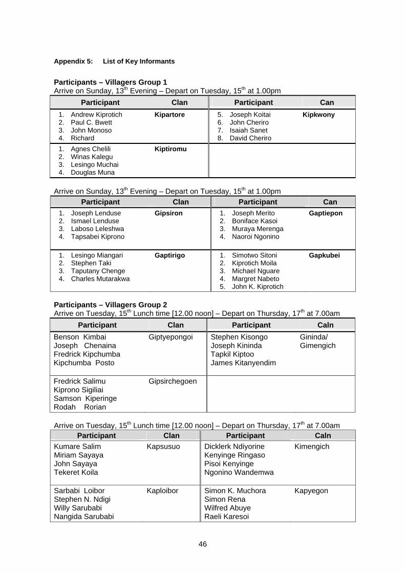
46
Appendix 5: List of Key Informants
Participants – Villagers Group 1 Arrive on Sunday, 13th Evening – Depart on Tuesday, 15th at 1.00pm
Participant Clan Participant Can 1. Andrew Kiprotich 2. Paul C. Bwett 3. John Monoso 4. Richard
Kipartore 5. Joseph Koitai 6. John Cheriro 7. Isaiah Sanet 8. David Cheriro
Kipkwony
1. Agnes Chelili 2. Winas Kalegu 3. Lesingo Muchai 4. Douglas Muna
Kiptiromu
Arrive on Sunday, 13th Evening – Depart on Tuesday, 15th at 1.00pm
Participant Clan Participant Can 1. Joseph Lenduse 2. Ismael Lenduse 3. Laboso Leleshwa 4. Tapsabei Kiprono
Gipsiron 1. Joseph Merito 2. Boniface Kasoi 3. Muraya Merenga 4. Naoroi Ngonino
Gaptiepon
1. Lesingo Miangari 2. Stephen Taki 3. Taputany Chenge 4. Charles Mutarakwa
Gaptirigo 1. Simotwo Sitoni 2. Kiprotich Moila 3. Michael Nguare 4. Margret Nabeto 5. John K. Kiprotich
Gapkubei
Participants – Villagers Group 2 Arrive on Tuesday, 15th Lunch time [12.00 noon] – Depart on Thursday, 17th at 7.00am
Participant Clan Participant Caln Benson Kimbai Joseph Chenaina Fredrick Kipchumba Kipchumba Posto
Giptyepongoi Stephen Kisongo Joseph Kininda Tapkil Kiptoo James Kitanyendim
Gininda/ Gimengich
Fredrick Salimu Kiprono Sigiliai Samson Kiperinge Rodah Rorian
Gipsirchegoen
Arrive on Tuesday, 15th Lunch time [12.00 noon] – Depart on Thursday, 17th at 7.00am
Participant Clan Participant Caln Kumare Salim Miriam Sayaya John Sayaya Tekeret Koila
Kapsusuo
Dicklerk Ndiyorine Kenyinge Ringaso Pisoi Kenyinge Ngonino Wandemwa
Kimengich
Sarbabi Loibor Stephen N. Ndigi Willy Sarubabi Nangida Sarubabi
Kaploibor Simon K. Muchora Simon Rena Wilfred Abuye Raeli Karesoi
Kapyegon

47
Participants – Villagers Group 3
Arrive on Wednesday 16th , evening – Depart on Friday, 18th at 1.00pm Participant Clan Participant Clan
Joseph Barngetuny Kiprui Ndaraiya Stephen Tangus Jane Chelangat
Gapyemit
Wilson Warionga James Warionga
Giptopog
Arrive on Wednesday 16th , evening – Depart on Friday, 18th at 1.00pm
Participant Clan Participant Clan
Hassan Sangare Harison Nalungute Samuel Cherubet L. Johnson Kimurgor Rana
Kipkepoi
Zablon Tolu Sammy Barnoti Tolu Tunai Nangoe Justus Richard M. Tolu
Kaptolu
James Kuruna Simon K. Kasoi David Sironga Kasoye Tarakwai
Kaptiepopo Ephantus Cheruiyot Simon Kimando Joseph Seriseri Benson Sabayoki
Kapkaigi
John Mariro Jackson Kiplengali Samgo Nokipa Ndugori William Nduati
Kapshoe
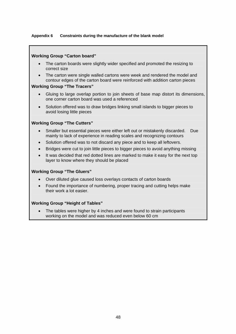
48
Appendix 6 Constraints during the manufacture of the blank model
Working Group “Carton board”
• The carton boards were slightly wider specified and promoted the resizing to correct size
• The carton were single walled cartons were week and rendered the model and contour edges of the carton board were reinforced with addition carton pieces
Working Group “The Tracers”
• Gluing to large overlap portion to join sheets of base map distort its dimensions, one corner carton board was used a referenced
• Solution offered was to draw bridges linking small islands to bigger pieces to avoid losing little pieces
Working Group “The Cutters”
• Smaller but essential pieces were either left out or mistakenly discarded. Due mainly to lack of experience in reading scales and recognizing contours
• Solution offered was to not discard any piece and to keep all leftovers. • Bridges were cut to join little pieces to bigger pieces to avoid anything missing • It was decided that red dotted lines are marked to make it easy for the next top
layer to know where they should be placed Working Group “The Gluers”
• Over diluted glue caused loss overlays contacts of carton boards • Found the importance of numbering, proper tracing and cutting helps make
their work a lot easier.
Working Group “Height of Tables”
• The tables were higher by 4 inches and were found to strain participants working on the model and was reduced even below 60 cm

49
Appendix 7 Day 1 - Trainees’ Frame of Mind at the Beginning of the Workshop
Expectations expressed by trainees at the beginning of the workshop (metacard exercise, Monday – August 9th, 2006)
• Participant’s expectations of the P3d-Model Training • To learn the technique of PGIS • To understand the construction of a spatially accurate 3D dimensional model • How P3DM could be used as a tool to empower the community • To make practical what we have always read about 3-D modeling • To learn the Ogiek culture • To learn about community mapping • To learn how to use the map in negotiating for Ogiek rights • To gain knowledge and understand more about community mapping • To learn about 3D mapping processes • To learn how the knowledge gained can be applied to redress historical wrong • How to apply community maps for NRM or assets • To learn new approaches and mitigation processes from other international communities • To learn more about 3D models and community land usage • To apply knowledge learnt in class and expand on this in the field of community mapping. • To know how community visualize their resources and priority(What is important to them. • Understand how community mapping can help resolve conflicts(Between clans for the
ogiek case) • To understand and learn how to use my technical background in a particular way and
possibly then to do it. • We are going to talk about community participatory meetings and community hand one
maps • To learn more on community mapping techniques esp. technical side (GPS/GIS) • I expect to learn whether 3 dimensional mapping is an effective tool for community
advocacy. • How to apply community maps for negotiating with Gov’t admin. • To participate with practitioners who share a passion for 3D PGIS • To know how to successfully build a P3DM without leaving community behind during the
process. • To deepen my understanding of the technical issues of models and sales. • To learn how to solve conflicts between different communities using 3D-modelling. • How to apply community maps for conflict resolution • To understand/ learn which is the power and for what can be used. • To understand more and contribute to community mapping • To learn more about 3-D modelling and how to apply it in the real world of community
mapping • To know how 3-D mapping will help resolve conflict amongst different stakeholders. • To complete 3D model for Ogiek territory
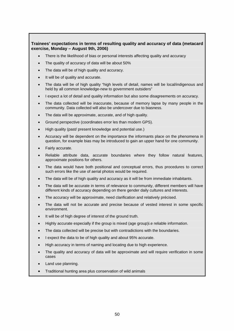
50
Trainees’ expectations in terms of resulting quality and accuracy of data (metacard exercise, Monday – August 9th, 2006)
• There is the likelihood of bias or personal interests affecting quality and accuracy
• The quality of accuracy of data will be about 50%
• The data will be of high quality and accuracy.
• It will be of quality and accurate.
• The data will be of high quality “high levels of detail, names will be local/indigenous and held by all common knowledge-new to government outsiders”
• I expect a lot of detail and quality information but also some disagreements on accuracy.
• The data collected will be inaccurate, because of memory lapse by many people in the community. Data collected will also be undercover due to biasness.
• The data will be approximate, accurate, and of high quality.
• Ground perspective (coordinates error les than modern GPS).
• High quality (past/ present knowledge and potential use.)
• Accuracy will be dependent on the importance the informants place on the phenomena in question, for example bias may be introduced to gain an upper hand for one community.
• Fairly accurate.
• Reliable attribute data, accurate boundaries where they follow natural features, approximate positions for others.
• The data would have both positional and conceptual errors, thus procedures to correct such errors like the use of aerial photos would be required.
• The data will be of high quality and accuracy as it will be from immediate inhabitants.
• The data will be accurate in terms of relevance to community, different members will have different kinds of accuracy depending on there gender daily cultures and interests.
• The accuracy will be approximate, need clarification and relatively précised.
• The data will not be accurate and precise because of vested interest in some specific environment.
• It will be of high degree of interest of the ground truth.
• Highly accurate especially if the group is mixed (age group)i.e reliable information.
• The data collected will be precise but with contradictions with the boundaries.
• I expect the data to be of high quality and about 95% accurate.
• High accuracy in terms of naming and locating due to high experience.
• The quality and accuracy of data will be approximate and will require verification in some cases
• Land use planning.
• Traditional hunting area plus conservation of wild animals

51
How Do You See Your Role In The Mapping Process? (metacard exercise, August 9th, 2006)
• To listen and observe • To assist when asked but to observe and learn • Educative and learning • My role in the mapping process is to acknowledge the different of thinking or deed
of the community • I expect I will help with the communication between indigenous people and the
technical team to help each side hear each other. • To listing name of hunters and gathering and observe • Construction of the 3D model and share knowledge • I should only act as a guide a non-participant • To help/support them with my technical knowledge, my hands and my will of
participation • Learn how to facilitate the mapping process • Help the community understand what it means to map and the importance to
solving conflicts. • To construct the blank 3D model • Observe the process as much as possible only seeking clarification on grey areas • Team leader • To observe and listen • To show them of what use the provided materials are for • Help the elders or community members understand the type of data required and
assist in compiling of the data collected. • Helping them to understand and interpret maps • Traditional areas, Historical and taboo system areas • Help the elders in arranging the topo-sheets in order • Explain to them what exactly they should do and listen to their concerns • To ensure confidentiality at all times “ make public what they want to make public” • To advise on symbols to use to represent different features .To advise on the
scale of different features • To assure them that we, as responsible people will not allow the mis-use of this
knowledge. • Orient them on the overlying features and colour semblance • To shut up and not interfere • To engender “trust “ and confidence to “reveal “ their knowledge.
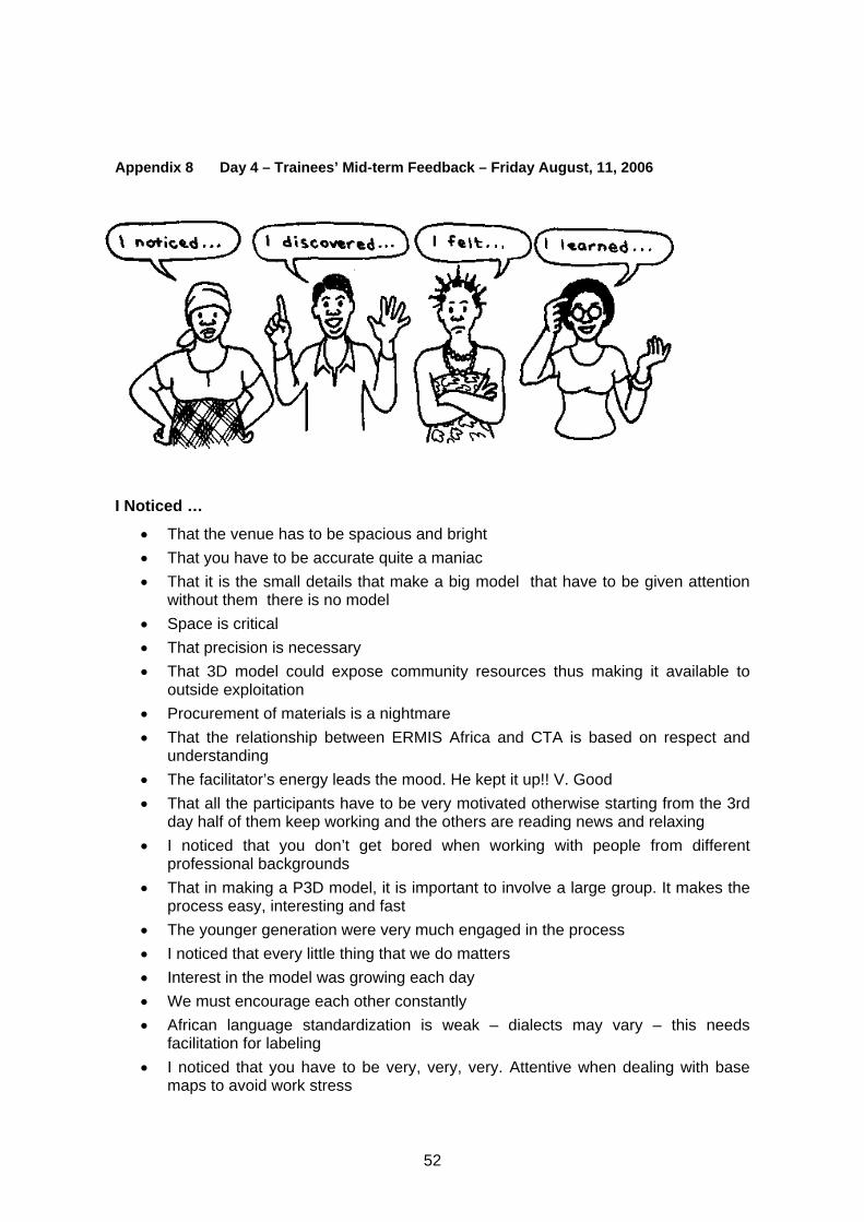
52
Appendix 8 Day 4 – Trainees’ Mid-term Feedback – Friday August, 11, 2006
I Noticed …
• That the venue has to be spacious and bright • That you have to be accurate quite a maniac • That it is the small details that make a big model that have to be given attention
without them there is no model • Space is critical • That precision is necessary • That 3D model could expose community resources thus making it available to
outside exploitation • Procurement of materials is a nightmare • That the relationship between ERMIS Africa and CTA is based on respect and
understanding • The facilitator’s energy leads the mood. He kept it up!! V. Good • That all the participants have to be very motivated otherwise starting from the 3rd
day half of them keep working and the others are reading news and relaxing • I noticed that you don’t get bored when working with people from different
professional backgrounds • That in making a P3D model, it is important to involve a large group. It makes the
process easy, interesting and fast • The younger generation were very much engaged in the process • I noticed that every little thing that we do matters • Interest in the model was growing each day • We must encourage each other constantly • African language standardization is weak – dialects may vary – this needs
facilitation for labeling • I noticed that you have to be very, very, very. Attentive when dealing with base
maps to avoid work stress

53
• Giacomo’s energy is fantastic for the process • That the contour must be the same size as the table – precisely. Else it affects the
3D! facilitation is a hared responsibility • That the children’s “legend” still needs to made • That we must work hard to look good! • People must work together to achieve their goal • That visitors bring development • That something we id today is important in our life • Learning is an enjoyable exercise which needs patience • That God’s creation is still on through mankind • Monitor pins stock and swoop code if necessary • I noticed that other people can do good things to others e.g. the 3D modelling
I Discovered …
• That accuracy of the 3DM require people who understand the territory and terminologies well
• The more background work that is done, the more “quality input” occurs in the development of the legend
• That teamwork is the game • That it is a fast process (faster than I expected) and there is a better allocation of
time and resources compared with other methods • That making 3DM is not easy as I thought in terms of space, time and resources,
energy • The result of P3D Model is impeccable because of collective effort • That the base maps need to be done accurately • That precision is very important on the base map • Multi-tasking is very crucial in effective teamwork • Hunter – gatherers use points more than areas prediction of game moments is
key • That involving the students (the next generation) is one of the best practices in 3D
modeling • That the cardboard and the glue must work together • That the actual word “hedqund”* can be misunderstood! • That meaning of special categories change with discussion • That the Ogiek community refer to regions according to the soil type and not
climate regions • That P3D – Model is a process that is owned by the community and all information
put on the model has to originate from the community members • Discovered that by working together we can do great things. That there are only 4
types of soils in Mau • The model is a difficult task to complete but was a lot of fun • The school children are indispensable • That 3D model is an important development tool, since it can fore warn the
community members on the impacts of destructive activities like Deforestation! This would motivate them into sustainable development activities like Agro-forestry and Afforest-ration
54
• That space is crucial when assembling base map • That you can use local materials like the thorn of acacia for pin to reduce the cost
of pins • I discovered that, the larger the number of people entering info on the 3D model,
the higher the inconsistency of the information • That facilitation skills is highly recommended to keep consistency • That nothing can come from the blue sky but through hard work • One must work tirelessly to succeed in life
I felt …
• That there is a lot of information embedded in the blank model already • The draft legend needs to include a wider group • The work is getting clearer and meaningful • That 3D model can be used as a multi-disciplinary tool • I never thought we could make it …. The tracing, cutting, gluing etc but after
finishing the blank model, I felt we were there. It was a turning point to the whole project
• Happy to see a process where the community owns the mapping and there is much inter-generational sharing
• Overjoyed for this function to take place in our school • My anxiety disappear, we can do it • I felt cold • The sheer joy of working with Giacomo! • That I was impressed by the diligence of the university students • Too many carton papers went into waste • The final model is empty • That the process of building the model can be quiet demanding but rewarding • Tired but proud of what we’ve accomplished in day’s work • Very happy as model comes alive • That getting the right contour and right materials can be a huge challenge for this
work • Frustrated by the high level of accuracy in measuring the maps • Frustrated at not being able to be part of draft legend process • It was nice working with people from different nations • That 3D mapping has more potential than I thought • That I’m enjoying to be here and to work with all the others • Sad at how we have destroyed Mau and yet it serves us with so much water • That the height of the tables is too high thus not allowing full participation of all
members (community) • That keeping name tags add value (increase the level of participation) • The objective of the 3D modeling was not well shared among community
members • A little cut off from this phase due to the language barriers…..(but I have a
suggestion) • Happy because models were finished

55
• Exited and thrilled to be here • All is possible if one has the patience • We must be ready to work around the clock to make a break through in life • That I’m not as I came to this venue • Everything is with possible determination and dedication
I Learned …
• When we can work as a team we can do it • That a lot of thematic data can be generated from a 3D Model • Every voice and hand counts • More legend items keep on coming up during the process of 3D modeling • 3D participatory mapping is an excellent tool for intergenerational dialogue about
culture, identity and the environment • 3D model is quite a quick process and tangible • Participatory 3D modeling results into more accurate and reliable data • Tamed wild animals are found on areas with specific soil types • That it takes time to come up with a legend and it has to come from the
community • That it is important to glue the white pieces of paper in an accurate way otherwise
the contour lines are not visible anymore • That cutting/tracing the contours need patience and precession during adjusting
the map • That you need students and teachers to do the model so as to have fresh energy
to finish it • That many hands make light work and coordination critical • Not only did I learn more on 3D modeling but I also learned some new things:
QLQLK for path in XOSA • Intergenerational learning is something that is ongoing through sharing simple
tasks • That precision is vital when cutting the contours • That learning is the most important today • That knowledge is power • No man can work in isolation • That knowledge is wealth • That unity is strength • I learned that there is hidden truth that can be processed by the community in
mapping • The legend has to be prepared in advance of the mapping exercise • That you have to be ready to face unpredictable variables • That each of the polygons should e closed • That we should be extremely careful with paints. Participants may dip a brush in
two colours and the result on the model will not be the same • That painting is finished a day before points are put on the model

56
I would like to suggest …
• We make a 3D Model of Egerton University • That a specialist be around to massage the necks and knees after tracing contour • That there should be consultations for Ogiek in Nakuru, Narok and Mt. Elgon on
the legends and naming • Elevation data should be written on the portion of the layer which will be pasted • I suggest that we be given some work to do now. We are idle not good for our
health • That before engage in constructing the model, the objective must be understood
by all interested and affected parties! • I would suggest that anyone wishing to see a 3D model must include bi-lingual
professional to help in pronunciations of a variety of languages and spelling like Dr. Nigel….. he was amazing and did much on the legend
• That there is music to energize the participants during the modelling process • That a counsellor is near to handle stress related to base map precision • Visiting the Mau to the top before the exercise (Trainees) • The objective of the 3D Model must be made clear to avoid raising of false
expectations • 3D Model be done on other hunter-gatherers land (Yaaku and Sengwer) • That more time be allocated to legend development • That teams should rotate otherwise they get tired and can do errors (e.g. Tracing
contours lines) • That we develop overlays with fibreglass for time or change layers • To involve more, all the participants in the preparation of the draft legend • Legend process happens earlier – it helps to have it in local language. It needs
dialogue and gender balance • If timing between tea and meals should be well spaced • To explore the possibility of using local/eco-sustainable material, for example
acacia thorns and seeds instead of the Japanese pins • You think of other activities to maintain the interest of the participants • That the same learning should be done from time to time • We should all aim high in education as those who have shown us have • Students should be assisted through practical exercises like this one • Such practical work should be done from now and then in all subjects • This exercise should be diversified to male this concerned to benefit more • I would suggest that we all agree that glue is thicker than water • To have some translators so everybody can follow the discussion that are going
on and learn • To include in the plan of activities internal meetings (e.g. in the evening of each
day) for discussing about the day and clarifying the activities of the day after. Keeping all updated of what is going on
• After each of the model is finished by a group of clans the trainees should have time about some features or places or points so that they learn from the elders
• I would like to suggest that communities for which 3D Model is meant for to agree on a workable time frame …..Nothing less nothing more. If it’s the past then be it

57
and not map the past and the present together when the information you want mapped is past information. How do you map the present on the past without mistakes
• That representative from all the clans came on the first day of doing the legend and agreed on the first day. If actually mind mapping the model so that they agree on main features and areas
• The entire community should be enlightened more in education particularly the youth so that they can pursue and better their future lives
• To distribute more documents and info to all the participants (e.g. the classification system that the community will use. Altitude zones or vegetation zones or ecological zones etc) in order to allow everybody to follow the discussion especially the ones not experts in land cover mapping
• There need to be more debate about the legend

58
Appendix 9 Day 11 – Trainees’ Final Feedback – Friday August, 18 2006
I FELT
• The clan has really appreciated the 3D Modeling • Land issue is quite touching not only the elderly, but to the entire range of the
community • That God should be very much appreciated for this vital exercise • I’m proud to be associated during this noble historic community exercise • That we are very appreciative for coming up with map work • To thanking the Ogiek community for accepting your offer • God should bless you abundantly for working tirelessly for the needy • I’m happy even and children to be happy also • I felt very happy because the map will help our future Generation • Happy to see the way our area has been covered and this will help our children to
know their territory • I felt to congratulate you to have come to educate us to know more about our
territory. We have served a lot of not having the identity of the Ogiek boundaries. We are now open minded. May almighty father in heaven bless you. Thanks
• We are very happy since they even have made us to remember what was forgotten
I Noticed
• I have noticed that since in time immemorial God has shown us the way to success
• The well wishes God bless you for young generation will come to know their rights. God bless
I Discovered
• Today I discovered that I was cheated by my fellow friends that they will get our land back from the land grabbers
• My hidden rights have come to the lights during daylight when I needed to pursue my future
• I thank clan elders for helping us to know the boundaries between our neighbouring clan. Also thanks for the visitors from in and outside Africa
• That there are names of places and forests I did not know I Learnt
• Thanks for you all for cooperating to come and show us our rights for our grandchildren to learn Ogiek history. God bless all visitors for bringing us together
• I learned that we have put spare of a wider knowledge to know our clan territory and the importance of having a map of the all covered Ogiek land. It is a nice privileged to us young generation and the coming generation
• I have learned more about my land, community so I’m very happy to discover more
• I’m happy to learn that Ogiek in Africa to make the model
59
• I have learned that there are indigenous names • I’ve learned that we have many resources in Mau • I have learned that the model will give the Ogiek history and remembrance • I learnt that God is good for I have seen something that I could not find anywhere
else • I learned new names of places territories and rivers in Ogiek language
I Would Like To Suggest
• I would like to suggest my sincere to my country and my district to enable me to achieve opportunity of mapping my clan territory
COMMUNITY ELDERS - GROUP 2 I Felt
• Overwhelmed to see it brought back • I felt very happy since it showed us the places we used to live in the past • I felt very happy for the many visitors who came to us, these can be of good
fortune of us getting back our land • I felt learned and enlightened • We are grateful to the event since it remind us past information of our ancestors • The beginning of learning greater things of the past and our survival • I felt in my heart a feeling of integrity • We were taught new opportunities • We are glad that the 3D Map was able to show us our past and also remind us
how our fore fathers had divided land/regions depending on altitude and among the clans
• I feel happy that we are assisted to map our territories • I felt well to do thereafter • I felt happy in my life • I would like to thank all participants • We are happy for we have learnt things about our land we had forgotten • Congratulations for hosting this memorable occasion • We are happy about this initiative because we have learnt more about out land • It encouraged me • I felt that the community is to be well represented outside • I’m happy since we joint hands with international people
I Noticed
• I noticed a lot of experience that I never knew • I noticed that over territory is come on the map • I noticed of valleys and hills that bordered our territory • I noticed that many things is to be discovered • I noticed that landscape can be modelled • I noticed that the landscape can be modeled closer to people

60
• I noticed that drunkard members of the community have more information because they talk their minds out without fear. They call a spade a spade and not a big spoon. Give them more of the stuff and u will get more information
I Discovered
• I discovered that we can do mapping which we thought we could not be able to do
• Knowledge of the past on early days • What was seen to be can be brought back • There re several ways to the same thing • The real image of our land in the past can be viewed • Thanks to all organizers for assisting Ogiek community clans through territorial
mapping exercises past activities:- • Honey collection • Meat of various types of animals like, antelopes, elephants, buffaloes etc • Homes of clans • Herbs collection • Water • Firewood • Mapping exercises might assist Ogiek clan – in East Mau territories to be as back
as during the period when our God creator did the work at Ogiek homeland shown on this mapping work. Thanks to all for your kind work
I Learnt
• I learnt that land and its resources can be mapped • The community lived in integrity • I loved the things as Ogiek since it will make us to be known • I learnt of the lost truth • Through struggle all can be possible • I learnt that other people of different technologies can help unearth the lost
information • Our past has almost been re-instituted • I learned how our land was • We have been able to learn of things we had forgotten. The older generation had
forgotten about our land • I learned about new map I have not seen • I learnt new experience on clan territory and boundaries • We have come to learn and remember more about our past and we appreciate the
assistance I Would Like To Suggest
• I could suggest that, if this succeed it will be a prosperity • I suggest that these map can be used by Ogiek people to enhance their land legal
issues • I’m suggesting that these people be given a lot of thanks
61
• I wish to thank ERMIS Africa and other bodies for organizing Ogiek elders to draw their maps for Ogiek forefathers’ territories which had been spoilt by European Government clearing our forest land for trees or plantations development. The mapping exercise have brought back Ogiek clan territorial borderlines
• Truth is yet to be known COMMUNITY ELDERS - GROUP 3 I Felt
• I felt so pity after our environment faced degradation • I felt that I could get the copy of the process • I felt that there might be possibility of truth • I felt that this exercise of mapping be done in different parts of the country • I felt that it was better if we had taught about these earlier to prevent damages • I felt that if we are following instruction the truth would be seen and known • I felt happy to know my boundary • I felt proud of my clan territory being marked out and also the entire community
land I Noticed
• I noticed that the land was completely destroyed • I noticed people of all walks of life participating in this workshop • I noticed a team work or group work of the both community and the NGO’s
participating together to give map of Ogiek country • I noticed that if there is a case I can answer the questions of my living area
because I have known my landscape, also I have seen all my properties therefore now I’m happy to have known all bout it
I Discovered
• I discovered that we have potentiality of managing of our rivers and plant trees • I discovered that 3D Model help solving dispute/conflicts • I have discovered the fact of this community of my tribe as life and now we pray
God to know us and also to have good belief and have title deeds there after • I discovered clans territorial boundaries
I Learnt
• I learned that indigenous knowledge is powerful • I learned that we have many resources that we could not access • I have realized the boundary of our clan (Leshoi) • I have learned very many things i.e. my landscape, beehives and neighboring
communities of my tribe now I have known them wow already • I learned that it has added to our knowledge on how to manage environment • I learnt that this exercise could be of good help to the future generation in terms of
learning

62
• I learned that how we used to live can be mapped • I learned that we can show the rest of the other communities of Kenya and the
world that we have our own home as it has been shown on the drawn map of East Mau Ogiek Reserve
• I learnt that I can map my ancestral territories and would not forget • I learned that we are lost and need to unite ourselves • I learned that I have my rights
I Would Like To Suggest
• I learned that participatory method help to pass information from old to young generation
• I suggest that key stakeholders of Natural resources should integrate indigenous knowledge in management
• I would like to suggest that work we have done could help us to gain something e.g. the government to identify our ancestral land
• I will agree with you facilitators after I will see the truth of the mapping my land • The map to be used in a cultural centre where tradition could be preserved • I’m suggesting that we be assisted to benefit in the mapped model to achieve our
goal • I suggest that we plant trees
PRIMARY SCHOOL KIDS I Discovered
• That nothing can come from the blue sky but through hard work • One Must work tirelessly to succeed in life
I Felt • Happy because models were finished • Excited and thrilled to be here • All is possible if one has patience • We must be ready to work round the clock to make a breakthrough in life • That I am not as I came to this venue • Everything is possible with determination and dedication • There needs to be more debate about the legend
I Learned • That learning is the most important thing today • That knowledge is power • No man can work in isolation • That knowledge is wealth • That unity is strength
I Noticed
• That the children’s ‘legend’ still needs to be made.

63
• That we must work hard to look good • People must work together to achieve their goals • That visitors bring development • That something we did today is important to our lives • Learning is an enjoyable exercise which needs patience • That God’s creation is still through mankind
I Would Like To Suggest
• The same learning should be done from time to time • We should all aim high in education as those who have shown us • Students should be assisted through practical exercises like this one • Such practical work should be done now and then in all subjects • This exercise should be diversified to make those concerned benefit more • That we all agree that glue is thicker than water
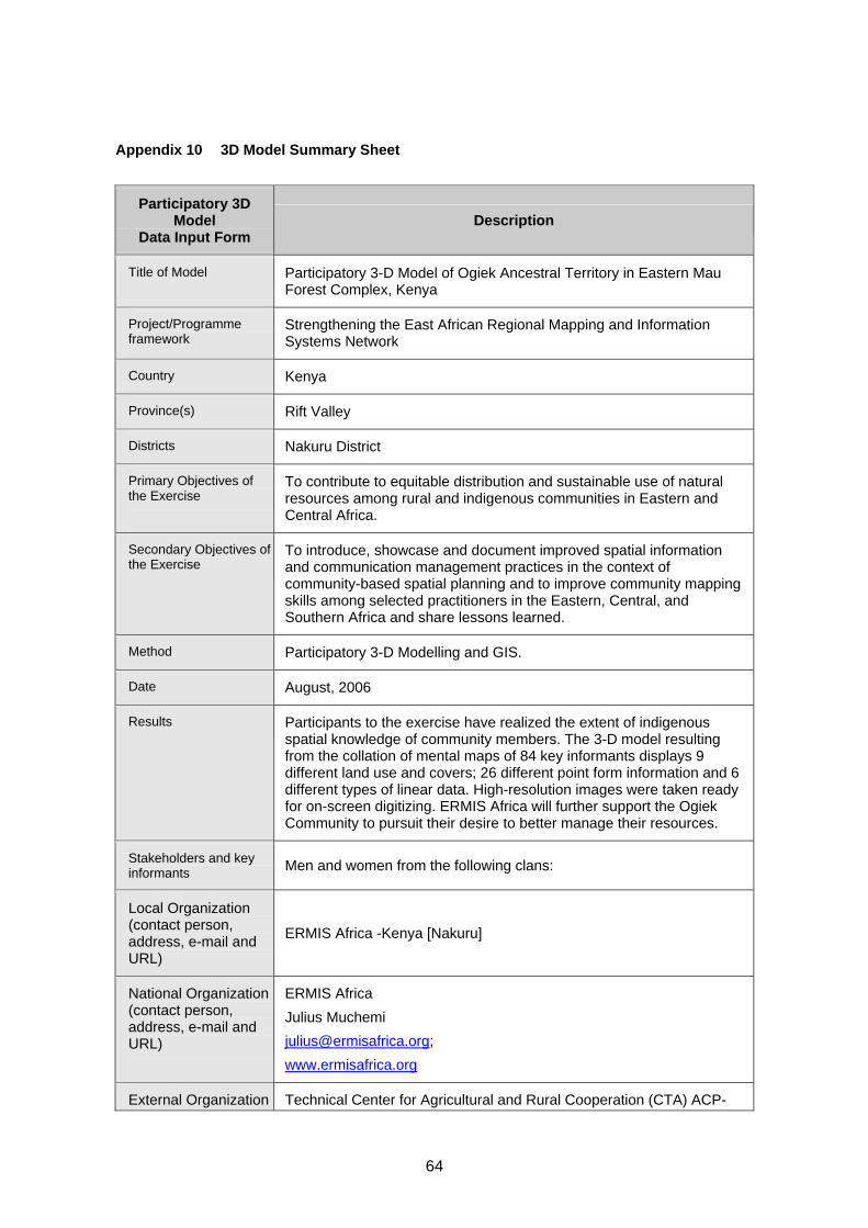
64
Appendix 10 3D Model Summary Sheet
Participatory 3D Model
Data Input Form Description
Title of Model Participatory 3-D Model of Ogiek Ancestral Territory in Eastern Mau Forest Complex, Kenya
Project/Programme framework
Strengthening the East African Regional Mapping and Information Systems Network
Country Kenya
Province(s) Rift Valley
Districts Nakuru District
Primary Objectives of the Exercise
To contribute to equitable distribution and sustainable use of natural resources among rural and indigenous communities in Eastern and Central Africa.
Secondary Objectives of the Exercise
To introduce, showcase and document improved spatial information and communication management practices in the context of community-based spatial planning and to improve community mapping skills among selected practitioners in the Eastern, Central, and Southern Africa and share lessons learned.
Method Participatory 3-D Modelling and GIS.
Date August, 2006
Results Participants to the exercise have realized the extent of indigenous spatial knowledge of community members. The 3-D model resulting from the collation of mental maps of 84 key informants displays 9 different land use and covers; 26 different point form information and 6 different types of linear data. High-resolution images were taken ready for on-screen digitizing. ERMIS Africa will further support the Ogiek Community to pursuit their desire to better manage their resources.
Stakeholders and key informants Men and women from the following clans:
Local Organization (contact person, address, e-mail and URL)
ERMIS Africa -Kenya [Nakuru]
National Organization (contact person, address, e-mail and URL)
ERMIS Africa Julius Muchemi [email protected]; www.ermisafrica.org
External Organization Technical Center for Agricultural and Rural Cooperation (CTA) ACP-

65
Participatory 3D Model
Data Input Form Description
(contact person, address, e-mail and URL)
EU), Wageningen, The Netherlands. Contact person: Giacomo Rambaldi Email: [email protected]
Funding Agencies (name and URL)
Technical Center for Agricultural and Rural Cooperation (CTA) ACP-EU), Wageningen, The Netherlands http://www.cta.int IPACC
Horizontal Scale of 3-D model (1:X,000) 1:10,000
Vertical Scale of 3-D model (1:X,000) 1:5,000
Size of model (m x m) 2.4 m x 24 m
Area covered by the model (km2) 576
Corner coordinates of the 3-D model
Projection UTM Spheroid GRS80 Datum WGS84 Zone 36S X-shift 500,000 Y-shift 10,000,000

66
Appendix 11 Extraction of Data from the 3-D Model