sales ratio guidelines - south dakota
TRANSCRIPT
SALES RATIO GUIDELINES
2017
(Revised)
COMPILED BY: PROPERTY TAX DIVISION
DEPARTMENT OF REVENUE 445 EAST CAPITOL AVENUE PIERRE, SOUTH DAKOTA 57501-3100

TABLE OF CONTENTS 1 Sales Ratio Guidelines 2 Deed Types and Codes 3 County numbers and mobile home numbers 4 Real Property Classification 5 Codes Used in Ratio Program 6 Guideline for Completion of Mobile Home Transfers 9 Instructions for completing transfers - Register of Deeds 10 Instructions for completing transfers - Director of Equalization 11 Building and Property Information 14 Allowable Adjustments 15 Instructions for soil information 16 Sample – Parcel Weighted Rating 17 Weighted Soil Rating & Marshland Ratings 19 Sales Ratio Remarks for Rejection 20 Procedure for Submitting &Auditing Sales Data 22 Administrative Rules 24 Statutes 27 Definitions 30 Types of Deeds 32 City Listings for Urban Property 36 School Districts by County

Ratio Guidelines 2017 1
SALES RATIO GUIDELINES
The specific statutory citation authorizing the sales ratio is found in SDCL 10-11-54 through 10-11-60, which directs and authorizes the Secretary of Revenue to collect data and publish the findings annually. In carrying out these responsibilities the following guidelines will assure uniformity in collecting and reporting all sales data on a state-wide basis.
Assessment year and ratio year is the period beginning November 1 and ending the following October 31.
By the end of the month, the Director of Equalization shall receive from the Register of Deeds all real estate transfers for that month. The Director of Equalization shall be responsible for numbering the transfers with the card numbers.
All transfers must be submitted to the Department of Revenue according to the schedule in Admin Rule 64:05:01:06.
All transfers will be included in the statistical study unless proven that the transfer was not an arms-length transaction. SDCL 10-11-56 defines arms-length as a transfer of property offered on the open market for a reasonable period of time between a willing seller and a willing buyer with no coercion or advantage taken by either party.
Every transfer from the Register of Deeds to the Director of Equalization is to be accompanied by a Certificate of Value. The information on the Certificate and other verification must be used to determine if a sale is not an arms-length sale or if adjustments are necessary to the purchase price. DO NOT DESTROY CERTIFICATES OF VALUE OR OTHER VERIFICATION INFORMATION UNTIL THE SALES ARE OUTSIDE THE TWO YEAR RATIO PERIOD.
If a sale is rejected, adequate explanation must be provided on the transfer and verification information placed on file in the Director of Equalization’s office.
Directors of Equalization are authorized to adjust purchase price to reflect the actual consideration for real property. The most common adjustments will be to subtract for personal property included in the sale and unique financing. Any adjustments to selling price must be explained adequately on the transfer and verification information placed on file in the Director of Equalization’s office.
For the purposes of this report URBAN property will be considered all property within municipal boundaries. RURAL property will be all property outside municipal boundaries.
Remember, the more sales in the ratio study, the more confidence there is in the conclusions drawn from the study. Sales are vital to the appraiser in the quest for market value. The sale of a property provides an indication of its worth. The sale of several similar properties provides the appraiser with a good indication as to the value of similar properties that have not sold. However, the sales that the appraiser considers in providing an indication of those values must fit the definition of market value.
To assure that the sales being used to establish value fit within the definition of market value, the appraiser must validate sales and make adjustments when necessary. This will ensure that the sales being used are, in fact, proxies for market value.
Accurate and equitable assessments are an absolute necessity if the property tax burden is to be distributed fairly in the taxing jurisdiction. Tests must be performed to measure the accuracy of assessments. The primary test for measuring assessment performance is the ratio study.

Ratio Guidelines 2017 2
Deed Types and Codes for Sales Ratio
Deed Type Code
Abandonment A
Administrator’s Deed AD
Condemnation CM
Contract C
Contract for Deed CD
Corporate Deed CP
Correction Deed CR
Covenant CV
Transfer Death Deed DD
Easement E
Executor’s Deed ED
Final Decree FD
Foreclosure F
Guardian’s Deed GD
Highway Use Deed HD
Mineral Deed MD
Other OT
Patent P
Personal Representative’s Deed PD
Probate PR
Quitclaim Deed QD
Sheriffs Deed SD
Special Warranty Deed SW
Tax Deed TX
Termination of Joint Tenancy TJ
Trust Deed TR
Trustee’s Deed TD
Warranty Deed WD

Ratio Guidelines 2017 3
COUNTY RATIO CARD NUMBERS AND MOBILE HOME NUMBERS
COUNTY NUMBER COUNTY COUNTY NUMBER COUNTY
01 Aurora 34 Hutchinson 02 Beadle 35 Hyde 03 Bennett 36 Jackson
04 Bon Homme 38 Jerauld 05 Brookings 39 Jones
06 Brown 40 Kingsbury
07 Brule 41 Lake
08 Buffalo 42 Lawrence
09 Butte 43 Lincoln
10 Campbell 44 Lyman
11 Charles Mix 45 McCook
12 Clark 46 McPherson
13 Clay 47 Marshall 14 Codington 48 Meade
15 Corson 49 Mellette
16 Custer 50 Miner 17 Davison 51 Minnehaha
18 Day 52 Moody
19 Deuel 53 Pennington
20 Dewey 55 Perkins
21 Douglas 56 Potter 22 Edmunds 57 Roberts
23 Fall River 58 Sanborn
24 Oglala Lakota 59 Spink
25 Faulk 60 Stanley
26 Grant 62 Sully
27 Gregory 64 Todd
28 Haakon 63 Tripp
29 Hamlin 65 Turner 30 Hand 66 Union
31 Hanson 67 Walworth
32 Harding 68 Yankton
33 Hughes 69 Ziebach

Ratio Guidelines 2017 4
REAL PROPERTY CLASSIFICATION
Abstract Class “A” – Ag Land *** “S” Denotes Owner Occupancy
AG - A Land classified as agricultural without corporate limits.
AG - SL Land classified as agricultural without corporate limits being leased from the Commissioners of School and Public Lands.
AG – A1 Improvements and structures on land classified as agricultural without corporate limits, less dwellings and automobile garages.
NA – A1 Dwellings and Automobile garages on land classified as agricultural without corporate limits.
NA – AM1 Manufactured home classified as real estate after June 30, 1999, on land classified as agricultural without corporate limits.
AG – AC Land classified as agricultural without corporate limits under commercial use.
NA – AC2 Improvements and structures on land classified as agricultural without corporate limits, under commercial use.
Abstract Class “C” – Platted Land Outside City Limits *** “S” Denotes Owner Occupancy
AG – C Platted lots classified as agricultural without corporate limits.
AG – C1 Improvements and structures on platted lot and acreages classified as agricultural without corporate limits, less dwellings and automobile garages.
NA – C1 Dwellings and automobile garages on platted lots and acreages classified as non-agricultural without corporate limits.
AG – CC Platted lots and acreages classified as agricultural without corporate limits improved or unimproved under commercial use.
AG – CC2 Improvements and structures on platted lots and acreages classified as agricultural without corporate limits, under commercial use.
NA – C Platted lots and acreages without corporate limits.
NA – C1 Improvements and structures on platted lots and acreages without corporate limits.
NA – CM1 Manufactured home classified as real estate after June 30, 1999, on platted lots and acreages without corporate limits.
NA – CC Platted lots and acreages without corporate limits improved or unimproved, under commercial use.
NA – CC2 Improvements and structures on platted lots and acreages without corporate limits, under commercial use.
Abstract Class “D” – Platted land in City Limits *** “S” Denotes Owner Occupancy
AG – D City or town lots and acreages classified as agricultural.
AG – D1 Agricultural improvements and structures less dwellings and automobile garages on city or town lots and acreages classified as agricultural.
NA – D1 Dwellings and automobile garages on city or town lots and acreages classified as Non-agricultural.
AG – DC City and town lots and acreages improved or unimproved classified as agricultural for commercial use.
AG – DC2 Improvements and structures classified as agricultural on city or town lots and acreages under commercial use.
NA – D Lots and acreages in city or town.
NA – D1 Improvements and structures on city or town lots and acreages.
NA – DM1 Manufactured home classified as real estate after June 30, 1999 on city or town lots and acreages.
NA – DC City or town lots and acreages improved or unimproved under commercial use.
NA – DC2 Improvements and structures on city or town lots and acreages under commercial use.

Ratio Guidelines 2017 5
CODES USED IN RATIO PROGRAM
MOBILE HOME TRANSFER TYPES These are the TYPES of transfers that we see on the MH website. They are a guide as to why the title was changed. These are not necessarily rejects. You only need one reject reason in your remarks, so if it’s a DUP the remarks should be “duplicate title”. Keep it short, keep it simple.
ABD Abandoned
NTW Non-titled Watercraft
OBL Operation by Law (applicant has a court order stating he/she is awarded the vehicle or the Attorney General’s office confiscated a vehicle and is applying for a title or have sold the vehicle and the applicant is applying)
OOS Out of State
NEW Initial Title Issuance
AMD Amend Title
DUP Duplicate Title
RTN Restore Title (No Transfer)
RTX Restore Title for Transfer
REP Repossession
SWI Title Switching
TRX Transfer
URB Unpaid Repair Bill (The applicant has the vehicle because the owner never came to pick up the vehicle and pay the repair bill)
*DUP and REP are automatic rejects on the MH portion of the site.*
Abstract Classes Buildings
A 20 CC+CC2 27 Low
A+A1 21 D 5 Fair
AC 22 D+D1 6 Average
AC2 23 DC 7 Good
C 24 DC+DC2 8 Very Good
C+C1 25 Excellent
CC 26

Ratio Guidelines 2017 6
GUIDELINE FOR COMPLETION OF MOBILE HOME TRANSFERS
The data information is supplied to the Department from Divis ion of Motor Vehicles, which is inputted by the County Treasurer.
Transfers for manufactured homes are treated the same as real estate transfers. They are just on a different form. All are considered good sales unless they do not meet the arms-length transaction criteria.
Upon receiving the transfers of manufactured homes from the Department of Revenue, information concerning the home needs to be completed. Also, verify the selling price and other information concerning the transaction.
It is REQUIRED to complete the following information on all manufactured home transfers
1. Selling Price 2. Assessed Value 3. Town 4. Township/Range 5. School District 6. Width 7. Length 8. Condition 9. Quality
If the sale is a reject – mark as such and state reason for reject. Review page 20 for valid reject reasons of sales. (Same as real estate)
VERIFY SELLING PRICE! Just because a manufactured home is going on real estate does not mean the selling price does not need to be verified. As with real estate, all information gathered is still of benefit to the DOE office.
Completion of the assessed valuation information will help in what is needed to do to the manufactured homes for the following assessment year.
New, Used or Moved manufactured homes purchased from a dealer are not rejects. Fill in all data and put in remarks “purchased from a dealer.” Assessed value is the value that would have been put on the home had it been there on the previous assessment date, using the same methodology used to value any other manufactured homes.
New, Used or Moved manufactured homes going on real estate are not rejects. Fill in all data and put in remarks “going on real estate.” Assessed value is the value that would have been put on the home had it been there on the previous assessment date, using the same methodology used to value any other manufactured homes.
Manufactured home as real estate and title transferring *
If the manufactured home is sold with the land, put information on the PT55 and submit with other real estate transfers. On the manufactured home transfer, refer to the sequence number on the PT 55 and reject the manufactured home transfer.
If the manufactured home sold is a building on leased site, it remains in the manufactured home transfer file. It is not a reject unless it meets the “not an arms-length transaction” criteria.
If the manufactured home is purchased out of state, it remains in the manufactured home transfer file. It is not a reject unless it meets the “not an arms-length transaction” criteria.
Manufactured homes can be EXEMPT from taxation but NOT EXEMPT from assessment.
*This is only if the transfer comes through as a manufactured home transfer. If there was not a “title” transfer and it comes through on the real estate transfers, handle as a real estate transfer.*

Ratio Guidelines 2017 7
Examples:
1. Manufactured home trade-in: Reject Sale 2. Manufactured home bought off lot from and out of state dealer: Good Sale 3. Owner designed manufactured home: Reject Sale 4. Manufactured home amended or duplicate titles: Reject Sale
Details
1. County name (Select County from the drop down list)
2. Sequence Number – six digit field – the first two are the year of the transfer. The rest of the number is a sequential number supplied by the Department
3. Serial Number – of the manufactured home
4. Title Number – of the manufactured home
5. Title/Transfer Date
7. School District – Choose the number from the drop down list, when more than one district is involved use the school district number of where the headquarters is located or if none, where the majority of land lies. (REQUIRED)
8. Rev Code – Used by the Department
9. Notes – Used by the Department
Model / Make Information
10. Manufacturer
11. Make/Model
12. Home year
13. Home Width (REQUIRED)
14. Home Length (REQUIRED)
15. Home Sq. Ft.
16. Expando/Tipout Size
17. Expando/Tipout (W X L) Sq. Ft. – this is the square footage of any tipout or expando which is part of this manufactured home.
18. Addition size
19. Addition (W X L) Sq. Ft – this is for any additions to the manufactured home.
20. Quality – select from the drop down list; Low, Fair, Average, Good, Very Good or Excellent (REQUIRED)
21. Condition – select from the drop down list; Excellent, Very Good, Good, Average, Badly Worn or Worn Out (REQUIRED)

Ratio Guidelines 2017 8
Value Information
22. Transfer Type – refers to the type of transfers for the manufactured home. See page 5 for a list of these codes.
23. Exemption – the manufactured home may be exempt from taxation due to: Military, Reservation, or Statute. If there is exemption please select from the drop down list.
24. Selling Price – of the manufactured home. (REQUIRED)
25. Assessed Value – of the manufactured home. (REQUIRED)
26. Confirmed By – select from the drop down list who confirmed the sale (grantor, grantee, real estate agent, etc.). This is NOT the person in the DOE office. Note “Sally Jones talked to the grantee Bill Smith” or “sale confirmed by grantee Bill Smith”
27. Township: Rural property – use the township number (REQUIRED)
Urban property – use the last 3 digits of the zip code
Select from the drop down list: North or South
28. Range: Rural property – range number
Urban property – leave blank
Select from the drop down list: East or West
29. Zip Code - select from the drop down list (if not listed, chose the one closest to it)
30. Reject Sale
31. Remarks – use this field freely and extensively, but professionally. Reasons for reject should be put here. DO NOT just put the word reject. Tell why. Remember these sales are to be judged just like the real estate. They are good unless it can be proven they are not arms-length transactions.
Seller Information
32. Name
33. Address
34. City
35. State – use the drop down to select State
36. Zip
Buyer Information
37. Name
38. Address
39. City
40. State – use the drop down to select State
41. Zip
42. Reject Reason – this is used by the Department

Ratio Guidelines 2017 9
INSTRUCTIONS FOR FILLING OUT THE PT 55
ITEMS TO BE COMPLETED BY
REGISTER OF DEEDS
ALL OF THE FOLLOWING INFORMATION IS REQUIRED ELECTRONICALLY
1. Sequence Number - this is the number of the real estate transfers as filed in the Register of Deeds office.
Begin with the number one (1) and number consecutively throughout the year. On January 1 of each year, restart the sequence number with the number one (1). If a sequence number is accidentally omitted, please make notation on certification form. DO NOT USE DUPLICATE NUMBERS AND NO LETTERS (such as 101A, 101B).
2. Year 3. Week – this identifies the week the transfer was filed 4. MO/YR - this identifies the month and year the transfer was filed 5. Parcel Number 6. County where transfer is registered 7. Register of Deeds number of book 8. Page number of book 9. Name of grantor (seller) 10. Grantors address 11. Grantees name (purchaser) 12. Grantees COMPLETE MAILING ADDRESS (SDCL 7-9-7) 13. Legal description that reasonably describes the property being transferred (SDCL 7-9-10) 14. Date filed in Register of Deeds office 15. Date of instrument (Found on Deed) 16. Type of Deed. If “other”, please specify. (See Chart on page 2) 17. Other 18. Exemption Number – Required (see page 24 for statute and list of exemptions) 19. Transfer fee 20. Stated consideration (Found on Certificate of Value)
After completing the above items:
A. A transfer is to be completed for ALL real property transfers including contract for deeds, quitclaim deeds, assignment of contract for deeds, etc.
B. The original certification form is to be retained by the Register of Deeds. The transfer information must be certified and distributed at the end of every month to the following:
a. County Auditor b. Director of Equalization (along with Certificate of Value) c. Department of Revenue
SDCL 7-9-10 Monthly report to tax officials of real estate transfers. It shall be the duty of the Register of Deeds in each county to keep in his office and to enter therein the name of the grantor and the grantee and a sufficient description of the real estate in each transfer to perfectly identify the same and, on the last working day of each calendar month, he shall certify to the Secretary of Revenue, County Auditor, and Director of Equalization a list of transfers for the current month.

Ratio Guidelines 2017 10
INSTRUCTIONS FOR FILLING OUT THE PT 55
ITEMS TO BE COMPLETED BY
DIRECTOR OF EQUALIZATION
ALL OF THE FOLLOWING INFORMATION IS REQUIRED
1. CARD NUMBERS – All transfers are to be numbered individually. County number shall be that number assigned by the Department of Revenue as shown on page 3. Transfer information shall be numbered using a consecutive order. DO NOT USE A NUMBER MORE THAN ONCE. Each assessment year will cause to start renumbering from number one (0001). The last two numbers shall designate the assessment year. The numbers need to be zero filled. See below example: EXAMPLE: Roberts County “D+D1” sale with instrument date of 5-1-16, date of filing 6-1-16. Card number is 57 - 0120 - 2016 [Roberts County (57) card number (0120) YEAR OF INSTRUMENT (16)
2. ASSESSMENT YEAR – The assessment year is determined by the transfer’s Instrument date, which is that period beginning November 1 and ending the following October 31.
REMINDER: TRANSFER NUMBER YEAR, ASSESSMENT INFORMATION AND INSTRUMENT DATE MUST ALL BE
THE SAME ASSESSMENT YEAR.
3. INSTRUMENT DATE – Date of transfer. Contract for Deed - list current date in the instrument date and note the original sale date in the remarks.
4. ROD SEQUENCE NUMBER – This is a six digit number. The first two numbers are the year the deed was filed in the Register of Deeds office. The last four are the sequence number assigned by the Register of Deeds. This needs to be zero filled (EX. Seq. No. 1 in 2016 should read 160001)
5. ABSTRACT TYPE – All transfers are to have a valid abstract type of property sold. (See pages 4 & 5) 6. A – N – I – All transfers are to have indicated if the property is A for ag or N for non-ag or I for irrigated 7. REJECT – If a sale has been determined to be a reject, enter it as such and make notations in REMARKS section as
to reason for rejection. Remarks are MANDATORY for ALL rejects. 8. FULL VERIFIED SELLING PRICE – total compensation for property. If personal property was involved in the sale,
deduct the consideration given for the personal property. Note the amount deducted in the REMARKS section. 9. TOWNSHIP/RANGE – All transfers must contain proper coding showing the location of the property. For property
within corporate limits, use last three digits of the zip code (See page 32). For properties without corporate limits, use appropriate township and range number. If property lies in more than one township/range, use township/range of where headquarters is located. If no headquarters use township/range of where majority of land lies.
10. RANGE – Range NUMBER of rural property. If urban property, code “00”. 11. TOTAL ACRES – Total acres being transferred must match total acres on soil form (PT 21A). 12. ASSESSED VALUES – this is the assessed value as was applicable on the previous assessment date (AS
DETERMINED BY DATE OF INSTRUMENT). The assessment data is to include any exemptions and reductions due to discretionary, which have been given to structures. Reminder: For sales with structures, check page 11 for limiting value of buildings details.
13. SCHOOL DISTRICT – Enter the school district number (Refer to section beginning on page 36.) When more than one district is involved, use the school district number of where the headquarters is located or, if none, where the majority of land lies.
14. REMARKS – The “remarks” section is to be used to explain reason for rejecting a sale, adjusting purchase price, and for limiting value application. Note in remarks if sale involved irrigated Ag land and designate as “I” (as in point 6 above). See page 20 for valid reject reasons. NO ABBREVIATIONS!

Ratio Guidelines 2017 11
BUILDING AND PROPERTY INFORMATION This should be used to help analyze the sales data. If there are any questions on this subject, please contact the your field staff.
LIMITING VALUES AND EXCLUSION OF BUILDING VALUES (A GUIDELINE)
In order for the assessor to determine whether rural sales should be considered as bare land sales for sales ratio purposes only, he/she must remove the influence of negligible structure and improvement values, which are not considered in the market value of the property at the time of sale.
Limiting value applies only to structures or improvements which are basically obsolete or of little importance to the operating unit and consists of the entire structure or improvement value in the sale. Examples of negligible structures would be an isolated out building or granary or an obsolete building site.
Sales of agricultural land with buildings having a structure or improvement value equal to or less than the limiting value of $5,000 should be considered as abstract class A for sales ratio purposes. The transfer information form should include only the land value in the assessment portion and a note in the remarks section should state the structure or improvement value and that the value was under the limiting value.
As a reminder, if a BUILDING is OCCUPIED, the sale must be used as land with improvements, regardless of the building value.
UTILITY VALUE
In order for the assessor to determine whether urban sales (land with structures or improvements) should be considered as bare land sales for sales ratio purposes only, he/she must determine the utility value of the structures and improvements located on the land.
If all the structures and improvements involved in the sale lack utility are obsolete, and it is evident that no value consideration was given to them in the sale price, then the sale should be considered as a bare land sale. The transfer information should include only the land value in the assessment value portion and a note in the remarks section should state the structure or improvement value and that no apparent consideration was given for the structures or improvements in the sale price.
As a reminder, if a STRUCTURE is OCCUPIED, the sale must be used in the land plus improvements category, regardless of the structure’s utility value.
NOTE: The limiting and utility value procedures above are for sales ratio study purposes only. Meaning that they do not affect the current assessment of the property.
OUT OF RATIO PERIOD
Deeds filed with a date of instrument prior to November 1, 2012 can be considered as out of ratio period and rejected for such.
For transfers considered “out of ratio period”, complete the assessment data with current assessment year information and note actual date of instrument in the remarks section.
Any instrument filed with an instrument date of November 1, 2012 and after cannot be rejected as out of ratio period. All pertinent data must be completed. Verify the transaction in the same manner as all other transfers. The assessment data must be completed with the assessment information pertaining to the year of the sale.

Ratio Guidelines 2017 12
KEEPING VALUES ON PROPERTY RECORD CARDS
The property record card is a continuous record of the values of the property. Each year the current year value needs to be recorded on the property record card for each legal description.
64:04:01:09. Property cards required -- Must show full and true value. A director shall prepare and maintain a property card for each property in the director's jurisdiction. The card shall show the full and true value of the property described. All property within the county must be recorded on the property cards provided by the department. Residential property and mobile home property shall be listed on PT-24, commercial property shall be listed on PT-25, and rural property shall be listed on PT-28. For those counties using the Marshall and Swift software program, a printout with the information concerning a structure may be attached to the property card. A computer-generated property record which includes the information required on the applicable property card is acceptable in lieu of a property card.
INUNDATED FARMLAND
On the assessed value information for the sale, use the value after making the adjustment for the inundation. In the remarks, show the value prior to making the adjustment for inundation in the remarks section.
MEANDERED WATERS
Follow the original survey but go and inspect the land. If it is under water, then it would be a valid adjustment.
PARTIAL INTERESTS TRANSFERRING
This is when more than one transfer pertains to a single property sale, such as three transfers, each showing one-third interest in a property.
The first one-third and the second one-third would be rejects. Once the third one-third is filed, it is a complete transfer of the property and would be a good sale (unless it does not meet the arms-length transaction definition).
All three will show the total selling price. All three will show the total assessed values. All three will have the soil data completed for the entire acreage being transferred. The “good sale” shall show the card numbers of the other “parts” of the sale showing the total interest has been transferred.
NOTE: Until all three instruments have been filed in the courthouse, it is not a good sale.
SPLITS
The following applies for ratio study purposes only. DO NOT change assessment records on splits until the following assessment date.
If a property is “split” during the assessment year, the sales information needs to be submitted just the same as any other transfer. Do not wait until the end of the year to submit the splits.
The Director of Equalization may want the property record cards “flagged” so the new valuation can be determined for the following assessment year, but that does not need to hold up submitting the transfer information.
If a property is split for the purpose of the platting off and selling of lots, there will not be a current assessed value for those new lots. Reject the sales for “New plat with no value for current assessment year”, use $1.00 for the land value and submit the transfer.
PROPERTIES WITH PREDETERMINED VALUES
The information on the transfer, including the soils data if applicable, must pertain to only the property being transferred. The assessed value will be the proportionate amount being transferred based on how the original assessment was established. BUT - - the assessment on the part transferring and the part not transferring must equal what the original assessment was on the whole.

Ratio Guidelines 2017 13
Example – 100 front foot city lot - assessed on front foot basis - 30 feet transferred - assessed value on the land for the ratio study purposes is 30% of the original 100 feet assessment.
Example – 40 acres of a 160 acre tract transfers - assessed on soil survey - recalculate the 40 acres and give it the value based on current productivity. The 40 acre transferred and the 120 acre not transferred assessments must total to the original 160 acre assessment. (Soil data that comes in must equal the 40 acres being transferred).
MORE THAN ONE TYPE OF PROPERTY
If a deed is filed which contains more than one type of property, it presents a problem. A deed may have property within and without corporate limits OR a deed may contain residential and commercial property. These can be used as a good sale, but be very cautious.
First try to verify selling price of the different classes, such as residential vs. commercial, within corporate limits vs. outside corporate limits. If you can verify the different parts, then make more than one sale. Put the assessment and selling price of the residential sale together as one sale and put the assessment and selling price of the commercial part as another sale. As to putting these two (or more) sales into the computer system, will need to make another sequence number since there is only one received from the ROD. Make a note in the remarks that the sales are related.
Example: Seq. No. 17-0525 is for a commercial and residential property transfer. Make sequence number 17-0525 for the commercial sale. Make Seq. No. 17-9525 the residential sale. In the remarks say this sale is the residential part of Seq. No.17-0525.
Use the same procedure for separating within and without corporate limits. If the property is all one type, just part of it is within corporate limits and part is without corporate limits, it can still be a good sale. Just choose if the sale is going to be considered as an urban or a rural sale.
Example: Transfer includes property within corporate limits and without corporate limits. It is all commercial property. If it meets the arms-length transaction, consider it a good sale. Choose if it is a rural or urban sale. (Suggestion – base the decision on where the buildings are located or where the majority of the land lies.)
CONTRACT FOR DEED
The initial filing of a Contract for Deed has the potential to be a “Good” sale. For unfiled contracts use the original contract date as the date of instrument, use assessed values from that year, and reference the date of the deed in the remarks.
If the instrument is prior to November 1, 2012 use the original contract date as the instrument date and reference the date of the deed in the remarks. But use current year assessed values and reject for being “out of ratio period”.
The completion of a contract for deed is a “Reject” sale. Don’t use “warranty deed” as the reject reason as this is not enough. You must also include the original contract date and sequence number. You may also use the book and page number but when you do this, also notate the original sequence number as the public may wish to see the original filing of the contract for deed.
FORECLOSURES
The transfer from the Owner to the Bank is always a reject sale. The owner had no choice but to give the home to the bank.
The transfer from the bank to the new owners has the potential to be a good sale. Normal “arm’s length transaction” rules apply.
Ratio Guidelines 2017 14
VERIFICATION PROCESS
This is the most important part of the whole process. If the data does not have the correct selling price, correct date of instrument, etc., no one will have the correct data for making decisions.
If the selling price of the different classes cannot be verified, question the buyer and seller as to what they were looking at buying. If the majority of the property is commercial, it is probably a commercial sale. Ask if the residential property had any bearing on the purchase.
If both types of the property had a significant effect on the sale and the selling price cannot be separated, reject the sale as “more than one classification of property involved in sale”.
BUT - - be very careful in applying the information that is given. Adjusting for personal property, financing, crops, etc., can be subjective and difficult to judge.
Each county should have a file on proper procedures on verification, how adjustments are made, etc. If not, contact the field person designated for the county for assistance.
Additional information on adjusting sale prices can be found in the IAAO publication pgs. 576 – 583; Property Appraisal and Assessment Administration.
For sales of splits, partial interests, multiple types of property, and so on: DOCUMENT, DOCUMENT, DOCUMENT

Ratio Guidelines 2017 15
ALLOWABLE ADJUSTMENTS FOR SALES RATIO STUDY
Adjustments for sales is permitted by Administrative Rule 64:05:01:02.01
Any adjustments made to selling price on any sale must be explained in the remarks section of the ratio card and documentation must be retained in the assessor’s office until such time the sale has been audited by the Department of Revenue.
1. Personal Property - if personal property was involved in the sale and the value of the personal property can be determined, this value is to be subtracted from the selling price. Planted crops can be considered personal property when crop is already planted when sale occurs. However, it must be taken into consideration the cost to plant for the seller, income of buyer for harvesting crops and the cost of harvesting.
2. Points - normally stated as percent of mortgage/loan. When buyer pays points to the lender, no change in selling price. When seller pays points, the buyer is actually receiving a preferred interest rate. This is to be added to the selling price.
3. Interest rates - if interest rate is less than the going rate of interest, the “present worth” of the difference in rates would be subtracted from the selling price. If the interest rate is more than the going rate of interest, the “present worth” of the difference would be added to the selling price. (computation shown on page 577 of “Property Appraisal and Assessment Administration” book)
4. Government payments - some land purchases are influenced by the income received by idling the land. Great care is to be taken when adjusting these sales. First determine if the payments influenced the seller and/or buyer in any way. If so the adjustment to be made must consider the payment and the probable income if a crop had been planted. A suggested way of adjusting these sales is (selling price - payment + income of crop most likely to be planted - costs of planting and harvesting crop).
MOST IMPORTANT – VERIFY-VERIFY-VERIFY
Before any adjustments to selling prices, ensure the information is correct. The only way to do that is through good verification processes. Review the information from the sale including any verification material to determine if it meets the arms-length transaction criteria. Do not rely solely on the Certificate of Value. Communicate with the buyer and/or seller concerning all conditions of the property transfer. The more that is known, the better the decisions and judgments.

Ratio Guidelines 2017 16
INSTRUCTIONS FOR SOIL INFORMATION
SOIL INFORMATION MUST BE SUBMITTED AT THE SAME TIME AS TRANSFER INFORMATION.
Soil information must be submitted for ALL A or A+A1 “good” sales and shall be submitted with the transfer information. In addition, soil information shall be provided for other A + A+A1 sales that have a transfer fee or stated consideration greater than $1.00. If the sale is an A+A1 (class 21) sale, the building assessed value, including exemption, shall be noted in the appropriate space.
Sales that are rejected are not required to have soils data uploaded.
Acres of soil information must match the acres being transferred
SOIL SURVEY
Show map units of property. Show acres as they are being assessed (crop/range). If a sale consists of more than one parcel; combine acres of like map units.
Example NE ¼ NW ¼ Combined AAA 25 AAB 16 AAA 25 AAB 40 TBA 42 AAB 56 PBA 15 TEA 22 PBA 15 TEA 22 TBA 42 ROAD ACRES
The number of acres on the transfer information and the soil information is the number of acres involved in the transaction. Both of these would show the total number of acres being transferred regardless if the acreage contains roadway acreage, and a notation should be made as to the number of roadway acres included. The soils used for roads, should be the actual soils. There is no soil named “road“.
EXAMPLE 1 The property being transferred is the N2NW4 (80 acres) which consists of 79 acres of farm land and 1 acre of road. The transfer and soil information would show 80 acres being transferred Such as:
AAB 35 Acres
ABA 40 Acres
GP 5 Acres
TOTAL: 80 Acres
EXAMPLE 2 The property being transferred is the N2NW4 less Hwy Lot H-1 which consists of 79 acres of farm land. (Lot H-1 is approximately 1 acre). The property being transferred consists of only 79 acres in that the Hwy Lot H-1 is not a part of this transaction.
Soil data is to be valid map units as appears on the current Table I and II information received from the Department of Revenue.

Ratio Guidelines 2017 17
CALCULATING WEIGHTED RATINGS
Map Symbol Acres Rating Weight CCA 50 0.661 33.050 CCB 38 0.564 21.432 CCC 42 0.511 21.462 CCD 30 0.673 20.190
Total Acres 160 Weight 96.134
Weighted Rating = Weight/Acres Weighted Rating = 96.134/160
Weighted Rating = 0.6008375

Ratio Guidelines 2017 18
Weighted Soil Rating & Marshland Ratings
County Marsh Rating Date of Publication Table Date Co Wgt Rating Aurora 0.100 September-80 July-92 0.652260 Beadle 0.100 September-79 July-92 0.708887 Bennett 0.129 May-71 February-83 0.483390 Bon Homme 0.340 January-83 July-92 0.731904 Brookings 0.100 December-58 June-89 0.677638 Brown 0.050 April-93 June-89 0.662986 Brule 0.100 December-85 November-92 0.672270 Buffalo 0.100 December-85 November-92 0.558700 Butte 0.298 August-76 February-93 0.438500 Campbell 0.100 October-79 February-93 0.582175 Charles Mix 0.100 February-82 November-92 0.642440 Clark 0.100 1999 June-04 0.624070 Clay 0.120 May-53 August-99 0.675660 Codington 0.206 December-66 April-83 0.752570 Corson 0.100 July-95 May-93 0.431688
Custer 0.100 9-90 Black Hills Part 5-96 Prairie Part February-93 0.369498
Davison 0.160 January-74 May-93 0.707142 Day 0.100 August-97 July-96 0.631301 Deuel 0.183 November-97 November-03 0.680376 Dewey 0.100 July-79 January-86 0.503590 Douglas 0.100 June-81 February-86 0.699270 Edmunds 0.160 September-77 September-92 0.678200 Fall River 0.100 April-82 February-85 0.484560 Faulk 0.100 January-84 October-91 0.743862 Grant 0.100 December-79 August-86 0.663060 Gregory 0.100 August-84 July-87 0.504130 Haakon 0.100 1998 July-01 0.486044 Hamlin 0.100 June-05 April-92 0.691354 Hand 0.170 1963 April-84 0.662520 Hanson 0.190 August-78 July-88 0.675000 Harding 0.100 December-88 November-89 0.331060 Hughes 0.100 January-75 October-83 0.670060 Hutchinson 0.100 August-78 March-91 0.775325 Hyde 0.100 1998 February-04 0.562980
Jackson 0.100 7-87 North Part 7-69 South Part October-85 0.466160
Jerauld 0.187 September-94 November-93 0.646670 Jones 0.100 1999 May-09 0.477500 Kingsbury 0.100 November-97 January-00 0.643140 Lake 0.160 December-73 August-85 0.775630 Lawrence 0.100 August-79 April-86 0.446580 Lincoln 0.201 June-76 January-86 0.771200 Lyman 0.160 May-87 August-87 0.546080 Marshall 0.200 June-75 February-87 0.606430 McCook 0.100 February-80 January-86 0.715450

Ratio Guidelines 2017 19
Weighted Soil Rating and Marshland Ratings
County Marsh Rating Date of Publication Table Date Co Wgt Rating McPherson 0.090 October-81 July-84 0.537390
Meade 0.100 1-86 North Part 7-78 South Part February-91 0.452570
Mellette 0.100 February-75 October-86 0.490840 Miner 0.150 December-84 July-87 0.727120 Minnehaha 0.100 June-64 July-00 0.683690 Moody 0.100 April-89 May-91 0.753733 Oglala Lakota 0.100 April-71 March-85 0.462890
Pennington 0.270 9-90 Black Hill Part 5-96 Prairie Part November-05 0.468640
Perkins 0.100 May-80 January-01 0.447700 Potter 0.150 October-85 October-91 0.638837 Roberts 0.120 May-77 June-83 0.651250 Sanborn 0.100 December-80 May-83 0.737670 Spink 0.100 June-54 August-01 0.626643 Stanley 0.183 September-80 August-87 0.437440 Sully 0.160 March-75 August-91 0.749060 Todd 0.100 May-74 May-84 0.521970 Tripp 0.150 June-79 January-87 0.565580 Turner 0.100 November-82 February-91 0.759470 Union 0.196 June-78 April-87 0.705460 Walworth 0.100 April-81 May-86 0.632230 Yankton 0.100 August-79 September-92 0.667430 Ziebach 0.100 March-90 July-87 0.431170
Ratio Guidelines 2017 20
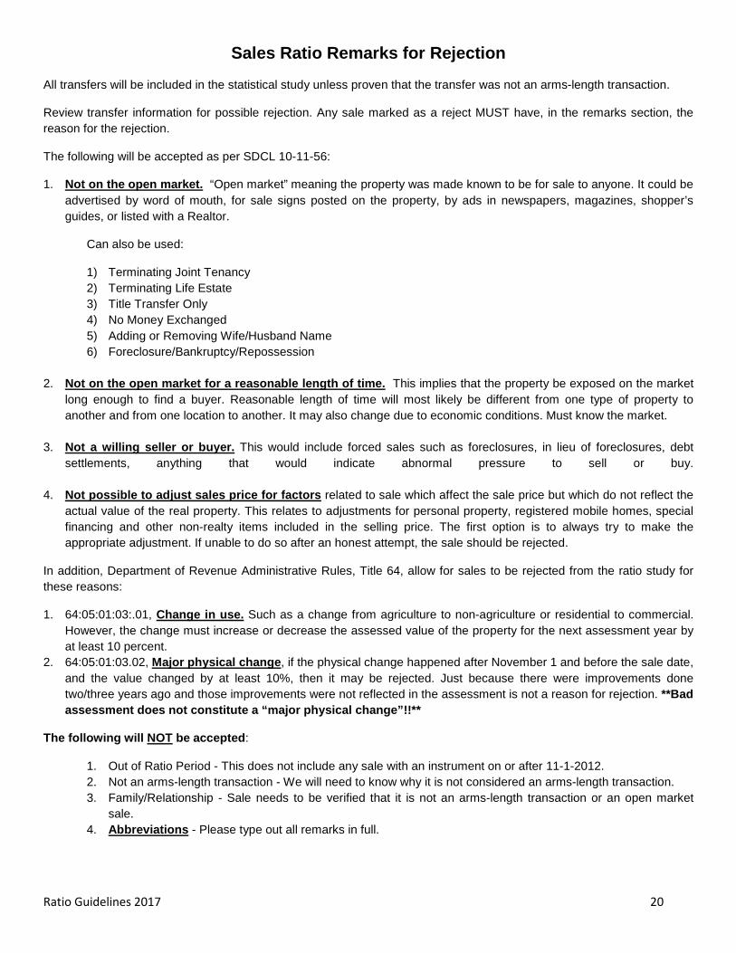
Sales Ratio Remarks for Rejection
All transfers will be included in the statistical study unless proven that the transfer was not an arms-length transaction.
Review transfer information for possible rejection. Any sale marked as a reject MUST have, in the remarks section, the reason for the rejection.
The following will be accepted as per SDCL 10-11-56:
1. Not on the open market. “Open market” meaning the property was made known to be for sale to anyone. It could be advertised by word of mouth, for sale signs posted on the property, by ads in newspapers, magazines, shopper’s guides, or listed with a Realtor.
Can also be used:
1) Terminating Joint Tenancy 2) Terminating Life Estate 3) Title Transfer Only 4) No Money Exchanged 5) Adding or Removing Wife/Husband Name 6) Foreclosure/Bankruptcy/Repossession
2. Not on the open market for a reasonable length of time. This implies that the property be exposed on the market
long enough to find a buyer. Reasonable length of time will most likely be different from one type of property to another and from one location to another. It may also change due to economic conditions. Must know the market.
3. Not a willing seller or buyer. This would include forced sales such as foreclosures, in lieu of foreclosures, debt settlements, anything that would indicate abnormal pressure to sell or buy.
4. Not possible to adjust sales price for factors related to sale which affect the sale price but which do not reflect the actual value of the real property. This relates to adjustments for personal property, registered mobile homes, special financing and other non-realty items included in the selling price. The first option is to always try to make the appropriate adjustment. If unable to do so after an honest attempt, the sale should be rejected.
In addition, Department of Revenue Administrative Rules, Title 64, allow for sales to be rejected from the ratio study for these reasons:
1. 64:05:01:03:.01, Change in use. Such as a change from agriculture to non-agriculture or residential to commercial. However, the change must increase or decrease the assessed value of the property for the next assessment year by at least 10 percent.
2. 64:05:01:03.02, Major physical change, if the physical change happened after November 1 and before the sale date, and the value changed by at least 10%, then it may be rejected. Just because there were improvements done two/three years ago and those improvements were not reflected in the assessment is not a reason for rejection. **Bad assessment does not constitute a “major physical change”!!**
The following will NOT be accepted:
1. Out of Ratio Period - This does not include any sale with an instrument on or after 11-1-2012. 2. Not an arms-length transaction - We will need to know why it is not considered an arms-length transaction. 3. Family/Relationship - Sale needs to be verified that it is not an arms-length transaction or an open market
sale. 4. Abbreviations - Please type out all remarks in full.
Ratio Guidelines 2017 21
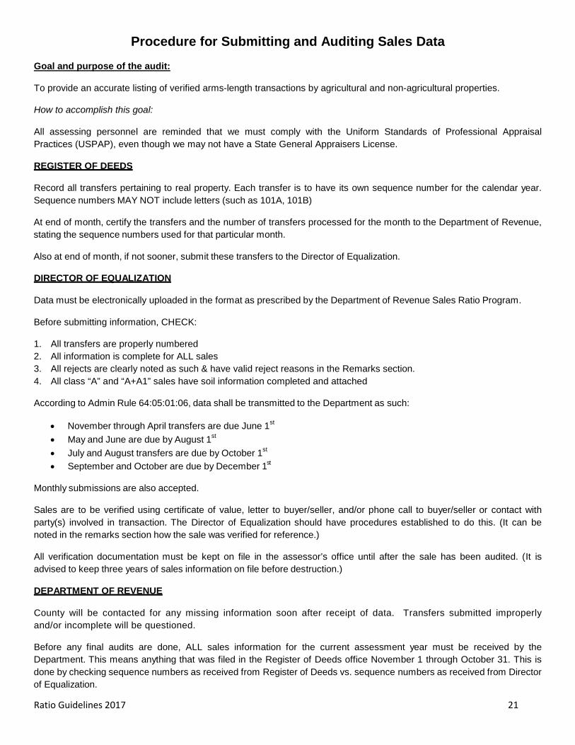
Procedure for Submitting and Auditing Sales Data
Goal and purpose of the audit:
To provide an accurate listing of verified arms-length transactions by agricultural and non-agricultural properties.
How to accomplish this goal:
All assessing personnel are reminded that we must comply with the Uniform Standards of Professional Appraisal Practices (USPAP), even though we may not have a State General Appraisers License.
REGISTER OF DEEDS
Record all transfers pertaining to real property. Each transfer is to have its own sequence number for the calendar year. Sequence numbers MAY NOT include letters (such as 101A, 101B)
At end of month, certify the transfers and the number of transfers processed for the month to the Department of Revenue, stating the sequence numbers used for that particular month.
Also at end of month, if not sooner, submit these transfers to the Director of Equalization.
DIRECTOR OF EQUALIZATION
Data must be electronically uploaded in the format as prescribed by the Department of Revenue Sales Ratio Program.
Before submitting information, CHECK:
1. All transfers are properly numbered 2. All information is complete for ALL sales 3. All rejects are clearly noted as such & have valid reject reasons in the Remarks section. 4. All class “A” and “A+A1” sales have soil information completed and attached
According to Admin Rule 64:05:01:06, data shall be transmitted to the Department as such:
• November through April transfers are due June 1st • May and June are due by August 1st • July and August transfers are due by October 1st • September and October are due by December 1st
Monthly submissions are also accepted.
Sales are to be verified using certificate of value, letter to buyer/seller, and/or phone call to buyer/seller or contact with party(s) involved in transaction. The Director of Equalization should have procedures established to do this. (It can be noted in the remarks section how the sale was verified for reference.)
All verification documentation must be kept on file in the assessor’s office until after the sale has been audited. (It is advised to keep three years of sales information on file before destruction.)
DEPARTMENT OF REVENUE
County will be contacted for any missing information soon after receipt of data. Transfers submitted improperly and/or incomplete will be questioned.
Before any final audits are done, ALL sales information for the current assessment year must be received by the Department. This means anything that was filed in the Register of Deeds office November 1 through October 31. This is done by checking sequence numbers as received from Register of Deeds vs. sequence numbers as received from Director of Equalization.
Ratio Guidelines 2017 22
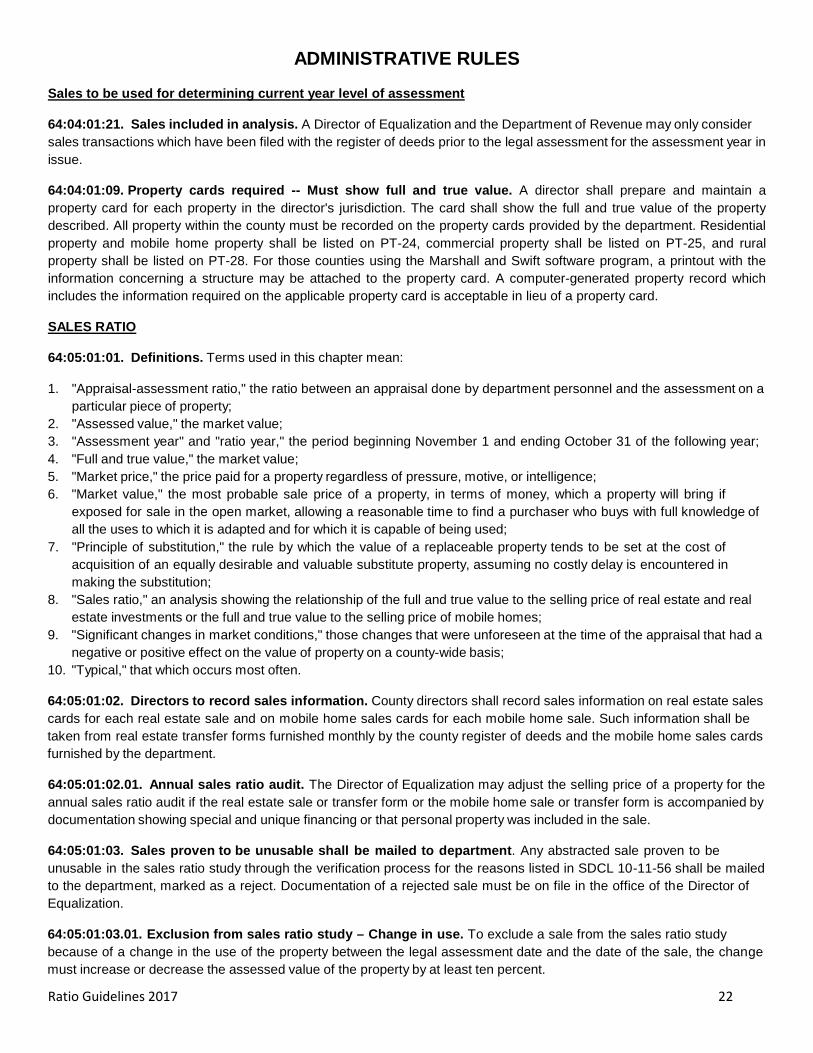
ADMINISTRATIVE RULES
Sales to be used for determining current year level of assessment
64:04:01:21. Sales included in analysis. A Director of Equalization and the Department of Revenue may only consider sales transactions which have been filed with the register of deeds prior to the legal assessment for the assessment year in issue.
64:04:01:09. Property cards required -- Must show full and true value. A director shall prepare and maintain a property card for each property in the director's jurisdiction. The card shall show the full and true value of the property described. All property within the county must be recorded on the property cards provided by the department. Residential property and mobile home property shall be listed on PT-24, commercial property shall be listed on PT-25, and rural property shall be listed on PT-28. For those counties using the Marshall and Swift software program, a printout with the information concerning a structure may be attached to the property card. A computer-generated property record which includes the information required on the applicable property card is acceptable in lieu of a property card.
SALES RATIO
64:05:01:01. Definitions. Terms used in this chapter mean:
1. "Appraisal-assessment ratio," the ratio between an appraisal done by department personnel and the assessment on a particular piece of property;
2. "Assessed value," the market value; 3. "Assessment year" and "ratio year," the period beginning November 1 and ending October 31 of the following year; 4. "Full and true value," the market value; 5. "Market price," the price paid for a property regardless of pressure, motive, or intelligence; 6. "Market value," the most probable sale price of a property, in terms of money, which a property will bring if
exposed for sale in the open market, allowing a reasonable time to find a purchaser who buys with full knowledge of all the uses to which it is adapted and for which it is capable of being used;
7. "Principle of substitution," the rule by which the value of a replaceable property tends to be set at the cost of acquisition of an equally desirable and valuable substitute property, assuming no costly delay is encountered in making the substitution;
8. "Sales ratio," an analysis showing the relationship of the full and true value to the selling price of real estate and real estate investments or the full and true value to the selling price of mobile homes;
9. "Significant changes in market conditions," those changes that were unforeseen at the time of the appraisal that had a negative or positive effect on the value of property on a county-wide basis;
10. "Typical," that which occurs most often.
64:05:01:02. Directors to record sales information. County directors shall record sales information on real estate sales cards for each real estate sale and on mobile home sales cards for each mobile home sale. Such information shall be taken from real estate transfer forms furnished monthly by the county register of deeds and the mobile home sales cards furnished by the department.
64:05:01:02.01. Annual sales ratio audit. The Director of Equalization may adjust the selling price of a property for the annual sales ratio audit if the real estate sale or transfer form or the mobile home sale or transfer form is accompanied by documentation showing special and unique financing or that personal property was included in the sale.
64:05:01:03. Sales proven to be unusable shall be mailed to department. Any abstracted sale proven to be unusable in the sales ratio study through the verification process for the reasons listed in SDCL 10-11-56 shall be mailed to the department, marked as a reject. Documentation of a rejected sale must be on file in the office of the Director of Equalization.
64:05:01:03.01. Exclusion from sales ratio study – Change in use. To exclude a sale from the sales ratio study because of a change in the use of the property between the legal assessment date and the date of the sale, the change must increase or decrease the assessed value of the property by at least ten percent.

Ratio Guidelines 2017 23
64:05:01:03.02. Exclusion from sales ratio study – Major physical change. To exclude a sale from the sales ratio study because of a major physical change in the property between the legal assessment date and the date of the sale, the change must increase or decrease the assessed value of the property by at least ten percent.
64:05:01:05. Real estate sales cards and mobile home sales cards to show assessed value. Real estate sales cards must show the assessed value of that property based on the assessment of the property for the assessment year in which the sale took place. Mobile home sales cards must show the assessed value of the mobile home based on the current year assessment prior to adjustments for late listing penalties or prorating.
For sales with instrument date of more than five years, and with verified selling price of more than one dollar and stated consideration of more than one dollar, the current year assessed value may be used, with the one dollar sale or current assessed value noted on the sales card information.
64:05:01:06. Time for filing. The Director of Equalization of each county shall verify real estate transfers and transmit the data to the department as follows:
Transfers Filed in Register of Deeds During Month of
Submit to Department of Revenue On or Before
November, December, January, February, March,
April June 1
May, June August 1
July, August October 1
September, October December 1
The Director of Equalization shall verify each transfer of any manufactured home and transmit the data to the department within 30 days after receipts of the transfer information.

Ratio Guidelines 2017 24
SALES RATIO STATUTES
10-11-54: Directors of equalization to report data on assessed valuation and sales to state department.
The Secretary of Revenue shall require all county Directors of Equalization to report to the Department of Revenue, data on assessed valuation and sales for such periods and in such form and content the Secretary of Revenue may require.
10-11-55: Annual studies by department of assessment to sales ratios.
The Secretary of Revenue annually shall prepare and publish comprehensive assessment to sales ratio studies of the average level of assessment, the degree of assessment uniformity, and the overall compliance with assessment requirements for each class of property in each county in the state.
10-11-56: Arms-length transactions included in departmental studies.
Any sale which has been verified to be an arms-length transaction shall be included in the annual study. For purposes of this section, the term, arms-length transaction, means the transfer of property offered on the open market for a reasonable period of time between a willing seller and a willing buyer with no coercion or advantage taken by either party. The Director of Equalization shall analyze each sale to eliminate factors related to the sale which affect the sale price but which do not reflect the actual value of the real property.
10-11-57: Assessed valuation used in application of studies to agricultural land.
In order to determine the ratio for agricultural land assessed pursuant to § 10-6-33.1, the Secretary of Revenue shall compare the assessed valuations on properties used for tax purposes in the year sold with the agricultural values of those properties as determined under §§ 10-6-33.1 and 10-6-33.2.
10-11-58: Computation of median level of assessment in each county.
In order to determine the average level of assessment in each county the Secretary of Revenue shall compute the median ratio. The median ratio is the middle value in the array of ratios of assessed valuations to sales, from the highest to the lowest for the current year and one year preceding the assessment year. If there are fewer than ten sales, medians may, in the case of agricultural land, be determined by bridging sales information from adjoining counties or in the case of nonagricultural land from other municipalities.
10-11-59: Computation of coefficient of dispersion for each county.
In order to determine the degree of assessment uniformity and compliance in the assessment of property within each county, the Secretary of Revenue shall compute the coefficient of dispersion. The coefficient of dispersion is the percentage which the average of the deviation of the assessment ratio of individual sale properties bears to their median ratio.
10-11-60: Publication of findings from assessment to sales ratio studies.
The Secretary of Revenue shall publish annually the findings of the assessment to sales ratio study along with whatever additional information he shall determine necessary to equalize and evaluate assessment of property in South Dakota.
10-11-65: Appeal from assessment to sales ratio studies.
Any person, firm, corporation, public or private, taxing district, or state department interested, may appeal from the assessment to sales ratio studies prepared by the Department of Revenue pursuant to § 10-11-55 to the Office of Hearing Examiners in the manner prescribed in chapter 10-11 for taking appeals from decisions of the county board of equalization.

Ratio Guidelines 2017 25
INUNDATED FARMLAND
10-6-33.21: Assessed value of inundated farmlands--Classification.
If an application is submitted pursuant to § 10-6-33.22, the Director of Equalization shall take into consideration and make adjustments in setting the assessed value for agricultural land which has been inundated by floods and is not farmable during the past three growing seasons. The Director of Equalization shall use the marshland soils rating classification pursuant to §§ 10-6-33.2 and 10-6-33.7 to determine the assessed value of the acreage inundated and not farmable.
10-6-33.22: Request for special assessment for inundated farmland--Time limit--Description of land.
If agricultural land has been inundated by floods and was not farmable during the past three growing seasons, any landowner or the landowner's agent or attorney may request the Director of Equalization to specially assess the land for the purpose of taxation by submitting an application before November first. The landowner or the landowner's agent or attorney shall describe on the application the portion of the agricultural land that has been inundated by floods and was not farmable during the past three growing seasons.
CERTIFICATE OF REAL ESTATE
7-9-7: Names, addresses, and descriptions required in recorded instruments--Certificate of value. No Register of Deeds may accept for record in the office of the Register of Deeds:
1. Any deed, affidavit terminating joint tenancy or life estate interests, or oil, gas, or other mineral lease that does not include the names of the grantor and the grantee or the lessor and the lessee, the names of the joint tenant, the post office address of the grantee or lessee, and a legal description of the property conveyed or leased;
2. Any mortgage that does not include the names of the mortgagor and the mortgagee, the post office address of the mortgagee, a legal description of the property, and the amount of the mortgage and when it is due;
3. Any assignment of mortgage or oil, gas, or other mineral lease that does not include the names of the assignor and the assignee, the post office address of the assignee, and a legal description of the property;
4. Any deed or contract for deed dated after July 1, 1988, used in the purchase, exchange, transfer, or assignment of interest in real property that is not accompanied by a certificate of value containing the name and address of the buyer and seller, the legal description of the real property, the actual consideration exchanged for the real property, the relationship of the seller and buyer, if any, and the terms of payment if other than payment in full at the time of sale; or
5. A transfer on death deed, pursuant to §§ 29A-6-401 to 29A-6-435, inclusive, is exempt from completing and submitting the certificate of value as set forth in subdivision (4) of this section.
EXEMPTIONS FROM TRANSFER FEE
43-4-22: Exemptions from real estate transfer fee. The fee imposed by § 43-4-21 does not apply to any transfer of title:
1. Recorded before July 1, 1968; 2. By or to the United States of America, this state, or any instrumentality, agency, or political subdivision of either; 3. Solely in order to provide for or to release security for a debt or obligation; 4. Which confirms or corrects a deed previously executed and recorded; 5. Between husband and wife, or parent and child with only nominal actual consideration therefor; 6. On sale for delinquent taxes or assessments, sheriffs' deeds, other deeds issued in foreclosure actions or proceedings
or deeds issued in lieu of foreclosure actions or proceedings; 7. On partition; 8. Pursuant to any mergers or consolidations of corporations or limited liability companies or plans of reorganization by
which substantially all of the assets of corporations or limited liability companies are transferred; 9. By a subsidiary corporation to its parent corporation for no consideration, nominal consideration, or in sole
consideration of the cancellation or surrender of the subsidiary's stock; 10. Pursuant to decrees of distribution entered in any decedent's estate; 11. Between an individual grantor, or grantors, and a corporation, where the grantor or grantors and the owner of the
majority of the capital stock of the corporation are the same person;

Ratio Guidelines 2017 26
12. Between any corporation and its stockholders or creditors, or between any limited liability company and its members or creditors, if to effectuate a dissolution of the corporation or limited liability company it is necessary to transfer the title of real property from the corporate entity to the stockholders or creditors;
13. On cemetery lots and grave sites; 14. Between an individual grantor, or grantors, and a limited or general partnership if the grantor or grantors and the owner
of the majority interest in the limited or general partnership are the same person; 15. Between a fiduciary and a beneficiary of the fiduciary or between a fiduciary and a third party, if the transfer or
conveyance is to accommodate the fiduciary relationship; 16. Between individuals, regardless of the relationship, if the conveyance is an absolute gift without consideration of any
kind in return for the conveyance; 17. Pursuant to a decree of divorce, annulment, or separate maintenance or pursuant to a settlement agreement approved
or adopted by a decree of divorce, annulment, or separate maintenance; 18. For which no consideration was given; 19. Between any Limited Liability Company and its members.

Ratio Guidelines 2017 27
DEFINITIONS
Of particular importance in any sales ratio study is a clear understanding of definitions used in the analysis. This is especially true for South Dakota because of the unique nature of some of its property tax laws.
Appraisal: An opinion by a qualified appraiser of the estimated value of real property. Elements of the analysis include: preliminary survey and planning; collection of data; application of cost, comparative sales, or income approaches; correlation and reconciliation of indicated values; and the final value.
Arm-length Transaction: A real estate sale between two unrelated, knowledgeable parties, neither of whom is under abnormal pressure from the other and each is attempting to maximize his gains.
Assessment Level: The level of assessment after application of any fractional assessment ratio, partial exemption, or other adjustment.
Assessment Uniformity: The degree to which properties within a specific class or county are assessed at equal percentages of market value. The most common measure of uniformity is the coefficient of dispersion.
Coefficient of Dispersion (COD): The average absolute deviation of all assessment/sales ratios from the chosen measure of central tendency expressed as a percentage of the measure of central tendency. The lower the coefficient of dispersion the more uniform the assessments are.
Coefficient of Variation (COV): The standard deviation expressed as a percentage of the mean.
Confidence Interval: The interval within which the population parameter (true median, mean, etc.) will be found in relation to the statistic from the sample data (the ratio study median, mean, etc.). This interval varies in relation to the confidence level desired, i.e. 90%, 95%, 99%, etc.
Confidence Level: The certainty that the statistician has in his confidence interval including the true parameter (true median, mean, etc.) of the whole population, i.e. all property in the county.
Date of sale: The data on which the real property sale was agreed to. The data of recording may be used as a proxy for the date of sale. (See Transaction Date)
Deed Recordation: The process of registering a real property sale with the county recorder’s office.
Dispersion: The degree to which data are distributed around a measure of central tendency. Measures of dispersion include the range, average deviation, standard deviation, coefficient of dispersion, and coefficient of variation.
Dollar – Weighted Mean (DW M): The measure of central tendency weighted by the dollar value of each entry. It is calculated by dividing the sum of all the adjusted assessments by the sum of all the adjusted sales prices.
Factoring: The process by which all assessments or a group of assessments are adjusted to meet the legal level of assessment. Factoring is considered appropriate when coefficients of dispersion are relatively low. The correct factor is calculated by dividing the target level of assessment by the current level of assessment.
Intangible Property: The non-physical evidence of ownership and of property rights such as patent rights, copyrights, notes, mortgages, deeds of trust, and stock certificates.
Mann-Whitney Test: A test that seeks to determine whether the differences in values between two sets of data from population are statistically significant.
Mean: The result of adding all the values and dividing by the number of values.
Measures of Central Tendency: Those statistics which measure the tendency of ratio data to center about a typical or central value. Measures of central tendency include the median, the mean, the mode, and the dollar-weighted mean.
Ratio Guidelines 2017 28
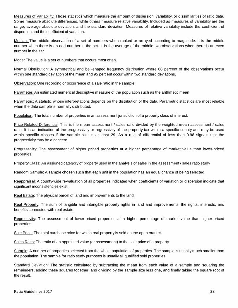
Measures of Variability: Those statistics which measure the amount of dispersion, variability, or dissimilarities of ratio data. Some measure absolute differences, while others measure relative variability. Included as measures of variability are the range, average absolute deviation, and the standard deviation. Measures of relative variability include the coefficient of dispersion and the coefficient of variation.
Median: The middle observation of a set of numbers when ranked or arrayed according to magnitude. It is the middle number when there is an odd number in the set. It Is the average of the middle two observations when there is an even number in the set.
Mode: The value is a set of numbers that occurs most often.
Normal Distribution: A symmetrical and bell-shaped frequency distribution where 68 percent of the observations occur within one standard deviation of the mean and 95 percent occur within two standard deviations.
Observation: One recording or occurrence of a sale ratio in the sample.
Parameter: An estimated numerical descriptive measure of the population such as the arithmetic mean
Parametric: A statistic whose interpretations depends on the distribution of the data. Parametric statistics are most reliable when the data sample is normally distributed.
Population: The total number of properties in an assessment jurisdiction of a property class of interest.
Price-Related Differential: This is the mean assessment / sales ratio divided by the weighted mean assessment / sales ratio. It is an indication of the progressivity or regressivity of the property tax within a specific county and may be used within specific classes if the sample size is at least 29. As a rule of differential of less than 0.98 signals that the progressivity may be a concern.
Progressivity: The assessment of higher priced properties at a higher percentage of market value than lower-priced properties.
Property Class: An assigned category of property used in the analysis of sales in the assessment / sales ratio study
Random Sample: A sample chosen such that each unit in the population has an equal chance of being selected.
Reappraisal: A county-wide re-valuation of all properties indicated when coefficients of variation or dispersion indicate that significant inconsistencies exist.
Real Estate: The physical parcel of land and improvements to the land.
Real Property: The sum of tangible and intangible property rights in land and improvements; the rights, interests, and benefits connected with real estate.
Regressivity: The assessment of lower-priced properties at a higher percentage of market value than higher-priced properties.
Sale Price: The total purchase price for which real property is sold on the open market.
Sales Ratio: The ratio of an appraised value (or assessment) to the sale price of a property.
Sample: A number of properties selected from the whole population of properties. The sample is usually much smaller than the population. The sample for ratio study purposes is usually all qualified sold properties.
Standard Deviation: The statistic calculated by subtracting the mean from each value of a sample and squaring the remainders, adding these squares together, and dividing by the sample size less one, and finally taking the square root of the result.

Ratio Guidelines 2017 29
Statistical Estimator: This estimates some characteristic of the sample drawn from the population for study. Parameters are used to estimate some characteristic about the population in general.
Statistics: Numerical descriptions calculated from a sample to estimate measures (parameters) for the population. Statistics include the mean, median, and the coefficient of dispersion.
Transaction Date: The date the real property transaction was agreed on, indicating that on that date it was worth the specified value.

Ratio Guidelines 2017 30
TYPES OF DEEDS AND PROPERTY INTERESTS
GENERAL DEFINTIONS - INTERESTS IN REAL ESTATE
The following are general definitions of instruments that are involved in real estate. For specific definitions, consult county’s state’s attorney.
Some of the definitions were taken from: Black’s Law Dictionary (5th ed. 1979)
CONTRACT - An agreement between two or more persons which creates an obligation to do or not to do a particular thing.
CONTRACT FOR DEED – An agreement by a seller to deliver the deed to a property when certain conditions have been met, such as completion of payments by purchaser.
CORPORATE DEED – A warranty or quit claim deed in the name of the corporation that is executed, and acknowledged on behalf of the corporation. The corporate seal is evidence that the officer was duly authorized to execute the deed.
CORRECTION DEED – A warranty or quit claim deed used to correct errors in the original deed.
HIGHW AY USE DEED – Used by governmental agencies to purchase right-of-way for roads and highways. The abutting owners may have reversionary rights upon vacating or abandonment of the property.
PATENT – The instrument by which a state or government grants public lands to an individual.
QUITCLAIM DEED – A deed intended to pass any title, interest, or claim which the grantor may have in the premises, but not professing that such title is valid, nor containing any warranty or covenants for title.
SHERIFF’S DEED – A document giving ownership rights in a property to a buyer at a sheriff’s sale, usually a mortgage foreclosure sale or a lien foreclosure sale.
SPECIAL WARRANTY DEED – A deed in which the grantor only covenants to warrant and defend the title against claims and demands of the grantor and all persons claiming by, through, and under him.
TAX DEED – A proof of ownership of land given to the purchaser by the government after the land has been taken from another person by the government and sold for failure to pay taxes.
TRANSFER OF DEATH DEED - Allows an owner of real property to execute a deed that names a beneficiary who will obtain title to the property at the owner’s death without going through probate. The transfer on death deed does not apply until all the owners have died. Owner can name alternate beneficiaries as well, in the event the beneficiary refuses the property or isn’t around to receive it. The deed can be revoked at any given time by requesting a revocation form or create a new transfer on death deed that replaces the original. The deed will include any mortgages, liens, etc. If money is owed or there is a contractor has a lien on it, the beneficiary will inherit those responsibilities along with the property.
TRUST DEED - A deed wherein legal title in real property is transferred to a trustee, which holds it as security for a loan (debt) between a borrower and lender.
TRUSTEE’S DEED – A warranty or quit claim deed in the name of the trust that is executed and acknowledged on behalf of the trust.
WARRANTY DEED –The grantor guarantees that the title being transferred is fee simple title, free from all encumbrances (except those specifically set forth in the document), and the grantor will defend the title. The deed will also include any interest that is subsequently acquired by the grantor.

Ratio Guidelines 2017 31
INVOLVING ESTATES OF DECEASED PERSONS, MINORS, OR INCOMPETENT PERSONS
ADMINISTRATOR’S / ADMINISTRATRIX’S DEED – A warranty or quit claim granted by person authorized by court to distribute and manage the estate. Administrators are now called Personal Representatives.
EXECUTOR’S / EXECUTRIX’S DEED – A court approved warranty or quit claim deed granted by the person who is appointed under a will to carry out the terms of the will. Executors are now called Personal Representatives.
FINAL DECREE – The final closing and distribution of an estate that is accomplished by an order of the court.
GUARDIAN’S DEED – A warranty or quitclaim deed executed by the guardian on behalf of the protected person. Guardians are appointed by the court to manage the affairs & properties of incompetents or minors.
PERSONAL REPRESENTATIVES’S DEED - A warranty or quit claim granted by person authorized by court to distribute and manage the estate.
PROBATE – All matters and proceedings pertaining to the administration of an estate.
TERMINATION OF JOINT TENANCY- Legal process of terminating a joint tenancy, i.e. transferring the property to the remaining joint tenant. Usually completed by an affidavit.
OTHER INSTRUMENTS OR ACTIONS
ABANDONMENT –Usually done during a bankruptcy – the relinquishing of all rights & interest in real property with no intention to reuse or reclaim.
CONDEMNATION – The act of the government and public utility companies to take private property for the public use and benefit, upon payment of just compensation.
COVENANT – An agreement by deed by which the parties pledge to do or not to do certain things.
EASEMENT – An agreement by which an interest is granted in real property giving the interest holder the right to use defined portions of another’s property for a specific use.
FORECLOSURE – The legal process terminating all rights of a mortgagor in the property covered by the mortgage. The property is sold to recover all or part of a loan.
LEASE – An agreement by which the rights of use and occupancy are transferred by the owner to another for a specified period of time for a specified rental. SDCL 43-32
PURCHASE OPTION - A right to purchase property at an agreed to price, on or before a specified date.
PURCHASE AGREEMENT – An offer to purchase a property.
VACATE – A formal governmental process, including public notice & hearings, by which the right of the general public are given up. To put an end to, as to vacate a street.

ZIP CODES FOR INCORPORATED CITIES
Ratio Guidelines 2017 32
COUNTY ZIP CODE MUNICIPALITIES COUNTY ZIP
CODE MUNICIPALITIES AURORA 368 PLANKINTON CHARLES MIX 329 DANTE 375 STICKNEY 342 GEDDES 383 WHITE LAKE 356 LAKE ANDES BEADLE 320 BROADLAND 367 PICKSTOWN 324 CAVOUR 369 PLATTE 348 HITCHCOCK 357 RAVINIA 350 HURON 380 WAGNER 353 IROQUOIS CLARK 217 BRADLEY BENNETT 379 VIRGIL 225 CLARK 381 WESSINGTON 236 GARDEN CITY 384 WOLSEY 254 NAPLES 386 YALE 258 RAYMOND BENNETT 551 MARTIN 271 VIENNA BON HOMME 315 AVON 278 WILLOW LAKE 059 SCOTLAND CLAY 037 IRENE 062 SPRINGFIELD 069 VERMILLION 063 TABOR 073 WAKONDA 066 TYNDALL 235 FLORENCE BROOKINGS 212 ARLINGTON CODINGTON 243 HENRY 002 AURORA 245 KRANZBURG 006 BROOKINGS 263 SOUTH SHORE 220 BRUCE 272 WALLACE 276 BUSHNELL VILLIAGE 201 WATERTOWN 026 ELKTON CORSON 641 MCINTOSH 061 SINAI 642 MCLAUGHLIN 071 VOLGA 645 MORRISTOWN 276 WHITE CUSTER 722 BUFFALO GAP BROWN 401 ABERDEEN 730 CUSTER 432 CLAREMONT 738 FAIRBURN 433 COLUMBIA 744 HERMOSA 441 FREDERICK 773 PRINGLE 445 GROTON DAVISON 334 ETHAN 446 HECLA 301 MITCHELL 474 STRATFORD 363 MOUNT VERNON 478 VERDON DAY 422 ANDOVER 479 WARNER 219 BRISTOL 481 WESTPORT 222 BUTLER BRULE 325 CHAMBERLAIN 239 GRENVILLE 355 KIMBALL 250 LILY 370 PUKWANA 468 PIERPONT BUTTE 717 BELLE FOURCHE 261 ROSLYN 742 FRUITDALE 273 WAUBAY 760 NEWELL 274 WEBSTER 762 NISLAND CAMPBELL 437 ARTAS 632 HERREID 646 MOUND CITY 648 POLLOCK

ZIP CODES FOR INCORPORATED CITIES
Ratio Guidelines 2017 33
COUNTY ZIP CODE MUNICIPALITIES COUNTY ZIP
CODE MUNICIPALITIES DEUEL 211 ALTAMONT HAMLIN 221 BRYANT 213 ASTORIA 223 CASTLEWOOD 218 BRANDT 234 ESTELLINE 226 CLEAR LAKE 241 HAYTI 237 GARY 242 HAZEL 238 GOODWIN 248 LAKE NORDEN 268 TORONTO HAND 362 MILLER DEWEY 625 EAGLE BUTTE 371 REE HEIGHTS 633 ISABEL 373 ST. LAWRENCE 656 TIMBER LAKE 381 WESSINGTON DOUGLAS 313 ARMOUR HANSON 311 ALEXANDRIA 328 CORSICA 332 EMERY 330 DELMONT 336 FARMER EDMUNDS 428 BOWDLE 340 FULTON 448 HOSMER HARDING 720 BUFFALO 451 IPSWICH 724 CAMP CROOK 471 ROSCOE HUGHES 522 BLUNT FALL RIVER 735 EDGEMONT 536 HARROLD 747 HOT SPRINGS 501 PIERRE 763 OELRICHS HUTCHINSON 331 DIMOCK FAULK 465 CHELSEA 029 FREEMAN 435 CRESBARD 045 MENNO 438 FAULKTON 052 OLIVET 466 ONAKA 366 PARKSTON 467 ORIENT 376 TRIPP 470 ROCKHAM HYDE 345 HIGHMORE 473 SENECA JACKSON 521 BELVIDERE GRANT 216 BIG STONE CITY 728 COTTONWOOD 246 LA BOLT 750 INTERIOR 251 MARVIN 543 KADOKA 252 MILBANK JERAULD 312 ALPENA 259 REVILLO 358 LANE 264 STOCKHOLM 382 WESSINGTON SPRINGS 265 STRANDBURG JONES 531 DRAPER 269 TWIN BROOKS 559 MURDO 317 BONESTEEL KINGSBURY 212 ARLINGTON GREGORY 523 BURKE 214 BADGER 529 DALLAS 353 BANCROFT 335 FAIRFAX 231 DE SMET 533 GREGORY 233 ERWIN 538 HERRICK 244 HETLAND 552 MIDLAND 353 IROQUOIS HAAKON 567 PHILIP 249 LAKE PRESTON 051 OLDHAM

ZIP CODES FOR INCORPORATED CITIES
Ratio Guidelines 2017 34
COUNTY ZIP CODE MUNICIPALITIES COUNTY ZIP
CODE MUNICIPALITIES LAKE 042 MADISON MINER 321 CANOVA 050 NUNDA 323 CARTHAGE 054 RAMONA 349 HOWARD 075 WENTWORTH 378 VILAS LAWRENCE 727 CENTRAL CITY MINNEHAHA 003 BALTIC 732 DEADWOOD 005 BRANDON 754 LEAD 018 COLTON 783 SPEARFISH 020 CROOKS 793 WHITEWOOD 022 DELL RAPIDS LINCOLN 004 BERESFORD 030 GARRETSON 013 CANTON 033 HARTFORD 027 FAIRVIEW 035 HUMBOLDT 032 HARRISBURG 060 SHERMAN 034 HUDSON 101 SIOUX FALLS 039 LENNOX 068 VALLEY SPRINGS 101 SIOUX FALLS MOODY 017 COLMAN 064 TEA 024 EGAN 077 WORTHING 028 FLANDREAU LYMAN 544 KENNEBEC 065 TRENT 365 OACOMA 074 WARD 568 PRESHO OGLALA LAKOTA 716 BATESLAND 569 RELIANCE PENNINGTON 719 BOX ELDER MARSHALL 430 BRITTON 745 HILL CITY 232 EDEN 751 KEYSTONE 247 LAKE CITY 761 NEW UNDERWOOD 454 LANGFORD 775 QUINN 270 VEBLEN 701 RAPID CITY MCCOOK 319 BRIDGEWATER 790 WALL 012 CANISTOTA 791 WASTA 048 MONTROSE PERKINS 620 BISON 058 SALEM 638 LEMMON 374 SPENCER POTTER 442 GETTYSBURG MCPHERSON 437 EUREKA 450 HOVEN 447 HILLSVIEW 455 LEBANON 456 LEOLA 475 TOLSTOY 457 LONG LAKE ROBERTS 224 CLAIRE CITY 482 WETONKA 227 CORONA MEADE 719 BOX ELDER 255 NEW EFFINGTON 626 FAITH 256 ORTLEY 769 PIEDMONT 257 PEEVER 785 STURGIS 260 ROSHOLT 718 SUMMERSET 262 SISSETON MELLETTE 579 WHITE RIVER 266 SUMMIT 585 WOOD 277 WHITE ROCK 279 WILMOT

ZIP CODES FOR INCORPORATED CITIES
Ratio Guidelines 2017 35
COUNTY ZIP CODE MUNICIPALITIES COUNTY ZIP
CODE MUNICIPALITIES
SANBORN 314 ARTESIAN WALWORTH 420 AKASKA 359 LETCHER 631 GLENHAM 385 WOONSOCKET 452 JAVA SPINK 424 ASHTON 458 LOWRY 429 BRENTFORD 601 MOBRIDGE 434 CONDE 472 SELBY 436 DOLAND YANKTON 031 GAYVILLE 440 FRANKFORT 037 IRENE 461 MELLETTE 040 LESTERVILLE 465 NORTHVILLE 046 MISSION HILL 469 REDFIELD 067 UTICA 476 TULARE 072 VOLIN 477 TURTON 078 YANKTON STANLEY 532 FORT PIERRE ZIEBACH 623 DUPREE SULLY 520 AGAR 625 EAGLE BUTTE 564 ONIDA TODD 555 MISSION 572 ST FRANCIS TRIPP 528 COLOME 580 WINNER 584 NEW WITTEN TURNER 014 CENTERVILLE 015 CHANCELLOR 021 DAVIS 319 DOLTON 036 HURLEY 037 IRENE 043 MARION 047 MONROE 053 PARKER 070 VIBORG UNION 001 ALCESTER 004 BERESFORD 025 ELK POINT 038 JEFFERSON 049 NORTH SIOUX CITY

SCHOOL DISTRICTS
Ratio Guidelines 2017 36
School Name District # School Name District # Aurora Buffalo Corsica – Stickney 21-3 Chamberlain 07-1 Kimball 07-2 Kimball 07-2 Mount Vernon 17-3 Miller Area 29-4 Plankinton 01-1 Wessington Springs 36-2 Platte – Geddes 11-5 Butte Wessington Springs 36-2 Belle Fourche 09-1 White Lake 01-3 Newell 09-2 Beadle Spearfish 40-2 Doland 56-2 Campbell Hitchcock – Tulare 56-6 Bowdle 22-1 Huron 02-2 Eureka 44-1 Iroquois 02-3 Herreid 10-1 Miller Area 29-4 Mobridge – Pollock 62-6 Wessington Springs 36-2 Selby Area 62-5 Willow Lake 12-3 Charles Mix Wolsey – Wessington 02-6 Andes Central 11-1 Bennett Armour 21-1 Bennett County 03-1 Avon 04-1 Bon Homme Platte – Geddes 11-5 Avon 04-1 Tripp – Delmont 33-5 Bon Homme 04-2 Wagner Community 11-4 Scotland 04-3 Clark Tripp – Delmont 33-5 Clark 12-2 Brookings De Smet 38-2 Arlington 38-1 Doland 56-2
Brookings 05-1 Groton Area 06-6 Deubrock Area 05-6 Hamlin 28-3 Elkton 05-3 Henry 14-2 Estelline 28-2 Webster Area 18-5 Sioux Valley 05-5 Willow Lake 12-3 Brown Clay Aberdeen 06-1 Beresford 61-2 Britton – Hecla 45-4 Centerville 60-1 Frederick Area 06-2 Gayville – Volin 63-1 Groton Area 06-6 Irene – Wakonda 13-3 Langford Area 45-5 Vermillion 13-1 Northwestern Area 56-7 Viborg – Hurley 60-6 Warner 06-5 Codington Brule Castlewood 28-1 Chamberlain 07-1 Deuel 19-4 Kimball 07-2 Florence 14-1 Platte – Geddes 11-5 Grant – Deuel 25-3 Wessington Springs 36-2 Hamlin 28-3 White Lake 01-3 Henry 14-2 Watertown 14-4 Waverly 14-5 Webster Area 18-5
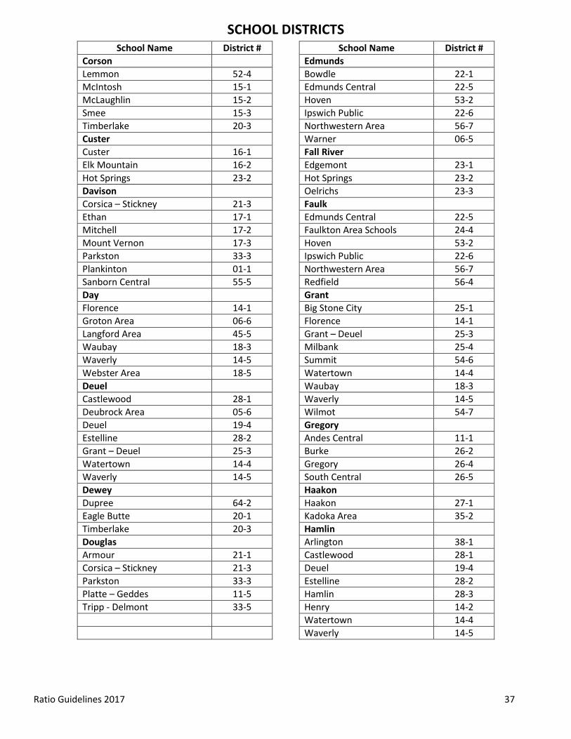
SCHOOL DISTRICTS
Ratio Guidelines 2017 37
School Name District # School Name District # Corson Edmunds Lemmon 52-4 Bowdle 22-1 McIntosh 15-1 Edmunds Central 22-5 McLaughlin 15-2 Hoven 53-2 Smee 15-3 Ipswich Public 22-6 Timberlake 20-3 Northwestern Area 56-7 Custer Warner 06-5 Custer 16-1 Fall River Elk Mountain 16-2 Edgemont 23-1 Hot Springs 23-2 Hot Springs 23-2 Davison Oelrichs 23-3 Corsica – Stickney 21-3 Faulk Ethan 17-1 Edmunds Central 22-5 Mitchell 17-2 Faulkton Area Schools 24-4 Mount Vernon 17-3 Hoven 53-2 Parkston 33-3 Ipswich Public 22-6 Plankinton 01-1 Northwestern Area 56-7 Sanborn Central 55-5 Redfield 56-4 Day Grant Florence 14-1 Big Stone City 25-1 Groton Area 06-6 Florence 14-1 Langford Area 45-5 Grant – Deuel 25-3 Waubay 18-3 Milbank 25-4 Waverly 14-5 Summit 54-6 Webster Area 18-5 Watertown 14-4 Deuel Waubay 18-3 Castlewood 28-1 Waverly 14-5 Deubrock Area 05-6 Wilmot 54-7 Deuel 19-4 Gregory Estelline 28-2 Andes Central 11-1 Grant – Deuel 25-3 Burke 26-2 Watertown 14-4 Gregory 26-4 Waverly 14-5 South Central 26-5 Dewey Haakon Dupree 64-2 Haakon 27-1 Eagle Butte 20-1 Kadoka Area 35-2 Timberlake 20-3 Hamlin Douglas Arlington 38-1 Armour 21-1 Castlewood 28-1 Corsica – Stickney 21-3 Deuel 19-4 Parkston 33-3 Estelline 28-2 Platte – Geddes 11-5 Hamlin 28-3 Tripp - Delmont 33-5 Henry 14-2 Watertown 14-4 Waverly 14-5

Schoo
SCHOOL DISTRICTS
Ratio Guidelines 2017 38
School Name District # School Name District # Hand Kingsbury Faulkton Area Schools 24-4 Arlington 38-1 Hitchcock – Tulare 56-6 De Smet 38-2 Miller Area 29-4 Hamlin 28-3 Redfield 56-4 Howard 48-3 Wolsey – Wessington 02-6 Iroquois 02-3 Hanson Lake Preston 38-3 Bridgewater – Emery 30-3 Oldham – Ramona 39-5 Ethan 17-1 Willow Lake 12-3 Hanson 30-1 Lake Howard 48-3 Chester Area 39-1 Mitchell 17-2 Colman – Egan 50-5 Parkston 33-3 Madison Central 39-2 Harding McCook Central 43-7 Harding County 31-1 Oldham – Ramona 39-5 Hughes Rutland 39-4 Agar – Blunt – Onida 58-3 Sioux Valley 05-5 Highmore – Harrold 34-2 Lawrence Pierre 32-2 Belle Fourche 09-1 Hutchinson Lead – Deadwood 40-1 Bridgewater – Emery 30-3 Meade 46-1 Ethan 17-1 Spearfish 40-2 Freeman 33-1 Lincoln Menno 33-2 Alcester – Hudson 61-1 Parkston 33-3 Beresford 61-2 Scotland 04-3 Canton 41-1 Tripp – Delmont 33-5 Centerville 60-1 Hyde Harrisburg 41-2 Faulkton Area Schools 24-4 Lennox 41-4 Highmore – Harrold 34-2 Sioux Falls 49-5 Miller Area 29-4 Tea Area 41-5 Jackson Lyman Haakon 27-1 Chamberlain 07-1 Kadoka Area 35-2 Gregory 26-4 Jerauld Lyman 42-1 Huron 02-2 Winner 59-2 Kimball 07-2 Marshall Wessington Springs 36-2 Britton – Hecla 45-4 Woonsocket 55-4 Groton Area 06-6 Jones Langford Area 45-5 Jones County 37-3 Sisseton Public 54-2 Kadoka Area 35-2 Webster Area 18-5

SCHOOL DISTRICTS
Ratio Guidelines 2017 39
School Name District # School Name District # McCook Moody Bridgewater – Emery 30-3 Brookings 05-1 Canistota 43-1 Chester Area 39-1 Chester Area 39-1 Colman – Egan 50-5 Freeman 33-1 Dell Rapids 49-3 Howard 48-3 Elkton 05-3 Madison Central 39-2 Flandreau 50-3 Marion 60-3 Rutland 39-4 McCook Central 43-7 Sioux Valley 05-5 Montrose 43-2 Oglala Lakota Parker 60-4 Oglala Lakota County 65-1 West Central 49-7 Pennington McPherson Custer 16-1 Edmunds Central 22-5 Douglas 51-1 Eureka 44-1 Hill City 51-2 Leola 44-2 New Underwood 51-3 Meade Rapid City 51-4 Douglas 51-1 Wall 51-5 Faith 46-2 Perkins Meade 46-1 Bison 52-1 New Underwood 51-3 Faith 46-2 Newell 09-2 Lemmon 52-4 Rapid City 51-4 Potter Wall 51-5 Faulkton Area Schools 24-4 Mellette Gettysburg 53-1 Colome Consolidated 59-3 Hoven 53-2 Jones County 37-3 Roberts Winner 47-1 Big Stone City 25-1 Miner Milbank 25-4 Hanson 30-1 Rosholt 54-4 Howard 48-3 Sisseton Public 54-2 McCook Central 43-7 Summit 54-6 Oldham – Ramona 39-5 Waubay 18-3 Sanborn Central 55-5 Wilmot 54-7 Minnehaha Sanborn Baltic 49-1 Huron 02-2 Brandon Valley 49-2 Mount Vernon 17-3 Canton 41-1 Sanborn Central 55-5 Chester Area 39-1 Wessington Springs 36-2 Dell Rapids 49-3 Woonsocket 55-4 Garretson 49-4 Spink Harrisburg 41-2 Clark 12-2 Lennox 41-4 Doland 56-2 Montrose 43-2 Groton Area 06-6 Parker 60-4 Hitchcock – Tulare 56-6 Sioux Falls 49-5 Northwestern Area 56-7 Tea Area 41-5 Redfield 56-4 Tri-Valley 49-6 Warner 06-5 West Central 49-7 Willow lake 12-3
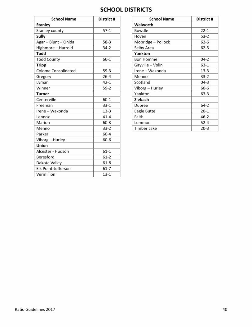
SCHOOL DISTRICTS
Ratio Guidelines 2017 40
School Name District # School Name District #
Stanley Walworth Stanley county 57-1 Bowdle 22-1 Sully Hoven 53-2 Agar – Blunt – Onida 58-3 Mobridge – Pollock 62-6 Highmore – Harrold 34-2 Selby Area 62-5 Todd Yankton Todd County 66-1 Bon Homme 04-2 Tripp Gayville – Volin 63-1 Colome Consolidated 59-3 Irene – Wakonda 13-3 Gregory 26-4 Menno 33-2 Lyman 42-1 Scotland 04-3 Winner 59-2 Viborg – Hurley 60-6 Turner Yankton 63-3 Centerville 60-1 Ziebach Freeman 33-1 Dupree 64-2 Irene – Wakonda 13-3 Eagle Butte 20-1 Lennox 41-4 Faith 46-2 Marion 60-3 Lemmon 52-4 Menno 33-2 Timber Lake 20-3 Parker 60-4 Viborg – Hurley 60-6 Union Alcester - Hudson 61-1 Beresford 61-2 Dakota Valley 61-8 Elk Point-Jefferson 61-7 Vermillion 13-1