salisbury beach state reservation - mass.gov · salisbury beach is a complex barrier beach system,...
TRANSCRIPT

i
SALISBURY BEACH STATE RESERVATION BARRIER BEACH MANAGEMENT PLAN EXECUTIVE OFFICE OF ENERGY & ENVIRONMENTAL AFFAIRS DEPARTMENT OF CONSERVATION & RECREATION
September 2008

SALIBURY BEACH STATE RESERVATION BARRIER BEACH MANAGEMENT PLAN
TABLE OF CONTENTS
PAGE I. PURPOSE OF THE PLAN 1 II. BACKGROUND 3
A. General 3 B. History of Salisbury Beach 3 C. Description of Salisbury Beach State Reservation 5
1. Recreational Opportunities 2. Natural Resources
D. Improvements at Salisbury Beach Reservation 8 1. Recreational Improvements 2. Natural Resources
E. Department of Conservation and Recreation 9 F. Geological History and Processes 10
III. ENVIRONMENTAL REGULATIONS 12
A. MA Wetlands Protection Act (MGL c. 131 s.40) 12 B. Additional Regulations 12
1. State 2. Federal
IV. BEACH MANAGEMENT AREAS 14
A. Beach Management Area 1 – Reservation 14 B. Beach Management Area 2 – Residential 14 C. Beach Management Area 3 – Beach Center 16
V. PUBLIC USE, ACCESS AND SAFETY 17
A. Public Use 17 1. Facilities 2. Beach and Dune Areas 3. Public Use Beach Permits
B. Public Access 19 1. General 2. Pedestrian Access 3. Maintenance of Public Access Ways 4. Vehicular Access 5. Beach Access Authorization
C. Public Safety 27 1. Lifeguards
ii

2. Emergency Response 3. Beach Patrols 4. Bathing Beach Water Quality
D. Public Access Ways and Facility Management Recommendations 31
VI. RESOURCE AREA MANAGEMENT AND PROTECTION 36 A. General Description 36 B. Barrier Beach (310 CMR 10.29) 36
1. Definition 2. Functions 3. Critical Characteristics 4. Performance Standards
C. Coastal Beach (310 CMR 10.27) 37 1. Definition 2. Functions 3. Critical Characteristics 4. Performance Standards 5. Existing Conditions of Coastal Beach 6. Coastal Beach Management and Protection
a. Debris and Trash Removal b. Beach Grooming c. Beach Maintenance d. Beach Nourishment
D. Coastal Dunes (310 CMR 10.28) 41 1. Definition 2. Functions 3. Critical Characteristics 4. Performance Standards 5. Existing Conditions of Coastal Dune 6. Coastal Dune Management and Protection
a. Control of Pedestrian Access b. Dune Maintenance c. Dune Nourishment
7. Dune Crossing Design Standards E. Salt Marsh (310 CMR 10.32) 48
1. Definition 2. Functions 3. Critical Characteristic 4. Performance Standards 5. Existing Conditions of Salt Marsh 6. Salt Marsh Management and Protection
F. Land Subject to Coastal Storm Flowage (310 CMR 10.04) 49 1. Definition 2. Functions 3. Critical Characteristics 4. Performance Standards
iii

5. Existing Conditions of LSCSF 6. LSCSF Management and Protection
G. Riverfront Area (310 CMR 10.58) 51 1. Definition 2. Applicability to Salisbury Beach State Reservation
H. Resource Area Management Recommendations 51
VII. RARE SPECIES AND WILDLIFE MANAGEMENT 54 A. Rare Species Protection and Habitat Management 54 B. Wildlife Management 56 C. Rare Species and Wildlife Habitat Management Recommendations 57
VIII. STORM-RELATED MAINTENANCE AND DAMAGE PROTECTION 61 A. General 61 B. Debris Removal 61 C. Access Way Repair 61 D. Storm-Related Beach and Dune Maintenance 62 E. Storm-Related Maintenance and Damage Management 62
Recommendations
IX. PUBLIC OUTREACH 64 A. General 64 B. Outreach Recommendations 65
X. LITERATURE CITED 66
TABLES Table 1 Existing Equipment and Typical Uses Table 2 Existing Public Access Ways within BMA 1 (Ocean) Table 3 Existing Public Access Ways within BMA 2 Table 4 Existing Public Access Ways within BMA 3 FIGURES Figure 1 Aerial Image of Salisbury Beach State Reservation Figure 2 DCR Recreational Facilities Figure 3 Beach Management Areas Figure 4A Pedestrian & Vehicular Access BMA 1 – Reservation (Ocean) Figure 4B Pedestrian & Vehicular Access BMA 2 – Residential (South) Figure 4C Pedestrian & Vehicular Access BMA 2 – Residential (North) Figure 4D Pedestrian & Vehicular Access BMA 3 – Beach Center Figure 5A Lifeguard Post Location BMA 1 –Reservation (Ocean) Figure 5B Lifeguard Post Location BMA 3 – Beach Center Figure 6 Proposed Sand Stockpile Area (SSA) BMA 1–Reservation (Ocean) Figure 7A Dune Restoration Areas BMA 2 – Residential (South) Figure 7B Dune Restoration Areas BMA 3 – Beach Center Figure 8 Shorebird Nesting Areas BMA 1 – Reservation (Ocean & River)
iv
APPENDICES APPENDIX A Applicable Laws and Regulations APPENDIX B Executive Order No. 181 regarding Barrier Beaches APPENDIX C Executive Order 149 regarding Flood Insurance Coordination APPENDIX D Beach Access Authorization Form APPENDIX E Resource Protection Partners APPENDIX F DCR Guide to Dune Stabilization APPENDIX G Salisbury Beach Dune Walkover Access Design Standards APPENDIX H Dune Crossing Authorization Tracking Sheet APPENDIX I FIRM Maps APPENDIX J NHESP and USFWS Guidelines for Managing Recreational Use of
Beaches to Protect Piping Plovers, Terns, and their Habitats in Massachusetts
APPENDIX K Piping Plover Nesting Locations APPENDIX L DCR and Other Official Vehicle Use on the Beach APPENDIX M Sample Sand Specification for Off-site Material APPENDIX N Photographs APPENDIX O Order of Conditions – 2008 Salisbury Beach State Reservation
Barrier Beach Management Plan
v
ACRONYMS AND ABBREVIATIONS ADA Americans with Disabilities Act A-Zone Special Flood Hazard Area BMA Beach Management Area CHC Coastal Hazards Commission CMR Code of Massachusetts Regulations CZM Massachusetts Office of Coastal Zone Management DAR Massachusetts Department of Agricultural Resources DCR Massachusetts Department of Conservation and Recreation DEM Massachusetts Department of Environmental Management (now DCR) DFW Massachusetts Division of Fisheries and Wildlife DFG Massachusetts Department of Fish and Game EOEEA Massachusetts Executive Office of Energy and Environmental Affairs FEMA Federal Emergency Management Agency FIRM Flood Insurance Rate Map GIS Geographic Information System LSCSF Land Subject to Coastal Storm Flowage LSZ Land Stewardship Zone MassDEP Massachusetts Department of Environmental Protection MassDPW Massachusetts Department of Public Works MassGIS Massachusetts Office of Geographic and Environmental Information MBBTF Massachusetts Barrier Beach Task Force MESA Massachusetts Endangered Species Act MDC Metropolitan District Commission (now DCR) MDPH Massachusetts Department of Public Health MEMA Massachusetts Emergency Management Agency MEPA Massachusetts Environmental Policy Act MGL Massachusetts General Law NHESP Natural Heritage and Endangered Species Program NOI Notice of Intent OFBA Office of Fishing and Boating Access OLE Massachusetts Office of Law Enforcement RUP Recreational Use Permit SSA Sand Stockpile Area SCC Salisbury Conservation Commission SUP Special Use Permit USACE United States Army Corps of Engineers USFWS United States Fish & Wildlife Service USGS United States Geological Survey V-Zone Velocity Zone: Coastal High Hazard Area WPA Massachusetts Wetland Protection Act
vi

Salisbury Beach State Reservation Page 1 Barrier Beach Management Plan September 2008
I. PURPOSE OF THE PLAN Salisbury Beach State Reservation (Reservation), located in Salisbury, Massachusetts, is concentrated near the southern end of Salisbury Beach, which extends 3.8 miles from south to north along the Atlantic Ocean from the Merrimack River to the New Hampshire border. This entire length of shoreline consists of a high-quality sandy beach. The Reservation, which is owned by the Commonwealth of Massachusetts and managed by the Department of Conservation and Recreation (DCR), provides a number of recreational opportunities to the public, including swimming, fishing, camping and boating. Along with 3.8 miles of beach, the Reservation also contains vast areas of coastal dunes and salt marsh located behind the barrier beach. These coastal resource areas are all located within a complex barrier beach system. Because the Reservation is within a highly dynamic and sensitive ecosystem and there is such a great desire for public use, DCR is challenged with finding and maintaining a balance between providing safe and enjoyable recreational opportunities to its visitors, while protecting the barrier beach system, which includes fragile coastal dunes, beach, rare species and wildlife habitat. In Massachusetts, a barrier beach is a resource area provided protection under the Massachusetts Wetlands Protection Act (WPA), Massachusetts General Law (MGL) c. 131 s. 40 and its implementing regulations, 310 Code of Massachusetts Regulations (CMR) 10.00. By definition, a barrier beach consists of two additional protected resource areas, Coastal Dune and Coastal Beach. As such, all activities that occur on a barrier beach fall under jurisdiction of the WPA. An Emergency Order of Conditions was recently issued by the Salisbury Conservation Commission (SCC) to allow for dune restoration, repair to public access ways and beach clean-up caused by storm damage resulting from the April 15th, 2007 Nor’easter. As part of this Emergency Order, DCR is required to file an updated Barrier Beach Management Plan to address short and long term protection measures for the Reservation and barrier beach system. Once finalized, this barrier beach plan will be submitted as part of a new NOI to the SCC with copies also being submitted to the Massachusetts Department of Environmental Protection (MassDEP) and the Division of Fisheries and Wildlife (DFW) Natural Heritage & Endangered Species Program (NHESP). The SCC and other regulators will review both the current and future management activities described in the plan in regards to meeting the performance standards of the WPA. In addition to the SSC condition for DCR to prepare a updated barrier beach management plan, Executive Order 181 (issued in 1980) dictates that management plans for State-owned beach property shall be prepared and be consistent with state wetland policy. The purpose of the Salisbury Beach State Reservation Barrier Beach Management Plan presented herein is to identify issues pertaining to existing resource areas and to establish guidelines for coastal resource protection through appropriate management practices, in
order to establish a framework in which DCR can conduct sustainable recreation planning, facility improvements and maintenance activities. The primary goal for developing a beach management plan is to allow for the public to pursue recreational opportunities and environmental education in a safe and enjoyable environment, while instituting protection of the existing dune and beach system and other important ecological features which are an integral part of these coastal resources located within the Reservation.
Salisbury Beach State Reservation Page 2 Barrier Beach Management Plan
September 2008

II. BACKGROUND A. General Salisbury Beach is a complex barrier beach system, comprised of coastal beach, coastal dunes and salt marsh. Within the Salisbury Beach barrier beach system is the Salisbury Beach State Reservation, which is managed by DCR. The Salisbury Beach State Reservation is concentrated at the southern end of Salisbury Beach adjacent to the Merrimack River, and extends in a northerly direction along 3.8 miles of the Atlantic Ocean to the New Hampshire border as shown in Figure 1. The Merrimack River enters the Atlantic Ocean at the southern end of Salisbury Beach, and the western sector of the Reservation is bordered by adjacent areas of salt marsh. This extensive barrier beach system plays a critical role in the protection of the Merrimack River estuary, along with associated salt marsh habitat, dune preservation, and habitat for threatened and endangered species and other wildlife. The section presented herein describes the history of Salisbury Beach and the Reservation, as well as the management of the Reservation, including the geological history and processes that formed Salisbury Beach which continue to play an important role in the management of this dynamic system. B. History of Salisbury Beach Prior to settlement by the English colonists, members of the Pawtucket Indian group inhabited coastal areas of Massachusetts Bay from the Saugus /Salem, Massachusetts area to York Village, Maine. This group is locally referred to as the Pentuckets. These Native Americans subsisted primarily on shellfish, and supplemented their diet with wild game and a variety of both wild and domesticated plants. They hunted both wetland and upland game birds and fished shad, salmon and trout along the Merrimack River, which was their summer fishing ground (MHC 1997). Signs of the early inhabitants have been found mostly along the Merrimack River. Thirteen shell mounds have been discovered along the bank of the river. In addition, in 1868, Jeffries Wyman reported discovering large collections of Indian arrowheads and implements on the beach, approximately one mile from the left bank of the Merrimack (Wyman, 1868). In addition to these artifacts, local historians have re-traced a number of Indian trails along and in close proximity to Salisbury Beach, as well as inland. These trails include what are now Ferry Road and Seabrook Road. This trail later developed into a Colonial route that linked coastal areas to the north (New Hampshire) with the Merrimack River. Elm Street was likely as western-running trail (MHC, 1997). Water travel was also
Salisbury Beach State Reservation Page 3 Barrier Beach Management Plan
September 2008

Insert Figure 1
Salisbury Beach State Reservation Page 4 Barrier Beach Management Plan
September 2008

extremely important throughout the coastal area. Numerous creeks and coastal rivers such as the Merrimack River provided transportation routes to the coast. In September 1638, Simon Bradstreet, Christopher Batt and ten other proprietors received permission from the General Court of the Massachusetts Bay Colony “to begin a plantation at Merrimac”, north of the Merrimack River. Bradstreet and Batt had explored the area in August 1638, rowing across the Merrimack River from Newbury and up Town Creek. Nearby they found a broad open space on high ground previously cleared by Indians. European diseases spread by fishermen had already decimated the local Pentucket Indian tribe and left the land open for settlement. The proprietors laid out the town around this open space which today is known as “Town Green”. Initially, the Town of Salisbury included areas as far north as Hampton, New Hampshire and extended into the wilderness. Bradstreet and the proprietors recruited settlers for the new plantation, first named Colchester, by offering grants of land which included the Towns of Amesbury and Merrimack, Massachusetts as well as the New Hampshire towns of Seabrook, South Hampton, Newton, Hampstead, Plaistow and Kingston. The first settlers arrived in 1639. In 1640, the town was renamed “Salisbury” after Batt’s hometown in England. Haverhill Massachusetts was established in the same year and became the western boundary of the Town of Salisbury. The primary access to the settlement of Salisbury was via the Merrimack River to a dock at Town Creek near Mudnock Road. In 1644, George Carr established a ferry across the Merrimack at Carr’s Island. In 1645, Beach Road (Route 1A) was established and provided an access way to the beach. In 1649, a vote at Town Meeting ordered that all meadow on the north side of the Merrimack River should be reserved as common land. A proclamation read: “a beach common running from the Merrimac River’s mouth including all meadow and marsh not disposed of should remain a town common, forever.” However, this resolution did not last as the salt hay produced in the salt marsh was valuable as fodder and bedding for livestock, and the marsh was eventually divided into hundreds of private lots. C. Description of Salisbury Beach State Reservation
1. Recreational Opportunities The Salisbury Beach State Reservation contains 521 acres, including 3.8 miles of ocean beach and one mile of river beach. All of the 3.8 miles of ocean shoreline along Salisbury Beach is high quality sandy beach which is available to the public for strolling, swimming and other water-related activities. The Reservation also includes an area of beach along the Merrimack River which is used primarily for boating, fishing, strolling and dog walking. Because the Merrimack River currents are very strong and boat activity is high, swimming with in the river area of the Reservation is
Salisbury Beach State Reservation Page 5 Barrier Beach Management Plan
September 2008
prohibited. Waterfowl hunting is also allowed at the Reservation within the marshes along Black Rock Creek. The Salisbury Beach State Reservation is the most used camping area within Massachusetts. It is also one of the most popular sites for beach use, swimming, boating and fishing. On an annual basis, the Reservation generates over $500,000 in day-use revenues and over $850,000 in camping revenues. The Reservation has an annual attendance rate of over one million visitors. A total of eighteen (18) public access ways are currently maintained by DCR and provide access to the ocean side beach. At the most southern end of the Reservation are several facilities and associated amenities which DCR currently owns, operates and maintains. These facilities include several public bath houses and campground comfort stations, shade shelters, playground and picnic areas, parking lots, staff headquarters and a new Lifeguard Command Center which was completed in 2008. There are currently 484 campsites available on the west side of the Reservation. Boat access is provided to Black Rock Creek and the Merrimack River at the most westerly end of the campground. At this location, there are two concrete boat ramps and a parking area capable of holding up to 60 vehicles and trailers. These ramps provide water access for canoes, kayaks, powerboats and sailing craft. The larger of the two ramps is maintained by the Massachusetts Department of Fisheries and Wildlife (DFW) Office of Fishing and Boating Access (OFBA), formerly the Public Access Board (PAB) and includes seasonal docks. This ramp and dock system was constructed by OFBA in 1995. The small boat ramp was also constructed by OFBA in 1963. Although the small ramp is still in use, it is no longer maintained by OFBA. DCR presently manages both ramps and the parking lot which are open year round. The boat ramp facility experiences heaviest use from spring through fall. All DCR managed recreational facilities and amenities are shown in Figure 2. Photographs of many of these facilities and amenities are presented in Appendix N (see Photographs N-1 through N-17). Details pertaining to the management of facilities are presented in Section V, Public Use, Access and Safety.
2. Natural Resources Salisbury Beach contains many important natural resources that DCR strives to not only protect, but to enhance. These areas include the Coastal Beach, Coastal Dune, Salt Marsh and important wildlife and rare species habitat. The natural resource areas are protected under many different laws and regulations and are discussed in greater detail in later sections of this plan. It is the combination of natural resources and public facilities and amenities at the Salisbury Beach State Reservation that makes it one of the most attractive and popular recreational areas in the Commonwealth.
Salisbury Beach State Reservation Page 6 Barrier Beach Management Plan
September 2008

Insert Figure 2
Salisbury Beach State Reservation Page 7 Barrier Beach Management Plan
September 2008
D. Improvements at Salisbury Beach State Reservation
1. Recreational Improvements Prior to 1969, the Reservation was owned and maintained by the Massachusetts Department of Public Works (MassDPW). During that period, MassDPW developed much of the day use areas and camping facilities, including the administration and first aid buildings, the pavilion bath house and changing rooms and a parking area which accommodated up to 3,500 vehicles. In 1969, the State Legislature transferred care and control of the Reservation to DCR. DCR implemented major renovations to campground comfort stations in 1996, making the camping experience at the facility much more attractive to visitors. In addition, three new comfort stations were built by DCR for the convenience of beach goers. These elevated buildings, are located behind the primary dune on existing pavement areas and utilize alternative waste disposal technology that eliminates potential threats to this sensitive area. With the construction of new buildings, shaded picnic areas and landscape improvements, the number of available parking spaces was decreased to 1,500, minimizing the impacts to adjacent beach and dune areas. A total of $2.5 million was expended by DCR for these improvements, thereby representing the Commonwealth’s deep commitment to quality public recreation, resource conservation and community investment. Some other noticeable improvements that were implemented by DCR include the addition of the four elevated dune crossings which include two shade shelters. These access ways safely lead beach goers over environmentally sensitive dune areas. A new playground and picnic area was also created providing an exciting attraction for campers and beach visitors alike. This area was designed as an alternative to the traditional activities at the park, for gatherings and outdoor activities. Improvements also included the construction of a new park entrance building for campers and day use patrons. In 2006, DCR moved forward with the demolition of the former Pavilion building which was located at the southern end of the Reservation and southeast of the DCR Headquarters’ Building in order to make way for the construction of the much smaller lifeguard command center within the same general location. Construction of this new facility was completed in 2008 (see Photograph N-7, Appendix N). This project also will include the restoration of the primary dunes located seaward of the old Pavilion building. The amount of impervious area, in the form of roadways, parking areas, pathways and foundations, will also be decreased, and many of these areas will be re-planted with American beach grass (Ammophila breviligulata). In addition, a new shade shelter has been constructed to the southeast of the new Lifeguard Command Center (see Photograph N-9, Appendix N). This new shade shelter replaces the shade function which was formerly provided at the old Pavilion building.
Salisbury Beach State Reservation Page 8 Barrier Beach Management Plan
September 2008

2. Natural Resources
In addition to the recreational improvements noted above, DCR has restored dune areas (including dune crossings) along the beach. Just south of the Beach Center a sacrificial dune was constructed after the “No Name” storm of 1991, with funds provided by FEMA. In 2000, DCR demolished the building which existed at 9 South Ocean Front (also known as the “Frolics”) located in the Beach Center area of Salisbury Beach. A sacrificial dune was constructed and planted with beach grass within the former building footprint, to restore dune function including the protection against storm and flood damage. In the spring of 2007, another sacrificial dune was constructed between Access #1 and Access #2 as emergency response to the significant loss of primary dune in this area following the April 15th Nor’easter (see Photograph N-13, Appendix N). This storm also resulted in the repair to damaged dune crossings (access ways) located along the 3.8 miles of the beach which included the trucking in and placement of approximately 5,000 cubic yards of sand at Access #4. The Master Plan and GOALS Plan which was developed for the Reservation in the late 1980s states that Dune Restoration should be actively pursued through installation of snow fencing, revegetation and proper control of pedestrian and vehicular traffic (DEM, 1988; DEM, 1989). DCR currently stabilizes beach and dune areas with the installation of snow fence and dune grass plantings. These efforts continue to be implemented. These methods have proven effective, and DCR will continue to make this an annual program.
E. Department of Conservation and Recreation DCR is within the Executive Office of Energy and Environmental Affairs (EOEEA), which has four state agencies organized under it, each with a Commissioner who reports to the Secretary of Energy and Environmental Affairs. DCR consists of three operational Divisions: the Division of State Parks and Recreation; the Division of Urban Parks and Recreation; and the Division of Water Supply Protection. Policy and programmatic support for all operating divisions is provided by five bureaus: Recreation; Ranger Services; Forest Fire Control and Forestry; Special Services and Events; and the Universal Access Office. DCR’s primary mission and legal mandate is the protection of the Commonwealth’s natural and cultural resources and the provision of high quality recreational opportunities. DCR is committed to preserving the natural resources of the coastal environment while providing public access and recreation by following the requirements of the Massachusetts WPA and its implementing regulations (310 CMR 10.00), Executive Order 181 pertaining to Barrier Beaches (1980), and policies described in DCR’s Ocean Beach Restoration Initiative (1988) and the Executive Office of Environmental Affairs’
Salisbury Beach State Reservation Page 9 Barrier Beach Management Plan
September 2008

Guidelines for Barrier Beach Management (1994). DCR works extensively with other state agencies, including MassDEP, the Massachusetts Office of Coastal Zone Management (CZM), NHESP, DFW along with the SCC and other local interest groups, including the Salisbury Beach Betterment Association and the Massachusetts Beach Buggy Association, to meet these goals. F. Geological History and Processes Salisbury Beach is a barrier beach that is separated from the mainland by a large salt marsh which contains several tidal creeks. The physical area known as Salisbury Beach was created by the reworking of sediments deposited by glaciers as they melted and receded to the north 15,000 to 18,000 years ago. As it receded, the glacier left bedrock outcroppings which are present in small areas at the southern part of the Reservation, near the mouth of the Merrimack River. The source of the sand at the beach was historically a paleodelta deposited offshore as the glacier receded. The development of barrier beach/dune systems began approximately 6,300 years Before Present (B.P.). As previously described, prior to 10,500 B.P., the region was under an ice age load which caused a general subsidence. During the waning of the glacier, first the sea level rose significantly above coastal lowlands, and then the land rebounded and became elevated higher than average sea levels. As the sea rose, it eroded glacial deposits offshore which formed the foundation of a barrier beach/dune system. This underlying foundation consists of glacio-marine clay which is located at depths of 40 feet or more. Sand and gravel carried along the shore by waves and currents subsequently accumulated on top of the clay to form a spit. The area between the spit and the mainland was mostly open water. Over time, sea level rose and the spit continued to enlarge and migrate westward. The protected bay behind the spit filled in with sand, became shallow and developed into a salt marsh. Beaches are always in a state a flux. Climate, the intensity of the winds and currents, storms, available sediment supply and land-use determine the profile of the beach. The sand that accumulates on beaches comes from northern mountain boulders (often transported by rivers) which were finely ground first through years of glaciation and later by erosion as a result of storms and frost. The littoral current which runs from north to south during north/northeast winds transports sand down the coastline. This current is powerful, and the undertows and rip currents act like huge conveyer belts carrying sand southward to replenish beaches further down the coastline. If the littoral current is obstructed by structures such as jetties and groins, the beach will balloon out to the north of the obstruction “damming up” the littoral drift which would have replenished the beach to the south. Similarly, transport of sand in the onshore or offshore direction (cross-shore transport) results in an adjustment of the beach toward an equilibrium profile. The major source of cross-shore sediment transport comes from the paleodelta located offshore of the Merrimack River. High waves and water levels during storms
Salisbury Beach State Reservation Page 10 Barrier Beach Management Plan
September 2008
result in accelerated and modified longshore and cross-shore sediment (sand) transport processes. Not only do dunes protect inland areas but they supply sand to the adjacent beach system, thereby increasing its ability to dissipate storm waves. By absorbing much of the force of the waves, dunes provide protection to landward areas from storm damage and flooding. A healthy barrier beach system contains primary dunes and secondary dunes. If the sand dunes at Salisbury Beach were free from human interference, predictable geological processes would occur. High energy storm waves attack the beach and dune face. Sand is transported in an offshore direction to build sandbars. The decreased depth of the offshore area causes waves to break further offshore and away from the dune face. Less energetic waves, consequently, directly hit the beach and dunes. Vegetation on the dunes provide stability through its root system that holds the sand in place and by trapping windborne sand particles blown from the dry portion of the beach, increasing the volume of sand in the dune. The sand dunes at Salisbury Beach are moving westward with a motion similar to that of a bulldozer tread: a rolling, “going over itself” motion. Some natural factors, such as rising sea level, make this process inevitable, while others, such as littoral drift and dune vegetation, make it a relatively slow process. Storms can create changes very quickly. However, human activities also accelerate this process. People, with their desire to visit or live on the beach, often destroy the very resource that attracts them and the resources that provide storm buffering and flooding protection. A jetty located north of the Reservation in Hampton, New Hampshire, currently interrupts the flow of sand onto the northern section of Salisbury Beach. The beach is steeper south of this barrier. The jetty along the northern shore of the Merrimack River, provides protection to the navigation channel into and out of the Merrimack River and obstructs the flow of sand to the south towards Plum Island. Beaches typically migrate landward due in large part to reduced sediment supply and rising sea levels. The rate of relative sea level rise is currently about one foot per 100 years; however, the Intergovernmental Panel on Climate Change (IPCC) predicts that sea-level rise and its risk to coastal resources will accelerate over the next 100 years. Conservative projections of sea-level rise by the end of the century range from 4 to 21 inches, while projections given a higher emissions scenario range from 8 to 33 inches (CHC, 2007). Given on-going coastal issues and climate change, land mass forms in this dynamic system will constantly change over periods of time.
Salisbury Beach State Reservation Page 11 Barrier Beach Management Plan
September 2008
III. ENVIRONMENTAL REGULATIONS Numerous local, state and federal statutes and regulations exist to protect barrier beaches and regulate activities within these areas. The following is a listing of the most significant environmental statutes and regulations that apply to activities at Salisbury Beach and the Reservation, presented in accordance with the regulatory agency that oversees them. A. MA Wetlands Protection Act (MGL c. 131. s. 40) The WPA and its implementing regulations (310 CMR 10.00), are the most significant laws and regulations in terms of use and applicability for the protection of important natural resource areas found on barrier beaches and the activities which occur in these areas. Salisbury Beach consists of coastal wetland environments that are subject to the jurisdiction of the WPA and its implementing regulations. The SCC is the regulatory body responsible for the implementation of the WPA. Their jurisdiction encompasses any activity proposed or undertaken within a wetland resource area or within 100 feet of a wetland resource that will remove, fill, dredge or alter a resource area. The SCC consists of a seven member board appointed by the Town Board of Selectmen. The Salisbury Conservation Agent serves as staff of the SCC and provides the day-to-day administration of the wetland regulations. B. Additional Regulations Other state and federal laws and regulations may also apply to proposed work within the barrier beach. In addition, several regulations exist that dictate what activities are allowed on DCR property and Salisbury Beach, and they are also listed below. A more comprehensive list of environmental and other pertinent laws and regulations is found in Appendices A through C.
1. State Department of Environmental Protection (MassDEP) Wetlands Protection Program
• Massachusetts Wetlands Protection Act (overview and appeal authority of Conservation Commission decisions); administered by and with an initial filing with the SCC.
DCR, Division of State Parks and Recreation
• Forest and Park Rules (304 CMR 12.00)
Salisbury Beach State Reservation Page 12 Barrier Beach Management Plan
September 2008
MA Division of Fisheries and Wildlife, Natural Heritage & Endangered Species Program
• Massachusetts Endangered Species Act (MGL c.131A) and regulations (321 CMR 10.00)
• Executive Office of Energy and Environmental Affairs
• Massachusetts Environmental Policy Act (MEPA) (MGL c. 30 s.61-62H) and regulations (301 CMR 11.00)
• Coastal Zone Management Act (MGL c.21As.4A) and regulations (301 CMR 20.00)
2. Federal
U.S. Fish & Wildlife Service (USFWS) • Federal Endangered Species Act (16 U.S.C. 1451, et. seq.)
U.S. Army Corps of Engineers (USACE)
• Clean Water Act, Section 404 (33 U.S.C. 1251, et. seq.) • Rivers and Harbors Act of 1899 (33 U.S.C. 401, et. seq.)
Coastal Barrier Resources Act (16 U.S.C. 1451, et. seq.) National Flood Insurance Act (42 U.S.C. 4001, et. seq.) Americans with Disabilities Act (42 U.S.C. 12101, et. seq.)
Salisbury Beach State Reservation Page 13 Barrier Beach Management Plan
September 2008

IV. BEACH MANAGEMENT AREAS DCR owns and is responsible for management of the 3.8 miles of beach along the Atlantic Ocean and one mile of beach along the Merrimack River within the Reservation. Management activities and strategies may differ with respect to area. However, certain principles and practices exist that apply to all DCR-owned and managed property and are designed to meet all applicable environmental regulations. For the purposes of this barrier beach management plan, Salisbury Beach has been divided into three separate Beach Management Areas (BMAs) which have been created based upon similarities in management strategies. The limits of the 3 BMAs are shown in Figure 3 and described in further detail below. A. Beach Management Area 1 - Reservation BMA 1 consists of the Salisbury Beach State Reservation “Proper”. BMA 1 has been separated into two distinct sub-areas: BMA 1 (Ocean) and BMA 1 (River). Both of these sub-areas exist within the Reservation, therefore certain rules, regulations, and management strategies apply to these areas equally. However, because there is a marked difference in the environment and use along the ocean side and river side of the Reservation, each have their own set of unique management protocols and sanctioned activities. The ocean and river BMA 1 sub-areas are further described as follows:
BMA 1 (Ocean): extends from the jetty at the Federal Entrance Channel to the Merrimack River northward to the southern boundary of the first house lot at 203 Atlantic Avenue, just north of Access #1. This area includes the beach along the Atlantic Ocean side of the Reservation, and its associated appurtenances, including parking areas, comfort stations, shade shelters and a first-aid station.
BMA 1 (River): extends from the jetty at the Federal Entrance Channel westward along the Merrimack River to just beyond the public boat ramp. This area includes the beach along the Merrimack River, two boat ramps and the salt marsh adjacent to the river.
B. Beach Management Area 2 - Residential BMA 2 consists of the residential areas located along the ocean side of Salisbury Beach. This BMA is separated into two (2) sections: BMA 2 (South) and BMA 2 (North). BMA 2 (South) extends from the southern boundary of the first house lot at 203 Atlantic Avenue just north of Access #1 northward to Access #4 at Vermont Street. BMA 2 (North) extends from Access #5 Passageway/Central Avenue and extends northward to the New Hampshire Border.
Salisbury Beach State Reservation Page 14 Barrier Beach Management Plan
September 2008

Insert Figure 3
Salisbury Beach State Reservation Page 15 Barrier Beach Management Plan
September 2008

C. Beach Management Area 3 - Beach Center BMA 3 consists of the commercial area located along the ocean side of Salisbury Beach known as Beach Center. This BMA stretches from Access #4 at Vermont Street northward to Access #5 Passageway/Central Avenue.
Salisbury Beach State Reservation Page 16 Barrier Beach Management Plan
September 2008
V. PUBLIC USE, ACCESS AND SAFETY While recreational use is heaviest within the most southern side of the Reservation (“Reservation Proper”), public use of Salisbury Beach occurs throughout all 3 BMAs. The current activities associated with public use, access and safety are described in detail below. A. Public Use
1. Facilities BMA 1 (Ocean) includes existing DCR facilities which are utilized for visitor services, park administration and maintenance. The old Pavilion facility, which was constructed during the 1950’s, was recently demolished in the Spring 2006 and is currently being replaced with a new smaller facility for first aid and lifeguards. Construction of this facility was completed in 2008. Composting bath houses, comfort stations, picnic areas, shade shelters and parking areas are also located with BMA 1 (Ocean). BMA 1 (River) includes 484 campground sites and two public access boat ramps and parking area. A concrete seawall supported on a stone mound revetment provides shoreline stabilization between the campground and Merrimack River beach. Any proposed construction projects on the barrier beach will need to comply with the requirements of the Massachusetts WPA and its implementing regulations. This is also true for any residences or private commercial buildings in BMAs 2 and 3. In addition, any new structure or rebuilding of existing structures in any Flood Hazard Areas (including A-Zones), Coastal High-Hazard Areas (including Velocity Zones (V-Zones), and Coastal Dunes shall comply with the State Building Code (780 CMR, including Section 5323 and Appendix 120.G), which imposes special restrictions on the placement and construction of structures within these areas. These restrictions include that structures in Coastal High Hazard Areas be elevated on adequately anchored pilings or columns, so that the lowest portion of the structure is elevated at least 2 feet above the base flood elevation. The newly revised State Building Code (effective January 1, 2008) also regulates “Windborne Debris Protection” (780 CMR 5301). The WPA and State Building Code will help insure that buildings are constructed adequately above surrounding dune elevations to limit collateral storm damage by minimizing storm debris, allow dune migration, erosion of dunes during storms and other beneficial functions described above. As of February 2008, the newly revised Seventh Edition of the State Building Code only applies to one- and two-family dwellings, but should fully encompass all structures by September 2008. Routine maintenance activities associated with the DCR facilities at the Reservation include:
Salisbury Beach State Reservation Page 17 Barrier Beach Management Plan
September 2008

• Maintenance and repair of existing composting buildings, access roads, parking lots, boat ramps and seawall structure;
• Debris and trash removal from containers located in the parking areas,
next to the food concession, shade shelters and comfort stations; and
• Monitoring of water usage at composing toilets and the discharge of grey water.
2. Beach and Dune Areas Beach areas are utilized by visitors primarily for strolling, swimming and sun bathing. Access across the dunes to get to the beach is restricted to designated public access ways which are located along the 3.8 miles of beach and described in detail below in Section B (Public Access). Routine beach and dune maintenance is presently conducted by DCR staff on a regular basis within all BMAs. The details pertaining to management of beach and dune areas, including routine maintenance activities, is presented in Subsections C.6 (Coastal Beach Management and Protection) and D.6 (Coastal Dune Management and Protection). DCR has several different types of equipment that are used specifically for various beach maintenance activities throughout the Reservation. A summary of existing beach equipment and description of its typical use is presented in Table 1 below.
Table 1: Existing Beach Equipment and Typical Uses No.
DCR- Owned Vehicles
Vehicle Type Typical Uses
1 Toro Dingo – Compact, walk behind utility vehicle with rubber tracks
General sweeping of windblown sand along walkways and adjacent parking lot areas.
1 4-wheel drive, ¾ –ton Pick-up Truck Lifeguard emergency response.
2 Light-weight, 4-wheel drive (1)-person All-Terrain Vehicle s (ATVs) Beach patrol; emergency response.
1 Small light-weight 4-wheel drive (2)-person UTV (Gator) Beach patrol; emergency response.
2 1-ton, 4-wheel drive Dump Truck with specialized, low pressurized tires
Follows Barber Surf Rake for debris pick-up and disposal.
1 Barber Surf Rake (or “Sweeper”) Clearing of debris off beach; leveling of public access ways for placement of on-grade mats in Spring.
1 Trojan Front-end Loader
Removal of large debris only, including but not limited to, lobster traps, logs, ropes, etc. Emergency response to stranded boats or unauthorized vehicles on the beach.
1 1-ton pick-up with plow Snow removal; beach maintenance
1 ¾-ton Crew Cab Transportation of beach management team and equipment.
Salisbury Beach State Reservation Page 18 Barrier Beach Management Plan
September 2008

Further description of the specific use(s) of equipment is also provided in the Section VI, Resource Area Management and Protection. DCR field staff will annually review all equipment and make recommendations to the Commissioner or his designee as what should be replaced or upgraded. Currently, DCR has generated a new equipment request list that includes a new front-end loader and Barber surf rake for DCR staff and a 1-ton dump truck.
3. Public Use Beach Permits DCR requires that a permit be obtained for various types of public uses along the beach itself. These permits include: Recreation Use Permit: A Recreational Use Permit (RUP) is required for any private activities, such as parties, that are proposed to occur on the beach that abide by Park policies (i.e. no alcohol, etc.). This permit may be obtained from the DCR headquarters located at the Reservation. Special Use Permit: A Special Use Permit (SUP) is required for proposed functions that include activities which are not within normal park rules (including prohibition of alcohol). This permit must be obtained from the DCR office located in Boston. Weddings and organized festivals are included under this permit category.
B. Public Access
1. General DCR presently maintains 18 public access ways cross over existing dunes and lead to the beach within BMAs 1 (Ocean only), 2 and 3. While DCR owns Salisbury Beach down to the low water mark, not all of the existing access ways are actual property of the Commonwealth. Several of the access ways are privately owned or owned by the Town of Salisbury but include deeded rights for public access. DCR continues to research and identify the ownership of several access ways which are unknown at this time. Of the 18 public access ways maintained by DCR and located within the Reservation, Parking Access #’s 1, 2 and 4 and Access #’s 2, 3, 7, 11, 12, and 13 are ADA (American with Disabilities Act) accessible. Several of these access ways allow for beach access by both emergency and maintenance vehicles. DCR also has beach wheelchairs available to the general public for use at any of the public access ways that are accessible. Existing public access ways consist of elevated timber boardwalks, on-grade timber boardwalks or natural sand pathways (see Photographs N-10 through N-12, Appendix N).
2. Pedestrian Access Over the years, DCR has focused on intentionally directing pedestrian access over the existing dunes and onto the beach at specific areas, as opposed to past practices of
Salisbury Beach State Reservation Page 19 Barrier Beach Management Plan
September 2008
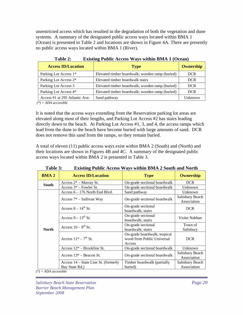
unrestricted access which has resulted in the degradation of both the vegetation and dune systems. A summary of the designated public access ways located within BMA 1 (Ocean) is presented in Table 2 and locations are shown in Figure 4A. There are presently no public access ways located within BMA 1 (River).
Table 2: Existing Public Access Ways within BMA 1 (Ocean) Access ID/Location Type Ownership
Parking Lot Access 1* Elevated timber boardwalk; wooden ramp (buried) DCR Parking Lot Access 2* Elevated timber boardwalk stairs DCR Parking Lot Access 3 Elevated timber boardwalk; wooden ramp (buried) DCR Parking Lot Access 4* Elevated timber boardwalk; wooden ramp (buried) DCR Access #1 at 295 Atlantic Ave. Sand pathway Unknown
(*) = ADA accessible It is noted that the access ways extending from the Reservation parking lot areas are elevated along most of their lengths, and Parking Lot Access #2 has stairs leading directly down to the beach. At Parking Lot Access #1, 3, and 4, the access ramps which lead from the dune to the beach have become buried with large amounts of sand. DCR does not remove this sand from the ramps, so they remain buried. A total of eleven (11) public access ways exist within BMA 2 (South) and (North) and their locations are shown in Figures 4B and 4C. A summary of the designated public access ways located within BMA 2 is presented in Table 3.
Table 3: Existing Public Access Ways within BMA 2 South and North
BMA 2 Access ID/Location Type Ownership Access 2* – Murray St. On-grade sectional boardwalk DCR South Access 3* – Fowler St. On-grade sectional boardwalk Unknown Access 6 – 176 North End Blvd. Sand pathway Unknown
Access 7* – Sullivan Way On-grade sectional boardwalk Salisbury Beach Association
Access 8 – 14th St. On-grade sectional boardwalk; stairs DCR
Access 9 – 13th St. On-grade sectional boardwalk; stairs Violet Nabhan
Access 10 – 9th St. On-grade sectional boardwalk; stairs
Town of Salisbury
Access 11* – 7th St. On-grade boardwalk; tropical wood from Public Universal Access
DCR
Access 12* – Brookline St. On-grade sectional boardwalk Unknown
Access 13* – Beacon St. On-grade sectional boardwalk Salisbury Beach Association
North
Access 14 – State Line St. (formerly Bay State Rd.)
Timber boardwalk (partially buried)
Salisbury Beach Association
(*) = ADA accessible
Salisbury Beach State Reservation Page 20 Barrier Beach Management Plan
September 2008

Insert Figure 4A
Salisbury Beach State Reservation Page 21 Barrier Beach Management Plan
September 2008

Insert Figure 4B
Salisbury Beach State Reservation Page 22 Barrier Beach Management Plan
September 2008

Insert Figure 4C
Salisbury Beach State Reservation Page 23 Barrier Beach Management Plan
September 2008
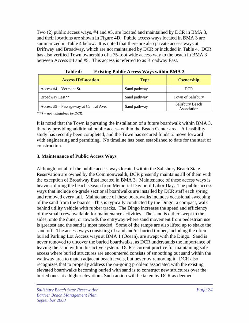
Two (2) public access ways, #4 and #5, are located and maintained by DCR in BMA 3, and their locations are shown in Figure 4D. Public access ways located in BMA 3 are summarized in Table 4 below. It is noted that there are also private access ways at Driftway and Broadway, which are not maintained by DCR or included in Table 4. DCR has also verified Town ownership of a 75-foot wide access way to the beach in BMA 3 between Access #4 and #5. This access is referred to as Broadway East.
Table 4: Existing Public Access Ways within BMA 3
Access ID/Location Type Ownership
Access #4 – Vermont St. Sand pathway DCR
Broadway East** Sand pathway Town of Salisbury
Access #5 – Passageway at Central Ave. Sand pathway Salisbury Beach Association
(**) = not maintained by DCR. It is noted that the Town is pursuing the installation of a future boardwalk within BMA 3, thereby providing additional public access within the Beach Center area. A feasibility study has recently been completed, and the Town has secured funds to move forward with engineering and permitting. No timeline has been established to date for the start of construction.
3. Maintenance of Public Access Ways Although not all of the public access ways located within the Salisbury Beach State Reservation are owned by the Commonwealth, DCR presently maintains all of them with the exception of Broadway East located in BMA 3. Maintenance of these access ways is heaviest during the beach season from Memorial Day until Labor Day. The public access ways that include on-grade sectional boardwalks are installed by DCR staff each spring and removed every fall. Maintenance of these boardwalks includes occasional sweeping of the sand from the boards. This is typically conducted by the Dingo, a compact, walk behind utility vehicle with rubber tracks. The Dingo increases the speed and efficiency of the small crew available for maintenance activities. The sand is either swept to the sides, onto the dune, or towards the entryway where sand movement from pedestrian use is greatest and the sand is most needed. Some of the ramps are also lifted up to shake the sand off. The access ways consisting of sand and/or buried timber, including the often buried Parking Lot Access ways at BMA 1 (Ocean), are swept with the Dingo. Sand is never removed to uncover the buried boardwalks, as DCR understands the importance of leaving the sand within this active system. DCR’s current practice for maintaining safe access where buried structures are encountered consists of smoothing out sand within the walkway area to match adjacent beach levels, but never by removing it. DCR also recognizes that to properly address the on-going problem associated with the existing elevated boardwalks becoming buried with sand is to construct new structures over the buried ones at a higher elevation. Such action will be taken by DCR as deemed
Salisbury Beach State Reservation Page 24 Barrier Beach Management Plan
September 2008

Insert Figure 4D
Salisbury Beach State Reservation Page 25 Barrier Beach Management Plan
September 2008
appropriate in the future. In addition to the elevated boardwalk structures, DCR also has purchased and installed several beach mats that are put down during the recreational season and removed during the off-season. These mat systems are located primarily in BMA 3. DCR is careful not to modify existing grade elevations so as not to create a pathway that will encourage high velocity waves to travel up and cause erosion of the beach/dunes during a storm event when performing maintenance at all of the existing public access ways. DCR installs and maintains snow fence at all access ways, with the exception of Access #5 (Passageway/Central Ave.) and Broadway East which are both located in BMA 3. In response to a request from the Town of Salisbury, there is presently no snow fence installed at Access #5. Access signs are posted at each end of every access way, and are replaced as necessary. In 2005, DCR placed orange barrel markers at Access #1 through #14 to assist the public in being able to visually locate these dune crossings and to further encourage their use. DCR will be installing 6 to 8-foot high permanent marker poles at each public access location in the Fall of 2008 to further enhance the ability to locate points of public and emergency access.
4. Vehicular Access Vehicular access to the beach is allowed within all of the BMAs, however only by those that are authorized. Vehicles authorized to use existing access ways include those used for emergency response, patrols and beach maintenance. Emergency vehicles that use these access ways include a 4-wheel drive, 3/4-ton Pick-up truck designed for beach use. Patrol vehicles include a light-weight 4-wheel drive, 1-person all-terrain vehicle (ATV); a small light-weight, 4-wheel drive 2-person UTV (Gator), and a 1-ton, 4-wheel drive dump truck with deflated tires. Maintenance vehicles include the Gator, dump truck, and a 4-wheel drive John Deer tractor with a Barber surf rake (Sweeper). Vehicular access is available at Parking Lot Access #’s 1 and 4 (behind DCR headquarters building) and at Access #’s 2 through 5, 7, and 11 through 13. These access ways are used typically by the emergency and patrol vehicles. Maintenance vehicles use Access #4, #5, #11, and #12. There is also an access available in New Hampshire for authorized Salisbury Beach State Reservation vehicles and at the private access ways located in BMA 3 at Driftway and Broadway. The Broadway access is the one that is most often used. Vehicular access locations within BMAs are shown in Figures 4A through 4D.
5. Beach Access Authorization Any private work that includes unavoidable access to the beach requires Beach Access Authorization. This authorization is granted by DCR once permission for the work has been obtained from the SCC. The application for Beach Access Authorization must include suggested dates, times, description of work, type of equipment used on the beach
Salisbury Beach State Reservation Page 26 Barrier Beach Management Plan
September 2008
for access and for project. A copy of the DCR Beach Access Authorization form is included in Appendix D. C. Public Safety
1. Lifeguards In 2008, DCR employed 24 lifeguards at Salisbury Beach. The staff consisted of 22 lifeguards, 1 head lifeguard and 1 supervisor lifeguard. Sixteen (16) lifeguards were on duty at a time. Nine lifeguard stands are located on Salisbury Beach. Five lifeguard stands are located in BMA 1 (Ocean) including Posts 1 near the jetty, 3, 5, 7 and 9 as shown in Figure 5A. There are also four stands located in BMA 3 including Posts 21 near Access #4, and posts 22, 23, and 24 near Access #5 as shown in Figure 5B. The lifeguard stands in BMA 1 (Ocean) are installed the Friday before Memorial Day and are removed the week after Labor Day. The lifeguard stands in BMA 3 are installed in June, the Friday before Father’s Day, and are removed near the end of August. Lifeguards are at their stations from 9:45 A. M. to 4:45 P. M. weekdays and weekends from Memorial Day through Labor Day. Lifeguard posts may be covered over extended hours on extremely heavy usage days, especially during very hot weather. One or two lifeguards are stationed at each stand, with a roaming patrol between posts. There are no lifeguards stationed within BMA 1 (River).
2. Emergency Response The number of emergency responses at Salisbury Beach is driven by surf conditions and rip tides. In 2008, lifeguards at Salisbury Beach made 65 rescues. They made 59 rescues in 2007 along with 29 and 17 rescues in 2006 and 2005, respectively. The occurrence of rip tides at Salisbury Beach was especially high in 2007, thus necessitating those particular rescues. The emergency response vehicle is a 4-wheel drive, ¾-ton pick-up truck equipped with emergency lights and designed for beach use. It is also equipped with backboards and first-responder/first-aid supplies. Lifeguards also have access to two (2) jet skis, one (1) jet ski with a rescue sled, a utility transportation vehicle (UTV) and an all terrain vehicle (ATV).
3. Beach Patrols Public safety is maintained via beach patrols which occur throughout all three BMAs, on varying levels, depending on time of year, time of day, and the specific BMA. Patrols consist of DCR staff in conjunction with officers from the MA Environmental and State Police units (including horse-mounted patrols) and the Town of Salisbury Police Department (PD). To ensure public safety along Salisbury Beach, it is essential that state and local law enforcement are available to act in cooperation with DCR staff.
Salisbury Beach State Reservation Page 27 Barrier Beach Management Plan
September 2008

Insert Figure 5A
Salisbury Beach State Reservation Page 28 Barrier Beach Management Plan
September 2008

Insert Figure 5B
Salisbury Beach State Reservation Page 29 Barrier Beach Management Plan
September 2008
The beach in BMA 1 (Ocean) is patrolled daily from dawn to dusk from Memorial Day through Labor Day. The patrols consist of DCR staff who use Gators, ATVs or trucks, depending on weather conditions. This BMA is patrolled by officers from the MA Office of Law Enforcement (OLE) primarily on the Fourth of July and during hunting season. MA State Police, on horse-mounted units, are also used within the Reservation from Memorial Day to Labor Day, primarily within the campground and parking lots, with availability to respond to other areas, if necessary. The Salisbury PD is also available to patrol the campground and parking lots within the Reservation when the State Police are not present, and during emergencies. During the off-season, beach patrols are made weekly. Beach patrols within BMA 3 consist primarily of Town of Salisbury PD. MA State police often also patrol this area. However, these patrols enter the actual beach only if necessary. They do not routinely patrol the beach itself.
4. Bathing Beach Water Quality DCR is responsible for monitoring and testing bathing waters at Salisbury Beach. Beginning in 2001, MGL c. 111, sec 5S required: 1.) establishing the water quality standards for all marine and freshwater public beach waters; 2.) monitoring and testing weekly; and 3.) informing the public about unsafe waters by posting notices at beaches when the water does not meet standards. Bathing beach water quality is regulated by the Massachusetts Department of Public Health (MDPH) under MGL Chapter 111, 5S and regulations cited as 105 Code of Massachusetts Regulations (CMR) 445.000: Minimum Standards for Bathing Beaches (State Sanitary Code, Chapter VII). All public and semi-public (e.g., campgrounds, motels) bathing beaches in Massachusetts must be monitored for bacterial and sometimes other types of contamination during the bathing season, typically extends from as early as Memorial Day through Labor Day for DCR beaches. Based upon statistics provided by MDPH, approximately 85% of water quality issues are caused by algae or birds. Salisbury Beach has been designated by MDPH as a Tier 2 site, which by definition is considered a “higher use beach with some pollution”(see MDPH’s Public Health-Based Beach Evaluation, Classification and Tiered Monitoring Plan (2003)). As a Tier 2 site, water quality monitoring is required to be performed on a weekly basis during the beach season. Water samples are analyzed for Enterococci, which is the bacterial standard indicator organism for determining levels of contamination at marine beaches in Massachusetts. Bathing water samples that contain levels of Enterococci in excess of the regulatory standard, 104 colony formed units per 100 milliliters of water (cfu/100 ml), are termed exceedances. If water samples from a beach are found to be in exceedance of regulatory standards, the beach must be posted as unsafe for swimming due to bacterial contamination.
Salisbury Beach State Reservation Page 30 Barrier Beach Management Plan
September 2008

The general public is notified via signs and colored flags posted at access points to a beach indicating the beach posting. For marine beaches, the general public is also notified via the MDPH website, which is operated in collaboration with local health officials and MDPH contract laboratories. MDPH is notified of exceedences within 24 hours. These beaches are to remain posted until the levels of bacterial contamination lower to safe levels, at which point the postings can be removed, and the MDPH is notified of the beach opening. Since monitoring was mandated to be performed at public beaches throughout Massachusetts in 2000, Salisbury Beach has posted only one exceedence to date, which was 120 cfu/100 ml on May 20, 2003. Prior to and since that date, all weekly samples have been below the exceedence limit (MDPH 2001-2006). D. Public Use, Access Ways and Facilities Management Recommendations The management recommendations presented below are for all of the BMAs within the Reservation unless otherwise specifically noted. 1. All existing DCR-managed public access ways will be kept open for both emergency
and recreational uses, including ADA-mandated accessibility. DCR will conduct periodic inspections of all access ways to ensure that safe passage to/from the beach area is maintained. Should safe access be compromised at any of the public access way locations, DCR will take the necessary actions (such as roping off unsafe areas, posting signage etc.) to divert pedestrian/vehicular access until it can be restored.
2. DCR will clear sand from public access ways, as necessary to maintain their function,
and keep sand within the immediate area, either in the dune or on the beach, wherever it is most beneficial. Maintenance of access ways will be primarily conducted by sweeping. Sand will be swept to the sides or towards the entryway where pedestrian traffic is the greatest using the Dingo or manual methods. For on-grade boardwalks, lifting and shaking methods may also be utilized. At elevated boardwalk locations which become buried, DCR will not remove sand, but will rather smooth it out within the designated boundaries of the access way, matching existing surrounding grades. DCR is careful not to modify existing grade elevations so as not to create a pathway that will encourage high velocity waves to travel up and cause erosion of the beach/dunes during storm events or exceptional high tides.
3. DCR will create and maintain a Sand Stockpile Area (SSA) behind the headquarters
building located in BMA 1 (Ocean). The proposed location for the SSA is shown in Figure 6. The SSA is approximately four (4) acres in size. Sand will be stockpiled to no greater than the height of the surrounding/adjacent dunes, resulting an estimated maximum storage capacity of approximately ±50,000 cubic yards (CY) of material. DCR proposes to store and maintain a minimum of ±30,000 CY of sand at the SSA. Sand from the SSA will be used for the purposes of emergency storm response, sand nourishment/restoration at critical areas, and repairing/maintaining public access ways and other access structures located along/throughout the Reservation. Details
Salisbury Beach State Reservation Page 31 Barrier Beach Management Plan
September 2008

Insert Figure 6
Salisbury Beach State Reservation Page 32 Barrier Beach Management Plan
September 2008
pertaining to sand nourishment/restoration and emergency storm response are discussed in Sections VI and VIII of the management plan.
4. The SSA will be created and maintained utilizing dredge sediments as available from
the dredging of the Merrimack River federal navigation channel project, windblown sand as removed from sweeping parking lot areas/roadways directly adjacent to the beach area, future construction projects requiring excavation and performed at the Reservation by DCR, storm overwash removed from Route 1A and Beach Center (BMA3), from private home construction by residents located along the beach and/or off-site sources (if necessary). All sand placed at the SSA will consist of material that is compatible with existing dune/beach sand. If any debris is present in any of the sand sources noted above, it will be pre-screened out prior to placement in the SSA.
5. DCR will minimize erosion at the SSA by placing snow fence around the perimeter of
the stockpile. In addition, DCR will also vegetate the stockpile with beach grass that is not being actively used at the Reservation. Other erosion protection measures, such as but not limited to, hay bales, silt fences and/or bio-degradable mats will only be used if additional measures beyond snow fencing and vegetation are deemed to be required.
6. Access to/from the SSA will be provided using the two existing pathways as shown in
Figure 6. DCR anticipates that gravel may need to be placed along these pathways for additional stability. DCR will submit written notification to the Conservation Commission a minimum of 2 weeks prior to the placement of gravel.
7. DCR will create a SSA Management Team which will consist of a nine (9) member
panel. Five (5) panel members will be representatives from DCR as appointed by the Commissioner. The remaining four (4) members will include one (1) representative from the Salisbury Conservation Commission, one (1) representative from the Salisbury Beach Betterment Association, one (1) Town Official designated by the Town Manager and the Town-designated Emergency Response Coordinator. The SSA Management Team will meet up to twice a year, as well as before and after major storm events. The team will be responsible for coordinating placement of material from future federal dredging projects at the SSA and/or directly along critical shoreline areas, maintaining stockpile volumes, identifying and prioritizing critical areas for sand nourishment/restoration and developing guidelines on non-DCR entities utilizing sand from the SSA. DCR will file a separate NOI for the placement of sand once critical areas and volumes have been identified and in conjunction with all other state and federal permit applications that will be required for this work.
8. NHESP has indicated that the proposed SSA location may contain Seabeach
Needlegrass, which is a protected state-listed species. DCR will consult with NHESP to avoid a direct “take” of Seabeach Needlegrass in development of the SSA.
Salisbury Beach State Reservation Page 33 Barrier Beach Management Plan
September 2008
9. All on-grade boardwalk structures installed by DCR at access way locations will be placed directly on top of the existing sand at the beginning of each recreational season and then removed at the end of the season to prevent them from being destroyed by high running tides and storms. DCR will submit written notification to the Conservation Commission a minimum of 2 weeks prior to the installation of any new on-grade boardwalks.
10. Whenever on-grade boardwalks are replaced, elevated boardwalks will be installed
where feasible. Ideally, DCR would like to replace on-grade boardwalks at Access 2, 3, 7, 8, 9,10, 12 and 13 provided that funding is available to do so. Newly constructed elevated boardwalks will be designed in accordance with the Salisbury Beach Dune Walkover Access Design Standards dated May 2, 2007 (see Appendix G). DCR will submit written notification to the Conservation Commission a minimum of 2 weeks prior to the installation of any new elevated boardwalks.
11. DCR will build over existing buried elevated boardwalk structures, as deemed
appropriate. Any components of the existing boardwalk that are partially buried, damaged or broken will be removed to ensure public safety. All new elevated boardwalk structures will be constructed at an appropriate elevation to minimize/avoid impacts to naturally migrating sand and in accordance with the Salisbury Beach Dune Walkover Access Design Standards dated May 2, 2007 (see Appendix G). DCR will submit written notification to the Conservation Commission a minimum of 2 weeks prior to the installation of replacement boardwalks.
12. DCR will install 6 to 8-foot high permanent marker poles at all existing access way
locations to further enhance the ability to locate points of public and emergency access. All marker poles will also include vertical tick marks to provide DCR with a means to monitor changes in sand elevations at these locations.
13. DCR will document public access conditions at all 18 locations with photography
and/or video each spring and fall. This documentation will assist DCR in visually assessing changes along the shoreline and dune areas and also provide a pre-storm condition baseline for seeking future FEMA/MEMA funding.
14. Should DCR wish to install any new vehicular access ways for the purpose of
emergency response or maintenance, they will be minimized in width and length to the most feasible extent without losing any important vehicular functions. Access will be designed to be maintained over existing dune elevations, rather than creating/maintaining access at a lower grade than adjacent dunes to minimize impacts from erosion over time.
15. Construction activities associated with major DCR facilities improvements will be
covered by a separate NOI to be filed with the Conservation Commission and MassDEP.
Salisbury Beach State Reservation Page 34 Barrier Beach Management Plan
September 2008

16. DCR will continue routine debris and trash removal from containers located in the
parking areas, next to the food concession, shade shelters and comfort stations. 17. DCR will increase ATV patrols of the beach by officers from OLE, lifeguards, and
DCR park staff. 18. DCR will continue current maintenance practices for existing roads, parking lots,
buildings and boardwalks located within the Reservation. Roadway and parking lot maintenance will include sweeping, removal of litter/debris and line striping. Any paving performed will be for the purposes of resurfacing and patching, and all work will be done within existing roadway and parking lot footprints. DCR will provide a minimum of 2 weeks written notice to the Conservation Commission for any resurfacing activities; however, should this work be considered emergency or time-sensitive, then DCR will notify the Conservation as soon as possible.
19. DCR will continue to monitor swimming and bathing water quality. 20. DCR will continue to monitor water usage at composting toilets and discharge of grey
water at BMA 1 (Ocean and River). 21. DCR will increase beach patrols, both day and night, to prevent vandalism, decrease
prohibited activities, discourage walking on dunes and increase public awareness of the fragility of the dune system.
22. DCR will acquire additional equipment to improve required beach activities,
including a front-end loader, an additional 1-ton dump truck, 1-ton crew cab, and an additional beach rake/sanitizer.
23. DCR will hire a beach team who will be dedicated to maintaining the beach. The
team will include a heavy equipment operator and recreation facility repairer. 24. In order to meet DCR waterfront standards, DCR would propose increasing the
number of lifeguards in BMA 1 (Ocean) from 22 to 26. 25. DCR will verify ownership of the existing Public Access Ways and develop
agreements with non-DCR owned access ways to ensure proper maintenance and continued public access.
Salisbury Beach State Reservation Page 35 Barrier Beach Management Plan
September 2008
VI. RESOURCE AREA MANAGEMENT AND PROTECTION
A. General Description As discussed previously, resource areas that exist within the Salisbury Beach State Reservation, as defined under the WPA and its implementing regulations (310 CMR 10.00), include Barrier Beach, Coastal Beach, Coastal Dune, Salt Marsh, Land Subject to Coastal Storm Flowage, and Riverfront Area. DCR's management of Salisbury Beach State Reservation strives to balance protection of the Reservation's sensitive natural resources with the need to provide safe and enjoyable public recreational opportunities. This section identifies and describes the resource areas at Salisbury Beach that are under the jurisdiction of the WPA and the most significant resource protection issues. This includes a description of the existing conditions of the Salisbury beach-dune system, as well as stabilization and protection measures which are utilized within resource areas. DCR addresses these issues with the assistance of several resource protection partners to meet the management needs of the coastal and upland resources at Salisbury Beach. A list of partners is provided in Appendix E. Additionally, these issues will be an integral component of the Department's environmental education and interpretive programs at Salisbury Beach. Much of this information presented herein is also provided in the report “Guidelines for Barrier Beach Management in Massachusetts (MA Barrier Beach Task Force (MBBTF) 1994). B. Barrier Beach (310 CMR 10.29)
1. Definition
Barrier Beach means a narrow low-lying strip of land generally consisting of coastal beaches and coastal dunes extending roughly parallel to the trend of the coast. It is separated from the mainland by a narrow body of fresh, brackish or saline water or a marsh system. A barrier beach may be joined to the mainland at one or both ends. (310 CMR 10.29(2)) Salisbury Beach is a barrier beach. This site has been assigned the unit code “Sb-1” as part of the Massachusetts Barrier Beach Inventory Project (MBBTF, 1994).
2. Functions Barrier beaches, including all of their coastal dunes, are significant to the public interests of storm damage prevention, flood control, and protection of marine fisheries, wildlife habitat, and, where there are shellfish, land containing shellfish. “Significant” means that they play a role in protecting these public interests of the WPA.
Salisbury Beach State Reservation Page 36 Barrier Beach Management Plan
September 2008
3. Critical Characteristics Since barrier beaches are composed of coastal beach and coastal dunes, the characteristics of a barrier beach that are critical to the protection of the public interests listed above are described below under the coastal beach and coastal dune subsections.
4. Performance Standards
When a barrier beach is significant to storm damage prevention, flood control, marine fisheries, or the protection of wildlife habitat, the following performance standards apply:
• All performance standards for coastal beach and coastal dunes. • No project may be permitted which will have an adverse effect on state-listed rare vertebrate or invertebrate species (see subsection entitled Rare Species Habitat Protection later in this chapter for more information).
C. Coastal Beach (310 CMR 10.27)
1. Definition Coastal Beach means unconsolidated sediment subject to wave, tidal and coastal storm action which forms the gently sloping shore of a body of salt water and includes tidal flats. Coastal beaches extend from the mean low water line landward to the dune line, coastal bankline or the seaward edge of existing manmade structures, when these structures replace one of the above lines, whichever is closest to the ocean. (310 CMR 10.27(2)) Tidal flats are the nearly level part of a coastal beach, usually extending from the low water line landward to the more steeply sloping portion of the coastal beach. On the bayshore they may end at the salt marsh line. The coastal beach resource area at Salisbury Beach is located along the Atlantic Ocean, as well as along the Merrimack River.
2. Functions Coastal beaches, including their tidal flats, are significant to the public interests of storm damage prevention, flood control, and the protection of wildlife habitat. Where tidal flats are present, they are presumed significant to the protection of marine fisheries and, where there are shellfish, to land containing shellfish. Salisbury Beach State Reservation Page 37 Barrier Beach Management Plan
September 2008
3. Critical Characteristics The characteristics of a coastal beach that are critical to storm damage prevention and flood control are: the ability of the coastal beach to respond to wave action and the volume and form of the beach. The characteristics critical to the protection of marine fisheries or wildlife habitat are: distribution of sediment grain size; water circulation; water quality; and relief and elevation.
4. Performance Standards When a coastal beach is significant to storm damage prevention, flood control, marine fisheries or the protection of wildlife habitat, the following performance standards apply:
• Any project on a coastal beach (with a few exceptions described in the Wetlands Protection regulations) must not have an adverse effect by increasing erosion, decreasing the volume, or changing the form of any coastal beach or an adjacent or downdrift coastal beach.
• Any groin, jetty, solid pier, or other solid fill structure which will interfere with littoral drift, in addition to complying with the above must also be constructed as follows: It must be the minimum length and height demonstrated to be necessary to maintain beach form and volume; jetties trapping littoral drift sediment must contain a by-pass system to transfer sediments to the downdrift side of the inlet, or when the inlet is re-dredged, the sediment should be used for beach nourishment to ensure that downdrift or adjacent beaches are not starved of sediments; and beach nourishment with clean sediment of compatible grain size may be permitted.
When a tidal flat is significant to marine fisheries or the protection of wildlife habitat, the following performance standards apply:
• Water-dependent projects must be designed and constructed using the best available measures to minimize adverse effects.
• Non-water-dependent projects must have no adverse effect on marine
fisheries or wildlife habitat caused by: alterations in water circulation; alterations in the distribution of sediment grain size; and changes in water quality, including, but not limited to, other than natural fluctuations in the levels of dissolved oxygen, temperature, or turbidity, or the addition of pollutants.
• No project may be permitted which will have an adverse effect on
specified habitat sites of state-listed rare vertebrate or invertebrate
Salisbury Beach State Reservation Page 38 Barrier Beach Management Plan
September 2008
species (see Section VII, Rare Species and Wildlife Management for addition information).
5. Existing Conditions of Coastal Beach The entire length of Salisbury Beach is high-quality sandy beach. Management of the beach varies among BMAs and will be discussed below in the following sections.
6. Coastal Beach Management and Protection DCR conducts routine beach operation and management practices, which include:
• Debris and Trash Removal • Beach grooming and wrack management
Off-season maintenance along the beach (from mid-September to mid-May) includes installation of snow fencing and planting of American beach grass along upper beach areas (when stock is available), removal of debris (including lobster traps which are often tangled together in a very large heap) and response to wildlife entanglements. a. Debris and Trash Removal
In the spring, a beach clean-up is conducted throughout the Reservation at all BMAs. This clean-up is conducted with volunteers and coordinated by the Massachusetts Beach Buggy Association. Large debris is removed following the initial clean up. Debris includes any large objects, such as logs, rope, lobster traps, etc., that wash up and pose a possible threat to safety or property. Debris is taken to the designated debris stockpile area behind the headquarters building, deposited into containers and stored until it can be properly removed offsite. Some logs that are removed from the beach are cut up and made available for use at the campground. In the fall, a beach clean-up is conducted with volunteers and coordinated by the National Park Lands. DCR encourages a “carry-in/carry-out” policy. Trash containers were removed from the beach years ago. DCR currently provides dumpsters, recycling bins and solar trash compactors, known as the BigBelly, at the parking lots in BMA 1 (Ocean). Trash bins are located in the parking lot in BMA 1 (River). Litter is removed by hand from the beach in BMA 3. b. Beach Grooming
Prior to Memorial Day and the start of the official recreational season at the Reservation, DCR conducts a spring clean up of all large debris from the beach. During the recreational season (from Memorial Day until Labor Day), DCR rakes the intensively used portion of beach in front of the reservation located within BMA 1 (Ocean) on a daily
Salisbury Beach State Reservation Page 39 Barrier Beach Management Plan
September 2008
basis and BMA 3 on a daily basis, if possible. Ideally, and if staff is available, raking is conducted once per week in BMA 2. No raking occurs along the river beach which is located within BMA 1(River). Raking during the off-season is only done in BMAs on an as-needed basis, typically after a major storm event which requires the removal of large debris. The beach grooming operations implemented by DCR staff consists of a 2-man crew (at a minimum). One member of the crew operates a 1-ton dump truck which removes any large debris encountered. The Barber Surf Rake (or “Sweeper”), which is attached to the back of a Ford tractor, is then pulled down the beach, removing small debris and/or wrack while leaving behind natural pebbles and/or rocks and without excessively disturbing the sand. The Sweeper then collects wrack/small debris and deposits it into a hopper. Once the hopper is full, it is emptied into the 1-ton dump truck, which typically follows behind the Sweeper during raking operations. The sand on the beach is only intentionally moved in order to reduce safety hazards on the beach, such as large holes. Routine grading or shaping is not conducted by DCR staff. Furthermore, heavy equipment is only used for beach maintenance on a very limited basis for the removal of large debris and emergency response to stranded boats and unauthorized vehicles. During the official recreational season which extends from Memorial Day to Labor Day, DCR cleans the shoreline of wrack on a daily basis along the entire 3.8 miles of beach (with the exception of BMA 1 (River) to enhance public safety and enjoyment of Salisbury Beach. DCR manages existing wrack along the beach by moving it up to /near the toe of the dune to provide a source of food for both rare and common shorebirds and to help to trap sand to facilitate dune formation. During the beach season, wrack is removed if it has become dry, buggy or contains debris. All wrack existing along the beach is left undisturbed during the off-season. Wrack is also left in place in areas of nesting shorebirds (see Section VII, Rare Species and Wildlife Management). Occasionally, storms will pile up large amounts of wrack. When this occurs, if the wrack is relatively “debris-free”, DCR removes and deposits it along the toe of the dune and/or behind existing snow fence. If the wrack contains large amounts of debris, it is transported via dump truck to the debris stockpile area located behind the DCR Headquarters’ building to dry and then it is properly disposed of. DCR is exploring opportunities to recycle the wrack once the debris has been removed. Consideration is being given to reusing it for compost and fertilizer. DCR is currently using wrack removed from the beach to fill in depressions in the vicinity of the former Pavilion which was recently replaced by the smaller, Lifeguard Command Center building. c. Beach Maintenance DCR incorporates annual beach maintenance as part of their routine management practices at the Reservation. Beach maintenance is and will continue to be supported by establishing annual funding to purchase snow fence, beach grass and equipment needed to accomplish the work. DCR’s annual program of beach maintenance utilizes natural
Salisbury Beach State Reservation Page 40 Barrier Beach Management Plan
September 2008
processes to help stabilize and re-build the upper beach areas through placement of snow fence and beach grass plantings along the entire 3.8 mile shoreline (excluding BMA 1-River). Placement of snow fence and beach grass is done by DCR on an annual basis and based on assessed need. Historically, this method has been successful in stimulating the natural re-growth of the beach. d. Beach Nourishment DCR does not currently implement routine beach nourishment as a standard maintenance practice at the Reservation. Beach nourishment is defined as “the process of replenishing a beach (or dune) with material (usually sand) obtained from another location, by either mechanical or hydraulic means” (MMBTF, 1994). Any future beach nourishment conducted by DCR will be performed in response to a declared state/federal storm emergency and in critical areas identified by the DCR SSA Management Team. DCR's primary focus for future routine nourishment efforts will be concentrated on critical dune areas and those at the beach-dune interface. Details pertaining to the use of dredge sediments for beach/dune nourishment and sand from the SSA are described below under Section D. Coastal Dunes, Dune Nourishment. (see Subsection 6.c below). D. Coastal Dunes (310 CMR 10.28)
1. Definition Coastal Dune means any natural hill, mound or ridge of sediment landward of a coastal beach deposited by wind action or storm overwash. Coastal dune also means sediment deposited by artificial means and serving the purpose of storm damage prevention and flood control. (310 CMR 10.28 (2)) The coastal dune resource area at Salisbury Beach is present along the entire length of the barrier beach.
2. Functions Coastal dunes are significant to the public interests of storm damage prevention, flood control, and the protection of wildlife habitat. On barrier beaches, all coastal dunes are deemed significant to these public interests.
3. Critical Characteristics The characteristics of coastal dunes that are critical to the protection of storm damage prevention, flood control, and wildlife habitat are: ability of the dunes to erode in response to the beach conditions; volume and form of the dunes; vegetative cover; ability of the dune to move landward or laterally; ability of the dune to continue serving as bird nesting habitat.
Salisbury Beach State Reservation Page 41 Barrier Beach Management Plan
September 2008

4. Performance Standards When a coastal dune is significant to storm damage prevention, flood control, marine fisheries, or the protection of wildlife habitat, the following performance standards apply:
• Any alteration of, or structure on, a coastal dune or within 100 feet of a
coastal dune shall not have an adverse effect on the coastal dune by: affecting the ability of waves to remove sand from the dune; disturbing the vegetative cover so as to destabilize the dune; causing any modification of the dune form that would increase the potential for storm or flood damage; interfering with the landward or lateral movement of the dune; causing removal of sand from the dune artificially; or interfering with mapped or otherwise identified bird nesting habitat.
• When a building already exists upon a coastal dune, a project
accessory to the existing building may be permitted, provided that such work, using the best commercially available measures, minimizes the adverse effect on the coastal dune caused by the impacts listed above.
• The following projects may be permitted provided that they have no
adverse effect on the coastal dune caused by the impacts listed above: pedestrian walkways, designed to minimize the disturbance to the vegetative cover and traditional bird nesting habitat; fencing and other devices designed to increase dune development, and to direct vehicular and pedestrian traffic; and plantings compatible with the natural vegetative cover.
• No project may be permitted which will have any adverse effect on the
habitat of state-listed rare vertebrate or invertebrate species (see section later in this report entitled Rare Species and Wildlife Management for more information).
5. Existing Conditions of Coastal Dune The condition of the dunes along Salisbury Beach varies along the length of the system. The dunes in the best condition are located at the southern end of the beach, in BMA 1. Being located within the Reservation Proper has afforded these dunes somewhat better protection than the dunes to the north. Due to capital improvements in the last several years, four elevated boardwalks have been constructed leading from the Reservation parking lots and channeling high pedestrian traffic over the dunes onto the beach. Also, extensive beach grass plantings, snow fence erection and the strategic placement of the
Salisbury Beach State Reservation Page 42 Barrier Beach Management Plan
September 2008
three comfort stations have allowed the dune system within BMA 1 to flourish and rebuild naturally. Further north, in BMA 2 (South), along the northern beach and in front of beach residences, the dunes can be classified as being low to poor quality. There is a sufficient amount of dune left to be recognizable but foot traffic and construction has damaged it. Just south of the Beach Center, a sacrificial dune was installed after the “No Name” storm of 1991, with funds provided through FEMA. Over the past 15 years, this dune has established itself well enough to be considered a fairly healthy dune as opposed to the previous condition of non-functioning Coastal Dune. In 2000, DCR demolished the “Frolics” building which was located in BMA 3. A sacrificial dune was then constructed in the former location of the building. In 2007, an emergency dune was constructed between Access #1 and Access #2 following the April 15th Nor’easter (see Photograph N-13, Appendix N). Figures 7A and 7B show the locations of dune reconstruction efforts which have been implemented by DCR. Lastly, there are areas containing highly impacted dunes. These very severely eroded dunes are located toward the commercialized area in BMA 3 and in front of a certain number of private residences. There is nothing between the ocean and structures but badly eroded, severely degraded Coastal Dune. Many of these degraded dunes are no longer “elevated land forms”. Because of a long history of uncontrolled access throughout the dunes, both the diversity and amount of vegetation is limited. Human interference with moving sand dunes and the resulting beach erosion, along with the reduced sediment supply to the beach and rising sea levels, escalate the potential for the loss of coastal property.
6. Coastal Dune Management and Protection Many of DCR's natural resource management and protection measures at Salisbury Beach State Reservation focus on the dune area. Dunes are the key natural component in a barrier beach system, since these sandy formations are the major element of the barrier, which in most cases prevent damage to natural or developed areas behind the dunes. Dune vegetation traps windblown sand, stabilizing the dunes and preventing the sand and other debris from covering developed portions of the property. Activities that most negatively impact the barrier beach system at Salisbury Beach are usually those that increase erosion by blocking replenishment, or free movement, of sand to the beach and dunes. The most obvious impact on sand dunes occurs when structures are built on the primary dune. When shifting dunes are replaced with solid structures, such as buildings, parking areas, solid fences, and seawalls or other coastal engineering structures, the energy of the waves is reflected or intensified which leads to an increase in beach and dune erosion. The other greatest factor in dune degradation is pedestrian and vehicular traffic over and through the dunes. To improve the condition of the dune, DCR
Salisbury Beach State Reservation Page 43 Barrier Beach Management Plan
September 2008

Insert Figure 7A
Salisbury Beach State Reservation Page 44 Barrier Beach Management Plan
September 2008

Insert Figure 7B
Salisbury Beach State Reservation Page 45 Barrier Beach Management Plan
September 2008
has taken great steps to control pedestrian access, and routinely implements the installation of snow fencing and conducts dune plantings with American beach grass (see Photographs N-14 and N-15, Appendix N). a. Control of Pedestrian Access DCR has designed a system of elevated boardwalks to facilitate pedestrian access to the main beach area while minimizing impacts to the dune system. The elevated boardwalks are also used to provide platforms for year-round scenic viewing and interpretive opportunities. b. Dune Maintenance DCR incorporates annual dune maintenance as part of their routine management practices at the Reservation. Dune maintenance is and will continue to be supported by establishing annual funding to purchase snow fence, beach grass and equipment needed to accomplish the work. Similar to those measures utilized along beach areas, DCR’s annual program for dune maintenance uses natural processes to help stabilize and re-build the dunes through the placement of snow fence and dune grass plantings. Historically, this method has been successful in stabilizing and stimulating the natural re-growth of the dunes. In 2005, funding was secured by DCR to install snow fence along the entire length of beach. All fencing has been and will continue to be installed according to procedures established in previous documents, including the Barrier Beach Guidelines, the Salisbury Beach Master Plan, and DCR Guide to Dune Stabilization. In order to maximize sand collection, fencing is installed at an angle, typically perpendicular to the prevailing northeast winds. The location of the fence with respect to the toe of the dune depends largely on the desired growth of the dune. The fence is installed at the toe of the dune to encourage vertical growth, and further away from the toe to encourage horizontal growth. DCR will continue to monitor and repair and/or install snow fencing on those areas that are in need due to storm related actions or the need to grow the dune. While snow fence installation allows sand to collect and help rebuild the dune, the dune can only be stabilized through the planting of vegetation. Dunes will not stay in place without vegetation and their roots to hold them. The vegetation is planted according to procedures established in previous documents, including the Barrier Beach Guidelines, the Salisbury Beach Master Plan, and DCR Guide to Dune Stabilization (Appendix F). Once an area has been re-vegetated, an additional row of fencing will be installed to help build the beach back out. This practice will be supported through an annual DCR operating expense dedicated to beach and dune management.
Salisbury Beach State Reservation Page 46 Barrier Beach Management Plan
September 2008
c. Dune Nourishment To-date, DCR has not implemented routine dune nourishment as a standard maintenance practice at the Reservation. Like beach nourishment, dune nourishment consists of the process of replenishing a dune with sand obtained from another location, by either mechanical or hydraulic means. In the past, dune nourishment has only been considered and performed by DCR in response to state and/or federal declared storm emergencies, at which time large amounts of sand have been brought into the Reservation and placed along severely eroded/damaged dune areas. As part of future (non-emergency) dune nourishment/restoration efforts, DCR will coordinate/partner with the USACE for the use of dredge sediments from the Merrimack River Federal Entrance Channel. The USACE dredges the federal entrance channel approximately every 2 to 5 years, with an average of 120,000 cubic yards of sand being removed each cycle. Historically, dredging has been conducted using an ocean-going hopper dredge, with sediments placed at authorized nearshore sites located off Salisbury Beach and Plum Island Beach (on the northern end of the island), with the USACE alternating between the two sites. Dredge sediments have been traditionally placed at these nearshore sites to allow for the natural transport of sediments onto the beach. The USACE has considered pumping dredge material directly on to nearby beaches (particularly Plum Island) to ensure a more controlled/strategic placement of sediments within the beach-dune system; however, this has never been implemented due to the additional costs imposed on the federal project. Rather than continue to place dredge sediments at currently permitted nearshore sites, DCR intends to utilize sediments from the next maintenance dredging of the Merrimack River Federal Entrance Channel for creation of the Sand Stockpile Area (SSA) and/or for renourishing critical dune areas located on/abutting DCR property. The material dredged from the Merrimack River provides a viable, long-term source of additional sand for the Reservation. Once the volume of sediment is identified from the next federal dredging project, DCR will coordinate with the USACE and file a separate NOI for the use and placement of this material at the SSA and/or at critical dune areas based upon the recommendations of the SSA Management Team. In addition to filing an NOI with the SSC, a dune nourishment program will also require coordination and permitting efforts with the USACE, CZM, DEP and NHESP. The actual placement location of sediments from all subsequent federal dredging efforts will be determined at that time; however, DCR intends to continue to use dredge sediments, as available, to replenish/maintain the SSA and/or to place them directly at critical dune areas.
7. Dune Crossing Design Standards DCR, MassDEP and CZM jointly developed design standards for Salisbury Beach that will be used for new public and private beach access, as well as substantially reconstructed/substantially damaged walkways or where it has been determined that
Salisbury Beach State Reservation Page 47 Barrier Beach Management Plan
September 2008
access has been placed or constructed in violation of the WPA. The intent of these standards is to provide a means of balancing the need for beach access with protecting the Coastal Dunes, which in turn will help to maintain the dune’s function of storm damage protection and flood control. These design standards will be used as part of the WPA permitting process and wetland enforcement cases by MassDEP and as part of a permit approval process by DCR for granting access to the State Beach. A copy of the design standards is included in Appendix G. Authorization for a private dune crossing must be obtained from DCR and either the SCC or MassDEP. A copy of the Dune Crossing Authorization Tracking Sheet is included in Appendix H. E. Salt Marsh (310 CMR 10.32)
1. Definition Salt Marsh means a coastal wetland that extends landward up to the highest high tide line, that is the highest spring tide of the year, and is characterized by plants that are well adapted to, or prefer living in, saline soils. Dominant plants within salt marshes are salt meadow cord grass (Spartina patens) and/or salt marsh cord grass (Spartina alterniflora). A salt marsh may contain tidal creeks, ditches and pools. (310 Code of Mass. Regulations 10.32 (2)) The salt marsh resource areas at Salisbury Beach are present along the back side of the barrier beach system.
2. Functions Salt marshes are significant to the public interests of protection of marine fisheries, wildlife habitat, and, where there are shellfish, to the protection of land containing shellfish, to the prevention of pollution, to storm damage prevention, and to ground water supply.
3. Critical Characteristics The characteristics of salt marshes that are critical to the protection of the public interests listed above are: growth, composition, and distribution of salt marsh vegetation; flow and level of tidal and fresh water; and presence and depth of peat
4. Performance Standards When a salt marsh is significant to the protection of marine fisheries, to the prevention of pollution, to storm damage prevention, or to ground water supply, the following performance standards apply:
• A proposed project in a salt marsh, on land within 100 feet of a salt Salisbury Beach State Reservation Page 48 Barrier Beach Management Plan
September 2008
marsh, or in a body of water adjacent to a salt marsh must not destroy any portion of the salt marsh and must not have an adverse effect on the productivity of the salt marsh. Alterations in growth, distribution, and composition of salt marsh vegetation must be considered in evaluating adverse effects on productivity. The harvesting of salt marsh hay is not prohibited. • A small project within a salt marsh, such as an elevated walkway or other structure, which has no adverse effects other than blocking sunlight from the underlying vegetation for a portion of each day, may be permitted if the project complies with all other applicable requirements of these regulations. • A project, which will restore or rehabilitate a salt marsh or create a salt marsh may be permitted. • No project may be permitted which will have an adverse effect on state-listed rare vertebrate or invertebrate species (see subsection entitled Rare Species and Wildlife Management)
5. Existing Conditions of Salt Marsh The salt marsh at Salisbury Beach is extensive, with many tidal creeks running throughout the area.
6. Salt Marsh Management and Protection Since “Salt Marsh” is technically not within the Barrier Beach, it is not extensively covered within this management plan. No impacts are allowed within the salt marsh at Salisbury Beach. However, hunting is allowed in the marsh in BMA 1 (River) and on private property in BMA 2. While the boat ramps in BMA 1 (River) exist adjacent to the salt marsh, boat users are discouraged from entering the marsh. F. Land Subject to Coastal Storm Flowage (310 CMR 10.04)
1. Definition Land Subject to Coastal Storm Flowage (LSCSF) means land subject to any inundation caused by coastal storms up to and including that caused by the 100-year storm, surge of record or storm of record, whichever is greater (310 CMR 10.04). The areas mapped by the Federal Emergency Management Agency (FEMA) on community Flood Insurance Rate Maps (FIRM) as the 100-year flood plain within the coastal zone are included within LSCSF. On Salisbury Beach, these areas include (but may not be limited to) velocity zones (V-zones), overwash zones, and areas of still water flooding during the
Salisbury Beach State Reservation Page 49 Barrier Beach Management Plan
September 2008
100-year statistical storm (A-zones). LSCSF is an overlay resource area that includes other coastal wetland resource areas – Coastal Beach, Coastal Dune, and Salt Marsh. LSCSF does not have a buffer zone, nor does it have any performance standards.
2. Functions Land subject to coastal storm flowage may be significant to the interests of storm damage prevention, flood control, pollution prevention and wildlife habitat.
3. Critical Characteristics LSCSF contains other important resource areas, including Coastal Beach, Coastal Dune and Salt Marsh, which are important for storm damage prevention and flood control. The critical characteristics of each of these resource areas have been described in previous sections.
4. Performance Standards There are currently no performance standards for work in LSCSF. However, Salisbury Beach is defined as a Barrier Beach, consisting of Coastal Beach and Coastal Dune. LSCSF at Salisbury Beach will fall within one of these two resource areas and be subject to all of its particular performance standards.
5. Existing Conditions of LSCSF LSCSF on Salisbury Beach extends to the edge of the 100-year flood plain. Some areas are in V-zones, which are those areas that FEMA has mapped as being likely to have at least a three-foot wave with velocity moving across the beach or dune surface during the 100-year storm. This includes the beach, much of the coastal dune and salt marsh, as well as parts of several developed areas. The developed areas include: a large part of BMA3, much of Beach Road; two small parts of Route 1A North; the eastern half of Broadway; four section of the entrance road to the Reservation, and most of the campground (DEM 1989). These areas are shown on the FIRM maps for Salisbury Beach (Appendix I). The FIRM maps for this area are currently being revised by FEMA. Once these new maps are finalized, then this information will be reviewed by DCR to determine if any modifications to the beach management plan herein would be required.
6. LSCSF Management and Protection As stated previously above, LSCSF at Salisbury Beach falls within either Coastal Beach or Coastal Dune. The performance standards for these resource areas would apply to any activity proposed within LSCSR in this area, as appropriate. Work may not increase coastal flooding by redirecting floodwaters or by decreasing the ability of resource areas to provide their natural storm damage protection functions. In addition, work on Salisbury Beach State Reservation Page 50 Barrier Beach Management Plan
September 2008
structures within LSCSF must also comply with the newly revised regulations of the State Building Code (780 CMR 5323 and Appendix 120.G), as discussed in Section III, Environmental Regulations. G. Riverfront Area (310 CMR 10.58)
1. Definition A Riverfront Area is the area of land between a river’s mean annual high water line and a parallel line measured horizontally outward from the river 200 feet, except in specific instances (which do not apply in Salisbury). The riverfront area may include or overlap other resource areas or their buffer zone. The riverfront area does not have a buffer zone. (310 CMR 10.58 (2)).
2. Applicability to Salisbury Beach State Reservation Riverfront Area occurs only in BMA 1 (River). It begins at the mean high water mark of the Merrimack River and extends 200 feet from that line. This area includes other resource areas, including Coastal Beach, Coastal Dune, Salt Marsh and LSCSF. It also includes developed areas such as the campground and boat ramps. All those performance standards also apply to this riverfront area. The WPA also outlines performance standards for Riverfront Area (310 CMR 1.58(4)). Because of the small area of Riverfront Area within the larger Barrier Beach, this resource area will not be discussed in detail as part of this management plan. Any activities that are proposed within BMA 1 (River) will be sure to meet all performance standards associated with all resource areas, including Riverfront Area. H. Resource Area Management Recommendations The management recommendations presented below are for all of the BMAs within the Reservation unless otherwise specifically noted. 1. Beach and dune maintenance will be performed by DCR as described in detail above
in Subsections C.6 and D.6. 2. In an effort to further protect the shore and dune system at Salisbury Beach, DCR is
committed to concentrating structures and facilities in centralized areas outside of the primary dune.
3. All proposed elements will be located out of the V-Zone, including the primary dune, with the exception of the lifeguard stations.
4. Portions of the primary dune system that may be over washed by natural storm events
will be left untouched to enhance nesting habitat for plovers and least terns, and
Salisbury Beach State Reservation Page 51 Barrier Beach Management Plan
September 2008
provide travel corridors for plover chicks. 5. DCR will document beach and dune conditions along the entire 3.8 miles of shoreline
(excluding BMA 1-River) through the use of photography and/or video each spring and fall. This documentation will assist DCR in visually assess changes along the shoreline and dune areas and also provide a pre-storm condition baseline for seeking FEMA/MEMA funding.
6. Snow fencing will continue to be installed by DCR and as currently practiced on an
annual basis and after storm events (if necessary). Snow fencing will be installed only on state property and along the entire 3.8 miles of beachfront (excluding BMA 1-River). Snow fencing provides a mechanism to trap sand to naturally re-build dunes. It also helps protect the property within the dunes. Areas will be prioritized based on bi-annual dune conditions.
7. Annual beach/dune plantings will continue to be performed utilizing beach grass
purchased by DCR to help trap sand and rebuild the dune system in conjunction with the snow fence and to increase the overall stability of the dune system. Areas will be prioritized based on bi-annual dune conditions.
8. DCR will work with private homeowners located along the beach to educate them
about the importance of beach grass planting and to assist them in selecting appropriate plantings for their properties.
9. DCR will continue to collaborate with its resource protection partners and volunteers to supplement the existing vegetation with occasional beach grass (Ammophila breviligulata) plantings, in areas that will not adversely affect piping plover nesting habitat. Fore-dune stabilization with plantings of beach grass and other native species will be concentrated in the areas east of the recreational facility structures and parking lots to provide additional protection from storm tides (BMA 1 and BMA 2).
10. Annual funding will be identified for beach/dune maintenance and stabilization. 11. DCR will work to establish on-site nursery for American beach grass to help alleviate
shortages of vegetation for beach/dune planting. 12. DCR will remove litter from the beach on a daily basis and encourage the carry in /
carry out policy for beach visitors. DCR will continue to issue litter bags to beach users and also educate visitors regarding the importance of using them for trash removal.
13. DCR will elevate on-grade boardwalks through an annual program whenever existing
boardwalks are replaced.
Salisbury Beach State Reservation Page 52 Barrier Beach Management Plan
September 2008

14. Interference of natural movement of sand will be minimized. 15. DCR will perform dune nourishment under non-emergency conditions at critical areas
identified on/abutting DCR property by the SSA Management Team and in response to a declared federal/state emergency. DCR will coordinate with all required federal, state and local agencies for utilizing and/or stockpiling dredge material from the Merrimack River federal entrance channel. Emergency dune nourishment will be conducted as described under Section VIII, Storm-Related Maintenance and Damage Protection.
Salisbury Beach State Reservation Page 53 Barrier Beach Management Plan
September 2008
VII. RARE SPECIES AND WILDLIFE MANAGEMENT A. Rare Species Protection and Habitat Management Priority Habitat, as designated by the NHESP existing within all BMAs within the Reservation. The management of the beach for threatened and endangered species habitat is an intense challenge and a focus for resource stewardship since the Reservation is subjected to such high visitor use. The protection of rare and endangered species, and the related management of their habitat at Salisbury Beach, is done in cooperation with the DFW and NHESP and in compliance with the Guidelines for Managing Recreational Use of Beaches to Protect Piping Plovers, Terns, and their Habitats in Massachusetts (Appendix J). DCR has also established management policies and departmental regulations that comply with the Guidelines for Barrier Beach Management (MBBTF 1994). DCR considers the habitat issues at Salisbury Beach State Reservation as a dual challenge to:
1.) Manage species listed as rarities; 2.) Protect species which have recently recovered in number.
The primary rare species concerns at the Reservation relate to shorebirds that are recognized as rare or endangered at the State or Federal level. Piping Plovers use portions of Salisbury Beach for feeding and nesting, and Least Terns find food at the Reservation. Currently, management issues related to the birds and their habitat are handled by the Reservation staff in cooperation with the NHESP. Typically, nest sites have been concentrated at the southern end of the main beach, just north of the reservation. There was also one occurrence of a nest site in 2002, on the Merrimack River beach, south of the camp area. Maps shows nesting sites in 2001, 2002, and 2004 with are shown in Figure 8 with additional information presented in Appendix K. Piping Plovers nest on coastal beaches above the high tide line, on sand flats at the end of sand spits, on gently sloping fore-dunes, and in blowouts or overwash areas between or behind coastal dunes. Their nest is a simple scrape in the sand or mixtures of sand, gravel and shells. The nest is typically placed on open sand or in patches of sparse to moderately dense beach grass and other dune vegetation (see Photograph N-16, Appendix N). Recent studies indicate that the unvegetated berm, the vegetated berm, and the vegetated fore-dune are equally important nesting habitat areas at Salisbury Beach. The nesting periods of the Least Tern are similar to those of the Piping Plover. However, terns nest in colonies while plovers nest in isolated pairs.
Salisbury Beach State Reservation Page 54 Barrier Beach Management Plan
September 2008

Insert Figure 8
Salisbury Beach State Reservation Page 55 Barrier Beach Management Plan
September 2008
DCR’s current management practices along the beaches and dunes located within the Reservation and throughout the three BMAs include beach raking and wrack management. These practices are described in detail in Section VI.6.b Recreational off-highway vehicles (OHVs) are expressly prohibited at Salisbury Beach State Reservation. Currently, this prohibition is well known and recreational OHVs are not a management issue at Salisbury Beach. Only those vehicles necessary for maintenance or emergency purposes are allowed on the beach (see Appendix L). B. Wildlife Management All of the BMAs at the Reservation provide habitat for many different wildlife species. DCR manages the reservation's wildlife species, especially those classified as Threatened or Endangered, using measures recommended by NHESP. In addition, the Reservation plays a significant role in conserving native wildlife because sufficient acreage, cover and biological diversity are available to encourage the presence of a variety of birds, mammals (terrestrial and marine), insects and invertebrates. The shoreline not only accommodates rarities, but also hosts numerous species of more common waterfowl such as, but not limited to, American black duck, Canadian geese, blue-winged teal, green-winged teal, mallards, snow geese, and gadwall. Other waterfowl, such as, but not limited to, the American bittern*, Virginia rail, goldeneye, red-breasted merganser, sora, great egret, snowy egret, great blue heron, black-crowned night-herons, green-backed herons, glossy ibis, pied-billed grebe*, American coot and common moorhen* are also species known to exist within the Reservation. The shallow ponds, mudflats, and beaches at the Reservation are used by shorebirds for feeding and nesting. Common species of shorebirds include semipalmated plovers, black-bellied plovers, lesser and greater yellow legs, least sandpipers, semipalmated sandpipers, sanderlings, great black-backed gulls, herring gulls, common terns* and least terns*. Birds of prey found at Salisbury beach include snowy owls, sparrow hawk, marsh hawk, short-eared owl* and sometimes bald eagles*. The dunes and marshlands accommodate red fox, striped skunk, squirrel, raccoon, eastern cottontails, woodchucks, muskrats, meadow vole, deer mouse, star-nosed mole and white-tailed deer (* denotes listed species by NHESP). From September to May, harbor seals spend their time on Badgers Rocks located south of the campground in the Merrimack River. Other seals, such as grey seals and monk seals are occasional visitors to the Reservation. During the autumn and winter, duck hunting takes place in the marsh area of the Reservation and several duck blinds have been erected on private property. Hunting of these species is a form of management, which serves to keep populations of game species somewhat in balance within the area they inhabit.
Salisbury Beach State Reservation Page 56 Barrier Beach Management Plan
September 2008
The migration of wildlife is one of the evolutionary miracles of natural history. Marine mammals, and especially migratory birds, have probably been breeding and feeding, nesting and resting at Salisbury Beach for ten to twelve thousand years. On occasion DCR may have to remove or bury marine mammals that have washed up on the beach. Mammals that are found still alive receive necessary care and attention, usually under the leadership of the New England Aquarium marine mammal scientists. Many of the agency's resource protection partners regularly assist in efforts to revive and/or transport such animals - either back to the sea or to the aquarium. Dead animals or sea creatures that are found washed ashore are either buried in a remote portion of the property, or removed by officers from OLE or staff from the New England Aquarium for further review and study. C. Rare Species and Wildlife Habitat Management Recommendations The management recommendations presented below are for all of the BMAs within the Reservation unless otherwise specifically noted. 1. Prohibition of OHV use will continue throughout the Reservation. 2. Fireworks may be allowed by SUP, but not during the nesting season. 3. Nests and chicks shall be monitored and protected from pedestrians and vehicles as
required by the WPA and the Massachusetts Endangered Species Act (MESA) (see Appendix J).
4. DCR will continue to monitor Salisbury Beach for nesting sites. At least one
qualified person will be on staff to monitor the abundance, distribution, and reproductive success of Piping Plovers, seek to determine causes of nest and chick loss, and to provide protection to rare shorebirds, their nests and habitat. The monitor will help provide technical assistance to NHESP staff regarding rare shorebird management issues. All areas of suitable nesting habitat will be monitored for the presence of territorial, courting, nesting, or chick-rearing Piping Plovers at least 2 times per week between April 1 and July 1 each year. If Piping Plovers are found to be present, then the monitoring frequency will increase to at least 3 times per week and will continue until all nests have hatched or failed and all chicks have fledged or have disappeared and are presumed dead.
5. DCR will delineate and protect areas of suitable nesting habitat for Piping Plovers
utilizing symbolic fencing by April 1 each year. Vehicle driving and pedestrian access other than by persons engaged in rare species monitoring, management or research inside symbolic fencing will be prohibited until July 1 or until all nests of Piping Plover have hatched or failed and all chicks have fledged at either 35 days of age or when observed in flight, whichever occurs later. In order to maintain
Salisbury Beach State Reservation Page 57 Barrier Beach Management Plan
September 2008
credibility and effectiveness of symbolic fencing, the fencing will be removed after the birds leave the area.
6. DCR will continue to implement appropriate nest protection measures, including
symbolic and predator exclosure wire fences around nests and warning signs. When Piping Plover nests are discovered, areas of at least a 50-yard radius (where feasible) will be provided around the nests and above the high tide line will be delineated with warning signs and symbolic fencing. Fencing around nests will be expanded in cases where a 50-yard radius is inadequate to protect incubating adults or unfledged chicks from harm or disturbance. These areas will remain fenced in as long as viable eggs or unfledged chicks are present.
7. No mechanical beach raking will be performed by DCR inside areas protected with
symbolic fencing, or within 100 yards of any active plover nests or unfledged plover chicks. If mechanical raking is done by DCR within 200 yards of unfledged chicks, then the raking equipment will be accompanied by a qualified shorebird monitor who has first determined that no chicks are within 100 yards of raking equipment.
8. DCR will report the results of annual Piping Plover monitoring to the NHESP no later
than September 30th of each year, on standard census forms provided by the NHESP. Census reports shall be filed with the NHESP even in years when no Piping Plovers are observed on the Reservation.
9. Kite flying will be prohibited within 200 yards of nesting or territorial adults or
unfledged plover chicks between April 1 and August 31. 10. DCR will take necessary steps to protect nests that may unexpectedly be established
on all areas of the Salisbury Beach State Reservation. 11. During the winter, snow fencing is in place midway between the ocean and the day
use recreation facilities for beach stabilization. In the spring, the fencing is removed and used to protect potential shorebird habitat in a refuge area between the day use and camping areas. The fencing will be moved as early as possible in the spring, contingent on seasonal staffing availability.
12. DCR will continue to train lifeguards and other seasonal staff to assist in protecting
nest sites by educating visitors about the purpose of symbolic fencing, to prohibit kite flying within 200 yards of nests, and to prohibit visitors from bringing dogs to BMA 1 (Ocean). Dogs will still be allowed on BMA 1 (River).
13. DCR will continue to manage the beach in the northern part of BMA 1 (Ocean), from
north of the guarded beach area to an area just south of the first private residence, on and along the river beach parallel to the boat ramp entrance road, as a shorebird refuge area, using symbolic fencing, signs and the other techniques listed above.
Salisbury Beach State Reservation Page 58 Barrier Beach Management Plan
September 2008

14. Construction activities will be staged to allow for protection of rare species and to allow the beach to remain open during the recreation season.
15. DCR will submit a MESA review application to NHESP for projects which are not
for the purposes of maintaining or enhancing the habitat for the benefit of rare species and include, but are not limited to, the construction of new boardwalks not within an existing footprint and the creation of new vehicular access.
16. Interpretive programs can be used to increase public awareness and stewardship for
rare shorebird protection. 17. Whenever feasible, DCR will move a portion of the organic wrack materials to
shorebird habitat areas to enhance the cover and foraging substrate. 18. DCR will continue to work with the DFW, through the Westborough District Office,
to manage hunters, game species and surf fishing. 19. DCR will manage the reservation to sustain the diversity of habitats that provide food
sources and vegetative cover for both the native and resident species, and for those migrants that prefer Salisbury Beach State Reservation.
20. DCR will continue to work cooperatively with our Resource Protection Partners (see
Appendix E for complete list) to conduct wildlife management activities in the Reservation.
21. Patrol ATVs should be ridden at very low speeds when adjacent to symbolic fences
and around beach patrons. ATVs should avoid the wrack line whenever possible and travel along tidal flats rather than higher beach areas (see Appendix L).
22. DCR will leave sufficient wrack on the beach to provide seed source, nutrient source
and foraging habitat for shorebirds. If wrack along the beach contains debris and/or appears to be severely contaminated, it will be removed and transported to DCR headquarters where all inorganic materials will be removed. Once clean, the wrack will be recycled and re-deposited along the beach, if feasible. Detritus in the wrack line will not be removed from the symbolic fencing and plover nesting areas, and when removed from other areas, will be re-deposited close to nesting sites as a food source and to deter people from entering the plover habitat areas during the nesting season.
23. Dead or injured marine animals are occasionally discovered along the beach and all
marine mammals found dead will be reported. Park personnel will contact the DFW and/or the New England Aquarium to request necessary care for injured marine mammals. Dead animals or fish will either be buried in a remote location within the Reservation or removed by officers from OLE, or kept for further study and analysis
Salisbury Beach State Reservation Page 59 Barrier Beach Management Plan
September 2008
by the New England Aquarium. DCR will record GPS coordinates that identify the locations of all carcasses buried on the beach.
24. Remove all injured seagulls and other waterfowl and contact an animal rehabilitation
specialist, for transport to a rehabilitation center. 25. DCR’s on-staff coastal ecologist will monitor the growth of invasive species so that a
management plan for such species can be developed in the future.
Salisbury Beach State Reservation Page 60 Barrier Beach Management Plan
September 2008
VIII. STORM-RELATED MAINTENANCE AND DAMAGE PROTECTION A. General Erosion and flooding from coastal storms, such as Nor’easters and hurricanes, often result in significant damage or loss of property. However, even smaller, more frequently occurring storms pose potential greater risks to coastal areas, as this has been the case historically at the Reservation (CHC, 2007). Salisbury Beach State Reservation, as part of the barrier beach system, plays an intrinsic role in protecting the mainland against storm damage. The primary dune, the dune that is closest to the ocean, is the first line of defense against storms. Vegetated dunes absorb the force of waves created by on-shore storms and shield buildings and inland areas from storm damage and flooding. The height and volume of the dune determine how much protection it can provide from specific storm events. The dune volume can be significantly eroded during multiple small storms, reducing its ability to provide protection during subsequent storms. The height of the dune is not the only factor in providing storm damage protection – the volume is also very important. The Massachusetts Coastal Hazards Commission (CHC) recently cited decreased sediment supplies, and sea level rise as contributing factors to the decrease of the ability of dunes and beaches to perform their storm-protective functions (CHC, 2007). DCR is committed to working towards maintaining a balance between resource protection and human use of the barrier beach to ensure storm buffering and flood protection. B. Debris Removal Following major storms, beach clean up is often necessary to restore the Reservation to a condition that will fully support safe public use and access. Debris includes all man-made materials and any natural materials that may pose a hazard to public use and/or access to the beach and dunes. Debris is collected with size-appropriate equipment, including dump trucks and pick-up trucks. Once removed from the beach or dunes, debris is taken to the designated debris stockpile area located behind the DCR headquarters building, deposited into containers and stored until it can be properly removed and disposed of offsite. C. Access Way Repair After damaging storm events, DCR will evaluate the condition of all public access ways. All structures will be repaired to their original function. Existing snow fence will also be repaired. Where existing structures, such as stairs, have been undermined, sand will be brought in to re-establish former grades and stabilize structures. When available, stockpiled sand will be used. However, should sand need to be obtained from an off-site
Salisbury Beach State Reservation Page 61 Barrier Beach Management Plan
September 2008
source, sediment should be compatible to existing beach/dune sand and similar to the sand gradation specification provided in Appendix M. Minor re-grading will then be conducted, but will be minimized. New access signs will also be installed, where needed. D. Storm Related Beach and Dune Maintenance/Nourishment Consistent with current policy and practices, DCR will stabilize and re-build beach and dune areas through the use of snow fence and planting of beach grass annually in areas that are in need of repair or for those dunes that need more height and depth. More extensive efforts, i.e. beach/dune nourishment, will be done when an official declaration of a State of Emergency has been issued at the state and/or federal level after a storm event. DCR will utilize sand from the SSA for emergency response; however, if the SSA does not have sufficient sand volume, then DCR will consider bringing in sand onto the Reservation from an off-site source. Off-site material will be required to be compatible with existing beach/dune sediments and consistent with the specifications provided in Appendix M. E. Storm Related Maintenance and Damage Management Recommendations The management recommendations presented below are for all of the BMAs within the Reservation unless otherwise specifically noted. 1. DCR will remove storm debris from the beach and dune areas. 2. DCR will address public safety related to storms by restricting access with signs and
person-to-person contact to warn visitors of dangerous conditions. DCR will continue to cooperate with local, state and federal enforcement officers in restricting access during major storms.
3. If an Emergency is declared at State and/or Federal levels, DCR will use sand from
the SSA, or if necessary, bring it in from outside sources for the purpose of beach/dune nourishment. At that time, DCR will work with the Massachusetts Emergency Management Agency (MEMA) and FEMA to implement the dune reconstruction. All material brought in at such time would have compatible grain size with the natural dunes and beach.
4. Replace damaged or destroyed on-grade boardwalks with elevated boardwalks, as
funds are made available. 5. All damaged and/or lost snow fencing will be replaced. Should areas of beach grass
be lost, they will be re-planted during the appropriate time of year. 6. DCR may temporarily block off existing public access ways during/after storm events
as a matter of public safety.
Salisbury Beach State Reservation Page 62 Barrier Beach Management Plan
September 2008
7. DCR will provide a designated representative to be a part of the local emergency storm management group.
8. DCR will cooperate with private homeowners for them to obtain access and work on
the beach during/after a storm event. All homeowners will be required to submit the Beach Access Authorization Form which is presented in Appendix D.
Salisbury Beach State Reservation Page 63 Barrier Beach Management Plan
September 2008

IX. PUBLIC OUTREACH A. General DCR works with many different partners to provide public outreach and education, and enhance public stewardship of Salisbury Beach. Outreach programs and information are available from many different sources, including the Sea Grant program, DCR and CZM. Existing outreach information includes:
• Signage • Brochures • Public meetings/workshops
DCR is working to enhance dune protection by providing opportunities for environmental education through signage, brochures and holding public meetings. DCR meets regularly with the Salisbury Beach Betterment Association (SBBA), a type of “friends group” to the Reservation. These two groups, together with other stakeholders in Salisbury, have tried to address beach and dune management needs from a community perspective. For example, DCR and SBBA are working together with the Town of Salisbury to see how snow fence can best be distributed to, and installed for, elderly residents who may have difficulty with this activity. Platforms or resting areas with benches along boardwalks provide sites for interpretive programs and signs that educate visitors regarding significant natural resources, such as dune vegetation or rare nesting birds. Currently, wherever access to the dunes is restricted, if at all possible, signs are in place to explain the rationale for protection. In addition, DCR is working with the SCC and MassDEP on an outreach effort to raise awareness regarding required beach access approval requirements, so that beach and dune crossings are constructed in a more environmentally-friendly way and in accordance with the Dune Crossing Guidelines established by DCR and MassDEP. Bright orange notices will be left at properties where beach access work has begun without proper approvals or where damage to the dunes is apparent. This is currently on-going. DCR has also invested many hours talking with individual homeowners regarding new private access ways and their design standards. It has been important to educate homeowners on the value of protecting the dunes by following these standards. This education has created greater awareness of the sensitive nature of the dunes and the importance of dune health to protection of property. DCR has also helped many homeowners design access ways and has attended many public hearings in support of these homeowners. This one-on-one partnership with homeowners has created strong good will within the community and a greater sense of desire to protect the dunes.
Salisbury Beach State Reservation Page 64 Barrier Beach Management Plan
September 2008

The CHC strongly recommends Coastal Hazards Outreach, which would help residents and visitors understand risks during coastal storms. Such outreach includes how to prepare emergency supply kits, finding evacuation routes and finding emergency shelter (CHC 2007). B. Outreach Recommendations The management recommendations presented below are for all of the BMAs within the Reservation unless otherwise specifically noted. 1. Encourage private property owners in BMA 2 (South and North) and BMA 3 to
conduct annual installation of snow fencing and dune plantings to help build and stabilize their dunes.
2. DCR will encourage use of local assistance materials that will be available in Spring 2008 through CZMs StormSmart Coasts initiative for residents and visitors of Salisbury Beach regarding the risks associated with coastal storms.
3. Increase awareness of usage of existing public access ways to decrease foot traffic across and over dunes.
4. DCR will follow CHC recommendations to coordinate with the Town of Salisbury to
assure that residents and visitors understand the risks involved with coastal storms and can prepare to safeguard life and property.
5. DCR will continue to work with property owners to help design their access ways
which shall be consistent with the Salisbury Beach Dune Walkover Access Design Standards presented in Appendix G.
Salisbury Beach State Reservation Page 65 Barrier Beach Management Plan
September 2008
X. LITERATURE CITED Coastal Hazards Commission (CHC). 2007. Preparing for the Storm: Recommendations for Management of Risk from Coastal Hazards in Massachusetts. Department of Environmental Management, 1988, Salisbury Beach State Reservation Master Plan. 13 pp. Department of Environmental Management, 1989, Guidelines of Operations and Land Stewardship (GOALS), Salisbury Beach. Publication #16, 243-192-30-3-90-C.R. Klima, Jerry, Town of Salisbury Board of Selectmen Chairman, Comment Letter on Draft Salisbury Beach State Reservation Barrier Beach Management Plan, April 7, 2008. Massachusetts Barrier Beach Task Force (MBBTF). 1994. Guidelines for Barrier Beach Management in Massachusetts. Publication No. 18448-280-20-10/00-11.42-C.R. Massachusetts Department of Public Health (MDPH) 2001-2006. Annual Reports, Marine and Fresh Water Beach Testing in Massachusetts. Massachusetts Historical Commission (MHC). 1997. MHC Reconnaissance Survey Town Report, Salisbury. Wyman, Jeffries, 1868. An Account of Some Kjoekkenmoeddings, or Shell-heaps, in Maine and Massachusetts. The American Naturalist. Vol. 1. pp 561-584.
Salisbury Beach State Reservation Page 66 Barrier Beach Management Plan
September 2008
APPENDIX A
APPLICABLE LAWS AND REGULATIONS
APPENDIX B
EXECUTIVE ORDER 181 BARRIER BEACHES
APPENDIX C
EXECUTIVE ORDER 149 FLOOD INSURANCE COORDINATION

APPENDIX D
BEACH ACCESS AUTHORIZATION FORM

APPENDIX E
RESOURCE PROTECTION PARTNERS
APPENDIX F
DCR GUIDE TO DUNE STABILIZATION
APPENDIX G
SALISBURY BEACH DUNE WALKOVER ACCESS DESIGN STANDARDS

APPENDIX H
DUNE CROSSING AUTHORIZATION TRACKING SHEET

APPENDIX I
FIRM MAPS

APPENDIX J
NHESP AND USFWS GUIDELINES FOR MANAGING RECREATIONAL USE OF BEACHES
TO PROTECT PIPING PLOVERS, TERNS AND THEIR HABITATS

APPENDIX K
PIPING PLOVER NESTING LOCATIONS
APPENDIX L
DCR AND OTHER OFFICIAL VEHICLE USE ON THE BEACH
APPENDIX M
Sand Gradation Specification for Off-site Material

APPENDIX N
Photographs
APPENDIX O
Order of Conditions 2008 Salisbury Beach State Reservation
Barrier Beach Management Plan
