sample approval matrix example only – one … · 1 approval matrix example – 11/9/09 (jb)...
TRANSCRIPT
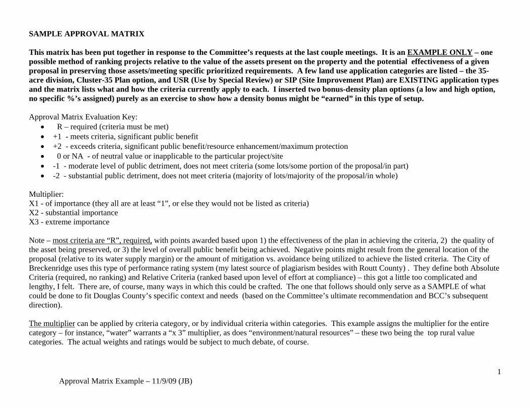
1 Approval Matrix Example – 11/9/09 (JB)
SAMPLE APPROVAL MATRIX This matrix has been put together in response to the Committee’s requests at the last couple meetings. It is an EXAMPLE ONLY – one possible method of ranking projects relative to the value of the assets present on the property and the potential effectiveness of a given proposal in preserving those assets/meeting specific prioritized requirements. A few land use application categories are listed – the 35-acre division, Cluster-35 Plan option, and USR (Use by Special Review) or SIP (Site Improvement Plan) are EXISTING application types and the matrix lists what and how the criteria currently apply to each. I inserted two bonus-density plan options (a low and high option, no specific %’s assigned) purely as an exercise to show how a density bonus might be “earned” in this type of setup. Approval Matrix Evaluation Key:
• R – required (criteria must be met) • +1 - meets criteria, significant public benefit • +2 - exceeds criteria, significant public benefit/resource enhancement/maximum protection • 0 or NA - of neutral value or inapplicable to the particular project/site • -1 - moderate level of public detriment, does not meet criteria (some lots/some portion of the proposal/in part) • -2 - substantial public detriment, does not meet criteria (majority of lots/majority of the proposal/in whole)
Multiplier: X1 - of importance (they all are at least “1”, or else they would not be listed as criteria) X2 - substantial importance X3 - extreme importance Note – most criteria are “R”, required, with points awarded based upon 1) the effectiveness of the plan in achieving the criteria, 2) the quality of the asset being preserved, or 3) the level of overall public benefit being achieved. Negative points might result from the general location of the proposal (relative to its water supply margin) or the amount of mitigation vs. avoidance being utilized to achieve the listed criteria. The City of Breckenridge uses this type of performance rating system (my latest source of plagiarism besides with Routt County) . They define both Absolute Criteria (required, no ranking) and Relative Criteria (ranked based upon level of effort at compliance) – this got a little too complicated and lengthy, I felt. There are, of course, many ways in which this could be crafted. The one that follows should only serve as a SAMPLE of what could be done to fit Douglas County’s specific context and needs (based on the Committee’s ultimate recommendation and BCC’s subsequent direction). The multiplier can be applied by criteria category, or by individual criteria within categories. This example assigns the multiplier for the entire category – for instance, “water” warrants a “x 3” multiplier, as does “environment/natural resources” – these two being the top rural value categories. The actual weights and ratings would be subject to much debate, of course.

2 Approval Matrix Example – 11/9/09 (JB)
WATER Ensure the provision of a sustainable water supply:
• Apply water supply (18-A) standards to all projects (regs modified as appropriate) • Encourage renewable water supply use or augmentation • Utilize margin distinctions • Apply appropriate water demand restrictions • Water supply resources to remain in subarea • Encourage use of central water systems • Support existing Districts • Central management of septic systems (water quality)
Criteria vs. Application Type
SB 35 Division Cluster 35 Plan Low density bonus (_X_ minimum points)
Higher density bonus ( X minimum points)
USR or similar special use
Meet requirements of existing, and any future amendments of, 18A
Not subject to 18A. SEO well permit process only.
303B.05 specifies water supply standards (“18-A – like”)
R R R (except for horse boarding)
Water supply narrative submitted
R address water demands, type of well permit sought, source of water to be used, attorney’s letter provided proof of water supply ownership, and proof that all necessary decrees, permits, or other
R R R (as part of 18A)

3 Approval Matrix Example – 11/9/09 (JB)
legal req. are in place for use of water. (18-A-like)
Renewable supply or augmentation plan, in any margin
+1 +1
Water – central system serving multiple lots or incorporation into existing special district
+1 +1 (possibly require for a certain sized project)
Water – other conservation measure
+.5 +.5
Water – limited irrigated landscape (res)
R R
Declaration of restrictive covenants for water (tie water rights to land)
County may R R R R
Margin C location 0 0 Margin B location -1 -1 Margin A location -2 -2 Guesthome or caretaker (accessory) units
None allowed in Margin A 1 unit allowed in Margin A or Margin B if served by special district AND with 5 acre minimum lot size.
NA None allowed (except caretaker for active ag use based upon needs of preserved ag tracts)
NA None allowed (except caretaker for active ag use based upon needs of preserved ag tracts)
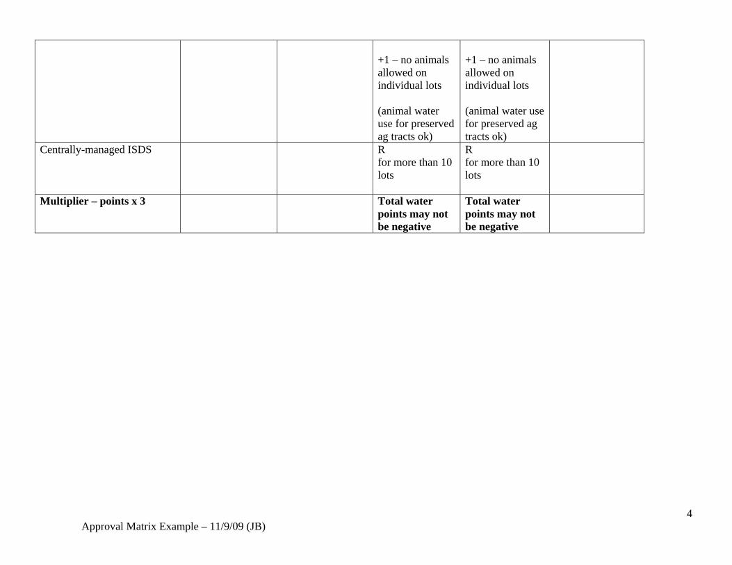
Animal (horse or livestock) use restrictions on residential lots
Allowed subject to animals regs and as restricted by SEO well permit.
R 0 – some restrictions on #’s above standard Animal Regs/Section 24
R 0 – some restrictions on #’s above standard Animal Regs/Section 24
Supply requirement for horse boarding is 20 gallons per horse per day
4 Approval Matrix Example – 11/9/09 (JB)
+1 – no animals allowed on individual lots (animal water use for preserved ag tracts ok)
+1 – no animals allowed on individual lots (animal water use for preserved ag tracts ok)
Centrally-managed ISDS R for more than 10 lots
R for more than 10 lots
Multiplier – points x 3 Total water points may not be negative
Total water points may not be negative

5 Approval Matrix Example – 11/9/09 (JB)
Environment and Natural Resource Protection Preserve the following environmental resources, through an initial property assessment and prioritization effort:
• Floodplains and riparian corridors • Natural grade and terrain • Geologic hazards and key topographic features • Wildlife habitat and movement corridors • Major viewsheds, ridgelines and other visual assets • Important historic structures, elements, and uses
Criteria vs. Application Type
SB 35 Division Cluster 35 Plan Low density bonus (_X_ minimum points)
Higher density bonus ( X minimum points)
USR or similar special use
Resource Inventory/Prioritization Preserve significant environmental, geological, historical and visual resources and features (as set forth on the required RCE/Resource Conservation Exhibit prepared for the plan) Require a Comprehensive Baseline environmental resource/natural resource inventory (slopes, soils/geo hazards floodplains/wetlands, wildlife habitat/movement corridors, viewsheds/ridgelines, vegetation, historic structures, archeological resources)
R (This is the current wording found in the cluster 35 Regs. All other criteria are tied back to consistency with the “RCE”) RFC recommends that the County provide support for preparation of management plans to encourage Cluster 35 use
R Baseline inventory required as first step & available for mandatory neighborhood meeting
R Baseline inventory required as first step & available for mandatory neighborhood meeting
Existing and proposed topo and floodplains are required to be shown.
Riparian Corridors
Floodplain overlay applies to
Per RCE (& other regs)
R Riparian
R Riparian corridors
Floodplain overlay applies

6 Approval Matrix Example – 11/9/09 (JB)
Floodplain, wetlands, seasonal watercourses avoided; Preserve and protect riparian corridors in natural conditions with adequate setbacks established;
all as does federal regulations for certain types of wetlands and watercourses
corridors preserved in tracts: +1 Riparian enhancement: +.5
preserved in tracts, with maximum separation from residential uses: +1 Riparian (wildlife) corridors fenced/protected from livestock: +1 Riparian enhancement for public or wildlife use: +1
to all as does federal regulations for certain types of wetlands and watercourses
Topography Preserve existing topography and grade:
• Avoid development on slopes greater than 20%;
• Prohibit overlot grading
for homesites
• Use envelopes to limit homesite disturbance
• Preserve unique
topographic/geologic features
• Utilize natural contours
for road alignments
Per RCE R Points available based upon the effectiveness of the plan in meeting this requirement. Excessive mitigation would yield negative points.
R Points available based upon the effectiveness of the plan in meeting this requirement. Excessive mitigation would yield negative points.
Site disturbance issues can generally be addressed through the USR/SIP process
7 Approval Matrix Example – 11/9/09 (JB)
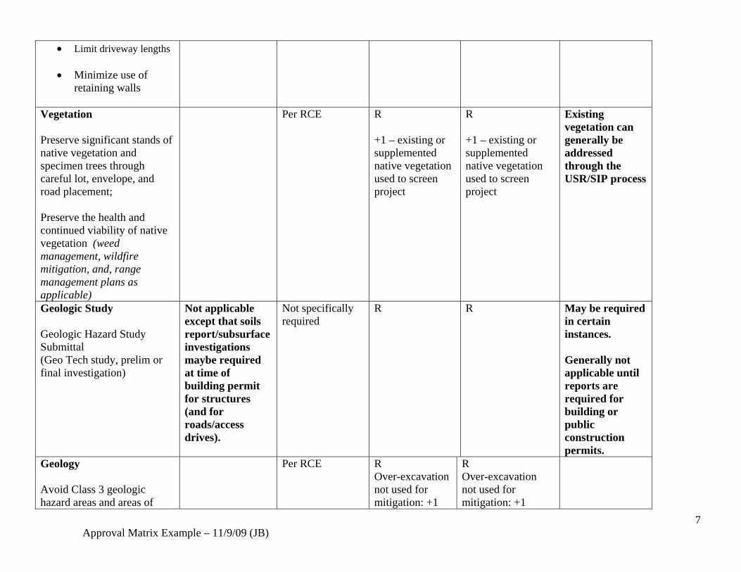
• Limit driveway lengths
• Minimize use of retaining walls
Vegetation Preserve significant stands of native vegetation and specimen trees through careful lot, envelope, and road placement; Preserve the health and continued viability of native vegetation (weed management, wildfire mitigation, and, range management plans as applicable)
Per RCE R +1 – existing or supplemented native vegetation used to screen project
R +1 – existing or supplemented native vegetation used to screen project
Existing vegetation can generally be addressed through the USR/SIP process
Geologic Study Geologic Hazard Study Submittal (Geo Tech study, prelim or final investigation)
Not applicable except that soils report/subsurface investigations maybe required at time of building permit for structures (and for roads/access drives).
Not specifically required
R R May be required in certain instances. Generally not applicable until reports are required for building or public construction permits.
Geology Avoid Class 3 geologic hazard areas and areas of
Per RCE R Over-excavation not used for mitigation: +1
R Over-excavation not used for mitigation: +1

8 Approval Matrix Example – 11/9/09 (JB)
steeply dipping bedrock Appropriately mitigate lesser geologic constraints Avoid development near key geologic (visual) features
Major hazards kept outside of lots (under 10 acres in size): + 1
Views/Visual Assets Preserve significant viewsheds, as seen from public roads or open space areas, including properties preserved by conservation easement. Avoid placement of development on or near the top of significant ridgelines where portions of structures would break the skyline plane when viewed from nearby public roadways, neighborhoods, or open space areas. Avoid placement of homesites on visible side slopes (those without natural vegetative screening opportunities) Require the use of natural, non-reflective colors and materials for structures
Per RCE R Points available based upon the quality of the visual asset being preserved
R +2 – Major ridgeline or viewshed preserved as visible from arterial or highway, such resource preserved to maximum effectiveness/public benefit.
Visual impact, placement of structures can generally be addressed through the USR/SIP process
Wildlife Per RCE R R Wildlife impacts

9 Approval Matrix Example – 11/9/09 (JB)
Preserve wildlife habitat and movement corridors to accommodate a wide range of existing wildlife species; Design interconnected habitat and movement corridors in accordance with the Comprehensive Master Plan.
+1 – High value habitat or connection corridor preserved.
+2 – High value habitat or connection corridor of optimum width/dimension preserved.
can be addressed in the USR/SIP process. General referrals made to DOW.
Historic Preserve Historic structures, uses, or other important cultural elements related to farming or ranching heritage.
Per RCE R +1 – Significant historic structures or elements preserved
R +2 – Major historic structure, element or use preserved and made accessible to the public.
Historic resources can generally be addressed through the USR/SIP process.
Multiplier – x3 Environmental
points may not be negative
Environmental points may not be negative

10 Approval Matrix Example – 11/9/09 (JB)
Infrastucture/Improvements and other rural services Ensure that roads, infrastructure and services are adequate to serve the rural community, but maintain a design character and scale that is consistent with the rural lifestyle:
• Road designs are rural in character • Road alignments follow natural grade and terrain • Traffic impacts do not decrease LOS on existing road system • Dust mitigation required when traffic thresholds warrant • Drainage impacts adequately addressed • Capital impacts on schools, police, fire and other services evaluated • Utilize HOAs or existing special districts to maintain facilities • County technical assistance provided to encourage Cluster 35 use
Criteria vs. Application Type
SB 35 Division Cluster 35 Plan Low density bonus (_X_ minimum points)
Higher density bonus ( X minimum points)
USR or similar special use
Proof of legal and physical access provided
R R R R
Roads must meet County engineering standards (including drainage)
R (per the wildfire hazard regs, former NFPA 299)
R RFC recommends that engineering assistance by provided by the County to encourage use of Cluster 35 option
R R
Road alignments should follow natural terrain/minimal grading disruption as much as possible Design provides for narrower roads with natural surfacing
R Rating based on effectiveness of the design
R Rating based on effectiveness of the design

11 Approval Matrix Example – 11/9/09 (JB)
and shoulders where possible Traffic study submitted County may R
County assistance in preparation of traffic study/analysis?
R R
Traffic generated will not lower the existing LOS on surrounding/connecting roadways
R R
Dust mitigation plans should be implemented for gravel roads where traffic thresholds warrant
R R
Preliminary roadway construction plans submitted
R R
Preliminary drainage and floodplain analysis submitted
R
Drainage study/plans submitted
R R
Improvements Agreement between applicant and County
R R R
Mandatory HOA (or special district) to assume responsibility for road, drainage, and any other amenities must be formed
R R R
Utilize existing special/metro district for maintenance where feasible
+1 +1
Subsequent subdivision exemption approval
R R, Different process would be used (full subdivision)
R Different process would be used (full subdivision)
All necessary easements provided and recorded
R (separately
R (recorded with
R (recorded with

12 Approval Matrix Example – 11/9/09 (JB)
recorded) final plat) final plat) Other level of service impacts adequately addressed: schools, police, fire/emergency
NA R Require concurrency evaluation (capital impacts)
R Require concurrency evaluation (capital impacts)
Multiplier – x1

13 Approval Matrix Example – 11/9/09 (JB)
Site Design Criteria/Rural Quality of Life Standards:
• Blend development into the natural terrain and character of the site • Minimize negative impacts of off-site views of grading and building massing; • Develop in a visually cohesive manner; • Provide adequate buffering of neighboring properties and uses to ensure compatibilityat shared edges or boundaries; • Ensure reasonable building scale; • Preserve dark skies through limited light fixtures, types of fixtures and lumen level restrictions; • Preserve open range appearance; preserve existing vegetation; • Require wildlife and visually compatible fencing; • Preserve rural character through appropriate architectural and other design criteria; • Preserve a low-density, rural appearance through minimum lots sizes
Criteria vs. Application Type
SB 35 Division Cluster 35 Plan Low density bonus (_X_ minimum points)
Higher density bonus ( X minimum points)
USR or similar special use
5 acre lot minimum 2 acre for well and septic 5 acres if accessory unit is requested
R R Depends on zoning disrict
10 acre lot minimum applied +2 +2 20 acre lot minimum applied +3 +3 Buffering at property perimeters should provide a continued rural appearance for adjoining properties, using one or more of the following:
• Match adjoining lots sizes at visible edges (up to a minimum of 20 acres next to undivided A-1)
R Rating will vary based upon effectiveness of plan layout in accomplishing objective
R Rating will vary based upon effectiveness of plan layout in accomplishing objective
Buffering of adjacent properties generally considered in USR/SIP process

14 Approval Matrix Example – 11/9/09 (JB)
• Use existing
vegetation or topography to screen homesites from view
• Site specific building
envelopes to limit visual impacts to adjacent properties
• Use supplemental
plantings, berming, or increased setbacks to further mitigate views of specific lots
• Prohibit the placement of homesites on or near visible ridgelines
• Limit the appearance of density from public view corridors by restricting the total number of visible lots/homesites
Entries Neighborhood entry and other common features should be designed to maintain rural scale and character
R R
HOA Design Guidelines
R R

15 Approval Matrix Example – 11/9/09 (JB)
HOA-enforced design guidelines should be developed to require critical architectural and other design elements Lighting Exterior lighting must be limited in number, placement and type of fixtures to preserve the dark-skies environment:
• Low lumen (1200 max) bulbs and /or full cut off fixtures are required.
• No architectural or
landscape up-lighting lighting are allowed
• No flood lights are
allowed.
• Security lighting must be limited to motion detectors and be fully shielded.
• Prohibit pole lights
and limit height of exterior fixtures relative to finish floor or deck elevation (develop specific
R Rating will vary based upon effectiveness of plan layout in accomplishing objective
R Rating will vary based upon effectiveness of plan layout in accomplishing objective

16 Approval Matrix Example – 11/9/09 (JB)
standards for this).
• Limit neighborhood entry lighting and street lights.
Building scale and design Compatible building scale and design should be enforced through site specific design guidelines to include all of the following requirements: • elevation, square footage,
and other design parameters for new residential and accessory structures
• Building heights
measured from natural grade datum point to peak of roof
• Architectural standards
including the use of natural colors and materials (non-reflective, rural in appearance)
• Prohibition on accessory
dwelling units and limitations on accessory structures to the building envelope
R Rating will vary based upon effectiveness of plan layout in accomplishing objective
R Rating will vary based upon effectiveness of plan layout in accomplishing objective

17 Approval Matrix Example – 11/9/09 (JB)
• Natural grade and native
vegetation preserved outside of the building envelope
• Driveway design to
maintain a rural appearance and avoid the excessive use of retaining walls
Fencing A master fencing plan shall be developed for the property to address wildlife movement, visual compatibility, and any livestock or horse containment needs. Fencing shall be visually open and /or transparent, comprised of natural colors and materials, Fencing shall meet wildlife-friendly fencing standards where ever possible, but particularly in and around major movement corridors and at property edges. Residential fencing shall be limited to the building envelope with the use of
R Rating will vary based upon effectiveness of plan layout in accomplishing objective
R Rating will vary based upon effectiveness of plan layout in accomplishing objective

18 Approval Matrix Example – 11/9/09 (JB)
privacy fencing strictly limited. Multiplier – x2

19 Approval Matrix Example – 11/9/09 (JB)
Open Lands Presevation (Priority of project based on quality of open space/land preservation asset) This element of the matrix is an attempt to rate projects for eligibility for any kind of incentive-based land use process based upon the type, amount and quality of the rural land itself. Criteria vs. Application Type
SB 35 Division Cluster 35 Plan Low density bonus (_X_ minimum points)
Higher density bonus ( X minimum points)
USR or similar special use
67% open space preserved R R 67% in separate tracts +2 +2 67%, some preserved within lots (40% must still be provided within separate tracts)
+1 -1
Conservation easement or open space agreement used to protect open space in perpetuity
R +1 – appropriate for formal dedication to the County (consult with COSAC required)
R +1 – appropriate for dedication to the County (consult with COSAC required)
Public access to the open space provided
+2 +2
Contains major wildlife habitat or connecting corridor as identified in CMP
+2 +2
Includes listed endangered species
+.5 +.5
Major viewshed or ridgeline preserved in contiguous, undeveloped state (unobstructed, visible from
+1
+2 (highly visible from arterial roadway or

20 Approval Matrix Example – 11/9/09 (JB)
multiple locations) highway) Provides for continued active, agricultural use (500 acre minimum)
+2 +2
Adjacent to an existing County, State or Federal open space, park. or conservation easement (and would be a logical extension thereto).
+2 +2
Involves a major renewable water asset which will remain with the land/to serve the rural subarea
+3 +3
Includes a unique, highly visible geologic landform that serves an defining element of the Douglas County landscape
+3 +3
Includes an historic element or structure of high preservation value to the County (based upon consult with Historic Preservation Board)
+2 +2
Total Points for eligibility: ___ High priority ___ Significant priority ___ Low priority

21 Approval Matrix Example – 11/9/09 (JB)
Public Input Process Increase public participation in rural land use decisions through early involvement, public hearing venues and decision making, and increased opportunities to stay informed of proposals on an ongoing basis. Criteria vs. Application Type
SB 35 Division Cluster 35 Plan Low density bonus (_X_ minimum points)
Higher density bonus ( X minimum points)
USR or similar special use
Public Review Process None Administrative review followed by BCC review of exemption. Courtesy notices to adjacent owners at beginning of referral period. RFC recommends, at minimum, BCC public meeting on Cluster 35 Plan approval. No administrative approval.
Mandatory neighborhood meeting PC hearing BCC hearing Possible COSAC and/or Rural Advisory Board review component?
Mandatory neighborhood meeting PC hearing BCC hearing Possible COSAC and/or Rural Advisory Board review component?
USR’s require pubic hearings before PC and BCC SIPs are administrative processes that involve courtesy notices to adjacent owners and a full referral comment process.