sampling threatened microbial communities
TRANSCRIPT

Species and Communities Branch newsletter for species and ecological communities conservationJuly 2011 Volume 17 Issue 1
Sampling threatened microbial communitiesby Val English and Wendy Chow
Microbial communities can form solid structures such as the world-renowned stromatolites at Shark Bay. These ‘microbialites’ (a general term for structures formed by microbes), can occur in different forms including ‘stromatolites’ and ‘thrombolites’. Stromatolites differ from thrombolites in that they have a layered internal structure, whereas thrombolites have a ‘clotted’ structure.
A series of Western Australia’s unique stromatolites and thrombolites are the focus of a current sampling program. The sampling program is being conducted by the Department of Environment and Conservation’s Species and Communities Branch in close collaboration with a University of Western Australia hydrogeologist, and molecular ecologists from Macquarie University. The Macquarie University laboratory uses DNA analysis techniques to identify the microbial species present.
The program currently involves sampling of three priority and three threatened ecological communities (PECs and TECs) in the state’s south west. An initial aim will be to examine the dominant microbes present. Water quality samples have also been collected from the sites to provide a snap-shot of microbes that are adapted to different hydrological conditions.
Above Lake Clifton thrombolites. Photo – Val English
Left Sunset over microbialites at Pink Lake, Esperance. Photo – Wendy Chow
Inside this issueSampling threatened microbial communities ............................................ 1
Healthy Wetland Habitats – helping conserve high value bushland ...... 2
Survey of ironstone community on private land ........................................ 3
A jewel north of Moora .................................................................................. 3
Western Australia’s threatened eremophilas .............................................. 4
Conservation of important claypans ........................................................... 5
World Wetlands Day ....................................................................................... 6
To burn or not to burn: some issues of declared rare flora in the Goldfields Region .................... 6
Clean up day at TEC sites .............................................................................. 7
Recovery plans approved ............................................................................. 8

2 watsnu
Peter Jacobs, a private landholder in Serpentine, recently discovered the high conservation value of the remnant bushland on his property. The vulnerable Tetraria australiensis (southern tetraria) was first identified on Peter’s property in 2010 by Dr Penny Hollick (Botanist and Natural Area Ecologist, Serpentine-Jarrahdale Shire) through Peter’s involvement in SJ Landcare Centre and Serpentine Jarrahdale Shire’s partnership program Healthy Habitats. On a later visit to the property, critically endangered Caladenia huegelii (grand spider orchid) was discovered by a DEC ecologist. Rapid bushland surveys of the property also identified that there are probably three threatened ecological communities. These will require further work to confirm their identity and include two critically endangered marri woodlands on heavy soils, and an endangered banksia community.
Peter is committed to protecting and conserving the valuable bushland. Through the recognition of the threatened flora and probable threatened ecological communities, Peter was successful in receiving funding assistance from the South West Catchments Council for fencing, weed control, revegetation in upland areas, dieback mapping and management.
Peter was also successful in his application to DEC’s Healthy Wetland Habitats (HWH) program, receiving additional funding
assistance for a dieback treatment kit, weed control (targeting Watsonia meriana, Eucalyptus camaldulensis and Acacia longifolia) and revegetation in wetland areas.
The HWH program aims to promote wetland conservation on private property. Management assistance is available to landowners who have conservation category wetlands and wetlands protected under other state mechanisms for activities that will make a significant contribution to wetland conservation or restoration. HWH is currently targeting landholders in the City of Armadale, City of Gosnells and Serpentine Jarrahdale Shire.
For more information contact Amanda Fairs on (08) 9219 8788 or by email ([email protected]).
The sites sampled include stromatolites in Pink Lake (priority 1), Pamelup Pond (priority 2), Lake Walyungup (priority 1) and Lake Thetis (vulnerable TEC); and thrombolites in Lake Clifton and Lake Richmond (both critically endangered TECs).
All of the lakes were visited in autumn 2011, when the microbial structures were highly accessible due to very low water levels after an exceptionally dry winter. In addition the water temperature was relatively high, so the microbes would be expected to be very active. Different forms of microbial structures were noted around some of the lakes, and these were sampled separately. For example, the structures in Lake Richmond varied in shape, colour, texture and size, and a selection of deep rich green, orange, and black specimens were collected. Those collected on Pink Lake were egg shaped and many were salt encrusted.
The project is in a preliminary phase but a major aim of the studies will be to provide data about how the composition of microbial communities relates to water
quality. The challenge will then be to seek to manage the lakes to ensure that water quality remains within acceptable limits so these unique structures can continue to survive and grow as their ancestors have done for the past 3.5 billion years.
For more information please contact Wendy Chow on (08) 9334 0554 or by email ([email protected]).
Above Lake Walyungup microbial community.
Left Microbial community at Lake Richmond. Photos – Val English
Above Bushland at Rapids Road. Photo – Sue Downes
Right Peter Jacobs and Melissa Bastow assessing Watsonia infestation in wetland area. Photo – Amanda Fairs
Healthy Wetland Habitats – helping conserve high value bushlandby Amanda Fairs

3 watsnu
In late November 2010 officers from DEC’s Species and Communities Branch and regional and district officers met with the owner of three adjacent lots in the Scott River area. DEC officers surveyed the lots for the presence of the endangered ecological community known as ‘Scott River Ironstone Association’. The community is confined to shallow soils over massive ironstone in the Scott Coastal Plain near Augusta. Vegetation composition varies as a result of different soil depths and types over the massive ironstone but it is usually found in areas with soil depths of up to half a metre and often where ironstone outcrops at the surface.
All occurrences apart from those on the three private lots were surveyed by DEC staff in 2005. The Scott Ironstone TEC was originally mapped from aerial photography and soil mapping on both private and public lands in the area. The remaining private land was thought to contain substantial areas of this community. However, until access was granted for survey on private land, little was known about the composition and condition of these remaining remnants.
Remnants on the private land were found to be in varying condition ranging from completely degraded to excellent condition. Some areas had become degraded due to grazing over many decades. It was confirmed that most of the remnants were in fact the Scott Ironstone community as per the original soil mapping. The participation and cooperation of private land owners will play an integral part in the conservation of these remaining areas of this threatened ecological community.
For more information contact Mia Podesta on (08) 9334 0116 or by email ([email protected]).
Top Creekline at Scott Ironstone.
Above Priority 3 species Hakea tuberculata occurs on the Scott Ironstone TEC. Photos – Jill Pryde
Above Regelia megacephala on the ridge top of a Coomberdale Chert TEC occurrence. Photo – Jill Pryde
An area of special significance occurs along the Midlands Rd just north of Moora. The Noondine (or Coomberdale) Chert is an important narrow band of low hills and outcropping rocks up to 14 kilometres wide. This chert formation is home to a threatened ecological community (TEC).
The Coomberdale Chert TEC was originally described in the early 1990s from a survey that recognised the unique nature of the vegetation types occurring on the chert. The chert hills contain Western Australia’s best quality chert for the production of silicon and are also completely surrounded by
agricultural land. Threats therefore include clearing for mining and other uses, grazing, altered fire regimes, weed invasion; and also potentially drying climate and altered hydrology. The Coomberdale Chert TEC was subsequently listed as endangered in 2001 due to its restricted nature and the various threats to the community.
The vegetation that occupies the outcropping areas of the Coomberdale Chert were recently surveyed in detail by a mining company working in the area. Thirty vegetation units and many more sub-units were defined; these corresponded to different
A jewel north of Moora by Monica Hunter
Survey of ironstone community on private landby Mia Podesta
4 watsnu
soil depths and subsurface rock on the slopes. The vegetation surveyed included a range of woodlands, shrublands and low heaths. The principal vegetation types of the TEC include: Allocasuarina campestris (tammar) high shrublands to open and closed scrub, Allocasuarina microstachya open scrub, Regelia megacephala high shrubland to open and closed scrub, Kunzea praestans high shrubland to open and closed scrub, Melaleuca calyptroides ms open to closed heath, Hibbertia subvaginata low shrublands to low open heath, and Xanthorrhoea drummondii shrubland. The TEC also provides habitat for 12 declared rare and priority flora.
The recovery plan for this community is being updated with funds from the Specific
Nature Conservation Projects. Landholders have been contacted and many occurrences have been visited. A number of landholders have shown great interest in conserving the TEC, and more detailed information about the community will be provided to them. Some fencing will be completed on private land to help protect the vegetation from grazing. Recommended recovery actions include further research into the ecology of this important community, development of a detailed program of monitoring, and preparation of a fire management strategy.
For more information contact Monica Hunter on (08) 9219 8627 or by email ([email protected]).
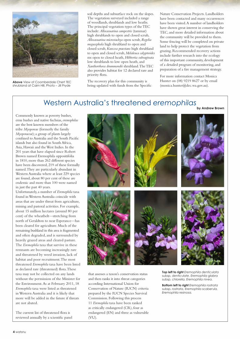
Commonly known as poverty bushes, emu bushes and native fuchsias, eremophilas are the best known members of the tribe Myoporeae (formerly the family Myoporaceae); a group of plants largely confined to Australia and the South Pacific islands but also found in South Africa, Asia, Hawaii and the West Indies. In the 201 years that have elapsed since Robert Brown named Eremophila oppositifolia in 1810, more than 262 different species have been discovered, 219 of these formally named. They are particularly abundant in Western Australia where at least 229 species are found, about 80 per cent of these are endemic and more than 100 were named in just the past 40 years.Unfortunately, a number of Eremophila taxa found in Western Australia coincide with areas that are under threat from agriculture, mining and pastoral activities. For example, about 15 million hectares (around 80 per cent) of the wheatbelt—stretching from north of Geraldton to near Esperance—has been cleared for agriculture. Much of the remaining bushland in this area is fragmented and often degraded, and is surrounded by heavily grazed areas and cleared pasture. The Eremophila taxa that survive in these remnants are becoming increasingly rare and threatened by weed invasion, lack of habitat and poor recruitment. The most threatened Eremophila taxa have been listed as declared rare (threatened) flora. These taxa may not be collected on any lands without the permission of the Minister for the Environment. As at February 2011, 18 Eremophila taxa were listed as threatened in Western Australia and it is likely that more will be added in the future if threats are not abated.
The current list of threatened flora is reviewed annually by a scientific panel
that assesses a taxon’s conservation status and then ranks it into threat categories according International Union for Conservation of Nature (IUCN) criteria prepared by the IUCN Species Survival Commission. Following this process 11 Eremophila taxa have been ranked as critically endangered (CR), four as endangered (EN) and three as vulnerable (VU).
Above View of Coomberdale Chert TEC shrubland at Cairn Hill. Photo – Jill Pryde
Western Australia’s threatened eremophilasby Andrew Brown
Top left to right Eremophila denticulata subsp. denticulate, Eremophila glabra subsp. chlorella, Eremophila nivea.
Bottom left to right Eremophila rostrata subsp. rostrata, Eremophila scaberula, Eremophila resinosa.

5 watsnu
Eremophila taxa listed as threatened and their current rankings
Eremophila ciliata (CR)Eremophila denticulata subsp. denticulata (VU)Eremophila denticulata subsp. trisulcata (EN)Eremophila glabra subsp. chlorella (CR)Eremophila koobabbiensis ms (CR)Eremophila lactea (CR)Eremophila nivea (CR)Eremophila pinnatifida (CR)Eremophila resinosa (EN)Eremophila rostrata subsp. rostrata (CR)Eremophila rostrata subsp. trifida (CR)Eremophila scaberula (CR)Eremophila subteretifolia (CR)Eremophila ternifolia (VU)Eremophila vernicosa (VU)Eremophila verticillata (CR)Eremophila virens (EN)
Eremophila viscida (EN)
Eremophila taxa for which interim recovery plans have been prepared
In accordance with DEC policy, interim recovery plans have now been prepared and are being implemented for all threatened Eremophila taxa ranked as critically endangered and have also been prepared and implemented for some with a lower ranking, i.e. endangered or vulnerable. Many of these plans can be viewed at http://www.dec.wa.gov.au/content/view/865/2009/.
Eremophila taxa listed as priority flora
In addition to those offered legislative protection, a further 85 Eremophila taxa are on DEC’s priority flora list. With the exception of those listed as priority 4, these taxa are thought to be rare or threatened but require further detailed survey to accurately assess their conservation status. For a list of priority Eremophila taxa see: http://florabase.dec.wa.gov.au/conservationtaxa.
For more information on threatened Eremophila taxa please contact Andrew Brown on (08) 9334 0122 or by email ([email protected]).
Conservation of important claypansby Val English
Top Newly discovered claypan TEC at Brook Road.
Above Drain for rehabilitation. Photos – Val English
Top left to right Eremophila denticulata subsp. trisulcata, Eremophila subteretifolia, Eremophila ternifolia. Above right Eremophila vernicosa.
Two areas of bushland previously on private land on Wanaping Road and Brook Road in Kenwick, were purchased for conservation in 2010 by the West Australian Planning Commission (WAPC). The acquisitions were part of the implementation of Bush Forever – a strategic plan for the conservation of important bushland in the Perth metropolitan area. The lands are part of the acquisition of a series of linked lots in the Kenwick area that form the Greater Brixton Street wetlands. Although both lots were previously known to have significant wetland and other values, one of them was not identified as containing a claypan threatened ecological community (TEC) until January 2011.
Bushland on the lot on Brook Road was found to contain a suite of species that had only been previously located in areas of the vulnerable ‘Herb rich shrublands in clay pans’ TEC. The habitat—a wetland on soil that has a fine clay soil—was also typical of this particular TEC. This claypan community is only known from a total of about 170 hectares, of which about one third is in secure conservation reserves.
A proportion of the two lots has been degraded in the past, and now requires significant weed control, infill of drains, track rehabilitation, rubbish removal, and possibly removal of soil contaminants. Staff from DEC met with WAPC staff on site in February 2011 to discuss options for management of the drains and soil contaminants. Data will be gathered about the current groundwater levels and quality, and how the drains and soil contaminants might currently be affecting these.
This information will help to guide future actions with regard to seeking to improve groundwater quality and groundwater and surface water flows. Future management will be aimed at mimicking the original water levels, surface and groundwater flows in these very rare and threatened claypans.
For more information contact Val English on (08) 9334 0409 or [email protected]

6 watsnu
Gastrolobium graniticum is one of 12 declared rare flora present in the DEC Goldfields Region. The species occurs in small populations in sand or sandy loam in and around granite rocks, growing with shrublands or woodlands of Allocasuarina huegeliana, Acacia lasiocalyx and Eucalyptus eremophila in an area west of Coolgardie. Six populations are known in the DEC Goldfields Region and two populations known from the DEC Wheatbelt Region. Populations vary considerably in size; from only four plants to a population with more than 1,000 plants.
A large population that was discovered in 2005 on an unnamed granite rock south of Victoria Rock was burnt in a wildfire in 2006, and inspections in 2009 indicated the population is thriving. However, populations at Victoria Rock, Bullabulling and Boondi Rock had declined since previous counts (2002) and some plants appeared stressed. The DEC Goldfields Region suspected that fire may be needed
at these declining populations to stimulate germination, but did not want to risk damage. It was resolved that a population previously recorded at Gnarlbine Rock, where Gastrolobium graniticum was first collected in 1899 but had not been seen at in recent years, would be burnt.
With funding received from the State NRM Program, a translocation proposal in the form of a reintroduction was carried out early this year. Seed collected from the unnamed granite rock population was planted in two plots at the edge of Gnarlbine Rock; one was to be burnt, and the other was the unburnt control. A burn was carried out by the DEC Goldfields Region at the site on 9 February 2011. With 68 millimetres of rainfall at the site recorded in the two months prior to this date, it was hoped that more summer rain would fall after the burn to stimulate good germination. However, this has not happened, and less than 10 per cent of seeds have germinated in both plots to
The 7th Annual WA Wetlands Management Conference was held on Wednesday 2 February to commemorate World Wetlands Day—the anniversary of the signing of the Convention on Wetlands of International Importance, also known as the Ramsar Convention. The Ramsar Convention is an inter-governmental treaty that provides the framework for national action and international cooperation for the conservation and wise use of wetlands. This year was the 40th anniversary of the signing of the convention.
The international theme for World Wetlands Day 2011 was Forests for water and wetlands, in support of the United
Nations declaration of 2011 as the International Year of Forests.
WA currently has 12 wetlands recognised as internationally important under the Ramsar Convention on Wetlands for their outstanding ecology, botany, zoology, limnology and hydrology. Another eight wetlands are currently nominated for listing. Management plans and ecological character descriptions of the Ramsar wetlands are in the process of being placed on DEC’s website.
The conference was held at Cockburn Wetlands Education Centre and was attended by community members, students, local and state government officers and
industry representatives. Keynote speakers included Dr Pierre Horwitz presenting on Ramsar updates, Josephine Searle on Department of Water groundwater investigations, Dr Jane Chambers on wetlands and climate change and Dr Andrew Storey on a description of the Vasse-Wonnerup Wetlands.
The one-day event was to raise awareness about the importance of our wetlands and the vast amount of work that is going on in WA to conserve, manage and restore them.
For more information please visit http://www.dec.wa.gov.au/wetlands or contact Melissa Bastow on 9219 8710 or by email ([email protected].)
Above Anne with her poster on wetland mapping.
Left Thomsons Lake Ramsar Wetland. Photos – Melissa Bastow
World Wetlands Dayby Melissa Bastow
To burn or not to burn: some issues of declared rare flora in the Goldfields Region
by Jennifer Jackson
Above Burn carried out at Gnarlbine Rock in an attempt to reintroduce DRF Gastrolobium graniticum to the rock. Photo – Jennifer Jackson

7 watsnu
date. Furthermore, seedlings that have germinated appear to have been eaten by an unknown invertebrate. The DEC Goldfields Region hope to carry out another burn at Gnarlbine Rock next spring, summer or autumn, and some manual watering and invertebrate control may be applied.
In addition to the burning trials at Gnarlbine Rock, the DEC Goldfields Region also plan to manually water one of the declining populations sometime this winter to encourage germination within the population. The population at Boondi Rock in Goldfields Woodlands National Park has declined to eight plants after 30 plants were recorded in 1997. In addition, no good flowering, fruiting or germination have been observed recently at the site. Boondi Rock is one of several rock catchments that were developed for railway water supply in the Goldfields during the late 1800s.
The outer edge of these rocks were lined with large slabs of granite that caught any water that fell onto the rock and directed it into a nearby dam. As a consequence, the Gastrologium graniticum plants here have not received the natural run-off from the rock for more than 100 years. The site is in the middle of a day-use/camping area in Goldfields Woodlands National Park, and the wall and associated dam has been maintained for historical value. Removal of parts of the wall may focus increased attention on the population. If the manual watering assists the plants that remain to flower and fruit, seed could be collected and used to establish a new population from the same genetic stock at a less visible area of the rock.
For more information contact Jenny Jackson on (08) 9080 5521 or by email ([email protected]).
Above Catchment area leading to a dam at the base of Boondi Rock in Goldfields Woodlands National Park. Photo – DEC
Above Clean up day at Wannaping Road. Photo – Val English
Enthusiastic DEC personnel and Western Power staff took part in Clean Up Australia Day in March 2011. Representatives of Species and Communities Branch and Swan Coastal District targeted two threatened ecological communities (TECs) in ‘adopt-a-spot clean-up’ as part of Keep Australia Beautiful WA. The areas included the Carousel wetlands with an occurrence of the endangered ‘Shrublands and woodlands on Muchea Limestone’ and a recently acquired extension to the Greater Brixton Street wetlands at Wanaping Road Kenwick with an occurrence of the vulnerable ‘Herb rich shrublands in clay pans’.
In all 17 people participated, removing tonnes of sofas, tyres, boxes of clothes, shopping trolleys and takeaway food and drink containers.
Rubbish dumping in our urban bushland is a significant threat as it can damage vegetation, cause contamination of surface and groundwater and is generally seen as decreasing the value of the bushland. Targeting some key sites for rubbish removal each year will help to lessen this threat.
For more information contact Jill Pryde on (08) 9334 0263 or by email ([email protected]).
Clean up day at TEC sitesby Jill Pryde
Four new flora interim recovery plans (IRPs) have recently been endorsed by DEC’s Director of Nature Conservation. All of these taxa are listed as critically endangered. These plans have been developed with funding assistance from DEC’s Specific Nature Conservation Projects.
Recovery plans approved
Editors: Susan Downes and Jill PrydeSpecies and Communities BranchDepartment of Environment and ConservationWestern AustraliaLocked Bag 104, Bentley Delivery Centre, Bentley WA 6983Email: [email protected] or [email protected]
2011
0334
-071
1-W
EB
WE
S
TE
R N A U S TR
A
LIA
TH
E G
OV E R N M
EN
T O
F
WE
S
TE
R N A U S TR
A
LIA
TH
E G
OV E R N M
EN
T O
F
No. Title Prepared by DEC region/districts involved307 Stylidium semaphorum Robyn Luu, Andrew Brown Perth Hills, Swan308 Grevillea althoferorum subsp. fragilis Robyn Luu, Andrew Brown Perth Hills, Swan309 Hibbertia abyssa Robyn Luu, Damien Rathborne, Sarah Barrett, Andrew Brown Albany, South Coast 310 Keraudrenia exastia Robyn Luu, Andrew Brown West Kimberley, Kimberley
The plans are available on DEC’s website at www.dec.wa.gov.au/index.php?option=com_content&task=view&id=869&Itemid=2008.