san jorge nickel project - solomonislands-data.sprep.org tech... · j17022rp1 i table of contents...
TRANSCRIPT
San Jorge Nickel Project
Environmental Impact Statement (EIS) | Draft
Non-technical Summary
Prepared for Axiom Mining Limited | 18 January 2018

J17022RP1
San Jorge Project
Environmental Impact Assessment
Non Technical Summary
Prepared for Axiom KB Limited | 18 January 2018
Suite 1, Level 4, 87 Wickham TerraceSpring Hill QLD 4000
T +61 7 3839 1800F +61 7 3839 1866
www.emmconsulting.com.au
J17022RP1
San Jorge Project
Non Technical Summary ‐ Draft Report
Report J17022RP1 | Prepared for Axiom KB Limited | 18 January 2018
Prepared by Rob Morris Approved by Luke Stewart
Position Associate Director Position CEO
Signature
Signature
Date 18 January 2018 Date 18 January 2018
This report has been prepared in accordance with the brief provided by the client and has relied upon the information collected at the time and under the conditions specified in the report. All findings, conclusions or recommendations contained in the report are based on the aforementioned circumstances. The report is for the use of the client and no responsibility will be taken for its use by other parties. The client may, at its discretion, use the report to inform regulators and the public.
© Reproduction of this report for educational or other non‐commercial purposes is authorised without prior written permission from EMM provided the source is fully acknowledged. Reproduction of this report for resale or other commercial purposes is prohibited without EMM’s prior written permission.
Document Control
Version Date Prepared by Reviewed by
V1 8/11/17 R Morris L Stewart
V2 18/1/18 E Thackray R Morris
T +61 (0)7 3839 1800 | F +61 (0)7 3839 1866
Suite 1 | Level 4 | 87 Wickham Terrace | Spring Hill | Queensland | 4000 | Australia
www.emmconsulting.com.au

J17022RP1 i
Table of contents
Chapter 1 Introduction 1
Chapter 2 Project description 3
Chapter 3 Publication consultation 5
Chapter 4 Project need and alternatives considered 7 4.1 The need 7 4.2 Benefits 7 4.3 Alternatives 7
Chapter 5 Existing environment 9 5.1 Location and topography 9 5.2 Climate and weather 9 5.3 Physical environment 9
5.3.1 Tectonics 9 5.3.2 Geology 9 5.3.3 Soil 10 5.3.4 Flora and vegetation 10 5.3.5 Fauna 10 5.3.6 Freshwater environment 10 5.3.7 Marine environment 10 5.3.8 Land use and tenure 10 5.3.9 Visual amenity 11 5.3.10 Noise 11 5.3.11 Air quality 11
Chapter 6 Impact assessment methodology 13
Chapter 7 Key environmental and social impacts 15 7.1 Geology and soils 15 7.2 Terrestrial ecology 15 7.3 Freshwater environment 16 7.4 Marine Environment 16 7.5 Marine Ecology 16 7.6 Amenity 17
7.6.1 Visual amenity 17 7.6.2 Air quality 17 7.6.3 Noise 17
J17022RP1 ii
Table of contents
7.7 Socio‐economic 18 7.8 Cultural heritage 18
Chapter 8 Summary and conclusions 21
Figures
1.1 Project location 2
2.1 Proposed mine layout plan 4
Photographs
3.1 Public consultation in Talise Village, San Jorge, September 2017 5
5.1 View across San Jorge Island, September 2017 11
7.1 View across San Jorge with Kogarutu in the foreground 19
8.1 Ecological fieldworkers on the project area, September 2017 22
J17022RP1 1
1 Introduction
Axiom KB Limited (Axiom KB), a subsidiary of Axiom Mining Limited (Axiom), proposes to develop the San Jorge Nickel Project on San Jorge Island in Isabel Province of the Solomon Islands. The project will comprise extraction of approximately 2 million tonnes per annum (Mtpa) of nickel laterite deposits over a period of five to ten years.
Axiom has secured a Prospecting Lease (PL 01/15) and a 50 year leasehold over the San Jorge Tenement (36 km2). The tenement area is referred to as the ‘project area’ for the purpose of the EIS and is shown in Figure 1.1. Mining is a “prescribed” development under the Environment Act 1988 (Environment Act) and requires the production of an Environmental Impact Statement (EIS) compliant with the Environment Regulations (2008) (Environment Regulations).
The project can be effectively and efficiently implemented due to the shallow nature of the deposit, direct access to deep water and limited infrastructure requirements. Further, no ore processing is proposed onsite reducing the potential for environmental impacts and there are no settlements within the project area.
Axiom has engaged EMM Consulting Pty Ltd (EMM) to prepare an environmental impact statement (EIS), which describes the construction, mining and rehabilitation activities proposed by Axiom. The EIS has been prepared in accordance with the requirements for approval of the Solomon Island Government as set out in Section 23 of the Environment Act and clause 29 of the Environment Regulations for development of a project.
The EIS describes:
the proponent, the nickel resource and the proposed project;
the legislative framework relevant to the environmental assessment and management of mining projects in the Solomon Islands;
project‐related stakeholder consultation;
EIS methodology and issues prioritisation;
existing environment, impact assessment method, potential impacts and environmental management and monitoring for each potentially impacted environmental aspects;
potential cumulative impacts associated with the concurrent operation of the project with adjoining proposed and operational projects; and
a summary of the proposed environmental commitments, management framework and monitoring.
This non technical summary provides a summary document of the EIS as required by the Environment Act.

San JorgeIsland
Honiara
TulagiYandina
Auki
Guadalcanal
PavuvuIsland
Ramos
Nggela SuleIsland
Santa IsabelIsland
Malaita
DaiIsland
SavoIsland
´\\E
mmsv
r1\em
m\Jo
bs\20
17\J1
7022
- San
Jorge
Proje
ct ES
IA\GI
S\02_
Maps
\EIA0
02_R
egion
al_20
1711
01_0
5.mxd
6/11
/2017
0 50 100km
Prospecting licence boundarySan Jorge Island coastline
KEY
Source: EMM (2017); Axiom Mining Limited (2017)WGS 1984 UTM Zone 57S
Axiom Mining LimitedSan Jorge Nickel Project
Environmental impact statementFigure 1.1
Project location
San JorgeIsland

J17022RP1 3
2 Project description
The San Jorge nickel deposits are located at a relatively shallow depth (5 to 15 m). The deposits will be strip mined, and then the ore will be partially dried and transported to a loading facility within the tenement, prior to shipment. Access to deep water in Thousand Ships Bay is close by, allowing easy marine access to regional processing hubs.
The site includes some existing facilities and infrastructure from logging activities and previous exploration including haul roads and lay down areas that Axiom will upgrade, replace and maintain for use by the project. The project will comprise:
Construction phase:
- site preparation works, eg. vegetation clearance for construction, surface water controls and water supply;
- development of mine administration facilities, mine accommodation, laydown areas and site services infrastructure;
- establishment of haul roads and stockpiles between mining areas and the ore handling facility;
- development of the ore handling facility, including a boat ramp and a personnel jetty; and
- trans‐shipment infrastructure in Thousand Ships Bay such as channel markers.
Operations phase:
- progressive clearing of vegetation and topsoil prior to mining, and stockpiling of these materials for use in rehabilitation;
- progressive haul and service road development within the mining area;
- ore extraction within the mine area;
- ore drying using windrows;
- ore transport to ore loading facility;
- barge loading;
- transfer from barges to ocean‐going vessels at an off‐shore mooring;
- ancillary activities, including operation of the mine camp, worker transportation, waste disposal; and
- progressive rehabilitation.
Mine and facilities closure.
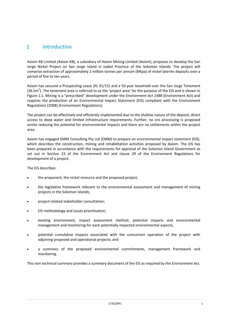
The proposed mine layout is shown below in Figure 2.1.
×
Î
Î
!
ORE DRYING AREA
Existing jetty
!
BASE CASE PORT ANDORE HANDLING FACILITY
!
BASE CASE MINEINFRASTRUCTURE AREA
!
STOCKPILE
320280240200
300
260
8060
220180
240220200160120
280220
300260
120
6016080
100 40
800
160
120
140120
100
80
120100
120100
140
120
20
0
340
160
120
140
40
20
60
40 20
240240
260
160
120
40
40
020
Ramuhale
Salavo
Ghob
u
Beakama
Kodoveka
Duru
DavuHughu
Suima
´\\E
mmsv
r1\em
m\Jo
bs\20
17\J1
7022
- San
Jorge
Proje
ct ES
IA\GI
S\02_
Maps
\EIA0
01_M
ineInf
rastru
cture_
2017
1108
_06.m
xd 8/
11/20
17
0 1 2km
× Accommodation camp
Î Port options
Potential area of disturbance
Prospecting licence boundary
San Jorge Island coastline
Access road
Proposed access road
Watercourse / drainage line
Contour (20 m)
Stockpile location
! ! ! ! !
! ! ! ! !
! ! ! ! ! Current known resource extent
Identified deposits to be mined
KEY
Source: EMM (2017); Axiom Mining Limited (2017)WGS 1984 UTM Zone 57S
Axiom Mining LimitedSan Jorge Nickel Project
Environmental impact statementFigure 2.1
Proposed mine layout plan
×
Î!
ALTERNATIVE CASE PORTAND ORE HANDLING FACILITY
!
ALTERNATIVE CASE MINEINFRASTRUCTURE AREA
!
INTERMEDIATE ROM STOCKPILE
Existing jetty
80
60
0
4020
100
140
120
ALTERNATIVE CASE
Alternative case (see inset)
J17022RP1 5
3 Publication consultation
Axiom has been engaging with the local people on San Jorge Island and associated areas of Santa Isabel Island since January 2016. A complete record of their consultation meetings is given in Appendix H of the full EIS. The following gives a brief overview of the consultation process undertaken to date.
Initial consultation regarded the deployment of monitoring equipment such as water monitoring devices and land access. In late February to early March 2016, Axiom undertook initial consultation with representatives from the following villages regarding the establishment of a Surface Access Agreement (SAA): Nagolau, Suva, Sepi, Lepi, Kamaosi, Vulavu, Sigana, Thathaje, Midoru and Japuana for the San Jorge Tenement (project area).
In June 2016, Axiom visited Talise and Sepi village to update people on the current status of Axiom’s mining tenements in south Isabel Province. The update informed local people that the Government (via the recent court ruling) had confirmed that Axiom has a valid Prospecting License (PL) on south San Jorge and that they planned to secure a SAA and to carry out prospecting work on San Jorge in the near future.
In August 2016 Axiom presented in the Heritage Park Hotel (Honiara) and later in Sepi Village regarding their proposed exploration program, social and environmental impacts, tambu site identification, employment opportunities and road and landing development.
Consultation through the rest of 2016 and early 2017 was a continuous process culminating with the signing of a legal SAA with most customary landholders in February 2017, and an updated agreement signed with the Bungusule clan in May 2017.
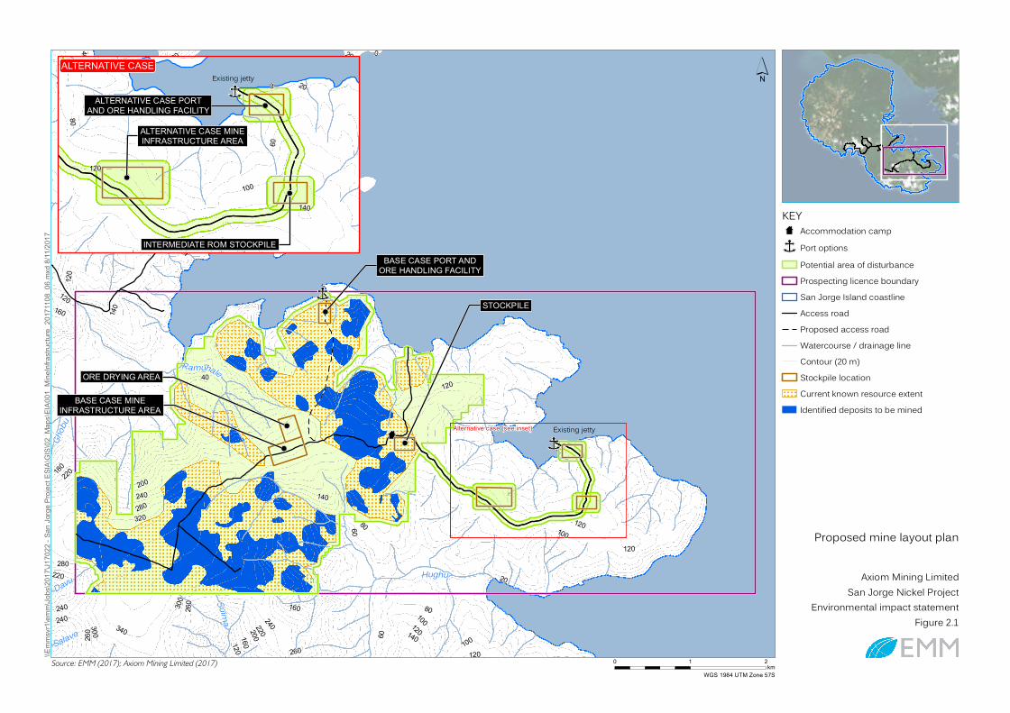
More recently, as set out in the Socio‐economic Assessment within the EIS, consultation has taken place in September 2017 as part of the EIA process in Talise and a number of villages on southern Santa Isabel Island (see Photograph 3.1).
Photograph 3.1 Public consultation in Talise Village, San Jorge, September 2017

J17022RP1 6
J17022RP1 7
4 Project need and alternatives considered
4.1 The need
Southern Isabel Province contains significant deposits of nickel rich laterites. Nickel, when added to other metals such as iron and copper, can create strong and versatile alloys including stainless steel. Nickel is also resistant to corrosion, and is used by the electroplating industry to provide a corrosion resistant coating. Nickel is also used in the production of rechargeable batteries; which is expanding significantly with the development of electric and hybrid vehicles (Nickel Institute, 2017). In 2015, 68% of nickel was used in the production of stainless steel, 20% in other alloys, 9% in electroplating and the remaining 4% for a variety of uses, including batteries. There is a continuous global demand for nickel for these purposes.
The economy of the Solomon Islands is predominantly based on forestry and agriculture, which makes it vulnerable to changing climate and market forces. In 2011, the government decided to establish alternative export industries to compensate for the expected decline of the forestry industry; these industries include mining, tourism and fishing.
4.2 Benefits
There are a number of significant socio‐economic benefits that would arise from the development of the proposed mine:
it would add significant direct revenue to the Solomon Islands’ Government via royalties;
it would create jobs during construction (approx. 300) and operation (approx. 120 to 140);
revenue would go directly into the local economy in southern Isabel Province via the share ownership model; and
there would be indirect economic benefits from associated industries and service / product suppliers.
4.3 Alternatives
The following alternative options have been considered:
The project not proceeding. If the project does not go ahead, and the resource is left in‐situ, the socio‐economic benefits described above will not be realised.
Alternative locations. The location of the ore bodies is a fixed geological phenomenon and mining the nickel has to involve these areas.
Processing of nickel. It is not economically viable to process the nickel locally in the Solomon Islands. The ore will be exported to be processed overseas.
Infrastructure. Various alternatives have been considered for the haul roads, the location of the ore handling facility and shipping methods.

J17022RP1 8

J17022RP1 9
5 Existing environment
5.1 Location and topography
The Solomon Islands are an archipelago of islands and coral atolls in the Pacific Ocean. The islands are mountainous and form a double chain separated by the New Georgia Sound. They are aligned north‐west to south‐east, stretching approximately 1,400 km from Bougainville to the Santa Cruz Islands. San Jorge Island is situated in the central part of the Solomon Islands, immediately offshore from the southern edge of Santa Isabel Island, in Isabel Province (see Figure 1.1). Honiara is approximately 102 km south‐south‐east of San Jorge Island. San Jorge Island is separated from Santa Isabel by a large bay in the south‐east named Thousand Ships Bay, which is approximately 6 km wide at its entrance. The prospecting licence area (PL 01/15) is located on the south‐eastern part of San Jorge Island, where the elevations range from sea level to 360 m AMS. The tenement measures approximately 9 km west to east and 4 km north to south and approximately 30% of the tenement is sea.
5.2 Climate and weather
The Solomon Islands experience an equatorial climate influenced by the El Niño Southern Oscillation (ENSO). There is generally a dry season from May to October, and a wet season from November to April. Temperatures in southern Isabel Province (2008‐2012) had minimum temperatures ranged from 20.4°C to 23.4°C and maximum temperatures from 31.5°C to 35.9°C. The warmest months are November to April and the coolest months are May to October. Relative humidity varies greatly over the course of the day, but has little seasonal variation. The minimum average monthly humidity ranged from 64% to 72% and average monthly maximum humidity ranged from 97% to 99%. Annual rainfall in the Solomon Islands ranges from 3,000 mm to 5,000 mm with significant variation between locations due to prevailing winds and topography. In southern Isabel, the minimum rainfall generally occurs between April and June, and the maximum rainfall occurs between December and April. The lowest recorded rainfall (100 mm) was in June 2010 and the highest recorded rainfall 650 mm was in January. The wind environment varies with season: west south‐westerlies predominate during January, which shift to the north‐west during February and March. Wind directions shift to the northeast during June then back to the northwest in October. The average yearly wind speed is between 1.33 m/s and 2.41 m/s with maximum wind speed between 4.14 m/s and 8.93 m/s.
5.3 Physical environment
5.3.1 Tectonics
The Solomon Islands archipelago is at the boundary of the Australian and Pacific continental plates and is tectonically active. Santa Isabel and San Jorge islands form part of a linear north‐west to south‐east trending chain of islands in the New Georgia Group.
5.3.2 Geology
The island of San Jorge was mapped by the British Government in the early 1960s, and the map published by the Ordnance Survey in 1969. This shows that the outcropping rocks on the San Jorge Tenement are ultramafic intrusions of Oligocene to Eocene age (between 56 and 23 million years old).
The nickel laterite deposits of the Solomon Islands have developed under tropical conditions over ultramafic rocks. They have largely formed by weathering and decomposition of the underlying ultramafic rocks which leads to enrichment of nickel within the soil. The laterite formation comprises two separate zones: the saprolite zone; and the limonite zone.

J17022RP1 10
5.3.3 Soil
Soil mapping of the areas shows that the majority of the project area is underlain by yellowish red clay (Haplorthox), brown to yellow clays and loams (Dystropepts) and humus‐rich yellow to red clay (Haplohumox). These are strongly weathered and leached acidic soils with low nutrients and high levels of heavy metals. There are also some small pockets of coastal saline clays (Sulfihemists) in coastal swamps and lagoons, and riverine mottled clay (Tropaquents) along watercourses.
5.3.4 Flora and vegetation
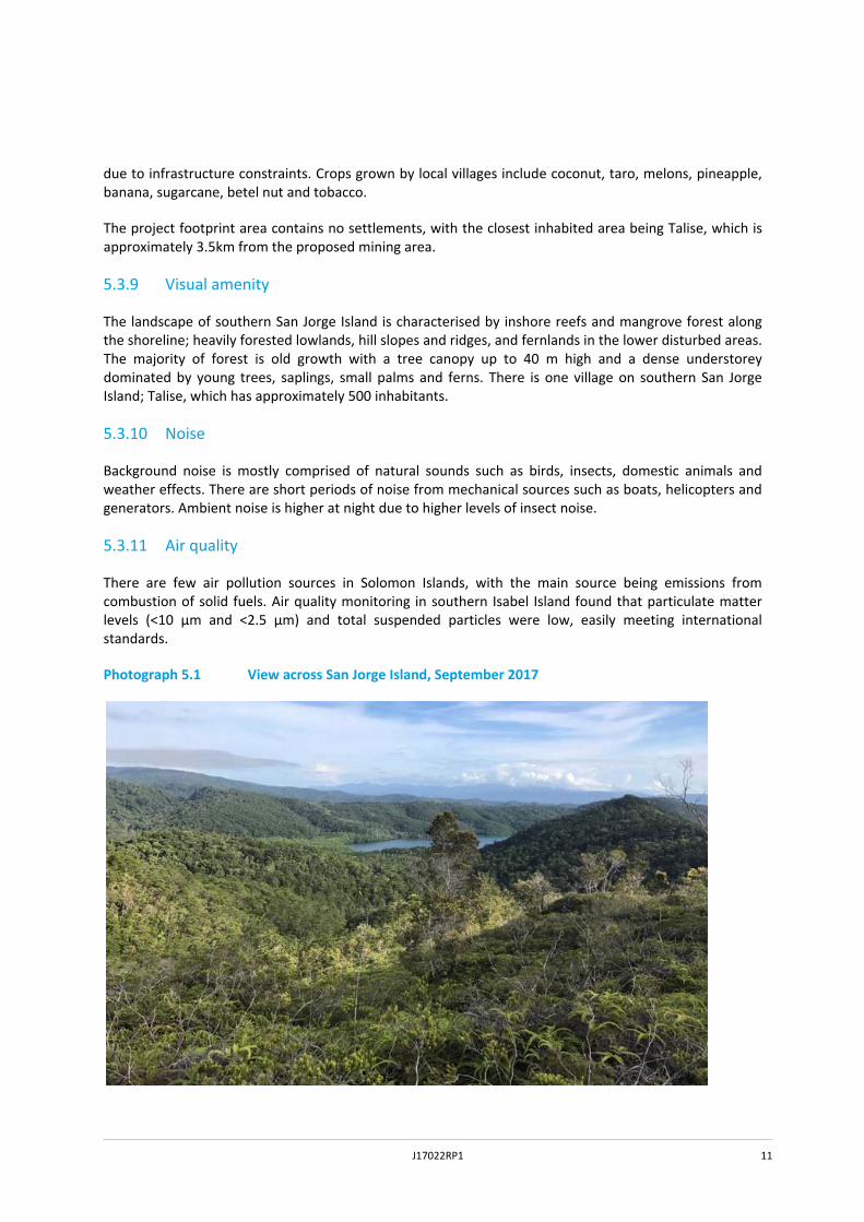
The Solomon Islands are predominantly vegetated with rainforest except for small areas of grassland and heath. They have one of the highest rates of species richness (approximately 5,000 species) and endemism in the world, with many species only found in the Solomon Islands. Tall rainforests are common in gullies and on north‐facing slopes, with extensive thickets of small trees and climber tangles elsewhere. The main plant communities in the project area are ironwood forest over ultramafic rocks, lowland rainforest and mangroves. The project area is heavily vegetated with ultramafic forest dominating the higher areas and fernlands in the lower disturbed areas (See Photograph 5.1).
5.3.5 Fauna
The Solomon Islands have one of the highest rates of endemism in the world with 39 species listed on the International Union of Conservation of Nature (IUCN) Red List of Threatened Species. Threatened taxa comprise two amphibian species, two reptile species, 17 bird species and 18 mammal species. Nearby Santa Isabel Island has the highest diversity of frogs in the Solomon Islands with 22 species.
5.3.6 Freshwater environment
The project area is drained by a number of small creeks which run from higher terrain north and east to Albatross Bay to the north and Astrolabe Bay to the east. These creeks are fed by rainfall and artesian springs. High rates of runoff are observed in the catchments due to the undulating terrain and heavy rainfall. High turbidity and sediment loads in surface drainage lines are frequent and it is likely that aquatic fauna are adapted to the variable water quality and quantity. The freshwater systems close to villages are used for drinking water, and provide habitat for eels and freshwater molluscs.
5.3.7 Marine environment
Thousand Ships Bay between San Jorge and Santa Isabel islands is characterised by mangroves along the shorelines, fringing coral reefs and small islands. Thousand Ships Bay is around 50 m deep between Santa Isabel and San Jorge islands. The marine environment is the local inhabitants’ main source of protein (fish) and a source of income. The bay is subject to customary fishing rights. Local people fish for reef fish, turtles, shellfish, crabs, crayfish and, in deeper water, snapper. Fish are used for local consumption. Some are taken to the fish market, where snapper is the most lucrative species. Local residents report that the bay becomes turbid after heavy rainfall and that they do not fish during this time.
5.3.8 Land use and tenure
Land tenure on San Jorge Island is mostly customary with most land owned by tribes and clans. Land use mostly comprises traditional uses including hunting and fishing, with such activities providing an important source of protein. Logging also occurs in some areas, which results in clearing of native forest leading to depletion of soil nutrients and erosion. However, these undertakings are not well developed
J17022RP1 11
due to infrastructure constraints. Crops grown by local villages include coconut, taro, melons, pineapple, banana, sugarcane, betel nut and tobacco.
The project footprint area contains no settlements, with the closest inhabited area being Talise, which is approximately 3.5km from the proposed mining area.
5.3.9 Visual amenity
The landscape of southern San Jorge Island is characterised by inshore reefs and mangrove forest along the shoreline; heavily forested lowlands, hill slopes and ridges, and fernlands in the lower disturbed areas. The majority of forest is old growth with a tree canopy up to 40 m high and a dense understorey dominated by young trees, saplings, small palms and ferns. There is one village on southern San Jorge Island; Talise, which has approximately 500 inhabitants.
5.3.10 Noise
Background noise is mostly comprised of natural sounds such as birds, insects, domestic animals and weather effects. There are short periods of noise from mechanical sources such as boats, helicopters and generators. Ambient noise is higher at night due to higher levels of insect noise.
5.3.11 Air quality
There are few air pollution sources in Solomon Islands, with the main source being emissions from combustion of solid fuels. Air quality monitoring in southern Isabel Island found that particulate matter levels (<10 µm and <2.5 µm) and total suspended particles were low, easily meeting international standards.
Photograph 5.1 View across San Jorge Island, September 2017

J17022RP1 12
J17022RP1 13
6 Impact assessment methodology
This EIS uses some existing environment information from Sumitomo’s Santa Isabel EISs (SMM, 2012 and 2014), which has been validated for the San Jorge Tenement deposit by site‐specific technical assessments (including field surveys). This provided site specific data on the following: terrestrial ecology, soils and revegetation, physical marine environment and surface water. The technical assessments included consultation with local people within or associated with the tenement; site inspections; water and soil sampling; flora and fauna surveys; analysis of results; and a site‐specific assessment of potential impacts.
Environmental and social values of the area were defined prior to an impact assessment taking place. An environmental value is a quality or characteristic of the environment that is required for ecological health, amenity or safety, or one protected by legislation. Social values usually relate to sensitive receptors, such as a village or school.
The significance of an impact has been assessed by calculating the sensitivity or susceptibility to change of a social or environmental value, and the worst‐case magnitude of the impact that will affect it. The residual significance of the impact is then calculated based on successful implementation of environmental management (mitigation) measures.

J17022RP1 14

J17022RP1 15
7 Key environmental and social impacts
Axiom has committed to a range of mitigation measures developed to reduce or avoid the potential adverse impacts of the project and enhance its benefits. The mitigation measures are derived from the work of technical specialists, international leading‐practice standards, and design features from Axiom. The mitigation measures will generally form the basis of management plans that will be prepared prior to the project’s construction. The summary of key environmental and social impacts below, takes account of these measures. The following management plans will be prepared:
Erosion and sediment control plan;
Rehabilitation plan;
Hazardous materials and spill response plan;
Waste management plan;
Acid sulphate soils plan;
Ballast water management plan;
Pest and weed management plan;
Air quality management plan;
Marine monitoring plan; and
Biodiversity monitoring plan
7.1 Geology and soils
The soils and geology found on San Jorge within the tenement area are vulnerable to impacts from the project. Potential impacts include soil erosion, landslips, loss of fertility, acidity arising from acid sulphate soils (ASS), and impacts from spills and waste. The development and implementation of management plans covering land rehabilitation, erosions and sediment control, ASS, hazardous materials, waste will reduce the significance of these impacts to low levels, although erosion could still be a moderately significant issue.
7.2 Terrestrial ecology
The site contains a number of relatively unusual habitats including ultramafic forests, ultramafic swamp forest and fernlands. These habitats and their associated flora and fauna (birds, mammals, reptiles and amphibians) are considered to be of regional value. Impacts upon these ecological resources would include: land clearance; habitat fragmentation and edge effects; water quality impacts in streams; direct and indirect mortality of fauna; increased noise; artificial light at night; possible fires; traffic; increased dust; soil erosion; and the potential for introduced weeds and animal pests to enter the area.
A wide range of mitigation measures have been proposed to minimise these impacts including, but not limited to: progressive rehabilitation; retaining as much natural vegetation as possible, especially in gullies; erosions and sediment controls; development of a site‐specific pest and weed management plan; and development of an air quality management plan.

J17022RP1 16
Whilst the implementation of these mitigation measures will reduce the significance of the impacts, the overall impacts are considered moderately significant due to the long term loss of a large area of ultramafic forest.
7.3 Freshwater environment
The project area supports a number of small freshwater streams (3‐4 km long) that flow into the sea. These streams are vulnerable to impacts from project activities. The main impact of the project will be to increase sedimentation in the streams from soil erosion. Soil erosion will be most likely in heavy rainfall events following vegetation clearance. Other potential impacts include changes to hydrologic regimes and riverbed erosion, and contamination of freshwater from sediment and hazardous materials.
The implementation of the water management strategy and related management plans and mitigation measures will reduce the significance of these impacts from high, to low and moderate. Impacts are most likely to occur during significant rainfall events when the design capacity of the erosion and sediment controls is stressed.
7.4 Marine Environment
The marine waters around San Jorge Island are vulnerable to sedimentation impacts from local watercourses and impacts from the spillage of ore during the export process. The impacts of sedimentation and loading at the marine jetty have been modelled using a hydrodynamic model. The results have shown that during mine operations, water quality impacts will largely be confined to the local bays, which are generally depositional environments; estuaries surrounded by mangroves. In extreme rainfall events, the closer parts of some fringing reefs may be slightly affected, but the deeper water reefs should not be impacted. Transhipment of the ore at sea should have limited impacts due to the depth of water and the effects of dilution.
The implementation of management plans and the application of management measures will reduce the significance of these impacts from moderate, to low to moderate. Impacts are most likely to occur during significant rainfall events when the design capacity of water management and erosion and sediment controls is stressed.
7.5 Marine Ecology
While coastline habitats show some signs of disturbance from current land uses eg logging, the wider marine environment within the project area appears to be in good condition with clear, well oxygenated waters and a range of habitats that support a healthy diversity of corals and fish. The marine biodiversity within the project area and wider locality is likely to be high, especially as the Solomon Islands from part of the highly diverse ‘Coral Triangle’. Issues that may arise without acceptable preventative management measures include: turbidity and sedimentation following rainfall events during construction and operation; hazardous spills and leaks from the Project plant and equipment; acid sulphate soils from the construction of the jetty; ballast water from vessels entering the project area; litter and waste created from the Project; and vessel collisions with marine fauna.
These issues can be prevented or reduced by implementing various management plans. These include: an erosion and sediment control plan; hazardous materials management plan; liquid and solid waste management plan; acid sulphate soils plan; ballast water management plan; marine monitoring plan; and; biodiversity management plan. Provided that these measures are implemented and monitoring takes place to ensure control of key issues such as sedimentation, the impacts of the project should be localised and should not trigger long term damage to the marine environment in the project area.
J17022RP1 17
7.6 Amenity
The amenity chapter considered three environmental issues that could affect local people: visual amenity; air quality and noise.
7.6.1 Visual amenity
Visual impacts were considered on four villages: Talise (on San Jorge); and the villages of Suma, Thatheje and Sepi on the west coast of Santa Isabel Island overlooking Thousand Ships Bay.
The view shed analysis found that visual impacts would generally be minor because:
few project components are likely to be viewable from Talise during construction and operation as there is a high ridge between the proposed mine and the village which will shield views; and
whilst many project components are likely to be viewable from Suma, Thatheje and Sepi, these will be located a significant distance away (minimum of 7 km distant).
Mitigation measures proposed include: vegetation retention where possible; progressive mining; and progressive rehabilitation. Visual impacts prior to mitigation are considered minor. By considering the topography and distance between villages and project components there is high confidence that there will be a minor residual impact.
7.6.2 Air quality
The nearest permanently settled village, Talise, is approximately 3.5km from the nearest area of potential disturbance at the mine. Past air quality studies in southern Isabel Province have shown air quality in the area is high; ie unpolluted.
Dust and particulate matter levels could increase during construction and operational mining when the weather is dry. Dust could originate from pits, stockpiles, windrows, loading/unloading operations and roads.
The assessment has shown that there will be minimal increases in dust and particulate matter (PM10, PM2.5) at Talise or villages on Santa Isabel. With the implementation of an air quality management plan and associated dust control measures, there will be no residual impacts on air quality affecting local villages. It should be noted that if the alternative port option is considered, the temporary settlement at Kogarutu would have to be vacated and the owners compensated.
7.6.3 Noise
The nearest permanently settled village is Talise. Noise levels are relatively low during the day time (34 dBA) and dominated by natural noises such as bird song, insects and wind. Night time noise levels increase to 39 dBA primarily due to increased insect noise.
Noise levels will increase on the mine during construction and operation due to mining plant and equipment that will be used on site including: excavators, dump trucks, dozers and front‐end loaders. Noise modelling of all of this plant operating on the site was undertaken. Modelling predicted noise levels at three noise‐sensitive receivers; the nearest dwelling within the Talise village and one location at each of the temporary settlements at Kogarutu and Loghutu.
J17022RP1 18
For operation, under the base port option and the alternative port option there were no exceedances of the recognised noise criteria at any of the sensitive receptor locations, therefore the project is predicted to have a negligible impact. Construction noise impacts are predicted to be lower than operational impacts and therefore they are also expected to have a negligible impact.
7.7 Socio‐economic
The Solomon Islands is considered a lower middle income country, with a $1.202 billion USD GDP in 2016, when it grew 3% year on year. It is currently ranked joint 176th out of 196 countries by the World Bank. The GDP has been growing at an average of 3% in recent years and this trend is expected to continue. It is estimated that 22.7% of the population were living below the poverty line in 2015.
San Jorge Island is a sparsely populated island situated in southern Isabel Providence, separated from Santa Isabel Island by Thousand Ships Bay. The San Jorge tenement Axiom is looking to develop for mining has no permanent settlements within it. The village of Talise is the closest permanent settlement. There are two temporary settlements on San Jorge one within (Kogarutu see Photograph 7.1) and one just outside (Loghutu) the tenement.
The socio‐economic assessment reviews the current situation in the Solomon Islands and more specifically the southern Isabel Province and San Jorge Island regarding: governance and society; demographics; livelihood and employment; land tenure; education; healthcare; and housing. The introduction of a mine in southern Isabel Providence will have both beneficial and adverse impacts on these socio‐economic attributes.
On the beneficial side, the project will have significant positive benefits: it will increase revenue to the Solomon Island’s government through royalties; it will increase jobs; and it will increase regional revenue via both direct spend from jobs and services being provided to the mine from local businesses. In addition, it will increase transport to the region making the area more accessible to and from the capital, Honiara.
There are also some potential adverse impacts: disruption of village life / tranquillity; social inequality regarding money distribution; inter‐ and intra‐village conflict; gender inequality; increased demand on local social infrastructure; increases in anti‐social behaviour, potential impacts on customary fishing grounds, the loss of hunting areas, water pollution / sedimentation causing increased heavy metals in food chain, and increased air pollution and noise.
The assessment sets out a range of measures to mitigate potential adverse impacts which in many cases can make them a positive benefit of the project. Assuming a well considered social management plan, addressing all the issues is implemented, most, if not all of the potential negative impacts can be mitigated. The positive impacts of the mine have the potential to grow the area economically and should have significant benefits on education, healthcare and the livelihoods of the local communities.
7.8 Cultural heritage
The Solomon Islands has a rich and varied cultural heritage with Melanesian influences intertwining with European expeditions in the early colonial era from 1567. There is little written historical literature regarding southern Isabel Province, and particularly San Jorge before the beginning of the 20th century.
Axiom has undertaken continuous consultation with local villagers who have customary land holdings within the project area. Part of this process has included the identification of culturally important sites, including tambu (forbidden) sites and other cultural features on or adjacent to the project area.

J17022RP1 19
A total of four tambu sites and one other culturally important site were identified in conjunction with local leaders within or adjacent to the project area. These included: a tambu site where skulls were known to be sited; 2 tambu sites important because of their location and views; a tambu site important for crocodiles; and lastly the area’s customary fishing nets. None of the sites will be directly affected by the proposed development. However some indirect adverse effects have been noted: access for local people to all of the tambu sites may be affected during the construction and operation of the mine. In addition, the setting (surrounding landscape) at all of the sites may be affected. The customary fishing nets may be affected by disturbance from barges and shipping and by sedimentation from adjacent rivers during storm events.
The assessment set out a range of management measures to address potential impacts from chance finds. Overall the impacts are considered to be of low significance, with issues being resolved through consultation, and possible compensation, particularly regarding the customary fishing nets.
Photograph 7.1 View across San Jorge with Kogarutu in the foreground

J17022RP1 20

J17022RP1 21
8 Summary and conclusions
The EIS has been prepared to accompany the application for a nickel mine on San Jorge Island in southern Isabel Province in the Solomon Islands. The project will comprise extraction, by shallow strip mining, of approximately 2 million tonnes per annum (Mtpa) of nickel laterite deposits, over a period of five to ten years. The ore will be directly shipped overseas for processing.
There is a continuous global demand for nickel: when added to other metals eg iron and copper, it creates strong, versatile alloys including stainless steel; and it is used in rechargeable batteries eg in electric cars.
The economy of the Solomon Islands is predominantly based on forestry and agriculture, which makes it vulnerable to changing climate and market forces. The project aligns with government policy of diversification to increase jobs and revenue streams.
Axiom is committed to an enduring partnership with traditional land owners and development of mining that benefits the local community and wider region. This is reflected in its ownership structure, with this project being 10% owned by the customary land owners of the San Jorge tenement.
The project will create a significant number of jobs – approximately 300 during construction and 120 to 140 during operations. Axiom will aim to recruit locally where possible, particularly from villages with customary ownership of the land, thereby ensuring the mine benefits local communities. Not only will this significantly increase income, but the training will provide ongoing benefits such as attainment of new skills that can be taken back to home villages. The project will generate significant revenue through taxes and royalties for the government. It is anticipated that taxes and royalty benefits will be used for social infrastructure and social development such as education, healthcare and other long term community projects.
The EIS sets out relevant legislation in the Solomon Islands, and includes a summary of project‐related stakeholder consultation. It also describes the EIS methodology setting out how impacts have been identified, described and quantified. For each social and environmental aspect, the EIS sets out: the existing environment; an impact assessment method; potential impacts; environmental management measures; and residual environmental impacts assuming environmental management measures are implemented. The key issues described in the EIS are related to:
Geology/Soils: the shallow, red soils are susceptible to erosion during heavy rainfall, once vegetation is cleared. A rehabilitation plan has been prepared to reduce soil erosion and associated impacts.
Terrestrial Ecology: the clearance of ultramafic forests and fernlands, including flora and fauna (over 1000 ha in total) will reduce the area’s ecological value. Whilst environmental protection measures and a rehabilitation plan will reduce impacts, the site will still be adversely affected over a long term period.
Freshwater environment: the project area supports a number of small freshwater streams (3‐4 km long) that flow into the sea. The main impact of the project will be to increase sedimentation in the streams from soil erosion. The rehabilitation and erosion and sediment control plans will assist in reducing adverse impacts, although some increase in sedimentation and turbidly will not be completely preventable.
Marine ecology/Marine environment: the marine water quality and ecology will be locally affected by stream sedimentation. In addition, loading of barges and ships with ore and the jetty construction may have local adverse water quality impacts. A variety of management plans are proposed to reduce impacts.
Amenity: this assessment considered impacts of the project relating to visual amenity, air quality and noise on local villages. The nearest receptors are in Talise, 3.5km from the project. The three assessments

J17022RP1 22
(visual, air quality and noise) all concluded that impacts would all be minor / negligible due to the distance between the mine and receptors.
Socio‐economic/Cultural heritage: there are a number of significant socio economic benefits that would arise from the development of the mine: direct revenue to the Government; jobs during construction and operation; revenue into the local economy via the share ownership model; and indirect economic benefits from associated industries and services to supply the mine. The project does not directly impact any villages or settlements and therefore no resettlement action plan is required. The project could have some indirect, adverse social impacts, however a range of social management measures have been suggested to reduce or eliminate these issues. Four culturally sensitive tambu sites and a customary fishing area have been identified by local residents for protection should the project proceed. None of these are directly affected by the project, and indirect impacts are considered to be minor.
Photograph 8.1 Ecological fieldworkers on the project area, September 2017