san juan county, utah resource assessment - usda · san juan county, utah resource assessment...
TRANSCRIPT

San Juan County, Utah Resource Assessment August 2005
La
This resource assessment is designed to gather and display information specific to San Juan County, Utah. This report will highlight the natural and social resources present in the county, detail specific concerns, and be used to aid in resource planning and target conservation assistance needs. This document is dynamic and will be updated as additional information is available through a multi-agency partnership effort. The general observations and summaries are listed first, followed by the specific resource inventories.
Contents Observations and Summary Resource Concerns - Air, Plants, Animals
Land Use Resource Concerns - Social and Economic
Resource Concerns - Soils Survey Results
Resource Concerns - Water Footnotes/Bibliography
In SaAror Pofedof 45 Suwitsligyr-
Equ
st printed 2/2/2006 12:28 PM 8/1/2005 1
troduction
n Juan County is located in the far south-eastern portion of Utah within the Colorado Plateau along the Colorado and izona borders. It is the largest county in Utah and the second largest in the United States with approximately 7,884 mi2 5.2 million acres. Some of the more famous attractions within San Juan County are Canyonlands National Park, Lake well, Four Corners area and the Navajo Indian Reservation. The majority of the land (approx. 72%) is administered by eral and tribal agencies. Land ownership/administration within San Juan County is broken down as follows (acres, % total): BLM 2,074,247, 41%; Indian Reservation 1,220,846, 23%; National Parks Service 587,375, 10%; U.S.F.S 0,549, 9%; State of Utah 406,415, 8%; Private 406,367, 8%, and Private Indian Trust Funds 25,117, 1%.
mmer precipitation patterns are typical for the south west with monsoonal storms, with heavier snow accumulations hin the higher elevations during the winter months. The average growing season is June 1 through October 1, with htly longer periods in the lower elevations. The average annual precipitation within the County is between 6 and 22 in
1.
al Opportunity Providers and Employers.

San Juan County, Utah Resource Assessment August 2005
Last printed 2/2/2006 12:28 PM 8/1/2005 2
Back to Contents General Land Use Observations Grass / Pasture / Hay Lands
Complications related to overgrazing include poor pasture condition, soil compaction and water quality issues. Control of noxious and invasive plants is an ever increasing problem. The small, part-time farms are less likely to adopt conservation due to cost and low farm income.
Row & Perennial (orchards / vineyards / nurseries) Crops Residue, nutrient and pest management are needed to control erosion and to protect water quality. The small, part-time farms are less likely to adopt conservation due to cost and low farm income.
Forest On private, non-industrial forest there are issues with erosion, water quality and forest productivity On non-industrial forest land, landowner objectives often are not on actively managing the land for timber
production. Land use constraints and the lack of economic incentives further discourage conservation. Resource Assessment Summary
CategoriesConcern
high, medium, or low
Description and Specific Location (quantify where possible)
Soil Medium Soil erosion associated with dryland farming.
Water Quantity Medium Water depletion in Lake Powell and additonal lower basin storage.
Water Quality Ground Water Medium General concerns regarding ground water quality.
Water Quality Surface Water Medium General concerns regarding ground water quality.
Air Quality Low No concerns mentioned.
Plant Suitability Medium General concerns regarding noxious/invasive weeds.
Plant Condition Low No concerns mentioned.
Fish and Wildlife Medium Do not want the reintroduction of wolves in the area.
Domestic Animals Low No concerns mentioned.
Social and Economic Low No concerns mentioned.
San Juan County, Utah Resource Assessment August 2005
La
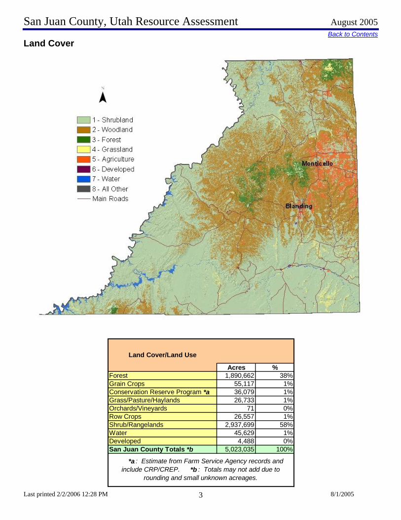
Back to ContentsLa d Cover
n
st printed 2/2/2006 12:28 PM 8/1/2005 3
Acres %Forest 1,890,662 38%Grain Crops 55,117 1%Conservation Reserve Program *a 36,079 1%Grass/Pasture/Haylands 26,733 1%Orchards/Vineyards 71 0%Row Crops 26,557 1%Shrub/Rangelands 2,937,699 58%Water 45,629 1%Developed 4,488 0%San Juan County Totals *b 5,023,035 100%
*a : Estimate from Farm Service Agency records and include CRP/CREP. *b : Totals may not add due to
rounding and small unknown acreages.
Land Cover/Land Use

San Juan County, Utah Resource Assessment August 2005
L
Back to ContentsSpecial Considerations for San Juan County:
• Thirty-seven percent of private forest is in industrial forest ownership. • As of August 2005, 36,079 acres of CREP have been applied (FSA). • Row crops include a variety of field and vegetable crops. • There are approximately 55,117 acres of grain. • Shrub/rangelands consist of desert shrub and barren lands. • Nine one-hundredth of a percent of the county consists of urban land uses within metropolitan areas. • Nine tenth of a percent of the county is covered with water.
L
ast printed 2/2/2006 12:28 PM 8/1/2005 4
and Ownership
San Juan County, Utah Resource Assessment August 2005
Last print
Back to Contents
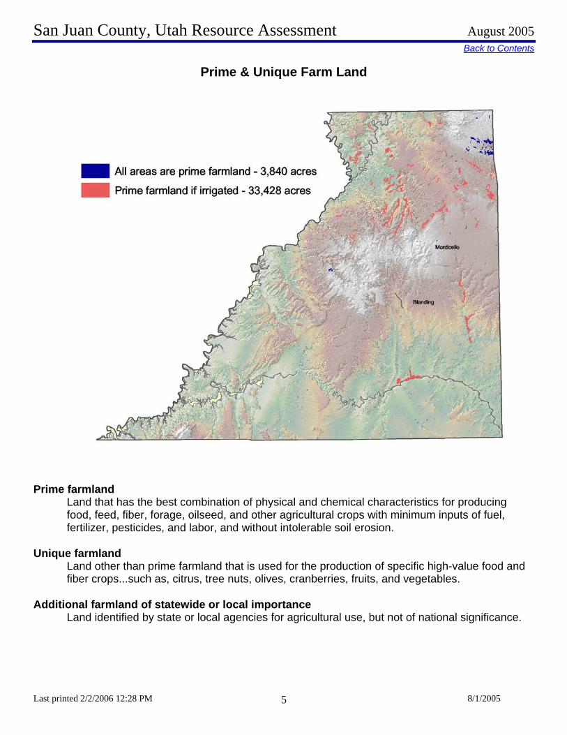
Prime & Unique Farm Land
Prime f
Lff
Unique
Lf
Additio
L
ed 2/2/2006 12:28 PM 8/1/2005 5
armland and that has the best combination of physical and chemical characteristics for producing ood, feed, fiber, forage, oilseed, and other agricultural crops with minimum inputs of fuel, ertilizer, pesticides, and labor, and without intolerable soil erosion.
farmland and other than prime farmland that is used for the production of specific high-value food and iber crops...such as, citrus, tree nuts, olives, cranberries, fruits, and vegetables.
nal farmland of statewide or local importance and identified by state or local agencies for agricultural use, but not of national significance.

San Juan County, Utah Resource Assessment August 2005
Last printed 2/2/2006 12:28 PM 8/1/2005 6
Back to Contents Resource Concerns – SOILS
Categories Specific Resource Concern / Issue
Cro
pH
ayPa
stur
eG
raze
d R
ange
Gra
zed
Fore
stPa
stur
e N
ativ
e/N
atur
aliz
ed
Wild
life
Wat
ersh
ed P
rote
ctio
nFo
rest
Hea
dqua
rter
sU
rban
Rec
reat
ion
Wat
erM
ined
Nat
ural
Are
a
Sheet and Rill x x x x xWind x x x xEphemeral Gully x x x x xClassic Gully xStreambank x x xShorelineIrrigation-induced x xMass Movement x x xRoad, roadsides and Construction Sites x x x x x xOrganic Matter Depletion xRangeland Site Stability x x xCompaction x x xSubsidence x xContaminantsSalts and Other Chemicals xContaminants: Animal Waste and Other OrganicsN x x x xContaminants: Animal Waste and Other OrganicsP x x x xContaminants: Animal Waste and Other OrganicsK x x x xContaminants : Commercial FertilizerN x x x x xContaminants : Commercial FertilizerP x x x x xContaminants : Commercial FertilizerK x x x x xContaminantsResidual Pesticides x x x xDamage from Sediment Deposition x x x x x
Soil Erosion
Soil Condition
xxx

San Juan County, Utah Resource Assessment August 2005
L
Back to ContentsLand Capability Class on Cropland and Pastureland
ast printed 2/2/2006 12:28 PM 8/1/2005 7Acres Percentage I - slight limitations 0 0% II - moderate limitations 18,574 19% III - severe limitations 60,506 62% IV - very severe limitations 18,885 19% V - no erosion hazard, but other limitations 0 0% VI - severe limitations, unsuited for cultivation, limited to pasture, range, forest 0 0% VII - very severe limitations, unsuited for cultivation, limited to grazing, forest, wildlife 0 0%
Land Capability Class (Irrigated Cropland &
Pastureland Only)
VIII - misc areas have limitations, limited to recreation, wildlife, and water supply 0 0%

San Juan County, Utah Resource Assessment August 2005
Last printed 2/2/2006 12:28 PM 8/1/2005 8
Back to ContentsSoil Erosion
San Juan County Soil Erosion
0.805 0.8220.875
0.797
0.147 0.1640.122 0.120
0.000
0.200
0.400
0.600
0.800
1.000
1982 1987 1992 1997
Years
tons
/acr
e
Soil Loss by WindSoil Loss by Water
Sheet and rill erosion by water on the sub basin pasturelands have been reduced by .08 tons of soil per acre from 1992 to 1997. Dry cropland in San Juan County can be compared using a multiplier of ten.
Controlling erosion not only sustains the long-term productivity of the land, but also affects the amount of
soil, pesticides, fertilizer, and other substances that move into the nation’s waters.
Through NRCS programs many farmers and ranchers have applied conservation practices to reduce the effects of erosion by water. As a result, erosion rates on pasturelands fell 40 percent from 0.164 to 0.12 tons/acre/year from 1987 to 1997. Dry cropland in San Juan County can be compared using a multiplier of ten.

San Juan County, Utah Resource Assessment August 2005
Last printed 2/2/2006 12:28 PM 8/1/2005 9
Back to ContentsResource Concerns – WATER
Categories Specific Resource Concern / Issue
Cro
pH
ayPa
stur
eG
raze
d R
ange
Gra
zed
Fore
stPa
stur
e N
ativ
e/N
atur
aliz
ed
Wild
life
Wat
ersh
ed P
rote
ctio
nFo
rest
Hea
dqua
rter
sU
rban
Rec
reat
ion
Wat
erM
ined
Nat
ural
Are
a
Water Quantity – Rangeland Hydrologic Cycle x x x x xExcessive SeepageExcessive Runoff, Flooding, or Ponding x x x x x x x x x x x xExcessive Subsurface WaterDrifted Snow x x x x x xInadequate OutletsInefficient Water Use on Irrigated Land x x xInefficient Water Use on Non-irrigated Land x x xReduced Capacity of Conveyances by Sediment Deposition
Reduced Storage of Water Bodies by Sediment Accumulationx x x x x
Aquifer OverdraftInsufficient Flows in Watercourses x x x x xHarmful Levels of Pesticides in GroundwaterExcessive Nutrients and Organics in GroundwaterExcessive Salinity in GroundwaterHarmful Levels of Heavy Metals in GroundwaterHarmful Levels of Pathogens in GroundwaterHarmful Levels of Petroleum in GroundwaterHarmful Levels of Pesticides in Surface Water x x xExcessive Nutrients and Organics in Surface WaterExcessive Suspended Sediment and Turbidity in Surface Water
x x x x x x x x xExcessive Salinity in Surface WaterWater Quality – Colorado River Excessive SalinityHarmful Levels of Heavy Metals in Surface WaterHarmful Temperatures of Surface Water Harmful Levels of Pathogens in Surface Water x x xHarmful Levels of Petroleum in Surface Water
Water Quantity
Water Quality, Groundwater
Water Quality, Surface

San Juan County, Utah Resource Assessment August 2005
Last pr
Back to ContentsPrec itation and Streams
Irrig
St
Per
ip
inted 2/2/2006 12:28 PM 8/1/2005 10
ACRES ACRE-FEET Surface 8930.00 35720.00 Well
ated Adjudicated Water Rights
Total Irrigated Adjudicated Water Rights 8930.00 35720.00 Total Avg. Yield 11,075 ream Flow Data USGS 09379500 San Juan River Near Bluff,
UT May-Sept Yield 15,555 MILES PERCENT Total Miles - Major (100K Hydro GIS Layer) 2140.00 n/a Stream Data 303d (DEQ Water Quality Limited Streams) 0.00 0%
Irrigation Efficiency: <40% 40 - 60% >60%
Cropland 15% 45% 40%
Pastureland 15% 25% 60%centage of Total
Acreage
San Juan County, Utah Resource Assessment August 2005
Last printed 2/2/2006 12:28 PM 8/1/2005 11
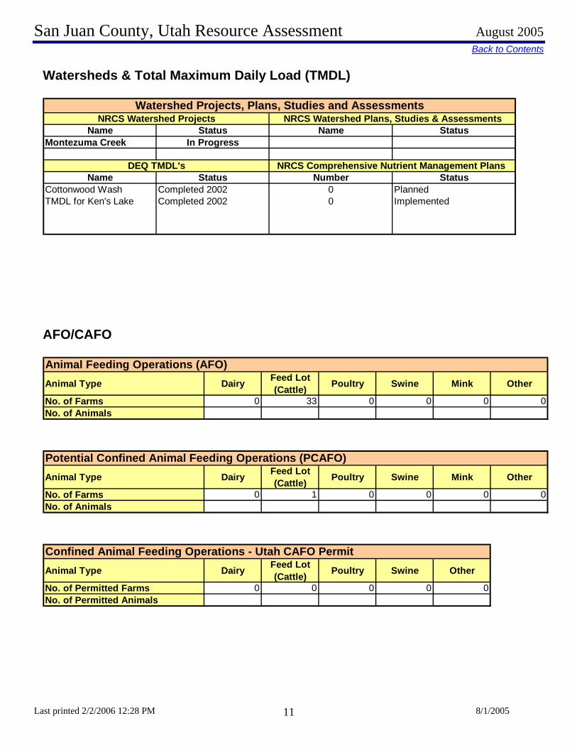
Back to Contents Watersheds & Total Maximum Daily Load (TMDL)
Name Status Name StatusMontezuma Creek In Progress
Name Status Number StatusCottonwood Wash Completed 2002 0 PlannedTMDL for Ken's Lake Completed 2002 0 Implemented
Watershed Projects, Plans, Studies and AssessmentsNRCS Watershed Projects NRCS Watershed Plans, Studies & Assessments
DEQ TMDL's NRCS Comprehensive Nutrient Management Plans
AFO/CAFO Animal Feeding Operations (AFO)Animal Type Dairy Feed Lot
(Cattle) Poultry Swine Mink Other
No. of Farms 0 33 0 0 0No. of Animals
0
Potential Confined Animal Feeding Operations (PCAFO)Animal Type Dairy Feed Lot
(Cattle) Poultry Swine Mink Other
No. of Farms 0 1 0 0 0No. of Animals
0
Confined Animal Feeding Operations - Utah CAFO PermitAnimal Type Dairy Feed Lot
(Cattle) Poultry Swine Other
No. of Permitted Farms 0 0 0 0No. of Permitted Animals
0

San Juan County, Utah Resource Assessment August 2005
Last printed 2/2/2006 12:28 PM 8/1/2005 12
Back to Contents Resource Concerns – AIR, PLANTS, ANIMALS
Categories Specific Resource Concern / Issue
Cro
pH
ayPa
stur
eG
raze
d R
ange
Gra
zed
Fore
stPa
stur
e N
ativ
e/N
atur
aliz
ed
Wild
life
Wat
ersh
ed P
rote
ctio
nFo
rest
Hea
dqua
rter
sU
rban
Rec
reat
ion
Wat
erM
ined
Nat
ural
Are
a
Particulate matter less than 10 micrometers in diameter (PM 10) x x x xParticulate matter less than 2.5 micrometers in diameter (PM 2.5) x x x xExcessive Ozone Excessive Greenhouse Gas: CO2 (carbon dioxide) x x x xExcessive Greenhouse Gas: N2O (nitrous oxide)Excessive Greenhouse Gas: CH4 (methane)Ammonia (NH3)Chemical DriftObjectionable OdorsReduced Visibility x x x xUndesirable Air MovementAdverse Air Temperature
Plant Suitability
Plants not adapted or suited x x xPlant Condition – Productivity, Health and Vigor x x xThreatened or Endangered Plant Species: Plant Species Listed or Proposed for Listing under the Endangered Species Act x x xThreatened or Endangered Plant Species: Declining Species, Species of Concern x x xNoxious and Invasive Plants x x x x x x x xForage Quality and Palatability x x x x xPlant Condition – Wildfire Hazard x x xInadequate Food x x xInadequate Cover/Shelter x x xInadequate Water x x xInadequate Space x x xHabitat Fragmentation x x x Imbalance Among and Within Populations x x xThreatened and Endangered Species: Species Listed or Proposed for Listing under the Endangered Species Act x x xInadequate Quantities and Quality of Feed and Forage x x x xInadequate Shelter x x x xInadequate Stock Water x x x xStress and Mortality x x x x
Air Quality
Plant Condition
Fish and Wildlife
Domestic Animals
x
x
x
x

San Juan County, Utah Resource Assessment August 2005
Last printed 2/2/2006 12:28 PM 8/1/2005 13
Back to Contents Noxious Weeds
Utah Noxious Weed List
The following weeds are officially designated and published as noxious for the State of Utah, as per the authority vested in the Commissioner of Agriculture under Section 4-17-3, Utah Noxious Weed Act:
• Bermuda grass** (cynodon dactylon) • Canada thistle (cirsium arvense) • Diffuse knapweed (centaurea diffusa) • Dyers woad (isatis tinctoria L) • Field bindweed (Wild Morning Glory) (convolvulus arvensis) • Hoary cress (cardaria drabe) • Johnson grass (sorghum halepense) • Leafy spurge (euphorbia esula) • Medusa head (taeniatherum caput-medusae) • Musk thistle (carduus mutans) • Perennial pepper weed (lepidium latifolium) • Perennial sorghum (sorghum halepense L & sorghum almum) • Purple loosestrife (lythrum salicaria L.) • Quack grass (agropyron repens) • Russian knapweed (centaurea repens) • Scotch thistle (onopordum acanthium) • Spotted knapweed (centaurea maculosa) • Squarrose knapweed (centaurea squarrosa) • Yellow starthistle (centaurea solstitialis)
Additional noxious weeds declared by San Juan County (2003): Silverleaf Nightshade, Buffalobur, Whorled Milkweed, Jointed goatgrass

San Juan County, Utah Resource Assessment August 2005
Last printed 2/2/2006 12:28 PM 8/1/2005 14
Back to ContentsWildlife Species of Greatest Conservation Need The Utah Comprehensive Wildlife Conservation Strategy (CWCS) prioritizes native animal species according to conservation need. At-risk and declining species in need of conservation were identified by examining species biology and life history, populations, distribution, and threats. The following table lists species of greatest conservation concern in the county.
Common Name Group Primary Habitat Secondary HabitatFEDERALLY-LISTED
California Condor (experimental) Bird CliffBlack-footed Ferret (extirpated) Mammal Grassland High Desert ScrubGray Wolf (extirpated) Mammal Mountain Shrub Mixed ConiferBonytail Chub Fish Water - LoticColorado Pikeminnow Fish Water - LoticHumpback Chub Fish Water - LoticRazorback Sucker Fish Water - LoticSouthwestern Willow Flycatcher Bird Lowland Riparian Mountain RiparianMexican Spotted Owl Bird Cliff Lowland RiparianBald Eagle Bird Lowland Riparian AgricultureBrown (Grizzly) Bear (extirpated) Mammal Mixed Conifer Mountain ShrubGunnison Sage-grouse Bird ShrubsteppeYellow-billed Cuckoo Bird Lowland Riparian Agriculture
Proposed: (None)STATE SENSITIVE
Northern Goshawk Bird Mixed Conifer AspenBluehead Sucker Fish Water - Lotic Mountain RiparianRoundtail Chub Fish Water - LoticFlannelmouth Sucker Fish Water - LoticAllen’s Big-eared Bat Mammal Lowland Riparian Pinyon-JuniperAmerican White Pelican Bird Water - Lentic WetlandArizona Toad Amphibian Lowland Riparian WetlandBig Free-tailed Bat Mammal Lowland Riparian CliffBobolink Bird Wet Meadow AgricultureBurrowing Owl Bird High Desert Scrub GrasslandCommon Chuckwalla Reptile High Desert Scrub Low Desert ScrubDesert Night Lizard Reptile Low Desert Scrub Pinyon-JuniperFerruginous Hawk Bird Pinyon-Juniper ShrubsteppeFringed Myotis Mammal Northern Oak Pinyon-JuniperGreater Sage-grouse Bird ShrubsteppeGunnison’s Prairie-dog Mammal Grassland High Desert ScrubKit Fox Mammal High Desert ScrubLewis’s Woodpecker Bird Ponderosa Pine Lowland RiparianMexican Vole Mammal Ponderosa Pine AspenShort-eared Owl Bird Wetland GrasslandSilky Pocket Mouse Mammal Grassland ShrubsteppeSmooth Greensnake Reptile Mountain Riparian Wet MeadowSpotted Bat Mammal Low Desert Scrub CliffThree-toed Woodpecker Bird Sub-Alpine Conifer Lodgepole PineTownsend’s Big-eared Bat Mammal Pinyon-Juniper Mountain ShrubYavapai Mountainsnail Mollusk Aspen Rock
*Definitions of habitat categories can be found in the Utah Comprehensive Wildlife Conservation Strategy.
Conservation Agreement Species:
Species of Concern:
AT-RISK SPECIES
Endangered:
Threatened:
Candidate:

San Juan County, Utah Resource Assessment August 2005
Last printed 2/2/2006 12:28 PM 8/1/2005 15
Back to Contents The Utah CWCS also prioritizes habitat categories based on several criteria important to the species of greatest conservation need. The top ten hey habitats state-wide are (in order of priority): 1) Lowland Riparian (riparian areas <5,500 ft elevation; principal vegetation: Fremont cottonwood and willow)
2) Wetland (marsh <5,500 ft elevation; principal vegetation: cattail, bulrush, and sedge) 3) Mountain Riparian (riparian areas >5,500 ft elevation; principal vegetation: narrowleaf cottonwood, willow, alder, birch and dogwood) 4) Shrubsteppe (shrubland at 2,500 - 11,500 ft elevation; principal vegetation: sagebrush and perennial grasses)
5) Mountain Shrub (deciduous shrubland at 3,300 - 9,800 ft elevation; principal vegetation: mountain mahogany, cliff rose, bitterbrush, serviceberry, etc.) 6) Water - Lotic (open water; streams and rivers)
7) Wet Meadow (water saturated meadows at 3,300 - 9,800 ft elevation; principal vegetation: sedges, rushes, grasses and forbs) 8) Grassland (perennial and annual grasslands or herbaceous dry meadows at 2,200 - 9,000 ft elevation)
9) Water - Lentic (open water; lakes and reservoirs) 10) Aspen (deciduous aspen forest at 5,600 - 10,500 ft elevation)
Resource Concerns – SOCIAL AND ECONOMIC
Categories Specific Resource Concern / Issue
Cro
pH
ayPa
stur
eG
raze
d R
ange
Gra
zed
Fore
stPa
stur
e N
ativ
e/N
atur
aliz
ed
Wild
life
Wat
ersh
ed P
rote
ctio
nFo
rest
Hea
dqua
rter
sU
rban
Rec
reat
ion
Wat
erM
ined
Nat
ural
Are
a
Non-Traditional Landowners and Tenants x x x xUrban Encroachment on Agricultural LandMarketing of Resource Products x x xInnovation Needs x x xNon-Traditional Land Uses x x x x x x x x x x x x x x xPopulation Demographics, Changes and TrendsSpecial Considerations for Land Mangement (High State and Federal Percentage) x x x x xActive Resource Groups (CRMs, etc)Full Time vs Part Time Agricultural CommunitiesSize of Operating UnitsLand Removed from Production through EasmentsLand Removed from Production through USDA Programs x x x x x
Other
Social and Economic

San Juan County, Utah Resource Assessment August 2005
Last printed 2/2/2006 12:28 PM 8/1/2005 16
Back to Contents Census and Social Data
San Juan County Population Growth 1900 - 2003
0
2,000
4,000
6,000
8,000
10,000
12,000
14,000
16,000
1900 1910 1920 1930 1940 1950 1960 1970 1980 1990 2000 2003est.
0
10
20
30
40
50
60
70
80
90
1-9 10-49 50-179 180-499 500-999 1000+
Size of Farms in 2002 (Acres)
Number of Farms: 231 Number of Operators:
Full-Time Operators: 140 Part-Time Operators: 91
San Juan County, Utah Resource Assessment August 2005
Last printed 2/2/2006 12:28 PM 8/1/2005 17
Back to Contents
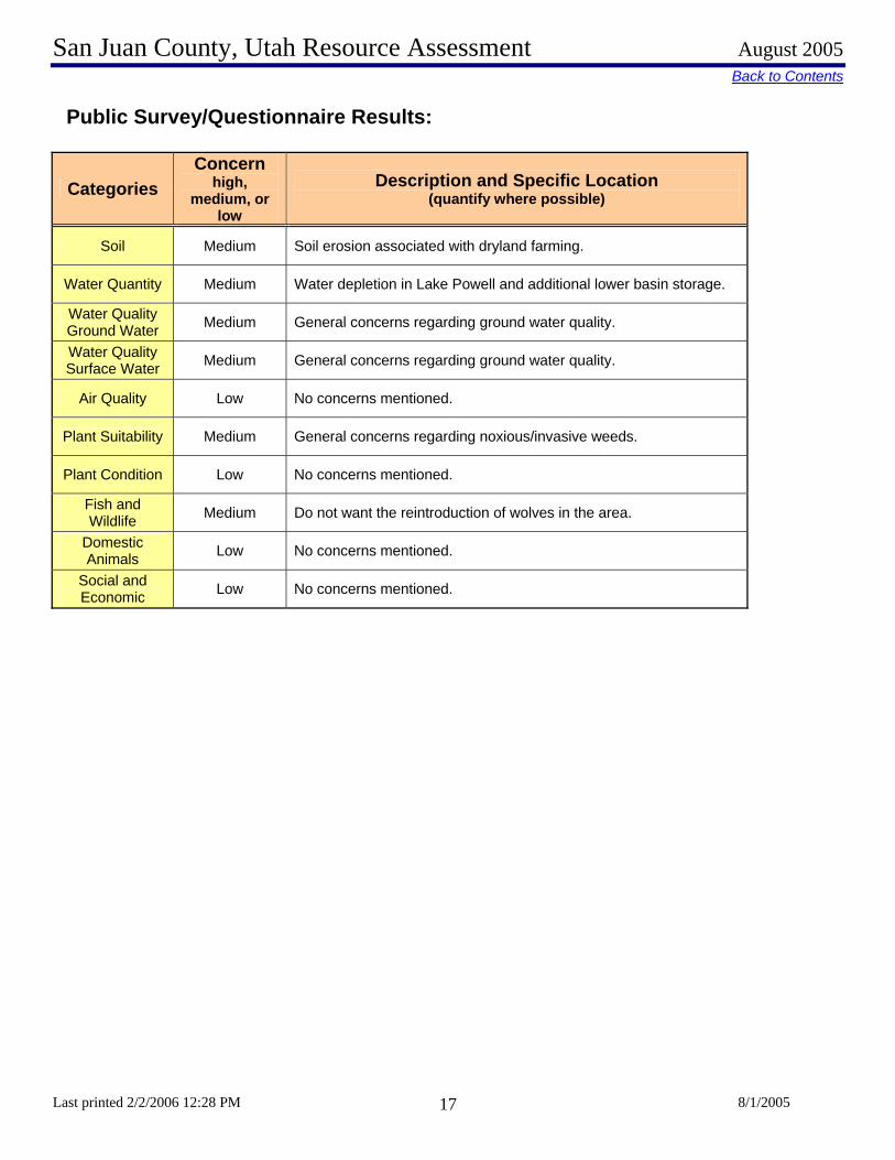
Public Survey/Questionnaire Results:
Categories Concern
high, medium, or
low
Description and Specific Location (quantify where possible)
Soil Medium Soil erosion associated with dryland farming.
Water Quantity Medium Water depletion in Lake Powell and additional lower basin storage.
Water Quality Ground Water Medium General concerns regarding ground water quality.
Water Quality Surface Water Medium General concerns regarding ground water quality.
Air Quality Low No concerns mentioned.
Plant Suitability Medium General concerns regarding noxious/invasive weeds.
Plant Condition Low No concerns mentioned.
Fish and Wildlife Medium Do not want the reintroduction of wolves in the area.
Domestic Animals Low No concerns mentioned.
Social and Economic Low No concerns mentioned.
San Juan County, Utah Resource Assessment August 2005
Last printed 2/2/2006 12:28 PM 8/1/2005 18
Back to ContentsFootnotes / Bibliography 1. General information about San Juan County obtained from a San Juan County website and the NRCS office. 2. Location and land ownership maps made using GIS shape files from the Automated Geographical Reference Center (AGRC), a Utah State Division of Information Technology. Website: http://agrc.utah.gov/ 3. Land Use/Land Cover layer developed by the Utah Department of Water Resources. A polygon coverage containing water-related land-use for all 2003 agricultural areas of the state of Utah. Compiled from initial USGS 7.5 minute Digital Raster Graphic water bodies, individual farming fields and associated areas are digitized from Digital Orthophotos, then surveyed for their land use, crop type, irrigation method, and associated attributes. 4. Prime and Unique farmlands derived from SURGO Soils Survey UT607 and Soil Data Viewer. Definitions of Prime and Unique farmlands from U.S. Geological Survey, http://water.usgs.gov/eap/env_guide/farmland.html#HDR5 5. Land Capability Classes derived from SURGO Soils Survey UT607 and Soil Data Viewer. 6. Tons of Soil Loss by Water Erosion data gathered from National Resource Inventory (NRI) data. Estimates from the 1997 NRI Database (revised December 2000) replace all previous reports and estimates. Comparisons made using data published for the 1982, 1987, or 1992 NRI may produce erroneous results. This is due to changes in statistical estimation protocols, and because all data collected prior to 1997 were simultaneously reviewed (edited) as 1997 NRI data were collected. In addition, this December 2000 revision of the 1997 NRI data updates information released in December 1999 and corrects a computer error disc overed in March 2000. For more information: http://www.nrcs.usda.gov/technical/NRI/ 7. Precipitation data was developed by the Oregon Climate Service at Oregon State University using average monthly or annual precipitation from 1960 to 1990. Publication date: 1998. Data was downloaded from the Resource Data Gateway, http://dgateway-wb01.lighthouse.itc.nrcs.usda.gov/lighthouse 8. Irrigated Adjudicated Water Rights obtained from the Utah Division of Water Rights. 9. USGS USGS Real-Time Data for the Nation 10. Stream length data calculated using ArcMap and 100k stream data from AGRC and 303d waters from the Utah Department of Environmental Quality. 11. General information about San Juan County obtained from a San Juan County website and the NRCS office. 12. The 2003 noxious weed list was obtained from the State of Utah Department of Food and Agriculture. For more information contact Steve Burningham, 801-538-7181 or visit their website at http://ag.utah.gov/plantind/noxious_weeds.html
San Juan County, Utah Resource Assessment August 2005
Last printed 2/2/2006 12:28 PM 8/1/2005 19
13. Wildlife information derived from the Utah Division of Wildlife Resources' Comprehensive Wildlife Conservation Strategy (CWCS) ( http://wildlife.utah.gov/cwcs/ ) and from the Utah Conservation Data Center ( http://dwrcdc.nr.utah.gov/ucdc/ ). 14. County population data from the U.S. Census Bureau, Utah Quick Facts, http://quickfacts.census.gov/qfd/states/49000.html 15. Farm information obtained from the National Agricultural Statistics Service, 2002 Census of Agriculture. http://www.nass.usda.gov/census/census02/volume1/index2.htm