sand creek ranch pud potable water and waste treatment ... · pud potable water and waste treatment...
TRANSCRIPT
Sand Creek Ranch Conservation Community
______________________________________________________________________________
Sand Creek Ranch Conservation
Community
PUD Potable Water and Waste Treatment Report
For
Wyoming DEQ
By
Weston EngineerinG
SSAANNDD CCRREEEEKK RRAANNCCHH PPLLAANNNNEEDD UUNNIITT DDEEVVEELLOOPPMMEENNTT
JOHNSON COUNTY, WYOMING
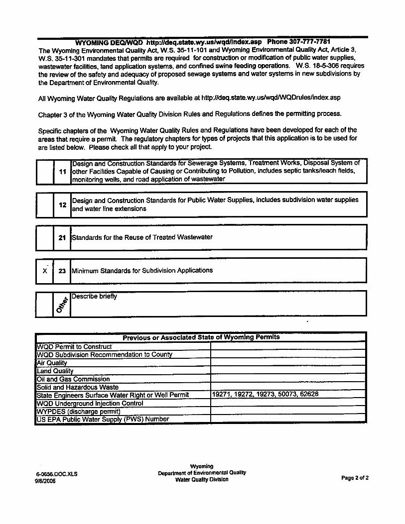
RREEPPOORRTT FFOORR MINIMUM STANDARDS FOR
SUBDIVISION APPLICATIONS DEQ-WQD CHAPTER 23
FEBRUARY 2007
PREPARED FOR:
Sand Creek, the Ranch Preservation Co., LLC
SUBMITTED TO:
WYOMING DEPT. OF ENVIRONMENTAL QUALITY WATER QUALITY DIVISION
PREPARED BY:
Weston Engineering, Inc.
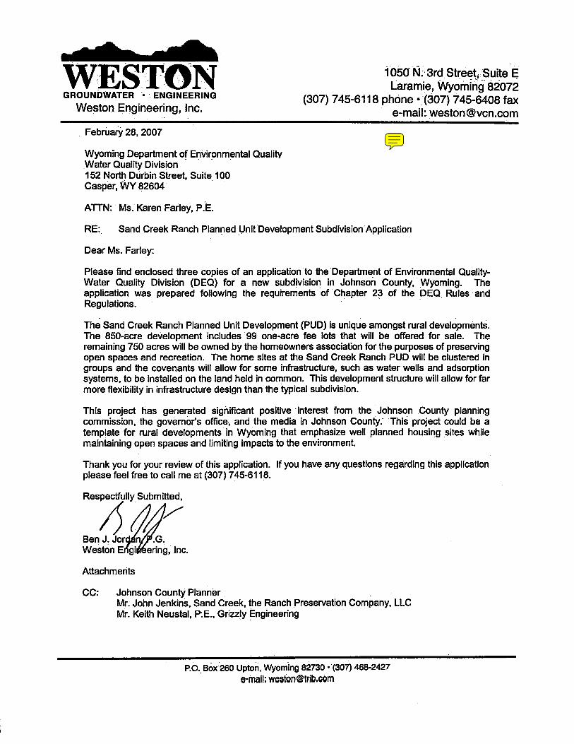
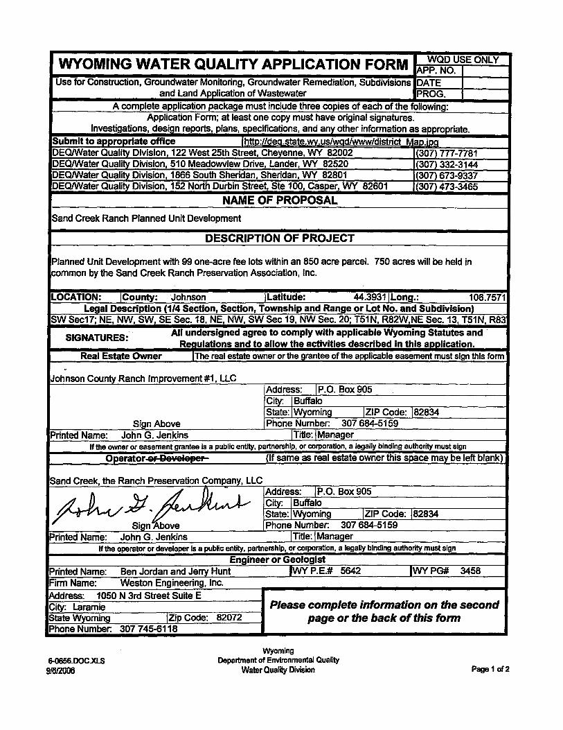
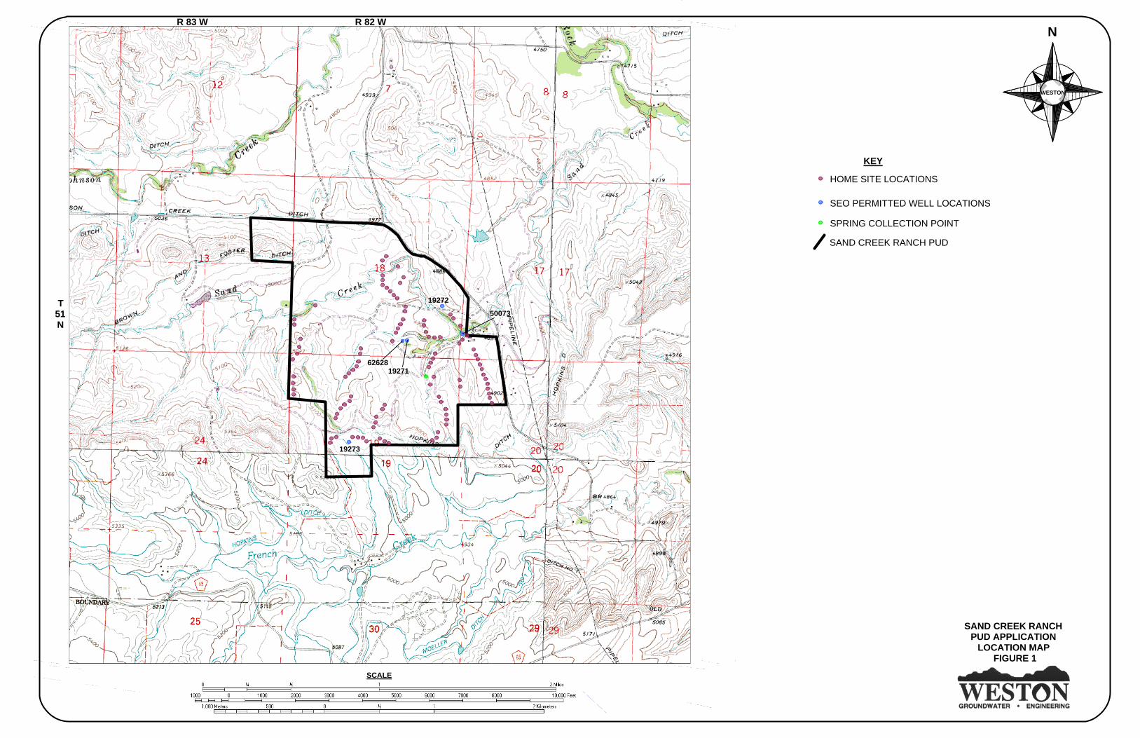
INTRODUCTION This document is prepared for Sand Creek, the Ranch Preservation Co., LLC, to aid in obtaining approval of the Department of Environmental Quality – Water Quality Division (DEQ) and the Johnson County Planner for the Sand Creek Ranch Planned Unit Development (PUD) outside Buffalo, Wyoming. This document is formatted to facilitate review of the DEQ following the requirements of DEQ rules and regulations found in Chapters 8, 11, 12, and 23. Figure 1 provides the topography and major geographic features within the development and all areas within one mile of the development boundaries. The base map is adapted from the USGS Lake DeSmet West (1977), Lake DeSmet East (1970), North Ridge (1993), and Buffalo (1970) 1:24,000 topographic quadrangles. Sand Creek Ranch PUD is located in Johnson County in Sections 17, 18, 19, and 20, Township 51 North, Range 82 West and Section 13, Township 51 North, Range 83 West. The proposed development consists of 99 one-acre lots contained within an 850 acre parcel. Approximately 750 acres will be held in common by the homeowners. The Sand Creek Ranch PUD will use individual on-site septic systems and water supply wells because of the low density of the housing units. Covenants and by-laws will allow for installation of wells and adsorption systems on common owned land if needed, on a case-by-case basis. It is possible that at some locations on the PUD that clustered homes may share an adsorption system or water well. This situation will be addressed on a case-by-case basis depending upon the benefits of such systems.
SAND CREEK RANCHPUD APPLICATION
LOCATION MAP FIGURE 1
N
WESTON
SCALE
SEO PERMITTED WELL LOCATIONS
HOME SITE LOCATIONS
SAND CREEK RANCH PUD
KEY
T51N
R 83 W R 82 W
SPRING COLLECTION POINT
19272
50073
6262819271
19273
Site Suitability for Individual Water Supply And Wastewater Systems Sand Creek Ranch Planned Unit Development, Johnson County Wyoming
2
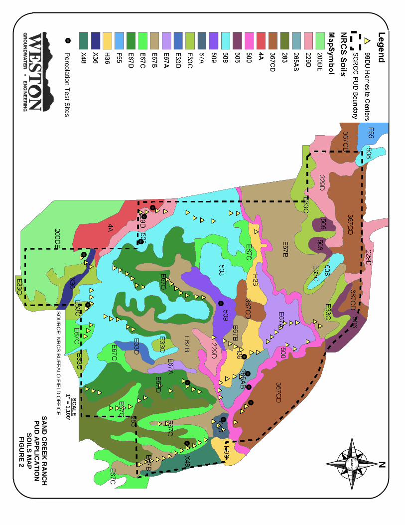
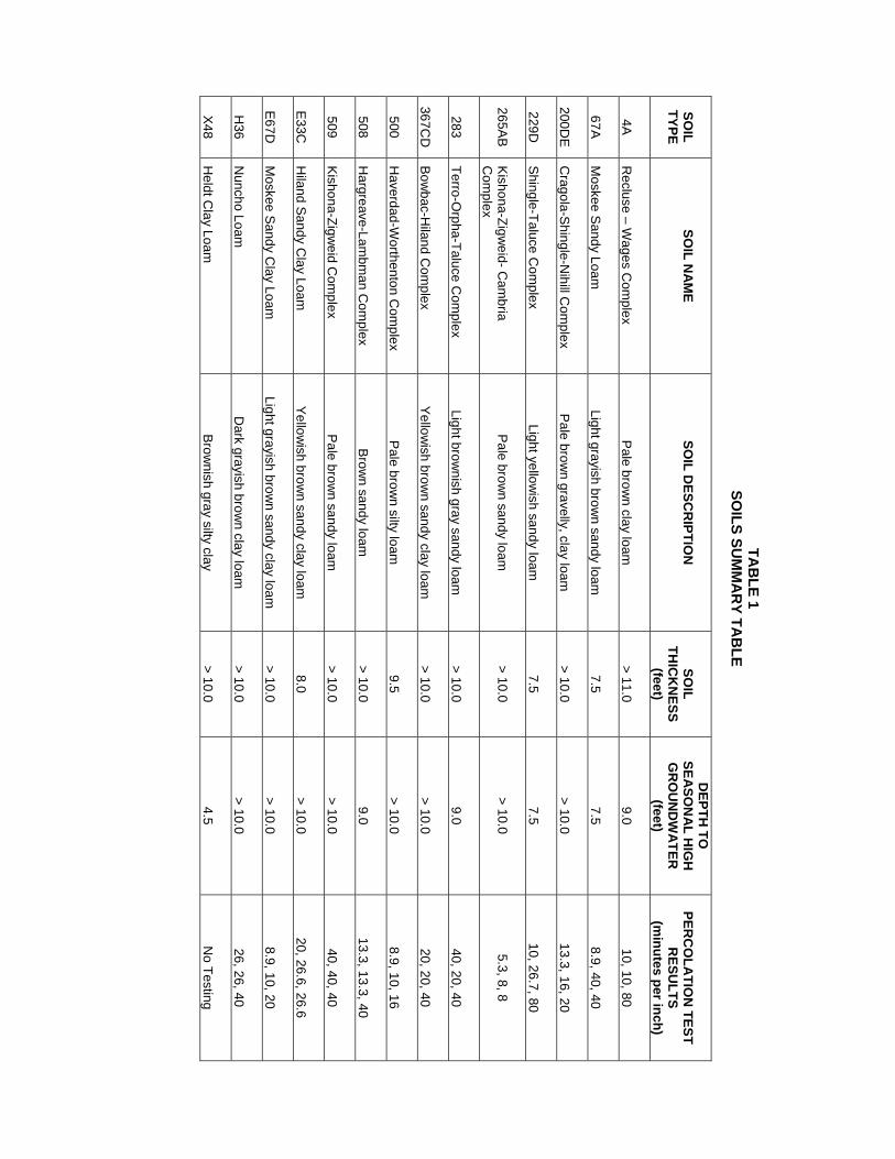
CHAPTER 23 - SECTION 7 (a)(i) Type of Sewage System Disposal of domestic sewage will be made with individual on-lot septic systems with adsorption systems. Individual homeowners will be responsible for obtaining permits to install the disposal systems and hiring experienced installers. The Sand Creek Ranch PUD homeowners association will review all building plans prior to construction to ensure that the plans meet the development’s restrictive covenants and that they serve not only the good of the individual homeowner, but the community as a whole. At some locations on the PUD up to four homes may share a common adsorption system. At this time it is expected that no more than four homes will share an adsorption system to avoid the requirements of an underground injection control (UIC) permit. (a)(ii-iii) Adequacy of Sewer System Based on the general layout of this development, including the lot size of one acre, lot density, and subsurface conditions, individual on-lot septic disposal is adequate for this development. The Sand Creek Ranch PUD emphasizes residential clusters consisting of between two and 12 homes surrounded by undeveloped natural and agricultural lands. The remainder of this section of the report addresses the details of the sewer system assessment and compliance with applicable rules and regulations. (b)(i-v) New Central Sewage System This section is not applicable to the Sand Creek Ranch PUD because individual on-site septic systems will be used for wastewater disposal. It is anticipated that no more than four- three bedroom homes will be connected to an individual adsorption system to avoid being classified as an UIC facility. (c)(i-iii) Connection to Existing Central Sewage System This section is not applicable to the Sand Creek Ranch PUD because on-site septic systems will be used for wastewater disposal. (d) On-Lot Sewer System (d)(i) Groundwater and Impermeable Soils Separation Soils mapping on the Sand Creek Ranch PUD indicates that there are a total of 14 soil types on the development where houses and/or adsorption systems may be located. Soils mapping was recently completed for the Sand Creek Ranch area by the Buffalo, Wyoming office of the Natural Resources Conservation Service (NRCS). The results of the soils mapping are provided on Figure 2 and descriptions are provided in Table 1. Weston Engineering, Inc. (WESTON) supervised the excavation of a 10-foot deep test pit in each of the soil types. General descriptions of the materials encountered, the thickness of the soils, and the depth to seasonal high groundwater are provided in Table 1. Detailed descriptions of the excavated materials, with photographs, are provided in Appendix A. Four of the fourteen soil types, 67A, 229D, 500, and E33C, have soils less than 10 feet thick. As observed in Table 1, two of the soils have thicknesses of only 7.5 feet. To ensure that the minimum separation of 4 feet from the base of the adsorption system to bedrock is attained as required by DEQ Rules and Regulations Chapter 11, Section 36 (c)(i)., the base must be buried no deeper than 3.5 feet below grade. This condition affects only three home sites in the east-central part of the development.
SAN
D C
REEK
RA
NC
HPU
D A
PPLICA
TION
SOILS M
AP
FIGU
RE 2 NW
ESTON
SCA
LE1" = 1,100'
Percolation Test S
itesS
OU
RC
E: N
RC
S B
UFFA
LO FIE
LD O
FFICE
TAB
LE 1 SO
ILS SUM
MA
RY TA
BLE
SOIL
TYPE
SO
IL NA
ME
SO
IL DESC
RIPTIO
N
SO
IL TH
ICK
NESS
(feet)
DEPTH
TO
SEASO
NA
L HIG
H
GR
OU
ND
WA
TER
(feet)
PER
CO
LATIO
N TEST
RESU
LTS (m
inutes per inch) 4A
Recluse – W
ages Com
plex
Pale brow
n clay loam
> 11.0
9.0
10, 10, 80
67A
Moskee Sandy Loam
Light grayish brown sandy loam
7.5
7.5
8.9, 40, 40
200DE
Cragola-Shingle-N
ihill Com
plex
Pale brown gravelly, clay loam
> 10.0
> 10.0
13.3, 16, 20
229D
Shingle-Taluce Com
plex
Light yellowish sandy loam
7.5
7.5
10, 26.7, 80
265AB Kishona-Zigw
eid- Cam
bria C
omplex
Pale brow
n sandy loam
> 10.0
> 10.0
5.3, 8, 8
283
Terro-Orpha-Taluce C
omplex
Light brow
nish gray sandy loam
> 10.0
9.0
40, 20, 40
367C
D
Bowbac-H
iland Com
plex
Yellowish brow
n sandy clay loam
> 10.0
> 10.0
20, 20, 40
500
Haverdad-W
orthenton Com
plex
Pale brown silty loam
9.5
> 10.0
8.9, 10, 16
508 H
argreave-Lambm
an Com
plex
Brown sandy loam
> 10.0
9.0
13.3, 13.3, 40
509 Kishona-Zigw
eid Com
plex
Pale brown sandy loam
> 10.0
> 10.0
40, 40, 40
E33C
Hiland Sandy C
lay Loam
Yellow
ish brown sandy clay loam
8.0
> 10.0
20, 26.6, 26.6
E67D
Moskee Sandy C
lay Loam
Light grayish brow
n sandy clay loam
> 10.0
> 10.0
8.9, 10, 20
H
36 N
uncho Loam
D
ark grayish brown clay loam
> 10.0
> 10.0
26, 26, 40
X48 H
eldt Clay Loam
Brow
nish gray silty clay
> 10.0
4.5
No Testing
Site Suitability for Individual Water Supply And Wastewater Systems Sand Creek Ranch Planned Unit Development, Johnson County Wyoming
3
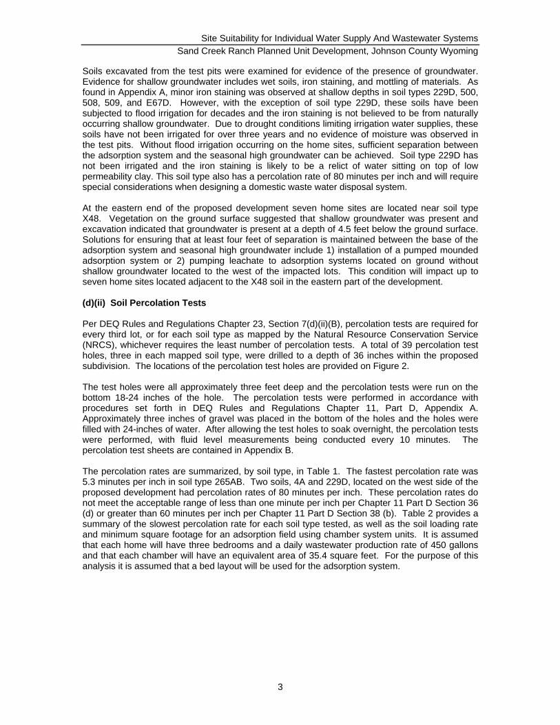
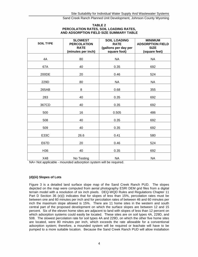
Soils excavated from the test pits were examined for evidence of the presence of groundwater. Evidence for shallow groundwater includes wet soils, iron staining, and mottling of materials. As found in Appendix A, minor iron staining was observed at shallow depths in soil types 229D, 500, 508, 509, and E67D. However, with the exception of soil type 229D, these soils have been subjected to flood irrigation for decades and the iron staining is not believed to be from naturally occurring shallow groundwater. Due to drought conditions limiting irrigation water supplies, these soils have not been irrigated for over three years and no evidence of moisture was observed in the test pits. Without flood irrigation occurring on the home sites, sufficient separation between the adsorption system and the seasonal high groundwater can be achieved. Soil type 229D has not been irrigated and the iron staining is likely to be a relict of water sitting on top of low permeability clay. This soil type also has a percolation rate of 80 minutes per inch and will require special considerations when designing a domestic waste water disposal system. At the eastern end of the proposed development seven home sites are located near soil type X48. Vegetation on the ground surface suggested that shallow groundwater was present and excavation indicated that groundwater is present at a depth of 4.5 feet below the ground surface. Solutions for ensuring that at least four feet of separation is maintained between the base of the adsorption system and seasonal high groundwater include 1) installation of a pumped mounded adsorption system or 2) pumping leachate to adsorption systems located on ground without shallow groundwater located to the west of the impacted lots. This condition will impact up to seven home sites located adjacent to the X48 soil in the eastern part of the development. (d)(ii) Soil Percolation Tests Per DEQ Rules and Regulations Chapter 23, Section 7(d)(ii)(B), percolation tests are required for every third lot, or for each soil type as mapped by the Natural Resource Conservation Service (NRCS), whichever requires the least number of percolation tests. A total of 39 percolation test holes, three in each mapped soil type, were drilled to a depth of 36 inches within the proposed subdivision. The locations of the percolation test holes are provided on Figure 2. The test holes were all approximately three feet deep and the percolation tests were run on the bottom 18-24 inches of the hole. The percolation tests were performed in accordance with procedures set forth in DEQ Rules and Regulations Chapter 11, Part D, Appendix A. Approximately three inches of gravel was placed in the bottom of the holes and the holes were filled with 24-inches of water. After allowing the test holes to soak overnight, the percolation tests were performed, with fluid level measurements being conducted every 10 minutes. The percolation test sheets are contained in Appendix B. The percolation rates are summarized, by soil type, in Table 1. The fastest percolation rate was 5.3 minutes per inch in soil type 265AB. Two soils, 4A and 229D, located on the west side of the proposed development had percolation rates of 80 minutes per inch. These percolation rates do not meet the acceptable range of less than one minute per inch per Chapter 11 Part D Section 36 (d) or greater than 60 minutes per inch per Chapter 11 Part D Section 38 (b). Table 2 provides a summary of the slowest percolation rate for each soil type tested, as well as the soil loading rate and minimum square footage for an adsorption field using chamber system units. It is assumed that each home will have three bedrooms and a daily wastewater production rate of 450 gallons and that each chamber will have an equivalent area of 35.4 square feet. For the purpose of this analysis it is assumed that a bed layout will be used for the adsorption system.
Site Suitability for Individual Water Supply And Wastewater Systems Sand Creek Ranch Planned Unit Development, Johnson County Wyoming
4
TABLE 2 PERCOLATION RATES, SOIL LOADING RATES,
AND ADSORPTION FIELD SIZE SUMMARY TABLE
SOIL TYPE
SLOWEST PERCOLATION
RATE (minutes per inch)
SOIL LOADING RATE
(gallons per day per square foot)
MINIMUM ADSORPTION FIELD
SIZE (square feet)
4A
80
NA
NA
67A
40
0.35
692
200DE
20
0.46
524
229D
80
NA
NA
265AB
8
0.68
355
283
40
0.35
692
367CD
40
0.35
692
500
16
0.505
486
508
40
0.35
692
509
40
0.35
692
E33C
26.6
0.41
580
E67D
20
0.46
524
H36
40
0.35
692
X48
No Testing
NA
NA
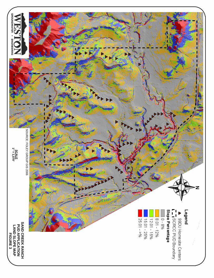
NA= Not applicable - mounded adsorption system will be required. (d)(iii) Slopes of Lots Figure 3 is a detailed land surface slope map of the Sand Creek Ranch PUD. The slopes depicted on the map were computed from aerial photography ESRI DEM grid files from a digital terrain model with a resolution of six inch pixels. DEQ-WQD Rules and Regulations Chapter 11 Part D Section 36 (e)(i) indicates that for slopes of less than 15%, percolation rates must be between one and 60 minutes per inch and for percolation rates of between 46 and 60 minutes per inch the maximum slope allowed is 15%. There are 11 home sites in the western and south central part of the proposed development on which the surface slopes are between 12 and 15 percent. Six of the eleven home sites are adjacent to land with slopes of less than 12 percent on which adsorption systems could easily be located. These sites are on soil types 4A, 229D, and 508. The slowest percolation rate for soil types 4A and 229D, on which the other five home sites are located, were 80 minutes per inch, which exceeds the rate allowable for a conventional adsorption system; therefore, a mounded system will be required or leachate will have to be pumped to a more suitable location. Because the Sand Creek Ranch PUD will allow installation
NWESTO
N
SCA
LE1" = 1,070'
SAN
D C
REEK
RA
NC
HPU
D A
PPLICA
TION
LAN
D SLO
PE MA
P FIG
UR
E 3
SO
UR
CE
: FOLE
Y G
RO
UP
GIS 2006
Site Suitability for Individual Water Supply And Wastewater Systems Sand Creek Ranch Planned Unit Development, Johnson County Wyoming
5
of adsorption fields on property managed by the homeowner’s association, pumping leachate to a suitable location to the east where slopes are less steep is a likely solution. Johnson County requires that domestic waste water disposal systems be designed by a professional engineer, which will ensure that any adsorption system be designed to meet both DEQ and Johnson County standards. The slowest percolation rate for soil type 500 is 40 minutes per inch, which is suitable for slopes up to 20%. All adsorption systems will be set at least 15 feet from any break in slope that exceeds 15 degrees to meet DEQ Rules and Regulations Chapter 11 Part D Section 36 (e)(ii). (d)(iv) USGS Map Figure 1 is a 1:24,000 scale base map showing the water sheds, drainages, and water bodies both within the Sand Creek Ranch PUD and within one mile of its boundaries. The Sand Creek Ranch PUD lies within the watersheds of Sand Creek and French Creek. Eighty-nine home sites lie within the Sand Creek drainage, while the 10 home sites south of the Hopkins Ditch in the south central part of the proposed development lie within the French Creek drainage. While several of the home sites are near ephemeral drainages and the mainstem of Sand Creek, all adsorption systems will maintain adequate separation distances from bodies of water as required in DEQ Rules and Regulations Chapter 11 Part D Section 35 (a)(i). (d)(v) Replacement Adsorption System Area As indicated in Table 2, it is anticipated that the maximum square footage of an adsorption field for a three bedroom home at Sand Creek Ranch will be 692 square feet. A replacement field of the same size should be easily sited on the one acre lots each PUD will have. If site conditions do not allow for installation of a replacement adsorption system, then the replacement fields can be located on lands held in common with approval from the homeowner’s association. In the event that a four bedroom home is built on one of the lots, the corresponding adsorption system would have a square footage of 916 square feet. Both the adsorption system and a replacement system should fit on most lots, or could be located on the commonly owned property with approval from the homeowner’s association. (d)(vi & vi A) Population-Wastewater Type There are 99 single-family residential dwelling lots proposed in the Sand Creek Ranch PUD. Current plans anticipate that the vast majority of the housing units will have three bedrooms, with a few homes having two bedrooms and a few with four bedrooms. Although it is expected that many of the homeowners in the Sand Creek Ranch PUD will be retirees with two persons per home; however, for the purpose of facilities design it is assumed that there will be 3 persons per home. Using this assumption the maximum population of the development at build out is 297 persons. No commercial, industrial, or multiple use development will be allowed and generated wastewater will be domestic in nature. (d)(vii) Groundwater and Surface Water Protection (d)(vii)(A)(I-III) Geology The Sand Creek Ranch PUD lies on the Wasatch Formation. The Wasatch Formation consists of interbedded claystones, sandstones, conglomerates, and coal beds (Whitcomb and others, 1966). Whitcomb and others (1966) report that the Wasatch Formation is between 1,000 and 2,000 feet in northern Johnson County, but no wells for which lithologic logs are available in the vicinity of the Sand Creek Ranch PUD have been reported to fully penetrate the Wasatch Formation. Even with lithologic logs, determining the contact between the Wasatch Formation and the underlying Fort Union Formation can be difficult (Whitcomb and others, 1966). A coal bed methane gas well in Section 20, Township 51 North, Range 82 West (API Number 49-019-
Site Suitability for Individual Water Supply And Wastewater Systems Sand Creek Ranch Planned Unit Development, Johnson County Wyoming
6
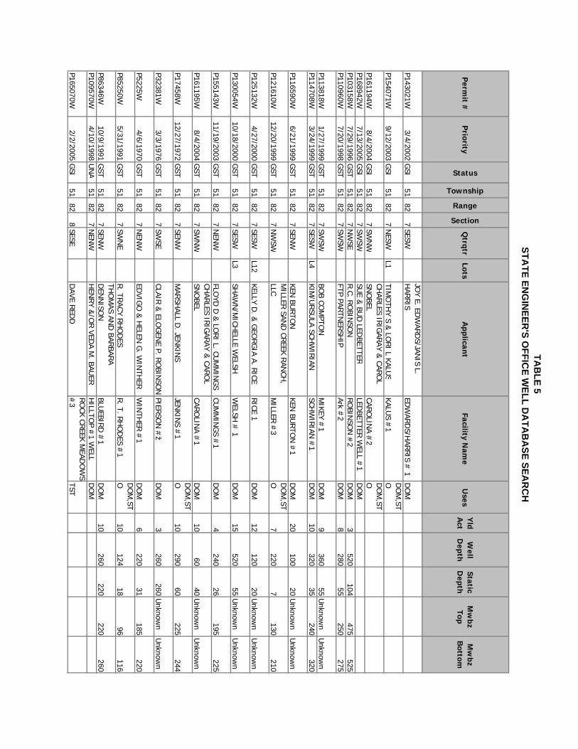
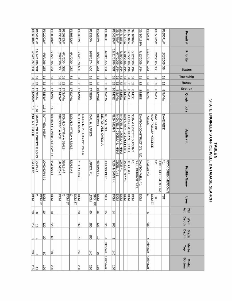
21128) was slated in 1999 to produce gas from a coal seam in the upper Fort Union Formation from a depth of 920 feet; however, the well was never drilled. According to geologic mapping by Hodson and others (1973) and Whitcomb and others (1966) there are no geologic structures, including faults, fractures, or karst features, in the area of the proposed development. The Wasatch Formation dips at 5 degrees to the east-northeast as measured on a sandstone outcrop in the SE ¼ Section 18, Township 51 North, Range 82 West. (d)(vii)(B)(I-IV) Groundwater Two distinct intervals of groundwater are encountered beneath the Sand Creek Ranch PUD. Shallow groundwater is observed at a small spring at an elevation of 4,920 feet in the NE ¼ NE ¼ Section 19, Township 51 North, Range 82 West and in a slough at an elevation of 4,850 feet in the SW ¼ SW ¼ Section 17, Township 51 North, Range 82 West. The spring in Section 19 was discharging between one and two gallons per minute on January 18, 2007. No water was observed moving at the slough in Section 19 and water only observed at a depth of 4.5 feet in a back hoe test pit. Although sandstones were not observed at either of these locations, it is likely that the source of the shallow groundwater is from drainage of a sandstone bed buried at a shallow depth. Five permitted water wells are located on the Sand Creek Ranch PUD. The wells vary in depth from 82 to 150 feet. Details for the wells in the Sand Creek Ranch PUD are summarized in Table 3 and copies of the statements of completion for the wells are provided in Appendix C. Jenkins #1 (U.W. 50073), which is 140 feet deep, has the highest production rate, of the five wells at 12 gallons per minute (gpm). The lithologic log for Jenkins #1 does not indicate that thick layers of shale or claystone overlay the production intervals (120-140 feet), but the fact that the well flows at the ground surface while the water is being produced from a depth of between 120 and 140 feet does indicate that the aquifer is confined. The statement of completion for Jenkins #3 (U.W. 42476), which is located a few hundred feet northeast of the Sand Creek Ranch PUD, is also included in Appendix C. The statements of completion and lithologic logs for U.W. 42726 and U.W. 62628 indicate that water is produced from sandstones and coal beds that underlie low permeability shales. The fact that the water levels in these two wells rises significantly above the production intervals indicates that the sandstones that yield water to the wells is confined. The low permeability shales prevent mingling of the shallow groundwater observed in the spring and slough from mixing with the deeper water. This is verified by the difference in water levels between the shallow groundwater and the water in the wells. An attempt was made to measure the water levels in the five Sand Creek Ranch water wells. A water level could not be obtained from Jenkins #1 because the well flows when it is not pumped and the wellhead is sealed. The water in Camino #2 was frozen at the ground surface, which prevented measurement of the water level. The water levels measured in the remaining three wells and the results are provided in Table 3. Water levels have not been routinely measured in the wells therefore the seasonal variations in water levels is not known. In a memorandum written by the State Engineers Office on August 26, 1985, water levels were measured in several area wells to investigate whether water levels had declined. The summer season water levels were found to be “somewhat lower” than water levels reported on statements of completion, but the decreases in water levels were attributed to increased lawn irrigation. A copy of the memorandum is contained in Appendix C attached to the statement of completion for U.W. 27905. (d)(vii)(C) Aquifer Classification (d)(vii)(C)(I) State Engineer Well Search The Wyoming State Engineer’s Office database was accessed from the internet on December 13, 2006 to conduct an inventory of permitted water wells located within one mile the proposed
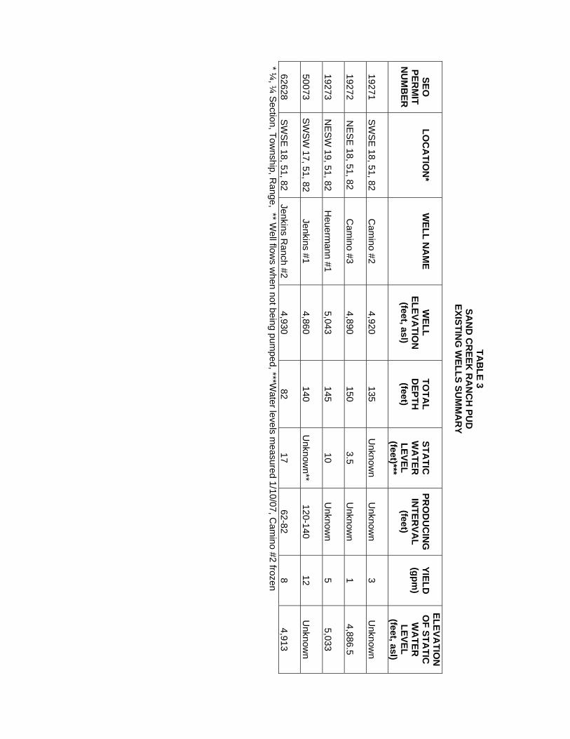
TAB
LE 3 SA
ND
CR
EEK R
AN
CH
PUD
EXISTIN
G W
ELLS SUM
MA
RY
SEO
PERM
IT N
UM
BER
LO
CA
TION
*
WELL N
AM
E
WELL
ELEVATIO
N
(feet, asl)
TO
TAL
DEPTH
(feet)
STA
TIC
WA
TER
LEVEL (feet)***
PR
OD
UC
ING
IN
TERVA
L (feet)
YIELD
(gpm
)
ELEVATIO
N
OF STA
TIC
WA
TER
LEVEL (feet, asl)
19271
S
WS
E 18, 51, 82
C
amino #2
4,920
135
U
nknown
U
nknown
3
Unknow
n
19272
NE
SE
18, 51, 82
Cam
ino #3
4,890
150
3.5
Unknow
n 1
4,886.5
19273
N
ES
W 19, 51, 82
H
euermann #1
5,043
145
10
Unknow
n 5
5,033
50073
S
WS
W 17, 51, 82
Jenkins #1
4,860
140
U
nknown**
120-140
12
Unknow
n
62628
SW
SE
18, 51, 82
Jenkins Ranch #2
4,930
82 17
62-82
8
4,913 * ¼
, ¼ S
ection, Township, R
ange, ** Well flow
s when not being pum
ped, ***Water levels m
easured 1/10/07, Cam
ino #2 frozen
Site Suitability for Individual Water Supply And Wastewater Systems Sand Creek Ranch Planned Unit Development, Johnson County Wyoming
7
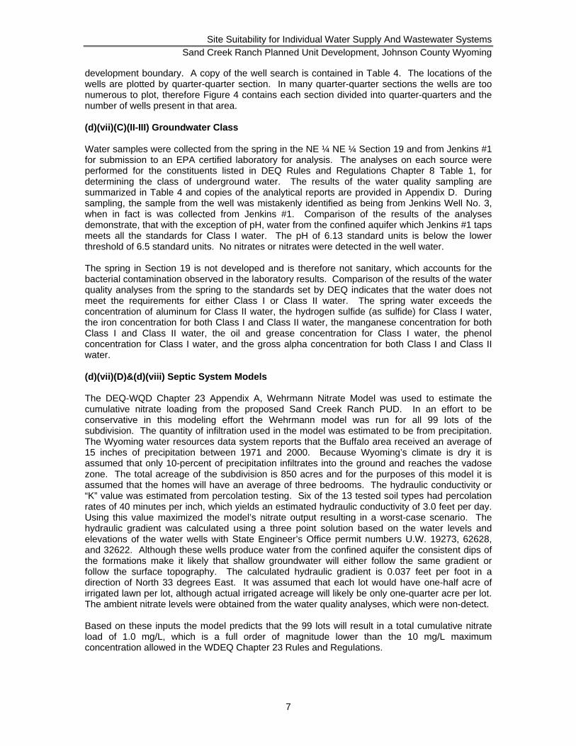
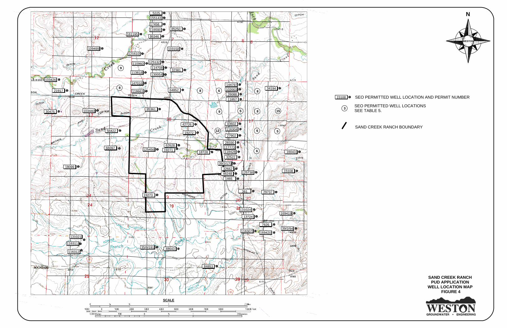
development boundary. A copy of the well search is contained in Table 4. The locations of the wells are plotted by quarter-quarter section. In many quarter-quarter sections the wells are too numerous to plot, therefore Figure 4 contains each section divided into quarter-quarters and the number of wells present in that area. (d)(vii)(C)(II-III) Groundwater Class Water samples were collected from the spring in the NE ¼ NE ¼ Section 19 and from Jenkins #1 for submission to an EPA certified laboratory for analysis. The analyses on each source were performed for the constituents listed in DEQ Rules and Regulations Chapter 8 Table 1, for determining the class of underground water. The results of the water quality sampling are summarized in Table 4 and copies of the analytical reports are provided in Appendix D. During sampling, the sample from the well was mistakenly identified as being from Jenkins Well No. 3, when in fact is was collected from Jenkins #1. Comparison of the results of the analyses demonstrate, that with the exception of pH, water from the confined aquifer which Jenkins #1 taps meets all the standards for Class I water. The pH of 6.13 standard units is below the lower threshold of 6.5 standard units. No nitrates or nitrates were detected in the well water. The spring in Section 19 is not developed and is therefore not sanitary, which accounts for the bacterial contamination observed in the laboratory results. Comparison of the results of the water quality analyses from the spring to the standards set by DEQ indicates that the water does not meet the requirements for either Class I or Class II water. The spring water exceeds the concentration of aluminum for Class II water, the hydrogen sulfide (as sulfide) for Class I water, the iron concentration for both Class I and Class II water, the manganese concentration for both Class I and Class II water, the oil and grease concentration for Class I water, the phenol concentration for Class I water, and the gross alpha concentration for both Class I and Class II water. (d)(vii)(D)&(d)(viii) Septic System Models The DEQ-WQD Chapter 23 Appendix A, Wehrmann Nitrate Model was used to estimate the cumulative nitrate loading from the proposed Sand Creek Ranch PUD. In an effort to be conservative in this modeling effort the Wehrmann model was run for all 99 lots of the subdivision. The quantity of infiltration used in the model was estimated to be from precipitation. The Wyoming water resources data system reports that the Buffalo area received an average of 15 inches of precipitation between 1971 and 2000. Because Wyoming’s climate is dry it is assumed that only 10-percent of precipitation infiltrates into the ground and reaches the vadose zone. The total acreage of the subdivision is 850 acres and for the purposes of this model it is assumed that the homes will have an average of three bedrooms. The hydraulic conductivity or “K” value was estimated from percolation testing. Six of the 13 tested soil types had percolation rates of 40 minutes per inch, which yields an estimated hydraulic conductivity of 3.0 feet per day. Using this value maximized the model’s nitrate output resulting in a worst-case scenario. The hydraulic gradient was calculated using a three point solution based on the water levels and elevations of the water wells with State Engineer’s Office permit numbers U.W. 19273, 62628, and 32622. Although these wells produce water from the confined aquifer the consistent dips of the formations make it likely that shallow groundwater will either follow the same gradient or follow the surface topography. The calculated hydraulic gradient is 0.037 feet per foot in a direction of North 33 degrees East. It was assumed that each lot would have one-half acre of irrigated lawn per lot, although actual irrigated acreage will likely be only one-quarter acre per lot. The ambient nitrate levels were obtained from the water quality analyses, which were non-detect. Based on these inputs the model predicts that the 99 lots will result in a total cumulative nitrate load of 1.0 mg/L, which is a full order of magnitude lower than the 10 mg/L maximum concentration allowed in the WDEQ Chapter 23 Rules and Regulations.
SAND CREEK RANCHPUD APPLICATION
WELL LOCATION MAP FIGURE 4
N
WESTON
SCALE
SEO PERMITTED WELL LOCATIONSSEE TABLE 5.
6 8
9 5 8 15
12 6 5
6
8
9
8
3
SAND CREEK RANCH BOUNDARY
131021
116311
116312
18099
66097
56422
10344030475
103426
21917
109499
161195
121610
110960
113818
147016
118663
5225155143
17458
116590
86346
125132
114708
13005432381
103158
85250
64852
95361
12545662628
19271 18728
42726
19272
19273
35/8/191 48643
84853
11630739/2/94
7626
169420
169419131024
13724
29737361
15108125738
16043
39/2/1703266246248
1465
2833011777311842832522
341941447971020032608811857
43602116304
27902
15108 SEO PERMITTED WELL LOCATION AND PERMIT NUMBER

Site Suitability for Individual Water Supply And Wastewater Systems Sand Creek Ranch Planned Unit Development, Johnson County Wyoming
8
WDEQ Chapter 23 Appendix B, Minimum isolation distance was used to calculate the vertical travel time and 2 year horizontal travel time for each lot. The vertical travel time is calculated to be 89 days based on 315 inches for “AP” and the total volumetric soil moisture was estimated from the Table 1 provided by WDEQ. The depth to seasonal high groundwater was estimated to be 10 feet, which was indicated from most of the soil test pits on the site. The two year horizontal time of travel distance is calculated to be 712 feet, based on inputs of 3 feet/day for K, a hydraulic gradient of 0.037 feet/foot and an effective porosity of 10-percent. This predict indicates that neighboring properties should not be affected by wastewater disposal from the Sand Creek Ranch PUD and that what little fluid may leave the property will have an estimated nitrate concentration of 1 mg/L.
Site Suitability for Individual Water Supply And Wastewater Systems Sand Creek Ranch Planned Unit Development, Johnson County Wyoming
9
TABLE 4 WATER QUALITY SAMPLING RESULTS
SEO Permit Number
Water Quality Standard
Class I Water*
Water Quality Standard
Class II Water*
Jenkins # 1 U.W. 50073
Spring NE ¼ NE ¼ Section 19
Total Depth (feet)
-
-
140
Ground Level
Formation - - Wasatch Wasatch Date Collected - - 1/11/07 1/18/07
Aluminum (mg/L)
-
5.0
ND
7.4
Ammonia (mg/L)
0.5
-
0.09
0.30
Arsenic (mg/L) 0.05 0.1 ND 0.004 Barium (mg/L) 1.0 - ND 0.3 Boron (mg/L) 0.75 0.75 ND 0.2
Cadmium (mg/L)
0.01
0.01
ND
ND
Chloride (mg/L) 250 100.0 9 4 Chromium
(mg/L)
0.05
0.1
ND
ND Copper (mg/L) 1.0 0.2 ND ND Cyanide (mg/L) 0.2 - ND ND Fluoride (mg/L) 1.4-2.4 - 0.1 0.2
Hydrogen Sulfide (mg/L)
0.05
-
ND
11.4
Iron (mg/L) 0.3 5.0 ND 42.1 Lead (mg/L) 0.05 5.0 ND ND Manganese
(mg/L)
0.05
0.2
0.01
0.79 Mercury (mg/L) 0.002 - ND ND
Nitrate as N (mg/L)
10
-
ND
ND
Nitrite as N (mg/L)
1.0
-
ND
ND
Oil and Grease Virtually Free 10.0 ND 6.5 Phenol (mg/L) 0.001 - ND 0.027
Selenium (mg/L) 0.01 0.02 ND ND Silver (mg/L) 0.05 - ND ND
Sulfate (mg/L) 250 200.0 96 108 Total Dissolved Solids (mg/L)
500 2000.0 318 446
Uranium 5.0 5.0 ND 0.0292 Zinc (mg/L) 5.0 2.0 0.08 0.03
pH (S.U.) 6.5 – 8.5 4.5-9.0 6.13 7.84 Gross Alpha
(pCi/L)
15
15
ND
30.2 +/-1.6 *Source DEQ-WQD Chapter 8, Table 1. ND = NOT DETECTED
Site Suitability for Individual Water Supply And Wastewater Systems Sand Creek Ranch Planned Unit Development, Johnson County Wyoming
10
CHAPTER 23 - SECTION 8 (a)(i) Type of Water Supply The water supply needs for the Sand Creek Ranch PUD will be met with on-site wells. It is anticipated that individual wells will be drilled to meet the needs of each lot owner. As stated above, if water supply wells need to be drilled off of the one-acre fee lots to meet minimum offsets from wastewater disposal facilities and adsorption system replacement reservations, then the lot owners will have the ability to site wells on the lands owned in common. It may be preferable to have groups of homes share a common water well. Up to three homes can be connected to a single well and remain a domestic water well under the State Engineer’s Office rules and regulations. Installation of a common well to be shared among homeowners would require installation of storage facilities and booster pumps to each home. Figures 5 and 6 are generic designs, previously approved by DEQ-WQD, for storage and distribution systems for three homes sharing a water well within a subdivision. Minor adjustments to this design could be required for site specific conditions and to account for actual production of the water well. Any such system should be designed by a professional engineer. (a)(ii) Average and Maximum Water Usage It is assumed that the 99 lots will have an average population of 3.5 persons. The build-out population of the Sand Creek Ranch PUD, if a home is built on each lot, will be 347 persons. DEQ-WQD Rules and Regulations Chapter 12 Section 8 (a) states that a design rate 125 gallons per day per person can be used for an average daily demand and a rate of 340 gallons per day per person can be used for a peak day demand if no consumption data are available. Application of these per capita demands to the build out population of 347 persons results in an average daily demand of 43,375 gallons (30 gpm) and a peak daily demand of 117,980 gallons (82 gpm). Sand Creek Ranch has territorial surface water rights that will be transferred to the Sand Creek Ranch PUD homeowners association. Water rights on the individual 99 fee lots will be managed for each lot by the homeowners association. The Sand Creek Ranch PUD will have an irrigation system that allows for lawn watering for use by the home owners using a portion of the appropriated water rights. Architectural covenants will limit the size of irrigated lawns and lots will have up to 500 gallons per day for watering from the surface water source. This supplemental source of supply will serve to significantly reduce the peak daily demand on the potable water supply sources; therefore, the actual peak daily demand will be lower than the 82 gpm projected above. (a)(iii) Water Well - Septic System Compatibility As described previously, water wells drilled to depths below 80 feet exhibit a significant degree of confinement and leachate from septic systems is not likely to migrate into the sandstones yielding drinking water to wells. Furthermore, the nitrate modeling indicates that in a worst-case scenario the nitrate concentrations could rise by only one mg/L. Since the confined aquifer beneath the Sand Creek Ranch PUD has an effective nitrate concentration of 0 mg/L, the model predicts that the nitrate concentration would be far below the maximum contaminant level of 10 mg/L. (a)(iv) Surface and Groundwater Rights Currently several surface water and groundwater rights are held by Sand Creek Ranch. Table 3 provides details of the permitted wells for which rights are held by Sand Creek Ranch. Copies of the statements of completion are provided in Appendix C. A water rights inventory was compiled by Mr. Frank Carr of Water Right Services in 2004. The report provided by Mr. Carr is provided in Appendix F. Sand Creek Ranch will be transferring all existing water rights to the Sand Creek Ranch PUD for management for use by the ranch community.
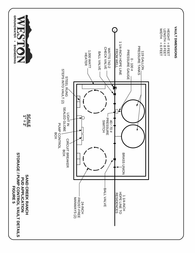
SAN
D C
REEK
RA
NC
HPU
D A
PPLICA
TION
STOR
AG
E / PUM
P CO
NTR
OL VA
ULT D
ETAILS
FIGU
RE 5
SCA
LE1" = 2'
WA
TTS 742-2
CH
EC
K V
ALVE
BALL VALV
E
STE
EL R
UN
GSTE
PS IN
TO V
AULT (2)
LIGH
T INSEA
LED
GLO
BEPU
MP C
ON
TRO
LB
OX C
IRC
UIT BR
EAKER
BO
X
24-INC
HFR
OS
T-FRE
EM
ANW
AYS (2)
BR
AS
S U
NIO
N
40 / 70 #P
RE
SS
UR
ESW
ITCH
0 - 100 #P
RE
SS
UR
E G
AU
GE
119 GA
LLON
PR
ES
SU
RE
TAN
KS
1 1/4-INC
HH
DP
E LIN
E TO
RE
SID
EN
CE
S1 1/4-IN
CH
HD
PE
LINE
FRO
M W
ELL
VAU
LT DIM
ENSIO
NS
HE
IGH
T = 8 FEE
TLE
NG
TH = 8 FEE
TW
IDTH
= 6 FEE
T
1,000 WA
TTH
EA
TER
BALL VALV
E
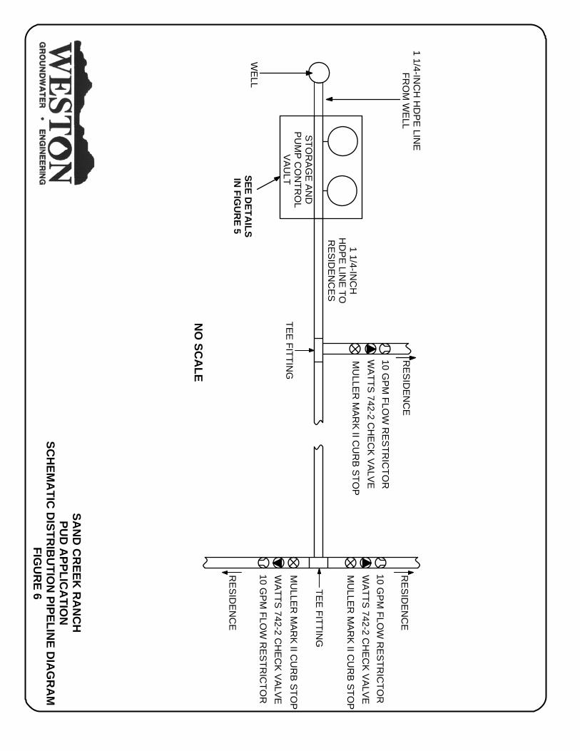
SAN
D C
REEK
RA
NC
HPU
D A
PPLICA
TION
SCH
EMA
TIC D
ISTRIB
UTIO
N PIPELIN
E DIA
GR
AM
FIGU
RE 6
1 1/4-INC
HH
DP
E LIN
E TO
RE
SID
EN
CE
S
1 1/4-INC
H H
DP
E LIN
EFR
OM
WE
LL
STOR
AG
E AN
DPU
MP C
ON
TRO
LV
AU
LT
RE
SID
EN
CE
RE
SID
EN
CE
RE
SID
EN
CE
10 GP
M FLO
W R
ES
TRIC
TOR
WATTS 742-2 C
HE
CK VALVE
MU
LLER
MA
RK
II CU
RB
STO
P
10 GP
M FLO
W R
ES
TRIC
TOR
WATTS 742-2 C
HE
CK VALVE
MU
LLER
MA
RK
II CU
RB
STO
P
10 GP
M FLO
W R
ES
TRIC
TOR
WATTS 742-2 C
HE
CK VALVE
MU
LLER
MA
RK
II CU
RB
STO
P
WE
LL
TEE
FITTING
TEE
FITTING
NO
SCA
LE
SEE DETA
ILSIN
FIGU
RE 5

Site Suitability for Individual Water Supply And Wastewater Systems Sand Creek Ranch Planned Unit Development, Johnson County Wyoming
11
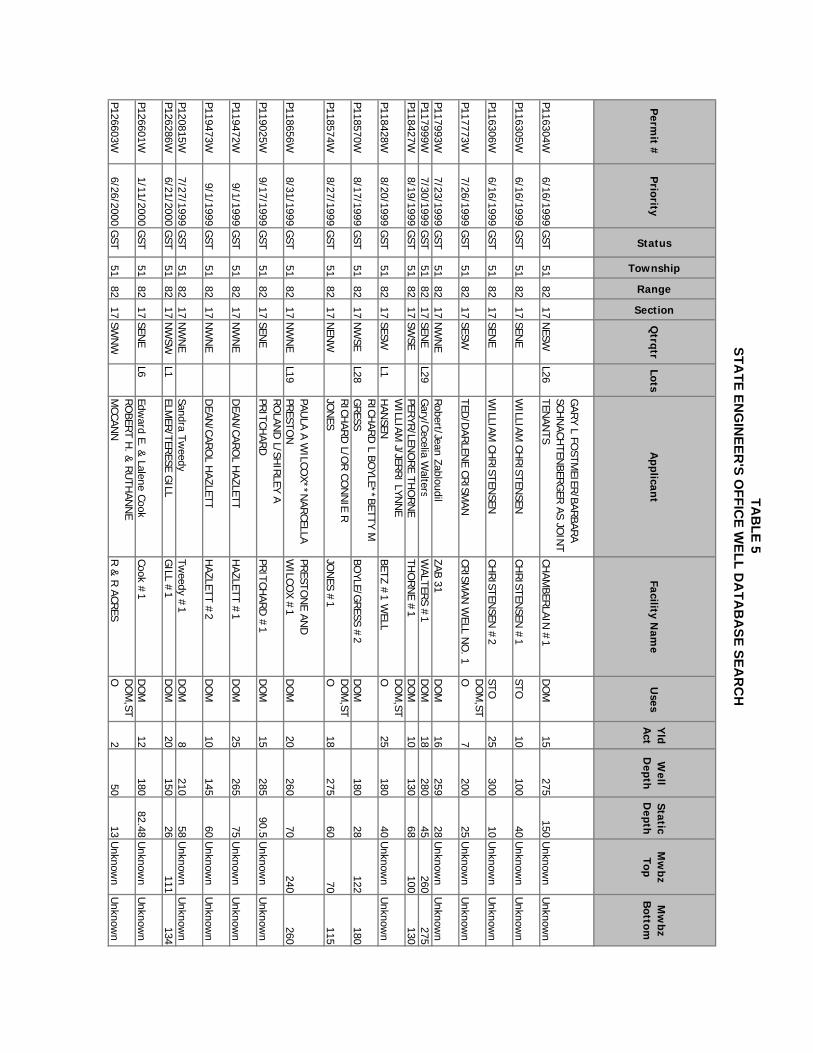
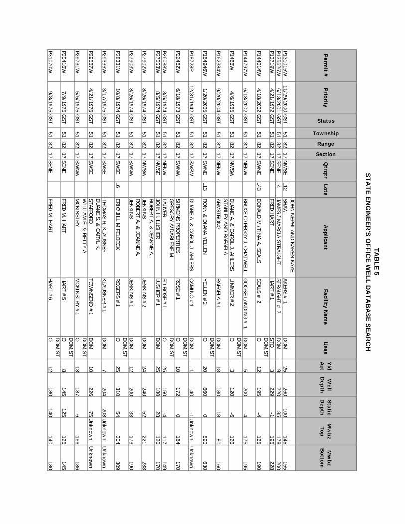
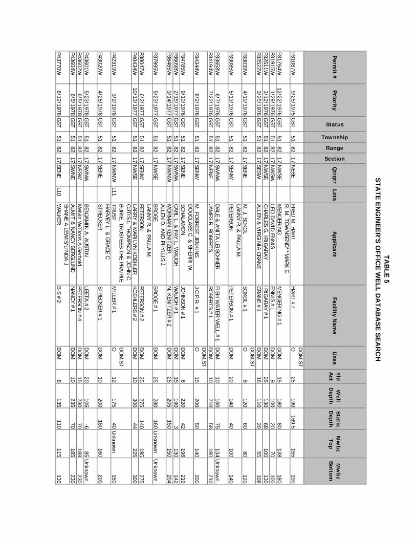
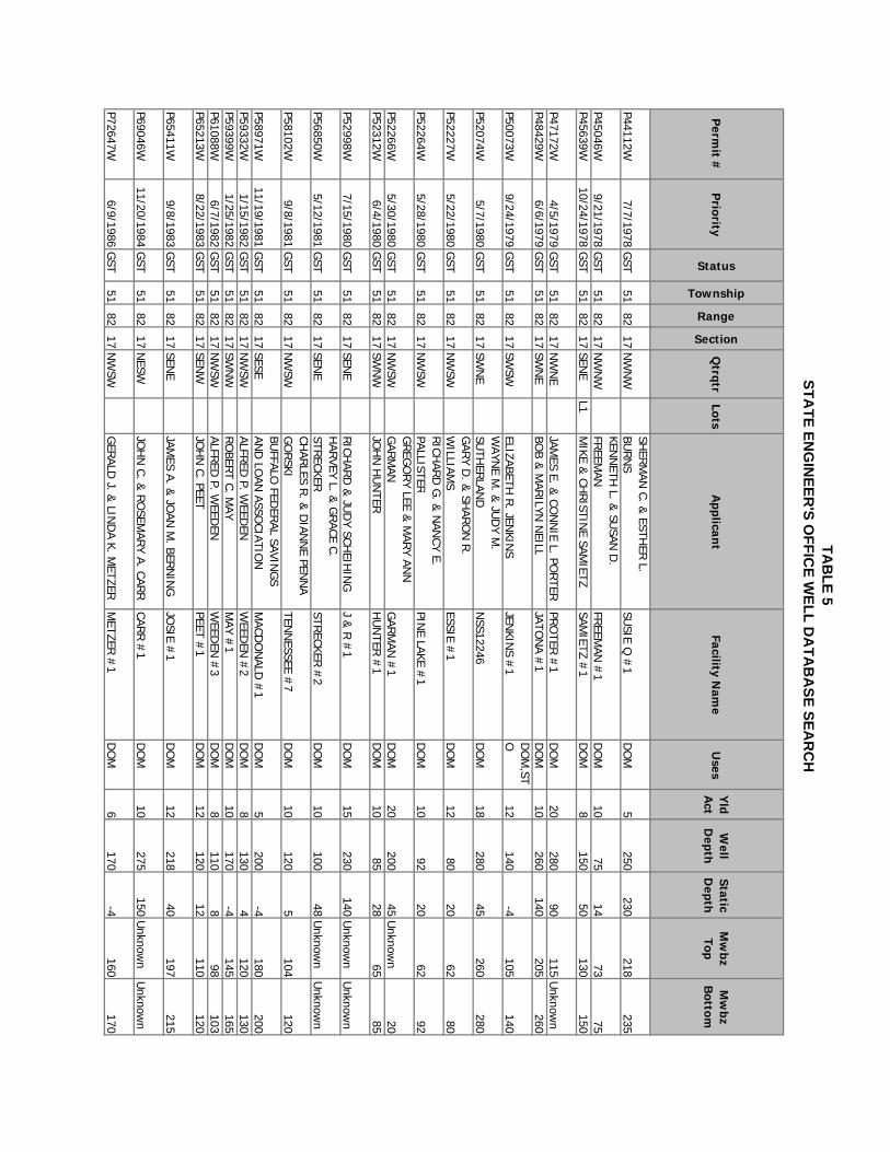
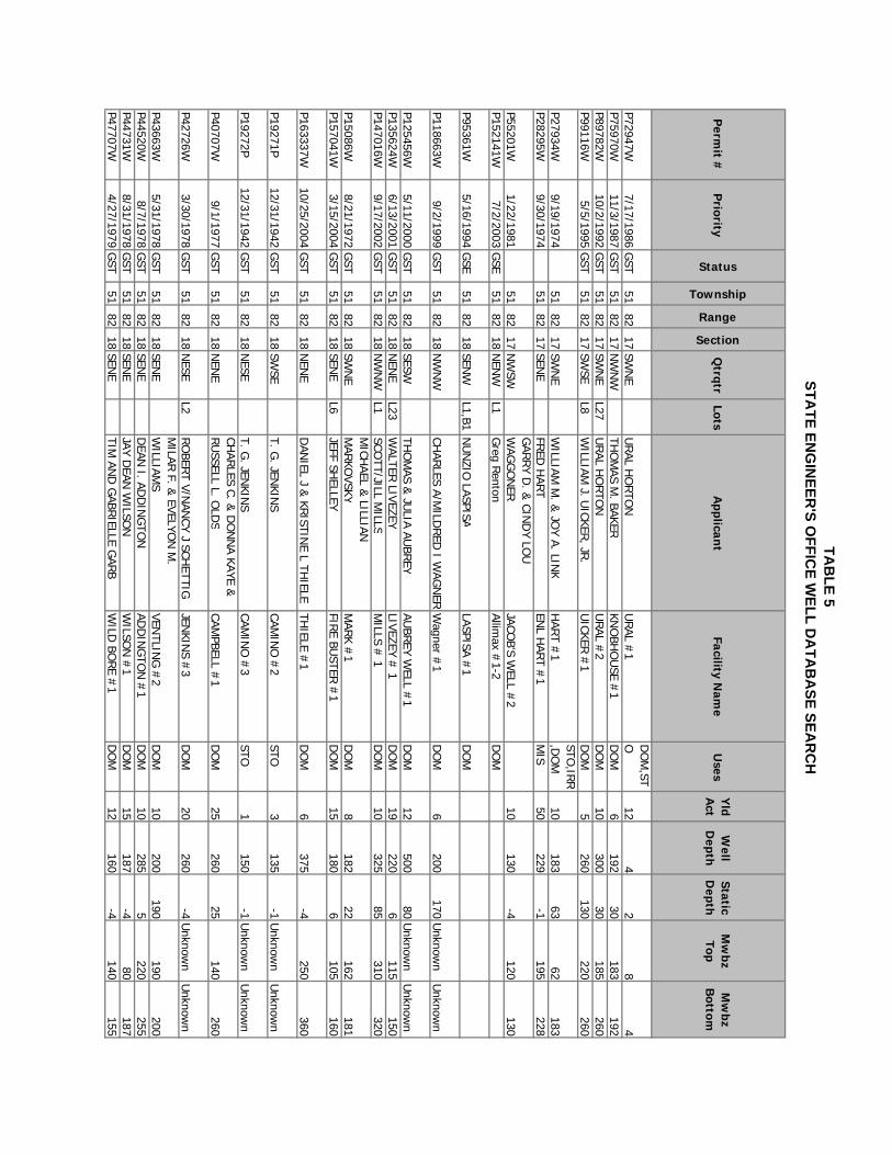
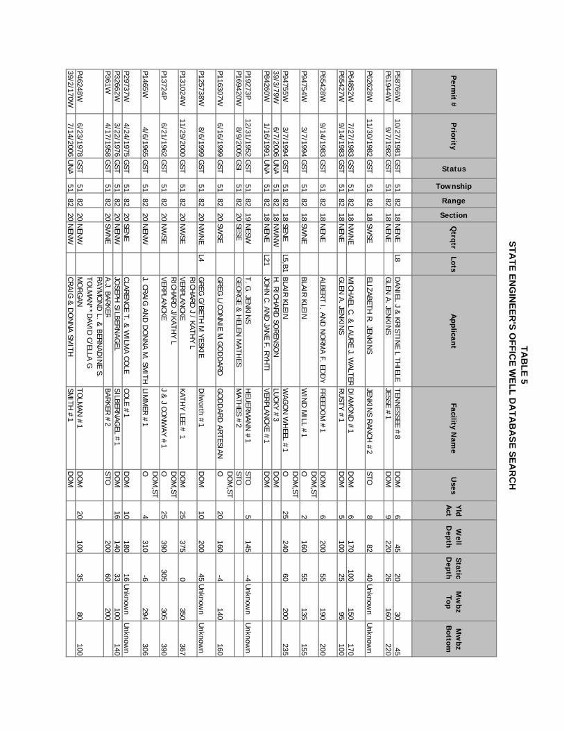
(a)(v) Mitigation of Impacts To date there have been no documented impacts to surrounding property owners as a function of groundwater withdrawals. It is not anticipated that impacts will occur as a result of developing a groundwater supply for the 99 lots on the Sand Creek Ranch PUD. The potential for further impact is further lessened by the ability of the Sand Creek Ranch PUD to use existing surface water irrigation rights to meet peak day demands on potable water that are a result of limited lawn watering. If impacts are proven to be the result of this subdivision, the homeowners would be forced to reduce water usage, and/or drill wells deeper, such that they are not all impacting the same production intervals. (b) Connection to Existing Water Supply System This section is not applicable to the Sand Creek Ranch PUD because individual water wells will be used to meet the water demands of the residents. (c) Common Water Supply System This section is not applicable to the Sand Creek Ranch PUD because individual or clustered water wells will be used to meet the water demands of the residents. (d) Groundwater Quantity and Quality As detailed in Table 3, the five water wells are located on the Sand Creek Ranch PUD yield between one and 12 gpm. A review of Table 5, the permitted water well summary table, indicates that 100 wells in the vicinity yield between 10 and 20 gpm. A well with a capacity of five gpm will provide adequate water for a single family dwelling, especially if irrigation of lawns is partially satisfied with surface water. Whitcomb and others (1966) documented a pump test on a well in the SE ¼ SE ¼ Section 33, Township 51 North, Range 82 West, which is approximately two miles southeast of the Sand Creek Ranch PUD. The well was pump tested at 70 gpm for four hours with 46 feet of drawdown. The specific capacity was computed to be 1.5 gpm per foot of drawdown. These well data indicate that the likelihood of obtaining adequate quantities of water for the Sand Creek Ranch PUD is excellent. The overall quality of water from Jenkins #1 is very good, as demonstrated in Table 4. The TDS is well below the recommended level of 500 mg/L. The only deviation from the standards for a public water supply source is the pH, which is slightly below the minimum standard of 6.5 standard units. Similar qualities can be expected from wells drilled to similar depths.
TAB
LE 5STA
TE ENG
INEER
'S OFFIC
E WELL D
ATA
BA
SE SEAR
CH
Perm
it #P
riority
Status
Township
Range
Section
Qtrqtr
LotsA
pplicant
Facility Nam
eU
sesY
ld A
ctW
ell D
epthStatic D
epthM
wbz
TopM
wbz
Bottom
P143021W3/4/2002
GSI
5182
7SESW
JOY E. ED
WAR
DS/JAN
IS L. H
ARRIS
EDW
ARD
S/HAR
RIS #
1D
OM
P154071W9/12/2003
GSI
5182
7N
ESWL1
TIMO
THY S &
LORI L KALU
SKALU
S #1
DO
M,ST
O
P161194W8/4/2004
GSI
5182
7SW
NW
CHAR
LES IRIG
ARAY &
CARO
L SN
OBE L
CARO
LINA #
2D
OM
,STO
P168942W7/13/2005
GSI
5182
7SW
SWSU
E & BU
D LED
BETTERLED
BETTER W
ELL #1
DO
MP103158W
7/29/1996G
ST51
827
NW
SER.C. R
OBIN
SON
RO
BINSO
N #
2D
OM
3520
104475
525P110960W
7/20/1998G
ST51
827
SWSW
FTP PARTN
ERSH
IPArk #
2D
OM
8280
55250
275
P113818W1/27/1999
GST
5182
7SW
S WBO
B COM
PTON
MIKEY #
1D
OM
9360
55U
nknown
Unknow
nP114708W
3/24/1999G
ST51
827
SESWL4
KIM/U
RSU
LA SCHW
IRIAN
SCHW
IRIAN
#1
DO
M10
32035
240320
P116590W6/21/1999
GST
5182
7SEN
WKEN
BURTO
NKEN
BURTO
N #
1D
OM
20100
20U
nknown
Unknow
n
P121610W12/20/1999
GST
5182
7N
WSW
MILLER
SAND
CREEK R
ANCH
, LLC
MILLER
#3
DO
M,ST
O7
2207
130210
P125132W4/27/2000
GST
5182
7SESW
L12KELLY D
. & G
EORG
IA A. RICE
RICE 1
DO
M12
12020
Unknow
nU
nknown
P130054W10/18/2000
GST
5182
7SESW
L3SH
AWN
/MICH
ELLE WELSH
WELSH
# 1
DO
M15
52055
Unknow
nU
nknown
P155143W11/19/2003
GST
5182
7N
ENW
FLOYD
D &
LORI L. CU
MM
ING
SCU
MM
ING
S #1
DO
M4
24026
195225
P161195W8/4/2004
GST
5182
7SW
NW
CHAR
LES IRIG
ARAY &
CARO
L SN
OBE L
CARO
LINA #
1D
OM
1060
40U
nknown
Unknow
n
P17458W12/27/1972
GST
5182
7SEN
WM
ARSH
ALL D. JEN
KINS
JENKIN
S #1
DO
M,ST
O10
29060
225244
P32381W3/3/1976
GST
5182
7SW
SECLAIR
& ELO
GEN
E P. RO
BINSO
NPIER
SON
#ž
DO
M3
260260
Unknow
nU
nknown
P5225W4/6/1970
GST
5182
7N
ENW
EDVIG
O &
HELEN
G. W
INTH
ERW
INTH
ER #
1D
OM
6220
31185
220
P85250W5/31/1991
GST
5182
7SW
NE
R. TR
ACY RH
OD
ESR. T. R
HO
DES #
1D
OM
,STO
10124
1896
116
P86346W10/9/1991
GST
5182
7SEN
WTH
OM
AS AND
BARBAR
A D
ENN
ISON
BLUEBIR
D #
1D
OM
10260
220220
260P109570W
4/10/1998U
NA
5182
7N
ENW
HEN
RY &
/OR VED
A M. BAU
ERH
ILLTOP #
1 WELL
DO
M
P165070W2/2/2005
GSI
5182
8SESE
DAVE R
EDD
RO
CK CREEK M
EADO
WS
#3
TST
TAB
LE 5STA
TE ENG
INEER
'S OFFIC
E WELL D
ATA
BA
SE SEAR
CH
Perm
it #P
riority
Status
Township
Range
Section
Qtrqtr
LotsA
pplicant
Facility Nam
eU
sesY
ld A
ctW
ell D
epthStatic D
epthM
wbz
TopM
wbz
Bottom
P165071W2/2/2005
GSI
5182
8SW
NW
DAVE R
EDD
RO
CK CREEK M
EADO
WS
#1
TST
P165072W2/2/2005
GSI
5182
8SW
SED
AVE RED
DRO
CK CREEK M
EADO
WS
#2
TST
P16243P12/31/1967
GST
5182
8SEN
EALVA TAYLO
R**G
EORG
E TAYLO
RTAYLO
R #
3D
OM
,STO
5900
-4U
nknown
Unknow
n
39/10/163W7/12/2006
UN
A51
828
NESE
DAW
SON
CON
STRU
CTION
, INC.
DAW
SON
WELL #
1D
OM
39/10/89W6/12/2006
UN
A51
828
NESE
SEAN &
LYNETTE D
URRAN
TS &
L DU
RRAN
T WELL
#1
DO
M39/4/307W
9/25/2006U
NA
5182
8SW
SEJO
HN
& CATH
ERIN
E DESCH
DESCH
#1
DO
M39/5/173W
7/18/2006U
NA
5182
8N
ESWD
AN &
MO
NICA D
AUG
HER
TYD
AUG
HER
TY #1
DO
M39/5/186W
7/26/2006U
NA
5182
8N
ESWM
ICHAEL J. CECELIA L IH
NAT
CECE #1
DO
M39/8/78W
6/7/2006U
NA
5182
8SW
NW
MICH
AEL J. CECELIA L IHN
ATCECELIA #
1D
OM
P104525W11/21/1996
GST
5182
16N
ENE
GLEN
MEAN
SG
LEN M
EANS #
4D
OM
14160
2140
160
P16043P4/30/1955
GST
5182
16SW
SWREEVES IN
C.RO
BINSO
N #
1STO
15220
-1U
nknown
Unknow
n
P95286W5/5/1994
GST
5182
16N
WN
ED
ELTON
AND
CARO
L A. H
ERM
ANH
ERM
AN #
1D
OM
16123
1095
119
P28330W10/8/1974
ADJ
5182
17SESW
CARL H
. LARSO
NLAR
SON
#1
STO,IRR
,DO
M40
250150
140250
P42392W3/14/1978
ADJ
5182
17N
WN
ELAN
NY R
. PETERSO
N**PAU
LA M
. PETERSO
NPETER
SON
#3
DO
M20
26070
240260
P159882W6/1/2004
GSE
5182
17SW
NW
DO
NALD
M/TIN
A A SEALSSEALS #
3D
OM
,STO
P159883W6/1/2004
GSE
5182
17SW
NW
DO
NALD
M/TIN
A A SEALSSEALS #
4D
OM
,STO
P173012W2/6/2006
GSI
5182
17N
ENW
GREG
ORY LAU
VERLAU
VER #
1D
OM
P100049W8/15/1995
GST
5182
17N
WSE
L14RICH
ARD
B/MAR
Y ANN
BAYERS
BAYERS #
1D
OM
10220
60180
220
P102003W4/8/1996
GST
5182
17N
ENW
L15,BM
ATTHEW
HEN
RY
LON
GH
ORN
#3
DO
M10
12030
80120
P104511W11/14/1996
GST
5182
17SEN
WL1,B2
JAMES A/O
R FLO
REN
CE E LON
GLO
NG
#1
DO
M,ST
O6
134
411
P106818W7/24/1997
GST
5182
17N
WN
WL13
ORLEN
L FYOCK
FYOCK #
1D
OM
20212
3200
205
TAB
LE 5STA
TE ENG
INEER
'S OFFIC
E WELL D
ATA
BA
SE SEAR
CH
Perm
it #P
riority
Status
Township
Range
Section
Qtrqtr
LotsA
pplicant
Facility Nam
eU
sesY
ld A
ctW
ell D
epthStatic D
epthM
wbz
TopM
wbz
Bottom
P116304W6/16/1999
GST
5182
17N
ESWL26
GAR
Y L FOSTM
EIER/BAR
BARA
SCHN
ACHTEN
BERG
ER AS JO
INT
TENAN
TSCH
AMBER
LAIN #
1D
OM
15275
150U
nknown
Unknow
n
P116305W6/16/1999
GST
5182
17SEN
EW
ILLIAM CH
RISTEN
SENCH
RISTEN
SEN #
1STO
10100
40U
nknown
Unknow
n
P116306W6/16/1999
GST
5182
17SEN
EW
ILLIAM CH
RISTEN
SENCH
RISTEN
SEN #
2STO
25300
10U
nknown
Unknow
n
P117773W7/26/1999
GST
5182
17SESW
TED/D
ARLEN
E CRISM
ANCR
ISMAN
WELL N
O. 1
DO
M,S T
O7
20025
Unknow
nU
nknown
P117993W7/23/1999
GST
5182
17N
WN
ERobert/Jean Zabloudil
ZAB 31D
OM
16259
28U
nknown
Unknow
nP117999W
7/30/1999G
ST51
8217
SENE
L29G
ary/Cecelia Walters
WALTER
S #1
DO
M18
28045
260275
P118427W8/19/1999
GST
5182
17SW
SEPER
YR/LEN
ORE TH
ORN
ETH
ORN
E #1
DO
M10
13068
100130
P118428W8/20/1999
GST
5182
17SESW
L1W
ILLIAM J/JER
RI LYN
NE
HAN
SENBETZ #
1 WELL
DO
M,ST
O25
18040
Unknow
nU
nknown
P118570W8/17/1999
GST
5182
17N
WSE
L28RICH
ARD
L BOYLE**BETTY M
G
RESS
BOYLE/G
RESS #
2D
OM
18028
122180
P118574W8/27/1999
GST
5182
17N
ENW
RICH
ARD
L/OR CO
NN
IE R
JON
ESJO
NES #
1D
OM
,STO
18275
6070
115
P118656W8/31/1999
GST
5182
17N
WN
EL19
PAULA A W
ILCOX**N
ARCELLA
PRESTO
NPR
ESTON
E AND
W
ILCOX #
1D
OM
20260
70240
260
P119025W9/17/1999
GST
5182
17SEN
ERO
LAND
L/SHIR
LEY A PR
ITCHAR
DPR
ITCHAR
D #
1D
OM
15285
90.5U
nknown
Unknow
n
P119472W9/1/1999
GST
5182
17N
WN
ED
EAN/CAR
OL H
AZLETTH
AZLETT #1
DO
M25
26575
Unknow
nU
nknown
P119473W9/1/1999
GST
5182
17N
WN
ED
EAN/CAR
OL H
AZLET TH
AZLETT #2
DO
M10
14560
Unknow
nU
nknown
P120815W7/27/1999
GST
5182
17N
WN
ESandra Tw
eed yTw
eedy #1
DO
M8
21058
Unknow
nU
nknown
P126286W6/21/2000
GST
5182
17N
WSW
L1ELM
ER/TER
ESE GILL
GILL #
1D
OM
20150
26111
134
P126601W1/11/2000
GST
5182
17SEN
EL6
Edward E. &
Lalene Coo kCook #
1D
OM
12180
82.48U
nknown
Unknow
n
P126603W6/26/2000
GST
5182
17SW
NW
RO
BERT H
. & R
UTH
ANN
E M
CCANN
R &
R ACR
ESD
OM
,STO
250
13U
nknown
Unknow
n
TAB
LE 5STA
TE ENG
INEER
'S OFFIC
E WELL D
ATA
BA
SE SEAR
CH
Perm
it #P
riority
Status
Township
Range
Section
Qtrqtr
LotsA
pplicant
Facility Nam
eU
sesY
ld A
ctW
ell D
epthStatic D
epthM
wbz
TopM
wbz
Bottom
P131015W11/29/2000
GST
5182
17N
WSE
L12JO
HN
NEPH
I AND
KAREN
KAYE SH
AWAKER
S # 1
DO
M25
260100
145155
P135626W6/13/2001
GST
5182
17SEN
EL4
JAMES / M
ARCIA STR
AIGH
TSTR
AIGH
T # 2
DO
M9
22085
178200
P13719W4/21/1972
GST
5182
17SEN
EFR
ED H
ART
HAR
T #1
STO3
229-1
195228
P144014W4/18/2002
GST
5182
17SW
NE
L43D
ON
ALD M
./TINA A. SEALS
SEALS # 2
DO
M,ST
O12
195-4
165190
P144797W6/13/2002
GST
5182
17N
ENW
BRU
CE C./PEGG
Y J. CHATW
ELLG
OO
SE LAND
ING
# 1
DO
M5
200-4
175195
P1466W4/6/1965
GST
5182
17N
WS W
DU
ANE A. &
CARO
L J. AHLER
SLIM
MER
#2
DO
M,ST
O3
120-6
120
P162384W9/20/2004
GST
5182
17N
ENW
STANLEY AN
D R
AFAELA AR
MSTR
ON
GRAFAELA #
1D
OM
18180
1880
160
P164946W1/20/2005
GST
5182
17SW
NE
L13RO
NN
& D
IANA YELLEN
YELLEN #
2D
OM
,STO
20660
0590
630
P18728P12/31/1942
GST
5182
17SW
S WD
UAN
E A. & CAR
OL J. AH
LERS
CAMIN
O #
1D
OM
1140
-1U
nknown
Unknow
n
P22462W6/18/1973
GST
5182
17SW
NW
SIRM
ON
S PRO
PERTIES
RO
SE #1
DO
M,ST
O10
1720
164170
P26088W3/5/1974
GST
5182
17N
ENW
GREG
ORY A/D
ARLEN
E M
LAUVER
ED R
OSE #
1D
OM
,STO
25150
-4117
149P27553W
8/5/1974G
ST51
8217
NW
SEJO
HN
H. LU
SHER
LUSH
ER #
1D
OM
25180
28120
170
P27902W8/26/1974
GST
5182
17N
WS W
RO
BERT A. &
JEANN
E A. JEN
KINS
JENKIN
S #2
DO
M24
24052
221238
P27903W8/26/1974
GST
5182
17SW
NW
RO
BERT A. &
JEANN
E A. JEN
KINS
JENKIN
S #1
DO
M12
20033
173190
P28331W10/8/1974
GST
5182
17SW
SEL6
ERIC/JILL M
FELBECKRO
GER
S #1
DO
M,S T
O25
31054
304309
P29336W3/17/1975
GST
5182
17SW
SETH
OM
AS R. KLAU
SNE R
KLAUSN
ER #
1D
OM
7204
203U
nknown
Unknow
n
P29567W4/21/1975
GST
5182
17SW
SED
UAN
E S. & CAR
YL K. STAFFO
RD
TOW
NSEN
D #
1D
OM
10226
75U
nknown
Unknow
n
P29731W5/5/1975
GST
5182
17SW
NW
WILLIAM
E. & BETTY A.
MCKIN
STR YM
CKINSTR
Y #1
DO
M,ST
O13
187-6
166186
P30416W7/9/1975
GST
5182
17SEN
EFR
ED M
. HAR
TH
ART #
5D
OM
,STO
8145
125125
145
P31070W9/8/1975
GST
5182
17SEN
EFR
ED M
. HAR
TH
ART #
6D
OM
,STO
12180
140140
180
TAB
LE 5STA
TE ENG
INEER
'S OFFIC
E WELL D
ATA
BA
SE SEAR
CH
Perm
it #P
riority
Status
Township
Range
Section
Qtrqtr
LotsA
pplicant
Facility Nam
eU
sesY
ld A
ctW
ell D
epthStatic D
epthM
wbz
TopM
wbz
Bottom
P31087W9/25/1975
GST
5182
17N
ESEFR
ED M
. HAR
TH
ART #
7D
OM
,STO
25190
169.5155
190
P31764W12/22/1976
GST
5182
17N
WSE
R. M
. TOW
NSEN
D**M
ARK E.
MEN
GER
ING
MEN
GER
ING
#1
DO
M15
18080
138180
P31915W1/29/1976
GST
5182
17N
WSW
LEO D
AVID EN
NIS
ENN
IS #1
DO
M9
10020
70100
P32511W3/12/1976
GST
5182
17N
WSE
CHAR
LES G. IR
IGAR
AYIR
IGAR
AY #1
DO
M25
13068
100130
P32522W3/25/1976
GST
5182
17SESW
ALLEN &
VIRG
INIA CR
ANE
CRAN
E #1
DO
M16
11020
55108
P33039W4/19/1976
GST
5182
17SEN
EM
. J. SOKO
LSO
KOL #
1D
OM
,STO
8120
6080
120
P33085W5/13/1976
GST
5182
17SEN
WLAN
NY R
. & PAU
LA M.
PETERSO
NPETER
SON
#1
DO
M20
14040
100140
P33658W6/7/1976
GST
5182
17SW
NW
DALE &
ANITA LEISCH
NER
FISH W
ATER W
ELL #1
DO
M10
16075
134U
nknown
P34194W7/22/1976
GST
5182
17N
ENE
JAMES R
. RO
BERTS
RO
BERTS #
1D
OM
10210
58180
210
P34344W8/2/1976
GST
5182
17SEN
WM
. FORREST JEN
KINS
J.C.P.R. #
1D
OM
,STO
15200
50140
200
P34785W9/10/1976
GST
5182
17SEN
ED
OU
GLASS C. &
SHER
RI W
. SCH
ALAMO
NJO
HN
SON
#1
DO
M6
22042
196219
P36098W2/15/1977
GST
5182
17SW
NW
CARL L. &
FAY L. WAU
GH
WAU
GH
#1
DO
M15
1903
130142
P36465W3/14/1977
GST
5182
17N
WN
WM
ORM
AN KEN
ITZERN
. KENITZER
#2
DO
M25
205150
150204
P37995W5/23/1977
GST
5182
17N
WSE
ALLEN D
. AND
PHYLLIS J.
BRO
GE
BRO
GE #
1D
OM
25280
160U
nknown
Unknow
n
P38047W6/2/1977
GST
5182
17SEN
WLAN
NY R
. & PAU
LA M.
PETERSO
NPETER
SON
#2
DO
M25
275140
195275
P40434W10/13/1977
GST
5182
17N
WSE
LARRY &
MAR
ILYN KO
EHLER
KOEH
LERS #
2D
OM
10300
44225
300
P42319W3/2/1978
GST
5182
17N
WN
WL11
CUTIS L TH
OM
PSON
& JO
HN
C. BU
RIE, TR
USTEES TH
E PRAIR
IE TR
UST
MILLER
#1
DO
M,ST
O12
17540
Unknow
n150
P43020W4/25/1978
GST
5182
17SEN
EH
ARVEY L. &
GRACE C.
STRECKER
STRECKER
#1
DO
M10
200180
160200
P43601W5/23/1978
GST
5182
17SW
NW
BENJAM
IN A. AU
STINLEETA #
2D
OM
20105
-685
Unknow
nP43602W
6/5/1978G
ST51
8217
NESW
Melvin W
/Doris A G
erholdPETER
SON
#4
DO
M15
23070
188230
P43604W6/5/1978
GST
5182
17SW
NE
ALMIT &
NAN
CY BERG
LUN
DN
ANCY #
1D
OM
10235
70185
230
P43770W6/12/1978
GST
5182
17SEN
EL10
SHAN
E A LEWIS/LIN
DA J
WALKE R
B S #2
DO
M8
135110
115130
TAB
LE 5STA
TE ENG
INEER
'S OFFIC
E WELL D
ATA
BA
SE SEAR
CH
Perm
it #P
riority
Status
Township
Range
Section
Qtrqtr
LotsA
pplicant
Facility Nam
eU
sesY
ld A
ctW
ell D
epthStatic D
epthM
wbz
TopM
wbz
Bottom
P44112W7/7/1978
GST
5182
17N
WN
WSH
ERM
AN C. &
ESTHER
L. BU
RN
SSU
SIE Q #
1D
OM
5250
230218
235
P45046W9/21/1978
GST
5182
17N
WN
WKEN
NETH
L. & SU
SAN D
. FR
EEMAN
FREEM
AN #
1D
OM
1075
1473
75P45639W
10/24/1978G
ST51
8217
SENE
L1M
IKE & CH
RISTIN
E SAMIETZ
SAMIETZ #
1D
OM
8150
50130
150
P47172W4/5/1979
GST
5182
17N
WN
EJAM
ES E. & CO
NN
IE L. PORTER
PRO
TER #
1D
OM
20280
90115
Unknow
nP48429W
6/6/1979G
ST51
8217
SWN
EBO
B & M
ARILYN
NEILL
JATON
A #1
DO
M10
260140
205260
P50073W9/24/1979
GST
5182
17SW
S WELIZABETH
R. JEN
KINS
JENKIN
S #1
DO
M,ST
O12
140-4
105140
P52074W5/7/1980
GST
5182
17SW
NE
WAYN
E M. &
JUD
Y M.
SUTH
ERLAN
DN
SS12246D
OM
18280
45260
280
P52227W5/22/1980
GST
5182
17N
WS W
GAR
Y D. &
SHAR
ON
R.
WILLIAM
SESSIE #
1D
OM
1280
2062
80
P52264W5/28/1980
GST
5182
17N
WS W
RICH
ARD
G. &
NAN
CY E. PALLISTE R
PINE LAKE #
1D
OM
1092
2062
92
P52266W5/30/1980
GST
5182
17N
WS W
GREG
ORY LEE &
MAR
Y ANN
G
ARM
ANG
ARM
AN #
1D
OM
20200
45U
nknown
20P52312W
6/4/1980G
ST51
8217
SWN
WJO
HN
HU
NTER
HU
NTER
#1
DO
M10
8528
6585
P52998W7/15/1980
GST
5182
17SEN
ERICH
ARD
& JU
DY SCH
EIHIN
GJ &
R #
1D
OM
15230
140U
nknown
Unknow
n
P56850W5/12/1981
GST
5182
17SEN
EH
ARVEY L. &
GRACE C.
STRECKER
STRECKER
#2
DO
M10
10048
Unknow
nU
nknown
P58102W9/8/1981
GST
5182
17N
WS W
CHAR
LES R. &
DIAN
NE PEN
NA
GO
RSKI
TENN
ESSEE #7
DO
M10
1205
104120
P58971W11/19/1981
GST
5182
17SESE
BUFFALO
FEDER
AL SAVING
S AN
D LO
AN ASSO
CIATION
MACD
ON
ALD #
1D
OM
5200
-4180
200P59332W
1/15/1982G
ST51
8217
NW
SWALFR
ED P. W
EEDEN
WEED
EN #
2D
OM
8130
4120
130P59399W
1/25/1982G
ST51
8217
SWN
WRO
BERT C. M
AYM
AY #1
DO
M10
170-4
145165
P61088W6/7/1982
GST
5182
17N
WSW
ALFRED
P. WEED
ENW
EEDEN
#3
DO
M8
1108
98103
P65213W8/22/1983
GST
5182
17SEN
WJO
HN
C. PEETPEET #
1D
OM
12120
12110
120
P65411W9/8/1983
GST
5182
17SEN
EJAM
ES A. & JO
AN M
. BERN
ING
JOSIE #
1D
OM
12218
40197
215
P69046W11/20/1984
GST
5182
17N
ESWJO
HN
C. & R
OSEM
ARY A. CAR
RCAR
R #
1D
OM
10275
150U
nknown
Unknow
n
P72647W6/9/1986
GST
5182
17N
WS W
GER
ALD J. &
LIND
A K. METZER
METZER
#1
DO
M6
170-4
160170
TAB
LE 5STA
TE ENG
INEER
'S OFFIC
E WELL D
ATA
BA
SE SEAR
CH
Perm
it #P
riority
Status
Township
Range
Section
Qtrqtr
LotsA
pplicant
Facility Nam
eU
sesY
ld A
ctW
ell D
epthStatic D
epthM
wbz
TopM
wbz
Bottom
P72947W7/17/1986
GST
5182
17SW
NE
URAL H
ORTO
NU
RAL #
1D
OM
,STO
124
28
4P75970W
11/3/1987G
ST51
8217
NW
NW
THO
MAS M
. BAKERKN
OBH
OU
SE #1
DO
M6
19230
183192
P89782W10/2/1992
GST
5182
17SW
NE
L27U
RAL H
ORTO
NU
RAL #
2D
OM
10300
30185
260P99116W
5/5/1995G
ST51
8217
SWSE
L8W
ILLIAM J. U
ICKER, JR
.U
ICKER #
1D
OM
5260
130220
260
P27934W9/19/1974
5182
17SW
NE
WILLIAM
M. &
JOY A. LIN
KH
ART #
1STO
,IRR,D
OM
10183
6362
183P28295W
9/30/197451
8217
SENE
FRED
HAR
TEN
L HAR
T #1
MIS
50229
-1195
228
P55201W1/22/1981
5182
17N
WSW
GAR
RY D
. & CIN
DY LO
U
WAG
GO
NER
JACOB'S W
ELL #2
10130
-4120
130P152141W
7/2/2003G
SE51
8218
NEN
WL1
Gre g R
entonAllim
ax #1-2
DO
M
P95361W5/16/1994
GSE
5182
18SEN
WL1,B1
NU
NZIO
LASPIS ALASPISA #
1D
OM
P118663W9/2/1999
GST
5182
18N
WN
WCH
ARLES A/M
ILDRED
I WAG
NER
Wa gner #
1D
OM
6200
170U
nknown
Unknow
n
P125456W5/11/2000
GST
5182
18SESW
THO
MAS &
JULIA AU
BRE Y
AUBR
EY WELL #
1D
OM
12500
80U
nknown
Unknow
nP135624W
6/13/2001G
ST51
8218
NEN
EL23
WALTER
LIVEZEYLIVEZEY #
1D
OM
19220
6115
150P147016W
9/17/2002G
ST51
8218
NW
NW
L1SCO
TT/JILL MILLS
MILLS #
1D
OM
10325
85310
320
P15086W8/21/1972
GST
5182
18SW
NE
MICH
AEL & LILLIAN
M
ARKO
VSK YM
ARK #
1D
OM
8182
22162
181P157041W
3/15/2004G
ST51
8218
SENE
L6JEFF SH
ELLEYFIR
E BUSTER
#1
DO
M15
1806
105160
P163337W10/25/2004
GST
5182
18N
ENE
DAN
IEL J & KR
ISTINE L TH
IELETH
IELE #1
DO
M6
375-4
250360
P19271P12/31/1942
GST
5182
18SW
SET. G
. JENKIN
SCAM
INO
#2
STO3
135-1
Unknow
nU
nknown
P19272P12/31/1942
GST
5182
18N
ESET. G
. JENKIN
SCAM
INO
#3
STO1
150-1
Unknow
nU
nknown
P40707W9/1/1977
GST
5182
18N
ENE
CHAR
LES C. & D
ON
NA KAYE &
RU
SSELL L. OLD
SCAM
PBELL #1
DO
M25
26025
140260
P42726W3/30/1978
GST
5182
18N
ESEL2
RO
BERT V/N
ANCY J SCH
ETTIGJEN
KINS #
3D
OM
20260
-4U
nknown
Unknow
n
P43663W5/31/1978
GST
5182
18SEN
EM
ILAR F. &
EVELYON
M.
WILLIAM
SVEN
TLING
#2
DO
M10
200190
190200
P44520W8/7/1978
GST
5182
18SEN
ED
EAN I. AD
DIN
GTO
NAD
DIN
GTO
N #
1D
OM
10285
5220
255P44731W
8/31/1978G
ST51
8218
SENE
JAY DEAN
WILSO
NW
ILSON
#1
DO
M15
187-4
80187
P47707W4/27/1979
GST
5182
18SEN
ETIM
AND
GABR
IELLE GAR
BW
ILD BO
RE #
1D
OM
12160
-4140
155
TAB
LE 5STA
TE ENG
INEER
'S OFFIC
E WELL D
ATA
BA
SE SEAR
CH
Perm
it #P
riority
Status
Township
Range
Section
Qtrqtr
LotsA
pplicant
Facility Nam
eU
sesY
ld A
ctW
ell D
epthStatic D
epthM
wbz
TopM
wbz
Bottom
P58766W10/27/1981
GST
5182
18N
ENE
L8D
ANIEL J &
KRISTIN
E L THIELE
TENN
ESSEE #8
DO
M6
4520
3045
P61944W9/7/1982
GST
5182
18N
ENE
GLEN
A. JENKIN
SJESSE #
1D
OM
9220
26160
220
P62628W11/30/1982
GST
5182
18SW
SEELIZABETH
R. JEN
KINS
JENKIN
S RAN
CH #
2STO
882
40U
nknown
Unknow
n
P64852W7/27/1983
GST
5182
18N
WN
EM
ICHAEL C. &
LAURE J. W
ALTERD
IAMO
ND
#1
DO
M6
170100
150170
P65427W9/14/1983
GST
5182
18N
ENE
GLEN
A. JENKIN
SRU
STY #1
DO
M5
10025
95100
P65428W9/14/1983
GST
5182
18N
ENE
ALBERT I. AN
D N
ORM
A F. EDD
YFR
EEDO
M #
1D
OM
6200
55190
200
P94754W3/7/1994
GST
5182
18SW
NE
BLAIR KLEIN
WIN
D M
ILL #1
DO
M,ST
O2
16055
135155
P94755W3/7/1994
GST
5182
18SEN
EL5,B1
BLAIR KLEIN
WAG
ON
WH
EEL #1
DO
M,ST
O25
24060
200235
39/3/79W6/7/2006
UN
A51
8218
NW
NW
H. R
ICHAR
D SO
REN
SON
LUCKY #
3D
OM
P84260W1/16/1991
UN
A51
8218
NEN
EL21
JOH
N C. AN
D JAN
E F. RYH
TIVER
PLANCKE #
1D
OM
P19273P12/31/1952
GST
5182
19N
ESWT. G
. JENKIN
SH
EUER
MAN
N #
1STO
5145
-4U
nknown
Unknow
nP169420W
8/9/2005G
SI51
8220
SESEG
EORG
E & H
ELEN M
ATHES
MATH
ES #2
STO
P116307W6/16/1999
GST
5182
20SW
SEG
REG
L/CON
NIE M
GO
DD
ARD
GO
DD
ARD
ARTESIAN
DO
M,ST
O20
160-4
140160
P125738W8/6/1999
GST
5182
20N
WN
EL4
GREG
G/BETH
M YESKIE
Dilw
orth #1
DO
M10
20045
Unknow
nU
nknown
P131024W11/29/2000
GST
5182
20N
WSE
RICH
ARD
J / KATHY L
VERPLAN
CKEKATH
Y LEE # 1
DO
M25
3750
350367
P13724P6/21/1962
GST
5182
20N
WSE
RICH
ARD
J/KATHY L
VERPLAN
CKEJ &
J CON
WAY #
1D
OM
,STO
25390
305305
390
P1465W4/6/1965
GST
5182
20N
ENW
J. CRAIG
AND
DO
NN
A M. SM
ITHLIM
MER
#1
DO
M,ST
O4
310-6
294306
P29737W4/24/1975
GST
5182
20SEN
ECLAR
ENCE T. &
WILM
A COLE
COLE #
1D
OM
10180
16U
nknown
Unknow
nP32662W
3/22/1976G
ST51
8220
NEN
WJO
SEPH SILBER
NAG
ELSILBER
NAG
EL #1
DO
M16
14033
100140
P361W4/17/1958
GST
5182
20SW
NE
A.J. BARKER
BARKER
#2
STO200
60200
P46248W6/23/1978
GST
5182
20N
ENW
RAYM
ON
D L. &
BERN
ADIN
E S. TO
LMAN
**DAVID
C/ELLA G
MO
RG
ANTO
LMAN
#1
DO
M20
10035
80100
39/2/170W7/14/2006
UN
A51
8220
NEN
WCR
AIG &
DO
NN
A SMITH
SMITH
#1
DO
M
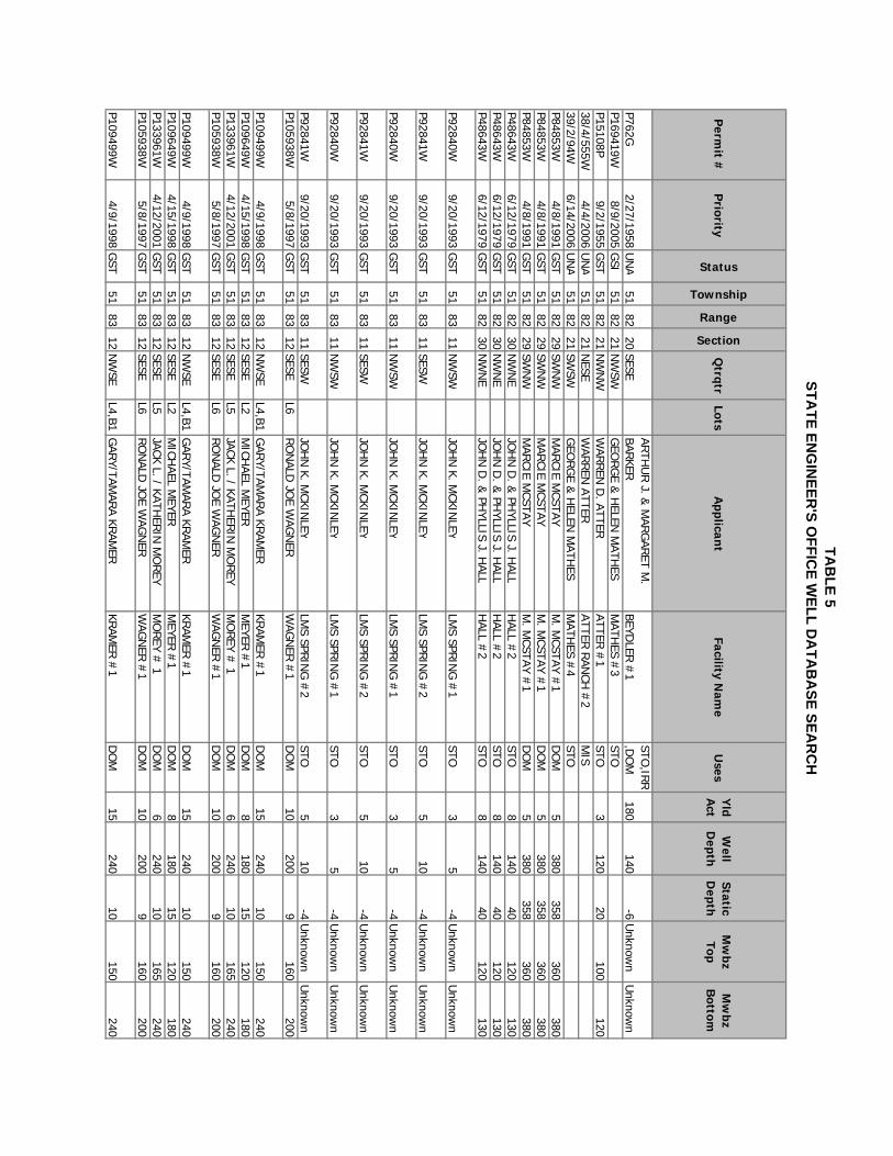
TAB
LE 5STA
TE ENG
INEER
'S OFFIC
E WELL D
ATA
BA
SE SEAR
CH
Perm
it #P
riority
Status
Township
Range
Section
Qtrqtr
LotsA
pplicant
Facility Nam
eU
sesY
ld A
ctW
ell D
epthStatic D
epthM
wbz
TopM
wbz
Bottom
P762G2/27/1958
UN
A51
8220
SESEAR
THU
R J. &
MAR
GAR
ET M.
BARKER
BEYDLER
#1
STO,IRR
,DO
M180
140-6
Unknow
nU
nknown
P169419W8/9/2005
GSI
5182
21N
WSW
GEO
RG
E & H
ELEN M
ATHES
MATH
ES #3
STOP15108P
9/2/1955G
ST51
8221
NW
NW
WAR
REN
D. ATTER
ATTER #
1STO
3120
20100
12038/4/555W
4/4/2006U
NA
5182
21N
ESEW
ARREN
ATTERATTER
RAN
CH #
2M
IS39/2/94W
6/14/2006U
NA
5182
21SW
SWG
EORG
E & H
ELEN M
ATHES
MATH
ES #4
STOP84853W
4/8/1991G
ST51
8229
SWN
WM
ARCIE M
CSTAYM
. MCSTAY #
1D
OM
5380
358360
380P84853W
4/8/1991G
ST51
8229
SWN
WM
ARCIE M
CSTAYM
. MCSTAY #
1D
OM
5380
358360
380P84853W
4/8/1991G
ST51
8229
SWN
WM
ARCIE M
CSTAYM
. MCSTAY #
1D
OM
5380
358360
380P48643W
6/12/1979G
ST51
8230
NW
NE
JOH
N D
. & PH
YLLIS J. HALL
HALL #
2STO
8140
40120
130P48643W
6/12/1979G
ST51
8230
NW
NE
JOH
N D
. & PH
YLLIS J. HALL
HALL #
2STO
8140
40120
130P48643W
6/12/1979G
ST51
8230
NW
NE
JOH
N D
. & PH
YLLIS J. HALL
HALL #
2STO
8140
40120
130
P92840W9/20/1993
GST
5183
11N
WS W
JOH
N K. M
CKINLEY
LMS SPR
ING
#1
STO3
5-4
Unknow
nU
nknown
P92841W9/20/1993
GST
5183
11SESW
JOH
N K. M
CKINLE Y
LMS SPR
ING
#2
STO5
10-4
Unknow
nU
nknown
P92840W9/20/1993
GST
5183
11N
WS W
JOH
N K. M
CKINLEY
LMS SPR
ING
#1
STO3
5-4
Unknow
nU
nknown
P92841W9/20/1993
GST
5183
11SESW
JOH
N K. M
CKINLE Y
LMS SPR
ING
#2
STO5
10-4
Unknow
nU
nknown
P92840W9/20/1993
GST
5183
11N
WS W
JOH
N K. M
CKINLEY
LMS SPR
ING
#1
STO3
5-4
Unknow
nU
nknown
P92841W9/20/1993
GST
5183
11SESW
JOH
N K. M
CKINLE Y
LMS SPR
ING
#2
STO5
10-4
Unknow
nU
nknown
P105938W5/8/1997
GST
5183
12SESE
L6RO
NALD
JOE W
AGN
ERW
AGN
ER #
1D
OM
10200
9160
200
P109499W4/9/1998
GST
5183
12N
WSE
L4,B1G
ARY/TAM
ARA KR
AMER
KRAM
ER #
1D
OM
15240
10150
240P109649W
4/15/1998G
ST51
8312
SESEL2
MICH
AEL MEYER
MEYER
#1
DO
M8
18015
120180
P133961W4/12/2001
GST
5183
12SESE
L5JACK L. / KATH
ERIN
MO
REY
MO
REY #
1D
OM
6240
10165
240P105938W
5/8/1997G
ST51
8312
SESEL6
RO
NALD
JOE W
AGN
ERW
AGN
ER #
1D
OM
10200
9160
200
P109499W4/9/1998
GST
5183
12N
WSE
L4,B1G
ARY/TAM
ARA KR
AMER
KRAM
ER #
1D
OM
15240
10150
240
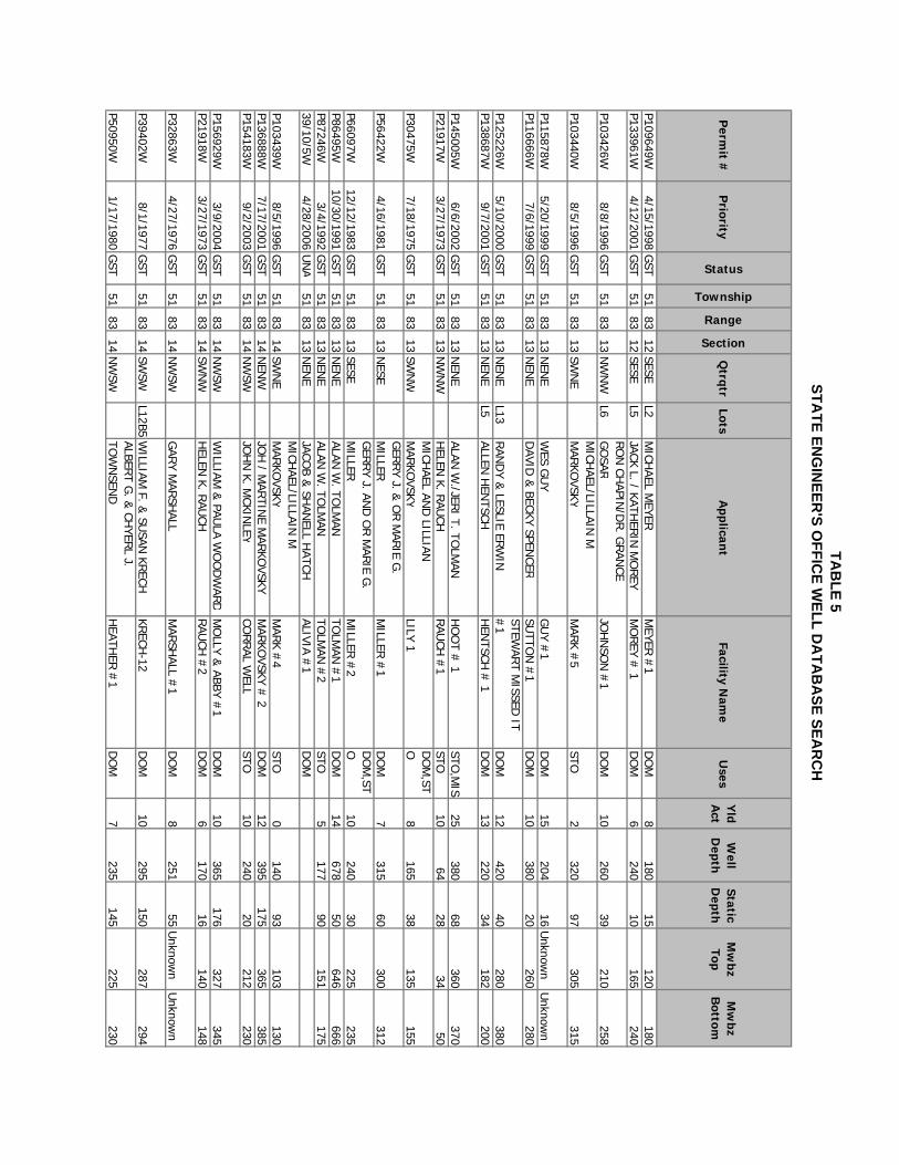
TAB
LE 5STA
TE ENG
INEER
'S OFFIC
E WELL D
ATA
BA
SE SEAR
CH
Perm
it #P
riority
Status
Township
Range
Section
Qtrqtr
LotsA
pplicant
Facility Nam
eU
sesY
ld A
ctW
ell D
epthStatic D
epthM
wbz
TopM
wbz
Bottom
P109649W4/15/1998
GST
5183
12SESE
L2M
ICHAEL M
EYERM
EYER #
1D
OM
8180
15120
180P133961W
4/12/2001G
ST51
8312
SESEL5
JACK L. / KATHER
IN M
OREY
MO
REY #
1D
OM
6240
10165
240
P103426W8/8/1996
GST
5183
13N
WN
WL6
RO
N CH
APIN/D
R. G
RAN
CE G
OSAR
JOH
NSO
N #
1D
OM
10260
39210
258
P103440W8/5/1996
GST
5183
13SW
NE
MICH
AEL/LILLAIN M
M
ARKO
VSK YM
ARK #
5STO
2320
97305
315
P115878W5/20/1999
GST
5183
13N
ENE
WES G
UY
GU
Y #1
DO
M15
20416
Unknow
nU
nknown
P116666W7/6/1999
GST
5183
13N
ENE
DAVID
& BECKY SPEN
CERSU
TTON
#1
DO
M10
38020
260280
P125226W5/10/2000
GST
5183
13N
ENE
L13RAN
DY &
LESLIE ERW
INSTEW
ART M
ISSED IT
#1
DO
M12
42040
280380
P138687W9/7/2001
GST
5183
13N
ENE
L5ALLEN
HEN
TSCHH
ENTSCH
# 1
DO
M13
22034
182200
P145005W6/6/2002
GST
5183
13N
ENE
ALAN W
./JERI T. TO
LMAN
HO
OT #
1STO
,MIS
25380
68360
370P21917W
3/27/1973G
ST51
8313
NW
NW
HELEN
K. RAU
CHRAU
CH #
1STO
1064
2834
50
P30475W7/18/1975
GST
5183
13SW
NW
MICH
AEL AND
LILLIAN
MAR
KOVSK Y
LILY 1D
OM
,STO
8165
38135
155
P56422W4/16/1981
GST
5183
13N
ESEG
ERRY J. &
OR M
ARIE G
. M
ILLERM
ILLER #
1D
OM
7315
60300
312
P66097W12/12/1983
GST
5183
13SESE
GER
RY J. AN
D O
R M
ARIE G
. M
ILLERM
ILLER #
2D
OM
,STO
10240
30225
235P86495W
10/30/1991G
ST51
8313
NEN
EALAN
W. TO
LMAN
TOLM
AN #
1D
OM
14678
50646
666P87246W
3/4/1992G
ST51
8313
NEN
EALAN
W. TO
LMAN
TOLM
AN #
2STO
5177
90151
17539/10/5W
4/28/2006U
NA
5183
13N
ENE
JACOB &
SHAN
ELL HATCH
ALIVIA #1
DO
M
P103439W8/5/1996
GST
5183
14SW
NE
MICH
AEL/LILLAIN M
M
ARKO
VSK YM
ARK #
4STO
0140
93103
130P136888W
7/17/2001G
ST51
8314
NEN
WJO
H / M
ARTIN
E MAR
KOVSKY
MAR
KOVSKY #
2D
OM
12395
175365
385P154183W
9/2/2003G
ST51
8314
NW
SWJO
HN
K. MCKIN
LEYCO
RRAL W
ELLSTO
10240
20212
230
P156929W3/9/2004
GST
5183
14N
WS W
WILLIAM
& PAU
LA WO
OD
WARD
MO
LLY & ABBY #
1D
OM
10365
176327
345P21918W
3/27/1973G
ST51
8314
SWN
WH
ELEN K. R
AUCH
RAU
CH #
2D
OM
6170
16140
148
P32863W4/27/1976
GST
5183
14N
WS W
GAR
Y MAR
SHALL
MAR
SHALL #
1D
OM
8251
55U
nknown
Unknow
n
P39402W8/1/1977
GST
5183
14SW
S WL12B5
WILLIAM
F. & SU
SAN KR
ECHKR
ECH-12
DO
M10
295150
287294
P50950W1/17/1980
GST
5183
14N
WSW
ALBERT G
. & CH
YERL J.
TOW
NSEN
DH
EATHER
#1
DO
M7
235145
225230
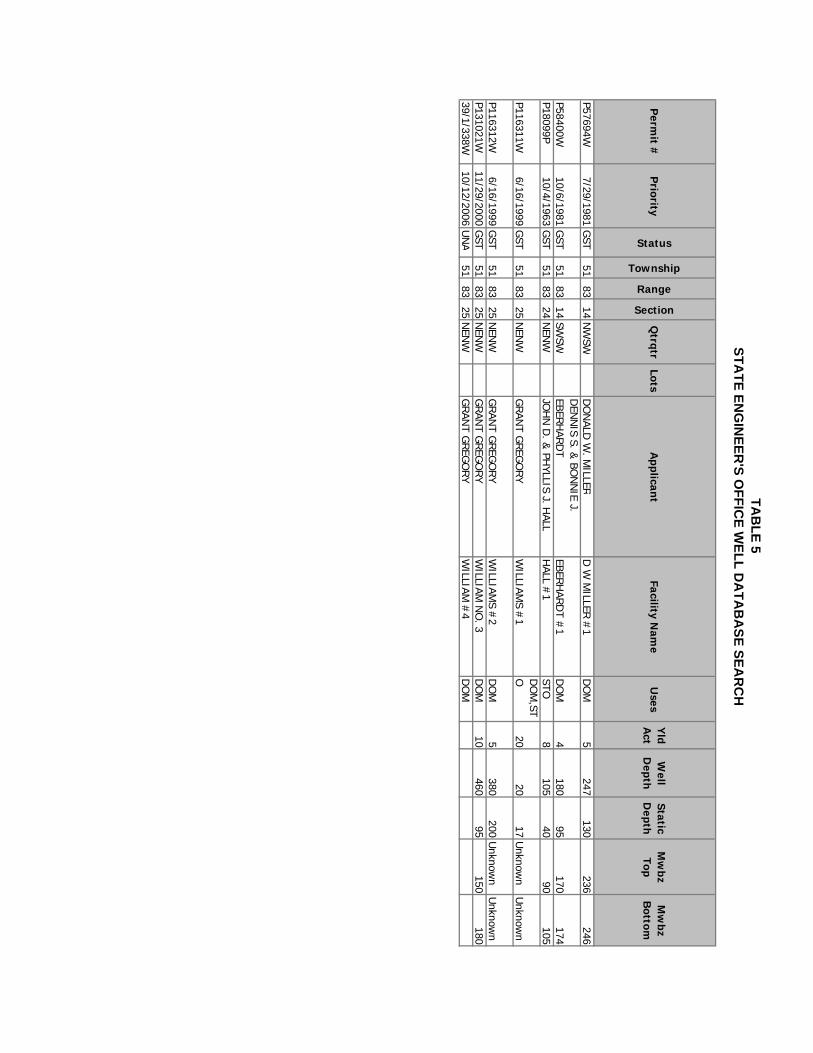
TAB
LE 5STA
TE ENG
INEER
'S OFFIC
E WELL D
ATA
BA
SE SEAR
CH
Perm
it #P
riority
Status
Township
Range
Section
Qtrqtr
LotsA
pplicant
Facility Nam
eU
sesY
ld A
ctW
ell D
epthStatic D
epthM
wbz
TopM
wbz
Bottom
P57694W7/29/1981
GST
5183
14N
WSW
DO
NALD
W. M
ILLERD
W M
ILLER #
1D
OM
5247
130236
246
P58400W10/6/1981
GST
5183
14SW
S WD
ENN
IS S. & BO
NN
IE J. EBER
HAR
DT
EBERH
ARD
T #1
DO
M4
18095
170174
P18099P10/4/1963
GST
5183
24N
ENW
JOH
N D
. & PH
YLLIS J. HAL L
HALL #
1STO
8105
4090
105
P116311W6/16/1999
GST
5183
25N
ENW
GRAN
T GREG
ORY
WILLIAM
S #1
DO
M,ST
O20
2017
Unknow
nU
nknown
P116312W6/16/1999
GST
5183
25N
ENW
GRAN
T GREG
ORY
WILLIAM
S #2
DO
M5
380200
Unknow
nU
nknown
P131021W11/29/2000
GST
5183
25N
ENW
GRAN
T GREG
ORY
WILLIAM
NO
. 3D
OM
10460
95150
18039/1/338W
10/12/2006U
NA
5183
25N
ENW
GRAN
T GREG
ORY
WILLIAM
#4
DO
M
Site Suitability for Individual Water Supply And Wastewater Systems Sand Creek Ranch Planned Unit Development, Johnson County Wyoming
12
REFERENCES CITED Hodson, W.G. and others, 1973, Water Resources of the Powder River Basin and Adjacent Areas, Northeastern Wyoming; USGS Hydrologic Atlas HA 465, 4 plates. Whitcomb, H.A. and others, 1966, Ground-Water Resources and Geology of Northern and Central Johnson County; USGS Water Supply Paper 1806, 99 pp, 2 plates. Wyoming Department of Environmental Quality (DEQ) Water Quality Rules and Regulations, Chapters 8, 11, 12, and 23. Wyoming State Engineer’s Office, various, water well database, accessed on-line December 13, 2006.
APPENDIX A
SOIL TYPE DESCRIPTION
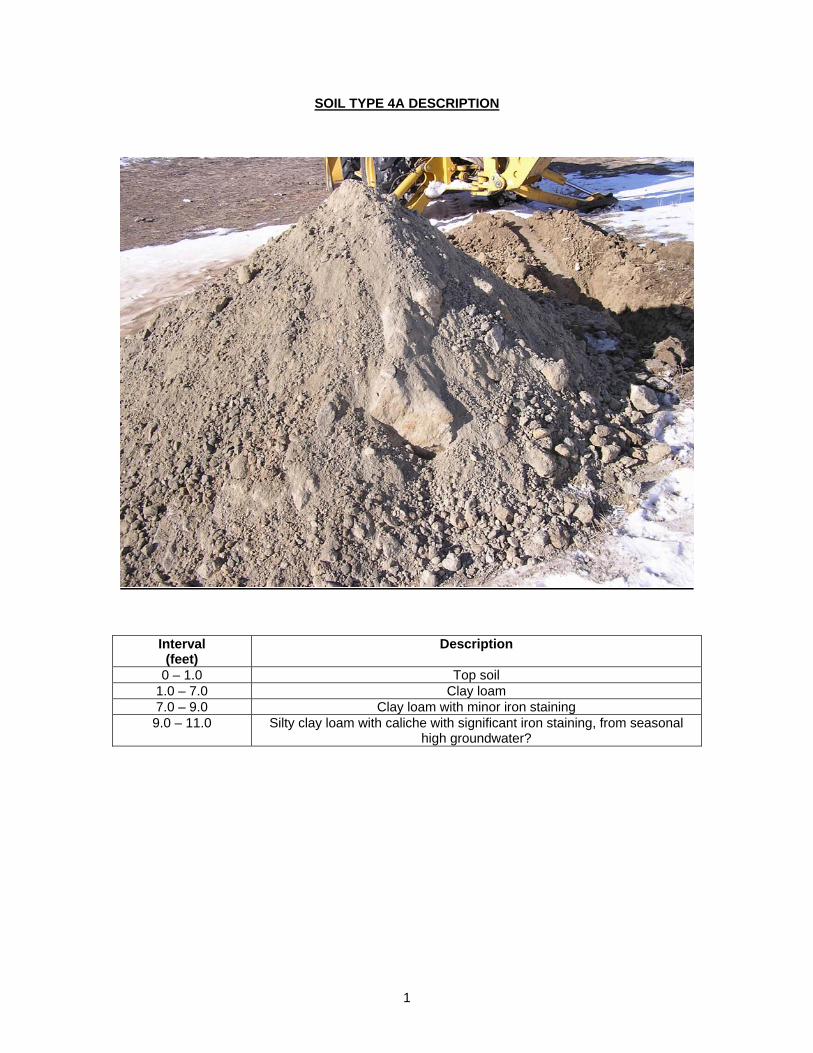
1
SOIL TYPE 4A DESCRIPTION
Interval (feet)
Description
0 – 1.0 Top soil 1.0 – 7.0 Clay loam 7.0 – 9.0 Clay loam with minor iron staining 9.0 – 11.0 Silty clay loam with caliche with significant iron staining, from seasonal
high groundwater?
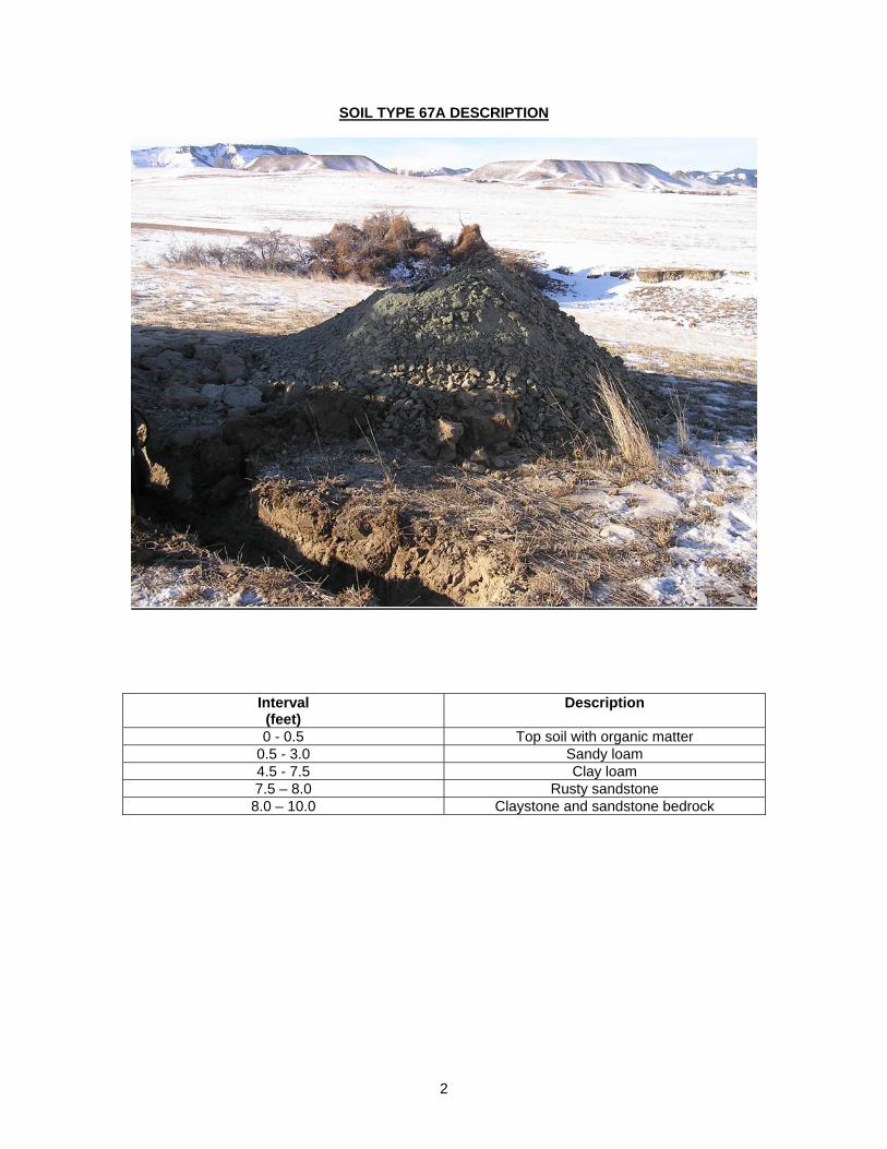
2
SOIL TYPE 67A DESCRIPTION
Interval (feet)
Description
0 - 0.5 Top soil with organic matter 0.5 - 3.0 Sandy loam 4.5 - 7.5 Clay loam 7.5 – 8.0 Rusty sandstone 8.0 – 10.0 Claystone and sandstone bedrock
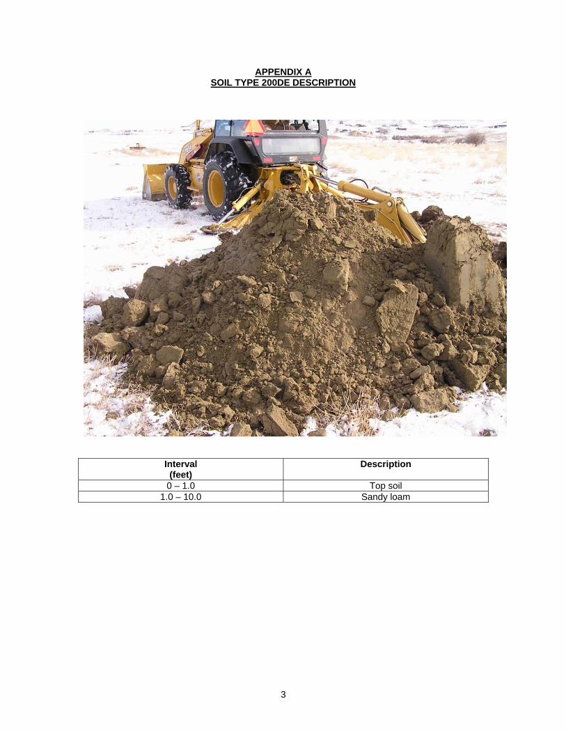
3
APPENDIX A SOIL TYPE 200DE DESCRIPTION
Interval (feet)
Description
0 – 1.0 Top soil 1.0 – 10.0 Sandy loam
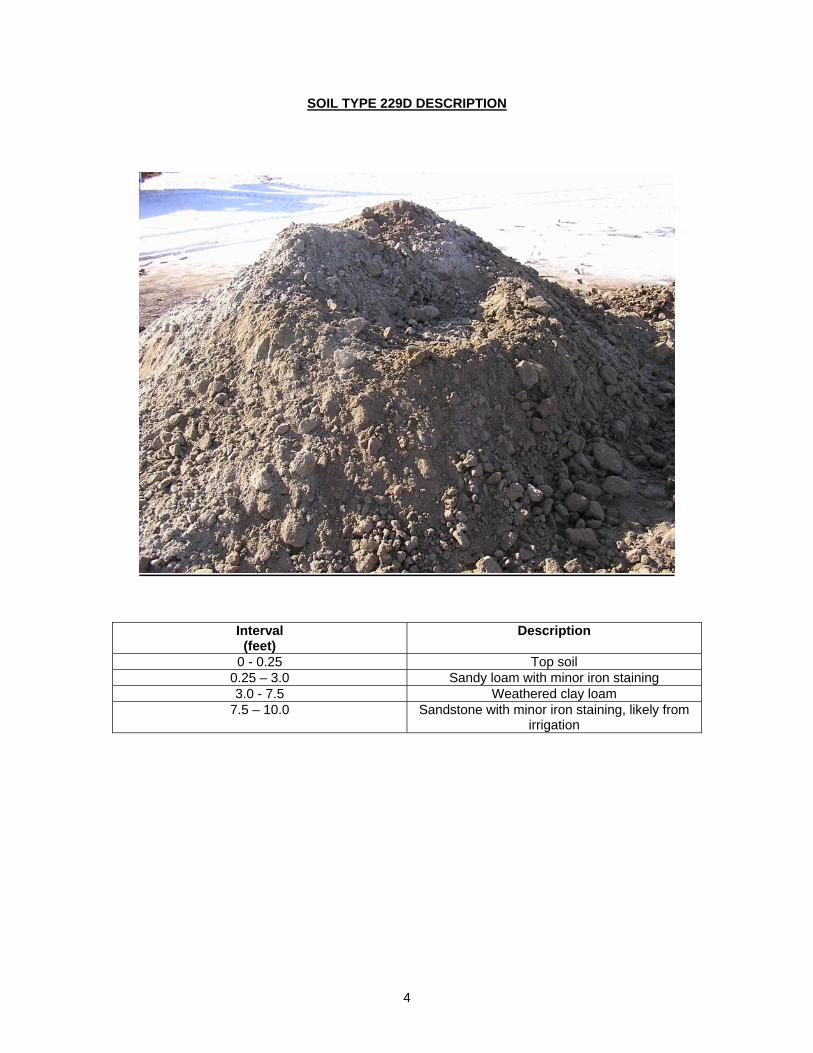
4
SOIL TYPE 229D DESCRIPTION
Interval (feet)
Description
0 - 0.25 Top soil 0.25 – 3.0 Sandy loam with minor iron staining 3.0 - 7.5 Weathered clay loam
7.5 – 10.0 Sandstone with minor iron staining, likely from irrigation
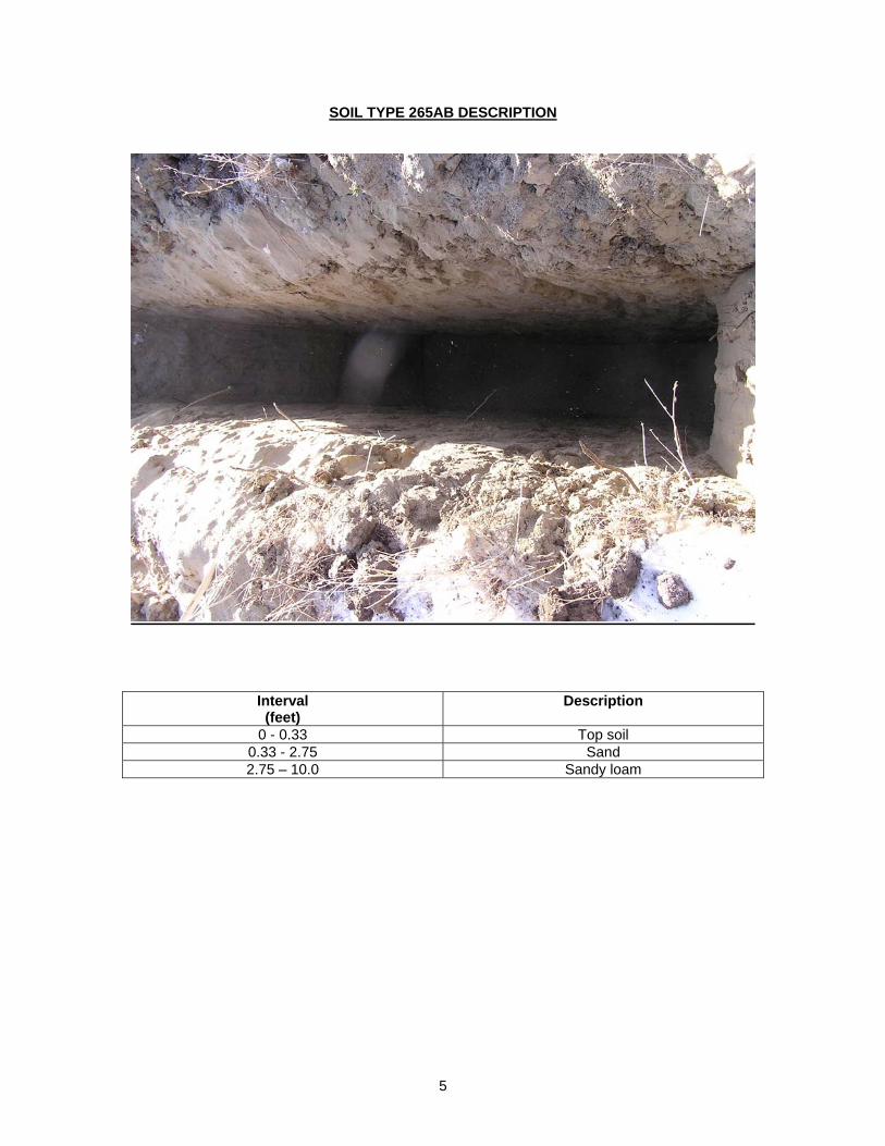
5
SOIL TYPE 265AB DESCRIPTION
Interval (feet)
Description
0 - 0.33 Top soil 0.33 - 2.75 Sand 2.75 – 10.0 Sandy loam
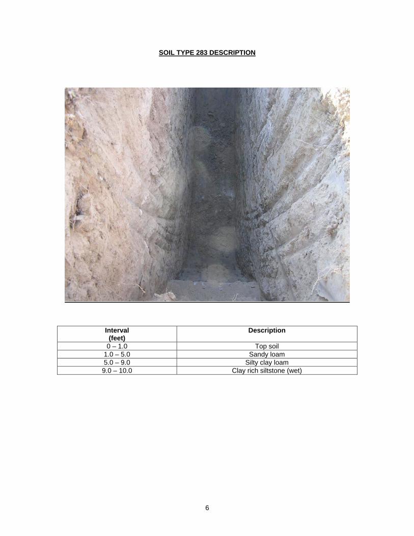
6
SOIL TYPE 283 DESCRIPTION
Interval (feet)
Description
0 – 1.0 Top soil 1.0 – 5.0 Sandy loam 5.0 – 9.0 Silty clay loam 9.0 – 10.0 Clay rich siltstone (wet)
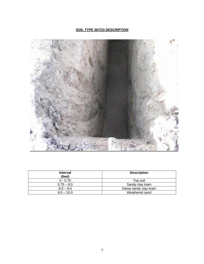
7
SOIL TYPE 367CD DESCRIPTION
Interval (feet)
Description
0 - 0.75 Top soil 0.75 – 8.0 Sandy clay loam 8.0 – 9.0 Damp sandy clay loam 9.0 – 10.0 Weathered sand
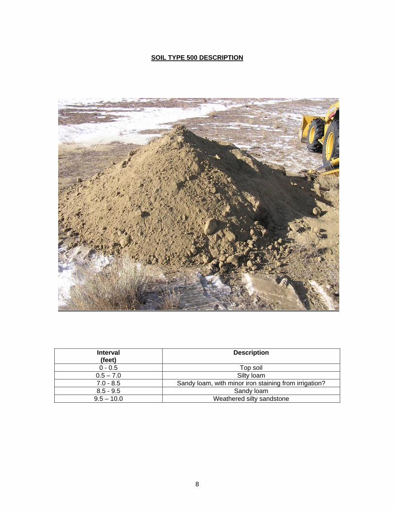
8
SOIL TYPE 500 DESCRIPTION
Interval (feet)
Description
0 - 0.5 Top soil 0.5 – 7.0 Silty loam 7.0 - 8.5 Sandy loam, with minor iron staining from irrigation? 8.5 - 9.5 Sandy loam
9.5 – 10.0 Weathered silty sandstone
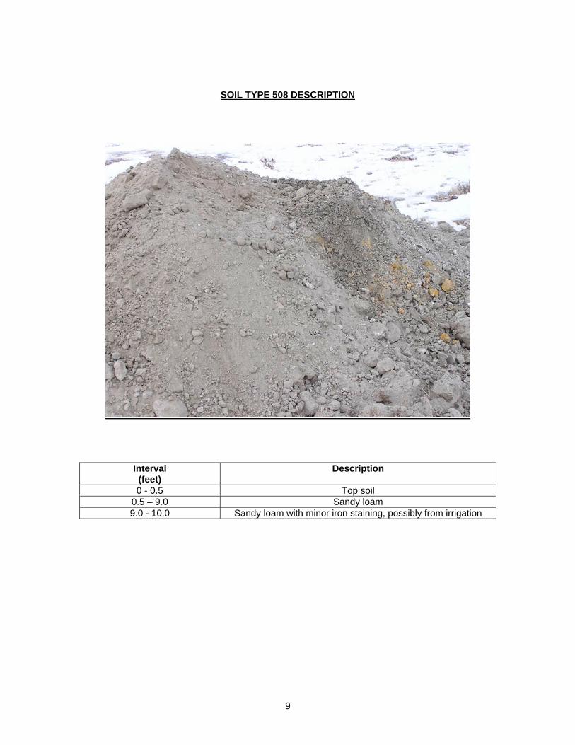
9
SOIL TYPE 508 DESCRIPTION
Interval (feet)
Description
0 - 0.5 Top soil 0.5 – 9.0 Sandy loam 9.0 - 10.0 Sandy loam with minor iron staining, possibly from irrigation
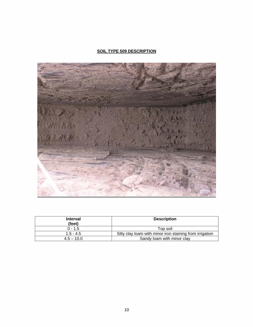
10
SOIL TYPE 509 DESCRIPTION
Interval (feet)
Description
0 - 1.5 Top soil 1.5 - 4.5 Silty clay loam with minor iron staining from irrigation
4.5 – 10.0 Sandy loam with minor clay
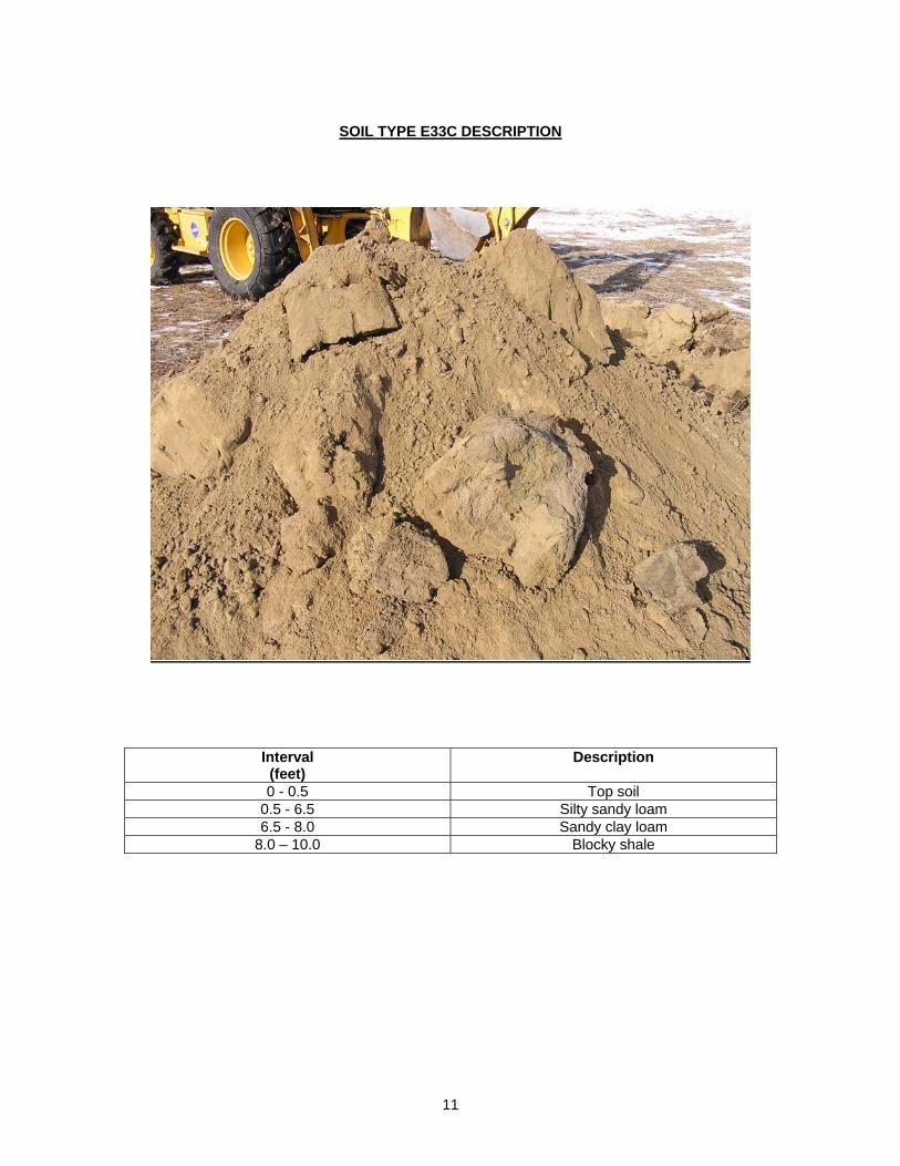
11
SOIL TYPE E33C DESCRIPTION
Interval (feet)
Description
0 - 0.5 Top soil 0.5 - 6.5 Silty sandy loam 6.5 - 8.0 Sandy clay loam
8.0 – 10.0 Blocky shale
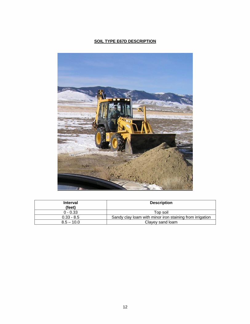
12
SOIL TYPE E67D DESCRIPTION
Interval (feet)
Description
0 - 0.33 Top soil 0.33 - 8.5 Sandy clay loam with minor iron staining from irrigation 8.5 – 10.0 Clayey sand loam
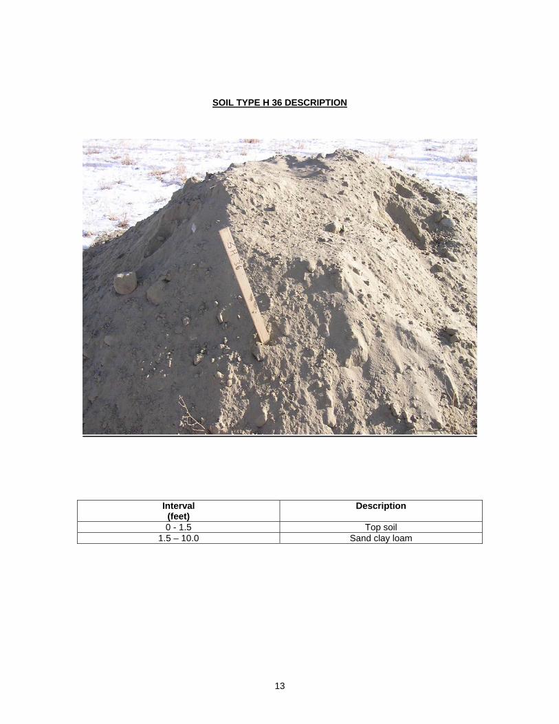
13
SOIL TYPE H 36 DESCRIPTION
Interval (feet)
Description
0 - 1.5 Top soil 1.5 – 10.0 Sand clay loam
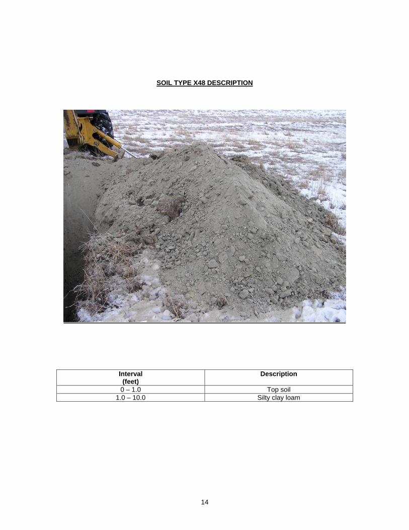
14
SOIL TYPE X48 DESCRIPTION
Interval (feet)
Description
0 – 1.0 Top soil 1.0 – 10.0 Silty clay loam
APPENDIX B
PERCOLATION TESTSHEET
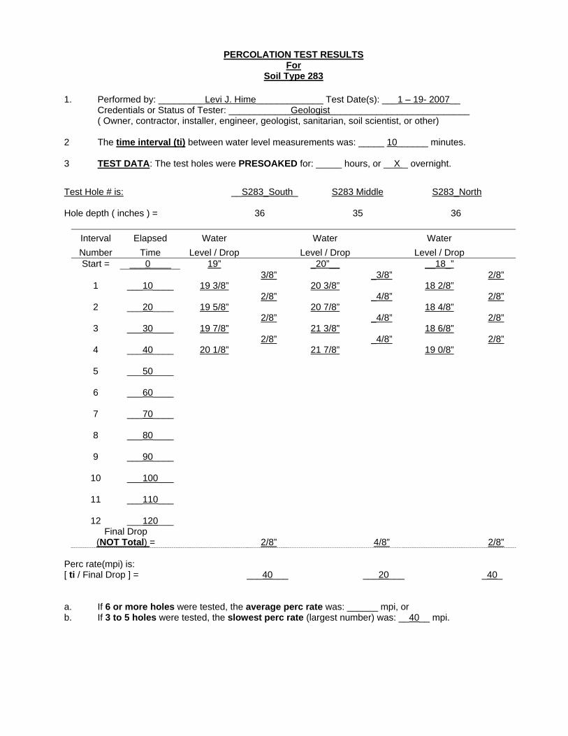
PERCOLATION TEST RESULTS For
Soil Type 283 1. Performed by: _________Levi J. Hime_____________ Test Date(s): ___1 – 19- 2007__
Credentials or Status of Tester: ____________Geologist___________________________ ( Owner, contractor, installer, engineer, geologist, sanitarian, soil scientist, or other) 2 The time interval (ti) between water level measurements was: _____ 10______ minutes. 3 TEST DATA: The test holes were PRESOAKED for: _____ hours, or __X _ overnight. Test Hole # is: __S283_South_ S283 Middle S283_North Hole depth ( inches ) = 36 35 36
Interval Number
Elapsed Time
Water Level / Drop
Water Level / Drop
Water Level / Drop
Start = ___0____ 19” _20”__ __18_” 3/8” _3/8” 2/8”
1 ___10____ 19 3/8” 20 3/8” 18 2/8” 2/8” _4/8” 2/8”
2 ___20____ 19 5/8” 20 7/8” 18 4/8” 2/8” _4/8” 2/8”
3 ___30____ 19 7/8” 21 3/8” 18 6/8” 2/8” _4/8” 2/8”
4 ___40____ 20 1/8” 21 7/8” 19 0/8”
5 ___50____
6 ___60____
7 ___70____
8 ___80____
9 ___90____
10 ___100___
11 ___110___
12 ___120___ Final Drop
(NOT Total) =
2/8”
4/8”
2/8” Perc rate(mpi) is: [ ti / Final Drop ] = ___40___ ___20___ _40_ a. If 6 or more holes were tested, the average perc rate was: ______ mpi, or b. If 3 to 5 holes were tested, the slowest perc rate (largest number) was: __40__ mpi.
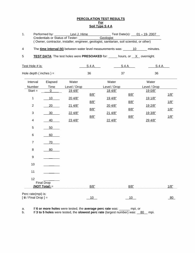
PERCOLATION TEST RESULTS For
Soil Type S 4 A
1. Performed by: _________Levi J. Hime_____________ Test Date(s): ___01 – 19- 2007__ Credentials or Status of Tester: ____________Geologist___________________________ ( Owner, contractor, installer, engineer, geologist, sanitarian, soil scientist, or other) 4 The time interval (ti) between water level measurements was: _____ 10______ minutes. 5 TEST DATA: The test holes were PRESOAKED for: _____ hours, or __X _ overnight. Test Hole # is: ____S 4 A ___ ____S 4 A ___ ____S 4 A ___ Hole depth ( inches ) = 36 37 36
Interval Number
Elapsed Time
Water Level / Drop
Water Level / Drop
Water Level / Drop
Start = ___0____ 19 4/8” 18 4/8” 19 0/8” 8/8” 8/8” 1/8”
1 ___10____ 20 4/8” 19 4/8” 19 1/8” 8/8” 8/8” 1/8”
2 ___20____ 21 4/8” 20 4/8” 19 2/8” 8/8” 8/8” 1/8”
3 ___30____ 22 4/8” 21 4/8” 19 3/8” 8/8” 8/8” 1/8”
4 ___40____ 23 4/8” 22 4/8” 29 4/8”
5 ___50____
6 ___60____
7 ___70____
8 ___80____
9 _________
10 _________
11 _________
12 _________ Final Drop
(NOT Total) =
8/8”
8/8”
1/8” Perc rate(mpi) is: [ ti / Final Drop ] = __10__ __10__ _80_ a. If 6 or more holes were tested, the average perc rate was: ______ mpi, or b. If 3 to 5 holes were tested, the slowest perc rate (largest number) was: __80__ mpi.
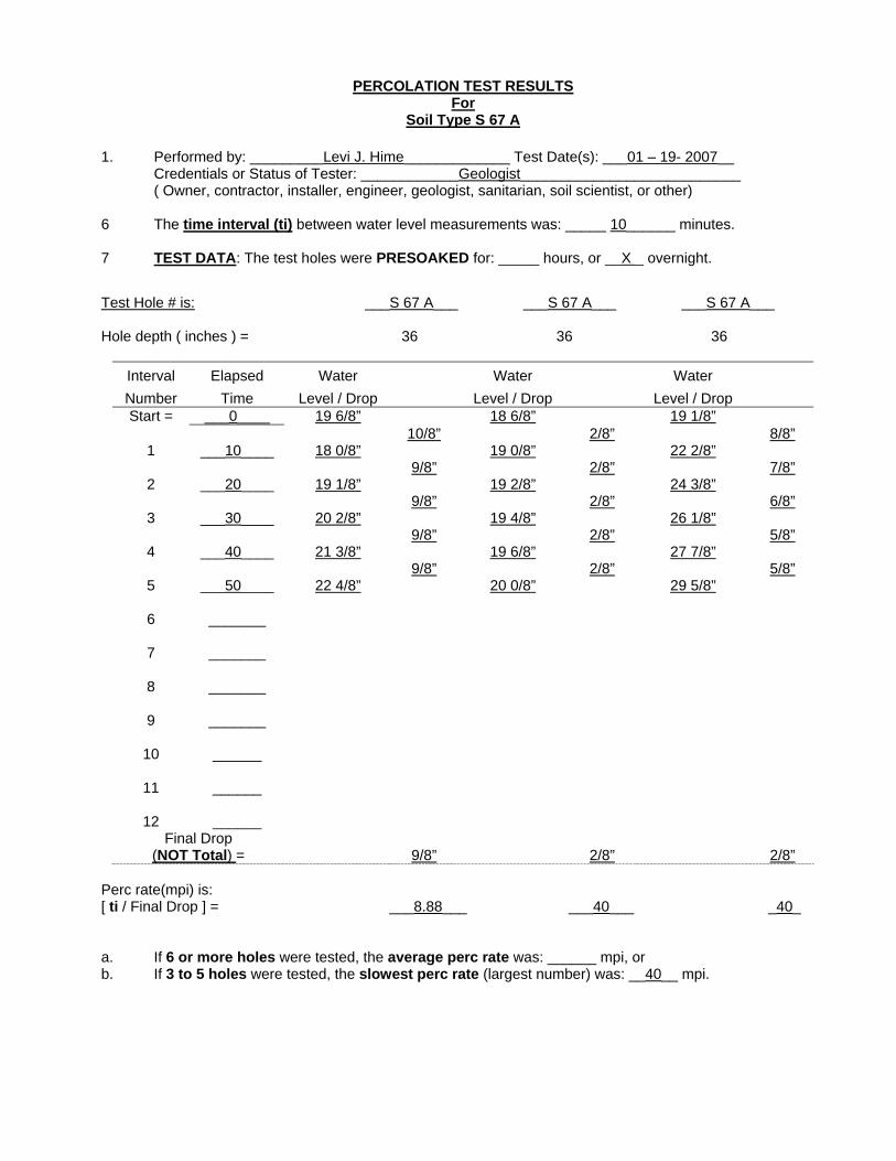
PERCOLATION TEST RESULTS For
Soil Type S 67 A 1. Performed by: _________Levi J. Hime_____________ Test Date(s): ___01 – 19- 2007__ Credentials or Status of Tester: ____________Geologist___________________________ ( Owner, contractor, installer, engineer, geologist, sanitarian, soil scientist, or other) 6 The time interval (ti) between water level measurements was: _____ 10______ minutes. 7 TEST DATA: The test holes were PRESOAKED for: _____ hours, or __X _ overnight. Test Hole # is: ___S 67 A___ ___S 67 A___ ___S 67 A___ Hole depth ( inches ) = 36 36 36
Interval Number
Elapsed Time
Water Level / Drop
Water Level / Drop
Water Level / Drop
Start = ___0____ 19 6/8” 18 6/8” 19 1/8” 10/8” 2/8” 8/8”
1 ___10____ 18 0/8” 19 0/8” 22 2/8” 9/8” 2/8” 7/8”
2 ___20____ 19 1/8” 19 2/8” 24 3/8” 9/8” 2/8” 6/8”
3 ___30____ 20 2/8” 19 4/8” 26 1/8” 9/8” 2/8” 5/8”
4 ___40____ 21 3/8” 19 6/8” 27 7/8” 9/8” 2/8” 5/8”
5 ___50____ 22 4/8” 20 0/8” 29 5/8”
6 _______
7 _______
8 _______
9 _______
10 ______
11 ______
12 ______ Final Drop
(NOT Total) =
9/8”
2/8”
2/8” Perc rate(mpi) is: [ ti / Final Drop ] = ___8.88___ ___40___ _40_ a. If 6 or more holes were tested, the average perc rate was: ______ mpi, or b. If 3 to 5 holes were tested, the slowest perc rate (largest number) was: __40__ mpi.
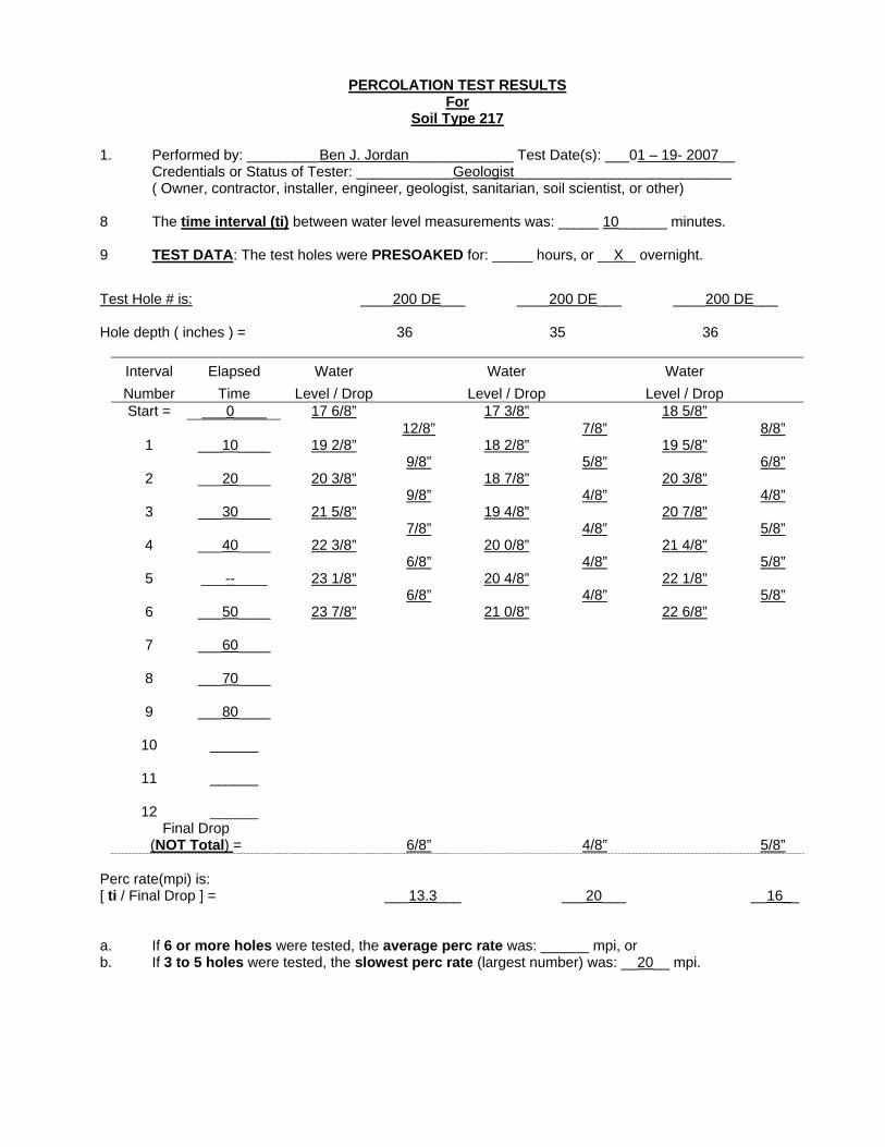
PERCOLATION TEST RESULTS For
Soil Type 217 1. Performed by: _________Ben J. Jordan_____________ Test Date(s): ___01 – 19- 2007__ Credentials or Status of Tester: ____________Geologist___________________________ ( Owner, contractor, installer, engineer, geologist, sanitarian, soil scientist, or other) 8 The time interval (ti) between water level measurements was: _____ 10______ minutes. 9 TEST DATA: The test holes were PRESOAKED for: _____ hours, or __X _ overnight. Test Hole # is: ____200 DE___ ____200 DE___ ____200 DE___ Hole depth ( inches ) = 36 35 36
Interval Number
Elapsed Time
Water Level / Drop
Water Level / Drop
Water Level / Drop
Start = ___0____ 17 6/8” 17 3/8” 18 5/8” 12/8” 7/8” 8/8”
1 ___10____ 19 2/8” 18 2/8” 19 5/8” 9/8” 5/8” 6/8”
2 ___20____ 20 3/8” 18 7/8” 20 3/8” 9/8” 4/8” 4/8”
3 ___30____ 21 5/8” 19 4/8” 20 7/8” 7/8” 4/8” 5/8”
4 ___40____ 22 3/8” 20 0/8” 21 4/8” 6/8” 4/8” 5/8”
5 ___--____ 23 1/8” 20 4/8” 22 1/8” 6/8” 4/8” 5/8”
6 ___50____ 23 7/8” 21 0/8” 22 6/8”
7 ___60____
8 ___70____
9 ___80____
10 ______
11 ______
12 ______ Final Drop
(NOT Total) =
6/8”
4/8”
5/8” Perc rate(mpi) is: [ ti / Final Drop ] = ___13.3___ ___20___ __16__ a. If 6 or more holes were tested, the average perc rate was: ______ mpi, or b. If 3 to 5 holes were tested, the slowest perc rate (largest number) was: __20__ mpi.
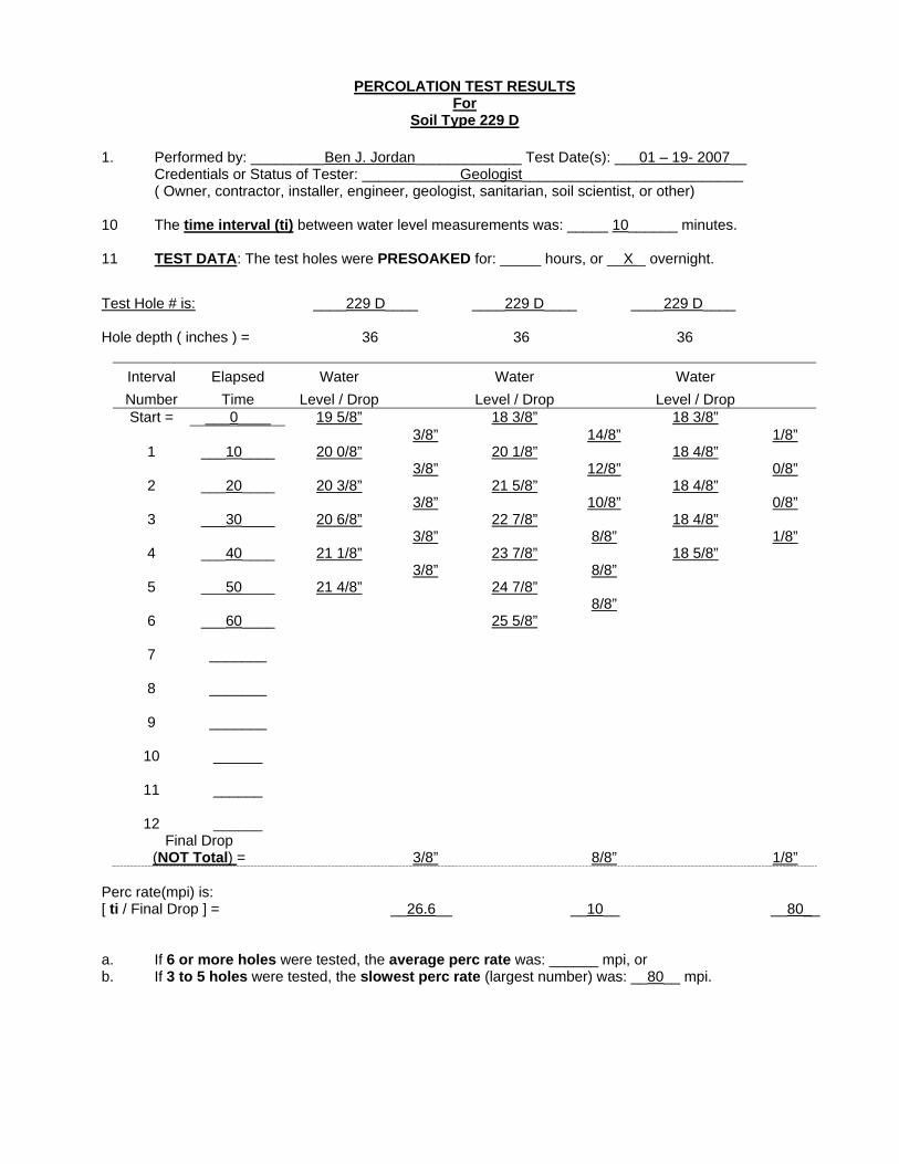
PERCOLATION TEST RESULTS For
Soil Type 229 D 1. Performed by: _________Ben J. Jordan_____________ Test Date(s): ___01 – 19- 2007__ Credentials or Status of Tester: ____________Geologist___________________________ ( Owner, contractor, installer, engineer, geologist, sanitarian, soil scientist, or other) 10 The time interval (ti) between water level measurements was: _____ 10______ minutes. 11 TEST DATA: The test holes were PRESOAKED for: _____ hours, or __X _ overnight. Test Hole # is: ____229 D____ ____229 D____ ____229 D____ Hole depth ( inches ) = 36 36 36
Interval Number
Elapsed Time
Water Level / Drop
Water Level / Drop
Water Level / Drop
Start = ___0____ 19 5/8” 18 3/8” 18 3/8” 3/8” 14/8” 1/8”
1 ___10____ 20 0/8” 20 1/8” 18 4/8” 3/8” 12/8” 0/8”
2 ___20____ 20 3/8” 21 5/8” 18 4/8” 3/8” 10/8” 0/8”
3 ___30____ 20 6/8” 22 7/8” 18 4/8” 3/8” 8/8” 1/8”
4 ___40____ 21 1/8” 23 7/8” 18 5/8” 3/8” 8/8”
5 ___50____ 21 4/8” 24 7/8” 8/8”
6 ___60____ 25 5/8”
7 _______
8 _______
9 _______
10 ______
11 ______
12 ______ Final Drop
(NOT Total) =
3/8”
8/8”
1/8” Perc rate(mpi) is: [ ti / Final Drop ] = __26.6__ __10__ __80__ a. If 6 or more holes were tested, the average perc rate was: ______ mpi, or b. If 3 to 5 holes were tested, the slowest perc rate (largest number) was: __80__ mpi.

PERCOLATION TEST RESULTS For
Soil Type 265 AB 1. Performed by: _________Ben J. Jordan_____________ Test Date(s): ___01 – 19- 2007__ Credentials or Status of Tester: ____________Geologist___________________________ ( Owner, contractor, installer, engineer, geologist, sanitarian, soil scientist, or other) 12 The time interval (ti) between water level measurements was: _____ 10______ minutes. 13 TEST DATA: The test holes were PRESOAKED for: _____ hours, or __X _ overnight. Test Hole # is: ___265 AB___ ___265 AB___ ___265 AB___ Hole depth ( inches ) = 36 36 36
Interval Number
Elapsed Time
Water Level / Drop
Water Level / Drop
Water Level / Drop
Start = ___0____ 18 2/8” 19 7/8” 16 5/8” 16/8” 15/8” 12/8”
1 ___10____ 20 2/8” 21 6/8” 18 1/8” 15/8” 12/8” 10/8”
2 ___20____ 22 1/8” 23 2/8” 19 3/8” 14/8” 12/8” 10/8”
3 ___30____ 23 7/8” 24 6/8” 20 5/8” 15/8” 10/8” 10/8”
4 ___40____ 26 4/8” 26 0/8” 21 7/8” 15/8” 10/8” 10/8”
5 ___50____ 27 3/8” 27 2/8” 23 1/8” 15/8” 10/8”
6 ___60____ 29 2/8” 28 4/8”
7 _______
8 _______
9 _______
10 ______
11 ______
12 ______ Final Drop
(NOT Total) =
15/8”
10/8”
10/8” Perc rate(mpi) is: [ ti / Final Drop ] = ___10___ ___8___ __8__ a. If 6 or more holes were tested, the average perc rate was: ______ mpi, or b. If 3 to 5 holes were tested, the slowest perc rate (largest number) was: __8__ mpi.
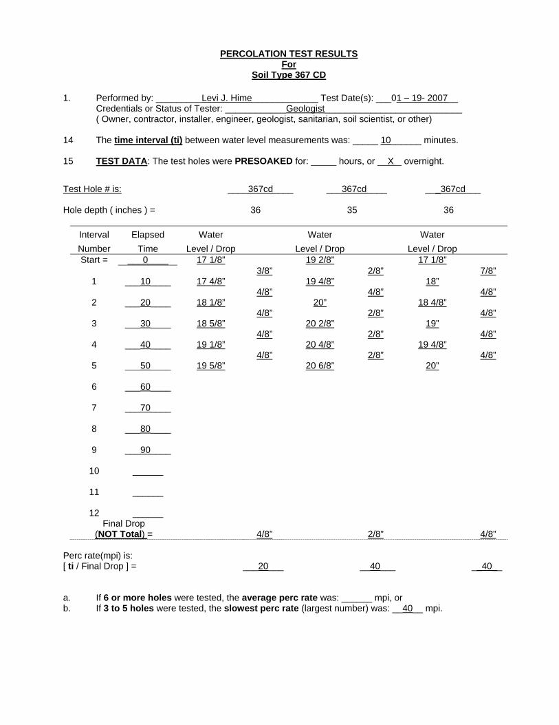
PERCOLATION TEST RESULTS For
Soil Type 367 CD 1. Performed by: _________Levi J. Hime_____________ Test Date(s): ___01 – 19- 2007__ Credentials or Status of Tester: ____________Geologist___________________________ ( Owner, contractor, installer, engineer, geologist, sanitarian, soil scientist, or other) 14 The time interval (ti) between water level measurements was: _____ 10______ minutes. 15 TEST DATA: The test holes were PRESOAKED for: _____ hours, or __X _ overnight. Test Hole # is: ____367cd____ ___367cd____ ___367cd___ Hole depth ( inches ) = 36 35 36
Interval Number
Elapsed Time
Water Level / Drop
Water Level / Drop
Water Level / Drop
Start = ___0____ 17 1/8” 19 2/8” 17 1/8” 3/8” 2/8” 7/8”
1 ___10____ 17 4/8” 19 4/8” 18” 4/8” 4/8” 4/8”
2 ___20____ 18 1/8” 20” 18 4/8” 4/8” 2/8” 4/8”
3 ___30____ 18 5/8” 20 2/8” 19” 4/8” 2/8” 4/8”
4 ___40____ 19 1/8” 20 4/8” 19 4/8” 4/8” 2/8” 4/8”
5 ___50____ 19 5/8” 20 6/8” 20”
6 ___60____
7 ___70____
8 ___80____
9 ___90____
10 ______
11 ______
12 ______ Final Drop
(NOT Total) =
4/8”
2/8”
4/8” Perc rate(mpi) is: [ ti / Final Drop ] = ___20___ __40___ __40__ a. If 6 or more holes were tested, the average perc rate was: ______ mpi, or b. If 3 to 5 holes were tested, the slowest perc rate (largest number) was: __40__ mpi.

PERCOLATION TEST RESULTS For
Soil Type 500 1. Performed by: _________Ben J. Jordan_____________ Test Date(s): ___01 – 19- 2007__ Credentials or Status of Tester: ____________Geologist___________________________ ( Owner, contractor, installer, engineer, geologist, sanitarian, soil scientist, or other) 16 The time interval (ti) between water level measurements was: _____ 10______ minutes. 17 TEST DATA: The test holes were PRESOAKED for: _____ hours, or __X _ overnight. Test Hole # is: ____500____ ___500____ ___500___ Hole depth ( inches ) = 36 35 36
Interval Number
Elapsed Time
Water Level / Drop
Water Level / Drop
Water Level / Drop
Start = ___0____ 18 6/8” 17 7/8” 19 4/8” 10/8” 6/8” 10/8”
1 ___10____ 20 0/8” 18 5/8” 20 6/8” 8/8” 7/8” 11/8”
2 ___20____ 21 0/8” 19 4/8” 22 1/8” 8/8” 5/8” 9/8”
3 ___30____ 22 0/8” 20 1/8” 23 2/8” 8/8” 5/8” 9/8”
4 ___40____ 23 0/8” 20 6/8” 24 3/8” 8/8” 5/8” 9/8”
5 ___50____ 24 0/8” 21 3/8” 25 4/8”
6 ___60____
7 ___70____
8 ___80____
9 ___90____
10 ______
11 ______
12 ______ Final Drop
(NOT Total) =
8/8”
5/8”
9/8” Perc rate(mpi) is: [ ti / Final Drop ] = ___10___ __16___ __8.8__ a. If 6 or more holes were tested, the average perc rate was: ______ mpi, or b. If 3 to 5 holes were tested, the slowest perc rate (largest number) was: __16__ mpi.
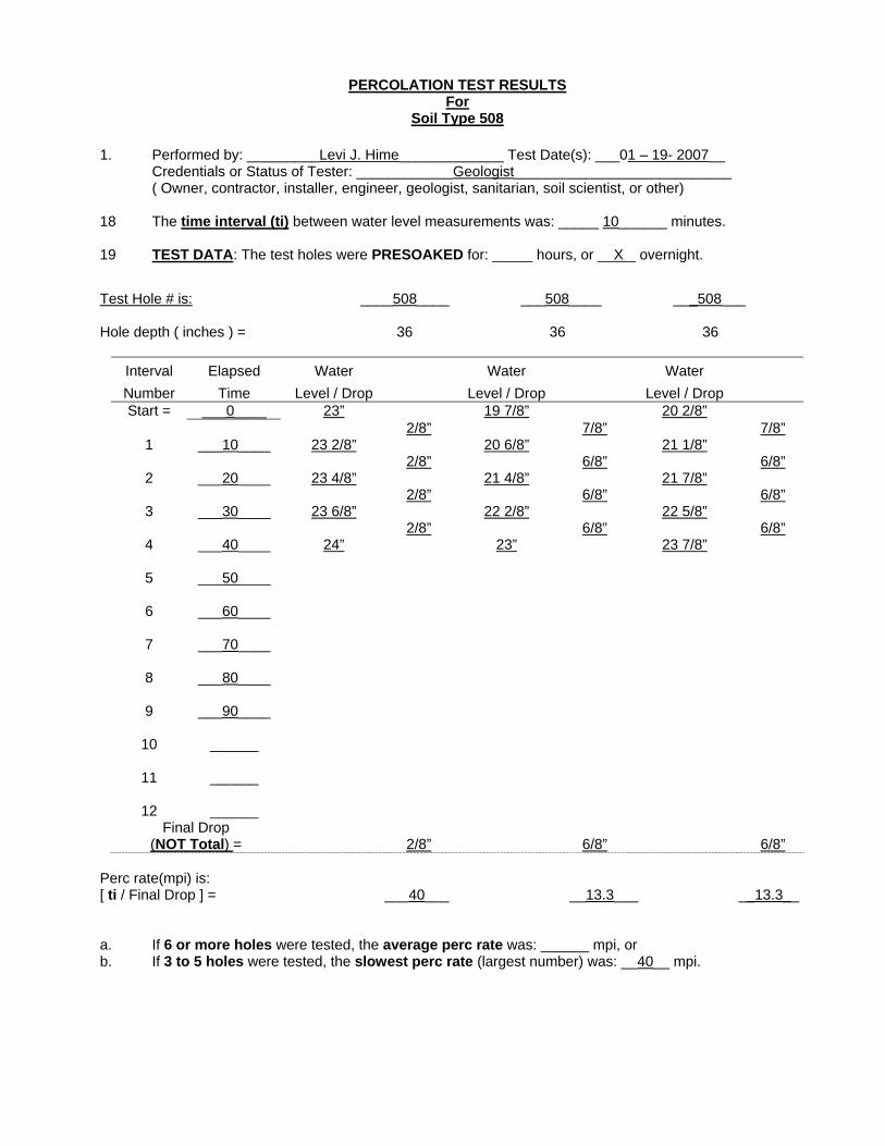
PERCOLATION TEST RESULTS For
Soil Type 508 1. Performed by: _________Levi J. Hime_____________ Test Date(s): ___01 – 19- 2007__ Credentials or Status of Tester: ____________Geologist___________________________ ( Owner, contractor, installer, engineer, geologist, sanitarian, soil scientist, or other) 18 The time interval (ti) between water level measurements was: _____ 10______ minutes. 19 TEST DATA: The test holes were PRESOAKED for: _____ hours, or __X _ overnight. Test Hole # is: ____508____ ___508____ ___508___ Hole depth ( inches ) = 36 36 36
Interval Number
Elapsed Time
Water Level / Drop
Water Level / Drop
Water Level / Drop
Start = ___0____ 23” 19 7/8” 20 2/8” 2/8” 7/8” 7/8”
1 ___10____ 23 2/8” 20 6/8” 21 1/8” 2/8” 6/8” 6/8”
2 ___20____ 23 4/8” 21 4/8” 21 7/8” 2/8” 6/8” 6/8”
3 ___30____ 23 6/8” 22 2/8” 22 5/8” 2/8” 6/8” 6/8”
4 ___40____ 24” 23” 23 7/8”
5 ___50____
6 ___60____
7 ___70____
8 ___80____
9 ___90____
10 ______
11 ______
12 ______ Final Drop
(NOT Total) =
2/8”
6/8”
6/8” Perc rate(mpi) is: [ ti / Final Drop ] = ___40___ __13.3___ __13.3__ a. If 6 or more holes were tested, the average perc rate was: ______ mpi, or b. If 3 to 5 holes were tested, the slowest perc rate (largest number) was: __40__ mpi.
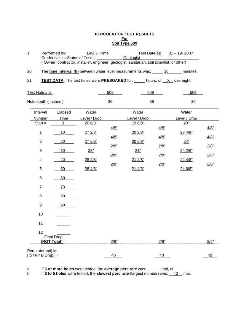
PERCOLATION TEST RESULTS For
Soil Type 509 1. Performed by: _________Levi J. Hime_____________ Test Date(s): ___01 – 19- 2007__ Credentials or Status of Tester: ____________Geologist___________________________ ( Owner, contractor, installer, engineer, geologist, sanitarian, soil scientist, or other) 20 The time interval (ti) between water level measurements was: _____ 10______ minutes. 21 TEST DATA: The test holes were PRESOAKED for: _____ hours, or __X _ overnight. Test Hole # is: ____509____ ___509____ ___509___ Hole depth ( inches ) = 36 36 36
Interval Number
Elapsed Time
Water Level / Drop
Water Level / Drop
Water Level / Drop
Start = ___0____ 26 6/8” 19 6/8” 23” 4/8” 4/8” 4/8”
1 ___10____ 27 2/8” 20 2/8” 23 4/8” 4/8” 4/8” 4/8”
2 ___20____ 27 6/8” 20 6/8” 24” 2/8” 2/8” 2/8”
3 ___30____ 28” 21” 24 2/8” 2/8” 2/8” 2/8”
4 ___40____ 28 2/8” 21 2/8” 24 4/8” 2/8” 2/8” 2/8”
5 ___50____ 28 4/8” 21 4/8” 24 6/8”
6 ___60____
7 ___70____
8 ___80____
9 ___90____
10 ______
11 ______
12 ______ Final Drop
(NOT Total) =
2/8”
2/8”
2/8” Perc rate(mpi) is: [ ti / Final Drop ] = ___40___ __40___ __40__ a. If 6 or more holes were tested, the average perc rate was: ______ mpi, or b. If 3 to 5 holes were tested, the slowest perc rate (largest number) was: __40__ mpi.

PERCOLATION TEST RESULTS For
Soil Type E 33C 1. Performed by: _________Levi J. Hime_____________ Test Date(s): ___01 – 19- 2007__ Credentials or Status of Tester: ____________Geologist___________________________ ( Owner, contractor, installer, engineer, geologist, sanitarian, soil scientist, or other) 22 The time interval (ti) between water level measurements was: _____ 10______ minutes. 23 TEST DATA: The test holes were PRESOAKED for: _____ hours, or __X _ overnight. Test Hole # is: ____33C____ ___33C____ ___33C___ Hole depth ( inches ) = 36 36 36
Interval Number
Elapsed Time
Water Level / Drop
Water Level / Drop
Water Level / Drop
Start = ___0____ 26 4/8” 28 5/8” 21 7/8” 4/8” 4/8” 4/8”
1 ___10____ 27” 29 1/8” 22 3/8” 4/8” 3/8” 3/8”
2 ___20____ 27 4/8” 29 4/8” 22 6/8” 4/8” 3/8” 3/8”
3 ___30____ 28” 29 7/8” 23 1/8” 4/8” 3/8” 3/8”
4 ___40____ 28 4/8” 30 2/8” 23 4/8” 4/8” 3/8” 3/8”
5 ___50____ 29” 30 5/8” 23 7/8”
6 ___60____
7 ___70____
8 ___80____
9 ___90____
10 ______
11 ______
12 ______ Final Drop
(NOT Total) =
4/8”
3/8”
3/8” Perc rate(mpi) is: [ ti / Final Drop ] = ___20___ __26.6__ __26.6__ a. If 6 or more holes were tested, the average perc rate was: ______ mpi, or b. If 3 to 5 holes were tested, the slowest perc rate (largest number) was: __26.6__ mpi.

PERCOLATION TEST RESULTS For
Soil Type 67 D 1. Performed by: _________Levi J. Hime_____________ Test Date(s): ___01 – 19- 2007__ Credentials or Status of Tester: ____________Geologist___________________________ ( Owner, contractor, installer, engineer, geologist, sanitarian, soil scientist, or other) 24 The time interval (ti) between water level measurements was: _____ 10______ minutes. 25 TEST DATA: The test holes were PRESOAKED for: _____ hours, or __X _ overnight. Test Hole # is: ____67d____ ___67d____ ___67d___ Hole depth ( inches ) = 36 36 36
Interval Number
Elapsed Time
Water Level / Drop
Water Level / Drop
Water Level / Drop
Start = ___0____ 18 6/8” 21 7/8” 20 2/8” 10/8” 4/8” 9/8”
1 ___10____ 20” 22 3/8” 21 3/8” 9/8” 4/8” 8/8”
2 ___20____ 21 1/8” 22 7/8” 22 3/8” 9/8” 4/8” 8/8”
3 ___30____ 22 2/8” 23 3/8” 23 3/8” 9/8” 4/8” 8/8”
4 ___40____ 23 3/8” 23 7/8” 24 3/8”
5 ___50____
6 ___60____
7 ___70____
8 ___80____
9 ___90____
10 ______
11 ______
12 ______ Final Drop
(NOT Total) =
9/8”
4/8”
8/8” Perc rate(mpi) is: [ ti / Final Drop ] = ___8.88___ __20___ __10__ a. If 6 or more holes were tested, the average perc rate was: ______ mpi, or b. If 3 to 5 holes were tested, the slowest perc rate (largest number) was: __20__ mpi.

PERCOLATION TEST RESULTS For
Soil Type H 36 1. Performed by: _________Levi J. Hime_____________ Test Date(s): ___01 – 19- 2007__ Credentials or Status of Tester: ____________Geologist___________________________ ( Owner, contractor, installer, engineer, geologist, sanitarian, soil scientist, or other) 26 The time interval (ti) between water level measurements was: _____ 10______ minutes. 27 TEST DATA: The test holes were PRESOAKED for: _____ hours, or __X _ overnight. Test Hole # is: ____H 36____ ___H 36____ ___H 36___ Hole depth ( inches ) = 36 36 36
Interval Number
Elapsed Time
Water Level / Drop
Water Level / Drop
Water Level / Drop
Start = ___0____ 19 3/8” 21 1/8” 21 2/8” 6/8” 2/8” 4/8”
1 ___10____ 20 1/8” 21 6/8” 21 6/8” 3/8” 2/8” 3/8”
2 ___20____ 20 4/8” 22” 22 1/8” 2/8” 4/8” 4/8”
3 ___30____ 20 6/8” 22 4/8” 22 5/8” 3/8” 2/8” 3/8”
4 ___40____ 21 1/8” 22 6/8” 23” 3/8” 2/8” 3/8”
5 ___50____ 21 4/8” 23” 23 3/8” 3/8” 2/8” 3/8”
6 ___60____ 21 7/8” 23 2/8” 23 6/8”
7 ___70____
8 ___80____
9 ___90____
10 ______
11 ______
12 ______ Final Drop
(NOT Total) =
3/8”
2/8”
3/8” Perc rate(mpi) is: [ ti / Final Drop ] = ___26.6___ __40___ __26.6__ a. If 6 or more holes were tested, the average perc rate was: ______ mpi, or b. If 3 to 5 holes were tested, the slowest perc rate (largest number) was: __40__ mpi.
APPENDIX C
SAND CREEK PUDWELL LOGS
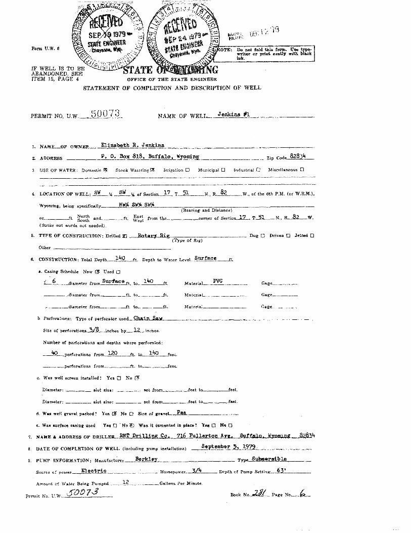
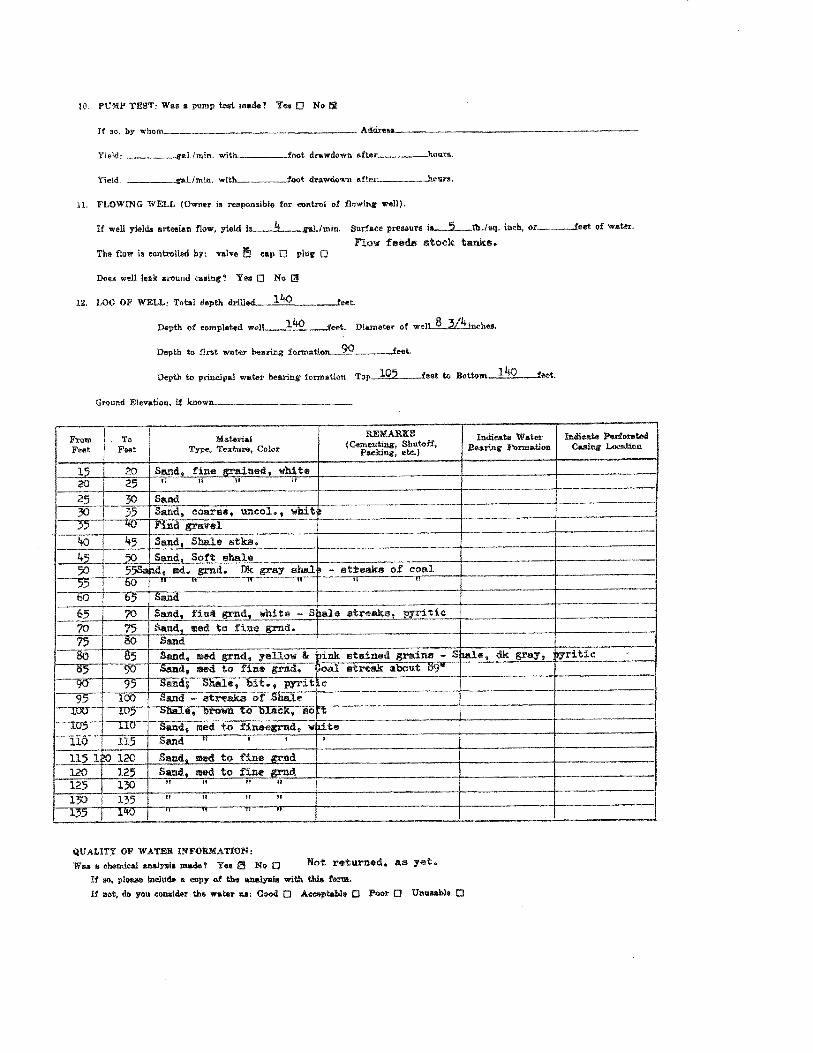


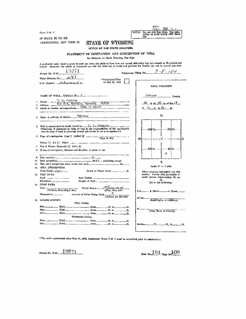
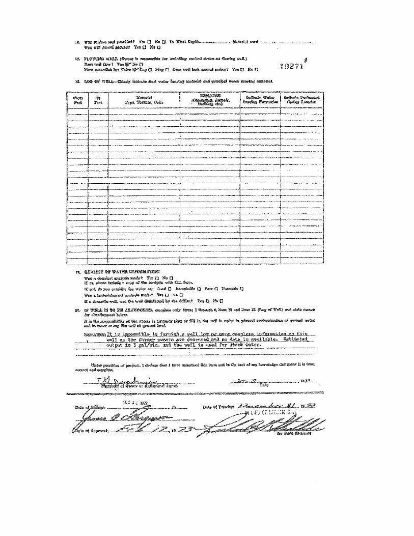
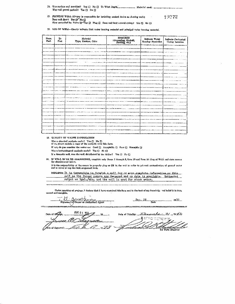
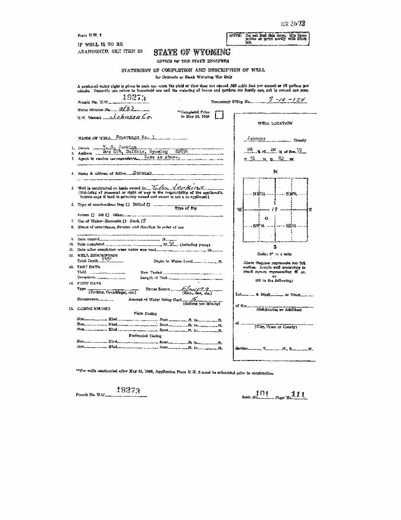
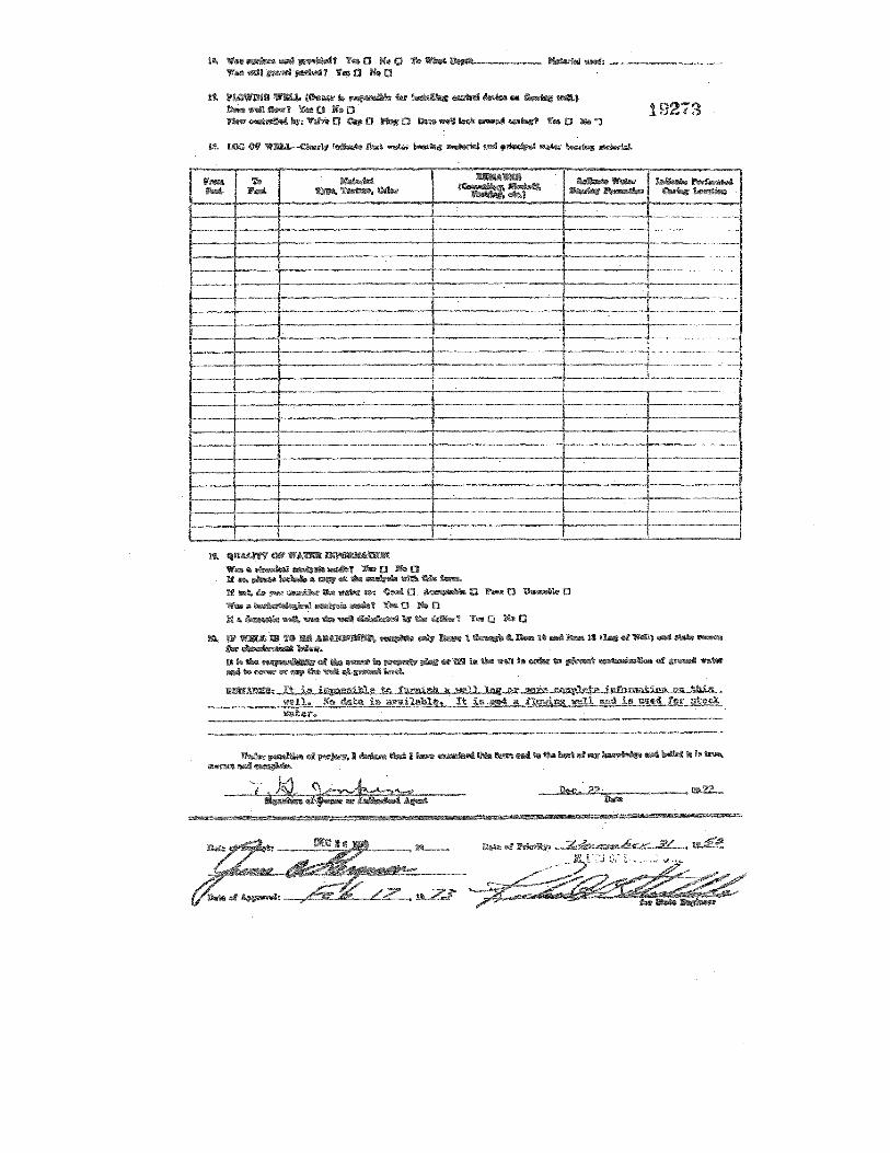
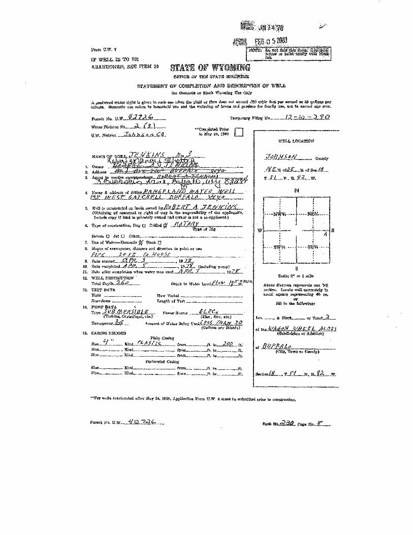
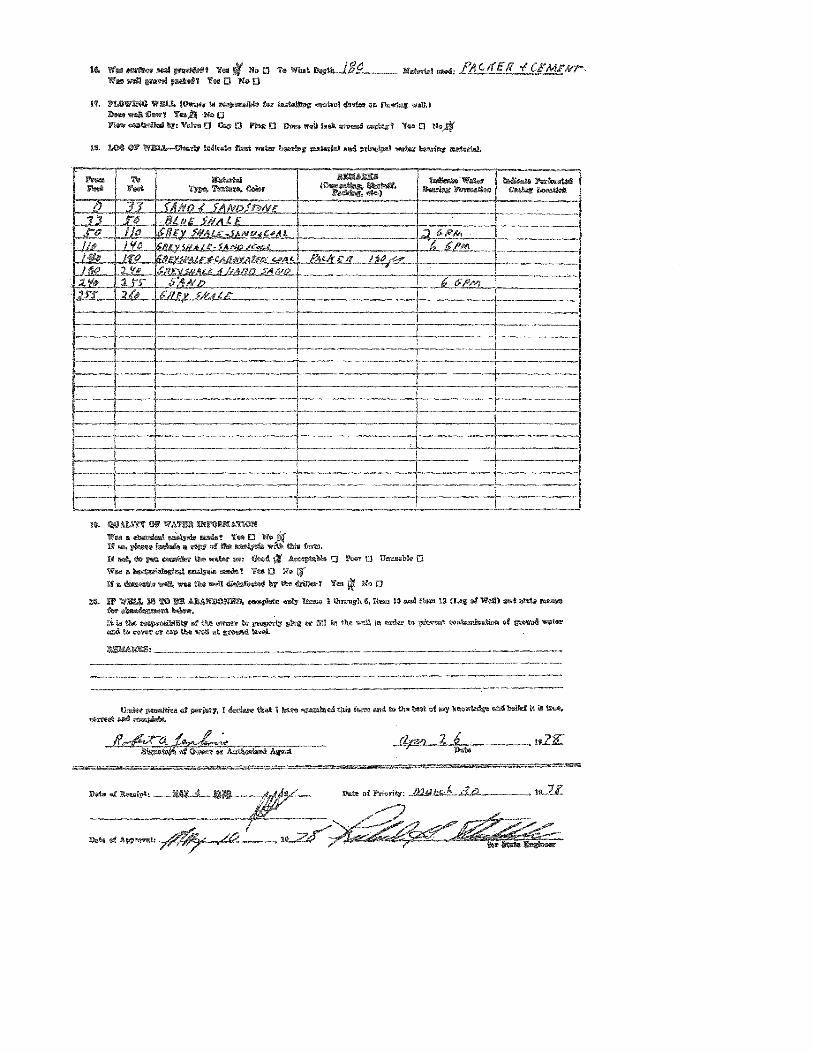
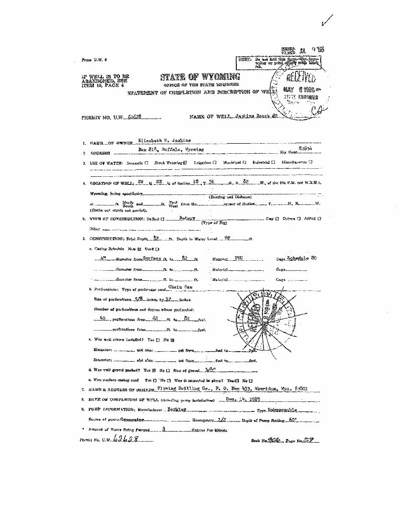
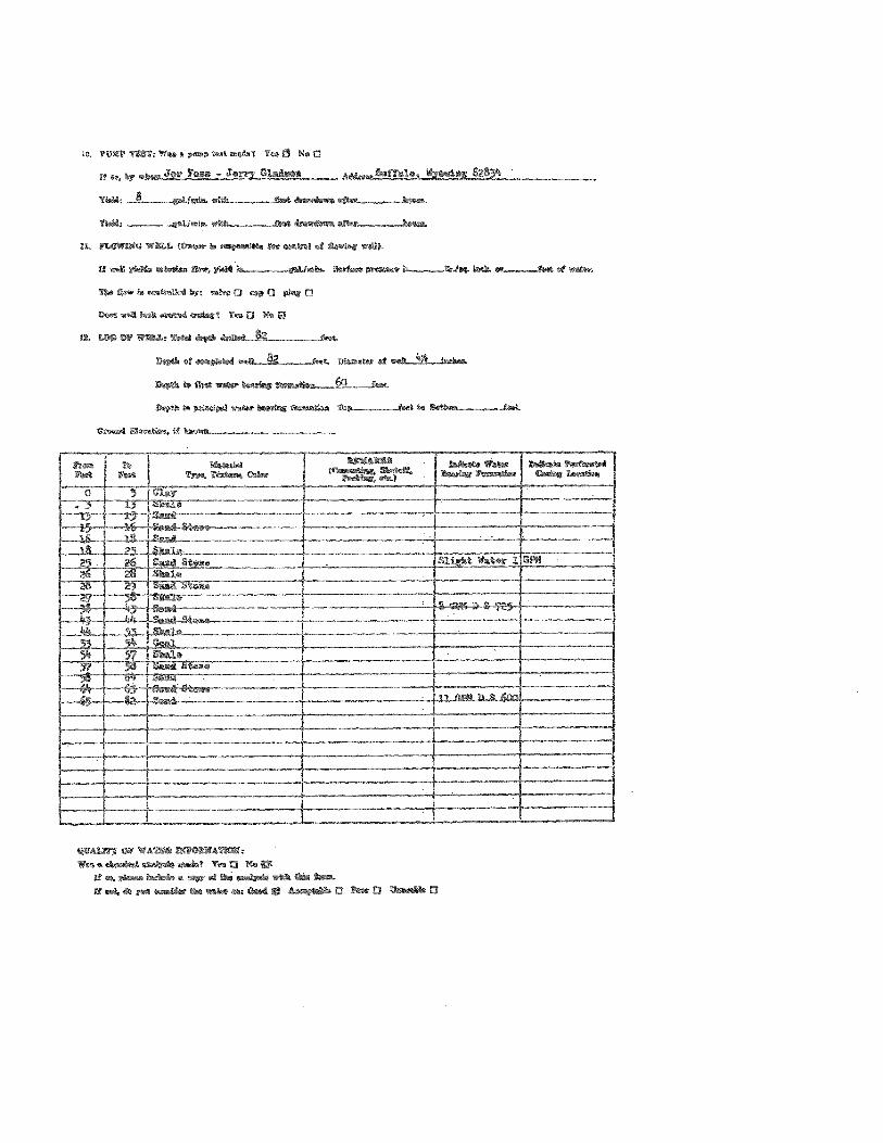
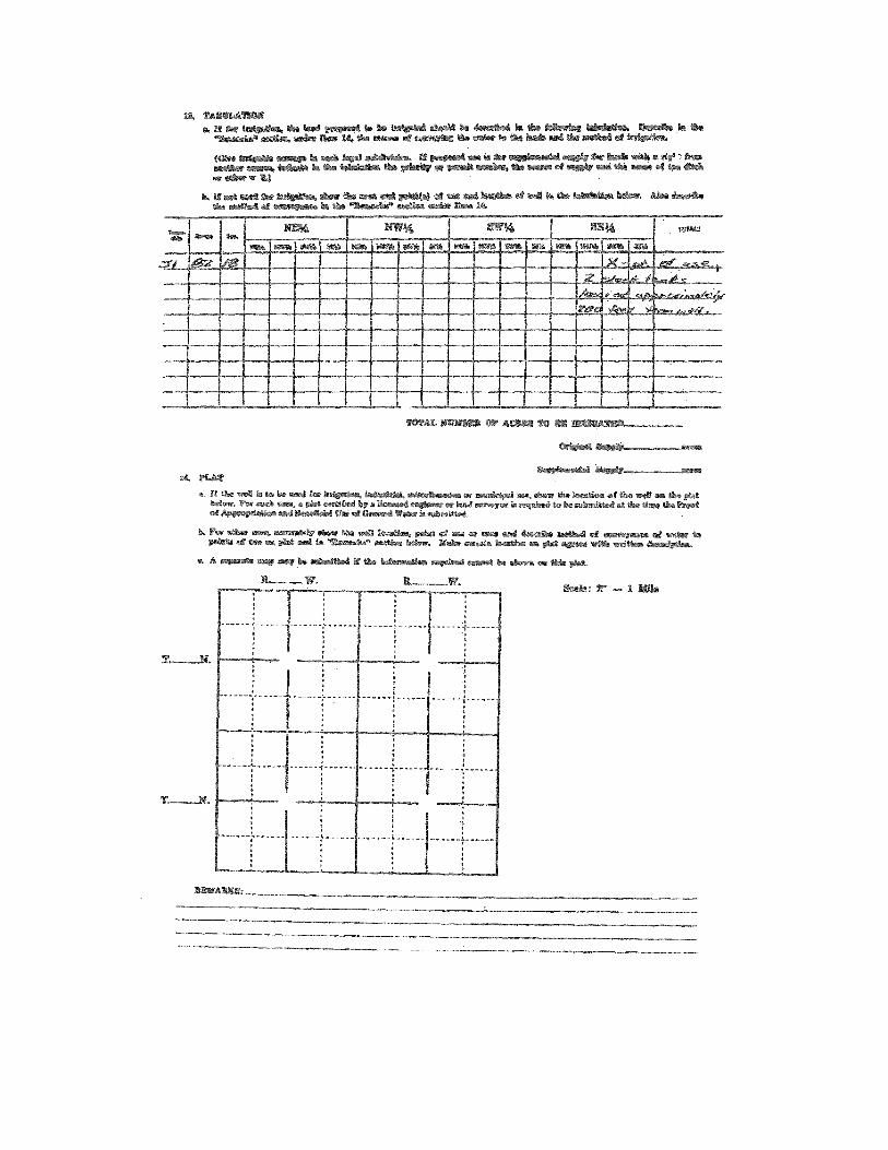
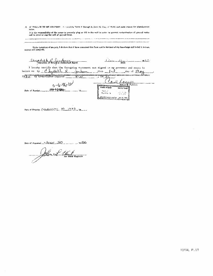
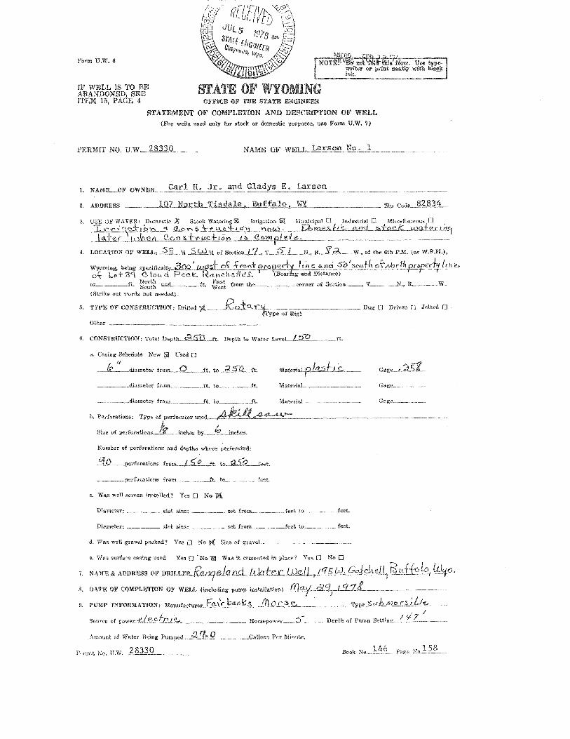
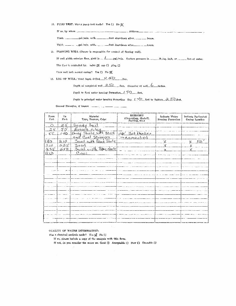
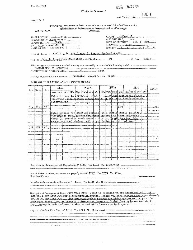
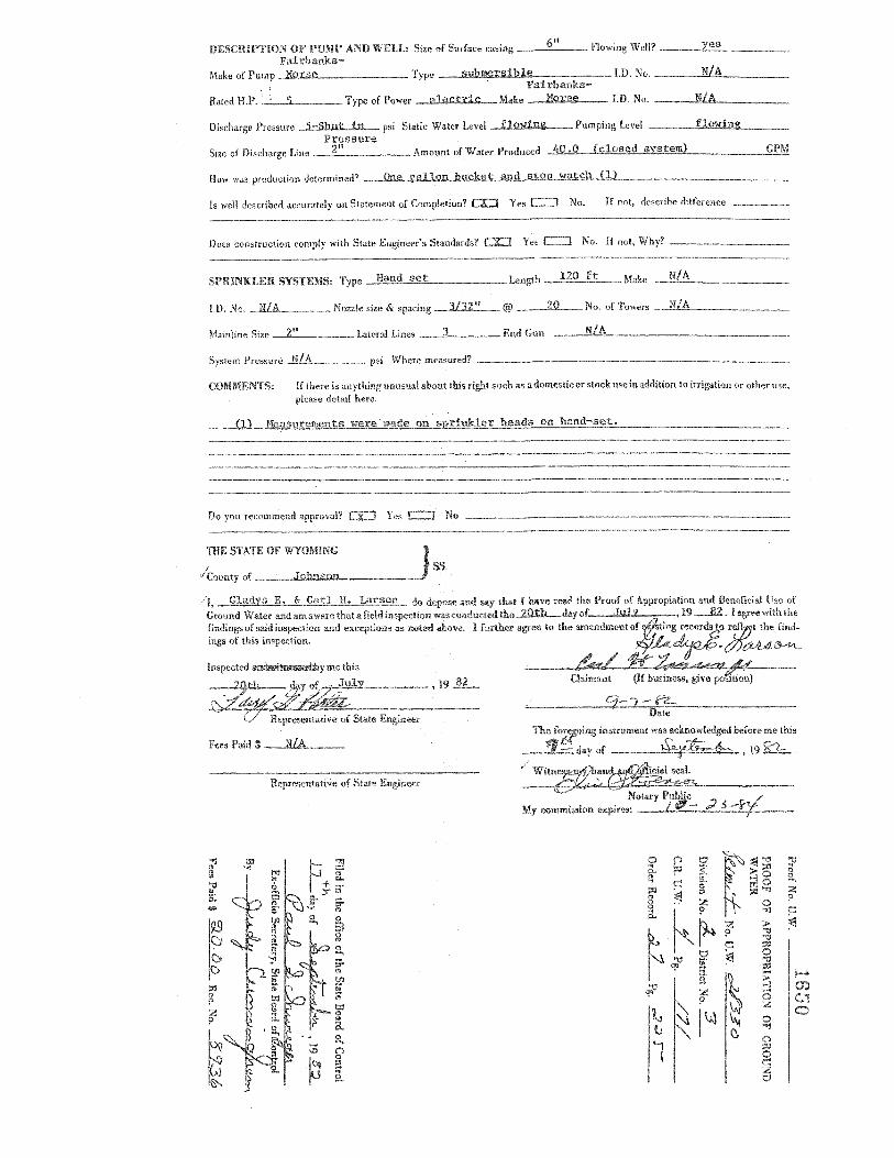
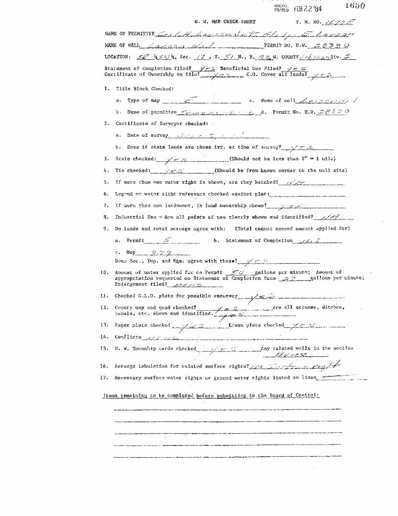
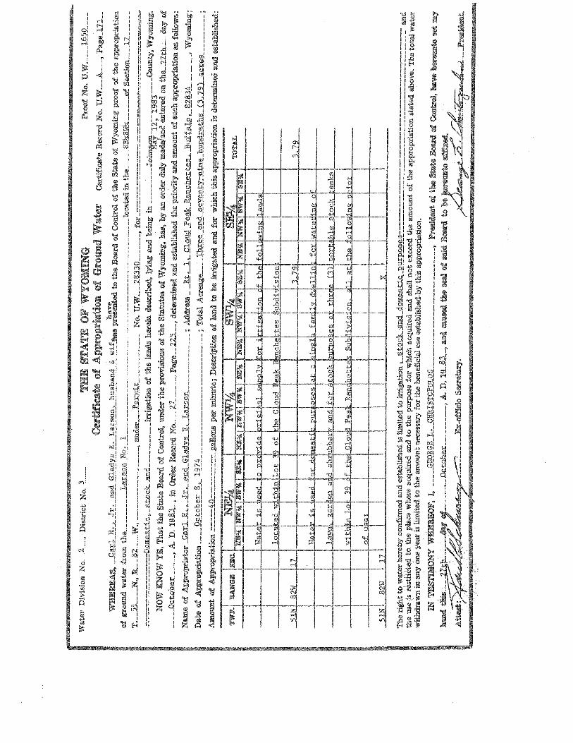
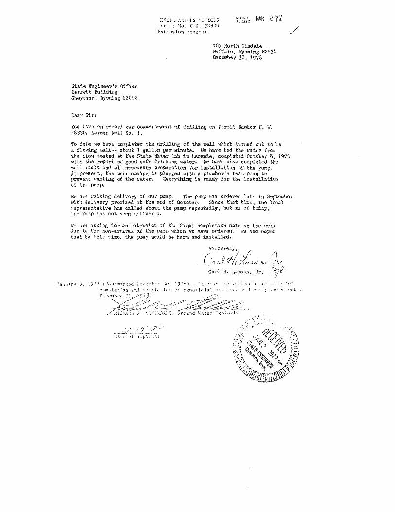
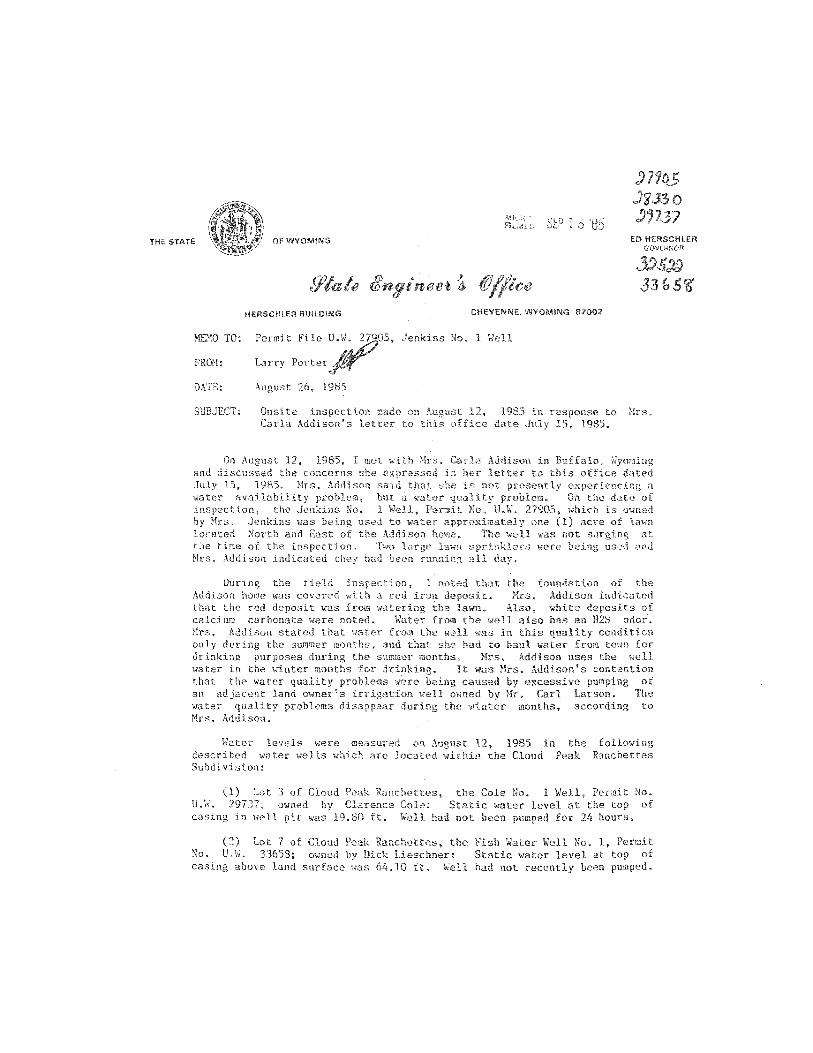
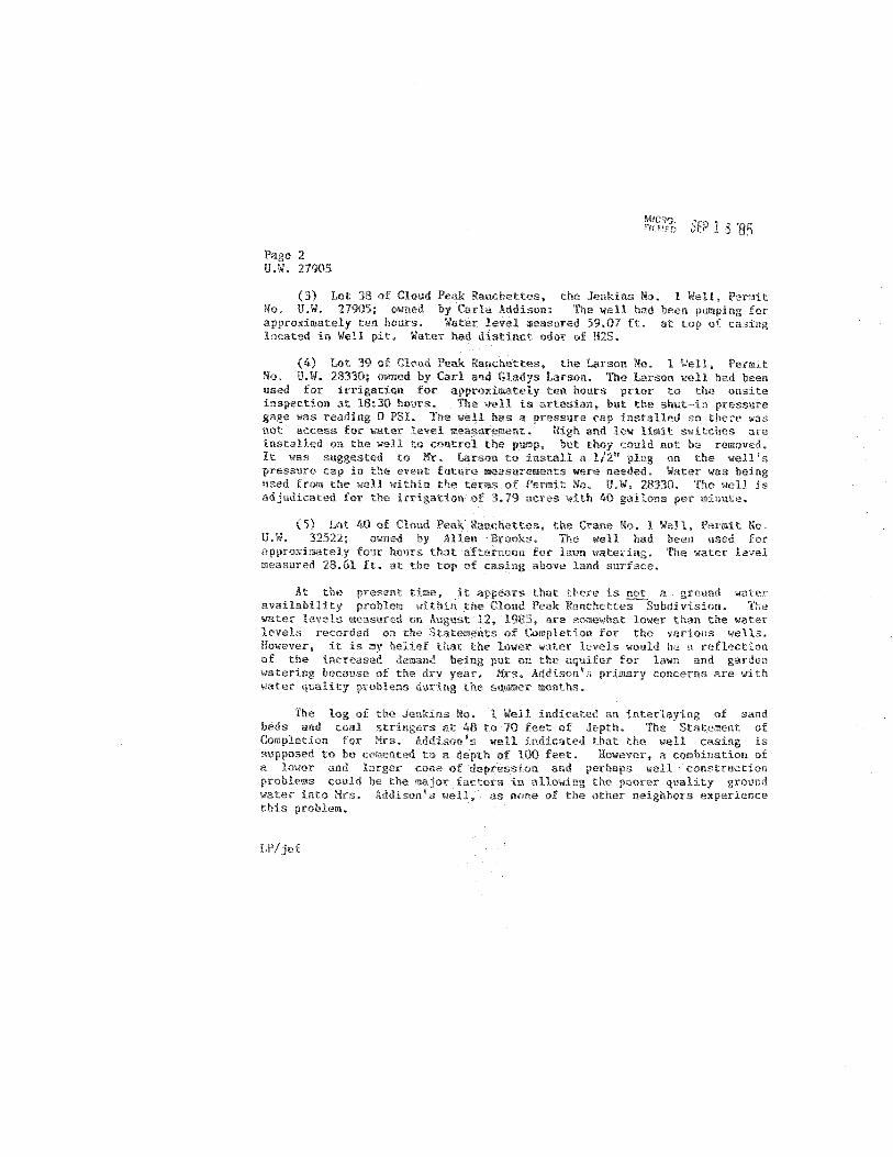

APPENDIX D
WATER QUALITY

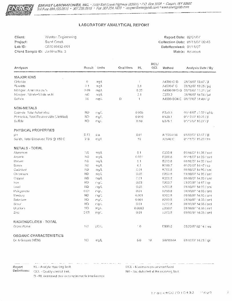
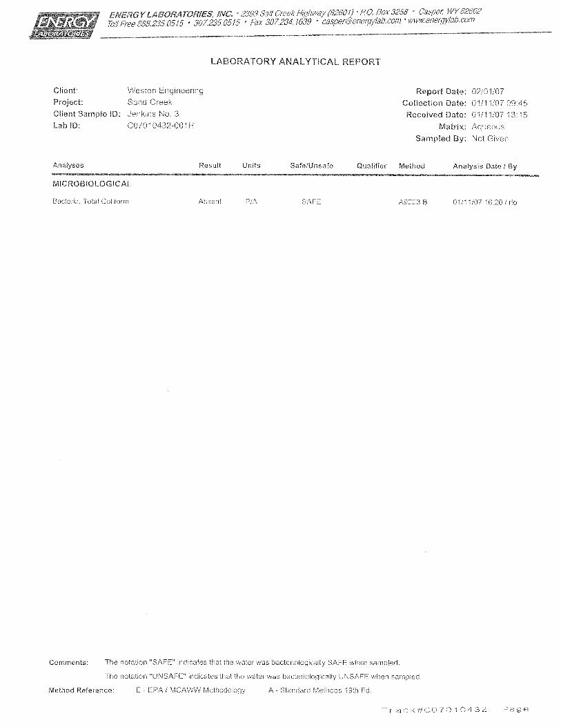
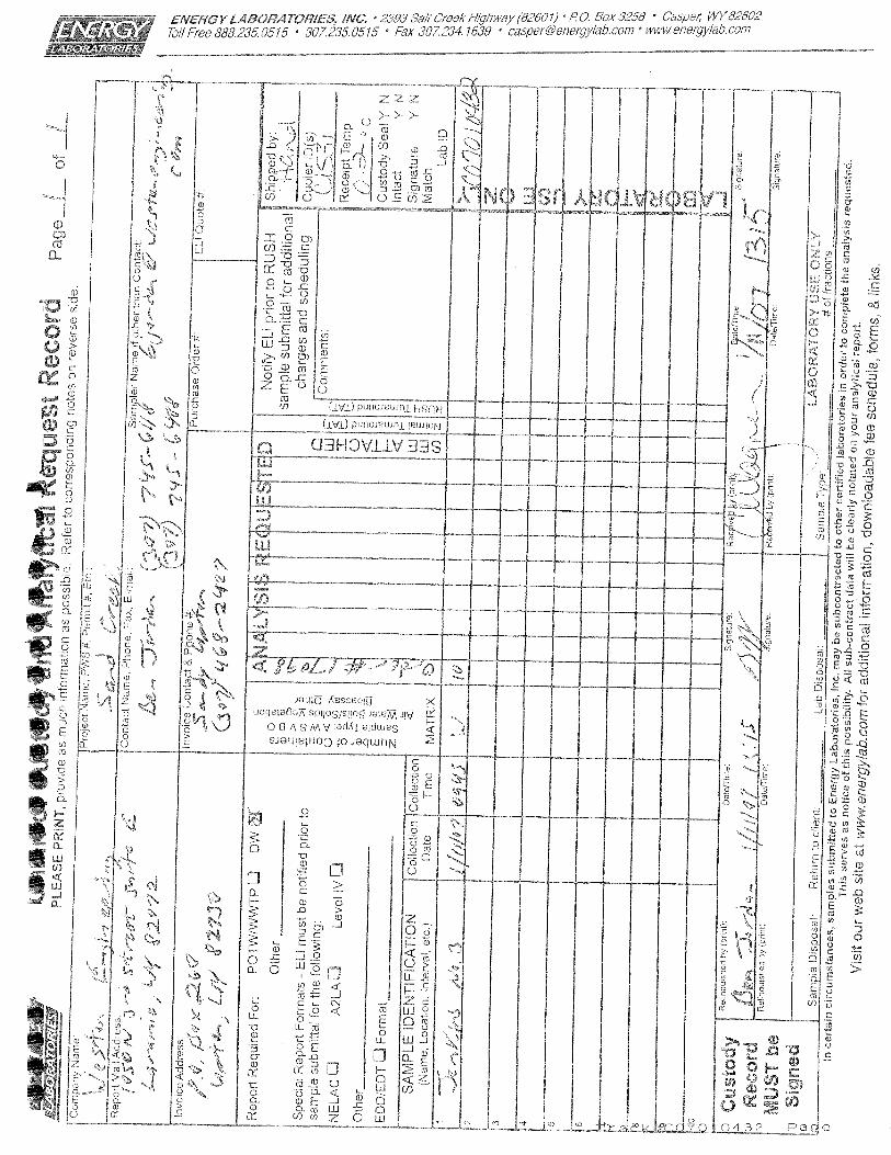
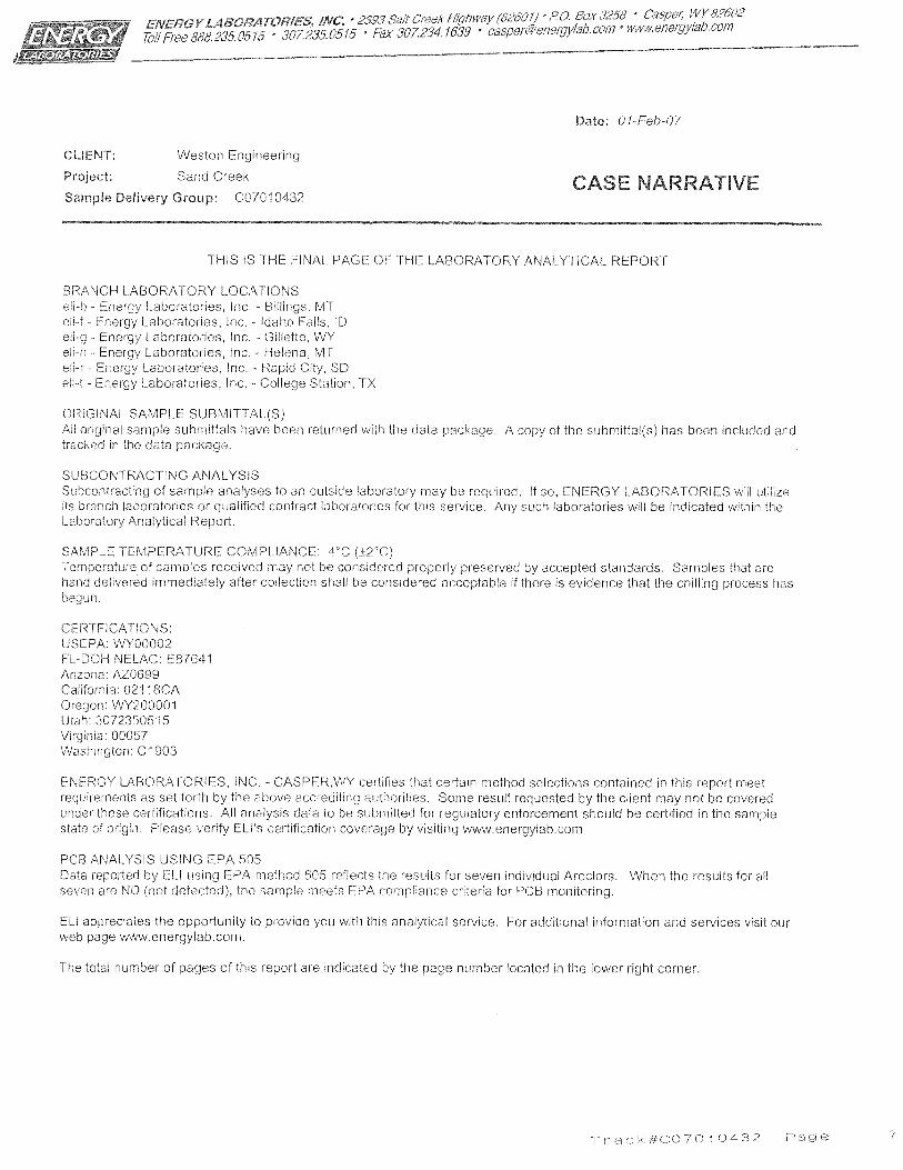
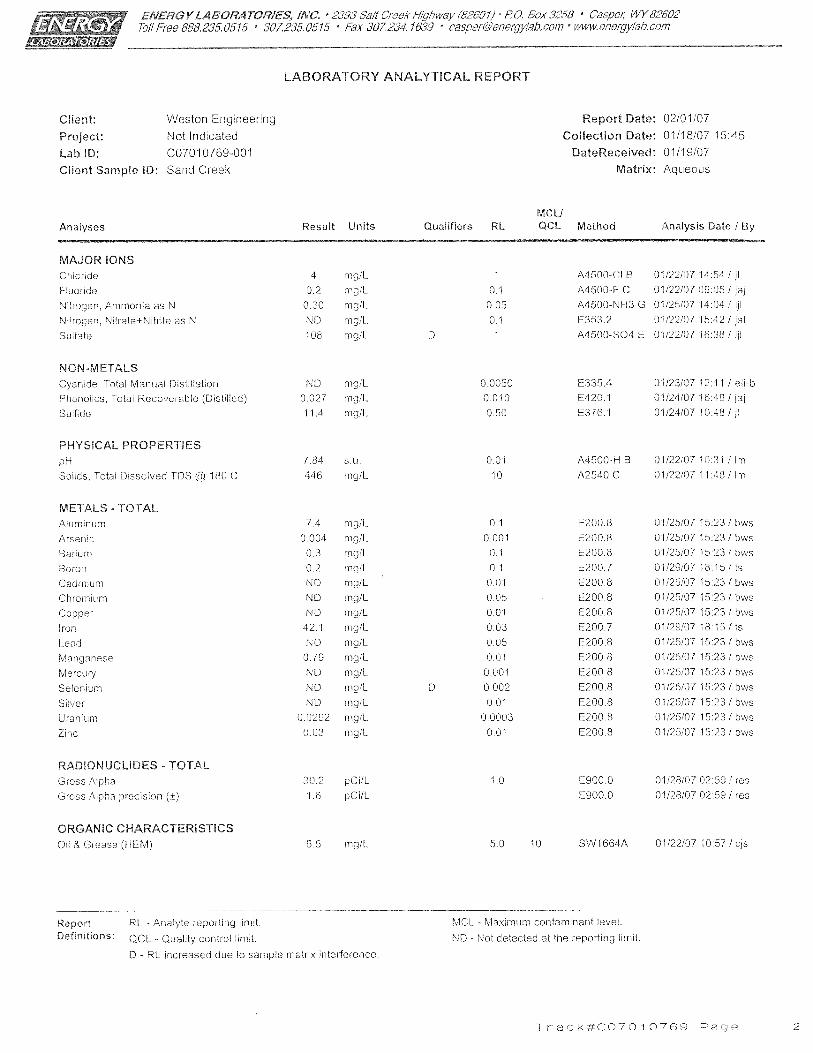
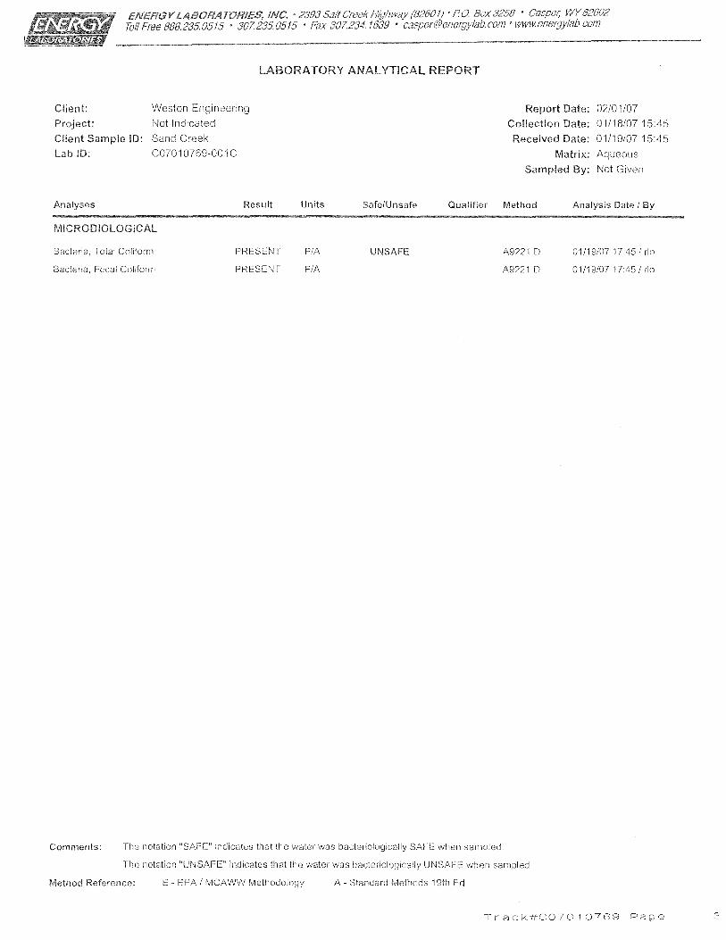
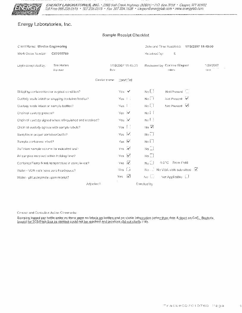
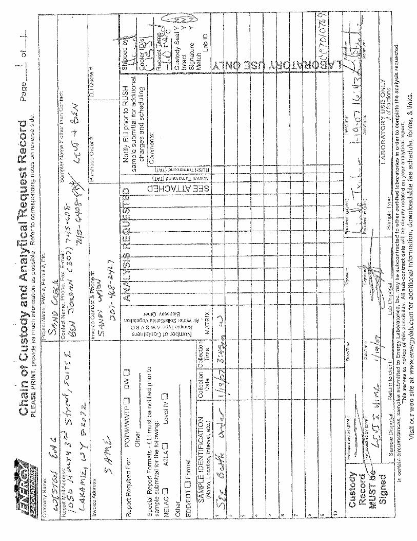
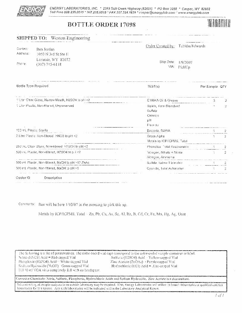
APPENDIX E
NITRATE MODELS
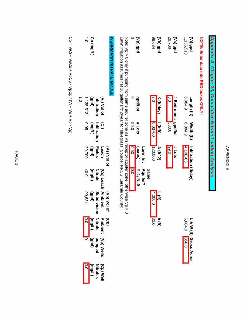
AP
PE
ND
IX E
Appendix A
, Chapter 23, C
umulative N
itrate Loading Analysis
NO
TE: Enter data into RED
boxes ON
LY!
(Vi) gpdLength (ft)
Width (ft)
Infiltration (ft/day)L &
W (ft)
Gross A
cre s1,135,513
6,084.96,084.9
4.10E-03
6,084.9850.0
(Vs) gpd# B
edrooms
gpd/lot# Lots
29,7003.0
300.099.0
(Vb) gpdK
(ft/day)i (ft/ft)
A (ft^2)
L (ft)b (ft)
99,6343.0
0.03700120,000
4,000.030.0
(Vp) gpdgpd/Lot
# LotsLaw
n Irr. (acres)
Same
Aquifer?
Y=1; N=0
00
99.00.50
0.0N
ote: Vp > 0 only if pum
ping from sam
e aquifer zone as Vs receptor aquifer zone; otherw
ise Vp = 0
Lawn irrigation assum
es net 18 gallons/ft^2/year for bluegrass (Source: N
RC
S, Laram
ie County)
WEH
RM
AN
N N
ITRA
TE MO
DE L
Co (m
g/L)
(Vi) Vol of Infiltration (gpd)
(Ci)
Infiltration (m
g/L)
(Vs) Vol of Leach Fields (gpd)
(Cs) Leach
Nitrate
(mg/L)
(Vb) Vol of A
mbient
Subdivision (gpd)
(Cb)
Am
bient N
itrate (m
g/L)
(Vp) Wells
pumped
(gpd)
(Cp) W
ell N
itrates (m
g/L)1.0
1,135,5130.05
29,70040.0
99,6340.0
00.0
1.0
Co = V
iCi + V
sCs + V
bCb - V
pCp / (V
i + Vs + V
b - Vp)
PA
GE
1
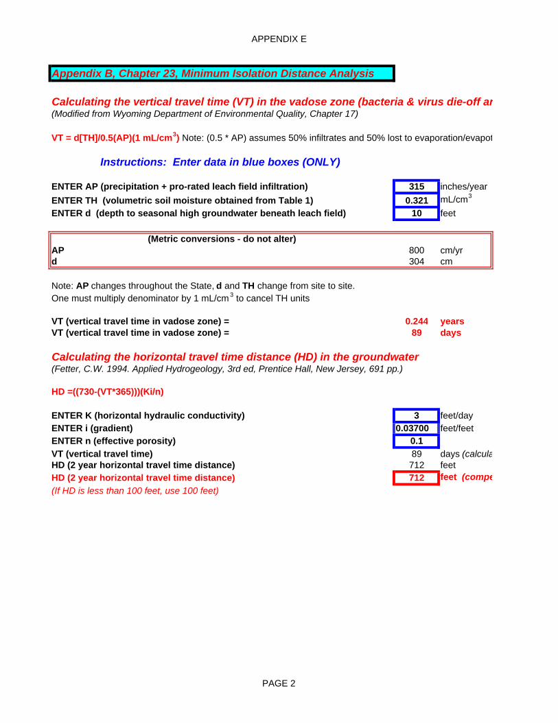
APPENDIX E
Appendix B, Chapter 23, Minimum Isolation Distance Analysis
Calculating the vertical travel time (VT) in the vadose zone (bacteria & virus die-off an(Modified from Wyoming Department of Environmental Quality, Chapter 17)
VT = d[TH]/0.5(AP)(1 mL/cm3) Note: (0.5 * AP) assumes 50% infiltrates and 50% lost to evaporation/evapot
Instructions: Enter data in blue boxes (ONLY)
ENTER AP (precipitation + pro-rated leach field infiltration) 315 inches/yearENTER TH (volumetric soil moisture obtained from Table 1) 0.321 mL/cm3
ENTER d (depth to seasonal high groundwater beneath leach field) 10 feet10
(Metric conversions - do not alter)AP 800 cm/yrd 304 cm
Note: AP changes throughout the State, d and TH change from site to site.One must multiply denominator by 1 mL/cm 3 to cancel TH units
VT (vertical travel time in vadose zone) = 0.244 yearsVT (vertical travel time in vadose zone) = 89 days
Calculating the horizontal travel time distance (HD) in the groundwater (Fetter, C.W. 1994. Applied Hydrogeology, 3rd ed, Prentice Hall, New Jersey, 691 pp.)
HD =((730-(VT*365)))(Ki/n)
ENTER K (horizontal hydraulic conductivity) 3 feet/dayENTER i (gradient) 0.03700 feet/feetENTER n (effective porosity) 0.1VT (vertical travel time) 89 days (calculaHD (2 year horizontal travel time distance) 712 feet HD (2 year horizontal travel time distance) 712 feet (compe(If HD is less than 100 feet, use 100 feet)
PAGE 2
APPENDIX F
WATER RIGHTS SEARCH