sand mine restoration plan - epa archives · sand mine restoration plan grand mere state park ......
TRANSCRIPT

SAND MINE RESTORATION PLAN GRAND MERE STATE PARK
Revised: August 2000
Prepared by
Glenn Palmgren Stewardship Ecologist
Michigan Natural Features Inventory
for
State Park Stewardship Program Parks and Recreation Bureau
Michigan Department of Natural Resources PO Box 30257
Lansing, Michigan 48909-7528
and
Great Lakes National Program Office U.S. Environmental Protection Agency
77 West Jackson Boulevard Chicago, Illinois 60604-3590
(Project # GL985669-01-1)

Table of Contents
Introduction and Background ..............................................................................................................1
Geologic History: The Formation of Grand Mere’s Surface Features.....................................................2
Natural Communities ..........................................................................................................................2
Dune Forests...................................................................................................................................2
Wetpanne........................................................................................................................................3
Key Ecosystem Processes ................................................................................................................3
Land Use History................................................................................................................................3
Land Administration...........................................................................................................................4
Vision ................................................................................................................................................4
Threats and Potential ..........................................................................................................................5
Reclamation & Management ...............................................................................................................5
Timeline of Reclamation & Management Events...............................................................................5
Planting & Site Preparation ..............................................................................................................6
Planting Plan...................................................................................................................................8
Steep Slopes (all aspects) .............................................................................................................8
Gentle Slopes ............................................................................................................................11
Prairie .......................................................................................................................................13
Wetpanne ..................................................................................................................................14
Wetland Shelf ............................................................................................................................16
Shallow water............................................................................................................................18
Deep water................................................................................................................................19
Non-native Invasive Species Control ..............................................................................................20
Monitoring....................................................................................................................................20
Literature Cited ................................................................................................................................20
Appendix A: Planting Zones Map.....................................................................................................22
Appendix B: Global and State Element Ranking Criteria ....................................................................23
Appendix C: Public Act 451 of 1994 – Part 353 “Sand Dunes Protection & Management” ..................24
Appendix D: Public Act 451 of 1994 – Part 637 “Sand Dune Mining” ...............................................25
Appendix E: Critical Dune Areas at Grand Mere................................................................................26

SAND MINE RESTORATION PLAN: GRAND MERE STATE PARK
Introduction and Background Grand Mere State Park, located in southwestern Michigan on the shores of Lake Michigan, contains some of the most unique sand dune features in the world. The park also contains three lakes, called North, Middle, and South Lake, and has over one mile of Lake Michigan frontage. The sand dunes within the park are part of the largest freshwater dune system in the world, lining the shores of the Great Lakes. These dunes historically supported a wide array of natural communities, including dry-mesic southern (oak-hickory) forest, rich conifer (cedar) swamp, southern (mixed hardwood) swamp, wetpanne and interdunal wetland (shrub swamp/emergent marsh), open dunes, and a wooded dune and swale complex.
The dunes at Grand Mere fall within a state-designated “Critical Dune Area.” The area containing the present-day park was also designated a National Natural Landmark in 1968. The park was first created on 393 acres of land in 1973, and more than doubled in size with the acquisition of 490 additional acres in 1986. The master plan for Grand Mere State Park, approved in 1986, cited “sand dune preservation” as the primary management objective for the park. A highly diverse flora exists at Grand Mere, with over 550 species of plants documented within the park. Furthermore, Grand Mere lies in a unique place on the southern shore of Lake Michigan where plants typical of both northern and southern temperate latitudes grow together in the same community. Because of the unique flora, fauna, and geology of the dune and wetland features at Grand Mere, the park has long been used as an “outdoor laboratory” for natural resource teaching and research. The high quality natural features within this park have clearly been recognized for many years, and the imperative is in place to manage this park to protect and enhance these natural features.
Currently, an active sand mine (the Manley-Peters mine) exists in the southwestern portion of the park. The property was initially mined in 1965 by Manley Brothers, but mining stopped several years later. In 1979, Manley Brothers wanted to resume mining at the site, but because the site falls within a designated critical dune area, they had to file for a permit under the new Sand Dune Management and Protection Act of 1976. The application was initially denied by the MDNR, and Manley Brothers sued the MDNR. A revised permit was agreed upon by Manley Brothers and the MDNR, but a private citizen group filed suit against both the MDNR and Manley Brothers. The lawsuit resulted in a court-entered agreement that guides current operations on the site. As part of the permit application procedure, a Progressive Cell-Unit Mining and Reclamation Plan (PCUMRP) and an Environmental Impact Statement (EIS) were prepared in 1984. Following final issuance of the permit on June 17, 1985, mining operations began. Manley Brothers operated this mine until it was purchased by TechniSand, Inc. in 1991. TechniSand continues to mine this site in accordance with the PCUMRP of 1984 and the court agreement. A revised PCUMRP was completed in 2000, and TechniSand was granted a permit to mine below the water table and create wetland features on the site. According to the terms of the original court agreement, all mining at the site must be completed by June 17, 2003, and all site reclamation work specified in the PCUMRP (as amended) must be completed by June 17, 2005. The property containing the Manley-Peters mine will then revert to the State for administration. Stockpiles must be removed from the processing site (the nearby Livingston Road facility) by June 17, 2007 and stockpile areas must then be restored within two years.
Most recent reclamation efforts in Michigan’s dunes have been restricted to the planting of native beach grass (Ammophila breviligulata) and scattered trees not native to Michigan’s coastal dunes. Beach grass does an excellent job of quickly stabilizing the exposed sands. The monoculture that develops, however, is very different than the complex vegetative patterns that naturally occur on undisturbed dunes. With this reclamation project, we hope to demonstrate the practicality of replanting a more diverse and natural vegetative cover which will complement the surrounding undisturbed vegetation. This restoration plan provides the framework for management activities to restore a suite of functioning ecosystems at the sand

Grand Mere Sand Mine Restoration Plan – Page 2
mine that approximate, as much as possible, the surrounding natural ecosystems within Grand Mere State Park.
Geologic History: The Formation of Grand Mere’s Surface Features Within the park, the dominant landforms are the sand dunes along the shore of Lake Michigan. A large bay of the glacial Great Lakes was present where Grand Mere State Park is today. During Algonquin Great Lakes time (roughly 12,000 years ago), a large spit formed from the south along the west side of the bay, nearly cutting it off from the glacial lake (Tague 1947). Most of the dunes at Grand Mere formed on this Algonquin sand spit during the later Nipissing Great Lakes period, approximately 4,500 years ago. During the more recent post-Algoma period (3,000 years ago until present), a smaller spit from the north merged with the larger, dune covered southern spit, closing off the bay. As water levels fell, five lakes formed in this bay. The two southern lakes have subsequently filled in and have become the present-day tamarack swamp south of South Lake. While the lakes were forming in the bay as water levels fell, some smaller foredunes were formed along the shoreline of Lake Michigan. The topography and sandy soils of the park can be attributed to this glacial history.
Natural Communities The presettlement (ca. 1800) vegetation of Grand Mere State Park is interpreted off the digital database produced by Comer, et al. (1995), as interpreted from the notes of the original land surveyors of the area. Presettlement vegetation in the park varied with differences in landform, soils, and topography. The park supported communities of plants and animals similar to the surrounding area and characteristic of the regional ecosystem (Southern Lake Michigan Lake Plain, see Albert 1995) of which it is a part. Specific presettlement vegetation communities found at the park that are included in this reclamation are dry-mesic southern forest (with areas of open dune) and wetpanne (interdunal wetland). Small areas of mesic hardwood forest and prairie will also be re-created. Dry-mesic southern forests (dominated by black, white, and red oak) covered the dunes and most other upland areas in Grand Mere State Park. Wetpannes (dominated by various sedges, rushes, grasses, and forbs) surrounded the lakes. The wetpannes also included shrub-dominated areas similar to those that now encircle the lakes. A detailed description of the vegetation of Grand Mere is given by Wells and Thompson (1980), and the following descriptions of communities are based on the classification by Michigan Natural Features Inventory (1989).
Dune Forests Forested dunes and surrounding flat upland sites were characterized by dry-mesic southern forest. Blowouts of exposed sand and open dune , dominated by beach grass, sand reed, and little bluestem were common. The locations of blowouts changed over time, and were likely present in various areas within Grand Mere State Park in presettlement time. Typical dry-mesic southern forests are dominated by black and white oak, with northern pin oak on the driest hilltops and ridges. Northern red oak is common in valleys, on north slopes, and on wetland edges. In presettlement times on the southern shore of Lake Michigan, white pine and jack pine were common on most forested dunes, often dominant on southern slopes (Cowles 1899). In many cases pignut and shagbark hickories were also found on these wooded sites. Dry-mesic southern forests occur on dunes, outwash, and ice-contact features, with soil textures ranging from sandy loam to sand. Typical birds of presettlement dry-mesic southern forests included cerulean warbler; American redstart; broad-winged, Cooper’s, and sharp-shinned hawks; passenger pigeon; ruffed grouse; wild turkey; blue jay; black-capped chickadee; great horned owl; hairy, downy, and red-headed woodpeckers; eastern wood-pewee; great-crested, least and acadian flycatchers; red-eyed and yellow-throated vireos; white-breasted nuthatch; common raven; blue-gray gnatcatcher; and scarlet tanager. Mammals found in these forests likely included gray squirrel, fox squirrel, eastern chipmunk, Virginia opossum, northern short-tailed shrew, northern bat, southern flying squirrel, white-footed mouse,

Grand Mere Sand Mine Restoration Plan – Page 3
woodland vole, common gray fox, common raccoon, and striped skunk. Currently, dry-mesic southern forests are ranked rare or uncommon in the state (S3) and widespread globally (G4) by the Michigan Natural Features Inventory (see Appendix B for ranking criteria). Open dunes and sand/gravel beaches are both currently ranked rare or uncommon statewide (S3) and globally (G3).
Wetpanne Wetpannes are interdunal wetlands where the surface soil has been eroded away by wind down to the water table. The remaining soil is saturated by a water table at or near the surface. The water table fluctuates seasonally and yearly, partly in synchrony with lake level changes. In wetpannes of southwestern Michigan, the dominant vegetation is very unique, with a component of Atlantic coastal plain disjunct species (Reznicek 1994). At Grand Mere State Park, wetpannes likely occurred in presettlement time surrounding the inland lakes. These wetpannes were likely dominated by several species of sedges, rushes, grasses, and wetland forbs, with scattered shrub-dominated patches. Over time, the areas surrounding all three lakes have succeeded to inundated shrub swamp or southern shrub-carr communities. Characteristic plant species found in wetpanne communities include lake shore rush (Juncus balticus), twig-rush (Cladium marsicoides), Kalm’s St. John’s-wort (Hypericum kalmianum), hair beak-rush (Rhynchospora capillacea), Kalm’s lobelia (Lobelia kalmii), fringed gentian (Gentianopsis crinita), purple gerardia (Agalinis purpurea), hardstem bulrush (Schoenoplectus acutus), white boneset (Eupatorium perfoliatum), Ohio goldenrod (Solidago ohioensis), and blue-joint grass (Calamagrostis canadensis). Jack pine (Pinus banksiana) is often common around the edges. Interdunal wetlands are currently ranked imperiled both globally (G2) and in Michigan (S2).
Key Ecosystem Processes The dominant ecosystem process in dune systems is wind and the corresponding effect it has on sand movement. Wind causes blowouts and erosion of slopes on dunes, often burying forests in sand, leaving a barren sand feature. This sand is quickly colonized by herbaceous plants such as beach grass and sand reed. These plants stabilize the slopes and allow other species to colonize the site, eventually allowing succession to a dry-mesic forest community. In the absence of dense vegetation, wind-blown sand can be highly erosive to plant tissues, essentially “sand-blasting” plant stems and leaves, hindering establishment of all but the hardiest plants on open dunes. In dry-mesic southern forests, wind causes damage to branches of large old rotting oak trees, creating canopy gaps that, in combination with fire, stimulate oak regeneration. Severe wind storms that cause significant limb and bole breakage in oak forests typically occur at intervals of about 100 years, but may have been more frequent in dune systems.
Another important ecosystem process in presettlement dune-related ecosystems was fire. Although wind was a more dominant disturbance process in these systems, surface fires were probably occasional in the forested dunes. These surface fires would reduce or eliminate understory and ground cover, perpetuating an open oak forest condition. Stand replacing catastrophic fires may have been important, but much less common in the dry oak forests, occurring at intervals of 200-300 years or more. Fires likely also ran through the wetpannes, especially during dry seasons with low water levels. These wetland fires probably kept some wetpannes from becoming completely shrub-dominated. Wildfires were most often ignited by lightening. In the absence of significant fires, dune forests commonly gain an overstory component of beech, sugar maple, and hemlock over the course of hundreds of years.
Land Use History The area surrounding Grand Mere State Park has a rich cultural history, dating back to occupation by the Miami and Pottawatomi Native Americans. The first European-American to settle the area was Major Timothy S. Smith in 1827 (Grande Mere Association 1973). The majority of the present-day Grand Mere State Park was owned by T.W. Dunham by 1887. A trail was located where Wishart Road runs today,

Grand Mere Sand Mine Restoration Plan – Page 4
skirting the western edge of the tamarack swamp and South Lake, and following today’s nature trail and park entrance road between Middle and South Lakes. Another trail connected to this trail and skirted the western and northern edges of Middle Lake (where Grand Mere Rd runs today). A sawmill was operated by Mr Dunham on the northwest corner of Middle Lake, beginning in 1867 (Grande Mere Association 1973). Mr Dunham planted a peach orchard on the northwest corner of South Lake after his lumber business declined. A Native American village was reportedly buried by shifting sands at the location of the peach orchard (Grande Mere Association 1973). The Dunham Resort was a well-known place to visit to the northwest of Middle Lake on the shore of Lake Michigan in the early 1900s.
In the early 1900s, the boggy area surrounding South Lake was used for intensive cranberry cultivation. Several other orchards and nurseries were attempted in the Grand Mere area in the 1920s and 1930s, but none succeeded. Waverland Beach (first known as the Fox-Lind subdivision, and then “Wave Over Land Beach”) was started as a subdivision of beach-front homes in 1908 (Grande Mere Association 1973).
Thirty acres of trees were cleared by the Manley Sand Company in 1965 (at the present-day Manley-Peters mine), and mining was started at that site in January 1966. Around this time, the Grande Mere Association purchased 22 acres at Waverland Beach and started the Grande Mere Nature Study Preserve (held in title by the Kalamazoo Nature Center). The State eventually purchased 393.16 acres from the Shapiro estate in 1973 and established Grand Mere State Park. The Nature Conservancy acquired 490.5 acres of property (mostly from Manley Brothers and Peters), and sold that land to the State in 1986. Through this acquisition, Manley Brothers retained the right to mine 25 acres of the property, which would then be turned over to the State.
Throughout the history of Grand Mere, the notable land cover changes within current park boundaries were 1) the selective logging (presumably of white pine) associated with the Dunham sawmill, 2) the establishment of Dunham’s peach orchard, 3) the cranberry operation on South Lake altering vegetation composition, 4) mining at the Manley-Peters sand mine, and 5) remnants of scattered orchards and nurseries that may have been within the present park boundaries.
Land Administration Grand Mere State Park is administered by the Parks and Recreation Bureau of the Michigan Department of Natural Resources. Besides the park master plan, land administration must follow the rules and regulations that apply to critical dune areas in Michigan. The laws governing critical dune areas are in Appendix C, the laws pertaining to sand mining are in Appendix D, and a map of the area designated as critical dune in Grand Mere is in Appendix E.
Vision The Manley-Peters sand mine at Grand Mere State Park will be restored to approximate, as near as possible, the natural conditions of surrounding dunes. A diverse array of native plants will dominate the site, with an initial open dune community changing into a dry-mesic oak forest over time on the steep slopes. The nearly level areas on the east side of the mine will be dominated by mesic forest species. A small upland prairie will grade naturally into wetland terraces with water depths of 1-2 feet and dominated by a diverse compliment of native wetland plants. Two wetpannes will be established in the expanded southwest and southeast corners of the lake with saturated soil and dominated by many species of native grasses, sedges, forbs, and shrubs. The wetpannes and shallow (< 2 feet deep) wetland terraces will be at least 60 feet wide, and will encircle a small pond in the center of the mine. The final grading and initial planting of native species will be accomplished by TechniSand, with technical and financial assistance from the State Park Stewardship Program and the US Environmental Protection Agency. Throughout the project, cooperation among private industry, state and federal agencies, and the local

Grand Mere Sand Mine Restoration Plan – Page 5
community will be encouraged. This restoration will serve as a model for the sand mining industry and regulators on how to accomplish an ecologically-sound restoration of a sand mine in Great Lakes dunes.
Threats and Potential The most important threat to restoration of the sand mine is colonization of the site by non-native plant species. Over 90 species of non-native plants are known from Grand Mere State Park and vicinity, and many of these could easily establish in the sand mine. Non-native plants are not an integral part of the natural ecosystems at Grand Mere, and their establishment at the sand mine will seriously hinder efforts to restore natural communities. If non-native species colonize the mine, they will likely out-compete native species that are being planted, resulting in weedy, unnatural vegetation. To combat the threat of invasive species, a diverse matrix of native plants will be planted at the mine as soon as possible following final grading. With the help of manual and chemical control of non-native plants where necessary, the native species will thrive and dominate the site, leaving little room for non-native invasives.
The potential for restoration of this sand mine is good, however it may be difficult to establish many species on the unstable, droughty sand slopes left following mining. The native species chosen for this restoration naturally occur on similar harsh sites nearby. Although initial establishment may be difficult, the likelihood of establishing many of them over time with proper management is very high.
Reclamation & Management Management activities at the sand mine will consist of three major efforts. The first is planting of appropriate native species in all areas of the mine as soon as possible following final grading. The second task is the control of non-native invasive species that establish at the sand mine. Third is monitoring. The timeline below gives the approximate timing of events related to this restoration effort, as predicted by the current progress as of August 2000.
Timeline of Reclamation & Management Events Winter 2000 State Park Stewardship Program (SPSP) submitted this restoration plan to USEPA.
SPSP began establishing contracts for native plant propagation.
Spring 2000 TechniSand initiated planting of all “final graded” slopes to date with Ammophila breviligulata and Quercus rubra. This included many “steep slope” areas. Invasive non-native species will be foliar herbicided using 1½ -2 % glyphosate (Round-up or equivalent) as necessary prior to planting throughout this project to provide for good establishment of natives.
TechniSand and SPSP cooperated in hosting several field trips for local elementary school classes to learn about sand mining and reclamation.
SPSP established three photo-monitoring points to document initial phase of planting.
SPSP continued establishing contracts for native plant propagation.
Summer 2000 SPSP took repeat photos at the photo-monitoring points to visually document progress to date.
SPSP conducted preliminary evaluation of success of plantings.
SPSP finished establishing all remaining contracts for native plant propagation.

Grand Mere Sand Mine Restoration Plan – Page 6
October 2000 SPSP writes and submits a “final report” to USEPA documenting expenditures of grant money, and reporting on initial success of planting efforts. Additional report(s) will be submitted as additional plants are established from contracted growers and other sources, and as further ecological evaluations of the site are made. The restoration plan will be revised as plantings or management change over time to better suit the developing site conditions. This concludes the USEPA grant.
Fall 2000 -- Additional plantings are made by TechniSand and SPSP as specified in the planting ongoing plan and as final grading is completed. Evaluations of current site conditions and prior success with planting will be used to modify the planting plan as needed.
Volunteer seed collection continues, organized by SPSP, targeted at species needed for upcoming plantings.
SPSP repeats photo-monitoring points annually to document restoration success.
SPSP initiates plot sampling to document success of restoration (see Monitoring section below). Plots are established in each zone following initial planting, and data are gathered for three years following final planting of material purchased with USEPA grant money.
SPSP controls non-native invasive species as needed throughout the project.
June 17, 2003 TechniSand must complete all mining by this date, as specified in court agreement.
June 17, 2005 All reclamation of the site by TechniSand must be complete (to meet MDEQ standards). TechniSand is released from further legal obligations for reclamation of the Peters property.
June 2005 -- SPSP continues restoration and management of the site indefinitely (with cooperation ongoing and volunteer assistance from TechniSand).
SPSP continues photo-monitoring.
Additional report(s) are submitted to USEPA and other involved parties as new information becomes available and progress is documented through monitoring.
Planting & Site Preparation For the purposes of planting, the site has been roughly divided into eight zones (Appendix A). Each zone will contain a unique combination of topography, soil, microclimate, and plant community structure and composition. Within each zone, a planting plan has been developed including a species list, density of plantings, estimates of plant material needed, estimated costs (when available), and a timeline for planting (see below). The plants included in this plan are selected to provide a suite of key native plant species that create the biological framework of the native plant communities likely to occur naturally at this site. Also factored into the planting plan is anticipated availability of local genotype plant material, anticipated survival of the species on the site, regulatory requirements for stabilization of sand mines, and cost of propagating the plants. We expect several species of common native plants (such as sassafras or choke cherry) to naturally colonize the sand mine following final grading; where colonization of a desirable native species is expected to be sufficient, no planting of that species is planned. Note that the boundaries of the planting zones are not fixed. These zones will likely be altered somewhat as restoration proceeds based on the final location of the water table relative to the contour of the site following final grading.
In addition to the actual planting of seed or plants, other related site preparation procedures should be followed. Following final grading, coarse woody debris should be scattered on the slopes and overburden should be spread. The boles of large trees that are felled as a result of mining activities should be left on the surface of the site where possible. If few or no logs are available from on site, additional logs or

Grand Mere Sand Mine Restoration Plan – Page 7
woody debris may be imported to the site if trees are being felled for other nearby projects. The logs should be scattered in various orientations across the steep slopes (at a density of roughly 1 log for every 2 acres) to provide protected micro-habitats for plants to establish, to provide habitats for small animals, and to break up the aesthetic monotony of the recently-graded slopes. Also, the overburden that was removed and stockpiled prior to mining should be spread 2-4 inches thick over the slopes and in shallow portions of the water feature at depths less than 2 feet below the mean water table to help establish the fine-textured and organic soil necessary to support many plants. If any overburden remains after sufficiently covering the slopes and shallow areas of the water feature, it should be spread in the “gentle slopes” and “prairie” areas to the east of the water feature.
The planting plan should be followed closely. TechniSand is responsible for purchasing the species indicated with an asterisk (*) in the planting plan. TechniSand is also responsible for purchasing and installing all beach grass (marked with **), and for providing hydroseeding equipment and labor in those areas to be hydroseeded. All plants must be of local genotype (from a dune seed source within Grand Mere State Park where possible, otherwise from within Berrien County if possible, or adjacent counties if insufficient seed source is available from a closer area. The State Park Stewardship Program will plant the asterisked (*) species and purchase and plant the remaining species, using USEPA grant money and internal program funding. Planting even one inappropriate species (including species native to Michigan, but from distant seed sources) on the site could seriously hinder the progress of restoration. However, while implementing the plan over the next several years, it will likely be necessary to revise the planting plan to substitute for species that are unavailable at the time of planting, to compensate for unexpectedly high or low survival rates, and/or to better suit the site conditions that develop over time at the sand mine. Any substitutions or revisions to this plan must be carefully researched by the State Park Stewardship Program to determine appropriateness for the restoration. Following the release of TechniSand’s liability for reclamation of the sand mine, the State Park Stewardship Program will continue restoration and management of the sand mine indefinitely in conjunction with stewardship activities in Grand Mere State Park. These activities will likely include additional plantings to further enrich native species diversity and continuing efforts to control non-native invasive plants.
The following planting plan is organized into seven parts. Each part corresponds to one of the planting zones illustrated on the map (Appendix A), with the exception of the two steep slope zones that are described together in the planting plan. Within each part of the planting plan, an annual timeline is given that begins immediately following final grading (contouring) of the surface. Species are listed (in approximate order of priority), with scientific name, common name, planting density, anticipated source for plant material/growing/planting, and estimated cost per acre by species (if prices are available). Prices include seed collection, propagation, and planting, where those tasks are contracted. Where SPSP or volunteer labor is used, those costs are not included. Note that in the some areas, one non-native species is specified for planting. This species (oats) is used for temporary cover to aid the establishment of the native plants, and should die out naturally after 1-3 years.
The following abbreviations are used in the “Seed/Grow/Plant” column below: SP = State Park Stewardship Program staff; NRCS = USDA Natural Resources Conservation Service Rose Lake Plant Materials Center; WT = WildType Design, Native Plants & Seed; VB = VanBochove’s Greenhouse Direct; WN = Wetlands Nursery; OP = Olde Paths Perennial Farm; K = Kaya Forest Services; SMS = Southern Michigan Seed; Vol = Volunteers (coordinated by the SPSP).

Grand Mere Sand Mine Restoration Plan – Page 8
Planting Plan
Steep Slopes (all aspects)
Estimated area: 13.5 acres S,W,E aspects + 6.3 acres N aspect
Spring or Fall after final grading (2000/2001)
1. Plant the following nursery-grown plants at staggered spacings throughout the site
Scientific Name Common Name Planting Density Seed Grow Plant $ per acre
** Ammophila breviligulata Beach grass (Marram) 19,360 – 43,560 plugs/ac (12 – 18” spacing) OP ~$1,600-3,700
* Quercus rubra Red oak 150 1-0 bare-root seedlings/ac (17’ spacing) VP K $130 plant on protected N- and E-facing slopes only
* Quercus velutina Black oak 150 1-0 bare-root seedlings/ac (17’ spacing) VP K $130 plant on all other slopes not planted with red oak
* Quercus alba White oak 75 1-0 bare root seedlings/ac (local source) VP K $63 interplant between black & red oaks
2. Inter-seed (broadcast) with the following mix
Scientific Name Common Name Planting Density Seed Grow Plant $ per acre
Andropogon scoparius Little bluestem 3 lbs/ac Vol SP $0
Calamovilfa longifolia Dune reed 2.5 lbs/ac Vol SP $0
Panicum virgatum Switch grass 0.25 lbs/ac Vol SP $0
Elymus canadensis Canada wild rye 0.25 lbs/ac Vol SP $0
Avena sativa Oats ~32 lbs/ac (non-native temporary cover crop) SMS SP $5.50

Grand Mere Sand Mine Restoration Plan – Page 9
Year 2 (Fall 2001/Spring 2002, or as site conditions become appropriate)
1. Check survivorship of original plantings, supplement as necessary
2. Plant the following nursery-grown plants or seed at staggered spacings throughout the site
Scientific Name Common Name Planting Density Seed Grow Plant $ per acre
Prunus pumila Sand cherry 100 seedlings/ac (container-from local seed) SP NRCS K $124
* Cornus stolonifera Red-osier dogwood 80 seedlings/ac (container-from local seed) WT WT K $180 plant clumps of 3 at 40’ spacing
Artemisia campestre Beach wormwood 70 seedlings/ac (container-from local seed) Vol NRCS SP $70
Monarda punctata Horse-mint 0.5 oz/ac seed (collected from local source) WT SP $42
Vitis riparia Riverbank grape 40 seedlings/ac (container-from local seed) WT WT K $112
Lespedeza hirta Hairy bush-clover 0.5 oz/ac seed (collected from local source) WT SP $42
* Pinus strobus White pine 1 2-0 bare root seedling/ac (local source) VP K $3
Populus grandidentata Large-tooth aspen 4 clumps of 10 stems scattered through entire area SP $0 (rooted cuttings on site)
Year 3 (Fall 2002/Spring 2003, or as site conditions become appropriate)
1. Check survivorship of original plantings, supplement as necessary
2. Plant the following nursery-grown plants in remaining openings at staggered spacings throughout the site
Scientific Name Common Name Planting Density Seed Grow Plant $ per acre
Solidago nemoralis Old-field goldenrod 70 seedlings/ac (container-from local seed) WT VB SP $121
Ptelea trifoliata Wafer-ash 25 seedlings/ac (container-from local seed) SP NRCS K $34
Lithospermum carolinense Hairy puccoon 30 seedlings/ac (container-from local seed) WT NRCS SP $55
Aster oolentangiensis Sky-blue aster 50 seedlings/ac (container-from local seed) WT VB SP $95
Arctostaphylos uva-ursi Bearberry 20 seedlings/ac (container-from local seed) WT NRCS K $53

Grand Mere Sand Mine Restoration Plan – Page 10
Scientific Name Common Name Planting Density Seed Grow Plant $ per acre
Hamamelis virginiana Witch hazel 20 seedlings/ac (container-from local seed) WT NRCS K $60
Amelanchier arborea Serviceberry 20 seedlings/ac (container-from local seed) Vol NRCS K $27
Asclepias tuberosa Butterfly-weed 1.0 oz/ac seed (collected from local source) WT SP $42
Euphorbia corollata Flowering spurge 50 seedlings/ac (container-from local seed) Vol NRCS SP $50
Salix cordata Dune willow 30 stems/ac (1 yr old rooted cuttings-local source) WT NRCS K $63
Smilacina stellata Starry false Solomon-seal 50 seedlings/ac (container-from local seed) WT WT SP $154
Juniperus communis Ground juniper 20 seedlings/ac (container-from local seed) Vol NRCS K $27
Years 4-6
Check survivorship of original plantings, supplement as necessary

Grand Mere Sand Mine Restoration Plan – Page 11
Gentle Slopes
Estimated area: 5.4 acres
Spring or Fall after final grading (2000/2001)
1. Broadcast (or hydroseed) with the following seed mix
Scientific Name Common Name Planting Density Seed Grow Plant $ per acre
Andropogon scoparius Little bluestem 3 lbs/ac Vol SP $0
Calamovilfa longifolia Dune reed 2.5 lbs/ac Vol SP $0
Elymus canadensis Canada wild rye 0.25 lbs/ac Vol SP $0
Avena sativa Oats ~32 lbs/ac (non-native temporary cover crop) SMS SP $5.50
2. Plant the following nursery-grown plants at staggered spacings throughout the site
Scientific Name Common Name Planting Density Seed Grow Plant $ per acre
* Quercus rubra Red oak 125 seedlings/ac (container-from local seed) VP K $133
* Quercus alba White oak 75 seedlings/ac (container-from local seed) VP K $70
Year 2 (Fall 2001/Spring 2002, or as site conditions become appropriate)
1. Check survivorship of original plantings, supplement as necessary
2. Plant the following nursery-grown plants at staggered spacings throughout the site
Scientific Name Common Name Planting Density Seed Grow Plant $ per acre
Aster pilosus Hairy aster 75 seedlings/ac (container-from local seed) WT WT SP $246
Smilax rotundifolia Common green-briar 40 seedlings/ac (container-from local seed) WT NRCS K $203
Carex pensylvanica Pensylvania sedge 50 divisions/ac (container-from local seed) WT WT SP $215

Grand Mere Sand Mine Restoration Plan – Page 12
Year 3 (Fall 2002/Spring 2003, or as site conditions become appropriate)
1. Check survivorship of original plantings, supplement as necessary
2. Plant the following nursery-grown plants at staggered spacings throughout the site
Scientific Name Common Name Planting Density Seed Grow Plant $ per acre
Liriodendron tulipifera Tuliptree 50 seedlings/ac (container-from local seed) Vol NRCS K $60
Tilia americana Basswood 50 seedlings/ac (container-from local seed) Vol NRCS K $60
Populus deltoides Eastern Cottonwood 2 clumps of 10 stems each for entire area SP $0 (rooted cuttings on site)
Lindera benzoin Spicebush 30 seedlings/ac (container-from local seed) Vol NRCS K $36
Hamamelis virginiana Witch hazel 20 seedlings/ac (container-from local seed) WT NRCS K $60
Cornus florida Flowering dogwood 30 seedlings/ac (container-from local seed) Vol NRCS K $38
Amelanchier arborea Serviceberry 10 seedlings/ac (container-from local seed) Vol NRCS K $14
Pteridium aquilinum Bracken fern 10 plants/ac (transplant (dig) from local sources) SP $0
Viburnum acerifolium Maple-leaved viburnum 20 seedlings/ac (container-from local seed) Vol NRCS K $27
Tradescantia ohioensis Common spiderwort 50 seedlings/ac (container-from local seed) WT VB SP $211
Nyssa sylvatica Black gum 30 seedlings/ac (container-from local seed) Vol WT K $104
Comandra umbellata Bastard toad-flax 30 seedlings/ac (container-from local seed) WT NRCS SP $123
Vaccinium angustifolium Low-sweet blueberry 30 seedlings/ac (container-from local seed) WT NRCS K $130
Lonicera canadensis Amer. fly honeysuckle 10 seedlings/ac (container-from local seed) Vol NRCS K $14
Years 4-5
Check survivorship of original plantings, supplement as necessary

Grand Mere Sand Mine Restoration Plan – Page 13
Prairie
Estimated area: 1.2 acres
Spring or Fall after final grading (2001/2002)
Broadcast with the following seed mix
Scientific Name Common Name Planting Density Seed Grow Plant $ per acre
Andropogon scoparius Little bluestem 3 lbs/ac Vol SP $0
Calamovilfa longifolia Dune reed 2.5 lbs/ac Vol SP $0
Panicum virgatum Switch grass 0.25 lbs/ac Vol SP $0
Elymus canadensis Canada wild rye 0.25 lbs/ac Vol SP $0
Coreopsis tripteris Tall coreopsis 0.25 lbs/ac Vol SP $0
Rudbeckia hirta Black-eyed susan 1.0 oz/ac Vol SP $0
Solidago nemoralis Old-field goldenrod 1.0 oz/ac Vol SP $0
Lespedeza hirta Hairy bush-clover 1.0 oz/ac Vol SP $0
Virgulus (Aster) ericoides Heath aster 1.0 ox/ac Vol SP $0
Vernonia missurica Missouri ironweed 1.0 oz/ac Vol SP $0
Eupatorium maculatum Joe-pye weed 1.0 oz/ac Vol SP $0
Monarda fistulosa Wild bergamot 0.5 oz/ac Vol SP $0
Avena sativa Oats ~32 lbs/ac (non-native temporary cover crop) SMS SP $5.50
+ any other native prairie forb seed that can be collected within the park Vol SP $0
Years 2-4
Check survivorship of original plantings, supplement as necessary

Grand Mere Sand Mine Restoration Plan – Page 14
Wetpanne
Estimated area: 2.9 acres
Spring or Fall after final grading (Spring/Fall 2001, Note: consider leaving unplanted for ±±1 yr to allow sand erosion down to water table)
Plant the following nursery-grown plants at staggered spacings (or seed) where water table is at or near the surface ( ±± 6 inches on average)
Scientific Name Common Name Planting Density Seed Grow Plant $ per acre
Juncus balticus Lake shore rush 2000 seedlings/ac (container-from local seed) WT NRCS SP $2,262
Schoenoplectus (Scirpus) pungens Threesquare 500 seedlings/ac (container-from local seed) WT WT SP $942
* Juncus effusus Common rush 1200 seedlings/ac (container-from local seed) WT NRCS SP $1,342
* Iris virginica Southern blue flag 100 seedlings/ac (container-from local seed) WT WN SP $286
Carex hystericina Porcupine sedge 900 seedlings/ac (container-from local seed) WT WT SP $1,317
Carex lurida Bottlebrush sedge 900 seedlings/ac (container-from local seed) WT WT SP $1,438
Euthamia graminifolia Grass-leaved goldenrod 50 seedlings/ac (container-from local seed) WT WT SP $347
* Eupatorium perfoliatum White boneset 200 seedlings/ac (container-from local seed) WT WN SP $468
* Schoenoplectus (Scirpus) acutus Hardstem bulrush200 seedlings/ac (container-from local seed) WT WT SP $534
* Peltandra virginica Arrow-arum 200 plants/ac (transplant from local source) WN $192
* Sagittaria latifolia Common arrowhead 200 seedlings/ac (container-from local seed) WT WN SP $308
* Pontederia cordata Pickerel-weed 200 seedlings/ac (container-from local seed) Vol NRCS SP $200
Asclepias incarnata Swamp milkweed 450 seedlings/ac (container-from local seed) WT WN SP $676
* Rudbeckia hirta Black-eyed susan 200 seedlings/ac (container-from local seed) WT VB SP $501
Juncus canadensis Canadian rush 450 seedlings/ac (container-from local seed) WT WN SP $676
Year 2 (Spring/Fall 2002, or as site conditions become appropriate)
1. Check survivorship of original plantings, supplement as necessary

Grand Mere Sand Mine Restoration Plan – Page 15
2. Plant the following nursery-grown plants at staggered spacings (or seed) where water table is at or near the surface (±± 6 inches on average)
Scientific Name Common Name Planting Density Seed Grow Plant $ per acre
Hypericum kalmianum Kalm’s St. John’s-wort 200 seedlings/ac (container-from local seed) WT NRCS SP $484
Gentianopsis crinita Fringed gentian 1.0 oz/ac seed (collected from local source) WT SP $172
Lobelia kalmii Kalm’s lobelia 100 seedlings/ac (container-from local seed) Vol VB SP $109
Calamagrostis canadensis Blue-joint grass 500 seedlings/ac (container-from local seed) WT WT OP $1,242
Rhynchospora capillacea Hair beak-rush 200 seedlings/ac (container-from local seed) WT WN SP $364
Cladium mariscoides Twig-rush 200 seedlings/ac (container-from local seed) WT NRCS SP $320
Solidago riddellii Riddell’s goldenrod 200 seedlings/ac (container-from local seed) WT WN SP $476
Aster puniceus Swamp aster 200 seedlings/ac (container-from local seed) WT WN SP $476
Verbena hastata Blue vervain 100 seedlings/ac (container-from local seed) WT WN SP $380
Thelypteris palustris Marsh fern 30 plants/ac (transplant (dig) from local sources) SP $0
Bidens cernua Nodding bur-marigold 0.5 oz/ac seed (collected from local source) WT SP $284
Carex stricta Strict sedge 100 seedlings/ac (container-from local seed) WT VB SP $269
Lycopus americanus Bugleweed 200 seedlings/ac (container-from local seed) WT NRCS SP $372
Triglochin maritima Common bog arrow-grass 50 seedlings/ac (container-from local seed) Vol NRCS SP $50
Lobelia siphilitica Great blue lobelia 200 seedlings/ac (container-from local seed) WT WN SP $468
Lathyrus palustris Marsh pea 100 seedlings/ac (container-from local seed) WT NRCS SP $272
Coreopsis tripteris Tall coreopsis 0.5 oz/ac seed (collected from local source) WT SP $284
Ranunculus pensylvanicus Bristly crowfoot 30 seedlings/ac (container-from local seed) Vol WN SP $29
Years 3-4
Check survivorship of original plantings, supplement as necessary

Grand Mere Sand Mine Restoration Plan – Page 16
Wetland Shelf
Estimated area: 3.5 acres
Spring or Fall after final grading
Plant the following nursery-grown plants at staggered spacings
Scientific Name Common Name Water depth Planting Density Seed Grow Plant $ per acre
SEDGES, RUSHES, & FORBS
Juncus effusus Common rush 1 foot 1000 seedlings/ac WT NRCS SP $1,118
Carex lurida Bottlebrush sedge 1 foot 1000 seedlings/ac WT WT SP $1,598
Sagittaria latifolia Common arrowhead 1 foot 100 seedlings/ac WT WN SP $154
Peltandra virginica Arrow-arum 1 foot 100 plants/ac (transplants) WN $96
Pontederia cordata Pickerel-weed 1 foot 100 seedlings/ac Vol NRCS SP $100
Carex hystericina Porcupine sedge 1 foot 500 seedlings/ac WT WT SP $732
Juncus balticus Lake shore rush 1 foot 200 seedlings/ac WT NRCS SP $226
Schoenoplectus (Scirpus) pungens Threesquare 1 foot 200 seedlings/ac WT WT SP $377
Iris virginica Southern blue flag 1 foot 50 seedlings/ac WT WN SP $143
Juncus effusus Common rush 2 feet 1000 seedlings/ac WT NRCS SP $1,118
Sparganium chlorocarpum Dwarf bur-reed 2 feet 800 seedlings/ac WT NRCS SP $1,300
Nymphaea odorata Water-lily 2 feet 100 plants/ac (transplants) WN $96
Nuphar advena Pond-lily 2 feet 50 plants/ac (transplants) WN $48
Scirpus subterminalis Water bulrush 2 feet 800 seedlings/ac WT NRCS SP $1,200
Scientific Name Common Name Planting Density Seed Grow Plant $ per acre
SHRUBS (clumped in few dense patches along upland edge of water feature)
Ilex verticillata Michigan holly 30 seedlings/ac SP NRCS K $35
Cephalanthus occidentalis Buttonbush 30 seedlings/ac SP WT K $50

Grand Mere Sand Mine Restoration Plan – Page 17
Scientific Name Common Name Planting Density Seed Grow Plant $ per acre
Cornus amomum Silky dogwood 30 seedlings or cuttings/ac WT WT K $285
Cornus stolonifera Red-osier dogwood 30 seedlings or cuttings/ac WT WT K $68
Salix exigua Sandbar willow 20 seedlings or cuttings/ac WT NRCS K $166
Year 2 (or as site conditions become appropriate)
1. Check survivorship of original plantings, supplement as necessary
2. Plant the following nursery-grown plants at staggered spacings (or seed)
Scientific Name Common Name Water depth Planting Density Seed Grow Plant $ per acre
SEDGES, RUSHES, & FORBS
Alisma plantago-aquatica Water-plantain 1 foot 200 seedlings/ac Vol WN SP $188
Carex stricta Strict sedge 1 foot 100 seedlings/ac WT VB SP $269
Calamagrostis canadensis Blue-joint grass 1 foot 100 seedlings/ac WT WT OP $248
Cladium mariscoides Twig-rush 1 foot 100 seedlings/ac WT NRCS SP $160
Ranunculus pensylvanicus Bristly crowfoot 1 foot 50 seedlings/ac Vol WN SP $48
Scientific Name Common Name Planting Density Seed Grow Plant $ per acre
SHRUBS (plant with shrub clumps from year 1)
Spirea alba Meadowsweet 30 seedlings/ac WT WT K $300
Decodon verticillatus Swamp loosestrife 30 seedlings/ac WT WT SP $416
Rosa palustris Swamp rose 30 seedlings/ac WT WT K $285
Aronia prunifolia Black chokeberry 30 seedlings/ac WT NRCS K $270
Years 3-4
Check survivorship of original plantings, supplement as necessary
Grand Mere Sand Mine Restoration Plan – Page 18
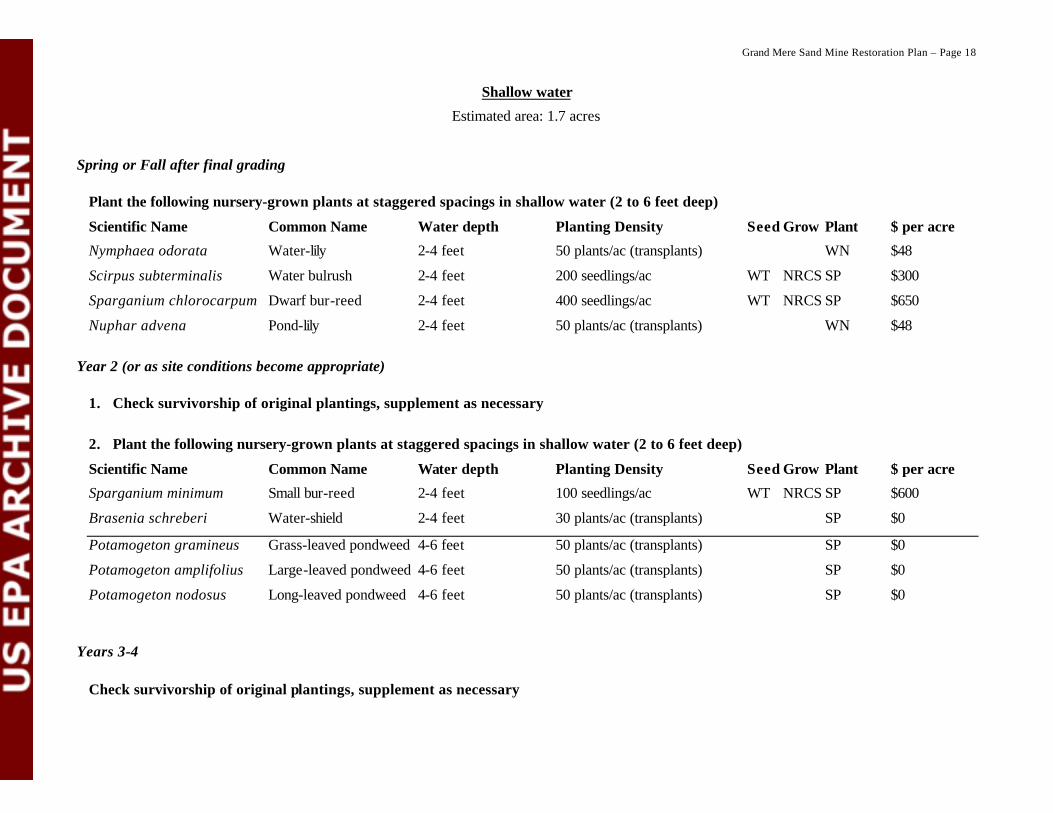
Shallow water
Estimated area: 1.7 acres
Spring or Fall after final grading
Plant the following nursery-grown plants at staggered spacings in shallow water (2 to 6 feet deep)
Scientific Name Common Name Water depth Planting Density Seed Grow Plant $ per acre
Nymphaea odorata Water-lily 2-4 feet 50 plants/ac (transplants) WN $48
Scirpus subterminalis Water bulrush 2-4 feet 200 seedlings/ac WT NRCS SP $300
Sparganium chlorocarpum Dwarf bur-reed 2-4 feet 400 seedlings/ac WT NRCS SP $650
Nuphar advena Pond-lily 2-4 feet 50 plants/ac (transplants) WN $48
Year 2 (or as site conditions become appropriate)
1. Check survivorship of original plantings, supplement as necessary
2. Plant the following nursery-grown plants at staggered spacings in shallow water (2 to 6 feet deep)
Scientific Name Common Name Water depth Planting Density Seed Grow Plant $ per acre
Sparganium minimum Small bur-reed 2-4 feet 100 seedlings/ac WT NRCS SP $600
Brasenia schreberi Water-shield 2-4 feet 30 plants/ac (transplants) SP $0
Potamogeton gramineus Grass-leaved pondweed 4-6 feet 50 plants/ac (transplants) SP $0
Potamogeton amplifolius Large-leaved pondweed 4-6 feet 50 plants/ac (transplants) SP $0
Potamogeton nodosus Long-leaved pondweed 4-6 feet 50 plants/ac (transplants) SP $0
Years 3-4
Check survivorship of original plantings, supplement as necessary

Grand Mere Sand Mine Restoration Plan – Page 19
Deep water
Estimated area: 4.0 acres
Spring or Fall after final grading
Plant the following nursery-grown plants at staggered spacings within the pond
Scientific Name Common Name Water depth Planting Density Seed Grow Plant $ per acre
Potamogeton amplifolius Large-leaved Pondweed 6-8 feet 20 plants/ac (transplants) SP $0
Vallisneria americana Wild-celery 6-10 feet 20 plants/ac (transplants) SP $0
Potamogeton gramineus Grass-leaved Pondweed 6-10 feet 20 plants/ac (transplants) SP $0
Potamogeton pectinatus Sago pondweed 6-10 feet 20 plants/ac (transplants) SP $0
Potamogeton zosteriformis Flat-stemmed Pondweed 6-10 feet 20 plants/ac (transplants) SP $0
Years 2-4
Check survivorship of original plantings, supplement as necessary

Grand Mere Sand Mine Restoration Plan – Page 20
Non-native Invasive Species Control Non-native invasive species control will be ongoing throughout the sand mine restoration project. To accomplish effective control, several techniques will be used.
1. Plants may be mechanically removed. Methods could include hand pulling, digging up, or cutting stems as appropriate for the species, number of plants, and specific location.
2. Grasses, forbs, and small shrubs or trees may be foliar sprayed with herbicide. The most environmentally-benign herbicide that is effective will be used. One effective method is to use 1½ % active ingredient glyphosate. Label instructions will always be read and followed.
3. Larger shrubs and trees may be cut. For those species known to resprout, cut stumps will be treated with herbicide. The most environmentally-benign herbicide that is effective will be used. One effective method is to treat cut stumps with 18 - 20½ % active ingredient glyphosate within 5-10 minutes after cutting. Label instructions will always be read and followed. Cut material may be left on site if it would likely be beneficial to the health of the site, otherwise it will be removed.
Monitoring As part of this restoration, it will be necessary to evaluate the success through biological monitoring. The intent is to do only enough monitoring as is necessary to determine success or failure of the project, not to perform a statistical scientific study. In light of this fact, we will monitor success through a combination of photo-monitoring and permanent plot sampling.
1. Photo-monitoring will serve as documentation of the gross structural composition and diversity of the plant community. This is a qualitative monitoring technique that will not provide any quantitative data, but will serve as documentation of progress made towards restoration. Three or more photo-monitoring points will be installed at strategic locations around the sand mine following final grading.
2. Permanent plot sampling will be used to quantitatively assess the success of restoration. Three or more permanent five-meter radius circular plots will be installed within each planting zone, except the shallow and deep water zones will be treated together for monitoring purposes. These plots will be sampled annually by creating a list of all living plant species in each plot. If an average of at least 60% of the originally planted species are surviving for three years after planting in each zone, the planting project will be considered a success. As stated before, restoration will be ongoing for many years beyond the scope of the above planting plan, during which time monitoring protocols will be re-evaluated.
Literature Cited Albert, D.A. 1995. Regional landscape ecosystems of Michigan, Minnesota, and Wisconsin: A working
classification. USDA For. Serv. Gen. Tech. Rep. NC-178. 250 pp. + map.
Comer, P.J., D.A. Albert, H.A. Wells, B.L. Hart, J.B. Raab, D.L. Price, D.M. Kashian, R.A. Corner, D.W.Schuen (Map Interpretation); M.B. Austin, T.R. Leibfreid, K.M. Korroch, L. Prange-Gregory, J.G. Spitzley, C.J. DeLain, L.J. Scrimger (Digital Map Production). 1995. Michigan’s presettlement vegetation, as interpreted from the General Land Office surveys 1816-1856. Michigan Natural Features Inventory, Lansing, MI. Digital Map.
Cowles, H.C. 1899. The ecological relations of the vegetation on the sand dunes of Lake Michigan. Bot. Gaz. 27: 95-117, 167-202, 281-308, 361-391.

Grand Mere Sand Mine Restoration Plan – Page 21
Grande Mere Association. 1973. Grande Mere: a very special place. Kalamazoo Nature Center, Kalamazoo, MI. 103 pp.
Michigan Department of Natural Resources. 1989. Atlas of critical dunes. MDNR, Land & Water Management Division, Lansing, MI. 72 pp.
Michigan Natural Features Inventory. 1989. Draft descriptions of Michigan natural community types. Available on the MNFI web site at http://www.dnr.state.mi.us/Wildlife/Heritage/Mnfi/default.htm 34 pp.
Reznicek, A.A. 1994. The disjunct coastal plain flora in the Great Lakes region. Biological Conservation 68: 203-215.
Tague, G.C. 1947. The post-glacial geology of the Grand Marais embayment, Berrien County, Michigan. Publication 45, Geological Series 38. Part I. Occasional Papers for 1946 on the Geology of Michigan. Michigan Department of Conservation, Geological Survey Division. 82 pp.
Wells, J.R. and P.W. Thompson. 1980. Vegetation of the Grand Mere lakes area. Unpublished report to the Michigan Department of Natural Resources. 76 pp.

Grand Mere Sand Mine Restoration Plan – Page 22
Appendix A: Planting Zones Map

Grand Mere Sand Mine Restoration Plan – Page 23
Appendix B: Global and State Element Ranking Criteria