sandown conservation area - isle of wight council conservation … · sandown conservation area ......
TRANSCRIPT

Directorate of Economy and Environment Director Stuart Love
Sandown Conservation Area Conservation Area Appraisal
Adopted April 2011
Conservation and Design Planning Services 01983 823552 [email protected]

Contents Conservation Area Boundary Map 2 Introduction 3 SANDOWN CONSERVATION AREA Location, Context and Setting 4 Historic Development of the Area 5 Archaeological Potential 10 SPATIAL ANALYSIS Character Areas 11 Key Views and Vistas 12 Character Areas and Key Views Map 13 CHARACTER ANALYSIS Character Area 1: The Resort Centre 14 Character Area 2: The Residential Area 22 CONDITION ANALYSIS Pressures, Problems and the Capacity for Change 28 Potential for Enhancements 29
General Guidance 31 Bibliography and References 34 Appendix A – Boundary Description 35

Sandown Conservation Area Appraisal 2
Figure 1: Sandown Conservation Area Boundary

Sandown Conservation Area Appraisal 3
Figure 2: Aerial photograph (2005) superimposed with conservation area boundary 1. Introduction 1.1 The Isle of Wight Council recognises that a quality built environment is an essential element in creating distinctive, enjoyable and successful places in which to live and work. Our EcoIsland Sustainable Community Strategy and Island Plan Core Strategy recognise that our historic environment assets attract investment and tourism, can provide a focus for successful regeneration and are highly valued by local communities. 1.2 As part of a rolling programme of conservation area designation and review, the Council designates parts of Sandown as a Conservation Area. Local Planning Authorities have a duty under The Planning (Listed Buildings and Conservation Areas) Act 1990 to designate as conservation areas any areas considered to be of special architectural or historic interest, the character or appearance of which it is desirable to conserve or enhance. 1.3 Legislation also makes provision for
schemes to enhance the area. Therefore, the inclusion of areas of potential allows for schemes to be put forward that will improve the area, in keeping with its own individual character, and to a high standard. Further policy guidance and information for land and property owners can be found on page 32 of this document. 1.4 Designation does not mean that development cannot take place within the conservation area or within its setting. Designation means that special consideration will be given to applications within the conservation area to ensure that any demolition is fully justified and that schemes (which are acceptable on all other planning grounds) are of a suitable design, are high quality and appropriate to the special character. This additional level of consideration allows the Council to insist upon the best possible standards of design within a conservation area, and equally to refuse development proposals on the grounds of poor design or quality.

Sandown Conservation Area Appraisal 4
Figure 3: An unusual Sandown resident, another attraction to entice and amuse visitors to the resort (J Dore Collection, IWCRO) 2. Sandown Conservation Area 2.1 The area under review falls within the area known locally as The Bay which defines a broad sandy bay between Culver and Dunnose chalk cliffs on the southeast coast. Sandown developed as a Victorian seaside resort which is renowned for its pier and almost 3 miles of award winning beaches and extensive visitor accommodation and as such is one of the most popular locations on the Island for summer visitors. It shares the Bay with its sister resort Shanklin further to the south, and Lake which together provide the majority of the Island’s tourist accommodation and visitor amenities. Sandown has not previously been designated as a conservation area. 3. Location, context and setting 3.1 The designated area is within the civil parish of Sandown which was formed in 1894 Sandown is a linear coastal resort established parallel to the water’s edge in the Victorian period. Encircling the main tourist area is a zone of residential settlement east
of the railway line (itself parallel to the coast) separated by Battery Gardens and The Heights Leisure centre from the village of Lake to the south west. Radiating northwest from the historic residential zone is a low lying hinterland, previously common land on which modern development such as Perowne Way, Sandown High School and the Golf Club have been established along the marshy edges of the River Yar valley. The geological context of the town is cretaceous Wealden formation deposits of sandstones and mudstones famous for their dinosaur remains. The Yar valley at this point is an inverted “Y” with the base cutting through the east west running chalk ridge at Yarbridge. The town has expanded almost in a diamond shape away from the alluvium and marsh in the river valley. 3.2 Designed by the Victorians as a coastal resort, the town has buffeted some of the effects of accessible foreign travel and an increase in disposable income which have realigned the tourism market from the 1960s onwards, to some extent by mass provision of affordable accommodation in the school

Sandown Conservation Area Appraisal 5
holidays from as early as 1930. The resort has been somewhat protected from the fates of some mainland counterparts which struggle to find new identities and economic bases. In Sandown, hotels and catering establishments continue to be the largest employment sector and a large portion of the town centre floor space is in leisure use with convenience retail and a few services dotted amongst the tourism accommodation. Some guest houses and hotels trade on their Victorian origins and period detail and their situation in terms of proximity to the beach, spacious grounds and sea views – all of which are inherited from the Victorian principles of designing this coastal resort and of great significance to local character. 3.3 The recent Town Centre Health Check Study (Halcrow 2009) reported that public perception of the town centre is poor and overall quality of the environment in the High Street scores very low. The High Street does not provide the high end gift shop or niche retailers seen elsewhere on the Island and functions only partially successfully as a service centre for the residential population although there is a number of independent and home grown brands in the High Street and vacancy rates appear low. The low number of multiple retailers (only Boots and Sainsburys at the time of writing) is perhaps due to the smaller size of the town as well as the lack of availability of modern, large retail space. Much of the built fabric is historic, double bay and two or three storey with the upper floors now utilized as low value rental accommodation. The Sandown Health Check concluded that “it is clear that investment and building maintenance has been lacking for some time. Hotels which back onto the High Street provide a major eyesore particularly as this is a gateway location. On the other side of the road, shop fronts appear neglected and convey a run down appearance which adds to the overall degradation of the environment. Ad hoc extensions litter the High Street and the visibility of satellite dishes on upper floors is intrusive on the streetscape” (Halcrow 2009). 3.4 At the time of the 1991 census, returns recorded a population of 5,299, in 2001 population figures for the parish reached 6,549. In the summer months, the population grows exponentially as the town services some of the Island’s 600,000 visitors. Whilst
the tourism sector has contracted across the Island, it remains worth over half a billion pounds per annum to the Island’s economy and future growth, particularly in short breaks, is predicted. Parts of the town are designated in the Core Strategy as Core Tourism Areas and therefore Sandown has a real opportunity to focus on increasing the quality of existing tourism destinations and supporting sustainable economic growth through high quality tourism. 4. Historic development of the area 4.1 The settlement pattern and growth of Sandown reflects its geology and topography in that there are few records of occupation in this area prior to reclamation works and draining of the levels. The coastal location and vulnerable stretches of sand provided the need for military defence in the post medieval period, and these same sandy beaches were the impetus for sustained growth as a Victorian coastal resort. The lower lying marshy areas edging the River Yar have remained a physical constraint on expansion until the late 20th century. 4.2 During the Hundred Years War (1337-1453), the Island suffered tremendously through the concerted attacks of the French along the southern coast of England. The Henrician Fort was built between 1537 and 1540 and formed part of Tudor defence scheme for the southern seaboard. By the mid 17th Century the walls were in a ruinous state because of sea damage and it was taken down by Sir John Oglander after 1631. The site is shown on 16th Century maps but they are not accurate enough to identify the location of the fort exactly. Henry VIII’s fort was replaced by a new fort which came into use in the late summer of 1636 and which now lies under the tennis courts at Sandham Grounds. 4.3 Early occupation in the Sandown area is not recorded in detail but may be suggested by early 13th century records which attest to the Oglander family’s interest in half an acre of land in the village of Sandham, followed by their purchase of a small holding at South Sandham in 1503, and then in 1559 the manor of North Sandham. It is suggested that the unpublished 1793 Ordnance Survey which depicts a small linear row settlement known as Sandham along what is now

Sandown Conservation Area Appraisal 6
Avenue Road and Fort Street may reflect an older established pattern related to and servicing the adjacent coastal forts through the years. The line of Carter Street and Fort Street can be seen. In the broader area, Black Pan near Lake, Sandham Farm and Adgestone are small farms scattered across rough open heath, common land and marsh and together with dispersed hamlets such as Upper Borthwood were connected by a network of roads. It is difficult to ascertain the foundation of this settlement pattern but the retention of key routes to the present day e.g. the triangle formed by the B3329 and the Broadway (formerly Broad Lane) amongst others and the 18th century farm buildings they originally served, is nonetheless a significant pattern sustained in the landscape. 4.4 Perhaps the earliest activity in the area of today’s High Street and Beachfield Road was a handful of buildings that included Sandham Cottage (see map above) the beloved “villakin” of Sir John Wilkes, a London based political agitator and former London Mayor who retired there in 1788. He laid out the surrounding grounds and erected cloth pavilions in order to take advantage of the commanding views over the bay and in so doing established Sandown as a desirable location among the London gentry of the 18th century. It is later recorded (by Bullar in his Historical and Picturesque Guide to the Isle of Wight, 1810) that Sandown Cottage became “one of those fancy places which the summer visitants to the Isle of Wight seldom omitted in their excursions; a circumstance highly acceptable to its master who refused admission to no-one”. 4.5 By the late 18th century seaside resorts had become popular in the UK, with many 18th century authors extolling the health giving properties of the seaside, particularly bathing in the sea and a mild climate. Great Yarmouth, Margate, Hastings and Worthing among others were established by this time therefore the resort development at Sandown was quite late, but by 1851 the local directory promoted the town as a “pleasant bathing place”, a “charming locality for marine villas and sea bathing” and also emphasised neatness, good inns, hotels and well-stocked shops along with the quality of the beach and fineness of prospect. 4.6 As with other seaside resorts, Sandown
was laid out principally in reference to the shoreline where the prospect and seascapes could be both enjoyed by the visitor and capitalised upon by the hotel developer, rather than emanating from the heart of the historic settlement. Through the 19th century, the beginnings of the coastal resort take shape as the settlement focus spreads from Sandham Street (Avenue Road/Fort Street) along the coast to Beachfield Road area. The Vectis Directory of 1839 lists only one inn keeper at Sandown, a small number of trades and no resident gentry (unlike Shanklin which has 19 tradespeople and Bembridge with its numerous gentry), but entries in the Tithe Apportionment, namely a Chapel on the Broad Lane (Broadway, now converted), the description of parcel 875a on the High Street as “building land”, and the Kings Head Inn on the High Street (now Kings House), could indicate momentum in the provision of resort like facilities. By 1836 regular coaches (the Surprise from Ryde and Felicity from Brading) would have been bringing guests and communications to the fledgling town (Parker, 1977). By 1855, the Directory lists 10 members of the gentry at properties such as Culver Lodge, Chester Lodge and Rose Cottage and other notable visitors to the town included the Crown Prince and Princess of Germany reputed to have stayed in what is now the Royal Pier Hotel. 4.7 The Sandown Board of Health was established in 1860 under the Local Government Act and this became the framework for proto-urban facilities with regards familiar local government concerns of water supply, sewage treatment, highways, lighting and economic prosperity. The Board was still heavily reliant on the good will and enterprise of individuals like Thomas Webster who was responsible for numerous improvements including the construction of the town’s first waterworks to treat sewage, the significance in which was to maintain the reputation of the town as the best bathing on the Island. It is presumed Baron Wm Oglander donated the land on which Christ Church (the first C of E building in Sandown built in 1845) and the National School are sited.

Sandown Conservation Area Appraisal 7
By the Ordnance Survey map of 1862, there is a seemingly proto-urban cluster alongside the coast. The then High Street (now Beachfield Road) runs from the National School and Christ’s Church on the junction with Broad Lane in the west past the Star and Garter Hotel and over a dozen coastal villas (many in formal gardens) to where it joins with Melville Terrace. 4.8 In the later 19th century wealthy visitors had the time and money to travel wherever they wished and railways strengthened the relationships between particular resorts and
inland towns and cities. Railways, employers and institutes organised excursions, particularly after the Bank Holidays Act in 1871. People retired or went to coastal towns to convalesce and to take advantage of much publicised health benefits. Sandown’s railway was being built at the time of the 1862 mapping and rapid growth followed its opening in 1864 as indicated by the mapping of two brickfields off Avenue Road and off Jeals Lane in 1862. The exponential growth of the town is borne out by the Census figures which record the resident population as 1,743 in 1861 and then rising to a massive 3,466 in 1871.
Figure 5: Extracts from the Ordnance Survey 1:25,000, published 1862.Note the extent of the new railway.

Sandown Conservation Area Appraisal 8
The number of boarding houses advertising in the Directories had risen from 6 in 1855 to 64 in 1875. 4.9 Sandown was relatively late in getting a pier compared to elsewhere but by 1879 it acted as a landing stage for passenger steamers to and from Cherbourg, Bournemouth, Swanage and Weymouth and which were so important to the growth of many coastal towns across the UK. Prior to the Ordnance Survey mapping in 1885 further complex projects are achieved including the construction of the esplanade (almost 0.8km in length) and the laying out and reorganisation of numerous roads. The Pier was lengthened
and access improved following the formation of a new company which included Richard Webster (later Lord Alverstone) and a new pavilion was opened in 1895. This is the second metamorphosis of the town following its re-centring from Avenue Road to Beachfield Road and is accompanied by a further phase of rapid growth west of the railway and Broad Lane as residential properties infilled Fitzroy and Leed Street, parts of St Johns Road and Station Avenue. 4.10 Further development concentrated along Winchester Park Road, Carter Street, Grove Road and Victoria Road.
Figure 6: Extracts from the Ordnance Survey 1:25,000, published 1898.

Sandown Conservation Area Appraisal 9
Figure 3: The seafront residences (including Guadaloupe Terrace) prior to the building of the Esplanade c. 1880 By the time of the 1909 edition, these areas have begun to be populated but the pace of development in the town inevitably slows during the early 20th century. After the war the Sandown Urban District Council set about updating the piers facilities and enhancing the town and a new pavilion was built in 1934. Paddle steamer pleasure cruises and numerous summer shows in the Pavilion continued the success of the Pier until it was requisitioned in World War Two. 4.11 Piers, winter gardens and facilities such as cinemas became the highlights of 20th century seaside architecture but there is a contemporaneous escalation of shops and amusement arcades along many seafronts which, as retailers quickly add small outlets onto hotels or extend the ground floor of dwelling houses to supply the seaside requisites of rock, buckets & spades and souvenirs, are less celebrated for their design. 4.12 As well as catering for growing numbers of visitors due to paid leave and increasing access to cheap transport, the resident populations of resorts were also increasing rapidly in the 1930s. Sections of the south coast mainland became a magnet for people seeking genteel retirement, and Sandown,
Shanklin and Lake also grew. Attracted by good transport links, the permanent resident population of Sandown increased to the point where the conurbation of ribbon development along new roads is comparable with mainland suburbia. From the 1940s onwards institutions such as Butlins and the establishment of holiday camps and bungalow towns met the demand for affordable accommodation during the school holidays. 4.13 The town prospered in the 1950s at the height of popularity of the British seaside holiday. In 1951, guides to the town promoted a 35 minute flight from London to Sandown Airport. Marion Lane records that during the summer there was a regular hourly service and in 1949 approximately 3,000 passengers flew to Sandown. Another direct route was established in 1957 by a local company to collect passengers from Portsmouth by motor launch, bypassing congestion at Ryde Pier and train station and arriving at Sandown Pier head in just 75 minutes (Lane, 1990). By 1950 the number of railway journeys nationwide had reduced as more people took holidays by car or coach. Tourist brochures of the time detail through services in association with Red Funnel available daily between London, Midlands, South West and the Isle of Wight
Sandown Conservation Area Appraisal 10
.
Red Funnel also teamed up with Associated Motorways (an operators association with established bus routes to Bristol, Cheltenham and South Wales), Yelloways of Rochdale and London Coastal Coaches Ltd to secure bookings for their daily 55 minute steam car ferry. 4.14 The popularity of numerous British seaside resorts continued until the 1970s when further availability of cheap and world wide travel and an increase in disposable income allowed for holidays abroad. 5. Archaeological Potential 5.1 The majority of the archaeological interest in the Sandown area relates to the military archaeology since the residential streets were populated on virgin arable land late into the 20th century. Most activity in
Sandown was due to the coastal forts which must have required a considerable military presence from as early as the 16th century. 5.2. In 1861, construction commenced at Sandown Battery (the Granite Fort at the end of Fort Street) since the 17th century fort had eroded and was dismantled. Together with Sandham Barracks Battery its sister fort, the Granite Fort was designed to protect the beach and Bay as part of Palmerston’s defence scheme for southern England. The Granite Fort was, according to Albin “the only fort of any consequence on the Island and is therefore kept in good condition and properly manned” (Albin, Companion to the Isle of Wight, 1802)). Sandown Barrack Battery was completed in 1863 to flank the beach and support the Granite Fort. The Royal Garrison Artillery would have been housed in the adjacent barracks (a block remains adjacent
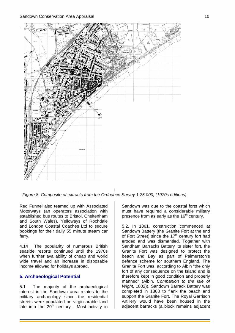
Figure 8: Composite of extracts from the Ordnance Survey 1:25,000, (1970s editions)

Sandown Conservation Area Appraisal 11
the Heights Health Centre). The remains of the red brick battery opposite are now incorporated in Battery Gardens and form an extension of the Cliff Path and a popular promenade providing important scenic views over the Bay. 5.3 During WWI many of the existing military defences were updated and new ones were constructed across the Island. Sandown (Granite) Fort was used as a practice battery and Sandown Barrack Battery was used as a practice site. 5.4 During WWII Sandown Battery was used to shelter one of the terminals for the PLUTO (Pipe Lines Under The Ocean) pipeline in 1943. Operation PLUTO (Pipe Lines Under The Ocean) was initiated to supply oil from Britain to the allies in France and involved the construction of pipelines across the Island to Shanklin Chine and Sandown Bay, which were the first operational PLUTO pipelines in WWII. The construction of the pipelines involved pump stations on the coast and disguised markers, running north-south following the line of the pipes, across the centre of the Island. Pump houses for PLUTO were also disguised at Brown’s Golf Course (now a listed building) and Granite Fort, Sandown. Pillboxes were located at Sandown Battery, Sandown Bay Holiday centre and on top of casement at Sandown Fort. During the war the pier was commandeered by the military and shortened in an effort to prevent it being used as a landing stage by enemy troops. Both Sandown and Shanklin suffered badly during the war with an estimated 1,500 buildings damaged or ruined (J. Jones, p112). SPATIAL ANALYSIS 6. Character Areas 6.1 The proposed Sandown Conservation Area is divided into 2 character areas within the wider settlement. 6.2 The boundary of the Resort Centre focuses on the key features at the heart of the Victorian Resort and includes the area which is now the commercial centre of the modern town. It encompasses the length of the Esplanade to the end of the promenade wall from where views over the chalets along
the green cliff edge, and across the Bay are found. The boundary runs up along Ferncliff Road but excludes properties fronting Beachfield Road since the character is weakened by poor post war design and infill development. The boundary crosses north to the include the High Street at the grouping of stuccoed 3 storey properties, finished in black and white (including Keats) and further back from the High Street, Albion Street, Union Road, Wilkes Lane and Town Lane which provide a strong but different character. 6.3 The boundary excludes much of George Street although there are some buildings of note including the Stone Cottage and no. 22, and also excludes Leed Street although there are particularly notable buildings at no 8/Claremont Hotel on Grafton/Leed Street, and the former Church. Grafton Street is also excluded but the Town Hall is worthy of mention (listed Grade II) and the chapel may be worthy of nomination for the Local List. There is similar grandeur and architectural detailing in the adjacent buildings around the Town Hall and their boundary features. 6.4 The Conservation Area designation includes the High Street and Esplanade, but excludes Culver Parade partly because this is outside of the extent of the esplanade construction project in the 1880s, perhaps due to the proximity of the Fort constraining expansion westwards and partly because the area becomes more open, with the seascape and natural environment providing the backdrop to single storey 20th century recreational facilities. The provision of these facilities on the eastern beach is important in design terms and for the character of the area, the vitality of the town and continues a long established pattern of the seaside resort, but they do not provide a strong built environment. 6.5 The Residential Area focuses on the earliest suburban streets which connect the Station in the west with the Esplanade. The first such street was Station Road, later renamed Station Avenue in recognition of the broad width and tree planting. There is an emphasis on quality and detailing in the public realm in this area which is not reflected equally in later streets west of Broadway and so these are not included. There has inevitably been some contraction and movement in the commercial locales and so

Sandown Conservation Area Appraisal 12
parts of the residential area, particularly on Station Avenue and St Johns Road may include the sites of former shops. 6.6 The only section of the Broadway to be included is around the Station Avenue junction, in order to include the earliest surviving stone church, one of the first buildings on Broadway. The former Methodist Chapel is now in residential use but is marked on the 1793 OS. Also this area is worthy of inclusion due to the quality detailing and rhythm of the boundary walls and the way in which these prominent buildings in corner plots have been made to address the road layout. Further along the Broadway and outside of the designated area is a similar junction with Winchester Park Road where again the plan form of the earlier properties in the town provides particularly strong character. 7. Key Views and Vistas 7.1 From numerous locations along the Esplanade, there are important long distance views to Culver Cliffs and Dunnose, which take in the natural chalk downs and the green cliff edge. Culver Cliffs can also be seen from elsewhere where the land rises e.g. Beachfield Road and the Broadway and this is important in reflecting the wider rural setting of the town. Views are also important across the Bay and out to sea. From the sea, the view was at one time very green and the greenery of the conservation area trees and gardens is important in balancing the urbanizing buildings and providing a small town feel. The gabled beach huts to the west of the Esplanade, as small scale temporary structures are important features to reinforce the seaside setting. CHARACTER ANALYSIS The following pages analyse the character of the Sandown Conservation Area as exhibited in the individual character areas.

Sandown Conservation Area Appraisal 13
Figure 9: Character areas map with views

Sandown Conservation Area Appraisal 14
Summary of Special Interest The welcoming, open esplanade is at the heart of the resort. The Pier has fulfilled an important role in enhancing access for tourists and providing entertainment for over a century. It marches out into the bright shiny seascape with its unique sounds of laughter and bird cries reflecting off the water. Bordered by tall hotels glowing with expanses of glass and bright white walls, the esplanade is conveniently linked through secret paths and short winding streets to the narrow High Street from which it is almost hidden. The deep overhangs, plan form and detailed quality decoration which survives most frequently in the upper storeys attest to an age of grandeur, popularity and distinction as a reputable Victorian coastal resort. The potential for restoration to revive the former glory from under a temporary coat of neglect is important to the significance of the area and its heritage value.
Sandown Conservation Area Appraisal 15
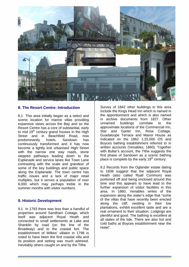
8. The Resort Centre: Introduction 8.1 This area initially began as a select and scenic location for marine villas providing expansive views across the Bay and so the Resort Centre has a core of substantial, early to mid 19th century grand houses in the High Street and in Beachfield Road, now predominantly hotels. Sandown has continuously transformed and it has now become a tightly knit urbanised High Street with the narrow one way roads, stone stepped pathways leading down to the Esplanade and service lanes like Town Lane contrasting with the scale and grandeur of some of the key buildings and public space along the Esplanade. The town centre has traffic issues and a lack of major retail multiples, but it serves a population of over 6,000 which may perhaps treble in the summer months with visitor numbers. 9. Historic Development 9.1 In 1793 there was less than a handful of properties around Sandham Cottage, which itself was adjacent Royal Heath and connected to small settlements at Lake and Shanklin by road (on the line of the Broadway) and to the coastal fort. The establishment of Wilkes’ villakin in 1798 is noted to have been the first coastal villa and its position and setting was much admired. Inevitably others caught on and by the Tithe
Survey of 1842 other buildings in this area include the Kings Head Inn which is named in the apportionment and which is also named in archive documents from 1827. Other unnamed buildings correlate to the approximate locations of the Commercial Inn, Star and Garter Inn, Rose Cottage, Guadaloupe Terrace and Manor House as indicated on the 1862 1:25,000 OS and Boyces bathing establishment referred to in written accounts (Venables, 1860). Together with Bullar’s account, the Tithe suggests the first phase of Sandown as a scenic bathing place is complete by the early 19th century. 9.2 Records from the Oglander estate dating to 1838 suggest that the adjacent Royal Heath (also called Ryall Common) was portioned off and being enclosed around this time and this appears to have lead to the further expansion of visitor facilities in this area. In 1860, Venables writes of the expansion along the water’s edge that “some of the villas that have recently been erected along the cliff, nestling in their low plantations, exhibit excellent taste and are a real ornament to their situation. Lodgings are plentiful and good. The bathing is excellent at all states of the tide. There are also hot and cold baths at Boyces establishment near the Hotel”.

Sandown Conservation Area Appraisal 16
Figure 12: The completed Esplanade opposite Guadaloupe Terrace (before its conversion in the 1930s to the Trouville Hotel). 9.3 Venables equally berates the pace of new developments in the town, particularly how Wilkes’ Villa (Sandham Cottage) has by this time been “swept away by the march of so-called improvement utterly regardless of historic interest”. The pace of development did not suit everyone but as the railway connected Sandown to the main port of Ryde in 1864, the average weekly number of passengers on the Ryde – Shanklin line was recorded as just under 7,000 in 1870. The residential areas were expanding to provide appropriate accommodation for the increasing visitor numbers and in 1875 12 lodging houses are recorded in the High Street. A handful of properties in the High Street are private residences, including Guadaloupe (now the Trouville Hotel). Within the Resort Centre there are a variety of trades listed including typical seaside shops selling gifts and toys and two photographers. The Directory also lists a dozen building trades, suggesting development and growth is ongoing. 9.4 The 1885 OS map records the construction of a long esplanade to provide a promenade. The combined esplanade, sea wall and steps to Pier Street are executed to very high quality incorporating tall stone piers
located at regular intervals along its length, benches, lantern gas lighting and a continuous iron railing bounding the promenade (as recorded by images from the Francis Frith collection). The route of the Esplanade crossed the lands of a handful of landowners and therefore this project may have been brought about by the Sandown Board of Health (from 1860), or alternatively it could represent a group of businessmen working together to promote their own financial interest and the dominance of Sandown as a quality coastal resort. By the time of the 1895 Kelly’s Directory, there are many less builders listed, instead financial rather than physical growth is indicated by an increase in fancy goods sellers, dress makers, a florist, and the establishment of a coffee house on Fitzroy Street and a mineral water manufacturer on Bridger Street. The Esplanade also incorporates a Bazaar. 9.5 A pier was begun in 1876 following a second Act of Parliament since the first Sandown Pier Company in the 1860s had failed to raise sufficient capital. Work commenced in 1876 but when the pier opened in 1879 it only extended some 360 feet due to lack of funds so only provided access for paddle steamers at certain tides.

Sandown Conservation Area Appraisal 17
Figure 13: Above left the Pier in c.1900, above right the PS Balmoral disembarking passengers at the pierhead pavilion in the early 1930s. Above the modernistic pierhead pavilion in 2010. 9.6 After further unsuccessful attempts to raise capital a new company was formed under the influence of Island MP Richard Webster (later Lord Alverstone) in 1887 to considerably extend the pier and make it available for steamers at all times. A new domed pavilion (erected at a cost of £12,000 at the pier head) and the lengthened pier re-opened at a grand opening ceremony in September 1895. 9.7 Lord Alverstone died in 1915 whilst a majority shareholder in the pier, therefore the then Sandown Urban District Council acquired the pier from his estate in 1918. The Council then set about updating the piers facilities and enhancing the town and a new pavilion was built at the pier entrance in 1933 to seat nearly 1,000. Paddle steamer pleasure cruises and numerous summer shows in both Pavilions continued the success of the Pier and its central role in the town’s growth until it was requisitioned in World War Two. 9.8 Records from the 1930s suggest that the economy in Sandown was thriving after the war. There were many and varied facilities for
the visitor besides the very successful action-packed pier with its two pavilions. There were two cinemas and both the Pavilion on the pier head and the modern Rivoli cinema on Station Avenue optimistically embraced the new modernistic style of architecture. There were 9 pubs, 7 garages, 3 photographers, 4 chemists, 7 cobblers, 9 clothes shops and over a dozen grocers amongst other commercial enterprises. Within the High Street alone there were 7 cafes (although some of these were attached to a bakers or fishmongers but there were also other cafes located off the High Street (Woodford, 1995)). The Arcade on the esplanade – a typically seaside feature of a row of shops and the Blue Lagoon Pool were 1930s developments which along with Bandstand (and continued regular concerts by the Sandown Band) provided still more entertainments for visitors. Typically with coastal resorts, light leisure uses are located on relatively undeveloped land often reclaimed and therefore unsuitable for substantial building, but appropriate as gardens, car parks or crazy golf and other amusements as occurred at Sandown with the canoe lake and the Eastern Gardens

Sandown Conservation Area Appraisal 18
Figure 14: A postcard image showing the Canoe Lake in the 1950s with Culver Cliff in the background. 9.9 In the 1950s Sandown High Street contained national brands including Boots chemists, Stead and Simpson shoes and W H Smiths stationers, along with numerous banks, grocers, a photographers, bookshops and furniture stores. Surveys in 1957 suggest there were almost no vacancies and that the town supported 5 cafes and 3 restaurants as well as numerous pubs and bars (www.invectis.co.uk). 1950s adverts detail through services ran by the Royal Blue Express Services in association with Red Funnel available daily between London, Midlands, South West and the Isle of Wight. Red Funnel also teamed up with Associated Motorways (an operators association with established bus routes to Bristol, Cheltenham and South Wales), Yelloways of Rochdale and London Coastal Coaches Ltd to secure bookings for their daily 55 minute steam car ferry. In this way the accessibility and popularity of British seaside holidays continued to increase until the 1970s when further availability of cheap and world wide travel and an increase in disposable income allowed for holidays abroad.
9.10 The Pier was partially reconstructed in 1970-73. The old pavilion was pulled down and the pier head end pavilion was used as a theatre, following the pier’s third opening ceremony on 22 July, 1973 by Earl Mountbatten. Piers, winter gardens and facilities such as theatres and cinemas were the highlights of 20th c seaside architecture. In the 1960s and 1970s, there is a concentration of shops and amusement arcades along the seafront which is predominantly non traditional architecture and the preserve of the visitor rather than the resident. The location and character of commerce impacts the design with small single outlet retailers on the ground floor of former houses or added onto hotels to cheaply supply the seaside requisites of rock, buckets and spades and souvenirs having an ad-hoc, temporary feel. The arrival of visitors en masse have therefore brought unprecedented changes to the character of existing streets where rows of grand villas have been turned into a focus of leisure pursuits, refreshment and evening entertainment.

Sandown Conservation Area Appraisal 19
Figure 15: Sandown High Street c.1910 10. Building Qualities, Materials and Local Details 10.1 On the north side of the High Street buildings were three storeys and stucco on brick. Built on a narrow plan a recessed door under a round headed arch with keystone gave access to living accommodation above the ground floor shop premises. On the south side, the larger plan of earlier grand houses such as Guadaloupe and Bay House already exist as private residences in the 1840s and benefit from front curtilages, walls and railings, and despite the amalgamation of several units under one ownership, the vertical emphasis provided by the traditional architecture, the retention of domestic curtilage features and the lack of signage provide the appearance of individual units. There are some detailed moulded door architraves and the domestic history of these buildings as seaside villas is evident e.g. Fair Lea which has a flat hood from a denticulated cornice. Most buildings in the High Street are now painted and so the natural stone of Kings House is very eye catching against this backdrop and its natural stonework and simplistic square plan design conveys some
of the historic value to this building first noted in the Oglander Collection papers in 1727. 10.2 Further west towards Pier Street are groups of red brick two and three storey properties on the south side, some of which incorporate canted bays at first floor level, interesting pediments and well preserved traditional decorative shopfronts. Despite being three storeys these much later groupings are of a reduced scale and mass but as the road narrows they provide some enclosure. It appears that the majority of other shops have been re-fronted –many unsympathetically- in the late 20th century. Historic shopfronts in Pier Street and Melville Street and elsewhere should be retained. 10.3 The expansive Ocean Hotel forms an end stop to York Road and occupies a quasi palace terrace (a terrace building given the appearance of one elaborate building usually with exaggerated decorative elements at each end, here two columns topped by Corinthian capitals have been applied either side of a more refined window detailing). In this eastern element of the Hotel property, the windows are in shallow reveals

Sandown Conservation Area Appraisal 20
Figure 16: Above left, Quality Regency style architecture surviving on the upper floors of the shops along High Street
Figure 17: Above right, The Ocean View Hotel and its valuable garden as seen from Esplanade
emphasised by a moulded surround with pediment above. A denticulated cornice decorates the broad overhanging eaves which is in the Italianate style and which is one of many elements which are repeated on the small Victorian mixed use properties on the north side. The western element of the hotel is set back from the street and appears altogether a more standard design exhibiting the canted bays at second storey level seen elsewhere. Like other properties in the eastern end of the High Street, the Ocean Hotel is double fronted with an imposing façade fronting both the High Street and the Esplanade. 10.4 Apart from the small gables of the Seagrove Hotel, in this area, the roofscape is most commonly shallow slate hipped roofs with red hip tiles which are hidden from below by broad eaves with exaggerated brackets and by parapets at the gables. Another common feature is the pediment. Some buildings appear to have been raised in height and some in the High Street are less successful since the introduction of masses of visible slates in the form of mansard roofs is jarring in the streetscene. 10.5 Of particular interest amongst the vast expanse of painted Regency style stucco on the High Street is the contrasting brickwork of number 85 and those flatted properties where original timber window and historic glass are retained. 10.6 Back from the High Street, roads like Albion Street, Union Road, Wilkes Lane and Town Lane provide a strong but different
character where a contrasting sense of enclosure stems from narrow or no pavements, no gardens, a lack of views of the sea and narrow plot sizes. These are densely packed areas where traces of the former commercial uses and trades sometimes remain – e.g. there is a short section called Albion Street which includes two warehouse or industrial premises, one of which has the ghost of a handwritten sign painted on the brickwork. It is clear from the ghosts of former uses in the wider built environment that the town supported a deeper commercial focus than the single street of present. In the 1930s records of commercial premises note almost 20 units along St John’s Road, a dozen on Wilkes Road. 10.7 The junction with the High St, Culver Parade and Victoria Road is a notable junction for the quality landmark buildings dominating the head of each of the 4 arms, including the first library building (yellow brick with Dutch roof and still in use as a “free” library). 10.8 Whilst some notable buildings are individually detailed and local styles discussed, inevitably there are many more buildings and styles which contribute to the character of the conservation area than can be mentioned here. 11. Public Realm 11.1 The condition and quality of the public realm is particularly important to any coastal resort which trades on its pleasing

Sandown Conservation Area Appraisal 21
appearance and ambience. Historic sources (such as early photographs) illustrate the high quality of the Esplanade and the extent of natural stone paving (now replaced with tarmac) through to Culver Parade is noted. As a testament to the high quality of the scheme when first constructed, the original sea wall, steps, boundary railing and original width of the esplanade survive intact although the piers have been reduced in height and this reduces their impact markedly. 11.2 A recent upgrade to the footway paving has occurred on the western Esplanade adjacent the Pier entrance on the site of the former bandstand. The general clutter in the public realm (of excess signage etc) has been reduced. This encourages better permeability through to the western esplanade and together with black historic style lantern heads has combined to give a pleasing improvement. 11.3 A clear benefit to the special character of the High St/Culver Parade/Victoria Road junction is the low level of traffic management measures, the pleasant effect of areas for planting combined with wide pavements and the availability of long views to the sea and inland. 12. Green Spaces and Biodiversity Value, Key Views and Vistas 12.1 Views from the Esplanade are terminated abruptly by the towering four storey hotels, the roofline of which is silhouetted against the sky. Palm trees are dotted within the hotel gardens and coastal plants top a few boundary walls and hanging baskets but in the main the main element of nature is provided by the sea and beach itself. Views along the Esplanade are open to the sea and the passing of cruise ships and so the “holiday feel” is maintained by visible activity the beach and pier. Longer views to the cliffs are important to reinforce the wider rural nature of the conservation area’s setting and the dramatic topography of the Island’s chalk cliffs. 12.2 Views along the High Street are channelled by the narrow street width and mostly three storey buildings. Where this opens out it is often punctuated by landmark or corner plot buildings such as the 20th century HSBC bank. Paths such as that west
of Kings House and cut throughs like Esplanade Road provide some visual linkage up the coastal slope but for the most part there is little inter-visibility with the High Street.

Sandown Conservation Area Appraisal 22
Summary of Special Interest Familiar rhythms of decorated homely gables and canted bays executed with contrasting precise brickwork and coloured stucco are juxtaposed in some instances with delicate wrought iron framed glass porches and locally distinctive robust gate pillars topped with ornamental urns. Whether in buff or red brick, the quality of detail and original execution deserves closer inspection throughout the residential area and numerous original timber paneled doors, tiled pathways, decorative terracotta pieces, boundary walls and timber sash windows combine to provide a strong pattern and are particularly important to the significance of the area. Interesting features on individual buildings may relate to former uses as shops or hotels and the street trees are a valuable remainder of the original scheme of planted avenues.

Sandown Conservation Area Appraisal 23
Figure 10: Features of St John’s Avenue (top) and xxxx (bottom)
13. The Residential Area: Introduction 13.1 Much of this area evolved at the point of the most rapid growth of the town. From the Station in the west, streets were laid out rather formally on an irregular grid pattern reaching towards the sea which at points reflects the boundaries of the former arable fields. As a coastal resort dependant upon visitors, the appearance and attention to detail in the public realm and built environment was especially important, and consequently there are particularly fine examples of period houses in this area. The consistency and integrity of the repeated boundary walls, gate pillars, gabled roof peaks and well proportioned sash windows in the Residential Area give a strong sense of rhythm and familiarity. The area also includes traces of numerous facilities essential to attract and amuse visitors including chapels, corner shops and a cinema. Some streets were planted with trees as broad avenues and these are significant in adding value to the quality and amenity of these streets. 14. Historic Development 14.1 There are early buildings on the 1862 OS which correlate with positions on the 1842 Tithe Survey including Caroline House (Later Culver Lodge, Victoria Road now demolished), but much of this area was not developed until the 1860s and 1870s and the coming of the railway. The railway connected Sandown to the main port of Ryde and to
Shanklin in 1864. Sandown station originally was a junction station and connected to Merstone, Newport and Cowes until those services were withdrawn in the mid 20th century. In 1870, the average weekly number of passengers on the Ryde – Shanklin line is recorded as just under 7,000. The Station was extended in 1881 when a refreshment room was built (Parker, 1977). 14.2 The 1875 directory lists approximately 100 private residences across the town compared with only 20 in 1855 and the population records show a rapid increase overall. A handful of residential properties are already established on the newly built Station Road, including Kennington Villa on the junction with the Broadway. The earliest residences were established along the High Street with views out to sea such as Guadaloupe and Rose Cottage, but as the town grew these quickly became exploited commercially for their prime position and the residential area contracted to this less prime situation away from the Esplanade. The 1895 Directory lists 13 apartments on Station Road for the visitor with numerous local shops including a general store and post office at the junction with Broadway, Tea dealer and refreshment seller to meet their needs. The number of private residences on Station Road reduces and this change in character is no doubt related to the opportunities presented by passing trade – of railway passengers passing through to the beach.

Sandown Conservation Area Appraisal 24
Figure 17: Early 20th century photograph of The Railway Hotel and adjacent buildings. Note the balustrade of the building opposite. (J Dore Collection, IWCRO) 14.3 Opposite the station is a former hotel with its corner entrance facing the station, variously called the Nottingham Castle Hotel and The Railway on historic maps. This lies in a prime position to offer not only accommodation but refreshments to travelers which were not available at the station until an extension provided a refreshment room in 1881. It was one of the earliest buildings on Station Road and is present on the 1862 OS. The adjacent land once occupied by station coal-yards is now a housing estate and the former Railway hotel a residential dwelling. 14.4 The stone church of St John the Evangelist was built in 1880/1 on the corner of St. John's Road to seat over 600 people. Some twenty years earlier St John’s Road was much shorter (up to Leed street on the 1862 OS) and had a commercial element at its junction with the High Street (then Bridger Street). By the 1909 map, St Johns extends to Carter Street, outside of the conservation area, but it is not built out beyond Victoria Road.
15. Building Qualities, Materials and Local Details 15.1 Some notable buildings are individually detailed below and local styles discussed, however inevitably there are many more buildings and styles which contribute to the character of the conservation area than can be mentioned here. 15.2 The architecture and detailing of Station Road very much reflects the growth of the town in relation to the establishment of the railway. Of particular note are the buildings adjacent to the Station including the terrace which has lost its balustrade and the former hotel with its corner entrance facing the station (see above). The Avenue was originally built out in a series of plots and therefore the terrace which occupies a consistent building line is a particularly notable feature. It is also stuccoed with a pediment and shallow roof so very different in character to the majority of properties along Station Road. Along with a similar crescent shaped terrace on Station Lane it is familiar as early Victorian seaside architecture as

Sandown Conservation Area Appraisal 25
Figure 18: St Johns Road with copper beech and plane trees seen elsewhere. Both terraces appear from the map to have been piecemeal additions rather than built out contemporaneously. 15.3 The Avenue was not designed as the residential suburb that it is now perceived to be and so vestiges of previous uses, quality detailing and prestigious hotels remain. Quality detailing is shown, for example, by the pair of properties on the corner plot of Station Rd and Fitzroy Street by which point the plan form has become narrower with plots more tightly knit. After Fitzroy Street, the avenue continues east into the heart of the town opening up again with well detailed small semi detached villas in a tree lined avenue. It terminates at Albert Road which picks up on the pattern of red brick semis at this point and echoes the with high quality detailing. 15.4 St Johns Road grew in stages as did most streets in Sandown and its buildings reflect this with older houses executed in stucco, associating them with the nearby High Street properties. The stone church of St John the Evangelist was built in the Early English style in 1880/1 by the C Luck on the
corner of St. John's Road. It has tall lancet windows and a 5 bay nave and seats over 600 people, and as such is one of the largest buildings in Sandown. 15.5 Plots gradually became infilled, mainly with residences although other chapels were built in and around this character area. Of note is the Art Deco cinema, the Kursall. 15.6 The only section of the Broadway to be included is around the Station Avenue junction, to incorporate the first post office and earliest surviving stone church which itself is one of the first buildings on Broadway. The former primitive Methodist Chapel is now in residential use but is marked on the 1793 Ordnance Survey map. Also this area is worthy of inclusion due to the quality detailing and rhythm of the boundary walls and the way in which these prominent buildings in corner plots have been made to address the road layout. Further along the Broadway and outside of the designated area is a similar junction with Winchester Park Road where again the plan form of the earlier properties in the town provides particularly strong character.
Sandown Conservation Area Appraisal 26
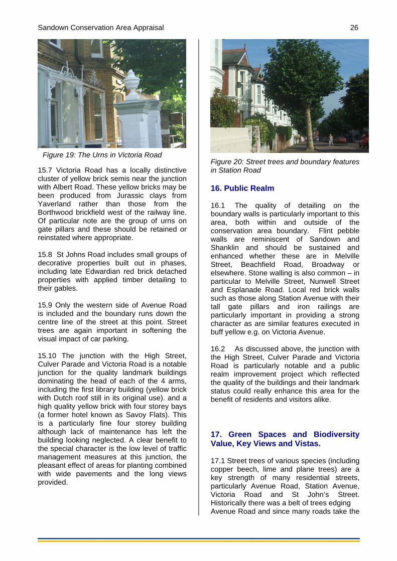
Figure 19: The Urns in Victoria Road
15.7 Victoria Road has a locally distinctive cluster of yellow brick semis near the junction with Albert Road. These yellow bricks may be been produced from Jurassic clays from Yaverland rather than those from the Borthwood brickfield west of the railway line. Of particular note are the group of urns on gate pillars and these should be retained or reinstated where appropriate. 15.8 St Johns Road includes small groups of decorative properties built out in phases, including late Edwardian red brick detached properties with applied timber detailing to their gables. 15.9 Only the western side of Avenue Road is included and the boundary runs down the centre line of the street at this point. Street trees are again important in softening the visual impact of car parking. 15.10 The junction with the High Street, Culver Parade and Victoria Road is a notable junction for the quality landmark buildings dominating the head of each of the 4 arms, including the first library building (yellow brick with Dutch roof still in its original use). and a high quality yellow brick with four storey bays (a former hotel known as Savoy Flats). This is a particularly fine four storey building although lack of maintenance has left the building looking neglected. A clear benefit to the special character is the low level of traffic management measures at this junction, the pleasant effect of areas for planting combined with wide pavements and the long views provided.
Figure 20: Street trees and boundary features in Station Road 16. Public Realm 16.1 The quality of detailing on the boundary walls is particularly important to this area, both within and outside of the conservation area boundary. Flint pebble walls are reminiscent of Sandown and Shanklin and should be sustained and enhanced whether these are in Melville Street, Beachfield Road, Broadway or elsewhere. Stone walling is also common – in particular to Melville Street, Nunwell Street and Esplanade Road. Local red brick walls such as those along Station Avenue with their tall gate pillars and iron railings are particularly important in providing a strong character as are similar features executed in buff yellow e.g. on Victoria Avenue. 16.2 As discussed above, the junction with the High Street, Culver Parade and Victoria Road is particularly notable and a public realm improvement project which reflected the quality of the buildings and their landmark status could really enhance this area for the benefit of residents and visitors alike. 17. Green Spaces and Biodiversity Value, Key Views and Vistas. 17.1 Street trees of various species (including copper beech, lime and plane trees) are a key strength of many residential streets, particularly Avenue Road, Station Avenue, Victoria Road and St John’s Street. Historically there was a belt of trees edging Avenue Road and since many roads take the

Sandown Conservation Area Appraisal 27
line of former field boundaries, ancient trees may have influenced the use of trees, but overall most of the roads were conscientiously designed and planted as avenues for the benefit of visitors and to increase the attractiveness of the resort’s public realm. Their amenity value remains high as they frame the highway and encourage long distance views along the street (typically terminated by a building on a junction such as a chapel). Street trees also add to the habitat provided by urban gardens.

Sandown Conservation Area Appraisal 28
CONDITION ANALYSIS Pressures, Problems and the Capacity for Change P.1 There are socio-economic factors, and issues regarding business confidence and the profile of the town. A recent Town Centre Health Check study identified the following as baseline issues: “The most fundamental challenge for the Isle of Wight is sustaining its economy with particularly focus on the tourist industry. In the last decade, visitor numbers to the Island have fluctuated considerably which should be of paramount concern for an economy that depends heavily on this sector. While visitor numbers have been on the increase over the last five years, sustaining growth must be a priority. For the majority of towns in this study, there is a definite link between tourism and the success of the town centre. Retail and leisure uses rely heavily on the tourist pound and this highlights the importance of maintaining and improving its centres. For this reason, maintaining their attractiveness and accessibility to tourists is important. Simple physical improvements such as good signage, maintaining shop fronts, attractive lighting and street furniture, controlling litter and graffiti, etc. not only contribute to town centre vitality and viability but also make a location more inviting to tourists.” (Halcrow 2009) P2. There is notable poor design to most hotel extensions. Many are flat roofed, visually intrusive and made of contrasting, less robust materials. There is capacity in many historic buildings to meet requirements for new facilities and to upgrade, but the re-organisation of facilities needs to be undertaken in a manner which sustains and enhances the special character of the conservation area rather than by retaining or adding small-scale, lowcost, ad-hoc extensions. P3. Related in part to the use of many buildings as guest accommodation, there are large numbers of problem car parking areas which are intrusive in the public realm and allow the car to dominate the streetscape. Where they consist of concrete aprons and have involved the loss of important boundary features and valued front gardens, parking
areas will have a negative impact on the street scene. P4. There is a gradual demise of street trees. One pressure to their survival is car use. A further problem is that they can cause uneven paving where they have not been planted in the appropriate manner. P5. Within the broader area there are flooding and coastal protection issues, particularly related to Culver Parade and the Yaverland area which are outside of the designated conservation area boundary. This will involve possible realignment of the flood defences as proposed by the draft SMP2. P6. As detailed in the Bay Area AAP, both the need to maintain a high quality tourism offer, and the concentration of effort in this core tourism area to continue to provide tourist accommodation are powerful forces for change. The area has also been designated a key regeneration area on the Island. P7. The influx of tourists in high season causes localised traffic problems and pressures on basic services (drainage etc). P8 There is a gradual loss of architectural integrity and quality due to poor awareness of architectural quality, low levels of maintenance and the use of inappropriate materials. The Town Centre Health Check suggests that priorities are public realm and building improvements. “In particular the quality of street frontages along the northern section of High Street is very poor and it is clear that investment and building maintenance has been lacking for some time. Hotels which back onto the High Street provide a major eyesore particularly as this is a gateway location. On the other side of the road, shop fronts appear neglected and convey a run down appearance which adds to the overall degradation of the environment. Ad hoc extensions litter the High Street and the visibility of satellite dishes on upper floors is intrusive on the streetscape”. P9 The Health Check noted a need to increase the quality and range of the retail offer stating that there is a lack of national multiple stores in the town centre and few buildings with appropriate floorplates to attract larger retail outlets.

Sandown Conservation Area Appraisal 29
Potential for Enhancements E1. The Town Centres Health Check Study (Halcrow 2009) found that “The Esplanade promotes an attractive environment. Pavement and road upgrades are evident and the use of flower baskets and good quality of street furniture creates an attractive open space for visitors”. The esplanade is of a higher physical quality than the town centre and may provide the basis for streetscape and inward investment as well as the recent refurbishment project providing encouragement and an example as to what can be achieved. Outside of the PFI project, the Council will work in partnership to secure sensitive public realm enhancement schemes in the conservation area. We will work with the Parish Council to identify public realm improvements which will sustain the historic interest and local distinctiveness of the conservation area. E2. The Health Check records the arrival of the Sainsbury’s store in the town centre as an opportunity for retail growth that may attract other national multiples. E3. A business survey in Sandown identified the opportunity to market the town centre and put on events and activities that may attract more tourists and visitors. E4. A key opportunity for improvements will be the Council’s Highways PFI project involving renewal and like for like replacement across the Island from 2013 and to include road surfacing, street furniture, road signs and lighting. This is an opportunity to safeguard the local distinctiveness through improving the poor aesthetics of Sandown’s public realm, in particular the cluttered streetscape and mismatched surface finishes. Poorly sighted, mismatched or decrepit signs, bins, road markings and bollards should be removed. The provision of additional permanent footways, signage, columns and road markings will be resisted and the Council will continue to support the restriction of signage, road markings and traffic management in order to sustain the valued character. The general approach to all highways works throughout the conservation area will follow the less-is-more principle and as with any village centre, an audit of the public realm should be undertaken to inform decision
making. Detailed guidance is contained in the Council’s Guidance for Works on Highways and the Public Realm document. Existing limestone kerbs and historic surface finishes will be retained and carefully repaired. Where cost savings permit, natural or traditional materials will be sought, stretches of historic material re-laid and specific local designs replicated in order to sustain important local character. E5. Within the designated conservation area boundaries, the Council will apply stricter policies and tighter controls on all types of development, paying particular attention to the need to sustain and enhance the character of the conservation area in line with PPS5 and to consider its setting. E6. The LPA will support all efforts to remove and replace over bearing or non traditional signage and support traditional shopfronts, sensitive illumination where justified and the use of hand painted fascia signage. E7. In line with PPS5, the LPA will consider the harm to the conservation area caused by proposals which involve the loss of a commercial unit not only in terms of its significance in the street scene but also associated public disbenefits. In particular the conversion of the resort’s traditional shops and seaside facilities which underpin its identity will be resisted where this will involve harm to the conservation area either through the loss of a service of significance to the economy, traditions or land use pattern of the conservation area. E8. Where appropriate the LPA will work with owners and the Parish Council to improve the local environment and take action to address dis-amenity, unlawful development, inappropriate land uses and to secure improved maintenance of and investment in vacant land or buildings. E9. In order to sustain and enhance the character of the conservation area where it is at risk of detrimental impacts from small changes, residential dwellings may be subjected to an Article 4 direction to remove certain permitted development rights. Large properties may therefore require permission for subdivision. Article 4 directions will also cover smaller details such as window designs and the retention of appropriate period detail

Sandown Conservation Area Appraisal 30
in chimneys, roof lines, boundaries and doors on selected residential dwellings in the conservation area. E10. Where new designs are proposed in the Conservation Area or its setting, the LPA will seek to encourage ingenuity and quality in design, appropriate to its particular historic context. The need to sustain various characteristics such as the historic plan form, views, relationships between buildings and a site’s land use will be key considerations in determining applications within the designated area. Proposals which lack quality materials or applications which are poorly detailed will not be accepted. Key information on the external finishes, profiles and fenestration detailing will be sought as part of the application in order that the effect of a proposal on the character of the conservation area can be determined. E11. The following buildings are of local historic and architectural interest and should be nominated to the Review Panel for consideration for the Island’s Local List - Beachfield House, Beachfield Road - Pierhead Pavilion
- The Savoy Hotel, Victoria Avenue - Battery Gardens, The Broadway - 6 churches/chapels - Old Comical - Oceanview Hotel, High Street - Indian Takeaway and adjacent Chinese Restaurant, High Street - Library, High Street - Rivoli Cinema, Station Avenue - Ivy Cottage, 3 Hill Street - Grand Hotel - Los Altos
E12. The building stock is in essence of high quality although this can be disguised by a thin veneer of neglect in some properties. The high quality of much of the historic built environment presents an opportunity for heritage led sustainable regeneration. E13. The Bay area AAP will bring about change and the Council have declared strong support for proposals that increase the quality of the tourism offer in recognition of a need to invest in high quality tourism and maximise benefits of sustainable tourism to the benefit of the island’s economy as a whole. E14 Conservation area designation may raise
awareness of the heritage value, quality and historic interest in Sandown’s buildings and the importance of sustaining the character of a quality coastal resort and in so doing help to raise confidence and the profile of the town.
31
General Guidance In recognition of the fact that the historic environment makes a very real contribution to our quality of life and the quality of our places, the Government Statement on the Historic Environment for England, (DCMS, 2010) established this vision : That the value of the historic environment is recognised by all who have the power to shape it; that Government gives it proper recognition and that it is managed intelligently and in a way that fully realises its contribution to the economic, social and cultural life of the nation. The historic environment should be seen as a vital contributor to improving the quality of place, and quality of life, for all. By supplying a focus for civic activity and offering opportunities for learning and recreation the historic environment can also be the foundation for more engaged and active communities. At its most basic, in providing distinctive local features and a tangible link to the past, the historic environment is often central to local identity in both urban and rural areas. Conserving the historic environment resource for future generations also accords with the principles of sustainable development. These wider objectives for the historic environment are reflected in Planning Policy Statement 1: Delivering Sustainable Development, (ODPM 2005) which says that, … planning should facilitate and promote sustainable and inclusive patterns of urban and rural development by [amongst other things] protecting and enhancing the natural and historic environment, the quality and character of countryside, and existing communities. The Council appreciate that our historic built environment is an essential element in creating distinctive, enjoyable and successful places in which to live and work. Our Eco Island vision and Local Development Framework Core Strategy recognizes that our natural and built environment attracts investment and tourism, provides a focus for successful regeneration and is highly valued by Island communities. Managing Change
It is acknowledged that change is inevitable. While it is right to provide protection and support for our past, this must be managed intelligently, with an appropriate balance of
priorities and an understanding of what could be gained or lost. “In shaping places, Government at all levels must give priority to creating high quality environments for those who use them, developing and implementing policies which seek to retain local distinctiveness and give due weight to the obligation to protect, enhance and promote the historic environment.” (The Government Statement on the Historic Environment for England, (DCMS, 2010)) Recent revisions to national planning policy guidance are informed by the known public benefits provided by the historic environment. Planning Policy Statement 5 (Planning for the Historic Environment, CLG, 2010) was introduced in March 2010 to replace PPG15 and PPG16. The PPS does not change existing legal framework for the designation of scheduled monuments, listed buildings, conservation areas etc and existing law sets out the basis on which the various consents or licenses may be required. The new PPS employs the term heritage asset in relation to conservation areas, listed buildings, locally listed features, historic landscapes, all sites on the Historic Environment Record (HER) including old buildings and archaeology, whether designated or not. PPS5 states that “once lost, heritage assets cannot be replaced and their loss has a cultural, environmental, economic and social impact. Significance can be harmed or lost through alteration or destruction of the heritage asset or development within its setting.” This approach governs how change is managed in a Conservation Area. Large scale change requires “clear and convincing justification” (HE9) for loss of significance affecting any designated asset, particularly with regards proposals incorporating substantial harm to a building or feature of significance within a Conservation Area. This justification needs to consider the various public benefits as outlined above and include marketing and other reasonable endeavors to secure the continued conservation of a heritage asset. PPS5 Policy HE7 defines the process of place-shaping as one where the desirability of enhancing or better revealing the significance of the conservation area is a key consideration, including, where appropriate, through sensitive development

32
of elements which do not contribute to the significance of the designated area. In these circumstances, LPA’s are encouraged to support design which is appropriate for its context and which makes a positive contribution to the appearance, character, quality and local distinctiveness of the historic environment and makes a positive contribution to economic vitality and sustainable communities. This additional level of consideration allows members and officers of the Council to insist upon the best possible standards of design for new developments within a conservation area or affecting its setting. Small scale changes are considered in Policy HE4 which specifically requires local authorities to consider whether the exercise of permitted development rights would undermine the aims for the historic environment, thereby supporting the use of Article 4 Directions in conservation areas. For all proposals in a conservation area or affecting its setting, Policy HE6 now requires that an authority only validate applications which provide sufficient information regarding a) the significance of any heritage asset and b) the proposed impact to it/them. Further detail on what information to provide is available at our website www.iwight.com/conservation or please call 01983 823552 in office hours. Applicants are also advised to contact the Archaeology Service [email protected] or phone 01983 823810 for access to the council’s Historic Environment Record (HER). Windows
The Council will always encourage the repair and refurbishment of original windows in Conservation Areas. The fabric of an original window i.e. timber, historic glass and fixtures and fittings are an important part of the historic interest of the window which itself forms an integral part of both the character and the appearance of a property. It is also important to note that the Council’s commitment to EcoIsland priorities includes measures to support sustainability and therefore the re-use of traditional buildings and the harnessing of their embodied energy is eminently sustainable. For the same reasons, it is also preferable to retain historic windows as opposed to installing new, industrially manufactured windows of plastic
materials such as UPVC. As such, the local planning authority supports the preservation of original timber or metal windows in buildings of historical or architectural value. When original timber or metal windows are beyond repair and this has been fully justified by the submission of a detailed specialist report, the preference will be for the like for like replacement of the decayed windows, incorporating the retained glazing and fixtures and fittings, where possible. Replacement with alternative windows, in terms of design or materials, will generally only be considered when the existing windows are of an inappropriate design, e.g. not contemporary with the architectural style of the building. Sensitive upgrading can be undertaken to improve the thermal performance of a historic building, most commonly this is through sash refurbishment, hidden draughtproofing, upgrading loft insulation and installing secondary glazing. Further ways to achieve a reduction in energy loss can be found in English Heritage’s advisory note Energy Conservation in Traditional Buildings (2008). Improvements to later or modern replacement windows will be sought where the units are poorly detailed, of inappropriate material and fail to enhance the character and qualities of the conservation area. Changes requiring planning permission
At the time of writing, ordinary unlisted dwellings do not require planning permission for the changing of windows. However, if a property contains flats or incorporates a commercial element, planning permission is likely to be required. When a conservation area is designated, alterations to Permitted Development Rights come into effect whether an Article 4 Direction is designated or not. Detailed advice should be obtained from the Council’s planning office or via the Planning Portal website. General advice regarding the most common issues within a conservation area is as follows. Please note this advice is correct at the time of writing. Extensions and alterations to dwellings

33
At the time of writing, the determination as to whether an extension requires planning permission is primarily determined by virtue of the location, ground coverage and dimensions of the alteration. The materials employed on any alteration or extension should be of similar appearance to the existing. Any roof extension or addition which would materially alter the shape of the roof (including dormers on any elevation) will require planning permission. Cladding any part of the exterior of a dwelling house within a conservation area (e.g. in artificial stone, timber of tiles) requires planning permission. Garages and outbuildings
At the time of writing, planning permission is usually required for garages and outbuldings, particularly if they would be situated on land forward of or between the side elevation of a dwelling and boundary of the curtilage of the dwellinghouse. Satellite dishes
At the time of writing, a satellite dish is not permitted on a chimney, wall or roof slope which faces onto and is visible from a highway or on a building which exceeds 15 metres in height. Solar panels and micro generation
At the time of writing, the erection of solar panels on a non listed building is permitted where the installation, so far as is practicable, is sited to minimise the effect on the external appearance of the building and the amenity of the area. Up to date advice relating to other types of proposals can be obtained from the Council’s planning office or via the Planning Portal website. Design of new development
PPS5 policies HE7, HE9 and HE10 require attention to the extent to which design contributes positively to the character, distinctiveness and significance of the historic environment. Irrespective of architectural style, a building will fit into its context if it observes the conventions of scale, height, building line, alignment, and materials that have been used previously in the conservation area. Further guidance can be found in Building in Context (CABE) and New
Development in Historic Areas (English Heritage). Archaeology
Most settlements contain archaeological evidence which helps to explain their origins and the way of life of former inhabitants. However, the historically diverse nature of settlement within a conservation area makes it difficult to define specific areas of archaeological potential. The likelihood of the occurrence of archaeological material is related specifically to previous land usage. Archaeological remains of any period could be found within a conservation area and therefore proposals to carry out works which include ground disturbance may require an archaeological evaluation or assessment. The results of a preliminary archaeological evaluation may indicate that the impact of the proposed development on archaeological remains is inappropriate or needs to be modified. Demolition of structures
At the time of writing, conservation area consent must be obtained for any proposal to totally demolish a building with a cubic content greater than 115 cubic metres or a structure such as a wall if it is higher than 1 metre adjacent a highway and 2 metres elsewhere. Where total loss of (or substantial harm to) the significance of a heritage asset is proposed, a case should be made on the grounds that the proposal is necessary to deliver substantial public benefits and that for example, no alternative location or design will achieve this appropriately.

34
Bibliography and References Basford, H. V. (1980) The Vectis Report: a survey of Isle of Wight Archaeology. Newport: Isle of Wight County Council. Basford, H. V Historic Parks and Gardens of the Isle of Wight Brinton, M. (1987). Farmhouses and Cottages of the Isle of Wight, Isle of Wight County Council - Cultural Services Department Brinton, R. (1994). Victorian Island, The Isle of Wight in Victorian Photographs. Dovecote Press: Dorset Brodie A and Winter, G. (2007). England’s Seaside Resorts English Heritage / Cambridge University Press Coles, K. Adlard and Sylvester-Bradley D. L. (1987) Creeks and Harbours of the Solent (10th edition) Nautical Books: London DCMS (2010) Planning for the Historic Environment (PPS5) Department of the Environment (1991). Planning (Listed Buildings and Conservation Areas) Act 1991 English Heritage (2006). Guidance on Conservation Area Appraisals English Heritage (2006). Guidance on the Management of Conservation Areas Isle of Wight Council. Historic Landscape Characterisation Jones, J. (2000) Castles to Cottages; the story of Isle of Wight Houses. Dovecote Press: Dorset
Kökeritz, H. (1940). The Place Names of the Isle of Wight (Nomina Germanica 9), Appleberg: Uppsala Lane, M (1990) Piers of the Isle of Wight Mynors, C. (2006). Listed Buildings, Conservation Areas and Monuments (4th Ed.), Sweet & Maxwell Page (1912) The Victoria County History of Hampshire - Volume 5 (p.215 - 217) Parker, A (1977) The story of Victorian Shanklin Isle of Wight: Shanklin Rotary Club. Lloyd, D. & Pevsner, N. (2006). Hampshire and the Isle of Wight, Penguin Books Ltd: Middlesex Post Office Directory, Hampshire County. Editions of 1855, 1875 and 1895 Woodford, C. R. (1995) My Sandown, My Island Maps Ordnance Survey: 1862 25 inch edition 1898 25 inch edition 1908 25 inch edition 1939 25 inch edition Acknowledgments Thanks to Richard Smout County Archivist

35
APPENDIX A – Boundary Description
Starting at the corner of Grove Road and St John’s Road head NW along Grove Road to end of the boundary of 73 St John’s Road
Continuing along the rear boundaries of properties 49 to 73 (odd) St John’s Road. At the rear of Througton Court turn NW along rear boundary of 79 Station Avenue. Continue along rear boundaries of 71 to 77 (odd) Station Avenue around the north
boundary of 58 St John’s Road. Cross over Fitzroy Street. between 45 and 47 Fitzroy Street NW to meet the corner of rear
boundary to 61a Station Avenue. Continuing NW direction to meet Broadway at north boundary of no. 60 Broadway. Cross over Broadway into Station Lane continuing along the centre of Station Lane to the
junction of Station Lane and Grove Road. Going around the north boundary on 1 Grove Road to meet the rear boundary of 19 Park
Mews follow rear boundaries of 7 to 19 Park Mews to a point between 1 Park Mews and 1 Station Road.
Turn NW along Park Mew to meet the railway line behind Sandown railway station turning SE between south end of station and Liamedos to join Elmbank Gardens.
Continues along Elmbank Gardens east turning between 2 Station Avenue and 4 Station Avenue along the rear boundaries of 6 to 14 Station Avenue to cross Hill Street.
Continuing eastwards between 1 Hill Street and Ardella Hill Street continue east along the rear boundaries of 18 to 30 Station Avenue.
Follow the south boundary of 21 Broadway crossing the road to meet Ashley Mews. Continue along Ashley Mews around the north boundary of 46 Broadway around the south
boundary of 44 Broadway. Continuing along the rear boundaries of 50 to 58 (even) Station Avenue turning north along
the eastern boundary of 58 Station Avenue following back edge of pavement to turn south along western boundary of 62 Station Road.
Follow the rear boundaries of 62 and 64 Station Avenue onto the south boundary of 41 Fitzroy Street.
Cross Fitzroy Street to follow the south boundary of 46 Fitzroy Street to a point where it meets the rear boundaries of 70 Station Avenue.
Continue along the rear boundaries of 70 to 80 (even) Station Avenue. Going around the rear boundaries of 84, 86 and 88 Station Avenue to meet the rear
boundary of 39 St John’s Road. Head south along the eastern boundary of 33 Leed Street. Crossing Leed Street follow the front boundaries of 36 to 24 (even) Leed Street. At the corner of George Street and Leed Street turn south continue along George Street to
the corner of Castle Mews. Head south along Castle Mew following rear boundaries of 6,7and 8 Benjamen Mews. Follow the boundary between 8 and 10 Melville Street turn west along the front boundaries
of 8 and 6 Melville Street Cross Melville Street to the west corner of 29 Beachfield Road follow the rear boundaries of
29 and 28 Beachfield Road. Crossing Beachfield Road to follow the boundary between 42 and 42a Beachfield Road to
meet Pier Passage. Head south along Pier Passage to meet the rear boundary of 40 Beachfield Road.
Continue along the rear boundary of 40 , 38 and 36 Beachfield Road continuing along the rear boundary of Sandon Court and onto the rear boundaries of 26 and 24 Beachfield Road.
Follow the north boundary of 1 Ferncliff Road heading south east along Ferncliff Road along the front boundaries of 3 and 5 Ferncliff Road.
At the South East corner of Ferncliff Gardens the boundary drops vertically down the cliff to meet and exclude Napoleons Landing on the Esplanade

36
At the slipway on the southern tip of the Esplanade the boundary extends to the low water mark going around the end of the pier pavilion to rejoin the shore at Avenue Slipway.
Continue along Avenue Slipway turning east along Culver Parade along the front boundary of 1 Culver Parade.
Follow the boundary between 1 Culver Parade around to the Public House on Avenue Road.
Turning north along the centre of Avenue Road to number 19 Avenue Road. Turn west between 19 and 21 Avenue Road to meet the rear boundary of 19 Avenue Road. Follow the rear boundaries of 19 to 13 (odd) Avenue Road along the back edge of
Burlington Road to meet the rear boundary of 4 Victoria Road. Turn NW along rear boundaries of 4 to 18 Victoria Road (even) around rear boundary of 20
Victoria Road to meet boundary of 30 Victoria Road . Continue along rear boundaries of Woodside apartments, 32 Victoria Road along the rear
boundaries of properties on north side of Victoria Road to meet rear boundary of 58 St John’s Road.
Follow the north boundary of 58 St Johns Road to meet the road. Turning south along St John’s Road to the starting point.