santa fe river watershed - new mexico environment ... · location: the santa fe river watershed is...
TRANSCRIPT
Prepared pursuant to the Clean Water Action Plan and Unified Assessment of New Mexico watersheds.
Santa Fe River Watershed
Restoration Action Strategy
(WRAS)
January 2002
Principal Author: Paige Grant, Santa Fe Watershed Association Maps prepared by: Dwight Chase, GIS Analyst, City of Santa Fe
ACKNOWLEDGEMENTS
The thorough, thoughtful review and editing by the Watershed Advisory Group and other participating members of the public listed in Appendix A, is gratefully acknowledged. Special thanks to: Shelley Cobau, Southwest Fluvial Systems, for her contribution of hydrologic findings and recommendations from the City of Santa Fe Arroyo de los Pinos Stormwater Management project; Neil Williams and Dale Lyons of Watershed West, for assistance with hydrologic graphics and general excellence as office neighbors; Janine Sieja for editing and helping to clean up the appendices. Dwight Chase’s work on the beautiful watershed maps that illustrate the WRAS was a crucial contribution to the project: many thanks to the City of Santa Fe Planning Department for the donation of his time. Funding for this WRAS was provided by Clean Water Act Section 319, distributed through the New Mexico Environment Department (NMED) Surface Water Quality Bureau (SWQB). Notwithstanding, any opinions expressed regarding goals and objectives of the WRAS are those of the principal author and the Watershed Advisory Group, and do not necessarily reflect the policies of the granting agencies. Any errors are the responsibility of the principal author, who can be reached at Santa Fe Watershed Association, PO Box 31160, Santa Fe, NM 87594-1160. This document can be found on the NMED website at the following address: www.nmenv.state.nm.us/swqb/Santa_Fe_WRAS-2002.pdf. The right to copy, excerpt, and quote from the document with appropriate attribution is freely granted. Paper copies are available for the cost of copying from NMED – SWQB, PO Box 26110, Santa Fe, NM 87502, attention Abraham Franklin.
Santa Fe River Watershed Restoration Action Strategy
Table of Contents
INTRODUCTION 1
SANTA FE RIVER WRAS:
1. PUBLIC OUTREACH 4
2. WATERSHED ASSESSMENT/INVENTORY 5 LOCATION 6 GEOHYDROLOGY 6 SURFACE WATER (Santa Fe River) 6 TOPOGRAPHY 15 SOILS 14 VEGETATION/PRECIPITATION 16 LAND USE 17
3. MONITORING/EVALUATION 18 4. WATER QUALITY PROBLEMS 26
5. WATER QUALITY GOALS 27
6. RECOMMENDED ACTIONS 29
7. FUNDING 32 REFERENCES CITED 35
APPENDIX A: WATERSHED ADVISORY GROUP MEMBERS and OTHER
PARTICIPANTS in WRAS PROCESS APPENDIX B: WATER QUANTITY and QUALITY MONITORING on the
SANTA FE RIVER APPENDIX C: CURRENT and RECENTLY COMPLETED WATERSHED
and RIVER RESTORATION PROJECTS in the SANTA FE RIVER WATERSHED
APPENDIX D: PROPOSED ACTIONS TO MEET WRAS GOALS

MAPS: SANTA FE RIVER WATERSHED (base map including stream gages) DRAINAGE AND FLOODPLAINS GEOLOGY SOILS VEGETATION AND PRECIPITATION LAND OWNERSHIP LAND USE (current) FUTURE LAND USE
1
Santa Fe River Watershed Restoration Action Strategy
(WRAS)
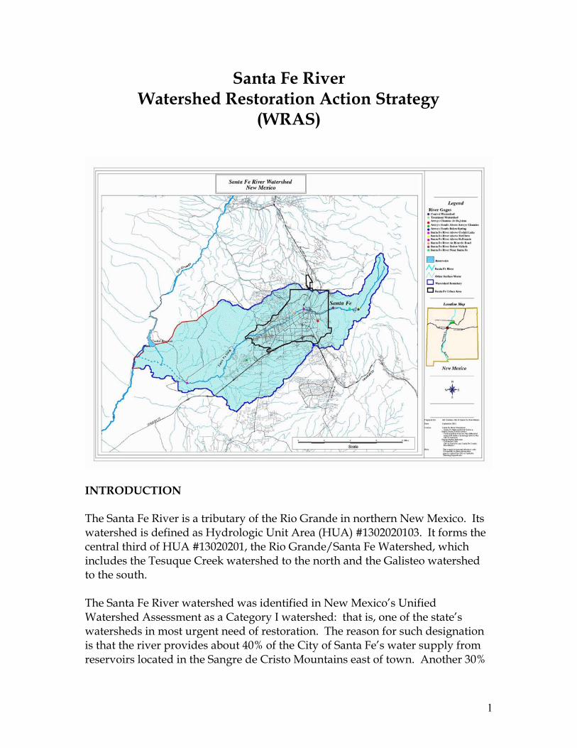
INTRODUCTION The Santa Fe River is a tributary of the Rio Grande in northern New Mexico. Its watershed is defined as Hydrologic Unit Area (HUA) #1302020103. It forms the central third of HUA #13020201, the Rio Grande/Santa Fe Watershed, which includes the Tesuque Creek watershed to the north and the Galisteo watershed to the south. The Santa Fe River watershed was identified in New Mexico’s Unified Watershed Assessment as a Category I watershed: that is, one of the state’s watersheds in most urgent need of restoration. The reason for such designation is that the river provides about 40% of the City of Santa Fe’s water supply from reservoirs located in the Sangre de Cristo Mountains east of town. Another 30%
2
of the City’s water comes from a group of wells mostly adjacent to the Santa Fe River west of St. Francis Drive. (The balance of the City’s water supply originates outside of the watershed.) Despite the dependence of a city of 62,203 (Census 2000) on the Santa Fe River, poor watershed and river management have resulted in almost complete dewatering of the river between the Alameda/Camino Cabra bridge and the City’s wastewater treatment plant. Water quality problems in the reach below the wastewater treatment plant have resulted in establishment of Total Maximum Daily Load (TMDL) standards for stream-bottom deposits, chlorine, dissolved oxygen and pH in that reach of the river, as a step toward attaining the designated uses of that reach as a marginal cold water fishery, a warm water fishery, and for livestock watering. The Clean Water Action Plan, initiated by the EPA and USDA, asks each state to prepare a Watershed Restoration Action Strategy (WRAS) for the priority watersheds identified in their Unified Assessment. The WRAS should list specific water quality problems; identify sources of contaminants causing those problems, and the relative contribution of the sources; provide a schedule of action items that should be undertaken to address those sources; and estimate the funding needs for those action items. The State of New Mexico has met this requirement for the Santa Fe River watershed by contracting with the Santa Fe Watershed Association to prepare a basic WRAS for the Santa Fe River watershed. We consider this WRAS to be a work-in-progress, and advise that it be updated every couple of years to reflect changing conditions. We hope that some of those changes will reflect improvements in watershed conditions brought about through the application of best management practices (BMPs) identified in the WRAS. The Santa Fe River WRAS was developed through the following process:
PUBLIC OUTREACH
Organize agencies and other stakeholders to form a Watershed Advisory Group (WAG) to develop the Santa Fe River WRAS. Meet with the WAG and conduct workshops with the general public, to discuss the WRAS and solicit input from as many interested parties as possible. WATERSHED ASSESSMENT/INVENTORY
Characterize the natural resource base and land uses in the watershed and the tools available (mapping, research, reports) to understand conditions and plan best management practices.
3
MONITORING /EVALUATION Generate plans for monitoring and data collection, incorporating existing agency and volunteer efforts. Summarize existing watershed/river restoration efforts. DEFINE SPECIFIC WATER QUALITY PROBLEMS and GOALS
Drawing on published and unpublished reports, professional experience and personal communication, develop a narrative of the roots of current problems, leading to proposals for their amelioration. Develop water quality goals and expected outcomes for the watershed.
DEFINE NECESSARY ACTIONS TO OBTAIN WATER QUALITY
GOALS
In concert with the WAG and in consideration of BMPs developed to date (i.e., the City of Santa Fe River Corridor Master Plan; the County’s Terrain Management regulations; the preferred alternative selected by the Forest Service from the Environmental Impact Statement of management options for the upper watershed; etc.) – develop a list of appropriate actions. IMPLEMENTATION SCHEDULE
This effectively serves as a ranking of projects in terms of relative importance to improvement of water quality conditions in the watershed.
FUNDING
Following from the implementation schedule, the WRAS considers funding requirements and potential sources, including in-kind match considerations, to carry out the full suite of projects envisioned for the watershed.
The following numbered sections follow the format in the checklist above and comprise the first edition of the Santa Fe Watershed Restoration Action Strategy.
4
Santa Fe River WRAS (first edition)
1. PUBLIC OUTREACH The Santa Fe community has a number of precedents in getting together to think about watershed issues. In the spring of 1998, the Santa Fe Watershed Association organized a Santa Fe River Tour for over 80 citizens and decision-makers. The objective of the tour was to highlight the condition of the river and its watershed, from the protected forest around the reservoirs, through the dewatered, degraded urban reach, to the La Cieneguilla area where the river comes back to life where it receives the discharge of treated effluent from the City’s wastewater treatment plant. Following the River Tour, State Land Commissioner Ray Powell approached the City and County of Santa Fe to establish a collaborative relationship for addressing problems with the Santa Fe River. In August of 1998, both local governments responded by adopting companion resolutions that called for City, County, Land Office and other partners to develop a strategy and program for rehabilitation of the Santa Fe River. These companion resolutions addressed the need for additional study of river conditions, full public participation by City and County residents in identifying goals for the Santa Fe River, identification of funding sources for river rehabilitation and development of a watershed plan to implement collaborative solutions. The City’s resolution was numbered 1998-57, and the committee that was pulled together to review implementation of the resolution directives in December of 1998 called itself the “Resolution 57 Committee”. The committee included representatives from the three agencies that passed the companion resolutions, plus the Santa Fe National Forest, the Acequia Madre Association, the Santa Fe Watershed Association, the Canyon Preservation Trust and private citizens from the villages of Agua Fria and La Cienega. The committee met monthly between January and May of 1999 and produced a report that summarized the reclamation efforts on the river, priority areas for river and watershed protection, data needs to provide an effective base for full watershed planning, and potential funding sources for further river and watershed protection efforts. In short, the Resolution 57 Committee constituted what in WRAS terms would be called a Watershed Advisory Group and conducted an effective first stage of the WRAS process. Consequently, when the Watershed Association began to plan to prepare the current WRAS, the original Resolution 57 Committee was contacted to serve as
5
the nucleus of a Watershed Advisory Group (WAG). Appendix A lists WAG members and members of the public who participated in the WRAS process. The WAG and public participants were asked to critique and comment on a draft WRAS, especially the following particulars: • Roles and responsibilities of involved stakeholders; • Long-term and short-term goals of the WRAS; • Action items for the years 2001 through 2003 addressing the short-term goals. The WAG determined the roles and responsibilities of the participants in the WRAS process to be: critique, edit and fact-check the draft WRAS prepared by the Santa Fe Watershed Association; assist in data gathering and brainstorming of best management practices; and work to make the actions of their agencies, organizations, or neighborhoods consistent with the WRAS. The WAG observed that there were numerous past and ongoing public participation processes in which interest and support had been expressed for restoration of the river. These processes include the City’s River Corridor Master Plan (1995); the “Southwest Sector” planning process (in progress); the Master Planning process for the State Land Office reach of the Santa Fe River (in progress); and the County’s River Corridor Master Plan (in progress). There is also the formal expression of support by the Agua Fria Village Association for the Agua Fria River Park proposal to the County Open Space program (1999). This evidence of public support for the Santa Fe River is adopted by reference into the WRAS. 2. WATERSHED ASSESSMENT / INVENTORY A watershed is that portion of a landscape where all rainfall and snowmelt flows toward a single outlet, typically a permanent or seasonal stream: in our case, the Santa Fe River. To illustrate the following discussion of the natural resource base and management of the Santa Fe River watershed, please refer to the map pocket in the hard copy of this report (in the electronic version, look for the file entitled “Watershed Maps”), for maps showing the location, configuration and topography of the Santa Fe River watershed, its geology, soils, vegetation, precipitation, drainage network, land ownership, and current and predicted future land use. LOCATION: The Santa Fe River watershed is a sub-basin of the Rio Grande, with its headwaters at Santa Fe Lake below Lake Peak in the Sangre de Cristo range. The mouth of the Santa Fe River is bifurcated, with a constructed channel
6
delivering occasional flow directly to Cochiti Reservoir, while the original Santa Fe River channel merges with the Rio Grande in a wetland below Cochiti Dam, created largely by seepage beneath the dam. The watershed of the Santa Fe River from its headwaters to its confluence with the Rio Grande is approximately 285 square miles, and the river course is approximately 46 miles long. GEOHYDROLOGY: The Sangre de Cristo mountains and foothills that form the east end of the watershed consist of preCambrian schist and gneiss with granite and amphibolite intrusions and many brecciated zones. Pennsylvanian limestone, shale and sandstone occur in a few outcrops on the west side of the preCambrian massif. Most of the watershed is characterized by the Quaternary/Tertiary Santa Fe Group (on the geology map, this unit is identified as “Quaternary/Tertiary Sediments”). The Santa Fe Group consists of alluvial fans, river channel deposits and interbedded volcanic rocks preserved in a complex of depressed fault blocks within the Rio Grande depression. The west side of the watershed came under the influence of the Quaternary lava flows that originated in the Valles Caldera of the Jemez Mountains: these rocks outcrop in the Santa Fe Canyon and form the piedmont of the Caja del Rio grazing lands. Complex Tertiary to Cretaceous intrusive rocks occur in the La Cienega area. Patches of Quaternary alluvium are found along the Santa Fe River, especially at its confluence with the Rio Grande. Groundwater occurs to a greater or lesser extent in all of these geologic units. The most significant aquifer is the Santa Fe Group, particularly its lower member, the Tesuque Formation. The upper member, the Ancha, is typically more conductive than the Tesuque but occurs above the water table in much of the Santa Fe watershed. Deeper groundwater is nearly continuous in the Tesuque Formation throughout the watershed area, to depths of 2000 feet or greater in some areas. This deep groundwater dates from the Ice Age and is recharged little if at all by present-day rainfall and snowmelt. Precipitation in the high mountains and flow in the Santa Fe River and its tributary arroyos seeps into and recharges shallow groundwater, which in some areas may be continuous with deeper groundwater. Volcanics often serve as a “floor” or channel to concentrate percolating groundwater and cause it to emerge as springflow. SURFACE WATER: Several perennial springs exist within the Santa Fe watershed: importantly, those that support irrigation in La Cienega and baseflow in the Santa Fe Canyon above La Bajada. The Santa Fe River and its tributary Cienega Creek are the only regularly flowing streams in the Santa Fe watershed.

7
SANTA FE RIVER: The Santa Fe River is an intermittent stream with two perennial reaches: (1) between its source at Santa Fe Lake and approximately the bridge at
Alameda/Camino Cabra (although, beginning in 1999, the reach from the bridge at Cerro Gordo/Upper Canyon to the Alameda/Cabra bridge has rarely flowed); and
(2) between the wastewater treatment plant and La Bajada. Flow records from Gauge 08316000 below McClure Reservoir indicate an annual total water yield that has ranged from a maximum of about 19,000 acre-feet in 1919, to a minimum of just over 1000 acre-feet in 1951 (Santa Fe National Forest, 1997?). Annual mean streamflow over most of the 20th century has ranged from a high of about 28 cubic feet per second (cfs) to a low of about 2 cfs (see graph below). Historic peak flows at the same gauge are reported to be 218 cfs for the 10-year return flow, and 2733 cfs for the 100-year peak (Santa Fe National Forest, 2001). Since a dam was constructed above this gauge in 1926 (Granite Point Dam, the predecessor to McClure Dam, which was completed in 1947), these flow rates do not represent natural conditions.
y = -0.0284x + 63.854
0102030
1910 1930 1950 1970 1990
Year
Stre
am F
low
(cfs
)
Figure 1: Annual mean stream flow at USGS Gage 08316000 below McClure Reservoir (“Santa Fe River near Santa Fe”)
Overall, water yields at the McClure gauge show a declining trend of about 20% from 1913 to 1999. This decline correlates with cessation of grazing and firewood removal in the upper watershed, and has been postulated to be a product of the tremendous increase in tree density that resulted from those management
8
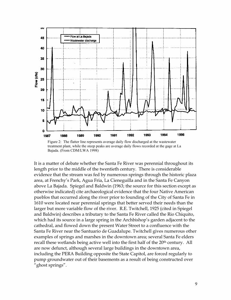
actions. The reduction in streamflow may be a combined result of (1) the increase in water use by up to 1400 trees per acre, compared with historical tree densities on the order of 100 trees per acre or less; and (2) snow lodging in the nested crowns of the trees and much of it evaporating from there, so that less snow accumulates on the ground to melt and run off in the spring (Santa Fe National Forest, 2001). Another factor that may be at work is a change in the pattern of rainfall. Luna Leopold (1951) analyzed rainfall records for Santa Fe from 1853 through 1949, and found that although total annual precipitation ranged around the same mean for that period, the rain arrived in events of different length and intensity. In the period between 1849 through 1895, there were fewer light rainfall events (in the range of 0.01 to 0.49 inches) and more heavy rainfall events (greater than 1.0 inch), than in the period from 1896 through 1939. Moderate rains of 0.50 to 0.99 inches were unchanged throughout the period studied. Leopold observed that smaller, more frequent rains are conducive to establishment of vegetation and larger rains produce more runoff and more erosion. Using his argument, the relatively large number of light rainfalls in the first three decades of the twentieth century may have helped to produce the vigorous regrowth of trees in the municipal watershed. It would be necessary to update Leopold’s analysis through the end of the 20th century to evaluate the importance of the size of rainfall events compared to tree density, as causing the decline in Santa Fe River flow. Evaporation from the reservoir above the gage has also been proposed as an explanation for reduced flows, but since the surface area of the reservoir has been relatively constant since 1947 while flows have continued their downward trend, this is not considered to be an important contributing factor. Through the urban reach, the Santa Fe River is typically a dry, dewatered channel except during snowmelt and storm runoff. CDM/LWA (1998) report that the water budget for the river at La Bajada consists of (1) effluent discharges from the City’s wastewater treatment plant averaging 9 cfs. This flow is adjusted by (2) seepage losses to the riverbed and banks over the four miles below the wastewater treatment plant. Over the next nine miles, (3) springs in the Santa Fe Canyon restore about 3 cfs to the river, with the result that the flow at the La Bajada gauge generally closely mimics the hydrograph of wastewater discharge, except for spikes caused by storm runoff. The storm peaks recorded at the La Bajada gauge give an indication of the impact of storm runoff in the rest of the system: storm flows are routinely one to two orders of magnitude greater than mean flow rates.
9
Figure 2: The flatter line represents average daily flow discharged at the wastewater treatment plant, while the steep peaks are average daily flows recorded at the gage at La Bajada. (From CDM/LWA 1998)
It is a matter of debate whether the Santa Fe River was perennial throughout its length prior to the middle of the twentieth century. There is considerable evidence that the stream was fed by numerous springs through the historic plaza area, at Frenchy’s Park, Agua Fria, La Cieneguilla and in the Santa Fe Canyon above La Bajada. Spiegel and Baldwin (1963; the source for this section except as otherwise indicated) cite archaeological evidence that the four Native American pueblos that occurred along the river prior to founding of the City of Santa Fe in 1610 were located near perennial springs that better served their needs than the larger but more variable flow of the river. R.E. Twitchell, 1925 (cited in Spiegel and Baldwin) describes a tributary to the Santa Fe River called the Rio Chiquito, which had its source in a large spring in the Archbishop’s garden adjacent to the cathedral, and flowed down the present Water Street to a confluence with the Santa Fe River near the Santuario de Guadalupe. Twitchell gives numerous other examples of springs and marshes in the downtown area; several Santa Fe elders recall these wetlands being active well into the first half of the 20th century. All are now defunct, although several large buildings in the downtown area, including the PERA Building opposite the State Capitol, are forced regularly to pump groundwater out of their basements as a result of being constructed over “ghost springs”.
10
Descriptions of Santa Fe by 17th, 18th, and 19th-century European visitors refer to the Santa Fe River as a trout stream, and Santa Feans now in their forties and younger recall fishing in (and skating on!) the river. According to the hydrographic survey of 1914, the flow of the river at that time was diverted by at least 38 ditches to irrigate 1,267 acres at an average application rate of 4.5 acre-feet per acre, for a total of 5,701 acre-feet. The furthest upstream irrigated fields were in the area now occupied by the City’s McClure Reservoir; the furthest downstream were farms in La Bajada that are still under acequia-fed irrigation. This amount of irrigation argues that there was generally sufficient flow in the river throughout that long reach, to warrant the effort to divert it. At the same time, as early as 1716 it was reported that the flow of the Santa Fe River was insufficient to irrigate all of the cultivated acreage in every year. Elder residents of Agua Fria speak of large cottonwoods and duck ponds in the riverbed that now carries only storm flows in its severely incised channel. Spiegel and Baldwin confirm these memories, noting “…partial ground-water barriers at Cieneguita (ed. note: now Frenchy’s Field) and Agua Fria at times cause the appearance of springs…” (p. 172). They further observe: “The early agricultural practices constituted an excellent form of artificial recharge of a part of the diverted water to the underlying aquifers because of ditch leakage and extensive water spreading. Despite the consumptive use by the irrigated fields, probably a larger proportion (possibly 30-50 percent) of the streamflow reached the zone of saturation after irrigation began than did under natural conditions.” All this suggests that flow in the Santa Fe River was probably interrupted from time to time between its spring-fed zones; but that under pre-development conditions the river had sufficient shallow groundwater to keep riparian vegetation alive and sufficient pools to serve as refugia for fish and obligate riparian wildlife, from the headwaters to La Bajada, even in the driest years. Below La Bajada, the evidence for springs and frequent flow is much sketchier than for the upstream section of the river. The regular dewatering of the Santa Fe River seems to have begun in the late 1940s, when water demand in the City began to approach the supply available from the reservoirs above town. Five wells were installed near the Santa Fe River; they supplied 68% of the City’s drinking water in 1951, and from that point forward served as an important supplemental water source, and occasionally (until the Buckman well field was brought on line in 1972) the major source for the City (CDM&LWA, 1998). In addition to the City’s riverside wells, there has been a tremendous proliferation of domestic and other permitted wells within the Santa Fe watershed. A search of the State Engineer Office well record data base for wells in the Santa Fe watershed, performed on August 16, 2001,
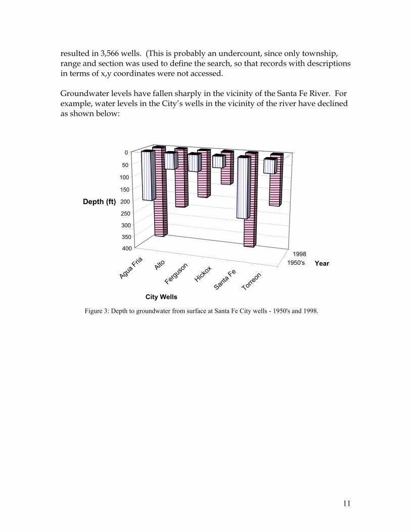
11
resulted in 3,566 wells. (This is probably an undercount, since only township, range and section was used to define the search, so that records with descriptions in terms of x,y coordinates were not accessed. Groundwater levels have fallen sharply in the vicinity of the Santa Fe River. For example, water levels in the City’s wells in the vicinity of the river have declined as shown below:
Agua
FriaAlto
Fergu
son
Hickox
Santa
Fe
Torre
on
1950's
1998
������������������������������������������������������������������������
������������������������������������������������������������������������������������������������������������
������������������������������������
������������������������������������������������������������������������
���������������������
��������������������������������������������������������
������������������������
������������������������������������������������
��������������������������������������������������������
����������������������������������������������������������������������������������������������������������������������������������
����������������������������
����������������������������������������������������������������������
����������������������������������������
������������������������������������������������������������������������
����������������
������������������������
������������
���������������������������
������
������������������
������������������������������������
������������������������������������������������������������������������������������������
���������
���������������������������
0
50
100
150
200
250
300
350
400
Depth (ft)
City Wells
Year
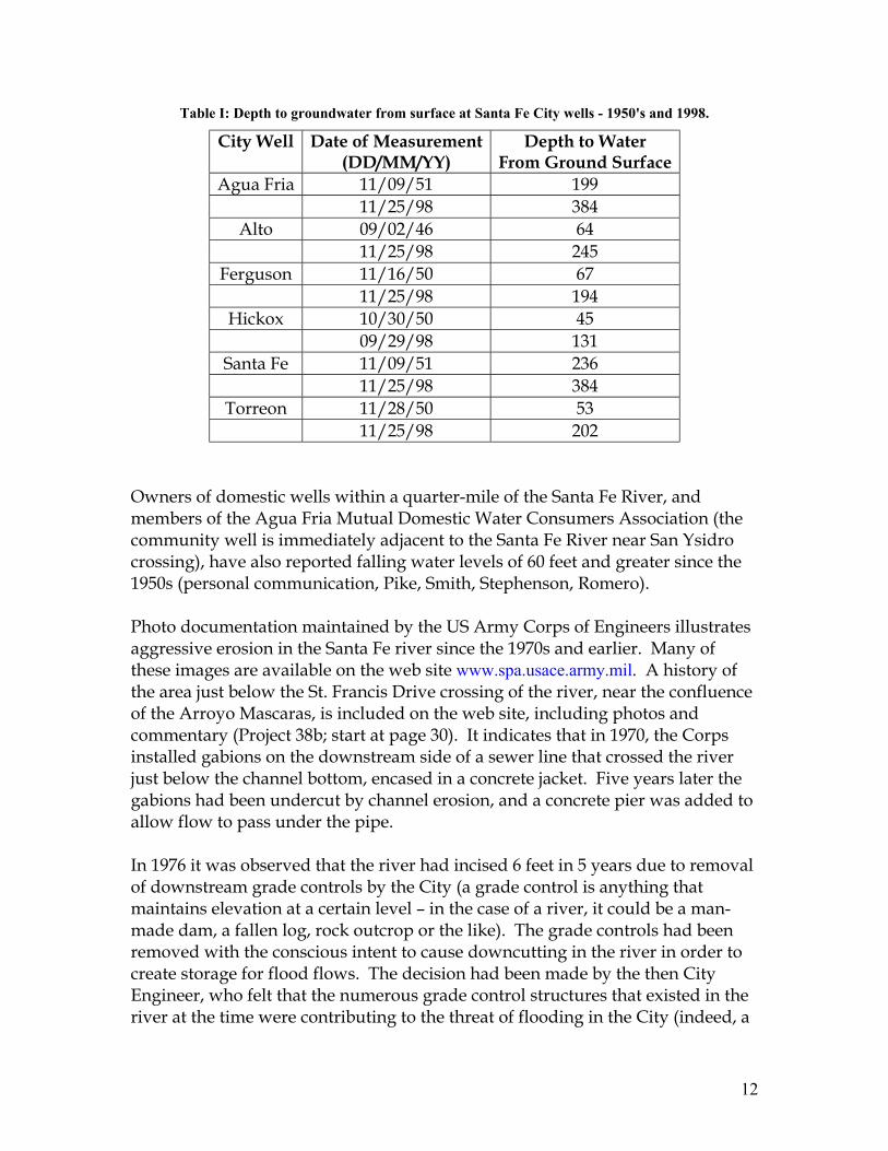
Figure 3: Depth to groundwater from surface at Santa Fe City wells - 1950's and 1998.
12
Table I: Depth to groundwater from surface at Santa Fe City wells - 1950's and 1998.
City Well Date of Measurement (DD/MM/YY)
Depth to Water From Ground Surface
Agua Fria 11/09/51 199 11/25/98 384
Alto 09/02/46 64 11/25/98 245
Ferguson 11/16/50 67 11/25/98 194
Hickox 10/30/50 45 09/29/98 131
Santa Fe 11/09/51 236 11/25/98 384
Torreon 11/28/50 53 11/25/98 202
Owners of domestic wells within a quarter-mile of the Santa Fe River, and members of the Agua Fria Mutual Domestic Water Consumers Association (the community well is immediately adjacent to the Santa Fe River near San Ysidro crossing), have also reported falling water levels of 60 feet and greater since the 1950s (personal communication, Pike, Smith, Stephenson, Romero). Photo documentation maintained by the US Army Corps of Engineers illustrates aggressive erosion in the Santa Fe river since the 1970s and earlier. Many of these images are available on the web site www.spa.usace.army.mil. A history of the area just below the St. Francis Drive crossing of the river, near the confluence of the Arroyo Mascaras, is included on the web site, including photos and commentary (Project 38b; start at page 30). It indicates that in 1970, the Corps installed gabions on the downstream side of a sewer line that crossed the river just below the channel bottom, encased in a concrete jacket. Five years later the gabions had been undercut by channel erosion, and a concrete pier was added to allow flow to pass under the pipe. In 1976 it was observed that the river had incised 6 feet in 5 years due to removal of downstream grade controls by the City (a grade control is anything that maintains elevation at a certain level – in the case of a river, it could be a man-made dam, a fallen log, rock outcrop or the like). The grade controls had been removed with the conscious intent to cause downcutting in the river in order to create storage for flood flows. The decision had been made by the then City Engineer, who felt that the numerous grade control structures that existed in the river at the time were contributing to the threat of flooding in the City (indeed, a

13
major flood in 1968 had floated cars on Water Street). The effect was certainly as intended: downcutting in the river continued to undercut the sewer pipe, which in 1977 was changed from clay to steel, but with no change in elevation. By 1982 the channel had cut 8 feet below the sewer line, which was suspended on pilings; by 1996, the pipe hung some 15 feet above the riverbed, suggesting an annual erosion rate of just under one foot of depth per year. This particular section of the river has been the focus of a City of Santa Fe river restoration project that has succeeded in aggrading the riverbed to approximately 8 feet below the same sewer pipe, which is now disguised by the first pedestrian bridge downstream of the St. Francis Drive crossing of the Santa Fe River. This particular case study illustrates that prior to the 1970s the river was full of grade control structures, presumably installed to check a process of downcutting that had already begun; and that the decision to remove those structures triggered a cycle of massive erosion and destabilizing of the river channel. The Santa Fe River bed has been extensively mined commercially for sand and gravel. The date of initiation of this practice has not been fixed, but State Highway Department aerial photographs from the 1960s reveal a ramp constructed at the end of Siler Road into the riverbed, with a “semi” descending the ramp apparently to pick up a load of aggregate. Sand and gravel operations preceded this snapshot by at least a decade and continue to the present time at one location in Agua Fria operated by M&R Sand and Gravel. At the time of writing, the County is in litigation to shut down that mine. The foregoing facts suggest a syndrome that may have produced the current dewatered, degraded conditions in the Santa Fe River. It seems that the groundwater drawdown created by heavy use of the City’s riverside wells beginning in 1951 caused a disconnection between the river and the shallow groundwater that formerly kept the river moist, if not flowing. (This situation was foreseen by Spiegel and Baldwin: “Long-continued pumping in Santa Fe will lower water levels in the Tesuque formation … and eventually decrease outflow …” (p. 178).) With the decline of the water table, the riparian vegetation that stabilized the riverbanks would have dried up and died. Consequently, when the river flowed again there was nothing to hold the soil, and the river began to erode and incise its channel. The intentional City policy of removing grade controls and allowing the channel to degrade in order to create a more convenient floodway, clearly had a significant effect on deepening the channel and destabilizing the banks. As the channel was cut deeper, it would have caused further draining of the water table as the riverbed incised through saturated zones. Sand and gravel mining in the bed of the river further exacerbated erosion and dewatering, as did the increasing development in the watershed (see Leopold, 1976), causing concentration of stormflows delivered into the river channel with tremendous erosive force.
14
A new complication in management of the Santa Fe River will be brought to bear when a City/County project (possibly also involving other partners) is developed to divert San Juan-Chama water from the Rio Grande at a location near the Buckman well field, and import it into the Santa Fe watershed. San Juan-Chama water is diverted from the headwaters of the San Juan River on the west side of the Continental Divide. It is brought to the east side of the Divide through a tunnel, and dropped into Heron Reservoir on the Chama River: hence “San Juan-Chama”. The water is delivered under contract to various municipalities and other entities in the Rio Grande watershed, by running it down the Chama and into the Rio Grande. Both Santa Fe and Albuquerque have for decades ostensibly been diverting a portion of their San Juan-Chama allotment through well fields adjacent to the river. However, falling water tables and other hydrologic evidence argue that very little of the San-Juan Chama flows have entered those wells. Instead, the release of San Juan-Chama water into the Rio Grande has helped to sustain flows in the “Great River”. At the time of preparation of the Santa Fe River WRAS, little detail was available on plans for diversion and treatment of the San Juan-Chama water, so the following list of potential effects on the Santa Fe River watershed is necessarily speculative:
San Juan-Chama water could be introduced into the Santa Fe River to recharge the wellfield tapped by the City’s riverside wells. As such, it would fall under the category of an Aquifer Storage and Recovery project: a state law was passed in 2000 to ensure that an entity could retain ownership of water so injected and subsequently withdrawn.
San Juan-Chama water would substitute for a portion of the water
currently withdrawn from the City ‘s riverside wells, reducing the pressure on the aquifer and potentially helping to restore the river/groundwater connection.
San-Juan-Chama water would become a component of the water that is
treated by the City’s wastewater treatment plant. A number of options have been discussed for reuse of the treated effluent including: delivery downstream of the WWTP, as in current practice; use for irrigation, construction or other non-potable purposes under contracts to specific entities, as in current practice; delivery of the treated effluent to other portions of the Santa Fe River to enhance flow and recharge, especially where this would benefit City wells; or delivery of the San Juan-Chama component of the treated effluent in such a way as to qualify under State Engineer permitting practice for “return flow credits” – which would allow
15
the diversion of up to twice the contracted amount of San Juan-Chama water. These options are not necessarily mutually exclusive, but it would be impossible to serve them all fully.
To summarize: The new San Juan-Chama diversion could help to sustain flow in the Santa Fe River, or it could simply bolster current use and development patterns, creating further build-out of the City and its suburbs for which still more water must eventually be sought.
TOPOGRAPHY: Ground surface elevations in the Santa Fe River watershed range from 12,408 feet above mean sea level at the top of Lake Peak to 5,220 feet at the Rio Grande. Slopes are extremely steep (often 40 degrees or greater) in the upper watershed from the ridgeline down to the zone where the preCambrian rocks of the Sangre de Cristos are overlapped by the deep sediments of the Santa Fe Group. Most of the rest of the watershed is gently rolling, except in the deeply incised basalt canyon of the Santa Fe River between La Cieneguilla and La Bajada, where the canyon walls are nearly vertical. SOILS: The soils in about the central half of the watershed are termed “Haplargids-Torriorthents-Calciorthids”. The Haplargids and Calciorthids do not have water available to mesophytic plants for long periods: they take up water slowly and most rainfall runs off. The Calciorthids are also characterized by a high lime content. The Torriorthents are limy soils on actively eroding slopes. A large area of mixed “Torriorthents and Rough Broken Land” occurs in the area that includes Gonzales Road, Estancia Primera, the developments along Old Taos Highway, Casa Solana and West Alameda. East of town the soils shift to Ustorthents-Cryoborolls. The Ustorthents are newly forming soils on recently exposed rock or sediments, under a cooler, moister climatic regime than the Torriorthents. The Cryoborolls are deep, dark, well-drained forest soils. At approximately McClure Reservoir this soil complex grades into a mix of Cryochrepts-Cryoboralfs, with a patch of three types of Boralfs in the upper canyon. Cryochrepts are light brown well-drained soils formed under cold, humid conditions, sometimes including permafrost; the Boralfs are typical soils of a conifer forest on steep slopes with a short growing season. The lower third of the watershed includes a unit of Torriorthents/Rough Broken Land near the confluence of the Santa Fe River and the Rio Grande. East of this unit the Haplargid-Torriorthent-Calciorthid unit reappears. It is separated from the same unit comprising the central half of the watershed by a complex of Torrifluvents-Calciorthids-Torriorthents. The Torrifluvent component of this
16
unit are brownish to reddish soils formed in water-deposited sediments on floodplains that are flooded infrequently. VEGETATION & PRECIPITATION: Average annual precipitation on the watershed ranges from 35 inches per year at Santa Fe Lake to 8 inches per year near the Rio Grande. The 12-inch isopleth crosses the watershed at its widest point. Only the northeasterly “thumb” of the watershed receives enough precipitation to produce a net annual gain over evapotranspiration losses, so this is the portion of the landscape that generates most of the streamflow and much of the recharge to groundwater. Vegetation types in the watershed are controlled by elevation, which in turn is the strongest local influence on temperature and precipitation. A few hundred acres at the highest elevation in the watershed are in alpine tundra. Downhill at treeline is the spruce-fir forest, which grades into mixed conifer and then dominantly Ponderosa pine forest at about 7500 feet. Fully 80% of the watershed is in pinon-juniper woodland/grassland. This is an ecosystem in transition from widely spaced trees in a grassy savannah, to a closed-canopy woodland with thin grass cover. This change is believed to have been brought about with the introduction of widespread grazing. Heavy grazing reduced the grass cover, which limited the fuel available for the periodic fires that once burned across the landscape, keeping the trees thinned out and stimulating grass growth. The reduction of grass cover on the erosive soils of the watershed is a cause of non-point-source pollution. The absence of riparian vegetation along most drainage ways including the Santa Fe River is a loss in terms of its contribution to channel stabilization, flood flow attenuation, wildlife habitat and recreational and aesthetic values. Where riparian vegetation is present, it is heavily infiltrated by invasive exotic species, especially tamarisk (also known as salt cedar) in the lower reaches below La Cieneguilla, Russian olive and Siberian elm through town and into the municipal watershed. Infestations of aggressive weeds have also been reported by the Santa Fe Botanic Garden in the Leonora Curtin wetlands project in La Cienega. The chief problem with non-native vegetation is that in out-competing native species, it reduces ecological niches and biodiversity. From the standpoint of restoration of the Santa Fe River and its tributary channels, exotics pose the additional problem that they tend to be less effective than willow at tolerating high flows without breaking, dislodging and causing downstream flooding problems. Also, evidence is beginning to emerge that water use by native vegetation is less than by exotic species. As one example, cottonwoods transpire at a much lower rate by night than by day, whereas tamarisk transpires almost constantly.

17
LAND USE: Beginning from the highest and most northerly point of the watershed, and moving southwesterly and downslope (areas approximate): Acreage Pecos Wilderness: most restrictive land use, no use of motorized equipment 7,000 Municipal watershed (exclusive of wilderness): managed to protect quality of City water supply – land ownership mostly Santa Fe National Forest, +/-10% City and private land 10,000 City of Santa Fe within Santa Fe River watershed: mixed density urban development, including 11,640 acres of open space (parks as well as public and private undeveloped land). Population 62,203 (2000 census). 22,991 Santa Fe County within Santa Fe River watershed: mixed density Development and open land. Population 87,700 inclusive of City population (BBER, 2001). 159,409 Caja del Rio grazing lands within Santa Fe River watershed: owner- Ship almost 50:50 BLM and Forest Service 27,368 Acequia-irrigated agricultural land in La Cienega and La Bajada 100 Cochiti Pueblo, grazing land and wetlands 20,181 Changes in land use within the Santa Fe watershed over the past century are illustrated by the following historic photographs paired with modern retakes of the same scene. Those changes include:
Dense regrowth of the forest in the municipal watershed.
Greatly increased numbers of pinon and juniper trees in what previously was a savannah marked with widely separated trees.
Decline in grazing in most of the watershed, both in areal extent and
intensity.
Tremendous increase in the area of urban and suburban development, while population density in the historically settled areas has typically decreased (a given block in the downtown area houses fewer people on

18
average than it did at the turn of the last century). Corresponding increase in impermeable surfaces – pavement, rooftops, and dirt roads --concentrating storm runoff and contributing to erosion in the watershed and within drainage channels.
Decline in agriculture.
Increase in water use.
Decline in streamflow, spring flows and, in some areas, ground water
levels.
Increase in population and in per capita use of all resources with the exception of grass and firewood. This factor can be demonstrated to have produced most of the above effects.
The paired photographs in the following pages (Figure 4-Figure 11) include a hillside in the municipal watershed, which in 1916 is nearly devoid of trees and dissected by gullies, and in 2000 shows dense tree growth; a large spring-fed pond next to the cathedral in an 1887 photograph, now a parking lot; a view of the uninhabited valley of La Cieneguilla in 1910 showing a wide, treeless Santa Fe River, which in the 2001 view has become a tree-lined river through a populous neighborhood; and the village of La Bajada in 1910 and 2001, the least changed landscape in the watershed, showing tree growth along the river over the century, probably as a result of reduced grazing impacts, and possibly augmented by the introductions of exotic tamarisk and Russian olive. The high sediment load evident in Figure 8 and Figure 10 may have been supplied both by bank erosion, as shallow braided channels generally have a tendency to continue to widen, and from areas upstream of either reach, where the channel may have been degrading rather than aggrading, or may have been more confined within arroyo walls (with concomitant bank erosion). 3. MONITORING /EVALUATION Data Collection Current activities involving collection of streamflow and surface water quality data are tabulated in Appendix B. To summarize that work here: The Santa Fe River has been gauged since 1913 at a point below McClure Reservoir. There are two other gauges on the Santa Fe River in the municipal watershed: one on the uncontrolled river just above where it flows into McClure Reservoir, and one below Nichols Reservoir. These gauges have been in and out
19
of operation over the decades. Two gauges were installed by the City on paired sub-basins on the south bank of McClure Reservoir in 2001, in connection with monitoring of the effects of proposed forest treatments in the upper watershed. Another two gauges were installed by the City in the urban reach of the river in 1999, one just above St. Francis Drive and the second above Frenchy’s Park. There is a gauge near the mouth of the Santa Fe Canyon above La Bajada that has been operated since 1970. Within a few years, through full operation of this suite of gauges and analysis of past records, we should have a reasonable grasp of the water budget of the Santa Fe River. A significant monitoring effort is being mounted through a multi-party effort to track the effects of proposed thinning and prescribed burning treatments in the municipal watershed. The table from the DEIS for the project, summarizing this monitoring work, is included Appendix B. Water quality data collection efforts are concentrated in the municipal watershed and below the wastewater treatment plant, where reliable flows can be anticipated. The only monitoring of the dewatered urban reach is the set of mainly qualitative observations by volunteers involved in the Santa Fe Watershed Association Riverwatch project. These observations have led to identification of probable cross-connections between sanitary sewers and storm sewers resulting in bacterial and other contaminants entering the river and possibly contributing to groundwater recharge in the middle of town.
20
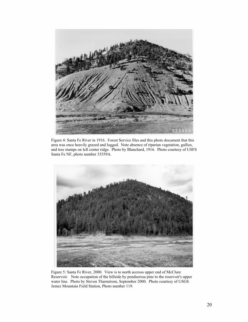
Figure 4: Santa Fe River in 1916. Forest Service files and this photo document that this area was once heavily grazed and logged. Note absence of riparian vegetation, gullies, and tree stumps on left center ridge. Photo by Blanchard, 1916. Photo courtesy of USFS Santa Fe NF, photo number 33559A.
Figure 5: Santa Fe River, 2000. View is to north accross upper end of McClure Reservoir. Note occupation of the hillside by pondserosa pine to the reservoir's upper water line. Photo by Steven Tharnstrom, September 2000. Photo courtesy of USGS Jemez Mountain Field Station, Photo number 119.
21
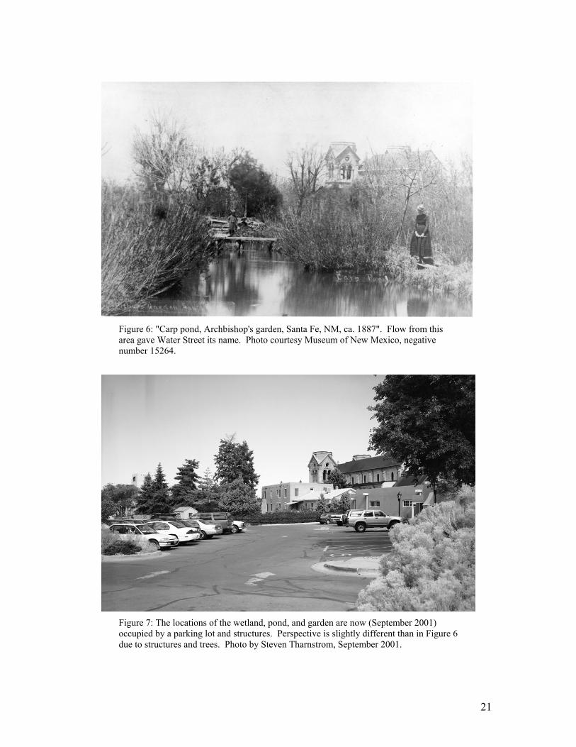
Figure 6: "Carp pond, Archbishop's garden, Santa Fe, NM, ca. 1887". Flow from this area gave Water Street its name. Photo courtesy Museum of New Mexico, negative number 15264.
Figure 7: The locations of the wetland, pond, and garden are now (September 2001) occupied by a parking lot and structures. Perspective is slightly different than in Figure 6 due to structures and trees. Photo by Steven Tharnstrom, September 2001.
22
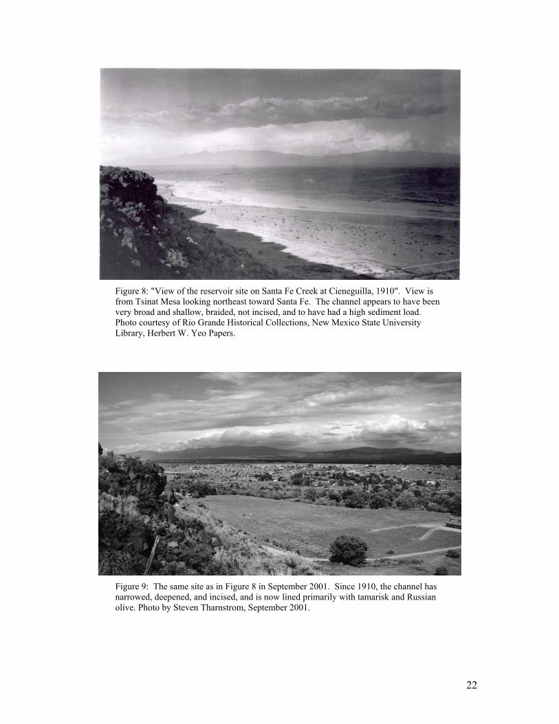
Figure 8: "View of the reservoir site on Santa Fe Creek at Cieneguilla, 1910". View is from Tsinat Mesa looking northeast toward Santa Fe. The channel appears to have been very broad and shallow, braided, not incised, and to have had a high sediment load. Photo courtesy of Rio Grande Historical Collections, New Mexico State University Library, Herbert W. Yeo Papers.
Figure 9: The same site as in Figure 8 in September 2001. Since 1910, the channel has narrowed, deepened, and incised, and is now lined primarily with tamarisk and Russian olive. Photo by Steven Tharnstrom, September 2001.
23
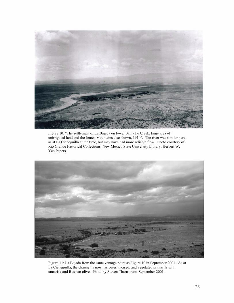
Figure 10: "The settlement of La Bajada on lower Santa Fe Creek, large area of unirrigated land and the Jemez Mountains also shown, 1910". The river was similar here as at La Cieneguilla at the time, but may have had more reliable flow. Photo courtesy of Rio Grande Historical Collections, New Mexico State University Library, Herbert W. Yeo Papers.
Figure 11: La Bajada from the same vantage point as Figure 10 in September 2001. As at La Cieneguilla, the channel is now narrower, incised, and vegetated primarily with tamarisk and Russian olive. Photo by Steven Tharnstrom, September 2001.
24
New Mexico Environment Department Surface Water Quality Bureau monitors the perennial reaches of the river for aquatic habitat conditions and drinking water quality parameters. NMED also collected data in the process of developing Total Maximum Daily Load (TMDL) standards for the reach of the river below the wastewater treatment plant (standards were adopted in 2000); they plan to resample that reach probably in 2005, consistent with their statewide TMDL monitoring schedule. The City of Santa Fe tracks the quality of its effluent discharge under the terms of an NPDES permit. The permit has officially expired, but is under perennial review by EPA and NMED, and the monitoring continues no matter the regulatory status. Watershed Watch projects involving Capital High School and Cochiti School students under the supervision of qualified scientists monitor water quality and aquatic habitat below the wastewater treatment plant and near the La Bajada gauge. Other school-based water quality monitoring projects have collected data in the Santa Fe River: these efforts have included Santa Fe High, Santa Fe Prep, and the College of Santa Fe. However, the data have not been consistent in terms of location, timing and quality assurance, and are therefore less useful for identifying trends. Data gaps The following data needs were identified by the Watershed Advisory Group: 1) An updated, accurate delineation of the floodplain for the whole Santa
Fe River to the Rio Grande. 2) A characterization of the riparian corridor including not just
hydrologic factors but also biological factors – extending the work of the Bosque del Rio project in the Upper Canyon Road area, to cover the entire river. This information will be critical for prioritizing reaches that require treatment.
3) Monitoring the quantity and quality of stormwater runoff.
Stormwater is the most likely source to restore flow in the Santa Fe River, but it will need to be managed to prevent water quality impacts to the riparian ecosystem and the quality of the ground water it recharges.
4) Development of an overall water budget for the Santa Fe watershed.
This would include tracking use by domestic wells.
25
5) Separating out the contribution of septic tanks to the nutrient loading in the river below the wastewater treatment plant.
6) Monitoring of radionuclides from the reclaimed La Bajada uranium
mine area (this has taken place in the past, but irregularly). Watershed/river restoration projects Please refer to Appendix C for current and recently completed projects in the Santa Fe River watershed involving watershed and river/arroyo restoration/reclamation. To summarize that work: Watershed restoration projects have centered on improving range and forest health by reducing the overstory that suppresses the growth of grasses and forbs. These projects depend considerably on the use of prescribed fire, and on setting up conditions so that unintended ignitions can be managed for ecosystem benefits. From the standpoint of reducing non-point-source pollution, a vigorous grass/forb cover is expected to reduce erosion and therefore the delivery of sediment into the Santa Fe River. In the case of the forest management project proposed for the municipal watershed, the project is also intended to reduce the potential for a major crown fire, which would result in mass wasting and the delivery of huge amounts of ash into the river. Watershed management projects may also focus on the suppression of exotic species and restoration of wetlands. In non-point-source terms, the benefit of such projects should be seen as enhancing off-channel storage and recharge, and restoring ecological balance: where invasive exotics take over, in the long run the consequences are erosion and sedimentation. River restoration projects include planting of native riparian tree and shrub species; suppression of exotics; creation of low-head check dams and bioengineering works to induce meandering, reduce velocity and increase groundwater recharge; and the use of traditional engineered erosion control structures. A project of the City of Santa Fe combines stormwater management demonstration projects with a model ordinance to carry out the kind of terrain management that would reduce runoff into arroyos, and thereby reduce sedimentation in the Santa Fe River.
26
4. WATER QUALITY PROBLEMS Considering the Santa Fe River watershed from east to west, the major sources of sediment, bacteria, nutrients and other non-point-source pollutants are:
• Ash and sediment that would result from a major fire in the watershed above the municipal reservoirs. Note that, without the trigger of fire, the upper watershed produces no ash and little or no sediment; however, this source of pollutants is listed here to explain the context of the proposed USFS/City of Santa Fe forest management project (see Appendix D, and narrative under “Watershed/river restoration projects”) that is intended to reduce the potential for a major fire and hence prevent production of these pollutants.
• Casual trash disposal and intentional dumping, a problem that afflicts
the river particularly through the urban reach, Agua Fria and in to La Cieneguilla.
• Dewatering of the river. This problem is partly described under the
“sediment” entries below but is worth recognition in its own right as a non-point-source issue. The dewatered river is geomorphologically unstable, resulting in bed and bank erosion and hence sediment production. As it carries no flow, there is no dilution available for contaminated stormflows.
• Sediment resulting from erosion related to existing and continuing
urban development, especially in the “Rough, Broken Land” soil type.
• Bacteria and nutrients related to cross-connections between sanitary sewers and storm sewers in the downtown area.
• Sediment resulting from aggressive stream bed and bank erosion in
the Santa Fe River, related to the syndrome of dewatering of the river described in Section 2, “Watershed Assessment and Inventory: Surface Water”. This problem is particularly acute in the reach between Guadalupe Street and the wastewater treatment plant.
• Nutrients related to sludge and wastewater treatment practices at the
wastewater treatment plant.
• Nutrients related to individual septic systems in the La Cieneguilla and La Cienega areas. Note that this is a non-point-source that ties groundwater and surface water issues together.

27
• Nutrients resulting from livestock/feedlot management near Cienega
Creek.
• Sediment resulting from erosion from rangeland in poor condition in the Caja del Rio area; also from occasional stray grazing in the riparian area in Santa Fe Canyon.
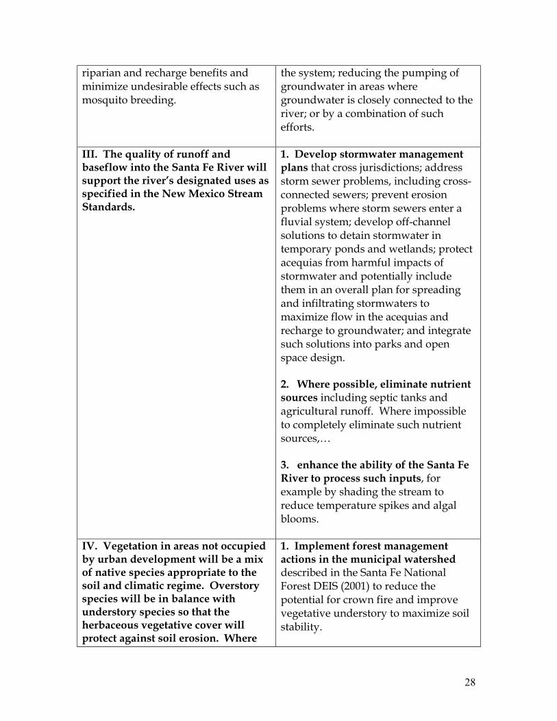
5. WATER QUALITY GOALS These goals have been developed to address the water quality problems listed in Section 4. Note that a number of the short-term objectives address several long-term goals.
Table II Long Term Goals And Short Term Objectives
LONG TERM GOALS
SHORT TERM OBJECTIVES
I. Sediment inputs to the Santa Fe River and its tributaries will be in balance with the amount of flow available to move the sediment through the system without excessive channel aggradation or incision or bank erosion.
1. Focus terrain management efforts on development in “Rough, Broken Land” and other highly erosive soil types. Such efforts should include a multi-faceted approach of reducing storm runoff, runoff harvesting for vegetation establishment, reducing the density of pinon and juniper trees and, where possible, instituting localized prescribed burns to improve grass cover; and implementing arroyo treatments to reduce the velocity of runoff and stabilize banks.
II. The Santa Fe River will be perennial in years of average and above-average precipitation. In years of below-average precipitation, the river will maintain sufficient pools to serve as refugia for aquatic and obligate riparian wildlife, and a water table high enough to support riparian vegetation. Ponding of water will be managed so as to maximize
1. Restore frequent flow and a viable riparian system throughout the full length of the Santa Fe River. This may be achieved with an engineering project involving delivery of a portion of the City’s treated effluent to the dewatered reach; releases from the reservoirs; restoration projects involving slowing the movement of stormwater through the system; reducing the pumping of
28
riparian and recharge benefits and minimize undesirable effects such as mosquito breeding.
the system; reducing the pumping of groundwater in areas where groundwater is closely connected to the river; or by a combination of such efforts.
III. The quality of runoff and baseflow into the Santa Fe River will support the river’s designated uses as specified in the New Mexico Stream Standards.
1. Develop stormwater management plans that cross jurisdictions; address storm sewer problems, including cross-connected sewers; prevent erosion problems where storm sewers enter a fluvial system; develop off-channel solutions to detain stormwater in temporary ponds and wetlands; protect acequias from harmful impacts of stormwater and potentially include them in an overall plan for spreading and infiltrating stormwaters to maximize flow in the acequias and recharge to groundwater; and integrate such solutions into parks and open space design. 2. Where possible, eliminate nutrient sources including septic tanks and agricultural runoff. Where impossible to completely eliminate such nutrient sources,… 3. enhance the ability of the Santa Fe River to process such inputs, for example by shading the stream to reduce temperature spikes and algal blooms.
IV. Vegetation in areas not occupied by urban development will be a mix of native species appropriate to the soil and climatic regime. Overstory species will be in balance with understory species so that the herbaceous vegetative cover will protect against soil erosion. Where
1. Implement forest management actions in the municipal watershed described in the Santa Fe National Forest DEIS (2001) to reduce the potential for crown fire and improve vegetative understory to maximize soil stability.
29
possible without causing undue impacts to local human populations, fire will be restored to its place in the ecosystem, as part of the effort to improve herbaceous cover and reduce sediment production from the watershed.
2. Implement range improvements including reduction of woody species and improvement of grass cover; development of stock watering facilities off-river; active herding of livestock to minimize impacts in particular riparian and pasture areas; fencing to allow recovery of riparian vegetation along streams and tributary arroyos.
V. To the extent possible given existing land development patterns, protection of the floodplain from further development so that it can serve its highest and best use as a floodway, with multiple beneficial uses consistent with that designation.
1. Accurately delineate the floodplain, and then protect it from development through regulation and by acquisition of property from willing sellers. 2. Carry out land use planning and open space protection with the objectives of improving watershed condition and riparian health.
6. RECOMMENDED ACTIONS & IMPLEMENTATION SCHEDULE Many of the current and recently completed projects listed in Appendix C are in direct response to the long-term and short-term goals expressed above. Many of these issues were raised in the Resolution 57 Committee’s final report, and also recognized informally by many land managers and stakeholders in the Santa Fe watershed, even before they were expressed formally through the WRAS process. Consequently, our list of proposed actions in Appendix D begins with those actions currently in place and pending, reorganized to show their relationship to the short-term objectives expressed above. The blanks in the table are left to invite brainstorming about other actions that would be appropriate to achieve the objectives. Watershed restoration projects proposed and underway in the rural portions of the Santa Fe River watershed follow well-established models involving various techniques to improve vegetative cover and reduce erosion. Recommended river restoration projects center on slowing stormflows as they move through the system. This has the effect of enhancing infiltration to groundwater and supporting riparian vegetation, which in turn can increase channel stability and
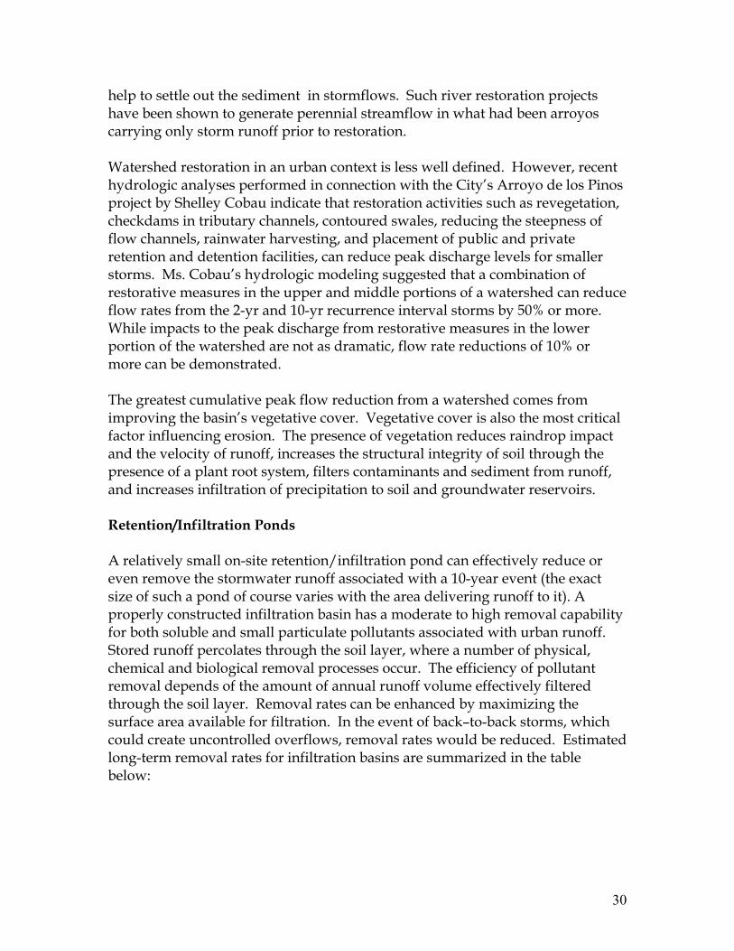
30
help to settle out the sediment in stormflows. Such river restoration projects have been shown to generate perennial streamflow in what had been arroyos carrying only storm runoff prior to restoration. Watershed restoration in an urban context is less well defined. However, recent hydrologic analyses performed in connection with the City’s Arroyo de los Pinos project by Shelley Cobau indicate that restoration activities such as revegetation, checkdams in tributary channels, contoured swales, reducing the steepness of flow channels, rainwater harvesting, and placement of public and private retention and detention facilities, can reduce peak discharge levels for smaller storms. Ms. Cobau’s hydrologic modeling suggested that a combination of restorative measures in the upper and middle portions of a watershed can reduce flow rates from the 2-yr and 10-yr recurrence interval storms by 50% or more. While impacts to the peak discharge from restorative measures in the lower portion of the watershed are not as dramatic, flow rate reductions of 10% or more can be demonstrated. The greatest cumulative peak flow reduction from a watershed comes from improving the basin’s vegetative cover. Vegetative cover is also the most critical factor influencing erosion. The presence of vegetation reduces raindrop impact and the velocity of runoff, increases the structural integrity of soil through the presence of a plant root system, filters contaminants and sediment from runoff, and increases infiltration of precipitation to soil and groundwater reservoirs. Retention/Infiltration Ponds A relatively small on-site retention/infiltration pond can effectively reduce or even remove the stormwater runoff associated with a 10-year event (the exact size of such a pond of course varies with the area delivering runoff to it). A properly constructed infiltration basin has a moderate to high removal capability for both soluble and small particulate pollutants associated with urban runoff. Stored runoff percolates through the soil layer, where a number of physical, chemical and biological removal processes occur. The efficiency of pollutant removal depends of the amount of annual runoff volume effectively filtered through the soil layer. Removal rates can be enhanced by maximizing the surface area available for filtration. In the event of back–to-back storms, which could create uncontrolled overflows, removal rates would be reduced. Estimated long-term removal rates for infiltration basins are summarized in the table below:
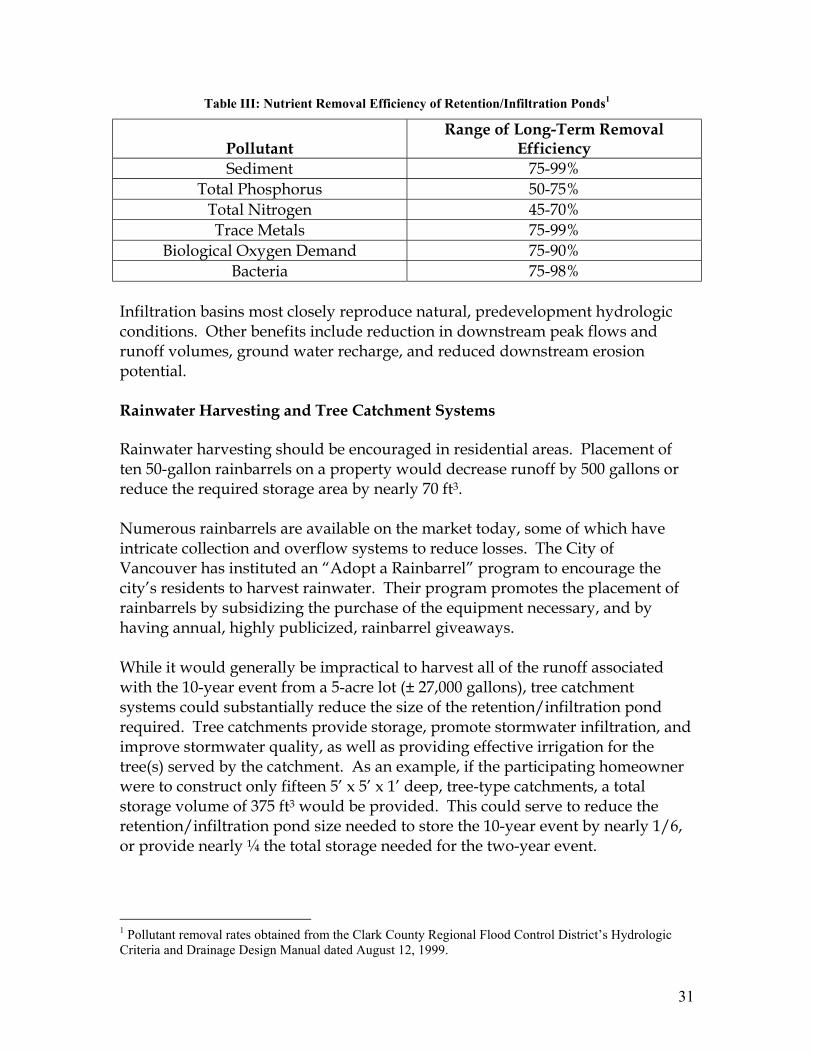
31
Table III: Nutrient Removal Efficiency of Retention/Infiltration Ponds1
Pollutant
Range of Long-Term Removal Efficiency
Sediment 75-99% Total Phosphorus 50-75%
Total Nitrogen 45-70% Trace Metals 75-99%
Biological Oxygen Demand 75-90% Bacteria 75-98%
Infiltration basins most closely reproduce natural, predevelopment hydrologic conditions. Other benefits include reduction in downstream peak flows and runoff volumes, ground water recharge, and reduced downstream erosion potential. Rainwater Harvesting and Tree Catchment Systems Rainwater harvesting should be encouraged in residential areas. Placement of ten 50-gallon rainbarrels on a property would decrease runoff by 500 gallons or reduce the required storage area by nearly 70 ft3. Numerous rainbarrels are available on the market today, some of which have intricate collection and overflow systems to reduce losses. The City of Vancouver has instituted an “Adopt a Rainbarrel” program to encourage the city’s residents to harvest rainwater. Their program promotes the placement of rainbarrels by subsidizing the purchase of the equipment necessary, and by having annual, highly publicized, rainbarrel giveaways. While it would generally be impractical to harvest all of the runoff associated with the 10-year event from a 5-acre lot (± 27,000 gallons), tree catchment systems could substantially reduce the size of the retention/infiltration pond required. Tree catchments provide storage, promote stormwater infiltration, and improve stormwater quality, as well as providing effective irrigation for the tree(s) served by the catchment. As an example, if the participating homeowner were to construct only fifteen 5’ x 5’ x 1’ deep, tree-type catchments, a total storage volume of 375 ft3 would be provided. This could serve to reduce the retention/infiltration pond size needed to store the 10-year event by nearly 1/6, or provide nearly ¼ the total storage needed for the two-year event.
1 Pollutant removal rates obtained from the Clark County Regional Flood Control District’s Hydrologic Criteria and Drainage Design Manual dated August 12, 1999.
32
Check dams Placement of check dams throughout the watershed would be beneficial. Check dams will reduce downstream sediment load and flow velocities, while providing some protection against further bed degradation. Depending on construction techniques and placement, check dam life may be somewhat limited, and regular maintenance or replacement may be required. On the other hand, Santa Fe is full of checkdams that date from the 1930s when they were constructed by the Civilian Conservation Corps. Many of these structures are still highly effective, and a number of them have filled with sediment and created little copses of riparian vegetation dependent on the moist soil found there. Revetment protection Placement of “dutch toes” at intervals along arroyos can prevent lateral migration and reduce further bank failure. Conveyance modernization Culvert entrances should be fitted with wing-type headwalls, or slope mitering should be employed if at all possible. Outlets should be reviewed and upgraded where localized scour is evident and outlet protection provided accordingly. Local major detention Placement of public detention facilities should be considered to reduce flow quantity in the lower reaches of a watershed. Note that if small detention ponds (less than 10-acre feet) are placed in series, review by the Office of the State Engineer (OSE) may be required. Ponds providing in excess of 10-acre feet of storage must be permitted by the OSE. 7. FUNDING The Watershed Advisory Group considered whether to attempt to quantify costs of implementing recommended actions everywhere they were needed in the Santa Fe watershed. We concluded that that exercise would not be useful, for several reasons: The numbers would be intimidatingly large, producing a response of “we can’t possibly afford it”, when as a practical matter these projects are advanced one at
33
a time on the initiative of various instigators on the basis of successful grant applications, serendipitous partnerships and agency funding priorities. Cost estimates prepared without careful analysis of the area involved and potential match arrangements, are unreliable and not indicative of actual project costs. Further, cost estimates can become quickly out of date. In funding restoration projects in the Santa Fe watershed, 319 grants have played a critical role. These projects require partnerships so that the federal grant match requirements can be met by a combination of a cash or in-kind match, either put up by a local agency or obtained through a non-governmental grant. The participation of community volunteers can also be offered as match to a government grant. Local agencies have also independently initiated and funded projects that are listed among “recommended actions”. Notable among these projects are the City’s River Corridor Master Plan and the projects developed to date under that guidance; the County’s Open Space program; and the County’s developing River Corridor Master plan. Three sources of information on funding opportunities were noted as particularly useful to those with a project concept consistent with the actions recommended under this WRAS: EPA’s Catalog of Federal Funding Sources for Watershed Protection, updated every year or two; document number EPA 841-B-97-008. New Mexico State Library Foundation Center Cooperating Collection. The State Library on Cerrillos Road at Camino Carlos Rey in Santa Fe maintains a clearinghouse on private foundations in their reference area, including CD-ROMs with thousands of philanthropic organizations, searchable by geography, subject area, etc. The librarians are generous with their assistance in learning to use the Foundation Center materials.

34
River Network, which is “dedicated to building the capacity of river and watershed organizations to support themselves financially”, offers a quarterly Fundraising Alert and a web site with information on funding sources friendly to river and watershed protection efforts. They can be contacted at:
River Network Eastern Office 4000 Albemarle St. NW #303 Washington D.C. 20016 (202) 364-2550; FAX – 2520 email: [email protected] website: www.rivernetwork.org

35
REFERENCES CITED Bureau of Business & Economic Research (BBER). Current. Web site: www.unm.edu/~bber/ Camp, Dresser & McKee, Inc., with Lee Wilson & Associates (CDM/LWA). 1998. Treated Effluent Management Plan. Consultant report prepared for the City of Santa Fe. Fleming, Bill. 1994. La Cienega Water Supply/Demand Analysis. Consultant report prepared for Santa Fe County. Leopold, Luna. 1951. Rainfall frequency: an aspect of climatic variation. Transactions of the American Geophysical Union, vol. 32, number 3, pp. 347-357. Leopold, Luna. 1976. Reversal of erosion cycle and climatic change. Quaternary Research, vol. 6, pp. 557-562. Cited in: Water and Environmental Planning. Dunne, T. and L. Leopold. 1978. W.H. Freeman & Co. New Mexico Environment Department (NMED). 2000. Total Maximum Daily Load (TMDL) for the Santa Fe River from the Cochiti Pueblo to the Santa Fe Wastewater Treatment Plant for Chlorine and Stream Bottom Deposits. Report available from NMED Surface Water Quality Bureau and online. New Mexico Environment Department (NMED). 2000. Total Maximum Daily Load for the Santa Fe River for Dissolved Oxygen and pH. Report available from NMED Surface Water Quality Bureau and online. New Mexico Highway and Transportation Department. Several years beginning approximately 1955. Aerial photographs covering the Santa Fe River corridor. NMHTD, Santa Fe, NM. New Mexico Water Quality Control Commission. 2000. Water Quality and Water Pollution Control in New Mexico 2000. NM Water Quality Control Commission, PO Box 26110, Santa Fe, NM 87502. O’Neil, Joy K. 2000. Volunteer River Monitoring Plan for the Urban Reach of the Santa Fe River Watershed. Professional Project Report for Master of Water Resources, University of New Mexico. (Unpublished.)
36
Personal communication between Paige Grant, Santa Fe Watershed Association, and the following individuals:
Archuleta, Edward; Director, Santa Fe Growth Management Project, 1000 Friends of New Mexico
Bove, Philip and Eleanor; Acequia Madre representatives Pike, David; spokesman for Agua Fria community well Romero, Elizardo; spokesman for Agua Fria community well Smith, Louis; owner of domestic well on Alameda just outside City limits Stephenson, John; Owner/Manager, Community Farm, Agua Fria Tsosie, Olivia; Agua Fria resident Williams, Neil, P.E.; principal, Watershed West
Santa Fe National Forest. 1997? Graph of total annual water yield of upper Santa Fe watershed based on flows recorded at Gauge 08316000, 1913 to 1997. Internal document; contact Steve McWilliams, Santa Fe National Forest Hydrologist. Santa Fe National Forest. 2001. Santa Fe Municipal Watershed Project Draft Environmental Impact Statement. Santa Fe National Forest, 1474 Rodeo Road, Santa Fe, NM 87504. Santa Fe River Committee. 1985. Rio de Santa Fe: Report and Recommendations. City of Santa Fe Planning Department. Snow, David H. 1988. The Santa Fe Acequia Systems: Summary Report on Their History and Present Status, with Recommendations for Use or Protection. City of Santa Fe Planning Department. Spiegel, Z. and B. Baldwin. 1963. Geology and Water Resources of the Santa Fe Area, New Mexico. Geological Survey Water-Supply Paper 1525. State Engineer Office. Current. Web site www.seo.state.nm.us. US Army Corps of Engineers (USACoE). Current. Web site www.spa.usace.army.mil. USDA Soil Conservation Service. 1975. Soil Taxonomy: a Basic System of Soil Classification for Making and Interpreting Soil Surveys. Agriculture Handbook No. 436
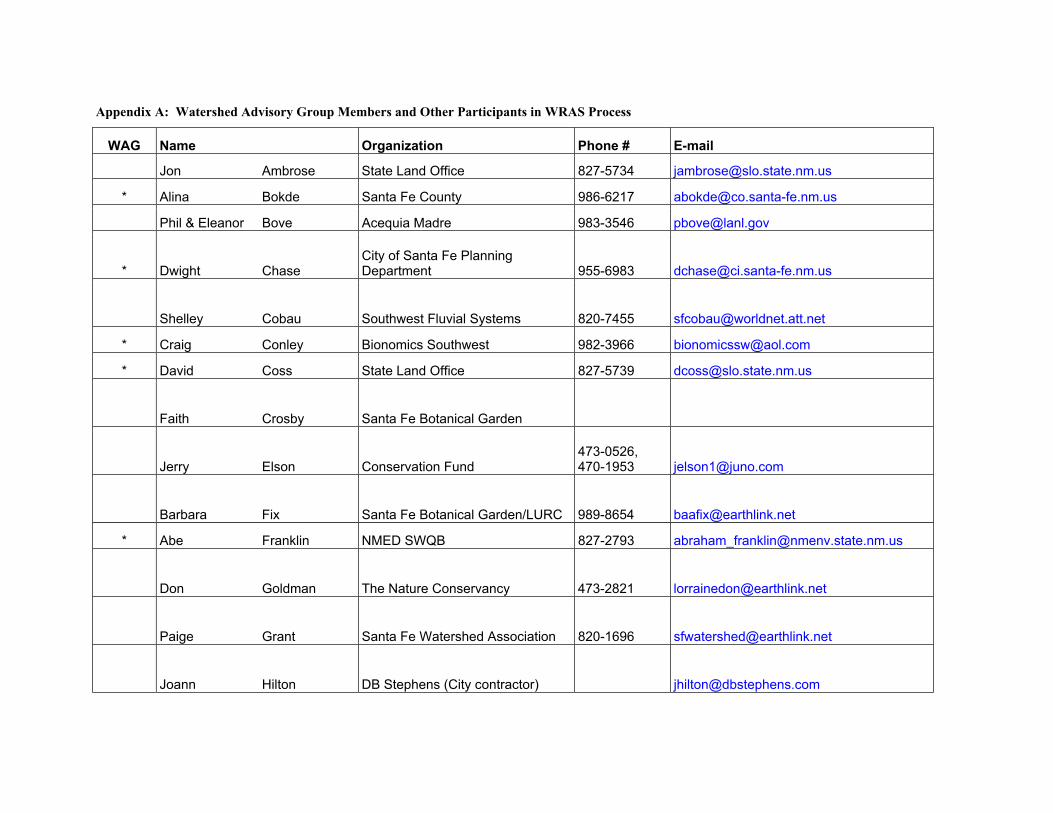
Appendix A: Watershed Advisory Group Members and Other Participants in WRAS Process
WAG Name Organization Phone # E-mail
Jon Ambrose State Land Office 827-5734 [email protected]
* Alina Bokde Santa Fe County 986-6217 [email protected]
Phil & Eleanor Bove Acequia Madre 983-3546 [email protected]
* Dwight Chase City of Santa Fe Planning Department 955-6983 [email protected]
Shelley Cobau Southwest Fluvial Systems 820-7455 [email protected]
* Craig Conley Bionomics Southwest 982-3966 [email protected]
* David Coss State Land Office 827-5739 [email protected]
Faith Crosby Santa Fe Botanical Garden
Jerry Elson Conservation Fund 473-0526, 470-1953 [email protected]
Barbara Fix Santa Fe Botanical Garden/LURC 989-8654 [email protected]
* Abe Franklin NMED SWQB 827-2793 [email protected]
Don Goldman The Nature Conservancy 473-2821 [email protected]
Paige Grant Santa Fe Watershed Association 820-1696 [email protected]
Joann Hilton DB Stephens (City contractor) [email protected]

WAG Name Organization Phone # E-mail
* Lea Johnson Forest Guardians 988-5126 x 155 [email protected]
Amy Lewis City of Santa Fe Water Division 954-7123 [email protected]
Nichoe Lichen Camino Real River Connection 438-4368
* Jerry Lovato City of Santa Fe Parks & Recreation jer&[email protected]
Dale Lyons Watershed West 982-5180 [email protected]
Matthew McQueen Taos Land Trust 751-3138 [email protected]
Steve McWilliams Santa Fe National Forest 438-7854 [email protected]
* Ron Sandoval City of Santa Fe Public Works 955-6621 [email protected]
Marian Shirin City of Santa Fe Planning Department 955-6608 [email protected]
Janine Sieja Santa Fe Watershed Association 989-7442 [email protected]
Kathy Smith NM Riparian Council [email protected]
Michael Smith City of Santa Fe River Commission 995-1013
Lois Snyderman 820-2402
* Karyn Stockdale Trust for Public Land [email protected]
Jose Varela-Lopez La Cieneguilla 438-2045; 660-5828
WAG Name Organization Phone # E-mail
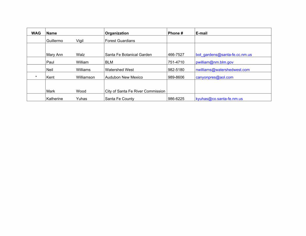
Guillermo Vigil Forest Guardians
Mary Ann Walz Santa Fe Botanical Garden 466-7527 [email protected]
Paul William BLM 751-4710 [email protected]
Neil Williams Watershed West 982-5180 [email protected]
* Kent Williamson Audubon New Mexico 989-8606 [email protected]
Mark Wood City of Santa Fe River Commission
Katherine Yuhas Santa Fe County 986-6225 [email protected]
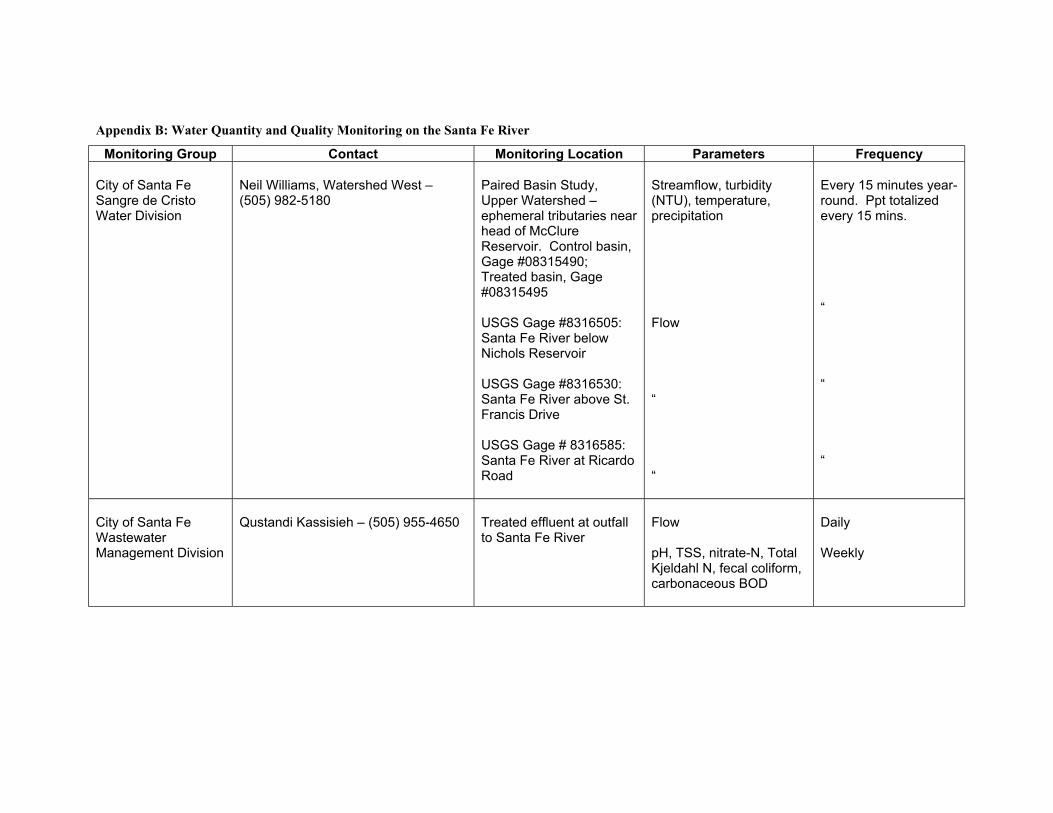
Appendix B: Water Quantity and Quality Monitoring on the Santa Fe River
Monitoring Group Contact Monitoring Location Parameters Frequency City of Santa Fe Sangre de Cristo Water Division
Neil Williams, Watershed West – (505) 982-5180
Paired Basin Study, Upper Watershed – ephemeral tributaries near head of McClure Reservoir. Control basin, Gage #08315490; Treated basin, Gage #08315495 USGS Gage #8316505: Santa Fe River below Nichols Reservoir USGS Gage #8316530: Santa Fe River above St. Francis Drive USGS Gage # 8316585: Santa Fe River at Ricardo Road
Streamflow, turbidity (NTU), temperature, precipitation Flow “ “
Every 15 minutes year-round. Ppt totalized every 15 mins. “ “ “
City of Santa Fe Wastewater Management Division
Qustandi Kassisieh – (505) 955-4650
Treated effluent at outfall to Santa Fe River
Flow pH, TSS, nitrate-N, Total Kjeldahl N, fecal coliform, carbonaceous BOD
Daily Weekly
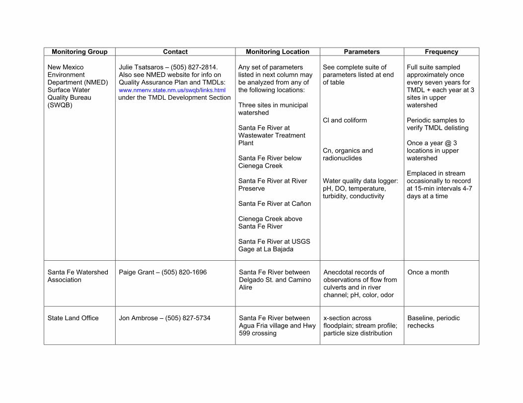
Monitoring Group Contact Monitoring Location Parameters Frequency New Mexico Environment Department (NMED) Surface Water Quality Bureau (SWQB)
Julie Tsatsaros – (505) 827-2814. Also see NMED website for info on Quality Assurance Plan and TMDLs: www.nmenv.state.nm.us/swqb/links.html under the TMDL Development Section
Any set of parameters listed in next column may be analyzed from any of the following locations: Three sites in municipal watershed Santa Fe River at Wastewater Treatment Plant Santa Fe River below Cienega Creek Santa Fe River at River Preserve Santa Fe River at Cañon Cienega Creek above Santa Fe River Santa Fe River at USGS Gage at La Bajada
See complete suite of parameters listed at end of table Cl and coliform Cn, organics and radionuclides Water quality data logger: pH, DO, temperature, turbidity, conductivity
Full suite sampled approximately once every seven years for TMDL + each year at 3 sites in upper watershed Periodic samples to verify TMDL delisting Once a year @ 3 locations in upper watershed Emplaced in stream occasionally to record at 15-min intervals 4-7 days at a time
Santa Fe Watershed Association
Paige Grant – (505) 820-1696
Santa Fe River between Delgado St. and Camino Alire
Anecdotal records of observations of flow from culverts and in river channel; pH, color, odor
Once a month
State Land Office
Jon Ambrose – (505) 827-5734
Santa Fe River between Agua Fria village and Hwy 599 crossing
x-section across floodplain; stream profile; particle size distribution
Baseline, periodic rechecks

Monitoring Group Contact Monitoring Location Parameters Frequency U.S.Geological Survey (USGS)
Robert Gold – (505) 830-7930, [email protected]; or Kathy Lange – (505) 830-7919
USGS Gage # 8315480: inflow to McClure Reservoir USGS Gage # 8316000: between McClure and Nichols Reservoirs USGS Gage # 8317200 above Cochiti
Flow
Every 15 minutes year-round
Watershed Watch -- Capital High
Rich Schrader, Watershed Watch Coordinator – (505) 992-0726
Below Wastewater Treatment Plant
“Chemistry”, temperature, pH, turbidity
1x per year
Watershed Watch -- Santa Fe Prep
Rich Schrader, Watershed Watch Coordinator – (505) 992-0726
Upper Santa Fe watershed
nutrients, heavy metals, temperature, pH, streamflow, turbidity and macroinvertebrates
1-2x per year
Full suite of parameters collected by NMED SWQB: temperature, DO, turbidity, P, NO3, NH3, pH, TDS, TSS, Total Hardness, Ca, K, Na, Alkalinity, HCO3, Cl, SO4, Mg, Al, Ba, Be, B, Cd, Cr, Co, Cu, Fe, Pb, Mg, Mn, Mo, Ni, Si, Ag, Sr, Sn, V, Zn, As, Se, U-natural, gross alpha, fecal coliform, E. coli, streambed deposits, macroinvertebrates, fish population
Excerpt from Santa Fe Municipal Watershed Environmental Impact Statement: Water Monitoring WATER: Are treatments adversely affecting water quality such that we are not in compliance with Federal, state and Forest Plan standards and Clean Water Act regulations? Are treatments resulting in beneficial increases in water yield or unacceptable peak flow events that may alter the stream channel morphology?
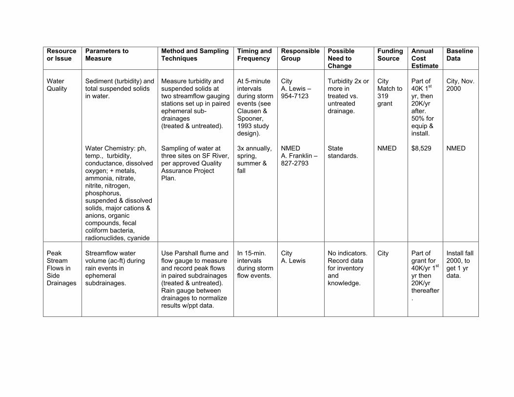
Resource or Issue
Parameters to Measure
Method and Sampling Techniques
Timing and Frequency
Responsible Group
Possible Need to Change
Funding Source
Annual Cost Estimate
Baseline Data
Water Quality
Sediment (turbidity) and total suspended solids in water. Water Chemistry: ph, temp., turbidity, conductance, dissolved oxygen; + metals, ammonia, nitrate, nitrite, nitrogen, phosphorus, suspended & dissolved solids, major cations & anions, organic compounds, fecal coliform bacteria, radionuclides, cyanide
Measure turbidity and suspended solids at two streamflow gauging stations set up in paired ephemeral sub-drainages (treated & untreated). Sampling of water at three sites on SF River, per approved Quality Assurance Project Plan.
At 5-minute intervals during storm events (see Clausen & Spooner, 1993 study design). 3x annually, spring, summer & fall
City A. Lewis – 954-7123 NMED A. Franklin – 827-2793
Turbidity 2x or more in treated vs. untreated drainage. State standards.
City Match to 319 grant NMED
Part of 40K 1st yr, then 20K/yr after. 50% for equip & install. $8,529
City, Nov. 2000 NMED
Peak Stream Flows in Side Drainages
Streamflow water volume (ac-ft) during rain events in ephemeral subdrainages.
Use Parshall flume and flow gauge to measure and record peak flows in paired subdrainages (treated & untreated). Rain gauge between drainages to normalize results w/ppt data.
In 15-min. intervals during storm flow events.
City A. Lewis
No indicators. Record data for inventory and knowledge.
City
Part of grant for 40K/yr 1st yr then 20K/yr thereafter.
Install fall 2000, to get 1 yr data.

SF River Geomor-phology
Stream width, depths, cross-sec area, entrenchment, channel bottom particle size distr., bank erodibility hazard index; + relative elevations of thalweg, water’s edge & bankfull at each habitat unit (pools, riffles, runs, glides), + cross sec area of pools.
Use Rosgen method (Harrelson, et al. 1994). Record measurements at two cross sections (a riffle+ a pool) and along one stream reach.
Annually each summer.
NMED A. Franklin
Particle size decrease, or increased with depth ratio outside range of natural variability (Rosgen)
NMED
$1,323
Blue Earth Eco-logical 2000
Aquatic Insects-Macro-inverte-brates and Fish Pop-ulations
Species richness, composition (%Ephemeroptera), tolerance/intolerance, feeding (percent filterers), and habit (percent clingers). Trout species numbers, size and condition (by species).
Multi-habitat approach and EPA Rapid Bioassessment Protocols (Barbour et al 1999) to sample at three sites on upper Santa Fe River. EPA Rapid Bioassessment Protocols to capture, record number, weight and size by species, on three sites on upper Santa Fe River
Annually each summer. Annually each summer.
NMED A. Franklin NMED A. Franklin
Change in macro-invertebrates as aquatic habitat & water quality indicators. No indicators. Document change in treated and untreated areas, for database info.
NMED NMED
Insects: $850 Fish: $1,400
Toli-sano’s 1998 data + NMED Oct. 2000 + SFHS 1996-2000 + Blue Earth Ecol, 2000

Appendix C: Current and Recently Completed Watershed and River Restoration Projects in the Santa Fe River Watershed
Project Description Entities Conducting Project Location Cost
Public Involvement? Y/N
Time Frame
Active Projects Upper watershed management to reduce fire danger, increase water yield and protect water quality.
U.S. Forest Service, City of Santa Fe
Headwaters to lower Sangre de Cristo Water Co. reservoirs
$983,064 Sec. 319 and matching funds/in kind, plus other agency funds
Y ongoing
Canyon Preservation Tust Project. Riparian vegetation enhancement and maintenance from old Two-Mile Dam site to Acequia Madre headgate. A private sector (NGO) project to supplement the River Corridor Master Plan: mapping, inventory and designation of surviving riparian habitat; restoration of degraded areas.
Canyon Preservation Trust, Randall Davey Audubon Center, US Fish & Wildlife Service & private land owners
Old Two-mile Dam to Acequia Madre head gate.
$150,000 Y 1996 - ongoing
As above Audubon New Mexico
$120,000 Y ongoing

Project Description Entities Conducting Project Location Cost
Public Involvement? Y/N
Time Frame
Santa Fe Water Management and River Restoration Strategy. Primary infrastructure components are: Ranney infiltration gallery for San Juan/Chama water, treated effluent return flow pipeline to the Rio Grande and treated effluent pipeline to Santa Fe River in urban reach to recreate perennial flow. Project includes data collection. Uncertain how much of plan will be retained in final design.
City Public Utility Department
Rio Grande to north of Santa Fe watershed, and within SF watershed
$20,000,000 Y 1999-2005
Santa Fe River Corridor Master Plan: Riparian corridor improvement, channel stabilization, trail system.
City Public Works Department
Patrick Smith Park to Frenchy's Park
$6-10 million Y 1995, continuing
Acequia Madre operation and maintenance
Acequia Madre Association
Length of Acequia not available N Ongoing
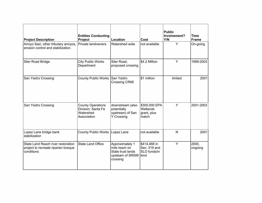
Project Description Entities Conducting Project Location Cost
Public Involvement? Y/N
Time Frame
Arroyo Saiz, other tributary arroyos, erosion control and stabilization.
Private landowners Watershed wide not available Y On-going
Siler Road Bridge City Public Works Department
Siler Road, proposed crossing
$4.2 Million Y 1999-2003
San Ysidro Crossing County Public Works San Ysidro Crossing CR68
$1 million limited 2001
San Ysidro Crossing County Operations Division, Santa Fe Watershed Association
downstream (also potentially upstream) of San Y Crossing
$300,000 EPA Wetlands grant, plus match
Y 2001-2003
Lopez Lane bridge bank stabilization
County Public Works Lopez Lane not available N 2001
State Land Reach river restoration project to recreate riparian bosque conditions
State Land Office Approximately 1 mile reach on State trust lands upsteam of SR599 crossing
$414,468 in Sec. 319 and SLO funds/in kind
Y 2000, ongoing
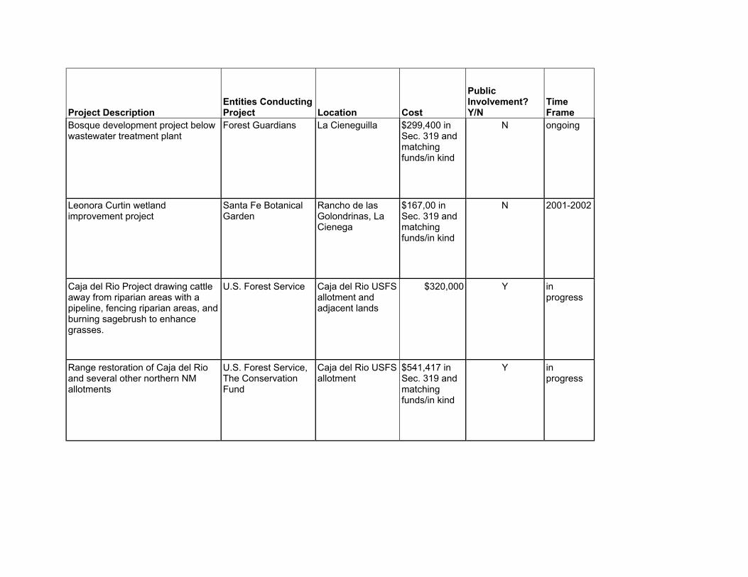
Project Description Entities Conducting Project Location Cost
Public Involvement? Y/N
Time Frame
Bosque development project below wastewater treatment plant
Forest Guardians La Cieneguilla $299,400 in Sec. 319 and matching funds/in kind
N ongoing
Leonora Curtin wetland improvement project
Santa Fe Botanical Garden
Rancho de las Golondrinas, La Cienega
$167,00 in Sec. 319 and matching funds/in kind
N 2001-2002
Caja del Rio Project drawing cattle away from riparian areas with a pipeline, fencing riparian areas, and burning sagebrush to enhance grasses.
U.S. Forest Service Caja del Rio USFS allotment and adjacent lands
$320,000 Y in progress
Range restoration of Caja del Rio and several other northern NM allotments
U.S. Forest Service, The Conservation Fund
Caja del Rio USFS allotment
$541,417 in Sec. 319 and matching funds/in kind
Y in progress
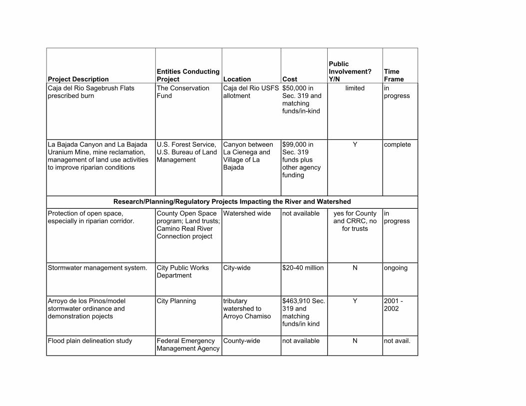
Project Description Entities Conducting Project Location Cost
Public Involvement? Y/N
Time Frame
Caja del Rio Sagebrush Flats prescribed burn
The Conservation Fund
Caja del Rio USFS allotment
$50,000 in Sec. 319 and matching funds/in-kind
limited in progress
La Bajada Canyon and La Bajada Uranium Mine, mine reclamation, management of land use activities to improve riparian conditions
U.S. Forest Service, U.S. Bureau of Land Management
Canyon between La Cienega and Village of La Bajada
$99,000 in Sec. 319 funds plus other agency funding
Y complete
Research/Planning/Regulatory Projects Impacting the River and Watershed Protection of open space, especially in riparian corridor.
County Open Space program; Land trusts; Camino Real River Connection project
Watershed wide not available yes for County and CRRC, no
for trusts
in progress
Stormwater management system. City Public Works Department
City-wide $20-40 million N ongoing
Arroyo de los Pinos/model stormwater ordinance and demonstration pojects
City Planning tributary watershed to Arroyo Chamiso
$463,910 Sec. 319 and matching funds/in kind
Y 2001 -2002
Flood plain delineation study Federal Emergency Management Agency
County-wide not available N not avail.
Project Description Entities Conducting Project Location Cost
Public Involvement? Y/N
Time Frame
Reconnaisance study of physical, chemical and biological conditions in Santa Fe River.
U.S. Army Corps of Engineers
County-wide not available N not avail.
Center for Service Learning property
private entity upstream of La Cienega
not available N not avail.
Removal of invasive trees in riparian areas; planting of native bosque vegetation
Government and non-profit groups
Watershed wide not available N not avail.
Updated and adapted from final report of Resolution 57 Committee, June 1999.
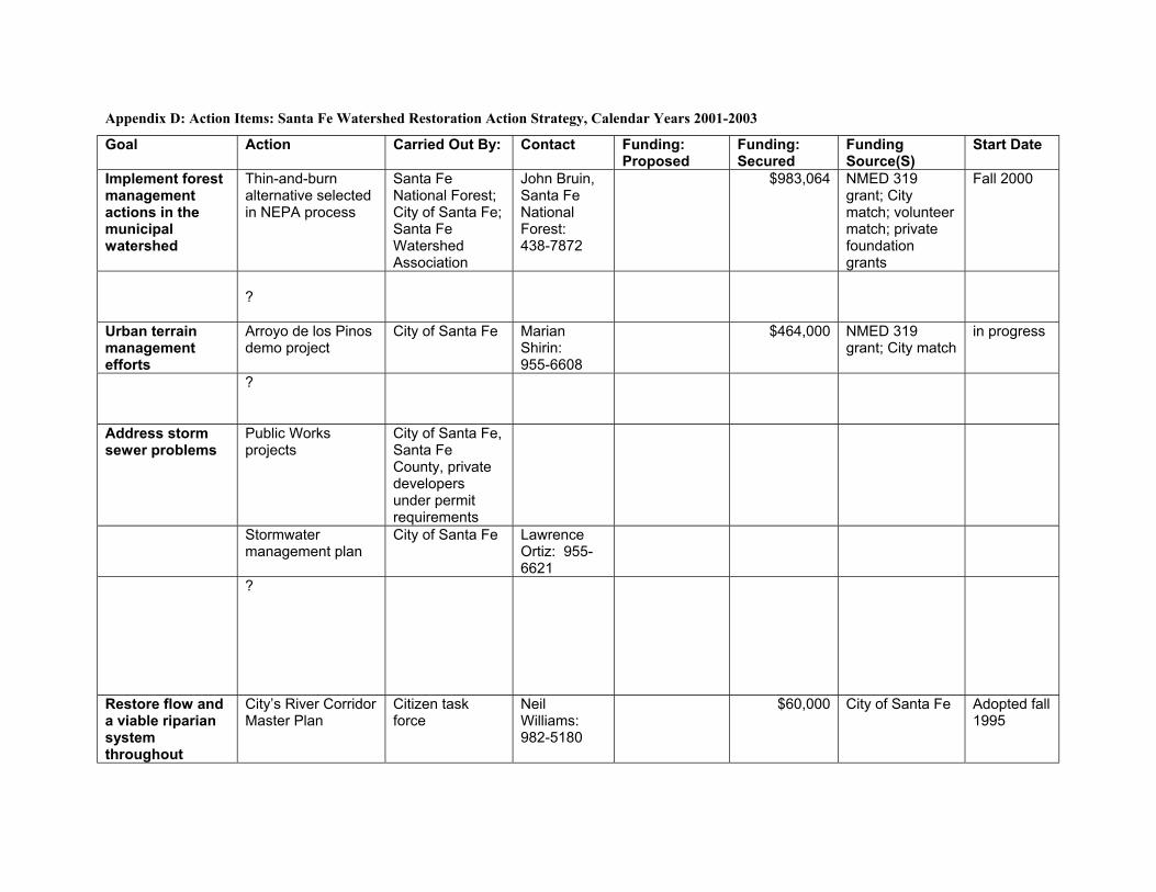
Appendix D: Action Items: Santa Fe Watershed Restoration Action Strategy, Calendar Years 2001-2003
Goal Action Carried Out By: Contact Funding: Proposed
Funding: Secured
Funding Source(S)
Start Date
Implement forest management actions in the municipal watershed
Thin-and-burn alternative selected in NEPA process
Santa Fe National Forest; City of Santa Fe; Santa Fe Watershed Association
John Bruin, Santa Fe National Forest: 438-7872
$983,064 NMED 319 grant; City match; volunteer match; private foundation grants
Fall 2000
?
Urban terrain management efforts
Arroyo de los Pinos demo project
City of Santa Fe Marian Shirin: 955-6608
$464,000 NMED 319 grant; City match
in progress
?
Address storm sewer problems
Public Works projects
City of Santa Fe, Santa Fe County, private developers under permit requirements
Stormwater management plan
City of Santa Fe Lawrence Ortiz: 955-6621
?
Restore flow and a viable riparian system throughout
City’s River Corridor Master Plan
Citizen task force
Neil Williams: 982-5180
$60,000 City of Santa Fe Adopted fall 1995
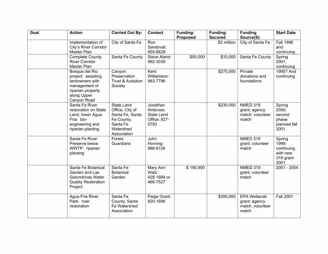
Goal Action Carried Out By: Contact Funding: Proposed
Funding: Secured
Funding Source(S)
Start Date
Implementation of City’s River Corridor Master Plan
City of Santa Fe Ron Sandoval: 955-6628
$2 million City of Santa Fe Fall 1996 and continuing
Complete County River Corridor Master Plan
Santa Fe County Steve Alarid: 992-3039
$50,000 $10,000 Santa Fe County Spring 2001, continuing
Bosque del Rio project: assisting landowners with management of riparian property along Upper Canyon Road
Canyon Preservation Trust & Audubon Society
Kent Williamson: 983-7796
$270,000 Private donations and foundations
1995? And continuing
Santa Fe River restoration on State Land, lower Agua Fria: bio-engineering and riparian planting
State Land Office, City of Santa Fe, Santa Fe County, Santa Fe Watershed Association
Jonathan Ambrose, State Land Office: 827-5793
$230,000 NMED 319 grant; agency match; volunteer match
Spring 2000; second phase planned fall 2001
Santa Fe River Preserve below WWTP: riparian planting
Forest Guardians
John Horning: 988-9126
NMED 319 grant; volunteer match
Spring 1999; continuing with new 319 grant 2001
Santa Fe Botanical Garden and Las Golondrinas Water Quality Restoration Project
Santa Fe Botanical Garden
Mary Ann Walz: 428-1684 or 466-7527
$ 190,900
NMED 319 grant; volunteer match
2001 - 2004
Agua Fria River Park: river restoration
Santa Fe County, Santa Fe Watershed Association
Paige Grant; 820-1696
$300,000 EPA Wetlands grant; agency match, volunteer match
Fall 2001
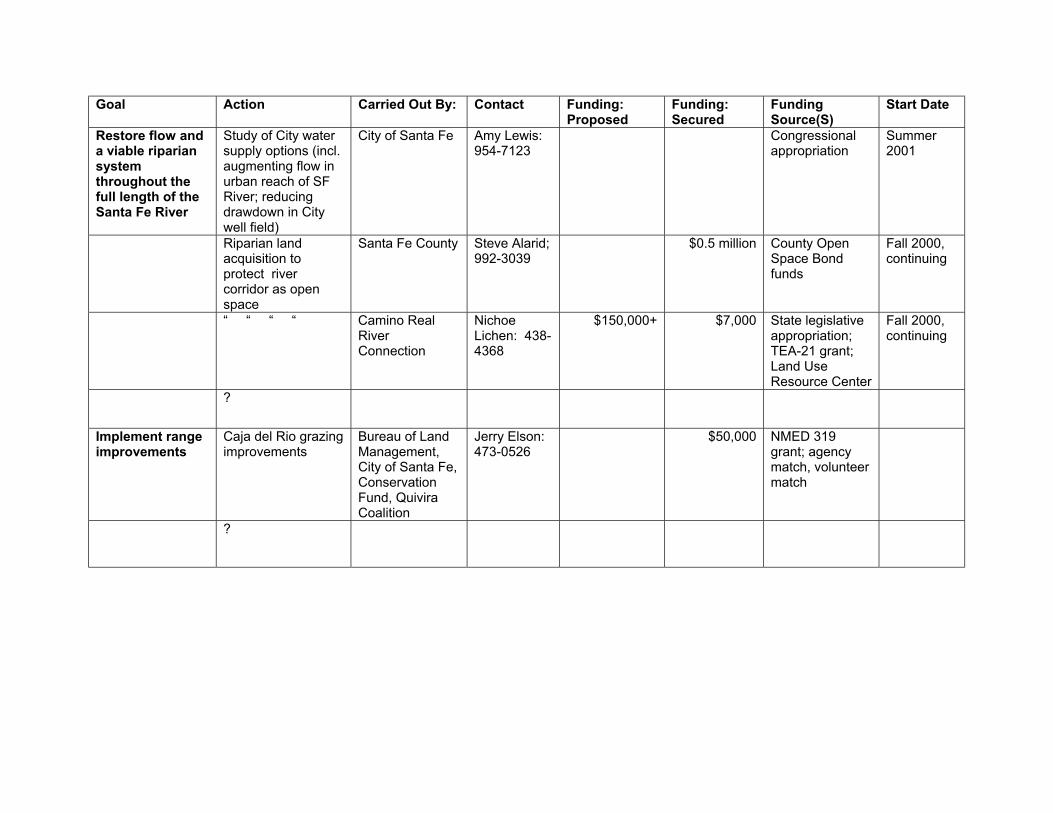
Goal Action Carried Out By: Contact Funding: Proposed
Funding: Secured
Funding Source(S)
Start Date
Restore flow and a viable riparian system throughout the full length of the Santa Fe River
Study of City water supply options (incl. augmenting flow in urban reach of SF River; reducing drawdown in City well field)
City of Santa Fe Amy Lewis: 954-7123
Congressional appropriation
Summer 2001
Riparian land acquisition to protect river corridor as open space
Santa Fe County Steve Alarid; 992-3039
$0.5 million County Open Space Bond funds
Fall 2000, continuing
“ “ “ “ Camino Real River Connection
Nichoe Lichen: 438-4368
$150,000+
$7,000 State legislative appropriation; TEA-21 grant; Land Use Resource Center
Fall 2000, continuing
?
Implement range improvements
Caja del Rio grazing improvements
Bureau of Land Management, City of Santa Fe, Conservation Fund, Quivira Coalition
Jerry Elson: 473-0526
$50,000 NMED 319 grant; agency match, volunteer match
?