scenario design on the impact of a high … · scenario design on the impact of a high -magnitude...
TRANSCRIPT

SCENARIO DESIGN ON THE IMPACT OF A HIGH-MAGNITUDE EARTHQUAKE IN THE CITY OF
LIMA, PERU
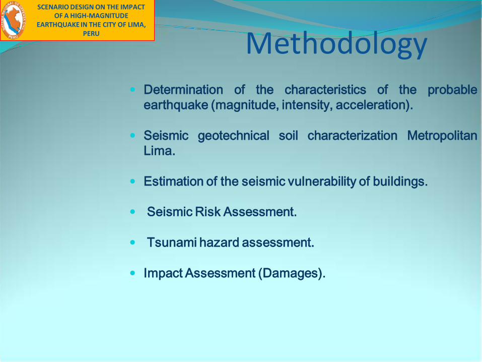
Methodology Determination of the characteristics of the probable
earthquake (magnitude, intensity, acceleration).
Seismic geotechnical soil characterization MetropolitanLima.
Estimation of the seismic vulnerability of buildings.
Seismic Risk Assessment.
Tsunami hazard assessment.
Impact Assessment (Damages).
SCENARIO DESIGN ON THE IMPACT OF A HIGH-MAGNITUDE
EARTHQUAKE IN THE CITY OF LIMA, PERU

Document Features
• An instrument to support basic performance protocol forhumanitarian response to seismic disasters in Lima-Callao.
• Done in a short period of time (two months) based onsecondary information available.
• Allows estimation of impacts and the preliminary analysis ofseismic risk.
• It provides the basis for creation of more precise and detailedproducts.
• Could be easily modified based on updated data.
• Shows the simulation scenario of earthquake damages inurban areas, representing results spatially using a geographicinformation system (GIS).
SCENARIO DESIGN ON THE IMPACT OF A HIGH-MAGNITUDE
EARTHQUAKE IN THE CITY OF LIMA, PERU

Study Area
Lima and the Constitutional Province of Callao. 41 districtsassessed in the study of vulnerability and seismic risk byCISMID (April 2005) were identified as the study area, as theCISMID study is the main source in the field of seismic hazardestimation.
Parameters to be effective:
Due to the vastness and the information available, the level ofdetail selected was the district level, and in very large districts,the planning sectors level (homogeneous urban areas identifiedin the majority of the District Development Plans).
SCENARIO DESIGN ON THE IMPACT OF A HIGH-MAGNITUDE
EARTHQUAKE IN THE CITY OF LIMA, PERU

Seismic Hazard EstimationDetermining the probable characteristics of earthquake.
• Depth: 33 km.
• Epicenter: In front of Lima.
• Magnitude: 8.0 Mw.
• Intensity: VIII (MM).
• Imax Area: Chimbote City and Metropolitan Lima
• Average Maximum Acceleration: 350-400 cm/seg2.
Source: Dr. H. TAVERA (IGP)SEISMIC HAZARD ESTIMATION
SCENARIO DESIGN ON THE IMPACT OF A HIGH-MAGNITUDE
EARTHQUAKE IN THE CITY OF LIMA, PERU

Seismic Zoning Lima and Callao
ZONE I:Rocky outcrops of rigid behaviorNatural Vibration periods: Vn 0.1 and 0.3 seconds.Seismic amplification factor S = 1.0Soil natural period Tp = 0.4 seconds.
ZONE II:Surface layer of fine granular soils and clay soilsVn: 0.3 and 0.5 seconds S = 1.2.Tp = 0.6 seconds.
ZONE III:Deposits of fine soil and sand, thick ground state.Vn: = 1.4.Tp = 0.9 seconds 0.5 and 0.7 seconds.
ZONE IV:Aeoliansand deposits of thick, loose, muddy soil and marine deposits Vn: 0.7segundos, S = 1.6, Tp = 1.2 seconds.
ZONE V:Areas formed by deposits of loose, heterogeneous fill thathave been placed in natural depressions or excavationsmade in the past, with powers between 5 and 15 m. Alsoincluded are landfills that were once located outside ofurban areas, but are now urbanized. The dynamic behaviorof these fills is uncertain and requires a specific study.
Source: CISMID.
SCENARIO DESIGN ON THE IMPACT OF A HIGH-MAGNITUDE
EARTHQUAKE IN THE CITY OF LIMA, PERU

ESTIMATES OF TSUNAMI HAZARD
SCENARIO DESIGN ON THE IMPACT OF A HIGH-MAGNITUDE
EARTHQUAKE IN THE CITY OF LIMA, PERU

Seismic Zoning Lima and Callao
TSUNAMI HAZARD CHARACTERIZATION
It is assumed that plane of subduction would be in thesame direction as the subduction axis caused by theearthquake proposed for the seismic scenario.
Ellipse Axes
1.- Time
L
V3 .- Flood level
Failure 2.-Wave Height Costa
Epicenter. Vertical displacement and alteration of the water column
SCENARIO DESIGN ON THE IMPACT OF A HIGH-MAGNITUDE
EARTHQUAKE IN THE CITY OF LIMA, PERU
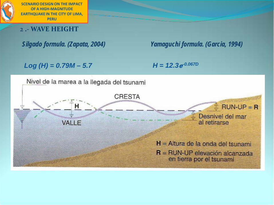
2 .- WAVE HEIGHT
Silgado formula. (Zapata, 2004) Yamaguchi formula. (Garcia, 1994)
Log (H) = 0.79M – 5.7 H = 12.3e-0.067D
SCENARIO DESIGN ON THE IMPACT OF A HIGH-MAGNITUDE
EARTHQUAKE IN THE CITY OF LIMA, PERU

Different levels of flood
SCENARIO DESIGN ON THE IMPACT OF A HIGH-MAGNITUDE
EARTHQUAKE IN THE CITY OF LIMA, PERU

ESTIMATION OF THE SEISMIC VULNERABILITY
SCENARIO DESIGN ON THE IMPACT OF A HIGH-MAGNITUDE
EARTHQUAKE IN THE CITY OF LIMA, PERU

HEIGHT OF BUILDING
ONE FLOOR TWO FLOORS
THREE FLOORS FOUR OR MORE FLOORS
SOURCE: INEI / PREDES
SCENARIO DESIGN ON THE IMPACT OF A HIGH-MAGNITUDE
EARTHQUAKE IN THE CITY OF LIMA, PERU

SOURCE: INEI / PREDES
CONDITION OF CONSERVATION
DETERIORATED IN CONSOLIDATION
CONSOLIDATED DENSIFIED
SCENARIO DESIGN ON THE IMPACT OF A HIGH-MAGNITUDE
EARTHQUAKE IN THE CITY OF LIMA, PERU

SOURCE: INEI / PREDES
MATERIAL OF BUILDING
BRICK OR CEMENT BLOCK ADOBE
WOOD / MAT
SCENARIO DESIGN ON THE IMPACT OF A HIGH-MAGNITUDE
EARTHQUAKE IN THE CITY OF LIMA, PERU

SOURCE: INEI / PREDES
TYPE OF HOUSING
INDEPENDENT HOUSE VILLA
APARTMENT IN BUILDING SPONTANEOUS SETTLEMENTS
SCENARIO DESIGN ON THE IMPACT OF A HIGH-MAGNITUDE
EARTHQUAKE IN THE CITY OF LIMA, PERU

ESTIMATION OF RISK SCENARIO AND MAGNITUDE OF IMPACT
SCENARIO DESIGN ON THE IMPACT OF A HIGH-MAGNITUDE
EARTHQUAKE IN THE CITY OF LIMA, PERU
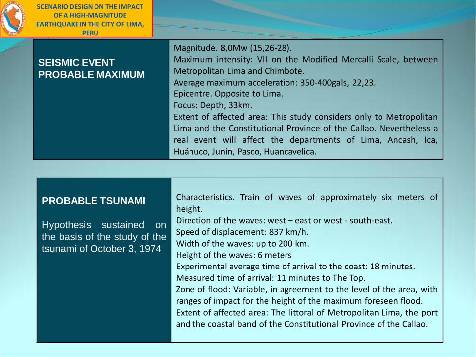
SEISMIC EVENTPROBABLE MAXIMUM
Magnitude. 8,0Mw (15,26-28).Maximum intensity: VII on the Modified Mercalli Scale, betweenMetropolitan Lima and Chimbote.Average maximum acceleration: 350-400gals, 22,23.Epicentre. Opposite to Lima. Focus: Depth, 33km.Extent of affected area: This study considers only to MetropolitanLima and the Constitutional Province of the Callao. Nevertheless areal event will affect the departments of Lima, Ancash, Ica,Huánuco, Junín, Pasco, Huancavelica.
PROBABLE TSUNAMI
Hypothesis sustained onthe basis of the study of thetsunami of October 3, 1974
Characteristics. Train of waves of approximately six meters ofheight.Direction of the waves: west – east or west - south-east.Speed of displacement: 837 km/h.Width of the waves: up to 200 km.Height of the waves: 6 metersExperimental average time of arrival to the coast: 18 minutes.Measured time of arrival: 11 minutes to The Top.Zone of flood: Variable, in agreement to the level of the area, withranges of impact for the height of the maximum foreseen flood.Extent of affected area: The littoral of Metropolitan Lima, the portand the coastal band of the Constitutional Province of the Callao.
SCENARIO DESIGN ON THE IMPACT OF A HIGH-MAGNITUDE
EARTHQUAKE IN THE CITY OF LIMA, PERU

SOIL TYPE
SEISMIC AMPLIFICATION
MOVEMENT
SEISMIC HAZARD
TSUNAMILIQUEFACTION
FLOOD
SLIDING
CHARACTERISTICS THAT INCREASE LIKELIHOOD OF PERSONAL INJURY AND DAMAGE TO INFRASTRUCTURE
SEISMIC VULNERABILITY
EARTHQUAKE SCENARIO
LOSS OF LIVES AND INFRASTRUCTURE
SEISMIC RISK
SCENARIO DESIGN ON THE IMPACT OF A HIGH-MAGNITUDE
EARTHQUAKE IN THE CITY OF LIMA, PERU

PICTURE OF SEISMIC IMPACT IN THE CITY OF LIME
POPULATION
DEAD 51,019
INJURED 686,105
NOT AFFECTED 7 548,603
TOTAL 8 285,727
HOUSING
DESTROYED 200,347
UNINHABITABLE 348,328NOT AFFECTED 1 331,583
TOTAL 1 880,257
SCENARIO DESIGN ON THE IMPACT OF A HIGH-MAGNITUDE
EARTHQUAKE IN THE CITY OF LIMA, PERU

LOCATION OF HOSPITALS AND PRIVATE CLINICS
The most important health facilities with majorcapacity were considered. The analysis showedthat approximately 68% of hospitals and 81% ofclinics are located on Soil Type I. This typepresents minor seismic danger.
SOURCE: INEI / PREDES
SOIL TYPEHEALTH ESTABLISHMENTS
HOSPITALS CLINICS
SOIL I 32 35
SOIL II 14 7
SOIL III 1 1
SOIL IV 0 0
SCENARIO DESIGN ON THE IMPACT OF A HIGH-MAGNITUDE
EARTHQUAKE IN THE CITY OF LIMA, PERU

SOIL TYPE EDUCATIONAL INSTITUTIONSINITIAL PRIMARY PRIMARY SECONDARY
SOIL I 931 1218 1909SOIL II 479 734 1134SOIL III 118 58 254SOIL IV 29 38 78
LOCATION OF EDUCATIONAL INSTITUTIONSIn order to better identify the points, it was necessary todivide the representation of this vulnerable asset typeinto four areas: Central, North, South and East. The resultsshow that 22% of educational centers are of the initiallevel, 29% are of primary level and 48% are of secondaryprimary level.SOURCE: CISMID, MINEDU
SCENARIO DESIGN ON THE IMPACT OF A HIGH-MAGNITUDE
EARTHQUAKE IN THE CITY OF LIMA, PERU
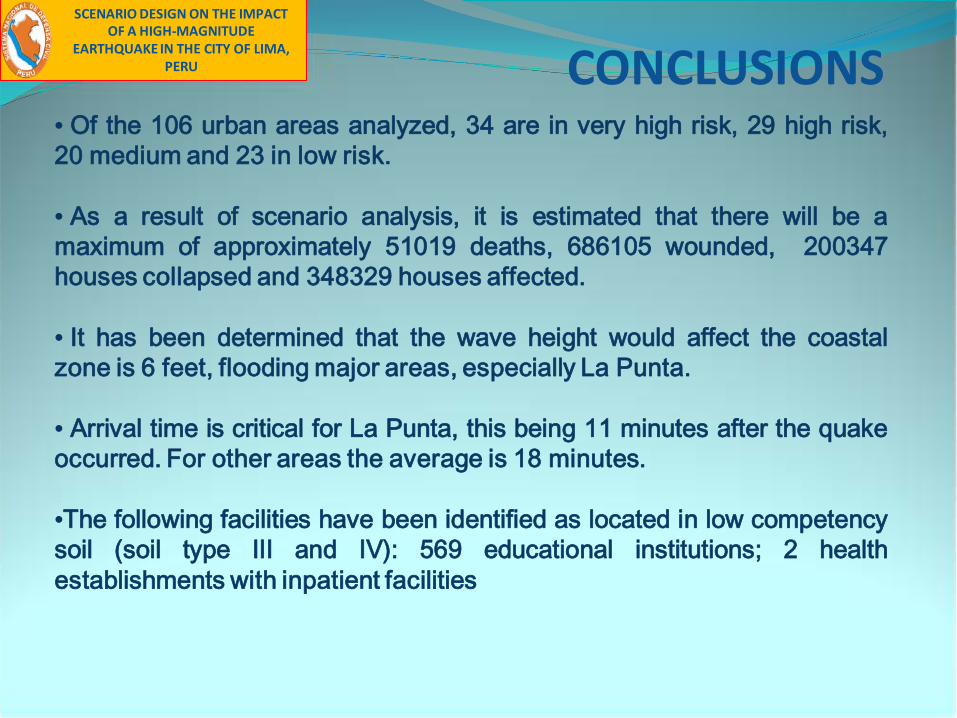
CONCLUSIONS• Of the 106 urban areas analyzed, 34 are in very high risk, 29 high risk,20 medium and 23 in low risk.
• As a result of scenario analysis, it is estimated that there will be amaximum of approximately 51019 deaths, 686105 wounded, 200347houses collapsed and 348329 houses affected.
• It has been determined that the wave height would affect the coastalzone is 6 feet, flooding major areas, especially La Punta.
• Arrival time is critical for La Punta, this being 11 minutes after the quakeoccurred. For other areas the average is 18 minutes.
•The following facilities have been identified as located in low competencysoil (soil type III and IV): 569 educational institutions; 2 healthestablishments with inpatient facilities
SCENARIO DESIGN ON THE IMPACT OF A HIGH-MAGNITUDE
EARTHQUAKE IN THE CITY OF LIMA, PERU

RECOMMENDATIONS (1/2)•The existing information on geotechnical microzonation is coarse. Moredetailed studies are needed, particularly for the identification of lesscompetent soils.
•The study established a maximum impact level. A range that alsoestablishes a minimum impact level should also be analyzed.
• Incorporate the analysis regarding damages caused to gas, water andelectricity networks.
• Refine details of study in regards to physical vulnerability
• Represent the risk of Lima at the block level. The indicators ofvulnerability must be obtained through census data and field verification.
SCENARIO DESIGN ON THE IMPACT OF A HIGH-MAGNITUDE
EARTHQUAKE IN THE CITY OF LIMA, PERU

RECOMMENDATIONS (2/2)
• Improve mechanisms for cooperation and information exchange throughan institution coordinating agency, avoiding duplication of effort in thecreation of information base.
• Perform risk analysis at the sectoral level and its subsequent integrationinto an integrated risk map for purposes of preparation.
• Awareness of local government level for risk studies are considered indevelopment planning and integrate with the other levels of government.
SCENARIO DESIGN ON THE IMPACT OF A HIGH-MAGNITUDE
EARTHQUAKE IN THE CITY OF LIMA, PERU

GRACIAS