schedule of proposed changes - fermanaghomagh.com
TRANSCRIPT

Local Development Plan 2030
Draft Plan Strategy
-
Schedule of Proposed Changes
October 2020

1
1. Introduction
1.1 Fermanagh and Omagh District Council (The Council) is preparing a new local development plan for the District, referred to as the Local Development Plan 2030 (LDP). This will replace the existing plans and provide a revised framework to inform planning decision making and guide development. The first plan document which will comprise the LDP, is the Draft Plan Strategy which was published and consulted upon between 26 October and 21 December 2018. As a result of this public consultation exercise, the Council received 322 individual Representations raising 659 issues.
1.2 Following detailed consideration of the representations received, the Council
is proposing a number of changes to the Draft Plan Strategy. 1.3 In considering representations received to the Draft Plan Strategy, and the
extent and nature of any proposed change required, account has been taken of Development Plan Practice Note 10 ‘Submitting Development Plan Documents for Independent Examination’ (DPPN 10).
1.4 DPPN 10 provides for two main types of change:
(1) Minor Changes: These are minor editing changes for factual correction
which do not need public consultation, and which would not affect the
soundness of the plan.
(2) Focussed changes: These are limited changes made only in exceptional
circumstances in order to deal with unforeseen issues and address
impacts upon the soundness of the plan. The DPPN advises that they
must be consulted upon prior to the submission of the plan for
examination.
1.5 In addition to these, the Council has identified a number of other changes
which, in our view, are considered to represent logical and rational
amendments to a policy or policy clarification in response to representations
received during the consultation period. They are not minor changes and they
are not in response to addressing ‘soundness’ issues. Whilst the changes in
many cases may be important and significant, they are not required to make
the plan sound. To ensure that those interested persons who made
representations are not disadvantaged, the Council considers that these
changes, in addition to focussed changes, require to be consulted upon.
Whilst minor changes do not require consultation, the Council has decided to
include them in the Schedule (Appendix 2).
2. Proposed Changes Consultation
2.1 The consultation period will run for 8 weeks, commencing on 8th October 2020
and ending on 3rd December 2020.

2
The purpose of the consultation is to inform the general public, consultation
bodies and interested parties of the Proposed Changes and allow comments
if they wish and to demonstrate for the Independent Examination (IE) that
everyone affected has had an opportunity to comment before any
recommended change is made to the Draft Plan Strategy by the Planning
Appeals Commission (PAC). It is important to note that ultimately it will be for
the Department for Infrastructure to determine whether any amendments
recommended by the Planning Appeals Commission should be made to the
Draft Plan Strategy.
2.2 It is important to note that comments made at this stage can only address and
relate to the soundness of Proposed Changes. This consultation is not an
opportunity to add to previous representations or to make new comments on
parts of the original Draft Plan Strategy not subject to change, as the PAC
may not consider any new representations. Further information on
‘soundness’ and the soundness tests can be found in DPPN 06.
2.3 Comments on the Proposed Changes can be submitted in writing by either:
• Emailing to [email protected] or:
• Posting to:
Local Development Plan
Strule House
16 High Street
Omagh
Co Tyrone
BT78 1BQ
2.4 It should be noted that comments received cannot be treated as confidential.
All comments will be made available for public inspection and placed on the
Council’s website. However, all personal contact details (personal telephone
numbers, email addresses, signatures and sensitive personal data) will
remain confidential. A copy of comments will be supplied to the Department
for Infrastructure and the Planning Appeals Commission as part of the
Independent Examination process. Further details are available in the
Council’s privacy notice: www.fermanaghomagh.com/your-council/privacy-
statement/
2.5 The deadline for comments is 3rd December 2020. Comments received after
the deadline will not be accepted.

3
3. Schedule of Proposed Changes
3.1 Appendix 1 of this report presents the Proposed Changes which have been
illustrated in the following two ways:
• Where there is new text to be included this is shown in red and
underlined:
• Where there has been a change to the wording of a policy or
paragraph, a deletion is shown in red and by a strike-through
3.2 For each Proposed Change, the document sets out the following: Proposed
Change Reference: a reference number for the proposed change; Draft Plan
Strategy Page: the page number of where the change is to occur; Policy/
Paragraph/Table Number etc: the specific policy, paragraph or table;
Summary of Issue/Justification: summarising the reasoning behind the
change: Proposed Change: the change itself, presented in the manner
identified in para.3.1; and the Representation/issue number that resulted in
the change. Exceptionally, some changes have been made as a consequence
of changes made elsewhere in the Draft Plan Strategy and these are denoted
as N/A in the last column.
3.3 The Proposed Changes are also subject to Sustainability Appraisal (SA)
incorporating Strategic Environmental Assessment (SEA), Habitats
Regulations Assessment (HRA); Rural Needs Impact Assessment (RNIA) and
Equality Impact Assessment (EqIA). These have been considered within the
relevant Addendums published alongside the Schedule of Proposed
Changes. Comments are invited on these Addendums in addition to
comments on the proposed changes.
3.4 It should be noted that the Council has considered every representation which
provided a comment to the Draft Plan Strategy. The Council’s responses to
the issues raised in representations will be presented as part of the LDP Draft
Plan Strategy Consultation Report which will be submitted as part of the
documentation required for Independent Examination.
4. What Happens Next?
4.1 Following the conclusion of the 8-week consultation period, the Draft Plan
Strategy and all comments received will be submitted to the Department for
Infrastructure who will consider whether the Draft Plan Strategy should
proceed to Independent Examination. The IE will be conducted by the
Planning Appeals Commission.
4.2 It is important to note that ultimately it will only be for the Department to
determine whether any amendments recommended by the Planning Appeals
Commission should be made to the Draft Plan Strategy.

4
4.3 For further information regarding the preparation of the LDP, please contact
the LDP Team either by email: [email protected] or
by phone on 0300 303 1777.

5
Appendix 1
Schedule of Proposed Changes.

Appendix 1 – Proposed Changes
6
Proposed Change Ref
Draft Plan Strategy Page
Policy/ Paragraph/ Table Number etc
Summary of Issue/Justification
Proposed Change
Rep/ Issue ref
PART ONE
2.0 Legal Status and Policy Context
1 15 Insert Paragraph (after 2.13)
Addition of text to refer to the UK Marine Policy Statement (UK MPS)
The UK Marine Policy Statement (UK MPS) The UK Marine Policy Statement (MPS) provides the policy framework for the marine planning system and taking decisions affecting the marine environment. This includes, for example, decisions on proposals that are not located near the coast, but which might impact on the marine area. In addition, any function (e.g. LDP preparation) capable of affecting (or which might affect) the marine area must also have regard to the appropriate marine policy documents.
The UK MPS is a material consideration and is of equivalent standing to terrestrial policy documents, such as the Regional Development Strategy (RDS) and the Strategic Planning Policy Statement (SPPS). It also provides the high-level policy context for the preparation of Marine Plans.
DPS/250/10
3.0 Preparation Process, Consultation and Assessments
2 18 Para.3.6 Include additional text to recognise cross boundary international environmental designations
It is also recognised that the council area is adjacent or connected to a number of international environmental designated sites in neighbouring areas and these have been taken into account in the preparation of the LDP.
DPS/022/02
5.0 The Council’s Vision and Strategic Growth Objectives
3 27 Table 1 Amend new homes figure in Strategic Objective 4 to reflect new HGI (Sept 2019) and amend footnote 2 accordingly.
Provide for 4,3005,1902 new homes by 2030 across a range of housing types and tenures… 2The Revised Housing Growth Indicator for FODC for the period 20162-203025 is 4,3500 (calendar year). This translates to 6,230 dwellings up to 2030 and 5,190 4,300 dwellings for the plan period - 1st April 2015- to 31st March 2030 (financial year).
N/A
4 29 Table 1 Amend Strategic Objective 15 to include words ‘and public health’
Sustainably manage and safeguard where appropriate our natural resources including minerals and water, protecting the environment and public health, and providing sustainable services including effective and sustainable waste management to meet population needs.
DPS/062/01
Draft Policy SP01: Furthering Sustainable Development
5 30 Policy SP01 Amend policy wording to comply with the demonstrable harms test in the SPPS.
The Council will permit development proposals which further sustainable development and promote measures to mitigate and adapt to climate change, and which accord with have regard to the Local Development Plan and other material considerations, unless the proposed development will cause demonstrable harm to interests of acknowledged importance. In such cases, planning permission should be refused.
DPS/022/03
Strategic Allocation of Land for Housing

Appendix 1 – Proposed Changes
7
Proposed Change Ref
Draft Plan Strategy Page
Policy/ Paragraph/ Table Number etc
Summary of Issue/Justification
Proposed Change
Rep/ Issue ref
6 39 Para. 6.22 Amend wording and figures to reflect new HGI (Sept 2019).
The RDS identifies regional housing needs as Housing Growth Indicators (HGIs) across Northern Ireland. The HGI figures issued by central government cover the period 20126-203025 (calendar year) and assigned 4,3500 dwellings to our Council area which, when adjusted to cover the period up to 2030, establishes a housing target of 6,230, or 5,1904,300 dwellings for the period 1st April 2015 to 31st March-2030.
N/A
7 40 Para. 6.25 Amend wording and figures to reflect new HGI (Sept 2019) and to reflect updated completions (between 2016 and 2019).
The scale, type, uses and form of development in settlements will reflect their role as employment, retail and service centres, their level of accessibility, and environmental and infrastructure constraints. Table 4 (below) indicates the overall strategic allocation of land for housing within our settlements to meet our housing need. Taking into account completions since 20165, this leaves a balance as at April 20197 of 4,0012,660 of the 5,190 4,300 new homes provision by 2030.
N/A
Draft Policy SP03: Strategic Allocation and Management of Housing Supply
8 40 Table 4 Addition of details of Housing Commitments and update Housing Need to current date and to reflect new HGI (Sept 2019).
Housing Need (20197-2030) Housing Commitments
(April 2019)
Dwellings
Land (Hectares)*
Dwellings
Main Towns Enniskillen 979676 39.1. 1298
Omagh 1,507983 60.3 1290
Total 2,4861,659 99.4 2578
Local Towns Carrickmore 2815 1.4 42
Dromore 8363 4.2 74
Fintona 9765 4.8 95
Irvinestown 15168 7.5 448
Lisnaskea 182135 9.1 272
Total 541347 27.0 931
Villages and Small Settlements*
Total
974675
64.9
1255
DPS/317/06
9 40 Insert New Paragraph (after Table 4)
Confirm that Table 4 is indicative/strategic only.
It should be noted that Table 4 is currently an indicative strategic allocation for our settlements. At the LPP stage more detailed analysis of current growth rates and any short-term infrastructure capacity limitations (including the forward programme for wastewater treatment works) will be accounted for and adjustments may be made to the allocation.
DPS/317/06 DPS/251/01
10 41 SP03 Policy Title
Add ‘in our Settlements’ to policy title to clarify that the policy only relates to settlements.
Draft Strategic Policy SP03 – Strategic Allocation and Management of Housing Supply in our Settlements.
DPS/051/10 DPS/109/09
11 41 Policy SP03 Amendments to policy to confirm it applies to Housing Supply within settlements only and amendments to policy to
The Plan Strategy will make provision for at least4,0002,660 new homes within our settlements in the period 20197-2030. (a) Main and Local Towns
DPS/022/04 DPS/115/13 DPS/317/04

Appendix 1 – Proposed Changes
8
Proposed Change Ref
Draft Plan Strategy Page
Policy/ Paragraph/ Table Number etc
Summary of Issue/Justification
Proposed Change
Rep/ Issue ref
ensure it relates to allocation and management of housing supply (and not windfall sites (see HOU01)). Re-wording to clarify the intent of the policy.
The following will be taken into account when determining the amount of land to allocate for housing: The number of houses built within the individual settlements between 1st March 2012 and 31st March 2017. The number of permissions (commitments) within the individual settlement. An allowance for windfall housing sites. Managing the Housing Supply In order toTo manage the housing supply over the plan period, zoned housing land within the main towns and local towns will be released in two phases. A criteria-based approach to selecting sites for each phase will be undertaken. The selection criteria will take account of several factors including; Accessibility Analysis; the prioritisation of brownfield land within the Urban Footprint; the ability to deliver affordable housing where a need exists; topography; flooding and other constraints to development including waste water network and treatment capacity. Sites will only be allocated where it can be shown that they can accommodate at least 10 dwellings. The Phase 1 and Phase 2 sites will be identified within the Local Policies Plan along with the key site requirements to guide their development. Until such time that the Local Policies Plan is adopted land will be zoned for housing as indicated within the Fermanagh Area Plan and the Omagh Area Plan. Phase 1 Sites Once Phase 1 will include committed housing sites with extant planning permissions or sites which are under development have been taken into account, Phase 1 sites will be identified . Phase 1 sites should be sufficient to meet any remaining future housing need over the Plan period (i.e. before 2030).in the majority of settlements. A criteria-based approach to selecting sites for each phase will be undertaken. The selection criteria will take account of a number of factors including Urban Capacity Study; Accessibility Analysis; the prioritisation of brownfield land within the Urban Footprint; topography; flooding and other constraints to developmentThe sites will be identified within the Local Policies Plan along with the key site requirements to guide their development. Sites will only be allocated where it can be shown that they can accommodate at least 10 dwellingsPhase 2 or Reserve Sites Where it is evident that the number of permissions (commitments) significantly exceeds the future housing need for the plan period within a settlement the following approach will be taken in the LPP: Phase 2 Housing sSites will be identified for allocation beyond the plan period (i.e. beyond after 2030). These will only be released at an earlier time within the plan period (i.e. before 2030) where it is evident through either monitoring or the re-appraisal of future housing need that these housing sites will be required to meet housing need within the plan period. The exact criteria and mechanism for how these sites could be released will be outlined within the Local Policies Plan. Development proposals for housing on unallocated ‘greenfield sites’ that are within the Settlement Limits will not be supported as they would undermine the strategy. This will also apply to development proposals for the renewal of existing and lapsed planning permissions (i.e. existing commitments) on ‘greenfield sites’. (b) Villages and Small Settlements Within the Villages and Small Settlements, Housing Policy Areas (HPAs) may be identified in the LPP. These will indicate where most new housing within these settlements will be located. The HPAs will be identified following a detailed analysis and character appraisal of the settlement and will focus on providing housing in

Appendix 1 – Proposed Changes
9
Proposed Change Ref
Draft Plan Strategy Page
Policy/ Paragraph/ Table Number etc
Summary of Issue/Justification
Proposed Change
Rep/ Issue ref
locations where it is most likely to integrate into the character of the settlement. The HPAs will also be commensurate with the scale of, and the future housing need of, the individual settlement and after committed housing sites with extant planning permissions or sites which are under development have been taken into account.
12 45 Para 6.33 Replace reference to Local Transport Strategy with Local Transport Study to reflect that DfI will not be publishing a Strategy but will be publishing a Study (NB: At this time only a draft copy of the Study has been provided to the Council by DfI).
The LDP will be supported by a Local Transport Strategy Study (LTS) prepared by the Department for Infrastructure (DfI).
N/A
PART TWO
1.0 Introduction
13 47 Para.1.3 Include text referring to the precautionary principle and align with draft policy SP01.
The Planning Act 2011 establishes a plan-led system which gives primacy to the Local Development Plan in the determination of planning applications unless other material considerations indicate otherwise. In determining planning applications, planning authorities will also be guided by the precautionary approach that, where there are significant risks of damage to the environment, its protection will generally be paramount, unless there are imperative reasons of overriding public interest. Our draft Plan Strategy provides…
DPS/022/05
2.0 DEVELOPMENT AND DESIGN
Development and Design – Context and Justification
14 48 Para 2.2 Include reference to Design and Access statement requirements.
This reflects the SPPS and the benefits of good design and place making which can create more successful places to live, bring communities together and attract business investment. This process can be supported by the development of Design and Access Statements. The SPPS also refers to the need for LDP policies “to promote or reinforce local distinctiveness”.
DPS/317/93
Draft Policy DE01: General Amenity Requirements
15 49 Policy DE01 Amendment to reword the opening sentence in relation to amenity, public safety and the public interest.
The Council will not support development proposals where they would unacceptably affect: 1) the amenities of the area or the residential amenity of nearby properties or sensitive receptors; and 2) the existing use of land and buildings, public safety (including road safety) and visual amenity ought to be protected in the public interest. These includeing the impact of
i) overlooking and/or loss of privacy; ii) dominance or overshadowing; iii) odour, noise, vibration or other forms of disturbance; iv) forms of pollution; and v) general disturbance.
DPS/317/31
16 49 Para 2.5 Amendment and add text to confirm public safety includes road matters and land stability.
In assessing planning applications, the basic question is not whether owners and occupiers of neighbouring properties would experience financial or other loss from a particular development, but whether the proposals would unacceptably affect amenities and the existing use of land and buildings, public safety or visual amenity, that ought to be protected in the public interest. Public safety is considered to include matters such as roads safety and land stability.
DPS/248/04 DPS/317/31

Appendix 1 – Proposed Changes
10
Proposed Change Ref
Draft Plan Strategy Page
Policy/ Paragraph/ Table Number etc
Summary of Issue/Justification
Proposed Change
Rep/ Issue ref
Draft Policy DE02: Design Quality
17 51 Para 2.11 Amendment to provide a fuller definition of connectivity by different travel modes.
The Council recognises that the importance of ensuring that all new developments within our settlements are well connected to existing public transport, cycling and walking routes, as well as providing facilities such as cycle parking and shower facilities to facilitate those using sustainable modes of transport.
DPS/317/32
Draft Policy DE03: Sustaining Rural Communities
18 53 Policy DE03 Delete reference to policy OSR03 (as it will be deleted) and add reference to TR03 as this could potentially allow development that would be within the countryside.
Non-Residential Development Planning permission will be granted for non-residential development in the countryside in the following cases: • outdoor sport and recreational uses in accordance with Policyies OSR03 OSR07 • Park and Ride and Park and Share car parks in accordance with Policy TR03
N/A
Draft Policy DE07: Advertisements
19 58 Para 2.28 Amendment and add text to confirm public safety includes road safety.
The Council will seek to ensure that the display of outdoor advertisements does not prejudice public safety, including road safety….”
DPS/317/34
Draft Policy DE08: Advertisements and the Historic Environment
20 58 Policy DE08 Additional wording to policy that signage must be carefully designed.
• where the asset is a building, signage must be carefully designed and located so as to respect the architectural form and detailing of the building; and,
DPS/113/12
3.0 PEOPLE AND PLACES
Draft Policy HOU01: Housing in Settlements Towns
21 61 Policy HOU01
Amendments to policy to confirm it relates to the consideration of applications on Windfall sites in settlements only (and not allocation or management of housing supply (See SP03)). Re-wording to clarify the intent of the policy.
Draft Policy HOU01 – Housing in Settlements and Windfall Sites Main and Local Towns The Council will support proposals for housing on sites zoned for housing within the towns and on brownfield land within the urban footprint of within the towns. a) The Council and will only permit proposals for housing on unzoned greenfield land within the settlement limits of a main or local town where either: (i) the future housing need and demand exceeds the number of existing permissions (commitments) and there is no evidence of this housing need being met through sites zoned for housing; or (ii) it is demonstrated within the Housing Need Assessment that there is an unmet need for aAffordable hHousing which cannot be met through any existing commitments or on sites zoned for housing. b) Other Villages and Small Settlements Within villages and small settlements, housing will be permitted within Housing Policy Areas and on brownfield land and where it is of a size and scale which is in-keeping with the size and scale of the settlement. The Council will only permit housing on unzoned greenfield land within the settlement limits of a village or small settlement where either:
DPS/022/06 DPS/095/02

Appendix 1 – Proposed Changes
11
Proposed Change Ref
Draft Plan Strategy Page
Policy/ Paragraph/ Table Number etc
Summary of Issue/Justification
Proposed Change
Rep/ Issue ref
(i) The future housing need exceeds the number of existing commitments and there is no evidence of this housing need being met on sites within any Housing Policy Areas; or, (ii) it is demonstrated within the Housing Need Assessment that there is an unmet need for Affordable Housing which cannot be met through any existing commitments or on sites within any Housing Policy Areas.
22 61 Insert New Paragraphs (after Para 3.7)
Clarify terminology used in the policy and confirm role of Annual Monitoring Report.
For the purposes of this policy ‘existing commitments’ means the total of any extant planning permissions or sites which are currently under development as recorded in the most recent Annual Monitoring Report. ‘Sites zoned for housing’ means, prior to the adoption of the LLP, sites zoned in the Area Plans, and after the adoption of the LLP, Phase 1 and Phase 2 sites. The Annual Monitoring Report will provide an update on any sites zoned for housing (including HPAs) to provide an indication of likelihood of development progressing. The policy will also apply to lapsed permission. Therefore, any lapsed permission on unzoned greenfield land within settlements limits will need to comply with points (i) or (ii).
DPS/022/06
Draft Policy HOU03: Affordable Housing in Settlements
23 63 Para 3.12 Additional text to confirm development viability is a material consideration.
In those circumstances where the number of affordable housing units required by this policy would exceed the need, a lower number of units will be acceptable. Where the viability of a site is in dispute, the Council will expect developers to present viability evidence on an open book basis at the planning application stage. Where necessary this evidence will be independently assessed, and where it is demonstrated that a development is not viable a reduced or alternative provision of affordable housing may be acceptable.
DPS/118/02
24 64 Para 3.14 Amendment to text to reflect that there are circumstances where social rented housing cannot be maintained in perpetuity.
The delivery of social rentedaffordable housing , and its retention in perpetuity, will be secured by planning conditions or by legal planning agreement.
DPS/115/16
Draft Policy HOU05: Shaping Our Houses and Homes
25 65 Policy HOU05
Additional criteria to ensure 10% of all units (for development of 20 or more units) meet wheelchair standard units, except within smaller settlements where there would be a lower threshold.
h) they demonstrate that secure-by-design principles have been applied; and- i) they provide reasonable separation distances from overhead power lines and sub-stations; and j) where either: (i) for a development of 20 units or more, or (ii) where the development is within a smaller settlement, a development of 10 units or more; at least 10% of all units are wheelchair standard units.
DPS/115/17
Draft Policy HOU06: Public Open Space in New Residential Developments
26 70 Policy HOU06
Delete two criteria and replace with a general ‘exception’ criterion.
iii) provision at a rate less than 10% of the total site area may be acceptable where the residential development:
• is located within a town centre; or,
• it is demonstrated that there are exceptional circumstances. is close to and would benefit from ease of access to areas of existing public open space; or provides accommodation for special groups, such as the elderly or people with disabilities.
DPS/267/04

Appendix 1 – Proposed Changes
12
Proposed Change Ref
Draft Plan Strategy Page
Policy/ Paragraph/ Table Number etc
Summary of Issue/Justification
Proposed Change
Rep/ Issue ref
Draft Policy HOU08: Annex Living
27 71 Policy HOU08
Delete policy as it is adequately covered by other policies in the Plan Strategy.
Draft Policy HOU08 – Annex Living The Council will support development proposals for the creation of self-contained accommodation through the extension to an existing dwelling or conversion of an outbuilding within the curtilage of the existing dwelling where it can be demonstrated that: (a) the self-contained unit will be used solely as accommodation ancillary to the main dwelling house; (b) adequate access, parking and turning facilities can still be provided within the site and which will not be independent of the existing dwelling house; and, (c) the scale of accommodation is subservient to the existing dwelling.
DPS/317/36
28 71 Para 3.29 As above There may be circumstances which necessitate ancillary accommodation, perhaps for a family member, through an extension to the house or the conversion of an outbuilding. In line with other policies of this plan, proposals will be assessed against their impact on the amenity of the area and on neighbouring properties. Any resulting planning permission will be subject to a condition tying the use of the extension or converted outbuilding as ancillary accommodation to the main dwelling house.
DPS/317/36
Draft Policy HOU09: Rural Replacement Dwellings
29 73 Para 3.37 Delete paragraph as it appears to contradict policy. Replace with alternative clarification to support policy intent.
The policy approach to retain existing unlisted vernacular dwellings may on occasion, for example due to the limited size of the existing dwelling, require that the existing dwelling is retained and sympathetically incorporated into the overall development proposal in order to permit a modest sized dwelling. Where the replacement of an unlisted vernacular dwelling is considered acceptable in principle, the encouragement provided in this policy is to retain and incorporate the existing structure into the overall layout of the development scheme and is intended to promote imaginative design solutions that will help retain a visual link with the past.
DPS/113/13
Draft Policy HOU10: Replacement of Other Rural Buildings
30 74 Policy HOU10
Insertion of the word ‘all’ to ensure consistency of language used throughout the DPS.
The Council will support the replacement of an intact redundant, non-residential building with a dwelling where all the following criteria are met:
DPS/113/14
Draft Policy HOU14: Rounding Off and Infilling
31 78 Policy HOU14
Amendment to policy wording and definition of what constitutes a group of buildings at criterion1 (c), to address concerns identified with DfI and more fully reflect intent of the policy and amendment to criterion 2 (Infilling), to accommodate two rather than one dwelling in a small gap.
The development of a new dwelling as a rounding off will be permitted where all the following criteria are met: … The proposed dwelling is visually linked with an existing group of buildings constituting a minimum number of 3 4 buildings, 3 of which must be dwellings each within their own defined curtilage; Infilling will be permitted within a line of buildings where the proposed site is a small gap suitable to accommodate only one two dwellings within an otherwise substantial and continuously built up frontage which will not detract from the rural character.
DPS/317/38 DPS/51/06 and DPS/108/03

Appendix 1 – Proposed Changes
13
Proposed Change Ref
Draft Plan Strategy Page
Policy/ Paragraph/ Table Number etc
Summary of Issue/Justification
Proposed Change
Rep/ Issue ref
Draft Policy HOU17: Affordable Housing
32 81 and 82
Policy HOU17
Increase from 6 to 8 dwellings in a group. Deletion of references to Rural Development/Community Association in line with representation from NIHE and legal advice.
Development proposals for a group of no more than 68 dwellings adjacent to or near……. • the application is made by a registered Housing Associationor a formally constituted Rural Development/Community Association registered with the Charities Commission and on the Council register for a minimum of 3 years; and …
DPS/0115/29
Draft Policy CF01: Community Facilities
33 83 CF01 Amend wording of policy to confine proposals for community facilities to within a settlement or in association with an RCA and clarify acceptable alternative uses in the countryside.
Development of new or enhanced community facilities will be permitted within a settlement or, in association with a Rural Community Area, where there is a clear community need for such a facility and they: are appropriate in scale to the needs of the local community and reflect the character of the location; and are located within the settlement or within the area they serve. In the case of a facility in association with an RCA, the use will be limited to a community hall only. Protection of community facilities Proposals involving a change of use or redevelopment of an existing community facility for a non-community use will only be supported where it can be demonstrated that:
(a) the building is no longer needed and is not economically viable for an alternative community use, and
(b) the alternative use is compatible with surrounding uses.
In the countryside, acceptable alternative uses will be limited to those where the nature and scale of the proposed use is non-residential and would be appropriate to its countryside location in accordance with other policies in the Plan.
DPS/317/40
Draft Policy OSR01: Protection of Open Space
34 86 Policy OSR01
Identify that open space should be protected irrespective of its current condition and to align with the SPPS.
The Council will only support the loss of existing or future open space, irrespective of its physical condition and appearance, to alternative uses in the following circumstances:
DPS/277/10
35 86 Insert New Paragraphs (after Para 3.74)
Provide clarification on the circumstances in which the second bullet point will apply.
In relation to playing fields and sports pitches in urban areas, there may be exceptional circumstances where it is demonstrated that the retention and enhancement of the facility can only be achieved by the redevelopment of a part of the area. This can, however, be detrimental to the quality and value of such facilities and call into question their overall viability. Consideration will therefore only be given to redevelopment proposals that are judged to have no adverse effect on the sporting potential or overall amenity value of the open space and which are restricted to an area no greater than 10% of the total site. This exception will be applied only once to guard against the piecemeal erosion of playing fields and sports pitches by a succession of small developments, possibly over a long period of time.
DPS/317/41
Draft Policy OSR02: Intensive Sports Facilities
36 87 Policy OSR02
Delete (d) as this is covered by other policies of the plan and third para. of policy so it aligns with SPPS.
c) the scale and design of the development is in keeping with the size of the settlement.; and d) the proposed intensive sports facility is convenient and accessible for all sections of society particularly children, older people and those with disabilities and is accessible in terms of walking, cycling and public transport.
DPS/022/07 DPS/317/25 DPS/317/42

Appendix 1 – Proposed Changes
14
Proposed Change Ref
Draft Plan Strategy Page
Policy/ Paragraph/ Table Number etc
Summary of Issue/Justification
Proposed Change
Rep/ Issue ref
Exceptionally, a large-scale intensive sports facility will be permitted within the countryside and away from the settlement edge where it is demonstrated that it is of strategic importance.
37 87 Para 3.75 Amend description of Intensive Sports facilities so it aligns with the SPPS.
An intensive sport facility is a purpose built indoor or outdoor resource which facilitates one or more activity fundamental to maintaining individual health and fitness. This may include, stadia, sports halls, leisure centres, swimming pools, footballs pitches such as rugby, soccer and Gaelic games and other indoor (and outdoor) sports facilities which provide for a wide range of activities.
DPS/317/42
Draft Policy OSR03: Outdoor Recreation in the Countryside
38 88 Policy OSR03 and para 3.76 and 3.77
Delete policy and clarification as policy is sufficiently covered by other policies of the plan.
Draft Policy OSR03 - Outdoor Recreation in the Countryside The Council will support development proposals for outdoor recreational uses and ancillary facilities in the countryside where: it has been demonstrated that the proposal cannot be located within a settlement or on the edge of a settlement; ancillary buildings and/or structures are designed to a high standard and are of a scale appropriate to the locality; the site is accessible by a range of transport modes including public transport and walking and cycling; and, it will not adversely impact on the landscape character or appearance of the countryside.
Policy Clarification
It is particularly important to consider the environmental impact of development proposals for outdoor recreation in the countryside, including lough shores, such as the potential impact on our valuable landscapes or habitats.
Hill walking, rambling, cycling, angling, horse riding, golf, orienteering and mountain biking and water based sports are among some of the popular countryside recreational activities within our Council area. Water based sports range from tranquil uses such as angling, sailing, canoeing and rowing to powered activities such as water-skiing, jet skiing and other boat uses. All these activities can generate a need for ancillary facilities such as a clubhouse, parking areas and access, and, in the case of water based sport uses, the need for slipways, jetties, boat houses, toilet and changing facilities.
DPS/022/08 DPS/277/12 DPS/317/26 DPS/317/42
Draft Policy OSR04: Protection of Lough Shores
39 88 Policy OSR04
Delete ‘significant’ from criteria (a) to align with SPPS.
a) there is no significant adverse impact on the natural environment, including biodiversity and landscape character;
DPS/022/09
40 89 Para 3.78 Provide a definition of a lough shore for clarity and highlight how designated sites may be impacted upon.
It is evident that the lough shores are often, by their nature, unspoilt areas and some are European or Ramsar sites.. It is important to conserve the environmental quality and character of the lough shores as well as the inland water bodies. For the purposes of this policy, lough shore is the area set back from the fringes of the shoreline of the lough. It will contain both areas of undisturbed woodland and wetland as well as existing access points associated with recreational activities such as fishing, boating, sailing, canoeing and marinas and it will also include existing walking and cycling trails. The site selection features for designated sites could be impacted directly by development or indirectly through the proliferation of access points and increase in recreation.
DPS/070/03
Draft Policy OSR05: Development Adjacent to a Main River
41 89 Policy OSR05
Delete criterion ‘c’ and ‘e’ as covered under other policies.
The Council will only support development proposals on sites adjacent to a main river where the following criteria are met:
N/A

Appendix 1 – Proposed Changes
15
Proposed Change Ref
Draft Plan Strategy Page
Policy/ Paragraph/ Table Number etc
Summary of Issue/Justification
Proposed Change
Rep/ Issue ref
a) a biodiversity strip of at least 10 metres from the edge of the river is provided and accompanied with an appropriate landscape management proposal; b) public access and recreation provision is provided where appropriate; c) there is no significant adverse impact on the natural environment or historic environment; cd) where a future riverside walk has been identified, the development incorporates its provision into the design or sets aside a sufficient area to accommodate its future provision; and, e) the proposal should not compromise or impact upon the natural flooding regime of the main river, nor interfere with water quality.
Draft Policy RCA01: Rural Community Areas
42 92 Para 3.89 Provide additional explanation of workspace/business start-up units
Examples of such types of development include and are not limited to:
• workspace/business start-up units, which include agricultural based, food production and machinery repairs.
DPS/317/128
4.0 ECONOMY
Draft Policy IB02: Loss of Industry and Business Uses
43 95 Policy IB02 and Para 4.10
Move from policy clarification to policy box that the reallocation of land zoned for Industrial and Business would be through the LDP process.
(a) Zoned Land
Alternative uses on land zoned for industry and business uses will not be permitted. The reallocation of land zoned for industry and business should only occur through the Local Development Plan process.
(b) Unzoned Land
Development proposals which result in the loss of land and floorspace used, or last used, for industry or business use will only be permitted where:
(i) it is from industry to a business use (excluding offices) or other comparable employment-
generating use; or
(ii) redevelopment for a mixed-use development which retains or incorporates into the scheme a
significant element of the industry or business use, and which will otherwise result in community or
environmental benefits; or
(iii) it is demonstrated that the present use is unsuitable for modern industry or business purposes and
there is no market interest in the site following one year of continuous active marketing.
(Para. 4.10) Industry and business uses across the district, both on zoned and unzoned sites, should be protected and so sufficient land for employment uses in maintained. As such, the re-allocation of land zoned for industry and business should normally only occur through the Local Development Plan process.
DPS/245/04
44 96 Insert New Paragraph (after Para 4.13)
Clarify terminology used in the policy in regard to ‘continuous active marketing’.
To demonstrate ‘continuous active marketing’ the following may be required: (a) how long has the site been vacant, (b) who has marketed the site (c) what the marketing exercise entailed including evidence that it was carried out; and (d) a summary and analysis of the response/s to the marketing exercise.
DPS/245/04
Draft Policy IB03: Development incompatible with Economic Development Uses

Appendix 1 – Proposed Changes
16
Proposed Change Ref
Draft Plan Strategy Page
Policy/ Paragraph/ Table Number etc
Summary of Issue/Justification
Proposed Change
Rep/ Issue ref
45 96 Insert New Paragraph (after Para 4.14)
Clarifying the details of mitigation and to align with the SPPS.
Where it is clearly demonstrated that a proposal for new or expanded development would prejudice the future operation of an established or approved economic development use, then it will normally be appropriate to refuse the application. However, it is incumbent on the planning authority to explore all means of mitigation with the developer and the established enterprise prior to determining the application.
DPS/245/04
Draft Policy IB05: Farm Diversification
46 98 Policy IB05 Remove criteria (c) to be consistent with policy IB06 and as these matters are covered by other policies of the plan.
(b) The character and scale of operation does not impact adversely on its location; and, It does not have an adverse impact on the natural or built heritage; and, (c) It does not have an adverse impact on the workings of the existing farm business.
N/A
Draft Policy IB06: Agricultural and Forestry Development
47 100 Policy IB06 and Insert New Paragraph (after Para 4.26)
Additional wording at end of policy box to refer to ammonia emissions and clarify in policy clarification, the potential significant adverse effects of ammonia emissions referred to in the policy.
Development proposals for intensive farming or animal husbandry must demonstrate that it does not result in any significant adverse environmental effects, particularly through increased ammonia emissions. Ammonia (NH3) is a gas emitted into the air as a result of many farming activities such as the housing of livestock, the storage and spreading of animal manures and slurries and the use of chemical fertiliser. Air pollution related to ammonia, and the associated nitrogen deposition, is known to have a damaging impact on sensitive habitats, wider biodiversity and ecosystem resilience, as well as human health. As such, applicants are recommended to make contact with DAERA for further information and advice prior to submission of a planning application.
DPS/250/08
Draft Policy TCR04: Villages and Small Settlements
48 112 Policy TCR04
Additional bullet point to confirm retail development in a village or small settlement would not be of a scale to impact on nearby town centres.
• it is to meet a local need and which sustains rural communities; and
• it is keeping with the size and character of the settlement; and.
• it would not have an adverse impact on town centres within the catchment.
DPS/317/85
Draft Policy TCR05: Petrol Filling Stations
49 112 Policy TCR05
Amend threshold to align with threshold in TCR01 relating to small scale convenience outside a town centre; Add bullet point to allow for exceptional cases outside of settlements; and add bullet point to confirm retail development at a PFS would not be of a scale to impact on nearby town centres.
The Council will support a proposal for a petrol filling station which is inside the settlement limits and outside town centres and where any proposed shop is:
• limited to a single shop ancillary to the use as a petrol filling station; and
• not in excess of 200250m2 gross retail floorspace. Outside settlement limits, a proposal for a petrol filling station will only be supported in the following circumstances:
• it is located along a dual carriageway route which is not currently served by existing petrol filling stations; and
• a clear and compelling need and safety case can be demonstrated;
• there is no adverse impact on town centres within the catchment;
• any shop ancillary to a petrol filling station will be limited to 200m2 gross retail floorspace;
• .and where it has been demonstrated to the satisfaction of the Council that there exists a need for a PFS outside settlement limits and the proposal has been accompanied by a full assessment of retail
DPS/317/83,86

Appendix 1 – Proposed Changes
17
Proposed Change Ref
Draft Plan Strategy Page
Policy/ Paragraph/ Table Number etc
Summary of Issue/Justification
Proposed Change
Rep/ Issue ref
impact as well as need in relation to existing settlements within its catchment. Shops ancillary to PFS outside settlements will be limited to 200m2 gross retail floorspace; and
• proposals would be permitted provided it has been demonstrated there is no adverse impact on town centres within the catchment”.
50 113 Para 4.42 Amend clarification to amended 250m2 gross to 200m2 gross to reflect Policy TCR05.
Therefore, the Council considers that proposals up to 250m2 200m2 gross retail floorspace are of such a scale and nature so as to not to cause a significant impact on other centres,
DPS/025/01
Draft Policy TOU01: Protection of Tourism Assets and Tourism Development
51 115 Policy TOU01
The overall quality or value of number of smaller parts of a tourism asset is more valuable than the sum parts. Policy reworded to reaffirm the policy intent of protecting tourism assets and strengthening the test for justifying the loss of a tourism amenity.
A Tourism Assets The Council will not permit any form of development that would, in itself or in combination with existing or approved development, have an adverse impact on the intrinsic character or quality of a tourism asset or any part thereof, or diminish its tourism value, or part thereof.
B Tourism Development The Council will only permit the loss of any tourism amenity, or any development intrinsically linked to tourism, where this does not provide an important tourism amenity in the locality and it has been demonstrated that development is not viable in the long term and there is an alternative provision in the locality to offset its loss where it has been demonstrated that there is a sufficient supply of amenities within the area to satisfy demand and /or the facility has been marketed and proven to be no longer viable.
DPS/069/01
52 115 Policy TOU01
Amend policy to remove aspect of policy test.
Planning permission will not be granted for the change of use of tourist accommodation into a dwelling unless it can be demonstrated that the building is no longer needed and is no longer viable for a tourism use.
DPS/069/01
53 116 Para 4.57 Additional clarification on how the information required to demonstrate that a facility has been marketed and that it is no longer economically viable.
Where a proposal involves a change of use from tourist accommodation to a dwelling, evidence must be provided to confirm that the property has been marketed for a meaningful period and that there is no realistic interest in its retention for the current use or for a tourism use. Applicants should demonstrate that the facility has been marketed and that it is no longer economically viable. This should be in the form of a marketing statement and include the following information:
• Independent valuation;
• Sales marketing materials and responses;
• Use/number of visitors/achieved room rate data;
• Business plans;
• Marketing plan, schedule and brochures;
• Investment schedule and plans;
• Details of plans to up-grade/re-position with full costing;
• It is demonstrated that it cannot be used for an alternative tourism use Appropriate marketing should be undertaken for a reasonable period of time before a planning application for a change of use or redevelopment of an existing tourism/leisure facility is considered. The Council considers that a period of 12 months is an appropriate period, and applicants are advised to submit their planning application within 3 months of completing the marketing exercise to avoid outdated evidence.
DPS/069/01
Draft Policy TOU02: Tourism Development in Settlements
54 114 Para 4.51 Additional clarification on Tourism Hubs and
Outside of settlements, tourism development will be directed towards tourism hubs. A Tourism Hub is located at a recognised significant tourism attraction which clusters with other related or complementary
DPS/069/02

Appendix 1 – Proposed Changes
18
Proposed Change Ref
Draft Plan Strategy Page
Policy/ Paragraph/ Table Number etc
Summary of Issue/Justification
Proposed Change
Rep/ Issue ref
examples of Tourism Hubs within the District.
forms of sustainable tourism development which work together to provide an overall tourism product and/or experience. Examples of Tourism Hubs within the Fermanagh and Omagh District Council area: South of Lisnaskea to Crom Estate; Belleek/Castle Caldwell; An-Creagán; Gortin Glens; Marble Arch Caves/Cuilcagh/Belcoo; and Killadeas/Lisnarick/Kesh area (includes Castle Archdale).
55 116 Policy TOU02
Restructuring of the policy in line with the policy intent and inclusion of additional criteria relating to reuse and adaptation.
The Council will support a proposal for tourism development within settlement boundaries which is of a nature, size, scale and design appropriate to the site, the surrounding area and the settlement. Tourism facilities and self-catering accommodation in the countryside, outside of Special Countryside Areas and the Lough shores, will be supported in any of the following circumstances:
a) It is a major tourism development which will be of exceptional benefit to the tourism industry within the Fermanagh and Omagh Council area, which requires a countryside location due to its size, site specific or functional requirements and will be of sustainable benefit to the locality.
All planning applications for a major tourism development must be accompanied by a Tourism Benefit Statement demonstrating how criteria (a) is met;
b)a) It is in association with and located at an existing and established tourist hub; c)b) It is demonstrated that the development is to be run in association with the tourist amenity or
asset; d)c) It would result in the replacement of a visually obtrusive development, when viewed from the
Islands Special Countryside Area and lough shores, to an alternative location in a position nearby with the new development similar in size and scale to the existing development and there being substantial visual, landscape and/or heritage benefits.
d) The building is suitable for reuse or adaption under IB05
Proposals for tourist accommodation should be subsidiary in scale and ancillary to the overall tourism hub and the layout, size and design of the units should deter permanent residential use. Exceptionally a major tourism development which will be of exceptional benefit to the tourism industry within the Fermanagh and Omagh Council area, which requires a countryside location due to its size, site specific or functional requirements and will be of sustainable benefit to the locality.,
All proposals including the expansion or extension of an existing tourism development should convert, reuse and or extend an existing building where possible. Where new building/s are justified these must should be sited and designed to consolidate with the tourist amenity and/or tourism asset part of the overall tourism hub or attraction. Proposals for tourist accommodation should be subsidiary in scale and ancillary to the overall tourism hub and the layout, size and design of the units should deter permanent residential use. All permissions for self-catering accommodation will include conditions removing permitted development rights and requiring the units to be used for holiday letting accommodation only and not for permanent residential accommodation.
DPS/113/22 DPS/317/27
Draft Policy TOU03: New Build Hotel, Guest House and Tourist Hostels outside Settlement Boundaries

Appendix 1 – Proposed Changes
19
Proposed Change Ref
Draft Plan Strategy Page
Policy/ Paragraph/ Table Number etc
Summary of Issue/Justification
Proposed Change
Rep/ Issue ref
56 119 Policy TOU03
Addition of the word ‘only’ to support policy intent.
The Council will only support a proposal for a hotel, guest house or tourist hostel in the countryside in the following circumstances:
DPS/277/19
57 120 Para 4.66 Amend clarification to define periphery.
New hotels, guest houses and tourist hostels should normally be located within settlements boundaries. However, where a firm proposal exists, it should not be impeded due to a lack of suitable land withint eh settlement and it is demonstrated that there is a lack of suitable land within the settlement, a site in the periphery may be considered. The periphery is defined as the outer limits or edge of a defined settlement. A site as close as possible to the settlement is more sustainable than a remote site.
DPS/277/49
Draft Policy TOU04: Holiday Parks, Touring Caravan and Camping Sites
58 120 Policy TOU04
Alternative wording, in line with the SPPS, provided for Criterion C.
c) exceptionally, where it has been demonstrated through submitted information that existing buildings are unsuitable for adaption and re use, a new building which is similar in size and scale to the existing buildings may be permitted; the redevelopment of an existing group of redundant buildings, excluding ancillary buildings or agricultural buildings, which are of permanent construction within or in close proximity to a tourism hub. The new development should be similar in size and scale to the existing buildings;
DPS/113/26
59 121 Para 4.69 and 4.77
Move paragraph 4.69 to the end of paragraph 4.47 for clarity.
A wide range of tourist accommodation which includes hotels, guest houses, caravan parks and camping sites is available across the Council area. Holiday Parks, Touring Caravan and camping sites make an important contribution to the economy and the overall provision of tourist accommodation within the Council area.
NA
Draft Policy MIN01: Minerals Development
60 123 Policy MIN01 Additional policy wording for valuable minerals. Amended wording to include clear presumption against mineral development in an ACMD; additional sentence relating to commercial peat extraction; additional criteria on cumulative effects.
The Council will support proposals for minerals development where it is demonstrated that they do not have an unacceptable adverse impact upon: -
i) the natural environment; ii) the landscape and visual amenity; iii) the historic environment; iv) the water environment; v) public safety, human health and amenity of people living or working nearby; vi) road safety and convenience of road users;
AND vi)vii) In all cases, the cumulative effects of such proposals on i) to vi) have been assessed for
all minerals development regardless whether those developments are classed as permitted or temporary development.
In considering a proposal for the extraction of valuable minerals including metalliferous minerals, where the site is within a designated area in the Local Development Plan, due weight will be given to the reason for the statutory zoning. There will be a presumption against their exploitation within designated Special Countryside Areas. Within Areas of Constraint on Mineral Development, there is a presumption against mineral development unless one or more of the following criteria must can be met in addition to i) to vii) the above:
vii)viii) the proposal involves an extension to an existing minerals development; or viii)ix) the minerals development will provide building materials that are substantially for the
restoration and repair of built conservation interest in the local area; or ix)x) the mineral is of high value valuable; or xi) the mineral is of limited occurrence and there is no reasonable alternative source outside
the ACMD; AND
DPS/054/06 et al DPS/273/05 DPS/022/48 DPS/126/04

Appendix 1 – Proposed Changes
20
Proposed Change Ref
Draft Plan Strategy Page
Policy/ Paragraph/ Table Number etc
Summary of Issue/Justification
Proposed Change
Rep/ Issue ref
x) the development is for less than 15 years duration.
Commercial Peat Extraction Commercial peat extraction, including proposals for new or extended sites or renewal of extant permissions, shallwill not be permitted .under this policy. All minerals development applications must include the proposed details of restoration and aftercare of the site in accordance with Policy MIN02. Applications for new and extended quarries within ACMDs must be accompanied by a landscape and visual impact assessment.
61 124 Para. 4.80 Amended wording to 3rd sentence to improve clarity.
However, if during the extraction phase, a mineral resource is found to be more extensive than originally indicated, the Council will consider a new planning application to extend the life of the quarry/mine. This will be and subject to the policy criteria set out above including viii) to xii), and the provision of the necessary supporting evidence and environmental information
DPS/022/20
62 125 Additional para.
Additional policy clarification for valuable minerals.
Valuable minerals refer to high value metalliferous minerals such as gold, silver, lead, copper and diamonds. Exploitation may create environmental effects which are particular to the methods of extraction or treatment of that mineral. In considering a proposal where the site is within a designated site, due weight will be given to the reason for the designation. There will not be a presumption against their exploitation in any area apart from within designated Special Countryside Areas. Exploration for such high value metalliferous minerals can usually be carried out under the current permitted development legislation. However, where planning permission is required, full consideration will be given to the potential environmental impacts and any risks posed to safety or human health.
Draft Policy MIN04: Unconventional Hydrocarbon Extraction
63 127 Para.4.89 Additional text to clarification on definition of hydraulic fracturing or fracking
This process means the generation of mechanical fractures in rock below the surfaces by means of the physical process of pumping fluid at high pressure into the rock via a petroleum wellbore for the purpose of enhancing the flow of all hydrocarbons between the rock and the wellbore. Delete words ‘and actual’ from 2nd sentence in paragraph.
DPS/006/01
5.0 ENVIRONMENT
Historic Environment – Context and Justification
64 128 Para 5.4 Confirm the role of HED in providing guidance.
…and is a statutory consultee on certain applications. HED also produces a range of guidance documents
which are relevant considerations for development proposals which may affect heritage assets.
DPS/009/01
DPS/113/02
DPS/317/55
Draft Policy HE01: Historic Environment Overarching
65 129 Policy HE01 Delete policy as it can be adequately addressed by other policies of the plan.
Draft Policy HE01 – Historic Environment Overarching The Council will only support development proposals which affect a heritage asset or its setting where it is satisfactorily demonstrated how the proposal would conserve, protect and, where possible, enhance the significance of the asset or its setting.
DPS/009/01 DPS/113/02 DPS/317/55
66 129 Para 5.5 and 5.6
As above. Policy Clarification Supporting information to accompany development proposals will vary depending on the nature of the asset
and its significance but may include: Heritage Statements; Archaeological Assessments; Archaeological
Evaluations; and/or, Design and Access Statement. Appendix 5 provides a general guide on collating and
producing supporting information for an application that may affect the Historic Environment or a heritage
asset.
DPS/009/01 DPS/113/02 DPS/317/54

Appendix 1 – Proposed Changes
21
Proposed Change Ref
Draft Plan Strategy Page
Policy/ Paragraph/ Table Number etc
Summary of Issue/Justification
Proposed Change
Rep/ Issue ref
Mitigation measures to protect, conserve and enhance the integrity of a heritage asset or its setting can
provide the basis for the approval of development proposals. Further details on the range of information
required to support applications, and the relevant considerations and mitigation measures, are detailed in
Policies HE02 to HE07 and are dependent on the type of asset.
67 130 Para 5.6 Delete paragraph [Note: text from this paragraph is moved to later in the section].
The preferred treatment of archaeological remains affected by development will be considered in the
following order:
• preservation of remains in situ;
• licensed excavation;
• recording, examination and archiving.
DPS/113/03
Draft Policy HE02: Archaeology
68 130 Para 5.87 Confirm that Scheduled Monuments/ ASAIs are statutorily protected for clarity.
…Scheduled Monuments and Areas of Significant Archaeological Interest (ASAIs). They are statutorily protected.
DPS/113/03
69 130 Para 5.98 Amendments to paragraph to clarify status of ASAIs
ASAIs are areas of particularly distinctive historic landscape. They character and topography and which are
likely to contain a number of individual and related sites and monuments and may be distinguished by their
landscape character and topography. In order to protect and preserve their integrity it is important that they
and their settings are protected preserved in situ.
DPS/113/03
70 131 Para 5.11 and 5.12
Delete para 5.11 and incorporate into para 5.12 to confirm role and status of Statement of Significance.
Any Statement of Significance for an ASAI will be a determining material consideration when assessing the
type and scale of development proposals against the above.
Within the LPP, specific policies will be developed for each of the ASAIs within the Council Aarea and which will recognise and respond to their unique characteristics and will provide guidance on the types of development that may be acceptable. Where they are in place, tThis will build on the current Statement of Significance which will themselves remain a material consideration in assessing the impacts of development proposals on these landscapes.for some of our ASAIs.
DPS/113/03
71 131 Para 5.13 Minor addition to include omitted reference to monuments that are not scheduled.
These can include sites and monuments that are not scheduled, buildings and structures of Industrial
Heritage or Defence Heritage, as well as battle sites.
DPS/113/03
72 131 Para 5.14 Minor amendments to wording.
A number ofThe factors below may will be included as indicators to aid used in assessing the local
significance in a wider judgement based on the individual circumstances of a caseof archaeological sites and
monuments and may include one or more of the following:
DPS/113/03
73 131 Insert New Paragraphs (after Para 5.14)
Additional text / paras. to confirm approach to archaeological assessment and to confirm intention to identify AAPs at LPP stage [Note: The above includes text previously contained with Para 5.6]
The Council will seek all necessary information from applicants to allow well informed planning judgements,
particularly where the impact of a development proposal on archaeological remains is unclear, or the relative
significance of such remains is uncertain. Should an applicant fail to provide a suitable assessment or
evaluation on request, the Council will adopt a precautionary approach and refuse planning permission.
Where the Council is minded to grant planning permission for development which will affect sites known or
likely to contain archaeological remains, it will ensure that appropriate measures are taken for the
identification and mitigation of the archaeological impacts of the development. The preferred treatment of
archaeological remains affected by development will be considered in the following order:
DPS/113/03

Appendix 1 – Proposed Changes
22
Proposed Change Ref
Draft Plan Strategy Page
Policy/ Paragraph/ Table Number etc
Summary of Issue/Justification
Proposed Change
Rep/ Issue ref
• preservation of remains in situ;
• licensed excavation;
• recording, examination and archiving of archaeology by way of condition
The Council will review existing and identify new Areas of Archaeological Potential (AAP) in the district in the Local Policies Plan. These are areas within the settlement limits, where, based on current knowledge, it is likely that archaeological remains will be encountered during development and change.
Draft Policy HE03: Listed Buildings and their Settings
74 132 Policy HE03(a)
Alterations to improve clarity of policy and align with SPPS.
a) Alterations and Extensions to a Listed Building and development in the setting of a Listed Building The Council will normally only permit development proposals that affect a listed buildings or its and their settings where it can be demonstrated that all of the following criteria are met:
• the essential character, its special architectural and/or historical interest, integrity and setting of the listed building will be protected, conserved and enhanced;
• the proposal makes use of quality detailed design including scale, height, massing, alignment, materials and techniques, are in keeping (traditional and/or sympathetic) in-keeping with architectural details of the listed buildingwith the character and appearance of the listed building and its setting; and
• The detailed design respects the character and appearance of the listed building and its setting in terms of scale, height, massing, proportion and alignment; and
• where a change of use is proposed, the use is compatible with the fabric, appearance, setting and character of the building; and
• .the alteration is desirable or necessary.
DPS/113/04 DPS/268/01 DPS/277/25 DPS/317/57
75 132 Policy HE03(b)
Delete reference in policy re considering demolition of a listed building “where the structural integrity of the building is dangerous and beyond repair” as this does not align with the SPPS.
b) Demolition of a Listed Building The total or part demolition of a Listed Building will only be permitted in exceptional circumstances where it is demonstrated that: it cannot be retained in its original or reasonably modified form; and demolition is desirable or necessary., including where the structural integrity of the building is dangerous and beyond repair. In such cases, appropriate arrangements must be in place for recording the building prior to demolition and for the timely redevelopment of the site.
DPS/317/57
76 132 Para 5.15 Minor change to text including deletion of reference to grades of Listed Building.
Listed Buildings are buildings or structures (such asincluding walls or bridges) of special architectural or historic interest. There are different grades of Listed Building (A, B+, B1 and B2) which is an indication of their significance. When designated, specific features of significance may have also been identified. Notwithstanding this, pPrior to…
DPS/113/04
77 133 Para 5.16 Minor changes to improve understanding and confirm SPPS requirement for use of conditions to secure redevelopment.
The premise will always be that a Listed Building is retained and conserved. In the exceptionally rare cases where the demolition of a listed building is allowed granted by way of this policy, it may will be undesirable unacceptable to leave a vacant plothave an unsightly ‘gap’ site within the streetscape or wider townscape. As such, where consent for the total demolition of a listed building, or any significant part of it, is granted, this should normally be conditional on prior agreement for the redevelopment of the site and appropriate arrangements for the recording of the building prior to its demolition.
DPS/113/04 DPS/317/57
78 133 Para 5.17 Minor change to text. Furthermore, Wwhere… DPS/113/04

Appendix 1 – Proposed Changes
23
Proposed Change Ref
Draft Plan Strategy Page
Policy/ Paragraph/ Table Number etc
Summary of Issue/Justification
Proposed Change
Rep/ Issue ref
Draft Policy HE04: Conservation Areas
79 133 Policy HE04 (a)
Amended wording to reflect SPPS.
• important views within, into and out of the area are protected and, where possible, enhanced retained. DPS/113/05
80 133 Policy HE04 (b)
Additional wording to reflect the SPPS ‘presumption’ against demolition.
Development proposals involving the demolition of an Unlisted Building in a Conservation Area will only be permitted in exceptional circumstances where it is demonstrated that the building makes no material contribution to the character or appearance of the area.
DPS/113/05 DPS/317/58
81 134 Para 5.19 Delete text as this would introduce a test higher than within SPPS.
…the Council recognises that there may be occasions where it is justified through the provision of sufficient evidence. In these circumstances the Council will require full information and detailed plans about what is proposed for the site following demolition. It must also be demonstrated that appropriate arrangements are in place for the prompt re-development of the site (secured by condition).
DPS/113/05
82 135
Enniskillen Conservation Area Map
Amend incorrect CA boundary to reflect boundary as shown in the Enniskillen Conservation Area Design Guide (March 1988)
DPS/268/02
Draft Policy HE05: Areas of Townscape Character (ATCs: and Areas of Village Character (AVCs)

Appendix 1 – Proposed Changes
24
Proposed Change Ref
Draft Plan Strategy Page
Policy/ Paragraph/ Table Number etc
Summary of Issue/Justification
Proposed Change
Rep/ Issue ref
83 138 Policy HE05 Remove reference to ‘affecting its setting’ in order to align with the SPPS.
The Council will only permit development proposals within An Area of Townscape Character or Village Character, or affecting its setting, where the following criteria are met…
DPS/277/27
84 138 Policy HE05 (a)
Remove reference to archaeology as this is already addressed by other policy.
• any trees, archaeological or other landscape features are protected and satisfactorily integrated into the design and layout of the development.
DPS/113/06
85 138 Policy HE05 (b)
Change wording to reflect SPPS. Strengthens test for demolition of an unlisted building in ATC/AVC.
The demolition of an Unlisted Building in an Area of Townscape Character or Village Character will normally only be permitted where the building makes no material contribution to the distinctive character or appearance of the area and appropriate arrangements are put in place for the redevelopment of the site.
DPS/113/06
86 138 Para 5.21 Change wording to reflect SPPS.
For this reason it is important that the design, scale, massing and finishes of any development proposal
reinforce and maintain or enhance the unique character of the ATC/AVC.
DPS/113/06
87 138 Para 5.22 Change wording to reflect SPPS.
In such cases, in order to maintain retain and or enhance the existing unique identity of the ATC/AVC the
proposed redevelopment must be sympathetic in scale, massing and design to the remainder of the
ATC/AVC.
DPS/113/06
Draft Policy HE06: Historic Parks, Gardens and Demesnes
88 139 Policy HE06 Change wording to better reflect SPPS and to enhance protection.
• the development would not adversely impact on the integrity and overall quality, understanding, experience and enjoyment of views to, from and within, the Historic Park, Garden or Demesne.
DPS/113/07 DPS/277/27 DPS/317/59
Draft Policy HE07: Local Landscape Policy Areas (LLPAs)
89 139 Policy HE07 Change wording to better reflect SPPS.
The Council will only permit development proposals within or adjoining an LLPA where it is demonstrated that they do not adversely impact on their intrinsic landscape characterquality, visual amenity value, and environmental and historic value and character.
DPS/113/08 DPS/250/09
90 140 Para 5.25 Minor amendment to wording to clarify that LLPAs sometimes do have a role in creating ‘buffers’.
Sometimes LLPAs can also assist in creating ‘buffers’ between… DPS/113/08
Draft Policy HE08: Enabling Development
91 140 Policy HE08 Inclusion of additional wording to enhance intent of policy.
The Council will only permit ‘Enabling Development’ relating to the conservation, refurbishment and re-use of a Heritage Asset in exceptional circumstances and where it will not materially harm its heritage value or setting. It must can be demonstrated through a Statement of Justification that the proposal will secure the future conservation of a Heritage Asset.
DPS/113/09
92 141 Para 5.28 To correctly reflect previous clarification in PPS6.
• It is demonstrated that the amount of enabling development is the minimum necessary to secure the future of the place, and that its form minimises harm to other public interests; and,
• The impact of the enabling development is precisely defined at the outset; and,
DPS/317/60
Draft Policy HE09: Change of Use, Conversion or Re-use of an Unlisted Locally Important Building or Vernacular building
93 142 Policy HE09 Amendments to provide additional wording in line with SPPS and to strengthen policy.
The change of use, sympathetic conversion or re-use of an unlisted locally important building or unlisted vernacular building will be permitted encouraged. Proposals will be required to if it would secure its upkeep and retention and ensure that no significant harm or loss is caused is sympathetic to the appearance or character of the building and its setting.surrounding uses. The following criteria must be met:
DPS/113/10 DPS/277/31 DPS/317/61

Appendix 1 – Proposed Changes
25
Proposed Change Ref
Draft Plan Strategy Page
Policy/ Paragraph/ Table Number etc
Summary of Issue/Justification
Proposed Change
Rep/ Issue ref
i) Maintain or enhance the form, character, architectural features and setting of the existing building and not have an adverse effect on the character or appearance of the locality; and
ii) Any new extensions, alterations or adaptions are sympathetic to the scale, massing and architectural style of the building and should not significantly alter the appearance or character of the building.
94 142 Para 5.33 Minor amendment to reflect SPPS and enhance application of the policy via improved clarification.
However, outside of these areas, retention of these types of buildings is also desirable as this willencouraged
as these heritage assets represent a continued understanding of the history of our district at a local level. As
such, all development proposals for the sympathetic conversion of a locally important and/or vernacular
building should involve the minimum of work and should maintain or enhance the existing character of the
building and its setting.
DPS/113/10
Draft NE01: Nature Conservation
95 144 Policy NE01 Amend policy wording so it fully reflects approach in SPPS and Legislation and the hierarchy of protected sites.
(a) Internationally Important Sites The Council will onlynot support any development that, either individually or in combination with existing and/or proposed plans or projects, is not likely to have a significant effect on will adversely affect the integrity an existing or proposed SPA, existing or candidate SAC, Sites of Community Importance, or a listed or proposed RAMSAR site. of an SAC, cSAC, SPA, pSPA site or a listed or proposed Ramsar site. Where a development proposal is likely to have a significant effect (either alone or in combination) or a reasonable scientific doubt remains, the Council shall make an appropriate assessment of the implications for the site in view of the site’s conservation objectives. Only after having ascertained that it will not adversely affect the integrity of the site, can the Council agree to the development and impose appropriate mitigation measures in the form of planning conditions or a planning agreement. A development proposal which could adversely affect the integrity of an international site may only be permitted in exceptional circumstances and where: (i) there are no alternative solutions; and (ii) the proposed development is required for imperative reasons of overriding public interest; and (iii) compensatory measures are agreed and fully secured through conditions or a planning agreement.
(b) Nationally Important Sites
Any dDevelopment affecting an ASSI, National Nature Reserve or Nature Reserve will only be permittedsupported where:
(i) it is would not likely to adversely affect the integrity of the area, including the value of the site to the habitat network site or the qualities features for which it has been designated; or (ii). any such adverse effects are clearly outweighed by social, environmental or economic benefits of national importance. In such cases, appropriate mitigation and/or compensatory measures will be required..or where any significant adverse effects on the qualities for which it is designated are clearly outweighed by social, environmental or economic benefits of national or regional importance.
(c) Locally Important Sites
The Council will only support Any development that likely to have a will significant adversely impact on areas or features of local importance for nature conservation including Wildlife Refuges and, Local Nature Reserves and SLNCIs, where local public benefits clearly outweigh the nature conservation value of the site and there
DPS/022/25 DPS/187/04 DPS/250/01 DPS/277/32 DPS/317/62

Appendix 1 – Proposed Changes
26
Proposed Change Ref
Draft Plan Strategy Page
Policy/ Paragraph/ Table Number etc
Summary of Issue/Justification
Proposed Change
Rep/ Issue ref
is a specific locational requirement for the development. In such cases, appropriate mitigation and/or compensatory measures will be required. will only be supported where it is demonstrated how such adverse impact can be avoided or mitigated.
Draft Policy NE02: Protected Species and their Habitats
96 145 Policy NE02 Amend policy wording so it aligns with SPPS and distinguishes between the different policy tests for EU and nationally protected species.
The Council will not permit development proposals :which are likely to harm a protected species and their habitats unless there are no alternative solutions and the proposal is to meet an overriding public interest and/or mitigation and/or compensatory measures are provided. European Protected Species Development that is likely to have an adverse effect on a European Protected species will not be permitted unless it can be demonstrated that:
(a) there is no satisfactory alternative; (b) the development is required in the interest of public health or public safety, or for other imperative
reasons of over-riding public interest, including those of a social and economic nature and beneficial consequences of primary importance to the environment;
(c) there is no detriment to the maintenance of the population of the species at a favourable conservation status; and
(d) mitigation and compensatory measures are agreed and their delivery secured. Other Protected Species The Council will only permit development that is not likely to harm any statutorily protected species and where any impact arising can be adequately mitigated or compensated against.
DPS/022/26 DPS/250/02 DPS/317/63
Draft Policy NE03: Biodiversity Other Habitats, Species or Features of Natural Heritage Importance
97 146 Policy NE03 Amend policy title to fully reflect the revised policy intentions and amend policy wording to more fully align with the SPPS.
Draft Policy NE03 – Biodiversity Other Habitats, Species or Features of Natural Heritage importance Development proposals which would have an in the unacceptable adverse impact : upon The Council will only permit development likely to result in an unacceptable adverse impact on , or damage to, habitats, species or the features listed below, where the benefits of the development outweigh the value of the habitat, species or feature. In such cases, appropriate mitigation and/or compensatory measures will be required.
• priority habitats;
• or priority species;
• active peatland;
• ancient and long established woodland;
• features of earth science conservation importance;
• features of the landscape which are of major importance for wild flora and fauna;
• rare or threatened native species;
• wetlands (including river corridors); or
• other natural heritage features worthy of protection, including trees and woodland;
Where there is potential that a habitat, species or other feature of natural heritage importance exists on a site or is likely to be impacted by development, the developer will be required to carry out an appropriate survey of the site’s interests and undertake a suitable ecological appraisal.
DPS/022/27 DPS/250/03 DPS/317/64

Appendix 1 – Proposed Changes
27
Proposed Change Ref
Draft Plan Strategy Page
Policy/ Paragraph/ Table Number etc
Summary of Issue/Justification
Proposed Change
Rep/ Issue ref
identified by the Council’s Local Biodiversity Action Plan (LBAP), will not be permitted unless the benefits of the proposed development outweigh the value of the habitat, species or feature. In such cases, priority species or priority habitat and appropriate mitigation and/or compensatory measures are provided. In the case where an International designated site (see (a) of draft Policy NE01) hosts a priority habitat or priority species, then a development proposal will only be permitted in exceptional circumstances as laid down in the relevant statutory provisions.
98 146 Para 5.44 Remove and replace policy clarification in relation to European and NI priority habitats and species.
Priority habitats and species may fall within and beyond designated sites. They include both European (as identified under Annex I and II of the Habitats Directive and Annex I of the Birds Directive) and Northern Ireland priority habits and species identified through the Northern Ireland Biodiversity Strategy (NIBS) (to achieve the statutory duties under the Wildlife and Natural Environment (NI) Act 2011). The Council’s Local Biodiversity Action Plan (LBAP) provides an audit of the local species and habitats of importance in our Council area, including threats to them, as well as outlining measures for their protection. The Habitat Action Plans (HAPs) and Species Action Plans (SAPs) within the LBAP should be taken into account when assessing development proposals.
DPS/022/27 DPS/250/03 DPS/317/64
Draft Policy L01: Development within the Sperrin AONB
99 148 Policy L01 Amendments to policy to more closely reflect the requirements of the SPPS and to provide detail of what is considered to be the distinctiveness of the AONB and specifying the requirement for a LVIA.
Development proposals which adversely affect or work to erode the distinctiveness special character including landscape character, visual amenity, natural, historic or cultural heritage of the Sperrin AONB, or its views or setting, when considered individually or cumulatively alongside existing or approved development, will not be permitted. Account must be taken of the Landscape Character Assessments and any other relevant guidance including an AONB Management Plan and local design guides. Development proposals must be accompanied by a Landscape Visual Impact Assessment.
All proposals must have regard to siting, massing, shape, design, finishes and landscaping in order that they may be integrated into the landscape. Favourable consideration will be given to the provision of pathways and informal recreational facilities of an appropriate scale and in a suitable location, subject to policy provisions contained elsewhere in the Plan.
DPS/250/04,17, 18 DPS/252/03 DPS/266/01 DPS/270/01 DPS/271/07
100 148 Para 5.53 Delete paragraph as it does not provide clarification to policy.
In circumstances where the existing buildings are considered to be of a poor quality or detrimental to the landscape and distinctiveness of the AONB there will not be accepted as precedent or directly comparable unless exceptionally all circumstances are exactly the same.
DPS/317/133
Draft Policy L02: Special Countryside Areas
101 149 Policy L02 Amendments made to reflect the exceptional circumstances upon which planning permission would be granted for development in the SCA. Specify requirement for LVIA.
Within Special Countryside Areas, planning permission will not be granted for development proposals unless they do not threaten the landscape character and unique amenity value of the area and, exceptionally, are:
• of such national or regional importance, as to outweigh any potential detrimental impact on the
unique qualities of the upland, outstanding vistas, or island environment; or
• for the consolidation of existing development, providing it is in character and scale, does not
threaten the visual amenity, nature conservation interest or Historic Environment interests and can
be appropriately integrated with the landscape character; or
• minor works or improvements to infrastructure such as walking and cycle-ways, fishing and canoe
stands; or
DPS/250/05 DPS/252/04 DPS/266/02 DPS/270/02 DPS/317/65

Appendix 1 – Proposed Changes
28
Proposed Change Ref
Draft Plan Strategy Page
Policy/ Paragraph/ Table Number etc
Summary of Issue/Justification
Proposed Change
Rep/ Issue ref
• providing tourism accommodation or facilities through the re-use of existing vernacular buildings
whilst being sympathetic to the landscape and nature conservation interests.
Development proposals must be accompanied by a Landscape Visual Impact Assessment.
102 149 Para 5.54 Additional clarification of consideration of special character of the designation.
Cuilcagh Mountain, the high summits of the Sperrins, and the islands of Lough Erne, Lough Macnean and Lough Melvin are particular examples of relatively unspoilt, unique areas which would be preserved in order to retain both their special environmental benefits and their aesthetic qualities thus development should be limited to those exceptional circumstances listed above. Recognition should be given to the interdependency between special qualities of the landscape and the natural functioning of the environment, taking into account internationally and nationally important nature conservation sites and associated ecosystems, species and habitats.
DPS/022/29 DPS/277/36
Draft Policy L03: Areas of High Scenic Value (AoHSV)
103 150 Policy L03 Amendment to policy to reflect policy intent and to remove duplication.
Proposals for development within Areas of High Scenic Value will only be permitted where it is demonstrated that they would not adversely affect or change either the quality or character of the landscape or the settings of the loughs. All proposals must have regard to siting, massing, shape, design, finishes and landscaping in order that they may be integrated into the landscape. Favourable Exceptional consideration will be given to the provision of pathways and informal recreational facilities of an appropriate scale and in a suitable location, subject to policy provisions contained elsewhere in the Plan.
N/A
6.0 INFRASTRUCTURE
Flood Risk Management – Context and Justification
104 151 Para 6.3 Reference to role of DfI Rivers as statutory consultee.
One of the main purposes of the flood maps is to highlight the areas that are prone to flooding and to inform anyone applying for planning permission if flooding is likely to be an important consideration. DfFI Rivers and Water and Drainage Policy Division, as consultees, can provide advice prior to the submission of documents such as Drainage assessments or Flood Risk Assessments.
N/A
Draft Policy FLD01: Development in Floodplains
105 152 Policy FLD01
Amendment to policy to improve structure.
The Council will not permit development within the floodplain unless it falls within one of the following
exceptions (a) to (dc)
a) Defended Areas – defined as pPreviously developed land protected by flood defences but which
excludesing the following:
d) ‘Minor Development’:
Where a proposal falls within one of the exceptions (a-cd) or is minor development, it must be demonstrated
that:
N/A
106 152 Policy FLD01
Amendment to policy to clarify essential infrastructure or bespoke accommodation for vulnerable groups or that
The Council will not permit development within the floodplain unless it falls within one of the following
exceptions (a) to (c):
b) Undefended Areas:
DPS/317/11,12

Appendix 1 – Proposed Changes
29
Proposed Change Ref
Draft Plan Strategy Page
Policy/ Paragraph/ Table Number etc
Summary of Issue/Justification
Proposed Change
Rep/ Issue ref
involve significant intensification of use will not be acceptable..
• replacement buildings (subject to provision of flood proofing measures). Proposals that include essential
infrastructure or bespoke accommodation for vulnerable groups or that involve significant intensification of
use will not be acceptable;
107 153 Para 6.4 Additional clarification to reflect DfI Rivers representation and DfI Water and Drainage Policy Division ‘Technical Flood Risk Guidance in relation to Allowances for Climate Change in Northern Ireland.’
…1 % Annual Exceedance Probability (AEP) of 1% for the river flood plainClimate Change 2080 EPOCH)
and apply a when allowing for climate change allowance with a 600mm freeboard.
DPS/317/13
Draft Policy FLD02: Development affected by Surface Water Flooding
108 154 Policy FLD02 and Para 6.10
Movement of text from policy clarification into policy so as to reflect the SPPS.
The Council will support new development at risk from surface water flooding or which would increase the risk of flooding elsewhere where it is demonstrated that adequate drainage measures will be put in place so as to effectively mitigate the flood risk to the proposed development or to and from the development elsewhere. All new development proposals for new building(s) and the change of use of buildings within an area at risk from surface water flooding must incorporate flood proofing measures. A Drainage Assessment will be required for the following types of development as these have the potential to create surface flooding elsewhere: • a residential development comprising of 10 or more dwelling units; • a development site in excess of 1 hectare; • a change of use, new buildings and/or hard surfacing exceeding 1000 square metres in area; • where a proposed development (excluding minor development) is located in an area where there is evidence of a history of surface water flooding; • where surface water run-off from the development may adversely impact upon other development or features of the Natural and Historic Environment (unless it falls within one of the categories (a) to (c) of Draft Policy FLD01).
DPS/317/11
Draft Policy FLD03: Development Using Sustainable Drainage Systems (SuDs)
109 155 FLD03 Amendment to policy to increase its application to all types of development given the benefits of this type of drainage solution.
All development proposals for major applications and/or for development on land which is identified as being at risk to surface water flooding must, where practicable, include proposals for Sustainable Drainage Systems.
DPS/022/32
Draft Policy FLD04: Protection of Flood Defences and Drainage Infrastructure
110 157 FLD04 Amendment to policy to more closely reflect the SPPS.
Development proposals located beside a flood defence, control structure or designated watercourse must provide a working strip of a minimum of 5 metres working strip adjacent to all designated watercourses and flood defence and drainage infrastructure. Any development proposal which would impede an existing working strip will not be permitted.
DPS/317/16
Draft Policy FLD05: Artificial Modifications of Watercourses
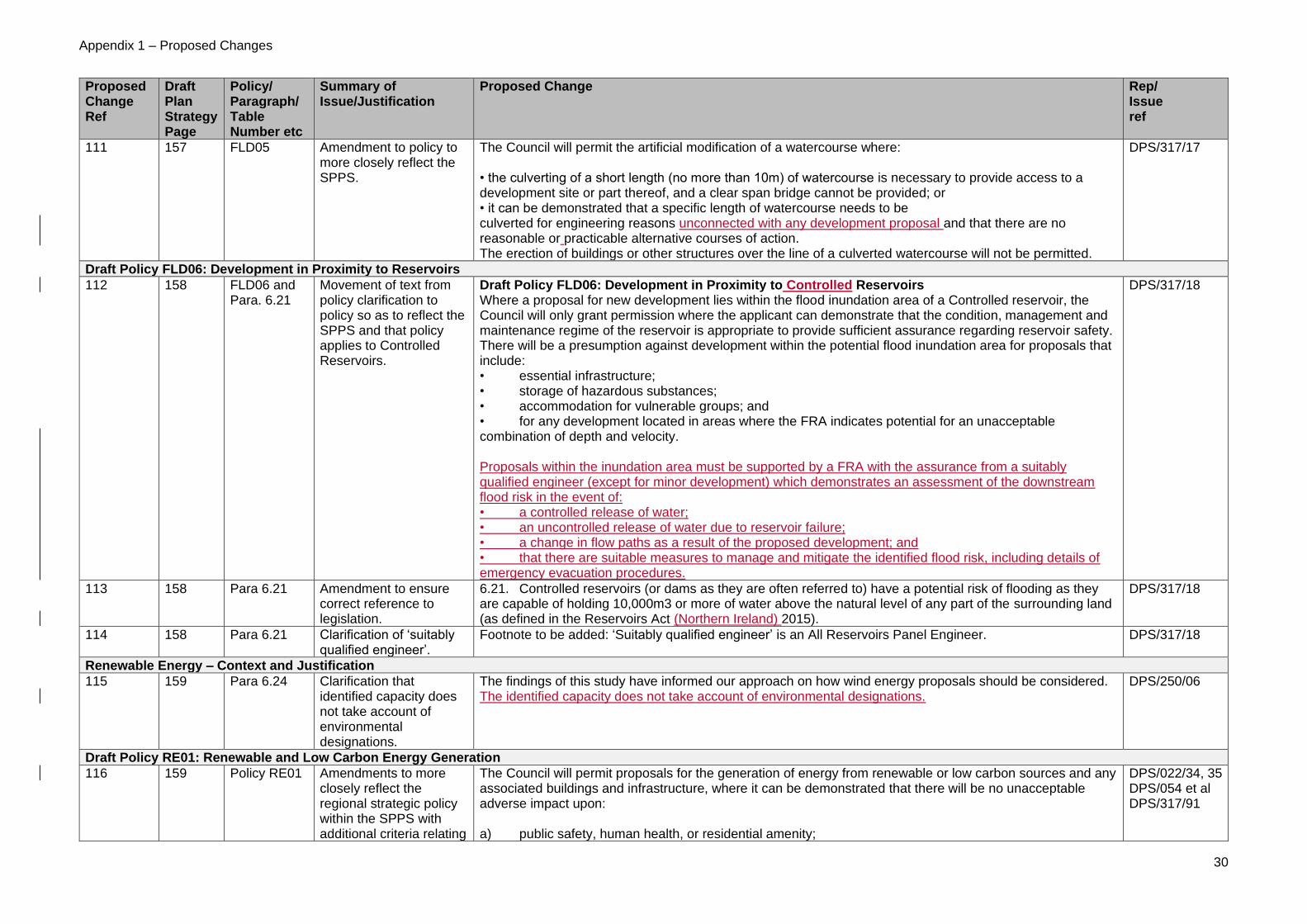
Appendix 1 – Proposed Changes
30
Proposed Change Ref
Draft Plan Strategy Page
Policy/ Paragraph/ Table Number etc
Summary of Issue/Justification
Proposed Change
Rep/ Issue ref
111 157 FLD05 Amendment to policy to more closely reflect the SPPS.
The Council will permit the artificial modification of a watercourse where: • the culverting of a short length (no more than 10m) of watercourse is necessary to provide access to a development site or part thereof, and a clear span bridge cannot be provided; or • it can be demonstrated that a specific length of watercourse needs to be culverted for engineering reasons unconnected with any development proposal and that there are no reasonable or practicable alternative courses of action. The erection of buildings or other structures over the line of a culverted watercourse will not be permitted.
DPS/317/17
Draft Policy FLD06: Development in Proximity to Reservoirs
112 158 FLD06 and Para. 6.21
Movement of text from policy clarification to policy so as to reflect the SPPS and that policy applies to Controlled Reservoirs.
Draft Policy FLD06: Development in Proximity to Controlled Reservoirs Where a proposal for new development lies within the flood inundation area of a Controlled reservoir, the Council will only grant permission where the applicant can demonstrate that the condition, management and maintenance regime of the reservoir is appropriate to provide sufficient assurance regarding reservoir safety. There will be a presumption against development within the potential flood inundation area for proposals that include: • essential infrastructure; • storage of hazardous substances; • accommodation for vulnerable groups; and • for any development located in areas where the FRA indicates potential for an unacceptable combination of depth and velocity. Proposals within the inundation area must be supported by a FRA with the assurance from a suitably qualified engineer (except for minor development) which demonstrates an assessment of the downstream flood risk in the event of: • a controlled release of water; • an uncontrolled release of water due to reservoir failure; • a change in flow paths as a result of the proposed development; and • that there are suitable measures to manage and mitigate the identified flood risk, including details of emergency evacuation procedures.
DPS/317/18
113 158 Para 6.21 Amendment to ensure correct reference to legislation.
6.21. Controlled reservoirs (or dams as they are often referred to) have a potential risk of flooding as they are capable of holding 10,000m3 or more of water above the natural level of any part of the surrounding land (as defined in the Reservoirs Act (Northern Ireland) 2015).
DPS/317/18
114 158 Para 6.21 Clarification of ‘suitably qualified engineer’.
Footnote to be added: ‘Suitably qualified engineer’ is an All Reservoirs Panel Engineer. DPS/317/18
Renewable Energy – Context and Justification
115 159 Para 6.24 Clarification that identified capacity does not take account of environmental designations.
The findings of this study have informed our approach on how wind energy proposals should be considered. The identified capacity does not take account of environmental designations.
DPS/250/06
Draft Policy RE01: Renewable and Low Carbon Energy Generation
116 159 Policy RE01 Amendments to more closely reflect the regional strategic policy within the SPPS with additional criteria relating
The Council will permit proposals for the generation of energy from renewable or low carbon sources and any associated buildings and infrastructure, where it can be demonstrated that there will be no unacceptable adverse impact upon: a) public safety, human health, or residential amenity;
DPS/022/34, 35 DPS/054 et al DPS/317/91
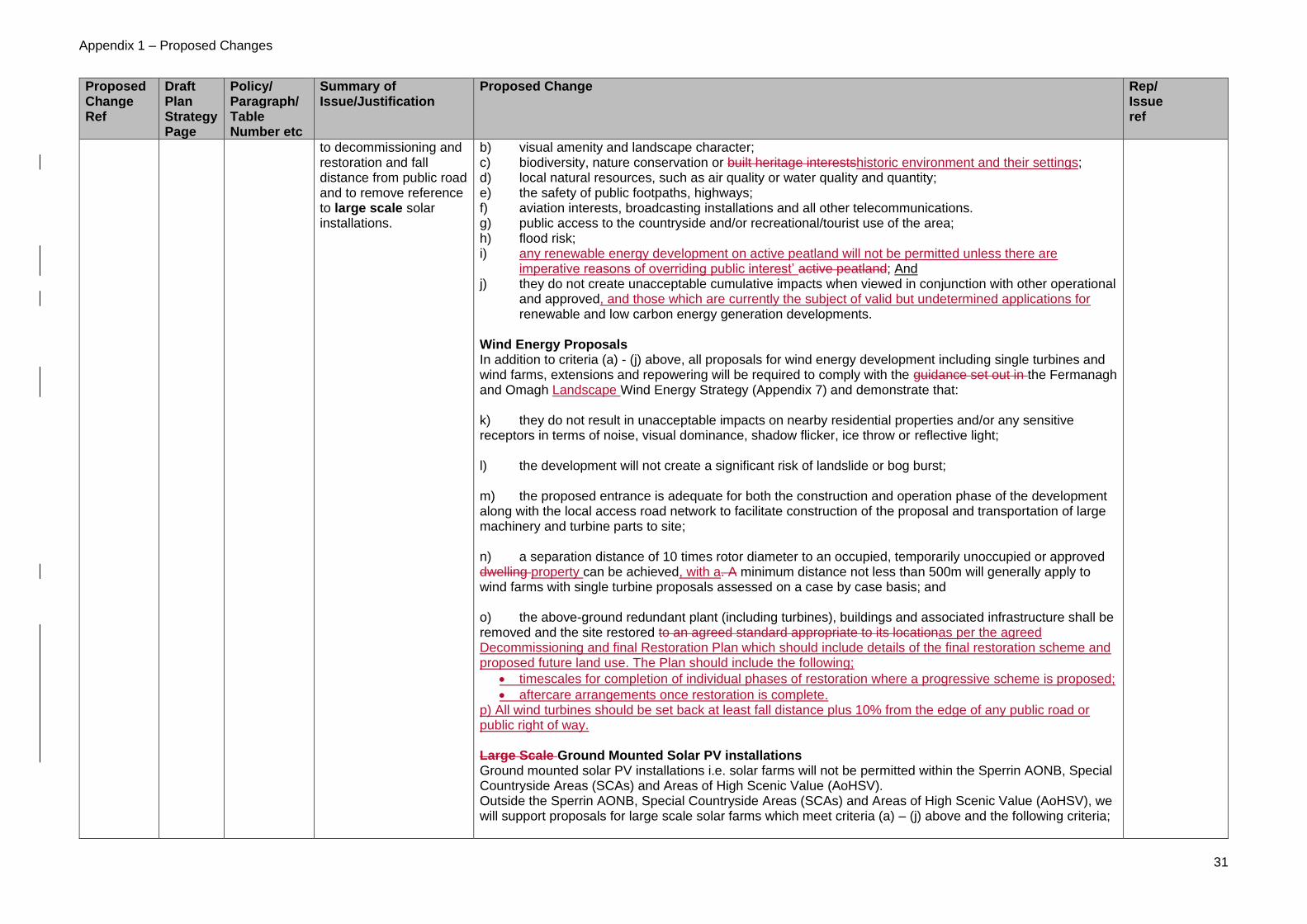
Appendix 1 – Proposed Changes
31
Proposed Change Ref
Draft Plan Strategy Page
Policy/ Paragraph/ Table Number etc
Summary of Issue/Justification
Proposed Change
Rep/ Issue ref
to decommissioning and restoration and fall distance from public road and to remove reference to large scale solar installations.
b) visual amenity and landscape character; c) biodiversity, nature conservation or built heritage interestshistoric environment and their settings; d) local natural resources, such as air quality or water quality and quantity; e) the safety of public footpaths, highways; f) aviation interests, broadcasting installations and all other telecommunications. g) public access to the countryside and/or recreational/tourist use of the area; h) flood risk; i) any renewable energy development on active peatland will not be permitted unless there are
imperative reasons of overriding public interest’ active peatland; And j) they do not create unacceptable cumulative impacts when viewed in conjunction with other operational
and approved, and those which are currently the subject of valid but undetermined applications for renewable and low carbon energy generation developments.
Wind Energy Proposals In addition to criteria (a) - (j) above, all proposals for wind energy development including single turbines and wind farms, extensions and repowering will be required to comply with the guidance set out in the Fermanagh and Omagh Landscape Wind Energy Strategy (Appendix 7) and demonstrate that: k) they do not result in unacceptable impacts on nearby residential properties and/or any sensitive receptors in terms of noise, visual dominance, shadow flicker, ice throw or reflective light; l) the development will not create a significant risk of landslide or bog burst; m) the proposed entrance is adequate for both the construction and operation phase of the development along with the local access road network to facilitate construction of the proposal and transportation of large machinery and turbine parts to site; n) a separation distance of 10 times rotor diameter to an occupied, temporarily unoccupied or approved dwelling property can be achieved, with a. A minimum distance not less than 500m will generally apply to wind farms with single turbine proposals assessed on a case by case basis; and o) the above-ground redundant plant (including turbines), buildings and associated infrastructure shall be removed and the site restored to an agreed standard appropriate to its locationas per the agreed Decommissioning and final Restoration Plan which should include details of the final restoration scheme and proposed future land use. The Plan should include the following;
• timescales for completion of individual phases of restoration where a progressive scheme is proposed;
• aftercare arrangements once restoration is complete. p) All wind turbines should be set back at least fall distance plus 10% from the edge of any public road or public right of way. Large Scale Ground Mounted Solar PV installations Ground mounted solar PV installations i.e. solar farms will not be permitted within the Sperrin AONB, Special Countryside Areas (SCAs) and Areas of High Scenic Value (AoHSV). Outside the Sperrin AONB, Special Countryside Areas (SCAs) and Areas of High Scenic Value (AoHSV), we will support proposals for large scale solar farms which meet criteria (a) – (j) above and the following criteria;

Appendix 1 – Proposed Changes
32
Proposed Change Ref
Draft Plan Strategy Page
Policy/ Paragraph/ Table Number etc
Summary of Issue/Justification
Proposed Change
Rep/ Issue ref
qo) they do not result in unacceptable impacts on nearby residential properties and/or any sensitive receptors. r) The proposed entrance is adequate for both the construction and operation phase of the development along with the local access road network to facilitate construction of the proposal and transportation of machinery and part to the site.
117 161 Para 6.27 Additional clarification to explain meaning of ‘temporarily unoccupied’.
Sensitive receptors are defined as habitable residential accommodation (although not necessarily occupied), hospitals, schools and churches. Temporarily unoccupied refers to a dwelling capable of immediate occupation.
DPS/266/03
118 161 Insert new paragraph (after para 6.28)
Amended wording relating to active peat to more closely reflect the SPPS.
Active peatland is of particular importance to Northern Ireland for its biodiversity, water and carbon storage qualities. Any renewable energy development on active peatland will not be permitted unless there are imperative reasons of overriding public interest as defined under The Conservation (Natural habitats, etc,) Regulations (Northern Ireland) 1995 as amended’.
DPS/022/34
119 161 Para 6.29 To confirm the role and status of the wind energy strategy.
The Landscape Wind Energy Strategy provides guidance on sets out the type of development that may be appropriate within these areas.
DPS/317/28
120 162 Para 6.32 Additional clarification relating to number, scale, size and siting of turbines and deletion of reference to ‘large-scale’.
The landscape and visual affects of wind energy developments, large scale solar PV farms and other renewable energy developments will vary on a case by case basis according to the type of development, its location and the landscape setting of the proposed development. Some of the effects may be minimised through appropriate siting, design and landscape schemes, depending on the size and type of development proposed. In relation to wind energy development the number, scale, size and siting of turbines may have an unacceptable impact on visual amenity or landscape character.
DPS/022/35 DPS/022/37
121 161 Text box Change ‘designated’ to ‘identified’ as these are not designations.
The areas designated identified as: N/A
122 162 Insert new paragraph after 6.32
Additional paragraph to policy clarification to increase awareness of potential impacts on international sites.
Renewable energy production can have direct or indirect impacts on a European or Ramsar designated site. For example, wind energy proposals can have an impact on supporting habitat for birds such as hen harrier; anaerobic digestion may be a source of ammonia; hydro power may lead to changes to flows of watercourses through abstraction. Therefore, the impacts of renewable energy proposals on designated sites will also be a priority consideration and proposals will require particular scrutiny through Environmental Impact Assessment (EIA) and Habitats Regulations Assessment (AA) where applicable.
N/A
Transportation – Context and Justification
123 162 Para 6.35 Minor amendment to context to confirm it is an aim to improve physical connectivity etc.
Therefore, an overall objective the aim is to improve physical connectivity and accessibility between and within settlements and their rural hinterland.
DPS/317/30
Draft Policy TR01: Land Use, Transport and Accessibility
124 163 Policy TR01 Amendment to the title and text of the policy to assist with the understanding of the policy and to avoid duplication of other
Draft Policy TR01 – Land Use and , Transport and Accessibility The Council will permit development proposals where it is demonstrated that:
a) there is the capacity to accommodate the type and amount of traffic generated, or where the impact can be suitably mitigated, taking into account the cumulative impact of developments;
b) access arrangements do not prejudice road safety or significantly inconvenience the flow of traffic;
DPS/317/115

Appendix 1 – Proposed Changes
33
Proposed Change Ref
Draft Plan Strategy Page
Policy/ Paragraph/ Table Number etc
Summary of Issue/Justification
Proposed Change
Rep/ Issue ref
policies. Add footnote to confirm basis for TAs.
c) adequate parking facilities are provided in accordance with the current published council parking standards;.
c)d) appropriate safe, convenient and secure facilities for cycle parking and cyclists are provided. Transport Assessment1 will be required where a development proposal is likely to have a significant impact on highway conditions. 1 See guide to Transport Assessment (published by DoE and DRD, 2006).
125 164 Para 6.38 Amend the clarification of Policy TR01
The aim of the policy is to promote road safety and to ensure that there is a safe and efficient movement of traffic, particularly on our local roads people and goods on all our roads.
DPS/317/117
Draft Policy TR02: Car Parks and Service Provision
126 165 Policy TR02 Amendment to policy to confirm it applies to temporary car parking and there will be a presumption against temporary car parking.
Proposals for new, or extended or temporary car parks within the town centres will only be permitted where they do not impact on the viability or vitality of the town centre. The loss of existing car parking or space for servicing within the town centre will not be permitted where it impacts on current or existing arrangements. There will be a presumption against temporary car parks where it is considered unnecessary and it is not linked to firm proposals for the development for the site.
DPS/317/20
127 165 Para 6.46 Amendment to include additional text and to provide clarification when the policy is applied to temporary car parking it would be time limited.
The provision of suitable car parking close to facilities and to meet a range of for all users including people with disabilities, parents and child parking spaces and(e.g. short and long-term visitors) is essential to support the needs of our businesses, residents and visitors. While planning applications for temporary car parks will be assessed in the light of all relevant factors, there will be a presumption against such development where it is considered unnecessary and is not linked to firm proposals for the development of the site. Planning permission for a temporary car park, if granted, will be subject to a time limit of 1 year.
DPS/317/20
Draft Policy TR04: Protected Routes
128 166 Policy TR04 Amendment to include additional criteria to comprehensively address all aspects where an access to a Protected Route may be acceptable.
A development proposal involving direct access, or the intensification of the use of an existing access, will only be permitted where:
a) in the case of motorways and high standard dual carriageways an exception may be considered for motorway service areas where there is demonstrable need;
a)b) in the case of other dual carriageways, ring roads, a Through-Pass or By-Pass, the
development is of regional significance; or
c) in the case of a Protected Route within settlement limits: i) the development cannot be accessed from an adjacent minor road; or ii) in the case of residential developments, where it will significantly assist in the creation of a quality environment without compromising road safety or result in an excessive number of access points. d) in the case of a Protected Route outside settlement limits where the development is for:
i) a replacement dwelling, where there is an existing vehicular access onto the protected route, or;
ii) a farm dwelling, a dwelling that serves the needs of an established commercial or industrial
enterprise, or is for other development that would meet the criteria for development in the
countryside and no other access is reasonably obtainable from an adjacent minor road.
DPS/317/23,67

Appendix 1 – Proposed Changes
34
Proposed Change Ref
Draft Plan Strategy Page
Policy/ Paragraph/ Table Number etc
Summary of Issue/Justification
Proposed Change
Rep/ Issue ref
129 167 Para 6.50 Confirm that the source for information on Protected Routes, and any updates, will be DfI.
The protection of these routes contributes to economic prosperity within the council area by providing efficient links between the main towns, airports, seaports and with the Republic of Ireland. Applicants are advised that details of Protected Routes are available from the Department for Infrastructure.
DPS/317/23
Draft Policy TR05: Safeguarding New Transport Schemes
130 167 Para 6.53 Amendment to include reference to the Regional Strategic Transport Network Transport Plan (RSTNTP), and confirm that the source for information on New Transport Schemes, and any updates, will be DfI.
The Regional Strategic Transport Network Transport PlanStrategy (RSTNTPS) will be the main source of identifying and prioritising future major road schemes and these will be identified on the Proposals Map. In addition, applicants are advised that details of New Transport Schemes, and any updates are available from the Department for Infrastructure.
DPS/317/124
Draft Policy TR06: Disused Transport Routes
131 168 Para 6.54 Change wording of definition of disused transport routes to reflect SPPS.
The Council recognises the need to identify and safeguard those more historic disused transport routes which would have once contributed towards transport but are now disused. These will include the potential reuse of old such as roads, canals, former railway tracks lines and canals where there is a reasonable prospect of re-use for future transport purposes. beds as well as other infrastructure and buildings associated with them (e.g. railway station).
DPS/271/10
Draft Policy WM01: Waste Management Facilities
132 174 Policy WM01 Minor amendment to reflect SPPS policy test in relation to location of a regional waste management facility.
Additionally, where a waste management facility is of a regional scale its location should relate closely to and benefit from easy access must be accessible to a key transport corridor and not have an unacceptable adverse impact upon road safety and convenience of road users.
DPS/317/29
Draft Policy WM03: Development in the vicinity of Waste Management Facilities
133 175 Para 6.71 Minor amendment to confirm that an Odour Consultation Zone may be identified for a WwTW.
Due to their nature and scale, many WWTWs have the potential to have a significant impact on the environment and on the amenity of local communities. Odour Consultation Zones may be identified for WWTWs. Many existing WWTWs are located close to or within settlements limits…
DPS/251/03
7.0 MONITORING AND REVIEW
134 178 Table 7 Monitoring Indicators
Proposed deletion of several indicators and review of remaining undertaken to include identification of targets and triggers and restructuring of table format/content (see Indicative Monitoring Framework, Appendix 3).
ID Indicator (To be deleted) 1 Length of new foot paths and cycle paths created 2 Length of rights of way and permissive paths lost through redevelopment 3 New Green and blue infrastructure created within new development 12 Sports facilities, open space/recreation land lost to redevelopment and new facilities/open space created 14 Number of new Riverside Walks created 15 New rural start-up project or community development in RCAs 30 Length of disused transport routes re-used for transport, recreation, nature conservation or tourism use 31 Level of telecommunication and high-speed broadband coverage 33 New or upgraded Waste Water treatment Works
DPS/22/39 DPS/054/23 et al DPS115/77 DPS126/02 DPS244/8,9 DPS/268/03 DPS/317/73

Appendix 1 – Proposed Changes
35
Proposed Change Ref
Draft Plan Strategy Page
Policy/ Paragraph/ Table Number etc
Summary of Issue/Justification
Proposed Change
Rep/ Issue ref
Glossary
135 216 Intermediate Housing
Include additional text to reflect SPPS
Consists of shared ownership housing provided through a Registered Housing Association and helps households who can afford a small mortgage, but that are not able to afford to buy a property outright. The property is split between part ownership by the householder and part social renting from the Registered Housing Association. The proportion of property ownership and renting can vary depending on householder circumstances and preferences. This definition of intermediate housing may change over time to incorporate other forms of housing tenure below open market rents.
DPS/099/01
PART THREE – APPENDICES
136 229
Appendix 1 Include additional guidance on LED lighting/digital displays which is a relevant consideration.
Digital advertising screens should only display static images and should not contain moving images. The rate of change between successive displays should not be instantaneous and should not include the sequencing of images over more than one advert or a message sequence, where a message is spread across more than one screen image. The minimum duration any image shall be displayed shall be determined by the Council. The minimum message display duration should ensure that the majority of approaching drivers do not see more than two messages.
The minimum message display duration of each image shall be calculated by dividing the maximum sight distance to the digital advertisement(metres) by the speed limit (metres/second) of the road (30mph = 13.4m/s, 40mph = 17.9m/s, 50mph = 22.4m/s, 60mph = 26.8m/s , 70mph = 31.3m/s.” The luminance of the screen should be controlled by light sensors which automatically adjust screen brightness for ambient light levels, in order to avoid glare at night and facilitate legibility during daytime. The proposed advertising screen should generally comply with the Institute of Lighting Professionals’ guidance PLG05, ‘The Brightness of Illuminated Advertisements’. Maximum night-time luminance of the digital screen must not exceed the appropriate value from Table 4 of PLG05, which must be considered in conjunction with the environmental zones as defined in Table 3 of PLG 05. Proposed luminance levels and control arrangements are to be agreed by the Department for Infrastructure – Roads. Advertisements shall not resemble traffic signs or provide directional advice. Road Traffic Regulation (NI) Order 1997 makes it an offence to display any sign which resembles a traffic sign on or near a public road. Telephone numbers and website addresses should not be displayed.
DPS/317/34
137
242 Appendix 5 Delete all as it is adequately addressed within HED guidance.
Appendix 5: Guidance for applications that affect Historic Environment or a Heritage Asset 1.1. As a general guide, supporting information to accompany applications that may affect the Historic
Environment, or a Heritage Asset should:
• Identify features of the asset that are important, following appropriate research and investigation;
• Should demonstrate an informed understanding of the asset, its setting and its significance so that proposed changes are made on the basis of up to date and accurate information;
• Set out the level of potential impacts on the heritage asset / feature and assess these;
DPS/009/01 DPS/113/02 DPS/317/55

Appendix 1 – Proposed Changes
36
Proposed Change Ref
Draft Plan Strategy Page
Policy/ Paragraph/ Table Number etc
Summary of Issue/Justification
Proposed Change
Rep/ Issue ref
• Where appropriate, suggest mitigation that is proportionate to the impact and the significance of the heritage asset / features of special interest, including, opportunities to protect, conserve and enhance;
• Overall, be at a level of detail proportionate to the scale of the development proposed and the significance of the asset; and,
• Be informed by appropriate expertise. 1.2. There should also be a record of how potential design solutions have taken account of the heritage
asset, its setting and its significance. Development proposals (particularly for new buildings or alterations and extensions to existing building) do not always need to replicate features of the assets and there may be occasions when a high quality contemporary and/or innovative design solution which is reflective of the asset, but informed by a solid understanding of the asset and its setting, would be more appropriate.
1.3. Applicants should be familiar with the range of sources and guidance that allows assets to be identified and appraised and any assessment should be undertaken and informed by an appropriate expert.
138 248 Appendix 7 To address a typographical error.
Amend the title of Appendix 7 from Wind Energy Strategy for Fermanagh and Omagh District Council to The Landscape Wind Energy Capacity Strategy for Fermanagh and Omagh District Council. Paragraph 2.1.9. These larger turbines should be sited away from the sensitive landscape of Florence Court and its setting to the south of the LCA.
N/A

Appendix 2
Schedule of Minor Editing Changes

Appendix 2 – Minor Editing Changes
1
Minor Editing
ref
Draft Plan Strategy Page
Policy/ Paragraph/ Table Number etc
Summary of Issue/Justification
18 Para 3.4 Typo. Line 4 change to “Public Consultation...”
28 -29 Table 1 – Strategic Objectives
Error with footnote and references. Sub-headings on page 29.
37 Settlement Hierarchy Map
Editing error. The map does not fully reflect the settlement hierarchy as detailed in Table 2 (p36). Some settlements have been incorrectly identified as villages. Amend so all labelling matches Table 2.
51 Para 2.11 Missing text at end of paragraph “walking and cycling routes.’
62 Para 3.9 Bracket missing. Add in front of “(see..”.
74 Para. 3.40 Drafting error. The paragraph is not required as it does not relate to anything in the policy.
75 Policy HOU11 Drafting error. Amend first line of policy to read: “The Council will support the redevelopment of a former site for a dwelling….”
92 Para 3.90 Full stop at end of paragraph missing.
140 Para 5.28 Editing error. Amend at line 6 from “…will be required demonstrating…” to “…will need to demonstrate…”
152 Policy FLD01 Detach (remaining within FLD policy) FLD01 para d) ‘Minor Development’ as one of the exceptions (a) to (d). ‘Minor Development’ should read as a stand-alone paragraph, the first line of which should read: ‘Where a proposal falls within one of the exceptions (a-c) or it is Minor Development, it must be demonstrated that:

Appendix 2 – Minor Editing Changes
2
Minor Editing
ref
Draft Plan Strategy Page
Policy/ Paragraph/ Table Number etc
Summary of Issue/Justification
155 Para 6.10 Amend bullet point 3 to: “a change of use involving new buildings and/or hard surfacing exceeding 1000 square metres in area”
156 Para 6.12 to 6.15 Typo – change SuDs to SuDS
178 Para. 7.6 Amend spelling error of ‘indicator’
N/A Policies HOU4, HOU09, HOU10, HOU16, OSR04, OSR05, HE05 and PU02
To ensure a consistency of approach across all policies of the DPS minor change of policy wording from the “following criteria are met” to “all the following criteria are met”.
N/A Proposals Map Update Protected Routes layer, which is shown for information purposes only, to show DfI Updated Protected Routes Map (published 19 December 2018). NB: This was only made available after the publication of the draft Plan Strategy.
N/A Proposals Map Editing error. Labels in the Legend do not correctly refer to policies.
1. Proposed SCA - (See Policy L02);
2. and AONB (See Policy L01).

Appendix 3 - Indicative Monitoring Framework
3
Appendix 3
Indicative Monitoring Framework

Appendix 3 - Indicative Monitoring Framework
4
Indicative Monitoring Framework
Indicator Ref
Indicator Source Relevant Plan Strategy Objective
Relevant Policy
Target Trigger
Topic Area: Spatial Growth Strategy
1 New dwellings completed across the settlement hierarchy and in the countryside and by land type (e.g. greenfield, brownfield, zoned, farm, infill, cluster etc)
FODC Planning Decisions
1 3 4
SP01 SP02 SP03 HOU01 HOU09 - HOU18
Delivery of new housing growth in line with Strategic Allocation of Housing
No. of new dwellings across settlement hierarchy and countryside exceeds 10% above/below target
2 Number of new jobs created Job Statistics. Census of Employment. Business Registration Employment Survey
7 8 9
SP01 SP04
To create 4,875 new jobs by 2030 or an average of 325 jobs per year
Additional jobs more than 10% below statistic.
Topic Area: Housing in Settlements
3 Five year supply of land for housing
FODC Planning Decisions
1 3 4
SP01 SP02 SP03 HOU01
To ensure that there is a minimum 5-year supply of land for housing within settlements
Less than a 5 year supply of land is available in an individual settlement to enable its

Appendix 3 - Indicative Monitoring Framework
5
Indicator Ref
Indicator Source Relevant Plan Strategy Objective
Relevant Policy
Target Trigger
allocation to be met.
4 Number of dwellings approved by size (no. of bedrooms)
FODC Planning Decisions. Annual Housing Monitor
4 6
SP01 HOU01 HOU05
At least 30% of all new residential properties are 1 or 2 bedrooms
Number of 1 or 2 bed properties is less than 30%.
5 Number of wheelchair accessible homes
FODC Planning Decisions. Annual Housing Monitor
4 6
SP01 HOU01 HOU05
10% of housing schemes for 20 units or more are wheelchair accessible or within smaller settlements, 10 units or more
Less than 10% of housing schemes for 20 units or more (or 10 units if a smaller settlement) are wheelchair accessible.
6 Number of affordable houses approved/completed
FODC Planning Decisions
1 4
SP01 HOU01 HOU03 HOU17
Delivery of 10% affordable housing on development proposals for 10 units or more or on sites of 0.5 ha or more where a need
Affordable housing provision is more than 10% below target

Appendix 3 - Indicative Monitoring Framework
6
Indicator Ref
Indicator Source Relevant Plan Strategy Objective
Relevant Policy
Target Trigger
has been identified.
Topic Area: Community Facilities
7 Number of existing community facilities lost to redevelopment
FODC Planning Decisions
1 5
SP01 CF01
No redevelopment except where justified through policy provisions.
More than one application approved for redevelopment in any one year contrary to policy provisions
Topic Area: Open Space and Recreation
8 Open space/recreation land lost to alternative uses
FODC Planning Decisions
1 5 6
SP01 OSR01
To limit the net loss of zoned or existing open space/recreation land to alternative uses
More than 5% of the site area for a specific zoning is approved for alternative uses.
9 Public space provision in new residential development
FODC Planning Decisions
1 5 6
SP01 HOU06
At least 10% of site area of residential developments of 25 units or more is provided as
More than 10% of housing approvals in any year does not meet the specified standards.
Appendix 3 - Indicative Monitoring Framework
7
Indicator Ref
Indicator Source Relevant Plan Strategy Objective
Relevant Policy
Target Trigger
public open space
10 Number of access points created along the shores of loughs
FODC Planning Decisions
13 18
SP01 OSR04
No target. Monitor trend.
No trigger.
Topic Area: Industry and Business
11 Development activity on zoned industry and business land
FODC Industrial and Business Land Monitor
7 8
SP01 SP04 IB01 IB02
No zoned or existing industry or business land lost to non-employment uses
More than 5% of the site area for a specific zoning is approved for non-employment uses.
Topic Area: Town Centre and Retailing
12 Development activity within Town Centres
FODC Planning Decisions Town Centre Health Checks
1 2
SP01 TCR01
At least 90% of town centre uses such as retail to be directed to town centres
More than 10% of retail floorspace approved in any one year outside Town Centres
13 Number of retail and non-retail planning permissions within Primary Retail Cores
FODC Planning Decisions Town Centre Health Checks
1 SP01 TCR01 TCR02
No more than 40% non-retail applications within Primary Retail Cores
Non-retail uses exceed 40%

Appendix 3 - Indicative Monitoring Framework
8
Indicator Ref
Indicator Source Relevant Plan Strategy Objective
Relevant Policy
Target Trigger
Topic Area: Tourism Development
14 New tourism amenities and accommodation
FODC Planning Decisions Annual tourism statistics (NISRA, DfE)
12 SP01 TOU02 TOU03 TOU04
No target. Monitor trend
No trigger
Topic Area: Minerals Development
15 Quantity of permitted reserves to meet annual production of construction aggregates (sand and gravel)
FODC Planning Decisions Annual Minerals Return
15 SP01 MIN01
Sand and gravel permitted reserves meet yearly production figures based on an average 3-year period
Provision of permitted reserves falls below 5 year supply
Topic Area: Historic Environment
16 Number of Listed Buildings demolished.
FODC Planning Decisions PAC decisions Built Heritage at
13 SP01 HE03
Less than 10% of ‘At Risk’ Listed Buildings removed from BHARNI Register due to demolition over a 5 year period
More than 10% of ‘At Risk’ Listed Buildings removed from BHARNI Register due to demolitions

Appendix 3 - Indicative Monitoring Framework
9
Indicator Ref
Indicator Source Relevant Plan Strategy Objective
Relevant Policy
Target Trigger
Risk NI (UAH/HED)
over a 5 year period
17 Number of demolitions within Conservation Areas & Areas of Townscape/Village Character
FODC Planning Decisions PAC decisions Built Heritage at Risk NI (UAH/HED)
13 SP01 HE04 HE05
Less than 10% of applications for demolition in Conservations Areas and ATC/AVCs approved over a 5 year period
More than 10% of applications for demolition in Conservations Areas and ATC/AVCs approved over a 5 year period
18 The number of non-designated heritage (in CA, ATC or the countryside) assets demolished or replaced.
FODC Planning Decisions
13 SP01 HE09
Less than 10% of applications approved for demolition or replacement over a 5 year period
More than 10% of applications approved for demolition or replacement over a 5 year period
19 Condition and record of changes within Areas of Significant Archaeological Interest (ASAI)
FODC Planning Decisions PAC decisions
13 SP01 HE01 HE02
No inappropriate development contrary to policy provisions
More than one application approved in any one year contrary to HE01 and HE02
Topic Area: Natural Environment

Appendix 3 - Indicative Monitoring Framework
10
Indicator Ref
Indicator Source Relevant Plan Strategy Objective
Relevant Policy
Target Trigger
20 New development affecting local, national, European designated sites; areas of Protected Species and their habitats; Other Habitats, Species or Features of Natural Heritage importance
FODC Planning Decisions
13 SP01 NE01 NE02 NE03
No inappropriate development contrary to policy provisions
More than one application approved in any one year contrary to NE01, NE02 or NE03
Topic Area: Landscape
21 New development within the AONB, SCAs and AoHSVs
FODC Planning Decisions
13 SP01 L01 L02 L03
No inappropriate development contrary to policy provisions
More than one application approved in any one year contrary to L01, L02 or L03
Topic Area: Flood Risk Management
22 Development in flood plains FODC Planning Decisions
6 17
SP01 FLD01
No permissions for non-compatible development in undeveloped flood risk areas and contrary to DfI Rivers advice.
More than one application approved in any one year contrary to policy provisions

Appendix 3 - Indicative Monitoring Framework
11
Indicator Ref
Indicator Source Relevant Plan Strategy Objective
Relevant Policy
Target Trigger
23 Number of planning permissions granted which include SuDS measures.
FODC Planning Decisions
15 17
SP01 FLD03
More than 75% of qualifying applications incorporating SuDS approved over a 5 year period
Less than 50% of qualifying applications for SuDS measures approved over a 5 year period.
Topic Area: Renewable Energy
24 Amount (MWh) of energy produced from renewable sources
Annual report by Department for Business, Energy and Industrial Strategy
16 SP01 RE01
To have increasing trend from baseline year of 2015 (642,173 MWh)
No increase from baseline year.
25 The number, height and location of new or re-powered wind turbines approved/operational
FODC Planning Decisions
16 SP01 RE01
No decisions contrary to the provisions of RE01 and the Landscape Wind Energy Capacity Strategy (LWECS)
More than one application permitted in any one year contrary to RE01 and the LWECS
Topic Area: Transportation

Appendix 3 - Indicative Monitoring Framework
12
Indicator Ref
Indicator Source Relevant Plan Strategy Objective
Relevant Policy
Target Trigger
26 Number of new or extended park and ride/park and share facilities to reduce need to travel by private car
FODC Planning Decisions DfI Survey/data
10 TR01 TR03
An increase in the current provision and usage of park and ride/park and share facilities
No increase in current provision and usage of park and ride/park and share
Topic Area: Waste Management
27 Number of new or extended waste management facilities
FODC Planning Decisions FODC/NI Waste Management Statistics (DAERA)
1 SP01 WM01 WM04
To meet targets outlined in Council’s waste management plan
Unmet need for new or extended facilities identified through Council’s waste management plan
General
28 Number of planning applications approved and refused by development type
FODC Planning Decisions
All All No planning decisions made contrary to policy provisions
More than one application approved in any one year contrary to policy provisions of the LDP.

Appendix 3 - Indicative Monitoring Framework
13