scoping a geospatial repository for academic deposit and extraction 1 date here title here grade...
Post on 22-Dec-2015
220 views
TRANSCRIPT

Date here title here
Scoping a Geospatial Repository for Academic Deposit and Extraction
1
GRADE Informal geospatial data sharing: Statistical analysis.
&Initial Pilot Site feedback (&
development) on GRADE geospatial repository
demonstrator. Rebecca Seymour
GRADE All-Partner Meeting, University of Edinburgh Oct 30 2006.
Geo
gra
phic
ima
ge
: ©
20
05 C
lark
La
bs.
30/10/06 GRADE All-Partner Meeting 2006, Edinburgh

Date here title here
Scoping a Geospatial Repository for Academic Deposit and Extraction
2
The Impetus Aim is to investigate the current methods of 'informal' GI-data sharing, and
quantify this, within academia (UK HE-FE)
By ‘informal’ we mean, any non-formal method used to share GIS datasets, i.e. via email, FTP, Bit Torrent, in person.
In definition of ‘formal’ we mean a repository-type sharing environment,
with inherent rules about geospatial data file type/format/content, ensuring a standard metadata accompaniment, guaranteeing that geospatial data is from regarded sources, and, stored within a managed system or repository.
The overarching aim is to understand the barriers to existing geospatial data-sharing in the UK, to look at and summarise the ways and routes researchers in academia share geo-data informally.
Also, to assist in informing the GRADE project to better understand the
licensing and technical issues attendant on geo-data-sharing practices within the community.
30/10/06 GRADE All-Partner Meeting 2006, Edinburgh

Date here title here
Scoping a Geospatial Repository for Academic Deposit and Extraction
3
Informal geospatial data-sharing questionnaire: background
Conducted at GISRUK, Nottingham, 5th-7th April 2006
Web-questionnaire released June 2006 (stratified sampling strategy to GRADE partners & email list, Go-Geo! email list, JISCmail GIS-UK, Digging-for-data, lis-maps)
http://edina.ac.uk/projects/grade/questionnaire.html
95 replies to date – even mix of Lecturers/Researchers & Student respondents
30/10/06 GRADE All-Partner Meeting 2006, Edinburgh

Date here title here
Scoping a Geospatial Repository for Academic Deposit and Extraction
4
The Questions
The questionnaire is made up of 6 main questions: Q1) Describe a time when you recently shared a geospatial
dataset? Q2) If you had a geospatial dataset to share, how would you give
it to someone? Q3) How/where do you search to find what geospatial datasets
are available? And 3 multiple choice: Q4) In searching for a geospatial dataset have you ever used (pick
as many as have used from a choice of informal methods of sharing geospatial data)
Q5) What would prevent you from sharing geospatial data (pick as many as wish from a choice of perceived barriers to sharing geospatial data)
Q6) Choose a ‘wish’ list of the 3 most important factors that would help you share geospatial data easier (rank 3 in order of preference, 1 top priority, 3 3rd priority).
30/10/06 GRADE All-Partner Meeting 2006, Edinburgh

Date here title here
Scoping a Geospatial Repository for Academic Deposit and Extraction
5
Question1) Can you describe a time when you
recently shared geospatial data 74 respondents were able to
describe a recent time when they shared geospatial data
Only 13 said had not ever
shared any geospatial data
As this was a free-text question to summarise answers were divided into the ‘HOW’ & the ‘WHAT’.
Most common ‘how’ was burn to CD/DVD, & email
Most common ‘what’ was DEM & boundary data.
30/10/06 GRADE All-Partner Meeting 2006, Edinburgh

Date here title here
Scoping a Geospatial Repository for Academic Deposit and Extraction
6
What this indicated 78% of respondents had shared geospatial data; many qualifying that they did this on a
frequent basis: “We often share administrative boundaries with various partner organisations” “Regularly share geospatial data around other departments in my university”
The most commonly type of data was DEM/DTM (esp. flood, river, and catchment analyses). & Boundary data sets.
Satellite/photogrammetry & census data also popular – not same copyright issues, sources more freely available.
Lot of datasets outside of the UK (different license reuse conditions)
Illustrates willingness to share where feel safe doing so (only certain types of data).
Quite a lot of data ‘environmental’ based / ‘hazard/emergency’ (i.e. earthquake, flood). (less boundary, street mapping, transport, governmental) – fears over data with commercial interests.
Are some gaps in data types. Go-Geo! spatial data audit pilot study – 700+ potential datasets recognised on internal
servers.
30/10/06 GRADE All-Partner Meeting 2006, Edinburgh

Date here title here
Scoping a Geospatial Repository for Academic Deposit and Extraction
7
Question2) If you have a dataset you are willing to
share, how in detail would you go about doing this? Big diversity of replies – interesting
Quite a few who ‘thought about’ the copyright/license restrictions that would allow/disallow the sharing of their data, but this is not especially high, perhaps when sharing ‘informally’ this is much more of an ‘after-thought’).
A lot of mention of metadata – many saying that they would supply full metadata (although none mentioned any standards relating to this, i.e. ISO 19115) – many others would give other information/documents to explain the data.
Wanted acknowledgement of their own work Data volume also an issue by many (influence
on how easily data transferred, some suggesting that they would only share smaller datasets)
30/10/06 GRADE All-Partner Meeting 2006, Edinburgh

Date here title here
Scoping a Geospatial Repository for Academic Deposit and Extraction
8
Question3) How are where do you search to
find what geospatial data is available? huge variety of answers Interesting - nearly all mentioned were
primary geospatial data-source providers/general web-search engines
Many sources non-UK The most common method for ‘finding’
geospatial data appears to be via personal contacts/’word-of-mouth’ – close knit community - major stimuli for ‘GIS knowledge’
Google really popular to find GIS web data.
What was also clear from this question was that people frequent a large number of sources for geospatial data
Only a few of these sources deal with data that is not baseline or source data, by that we mean it is research data or derived or reused data (i.e. GISCafe)
30/10/06 GRADE All-Partner Meeting 2006, Edinburgh

Date here title here
Scoping a Geospatial Repository for Academic Deposit and Extraction
9
Question4) In searching for or sharing a geospatial
dataset have you ever used?
Results in order of popularity:
Burn to CD/DVD most popular method (77 Votes) Email (76 votes) Personal URL (54 Votes) Read journal & contact author directly (52 Votes) Group/ email lists (47 votes) Jointly: peer/friends network, and via FTP (31 Votes) Metadata creation tools (26 Votes) Jointly: wikis, gisdevelopment.net type websites (21 Votes) Jointly: web-based forum groups, ESRI Data Hound (18 Votes) Virtual workspaces (16 Votes) Journal of maps/ online data journals (14 Votes) P2P (i.e. LionShare, Napster, Kazzer, Limewire) (13 Votes) Research council/funding body database (12 Votes) Bit Torrent (i.e. GeoTorrent.com) (9 Votes) Jointly ESRI GeoChat, and ‘Other’ (8 Votes)
GRADE All-Partner Meeting 2006, Edinburgh

Date here title here
Scoping a Geospatial Repository for Academic Deposit and Extraction
10
How people search and find a geospatial dataset
0
10
20
30
40
50
60
70
80
90
Informal methods of geospatial data-exchange
Re
sp
on
de
nt
Vo
tes (
Nu
mb
er)
30/10/06 GRADE All-Partner Meeting 2006, Edinburgh
Date here title here
Scoping a Geospatial Repository for Academic Deposit and Extraction
11
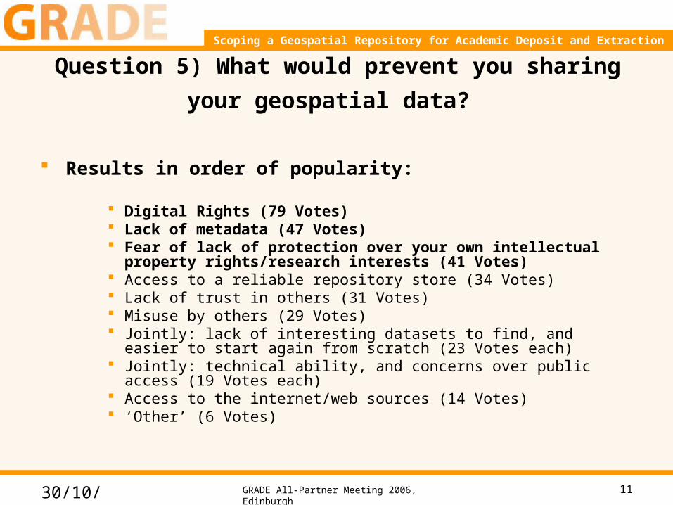
Question 5) What would prevent you sharing
your geospatial data?
Results in order of popularity:
Digital Rights (79 Votes) Lack of metadata (47 Votes) Fear of lack of protection over your own intellectual
property rights/research interests (41 Votes) Access to a reliable repository store (34 Votes) Lack of trust in others (31 Votes) Misuse by others (29 Votes) Jointly: lack of interesting datasets to find, and easier to start again
from scratch (23 Votes each) Jointly: technical ability, and concerns over public access (19 Votes
each) Access to the internet/web sources (14 Votes) ‘Other’ (6 Votes)
30/10/06 GRADE All-Partner Meeting 2006, Edinburgh
Date here title here
Scoping a Geospatial Repository for Academic Deposit and Extraction
12
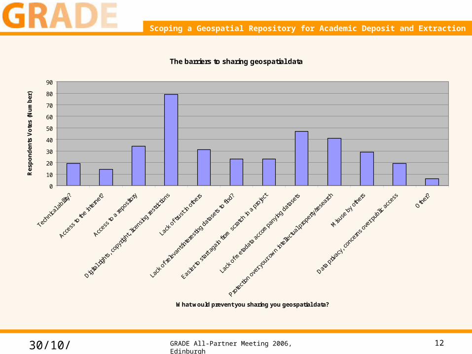
The barriers to sharing geospatial data
0
10
20
30
40
50
60
70
80
90
Techn
ical a
bility
?
Acces
s to
the
inter
net?
Acces
s to
a re
posit
ory
Digita
l righ
ts, co
pyrig
ht, li
cens
ing re
strict
ions
Lack
of t
rust
in ot
hers
Lack
of r
eleva
nt/in
tere
sting
dat
aset
s to
find?
Easier
to st
art a
gain
from
scra
tch in
a p
rojec
t
Lack
of m
etad
ata
acco
mpa
nying
dat
aset
s
Prote
ction
ove
r you
r own
intell
ectu
al pr
oper
ty/re
sear
ch
Misu
se b
y oth
ers
Data
priva
cy, c
once
rns o
ver p
ublic
acc
ess
Other
?
What would prevent you sharing you geospatial data?
Res
po
nd
ents
Vo
tes
(Nu
mb
er)
30/10/06 GRADE All-Partner Meeting 2006, Edinburgh

Date here title here
Scoping a Geospatial Repository for Academic Deposit and Extraction
13
Question 6) Wish list of what 3 things would make it
easier for you to share geospatial data?
Wish List ranking score:
Having a national geospatial repository holding for the UK (Score 109, 58 Votes)
Having one central portal that finds geospatial datasets (Score 95, 44 Votes)
Having less restrictive license agreements for academia (Score 92, 45 Votes)
Having no license agreements (Score 88, 42 Votes) Having local/departmental repositories (Score 43, 22 Votes) A geography/GIS forum similar to Napster or MySpace (Score 40,
17 Votes) Having greater control over who used your data (Score 19, 8 Votes) Faster computer speeds (Score 16, 9 Votes) Having a list of all available sources of informal geospatial data
(Score 9, 7 Votes) ‘Other’ (Score 8, 4 Votes)
30/10/06 GRADE All-Partner Meeting 2006, Edinburgh

Date here title here
Scoping a Geospatial Repository for Academic Deposit and Extraction
14
A pie chart to show the wish list of things that would most help people share geospatial data more easily
A National geospatial repository
A central find/locator portal
less restrictive licence agreements for academia
no licence agreements
University/departmental institutional repository
A geography forum – similar to Napster or myspace
More control over or recognition of your work
Faster computer network speeds
A full list of all sources and informal methods to share
geospatial data
Other?
A National geospatial repository
A central find/locator portal
less restrictive licence agreements for academia
no licence agreements
University/departmental institutional repository
A geography forum – similar to Napster or myspace
More control over or recognition of your work
Faster computer network speeds
A full list of all sources and informal methods toshare geospatial data
Other?
30/10/06 GRADE All-Partner Meeting 2006, Edinburgh

Date here title here
Scoping a Geospatial Repository for Academic Deposit and Extraction
15
Further comments (A flavour of the range of views):
There were a few ‘other’ ideals mentioned. A list of these comments is quoted below:
“I would want data in consistent open standards that can easily be loaded directly into my mapping application, and a 'LIVE' data server which feeds geospatial data directly to my application that does not need to be downloaded and therefore removed issues of IP, data storage, data management.”
“I have clicked on less restrictive licences for HE – it is probably ok I think it is just that people are unsure as to whether they can pass data (e.g. to other staff/students so long as they are signed up on the current JISC HE OS agreement for example). The fear and confusion is the issue rather than the licence itself.”
“Noting the Grid/e-social science point the approach of 'in silico' research is to not only carry out the experiments online but also to provide the facility to hot-link between datasets, (GI) tools, publications and people. This is why we need to look at such activities towards a mature discipline engaged in e-science and the ability to structure much of the activity in academic arenas (to begin with that relate to the development of Spatial Data Infrastructures and major policy activity such as INSPIRE. Some of the points above address this but do not go far enough or recognise these components contributing to a greater whole”
“I would like more Metadata to understand how the information was captured and how accurately.”
“We need to have one place, with one interface and one format for all geospatial data. At the moment, there is a confusing array of websites that offer different datasets (even replicating offers), which all have varying user interfaces and query interfaces, differing data formats and data schemas and varying metadata. VERY CONFUSING and not effective! ”
“I prefer to search web portals over (local) repositories”
“I would like a world portal”
“I would like an easier way to produce metadata and search”
30/10/06 GRADE All-Partner Meeting 2006, Edinburgh

Date here title here
Scoping a Geospatial Repository for Academic Deposit and Extraction
16
Conclusions
1. There is evidence that people want to, and do share geospatial data
2. The preference for doing this would be through a Nationalised Geospatial Repository.
3. The main barrier to geospatial data-sharing is confusion over rights and permissions.
30/10/06 GRADE All-Partner Meeting 2006, Edinburgh

Date here title here
Scoping a Geospatial Repository for Academic Deposit and Extraction
17
The GRADE Geospatial Repository Demonstrator Environmenthttp://gradedemo.edina.ac.uk/dspace/index.jsp
30/10/06 GRADE All-Partner Meeting 2006, Edinburgh

Date here title here
Scoping a Geospatial Repository for Academic Deposit and Extraction
18
Current Development
Map-based search tool File validation tool Cosmetic revamp
(buttons, keys, colours, geospatial file icons)
Licensing framework By-Subject browse
option
30/10/06 GRADE All-Partner Meeting 2006, Edinburgh

Date here title here
Scoping a Geospatial Repository for Academic Deposit and Extraction
19
Users 4 pilot sites:
Edinburgh Kingston Strathclyde Nottingham
Feedback also from: North Carolina State University, USA Cardiff (& Welsh Royal Observatory) Leeds Southampton (& GeoData Institute) Liverpool John Moores University Glamorgan UCL Oxford Bodleian Library Heriot-Watt National Library of Scotland National university of Maynooth, Ireland Queensland University of technology,
Australia 101 geospatial datasets deposited. 65 current registered users.
30/10/06 GRADE All-Partner Meeting 2006, Edinburgh

Date here title here
Scoping a Geospatial Repository for Academic Deposit and Extraction
20
Initial Feedback & comments (Feb/Mar 2006)
Search/ Functionality Cannot search on geographical extent – or point
to an area on a map. Cannot search by Institution Cannot search/filter on GIS File Type Would like to be able to search on, or have a
Quality Rating on the dataset. Would like to be able to search by a ‘field/study
location’ I would like to search by a basic list of data-
types or categories.
Evaluation of ‘discovered’ dataset: The viewable metadata/information
Happy with all the metadata viewable Wanted to see a pictorial image/thumbnail of
what the dataset looked like.
Download Process This was easy Possibly have some live streaming download to a
client / web-service – or an online mapping interface that has some basic functions, can print directly from (access, without full download)
Interoperability Files only exist in the format that they are uploaded
as. Limit to data-sharing Machine-machine interoperability, and in
semantics and e-Science
Upload Process Upload as a Zip format – Clear / Confusing? Would like to upload as a ‘package’ of files or a
project Cannot delete an uploaded dataset that belongs to
you – or edit it (i.e. for spelling mistakes) once submitted. Would like some tools to allow this - frustration.
Upload Simple and easy. Easy to follow instructions. Upload too many pages to go through – slows
process down. After upload cannot sort the list of your deposits – it
enters them randomly. Confusing. Not easy to tell what have already entered.
Would like to see an upload offline function/ability
Metadata Entry part of the Upload Enough fields. Sufficient Do not want a metadata of XY extent/projection
(only as an automatic function) Who is ‘depositor’? The Licensing metadata box – do not know how
should fill this in.
Cosmetics/user-interface All these comments have been addressed in
make-over
30/10/06 GRADE All-Partner Meeting 2006, Edinburgh

Date here title here
Scoping a Geospatial Repository for Academic Deposit and Extraction
21
Pilot Site Feedback (Sept – Dec 2006) More detail Beyond just GIS-departments/users – wider interaction & usage 1. Registered users of GRADE repository at your institution 2. Uploading/Downloading geospatial data from the GRADE repository 3. a top 10 personal wish-list of geospatial datasets you would ideally like a
national GRADE repository to hold
30/10/06 GRADE All-Partner Meeting 2006, Edinburgh
•4. Informal Geospatial data-sharing current practices at your institution (at least 500 word report)
•5. Case study examples of a derived geospatial dataset that was shared at your institution (include at least 2)