scratching at the surface: hidden mineralization at … geologi indonesia, vol. 28 no. 1 april 2013:...
TRANSCRIPT
Majalah Geologi Indonesia, Vol. 28 No. 1 April 2013: 51-63
Scratching at the Surface: Hidden Mineralization at Wetar?
Guratan Pada Permukaan Tanah: Mineralisasi Tersembunyi di Wetar?
1Herman Seran and 2Chris Farmer
1Batutua Tembaga Raya, 2Finders Resources
ABSTRACTWetar Island is one of the prominent mineralization nests lying along the Sunda - Banda Magmatic Arc. The initial stage of modern exploration commenced in 1986 and resulted in gold mining at the Kali Kuning and Lerokis deposits, producing approximately 20 tonnes of gold and 600 tonnes of silver. Currently, the old pits are being reopened for copper mineral extraction by PT. Batutua Kharisma Permai in cooperation with Batutua Tembaga Raya as part of the flagship Wetar Copper Project. Apart from the deposits of Kali Kuning, Lerokis and Meron, elsewhere on the island there has been limited conversion of hundreds of geophysical and geochemical anomalies to economic mineral resources. Having secured more than 8 million tonnes mineable copper reserve, Wetar Copper Project has a strategic advantage to build a production pipeline beyond the current ten-year-mine life. New exploration strategies and technologies have been considered to revisit prospects that occur all over the island. Lesson learning from past exploration results and methodologies, knowledge of mineralization and alteration styles, and success stories on the north coast indicate that Wetar is still very prospective for new mineable deposits. Hence, a new Wetar exploration strategy targets the discovery of other a typical volcanogenic massive sulfides (VMS) gold - base metal deposits concealed by younger formations. In addition, high sulfidation epithermal alteration that assemblages in the context of the Sunda-Banda Arc may suggest the presence of porphyry style deposits that are related to the known massive sulfides and the extensive unexplored anomalies spreading throughout the island. A cutting edge deep geophysical method is considered to be an effective option to trace deep buried mineralization at target depths unattainable by using technology available in the 1990’s. This approach has potential to unlock the true mineral inventory on Wetar Island.Keywords: mineralization, gold, copper, Wetar Island, Sunda-Banda Magmatic Arc
SARIPulau Wetar merupakan salah satu lokasi mineralisasi utama yang terletak di sepanjang Busur Magma Sunda-Banda. Tahap awal eksplorasi modern dimulai tahun 1986 dan memunculkan penambangan emas di cebakan Kali Kuning dan Lerokis, yang menghasilkan sekitar 20 ton emas dan 600 ton perak. Saat ini, sumuran-sumuran tua dibuka kembali untuk mengekstraksi mineral tembaga oleh PT. Batutua Kharisma Permai bekerja sama dengan Batutua Tembaga Raya sebagai bagian dari Proyek Tembaga Wetar. Terlepas dari deposit Kali Kuning, Lerokis, dan Meron, dimana pun di pulau tersebut ada keterbatasan konversi ratusan anomali geofisika dan geokimia bagi sumber daya mineral ekonomis. Proyek Tembaga Wetar memiliki lebih dari 8 juta ton cadangan tembaga, dan juga memiliki keuntungan strategis dalam membangun jalur pipa produksi di luar sepuluh tahun masa produksi pertambangan saat ini. Strategi eksplorasi dan teknologi baru telah meningkatkan prospek yang terdapat di seluruh pulau tersebut. Belajar dari hasil eksplorasi dan metodologi masa lalu, pengetahuan mineralisasi dan tipe alterasi, serta cerita sukses di pantai utara mengindikasikan bahwa Wetar masih prospektif untuk deposit tambang baru. Karena itu, strategi eksplorasi Wetar yang baru menargetkan penemuan sulfida masif tipe vulkanik yang lain (VMS) deposit logam dasar emas yang tersembunyi oleh formasi yang lebih muda. Selain itu, kumpulan alterasi epitermal sulfida tinggi dalam konteks Busur Sunda-Banda mengindikasikan keberadaan deposit tipe porpiri yang berkaitan dengan sulfida masif yang telah dikenal dan anomali ekstensif yang tak tereksplorasi yang tersebar di seluruh pulau tersebut.
51Naskah diterima: 03 Januari 2012, revisi terakhir: 10 April 2013, disetujui 12 April 2013

Majalah Geologi Indonesia, Vol. 28 No. 1 April 2013: 51-63
52
INTRODUCTION
The Wetar Copper Project is located on the northern coast of Wetar Island approximate-ly 400 km NE from Kupang, Nusa Tenggara Timur and 100 km west of the nearby capital city of Maluku Barat Daya Regency, Kisar Island. The project was previously exploited for gold and silver metals resulted in the production of approximately 20 tonnes of gold and 600 tonnes of silver from high sulfidation volcanogenic massive sulfides (VMS) ore, supplied by two pits namely Kali Kuning and Lerokis pits. The mine was operated by PT. Prima Lirang Mining (PLM). Production ceased in 1997 even though underlying copper sulfide bodies were known, yet deemed uneconomic given processing options and low copper prices at that time. Between 2004 and 2006, PT. Batutua Kha-risma Permai acquired nine tenements over both Lerokis and Kali Kuning prospects and several other known PLM prospects target-ing gold - silver and basemetal mineraliza-tion. The company built a strategic alliance with PT. Batutua Tembaga Raya (Finders Resources), as part of the Wetar Copper Project flagship, to explore and exploit the metals within the assigned tenements. The main cooperation has been centered on the introduction of new processing technol-ogy to enhance the feasibility of copper extraction from known copper resources mainly from the Kali Kuning, Lerokis, and Meron deposits. Accordingly, the project is now feasible to produce up to 25 kt/year LME “Grade A” copper cathode for a 10 year mine life from approximately 8 Mt of
copper ore, employing copper sulfide heap leaching and solvent extraction - electro winning (SX-EW) processing technology.
With the first pure copper cathode pro-cessing facility in Eastern Indonesia and technical leaching know-how developed over the past 5 years, it is strategic to extend and expand the current operation. There are two routes to underpin growth, namely aggressive exploration on Wetar in BKP tenements and cooperation with other tenement holders or to source raw materials from wider afield. Accordingly, defining a new exploration strategy based on existing Wetar exploration knowledge in combination with new advances in geophysical technology provides a signifi-cant opportunity to re-assess the mineral potential of Wetar and enhance the Wetar Copper Project.
Therefore, the paper’s ultimate objective is to discuss exploration strategies to increase the value of the project to its stakeholders. The discussion touches firstly on pertinent geological aspects of Wetar Island, then places high sulfidation VMS mineralization found on Wetar in a wider context, before commenting on the current status of the project and possible paths forward.
GEOLOGY
Regional Geology The Wetar Island is located along the Sunda - Banda magmatic arc resulted from continual subduction of the Australia - Indian Ocean Plate below the Eurasian Plate. Further to
Metode geofisika cutting edge deep dianggap sebagai opsi yang efektif untuk menjejaki mineralisasi yang terkubur dalam yang tak dapat dicapai menggunakan teknologi yang ada pada tahun 1990-an. Pendekatan ini memiliki potensi untuk benar-benar menemukan mineral di Pulau Wetar.Kata kunci: mineralisasi, emas, tembaga, Pulau Wetar, Busur Magma Sunda-Banda

Scratching at the Surface: Hidden Mineralization at Wetar? (H. Seran and C. Farmer)
53
the south lies an accretionary terrain, with Timor as the biggest island among others. The magmatic arc extends somewhat 3.800 kms (Garwin et al., 2005) from Sumatra in the northwest to Java. Lesser Sunda Islands and ending up in Banda Archipelago (Figure 1). The arc hosts a large number of mines or exploration targets for precious and base metal resources, mainly in the form of epith-ermal and porphyry systems, but occasionally in the case of Wetar, a volcanogenic massive sulfides (VMS) style. Several notable projects lying along the arc have been Martabe gold - copper mine and Lebong Donok in Sumatra, Pongkor and Tujuh Bukit Porphyry Project in Java, Batu Hijau Porphyry in Sumbawa, and Kali Kuning and Lerokis in Wetar (Figure 1).
Geology of Wetar
Wetar rises more than 1.875 m above sea level, formed mainly by submarine volca-nic products with a lesser degree of marine sediments (Sewell and Wheatley, 1994). Geology in Wetar started with the formation of the basement dated 12 Ma in terms of basaltic pillow lavas, overlain by younger submarine volcanic rocks between 7.78 to 3.03 Ma in the forms of dacite, diorite, and basaltic andesite. Meanwhile, sedimentation processes also occurred forming Globige-rina bearing limestones dated 5.2 to 3.9 Ma.
Paleontological analysis reveals deposition process formed no less than 2,000 m below the paleo-sea water level. The island started to emerge from the sea approximately 3 million years ago (Scotney et al., 2005). A complete stratigraphic column can be observed in Figure 2.
Wetar Island is a product of extensional oceanic crust rifting, resulted from the col-lision process further to the south. The land masses are continuously uplifted with a rate of 0.5 - 5 mm per annum. The volcanic arc islands are actually isolated and off-setted from each other by transform faults resulting from the tectonic activities along the Timor - Tanimbar trough (Figures 3 and 4). For in-stance, a strike-slip fault separates the Wetar from Alor Island to the west. Meanwhile, Wetar thrust plays significant role in absorb-ing collisional forces of 75 mm per annum between SE Asian and Indian-Australian Plates (Scotney et al., 2005).
Wetar Copper - Gold Deposits
More than a hundred anomalies and pros-pects were identified during the previous exploration works within the island of Wetar by means of remote sensing, geophysical, and geochemistry works (Sewell and Wheat-ley, 1994). Epithermal style of mineraliza-
Martabe
Pongkor
MT. Muro
Romang
GrasbergGrasberg
Wetar Copper
Awak Mas
Tujuh Bukit Batu Hijau
G. PaniToka Tidung
Gosowong
Lanut
Lebong Donok
N
Figure 1. Locality map of Sunda - Banda Volcanic Arc and notable mining projects.

Majalah Geologi Indonesia, Vol. 28 No. 1 April 2013: 51-63
54
Per
iod
Ep
och
Hol
ocen
eP
leis
toce
ne
QU
AT
ER
NA
RY
Age Tectonic Setting Lithology Date
Late veins +disseminations
Massive greyreef
limestones20
70
250
15
3
12.39 Ma
34.73 Ma
35.05 Ma
7.78-3
6.52 Ma
312 Ma
450
5.2-3.9 4
Ma
34.7 Ma(alteredfootwal)
14.93 Ma
Lahars+dykes
Spheruliticrhyolites
Debris flows
Dacite
Limestone
Chert/gypsum
Basalticandesites+
dacites
Syenogranite
Felsic domes
Andesitic pillow lavas
Multiple lavas(bimodal)+
intrusive rocks
Basalticpillow lavas
?Basalt
Stockwork zonesExtension+faulting,preparation of sitesfor mineralization
Extensive volcanism onWetar. Collisions of the
micro-continentalfragment art -8 Ma with
the subduction zone
Subduction relatedvolcanism+early backarc rifing (evolution of
Wetar edifice)
As rich sulfideswith flanking
Cu-Au-Ag-Hgrich baritemounds
Waning stages
Continued uplift ofboth the inner and
outer arcs
Rapid arc exhumationrelated to continued
shortening of thecollision zone
Late volcanism in thesouth + uplift of the
inner Banda arc relatedto the locking of the arc
Arrival and collisionbetween the
Australian contnentalmargin and the outerBanda arc + possible
arc reversal in the
Piacenzian
Zandian
Messinian
Tortonian
Serravalian
Langian
Pli
ocen
eM
ioce
ne
TE
RT
IAR
Y
Mineralization
Seq
uen
ce
Th
ick
nes
s(m
)
Figure 2. Northern Wetar stratigraphic column.
Oceanic Crust
Continental CrustBanda Sea
Papua
Australia
Wetar Basin
SavuBasin
SavuRoti
Alor Thrust
Flores Thrust
(AP)
Wetar Thrust
Wetar
Alor
Timor
Timor Trough
Timor Sea
Arafura SeaTanim
bar T
rough
Banda Arc
RomangDamar
Nila
SeruaTeun
BandaIsland
Ambon Seram
Manuk
Kai
TanimbarIsland
AruIsland
Aru
Tro
ugh
Buru
Seram Through
Wetar
Timor Trough
DamarBasin
BabarSermata
MoaAtauro
200 kmo120 E o125 E
o120 E o130 E
0
Accretionary Terrane
Active Volcano
Sumba
SumbawaJava
Bali
Sunda Arc
Sunda Trench / Java Trench
LombokSum
ba
Inner Volcanic Banda-arc
Outer Banda-arc0 500 km
N
N
Figure 3. Banda Volcanic Arc with Wetar tectonic setting (from Scotney et al., 2005).

Scratching at the Surface: Hidden Mineralization at Wetar? (H. Seran and C. Farmer)
55
InnerBanda-arc
OuterBanda-arc
Damar
Romang
extension
WetarNW
SE
Horizontallava flows
BandaSea
WetarStrait
Kisar
Moa
Timorcompression
Tim
or T
roug
h
Australi
an
Continental
Shelf
Crystallin
e
Basement
Recent to
Triasic
marine s
ediment
on shell
and to
bench75 mm/a
80 km
120 km
Crustal shortening
and thickening beneathtrench
SE Asia Plate
0 200 km
Wetar Basin
OceanicCrust
Sub detachmentat depth ?
Down to300 km
MountApi
Figure 4. Wetar tectonic setting in three dimensions (from Scotney et al., 2005).
tion, mainly volcanogenic massive sulfide mineral deposits, predominantly occupies the island. However, studies of the known deposits reveal that Wetar VMS mineraliza-tion is rather atypical compared with classic VMS deposits, giving its high gold content and high sulfidation alteration signatures and ore mineral associations (Herrington, 2007).
The mineralization in Wetar was formed as the result of the escape of hydrothermal solutions on the sea floor within an exten-sional crustal plate. The mineralization bod-ies appear in the form of lenses or mounds of massive sulfide, forming in paleo-topographic lows in seamounts, that have sharp zoned alteration halos (vertically and horizontally) and are often capped by a Au/Ag bearing baritic sand which is a chemical precipitate formed during a later hydrother-mal overprint. The deposits were formed at depths greater than 2.000 m in an ocean environment some 4.7 - 4.9 Ma. Research by Scotney and Herrington (amongst others) on the Kali Kuning, Lerokis, and Meron deposits, suggests that the high volatility of the ore forming hydrothermal fluids resulted
from contamination by continental material representing the source of elevated levels of gold in the Wetar mineralized bodies. This is drawn from the opinion that typical mid-oceanic ridge basalt (MORB) contain less gold compared to continental crust material based on typical mass balance ratios and the proximity of Wetar to nearby sources of continental crust. Hence, hydrothermal fluids are believed to have scavenged gold from the nearby continental crust as they percolated through the relatively gold-rich continental crust before reaching the sea floor as VMS deposits.
As observed in northern coast deposits, the VMS mineralization bodies are controlled by NW-SE and NE-SW trending structures. The massive sulfides bodies are discordant to the host rocks, mainly basaltic andesite and ryodacite flow units, rooting deeper within the fault zones, and then covered by younger marine sediments like limestone, cherts, and gypsum. Due to high erosional rates on Wetar Island, the new exploration focus is to discover preserved (hidden) VMS systems since previous exploration has been

Majalah Geologi Indonesia, Vol. 28 No. 1 April 2013: 51-63
56
successful in discovering outcroppingsys-tems and/or partially exposed alteration halos or eroded root systems.
For a preserved deposit to be located on Wetar, three key steps are required to form an ideal VMS target. Firstly, the seafloor formation of typical low sulfidation black smoker associated with predominantly pro-phylitic - argilic alteration zoning. Second-ly, an overprinting stage of barite and gold deposition along the periphery and utilizing available fractures within the black smoker bodies to form white smokers, associated with more acidic and oxidized hydrothermal fingerprints producing argilic and advanced argilic alteration halos, that may overlap and destroying some elements of the previ-ous alteration. Finally, post hydrothermal “protective” sedimentary or volcanic rock units which are typically marine sediments or dacitic flows. The alteration zonation for typical VMS deposits reveals intense silicification (silica) proximal to the sulfide bodies, following by clay minerals (illite - smectite) then towards distal portion where exhibiting chloritic alteration. The altera-tion distribution for Wetar mineralization is extensive, intensive and zoned (Scotney, et al., 2005, p.835).
The sulfide bodies, which can take vari-ous styles including pipes, mounds, and stockworks, are dominated by arsenian pyrite (~90% by volume). Chalcopyrite and sphalerite with minor galena are as-sociated primary sulfides and are observed as a replacement of and inter-grown with pyrite. The main other copper sulfide spe-cies are covellite, chalcocite (dignite), and tenantite. Mercury and silver minerals are also present in the form of cinnabar and moschellandsbergite. Barite is the main gounge mineral forming sulfides mounds, talus breccia, barite ore, stockworks, and veins. Later phase were barite cementing by
iron oxides, hydroxides, complex arsenates, and sulfates.
PROJECT STATUS AND METHODOLOGY
Project Strategic Advantages
Wetar Copper Project has four unique ad-vantages that positively influence success-ful project development and future growth. Firstly, the Wetar Copper Project is aligned well with the new mining law and produces pure metal, with 99.99% pure copper cath-ode from the first SX-EW plant Indonesia. Secondly, the project has been established using proprietary technology developed over the past 5 years, which not only suits Wetar metallurgical characteristics but also has potential applications for other ore types. Thirdly, underpinning the economic attrac-tiveness of the project, is an 18,000 tonnes per annum SX-EW plant already imported in Indonesia, whose replacement value is of the order of $30 - 40 m. Finally, the project location is isolated but within 4km of an existing port and located on an unpopulated Island where the previous mining history in the area has resulted in a very aware and very supportive set of local stakeholders.
By way of background, emphasizing how technological advances assist new mineral project development and discovery, the ex-ploration and mining history of Wetar sets the scene for both the current project and growth opportunities. The copper deposits lying beneath gold mineralization at the Kali Kuning and Lerokis have been known for more than 20 years. They were discovered by drilling, but it soon became apparent that the massive sulfides were all in stratigraphi-cally similar position and could be readily detected using electromagnetics. PT. Prima Lirang Mining did not develop the copper deposits because there was no economically

Scratching at the Surface: Hidden Mineralization at Wetar? (H. Seran and C. Farmer)
57
proven technology available during the time. Airborne EM surveys conducted in the mid-90’s were able to confirm the presence of massive sulfides at Kali Kuning, Lerokis, and Meron but realistically could only detect to depths of 25 - 50 m due to the limitations of airborne systems at that time.
The Wetar Copper project is the first eco-nomic copper sulfide heap leach in the world. Heap leaching of copper oxides is not new in the copper industry with about 20% of global copper production by SX-EW, but leaching of sulfide was not thought to be economic particularly due to slow recoveries from chalcopyrite and to a lesser extent covellite. However, after a series of laboratory tests and a pilot project using full height heaps, the careful analysis of the interactions between 34 parameters allowed optimization of the process and boost eco-nomic performance of the project.
RESULTS AND DISCUSSION
Mineral Reserves and Resources
Wetar Copper Project has a mining license for 20 years from bupati Maluku Barat Daya covering approximately 2,733 hectares. The production plan is founded on 8.2 million tonnes @2.5% Cu proven and probable mining reserves from both Kali Kuning and Lerokis pits. The reserves serve a ten year life of mine producing up to 25,000 tonnes/year LME grade A copper cathode by sulfide heap leaching and solvent extraction - elec-tro winning (SX-EW) technology.
Exploration focus #1: Additional massive sulfide resources
First priority for the Wetar Copper Project is to extend mine life by means of discovery of additional massive sulfide resources. The exploration philosophy has two priorities:
firstly, known prospects in the immediate district surrounding Kali Kuning and Le-rokis will be upgraded by drill testing and, secondly, the potential of the rest of the island will be evaluated using new explo-ration approaches. Despite extensive first/second pass geochemistry and geophysical surveys completed island-wide since the mid-1980’s (Sewell and Wheatley, 1994), the potential for further discovery on Wetar is driven by knowledge of the character and size of VMS mining districts elsewhere in the world and that post-mineralization cover masks in excess of 60 - 70% of the Wetar Island land mass. Comparing with notable VMS districts in Canada and Japan (Figure 5), where typically massive sulfides occur in clusters at a specific stratigraphic horizon, the number of deposits and com-bined resources known on Wetar are still very small. The three known deposits at Kali Kuning, Lerokis, and Meron massive sulfides account for approximately 10 Mt of ore. Whilst the number of deposits and size of VMS deposits in Canada and Japan is significantly larger ranging from 34 Mt (10 deposits) in Matagami in Japan to 100 Mt (19 deposits) at Noranda in Canada. Roughly, 70 % of the Mining IUP is covered by post mineral volcanic rocks, ranging from <10 m to more than 100 m in thickness. In places, where the mine sequence rocks are exposed, strong alteration and evidence of sulfide mineralization occur over an area roughly 7 km east-west by 3.5 km north-south. Both the Kali Kuning and Lerokis deposits are strong electrical conductors, and electromagnetic geophysical surveys have proven to be effective in locating mas-sive sulfide accumulations under the cover sequence (Figure 6).
At Karkopang, a cluster of EM conductors beneath younger cover was defined by an airborne EM survey flown by the previous

Majalah Geologi Indonesia, Vol. 28 No. 1 April 2013: 51-63
58
Potential for Futher VMS Discoveries
VMS Deposit Clusters in Canada and Japan
Flin Flon~ 8 deposits~ 80 mt
Snow Lake~ 11 deposits~ 40 mt
Hokuroku~ 12 deposits~ 90 mt
5 km
Matagami~ 12 deposits~ 90 mt
Wetar Island~ 3 deposits~ 10 mt
Noranda~ 19 deposits~ 100 mt
COVER SEQUENCE
0.75
N
0 0.5 1 km
MINERALIZED ZONES
ADVANCED ALTERATION
CLAY ALTERATION
BASEMENT SEQUENCE
STRONG CONDUCTOR
MODERATE CONDUCTOR
WEAK CONDUCTOR
Kali Kuning
Meron
Lerokis
Figure 5. A comparison between Wetar and the VMS Projects in Japan and Canada (modified from Sangster, 1980).
Figure 6. Northern Tenement Geology of the Wetar Copper Project.

Scratching at the Surface: Hidden Mineralization at Wetar? (H. Seran and C. Farmer)
59
owner.These anomalies have not been drill tested, and mapping in the streams periph-eral to the anomalies has identified a similar alteration to the alteration halo surrounding Kali Kuning.
At Meron, a 500 m long strong electrical conductor with similar size and geophysi-cal characteristics as the known sulfide deposit at Kali Kuning forms an immediate focus for expanding the ore reserves. The geology of Meron is similar to Kali Kun-ing, with a sequence of gold bearing barite sands overlying a copper-bearing massive sulfide deposit, with essentially the whole prospect area covered by a thin (10 - 50 m) sequence of younger volcanic rocks. The Meron gold-silver resource, outcrops at surface, and based on Billiton Indicated and Inferred estimates contains 394,000 tonnes grading 3.18 g/t Au and 143 g/t Ag (~80,000 Au Oz equivalent).
The massive sulfide can be “remotely” mapped under the cover sequence using geophysical techniques, specifically time-domain electromagnetics (Figure 7). Mas-sive sulfides have “decay constants” which
TEM MAGNITUDE (uV/A) CHANEL-25, NORTH VALLEY - MERON PROSPECT
9147600N
9147400N
9147200N
NO
RT
HIN
GS
(m
)
9147000N
9146800N
205400E
Scale : 1 : 10.000
0m 200m 400m 600m 800m
205600E 205800E 206000E 206200E 206400E 206600E
EASTINGS (m)
206800E 207000E 207200E 207400E 207600E
10
50
0uV/A
are an order of magnitude higher than, and unmistakable for, anomalies associated with disseminated mineralization.
At Meron, only 31 of 85 of the historical drill holes intersected sulfide mineraliza-tion as part of shallow drillings of the gold cap known above the southern quarter of the massive sulfide body. Based on this information, it is possible that Meron may contain between 1 and 5 million tonnes of potentially economic copper mineralization grading greater than 0.5% Cu. Since much of the massive sulfide at Meron is untested by drilling an initial 50 hole, ~5000 m program is planned to bring the Meron prospect up to Indicated and Inferred resource status. In addition to the copper potential, there is potential for discovery of new significant additional gold mineralization above other parts of the massive sulfide.
Elsewhere on Wetar Island, the exploration strategy is to re-assess potential for hidden extensions to known prospects or to discover new deposits masked by cover sequence rocks adjacent to exploration prospects dis-covered during the earlier exploration sur-
Figure 7. Meron TDEM anomaly.

Majalah Geologi Indonesia, Vol. 28 No. 1 April 2013: 51-63
60
veys since the mid-1980’s. In each of three main prospect areas, known gold-silver barite sand deposits were partially evalu-ated by scout drilling with only a cursory evaluation of copper potential.
At the Pantai Merah Prospect (Figure 8), 11 scout drill holes (457 m) were drilled in the vicinity of outcropping barite sands with reported “potential” for 600,000 t @ 1.6 g/t Au, 77 g/t Ag, 15.5% Ba; four of the drill holes intersected the upper parts of a massive sulfide (copper) body located under gold barite mineralization. Extensive geochemistry anomalism extends for + 3 km north in an area with + 80 % cover sequence.
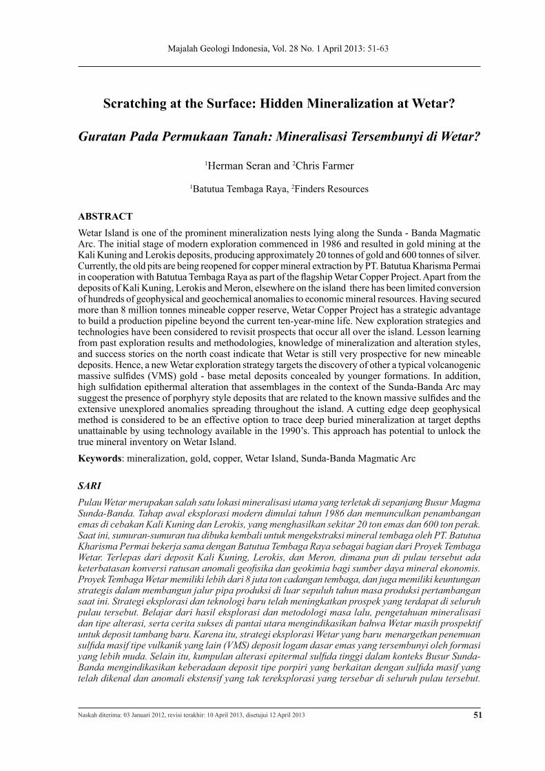
Similar opportunities occur at the W6 (Il-waki) Prospect, where 8 drill holes assessed gold mineralization adjacent to a limestone cover sequence and at the Batu Duri (J91) Prospect (Figure 9) where scout drilling tested outcropping barite sands with 9 drill holes (602.5 m) with a best Au result of 7 m @ 1.1 g/t Au and only one hole intercepting the underlying sulfides with 10 m @ 4.5% Cu. Around 15 km2 of cover sequence im-mediately surrounds the Batu Duri prospect, which is essentially a 0.5 km2 inlier of the basement sequence.
Exploration focus #2: Hidden Porphyry Systems
The massive sulfide deposits in Wetar are atypical compared to other VMS systems. In addition to the significant gold-silver cap, alteration assemblages comprise ad-vanced argillic alteration (vughy silica with enargite) more akin to those observed in high-sulfidation systems (Figure 10). Thus, the overall character of the Wetar deposits is one of classic VMS systems with mas-sive sulfides, occurring in clusters and at a defined stratigraphic horizon/age, but there are strong indications of a high sulfidation fluid overprint.
On a district scale, the Lerokis, Kali Kuning, and Meron are surrounded by large altera-tion zones that are connected. At Lerokis, specifically, peripheral parts of the altera-tion halo are marked by a chloritic zone with epidote, then closer to the center of the alteration zone are magnetite stockworks, enargite, and vughy silica. As elsewhere in the Pacific Rim, a large number of porphyry systems have high sulfidation caps including Far South-East (Philippines), Frieda River (Papua New Guinea), Dizon (Philippines), Tujuh Bukit, Batu Hijau, and Grasberg in Indonesia. Accordingly, future exploration
Mineralization andAlteration
LEGEND
Covered Sequences
Figure 8. Pantai Merah Prospect Drilling Target.
Scratching at the Surface: Hidden Mineralization at Wetar? (H. Seran and C. Farmer)
61
LEGEND
Alluvium
Limestone - Reef
Lahar
Basaltic Andesite
Andesite-Silica
Andesite-Hornblende
Tuff-Silica
Tuff-Barite
Barite Rock
efforts will address the possible nature of identified high sulfidation mineralization sys-tem telescoped on a deeper porphyry system.
New Exploration Applications: Deep Aerial Geophysics
From the mid-1980s to mid-1990s, Wetar Island was extensively explored using re-mote sensing, stream geochemistry, map-ping, drilling, and geophysics. This stage of exploration was successful with the discov-ery of at least 10 outcropping gold-bearing barite sand deposits across the island (a new deposit style for Indonesia). However, from approximately a hundred anomalies derived from geochemical and geophysical studies only two deposits proven to be mineable. A similar exploration approach and meth-odology to that undertaken in that previous exploration period is unlikely to yield new
discoveries; since, as in many first/second phases of exploration, the focus (and suc-cess) was to scratch at the surface.
Given the need for discovery of intact mineralized systems, the next phase of exploration focus is to explore for massive or disseminated sulfide bodies hidden 50 - 200 m below the land surface. The airborne EM technology of the 1990’s was unable to detect sulfide at those depths, but since then airborne EM technology has developed with more powerful and deeper seeking systems.
Although ground based EM is capable, given the topographical constraints at Wetar Island, ground surveys will be very inef-fective in terms of time and cost. Aerial geophysics and particularly a new system developed since 2007 may hold the key to success. The Z-Tipper Axis Electromagne-tism (Z-TEM) geophysical method (www.
Figure 9. Batu Duri Geological Map.

Majalah Geologi Indonesia, Vol. 28 No. 1 April 2013: 51-63
62
geotech.ca) has potential to be able to iden-tify anomalous conductors down to 2.000 m depth. For instance, Z-ETM geophysics method proves to be very accurate in locat-ing the porphyry anomalies like in Fiji (Sa-beto/Vuda Prospect) operated by Geopacific Resources NL (www.geopacific.com.au) (Figure 11) and Mandoos and Safwa Copper VMS in Oman discovered another variant of such geophysical method V-TEM (Syarief et al., 2011).
Figure 10. Photograph of vughy silica at Lerokis, Wetar Island.
Figure 11. Helicopter Z-TEM survey in Geopacific Resources NL from www.geopacific.com.au
CONCLUSSION
Despite being a known for over 20 years as a mineralization hotspot on the Sunda - Banda Arc, the true potential of the established mining district on Wetar Island remains untapped. With the imminent development of the Wetar Copper Project, a new phase of exploration can commence targeting unique
styles of gold-copper VMS mineralization and evaluating the potential of larger por-phyry systems.
Founded on an understanding of new pro-cessing and geophysical technologies devel-oped in the past 5 years, the potential abil-ity to identify the “hidden” mineral wealth of Wetar for the benefit of all stakeholders is an exciting opportunity for the “forgotten islands” of Indonesia and could mark a new successful chapter in the development of Indonesia’s natural resources.
ACKNOWLEDGMENT
The paper has been presented in the MGEI, Banda and east Sunda Seminar 2012. Thanks are expressed to the MGEI Seminar Committe for permision to publish the paper in MGI.
REFERENCES
Garwin, S., Hall, R., and Watanabe, Y., 2005. Tec-tonic Setting, Geology, and Gold and Copper Min-eralization in Cenozoic Magmatic Arcs of Southeast Asia and the West Pacific. Economic Geology 100th
Universary Volume, p.891-930, Society of Economic Geologists, Inc.
Herrington, R.J., 2007. VMS Deposits and Modern Seafloor Analogues. Irish Association for Economic Geology Short course: Alteration and Geochemistry in VMS Exploration, Dublin 31 March -1 April, 2007.
Sangster, D., 1980, Quantitative Characteristics of Volcanogenic Massive Sulphide Deposits, in Metal Content and Size Distribution of Massive Sulphide Deposits in Volcanic Centers. CIM Bulletin, 73, p.74-8.
Scotney, P.M., Roberts, S., Herrington, R.J., Boyce, A.J., and Burgess, R., 2005, The Development of Volcanic Hosted Massive Sulfide and Barite-gold Orebodies on Wetar Island, Indonesia. Mineralium Deposita 40, p.76 - 99, DOI 10.1007/500126-005- 0468-x.
Sewell, D.M. and Wheatley, C.J.V., 1994. Integrated Exploration Success for Gold at Wetar, Indonesia. Journal of Geochemical Exploration, 50, p.337 - 350.

Scratching at the Surface: Hidden Mineralization at Wetar? (H. Seran and C. Farmer)
63
Syarief, O., Maidment, D., and Al Balushi, H., 2011. The Discovery and Development of Mandoos and Safwa Copper VMS Deposits, North Semail Ophiolite - Sultanate of Oman. Proceedings, The 36th HAGI and 40th IAGI Annual Convention and Exhibition.
ZTEM (Z-Tripple Axis Electromagnetic) System inhttp://www.geotech.ca/Airborne-Surveys, retrieved June 2012.
Z-TEM Explained, http://geopacific.com.au/index.php/z-tem- explained/, retrieved June, 2012.