sdg&e east county substation project notice of …e east county substation project notice of...
TRANSCRIPT

SDG&E East County Substation Project Notice of Preparation / Notice of Public Scoping Meeting for an Environmental Impact Report / Environmental Impact Statement
A. Introduction San Diego Gas & Electric Company (SDG&E) has filed an application (A.09-08-003) for a Permit to Construct (PTC) with the California Public Utilities Commission (CPUC) for the proposed East County (ECO) Substation Project, also referred to as the proposed project. The proposed ECO Substation Project includes the following components: • Construction of a new 500/230/138 kilovolt (kV) substation (ECO Substation)
• Loop-in of the existing 500 kV Southwest Powerlink (SWPL) transmission line into the new ECO Substation, which will require installation of transmission structures outside of the fenced substation area but within the existing SWPL right-of-way (ROW) and ECO Substation property
• Construction of a new, approximately 13.3-mile-long, 138 kV transmission line from the ECO Substation to the Boulevard Substation, including the placement of an optical ground wire to provide critical communication services and lightning protection
• Rebuild the existing Boulevard Substation to 138/69/12 kV on a new parcel of land adjacent to the existing substation to accommodate switch racks, air-insulated buses, transformers, circuit breakers, disconnect switches, a control shelter, protective relays, and communication equipment. The existing 69/12 kV substation will be dismantled and removed after the new substation is in service.
• Construction of a microwave communication relay system composed of a new tower and control building at the ECO Substation
• Rebuild of the existing SDG&E Communication Facility at White Star.
SDG&E’s stated purpose for the project is to facilitate interconnection of renewable generation in southeastern San Diego County and to improve reliability for the existing electric transmission system in the Mountain Empire region of San Diego County. SDG&E has also filed an application for a Right-of-Way Grant with the United States Department of the Interior Bureau of Land Management (BLM). The CPUC and the BLM have developed and signed a Memorandum of Understanding (completed on December 14, 2009) that will direct the preparation of a joint Environmental Impact Report (EIR) and an Environmental Impact Statement (EIS) referred to as an EIR/EIS for the SDG&E ECO Substation Project. The CPUC, as the lead agency under California law, and the BLM, as the federal lead agency, will prepare a Draft and Final EIR/EIS to comply with the California Environmental Quality Act (CEQA) and the National Environmental Policy Act (NEPA). In accordance with the California Environmental Quality Act (CEQA) of 1970, and the CEQA Guidelines, the CPUC has decided that an EIR/EIS will be prepared to evaluate the project in accordance with the criteria, standards, and procedures of CEQA (California Public Resources Code, Section 21000 et seq.) and the CEQA Guidelines (14 CCR 15000 et seq.) Therefore, as
1

Notice of Preparation – Notice of Public Scoping Meeting East County Substation Project
required by CEQA, this Notice of Preparation (NOP) is being sent to interested agencies and members of the public. The purpose of the NOP is to inform recipients that the CPUC is beginning preparation of the ECO Substation EIR/EIS and to solicit information that will be helpful in the environmental review process. Information that will be most useful at this time would be descriptions of concerns about the impacts of the proposed project and suggestions for alternatives that should be considered. As required by NEPA, the BLM will publish a Notice of Intent (NOI) in the Federal Register for preparation of a joint EIR/EIS for the ECO Substation Project. Similar to this NOP, the intent of the NOI was to initiate the public scoping for the EIR/EIS, provide information about the proposed project, and also serve as an invitation for other federal agencies granted cooperating agency status to provide comments on the scope and content of the EIR/EIS. This notice includes background on the project proceeding, a description of the project that SDG&E proposes to construct, a summary of potential project impacts, time and location of the public scoping meeting, and information on how to provide comments to the CPUC and BLM. This NOP and the NOI can be viewed on the project website at the following link:
http://www.cpuc.ca.gov/environment/info/dudek/ECOSUB/ECOSUB.htm
B. Background SDG&E filed an application (A.09-08-003) with the CPUC for a PTC to construct the ECO Substation Project on August 10, 2009. The filing included a description of the project components, a proposed construction schedule, the conclusions of SDG&E’s Proponent’s Environmental Assessment (PEA) (which includes project-specific information and environmental information as required by CPUC’s General Order 131-D and the CPUC’s Information and Criteria List), and SDG&E’s Magnetic Field Management Plan. C. SDG&E Project Development Process SDG&E developed a public education and community outreach program in 2007 to inform local agencies, key stakeholders, and residents in the project area about the proposed project. SDG&E initiated the program by presenting the proposed project to the Jacumba Sponsor Group, the Boulevard Community Planning Group, and the Campo Community Planning Group, which are the communities most impacted by the proposed project. In addition, SDG&E presented the proposed project during subsequent meetings with area planning groups, property owners, and other interested stakeholders. SDG&E continued public outreach efforts during 2008 and 2009 to keep the community informed of changes to the plans and to provide periodic updates. Numerous briefings have been conducted with elected officials, government agencies, Native American tribes, property owners, renewable energy developers, and those requesting information about the proposed project. Furthermore, the Sunrise Powerlink-approval process resulted in additional community updates that include the ECO Substation Project.
2

Notice of Preparation – Notice of Public Scoping Meeting East County Substation Project
D. Project Description D.1 Project Purpose According to SDG&E, the proposed ECO Substation Project is needed for two primary reasons: 1. To facilitate interconnection of renewable generation in southeastern San Diego County 2. To improve reliability for the existing electric transmission system in the Mountain Empire
region of San Diego County. In addition, SDG&E has included the following six objectives in its PEA: 1. Provide an interconnection hub for renewable generation that eliminates the need for multiple
generator-owned or operated switching stations along SDG&E’s existing SWPL 500 kV transmission line.
2. Expand the interconnection capability of the southeastern transmission system to accommodate all of the region’s planned generation (based on data in the California Independent System Operator [CAISO] Generator Interconnection Queue [CAISO Queue], as of June 2009) and provide for the future as-yet-unplanned generation, thus increasing opportunities for California investor-owned utilities to meet or exceed California’s renewable energy source mandate of 20% by 2010 and Governor Schwarzenegger’s proposed goal of 33% renewable energy source by 2020.
3. Facilitate the interconnection of renewable generation sources in the Boulevard area.
4. Create a Supervisory Control and Data Acquisition (SCADA)-controlled, normally open loop in the southeastern transmission system to improve control, increase operational flexibility, and enhance the reliability of the regional transmission system.
5. Provide a second source for the southeastern transmission system that avoids the vulnerability of common structure outages, thus increasing the reliability of electrical service for Boulevard, Jacumba, and other surrounding communities.
6. Maximize the use of existing utility ROWs and access roads for the transmission component of the proposed project.
The objectives presented by SDG&E will guide the development of alternatives to the ECO Substation Project, but because CEQA and NEPA do not require that alternatives meet all objectives, these objectives do not unreasonably constrain the alternatives development process. D.2 Description of the Proposed Project The ECO Substation, SWPL loop-in, transmission line, and facility rebuilds proposed by SDG&E are known as the “ECO Substation Project.” As shown in Figure 1 (Regional Map) and Figure 2 (Proposed Project Overview Map) the project would be located in southeastern San Diego County. The main project components are described below.
3

Notice of Preparation – Notice of Public Scoping Meeting East County Substation Project
D.2.1 ECO Substation Project Location. As shown in Figure 2, the proposed substation site is located south of Interstate 8 (I-8), approximately 4 miles east of the town of Jacumba, on the west side of the Jacumba Mountain range within the In-Ko-Pah Gorge U.S. Geological Survey quadrangle. Old U.S. Highway 80 is located just north of the site and the U.S.-Mexico border is located to the south, as shown in Figure 2. Privately owned, undeveloped land borders the western and southern sides of the site, and undeveloped land managed by the BLM is located to the east. Project Configuration. The fenced portion of the ECO Substation would encompass approximately 58 acres. The new substation would be split into two separate fenced yards, a 500 kV yard and a 230/138 kV yard. The 500 kV yard would occupy 32 acres (approximately 1,290 feet by 1,080 feet) while the 230/138 kV yard would occupy roughly 26 acres (approximately 1,060 feet by 1,080 feet). In addition to fencing surrounding the individual substation yards, a 10-foot-tall chain-link fence topped with barbed wire would enclose the entire substation. Electrical facilities to be installed at the substation yards include 500 kV, 230 kV, and 138 kV air-insulated electrical buses, steel support structures, transformers, capacitors, reactors, circuit breakers, disconnect switches, communication equipment, control equipment, and protective relays. Other facilities would include metering, SCADA, security, and communications equipment. In addition, two single-story relay/control buildings, a single-story storage building, and a fire-suppression system with associated hydrants and an approximately 120,000-gallon water tank (15 feet tall and 30 feet in diameter) would also be installed at the ECO Substation site. The 120,000-gallon water tank would provide water for fire-suppression purposes and would also be utilized for landscape irrigation. A stationary generator to be used as a backup to the station lights and power transformers would also be installed. The tallest structures in the substation will be the 500 kV line and transformer dead-end structures and new communication tower. The maximum height for the 500 kV structures and communication tower will be approximately 135 feet. Drainage of the site would be facilitated through the construction of two retention ponds, approximately 1.2 and 1.9 acres in size. Lighting at the substation would be provided by approximately 50 300-watt tungsten-quartz lamps placed near major electrical equipment. Yard lights would only be used during the nighttime for security and safety reasons. In addition to yard lights, approximately 10 100-watt yellow floodlights would be mounted near the substation gates and building entrances to allow for nighttime emergency repair and routine maintenance access. All substation lighting would be oriented downward to minimize glare on surrounding property and habitat. Access Roads. An approximate 2,900-foot-long main access road would be constructed by SDG&E from Old U.S. Highway 80 to the ECO Substation. D.2.2 SWPL Loop-In Project Location. As shown in Figure 2, the SWPL loop-in would be constructed in the same general location as the ECO Substation. The SWPL loop-in would consist of a short loop to connect the existing 500 kV SWPL transmission line into the new substation. The loop-in would begin along the existing SWPL ROW northeast of the ECO Substation 500 kV yard, traverse
4

Notice of Preparation – Notice of Public Scoping Meeting East County Substation Project
south for approximately 1,200 feet, then turn west for 250 feet, and enter at the east side of the ECO Substation 500 kV yard. Two of the four SWPL loop-in structures would be located within the SWPL ROW while the remaining two structures and the SWPL loop-in would be located on or traverse private, undeveloped land. Project Configuration. Construction of the SWPL loop-in would require the removal of an existing 125-foot-tall tower and installation of four new steel lattice structures east of the ECO Substation fence. The anticipated maximum height of the new steel lattice structures would be approximately 125 feet. D.2.3 138 kV Transmission Line Project Location. As shown in Figure 2, an approximate 13.3-mile-long 138 kV transmission line would be constructed from the ECO Substation to the rebuilt Boulevard Substation located within the unincorporated community of Boulevard in southeastern San Diego County. Project Configuration. The new 13.3-mile-long, 138 kV transmission line would require 98 steel transmission poles. In addition, nine wooden distribution poles would be installed to replace existing Circuit 445 distribution poles and this distribution line would be co-located on the new 138 kV transmission line structures in Boulevard near the intersection of Jewel Valley Road and Tule Jim Lane. All of the 138 kV steel poles would have six cross-arms and an extended pole top to accommodate a fiber-optic ground wire attachment for lightning protection and critical communication. The tallest 138 kV structure would stand approximately 140 feet above ground surface. ROW and Access Roads. The new 13.3-mile-long, 138 kV transmission line would require a 100-foot-wide permanent ROW that would be located adjacent to and south of the existing SWPL ROW to approximately milepost (MP) 6. At this point, the line will cross under the SWPL and continue parallel for approximately 3.2 miles (to just past MP 9) along its north side until it intersects with an existing dirt access road. At this point, the line will turn northward to the Boulevard Substation. Between MPs 0.3 and 1.8, the transmission line would cross BLM land. Total land required for the new permanent ROW would be approximately 161 acres. Access roads would be constructed to most steel pole locations to facilitate installation and to allow for inspection and maintenance. All access roads to be built will be spur roads off of existing dirt roads. Spur roads would vary in length of between 20 to 250 feet and would be approximately 15 feet wide. A total of approximately 2.6 miles of spur roads would be constructed, requiring approximately 5.3 acres of land. D.2.4 Boulevard Substation Rebuild Project Location. As show in Figure 2, the existing Boulevard Substation is located on the south side of I-8, within the unincorporated community of Boulevard, approximately 12 miles northwest of the proposed ECO Substation site. Old Highway 80 is located just north of the site. The rebuilt Boulevard Substation would be located immediately east of the existing substation. The fenced area of the rebuilt Boulevard Substation would be approximately 2.0 acres. Nine existing structures (one residence, a barn, a garage, and five other smaller structures) would be removed in order to rebuild the substation.
5

Notice of Preparation – Notice of Public Scoping Meeting East County Substation Project
Project Configuration. The fenced area of the approximate 2.0-acre rebuilt substation would include 138 kV, 69 kV, and 12 kV facilities to accommodate the proposed 138 kV transmission line as well as the potential for up to four generation tie-lines (gen-ties). In addition, the rebuilt substation would provide 12 kV service to the surrounding area via an existing 69 kV transmission line. In order to connect the existing 69 kV transmission line (TL 6931) to the rebuilt Boulevard Substation, two new direct embedded steel poles (approximately 85 feet tall) would be installed southwest of the rebuilt substation. Once the rebuilt Boulevard Substation is energized (put into service), the existing substation would be dismantled and removed. The fenced area of the existing substation site is approximately 7,000 square feet (approximately 0.2 acres) and encloses one 69 kV line, one 7.5-MVA transformer, and two 12 kV circuits. Access Roads. Access to the rebuilt Boulevard Substation would be provided by a new 25-foot-wide, asphalt-paved access road. The approximate 190-foot-long access road would be constructed off of Old Highway 80 and would terminate at the main access gate of the rebuilt substation. Secondary access into the substation would be provided by an approximate 210-foot-long paved spur road constructed off the main access road that would terminate at the secondary access gate of the rebuilt substation. D.2.5 Communication System Relay/White Star Communication Facility Rebuild Project Location. As shown in Figure 2, the existing White Star Communication Facility is located on Tierra del Sol Road, 2.0 miles southeast of the unincorporated community of Boulevard in southeast San Diego County. Since the White Star Communication Facility rebuild would occur within SDG&E’s existing easement, no new land rights would be required; however, because the new White Star Communication Facility would be connected to existing facilities owned by the County of San Diego, the existing lease agreement would be modified. Project Configuration. SDG&E would replace two existing wooden poles with one 75-foot-tall steel tubular communications monopole at the existing White Star Communication Facility. Guy wires currently attached to the existing wooden poles would be removed. The new equipment to be installed at the existing White Star Communication Facility would include a 6-foot-diameter microwave antenna, waveguide, and grounding attached to a new 75-foot steel communications monopole. The microwave dish would be attached to the tower approximately 50 feet off the ground. In addition, voice radio antennas may be attached to the tower to support operational safety and fieldwork activities of electrical crews. The project would remove an existing equipment control shelter and install a small, pre-fabricated control building (approximately 12 feet by 16 feet) adjacent to the new steel communications monopole, which would house the microwave radio system and other telecommunication equipment. The project would also install a 48 VDC DC battery, including a rectifier, and one 25 kW backup generator. The backup generator will be located within a separate fenced facility located outside of the pre-fabricated control building. The new White Star Communication Facility site would measure approximately 30 feet by 30 feet and would be enclosed within a 6-foot-high chain-link fence. Access Roads. To provide access to the site, SDG&E would construct a new 20-foot-wide, 35-foot-long dirt road off of Tierra Del Sol Road.
6

Notice of Preparation – Notice of Public Scoping Meeting East County Substation Project
D.3 Description of Connected Actions and Interrelated Projects The CPUC and BLM have evaluated a range of projects to determine whether they are so closely related to the proposed project to be considered “connected actions” under the National Environmental Policy Act (NEPA). Projects that are considered “connected actions” under NEPA (40 CFR 1508.25(a)(1)) include actions that:
i) Are automatically triggered by proposed action
ii) Cannot or will not proceed unless the proposed action occurs first or simultaneously
iii) Are interdependent parts of a larger action and depend upon the larger action for their justification.
Additionally, the State CEQA Guidelines section 15378 defines the term “project” as relating to the whole of an action and any underlying activity being approved, and not to each governmental approval. The definition under CEQA remains sufficiently broad to enable appropriate protection of the environment and potential environmental impacts cannot be overlooked by focusing on isolated parts of the proposed project, while overlooking the overall potential effect from the whole action. Pursuant to CEQA and defined through case law, a public agency may not divide a project into a number of individual subprojects in order to avoid their responsibility to consider the entirety of the potential cumulative effect the project may cause as a whole.
The CPUC and BLM have determined that the Energia Sierra Juarez Generator—Tie Line Project (ESJ Project) is so closely related to the proposed project as to be considered a “connected action” under NEPA as this project cannot proceed without the ECO Substation Project. One additional project, the Tule Wind Project, as proposed by Iberdrola Renewables, Inc, is also an interrelated project as current plans would tie this project into the proposed Boulevard Substation rebuild component of the ECO Substation Project. These two projects will be analyzed within the same environmental document and are discussed in more detail below. D.3.1 Energia Sierra Juarez Gen-Tie Project As proposed by Energia Sierra Juarez, LLC, the proposed ESJ Project will have the capacity to import up to 1,250 MW of renewable energy generated in Northern Baja California, Mexico to the existing SWPL) Transmission Line in eastern San Diego County, California. The proposed line would be constructed on three to five 150-foot lattice towers or 170-foot steel monopoles, extending south from the point of interconnection with SWPL for about 0.65 mile to the U.S.–Mexico international border. The gen-tie will only transmit renewable energy from a wind farm project proposed in Mexico. The EIR/EIS will address the gen-tie line including any potential impacts to the United States associated with the wind turbines located in Mexico. This project requires a Presidential Permit (PP-334) from the United States Department of Energy and a Major Use Permit from the County of San Diego. The County of San Diego will use this ECO Substation Project EIR/EIS to issue the Major Use Permit for its compliance with CEQA. D.3.2 Tule Wind Project The proposed Tule Wind 200 MW project, consisting of wind turbines (in the 1.5 to 3 MW range) capable of generating up to 200 megawatts of electricity, would be located in the McCain Valley
7

Notice of Preparation – Notice of Public Scoping Meeting East County Substation Project
in the In-Ko-Pah Mountains. In addition to wind turbines and associated generator step-up transformers, the Tule Wind 200 MW project would include the following project components:
• A 34.5-kilovolt (kV) overhead and underground collector cable system linking each turbine to the next and to the project substation
• A 5-acre project substation including an on site operations and maintenance (O&M) facility. The substation would step up electricity from 34.5 kV to 138 kV. For public safety concerns, permanent fences would be erected around the substation, the meteorological towers, the O&M facility and equipment storage area
• An overhead 138 kV transmission line linking the project substation to an interconnection with the SDG&E Boulevard Substation. The project developer would construct and operate the portion of the transmission line from the project substation to the Boulevard Substation
• Newly constructed access roads and existing roads temporarily widened and improved. Roads will be open to hep public except for portions during the construction period. A 34.5 kV overhead and underground collector cable system linking each turbine to the next and to the project substation.
E. Affected Jurisdictions The ECO Substation Project would be located entirely within San Diego County. The ECO Substation, SWPL loop-in, Boulevard Substation, and White Star Communication Facility would be located on private land owned by SDG&E. The 13.3-mile, 138 kV transmission line would pass through the following jurisdictions: • BLM land: 1.5 miles • Unincorporated San Diego County: 10.5 miles • Nature Conservancy: 1.3 miles. The ESJ Project would be located entirely within San Diego County to the east of the community of Jacumba. The Tule Wind project would be located in eastern San Diego County. The project would be located on lands administered by BLM and the California State Lands Commission as well as lands on the Ewiiaapaayp Indian Reservation and lands under the jurisdiction of San Diego County, located north of Interstate 8. F. Potential Environmental Effects In accordance with CEQA and NEPA Guidelines, the CPUC and BLM intend to prepare a joint EIR/EIS to evaluate potential environmental effects of the proposed ECO Substation Project, and to propose mitigation measures to reduce any significant effects identified. The EIR/EIS will identify feasible alternatives, compare the environmental impacts of the alternatives to the proposed project, and propose mitigation to reduce their effects. Based on preliminary analysis of the proposed project and review of documents submitted by SDG&E and other parties to the CPUC’s PTC proceeding, completion of the proposed project may have a number of environmental effects. Potential issues and impacts to the existing
8

Notice of Preparation – Notice of Public Scoping Meeting East County Substation Project
environment include those listed in Attachment 1. No determinations have yet been made as to the significance of these potential impacts; such determinations will be made in the environmental analysis conducted in the EIR/EIS after the issues are considered thoroughly. To assist the reader in understanding the range of impacts that could be considered, and to provide a guide for scoping comments, Attachment 2 includes CEQA checklist questions that typically would be evaluated in an EIR. In addition to analysis of the issues listed in Attachment 1 and other issues raised in the scoping process, the EIR/EIS will include analysis of the ESJ Project as a connected action and the Tule Wind Project as an interrelated project to better judge the contributions of the individual projects to the overall impacts of the proposed ECO Substation Project. The EIR/EIS will also address the cumulative environmental consequences of the proposed ECO Substation, ESJ, and Tule Wind projects in combination with other past, present, and planned projects in the area, including known wind energy and transmission projects. This will serve to satisfy CEQA/NEPA requirements regarding regional cumulative concerns. Mitigation Measures SDG&E has proposed measures that could reduce or eliminate potential impacts of the proposed ECO Substation Project. The effectiveness of these measures (called applicant proposed measures or APMs) will be evaluated in the EIR/EIS, and additional measures (mitigation measures) will be developed to further reduce impacts, if required. When the CPUC and BLM make their final decision on the proposed project, they will define the mitigation measures to be adopted if the project or an alternative is approved, and the CPUC will require implementation of a mitigation monitoring and reporting program. G. Alternatives In compliance with CEQA and NEPA, the EIR/EIS will describe a reasonable range of alternatives to the proposed ECO Substation Project or project location that could feasibly attain all or most of the basic project objectives and avoid or lessen any of the significant environmental impacts of the proposed project. Alternatives to the proposed project may include different routes for the transmission line or alternative methods of providing electric power to the SDG&E area. Additionally, the No Project Alternative will be analyzed in the EIR/EIS. The No Project Alternative will describe the situation that would likely occur in the absence of proposed project implementation. Further, the EIR/EIS will evaluate the comparative merits of the alternatives. In the PEA for the ECO Substation Project, SDG&E evaluated a variety of project alternatives, including system alternatives, substation site alternatives, transmission line segment alternatives, and transmission line segment variation alternatives. These alternatives are briefly discussed below. As part of the environmental review process for the ECO Substation Project, the CPUC and BLM will re-evaluate the feasibility of SDG&E’s alternatives and determine whether or not any of them meet CEQA and NEPA requirements for being carried to full analysis. In addition, the CPUC and BLM will likely develop other alternatives for evaluation in the EIR//EIS. New alternatives developed during the environmental review process for the ECO Substation Project could be based on the input received during the scoping process and on the impacts of the proposed project identified during analysis.
9

Notice of Preparation – Notice of Public Scoping Meeting East County Substation Project
Substation Site Alternatives Considered by SDG&E • Campo Substation Site Alternative would be located adjacent to the Campo Indian
Reservation on tribal land south-southeast of the unincorporated community of Campo.
• A-1 Substation Site Alternative would be located in relative close proximity to a low-density rural residential area between the unincorporated communities of Campo and Boulevard. The site is generally south of Tierra Del Sol and borders the U.S.-Mexico international border on the south.
• A-3 Substation Site Alternative would be located in relative close proximity to a low-density rural residential area between the unincorporated communities of Campo and Boulevard (just east of alternative site A-1). The site is bordered by Tierra Del Sol Road to the north and the U.S.-Mexico international border to the south. This site is located 1.0 mile from Rattlesnake Mountain, which lies on land managed by the BLM and a portion of the site is currently designated as an agricultural preserve by the County of San Diego.
• A-4 Substation Site Alternative would be located south of the unincorporated community of Boulevard, approximately 500 feet north of the U.S.-Mexico international border.
• B-5 Substation Site Alternative would be located in the southeastern corner of San Diego County, north of the U.S.-Mexico international border and west of the Imperial County line. Alternative site B-5 is directly south of the proposed ECO Substation project. The site is generally level and is located approximately 1.0 mile from the Jacumba National Cooperative Land.
Transmission Line Segment Alternatives Considered by SDG&E • Old Highway 80 Transmission Line Segment Alternative (replaces proposed 138 kV
transmission line route from approximately MPs 5.8–13.3). Follows Old Highway 80 rather than unpaved roads to the west.
• Jacumba Transmission Line Segment Alternative (replaces proposed 138 kV transmission line route from approximately MPs 0.1-5.8). Follows and overbuilds an existing electrical distribution line from the proposed ECO Substation to the intersection of Old Highway 80 and the SWPL.
• Jewel Valley Road Transmission Line Segment Alternative (replaces proposed 138 kV transmission line route from approximately MPs 5.8–13.3). This route would run west from the intersection of Old Highway 80 and the SWPL, run parallel to an existing railroad line for approximately 1.4 miles, and then generally follow Jewel Valley Road for approximately 3.1 miles.
SDG&E Alternatives Eliminated from Evaluation in the PEA SDG&E considered and eliminated several sets of alternatives during its pre-filing study period, as described below. The PEA defines the rationale for SDG&E’s elimination of these alternatives in more detail. Key points are summarized below.
10

Notice of Preparation – Notice of Public Scoping Meeting East County Substation Project
Substation Sites • Ketchum Ranch Substation Site Alternative: This site is generally located between I-8 and
the U.S.–Mexico international border west of the proposed ECO Substation site (near MP 3 of the proposed 138 kV transmission line route).
• Jacumba Substation Site Alternative: This site is located to the north of the town of Jacumba (near MP 4 of the proposed 138 kV transmission line route).
• B-1 Substation Site Alternative: This site is located immediately west of the proposed ECO Substation site and a portion crosses over Old Highway 80.
Transmission Line Segment • Jewel Valley Road: This alternative was a segment variation located between MPs 11.5 and
12.4. System Alternatives • Eliminate the 138 kV Transmission Line from the Proposed Project: This alternative
would include building a new substation in the location of the preferred ECO Substation site, but only constructing the 500 kV and 230 kV yards and eliminating the 138 kV extension from the new substation to the rebuilt Boulevard Substation.
• Build a 500/230 kV Substation Rebuild, Rebuild Boulevard Substation, and Create a 69 kV Loop onto the Boulevard Substation from the Boulevard Tap: This alternative completely eliminates the 138 kV from the proposed project’s 500/230/138 kV substation and eliminates the 138 kV extension from the ECO Substation to the Boulevard Substation. A 69 kV loop would be created by rebuilding 13.0 miles of single-circuit pole line to a double-circuit pole line, creating a loop from the Cameron Tap to the Boulevard Substation.
• Build a New 230 kV Switchyard and Extend a 230 kV Line from the Imperial Valley Substation: This alternative completely replaces the proposed project. In its place, a 230 kV switchyard would be built and a 230 kV line would be extended from the Imperial Valley Substation west approximately 30 miles to the new switchyard.
• Connecting to Sunrise Powerlink Project: Should the Sunrise Powerlink project be looped in before the SWPL, it is anticipated that upgrading the Sycamore Substation would be required due to the outlet capability at Sycamore.
H. Public Scoping Meeting The CPUC and BLM will conduct two public scoping meetings in the project area, as shown in Table 1. The purpose of these scoping meetings is to present information about the proposed project and the CPUC and BLM's decision-making process, and to listen to the views of the public on the range of issues relevant to the scope and content of the EIR/EIS. Everyone is encouraged to attend one of these meetings to express their concerns about the project and to offer suggestions regarding the project as proposed, including alternatives.
11

Notice of Preparation – Notice of Public Scoping Meeting East County Substation Project
Table 1. Public Scoping Meeting
Location Day, Date, Time Directions
Jacumba Highland Center 44681 Old Highway 80 Jacumba, California 91934
January 27, 2010 7:00 p.m.
From the west, take I-8 east and take exit 73 toward Jacumba. Turn right (south) onto Carrizo Gorge Road and drive south 1.1 miles. Turn right at Old Highway 80. Jacumba Highland Center will be on the left-hand side. From the east, take I-8 west and take exit 73 toward Jacumba. Turn left (south) onto Carrizo Gorge Road and drive south 1.1 miles. Turn right at Old Highway 80. Jacumba Highland Center will be on the left-hand side.
Boulevard Volunteer Fire Department 39223 Highway 94 Boulevard, California 91905
January 28, 2010 7:00 p.m.
From the west, take I-8 east and take the CA-94 exit, Exit 65, toward Campo/Boulevard. Turn right (south) onto CA-94/Ribbonwood Road and drive south 0.5 mile. Boulevard Volunteer Fire Station will be on the left-hand side. From the east, take I-8 west and take the CA-94 exit toward Boulevard/Manzanita. Turn left (south) onto CA-94/Ribbinwood Road and drive south 0.6 mile. Boulevard Volunteer Fire Station will be on the left-hand side.
I. Scoping Comments At this time, the CPUC and BLM are soliciting information regarding the topics and alternatives that should be included in the EIR/EIS. Suggestions for submitting scoping comments are presented at the end of this section. All scoping comments must be received by February 10, 2010. You may submit comments in a variety of ways: (1) by U.S. mail, (2) by electronic mail (e-mail), (3) by fax, or (4) by attending the public scoping meeting (see time and location in Table 1) and handing in written comments at the scoping meeting. By Mail: If you send comments by U.S. mail, please use first-class mail and be sure to include your name and a return address. Please send written comments on the scope and content of the EIR/EIS to: Iain Fisher California Public Utilities Commission c/o Dudek 605 Third Street Encinitas, California 92024
12

Notice of Preparation – Notice of Public Scoping Meeting East County Substation Project
By Electronic Mail: E-mail communications are welcome; however, please remember to include your name and return address in the e-mail message. E-mail messages should be sent to [email protected] By Fax: You may fax your comment letter to our information line at (800) 371-8854. Please remember to include your name and return address in the fax, to write legibly, and use black or blue ink. A Scoping Report will be prepared, summarizing all comments received. This report will be posted on the project website at: http://www.cpuc.ca.gov/environment/info/dudek/ECOSUB/ECOSUB.htm and copies will be placed in the local document repository site listed in Table 2. In addition, a limited number of copies will be available upon request to the CPUC or BLM project managers. Suggestions for Effective Participation in Scoping Following are some suggestions for preparing and providing the most useful information for the EIR/EIS scoping process. 1. Review the description of the project (see Section D of this Notice of Preparation and the
maps provided). Additional detail on the project description is available on the project website where SDG&E’s PEA may be viewed.
2. Review the CEQA impact assessment questions (see Attachment 2).
3. Attend the scoping meeting to get more information on the project and the environmental review process (see time and date in Table 1).
4. Submit written comments or attend the scoping meeting and make oral comments. Explain important issues that the EIR/EIS should cover.
5. Suggest mitigation measures that could reduce the potential impacts associated with SDG&E’s proposed project.
6. Suggest alternatives to SDG&E’s proposed project that could avoid or reduce the impacts of the proposed project.
J. For Additional Project Information Internet Website. Information about this application and the environmental review process will be posted on the Internet at:
http://www.cpuc.ca.gov/environment/info/dudek/ECOSUB/ECOSUB.htm.
This site will be used to post all public documents during the environmental review process and to announce upcoming public meetings. In addition, a copy of SDG&E’s PEA may be found at this site, and the Draft EIR/EIS will be posted at the site after it is published. Project Information Hotline. You may request project information by leaving a voice message at (800) 371-8854 or sending a fax, using the same telephone number. Document Repositories. Documents related to the ECO Substation Project and the EIR/EIS will be made available at the site listed in Table 2.
13

Notice of Preparation – Notice of Public Scoping Meeting East County Substation Project
14
K. Issuance of Notice of Preparation The CPUC hereby issues this NOP of an EIR/EIS, which can be found at the repository sites listed in Table 2.
Table 2. Repository Site
Site Address Telephone Jacumba Public Library 44605 Old Highway 80
Jacumba, CA 91934 (619) 766-4608
Campo-Morena Village Branch Library
31356 Highway 94 Campo, CA 91906
(619) 478-5945
Potrero Branch Library 24883 Potrero Valley Road Potrero, CA 91963
(619) 478-5978
Dudek 605 Third Street Encinitas, CA 92024
(760) 942-5147

Notice of Preparation – Notice of Public Scoping Meeting East County Substation Project Attachment 1 Summary of Potential Impacts: ECO Substation Project A thorough and detailed analysis of impacts will be completed for the EIR/EIS. This overview is presented to assist the public and agencies in presenting scoping comments.
Environmental Issue Area
Potential Issues or Impacts
Aesthetics • Visual contrast, industrial character, view blockage, and skylining resulting from the placement of the project structures:
- New 500 kV and 230 kV substations proposed at the ECO Substation site - New 138 kV and 69 kV substations proposed at the Boulevard Substation site - New 138 kV transmission line through open space areas in San Diego County to connect ECO and Boulevard substations.
• Construction-related activities would result in the temporary degradation of existing visual character and quality in the project study area, including scenic vistas and other designated scenic resources.
• Nighttime construction lighting would be used during project construction and the proposed substations would include operational nighttime security lighting that could affect the nighttime view.
• There may be potential conflicts with federal, state, and local plans; regulations; or standards applicable to the protection of visual resources.
Agricultural Resources
• No issues identified.
Air Quality • Project construction will produce short-term air emissions (fugitive dust and vehicle equipment exhaust).
• Exposure by sensitive receptors including residences to pollutant emissions from project construction.
• Exposure by sensitive receptors to odors associated with vehicle and equipment exhaust.
• Violation of air quality standards during construction. Biological Resources • Project construction activities would result in temporary and permanent loss of native
wildlife and habitat. • Loss of habitat for sensitive species designated by state and federal resource agencies. • Construction and operation of the proposed project could disturb wildlife and cause
changes in wildlife behavior. • Conflict with state or local policies or ordinances protecting biological resources. • Overhead transmission lines could cause bird electrocution and collision.
Cultural and Paleontological Resources
• Construction of new towers and access roads could damage or destroy historic and archaeological sites, traditional cultural properties, or areas containing paleontological resources.
• Temporary use of staging areas and conductor pull sites could damage or destroy historic and archaeological sites, traditional cultural properties, or areas containing paleontological resources.
Geology, Soils and Mineral Resources
• Soil erosion on low fill slopes and steeply graded areas could result in sedimentation of water bodies.
• Ground surface rupture could occur where the proposed transmission line would cross active fault lines.
• Landslides, mudslides, or other related ground failures from seismic activity could occur and damage facilities, particularly where the proposed transmission line would cross active fault lines.
Attachment 1 1
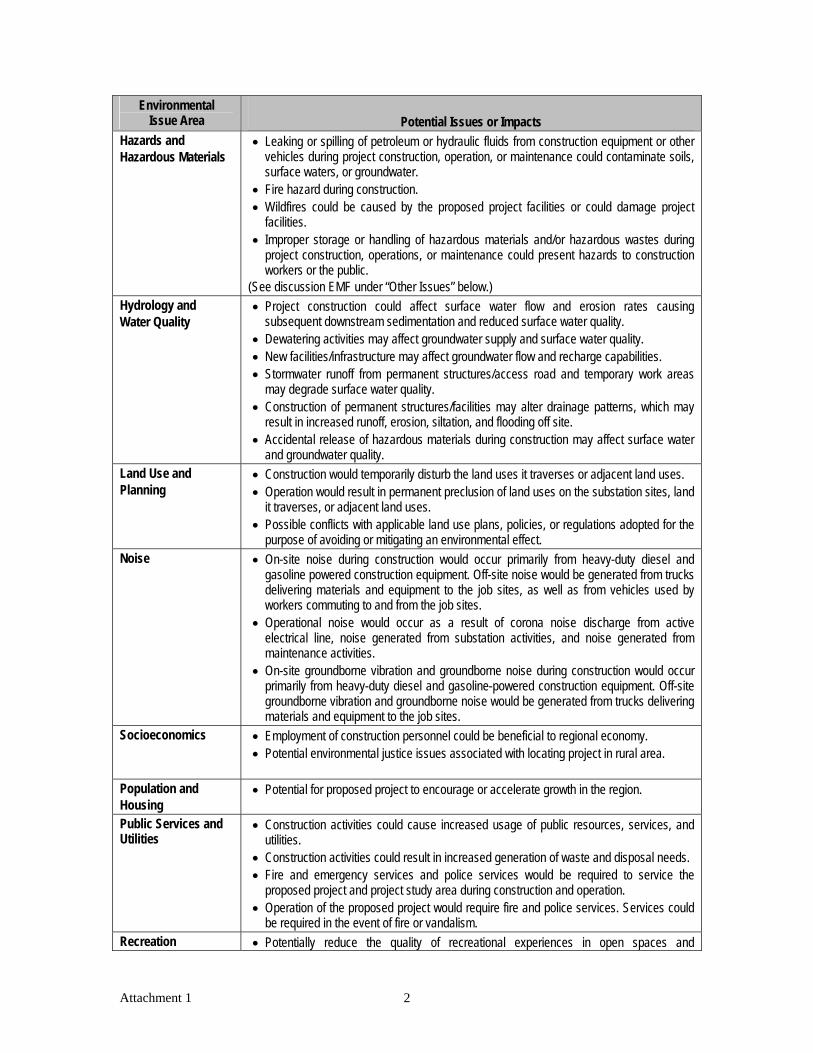
Environmental Issue Area Potential Issues or Impacts
Hazards and Hazardous Materials
• Leaking or spilling of petroleum or hydraulic fluids from construction equipment or other vehicles during project construction, operation, or maintenance could contaminate soils, surface waters, or groundwater.
• Fire hazard during construction. • Wildfires could be caused by the proposed project facilities or could damage project
facilities. • Improper storage or handling of hazardous materials and/or hazardous wastes during
project construction, operations, or maintenance could present hazards to construction workers or the public.
(See discussion EMF under “Other Issues” below.) Hydrology and Water Quality
• Project construction could affect surface water flow and erosion rates causing subsequent downstream sedimentation and reduced surface water quality.
• Dewatering activities may affect groundwater supply and surface water quality. • New facilities/infrastructure may affect groundwater flow and recharge capabilities. • Stormwater runoff from permanent structures/access road and temporary work areas
may degrade surface water quality. • Construction of permanent structures/facilities may alter drainage patterns, which may
result in increased runoff, erosion, siltation, and flooding off site. • Accidental release of hazardous materials during construction may affect surface water
and groundwater quality. Land Use and Planning
• Construction would temporarily disturb the land uses it traverses or adjacent land uses. • Operation would result in permanent preclusion of land uses on the substation sites, land
it traverses, or adjacent land uses. • Possible conflicts with applicable land use plans, policies, or regulations adopted for the
purpose of avoiding or mitigating an environmental effect. Noise • On-site noise during construction would occur primarily from heavy-duty diesel and
gasoline powered construction equipment. Off-site noise would be generated from trucks delivering materials and equipment to the job sites, as well as from vehicles used by workers commuting to and from the job sites.
• Operational noise would occur as a result of corona noise discharge from active electrical line, noise generated from substation activities, and noise generated from maintenance activities.
• On-site groundborne vibration and groundborne noise during construction would occur primarily from heavy-duty diesel and gasoline-powered construction equipment. Off-site groundborne vibration and groundborne noise would be generated from trucks delivering materials and equipment to the job sites.
Socioeconomics • Employment of construction personnel could be beneficial to regional economy. • Potential environmental justice issues associated with locating project in rural area.
Population and Housing
• Potential for proposed project to encourage or accelerate growth in the region.
Public Services and Utilities
• Construction activities could cause increased usage of public resources, services, and utilities.
• Construction activities could result in increased generation of waste and disposal needs. • Fire and emergency services and police services would be required to service the
proposed project and project study area during construction and operation. • Operation of the proposed project would require fire and police services. Services could
be required in the event of fire or vandalism. Recreation • Potentially reduce the quality of recreational experiences in open spaces and
Attachment 1 2

Attachment 1 3
Environmental Issue Area
Potential Issues or Impacts
recreational facilities. • Construction or operation could cause conflicts with established or pending resource
management or conservation plans. Transportation and Traffic
• Crossing of Old Highway 80 may require temporary disruption during construction. • Traffic would be generated by construction worker commute trips and equipment
deliveries. Hauling materials, such as poles, concrete, conductor, and excavation spoils, would temporarily increase existing traffic volumes in the project study area.
Other Issues • Cumulative effects of proposed wind energy and transmission projects in local area. • Electric and Magnetic Field (EMF) effects of project facilities.

Attachment 2 Environmental Checklist Following are the questions included in Appendix G of the California Environmental Quality Act (CEQA) Guidelines Environmental Checklist Form (California Public Resources Code, Section 21000 et seq.). These are issues that may be evaluated in an environmental impact report (EIR), if they are determined to be relevant to the project. This list is provided only to provide the reader with a general idea of the types of impacts that will be considered in the EIR/EIS. I. AESTHETICS. Would the project: • Have a substantial adverse effect on a scenic vista?
• Substantially damage scenic resources, including, but not limited to, trees, rock outcroppings, and historic buildings within a state scenic highway?
• Substantially degrade the existing visual character or quality of the site and its surroundings?
• Create a new source of substantial light or glare which would adversely affect day or nighttime views in the area?
II. AGRICULTURE RESOURCES. In determining whether impacts to agricultural resources are significant environmental effects, lead agencies may refer to the California Agricultural Land Evaluation and Site Assessment Model (1997) prepared by the California Department of Conservation as an optional model to use in assessing impacts on agriculture and farmland. Would the project: • Convert Prime Farmland, Unique Farmland, or Farmland of Statewide Importance
(Farmland), as shown on the maps prepared pursuant to the Farmland Mapping and Monitoring Program of the California Resources Agency, to non-agricultural use?
• Conflict with existing zoning for agricultural use, or a Williamson Act contract?
• Involve other changes in the existing environmental which, due to their location or nature, could result in conversion of Farmland, to non-agricultural use?
III. AIR QUALITY. Where available, the significance criteria established by the applicable air quality management or air pollution control district may be relied upon to make the following determinations. Would the project: • Conflict with or obstruct implementation of the applicable air quality plan?
• Violate any air quality standard or contribute substantially to an existing or projected air quality violation?
• Result in a cumulatively considerable net increase of any criteria pollutant for which the project region is non-attainment under an applicable federal or state ambient air quality standard (including releasing emissions which exceed quantitative thresholds for ozone precursors)?
Attachment 2 1

• Expose sensitive receptors to substantial pollutant concentrations?
• Create objectionable odors affecting a substantial number of people? IV. BIOLOGICAL RESOURCES. Would the project: • Have a substantial adverse effect, either directly or through habitat modifications, on any
species identified as a candidate, sensitive, or special status species in local or regional plans, policies, or regulations, or by the California Department of Fish and Game or U.S. Fish and Wildlife Service?
• Have a substantial adverse effect on any riparian habitat or other sensitive natural community identified in local or regional plans, policies, regulations, or by the California Department of Fish and Game or US Fish and Wildlife Service?
• Have a substantial adverse effect on federally protected wetlands as defined by Section 404 of the Clean Water Act (including, but not limited to, marsh, vernal pool, coastal, etc.) through direct removal, filling, hydrological interruption, or other means?
• Interfere substantially with the movement of any native resident or migratory fish or wildlife species or with established native resident or migratory wildlife corridors or impede the use of native wildlife nursery sites?
• Conflict with any local policies or ordinances protecting biological resources, such as a tree preservation policy or ordinance?
• Conflict with the provisions of an adopted Habitat Conservation Plan, Natural Community Conservation Plan, or other approved local, regional, or state habitat conservation plan?
V. CULTURAL RESOURCES. Would the project: • Cause a substantial adverse change in the significance of a historical resource as defined in
§15064.5?
• Cause a substantial adverse change in the significance of an archaeological resource pursuant to §15064.5?
• Directly or indirectly destroy a unique paleontological resource or site unique geologic feature?
• Disturb any human remains, including those interred outside of formal cemeteries? VI. GEOLOGY AND SOILS. Would the project: • Expose people or structures to potential substantial adverse effects, including the risk of loss,
injury, or death involving:
− Rupture of a known earthquake fault, as delineated on the most recent Alquist-Priolo Earthquake Fault Zoning Map issued by the State Geologist for the area or based on other substantial evidence of a known fault? (Refer to the California Division of Mines and Geology Spec. Pub. 42)
− Strong seismic groundshaking?
− Seismic-related ground failure, including liquefaction?
− Landslides?
Attachment 2 2

• Result in substantial soil erosion or the loss of topsoil?
• Be located on a geologic unit or soil that is unstable, or that would become unstable as a result of the project, and potentially result in on- or off-site landslide, lateral spreading, subsidence, liquefaction or collapse?
• Be located on expansive soil, as defined in Table 18-1-B of the Uniform Building Code (1994), creating substantial risks to life or property?
• Have soils incapable of adequately supporting the use of septic tanks or alternative waste water disposal systems where sewers are not available for the disposal of wastewater?
VII. HAZARDS AND HAZARDOUS MATERIALS. Would the project: • Create a significant hazard to the public or the environment through the routine transport, use,
or disposal of hazardous materials?
• Create a significant hazard to the public or the environment through reasonably foreseeable upset and accident conditions involving the release of hazardous materials into the environment?
• Emit hazardous emissions or handle hazardous or acutely hazardous material, substances, or waste within one-quarter mile of an existing or proposed school?
• Be located on a site which is included on a list of hazardous materials sites compiled pursuant to Government Code Section 65962.5 and, as a result, would it create a significant hazard to the public or the environment?
• For a project located within an airport land use plan or, where such a plan has not been adopted, within two miles of a public airport or public use airport, would the project result in a safety hazard for people residing or working in the project area?
• For a project within the vicinity of a private airstrip, would the project result in a safety hazard for people residing or working in the project area?
• Impair implementation of or physically interfere with an adopted emergency response plan or emergency evacuation plan?
• Expose people or structures to a significant risk of loss, injury, or death involving wildland fires, including where wildlands are adjacent to urbanized areas or where residences are intermixed with wildlands?
VIII. HYDROLOGY AND WATER QUALITY. Would the project: • Violate any water quality standards or waste discharge requirements?
• Substantially deplete groundwater supplies or interfere substantially with groundwater recharge such that there would be a net deficit in aquifer volume or a lowering of the local groundwater table level (e.g., the production rate of pre-existing nearby wells would drop to a level which would not support existing land uses or planned uses for which permits have been granted?
• Substantially alter the existing drainage pattern of the site or area, including through the alteration of the course of a stream or river, in a manner which would result in substantial erosion or siltation on- or off-site?
Attachment 2 3

• Substantially alter the existing drainage pattern of the site or area, including through the alteration of the course of a stream or river, or substantially increase the rate or amount or surface runoff in a manner which would result in flooding on- or off-site?
• Create or contribute runoff water which would exceed the capacity of existing or planned stormwater drainage systems or provide substantial additional sources of polluted runoff?
• Otherwise substantially degrade water quality?
• Place housing within a 100-year flood hazard area as mapped on a federal Flood Hazard Boundary or Flood Insurance Rate Map or other flood hazard delineation map?
• Place within a 100-year flood hazard area structures which would impede or redirect flood flows?
• Expose people or structures to a significant risk of loss, injury or death involving flooding, including flooding as a result of the failure of a levee or dam?
• Inundation by seiche, tsunami, or mudflow? IX. LAND USE AND PLANNING. Would the project: • Physically divide an established community?
• Conflict with any applicable land use plan, policy, or regulation of an agency with jurisdiction over the project (including, but not limited to the general plan, specific plan, local coastal program, or zoning ordinance) adopted for the purpose of avoiding or mitigating an environmental effect?
• Conflict with any applicable habitat conservation plan or natural community conservation plan?
• Result in the loss of availability of a known mineral resource that would be of value to the region and the residents of the state?
• Result in the loss of availability of a locally important mineral resource recovery site delineated on a local general plan, specific plan, or other land use plan?
X. NOISE. Would the project result in: • Exposure of persons to or generation of noise levels in excess of standards established in the
local general plan or noise ordinance, or applicable standards of other agencies?
• Exposure of persons to or generation of excessive groundborne vibration or groundborne noise levels?
• A substantial permanent increase in ambient noise levels in the project vicinity above levels existing without the project?
• A substantial temporary or periodic increase in ambient noise levels in the project vicinity above levels existing without the project?
• For a project located within an airport land use plan or, where such a plan has not been adopted, within two miles of a public airport or public use airport, would the project expose people residing or working in the project area to excessive noise levels?
Attachment 2 4

• For a project within the vicinity of a private airstrip, would the project expose people residing or working in the project area to excessive noise levels?
XI. POPULATION AND HOUSING. Would the project: • Induce substantial population growth in an area, either directly (e.g., by proposing new homes
and businesses) or indirectly (e.g., through extensions of roads or other infrastructure)?
• Displace substantial numbers of existing housing, necessitating the construction of replacement housing elsewhere?
• Displace substantial numbers of people, necessitating the construction of replacement housing elsewhere?
XII. PUBLIC SERVICES AND UTILITIES. • Would the project result in substantial adverse physical impacts associated with the provision
of new or physically altered governmental facilities, need for new or physically altered governmental facilities, the construction of which could cause significant environmental impacts, in order to maintain acceptable service ratios, response times or other performance objectives for any of the public services:
− Fire protection?
− Police Protection?
− Schools?
− Parks?
− Other public facilities?
• Exceed wastewater treatment requirements of the applicable Regional Water Quality Control Board?
• Require or result in the construction of new water or wastewater treatment facilities or expansion of existing facilities, the construction of which could cause significant environmental effects?
• Require or result in the construction of new storm water drainage facilities or expansion of existing facilities, the construction of which could cause significant environmental effects?
• Have sufficient water supplies available to serve the project from existing entitlements and resources, or are new or expanded entitlements needed?
• Result in a determination by the wastewater treatment provider which serves or may serve the project that it has adequate capacity to serve the project’s projected demand in addition to the provider’s existing commitments?
• Be served by a landfill with sufficient permitted capacity to accommodate the project’s solid waste disposal needs?
• Comply with federal, state, and local statutes and regulations related to solid waste?
Attachment 2 5

Attachment 2 6
XIII. RECREATION. Would the project: • Increase the use of existing neighborhood, and regional parks or other recreational facilities
such that substantial physical deterioration of the facility would occur or be accelerated?
• Include recreational facilities or require the construction or expansion of recreational facilities which might have an adverse physical effect on the environment?
XIV. TRANSPORTATION/TRAFFIC. Would the project: • Cause an increase in traffic which is substantial in relation to the existing traffic load and
capacity of the street system (i.e., result in a substantial increase in either the number of vehicle trips, the volume to capacity ratio on roads, or congestion at intersections?
• Exceed, either individually or cumulatively, a level of service standard established by the county congestion management agency for designated roads or highways?
• Result in a change in air traffic patterns, including either an increase in traffic levels or a change in location that results in substantial safety risks?
• Substantially increase hazards due to a design feature (e.g., sharp curves or dangerous intersections) or incompatible uses?
• Result in inadequate emergency access?
• Result in inadequate parking capacity?
• Conflict with adopted policies supporting alternative transportation (e.g., bus turnouts, bicycle racks)?
MANDATORY FINDINGS OF SIGNIFICANCE: • Does the project have the potential to degrade the quality of the environment, substantially
reduce the habitat of a fish or wildlife species, cause a fish or wildlife population to drop below self-sustaining levels, threaten to eliminate a plant or animal community, reduce the number or restrict the range of a rare or endangered plant or animal or eliminate important examples of the major periods of California history or prehistory?
• Does the project have impacts that are individually limited, but cumulatively considerable?
• (“Cumulatively considerable” means that the incremental effects of a project are considerable when viewed in connection with the effects of past projects, the effects of other current projects, and the effects of probable future projects.)
• Does the project have environmental effects which will cause substantial adverse effects on human beings, either directly or indirectly?

ImperialBeach
ChulaVista
NationalCity
Bonita
Coronado
LemonGrove
LaMesa
Poway
Encinitas
San Diego
Carlsbad
SanMarcos Escondido
VistaValleyCenter
Camp PendletonSouth Hidden
MeadowsOceanside
Bonsall
CampPendleton
North
Fallbrook
Rainbow
Jamul
Rancho SanDiegoSpring
Valley
Casa deOro-Mount Helix
AlpineHarbisonCanyon
Lakeside PineValley
El Cajon
Santee
Ramona San DiegoCountryEstates
Julian
BorregoSprings
SanClemente
DanaPoint
San JuanCapistrano
Highlands
Temecula
Imperial County
Orange
County
San Diego
CountySan Diego County
San Diego County
Riverside County S a l t o nS e a
P a c i f i c
O c e a n
M e x i c oM e x i c o
78
209
52163
56
75
1
98
111371
67
86
76
79
94
905
195
8
15
8
805
5
5
15
FIGURE 1
Regional MapEast County Substation Project - NOP
6168-01DECEMBER 2009
Z:\P
rojec
ts\j61
6801
\MAP
DOC\
MAP
S\NO
P Fi
gs\F
igure
1 R
egio
nal.m
xd
0 155 10Miles
ESJ Gen-TieProject Site
Tule WindProject Site
ECO SubstationProject Site

White Star
East County Substation and Connected Projects6168-01
DECEMBER 2009
0 21Miles
California
Mexico
San
Die
go C
ount
y
Impe
rial
Cou
nty
Anza-Borrego DesertState Park
Southwest Powerlink (SWPL)
Existing 69kV Line
ECO Substation Project ComponentsProposed SWPL Loop-In
Proposed 138 kV Line
Proposed 12 kV Temporary Distribution Tap
445 Circuit Collocated with 138 kV Line
Existing Transmission Line
Existing Boulevard Substation
Proposed 138 kV Line Milepost
Communication Facility
Proposed ECO Substation
Boulevard Substation Rebuild
Tule Wind Project Site Boundary
ESJ 500kV Alternative
ESJ 230kV Alternative
Bureau of Land Management
California State Parks
California State Lands Comission
Ewiiaapaayp Reservation
Interstate
Highway
Railroad
012345
67
89
10
11
12
13
ESJ Gen-TieProject Site
Tule WindProject Site
FIGURE 2
ECO SubstationProject Site