seagull environmental technologies, inc. · seagull environmental technologies, inc. (seagull) is...
TRANSCRIPT
EP-DT05-00005
Seagull Environmental Technologies, Inc. 121 NE 72nd Street Gladstone, Missouri 64118 Tel: (913) 851-3919, Fax: (913) 851-3889 www.seagullenvirotech.com
August 4, 2011 Mr. Howard Pham STAT Project Officer U.S. Environmental Protection Agency, Region 5 77 W. Jackson Boulevard Chicago, Illinois 60604 Subject: Sampling Activities for the Allied Paper/Portage Creek/Kalamazoo River Superfund
Site, Operable Unit (OU1): Allied Landfill Kalamazoo, Michigan CERCLIS ID: MID006007306 EPA Region 5, STAT Contract No. EP-S5-10-01, Task Order No. EP-DT05-00005 Task Monitor: Michael Berkoff, EPA Region 5 Remedial Project Manager Dear Mr. Pham: Seagull Environmental Technologies, Inc. (Seagull) is submitting the attached field sampling activities for the Allied Paper/Portage Creek/Kalamazoo River Superfund Site, Operable Unit (OU1): Allied Landfill in Kalamazoo, MI. If you have any questions or comments, please contact the STAT Program Manager at (913) 908-4697. Sincerely,
Hieu Q. Vu, PE STAT Program Manager Enclosure

EP-DT05-00005 1
SAMPLING ACTIVITY FOR THE ALLIED PAPER/PORTAGE CREEK/KALAMAZOO RIVER SUPERFUND SITE, OPERABLE
UNIT (OU1): ALLIED LANDFILL KALAMAZOO, MICHIGAN
Task Order No. EP-DT05-00005
Subsurface Soil Sampling
Under the U.S. Environmental Protection Agency (EPA) Region 5 Superfund Technical Assistance Team
(STAT) contract (No. EP-S5-10-01), Task Order No. EP-DT05-00005, Seagull Environmental
Technologies, Inc. (Seagull) was tasked to conduct subsurface soil sampling at the Allied Paper/Portage
Creek/Kalamazoo River Superfund Site, Operable Unit (OU1): Allied Landfill in Kalamazoo, MI. On
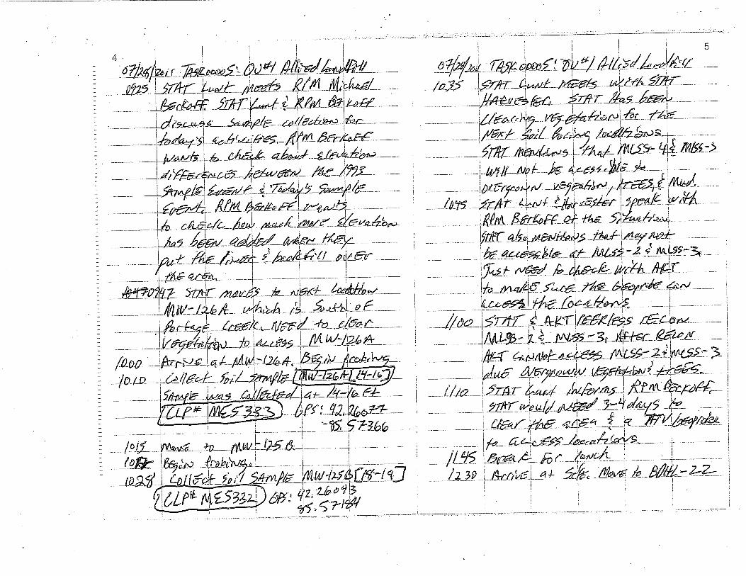
July 28, 2011, STAT Team Members Ryan Lunt and Joel Harvestor collected subsurface soil samples
from Operable Unit 1: Allied Landfill. Twelve subsurface soil samples were collect, plus a field duplicate
(see Table 1). On July 29, 2011, STAT shipped the samples to the designated Contract Laboratory
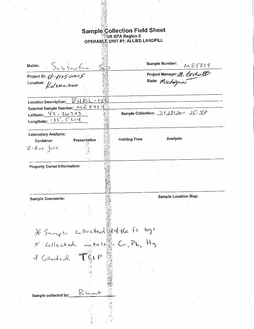
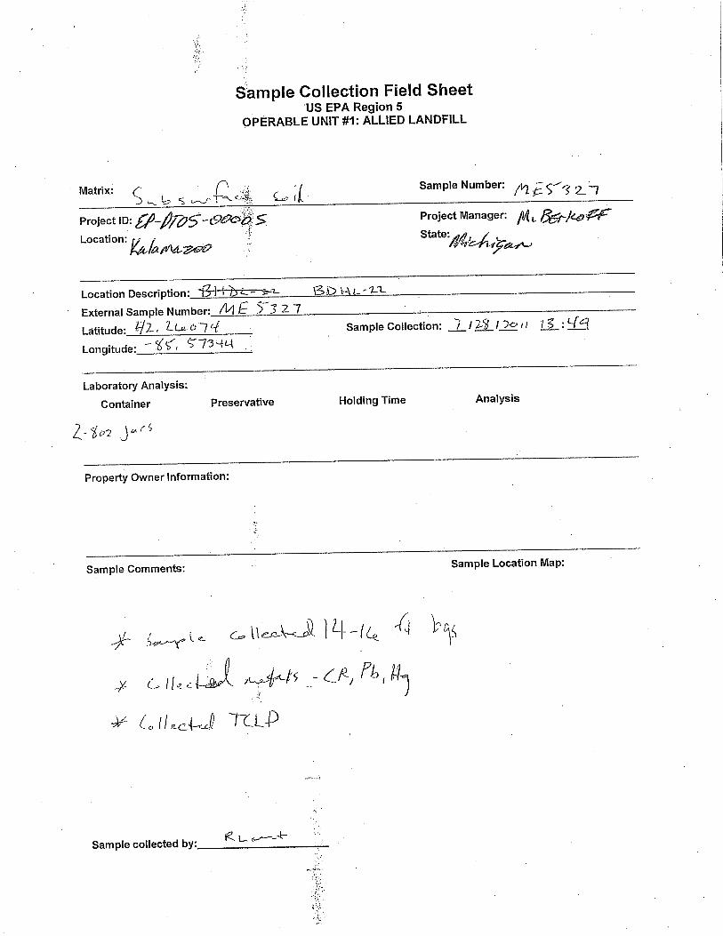
Program (CLP) laboratory for analysis of metals: lead, total chromium, and mercury. In addition, an extra
volume of soil was collected at each sampling locations. At the request of EPA Region 5 RPM, the extra
volume was submitted for analysis of TCLP.
TABLE 1
SUBSURFACE SOIL SAMPLES
ALLIED PAPER/PORTAGE CREEK/KALAMAZOO RIVER SUPERFUND SITE, OPERABLE UNIT (OU1): ALLIED LANDFILL
KALAMAZOO, MICHIGAN
Sample Location Latitude Longitude Sample Time Sample Depth Interval
(ft bgs)
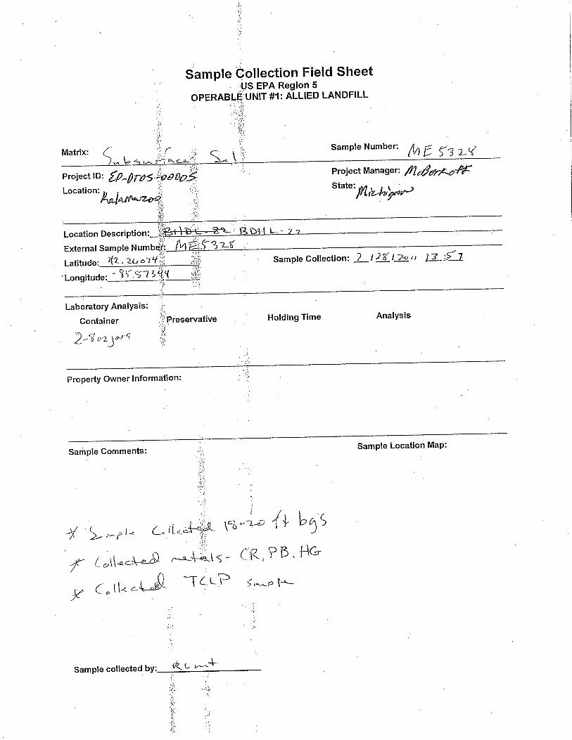
W-6 42.26086 -85.57689 09:18 12-13
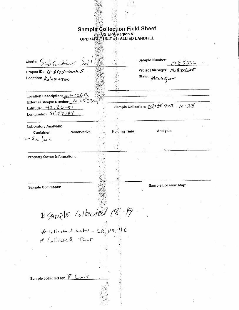
MW-126A 42.26077 -85.57366 10:10 14-16 MW-125B 42.26093 -85.57184 10:28 18-19
BDHL-22 42.26074 -85.57344 13:11 10-12
BDHL-22 42.26074 -85.57344 13:41 12-14
BDHL-22 42.26074 -85.57344 13:49 14-16
BDHL-22 42.26074 -85.57344 13:57 18-20
MW-121B 42.26128 -85.57350 14:45 16-17.5
FLF-1 42.26359 -85.57314 15:06 6-6.5
BHDL-123 42.26202 -85.57214 15:31 8-9.5 *BHDL-123 42.26202 -85.57214 15:31 8-9.5
BHDL-123 42.26202 -85.57214 15:40 14-16
BHDL-123 42.26202 -85.57214 15:57 17-19 Notes:
*Duplicate sample of BHDL-123 at 8-9.5 ft.
Ft bgs Feet below ground surface

EP-DT05-00005 2
APPENDICES Appendix A FIELD LOGBOOK
B FIELD SHEETS
C PHOTOLOG
D CLP LABORATORY’S COPY OF INORGANIC TRAFFIC REPORTS AND CHAIN-OF-CUSTODY RECORDS

APPENDIX A
FIELD LOGBOOK


APPENDIX B
FIELD SHEETS


APPENDIX C
PHOTOLOG
Client: Description: Photograph Number:
Direction: Photographer: Date:
Client: Description: Photograph Number:
Direction: Photographer: Date:
Environmental Protection Agency Region 5
Environmental Protection Agency Region 5
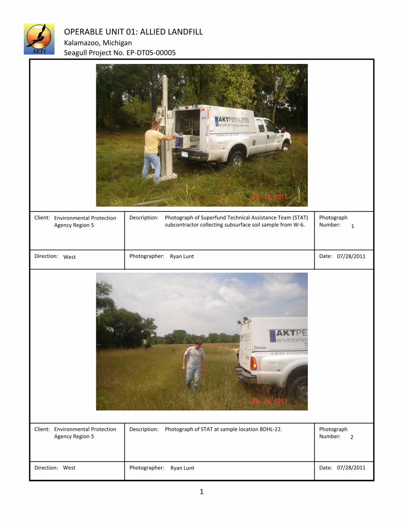
1
Ryan Lunt
Photograph of Superfund Technical Assistance Team (STAT) subcontractor collecting subsurface soil sample from W‐6.
West 07/28/2011
1
Ryan Lunt
Photograph of STAT at sample location BDHL‐22.
West 07/28/2011
2
OPERABLE UNIT 01: ALLIED LANDFILLKalamazoo, MichiganSeagull Project No. EP‐DT05‐00005

Client: Description: Photograph Number:
Direction: Photographer: Date:
Client: Description: Photograph Number:
Direction: Photographer: Date:
Environmental Protection Agency Region 5
Environmental Protection Agency Region 5
2
Ryan Lunt
Photograph of STAT personnel collecting a soil sample from BDHL‐22. The soil sample was collected from 12‐14 feet below ground surface (ft bgs).
South 07/28/2011
3
Ryan Lunt
Photograph of STAT subcontractor collecting a soil sample from sample location MW‐121B. The soil sample was collected from 16‐17.5 feet.
North 07/28/2011
4
OPERABLE UNIT 01: ALLIED LANDFILLKalamazoo, MichiganSeagull Project No. EP‐DT05‐00005

Client: Description: Photograph Number:
Direction: Photographer: Date:
Client: Description: Photograph Number:
Direction: Photographer: Date:
Environmental Protection Agency Region 5
Environmental Protection Agency Region 5
3
Joel Harvester
Photograph of STAT personnel digging a hole at MW‐121B to patch the landfill liner.
East 07/29/2011
5
Ryan Lunt
Photograph shows the 30 mil PVC liner that was used to patch the Allied Landfill liner .
N/A 07/29/2011
6
OPERABLE UNIT 01: ALLIED LANDFILLKalamazoo, MichiganSeagull Project No. EP‐DT05‐00005

APPENDIX D
CLP LABORATORY’S COPY OF INORGANIC TRAFFIC REPORTS AND CHAIN-OF-
CUSTODY RECORDS

