seaport redevelopment program - belmar, new jersey · seaport redevelopment program redevelopment...
TRANSCRIPT
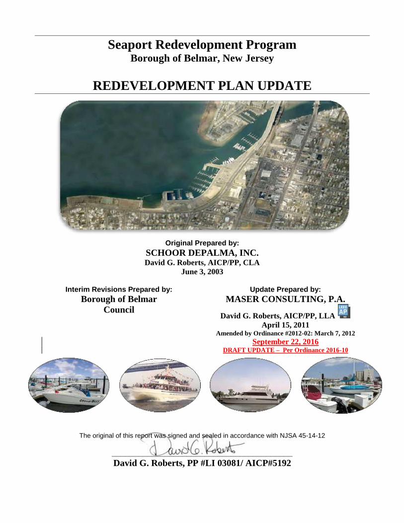
Seaport Redevelopment Program Borough of Belmar, New Jersey
REDEVELOPMENT PLAN UPDATE
Original Prepared by:
SCHOOR DEPALMA, INC. David G. Roberts, AICP/PP, CLA
June 3, 2003
Interim Revisions Prepared by:
Borough of Belmar
Council
Update Prepared by:
MASER CONSULTING, P.A.
David G. Roberts, AICP/PP, LLA
April 15, 2011 Amended by Ordinance #2012-02: March 7, 2012
September 22, 2016 DRAFT UPDATE – Per Ordinance 2016-10
The original of this report was signed and sealed in accordance with NJSA 45-14-12
_________________________________________
David G. Roberts, PP #LI 03081/ AICP#5192
BOROUGH OF BELMAR SEAPORT REDEVELOPMENT PROGRAM
REDEVELOPMENT PLAN UPDATE
1
TABLE OF CONTENTS Preface .........................................................................................................................................................2
1.0 Introduction / Statement of Purpose & Policies ..........................................................................3
1.1 Review of Applications for Redevelopment ........................................................................................... 3
1.2 Historical Background of Study Area ..................................................................................................... 4
1.3 Goals & Objectives of Seaport Redevelopment Plan ............................................................................. 5
2.0 Description of Project ....................................................................................................................6
2.1 Belmar Seaport Village Redevelopment Area ........................................................................................ 6 Seaport Plaza .......................................................................................................................................................... 8 Seaport Plaza Parking Deck ................................................................................................................................... 9
2.2 Belmar Marina-Maclearie Park Rehabilitation Area ............................................................................ 11
3.0 Relationship to Local Objectives and Municipal Development Regulations .........................12
4.0 Overview of Proposed Land Uses and Building Requirements ...............................................13
4.1 Seaport Village Redevelopment Area ................................................................................................... 13
4.2 Belmar Marina-Maclearie Park Rehabilitation Area ............................................................................ 19
5.0 Identification of Property for Acquisition & Redevelopment .................................................20
5.1 Identification of Redevelopment Parcels .............................................................................................. 20
6.0 Relocation Plan for Residents and Businesses...........................................................................26
7.0 Relationship of Redevelopment Plan to Master Plans of Contiguous Municipalities, County
Master Plan and State Development and Redevelopment Plan ..............................................28
Avon Borough ...................................................................................................................................................... 28 Neptune City ........................................................................................................................................................ 29 Neptune Township ............................................................................................................................................... 29 Monmouth County Growth Management Plan .................................................................................................... 29 State Development and Redevelopment Plan ....................................................................................................... 30
8.0 Design Criteria & Required Improvements to the Public Environment ................................31
8.1 Streetscape ............................................................................................................................................ 31
8.2 Riverfront .............................................................................................................................................. 35
8.3 Architectural ......................................................................................................................................... 35
9.0 Implementation Tools ..................................................................................................................36
9.1 Financial Incentives .............................................................................................................................. 36
9.2 ECONOMIC REDEVELOPMENT & GROWTH GRANTS (ERG) .................................................. 36
9.3 Redevelopment Powers ......................................................................................................................... 36
10.0 Selection of Redevelopers & Certification of Project Completion ..........................................37
APPENDICES
MAP OF SEAPORT REDEVELOPMENT AREA & BELMAR MARINA MACLEARIE PARK REHABILITATION AREA ...39
RESOLUTION DESIGNATING EXPANDED SEAPORT VILLAGE REDEVELOPMENT AREA ………………………………41
MAP OF REDEVELOPMENT AREA EXPANSION STUDY AREA………………………………………………………………….42
FUTURE LAND USE MAP WITH PROPOSED ZONING……………………………………………………………………………..43
BOROUGH OF BELMAR SEAPORT REDEVELOPMENT PROGRAM
REDEVELOPMENT PLAN UPDATE
2
PREFACE
The north end of Belmar’s downtown is located in a commercial area east of the Belmar Marina along
an underutilized riverfront with minimal public access opportunities. Realizing that reclaiming the
river’s edge as a public amenity could stimulate private investment and rejuvenate the north end of the
downtown, the Borough determined that it was necessary to prepare a redevelopment plan within the
same time frame as the planning and development of the new high span Route 35 Bridge so as to
coordinate the two projects and maximize the benefit to the Borough. Under the direction of Mayor
Kenneth E. Pringle, working in cooperation with the Borough Council, the Planning Board and local
property and business owners, a redevelopment investigation was undertaken in 1997 leading to the
designation of the Belmar Seaport Village Redevelopment Area in late Fall of that year.
The Seaport theme for the Redevelopment Area is grounded in the unification of the Marina and
adjacent public amenities with the traditional downtown through new vehicular and pedestrian linkages
under the reconstructed Route 35 bridge. The Plan is intended to create opportunities for public-private
partnerships to redevelop new, reconfigured parcels and to build upon the recent investment in two
seafood eateries within the Redevelopment Area, as well as the Borough’s ongoing improvements to the
Belmar Marina. The Borough has added a total of 73 transient boater slips in the Marina using a Federal
Boating Infrastructure Grant. The Plan envisions a mixed-use district with restaurant and specialty
shops at the street level below residential units and office space along a re-landscaped riverfront. This
concept is specifically intended to complement and support, rather than to compete with, the
neighborhood commercial uses in the center of the downtown. The Seaport is viewed as a mechanism to
enhance Belmar’s image as a family destination and to extend the tourism season into the Spring and
Fall months. It is also envisioned to be a highly desirable “downtown” waterfront neighborhood within
easy walking distance of commuter rail service and a wide range of goods and services offered in
Belmar’s business district along Main/F Street.
This Redevelopment Plan was developed by the consultant under the direction of Mayor Kenneth E.
Pringle and Borough administrative staff. It was revised several times by Belmar Borough Council
under the administrations of Mayor Pringle and current Mayor Mathew Doherty.
BOROUGH OF BELMAR SEAPORT REDEVELOPMENT PROGRAM
REDEVELOPMENT PLAN UPDATE
3
1.0 INTRODUCTION / STATEMENT OF PURPOSE & POLICIES
This Redevelopment Plan has been prepared by authorization of the Belmar Borough Council pursuant
to the Redevelopment and Housing Law (Chapter 79, P.L. 1992).
A redevelopment plan provides a framework for land use and land development within a redevelopment
area, as well as an opportunity to apply financial incentives and other implementation tools to enable the
Borough Council, acting as the redevelopment entity, to actively pursue the redevelopment of identified
redevelopment parcels through public-private partnership agreements with private sector redevelopers,
current property owners and other stakeholders.
The purpose of the Redevelopment Plan is to serve as the principal tool to guide the revitalization of the
Belmar Seaport Village Redevelopment Area. Successful implementation will require outreach to
commercial property owners, with the sensitive use of redevelopment powers and financial incentives by
the Borough to facilitate site-specific redevelopment projects.
The redevelopment policy of the Borough is to balance efforts to attract new mixed-use residential and
commercial development to the Redevelopment Area with the need to encourage the rehabilitation of
existing properties and reassure the owners of properties and businesses that the Borough will not
exercise its powers arbitrarily or capriciously.
It is also the redevelopment policy of the Borough that the present owners of property in designated
redevelopment parcels be given every opportunity to participate in the redevelopment program through
the reinvestment and redevelopment of their properties in accordance with the land uses, building and
design requirements of this Plan.
1.1 REVIEW OF APPLICATIONS FOR REDEVELOPMENT
Applications for redevelopment whether by a Redeveloper selected pursuant to Section 10, or by the
present property owner shall be reviewed as set forth in this section. The Application shall be submitted
on the standard Borough forms for a Site Plan and/or Subdivision with the usual fees and escrows which
shall be charged for the review reports and related work of the Borough professionals.
The Application for redevelopment shall first be reviewed by Borough staff and professionals for a
consistency determination which shall include, but not be limited to, a review of the project to determine
general compliance with the proposed development and uses of the parcel and related standards in this
Plan, the aesthetics of the project and the projects coordination with other existing projects and with the
proposed development and uses in this Plan for neighboring parcels and neighboring properties whether
or not they are addressed in this Plan.
After a favorable review of the Application, negotiation of a draft Redevelopment Agreement with a
prospective redeveloper and adoption of a resolution by the Mayor and Council designating the
prospective redeveloper as a redeveloper for a designated Parcel (or portion thereof) and authorizing the
execution of the redevelopment agreement negotiated, aa preliminary and/or final site application will be
prepared and submitted to the Technical and Design Review Committee and its Subcommittees as
provided for in Belmar Code Section 40-3.15.1 et seq. After the review by the Technical and Design
BOROUGH OF BELMAR SEAPORT REDEVELOPMENT PROGRAM
REDEVELOPMENT PLAN UPDATE
4
Review Committee and its Subcommittees, the preliminary and/or final site application shall then be
submitted to the Planning Board for its review as provided by law and in this Plan. Thereafter, the
Borough Council shall have the authority under this Plan to modify or overrule any bulk variance
granted by the Planning Board within 30 days of receipt of the memorializing resolution from the Board
as further provided for in Section 4.0 of this Plan.
1.2 HISTORICAL BACKGROUND OF STUDY AREA
The study area identified by the Borough for the Belmar Seaport is located on the northwestern end of
the municipality (see Location Map). It is the northerly end of the Borough’s main shopping street and
includes the area between the Belmar Marina and the properties along the east side of Main/F Street.
Main/F Street has historically served as the Borough’s downtown shopping district, giving the Borough
a commerce center and providing goods and services to residents and summer visitors. This commercial
spine contains a variety of retail, restaurant, service and office uses common to a downtown
neighborhood shopping center, as well as a number of auto-related uses that depend more on through-
traffic rather than support from residents and visitors. These new and used car dealerships have
traditionally started out in downtown areas and gradually moved to highway locations with larger land
areas for vehicle display and storage. In Belmar, the one new car dealership on Main Street is being
redeveloped into a mixed use building. One used car lot remains on Main Street in the Seaport Village
Redevelopment Area.
The Seaport Village Redevelopment Area has been influenced historically by both the railroad and the
Shark River Inlet. The rail line is currently called the New Jersey Coast Line and functions primarily as
a commuter line operated by New Jersey Transit. The line was originally constructed in the late 1800s,
however, as the principal means of carrying those urban dwellers from the north who could afford to
travel to the entertainment center in Long Branch, the Methodist camp meeting in Ocean Grove and the
developing resort community conceived by James Bradley for rest and rejuvenation in Asbury Park.
The line also served as the principal means of conveyance for raw materials and products manufactured
by industrial uses that sprung up along its length to service the burgeoning year-round and summer
populations through the early decades of the 20th Century. The evidence of this industrial activity
remains to this day, although many of the old multi-story industrial buildings along spurs from the main
line have long since been converted to truck transport or have fallen into disuse.
The Shark River Inlet has afforded safe haven for small ocean-going fishing vessels for over a hundred
years. Currently the river is crossed in three places: Ocean Avenue, Route 71 (Main/F Street) and Route
35. Two of these crossings (Ocean Avenue and Main Street) have drawbridges to enable the
recreational fishing fleet and larger pleasure craft to move up and down the river from the boat basin to
the ocean. The drawbridge at Route 35 was replaced by a high span bridge by 2005, which enabled the
Belmar Marina to be connected to the rest of the Seaport Redevelopment Area via an extension of
Seventh Avenue. As a result of the marine activity traditionally associated with the Shark River Inlet,
several water-related commercial uses are located along the river from the east side of Main/F Street to
the railroad bridge. These uses include a commercial boat storage facility (Ap’s Marina) and two
seafood restaurants: Havens and Hamptons (now closed) and Ollie Klein’s Fish Market and Restaurant.
Other uses that have river frontage but which are not water related include the vacant Pied Piper Ice
Cream warehouse building located next to the railroad bed.
BOROUGH OF BELMAR SEAPORT REDEVELOPMENT PROGRAM
REDEVELOPMENT PLAN UPDATE
5
The impetus for the Belmar Seaport concept is provided by the construction of a new Route 35 high
span bridge over the Shark River, which has re-connected Belmar’s Marina with its downtown area via
an extension of Seventh Avenue and provides an opportunity for a continuous one and one half (1½)
mile-long pedestrian walkway along the river from the marina to Main Street. The State Department of
Transportation completed the Bridge by the Spring of 2005. This date coincided with the Borough’s
completion of the transient boat area constructed with grant funds awarded to the Borough pursuant the
Federal Boating Infrastructure Grant program.
Over the past twenty years Belmar’s downtown has struggled with the fluctuating seasonal market for
goods and services that is typical of a resort community. To some extent, downtown merchants compete
with beachfront merchants for their share of the tourist dollar, while also trying to meet the needs of the
residents. The center of the downtown commercial corridor, at its intersection with 10th Avenue, has
made impressive strides in upgrading its image, and the improved visual quality and new commercial
investment is very apparent. Some redevelopment has occurred with construction of mixed-use projects
on Main Street and 7th
Street and Main Street and 8th
Avenue.
1.3 GOALS & OBJECTIVES OF SEAPORT REDEVELOPMENT PLAN
In order to address the conditions identified in the Redevelopment Area Investigation Summary Report,
the Belmar Seaport Redevelopment Plan seeks to realize the following Goals:
1. Revitalize the north end of the downtown through redevelopment of identified
redevelopment parcels using public-private partnership agreements with private sector
redevelopers and other stakeholders.
2. Create a mixed-use residential, restaurant, entertainment and specialty shop district along a
re-landscaped riverfront.
3. Make the Belmar downtown a family destination and extend the tourism season into the
Spring and Fall months (shoulder seasons).
4. Balance efforts to attract new residential and commercial development to the Redevelopment
Area with the need to encourage the rehabilitation of existing properties.
5. Unify the downtown with the Marina and adjacent park and adaptively re-use the existing
roadway of Route 35 replaced by the high span bridge.
6. Build a new village-like image for the north end of the downtown around the harbor-like
elements of the Shark River Inlet and Belmar Boat Basin/Marina.
7. Provide additional over-flow parking for the customers of the party and charter boats in the
Marina.
BOROUGH OF BELMAR SEAPORT REDEVELOPMENT PROGRAM
REDEVELOPMENT PLAN UPDATE
6
2.0 DESCRIPTION OF PROJECT
2.1 BELMAR SEAPORT VILLAGE REDEVELOPMENT AREA
The original Seaport Village Redevelopment Area in the Borough encompasseds approximately seven
(7) blocks in the northwestern end of the Borough. The area extendeds from the centerline of Eighth
Avenue north to the Shark River, including the main commercial corridor along Route No. 71. The
Area further extends extended to the west out to Railroad Avenue across Route No. 35 to the Shark
River, including all of the property north of Eighth Avenue, which is currently host to the Belmar
Marina.
After the portion of the Belmar Marina not included in the original Seaport Village Redevelopment
Area, as well as Maclearie Park, were designated as an Area In Need of Rehabilitation, the Borough
Council adopted the “Redevelopment Plan Update” prepared by Maser Consulting, P.A. dated April 15,
2011 as the amended redevelopment plan and on March 7, 2012 the Borough Council adopted ordinance
#2012-02 which approved and adopted further amendments to the Original Redevelopment Plan
(collectively, the “Amended Redevelopment Plan”) to include requirements for the Belmar Marina and
Maclearie Park Rehabilitation Area.
After the entire Borough was designated as an Area In Need of Rehabilitation as part of its recovery
efforts after Superstorm Sandy, the Belmar Council adopted Resolution 2014-65, “Creating a new
advisory committee for the purpose of discussing the redevelopment of Belmar”. The Advisory
Committee made a recommendation that the Seaport Village Redevelopment Area be expanded to
include most of the downtown core. The Committee felt that the Borough was no longer interested in
acquisition or condemnation of properties, as it was felt that large-scale redevelopers were no longer
necessary and the reorganization of public parking and transition to properties operated by public-
private partnerships was a new priority.
As part of the implementation of the Advisory Committee’s report of January of 2015, an Area In Need
of Redevelopment (AINR) Preliminary Investigation and Report (entitled, “Redevelopment Area
Preliminary Investigation Report, Seaport Redevelopment Area Expansion”, dated June 28, 2016) was
performed by Maser Consulting, PA during the months of April through July of 2016 and a public
hearing was held by the Belmar Planning Board on July 18, 2016. The Planning Board made a
recommendation to the Borough Council to expand the Seaport Village Redevelopment Area to include
Block 106, Lots 1-3, 5-6, 10.01, 10.02 and 11; Block 116, Lots 1-2; Block 117, Lots 1-4, 6-9, and 12-15;
Block 67, Lot 4.01; Block 86, Lots 1-7; Block 86.01, Lot 1; Block 87, Lots 1-3; and Block 96, Lots 1
and 3-9 on the tax maps of the Borough of Belmar without the power of condemnation (see map of
expanded Redevelopment Area in Appendix). On July 20, 2016, the Borough Council adopted a
resolution (see Appendix) designating the property recommended by the Planning Board as part of the
Seaport Village Redevelopment Area (the “Expanded Seaport Redevelopment Area”).
The Seaport theme envisioned in this Plan follows the examples of the traditional New England fishing
villages that feature human scale (one to three and a half story) buildings with pedestrian pathways and
public spaces. The partial reliance on public parking, combined with the natural attraction of a
waterfront location requires restaurants and shops to be within a comfortable walking distance,
preferably along the walking route between the parking and the waterfront to encourage impulse
BOROUGH OF BELMAR SEAPORT REDEVELOPMENT PROGRAM
REDEVELOPMENT PLAN UPDATE
7
spending along the way. The strategy of controlling the movement of people into the area by car, boat
and transit, and their transition to movement through the area on foot to encourage window-shopping
and impulse buying, is used in the planning of enclosed shopping malls and theme parks.
The emphasis of the Seaport district is to use the latent asset of the river’s edge to build on the gradually
growing reputation of Belmar’s downtown as a year-round destination for dining and entertainment, to
attract visitors and new residents to the downtown that will provide the economic impetus for new
investment in rehabilitation and expansion of new and existing businesses. These retail uses are intended
to support and not to compete with existing merchants and businesses in Belmar’s downtown business
district.
This Plan employs five basic components to the Seaport land use framework, which are equally
important to successful implementation:
1) Public Parking (approximately 773 spaces total)
a. Seaport Plaza (270 spaces)
b. Phase II Seaport Parking Deck (238 spaces, 188 spaces net)
c. Side Street Parking (179 spaces total)
a. Seventh Avenue (West): 37 +/- spaces
b. Seventh Avenue (East): +/- 29 spaces
c. Eighth Avenue (West): +/- 42 spaces
d. Eighth Avenue (East): +/- 18 spaces
e. Sixth Avenue: +/- 22 spaces
f. Fifth Avenue: +/- 20 spaces
d. New Municipal Surface Lots (136 spaces total)
a. Eighth Avenue (Parcel 14): 46 spaces
b. Eighth Avenue (Parcel 16): 15 spaces
c. Fifth/Sixth Avenue (Parcel 10): 75 spaces
2) Waterfront Attractions
a. Restaurants
b. Open Air Farmers/Fish Market
c. Riverfront Walkway
d. Marina (Commercial & Sport Fishing Fleet and Transient Slips)
e. Boat & Watercraft Rentals & Excursions
f. Water Transportation Services (water taxis, ferries)
g. Seaport Plaza
h. Waterfront Park and Recreation Uses
3) Support Retail, Inclusive of:
a. Art Studios, Galleries & Craft Shops
b. Performing Arts Theater
c. Antique Shops
d. Bookstores
e. Gift, Novelty & Souvenir Shops
f. Cafes & Ice Cream Shops
BOROUGH OF BELMAR SEAPORT REDEVELOPMENT PROGRAM
REDEVELOPMENT PLAN UPDATE
8
g. Bicycle Rental
h. Photography Stores
i. Vendor carts (Purchased by Borough and leased to licensed vendors at designated
locations approved by the Borough)
4) Offices
a. Professional & General Offices except on the ground floor or street level in buildings
fronting Main/F Street or along Shark River Inlet.
b. Real Estate Offices and Travel Agencies except on ground floor or street level in
buildings fronting the Shark River Inlet.
c. Governmental Offices
5) Residential Dwelling Units (second level or above)
2.1.1 Public Parking
Public parking, supplemented by on-site or off-site private parking, is intended to satisfy the overall
parking requirements for the land uses within the Seaport Village Redevelopment Area and to reduce the
need for on-site parking on smaller lots that contributes to disorganized traffic patterns. Residual land
area on the redevelopment parcels and existing properties to be rehabilitated can then be devoted to
landscaping, outdoor dining and seating areas, and to accommodate walkways to rehabilitated accessory
buildings to the rear of principal buildings. This intentional reliance on public parking requires that such
parking be available and conveniently located to businesses within the Seaport area.
Based on the Seaport Phase 1 Conceptual Plan, public parking is proposed in Seaport Plaza during the
initial phase of redevelopment, and in a Seaport Plaza Parking Deck, if necessary, to facilitate the
buildout of the Plan, or as part of the structured parking provided for a private, mixed-use
redevelopment project. It is anticipated that the Seaport Plaza parking, conceived as a reconfiguration of
the Borough Hall parking lot, Fifth and Railroad Avenues into a “car park” that doubles as an open air
public gathering space, would also serve as satellite parking for beach and Belmar Marina visitors on
weekend days during the Summer. Existing street parking will continue to be provided along Fifth,
Sixth, Seventh and Eighth Avenues. Factoring in a conservative 25% allowance for shared parking as
a result of the pedestrianization of the Seaport and availability of transit and transient boater access
should offset the demand for parking in the Seaport Village Redevelopment Area. It is estimated that
the combination of public parking within the Seaport Plaza and other additional municipal parking lots,
as well as some private off-street parking, should be sufficient to meet the parking demand created by
the buildout of the Plan No parking structures are proposed in this Plan east of Main/F Street due to the
close proximity of low-density residential neighborhoods.
Seaport Plaza
Seaport Plaza will be created through the consolidation of properties between Fifth and Seventh
Avenues west of F Street, including the right-of-way of the three streets. The initial phase of the Plaza
would exclude the acquisition of the Elks Club property and the adjacent residence. If the members of
the Elks Club find a suitable relocation site, this Plan would call for the future acquisition of the existing
BOROUGH OF BELMAR SEAPORT REDEVELOPMENT PROGRAM
REDEVELOPMENT PLAN UPDATE
9
Lodge and residence and expansion of the Seaport Plaza parking layout to include those properties.
Such future expansion would increase the estimated Plaza parking inventory from about 270 spaces to
about 314 spaces.
The Seaport Plaza is intended to serve as a multipurpose open space, as well as meeting the parking
needs of much of the daily and part of the hourly visitors to the Seaport area. The concept design for the
Plaza is to use brick pavers edged with granite cobbles to mark the parking stalls, pedestrian crosswalks,
sidewalks, seat wall planters, Riverfront Walkway, etc. The Plaza will be heavily planted with allees of
small shade trees in the center and large shade trees around the perimeter in order to emphasize the park
aspect of this central open space and to de-emphasize the parking aspect. The Plaza would be available
for special events such as small concerts, food festivals and fairs, likely to be scheduled during the
shoulder seasons when the beachfront parking is available. Parking for such events would be restricted
to the perimeter of the Plaza and pedestrian access would be encouraged to filter through the walkways
leading to the Plaza.
The Seaport Plaza parking is accessed from three points of entry: Fifth Avenue at the foot of the Route
71 Bridge as approached from the north; Seventh Avenue as the first point of entry approached on Main
Street from the south; and Seventh Avenue as accessed from Route 35, through the Marina and under
the new bridge.
Seaport Plaza Parking Deck
The Seaport Parking Deck is proposed for construction over a portion of the Seaport Plaza parking lot as
a later phase of redevelopment and only if the parking demand exceeds the capacity of the Plaza surface
parking and other municipal lots in the redevelopment area. This facility is envisioned as four levels of
parking (including the roof) on three and one-half stories, with the first parking level one-half story
below grade. The deck would have a footprint of 115 feet by 180 feet, with two story street level retail
fronting the Plaza, and a small amount of street level space (about 1,000 sq. ft.) for retail or an
administrative office facing Seventh Avenue. The main level of retail space fronting on the Plaza would
extend into the lower and ground levels of parking in order to allow a depth of 50 feet for the
commercial uses (48 stalls per level). The upper two levels (3rd level and roof) of the parking deck
would extend about 20 feet over the rear of the retail space to provide the full amount of parking (70
stalls per level) on those levels for a total of 236 parking spaces. However, the deck would be built on a
portion of the Seaport Plaza currently planned for surface parking for about 50 parking spaces.
Therefore the net gain would be 188 spaces. In addition, if it becomes necessary or desirable to
recapture the space of the roof for outdoor recreational activities, such as miniature golf course,
observation deck, amphitheater, or similar uses, the net increase in parking would be reduced to 118
spaces.
Alternatively, this Plan allows for the necessary public parking to be provided through the private
redevelopment of a mixed-use residential-retail development project within the same area of the Plaza in
a Transit-Village style.
The Seaport Parking Deck is intended to supplement the supply of long term (daily in hourly
increments) parking available in the Seaport Plaza. It is proposed for redevelopment at such time that
the Plaza parking becomes utilized to 80% of capacity and/or the Borough governing body determines
BOROUGH OF BELMAR SEAPORT REDEVELOPMENT PROGRAM
REDEVELOPMENT PLAN UPDATE
10
that additional off-street parking is needed, or at such time as a public-private partnership is reached
making the construction of the deck financially feasible.
These structured parking facilities will be used not only for Seaport visitors, but to relieve the pressure
on street parking at the beachfront during the summer. Shuttles between the Seaport and the beach are
envisioned, as well as the introduction of water taxis on the Shark River. Use of the deck facilities could
be encouraged through combination beach/parking passes. All parking structures will conform to the
Architectural Design Standards in Section 8.3 of this Plan.
2.1.2 Waterfront Attractions
One of the goals of the redevelopment of the Seaport is to capture the economic and recreational
benefits of the Shark River waterfront to attract visitors of all ages to Belmar and revitalize the dormant
north end of the downtown. In addition to the inherent visual interest that brings people to the water’s
edge, the sense of "place" that is generated by people engaged in other activities along, near and in the
river is needed to hold the attention of visitors long enough for them to spend money there as part of
their leisure time experience. These activities include a variety of restaurants and outdoor cafes to
choose from, outdoor and indoor entertainment performances of various types, water taxi rides with
stops between the Marina and the beachfront, larger boat traffic from private craft as well as commercial
fishing and sight-seeing excursions along the New Jersey and Manhattan shoreline, small boat rentals,
etc.
The key public improvement proposed to bring people to the water’s edge is the Riverfront Walkway.
This pedestrian walkway is envisioned to traverse both publicly and privately owned property via
easements and will connect Main Street at the Bridge (Ollie Klein’s existing parking lot) to the Belmar
Boat Basin (Marina). The preferred route for the Riverfront Walkway will be to follow the shoreline of
the Shark River Inlet and to pass under the existing rail bridge and new high-span vehicular bridge to the
Marina. Should the route under the bridges be determined not to be feasible, the Walkway route would
pass through the Seaport Plaza to Seventh Avenue and follow public sidewalks on the north side of
Seventh Avenue under the new bridge to the Marina. This Plan recommends against the use of a
pedestrian “fly-over” or any improvement that would encourage pedestrians to cross the railroad tracks
at other than a controlled and marked grade crossing.
2.1.3 Support Retail
The economic benefit of creating an attractive place for visitors is to provide business opportunities for
entrepreneurs and larger retailers to participate in and contribute to the Seaport community. The
presence of interesting shops and galleries to wander through adds to the allure of a visitor destination.
Real estate and travel agencies frequently will locate where they are visible to large numbers of visitors.
Many visitors to the Seaport may be impressed enough to want to invest in Belmar properties or learn
about other tourist destinations and lodging in the area. Visitors from outside the local area may wish to
rent bicycles to experience the unique chain of beachfront towns connected by boardwalks between
Spring Lake and Asbury Park.
The controlled presence of vendor carts can both add interest, activity and convenience to the Seaport
Plaza, parks and pedestrian walkways; and contribute revenue through licensing fees and cart leases for
BOROUGH OF BELMAR SEAPORT REDEVELOPMENT PROGRAM
REDEVELOPMENT PLAN UPDATE
11
the maintenance and operating costs of the Seaport. The carts could be selected and purchased by the
Borough and the items sold from the carts could be controlled through a licensing process so as not to
compete unfairly with existing and newly established merchants in the Seaport.
Again, we repeat that the emphasis of the Seaport district is to use the latent asset of the river’s edge to
build on the gradually growing reputation of Belmar’s downtown as a year-round destination for dining
and entertainment, to attract residents and visitors to the downtown that will provide the economic
impetus for new investment in rehabilitation and expansion of new and existing businesses. These retail
uses are intended to support and not to compete with existing merchants and businesses in Belmar’s
downtown business district.
2.1.4 Residential
In the tradition of a true seaport village, this Plan also provides for the use of upper floors of buildings
for residential purposes. Providing a mix of compatible residential and non-residential uses within
walking distance from the Belmar train station will facilitate the more efficient use of public transit,
reduce the reliance on public parking spaces, encourage activity in the area during evening hours,
increase the income producing potential, and thereby the taxable improvement value of individual
properties within the redevelopment area and increase the customer base supporting retail goods and
service providers in the Seaport and in adjacent downtown commercial areas.
2.2 BELMAR MARINA-MACLEARIE PARK REHABILITATION AREA
The Belmar Marina-Maclearie Park Rehabilitation Area in the Borough encompasses approximately 36
acres of land and water in the northwestern end of the Borough. The area extends from the western edge
of Maclearie Park (Block 225, Lot 1) to the eastern edge of the Belmar Marina (Block 88, Lot 1),
including all of the land, docks and other marina improvements north of State Route 35 (River Road).
The boundaries of the Rehabilitation Area are depicted on the map entitled “BELMAR SEAPORT
VILLAGE REDEVELOPMENT AREA & BELMAR MARINA-MACLEARIE PARK
REHABILITATION AREA”, located in the Appendix.
BOROUGH OF BELMAR SEAPORT REDEVELOPMENT PROGRAM
REDEVELOPMENT PLAN UPDATE
12
3.0 RELATIONSHIP TO LOCAL OBJECTIVES AND MUNICIPAL
DEVELOPMENT REGULATIONS
Current land use regulations for the Seaport Village Redevelopment Area and Belmar Marina-Maclearie
Park Rehabilitation Area rest within the Development Regulations of the Borough of Belmar, adopted
December 29, 1992. The Development Regulations zone the Seaport Village Redevelopment Area and
Belmar Marina-Maclearie Park Rehabilitation Area in accordance with many land uses that have either
become obsolete or which conflict with one or more of the three principal elements of the Seaport
Redevelopment Plan described in Section 2.0.
The five zoning districts that currently apply to portions of the Seaport Village Redevelopment Area are
Marine Commercial - 2 (MC-2), Central Business District - 1 (CBD-1), Central Business District - 2,
Residential - 75 (R-75) and Public Use Overlay (PB). The Belmar Seaport Study Area Map shows the
study area boundaries marked on the existing Zoning Map and shows that the portion of the
Redevelopment Area north of Fifth Avenue is zoned MC-2; the area between Seventh Avenue and Fifth
Avenue west of or fronting on Main Street is zoned CBD-2; portions of the Area fronting on the
numbered Avenues east of Main Street, including all of the Saint Rose School, are zoned R-75; the
portion between Seventh and Eighth Avenues west of or fronting on F Street are zoned CBD-1; and the
portion of the Redevelopment Area west of Route 35 is zoned PB.
The MC-2 and CBD-2 zones permit uses that are not water-dependent and which would not contribute
to the goals of the Seaport Redevelopment Plan, as outlined in Section 1.0. For example, new and used
car dealerships are permitted in the CBD-2 zone; auto repair shops are permitted in the CBD-2 and MC-
2 zones; motor vehicle service stations are permitted in the MC-2 zone. In addition, the MC-2 zone
prohibits many of the retail support uses that are specifically included in Section 2.0 of this Plan as
being needed in a themed district such as the Seaport. Specifically, antique shops, bookstores, camera
stores, gift-novelty-souvenir shops, florists and clothing shops are not permitted along the riverfront
under the current MC-2 zone regulations.
In addition to the incompatibility of the existing use regulations with the goals and objectives of this
Plan, the lot regulations are also an impediment to new development of water dependent uses, as half of
the existing parcels in the MC-2 zone are smaller than the minimum lot area requirement of 10,000
square feet and are too small to accommodate the water dependent uses likely to use frontage on the
Inlet (marinas, boat and watercraft rentals, water transportation services, boat building and repairing,
etc.).
Finally, while the CBD-1 allows the public parking of Belmar Plaza to satisfy the off-street parking
requirements for uses in that zone, all of the commercial uses north of Seventh Avenue are required to
provide on-site off-street parking where the prevailing lot sizes are too small to support both building
and parking uses.
For the reasons stated above, the Seaport Redevelopment Plan will replace the Development Regulations
for the portion of the Borough of Belmar that is within the designated Seaport Village Redevelopment
Area. The land uses and building requirements for the Seaport Village Redevelopment Area, upon the
adoption of this Plan by ordinance of the Borough Council, will be as outlined in Section 4.0 to follow.
BOROUGH OF BELMAR SEAPORT REDEVELOPMENT PROGRAM
REDEVELOPMENT PLAN UPDATE
13
4.0 OVERVIEW OF PROPOSED LAND USES AND BUILDING
REQUIREMENTS
Until such time as individual lots are acquired and assembled in accordance with this Plan, existing
buildings and uses thereon may be improved, enlarged, altered or rehabilitated in accordance with the
permitted land uses and building requirements set forth in this Redevelopment Plan. Uses and buildings
that are nonconforming with the land use and building requirements set forth in this Plan will become
legal nonconforming uses and structures subject to the same rights and limitations as pertain to other
nonconforming uses and structures under the Municipal Land Use Law and the Belmar Development
Regulations.
New development on one or more existing lots which match the minimum lot size requirements
established in this Plan shall be governed by the land uses and building requirements of this Plan. The
design of redevelopment project shall refer to the Seaport Village Redevelopment Area Design Guide
(the “Design Guide”) as adopted by resolution of the Mayor & Council on March 22, 2006 and as may
be amended by ordinance from time to time. The Design Guide is hereby incorporated into the Seaport
Redevelopment Plan as supplemental design standards, but deviations from the Design Guide are not
subject to the waiver requirements of this Plan and can be administratively approved by the Technical
Design and Review Committee. All new development and redevelopment must be consistent and
conforming to this Plan and no Use Variance may be granted by the Zoning Board of Adjustment to
permit a use that is prohibited in this Plan. Bulk requirements of this Plan may be varied by the Belmar
Planning Board as part of a site plan application in the same manner as applies under the Belmar
Development Regulations, except that a copy of the memorializing resolution shall be submitted within
ten days to the Borough Administrator for review by the Borough Council. The Borough Council shall
have the authority under this Plan to modify or overrule any bulk variance granted by the Planning
Board within 30 days of receipt of the memorializing resolution from the Board. The applicant shall be
notified in writing by the Board Secretary of any modification or overruling of a bulk variance and
include a copy of the amended resolution with the notice. Such amended resolution shall become the
final action of the Borough with regard to the site plan application and publication of the decision shall
be made as required in the Municipal Land Use Law.
4.1 SEAPORT VILLAGE REDEVELOPMENT AREA
4.1.1 Land Uses
The land uses permitted within the Seaport Village Redevelopment Area are listed below. Any land use
that is not specifically included as a permitted use is prohibited unless determined by the Borough
Council to be equivalent to a listed permitted use and consistent with the purposes and goals of this Plan.
A. Permitted Uses:
a. Public Parking Facilities
b. Public Plazas and Recreation Areas
c. Restaurants & Brew Pubs, excluding fast food but allowing cocktail lounges &
outdoor cafes
BOROUGH OF BELMAR SEAPORT REDEVELOPMENT PROGRAM
REDEVELOPMENT PLAN UPDATE
14
d. Indoor and Outdoor Farmers/Seafood Markets
e. Pedestrian & Bicycle Pathways and Facilities
f. Marinas, Boat building & Repairing & Boat Dealers
g. Boat, Kayak & Watercraft Rentals & Excursions
h. Water Transportation Services (water taxis, ferries, sight-seeing and excursion boats)
i. Art Studios, Galleries & Craft Shops
j. Performing Arts Theaters
k. Antique Shops
l. Bookstores
m. Gift, Novelty & Souvenir Shops
n. Cafes, Candy, Confectionery & Ice Cream Shops
o. Bicycle Rental
p. Camera & Photography Supply Stores
q. Professional & General Offices except on the ground floor or street level fronting
Main/F Street or along Shark River Inlet, and provided that such offices fronting on
Main Street may not have more than 1,000 square feet and 20 feet of frontage on the
ground floor or street level).
r. Real Estate and Travel Agencies except on the ground floor or street level in
buildings fronting the Shark River Inlet, and provided that such offices fronting on
Main Street may not have more than 1,000 square feet and 20 feet of frontage on the
ground floor or street level).
s. Municipal Offices & Services
t. Borough Licensed Vendor Carts, and Vendors who are veterans, exempt fireman or
others possessing a valid license issued pursuant to N.J.S.A. 45:24-9 et seq.
u. News Dealers and Newsstands
v. Indoor and Outdoor Recreation and Community Facilities
w. Retail Clothing Stores
x. Hobby Shops
y. Sporting Goods, Apparel and Equipment
z. Residential Dwelling Units , provided that they shall be restricted to the second floor
or above where:
i. fronting on Main/F Street
ii. on a side street within fifty (50) feet of Main/F Street
iii. within a building that fronts on Shark River Inlet, unless located entirely within
one hundred (100) feet of an adjacent residential zone.
aa. Existing Educational Facilities, provided that a site not currently used for educational
facilities and not located on Main/F Street may be constructed or rehabilitated for an
educational facility that is being relocated from another site in the Seaport Village
Redevelopment Area under redevelopment or rehabilitation for a use permitted in the
Plan.
BOROUGH OF BELMAR SEAPORT REDEVELOPMENT PROGRAM
REDEVELOPMENT PLAN UPDATE
15
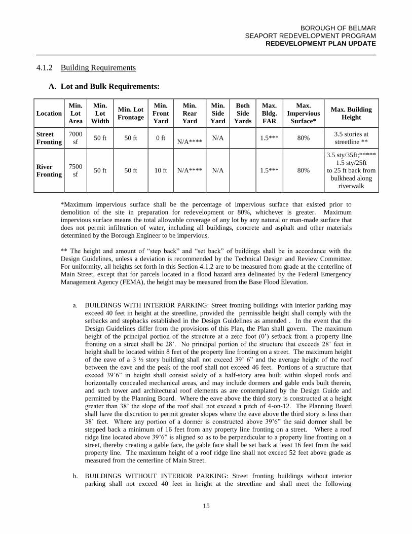
4.1.2 Building Requirements
A. Lot and Bulk Requirements:
Location
Min.
Lot
Area
Min.
Lot
Width
Min. Lot
Frontage
Min.
Front
Yard
Min.
Rear
Yard
Min.
Side
Yard
Both
Side
Yards
Max.
Bldg.
FAR
Max.
Impervious
Surface*
Max. Building
Height
Street
Fronting
7000
sf 50 ft 50 ft 0 ft
N/A**** N/A 1.5*** 80%
3.5 stories at
streetline **
River
Fronting
7500
sf 50 ft 50 ft 10 ft N/A**** N/A 1.5*** 80%
3.5 sty/35ft;*****
1.5 sty/25ft
to 25 ft back from
bulkhead along
riverwalk
*Maximum impervious surface shall be the percentage of impervious surface that existed prior to
demolition of the site in preparation for redevelopment or 80%, whichever is greater. Maximum
impervious surface means the total allowable coverage of any lot by any natural or man-made surface that
does not permit infiltration of water, including all buildings, concrete and asphalt and other materials
determined by the Borough Engineer to be impervious.
** The height and amount of “step back” and “set back” of buildings shall be in accordance with the
Design Guidelines, unless a deviation is recommended by the Technical Design and Review Committee.
For uniformity, all heights set forth in this Section 4.1.2 are to be measured from grade at the centerline of
Main Street, except that for parcels located in a flood hazard area delineated by the Federal Emergency
Management Agency (FEMA), the height may be measured from the Base Flood Elevation.
a. BUILDINGS WITH INTERIOR PARKING: Street fronting buildings with interior parking may
exceed 40 feet in height at the streetline, provided the permissible height shall comply with the
setbacks and stepbacks established in the Design Guidelines as amended . In the event that the
Design Guidelines differ from the provisions of this Plan, the Plan shall govern. The maximum
height of the principal portion of the structure at a zero foot (0’) setback from a property line
fronting on a street shall be 28’. No principal portion of the structure that exceeds 28’ feet in
height shall be located within 8 feet of the property line fronting on a street. The maximum height
of the eave of a 3 ½ story building shall not exceed 39’ 6” and the average height of the roof
between the eave and the peak of the roof shall not exceed 46 feet. Portions of a structure that
exceed 39’6” in height shall consist solely of a half-story area built within sloped roofs and
horizontally concealed mechanical areas, and may include dormers and gable ends built therein,
and such tower and architectural roof elements as are contemplated by the Design Guide and
permitted by the Planning Board. Where the eave above the third story is constructed at a height
greater than 38’ the slope of the roof shall not exceed a pitch of 4-on-12. The Planning Board
shall have the discretion to permit greater slopes where the eave above the third story is less than
38’ feet. Where any portion of a dormer is constructed above 39’6” the said dormer shall be
stepped back a minimum of 16 feet from any property line fronting on a street. Where a roof
ridge line located above 39’6” is aligned so as to be perpendicular to a property line fronting on a
street, thereby creating a gable face, the gable face shall be set back at least 16 feet from the said
property line. The maximum height of a roof ridge line shall not exceed 52 feet above grade as
measured from the centerline of Main Street.
b. BUILDINGS WITHOUT INTERIOR PARKING: Street fronting buildings without interior
parking shall not exceed 40 feet in height at the streetline and shall meet the following
BOROUGH OF BELMAR SEAPORT REDEVELOPMENT PROGRAM
REDEVELOPMENT PLAN UPDATE
16
requirements. The maximum height of the principal portion of the structure at the streetline shall
be 40 feet, except that no more than 50% of a principal portion of a building that is greater than 50
feet in width shall front a street on the streetline at the maximum height. At least 50% of the total
linear feet of mixed-use and nonresidential street facing building facades within a project on sites
with greater than 50 feet of street frontage must be within one foot of a sidewalk or equivalent
provision for walking, and functional entries to buildings shall occur at an average of 30 feet or
less along such facades and 75 feet or less along nonresidential or mixed-use portions of the entire
block (LEED-ND, NPDc1). The overall relationship of building height to street width along a
street facing façade of a project on a site with greater than 50 feet of street frontage shall maintain
a ratio not less than 1 foot of building height to 1.5 feet of street width, measured from the
building façade to the centerline of the street (1:3 overall for the block front for both sides of the
street), except that the total height of any building within the project shall not exceed 45 feet.
Building breaks shall be provided at intervals equal to the lesser of 50 feet or 50% of the building
façade and shall otherwise be in accordance with the Design Guidelines, as amended, unless a
deviation is recommended by the Technical Design and Review Committee. Building corners at
street intersections shall be designed as a visual focal point. Such corner treatments may exceed
the height restrictions of this section subject to the prior approval of the Redevelopment Entity,
provided such additional height is needed to achieve architectural ornamentation and not support
additional floor area.
For purposes of this Section 4.1.2, “building height shall be measured from street centerline (or, if located
in a flood hazard area, from the Base Flood Elevation) to the eave of a pitched roof and the base of the
parapet or cornice of a flat roof. A “half-story” shall be defined as the livable space located in a finished
attic or dormer area above the eave of the building. The “principal portion” shall be defined as the
structure’s façade exclusive of architectural elements such as window bays, trellises, roof overhangs,
decorative screens, railings and the like as are contemplated by the Design Guide and permitted by the
Planning Board. For properties located adjacent to residential boundary zones, also see footnote ****
below.
*** The Floor Area Ratio shall not apply where redevelopers provide enclosed parking on site for at least
all reserved parking spaces for residential units.
3 stories 40’ max height at Streetline
Site w 50’
Frontage
3.5 stories 45’ max height overall
Site with >50’
Frontage
100% of building
may be at Streetline
Figure 1: The ratio of building height to street width is the average taken along a block front. In the illustration
above, the average ratio is a minimum of 1:1.5 and a maximum of 1:1 at the streetline for one side of the
block.
BOROUGH OF BELMAR SEAPORT REDEVELOPMENT PROGRAM
REDEVELOPMENT PLAN UPDATE
17
**** A minimum 10-foot building setback shall be provided along any residential property zone boundary.
The maximum height at the 10’ setback line from a residential property zone boundary shall be 26’. No
principal portion of the structure that exceeds 26’ feet in height shall be located within 15 feet of the
residential property zone boundary. The maximum eave height within 25 feet of any residential zone
boundary shall be 36 feet. Any part of the structure that is greater than 36 feet and located within 35 feet of
a residential boundary shall consist solely of sloped roofs at a pitch not to exceed 4-on-12 and may include
dormers built therein, and architectural roof elements as are contemplated by the Design Guide and
permitted by the Planning Board. The maximum height of the roof ridge line within 35 feet of a residential
boundary shall be no greater than 49’ 6”. Where a roof ridge line is aligned so as to be perpendicular to a
residential property zone boundary, thereby creating a gable face, the gable face shall be setback at least 10
feet from the said zone boundary and shall have maximum height of a roof ridge line not exceeding 43 feet.
***** For uniformity, all heights set forth in this Section 4.1.2 regarding River Fronting properties are to be measured
from grade at the centerline of the adjoining street, except that heights for buildings located in a flood hazard area
delineated by the Federal Emergency Management Agency (FEMA) may be measured from the Base Flood Elevation.
Structures that are on River Fronting properties shall comply with the “step back” and “set back” requirements of the
Design Guidelines, unless a deviation is recommended by the Technical Design and Review Committee, and as
described in ** above, except that where building orientation on a river fronting parcel is angled between 45 degrees
and 135 degrees away from a bulkhead running parallel to the river walk, the 1.5 story/25 foot height requirement for
portions of a building within 25 feet of the bulkhead will not apply. The Planning Board shall have the discretion to
permit heights greater than 35’ for buildings on river fronting Parcels, if recommended by the Technical Design and
Review Committee, but not more than 42’.
While the minimum lot sizes have been established in general
accordance with existing CBD-2 zoning requirements, prevailing
lot sizes and logical redevelopment parcel configurations, there are
some differences with current zoning regulations. Maximum
impervious coverage has been set at the greater of 80% or the
amount of preexisting impervious surface in accordance with the
amended CAFRA regulations for "Coastal Towns" as established
by NJDEP consistent with the Planning Area 1 guidelines of the
State Development and Redevelopment Plan. The maximum
building height has been
reduced from the current 2.5
stories and 35 feet to 1.5
stories and 25 feet for
buildings oriented parallel to
and within 25 feet of the
bulkhead along the Shark
River Inlet. This
requirement is designed to provide a more intimate scale and
greater sense of openness along the water’s edge in combination
with maximum public access, consistent with CAFRA land use
policies. However, architectural elements that are ornamental in
nature (clocktowers, turrets, cornices, etc) and nautical structures
in appropriate locations, such as a lighthouse, that contributes to
the Seaport Theme, may be permitted to exceed the height
limitations up to a maximum of 45 feet, subject to review and
recommendation of the Technical Design Review Committee.
Figure 2: Examples of use of turrets as architectural elements to highlight building corners, etc.
Figure 3: Sample elevation of lighthouse structure permitted to exceed height limitation to a maximum of 45 feet to the base of the roof.
BOROUGH OF BELMAR SEAPORT REDEVELOPMENT PROGRAM
REDEVELOPMENT PLAN UPDATE
18
In addition, the minimum lot size for River Fronting parcels has been reduced from 10,000 square feet in
the current MC-2 zone, to 7500 square feet. These modifications are designed to maximize building
orientation to the River and to Fifth Avenue, while recognizing the shallowness of the block between
Fifth Avenue and the River.
4.1.3 Parking Requirements
Parking shall be provided for redevelopment of property or the addition or expansion of any building or
use existing within the Seaport Village Redevelopment Area as of the effective date of this
Redevelopment Plan. Such parking shall be provided based on three parking spaces per 1,000 square
feet of all nonresidential uses and two parking spaces per dwelling unit for residential uses, except there
will be no parking space required for any residential unit designated as an Affordable Housing Unit.
Any project that includes a marina shall provide parking for the marina based on the requirements of NJ
Department Environmental Protection CAFRA regulations. However, subject to the conditions set forth
below, a 50% shared parking allowance will be made for combining weekday uses with
evening/weekend uses in the same building. Office and general retail uses are considered to be weekday
uses, while residential and restaurant uses are considered to be evening/weekend uses. 50% of the
parking requirement of the evening/weekend use of the building may be met through parking already
provided for the weekday use.
Such additional parking may be provided by:
a) Providing the required spaces on-site.
b) Providing the required spaces on other properties owned by or under the control of the
developer, or publicly owned property under the control of the borough with prior agreement
being made through a developer’s agreement executed with the Mayor and Council for use of
public spaces, located within a zone which permits the proposed use(s), either contiguous
with or within five hundred (500') feet walking distance of a primary pedestrian entrance to
the site being developed.
c) Providing the required spaces by designing the redevelopment so as to create net new on-
street parking spaces.
d) A combination of alternates (a), (b), and/or (c) acceptable to the Borough Council shall be
acceptable for purposes of Plan approval only.
e) To the extent parking requirements are not met as provided above by either options (a) and
(b) or a combination of the two, the developer must contribute to a fund dedicated by the
Borough for the purpose of constructing public parking facilities within the Seaport Village
Redevelopment Area. The amount of the contribution will be determined by multiplying the
Mayor & Council’s estimated per space cost of constructing structured parking facilities
within the Seaport Village Redevelopment Area by the difference between the number of
parking spaces the Planning Board determines that the development requires pursuant to
Section 4.3 and the number of parking spaces the developer agrees to provide pursuant to
options (a), (b), and (c), above.
BOROUGH OF BELMAR SEAPORT REDEVELOPMENT PROGRAM
REDEVELOPMENT PLAN UPDATE
19
To the extent that the overall cost of public parking is defrayed by funds raised through an Economic
Redevelopment & Growth Grant (ERG) or the Redevelopment Area Bond Law (RAB), the contribution
formula may be adjusted accordingly by the Borough Council.
4.2 BELMAR MARINA-MACLEARIE PARK REHABILITATION AREA
4.2.1 Land Uses
The land uses permitted within the Belmar Marina-Maclearie Park Rehabilitation Area are listed below.
Any land use that is not specifically included as a permitted use is prohibited unless determined by the
Borough Council to be equivalent to a listed permitted use and consistent with the purposes and goals of
this Plan.
A. Permitted Uses:
a. Commercial and recreational facilities, municipal buildings, parks, playgrounds, and
other municipal facilities as are deemed necessary and appropriate by the Borough
Council are permitted.
b. Public and privately owned and/or operated recreational facilities, including ancillary
uses, such as bait and tackle sales, charter boat rentals and food/beverage
concessions.
c. Restaurants, Including Drive-In/Take-Out.
d. Gift, Novelty and Souvenir Shops.
e. Specialty Shops.
f. Services incidental to Water Transportation.
g. Marinas and Related Support Facilities.
h. Municipal Services and Facilities.
i. Public Parks, Playgrounds, Athletic Fields and Swimming Pools.
j. Miniature Golf Courses.
k. Indoor and Outdoor Farmers/Seafood Markets.
4.2.2 Building Requirements
A. Lot and Bulk Requirements:
The setback, height and related bulk requirements for buildings to be constructed within the Belmar
Marina-Maclearie Park Rehabilitation Area shall be determined through by the Borough Council, acting
as the Redevelopment Entity, on a project by project basis.
BOROUGH OF BELMAR SEAPORT REDEVELOPMENT PROGRAM
REDEVELOPMENT PLAN UPDATE
20
5.0 IDENTIFICATION OF PROPERTY FOR ACQUISITION &
REDEVELOPMENT
5.1 IDENTIFICATION OF REDEVELOPMENT PARCELS
The Belmar Seaport Village Redevelopment Area has had been divided into 19 Redevelopment Parcels,
as shown on the Belmar Seaport Village Concept Plan. Of the 19 parcels, Parcel 1 is was the Seaport
Plaza, leaving 18 redevelopment parcels for the permitted uses listed in Section 4.0 above.
Redevelopment Parcels were identified based on logical combinations of lots within a block that would
enable ideal redevelopment scenarios (mixed use buildings, etc.). However, the Belmar Redevelopment
Advisory Committee’s Report of January of 2015 recommended that the use of redevelopment parcels
be discontinued, as redevelopment projects are now being implemented on smaller properties by local
redevelopers rather than one large redeveloper implementing the entire redevelopment plan.
Redevelopment of complete Parcels as listed below is strongly encouraged, but not mandatory.
Portions of Redevelopment Parcels that are improved with permanent redevelopment pProjects
conforming to the permitted uses and development requirements of this Plan shall be designed, where
possible, to consider potential future expansion or connections with subsequent redevelopment of other
lots within the Redevelopment ParcelPlan Area. However each redevelopment proposal for other
portions of the Redevelopment Parcel will be evaluated separately by the Borough on its own merits.
5.2 IDENTIFICATION OF REHABILITATION AND REDEVELOPMENT
REQUIREMENTS
All of the buildings currently within Parcel 1 (Seaport Plaza) are designated for clearance, with the
exception of the Belmar Municipal Complex, the Elks Club on Lot 11 and the adjacent residence on Lot
12. Parcels 2 through 19 contain some buildings or sites that are designated for rehabilitation and others
that are designated for redevelopment as follows:
Parcels with Buildings to Be Rehabilitated:
Parcel 2: Rehabilitate or redevelop Pied Piper Building site and reconstruct site improvements
facing Seaport Plaza and riverfront, including riverfront walkway and landscaping;
Parcel 3: Reconfigure parking and landscaping to integrate with Seaport Plaza. Encourage facade
alterations to incorporate Seaport architectural theme using low interest loan pool
financing and short-term property tax incentives;
Parcel 5: Rehabilitate site with landscaping, lighting and pedestrian walkways. Modify building
entrances, if necessary to orient toward Seaport Plaza, including outdoor dining areas
near pedestrian walkways;
Parcel 6: Rehabilitate one story masonry used car garage, and/or redevelop with new building(s)
for one or more uses permitted in Section 4.0 of this Plan. Rehabilitate and/or redevelop
site with landscaping, lighting and pedestrian spaces. The Parcel contains one property,
Block 56, Lot 4, which is undersized and it is recognized that this nonconformity is a
BOROUGH OF BELMAR SEAPORT REDEVELOPMENT PROGRAM
REDEVELOPMENT PLAN UPDATE
21
preexisting nonconformity and despite this nonconformity the Parcel can be rehabilitated
and/or redeveloped as provided;
Parcel 6B: The parking lot of Block 56, Lot 2, identified as Parcel 6B on the Parcel Identification
Map, was originally identified for acquisition for redevelopment of adjacent Parcel 6.
However, as Parcel 6 is now recommended for rehabilitation, Parcel 6B is now also
recommended for rehabilitation in conjunction with either Parcel 5 and/or Parcel 6.
Parcels 7/8: Rehabilitate and integrate existing restaurant, fish market and adjacent residence into
consolidated and expanded restaurant and seafood market or other use permitted in
Section 4.0 of this Plan. Rehabilitate site with landscaping, lighting and pedestrian
walkways, including riverfront walkway, in accordance with the pedestrian access
easements indicated on the Seaport Conceptual Plan;
Parcel 12: Rehabilitate, consolidate and expand existing building professional office (former VFW
building) consistent with Seaport architectural design standards. Rehabilitate site with
landscaping, lighting and pedestrian walkways.
Parcel 20: Rehabilitate Belmar Marina and Maclearie Park for variety of recreational and limited
commercial uses as set forth in this Plan.
Individual tax lots may be developed as allowed under this Redevelopment Plan, subject to design
consideration given to subsequent redevelopment of full Parcels as set forth herein.
5.2 SUPPLEMENTARY REHABILITATION PROVISIONS:
Existing commercial properties within the Seaport Village Redevelopment Area which are not
recommended for redevelopment may be rehabilitated and expanded, provided such rehabilitation and
expansion is for uses permitted pursuant to Section 4.0 of this Plan and consistent with Seaport
architectural design standards. Such rehabilitation is subject to site plan approval of the Planning
Board and must include landscaping, lighting and pedestrian walkways where appropriate.
Existing residences east and west of Main Street within the Seaport Village Redevelopment Area that
are not recommended for redevelopment may be rehabilitated into a Bed and Breakfast Guest House or
Inn or converted for uses permitted pursuant to Section 4.0 of this Plan. Such rehabilitation is subject to
site plan approval of the Planning Board and must include landscaping, lighting and pedestrian
walkways where appropriate.
Freestanding barns and detached garages may be rehabilitated for uses permitted pursuant to Section 4.0
of this Plan. Such rehabilitation is subject to site plan approval of the Planning Board and must include
landscaping, lighting and pedestrian walkways where appropriate.
Parcels Designated for Redevelopment:
BOROUGH OF BELMAR SEAPORT REDEVELOPMENT PROGRAM
REDEVELOPMENT PLAN UPDATE
22
Other than the Seaport Plaza (Parcel 1 as shown on the Parcel Identification Map), the following Parcels
are designated for redevelopment, including the clearance of existing buildings and the construction of
new buildings in accordance with the Seaport architectural design standards for uses permitted in
Section 4.0 of this Plan:
Parcel 4: Consolidate parcel with portions of Sixth Avenue right-of-way to be vacated. Clear
existing one story masonry building and small one story vacant frame building.
Redevelop with new commercial building(s) for one or more uses permitted in Section
4.0 of this Plan. Redevelop site with landscaping, lighting and pedestrian walkways in
accordance with the pedestrian access easements indicated on the Seaport Concept Plan;
Parcel 8: Reconfigure Parcel as shown on the Redevelopment Parcel Map of this Plan. Redevelop
site with landscaping, lighting and pedestrian walkways in accordance with the pedestrian
walkway system indicated on the Seaport Concept Plan, including riverfront public plaza
and landscaping;
Parcel 9: Develop Block 55, Lots 10, 12, and 13.2 for new commercial or mixed-use building with
Seaport architectural design standards. Rehabilitate site with landscaping and lighting;
Parcel 11: Redevelop new commercial building on parking lot portion of senior apartment building
and replace parking along one-way road parallel to rail right of way.
Parcel 13 and 14 (800 Main Street) Block 85 Lot 9, 10 and Lot 18 (the Ninth Avenue municipal parking
lot): Redevelop new commercial or mixed-use building, consistent with Seaport Village
Redevelopment Design Guide with parking coordinated with the municipal parking on Lot
18, which is adjacent to and contiguous with Parcel 13 in the redevelopment area.
Parcel 15 and 16 (former DiFeo Used Car site): Redevelop new mixed use building with enclosed
parking consistent with Seaport Village Redevelopment Design Guide.
Parcel 17, consisting of Block 55, Lots 6, 7, 8 and 9 (500 Main Street, Acropolis parcel and former Yard
Two-Family home): Redevelop new mixed use building with enclosed parking consistent
with Seaport Village Redevelopment Design Guide.
Parcel 19, consisting of Block 45, Lot 1, 4 and 5 (AP’s Marina, former Havens & Hampton Restaurant
and 604 Fifth Ave residential property): Redevelop new mixed use buildings with
enclosed and surface parking consistent with Seaport Village Redevelopment Design
Guide. Redevelop site with landscaping, lighting and pedestrian walkways in accordance
with the pedestrian walkway system indicated on the Seaport Concept Plan including
riverfront public plaza and landscaping.
Individual tax lots may be developed as allowed under this Redevelopment Plan, subject to design
consideration given to subsequent redevelopment of full Parcels as set forth herein.
BOROUGH OF BELMAR SEAPORT REDEVELOPMENT PROGRAM
REDEVELOPMENT PLAN UPDATE
23
5.3 SUPPLEMENTARY REDEVELOPMENT PROVISIONS:
Provisions Related to Off-Site Improvements:
The designated redeveloper or other such party responsible for the development of a property in the
redevelopment area will be responsible for their fair share of any installation or upgrade of infrastructure
related to their project whether on-site or off-site. Infrastructure items include but are not limited to gas,
electric, water, sanitary and storm sewers, traffic control devices, telecommunications, streets, curbs,
sidewalks, street lighting and street trees. Each redeveloper or other party’s fair share of the cost of
installing or upgrading any infrastructure shall be determined in accordance with a formula to be
prepared by the Borough Engineer in consultation with the Borough’s Chief Financial Officer. The
extent of each redeveloper’s or other party’s responsibility will be outlined in the redevelopment
agreement with the Borough. Off-site responsibility for properties not covered under the redevelopment
agreement will be determined during the permit and/or site plan review phases.
All infrastructure improvements will comply with applicable local, state and federal codes.
Provisions Related to Sustainable Design Elements:
Each redevelopment project within the Seaport Village Redevelopment Area will be encouraged to
incorporate principles of sustainable design. These principles are outlined in the Sustainable Design
section of the Seaport Village Design Guide.
Each developer must attempt to include as many sustainable design elements as possible within each
development. The Borough has established a Sustainable Design Checklist which was adopted by
Resolution of the Mayor and Council on November 30, 2006 and is incorporated herein, and which may
be amended from time to time by resolution, to specify and quantify those areas of sustainable design
important to the Redevelopment Area. This checklist was developed using elements of the U.S. Green
Building Council’s Leadership in Energy and Environmental Design (“LEED”) system and was
modeled in large part on proposed LEED criteria for Neighborhood Development, but with amendments
and additions that are tailored specifically to Belmar’s Seaport Village Redevelopment Area and nearby
bodies of water.
Belmar’s Sustainable Design Checklist contains 68 items with a total credit value of 116 points. Of
these items 16 items are deemed to be prerequisites and amount to 16 points. The prerequisites must all
be included in the proposed development’s design. A minimum of 44 additional points, for an overall
total of 60 points, must be attempted by the developer in order to meet the sustainable design goals for
the Seaport Village Redevelopment Area. Any developer whose proposed development does not meet
the minimum point requirements may be required, at the Borough’s discretion, to make a contribution
toward an off-site improvement that will be sufficient to achieve the required number of credits.
Alternatively, the Mayor & Council shall have the option upon the recommendation of the Technical
Design and Review Committee, but not the obligation, to permit a developer to satisfy its obligation to
achieve a minimum number of sustainable design credits on a project deemed of critical importance to
the implementation of this Plan, or where the developer has achieved or made a financial or in-kind
BOROUGH OF BELMAR SEAPORT REDEVELOPMENT PROGRAM
REDEVELOPMENT PLAN UPDATE
24
contribution toward the cost of achieving excess sustainable design credits on another development
project in Seaport Village Redevelopment Area.
Each developer will be required to show attempted compliance with the Sustainable Design Checklist.
This should be in the form of drawings, details, specifications and any other documents the applicant
may wish to submit to the Borough’s Technical Design and Review Committee (“TDRC”) to illustrate
compliance with the design intent. A properly completed Sustainable Design Checklist must accompany
the submission to the (“TDRC”). Sufficient information will be required to enable the TDRC to assess
the developer’s compliance with the Sustainable Design Checklist. No site plan application for a
development in the Seaport Village Redevelopment Area shall be filed with the Planning Board unless
the TDRC has previously determined that the developer has complied satisfactorily with the Sustainable
Design Checklist, or the Mayor & Council has nevertheless authorized the filing of the site plan
application notwithstanding the TDRC’s finding. Nothing contained herein shall be construed to require
the Mayor & Council to refer to the Planning Board any development application that does not propose
to meet the minimum sustainable design credits as contained herein.
Each development project will be inspected by the Borough prior to completion and occupancy to insure
compliance by the developer with the Sustainable Design Checklist, and that sustainable design
elements sufficient to achieve the minimum number of sustainable design credits have in fact been
incorporated into the development or otherwise achieved. Terms sufficient to carry out the purpose and
intent of this section of the Redevelopment Plan shall be incorporated in the Redevelopers Agreement
with each redeveloper in the Seaport Village Redevelopment Area.
5.3 TEMPORARY USE OF PARCELS DESIGNATED FOR REDEVELOPMENT
Any Parcel listed in Section 5.2 as “Parcels Designated for Redevelopment” may be used for temporary
uses prior to being developed according to this Plan and under the following conditions:
1. The temporary use of a Parcel, or part of a Parcel if the redeveloper or property owner
does not own all of the property in the Parcel, shall be part of an approved application for
the redevelopment of the entire Parcel in accordance with this Plan.
2. The temporary use of a Parcel, or part of a Parcel, shall be for a specified period of time
as determined by the Mayor and Council during the Review of Applications for
Redevelopment process described in Section 1.0 of the Plan.
3. The redeveloper shall post a performance guarantee for the work required to remove the
temporary use(s) and all structures on the property which shall be at 120% of the costs for
the same and notwithstanding that this type of guarantee is not provided for in the
Municipal Land Use Law, N.J.S.A. 40:55D-1 et seq. (“MLUL”) the performance
guarantee shall be further calculated, posted and held pursuant to the procedures for
guarantees as provided for in the MLUL. Additionally, prior to the commencement of
any temporary use, the redeveloper shall post a performance guarantee for the work
required to construct the on-site improvements for the approved redevelopment
application for the entire Parcel, and any off-tract improvements if they are required, and
BOROUGH OF BELMAR SEAPORT REDEVELOPMENT PROGRAM
REDEVELOPMENT PLAN UPDATE
25
these guarantees shall be calculated, posted and held in the same manner as guarantees as
provided for in the MLUL.
4. After the specified period of time for the temporary use as approved by the Mayor and
Council, the temporary use shall cease, all permits, licenses and the like issued by the
Borough shall be revoked, and the redevelopment of the entire Parcel in accordance with
the approved redevelopment of the Parcel shall commence. If the redeveloper fails to
commence the redevelopment of the Parcel the performance guarantees shall be forfeited
and the approval of the application for redevelopment of the entire Parcel shall be
revoked.
5. The temporary use of a parcel, or part of a Parcel, must be for a use or uses permitted in
Section 4.1.1 of the Plan, including uses that may not be designated for that Parcel, and
advance the Goals & Objectives of Seaport Redevelopment Plan as described in Section
1.0 of the Plan, and advance the aesthetic goals of the Plan as described in Section 2.0 of
the Plan.
6. The Mayor and Council may place restrictions on the temporary uses to meet the
aforementioned objectives, to minimize any affect of the temporary uses on neighboring
properties and/or for the health, safety and welfare of the community. Any violation of
any such conditions shall result in the revocation of the approval for the temporary uses
and all permits, licenses and the like issued by the Borough shall be revoked and the
redevelopment of the entire Parcel in accordance with the approved redevelopment of the
Parcel shall commence as provided herein.
7. The temporary use of a Parcel, or part of a Parcel, may be contained in existing structures
or in new structures.
BOROUGH OF BELMAR SEAPORT REDEVELOPMENT PROGRAM
REDEVELOPMENT PLAN UPDATE
26
6.0 RELOCATION PLAN FOR RESIDENTS AND BUSINESSES
The overall relocation strategy for this Redevelopment Plan will be for the retention of any business
conforming to the land uses set forth herein. Any business that must be relocated as a result of the use
of Eminent Domain powers to implement this Plan and is unable to find satisfactory space in another
location within the Seaport Village Redevelopment Area will be compensated in accordance with the
Workable Relocation Assistance Plan that will be filed with the New Jersey Department of Community
Affairs.
Any such business that is determined to be incompatible with the land uses and/or development
requirements of this Plan will be compensated for reasonable relocation expenses to a site outside the
Redevelopment Area in accordance with the Workable Relocation Assistance Plan.
In general, this Plan does not project the need to relocate any business or household located in a building
that is recommended for rehabilitation, as there is no longer any provision or intention by the Borough to
exercise the power of Eminent Domain to acquire and assemble redevelopment parcels. Any business or
household located within a building designated for redevelopment in this Plan will become eligible for
relocation assistance at the time of the filing of the declaration of taking by the Borough Council, acting
as the Redevelopment Entity, and will be referred to the Relocation Assistance Officer appointed by the
Borough. If the dwelling unit is owner-occupied and is part of a redevelopment parcel included in a
redevelopment agreement, the redevelopment agreement shall include a provision that relocation
expenses pursuant to the Workable Relocation Assistance Program be paid to the owner at the time of
closing, or in the case of condemnation proceedings, between the filing of the declaration of taking and
the issuance of demolition permits to the redeveloper.
If Because condemnation is not required for the purposes of acquiring and assembling redevelopment
parcels, the costs of relocation, if any, shall be negotiated as part of the transfer of the property from the
owner to the redeveloper in the same manner as with ordinary real estate transactions.
6.1 ESTIMATION OF RELOCATION
It is possible that business relocation may occur from buildings located on the following properties, if
such buildings are acquired by the Borough and are occupied at the time of acquisition:
Block 56, Lot 1;
Block 56, Lot 4;
Block 55; Lot 12;
In the event that relocation of residential households becomes necessary due to an acquisition action by
the Borough, the Borough’s Relocation Officer will determine the condition of the dwelling unit to be
vacated and the rent paid by the household and assist the household in locating a dwelling unit of equal
or superior condition at the same monthly rental as the unit to be vacated. Replacement dwelling units
shall be within the Borough, if equivalent dwelling units are available. If equivalent dwelling units are
BOROUGH OF BELMAR SEAPORT REDEVELOPMENT PROGRAM
REDEVELOPMENT PLAN UPDATE
27
not available within the Borough, reasonable compensation to enable relocation outside the Borough
shall be provided in accordance with the Workable Relocation Assistance Plan.
In the event that relocation of businesses becomes necessary due to the condemnation process, the
Borough, through its Economic Development Coordinator, will work with local commercial realtors to
find suitable space for permitted uses in an alternative location within the Borough. Available vacant
space in existing buildings will be investigated first. If no suitable space is available, the business may
be compensated for any additional expense to move to a site outside the Borough in accordance with a
Workable Relocation Assistance Plan.
BOROUGH OF BELMAR SEAPORT REDEVELOPMENT PROGRAM
REDEVELOPMENT PLAN UPDATE
28
7.0 RELATIONSHIP OF REDEVELOPMENT PLAN TO MASTER PLANS OF
CONTIGUOUS MUNICIPALITIES, COUNTY MASTER PLAN AND
STATE DEVELOPMENT AND REDEVELOPMENT PLAN
The Belmar Planning Board will likely adopt the Belmar Seaport Redevelopment Plan as a Subelement
of the Belmar Master PlanThe Belmar Planning Board considered the expansion of the Belmar Seaport
Village Redevelopment Area at the same time as it was working on its 2016 Master Plan Reexamination
and Land Use Element Update. The Board adopted the Master Plan Update on August 15, 2016. The
Future Land Use Map (see Appendix) adopted as part of the Land Use Plan Element includes the “SRD”
(Seaport Redevelopment District) as inclusive of the expanded Seaport Village Redevelopment Area.
The Municipalities sharing boundaries with Belmar are the Borough of Avon, the Borough of Neptune
City and the Township of Neptune (across the Shark River), Township of Wall, the Borough of South
BelmarLake Como and the Borough of Spring Lake. Portions of Avon, Neptune Township and Neptune
City do not directly abut the Borough of Belmar, however, lie opposite Belmar along the Shark River
Inlet, while Wall Township is adjacent to the south and west, South Belmar is due south and Spring
Lake is adjacent along the oceanfront to the south.
Of the municipalities listed above, the Seaport Redevelopment Plan affects only those along the Inlet.
Those municipalities, specifically, Avon, Neptune Township and Neptune City are addressed
individually below. Essentially, the present land use patterns of those municipalities across the Shark
River Inlet are consistent with the proposed Seaport land uses. Further, those municipalities already
catering to a seasonal clientele will realize even greater economic opportunity with the development of
the Seaport.
Avon Borough
The Borough of Avon extends from the oceanfront along the Shark River Inlet to the south side of Route
71 (Main Street). The land uses in Avon and Belmar essentially mirror each other, except that the
beachfront uses in Belmar are more intensively commercial with residential uses taking over west of the
second inland block and extending almost all the way to Main Street (Route 71), while residential uses
predominate in Avon all the way to Ocean Avenue. Commercial uses are permitted along both sides of
Route 71 in Avon, and currently include marina and boat yards, which are also encouraged within the
Seaport Redevelopment Plan.
The Master Plan and land use regulations for Avon emphasize the preservation of residential
neighborhoods. The Seaport Redevelopment Plan encourages visitor-oriented uses that extend the
summer tourist season into the spring and fall. The enhanced restaurant, entertainment and specialty
retail uses at the Seaport are likely to attract Avon residents and may benefit seasonal Avon businesses
along Route 71 that rely on through traffic for their customer base.
Avon is constructing streetscape improvements to Route 71, including a center landscaped median and
brick paver sidewalks, which will enhance the Borough’s downtown and provide an attractive gateway
to the Belmar Seaport from the north.
BOROUGH OF BELMAR SEAPORT REDEVELOPMENT PROGRAM
REDEVELOPMENT PLAN UPDATE
29
Neptune City
Neptune City is a fully developed municipality with the predominant land use being residential. The City
has frontage on the Shark River Inlet across from the Borough of Belmar. While the City of Neptune is
largely a residential community, there are beaches as well as some commercial uses presently located
along the Shark River waterfront. The Seaport Village Redevelopment Area will provide a unique
opportunity for residents of Neptune City and will be compatible with the existing land uses along the
Inlet.
Neptune Township
The Land Use Element of the Neptune Township Master Plan includes a comparison study of the land
uses of adjacent municipalities. When addressing the Borough of Belmar, the following statement is
made ”The Borough of Belmar abuts the Township of Neptune on the eastern side of Route 35 in the
vicinity of the southern Shark River Island. The commercial and marina uses in Belmar are compatible
with the existing townhouse, marina and restaurant development of the Shark River Island”.
Commercial land uses in Neptune Township abutting the Shark River are located primarily in the
Commercial Service Zone.
Future commercial development in the Seaport area will be consistent with the existing marina and
restaurant development in Neptune Township. The creation of the Seaport as a destination point will
increase economic viability of the commercial districts in those municipalities, such as Neptune
Township, surrounding the Seaport that already cater to a seasonal clientele. In addition, the new high-
span bridge over the Shark River will include a separate pedestrian/bicycle path, which will afford
convenient non-vehicular access to the Seaport and Marina to the residents of Shark River Island.
Monmouth County Growth Management Plan
Monmouth County last adopted a Growth Management Guide stating goals, objectives and policies in
December of 1995. Goals identified under economic development include promoting managed growth
by providing a suitable long-term economic climate and preserving and enhancing the quality of life in
Monmouth County for the attraction of new businesses and the retention of existing businesses.
Objectives identified include supporting activities which provide a high quality of life for Monmouth
County residents in addition to contributing to the local economy and promoting the development and
support of businesses that keep money circulating within the county, increase capital flowing into the
county and provide long-term employment opportunities. Other goals identified in the Growth
Management guide include preserving the valuable historic, cultural, natural and scenic resources of
Monmouth County.
The Redevelopment Plan will boost the local economy by attracting new and current residents, visitors
and businesses to the Seaport and complement the Borough’s planned expansion of the Belmar Marina to
accommodate approximately 73 transient boat slips for visiting boaters. Consequently, jobs will be
created and the economy will be revitalized through the unique opportunities created by redevelopment.
BOROUGH OF BELMAR SEAPORT REDEVELOPMENT PROGRAM
REDEVELOPMENT PLAN UPDATE
30
The Seaport will be an identifiable place that attracts boaters, pedestrians and cyclists, given the
connection to the waterfront will not be auto-dependent. Through economic revitalization and the
creation of a unique destination point, the Seaport Redevelopment will enhance the overall quality of life
in Monmouth County.
While we have cited limited goals and objectives in this consistency review, we have identified those
goals and objectives that will be furthered by the Seaport Redevelopment. Because the Seaport
Redevelopment will contribute not only to the economic vitality of the Borough of Belmar but
surrounding municipalities and the County at large, the Redevelopment Plan is consistent with the goals,
objectives and policies stated in the Monmouth County Growth Management Guide.
State Development and Redevelopment Plan
The Borough of Belmar is designated as a Planning Area 1 or Metropolitan Planning Area in the State
Development and Redevelopment Plan. The State Plan identifies the typical New Jersey town in this
Planning Area as a relatively self-sufficient community with a mixed-use core commercial district that
provides limited regional commercial, institutional, cultural and transportation opportunities. All of the
aforementioned are available in the Borough of Belmar and the Seaport Redevelopment encourages the
continued provision of same by increasing economic vitality.
The Seaport Redevelopment Plan anticipates both the designation of Belmar as an Existing Town Center
pursuant to the Monmouth County Cross Acceptance Report, Map Amendment #41, and the 80%
maximum impervious surface standard in the proposed CAFRA rules for Coastal Towns. The
development design standards in this plan are mindful of and consistent with the proposed CAFRA rules
relating to impervious coverage. As well, the mixed-use, Transit Village styleland uses and commercial
development contemplated for the Seaport are consistent with the type of development in the Planning
Area 1.
The Seaport Redevelopment Plan is in conformance with the State Development and Redevelopment as
well as the Monmouth County Cross Acceptance Report.
BOROUGH OF BELMAR SEAPORT REDEVELOPMENT PROGRAM
REDEVELOPMENT PLAN UPDATE
31
8.0 DESIGN CRITERIA & REQUIRED IMPROVEMENTS TO THE PUBLIC
ENVIRONMENT
In addition to the land use and building requirements that are integral to the Seaport Redevelopment
Plan, the visual identity of the Seaport as defined by a physical design vocabulary is critically important
to creating a sense of “place”. The early sections of this Plan describe the vision for the Seaport as
being like a New England fishing town. The building requirements enable the village style development
that emphasizes pedestrian circulation, provides for a central commons (the Seaport Plaza). These
Design Standards are intended to implement the visual components of the Seaport and have been
categorized into Streetscape, Riverfront and Architectural standards as follows below.
8.1 STREETSCAPE
The Seaport streetscape will consist of a number of physical design elements as follows:
1. Ground surfaces;
2. Lighting;
3. Street trees and planters;
4. Street furniture (benches, street clocks, kiosks, trash receptacles, etc.);
5. Bicycle facilities;
6. Street graphics (wayfinding signage, pathway signage, street identification signage,
festive banners, etc.);
7. Traffic control (signage and signals).
The complete implementation of the Seaport streetscape will include the relocation of utilities
underground. This objective will be accomplished in three ways:
1. As part of the construction of the Seaport Plaza;
2. As part of the construction of the Riverfront Walkway and Marina rehabilitation;
3. As part of the redevelopment of private property, where necessary and appropriate.
The pathway linkages between the Seaport, Marina, core downtown, etc. should be integrated through
the use of common street graphics, lighting and ground surfaces to the greatest extent possible.
Ground Surfaces
Sidewalks, pedestrians walkways, plazas and crosswalks within the Seaport District are to be dry laid
brick pavers with soldier brick edges or an equivalent paving surface approved by the Planning Board as
part of site plan approval.
The Seaport Plaza is proposed to have parking aisles of asphalt, but with parking sections of dry laid
brick pavers edged with dry laid rectangular cobble pavers set horizontally as depicted at left.
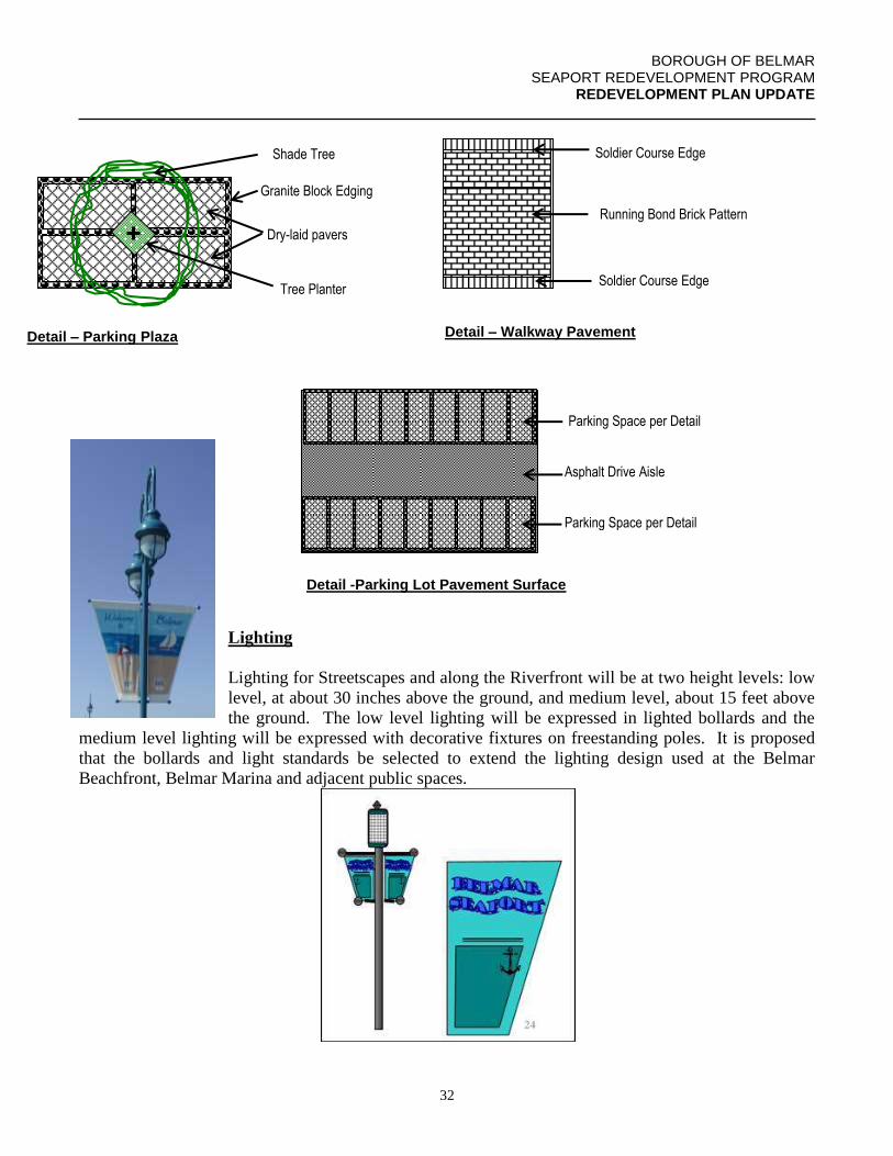
BOROUGH OF BELMAR SEAPORT REDEVELOPMENT PROGRAM
REDEVELOPMENT PLAN UPDATE
32
Shade Tree
Granite Block Edging
Dry-laid pavers
Tree Planter
Detail – Parking Plaza
Lighting
Lighting for Streetscapes and along the Riverfront will be at two height levels: low
level, at about 30 inches above the ground, and medium level, about 15 feet above
the ground. The low level lighting will be expressed in lighted bollards and the
medium level lighting will be expressed with decorative fixtures on freestanding poles. It is proposed
that the bollards and light standards be selected to extend the lighting design used at the Belmar
Beachfront, Belmar Marina and adjacent public spaces.
Soldier Course Edge
Running Bond Brick Pattern
Soldier Course Edge
Detail – Walkway Pavement
Parking Space per Detail
Asphalt Drive Aisle
Parking Space per Detail
Detail -Parking Lot Pavement Surface
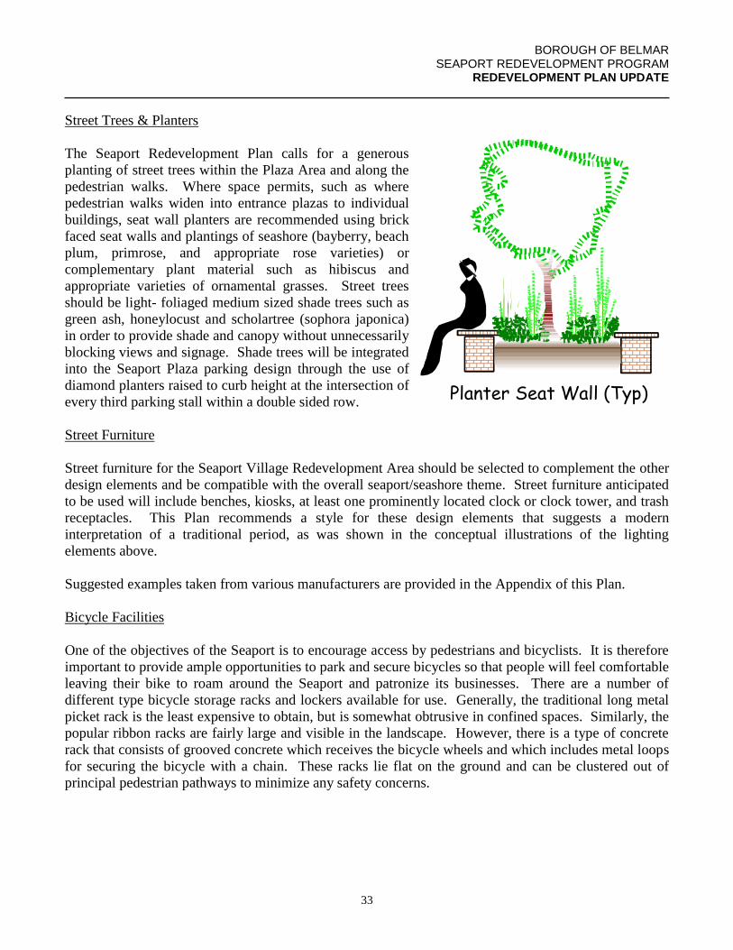
BOROUGH OF BELMAR SEAPORT REDEVELOPMENT PROGRAM
REDEVELOPMENT PLAN UPDATE
33
Street Trees & Planters
The Seaport Redevelopment Plan calls for a generous
planting of street trees within the Plaza Area and along the
pedestrian walks. Where space permits, such as where
pedestrian walks widen into entrance plazas to individual
buildings, seat wall planters are recommended using brick
faced seat walls and plantings of seashore (bayberry, beach
plum, primrose, and appropriate rose varieties) or
complementary plant material such as hibiscus and
appropriate varieties of ornamental grasses. Street trees
should be light- foliaged medium sized shade trees such as
green ash, honeylocust and scholartree (sophora japonica)
in order to provide shade and canopy without unnecessarily
blocking views and signage. Shade trees will be integrated
into the Seaport Plaza parking design through the use of
diamond planters raised to curb height at the intersection of
every third parking stall within a double sided row.
Street Furniture
Street furniture for the Seaport Village Redevelopment Area should be selected to complement the other
design elements and be compatible with the overall seaport/seashore theme. Street furniture anticipated
to be used will include benches, kiosks, at least one prominently located clock or clock tower, and trash
receptacles. This Plan recommends a style for these design elements that suggests a modern
interpretation of a traditional period, as was shown in the conceptual illustrations of the lighting
elements above.
Suggested examples taken from various manufacturers are provided in the Appendix of this Plan.
Bicycle Facilities
One of the objectives of the Seaport is to encourage access by pedestrians and bicyclists. It is therefore
important to provide ample opportunities to park and secure bicycles so that people will feel comfortable
leaving their bike to roam around the Seaport and patronize its businesses. There are a number of
different type bicycle storage racks and lockers available for use. Generally, the traditional long metal
picket rack is the least expensive to obtain, but is somewhat obtrusive in confined spaces. Similarly, the
popular ribbon racks are fairly large and visible in the landscape. However, there is a type of concrete
rack that consists of grooved concrete which receives the bicycle wheels and which includes metal loops
for securing the bicycle with a chain. These racks lie flat on the ground and can be clustered out of
principal pedestrian pathways to minimize any safety concerns.
Planter Seat Wall (Typ)
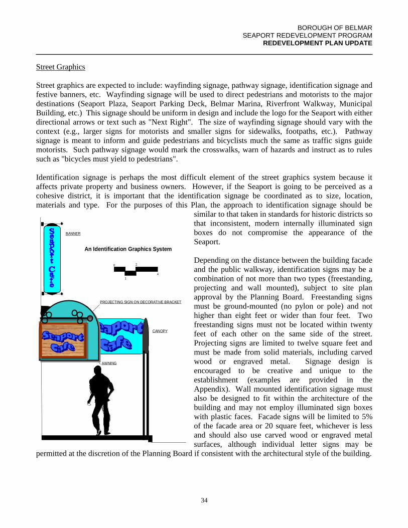
BOROUGH OF BELMAR SEAPORT REDEVELOPMENT PROGRAM
REDEVELOPMENT PLAN UPDATE
34
Street Graphics
Street graphics are expected to include: wayfinding signage, pathway signage, identification signage and
festive banners, etc. Wayfinding signage will be used to direct pedestrians and motorists to the major
destinations (Seaport Plaza, Seaport Parking Deck, Belmar Marina, Riverfront Walkway, Municipal
Building, etc.) This signage should be uniform in design and include the logo for the Seaport with either
directional arrows or text such as "Next Right". The size of wayfinding signage should vary with the
context (e.g., larger signs for motorists and smaller signs for sidewalks, footpaths, etc.). Pathway
signage is meant to inform and guide pedestrians and bicyclists much the same as traffic signs guide
motorists. Such pathway signage would mark the crosswalks, warn of hazards and instruct as to rules
such as "bicycles must yield to pedestrians".
Identification signage is perhaps the most difficult element of the street graphics system because it
affects private property and business owners. However, if the Seaport is going to be perceived as a
cohesive district, it is important that the identification signage be coordinated as to size, location,
materials and type. For the purposes of this Plan, the approach to identification signage should be
similar to that taken in standards for historic districts so
that inconsistent, modern internally illuminated sign
boxes do not compromise the appearance of the
Seaport.
Depending on the distance between the building facade
and the public walkway, identification signs may be a
combination of not more than two types (freestanding,
projecting and wall mounted), subject to site plan
approval by the Planning Board. Freestanding signs
must be ground-mounted (no pylon or pole) and not
higher than eight feet or wider than four feet. Two
freestanding signs must not be located within twenty
feet of each other on the same side of the street.
Projecting signs are limited to twelve square feet and
must be made from solid materials, including carved
wood or engraved metal. Signage design is
encouraged to be creative and unique to the
establishment (examples are provided in the
Appendix). Wall mounted identification signage must
also be designed to fit within the architecture of the
building and may not employ illuminated sign boxes
with plastic faces. Facade signs will be limited to 5%
of the facade area or 20 square feet, whichever is less
and should also use carved wood or engraved metal
surfaces, although individual letter signs may be
permitted at the discretion of the Planning Board if consistent with the architectural style of the building.
S ea p ort C a feTheHop
T
H
E
H
An Identification Graphics System
0
1
2
4
BANNER
CANOPY
AWNING
PROJECTING SIGN ON DECORATIVE BRACKET
S e ap o r tC a f e
T h eS e a p o rtC a fe
BOROUGH OF BELMAR SEAPORT REDEVELOPMENT PROGRAM
REDEVELOPMENT PLAN UPDATE
35
To the extent that it is appropriate to the architectural style of a building, identification signage will be
permitted on awnings, canopies and facade mounted banners, as well as professionally executed,
appropriately sized lettering on glass doors and storefront windows (see examples in Appendix).
8.2 RIVERFRONT
The design guidelines along the riverfront are intended to integrate the design elements of the Riverfront
Walkway with the site improvements planned on private properties that front on the Shark River Inlet.
To the extent that specific design elements, such as lighting, pavements and graphics (banners, logos and
signage) are used in both the streetscape and the riverfront spaces within the Seaport Village
Redevelopment Area, they will be based on these Design Guidelines to ensure consistency and to
communicate the Seaport visually as a unique district.
8.3 ARCHITECTURAL
In addition to the height and bulk requirements of this Redevelopment Plan, the following architectural
design guidelines shall apply:
1. Architectural styles used in rehabilitation of existing buildings and redevelopment of new
buildings must be compatible with the Seaport’s village theme (e.g. Seashore Colonial or
Victorian), although strict compliance with authentic architectural detailing will not be
required where, in the discretion of the Planning Board, another architectural style is more
appropriate or desirable. Architectural styles must not be mixed on the same building and
existing buildings with historic architectural value should be rehabilitated with exteriors
restored consistent with their original architectural style.
2. All roofs, except when serving as the top deck of a parking structure, will be required to have
a minimum slope of 30 degrees.
3. The use of roof treatments, such as dormers with a minimum slope of 22 degrees, scalloped
parapets, multiple gable rooflines, cupolas, etc. is specifically encouraged to add visual
interest to new and rehabbed buildings.
4. The use of detailing such as window shutters on upper floors, small paned storefront
windows and entrance door side windows or decorative framing is recommended and
encouraged where appropriate to the architectural style.
5. The architectural design standards of this Section shall be applied to all sides of a building
that faces a public walkway, including the Riverfront Walkway, and coordinated with the
standards set forth in Section 8.2 of this Plan.
BOROUGH OF BELMAR SEAPORT REDEVELOPMENT PROGRAM
REDEVELOPMENT PLAN UPDATE
36
9.0 IMPLEMENTATION TOOLS
9.1 FINANCIAL INCENTIVES
The Borough will be progressive in the use of long and short-term property tax incentives through tax
agreements when in the mutual interest of a redeveloper and the Borough. The Borough will also use
grant and loan programs and property tax incentives to encourage rehabilitation of private property
consistent with the uses and design standards of this Plan.
To the extent that the Borough is eligible for grant funds for public improvements necessary to facilitate
a redevelopment project, the Borough will take a proactive approach toward securing those funds.
9.2 ECONOMIC REDEVELOPMENT & GROWTH GRANTS (ERG)
Redevelopment projects within the Seaport Redevelopment Plan will be considered on a case by case
basis by the Borough for ERG gap financing pursuant to the Economic Stimulus Act of 2009 (N.J.S.A.
52:27D-489, et. seq.).
9.3 REDEVELOPMENT POWERS
Sensitive use of redevelopment powers includes the exercise of the taking of property by eminent
domain carefully and reluctantly as a last resort, when the underlying public purpose for redeveloping a
parcel in accordance with this Plan will be compromised by a failure to act on the part of the Borough.
The underlying public purpose specifically includes the acquisition of right-of-way for the construction
of parking or other infrastructure required to implement this Redevelopment Plan; and the consolidation
of property required to provide adequate land area for new development, as required to implement this
Redevelopment Plan. Any property owner from whom property is acquired through the eminent domain
process will be compensated based on fair market value of the property in accordance with applicable
law.
One of the redevelopment policies of the Borough is that the present owners of property in designated
redevelopment parcels be given every opportunity to participate in the redevelopment program through
the reinvestment, rehabilitation, and/or redevelopment of their properties in accordance with the land
uses, building and design requirements of this Plan. To that end, the present property owners of
properties within an affected redevelopment parcel are encouraged to present their own proposals for
redevelopment in accordance with this Plan.
BOROUGH OF BELMAR SEAPORT REDEVELOPMENT PROGRAM
REDEVELOPMENT PLAN UPDATE
37
10.0 SELECTION OF REDEVELOPERS & CERTIFICATION OF PROJECT
COMPLETION
The process of selecting a redeveloper to undertake a redevelopment parcel identified in this
Redevelopment Plan will require the following steps:
1. Prepare a Request For Qualifications (RFQ) to include, at a minimum, the following
information:
a. Description of the redeveloper entity, including type of company or partnership,
disclosure of ownership interest, list of comparable projects successfully
completed, list of references with name, address and phone information, list of
any general or limited partners, and financial profile of the redeveloper entity.
b. Description of proposed use for each redevelopment parcel to which the
prospective redeveloper is responding, including anticipated buildout analysis of
the site and overall approach to site development (regulatory process, use of
contractors and subcontractors, etc.)
c. Anticipated construction schedule, including estimated pre-construction time
period to secure permits and approvals once granted final site plan approval by
the Borough.
2. Selection of a prospective redeveloper for one or more redevelopment parcels with which
to enter into negotiations as to a redevelopment agreement, incorporating, at a minimum,
the information set forth in Paragraph 1 above. This prospective redeveloper will execute
a funding agreement with the Borough, agreeing to fund the Borough’s costs related to
the Borough’s consideration of the prospective redeveloper. Upon completion of
successful negotiations, a resolution to designate the prospective redeveloper as a
redeveloper and authorizing the execution of a redevelopment agreement will be
presented for review and approval, if appropriate, by the Mayor and Council.
3. The Borough may, at any time, entertain an unsolicited proposal from a prospective
redeveloper for redevelopment of one or more redevelopment parcels. The Borough will
have the option of entering into negotiations with such prospective redeveloper as set
forth above in Paragraph 2 above or putting out an RFQ to solicit interest from other
potential redevelopers for one or more of the parcels.
A redevelopment project will be certified as being completed by the Borough upon final inspection and
issuance of a certificate of occupancy by the Construction Official for all buildings and the release of all
performance and maintenance bonds for improvements by the Borough Council. The Agency will issue
a Certificate of Completion to the redeveloper, which will release the redeveloper from any further
obligations under the redevelopment agreement for that project.
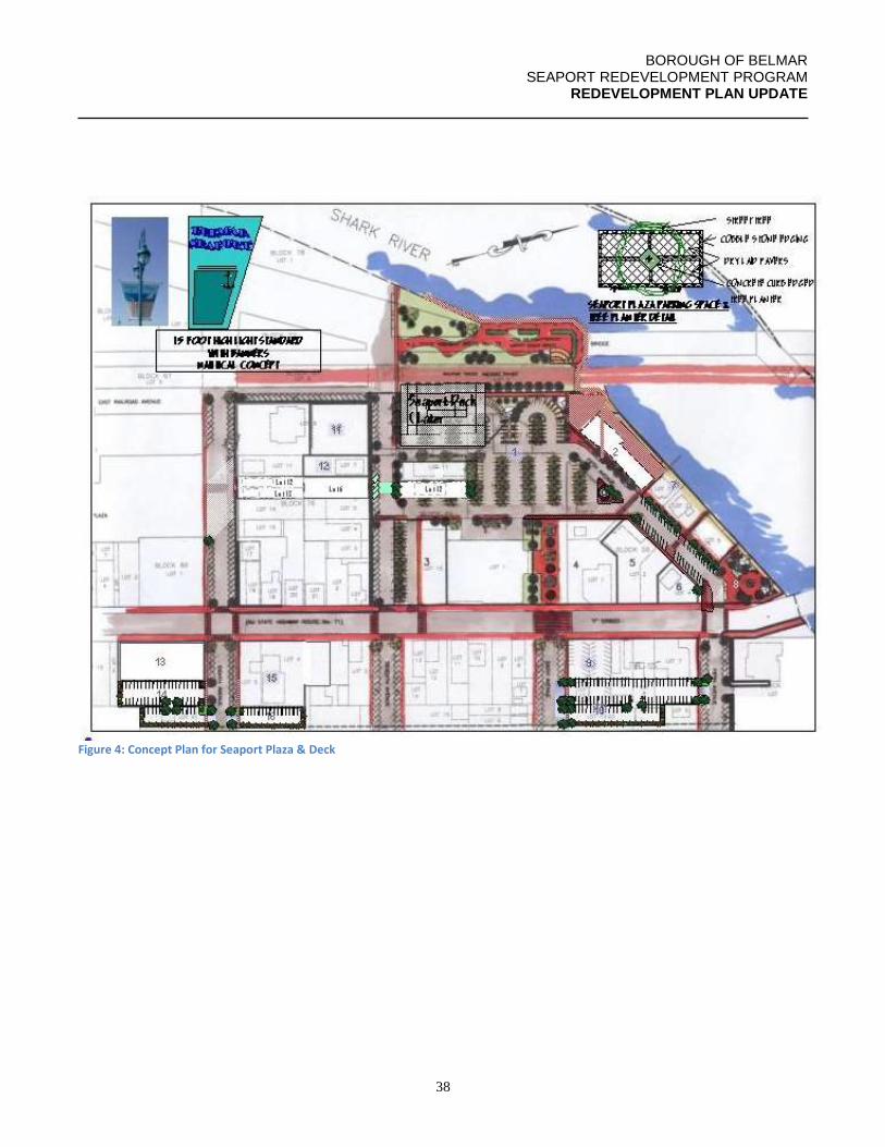
BOROUGH OF BELMAR SEAPORT REDEVELOPMENT PROGRAM
REDEVELOPMENT PLAN UPDATE
38
Figure 4: Concept Plan for Seaport Plaza & Deck
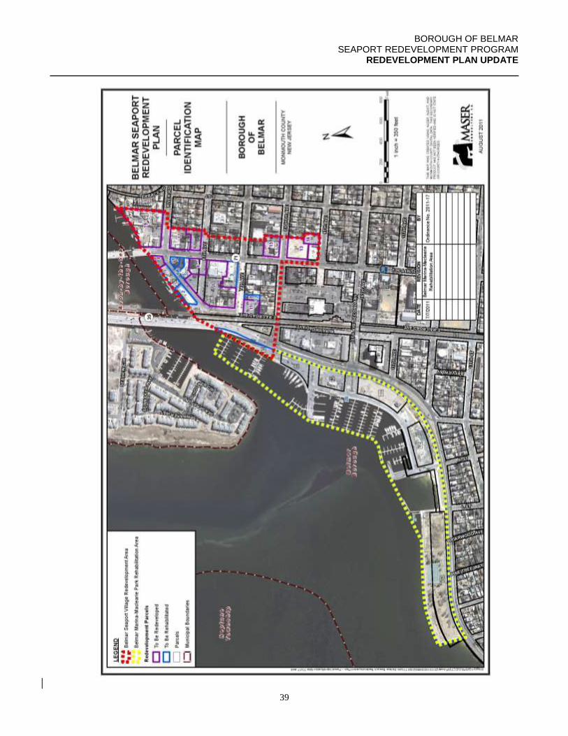
BOROUGH OF BELMAR SEAPORT REDEVELOPMENT PROGRAM
REDEVELOPMENT PLAN UPDATE
39
BOROUGH OF BELMAR SEAPORT REDEVELOPMENT PROGRAM
REDEVELOPMENT PLAN UPDATE
40
BOROUGH OF BELMAR SEAPORT REDEVELOPMENT PROGRAM
REDEVELOPMENT PLAN UPDATE
41
BOROUGH OF BELMAR SEAPORT REDEVELOPMENT PROGRAM
REDEVELOPMENT PLAN UPDATE
42
BOROUGH OF BELMAR SEAPORT REDEVELOPMENT PROGRAM
REDEVELOPMENT PLAN UPDATE
43