search for gold in weaverville - trinity county resource
TRANSCRIPT


When James Hilton, author of “Lost Horizon,” first saw the community, he called it “Shangri La, that strange and wonderful somewhere which is not a place but a state of mind.” Weaverville’s charm is greatly enhanced by the delightful streams that run through the basin. Formerly these stream channels were rich in gold...
At the foot of the Weaver Valley lies a basin holding the historic town of Weaverville.
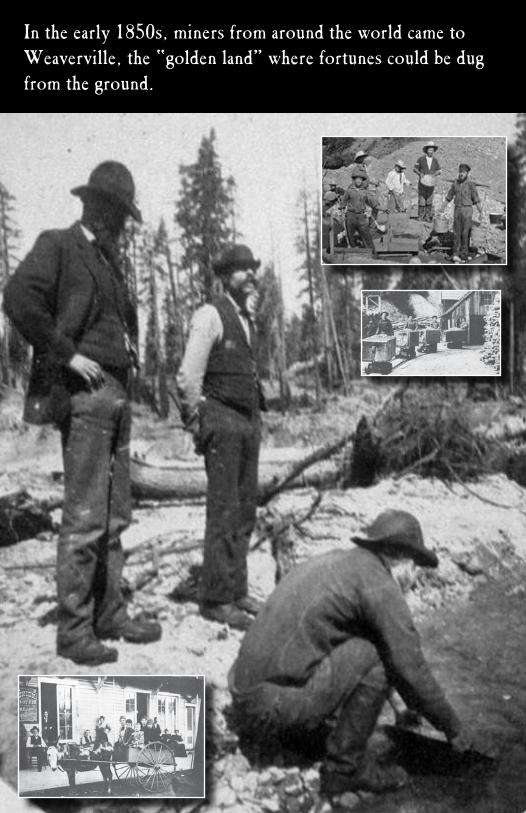
In the early 1850s, miners from around the world came to Weaverville, the “golden land” where fortunes could be dug from the ground.

The first Euroamerican contact in the region occurred when Jedediah Smith’s expedition blazed a trail to Southern Oregon in 1828. Early Euroamerican activity in the Trinity County area was limited to casual exploration or traversing the region en route to the Willamette Valley or to Sacramento. The first settler in the area was Pearson B. Reading. In 1844, he received a Mexican land grant near Redding and named it Rancho de Buenaventura. Reading built a house, ran cattle, planted fruit trees, and grew the first grapevines north of Sacramento. Reading was one of the first to explore the Trinity river system.
A Brief History
Visited only by a few trappers and immigrants, and home to a Native American population, the land was forever altered in 1848 with the discovery of gold at Sutter’s Mill in Coloma and the subsequent influx of people into Northern California. Trinity County was quickly overrun by gold seekers from all parts of the world. Not to be left behind, in 1848, Reading mined the Trinity River near Douglas City, at what is now Readings Bar. His return route
blazed the forthcoming Shasta-Weaverville road, traveling from the Weaverville basin up Rush Creek to the Lewiston area, over Trinity Mountains, then down to the eventual gold rush community of Shasta. News of Reading’s success drew miners to the remote diggings in Trinity County.In 1850, Sacramento newspapers publicized the diggings along Weaver Creek and miners rushed to the area. The town and creek were named for a prospector named either John or George Weaver who is credited with building the first cabin in the basin. In 1851, Weaverville consisted of one round tent and four log cabins. Two years later a school and hospital were established. Townspeople made their first attempt at officially incorporating Weaverville in 1855, electing city officers.It wasn’t long, however, before permanent communities were established and settlers began farming, ranching, and lumbering. Agricultural production was geared to personal consumption rather than for market sale. As California’s Euroamerican population grew, settlers established more regularized exchange routes and sold their surplus to newly arriving immigrants.

The history of Weaverville is much like that of many other mining towns in the California gold country, with its booms and busts, violent episodes, mining and settlement activities, and casts of colorful characters.
Weaverville’s early growth was stunted several times by fire. An 1853 blaze burned nearly half the town and two years later another burned 29 houses. Only two months later, in December 1855, a third fire destroyed many more buildings. The damage would have been greater, but townspeople had begun to construct buildings with brick. Twenty brick buildings dotted the town streets by 1859.
Weaverville residents mined the surrounding area using the technologies and techniques of the time, including gold pans, long toms, rockers, and ground sluicing.
“Before leaving Weaver I must speak of the town. It is a purely mining town—no other interest there except such as bears upon that—so it is like California in bygone times. There are a few valley ranches, very small, in the county; they raise something, but everything else must come from the outside. Sluices run through the town, but the town has no limits, no corporation. The houses grew more and more scattered up and down the valley—some are “washed out”—one church has been sluiced around until only enough land remains for it to stand upon.”
“There are twenty-eight saloons and liquor holes in the place, and gambling and fighting are favorite pastimes.”
From the Diary of William H. BrewerSeptember 24-27, 1862
Along the whole length of the creek,as far as one could see, on the banks of the creek, in the ravines, in the middle of the principal and only street in the town, and even inside some of the houses, were parties of miners, numbering from three or four to a dozen, all hard at work, some laying into it with picks, some shoveling the dirt into the “long toms” or with long handled shovels washing the dirt thrown in, and throwing out the stones,while others were
working pumps or baling water out of the holes with buckets. There was continual noise and clatter, as mud, dirt, stones, and water were thrown about in all directions; and the men, dressed in ragged clothes and big boots, wielding picks and shovels, and rolling big rocks about, were all working as if for their lives, going into it with a will, and a degree of energy, not usually seen among laboring men...”

Most of the world’s gold is locked deep underground, embedded in hard rock. But California gold was different—easily accessible to anyone with a few simple tools and a willingness to work hard.“It’s free politically. It doesn’t belong to anybody. There is no sign that says keep out. There’s no government .... nor judicial system .There are no boundaries, there’s no rules. It’s there, it’s free.”J.S. HollidayIt isn’t hard to understand why men left their homes and loved ones to travel thousands of miles to look for gold. At the time the average wage in the United States was less than a dollar for a twelve-hour day. In California, gold was free to anyone who could find it. A miner could take $25-$35 of gold a day—or even more—out of a river bed. Stories of miners becoming rich men in a single day spread like wildfire. Many of these stories were exaggerations, but some of them were true.
“The golden land where fortune could be dug from the ground.”
Miners’ tools were primitive by today’s standards, but the methods of gathering gold changed rapidly as the “easy pickings” disappeared. Tools were invented at a rapid rate as miners from all over sought new and more effective means of mining the ore.

According to one newspaper account, 1855 to 1860 were the most prosperous in Trinity County. Low-lying areas near sources of water were extensively mined during this period. Construction of water conveyance systems such as ditches, hollowed logs, flumes, and penstocks allowed the mining of higher grounds above the creeks in the 1860s. As the gold became harder to extract, miners looked
for ways of improving the local mining technology. Isaac Woodbury was the first to use the new technology of hydraulic mining at his mine in Garden Gulch near Weaverville. The appearance of the monitor in 1870, and its use in hydraulic mining, forever changed the surrounding landscape and mining technology. Hydraulic technology allowed expansion of mining to high benches previously inaccessible or unprofitable due to their distance from water.
“If you are a miner, nature is your enemy. At least your obstacle—your opposition. You have got to bust through nature, you have got to crack it open.You have got to tear it apart. You have got to rearrange it to get the gold. And once you get the gold, having rearranged the place, you walk away and leave it.”J.S. Holliday
Painting of La Grange Mine, Weaverville (Bancroft Library)

Within the Weaver basin in the early 1850s there was placer mining and hydraulicking along the creeks and drainages. With the advent of ditches came ground sluicing and finally the extensive dredging operations with more sophisticated mining equipment in the first half of the twentieth century. What remains is a topography greatly changed by the mining industry.
All these pictures show what looks like “natural” landscape but we will find that this is far from true. The area around Weaverville has been mined heavily and the topography has been changed forever. We will now look at ways in which the miners changed the face of the land in the search for gold.

As noted by William H. Brewer, a visitor to the area in 1862,“the river here makes a curve. A stratum of soil twenty or thirty feet thick forms a flat at the curve of the river, of limited extent. The ‘bed rock’ beneath this is of metamorphic slates, much twisted, contorted in every shape by former volcanic convulsions, and much of it very hard. The soil above is very hard, like rock itself, made up of loose rounded bowlders, cemented by a firm red clay into a mass as hard as ordinary sandstone. In this the gold is found.
“Deep ditches are cut, not only through this, but deep down in to the hard bed rock beneath, often twenty or more feet into the latter, and running out to the river. In these are the ‘sluices’—merely long troughs for conveying the water. The bottoms of these sluices are made of block sawed from the ends of partially squared timber, so that the end of the grain is presented to the surface, sometimes of a double row, sometimes, however, of but a single row of blocks. These do not lie perfectly square and level, so, as the water flows swiftly over them, they cause a ripple, like water flowing swiftly over the stony bed of a stream. The bottom of the box or trough, below these blocks, is perfectly tight, and quicksilver is poured in and collects in all the holes between the blocks.
“Ditches, from miles back in the mountain, bring the water up against the hillside, far above the surface of the flat, and a flume, or ‘race,’ built on high stilts, over seventy or one hundred feet high, brings the water directly over the ‘claim.’ A very stout hose, often six inches in diameter, conducts the water down from this high head, and has at its end a nozzle like that of a fire engine, only larger. Now, this stream of water, heavy and issuing with enormous force from the great pressure of so high a head of water, is made to play against this bank of hard earth, which melts away before it like sand, and all flows into the sluices—mud, bowlders, gold. The mud is carried off in the stream of thick, muddy water; the bowlders, if not too large, roll down with the swift current; the heavier gold falls in the crevices and is dissolved in the quicksilver, as sugar or salt would be in water. In some mines these sluices are miles long, and are charged with quicksilver by the thousands of pounds. This washing down banks by such a stream of water under pressure is ‘hydraulic mining.’ After a certain time the sluices are ‘cleaned up,’ that is, the blocks are removed, the quicksilver amalgamated with the gold, is taken out, the former being then driven off by heat—’retorted’—and the gold left.”

Miners formed informal companies to dam rivers and reroute the water in order to extract the gold. This method was soon replaced by more sophisticated means employed by corporations. The most powerful of these being was mining—huge jets of water that washed away the landscape.
“Jets so powerful, they could kill a man two-hundred feet away.”
Hupp Hydraulic Mine on East Weaver Flat

A mining boom was the result of the new technology. By 1870, Weaverville was shipping $1.5 million worth of gold annually. By the end of the century, miners had named and exploited most of the watersheds around the town of Weaverville.The engineering difficulties encountered in bringing water to the mines were very great due to the rocky and mountainous nature of the country through which the canals were brought. Hollows and valleys were spanned at a great height by aqueducts, supported on graceful scaffolding of pine logs, and precipitous mountains were girded by wooden flumes projecting from their rocky sides. Throughout the course of a canal, wherever water was wanted by the miners, it was supplied to them by the inch, a sufficient quantity for a party of five or six men costing about seven dollars a day.
The Testy Placer Mine near WeavervilleThe La Grange Mine, near Weaverville, was one of the largest hydraulicking mines in the state. The La Grange was a consolidation of mines with more than 3,000 acres, 3,000 feet of sluice boxes, and 27 miles of ditches and flumes. La Grange also hosted a sawmill, ice house, and electrical plant. In total, there were 87 hydraulic mines in operation in Trinity County. The 1916 State Mineralogist report also lists more than 60 quartz mines, six ground sluicing placer mines, eight drift mines and two gold dredging fields in operation in Trinity County. The pre-eminence of mining ensured that all other local industries would be its auxiliaries. Transportation, lumbering, water, power generation, and ranching were all directed and influenced by the mining industry.Mines used an enormous quantity of lumber in flumes, shoring, housing and general equipment. Lumber production in Shasta and Trinity counties was limited to production for local markets. Rough lumber was hauled some distance over the early roads, but it was too expensive to haul logs for any distance. With the development of the diesel truck and macadamized roads (made of layers of compacted broken stone), the cost of transporting logs was low enough to offset the waste at the mill. Widespread adoption of hydraulic technology also created a mini-industry in Weaverville focused on the manufacture of iron piping for the mines.Agriculture also reaped the benefits of mining, as orchards of fruits and nuts were planted, truck gardens sown, and livestock ranches established.The most important adjuncts of the mining industry for future generations, however, were the elaborate ditch and flume systems, which brought water not only to the mines, but to agricultural, commercial, and residential interests as well.
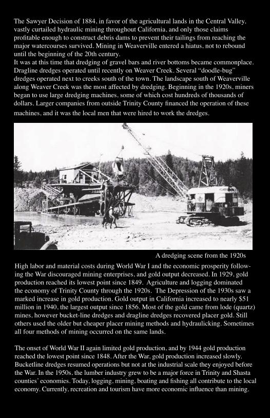
The Sawyer Decision of 1884, in favor of the agricultural lands in the Central Valley, vastly curtailed hydraulic mining throughout California, and only those claims profitable enough to construct debris dams to prevent their tailings from reaching the major watercourses survived. Mining in Weaverville entered a hiatus, not to rebound until the beginning of the 20th century.It was at this time that dredging of gravel bars and river bottoms became commonplace. Dragline dredges operated until recently on Weaver Creek. Several “doodle-bug” dredges operated next to creeks south of the town. The landscape south of Weaverville along Weaver Creek was the most affected by dredging. Beginning in the 1920s, miners began to use large dredging machines, some of which cost hundreds of thousands of dollars. Larger companies from outside Trinity County financed the operation of these machines, and it was the local men that were hired to work the dredges. iffles.
High labor and material costs during World War I and the economic prosperity follow-ing the War discouraged mining enterprises, and gold output decreased. In 1929, gold production reached its lowest point since 1849. Agriculture and logging dominated the economy of Trinity County through the 1920s. The Depression of the 1930s saw a marked increase in gold production. Gold output in California increased to nearly $51 million in 1940, the largest output since 1856. Most of the gold came from lode (quartz) mines, however bucket-line dredges and dragline dredges recovered placer gold. Still others used the older but cheaper placer mining methods and hydraulicking. Sometimes all four methods of mining occurred on the same lands.
The onset of World War II again limited gold production, and by 1944 gold production reached the lowest point since 1848. After the War, gold production increased slowly. Bucketline dredges resumed operations but not at the industrial scale they enjoyed before the War. In the 1950s, the lumber industry grew to be a major force in Trinity and Shasta counties’ economies. Today, logging, mining, boating and fishing all contribute to the local economy. Currently, recreation and tourism have more economic influence than mining.
A dredging scene from the 1920s

These images depict how large-scale placer and hydraulic mining activities altered the landscape. Today, the flume and water transportation systems have been lost to the vicissitudes of time and weather, leaving behind only the piles of hand-stacked and turned rock.

The Chinese in Weaverville
The first Chinese came to Weaverville from Shasta in 1853, a few at a time, and for companies that paid weekly. By 1854, they had established a Chinatown with four stores, four gambling saloons, and a restaurant, at a time when their population totaled about 1000 in the town and vicinity. A Chinese temple, the “Joss House,” was built in 1853. The structure was destroyed by fire in 1869 and rebuilt in 1874. This is the oldest continually used Chinese temple in California and a State Historic Landmark in Weaverville.
By the 1870s, Euroamerican miners considered the ground to be worked out and abandoned their claims. It was a common pattern for Chinese miners to move into supposedly
worked-out areas, and Weaverville became one of their most important strongholds in California. In 1870, however, the population had dwindled to 250, largely due to the floods of 1861-2, which wiped out many improvements along the rivers, and the American Civil War. In 1880, however, the Chinese population had increased to 493, evidently as they reworked the placers of the earlier miners. By 1886 their numbers were reduced to 75, and became increasingly smaller during the early years of the 20th century.
The Joss House in Weaverville

The See Yup Cemetery
At least two cemeteries were established in the 1850s by Chinese: the See Yup Cemetery, established by members of the Canton Company, and the Hong Kong Cemetery. Many of the dead buried in Weaverville were granted impressive funerals at the Chinese Masonic Temple on Main Street. Evidently the Chinese first buried their dead in the Weaverville Cemetery near Oregon Street but by the late 1850s had been forbidden to inter their dead “because of their quarrels and heathenish conduct at dead feasts.” The Chinese may, however, have continued burying their dead in the Public Cemetery as late as 1873, for a newspaper account that year noted:
The public burying grounds of Weaverville, in their present condition, are a disgrace to the community. Limbs, old boxes and other lumber from which have been exhumed the bodies of defunct Chinamen, are strewn around in every direction so that the passerby is impeded at every step (Trinity Journal June 1875)
In the early 1850s, J.D. Borthwick visited the mines and described the Chinese camps.“While walking around the diggings in the afternoon, I came upon a Chinese camp in a gulch near the village. About a hundred Chinamen had here pitched their tents on a rocky eminence by the side of their diggings. When I passed they were at dinner or supper, and had all the curious little pots and pans and other ‘fixins’ which I had seen in every Chinese camp and were eating the same dubious looking articles which excite in the mind of an outside barbarian a certain degree of curiosity to know what they are composed of but not the slightest desire to gratify it by the sense of taste…The Chinese invariably treated in the same hospitable manner any one who visited their camps, and seemed rather pleased than otherwise at the interest and curiosity excited by their domestic arrangements.”

The Sam Lee Ranch House
Those Chinese who remained in the area turned to other pursuits. Sam Lee became a miner, farmer, and storekeeper, while his son Moon Lee operated another commercial establish-ment in town, served as an important member of the Chamber of Commerce, and eventu-ally was appointed to the State Highway Commission.
Evidence of numerous Chinese camps can still easily be found in and around the Weaverville area, such as fragments of pots and ceramics mixed into the top layers of earth.

West Weaver CreekWeaverville’s mining area encompasses over 20 gulches, drainages, and tributaries of Weaver Creek, all of them producers of gold to varying degrees. On the west side of town, the West Weaver Creek drainage, although not as profitable as the gulches and tributaries of Weaver and East Weaver creeks, was nonetheless a significant contributor to the overall gold production in the basin and represents a microcosm of the entire district.
As you follow the trails or hike through the area, stop to note the landscape around you: the piles of large rocks, the deep gulches, the cut banks. As you ascend the slopes, notice the deep ditches which wind their way around the hillsides, and, in the larger drainages, the immense earthen dams that impounded the waters in preparation for washing the gold.

THE WEAVERVILLE BASIN TRAIL SYSTEM

A close examination of these aerial photographs of the West Weaver Creek Basin shows the immense effect mining has had on the landscape around the river. The rocks clearly show how the water has been channeled before reaching the river in the painstaking search for gold.

A photograph from the “golden” age of mining
This painting (above) depicts the methods of placer mining and closely resembles the landscape of the Weaver Basin today (below).

Farther down the creek you will see a few fruit trees, remnants of the extensive orchard of William Lowden, where over 50 varieties of apples, plums, prunes, peaches, and pears were planted in 1890 to serve the miners and their families.
If you are to continue your West Weaver Creek walk, marvel at the vast piles of gravel where dredges toiled day and night to turn the earth and extract the gold, totally obliterating the work of earlier miners, and leaving behind their cornrows of rock piles.Here you can find relics from the past from miners and their quest for gold. Tin cans, pipes and metal pins can all be easily found, abandoned and steadily rusting between the rocks. Enjoy viewing these artifacts, but please do not remove them—both to preserve the area for the education of future visitors, and to avoid breaking the law.

What is so fascinating as you walk the trails of the West Weaver Creek Basin is that nothing you see was as nature made it, but was forever altered by the human quest for gold.
