seasonal temperature variations - atmospheric …zwang/atsc2000/ch3.pdf · temperature observed at...
TRANSCRIPT

1
Fig. 3-CO, p. 54
Seasonal and Daily Temperatures
Seasonal Temperature Variations
• What causes the seasons – What governs the seasons is the amount of solar radiation
reaching the ground
• What two primary factors determine the amount of radiation reaching the ground? – Sun Angle – Time of exposure– These are created due to the earth's tilt and it's orbiting
around the sun– Earth’s axis of rotation is tilted by 23.5° from the vertical
axis– Also the amount of atmosphere the solar radiation has to
pass through

2
Earth’s orbit around sun is elliptical
The elliptical path (highly exaggerated) of the earth about the sun brings the earth slightly closer to the sun in January than in July.
Sunlight that strikes a surface at an angle is spread over a larger area than sunlight that strikes the surface directly. Oblique sun rays deliver less energy (are less intense) to a surface than direct sun rays.
Sun Angle

3
Test your knowledge with this interactive tool that determines the amount of solar radiation at the top of the atmosphere anytime during the year and at any latitude
http://profhorn.meteor.wisc.edu/wxwise/radiation/sunplot6.html
The relative amount of radiant energy received at the top of theearth’s atmosphere and at the earth’s surface on June 21—the summer solstice.
1. The length of day light2. The amount energy reach the surface
Land of the Midnight Sun. A series of exposures of the sun taken before, during, and after midnight in northern Alaska
during July.

4
How are the seasons determined?
• The astronomical definition– Based on the relative position between Sun and
Earth: length of day
• Meteorological definition– Based on temperature– Spring -- MAM– Summer -- JJA– Fall -SON– Winter--DJF
Winterbegins on the Winter Solstice (21 December)shortest day of the year24 hours of darkness above arctic circle less than 12 hours of daylight everywhere in NHsun angle is 90° at Tropic of Capricorn ends on the Vernal equinox (20 March)
Summerbegins on the summer solstice (21 June)
longest day of the year in NH24 hrs of sunlight north of arctic circlemore than 12 hours of daylight in NHsun angle is 90° at Tropic of Cancer ends on the Autumnal equinox (September 22)
Fallbegins on the Autumnal equinox (22 September)12 hours of sunlight everywhere sun angle is 90° at equator ends on the Winter solstice (21 December)
Seasons in the Northern Hemisphere –The astronomical definition
Springbegins on the Vernal Equinox (20 March)12 hours of sunlight everywheresun angle is 90° everywhere ends on the Summer Solstice (21 June)

5
QUESTIONS FOR THOUGHT:1. Consider two scenarios: (a) The tilt of the Earth
decreased to 10°. (b) The tilt of the Earth increased to 40°. How would this change the summer and winter temperatures here at Laramie?
2. Where would you expect to experience the smallest variation in temperature from year to year and from month to month? Why?
3. At the top of the earth's atmosphere during the early summer (Northern Hemisphere), above what latitude would you expect to receive the most solar radiation in one day? During the same time of year, where would you expect to receive the most solar radiation at the surface?
Table 3-1, p. 60
Summary of the SeasonsCheck out this animation showing the earth's orbit about the sun and amount of daylight for different latitudes:http://www-das.uwyo.edu/~zwang/atsc2000/Animations/44_Seasons/44.html
6
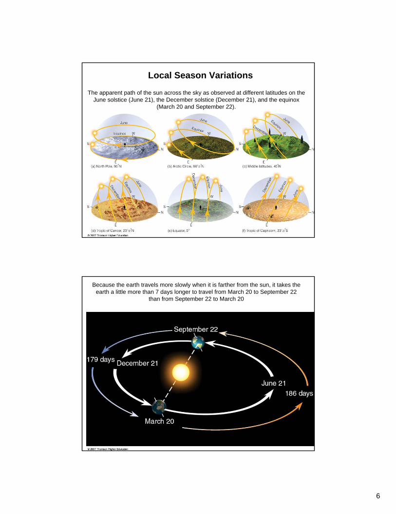
The apparent path of the sun across the sky as observed at different latitudes on the June solstice (June 21), the December solstice (December 21), and the equinox
(March 20 and September 22).
Local Season Variations
Because the earth travels more slowly when it is farther from the sun, it takes the earth a little more than 7 days longer to travel from March 20 to September 22
than from September 22 to March 20

7
In areas where small temperature changes can cause major changes in soil moisture, sparse vegetation on the south-facing slopes will often contrast with lush vegetation on the north-facing slopes.
Yearly temperature variation in the Northern Hemisphere
• Notice that the min and max temperatures lag behind the seasons......– minimum in January, not the winter solstice
(21 December)!– maximum in July/August, not the summer
solstice 21 June)!– WHY?
8
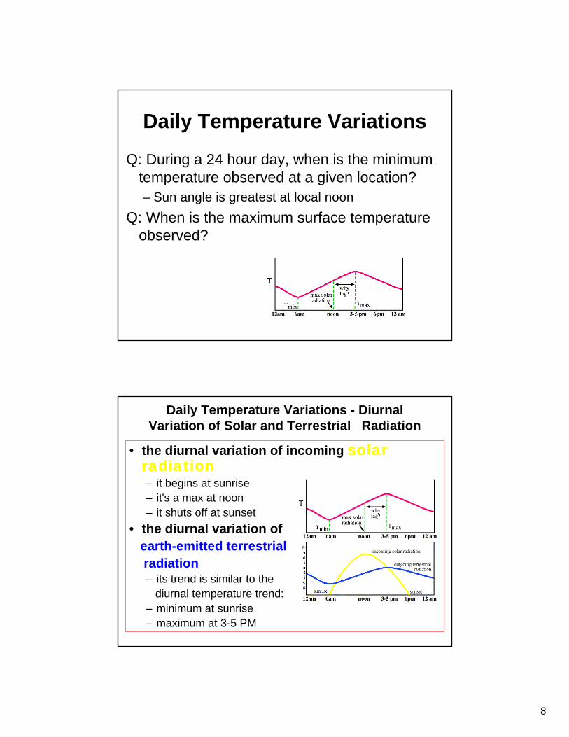
Daily Temperature Variations
Q: During a 24 hour day, when is the minimum temperature observed at a given location?– Sun angle is greatest at local noon
Q: When is the maximum surface temperature observed?
Daily Temperature Variations - Diurnal Variation of Solar and Terrestrial Radiation
• the diurnal variation of incoming solar radiation– it begins at sunrise– it's a max at noon– it shuts off at sunset
• the diurnal variation of earth-emitted terrestrialradiation– its trend is similar to the
diurnal temperature trend:– minimum at sunrise– maximum at 3-5 PM

9
Daily Temperature Variations - Net Radiation• The net radiation determines whether the surface
temperature rises, falls, or remains the same:• net radiation = incoming solar - outgoing IR
– If the net radiation > 0, surface warms ( 6 AM - 3-5 PM)– if the net radiation < 0, surface cools (3-5 PM - 6 AM)
• This also explains why the warmest part of the year is in July/August, not on 21 June during the summer solstice.
Factors Affecting Daytime Warming - Fundamental Process
What factors affect the rate of daytime warming?• What is the fundamental process which creates warming at the
earth's surface?– Short wave radiation is absorbed by the earth's surface - heats up the
ground• How does the hot ground transfer this energy to the atmosphere?
– Heat is transported from the hot surface to air molecules very near the hot surface by conduction
• Heat is then transported further upward by convection - thermals of air
• The layer of air near the earth's surface where most of the daily temperature variation occurs as a result of the heating/cooling of the ground is called the boundary layer– the boundary layer is typically 1-1.5 km deep
10
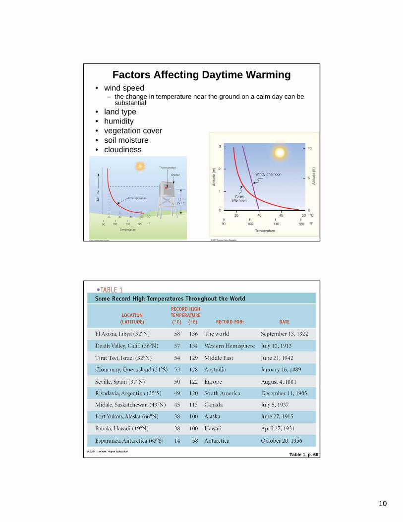
Factors Affecting Daytime Warming• wind speed
– the change in temperature near the ground on a calm day can be substantial
• land type • humidity • vegetation cover • soil moisture • cloudiness
Table 1, p. 66

11
The hottest place in North America, Death Valley, California, where the air temperature reached 57°C (134°F).
Night time cooling• During the night time hours, there is no SW heating the
ground, so the ground cools rapidly• hence, there is heat transfer by conduction from the
warm air to the cold ground• this heat transfer occurs in a shallow layer near the
ground since air is a poor conductor• a "radiation inversion" is formed: a shallow layer of air
near the earth's surface where the temperature increases with height
• average radiation inversion depth is about 100m, but can vary from 10m - 1 km

12
Factors promoting radiation inversion formation
• calm winds versus strong winds
• long nights versus short nights • dry air versus humid air • clear skies versus cloudy skies
• other factors:– surface wetness – vegetation type – surface type (snow,
sand, grass, etc...)
Drainage/Valley flows• What happens in valleys at night?
– heat is conducted from the near-surface air to the cold ground
– cool air near the ground descends down the slope into the valley
• what is the result of this process?
Cold air Cold ai
r

13
Table 2, p. 69
Protection against damaging frostUse wind machines
Use orchard heaters
What are they trying to accomplish ?

14
Protection against damaging frostOther methods
cover plants with a blanketflooding the ground in orchard
emit fine mist of water with sprinklers
Temperature Controls
At a given location, what factors affect the location's temperature?
– Latitude – land and water – ocean currents – elevation
January
July
Average air temperature near sea level

15
Temperature Variables• Daily (or diurnal) range of temperature - the
difference between the daily maximum and minimum temperature.
• Mean daily temperature - average of the highest and lowest temperature for a 24 hour period.
• Annual range of temperature - the difference between the average temperature of the warmest and coldest months.
• Mean annual temperature - average of the twelve monthly average temperatures.
The daily range of temperature decreases as we climb away from the earth’s surface. Hence, there is less day-to-night variation in air temperature near the top of a high-rise apartment complex than at the ground level.
The height dependency of daily range of temperature

16
Monthly temperature data and annual temperature range for St. Louis, Missouri, a city located near the middle of a continent and Ponta Delgada, a city located in the Azores in the Atlantic Ocean.
Monthly temperature and annual temperature range—Location effect
Temperature data for San Francisco, California (37°N), and Richmond, Virginia (37°N)—two cities with the same mean annual temperature.
Monthly temperature and annual temperature range—Location effect

17
The high temperature measured (for 30 years) on March 15 in a city located in the southwestern United States. The dashed line represents the normal temperature for the
30-year period.
When it comes to Temperature, what’s normal?
Heating Degree-days• Application of temperature data to energy
consumption:• A heating degree-day is defined as:
– 65°F - mean daily temp
Mean annual total heating degree-days in thousands of °F, where the number 4 on the map represents 4000 (base 65°F). (Data from U.S. Department of Commerce)

18
Cooling Degree-days• Application of temperature data to energy
consumption:• A cooling degree-day is defined as:
– mean daily temp - 65°F
Mean annual total cooling degree-days in thousands of °F, where the number 1 on the map represents 1000 (base 65°F). (Data from U.S. Department of Commerce)
Growing Degree-daysNormally, a growing degree-day for a particular day is defined as a day on which the mean daily temperature is one degree above the base temperature (also known as zero temperature) – the minimum temperature required for growth of that crop.

19
Air Temperature and Human Comfort The Wind Chill Index (WCI)
• Often on cooler days when the wind is blowing, the air temperature "feels" cooler than it actually is.
• Why?
The formula for calculating the Wind-chill equivalent temperature is: Wind Chill Temperature (ºF) = 35.74 + 0.6215T – 35.75(V0.16) + 0.4275T(V0.16)
where T is the air temperature and V is the wind speed in miles per hour.
In metric units: Wind Chill Temperature (ºC) = 13.12 + 0.6215T – 11.37(V0.16) + 0.3965T(V0.16)
where T is the air temperature and V is the wind speed in km per hour.
Table 3-3, p. 77
Frostbite: freezing skinHypothermia: the rapid, progressive metal and physical collapse that accompanies the lowering of human body temperature.

20
Table 3-4, p. 78
Measuring Temperature• Types of thermometers:
– Liquid-in-glass thermometer: glass tube filled with liquid (often mercury or alcohol) that expands/contracts with air temperature
– Maximum thermometer: usually are liquid-in-glass thermometers that record maximum observed temperature
– Minimum thermometer: usually are liquid-in-glass thermometers (use alcohol) that record minimum observed temperatures
– Electrical resistance thermometers - measure temperature by measuring resistance in a wire
– Radiometer - measures radiation emitted by an object

21
Liquid-in-glass thermometer A section of a maximum thermometer
A section of a minimum thermometer showing both the current air temperature and the minimum temperature in °F.

22
The thermograph with a bimetallic thermometerThe two metal (usually brass and iron) expand differently as
temperature change.
Recording partSensor part
Where should one measure air temperature?
• In the shade• Not at the ground -
typically 2 meters above ground level
• Most instrumentation shelters are 1.5-2 meters above the ground

23
The max–min instrument shelter (middle box) and other weather instruments that comprise the ASOS system.
Grass surface
Fig. 1, p. 62