second circular - globalgeochemicalbaselines · second circular dear colleagues, this is the second...
TRANSCRIPT
National and Kapodistrian University of Athens Harokopio University
of AthensGeotechnical Chamber of Greece
15th International Congress of the Geological Society of GreeceAthens, 22-24 May 2019
EXPLORING AND PROTECTING OUR LIVING PLANET EARTH
www.gsg2019.gr
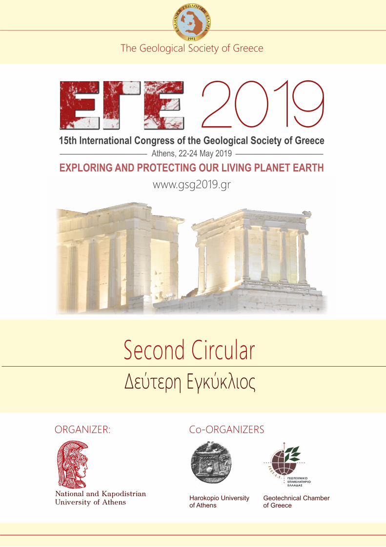
Δεύτερη Εγκύκλιος
Second Circular
The Geological Society of Greece
ORGANIZER: Co-ORGANIZERS
15th International Congress of the Geological Society of Greece | www.gsg2019.gr
SECOND CIRCULAR
Dear colleagues,
This is the second circular for the 15th International Congress of the Geological Society of Greece –
GSG2019: “Understanding and Protecting our Living Planet Earth”, to be held at the premises of
Harokopio University, Athens, Greece, between 22-24 May 2019.
The International Congresses of the Geological Society of Greece are multidisciplinary earth science
events, focusing on, but not limited to, the broader Aegean region and its surroundings, with the
view to highlighting the contribution of geosciences to the study of natural resources, natural hazards
and environment.
Please check the official GSG2019 web site: www.gsg2019.gr for updated information.
SUBJECTS GSG 2019 addresses all subjects of Earth Science, including: Active Tectonics, Applied Geophysics,
Applied Mineralogy, Archaeometry, Atmospheric Environment, Climatology, Energy Resources,
Engineering Geology, Environment and Health, Geoarchaeology, Geochemistry, Geochronology,
Geology and Education, Geosciences and Environment, Geothermal Energy, Geoconservation, GIS
and Geoinformatics, Hydrogeology, Industrial Rocks and Minerals, Marine Geology, Meteorology,
Mineralogy, Mineral Exploration, Natural Hazards, Neotectonics, Oceanography, Ore Deposits,
Palaeoclimatology, Palaeontology, Physical Geography, Physics of the Earth's Interior, Quaternary
Geology, Remote Sensing / Earth Observation, Sedimentology, Seismology, Speleology, Stratigraphy,
Structural Geology, Sustainable Development, Tectonics, Urban Geology. The Congress Scientific
Program is grouped under broad thematic headers and organizes in Sessions – more at the respective
chapter in this circular.
15th International Congress of the Geological Society of Greece | www.gsg2019.gr
ORGANIZATION The GSG2019 Congress is organized by the National and Kapodistrian University of Athens (NKUA).
Co-organizers are the Harokopio University of Athens (HUA) and the Geotechnical Chamber of
Greece (GEOTEE).
ORGANIZING COMITEE Congress Chair:
Efthymis Lekkas, Professor, NKUA [email protected]
Vice-Chair:
Issaak Parcharidis, Professor, HUA [email protected]
Secretariat:
Hara Drinia, Professor, NKUA [email protected]
Assimina Antonarakou, Assoc. Professor, NKUA [email protected]
Evangelia Kotsi, Ph.D.c., GEOTEE [email protected]
Treasurer:
Haralambos Kranis, Ass. Professor, NKUA [email protected]
Members:
Theodora Rondoyianni, Professor, National Technical University of Athens
Athanassios Ganas, Research Director, National Observatory of Athens
Dimitris Sakellariou, Research Director, Hellenic Centre for Marine Research
Ioannis Papanikolaou, Assoc. Professor, Agricultural University of Athens
Loukas Georgalas, Dr. Geologist, Ministry of Environment and Energy
Spyros Lalechos, Dr. Geologist, Earthquake Planning and Protection Organization
Evgenia Moraiti, Dr. Geologist, Institute of Geology and Mineral Exploration
Nikolaos Nikolaou, Dr. Geologist, Institute of Geology and Mineral Exploration
Xenophon Stavropoulos, Dr. Geologist, Association of Greek Geologists
SECRETARIAT AND CORRESPONDENCE For any inquiries and information, please contact one of the Congress Secretaries, the Congress
Treasurer, or through the Congress organizing agency:
Niki Bai, NBevents
5, Adrianoupoleos str., 55133 Thessaloniki, Greece
Tel. +30 2310-223461, e-mail: [email protected]
You can also use the contact form at: https://www.gsg2019.gr/contact-us-3/, or email us:
15th International Congress of the Geological Society of Greece | www.gsg2019.gr
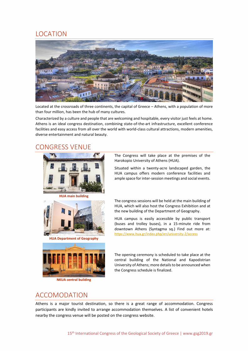
LOCATION
Located at the crossroads of three continents, the capital of Greece – Athens, with a population of more
than four million, has been the hub of many cultures.
Characterized by a culture and people that are welcoming and hospitable, every visitor just feels at home.
Athens is an ideal congress destination, combining state-of-the-art infrastructure, excellent conference
facilities and easy access from all over the world with world-class cultural attractions, modern amenities,
diverse entertainment and natural beauty.
CONGRESS VENUE
HUA main building
The Congress will take place at the premises of the Harokopio University of Athens (HUA).
Situated within a twenty-acre landscaped garden, the HUA campus offers modern conference facilities and ample space for inter-session meetings and social events.
HUA Department of Geography
The congress sessions will be held at the main building of HUA, which will also host the Congress Exhibition and at the new building of the Department of Geography.
HUA campus is easily accessible by public transport (buses and trolley buses), in a 15-minute ride from
downtown Athens (Syntagma sq.) Find out more at: https://www.hua.gr/index.php/en/university-2/access
NKUA central building
The opening ceremony is scheduled to take place at the central building of the National and Kapodistrian University of Athens; more details to be announced when
the Congress schedule is finalized.
ACCOMODATION Athens is a major tourist destination, so there is a great range of accommodation. Congress
participants are kindly invited to arrange accommodation themselves. A list of convenient hotels
nearby the congress venue will be posted on the congress website.
15th International Congress of the Geological Society of Greece | www.gsg2019.gr
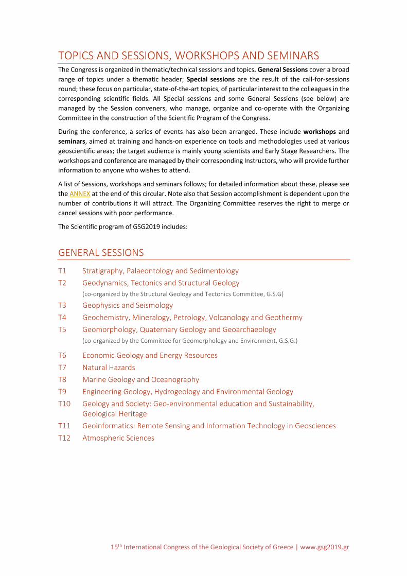
TOPICS AND SESSIONS, WORKSHOPS AND SEMINARS The Congress is organized in thematic/technical sessions and topics. General Sessions cover a broad
range of topics under a thematic header; Special sessions are the result of the call-for-sessions
round; these focus on particular, state-of-the-art topics, of particular interest to the colleagues in the
corresponding scientific fields. All Special sessions and some General Sessions (see below) are
managed by the Session conveners, who manage, organize and co-operate with the Organizing
Committee in the construction of the Scientific Program of the Congress.
During the conference, a series of events has also been arranged. These include workshops and
seminars, aimed at training and hands-on experience on tools and methodologies used at various
geoscientific areas; the target audience is mainly young scientists and Early Stage Researchers. The
workshops and conference are managed by their corresponding Instructors, who will provide further
information to anyone who wishes to attend.
A list of Sessions, workshops and seminars follows; for detailed information about these, please see
the ANNEX at the end of this circular. Note also that Session accomplishment is dependent upon the
number of contributions it will attract. The Organizing Committee reserves the right to merge or
cancel sessions with poor performance.
The Scientific program of GSG2019 includes:
GENERAL SESSIONS
T1 Stratigraphy, Palaeontology and Sedimentology
T2 Geodynamics, Tectonics and Structural Geology
(co-organized by the Structural Geology and Tectonics Committee, G.S.G)
T3 Geophysics and Seismology
T4 Geochemistry, Mineralogy, Petrology, Volcanology and Geothermy
T5 Geomorphology, Quaternary Geology and Geoarchaeology
(co-organized by the Committee for Geomorphology and Environment, G.S.G.)
T6 Economic Geology and Energy Resources
T7 Natural Hazards
T8 Marine Geology and Oceanography
T9 Engineering Geology, Hydrogeology and Environmental Geology
T10 Geology and Society: Geo-environmental education and Sustainability, Geological Heritage
T11 Geoinformatics: Remote Sensing and Information Technology in Geosciences
T12 Atmospheric Sciences
15th International Congress of the Geological Society of Greece | www.gsg2019.gr
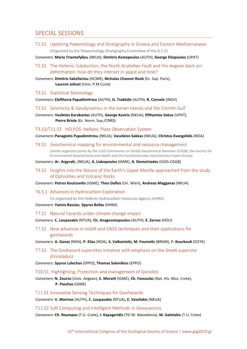
SPECIAL SESSIONS
T1.S1 Updating Paleontology and Stratigraphy in Greece and Eastern Mediterranean
(Organized by the Palaeontology-Stratigraphy Committee of the G.S.G)
Conveners: Maria Triantafyllou (NKUA), Dimitris Kostopoulos (AUTH), George Eliopoulos (UPAT)
T2.S1 The Hellenic Subduction, the North Anatolian Fault and the Aegean back-arc deformation: how do they interact in space and time?
Conveners: Dimitris Sakellariou (HCMR), Nicholas Chamot-Rook (Ec. Sup. Paris),
Laurent Jolivet (Univ. P.M Curie)
T3.S1 Statistical Seismology
Conveners: Eleftheria Papadimitriou (AUTH), G. Tsaklidis (AUTH), R. Console (INGV)
T3.S2 Seismicity & Geodynamics in the Ionian Islands and the Corinth Gulf
Conveners: Vasileios Karakostas (AUTH), George Kaviris (NKUA), Efthymios Sokos (UPAT),
Pierre Briole (Ec. Norm. Sup./CNRS)
T3.S3/T11.S3 HELPOS: Hellenic Plate Observation System
Conveners: Panagiotis Papadimitriou (NKUA), Vassileios Sakkas (NKUA), Christos Evangelidis (NOA)
T4.S1 Geochemical mapping for environmental and resource management (Jointly organized jointly by the IUGS Commission on Global Geochemical Baselines (CGGB), the Society for Environmental Geochemistry and Health and the EuroGeoSurveys Geochemistry Expert Group)
Conveners: Ar. Argyraki, (NKUA), A. Liakopoulos (IGME), A. Demetriades (IUGS-CGGB)
T4.S2 Insights into the Nature of the Earth’s Upper Mantle approached from the study of Ophiolites and Volcanic Rocks
Conveners: Petros Koutsovitis (IGME), Theo Daflos (Un. Wien), Andreas Magganas (NKUA)
T6.S.1 Advances in Hydrocarbon Exploration
Co-organized by the Hellenic Hydrocarbon resources Agency (HHRA)
Conveners: Yannis Bassias, Spyros Bellas (HHRA)
T7.S1 Natural hazards under climate change impact
Conveners: C. Loupasakis (NTUA), Ch. Anagnostopoulou (AUTH), E. Zervas (HOU)
T7.S2 New advances in InSAR and GNSS techniques and their applications for geohazards
Conveners: A. Ganas (NOA), P. Elias (NOA), S. Valkaniotis, M. Foumelis (BRGM), P. Kourkouli (ICEYE)
T7.S3 The Geohazard supersites initiative with emphasis on the Greek supersite (Enceladus)
Conveners: Spyros Lalechos (EPPO), Thomas Salonikios (EPPO)
T10.S1. Highlighting, Protection and management of Geosites
Conveners: N. Zouros (Univ. Aegean), E. Moraiti (IGME), Ch. Fassoulas (Nat. His. Mus. Crete),
P. Paschos (IGME)
T11.S1 Innovative Sensing Techniques for Geohazards
Conveners: V. Marinos (AUTH), C. Loupasakis (NTUA), E. Vassilakis (NKUA)
T11.S2 Soft Computing and Intelligent Methods in Geosciences
Conveners: Ch. Roumpos (T.U. Crete), I. Kapageridis (TEI W. Macedonia), M. Galetakis (T.U. Crete)
15th International Congress of the Geological Society of Greece | www.gsg2019.gr
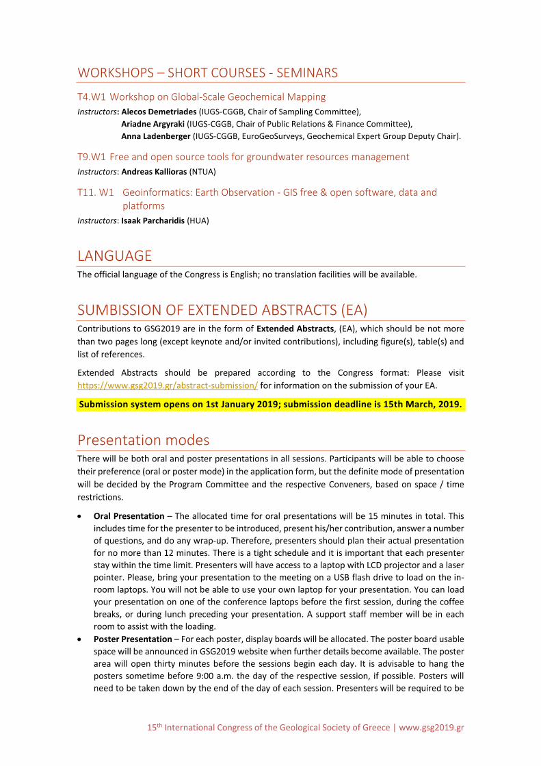
WORKSHOPS – SHORT COURSES - SEMINARS
T4.W1 Workshop on Global-Scale Geochemical Mapping
Instructors: Alecos Demetriades (IUGS-CGGB, Chair of Sampling Committee),
Ariadne Argyraki (IUGS-CGGB, Chair of Public Relations & Finance Committee),
Anna Ladenberger (IUGS-CGGB, EuroGeoSurveys, Geochemical Expert Group Deputy Chair).
T9.W1 Free and open source tools for groundwater resources management
Instructors: Andreas Kallioras (NTUA)
T11. W1 Geoinformatics: Earth Observation - GIS free & open software, data and platforms
Instructors: Isaak Parcharidis (HUA)
LANGUAGE The official language of the Congress is English; no translation facilities will be available.
SUMBISSION OF EXTENDED ABSTRACTS (EA) Contributions to GSG2019 are in the form of Extended Abstracts, (EA), which should be not more
than two pages long (except keynote and/or invited contributions), including figure(s), table(s) and
list of references.
Extended Abstracts should be prepared according to the Congress format: Please visit
https://www.gsg2019.gr/abstract-submission/ for information on the submission of your EA.
Submission system opens on 1st January 2019; submission deadline is 15th March, 2019.
Presentation modes There will be both oral and poster presentations in all sessions. Participants will be able to choose
their preference (oral or poster mode) in the application form, but the definite mode of presentation
will be decided by the Program Committee and the respective Conveners, based on space / time
restrictions.
Oral Presentation – The allocated time for oral presentations will be 15 minutes in total. This
includes time for the presenter to be introduced, present his/her contribution, answer a number
of questions, and do any wrap‐up. Therefore, presenters should plan their actual presentation
for no more than 12 minutes. There is a tight schedule and it is important that each presenter
stay within the time limit. Presenters will have access to a laptop with LCD projector and a laser
pointer. Please, bring your presentation to the meeting on a USB flash drive to load on the in‐
room laptops. You will not be able to use your own laptop for your presentation. You can load
your presentation on one of the conference laptops before the first session, during the coffee
breaks, or during lunch preceding your presentation. A support staff member will be in each
room to assist with the loading.
Poster Presentation – For each poster, display boards will be allocated. The poster board usable
space will be announced in GSG2019 website when further details become available. The poster
area will open thirty minutes before the sessions begin each day. It is advisable to hang the
posters sometime before 9:00 a.m. the day of the respective session, if possible. Posters will
need to be taken down by the end of the day of each session. Presenters will be required to be
15th International Congress of the Geological Society of Greece | www.gsg2019.gr
next to their posters site during specific time slots. Walk-through sessions, where poster authors
will be asked to give a brief description (c. 2 min) of their work, will be organized by the
respective session conveners.
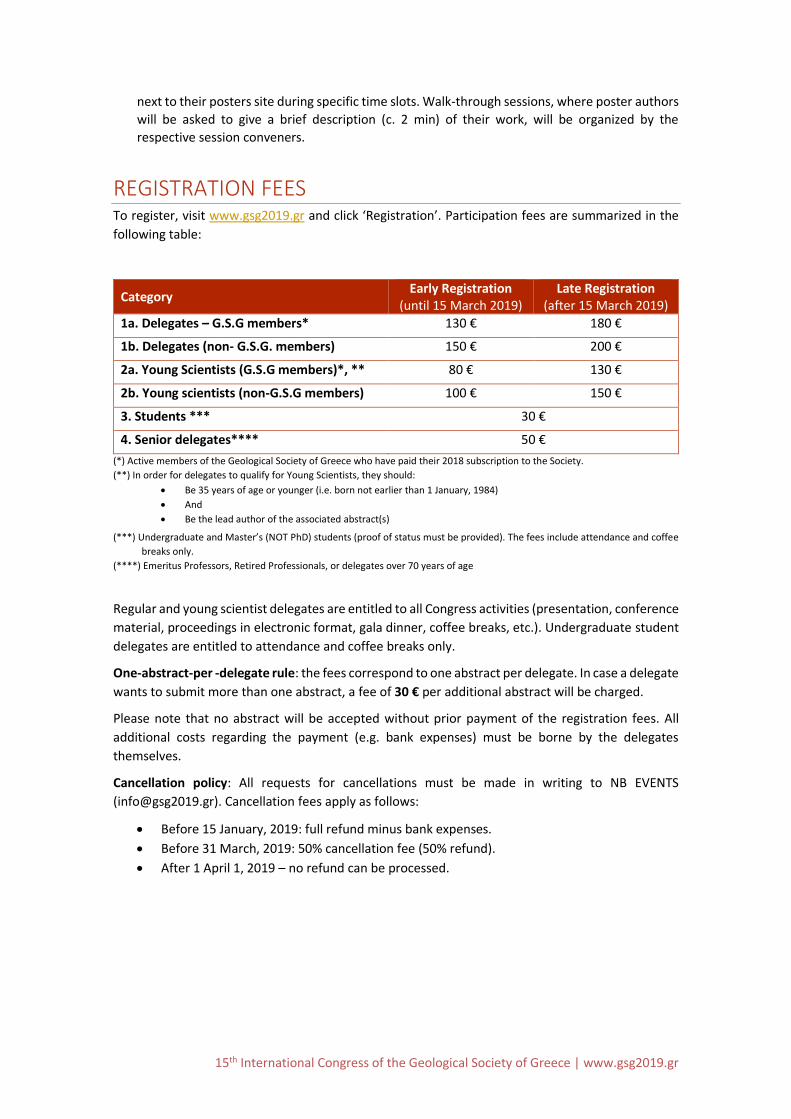
REGISTRATION FEES To register, visit www.gsg2019.gr and click ‘Registration’. Participation fees are summarized in the
following table:
Category Early Registration
(until 15 March 2019) Late Registration
(after 15 March 2019)
1a. Delegates – G.S.G members* 130 € 180 €
1b. Delegates (non- G.S.G. members) 150 € 200 €
2a. Young Scientists (G.S.G members)*, ** 80 € 130 €
2b. Young scientists (non-G.S.G members) 100 € 150 €
3. Students *** 30 €
4. Senior delegates**** 50 €
(*) Active members of the Geological Society of Greece who have paid their 2018 subscription to the Society.
(**) In order for delegates to qualify for Young Scientists, they should:
Be 35 years of age or younger (i.e. born not earlier than 1 January, 1984)
And
Be the lead author of the associated abstract(s)
(***) Undergraduate and Master’s (NOT PhD) students (proof of status must be provided). The fees include attendance and coffee
breaks only.
(****) Emeritus Professors, Retired Professionals, or delegates over 70 years of age
Regular and young scientist delegates are entitled to all Congress activities (presentation, conference
material, proceedings in electronic format, gala dinner, coffee breaks, etc.). Undergraduate student
delegates are entitled to attendance and coffee breaks only.
One-abstract-per -delegate rule: the fees correspond to one abstract per delegate. In case a delegate
wants to submit more than one abstract, a fee of 30 € per additional abstract will be charged.
Please note that no abstract will be accepted without prior payment of the registration fees. All
additional costs regarding the payment (e.g. bank expenses) must be borne by the delegates
themselves.
Cancellation policy: All requests for cancellations must be made in writing to NB EVENTS
([email protected]). Cancellation fees apply as follows:
Before 15 January, 2019: full refund minus bank expenses.
Before 31 March, 2019: 50% cancellation fee (50% refund).
After 1 April 1, 2019 – no refund can be processed.
15th International Congress of the Geological Society of Greece | www.gsg2019.gr
USEFUL INFORMATION FACILITIES. Delegates of GSG2019 may choose from a variety of restaurants located nearby the
Congress venue.
Transportation: HUA campus is located at Kallithea (https://www.hua.gr/index.php/en/university-
2/access), a 15-min bus ride from the city center (Syntagma). Bus, trolley-bus, metro and taxi services
to and from HUA are offered round the clock. Detailed information on the metropolitan transport
system of Athens can be found at: http://www.oasa.gr/?id=ind3ex&lang=en
Arrival by airplane. Athens is served by the Eleftherios Venizelos airport (‘Athens International
Airport’, AIA) (airport IATA code: ATH), located 30 km east of the city centre. It is the largest airport
in Greece and serves all regular and low-cost airlines. Delegates are strongly recommended to book
air travel as early as possible, as Greece is a busy tourist destination. More information on arriving
by airplane and getting to Athens can be found at the official airport website: http://www.aia.gr
Arrival by train. The central train station of Athens is “Stathmos Larissis’, which is linked to the
metropolitan transport system via metro and bus. Details, timetables, fare prices and maps can be
found at: http://www.trainose.gr/en/
Arrival by car. Those wishing to drive to Greece may either ferry their cars across to one of the
country's major ports (Igoumenitsa, Piraeus, Patras etc.) or enter the country overland. The mainland
points of entry are Kakavia, Kristallopigi (Albania), Evzoni, Niki (FYR of Macedonia), Promahonas
(Bulgaria), Kastania and Kipi (Turkey). All border stations operate on 24 hour service basis. Note that
parking is regulated in Athens, so you had better leave your car in an organized parking facility; a
number of parking lots are located within a few minutes walking distance from the Conference
venue.
Visas. Greece is a member of the European Union; therefore no visa is needed for E.U. citizens. Non‐
E.U. participants should contact their nearest Greek Embassy or Consulate for further information.
For a complete listing of Greek Embassies and Consulates abroad, including full contact information,
you may visit the page of the Greek Ministry of Foreign Affairs at www.mfa.gr. Those who require a
formal invitation for the purpose of obtaining a visa, or raising travel funds in their country, may
apply to NB Events ([email protected]).
Insurance. Travel insurance and medical care, when needed, are solely under the responsibility of
the participants.
Climate & Clothing. Weather is usually mild in late May. The Temperature may sometimes reach 25°
C, but it usually stays around 20°C. Generally one should expect bright and sunny days (May is
relatively dry month in Athens), and perhaps mildly cool nights which might require warmer clothing.
15th International Congress of the Geological Society of Greece | www.gsg2019.gr
ANNEX: SESSION, WORKSHOP AND SEMINAR DETAILS
GENERAL SESSIONS General Sessions (GS) are intended to accommodate every paper that is not specifically submitted under
a Special Session. Please, indicate the General Session number when you submit a paper. The
management of GS will be coordinated by the Organizing Committee and by the respective conveners,
where applicable.
T1 Stratigraphy, Palaeontology and Sedimentology
T2 Geodynamics, Tectonics and Structural Geology
(co-organized by the Structural Geology and Tectonics Committee, G.S.G)
Conveners: Alexandros Chatzipetros (AUTH), Haralambos Kranis (NKUA)
Keynote speaker(s): TBA
Session description: The session aspires to present results of ongoing research on cutting-edge topics on the broad
field of Geodynamics, Tectonics and Structural Geology (GTSG). The topics include, but are not limited to: rheology in
the lithosphere; transient vs. steady-state deformation; subduction zone dynamics, continental rifting and major
intraplate faults; link(s) and interaction between tectonics and earth-surface processes; tectonic hazards and research
response to societal needs; instrumentation and recent technological advances technologies (remote-sensing,
UAS/UAV, SfM, etc.) on structural and tectonics research; numerical and analogue modelling of tectonic processes;
geochronogical tools in tectonics and structural geology; fault zone architecture, fracture networks and topology.
We particularly welcome young scientists and Early Stage Researchers to submit their contributions: awards will be
given to outstanding oral and/or poster presentations by YS and ESRs
T3 Geophysics and Seismology
T4 Geochemistry, Mineralogy, Petrology, Volcanology and Geothermy
T5 Geomorphology, Quaternary Geology and Geoarchaeology
(co-organized by the Committee for Geomorphology and Environment, G.S.G.)
Conveners: Niki Evelpidou (NKUA), Efthymios Karymbalis (HUA)
Session description: The geomorphology of the landscape represents the dynamic between creative and destructive
processes. The interaction of these processes forms, modifies, or destroys geomorphic features on the Earth’s
surface. Landforms and landscape are the result of uplift and erosion, both of which are moderated by tectonic and
climatic boundary conditions. This session will focus all geomorphological environments (fluvial, coastal, etc.), on the
new challenges for geomorphologists to better understand the response of the Earth system, to approach with new
techniques and methods, to make new assessments and predictions for the future, and to contribute to societal
adaptation and preparedness.
We welcome contributions related to applied geomorphology, natural hazards, geomorphological mapping –
techniques and methods, coastal geomorphology, paleogeography & paleoenvironment, sea level changes and
coastal landscape.
T6 Economic Geology and Energy Resources
T7 Natural Hazards
15th International Congress of the Geological Society of Greece | www.gsg2019.gr
T8 Marine Geology and Oceanography
T9 Engineering Geology, Hydrogeology and Environmental Geology
T10 Geology and Society: Geo-environmental education and Sustainability, Geological Heritage
T11 Geoinformatics: Remote Sensing and Information Technology in Geosciences
T12 Atmospheric Sciences
SPECIAL SESSIONS
T1.S1 Updating Paleontology and Stratigraphy in Greece and Eastern Mediterranean
(Organized by the Palaeontology-Stratigraphy Committee of the G.S.G)
Conveners: Maria Triantafyllou (NKUA), Dimitris Kostopoulos (AUTH), George Eliopoulos (UPAT)
Session Description: This session provides an opportunity for systematic presentation of the new data on
Palaeontology and Stratigraphy of Greece and Eastern Mediterranean regarding the following objectives: new
paleontological and excavation researches, micropaleontological-biostratigraphic-chronostratigraphic applications,
stratigraphic correlations and dating of sedimentary deposits in the Hellenic territory and beyond, paleogeographical
reconstructions, palaeoenvironmental evolution of ecosystems-palaeoecological datasets, micropaleontology and
hydrocarbon exploration, high resolution palaeoceanographic evolution of the E. Mediterranean and palaeoclimatic
changes, microfossils as environmental health proxies in marine ecosystems, geo-biodiversity: fossils and fossiliferous
sites as key elements of the National and World Geological Heritage, geoarchaeology: contribution of paleontology
in the archeological research.
T2.S1 The Hellenic Subduction, the North Anatolian Fault and the Aegean back-arc deformation: how do they interact in space and time?
Conveners: Dimitris Sakellariou (HCMR), Nicholas Chamot-Rook (Ec. Sup. Paris),
Laurent Jolivet (Univ. P.M Curie)
Session description: Back-arc deformation processes are widely studied in various convergent plate boundaries.
Despite the fact that there is no consensus on the geodynamic processes which control the evolution of the
deformation, it is widely accepted that the style of deformation in back-arc settings varies between highly extensional
(eg. Mariana Arc) and highly compressional (eg. Chilean Arc). Transtensional and transpressional deformation are
known to dominate in many back-arc regions too. The Aegean constitutes a complicate back-arc area, where
understanding of the evolution and style of deformation and the present-day kinematics requires understanding of
the interaction of the Eocene-to-present Hellenic Subduction and slab roll-back with the post-Miocene (or later)
propagation of the North Anatolian Fault into the Aegean Sea and with potential inherited mechanical discontinuities
in the overriding plate (e.g. the Vardar Suture Zone).
Geological, geophysical, seismological and geodetic studies and campaigns conducted over the last decades have led
to the formulation of different and contradicting models for the evolution of the deformation in the Aegean during
the Plio-Quaternary. Arc-perpendicular back-arc extension and exhumation of metamorphic core-complexes along
low-angle detachments in Miocene have been replaced in the Plio-Quaternary by a complicate deformation pattern.
Extension at directions varying locally within the Aegean, enhanced extension at the termination of the North
Anatolian Fault splays, localized to diffuse strike-slip tectonics in the North Aegean, SW-ward translation of “rigid”
masses and/or radial extension in the South Aegean, arc-parallel extension along the Hellenic Arc, as well as
transtension/transpression accommodated by left and right lateral shearing to oblique rifting have been proposed in
15th International Congress of the Geological Society of Greece | www.gsg2019.gr
an effort to provide a comprehensive kinematic explanation for the observed geological structure and the mode of
seismicity in the Aegean back-arc.
In this session we welcome papers which will present new, geological (on-, offshore), geophysical (bathymetry,
seismic), geodetic and seismological data and results or review papers which will provide regional or local syntheses
and will contribute to the understanding of the geological and tectonic structure and deformation of the Aegean back-
arc area and its post-Miocene evolution under the light of the interaction of the Hellenic slab roll-back with the
westwards propagating North Anatolian Fault.
T3.S1 Statistical Seismology
Conveners: Eleftheria Papadimitriou (AUTH), G. Tsaklidis (AUTH), R. Console (INGV)
Session description: Statistical Seismology has become a strong component in earthquake physics and forecasting
research, since it provides the tools for modeling and shedding more light to earthquake generation processes,
earthquake occurrence probabilities, models of earthquake occurrence, foreshock and aftershock productivity
evaluation, earthquake triggering and hazard. Merging geophysics and statistics deepens our understanding in
earthquake spatial, temporal and size distribution, and in forecasting feasibility of physical and statistical models.
Participants are encouraged to join the session and submit their contribution related with earthquake predictability
and the validity of various models, through the employment of statistical methods and testing hypotheses.
T3.S2 Seismicity & Geodynamics in the Ionian Islands and the Corinth Gulf
Conveners: Vasileios Karakostas (AUTH), George Kaviris (NKUA), Efthymios Sokos (UPAT),
Pierre Briole (Ec. Norm. Sup./CNRS)
Session description: The area of Central Ionian islands and its continuation to the Western Corinth Gulf, constitute
the most seismically active part of the eastern Mediterranean region, with frequent moderate and strong (M>6.0)
earthquakes. During the last two decades the strong earthquakes that took place in the region, were extensively
studied and gave rise to the installation and densification of local seismological networks. Lower magnitude
earthquakes and seismic swarms are very frequent giving a huge amount of data to study their properties and any
possible connection to the larger ones. This session aims to scientific contributions related to the understanding of
the geodynamic evolution and the seismotectonic properties of the area. We invite new geophysical (seismic,
geodetic etc) and geological observations concerning the seismotectonic properties of the area, source and kinematic
modeling, seismic anisotropy, active deformation, the properties of the medium and the seismogenesis style.
T3.S3/T11.S3 HELPOS: Hellenic Plate Observation System
Conveners: Panagiotis Papadimitriou (NKUA), Vassileios Sakkas (NKUA), Christos Evangelidis (NOA)
Session description: The understanding of physical processes which are responsible for earthquakes, volcanic
eruptions, surface and tectonic processes, ground motion, wave propagation, seismic response of engineering
structures and tsunamis requires the prompt and long-term availability of high-quality data and services.
The accessibility to such data can accelerate the discovery of new earth science and earthquake engineering results,
as well as of novel uses for societal benefit. HELPOS is a distributed network of geosciences and earthquake
engineering observatories, running by the Greek Research Institutions and Universities. The backbone of the project
is formed by permanent stations (seismic, GPS, strong motion) involved in global, regional and local networks, which
feed high-quality services, mostly in real time. Permanent observatories are complemented with local stations and
networks in selected regions of interest. The in-situ monitoring and forecast modeling services of the HELPOS
Research Infrastructure is essential for earthquake, earthquake engineering, volcano and tsunami early-warning
systems, as well as for disaster relief, risk assessment, management and prevention. Open access to this
multidisciplinary research infrastructure will not only stimulate innovative research on earth dynamics and processes
leading to catastrophic events but will also result in new developments in engineering seismology towards more
effective disaster prevention.
The scope of the session is to present the research that is currently performed by the scientific community on the
previously mentioned fields, based on the existing infrastructure, as well as on the work that is planned in the
multidisciplinary studies in the field of the earth sciences.
15th International Congress of the Geological Society of Greece | www.gsg2019.gr
T4.S1 Geochemical mapping for environmental and resource management
(Jointly organized by the IUGS Commission on Global Geochemical Baselines (CGGB); the Society for Environmental Geochemistry and Health; and the EuroGeoSurveys Geochemistry Expert Group)
Conveners: Ar. Argyraki, (NKUA), A. Liakopoulos (IGME),
A. Demetriades (IUGS-CGGB)
Keynote Speakers: Anna Ladenberger, Geological Survey of Sweden
Andrew Hursthouse, Univ. of the West of Scotland, UK
Session description: Geochemical maps are the principal means of presenting the spatial distribution of chemical
elements and compounds in materials occurring at or below the Earth’s surface. The patterns revealed by
geochemical mapping can provide information on a wide range of Earth processes at different scales, from
nanometres to thousands of kilometres. For example, continental- and regional-scale geochemical projects can
identify districts of enhanced mineral potential within which targeted exploration can be conducted. They also
provide the geochemical baseline that is required to evaluate effectively local-scale environmental projects. Mapping
at a sub-mineral-grain scale can provide a basis for understanding mineralisation processes and to determine optimal
strategies for extraction of valuable target elements, while the sub-micron distribution of trace elements in Earth
materials can provide insights into their speciation, environmental fate and bioavailability. The focus of the session
will be on geochemical surveys at all mapping scales for the study of the environment and natural resources. Our
main objective is to provide the opportunity for young researchers to present their work and benefit from the
interaction with well- established applied geochemistry experts. We particularly welcome studies that have combined
geochemical data with data from other sources in order to provide tools for effective environmental and resource
management.
T4.S2 Insights into the Nature of the Earth’s Upper Mantle approached from the study of Ophiolites and Volcanic Rocks
Conveners: Petros Koutsovitis (IGME), Theo Daflos (Un. Wien), Andreas Magganas (NKUA)
Session description: The petrological, geochemical and structural study of ophiolites is of immense interests since it
sheds light to the origin and nature of the oceanic lithosphere. This is essential for resolving complex plate tectonic
processes and effects from subduction-related processes. Lavas and their derivatives having oceanic lithosphere
and/or subduction-related affinities provide additional information about melt segregation, degrees of partial melting
as well P-T conditions that occur in the depths of their origin contributing towards better understanding the magmatic
processes and the evolution of the Earth’s crust.
The session welcomes contributions focusing on (i) mineralogical, petrological and geochemical study of ophiolites
and volcanic rocks; (ii) insights into the formation, evolution and emplacement of ophiolites; (iii) petrogenetic
processes (e.g. partial melting, magmatic differentiation); (iv) the nature of the metasomatic agents; (v)
comprehension of subduction phenomena.
T6.S.1 Advances in Hydrocarbon Exploration
Co-organized by the Hellenic Hydrocarbon resources Agency (HHRA)
Conveners: Yannis Bassias, Spyros Bellas (HHRA)
Session description: Keynote talks on cutting-edge issues on H/C exploration.
T7.S1 Natural hazards under climate change impact
Conveners: C. Loupasakis (NTUA), Ch. Anagnostopoulou (AUTH), E. Zervas (HOU)
Session description: Climate change, beside its impact on the climate, affects severely the occurrence frequency of
natural catastrophic events, such as landslides, floods, and erosion and land subsidence. The objective of the
proposed session is to present holistic studies considering the influence of the climate change, as preparatory or as
triggering factor, on the occurrence of these natural disasters. Research outcomes and case studies concerning the
spatial distribution of these natural hazards, their mechanism and their prevention techniques are welcome aiming
to increase the efficiency of the civil protection.
15th International Congress of the Geological Society of Greece | www.gsg2019.gr
T7.S2 New advances in InSAR and GNSS techniques and their applications for geohazards
Conveners: A. Ganas (NOA), P. Elias (NOA), S. Valkaniotis, M. Foumelis (BRGM), P. Kourkouli (ICEYE)
Keynote Speakers: Pierre Briole (Ecole Normale Supérieure, Paris, France,
Panagiotis Psimoulis (University of Nottingham, UK)
Session description: Geodetic observations from InSAR and GNSS, comprise well-established techniques for studying
tectonic, volcanic/ geothermal, pumping and injection, or other geophysical processes that induce crustal
deformation and changes on the natural environment. Advances in these techniques allow us to observe ever-smaller
deformation signals and to differentiate the time sequence of geohazards as more data are available to users. In
addition, new data products based on new satellite missions such as ALOS 2 and Sentinel-1, have dramatically
increased the temporal and spatial coverage, may require modifications to current processing strategies. We seek
novel contributions on processing strategies and noise characterization for geodetic data, and their applications and
integration with other high-resolution imaging data such as UAV and LIDAR. The session topics include, but not limited
to InSAR time series analysis, InSAR combined with GNSS observations, tropospheric and ionospheric corrections,
InSAR and GNSS applications in the study of tectonic strain, earthquakes, landslides, subsidence, etc., as well as on
noise characterization.
T7.S3 The Geohazard supersites initiative with emphasis on the Greek supersite (Enceladus)
Conveners: Spyros Lalechos (EPPO), Thomas Salonikios (EPPO)
Keynote Speaker: Stefano Salvi, INGV, Supersite General Coordinator
Session description: Geohazard Permanent Supersites (Supersites) are single sites or extended areas of highest
priority to the geohazards community in which single or multiple geological hazards caused by single or multiple
sources poses a threat to human population and/or critical facilities. Supersites are subject to investigations aimed at
broadening the scientific understanding of the causative geological processes narrowing down the uncertainty in
hazard and risk assessment. Supersites provide open and free-of-charge access to comprehensive satellite (optical
and/or SAR) and ground-based geophysical data sets derived from different sources and different disciplines. (e.g.,
Seismic, GNSS, Strain meter, Tilt, Gas, gravity, LIDAR). The area of the Hellenic Supersite covers the most seismically
active area of Central Greece. More specifically it comprises the areas of:
• Ionian Islands, where the highest seismicity in Europe is observed and the highest acceleration in Greece have
been recorded. The area is undergoing rapid and intense ground deformation with large magnitude of recorded
uplift (> 4 mm/yr) that took place in the western part of Cephalonia Island for the period of 2003 to 2010.
• Corinth Rift, which is an ideal natural laboratory to investigate rift deformation mechanisms. Both 5-10-yr GPS
and 100-yr triangulation GPS velocity estimates suggest N-S extension at 15mm/yr in the west.
• Evoikos Rift, which shows a strongly thinned continental crust below the central section of the northern part
with thicknesses of only 19-20km and a local uplift rate exceeding 1mm/year. A rotation rate of 3-5˚/Myr is
reported for the eastern central Greece domain.
This special session aims at collecting scientific investigations related to the task of the supersite.
T10.S1. Highlighting, Protection and management of Geosites
Conveners: N. Zouros (Univ. Aegean), E. Moraiti (IGME),
Ch. Fassoulas (Nat. His. Mus. Crete), P. Paschos (IGME)
Session Description: The last decade has seen new approaches towards the basic, and not only, topics of Geosciences.
The awareness towards the protection of GeoEnvironment and the preservation of the Natural and Cultural Heritage
is now established, both in scientific research and in the public eyes. The preservation management of geological sites
and monument is of paramount importance; the conservation of protected natural habitats, as these areas are the
irrefutable and irreplaceable proof the history, and evolution of our living planet.
This Special session welcomes contributions on the conservation, protection, management and outreach activities
related to geo-heritage, geo-parks and geosites, with the view to highlighting their importance in a sustainable and
environmentally viable society.
15th International Congress of the Geological Society of Greece | www.gsg2019.gr
T11.S1 Innovative Sensing Techniques for Geohazards
Conveners: V. Marinos (AUTH), C. Loupasakis (NTUA), E. Vassilakis (NKUA)
Session description: Landslides, rockfalls, and debris flows, have been occurring extensively in a large number of
countries, causing heavy economic losses and casualties. In order to understand and mitigate geological disasters, the
use of innovative technologies is mandatory. Remote sensing and in particularly, close- and long-range sensing and
laser scanning techniques are one of the most dynamically developing methods for data acquisition on various scales
in the field of Engineering Geology. New developments in sensor technology and platforms enable 3D monitoring,
near-continuous kinematic sensing, autonomous mapping by means of robotics and multispectral 3D acquisitions.
Remote sensing technology encompasses different types of sensors (Differential Synthetic Aperture Radar (DInSAR),
Laser imaging Detection and Ranging (LiDAR), Thermal, Optical, Multispectral, and Hyperspectral) and platforms
(Terrestrial, Satellites, Aircraft, and Unmanned Aerial Vehicles (UAV)). The recent advancements in UAV deployment
have extended the use of remote sensing technology and enabled to overcome some of the challenges related to
temporal and spatial resolution associated with satellite platforms. These sensors and platforms enable us to collect
data and monitor earth surface for engineering geology applications at different spatial scales at locations where
comparable physical measurements are not feasible. Mainly, those technologies are focusing on improving the
understanding of their characteristics, give new insights into landslide mechanisms and present the development of
real-time monitoring and novel approaches to landslide forecasting and prediction. This technical session would
broadly cover the application of innovative remote sensing technologies and close photogrammetry for engineering
geology and landslide applications.
T11.S2 Soft Computing and Intelligent Methods in Geosciences
Conveners: Ch. Roumpos (T.U. Crete), I. Kapageridis (TEI W. Macedonia), M. Galetakis (T.U. Crete)
Session description: The session will include papers on the research and application of soft computing techniques
and intelligent methods such as neural networks, genetic algorithms, fuzzy systems, clustering methods and agent
systems to classification, prediction and estimation problems in mathematical geology and geosciences. Soft
computing techniques have been applied to geoscience problems for decades and they provide solutions to an ever-
increasing number of problems. The scope of the session will be to present the current state and progress of soft
computing techniques, their range of applications, and examples of actual scientific and industrial implementations
of soft computing-based solutions, including open and commercially available systems. Current research, future
trends and potential applications of soft computing techniques to emerging problems in geosciences is also within
the scope of the session. The objective is to stress the importance of such techniques in geosciences, provide
researchers in the field with the means to present their work, and raise the awareness of the academic, research and
industry community on the maturity and potential of soft computing techniques as the basis for developing
sophisticated and robust solutions.
WORKSHOPS – SHORT COURSES - SEMINARS
T4.W1 Workshop on Global-Scale Geochemical Mapping
Instructors: Alecos Demetriades (IUGS-CGGB, Chair of Sampling Committee),
Ariadne Argyraki (IUGS-CGGB, Chair of Public Relations & Finance Committee),
Anna Ladenberger (IUGS-CGGB, EuroGeoSurveys, Geochemical Expert Group Deputy Chair).
Description: The International Union of Geological Sciences (IUGS) Commission on Global Geochemical Baselines is
organizing a one-day workshop on Global Geochemical Baselines methods. This is one of a series of workshops given
by the Commission to promote mapping the chemistry of the Earth’s surface at the global scale. Previous workshops
have been held in China, Iran, Tanzania, South Africa and Canada.
The workshop will include lectures where the attendees will be given an overview of the methods, tools, and
techniques used in global geochemical baseline mapping. All training materials will be provided in electronic format.
An optional field excursion to Lavreotiki peninsula to the south-east of Athens is included, where the sampling
methods used in global-scale geochemical mapping will be demonstrated.
The workshop will include discussions of the following topics:
• Sampling design
• Field sampling methods
• Sample preparation and chemical analysis

15th International Congress of the Geological Society of Greece | www.gsg2019.gr
• Quality control methods
• Data processing
• Map generation
• Interpretation of geochemical patterns
• Management of global-scale geochemical projects
Workshop instructors have considerable experience in the planning, execution, and management of global-scale
geochemical mapping projects and in the publication of products resulting from these studies. Therefore, it will be a
good opportunity for young researchers to learn internationally accepted applied geochemical methods.
T9.W1 Free and open source tools for groundwater resources management
Instructors: Andreas Kallioras (NTUA)
Description: The short course will include a series of tutorials on "Open source and public domain GIS integrated
modelling environment for the simulation of water quantity and quality in surface water and groundwater with an
integrated water management and planning module". The course will be based on the FREEWAT platform (as
developed under a HORIZON 2020 project financed by the EU Commission under the call WATER INNOVATION:
BOOSTING ITS VALUE FOR EUROPE). FREEWAT is conceived as a composite plugin for the well-known QGIS
(http://qgis.org) GIS open source desktop software.
During the short course, the participants will be trained in using:
• Tools for the analysis, interpretation and visualization of hydrogeological and hydrochemical data and quality
issues, also focusing on advanced time series analysis, embedded in akvaGIS module.
• Simulation of models related to the hydrological cycle and water resources management: flow models, transport
models, crop growth models, management and optimization models (also related to irrigation management and
rural issues).
• Tools to perform model calibration, sensitivity analysis and uncertainty quantifications.
• Additional tools for general GIS operations to prepare input data, and post-processing functionalities (module
OAT – Observation and Analysis Tool).
T11. W1 Geoinformatics: Earth Observation - GIS free & open software, data and platforms
Instructors: Isaak Parcharidis (HUA)
Description: The seminar is offered by the Department of Geography/Harokopio University of Athens (HUA). It
focusses on the use of Sentinel Hub platform to access and download the following free satellite data from Copernicus
missions:
Sentinel-1 mission is the European Imaging Radar Observatory for the Copernicus joint initiative. The mission is
composed of a constellation of two satellites, Sentinel-1A and Sentinel-1B, sharing the same orbital plane and
featuring a short repeat cycle of 6 days optimized for SAR interferometry science and applications. This imagery
can be used for precise terrain deformation monitoring over landslide, seismic or subsidence areas by providing
regular and frequent interferometric observations. It can also support impact assessment for many types of
hazard including hydrometeorological and geological events.
Sentinel-2 mission is the European Multispectral Imaging. The Sentinel-2 mission includes 13-spectral band
multispectral optical imager with different resolution (down to 10 m) and a swath width of 290km. The mission
is composed of a constellation of two satellite units, Sentinel-2A and Sentinel-2B, sharing the same orbital plane
and featuring a short repeat cycle of 5 days at the equator optimized to mitigate the impact of clouds for science
and applications.
The seminar includes hands-on experience on the open ESA SNAP software by processing Sentinel 1 and 2 for
geohazards applications; and an introduction to QGIS free software
Cost: Free
Duration: Two days (5 hours each day)
Capacity: 24 congress participants; it will be offered on a first-come-first-served basis. Priority will be given to
motivated young scientists.
Location: master Lab-room of the Department of Geography
Certificate of attendance will be given to all successful participants.