section 1 - hampshire and wight trust for maritime archaeology
TRANSCRIPT


Contents
I. ACKNOWLEDGEMENTS .........................................................................................................2
1. PROJECT BACKGROUND.................................................................................................2
2. PROJECT METHODS .........................................................................................................2
2.1 ASSESSMENT OF KNOWN SITES ........................................................................................32.1.1 ARCHAEOLOGICAL ASSESSMENT ....................................................................................32.1.2 ACCESS........................................................................................................................32.2 RECRUITMENT OF VOLUNTEERS ........................................................................................42.3 FIELD SURVEY .................................................................................................................52.4 DESK BASED ARCHIVE RESEARCH.....................................................................................72.5 HAMBLE MEMORIES DAY ..................................................................................................82.6 SIGNIFICANCE ASSESSMENT AND REPORTING ..................................................................10
3. PROJECT RESULTS ........................................................................................................11
3.1 HAM002 HOE MOOR CREEK ..........................................................................................133.2. HAM007 FIVE SISTERS, BADNAM CREEK .......................................................................263.3. HAM008 GOSPORT FERRY, BADNAM CREEK ..................................................................323.4 HAM 009, 010, 011: DOCK CREEK/ DOCK COPSE ...........................................................353.5. HAM 017 THAMES BARGE KIMBERLEY ...........................................................................413.6. HAM037 AND HAM051 CARVEL HULKS, SATCHELL MARSH.............................................533.7. HAM043 HULK, POSSIBLE LIFEBOAT BUNNY MEADOWS ..................................................773.8. HAM044 CARVEL HULK, NEAR CRABLECK QUAY.............................................................833.9. HAM045 SWANWICK END HULK.....................................................................................903.10. HAM 046 HULK REMAINS OF A FISHING VESSEL, BUNNY MEADOWS ................................923.11 HAM 047 HULK, BUNNY MEADOWS...............................................................................963.12. HAM050 MOTOR MINESWEEPER, BUNNY MEADOWS.....................................................993.13. HAM052 CLINKER HULK, GRACE DIEU CORNER .........................................................1263.14. HAM054 SLIPWAYS, HAMBLE POINT ..........................................................................1333.15. HAM064 NORSEMAN ................................................................................................1403.16. HAM066 DOCK, SLIPWAYS AND CREEK NEAR BROOKLANDS FARM................................1523.17. HAM076 EYERSDOWN QUAY.....................................................................................1603.18. HAM098 BARGE WESSEX, FAIRTHORNE MANOR ........................................................1693.19. HAM099 BURRIDGE HARD ........................................................................................1803.20. HAM102 HARMSWORTH QUAY ..................................................................................1873.21. HAM103 BOTLEY QUAY ............................................................................................1963.22. HAM116 SEMI-CIRCLE OF TIMBER POSTS, NEAR HAMBLE COMMON ..............................2033.23. HAM153 SEAPLANE LIGHTER ....................................................................................209
4. PROJECT ARCHIVES.....................................................................................................217
5. EDUCATION, OUTREACH AND DISSEMINATION........................................................218
5.1 TALKS .........................................................................................................................2185.2 SCHOOL WORKSHOP....................................................................................................2185.3 DISPLAY PANELS..........................................................................................................2185.4 LEAFLET ......................................................................................................................2195.5 ARTICLES AND PRESS RELEASES ..................................................................................219
6. MANAGEMENT OUTCOMES .........................................................................................219
6.1 REVIEW OF VOLUNTEER LIAISON AND INVOLVEMENT .......................................................2206.2 REVIEW OF ARCHAEOLOGICAL RESULTS ........................................................................220
7. GLOSSARY.....................................................................................................................221

Recording Archaeological Remains on the River Hamble – HLF Project Report __________________________________________________________________________________
Hampshire & Wight Trust for Maritime Archaeology www.hwtma.org.uk
2
i. Acknowledgements
This project has been made possible due to funding from the Heritage Lottery ‘Your Heritage’ Fund.
The project has received the support of a wide range of individuals who kindly volunteered during fieldwork and research. Without the assistance of these individuals this project would not have been possible (further details of volunteer numbers is included in Section 6.1). We would particularly like to acknowledge the help and support of: David Bellfield, David Chun, Diana Forster and Bob Hughes with these investigations. We are grateful to Ian Underdown of the Hamble Parish Council, for access to the parish archives and the permission to use certain images within this report. HWTMA are grateful to Christopher Griffiths for his assistance with research, archiving and collation of survey drawings. Further thanks must be extended to Mary Foulkes and the Greyladyes Arts Foundation, who gave access to their collection of old photographs and introduced HWTMA staff to numerous individuals whose memories aided these investigations.
1. Project Background
The Hamble River Project is a programme of maritime research and field work along the Hamble River estuary. It is an innovative and unique maritime landscape study. The Hamble River has a long tradition of shipbuilding and maritime activity. This has left a legacy of ‘hulked’ vessels abandoned around the margins of the waterway. These are largely wooden vessels that probably date from between 1800 and 1940, although some earlier examples exist. Adjacent to many of these hulks are the remains of docks, wharves and landing places. Initial archaeological investigations by the HWTMA had recorded the position of a number of sites, however, they deserved detailed survey and investigation to create an archive of information on them before they were further affected through human or natural processes.
Thanks to a grant award from the Heritage Lottery Fund it has been possible to instigate a project involving a programme of assessment, investigation and reporting of these important archaeological sites. A key aspect of this project has been the involvement of local residents and river users in a range of fieldwork and research tasks.
This report outlines the project’s survey and research methodologies, the involvement of volunteers within the project, the interviewing of local residents and river users, individual site results and future recommendations for each site. It concludes with consideration of the success of the project and lessons to be learnt for future work.
2. Project Methods
This project can be viewed in three main phases; preparation, site investigations and reporting. Within the preparation phase a number of archaeological sites were identified as suitable for this project. These sites were assessed for archaeological potential and from a health and safety perspective, this resulted in an initial assessment report being produced. The

Recording Archaeological Remains on the River Hamble – HLF Project Report __________________________________________________________________________________
Hampshire & Wight Trust for Maritime Archaeology www.hwtma.org.uk
3
second stage, investigations, can be broken down into three categories; fieldwork, archival research and interviewing local residents and river users. This constituted the main phase of the project and all three investigative methods were employed concurrently. The third phase was the assessment and reporting stage, which reviewed the conclusions of the investigations and presented the results for dissemination. The methodologies used in the three phases are summarised below.
2.1 Assessment of Known Sites
The number and variety of hulks and associated sites around the Hamble River make the collection important for the study of the maritime archaeology of a tidal river system. These sites are subject to gradual degradation from physical, biological and chemical attack. Archaeological survey and investigation are required to ensure a record of these remains is produced and the results deposited in a publicly available archive.
The first stage of the ‘Recording Archaeological Remains on the Hamble River Project’ was to assess the list of known archaeological sites along the river. The assessment was designed to be two fold,
an archaeological assessment and
a health and safety and access assessment
2.1.1 Archaeological Assessment
There are 143 sites listed on the Hamble River site list. These were assessed for their archaeological and historical value. The criteria for assessment were:
regional and local history,
regional and local significance,
date,
rarity,
survivability; and
condition (including fragility and threats).
After the assessment 60 sites were considered to be of local or regional significance and warranted further investigation and recording. These include hards, ship building sites, docks, hulks and wrecks. The results of this assessment can be found in ‘Recording Archaeological Remains on the Hamble River: Site Assessments and Interim Progress Report’.
2.1.2 Access
Each site was assessed for issues of access. The assessment was at two levels. The primary assessment was for the Health and Safety requirements of volunteers. Access was deemed to be suitable for volunteers if it was
freely available
direct access
free from hazards
access at low tide
Access for the professional teams was considered to be for sites which

Recording Archaeological Remains on the River Hamble – HLF Project Report __________________________________________________________________________________
Hampshire & Wight Trust for Maritime Archaeology www.hwtma.org.uk
4
do not have direct access
have hazards but are controllable
2.2 Recruitment of Volunteers
From the inception of the Recording Archaeological Remains on the Hamble River Project the participation of volunteers was recognised as vital. Involvement of local people in archaeological survey and investigations enables them to engage directly with their heritage through a ‘hands on’ approach. Volunteers from all backgrounds and levels of archaeological experience were encouraged to participate, with invites being circulated with various organisations including:
Friends of the HWTMA
Hamble Estuary Partnership
Greyladyes Arts Foundation Heritage Day
Local archaeology and history societies
Local marinas and yacht clubs
Nautical Archaeological Society
Solent Forum
University of Bournemouth
University of Southampton
In addition to the organisations above being contacted a poster giving details of the project; its need for volunteers and requests for information appertaining to the river’s maritime heritage was created (Figure 1). This poster was distributed to public information boards and library notice boards in the local area. Details of the volunteer involvement outcomes during this project are presented below in Section 6.1.

Recording Archaeological Remains on the River Hamble – HLF Project Report __________________________________________________________________________________
Hampshire & Wight Trust for Maritime Archaeology www.hwtma.org.uk
5
Figure 1 A poster was created and widely distributed to encourage the general public to participate
2.3 Field Survey
Each site was assessed for the level of survey required. If the site was obviously modern a lower level of survey was selected, comprising of photographs and basic dimensions. If the site was deemed to be inaccessible, due to hazards, photographs were collected from a safe distance and dimensions were estimated. Sites that were accessible, and were assessed to be of higher potential were fully recorded. Datums were established on the sites and 30m measuring tapes were sited between the points. These sites were then recorded in plan using the datum offset method of survey (Figure 2). Levelled datums were established using line levels; these facilitated the drawing of sections and profiles (Figure 3). The archaeological drawings created by the methods were recoded to a scale of 1:20. All archaeological drawings are supported by full photographic surveys using both digital and film media.

Recording Archaeological Remains on the River Hamble – HLF Project Report __________________________________________________________________________________
Hampshire & Wight Trust for Maritime Archaeology www.hwtma.org.uk
6
Figure 2 An intertidal site being recorded in plan by volunteers using the datum offset method
Figure 3 Volunteers recording site profiles of an intertidal site

Recording Archaeological Remains on the River Hamble – HLF Project Report __________________________________________________________________________________
Hampshire & Wight Trust for Maritime Archaeology www.hwtma.org.uk
7
Figure 4 A volunteer being given archaeological photographic instruction
2.4 Desk Based Archive Research
Comprehensive archive research on the sites mentioned in this report was conducted as part the project investigations. These included national, regional and local resources.
Brixham Heritage Museum
The British Library Ordnance Survey Collection
Chatham Historic Dockard
The Fleet Air Arm Museum, Yeovilton
Hamble Parish Archive
Hampshire Historic Environment Record (HER)
Hampshire Record Office Tithe Map Archive
National Maritime Museum Library and Map Collection
Royal Naval Museum
Southampton City Local Studies and Maritime Library
Southampton Hall of Aviation
University of Southampton Centre Maritime Archaeology Library
Each resource was checked for information and evidence that might be relevant to the individual sites. For the maritime infrastructure sites the records held by the HER were useful at the beginning of the investigations as they gave an indication of what was already known about a site. Cartographic evidence proved to be invaluable to this project. Map progressions have the potential to give a date when a site was in use by and how it developed. A

Recording Archaeological Remains on the River Hamble – HLF Project Report __________________________________________________________________________________
Hampshire & Wight Trust for Maritime Archaeology www.hwtma.org.uk
8
date of omission may also indicate previous abandonment. Cartographic research for this project did present information of this nature.
In relation to the hulks investigated the Lloyds Shipping Register and Mercantile Navy list were especially useful. If a name was identified these resources could give provenance, ownership and size details. For background and typological research the national libraries and maritime collections were extremely helpful, and provided much of the support information presented within the reports.
The Hamble Parish Archive and the Greyladyes Arts Foundation have large collections of old photographs. Researchers were kindly allowed to view these collections and on occasion relevant images were found. These photographs have been placed within the associated reports.
Extensive internet research was also conducted in support of these investigations. Details of the websites visited and the information acquired can be found within the individual site reports.
2.5 Hamble Memories Day
Local knowledge, experiences and memories are an extremely important resource to a project of this nature. Oral history has the potential to present evidence which otherwise is hidden from documentary sources and can offer new dimensions to the known history of an area. However it can be an ephemeral resource that may be lost unless it is recorded. To encourage members of the public to come forward and share their memories the HWTMA organised an oral history event called ‘The Hamble Memories Day’. This took place on October 27th 2007, at Bursledon Village Hall. The event was advertised via the Southern Daily Echo, HWTMA website, local libraries and posters (Figure 4) placed on local information boards in the following districts:
Bursledon
Farham
Gosport
Hamble-le-Rice
Lowford
Sarisbury
Swanwick
Warsash

Recording Archaeological Remains on the River Hamble – HLF Project Report __________________________________________________________________________________
Hampshire & Wight Trust for Maritime Archaeology www.hwtma.org.uk
9
Figure 5 Poster advertising the Hamble Memories Day that was distributed widely throughout the area
The event proved to be successful with over one hundred visitors. The visitors were directed to photographs placed on tables and information folders about the sites being studied (Figure 5). It was hoped these images would stimulate the participant’s memories of these sites. If visitors had any information, or wished to leave contact details, labels were attached to the photographs for them to make notes. HWTMA staff also interviewed those with memories directly relevant to the project (Figure 6). A good deal of information was collected in this fashion, much of which was previously unknown and often inspired fresh routes of enquiry. Results of the Hamble Memories Day have been integrated into the individual site reports (Section 3).

Recording Archaeological Remains on the River Hamble – HLF Project Report __________________________________________________________________________________
Hampshire & Wight Trust for Maritime Archaeology www.hwtma.org.uk
10
Figure 6 HWTMA staff talking to local residents as they view photographs of the sites
Figure 7 Local residents sharing their memories of the Hamble River
2.6 Significance Assessment and Reporting
Prior to visiting the sites they were evaluated for archaeological potential (see ‘Recording Archaeological Remains on the Hamble River: Site Assessments and Interim Progress Report’). On visiting the sites it was possible to assess their potential in a more informed manner, and from this an appropriate level of survey could be gauged. Where possible comprehensive research relating to the sites was conducted and added to the results from the survey. Field data and research were then drawn together and an assessment of archaeological significance was conducted, this assessment utilised the following criteria:

Recording Archaeological Remains on the River Hamble – HLF Project Report __________________________________________________________________________________
Hampshire & Wight Trust for Maritime Archaeology www.hwtma.org.uk
11
Period,
Rarity,
Documentation,
Group value,
Survival/condition,
Fragility/vulnerability,
Diversity, and
Local significance.
In each report these criteria have been assessed and summarised into a table. The archaeological significance tables are supported with explanatory text. Using the assessment methods outlined; the sites have been given an archaeological significance valuation of High, Medium or Low.
The site reports found in Section 3 have been developed using a standard format. Within each individual site report the following sections can be found:
Title – HWTMA site code, location and date of survey
Introduction – Summary of site location, type of structure and condition
Survey Description – A description of survey methodology
Site Description – The results of the archaeological survey
Research – Desk based research methodologies and results
Interpretation – Explanation of probable identities, uses and dates drawn from the survey and research findings
Archaeological Significance – Assessment of the sites archaeological importance
Recommendations – Suggestions for future research and fieldwork
Reference – Sources of information, including books, websites and personal communications
3. Project Results
During the project it was possible to survey twenty-three sites (Figure 8), these had been selected as suitable for further investigation using the criteria as outlined in Section 2.1. After field survey had been conducted desk based research added to information gathering. The results of these investigations have been placed within individual site assessment reports, which are presented below. Due to the technical language mentioned in many of the reports a glossary of terms can be found in Section 8.

Recording Archaeological Remains on the River Hamble – HLF Project Report __________________________________________________________________________________
Hampshire & Wight Trust for Maritime Archaeology www.hwtma.org.uk
12
Figure 8 Locations of the sites investigated and presented in this report

Recording Archaeological Remains on the River Hamble – HLF Project Report __________________________________________________________________________________
Hampshire & Wight Trust for Maritime Archaeology www.hwtma.org.uk
13
3.1 HAM002 Hoe Moor Creek
NGR: 449770 110562 Date of Survey April-May 2007
3.1.1. Introduction On the western edge of Manor Farm Country Park there is creek known as Hoe Moor Creek which is a tributary of the Hamble River. Within the creek there are the remains of a number of human made structures. These features were surveyed and researched by students from Southampton University (Clara Fuquen, Lucy Semaan, Dylan Hopkinson and Panagiotis Athanasopoulos) with support from HWTMA. The information in this report is based upon their work.
3.1.2. Survey Description The structural remains, some of which are comprehensive, are located at various positions around the creek. A recording strategy which split the remains into twenty structural groups was devised. Each group was photographed and the component numbers, dimensions, orientation and basic description were recorded on a pro-forma. For spatial positioning a RTK GPS was used to survey the site as it covers an area in the region of 300m long.
3.1.3. Site Description Hoe Moor Creek runs from the northwest, where a modern bridge is located, to the southeast where it joins the Hamble River. The creek measures approximately 300m long by 40m across at it widest point. At the narrowest point before the bridge it is 10m wide. The creek is fully tidal. To the north of the creek lies Catland Copse, which is part of Manor Farm Country Park, and to the south is Brixedone Farm.
There are the remains of numerous structures located at various positions around the creek. The students who studied this site collected the locations of the structures using a DGPS system, but did not create a drawn record. Towards the southeast of the creek are the remains of a ford. The majority of the structures comprise of timber elements of varying heights protruding from the tidal sediments. These structural elements are in various states of disrepair. For the purpose of this report the structures have been recorded in twenty groups, descriptions these can be found below. These groups can be viewed in four main concentrations (Figure HAM002-1) at the following locations:
1. Toward the mouth of the creek on the southern bank a series of linear post alignments are visible. These timbers respect the southern bank of the creek and curve towards the north-west. On the opposite bank to the east of the ford is a discreet group of posts forming a rectangular structure.
2. About half way up the creek on the northern bank is a clearly defined feature which forms a bay of standing posts with a consolidated ‘dock’ structure directly to the north-west.

Recording Archaeological Remains on the River Hamble – HLF Project Report __________________________________________________________________________________
Hampshire & Wight Trust for Maritime Archaeology www.hwtma.org.uk
14
3. At the northwest extremity of the creek are post alignments on the northern bank which are closely associated with a footbridge over the creek.
4. At three locations around the creek there are irregular swampy areas which may be the eroded remains of further bays cut into the banks with no consolidating posts. These are on the north bank between the ford and the bay where two small islands can be seen; on the south bank in the upper part of the creek next to the stile after a footbridge which crosses the creek just below its tidal limit; and directly north of the bay and consolidated ‘dock’ on the north bank.
Figure HAM002- 1 The structures of Hoe Moor Creek have been recorded in twenty groups, which can be seen in four concentrations (Courtesy D. Hopkinson)
3.1.3.1 Concentration 1 On the southern bank there are a number of irregular posts in an east-west alignment (groups 11 and 12) (HCC 42472). The heights are up to 0.3m, diameters between 0.02-010m and the alignments span a distance of 40m. The timbers of group 11 are vertical (Figure HAM002-2), while the timbers of group 12 are generally inclined to the northeast.

Recording Archaeological Remains on the River Hamble – HLF Project Report __________________________________________________________________________________
Hampshire & Wight Trust for Maritime Archaeology www.hwtma.org.uk
15
Figure HAM002- 2 Group 11 comprises of an alignment of timber posts located near the southern bank (Courtesy D. Hopkinson)
To the west of group 11 and 12 is group 10. Group 10 is an irregular group of posts within an area of 5.30m x 3.00m. No internal structure or overall alignment could be identified other than a single section of east-west planking.
Mid-way along the creek on the north-western bank adjacent to the ford is a rectangular boxlike feature (Figure HAM002-3) (group 13) (HCC 42493). The dimensions of the feature are 14m by 3.8m, on an east-west orientation. The structure comprises of 22 visible upright posts that form the exterior of the box, with a further 25 posts within the interior, seemingly randomly distributed. A number of the interior posts have a steep rake of 30° from the horizontal. These interior posts may have helped consolidate the soils within the structure. No deck structure remains so it is unclear how the working surface area would have been situated.

Recording Archaeological Remains on the River Hamble – HLF Project Report __________________________________________________________________________________
Hampshire & Wight Trust for Maritime Archaeology www.hwtma.org.uk
16
Figure HAM002- 3 On the northern bank there is the remains of a box shaped structure (group 13) (Courtesy D. Hopkinson)
On the southern bank, where the creek bends towards the northwest a series of post alignments (groups 1 to 9), which follow the embankment, can be seen (Figure HAM002-4). With the exception of group 6 these features seem to form a larger structure of inter-leaved post alignments of similar construction. The tapering posts range from 0.07-0.12m in diameter, with an irregular or faceted cross-section. The posts near the bank are nearly vertical, while those further from the bank are inclined towards the water. These changes in inclination were observed as a gradual trend in this area, group 9 the furthest from the bank were steeply inclined at 20o from the horizontal. It is unclear if this trend is a product of construction, or the more probable gradual slumping of soils during use and decay which pushed the lower posts out of alignment.
Group 6 is different in construction from the others in the assemblage. It comprises of two groups of substantial posts aligned either side of an outflow pipe. Compared with the other posts in the area these posts have suffered less erosion, and their barkless surfaces are visible. However, there is some erosion with posts having thinned at the tidal line.

Recording Archaeological Remains on the River Hamble – HLF Project Report __________________________________________________________________________________
Hampshire & Wight Trust for Maritime Archaeology www.hwtma.org.uk
17
Figure HAM002- 4 Groups 1-9 are located on the southern bank and probably represent a number of structures (Courtesy D. Hopkinson)
Groups 10,11 and 12 are probably the remains of a bank revetment.
Structural group 13 is the remains of a dock structure from the 19th century that was associated with the Hoe Moor Brickworks.
Groups 1-5 and 7-9 - These features were interpreted as either a zone of heavy revetments on the curve of the creek, with major subsequent erosion of the bank; or as a jetty structure running parallel with the bank. The lack of similar grouped alignments either side of the area and the overall width of the group (4.30m) would perhaps suggest that a jetty is more likely.
Group 6 is associated with a modern outflow pipe; they were probably constructed to restrict erosion.
3.1.3.2 Concentration 2 One of the main structural features within the creek is a timber-lined bay located on the northern bank (Figure HAM002-5). The structure is roughly rectangular in shape measuring 4.8m by 13.8m before widening out slightly to a width of around 13m and total depth of 19.2m. Two different methods of construction were used in this area, because of this they were recorded in two groups (groups 16 and 17).

Recording Archaeological Remains on the River Hamble – HLF Project Report __________________________________________________________________________________
Hampshire & Wight Trust for Maritime Archaeology www.hwtma.org.uk
18
Group 16 is located at the north-eastern end and the return down the long south-eastern side. It is comprised of square posts, 3 along the short end and 6 visible ones along the long side, measuring 150mm x 100mm that are spaced approximately 2m apart (Figure HAM002-6). The posts appear to have been cut off at 1.30m above the mud, slightly higher than the high water mark, and during these periods the feature appears as short stubs of posts rising from the water. The posts are in generally good condition with some thinning at the tidal level (Figure HAM002-5). Just below the mud at ground level there are transverse timbers laid between the posts and the bank, although no evidence of fastenings can be seen.
Figure HAM002- 5 Groups 16 and 17 form a rectangular timber-lined dock area, the outline of which can still be seen at high water (Courtesy D. Hopkinson)

Recording Archaeological Remains on the River Hamble – HLF Project Report __________________________________________________________________________________
Hampshire & Wight Trust for Maritime Archaeology www.hwtma.org.uk
19
Figure HAM002- 6 The timber posts of group 16 have a regular spacing (Courtesy D. Hopkinson)
Group 17’s structure is of lighter construction and is characterised by a dense arrangement of posts laid adjacent to each other as shuttering; they are in varying states of repair (Figures HAM002-7 and 8). The timbers used in the structure are fairly consistent and have dimensions of 150mm x 80mm. Two horizontal stringers were observed, one on the inside of the bay and one on the reverse. These elements are connected using metal fastenings. These timbers form a revetment the face of which is irregular. Where the remains are in a poorer condition there are fewer posts remaining and no surviving stringers.

Recording Archaeological Remains on the River Hamble – HLF Project Report __________________________________________________________________________________
Hampshire & Wight Trust for Maritime Archaeology www.hwtma.org.uk
20
Figure HAM002- 7 The remaining structure of group 17 is different from group 16 and the posts are very close to each other (Courtesy D. Hopkinson)
Figure HAM002- 8 The posts form a revetment of varying states of repair surrounding an earth promontory (Courtesy D. Hopkinson)
Groups 16 and 17 are probably the remains of a structure that served as a solid dock for loading goods into or out of boats moored in the creek. On the western side of this island was a small isthmus of land which projected out slightly next to an area of eroded unconsolidated bank. It is likely that the area behind this may once have been a bay of some sort. From the cartographic evidence, these features were established by 1881.
3.1.3.3. Concentration 3 Located at the northwest extremity of the creek are groups 18 and 19. Group 18 (HCC 42490) is an alignment of irregular tapered posts; these posts are in a poor condition. The posts measure up to 0.10m in diameter and have a

Recording Archaeological Remains on the River Hamble – HLF Project Report __________________________________________________________________________________
Hampshire & Wight Trust for Maritime Archaeology www.hwtma.org.uk
21
spacing of approximately 1.3m. The alignment runs from a bank in a north-westerly direction for 15m, after which there is a dogleg and the alignment carries on in a west-north-west direction for a further 15m until it meets the footbridge (group 19) (Figure HAM002-9). There is an additional post alignment in front of the final stretch of this feature consisting of 15 substantial posts with rectangular cross-sections. Between these two post alignments, near the bridge, a further small section of irregular tapered posts can be found. Behind the post alignments the bank of the creek is made up of discarded building material such as tiles and brick rubble. A typical brick was recorded, measuring 0.24 x 0.11 x 0.06m with a small frog, and is likely to have been handmade in a sand mould. With visual assessment only it can be dated to anywhere between the 17th to 20th century, although a late 18th to early 19th century date has been suggested (Mills pers. com. Jun 2007).
Figure HAM002- 9 Group 18 runs up to the bridge (group 19) and has a clearly definable dog-leg (Courtesy D. Hopkinson)
The broader part of the creek is capped at its north-western extremity by a bridge (group 19). It comprises of a series of four shuttering panels, two each side of the bridge forming a ‘v’ shape either side of an iron pipe. Typically, the panels are made up of six vertical planks measuring 0.12m wide x 0.04m thick, and with a combined length of 2.10m and a height of 0.70m. On the upstream side of the bridge is a small post alignment across the mouth of the creek, presumably to stop debris from blocking up the aperture, and further around this area are more post alignments. Because of time constrains the decision was taken not to record these structures at this time.
From a visual inspection of the bridge (group 16) it appears that it has been substantially modified over time. There is a second iron pipe in the creek

Recording Archaeological Remains on the River Hamble – HLF Project Report __________________________________________________________________________________
Hampshire & Wight Trust for Maritime Archaeology www.hwtma.org.uk
22
nearby which may indicate a repair, and sandbags can be seen overlying the in-situ pipe. Much of the bridge construction is therefore modern; cartographic evidence suggests that the bridge had been built by 1909.
3.1.3.4. Concentration 4 On the north-eastern bank, mid-way along the creek there are two large areas of eroded bank (groups 14 and 15), which incorporate two small islands. Any features that may be at this location are discreet. There are some posts present, but they show no alignment and no coherent structure can be seen. In group 15 there is some potential for the presence of two bays, but if this is so only the terminal ends remain. Both are around 8m in dimension, have flat sides and rounded corners.
Directly south of the bridge lies another bay like area (group 20). There are some post alignments here, and they were recorded, although at present they shed little light on the use of this area.
The features recorded as groups 14, 15 and 20 are discreet. However, high tide shows the nature of the area most clearly, and during such periods the outline of more than one potential bay can be seen. In addition, cartographic evidence from 1891 does appear to show that embayments had been established at these locations.
3.1.4. Research From viewing cartographic evidence it is possible to gain an insight into the development of Hoe Moor Creek, starting with the earliest published map found to mention the creek.
1826 (Greenwood) - shows the creek lying next to Holm Moor, in the district of Bishops Waltham. To the north is ‘Pileitce’ or ‘Piteitce’ coppice, within which lies a single building. No individual features of the creek can be seen due to the scale.
1855 (Ordnance Survey – surveyed in 1810) - the creek and mudflats are more recognisable. The spur of land to the east of the creek is separated from the rest of the lands that form the estate of what was then called Brixden Farm. Today this is called Brixedone Farm. ‘Brixden’ is thought to be an archaic spelling of Bursledon and does not refer to brick manufacture. The woods north of the site were known as ‘Missing Coppice’, while to the west we see the first mention of ‘Fosters Coppice’ which remains under the same name today. 1871 (County Series 1:10560) – Modern names of Hoe Moor Creek, Hoe Moor Copse and Catland Copse annotated. In addition a brickfield is depicted. There was a large body of water opposite the brickfields and there was no footbridge at this time. A bay and dock area can be seen on the northern bank of the creek. On the southern bank the embayment that was recorded (group 20) is visible. A depiction of the ford can be seen. Towards the northwest of the creek three structures can be seen. These structures may have been the brick maker’s house, drying shed and the handmaker’s shed where the bricks would have been formed. To the north there is another structure, which was probably the clay dump; a place where clay was left for periods to

Recording Archaeological Remains on the River Hamble – HLF Project Report __________________________________________________________________________________
Hampshire & Wight Trust for Maritime Archaeology www.hwtma.org.uk
23
break up. Clay extraction for bricks can be seen on the edge of the woods to the north.
1881 (County Series 1:2500) – On the north bank there is a defined angular feature that may be the forerunner of the dock area (group 13). The embayment area on the northern bank can be seen (group 17), as can the promontory.
1897 (revised County Series 1:2500) – It is possible to define many of the features recorded. There are inlet features in the vicinity of groups 14, 15 and 20. The banks in these areas have been drawn with straight edges giving the impression that they were human creations. The structures to the north have also been altered, with the removal of a building and the creation of a new structure, and a courtyard development. A ford can be seen where the bridge is now located (group 19).
1909 (revised County Series 1:2500) – The brickworks have now closed and have been removed from the map. By this time a bridge has been built (group 19) to replace the earlier ford.
As can be seen from the 1909 map the brickworks were no longer functioning by this time. There are suggestions that clay was being transported from Hoe Moor via the river to supply the Bursledon Brickworks (White 1971, 87) (HCC 33819). If so, then use of the boat berths would continue, although some question whether this was the case. Clay is difficult to handle in large quantities and loading it into and out of barges would hardly seem worthwhile when there are extensive clay reserves readily available behind the Bursledon works (Stubbs pers. com.). By 1908 the clay pits were closed (Victoria County History 1908) and fell into disuse.
During the Second World War Manor Farm Country park was used by the Royal Navy and was commissioned in 1943 as HMS Cricket. Another naval base was located on the river, HMS Tormentor, and the two establishments provided significant Combined Operations training. HMS Cricket was located in Hoe Moor Copse and comprised of a camp of around 120 buildings. At several locations around the Hamble River inlets for the large number of landing craft were created. The vast majority of evidence of these is located between the northern bank of the entrance to Hoe Moor Creek up to Dock Copse Creek. Although they are eroded and their form is far from clear. There is potential that further makeshift bays were excavated in this area, the shuttering on group 17 may also have been modified at this time. The creek was the centre of intensive activity with training in the use of landing craft being undertaken from the camp. Landing Craft Assault (L.C.A.s) and Landing Craft Personnel (L.C.P.s) were built in large numbers towards the end of WWII, many of the boats being built by local shipbuilders (F.J. Deacon in Bursledon, Luke Bros. in Hamble, and the Southern Railway works in Eastleigh), while Landing Craft Mechanised (L.C.M.s) were also used at the creek. In the build up to the D-Day landings there was a huge amount of activity around the camp, at the time of the D-Day landings seven flotillas of 12 to 16 vessels each were based at HMS Cricket. Most were from ‘J Force’ and destined to land on Juno Beach on the coast of Normandy. On June 5th
1944 the 606 Flotilla’s L.C.M.s were ready in Hoe Moor Creek with many

Recording Archaeological Remains on the River Hamble – HLF Project Report __________________________________________________________________________________
Hampshire & Wight Trust for Maritime Archaeology www.hwtma.org.uk
24
other L.C.M.s, L.C.A.s and L.C.P.s moored elsewhere on the Hamble River. After the war the camp at Hoe Moor was used to house homeless families from Southampton. A great deal of research has been conducted by Bob and Rosemary Nimmo of the Botley Historical Society, which draws heavily on the testimony of veterans based at the camp (LHI website). In particular a Royal Marine soldier called Stan Booker who was based at the camp in 1944 reported that a road led down to the creek near the guardroom at the entrance to the camp, and was accessible to three ton lorries. His recollections made in 1991 show that the creek was dredged and widened to give access to about a dozen docking bays which were excavated from the river bank, and that wooden shuttering from these bays is still visible, he also notes that the creek is now silted up again (Stokes pers. com. April 2007). Research shows that the current features of the creek were largely already evident by 1906. So it would seem that this work during this period was largely limited to the dredging of the channel.
3.1.5. Interpretation Within Hoe Moor Creek there are a number of structures representing the remains of various phases of construction. Functionally speaking there are two main types of structure; revetment and landing stages (berths and docks). The Hamble River has a dynamic regime that is constantly changing the shape of the foreshore. To mitigate against the erosion of the bank within the creek, revetment has been placed at various locations. Revetment is not indicated on the County Series maps, which means it is not possible to date the construction of these features via this method, however, the desire to protect this creek from erosion will be linked to the construction of the landing stages.
Greenwoods map of 1826 depicts a structure where the brickworks would have been, but there is evidence to indicate that the brickworks were established much earlier. Indeed evidence suggests that bricks were supplied to the Botley Farm and Botley Rectory in 1749 (Chun 2007). If this is the case then there is a strong possibility that there would have been a requirement for a dock structure to transport the bricks from the Hoe Moor works. Despite this the earliest cartographic evidence for landing stages come from the 1871 map.
Cartographic evidence suggests that all of the dock structures were constructed by 1897, and they are all associated with the brick industry. There are the remains of landing craft berths near the creek, but none of these can be seen in the creek. During the Second World War the creek was dredged and this may have removed earlier archaeological evidence buried within the creek’s sediments.
3.1.6 Archaeological Significance
Criteria Assessment
Period Post-Medieval
Rarity Other dock structures of this period can be seen on the

Recording Archaeological Remains on the River Hamble – HLF Project Report __________________________________________________________________________________
Hampshire & Wight Trust for Maritime Archaeology www.hwtma.org.uk
25
river, see HAM009 and HAM076
Documentation Depicted on nineteenth century maps
Group Value N/A
Survival/Condition Poor condition
Fragility/Vulnerability In a dynamic environment, and may eventually be vulnerable to erosion
Local Significance Locally significant as related to the brick industry, which was important to the development of the local economy
Table HAM002- 1 Summary of HAM002's archaeological significance assessment
The brick industry was very important to the economic development of the local area, especially from the 18th century up to the 20th. For the majority of this period the river was the only truly efficient transportation route for these brickworks and this led to the creation of small jetties and dock areas around the river. Hoe Moor Creek gives an insight into how, prior to the development of the larger industrial Bursledon Brickworks, brick making was undertaken on a much smaller scale very near to the source of clay. It also is a fine example of how the associated transportation infrastructure of this small industry developed. For this reason the dock structures at Hoe Moor Creek can be considered to have high local archaeological significance.
HMS Cricket played a vital role within the preparations for the Normandy Landings, and therefore should be considered historically important. However, there are a number of other similar sites all over the country that were employed in a similar fashion. In the Solent region alone numerous bases were set up, including: HMS Manatee (Yarmouth, Isle of Wight), HMS Medina(Ryde, Isle of Wight), HMS Northney (Hayling Island), HMS Vectis (Seaview, Isle of Wight), HMS Squid (Southampton) and HMS Tormentor (Warsash). Considering the historical importance of HMS Cricket and the number of similar bases it is suggested that this site has medium archaeological significance.
3.1.7 Recommendations Due to the high local archaeological significance of the structures within this creek it is recommended that further investigations be conducted. The surveys carried out in preparation for this report have enabled an assessment of the structures present. From this it is possible to see that the dock structures (groups13, 16, and 17) require further recording, in an attempt to understand more about their structural form, construction (techniques and phases).
It is also recommended that further research be carried out to help establish:
How these structures fitted into the wider local brick industry
The size of the industry at Hoe Moor in relation to other regional sites
The nature of the shipping size and frequency from the creek
A more precise date for the beginning of Hoe Moor Brickworks, and by association for the maritime structures

Recording Archaeological Remains on the River Hamble – HLF Project Report __________________________________________________________________________________
Hampshire & Wight Trust for Maritime Archaeology www.hwtma.org.uk
26
3.1.8 References Chun, D. 2007. The Hamble: ‘A handsome proper flood’. Draft book.
Victoria County History (1908) Parishes: Botley, A History of the County of Hampshire 3:465-67
White, W.C.F. 1971 Gazetteer of Brick and Tile works in Hampshire Proceedings of the Hampshire Field Club and Archaeological Society 28:81-98
Dr Phil Mills BSc PhD MIFA – CBM specialist at University of Leicester. Kevin Stubbs – Historian at Bursledon Brickworks Conservation Centre.
Local Heritage Initiative website, H.M.S. Cricket/Cricket Camp - http://www.lhi.org.uk/projects_directory/projects_by_region/south_east/hampshire/hms_cricketcricket_camp_heritage_initiative/index.html Accessed 05.10.07
3.2. HAM007 Five Sisters, Badnam Creek
NGR: 448380 108370 Date of survey: May 2007
3.2.1. Introduction Badnam Creek is located on the western bank of the Hamble River, off Satchell Lane. This is near to Mercury Marina, which is a busy modern facility. The creek braches off the river in a westerly direction, and then divides in two and bends sharply to the north. During periods of low tide the creek dries extensively and becomes little more than a stream. Off the central channel the creek has a number of inlet bays and many small tributaries which fan out in various directions. Within some of the bays there are houseboats converted from barges and an Admiralty Motor Launch, in addition to the remains of badly degraded hulks (Figure HAM007-2). One of these hulks lies in such a bay on the western bank where the creek turns north. Little of the vessel can be seen above the sediments. Local research has shown that this hulk is the remains of a Thames Barge called ‘Five Sisters’.
3.2.2. Survey Description There is no path to the bay within which this vessel lies, and the area surrounding it comprises of high reeds restricting observation. Accessibility to this vessel via the foreshore is extremely difficult due to deep tidal sediments. As it was not possible to access the site photographs could only be taken from the opposite bank (Figure HAM007-1).

Recording Archaeological Remains on the River Hamble – HLF Project Report __________________________________________________________________________________
Hampshire & Wight Trust for Maritime Archaeology www.hwtma.org.uk
27
Figure HAM007-1 In Badnam Creek lies the remains of the Thames Sailing Barge 'Five Sisters'
3.2.3. Site Description This abandoned wooden hulk lies in a northeast-southwest orientation. The vessel is in an advanced state of decay and very little can be seen above the sediments. The estimated dimensions of the visible remains are approximately 30m in length by 6m wide. An impression of the hull outline can be seen, and around midships, on both sides, a section of the hull rises above the sediments to about 0.5m. Some of the internal construction components are visible, but it was not possible to make out what these may be from the opposite bank. It was also not possible to define the bow or the stern.
3.2.4. Research Local people were visited and questioned about their knowledge of the hulks that can be found in Badnam Creek. This proved to be a fruitful route of enquiry. Local resident and former Badnam Creek houseboat owner Katy Bewes indicated that this is the remains of a Sprit Sail Thames Sailing Barge ‘Five Sisters’. According to the Society for Sailing Barge Research (1996), the Five Sisters was constructed by Wills and Packham of Sittingbourne in 1891. The barge was used by the family of Tom and Peggy Larken as a houseboat, until it fell into disrepair (Figure HAM007-2). Once the vessel was abandoned it was moved from its previous position in a mud berth 50m to the south, to its current location. It is believed the barge was deposited above the remains of either an LCA or an Admiralty Motor Launch. Once in this position the ‘Five Sisters’ was burnt.

Recording Archaeological Remains on the River Hamble – HLF Project Report __________________________________________________________________________________
Hampshire & Wight Trust for Maritime Archaeology www.hwtma.org.uk
28
Figure HAM007-2 - Prior to 'Five Sisters' being moved to its current position it was used as a houseboat and was berthed in the mud berth second from the right
With the knowledge that this vessel was the Five Sisters it was possible to consult the Mercantile Navy List for information about its owners and ports of registry. This revealed:
1891-1931 registered Rochester, owned by Wills Packham Ltd, Sittingbourne, Kent
1932-1940 registered Rochester, owned by the London and Rochester Trading Company
1946 registered Rochester, owned by Flt Lt P. Gibbs of Bridgewater, Somerset
1947-1966 owned by T. Larkin 1967-1971 owned by R.S. Miles of Bassett, Southampton 1972-1976 owned by B.G. and J. Cothill, Mercury Yacht Harbour
Hamble
Peggy Larken wrote a book in 1970 describing their time with Five Sisters. This book provides a good deal of information about the vessel, but equally importantly gives a unique insight into a personal relationship with this vessel. It documents an account of the life of the boat from 1946 to 1961, including its travel and repairs.
Tom Larken, a Royal Navy Commander, bought Five Sisters in 1946 from a yard in Sittingbourne, Kent for £640, and had it converted into a houseboat over the next year. Previously the barge had worked transporting wheat, sand, cement, coal and Portland Stone mainly along the Medway and the
Recording Archaeological Remains on the River Hamble – HLF Project Report __________________________________________________________________________________
Hampshire & Wight Trust for Maritime Archaeology www.hwtma.org.uk
29
Thames, and often along the south coast. During the Second World War it had been requisitioned as an ammunition barge (Larken 1970).
Five Sisters was about 35m long, 6m in the beam and 3m from deck to keel. There were three masts; main, mizzen and bowsprit. Secondary propulsion came from a 40hp Atlantic engine, affectionately known as ‘The Great Bastard’ due to its temperamental behaviour. This was replaced in 1961 with a Parson’s Pike diesel engine. On board electrics were supplied from a small diesel generator. On the hull, located midships, there were two Lee Boards, one port and the other starboard. Lee Boards are a common feature of Thames Barges, they prevent the vessel from making too much leeway, which would be a problem as this type of vessel was flat bottomed and usually had a very shallow draught. The draught of the Five Sisters was only about 1m (Ibid).
During the Larkens’ ownership the Five Sisters had many homeports, including Whitstable, Gravesend, Paris, Faversham, Gosport and various berths around the Thames at London. The many movements were due to Tom Larken being drafted to various posts as his career in the Navy progressed, culminating in the rank of Admiral. It was with the promotion to this rank in 1960 that the barge moved to the Solent.
During periods of leave the Larkens would transit from their homeports and sail Five Sisters. In doing so they would visit many places such as Holland, Belgium, France, East Anglia and the south coast of England.
In the early 1950’s Five Sisters moved to Paris. For two years the barge was moored on the famous Left Bank at Quai d’Orsay in the very heart of Paris, only a stones throw from Place de la Concorde. Thames Barges are a very unusual visitor to the Seine and as such the Five Sisters became part of the Paris landscape during this time. As Peggy Larken remarked in her book, ‘Five Sisters, a novelty, began to draw people to her…Five Sisters lay alone at the quay, and naturally strollers stopped to examine her. It took a little time to get used to threading our way through a small knot of gazers and sightseers, and we soon found it impossible to have meals on deck’ (Ibid:111-112). Indeed, the newcomer became such a fixture of the Left Bank that students from the Sorbonne would come and help paint the barge.
Peggy Larken does make mention of the performance of Five Sisters in her book. A former mate of the barge informed her that the handling was ‘rather slow to windward but mighty powerful on a ritch’, which with years of sailing experience behind them they agree with completely (Ibid:48). Further to this she explains that ‘she performed best in light winds up to a force 5’ and that the ‘great art in sailing a barge is to get ‘lift’ from the strong estuary tides and to use the huge sail area with skill and guile’ (Ibid:159).
In 1961 the Larkens moved to Gosport. Peggy Larken mentions that Five Sisters was the only Thames Sailing Barge in these waters at this time, although it is unclear at to what area ‘these waters’ refer to. Despite this it does give an indication of their rarity in the Solent region at this time, which

Recording Archaeological Remains on the River Hamble – HLF Project Report __________________________________________________________________________________
Hampshire & Wight Trust for Maritime Archaeology www.hwtma.org.uk
30
must have been the case if we take the following quote into consideration; ‘Cameras clicked on all sides, as we were enjoying the publicity that our craft aroused in the Solent’ (Ibid:185).
Whilst holidaying in France in 1960 Five Sisters was involved in an accident when a floating crane and two accompanying tugs dragged their moorings and collided with the barge. The vessel was damaged significantly and temporary repairs were carried out so that voyage back to England could be made. Once back in England the Five Sisters was dry docked in Thornycroft’s Northam yard and the repairs were completed.
The book finishes in 1961, with the Five Sisters leaving Gosport for a new home in the west. Unfortunately, Peggy Larken neglects to inform as to the location of the new home. However, she does describe it as being near an old gasworks within an area of marsh and woodland. The Larkens set about demolishing the gasworks and transformed the area into one of ‘outstanding natural beauty’ (Ibid:197).
When the Five Sisters came to the Hamble River it continued to be used as a houseboat. It was moored in a berth in Badnam Creek. After sometime if fell into disrepair and was abandoned. The houseboat berths in Badnam Creek are much sought after, so there was a need to remove the Five Sisters. For this reason it was moved to its current location and burnt (Katherine Bewes, pers. com June 2007).
3.2.5. Interpretation This vessel is the abandoned remains of the Thames Sailing Barge ‘Five Sisters’ constructed at Sittingbourne in 1891. From 1891 up to 1946 this vessel was a working barge based in Rochester.
From 1946 it was used as a house boat by the Larkin Family, spending much of its time on the Thames and in Paris. It probably came to the Solent in the mid 1960’s. In 1967 it was sold to a Southampton resident and in 1972 it is registered as being moored at Mercury Harbour. This is when Five Sisterswould have been at Badnam Creek. Sometime around the turn of the decade it was abandoned and began to degrade. In the 1980’s it was moved to its current location and was burnt.

Recording Archaeological Remains on the River Hamble – HLF Project Report __________________________________________________________________________________
Hampshire & Wight Trust for Maritime Archaeology www.hwtma.org.uk
31
3.2.6. Archaeological Significance
Criteria Assessment
Period Built 1891
Rarity Once a common type of vessel, at least 22 similar vessels afloat. None from local area
Documentation Book written documenting its time as a houseboat
Group Value These vessels were important for national economy
Survival/Condition Poor condition, burnt down to the sediments and much of the structure has disappeared
Fragility/Vulnerability In a dynamic environment, and is vulnerable to erosion
Local Significance Came to the Solent late on in its life with a Naval officer based in Portsmouth
Table HAM007- 1 Summary of HAM007's archaeological significance assessment
The Five Sisters should be considered to have medium archaeological significance. From the eighteenth century Thames Barges played a significant role within the economy of England as they transported cargo around the North Sea and the Channel. In their heyday they were the most efficient means of transporting goods, in fact they are the largest cargo carrying sailing ship to be handled by only two men, being capable of carrying 250 tons and driven by up to 5,000 sq. ft. of canvas (Sailing Barge Association website).About a century ago there were over two thousand sailing, today there are about thirty one barges in regular sea going use (Thames Sailing Barge Trust website). The significant decline in the numbers of Thames Barges was noticeable even in the 1950’s. Peggy Larken remarked upon this within her book: ‘In August 1958 we were again in Whitstable. During this gap a sad change had taken place. Five Sisters, that once inconspicuous working barge, was now a rarity….’ (Larken 1970:44).
As time passes these vessels are becoming increasingly important as more examples disappear, leaving very few to remind us of their significance. However, the Five Sisters is in such a poor state of repair that its archaeological significance is diminished somewhat, especially as there are other examples of this type of vessel afloat.
As an individual story the Five Sisters is extremely interesting. The published account helps us see beyond the current dilapidated remains, and helps us understand that these vessels were viewed as more than machines by their owners. Peggy Larken’s book gives an account of this families love for the Five Sisters that makes the current state all the more poignant. When considering the hulk as it stands today we can see Peggy Larken was quite prophetic we she said:
‘Gardens may grow weeds and revert to the wild, houses even stand without much maintenance, but boats sink if not cared for, and barges become hulks if neglected’ (Ibid:160).

Recording Archaeological Remains on the River Hamble – HLF Project Report __________________________________________________________________________________
Hampshire & Wight Trust for Maritime Archaeology www.hwtma.org.uk
32
3.2.7. Recommendations It was not possible to complete a drawn survey of this site, however it can be suggested that there is not a requirement to do so as much is known about this vessel from the research conducted. If a safe method of access can be arranged, the recommendation would be for an in-depth photographic survey to be completed. This would give an indication of how much of the vessel remains and may help gauge the rate decay.
With regards the potential preservation of the Five Sisters, it is believed that this is not a viable option. As mentioned above Thames Sailing Barges are significant vessels, although there are numerous sailing examples still afloat and the remains of the Five Sisters are it too advanced stage of decay.
3.2.8. References Larken, P.,1970. Five Sisters. Robert Hale & Company, London.
Society for Sailing Barge Research 1996. ‘The Last Berth of the Sailorman’.Riverside Press Ltd, Ipswich.
Sailing Barge Association website - http://www.sailingbargeassociation.co.uk/Accessed
Thames Sailing Barge Trust website - http://bargetrust.org/ Accessed 05.10.07
Personal Communication Katherine Bewes, local resident, business owner at Mercury Yacht Harbour and former Badnam Creek Houseboat owner
3.3. HAM008 Gosport Ferry, Badnam Creek
NGR: 448380 108370 Date of Survey: May 2007
3.3.1. Introduction This site comprises of an abandoned metal hulk located amongst reeds in a mud inlet at Badnam Creek. The inlet is situated on the west bank of the western branch of Badnam Creek, and the hulked remains have a northeast-southwest orientation. The stern of the vessel is clearly visible, while the forward sections are hidden amongst the foliage. The vessel has been identified as the remains of the former Gosport Ferry Sandringham (FigureHAM008-1).

Recording Archaeological Remains on the River Hamble – HLF Project Report __________________________________________________________________________________
Hampshire & Wight Trust for Maritime Archaeology www.hwtma.org.uk
33
Figure HAM008-1 - The remains of the former ferry 'Sandringham' lies in the tidal mud of Badnam Creek
3.3.2. Survey Description Access to this vessel is extremely difficult as it lies in an area of tidal sediments. Because of this a drawn record or a complete photographic record could not be compiled. The only photographs that could be taken were from the opposite banks.
3.3.3. Site Description From the opposite bank the stern is visible and points toward the northeast. A large amount of the hull remains, although this has collapsed in sections and is buried up to the wale. The wale runs around the vessel below what would have been the deck level. The decking was wooden and this has almost completely collapsed. Above the deck there are the remains of the bulwalk and its plating, some of this plating has corroded leaving a number of holes. The stern, a ‘cruiser’ type, is the most preserved section of the vessel. Around the stern the vessel’s name, Sandringham, is just visible. The hull is in-situ around the quarterdeck, however, it has collapsed forward of the starboard quarter. Two bollards can be seen upright on the port and starboard quarters. The forward half of the vessel is obscured by vegetation and none of the superstructure could be seen.
3.3.4. Research Local people were visited and questioned about their knowledge of the hulks that can be found in Badnam Creek. This proved to be a fruitful route of enquiry. Local resident and former Badnam Creek houseboat owner Katy Bewes confirmed that this vessel was the remains of the former Gosport Ferry Sandringham.
The Sandringham was built in 1900 at Gosport for the Port of Portsmouth Floating Bridge Company. Sandringham was built as a replacement for Eva

Recording Archaeological Remains on the River Hamble – HLF Project Report __________________________________________________________________________________
Hampshire & Wight Trust for Maritime Archaeology www.hwtma.org.uk
34
Mary, and was intended to be used mainly for excursion work around Portsmouth. On completion the vessel had a displacement of 46 tons and propulsion was provided from a steam compound engine. Later during the 1950’s this was upgraded to a Gardener Diesel Engine (Davies 1982: 122).
Sandringham was taken up for war service in both world wars. During the First World War the vessel was requisitioned at the start of the war and was returned in 1919. In 1939 the Sandringham was employed as an examination vessel. From 1941 the War Department took control, and the vessel was used as a tender for warships in Portsmouth Harbour. Sandringham continued in this role after the war until 1956, when it was sold to the Solent Boating Company (later Blue Funnel Cruises) (Ibid).
During the 1950’s cruises around the docks at Southampton were becoming increasingly popular, and from 1956 Sandringham was employed in this fashion. This remained the case until 1969, when the vessel was laid up to act as a floating pontoon and workshop at Blue Funnel’s Cobden Bridge Yard on the Itchen River.
3.3.5. Interpretation The vessel in Badnam Creek is the remains of the Gosport Ferry Sandingham built in 1900. During the World Wars it was called into national service. After the Second World War it would have been a regular sight around the Solent as it gave tours of the area. Its registered port was the Itchen River in 1969. How and when Sandringham came to Badnam Creek is not known. It is possible that it arrived here to be salvaged or converted into a houseboat. Its present condition is very poor and the hull structure has collapsed in sections. The remains are hazardous and will become increasingly so as it continues to degrade.
3.3.6. Archaeological Significance
Criteria Assessment
Period Built 1900
Rarity Ferries of this type are not uncommon
Documentation Some published references have been found, but no plans
Group Value Was taken up into war service
Survival/Condition Poor condition and much structure has disappeared
Fragility/Vulnerability In a dynamic environment, and is vulnerable to erosion
Local Significance Was built in the local area, and spent most of its career in the region. Would have been a regular sight as it gave tours around the Solent
Table HAM008- 1 Summary of HAM008's archaeological significance assessment
The Sandringham can be considered to have medium archaeological significance. This vessel is a 20th century steamer and in being so is not particularly unique, however the Sandringham worked in the Solent for all of

Recording Archaeological Remains on the River Hamble – HLF Project Report __________________________________________________________________________________
Hampshire & Wight Trust for Maritime Archaeology www.hwtma.org.uk
35
its career, and would have been a common sight to many people. It would have been a noticeable feature within the maritime landscape of the local area.
3.3.7. Recommendations It was not possible to complete a drawn survey of this site, however, if a safe method of access can be arranged, an in-depth photographic survey would be recommended. This would give an indication of how much of the vessel remains and may help gauge the rate of decay. The remains are in such an advance stage of decay that it is believed that preservation would not be a viable option.
3.3.8. References Davies, K., 1982. Solent Passages and their Steamers. Isle of Wight County Press, Newport, Isle of Wight.
3.4 HAM 009, 010, 011: Dock Creek/ Dock Copse
NGR: 450675 111150 Date of Survey March 2007
3.4.1. IntroductionOn the north-eastern extremities of Manor Farm Country Park lies the small inlet Dock Copse (Figure HAM010-1). This is a narrow tidal inlet that widens to form a small basin, before narrowing and entering the main river channel. Near the southern end of the inlet a series of timber elements can be seen. The features have identifying codes HAM009 and HAM011, and HAM010 as a group by HWTMA.

Recording Archaeological Remains on the River Hamble – HLF Project Report __________________________________________________________________________________
Hampshire & Wight Trust for Maritime Archaeology www.hwtma.org.uk
36
Figure HAM010 - 1A sketch of Dock Copse Creek indicating where sites HAM009 and HAM011 are located
3.4.2. Survey Description The Dock Copse area was surveyed over two days. On the first day the eastern bank (HAM011) was surveyed, and a plan of the exposed timber was created (Figure HAM010-2). It was seen that five diagonal bracing timbers protruded from the bank. Of these, three were significant enough to warrant profile drawings (Figure HAM010-2).

Recording Archaeological Remains on the River Hamble – HLF Project Report __________________________________________________________________________________
Hampshire & Wight Trust for Maritime Archaeology www.hwtma.org.uk
37
Figure HAM010 - 2 Plan and section drawings of HAM011
The eastern bank (HAM009) was survey during the second day. A plan of the exposed timbers was created, which indicates the presence of five diagonal bracing timbers protruding from the embankment and a number of vertical posts (Figure HAM010-3). The five diagonal posts were fairly substantial and profiles were drawn.

Recording Archaeological Remains on the River Hamble – HLF Project Report __________________________________________________________________________________
Hampshire & Wight Trust for Maritime Archaeology www.hwtma.org.uk
38
Figure HAM010 - 3 Plan and section drawings of HAM009
3.4.3. Site Description Both HAM009 (Figure HAM010-3) and HAM011 (Figure HAM010-2) are constructed similarly and form part of a larger site that has been designated as HAM010. Horizontal timbers protrude from the banks on the west and east side. The timbers vary in lengths and have a diameter of circa 20cm. The timbers were debarked and a chiselled point carved into the exposed ends. These horizontal timbers may have been diagonally strengthened with additional timber to support a revetment or a walkway. Other than this little additional working is visible. Around the inlet channel on both sides a number of upright timbers can be seen protruding from the sediments. These may be supports for the diagonal timbers or situated to form the edge of the dock (Figure HAM010-4 & HAM010-5).

Recording Archaeological Remains on the River Hamble – HLF Project Report __________________________________________________________________________________
Hampshire & Wight Trust for Maritime Archaeology www.hwtma.org.uk
39
Figure HAM010 - 4 HAM 009 consists of five horizontal timbers protruding from the eastern bank to form part of a wharf or hard
Figure HAM010 - 5 HAM 011 forms the wharf or hard on the western bank where the timbers are more decayed and the revetment less obvious
3.4.4. Research Documentary references from 1754 (Chun 1997) indicate the presence of a dock structure located here. The dock was used for the storage and loading of

Recording Archaeological Remains on the River Hamble – HLF Project Report __________________________________________________________________________________
Hampshire & Wight Trust for Maritime Archaeology www.hwtma.org.uk
40
local timber onto vessels for transportation. The reference gives a mid-Eighteen century date, but the site may well have been in use for a significantly longer period. The documents indicate lime trees were seasoned on site by submergence under water in the creek. Lime may also have been unloaded here for the surrounding fields. On the 1881 County Series Map there is no depiction of a structure at this site (Figure HAM010-6). This suggests that the site had been abandoned by this time.
Figure HAM010 - 6 The County Series Map of 1881 (Courtesy Ordnance Survey)
3.4.5. Interpretation The site appears to be the remains dock installation used for loading timber onto vessels or from where timber was floated down river. Presence of the site is known from at least the mid-Eighteenth century, but it is likely to pre-date this. Cartographic evidence suggests the dock was no longer in use by the end of the nineteenth century.
3.4.6. Archaeological Significance
Criteria Assessment
Period Post-Medieval
Rarity A number of similar sites can be seen on the river. Including Eyersdown and Harmsworth

Recording Archaeological Remains on the River Hamble – HLF Project Report __________________________________________________________________________________
Hampshire & Wight Trust for Maritime Archaeology www.hwtma.org.uk
41
Documentation Documentary evidence that a dock for timber loading was here in 1754
Group Value These structures were part of the Post-Medieval maritime and economic infrastructure and were important the regional economy
Survival/Condition Poor condition and much structure has disappeared
Fragility/Vulnerability In a dynamic environment, and is vulnerable to erosion
Local Significance These structures were important for the development of the local economy during the Post-Medieval period
Table HAM010- 1 Summary of HAM010's archaeological significance assessment
It is known that this site is a dock of over 250 years old. Potentially it may have played an important role in the economy of the Hamble River and its hinterland. For this reason the site may contribute to the knowledge of the historical and economic development of the local area. On visiting the site it appears that additional structure may still be buried beneath the river sediments. As this structure may inform and further our understanding of the local maritime landscape, and because additional structure may still be buried this site should be considered to have high archaeological potential.
3.4.7. Recommendations A full survey has been undertaken at HAM009, however, it appears that timber structure may still exist beneath the sediments. At present the number, size and extent of these timbers is unknown. To gain a fuller understanding of the site it is recommended that some excavation be considered to expose some of these structural elements. Features such as fastening methods are not known and excavation may reveal such aspects.
To support the survey results further research is recommended to develop understanding of the nature and extent of the operations at Dock Copse, this may provide information on the economy of the Hamble River during the Post-Medieval period, particularly the timber trade.
At present the date of construction of this installation is unknown. It may be possible to acquire a construction date by further research. If this proves unsuccessful the taking of timber samples for dating purposes should be considered.
3.4.8. References Chun, D. 1997. ‘Hards, Quays and Landing Spaces on the ‘Upper’ Hamble’ in Hampshire Field Club and Archaeological Society, Newsletter 28, 1997
3.5. HAM 017 Thames Barge Kimberley
NGR: 449655 110020 Date of Survey: April-May 2007
3.5.1. Introduction Between the M27 Road Bridge and the Burlsedon Rail Bridge, on the eastern bank opposite Foulkes & Son’s yard, lie the hulked remains of the Thames

Recording Archaeological Remains on the River Hamble – HLF Project Report __________________________________________________________________________________
Hampshire & Wight Trust for Maritime Archaeology www.hwtma.org.uk
42
Sailing Barge Kimberley. Unlike some of the other hulks around the river identification of this vessel has been straightforward as the name is visible on the stern. At this location there are a number of other abandoned and decaying vessels present, some of which have been visited previously by HWTMA (HAM153 & HAM154). The area is also littered with all kinds of debris associated with a maritime scrap yard.
HWTMA first visited the site in 2000, noted the vessel’s location and took some photographs. During 2005 the site was re-visited by HWTMA and additional photographs were collected. In spring 2007 it was decided that Kimberley warranted further survey and research. This site was surveyed and researched by students from Southampton University (Melissa Dye, Andrea Hamel and Brian Seymour) with support from HWTMA. The information in this report is based upon their work.
3.5.2. Survey Description Initial research indicated that construction plans of the Thames Sailing barges are rare (Cooper 1955:31 & March 1970(1948):7), and that often individual vessels had unique features and adaptations for their intended work requirements and environments (Hearn 1999:4 & Perks 1975:21). To add to this vessels were often altered later in their careers, therefore subsequent changes would not be on the original plans. Hence, the creation of a drawn record of the Kimberley was an imperative.
Initial site visits were conducted to determine the methodology for future fieldwork. During these visits it was noted that it would not be possible to plan the upper deck or record the port side because of safety concerns. The portside faced offshore and was surrounded by deep sediments, while the upper deck was structurally unsafe.
A baseline was created and the vessel was recorded using the datum-offset method (Figure HAM017-1). From the survey it was possible to record the longitudinal profile, nine hull section profiles and the starboard side of the transom (Figure HAM017-2). The vessel is predominately symmetrical, so the starboard gunwale was surveyed in plan to give an indication of the complete hull shape.

Recording Archaeological Remains on the River Hamble – HLF Project Report __________________________________________________________________________________
Hampshire & Wight Trust for Maritime Archaeology www.hwtma.org.uk
43
Figure HAM017- 1A student using the datum offset method of recording in somewhat uncomfortable conditions
A full photographic survey was completed, showing the vessel as a whole in its environment. Individual interesting features were also recorded. The vessel is over 25m in length, and capturing an image of the whole starboard side was difficult. To remedy this a photo-mosaic of the starboard side was created.

Recording Archaeological Remains on the River Hamble – HLF Project Report __________________________________________________________________________________
Hampshire & Wight Trust for Maritime Archaeology www.hwtma.org.uk
44
Figure HAM017- 2 Survey drawings of the starboard side of HAM017 (courtesy of Dye et al)

Recording Archaeological Remains on the River Hamble – HLF Project Report __________________________________________________________________________________
Hampshire & Wight Trust for Maritime Archaeology www.hwtma.org.uk
45
3.5.3. Site Description Kimberley is a wooden hulled vessel, with metal fastenings. The vessel itself is located in the inter-tidal region of the foreshore, high up on the tidal reach, with the bow pointing north. For large periods of the tidal cycle the vessel is exposed, however, the lower sections remain submerged within tidal sediments. On the hull there are tidemarks, including marks indicating periods of extreme high tide. The hull has been breeched and the vessel no longer floats, but is permanently embedded within the fluvial mud with a slight list to port. As the bottom of the vessel is buried within the tidal mud it could not be seen. However, from viewing the section drawings, and through looking into the hull from the collapsed stern, all evidence suggests that the vessel is flat bottomed.
Kimberley’s Hull is mainly painted black, with a yellow stripe that runs around the bottom of the bulwark (Figure HAM017-3). At the forepeak there are engraved motifs around the hawseholes, these are yellow against a green background (Figure HAM017-4). Aft of these are the engraved names, which are written in yellow. The transom has further decoration that takes the form of banners with writing hanging from arrows. On the port side is the name Kimberley. The colouring has disappeared, although some yellow pigment does remain. On the starboard side is the name of the homeport of Ipswich, written in yellow against a blue background (Figure HAM017-5).
Figure HAM017- 3 The name Kimberley is engraved in to the Bulwark above a thin yellow stripe of decoration

Recording Archaeological Remains on the River Hamble – HLF Project Report __________________________________________________________________________________
Hampshire & Wight Trust for Maritime Archaeology www.hwtma.org.uk
46
Figure HAM017- 4 Bow view with decoration around the hawse holes clearly visible
Figure HAM017- 5 View of the collapsing transom, with the faded name and the home port of 'Ipswich' clearly visible
The measurements collected from the survey show the length to be 25.2m and the beam to be 6.8m. Where the stern has collapsed it is possible to see a cross-section of the hull, this shows that there are three layers of planking

Recording Archaeological Remains on the River Hamble – HLF Project Report __________________________________________________________________________________
Hampshire & Wight Trust for Maritime Archaeology www.hwtma.org.uk
47
both along the bottom and up the sides of the hull. The bottom planks are 0.04m thick with a maximum width of 0.64m. While the side planks are only 0.02m thick and they range in width from 0.24m to 0.38m. The top strake is the widest of the side planks, being 0.42m wide. At the stern the rail is 0.32m high, but increases in height up to 0.60m at the bow as the sheer increases. Ten scuppers are located along the starboard side, these would have facilitated the draining of water from the deck. Wear or damage can be seen on some of the timbers. On either side of the vessel, about midships are the leeboards (Figure HAM017-6). These are constructed with three planks, which taper from 0.70m to 0.44m. These timbers are held together with five metal bands.
Figure HAM017- 6 Photograph of the starboard leeboard
The Kimberley had a transom stern, although much of it has collapsed (Figure HAM017-7). The sternpost is still in place and upright, with the rudder attached with gudgeons and pintles. Construction of the rudder is composite, with horizontal timbers held together by metal straps. At the top of the rudder part of the steering gear is still in-situ. This comprises of a tiller bar with gearing at its forward point. The gearing would have been attached to the helm near this point.

Recording Archaeological Remains on the River Hamble – HLF Project Report __________________________________________________________________________________
Hampshire & Wight Trust for Maritime Archaeology www.hwtma.org.uk
48
Figure HAM017- 7 The transom stern of HAM017 has collapsed (looking north)
3.5.4. Research A number of institutions were visited and approached whilst researching the Kimberley. These included Southampton Library Maritime Collection, Hampshire Sites and Monuments Record, the Winchester Historic Environment Record and the National Monuments Record. In addition further organisations were also approached for information; the Thames Sailing Barge Association, the Society for Sailing Barge Research, the Online Barge Trust and the National Register of Historic Vessels. Luckily the survey team also had the chance to visit a restored Thames Barge, Kitty, whilst it was moored in Southampton’s Ocean Village. This visit and the subsequent conversations with the owners proved to be a fruitful route of enquiry.
The Kimberley was built in 1900 by John & Herbert Cann, Bathside, Gashouse Creek, Harwich. It was Spritsail rigged and registered at 65 tons (Mercantile Navy List and Maritime Directory, 1901: 662; Wood & Wood: 1996). Specifications in 1957 were registered as being 82.6ft (25.178m) in length, a breadth of 20.1ft (6.126m), depth of 6.5 ft (1.98m), 65 tons net and 84 tons gross (MNL, 1957: 740).
Kimberley is first mentioned in the 1901 edition of the Mercantile Navy List. In this it is registered as belonging to James O. Fison and its home port is Sutton, Suffolk (MNL, 1901:662). James Fison was head of one arm of the famous East Anglian fertilizer company, James Fison and Sons from 1895 (Fisons plc Website). Whilst under the ownership of Fisons the Kimberleywould have been probably employed in the transportation of fertiliser. The 1923 Mercantile Navy List shows the Kimberley had a new registered owner Frank G.C. Fison also of Sutton, which suggests that it was owned by the same company (MNL, 1923: 901).

Recording Archaeological Remains on the River Hamble – HLF Project Report __________________________________________________________________________________
Hampshire & Wight Trust for Maritime Archaeology www.hwtma.org.uk
49
In 1925 the Kimberley again had a new registered owner, this time it was a Herbert J. Haste, of Felixstowe, Suffolk (MNL, 1925: 927). A similar barge the Memory was ordered from John and Herbert Cann in 1904 by James Fison and Thomas Haste (Thames Barge Website). From this it is possible to see that the Fison and Haste families had a working relationship. This may suggest that Kimberley may not have been sold; only its registered owner was different.
From 1926 Kimberley was under the ownership of Ipswich millers Cranfield Brothers Ltd (MNL, 1926: 941). The company owned a number of Thames Sailing barges, including three vessels that were built by the Canns; May, Gladys and Beric (National Register of Historic Vessels and Thames Sailing Barge website). These were used for transporting grain and flour between Ipswich and London. Therefore it is easy to assume that Kimberley would have been employed in a similar fashion.
During the 1950s Kimberley underwent a series of conversions (White, pers. com. Apr 2007) and by 1957 was registered as a motor vessel (MNL, 1957: 740). The Maritime Navy List gives the vessel’s engine specifications as being 56bhp. At this time the vessel was still owned by Cranfield Brothers Ltd. As the 1960s were coming to an end the number of Thames Sailing Barges owned by Cranfield’s were being reduced as they were replaced by steel barges. The remaining Thames Sailing Barges were mainly being used for storage (Carr, 1989: 405).
From the 1970s onwards Kimberley underwent a series of restorations and refurbishments. In 1973 it was re-rigged (White, pers. comm.) and two years later a period of restoration began (Perks, 1975: 146). Kimberley was re-rigged again in the late 1980s, and interestingly had found its way to Southampton by this time. The status of Kimberley in 1988 was ‘Active’ but ‘laid up’ (Carr, 1989: 442). Restoration work by a Grahan Reeve continued into the early 1990s, but this appears to have been unsuccessful as the barge was considered to be ‘Lying derelict above Bursledon Bridge on the Hamble’ by 1996 (White, pers. comm.)
3.5.5. Interpretation Kimberley is a Thames Barge constructed in 1900 in East Anglia and had a career of transporting fertilizer and grain around the east coast. During the 1980s Kimberley moved to the Solent. There have been previous attempts to restore this vessel, but these have failed and it is now in an advanced state of decay. From recent visits to Kimberley it has been possible to witness its gradual collapse. For instance the mast was still upright and in position with the shrouds attached in 2005, but by spring 2007 this had collapsed (Figures HAM017-8 and 9).

Recording Archaeological Remains on the River Hamble – HLF Project Report __________________________________________________________________________________
Hampshire & Wight Trust for Maritime Archaeology www.hwtma.org.uk
50
Figure HAM017- 8 Photograph of Kimberley taken in 2005 with the main mast still in an upright position
Figure HAM017- 9 Photograph taken in 2007 with the collapsed mainmast lying off to the portside

Recording Archaeological Remains on the River Hamble – HLF Project Report __________________________________________________________________________________
Hampshire & Wight Trust for Maritime Archaeology www.hwtma.org.uk
51
3.5.6. Archaeological Significance
Criteria Assessment
Period Built 1900
Rarity Once a common type of vessel, at least 22 (NRHV) sailing barges afloat.
Documentation Registered in Lloyds and Mercantile Navy lists
Group Value These vessels were important for national economy
Survival/Condition Poor condition and rapidly collapsing
Fragility/Vulnerability In a dynamic environment, and is vulnerable to erosion
Local Significance Only came to local area 25 years ago
Table HAM017- 1 Summary of HAM017's archaeological significance assessment
Kimberley can be considered to have medium archaeological significance. Thames Sailing Barges are considered to be vernacular vessels of some historic importance, which has led to a number being designated, including examples of a similar age and size; five of which were built by the Cann Brothers. For instance Ironsides, Gladys and May (National Historic Ship Register). Kimberley therefore would be suitable for designation under this criterion, although the register does state that designated vessels should be substantially intact. Kimberley has lain derelict for over ten years and is in such an advanced that it may not be possible to seek designation through the Historic Ships Criteria.
As Kimberley spent most of its career on the east coat and around the Thames Estuary, and only came to the Solent region in the last 25 years or so its significance to the local area is low. However, as can be seen from the National Historic Ships register Thames Barges like the Kimberley are historically important, and hence it would be considered to have medium significance in a wider context. It can be debated over whether this significance has been diminished due to its poor conditions.
3.5.7. Recommendations Structurally Kimberley is becoming hazardous and this will only deteriorate as the vessel collapses, because of this no further survey is recommended. The plans collected for this report are sufficient and approaching the vessel may become dangerous. A great deal of information outlining the career of this vessel has been collected and provides the historic context for the vessel. Kimberley can provide an interesting case study into how a vessel deteriorates and its rate of decay. Therefore, it is recommended that Kimberley be visited periodically and photographed. These photographs will enable us monitor and gauge Kimberleys gradual collapse.
3.5.8. References Carr, F.G.G. 1989. Sailing Barges. Publisher: Terence Dalton
Cooper, F.S. 1955. Handbook of Sailing Barges. Publisher: C. Aldard

Recording Archaeological Remains on the River Hamble – HLF Project Report __________________________________________________________________________________
Hampshire & Wight Trust for Maritime Archaeology www.hwtma.org.uk
52
Hearn, P. 1998. Sailing a Thames Barge Sail-by-Sail: A Manual of Sail Handling and Other Working Practices. Published by Thames Barge Sailing Club. London.
March, E.J. 1970. Spritsail Barges of Thames and Medway. (first edition 1948). Publisher: David & Charles
Mercantile Navy List and Maritime Directory. 1901. Spottiswoode & Co Ltd.: London.
Mercantile Navy List and Maritime Directory. 1923. London: H.M. Stationery Office
Mercantile Navy List and Maritime Directory. 1925. London: H.M. Stationery Office.
Mercantile Navy List and Maritime Directory. 1926. London: H.M. Stationery Office.
Mercantile Navy List and Maritime Directory. 1957. London: H.M. Stationery Office.
Mercantile Navy List and Maritime Directory. 1969. London: H.M. Stationery Office.
Perks, R.H. 1975. Sprits’l: A Portrait of Sailing Barges and Sailormen.Greenwich, Conway Maritime Press
Wood, D. G. & E. Wood. 1996. The Last Berth of the Sailorman: Research Report. The Society for Sailing Barge Research.
Personal Communication John White, Secretary, The Society for Sailing Barge Research
Websites Fisons plc accessed 15.10.07 -http://www.fundinguniverse.com/company-histories/Fisons-plc-Company-History.html
National Register of Historic Vessels accessed 16.10.07 – http://nationalhistoricships.org.uk/index.cfm
Thames Barge Art accessed 15.10.07 - http://www.thames-barge-art.co.uk/Pages/Memory%20history.htm
Thames Sailing Barge accessed 16.10.07 – http://www.thamesbarge.org.uk/index.html

Recording Archaeological Remains on the River Hamble – HLF Project Report __________________________________________________________________________________
Hampshire & Wight Trust for Maritime Archaeology www.hwtma.org.uk
53
3.6. HAM037 and HAM051 Carvel Hulks, Satchell Marsh
NGR: HAM037 448630 107725 HAM051 448650 107780 Date of survey: Oct 2007 – Jan 2008
3.6.1. Introduction On the western bank of the Hamble River, between Hamble-le-Rice and Mercury Marina is an area of salt marsh known as Satchell Marsh. Towards the east of this marsh there is a linear embankment, which runs in a north-south direction. Between the marsh and the embankment there is a drainage channel, which is tidal. A visual inspection of the embankment demonstrates that there is a large amount of late nineteenth century refuse and debris within it (Figure HAM051-1), this may indicate that it is of human construction rather than a natural feature, although this is yet to be substantiated. In the vicinity of this embankment there are the remains of at least four hulks, one to the north, one to the west and two lying on the east side. This report outlines the archaeological investigations of the two vessels located on the eastern side of the embankment (Figure HAM051-2). These vessels have been given the HWTMA identity codes of HAM037 (southern hulk) and HAM051 (northern). The bows of these two hulks cut through the embankment and lie at 90° to it. These vessels are located within the intertidal zone and become increasing buried beneath tidal sediments towards the river channel.
Figure HAM051- 1 The remains of HAM051 cuts through an embankment containing a lot of refuse and debris

Recording Archaeological Remains on the River Hamble – HLF Project Report __________________________________________________________________________________
Hampshire & Wight Trust for Maritime Archaeology www.hwtma.org.uk
54
Figure HAM051- 2 The remains of HAM051 (red arrow) with HAM037 in the background (blue arrow). The embankment can be seen on the right of the photograph (looking
south)
Directly to the south of Satchell Marsh there is a small bay and boat hard. To the west of this is an area of housing around a cul-de-sac called Mercury Gardens. The bay, slip and the land prior to the development of Mercury Gardens at one time belonged to T.S. Mercury. This was a school that trained boys for a life at sea and operated between 1885 and 1968. Near to the hard there is a memorial plinth commemorating the school (Figure HAM037-1). It is believed that the HAM037 and HAM051 once belong to T.S. Mercury. As these vessels were associated with each other they are described together in this report.
Figure HAM037- 1 T.S. Mercury memorial plinth

Recording Archaeological Remains on the River Hamble – HLF Project Report __________________________________________________________________________________
Hampshire & Wight Trust for Maritime Archaeology www.hwtma.org.uk
55
3.6.2. Survey Description The two sites were visited on a number of occasions between October 2007 and January 2008. Archaeological survey was conducted during periods of low tide as this enabled access to the vessels. Two datums were created on each vessel, one at the stern and one at the bow. A baseline was established between the datums on each vessel. A sprit level was used in conjunction with the baseline to ensure a levelled height was maintained along its length. Measurements of the vessel structure were collected using the baseline and the datum offset method. In areas where the structure was confused or complicated a planning frame was used. From the measurements collected a drawn record of the sites was created, comprising of a profile, sections and plan views (Figure HAM051-4 and Figure HAM037-2). For the purposes of time efficiency, HAM051 was recorded fully in plan on the port side, and five example areas were recorded on the starboard side. All archaeological drawings were recorded to a scale of 1:20.
To complement the drawn record a photographic survey was also collected. Photographs of the vessels, component features and the vessels environment were taken.
3.6.3. Site Description As mentioned above these vessels were associated together and therefore have been placed within this report together. However, for the purposes of clarity they shall be described individually within this section.
HAM037 This hulk is the southern-most of the two and is the most degraded. In summary, the vessel remains comprise of part of the stern, numerous frames, some hull planking and a section of the keel and keelson at the bow. The basic dimensions of the remains are 23.10m long by 5.50m wide (Figure HAM037-2). The main part of the hull is constructed from frame timbers with carvel planking on the outside and ceiling planking on the inside. These are fastened together by metal roves and treenails. The centre of the vessel and the bilges are buried beneath the tidal sediments.
The stern is the largest remaining structural area. There is a sternpost, two inner posts, a rudder stock and a small piece of the rudder (Figure HAM037-3). Forward of the foremost inner post there is also the remains of a longitudinal knee. The sternpost rises to a height of 2.38m above the silt line, although it is broken at the top, it is 0.26m wide. Aft of the sternpost is the rudder stock, this is 2.46m high, by 0.26m wide and also shows signs of damage at the top. The sternpost and the rudderstock are attached together by a central metal pin (Figure HAM037-4). At the top and bottom of this there are metal brackets that are fastened to the sternpost and the rudder stock. The metal pin between the two is 1.76m long.
Forward of the sternpost there are two inner posts, both of which are broken at the top. These are 0.22m wide, although they are eroded. The two inner posts are fastened to the sternpost with large metal pins.

Recording Archaeological Remains on the River Hamble – HLF Project Report __________________________________________________________________________________
Hampshire & Wight Trust for Maritime Archaeology www.hwtma.org.uk
56
Evidence of a large number of the frames remain, because of this they give an outline of the vessel (Figure HAM037-5). The frames have been greatly affected by erosion and the upper sections have disappeared. However, from what remains it is possible to see that the frames were composite and comprise of futtocks attached to floor timbers. The heights of the frame joints have been staggered; otherwise a week point in the hull would have existed. Evidence suggests that the vessel had metal knees attached to the frames. Within the hull there are disarticulated metal knees. None of these have been found attached to the lower frames, so it is probable that they were part of the deckhead structure (Figure HAM037-6).
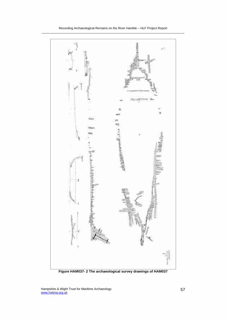
Recording Archaeological Remains on the River Hamble – HLF Project Report __________________________________________________________________________________
Hampshire & Wight Trust for Maritime Archaeology www.hwtma.org.uk
57
Figure HAM037- 2 The archaeological survey drawings of HAM037

Recording Archaeological Remains on the River Hamble – HLF Project Report __________________________________________________________________________________
Hampshire & Wight Trust for Maritime Archaeology www.hwtma.org.uk
58
Figure HAM037- 3 The stern of HAM037 with the Sternpost (red arrow), rudder stock (blue arrow), inner posts (green arrows) and a section of rudder (yellow arrow)
indicated (looking south)
Figure HAM037- 4 The axel of the rudder comprises of a pin with a bracket fastened to the sternpost and the rudder stock (looking south)

Recording Archaeological Remains on the River Hamble – HLF Project Report __________________________________________________________________________________
Hampshire & Wight Trust for Maritime Archaeology www.hwtma.org.uk
59
Figure HAM037- 5 The outline of HAM037 is marked by the frames (looking east)
Figure HAM037- 6 A disarticulated metal knee with a section of a deckhead beam attached
Hull strakes do remain on both side of the vessel, although only just above the silt line. The upper planking has disappeared. The planks do continue below ground level and it is probable that the bottom planking will still exist. On the port side of the vessel scouring is occurring, which indicates that these bottom

Recording Archaeological Remains on the River Hamble – HLF Project Report __________________________________________________________________________________
Hampshire & Wight Trust for Maritime Archaeology www.hwtma.org.uk
60
planks may be vulnerable (Figure HAM037-7). Evidence of ceiling planking can also be observed (Figure HAM037-8), although what does remain is in the vicinity of the silt line. Although pins on the insides of the frames suggest that these would have continued to a higher level within the vessel.
Figure HAM037- 7 A section of hull planking on the port side. It can be seen on this photograph that scouring beneath the vessel is occurring (looking north)
Figure HAM037- 8 A section of the starboard hull with the inner ceiling planking clearly visible (looking north)
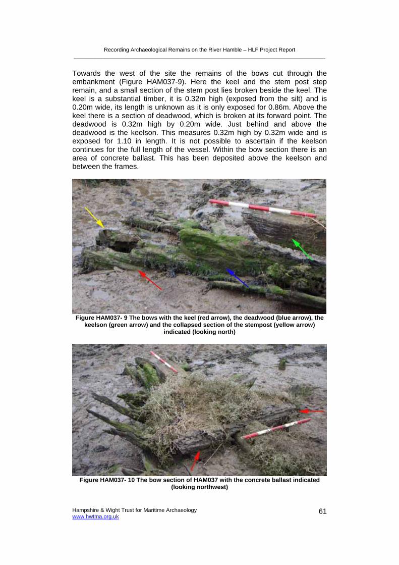
Recording Archaeological Remains on the River Hamble – HLF Project Report __________________________________________________________________________________
Hampshire & Wight Trust for Maritime Archaeology www.hwtma.org.uk
61
Towards the west of the site the remains of the bows cut through the embankment (Figure HAM037-9). Here the keel and the stem post step remain, and a small section of the stem post lies broken beside the keel. The keel is a substantial timber, it is 0.32m high (exposed from the silt) and is 0.20m wide, its length is unknown as it is only exposed for 0.86m. Above the keel there is a section of deadwood, which is broken at its forward point. The deadwood is 0.32m high by 0.20m wide. Just behind and above the deadwood is the keelson. This measures 0.32m high by 0.32m wide and is exposed for 1.10 in length. It is not possible to ascertain if the keelson continues for the full length of the vessel. Within the bow section there is an area of concrete ballast. This has been deposited above the keelson and between the frames.
Figure HAM037- 9 The bows with the keel (red arrow), the deadwood (blue arrow), the keelson (green arrow) and the collapsed section of the stempost (yellow arrow)
indicated (looking north)
Figure HAM037- 10 The bow section of HAM037 with the concrete ballast indicated (looking northwest)
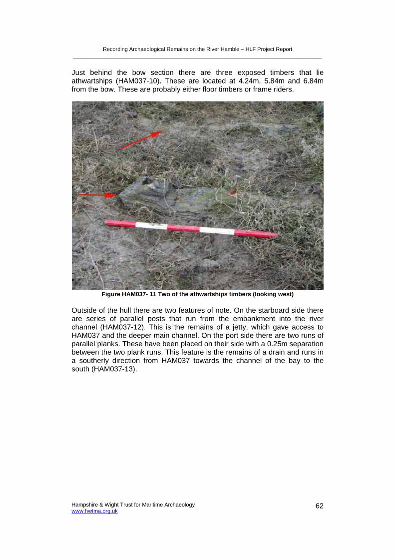
Recording Archaeological Remains on the River Hamble – HLF Project Report __________________________________________________________________________________
Hampshire & Wight Trust for Maritime Archaeology www.hwtma.org.uk
62
Just behind the bow section there are three exposed timbers that lie athwartships (HAM037-10). These are located at 4.24m, 5.84m and 6.84m from the bow. These are probably either floor timbers or frame riders.
Figure HAM037- 11 Two of the athwartships timbers (looking west)
Outside of the hull there are two features of note. On the starboard side there are series of parallel posts that run from the embankment into the river channel (HAM037-12). This is the remains of a jetty, which gave access to HAM037 and the deeper main channel. On the port side there are two runs of parallel planks. These have been placed on their side with a 0.25m separation between the two plank runs. This feature is the remains of a drain and runs in a southerly direction from HAM037 towards the channel of the bay to the south (HAM037-13).

Recording Archaeological Remains on the River Hamble – HLF Project Report __________________________________________________________________________________
Hampshire & Wight Trust for Maritime Archaeology www.hwtma.org.uk
63
Figure HAM037- 12 The remains of a jetty on the starboard side of HAM037 (looking east)
Figure HAM037- 13 On the portside of the vessel is the remains of a drain (looking north)

Recording Archaeological Remains on the River Hamble – HLF Project Report __________________________________________________________________________________
Hampshire & Wight Trust for Maritime Archaeology www.hwtma.org.uk
64
HAM051 This hulk is the northernmost of the two. A large amount of the timber structure protrudes through the sediments. However, the base of the hull is buried beneath these sediments (Figure HAM051-3). The basic dimensions of the hull are 19.42m long by 5.30m wide. The highest remaining part of the vessel is the rudder stock that is 3.32m above the sediments (Figure HAM051-5). The rudder stock is square and has a thickness of 0.30m. Aft of this there are the remains of three of the timbers that would have made up a composite rudder (Figure HAM051-5). These timbers are held together and fastened to the rudder stock by large metal pins. The remains of six of these can be seen. The rudder stock is attached to the sternpost by three pintles. The pintels are fastened to the rudder with metal straps (Figure HAM051-5). These are 0.08m wide, but are of varying lengths. The upper most is 0.22m long, the middle one is 0.58m and the lower one is 0.64m. Each of these has an associated gudgeon that is fastened to the sternpost (Figure HAM051-5). Forward of the sternpost at its base there is a large timber knee. This would have given extra support to the sternpost.
Figure HAM051- 3 HAM051 looking aft where the frames and sternpost can be clearly seen. The centre of the hull and the bilges are buried beneath sediments (looking east)

Recording Archaeological Remains on the River Hamble – HLF Project Report __________________________________________________________________________________
Hampshire & Wight Trust for Maritime Archaeology www.hwtma.org.uk
65
Figure HAM051- 4 The archaeological drawn survey of HAM051

Recording Archaeological Remains on the River Hamble – HLF Project Report __________________________________________________________________________________
Hampshire & Wight Trust for Maritime Archaeology www.hwtma.org.uk
66
Figure HAM051- 5 The stern with the rudder stock (red arrow), rudder timbers (blue arrow) pintles and gudgeons (green arrows) and the sternpost (yellow arrow) indicated
(looking south)
The first set of frames start 0.50m forward of the sternpost. The condition of these frames vary, some have broken just above the mud level, while others rise up to a height of 1.55m (Figure HAM051-6). It can be seen that these frames are composite, comprising of a floor timbers and futtocks. Some of the frames have become disarticulated at the joint. The heights at which the frame joints occur have been staggered so as not created a weak point along the hull. Frame sizes and spacing are relatively consistent, and any major discrepancies can be accounted for by erosion. The frames are between 0.14m – 0.16m, and the spacing is 0.10m-0.12m. The frames condition does vary with height. Those timbers close to the sediment are usually in good condition. The sections of timber framing that are exposed and lie between the low and high water marks are in the worst conditions. These sections are the most vulnerable to erosion as they are regularly drowned and exposed. The sections above the high water mark are eroded, but less than those within the tidal range (Figure HAM051-7). At the bows there are two frames, one either side, that are very tall (Figure HAM051-8). These frames are single pieces of timber and are 2.44m high. They would have been a major structural component of the bows.

Recording Archaeological Remains on the River Hamble – HLF Project Report __________________________________________________________________________________
Hampshire & Wight Trust for Maritime Archaeology www.hwtma.org.uk
67
Figure HAM051- 6 The remaining frames have been broken off or eroded to different heights (looking north)
Figure HAM051- 7 The upper part of this frame lies above the high tide and is less eroded than the timber that lies within the tidal range

Recording Archaeological Remains on the River Hamble – HLF Project Report __________________________________________________________________________________
Hampshire & Wight Trust for Maritime Archaeology www.hwtma.org.uk
68
Figure HAM051- 8 Volunteers recording the two tall frames located at the bow (looking west)
Along the outside of the hull there are several strakes remaining down to the silt line. The strakes are carvel laid and are fastened to the frames by metal pins. The planks that make up strakes above the silt line are highly eroded and have disappeared in sections. At amidships the hull planks are 0.22m wide by 0.06m thick. Planks can be seen at the silt line that continue beneath the sediment. The condition of the hull strakes on the port side is better than the starboard, and therefore the port planks will be described. Towards the stern the lowest two runs of strakes can be seen. As the tidal sediments rise the after planks are buried and a further higher strake is revealed. From amidships this strake also is buried, and an additional two higher planks are exposed. These are the highest remaining planks. The strakes do continue as far as the bows, where they would have been attached to the stempost with a flat-faced joint.
On the inside of the hull there is evidence of ceiling planking (Figure HAM051-9). This is only in sections and is in very bad condition. The best preserved examples can be found near the silt line. On the insides of a number of frames there are metal fastenings. This is evidence that the ceiling planking would have covered the lower parts of the hull’s insides.

Recording Archaeological Remains on the River Hamble – HLF Project Report __________________________________________________________________________________
Hampshire & Wight Trust for Maritime Archaeology www.hwtma.org.uk
69
Figure HAM051- 9 Ceiling planking visible just above the silt line, at the starboard forward quarter (looking north)
Figure HAM051- 10 The bow section with hull planking (red arrows), the stempost (blue arrow) and the concrete ballast (yellow arrows) indicated (looking north)
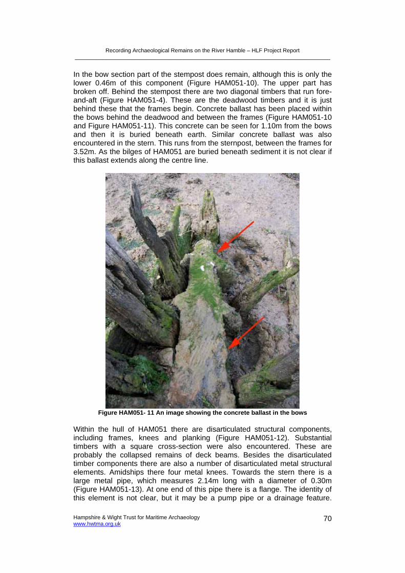
Recording Archaeological Remains on the River Hamble – HLF Project Report __________________________________________________________________________________
Hampshire & Wight Trust for Maritime Archaeology www.hwtma.org.uk
70
In the bow section part of the stempost does remain, although this is only the lower 0.46m of this component (Figure HAM051-10). The upper part has broken off. Behind the stempost there are two diagonal timbers that run fore-and-aft (Figure HAM051-4). These are the deadwood timbers and it is just behind these that the frames begin. Concrete ballast has been placed within the bows behind the deadwood and between the frames (Figure HAM051-10 and Figure HAM051-11). This concrete can be seen for 1.10m from the bows and then it is buried beneath earth. Similar concrete ballast was also encountered in the stern. This runs from the sternpost, between the frames for 3.52m. As the bilges of HAM051 are buried beneath sediment it is not clear if this ballast extends along the centre line.
Figure HAM051- 11 An image showing the concrete ballast in the bows
Within the hull of HAM051 there are disarticulated structural components, including frames, knees and planking (Figure HAM051-12). Substantial timbers with a square cross-section were also encountered. These are probably the collapsed remains of deck beams. Besides the disarticulated timber components there are also a number of disarticulated metal structural elements. Amidships there four metal knees. Towards the stern there is a large metal pipe, which measures 2.14m long with a diameter of 0.30m (Figure HAM051-13). At one end of this pipe there is a flange. The identity of this element is not clear, but it may be a pump pipe or a drainage feature.

Recording Archaeological Remains on the River Hamble – HLF Project Report __________________________________________________________________________________
Hampshire & Wight Trust for Maritime Archaeology www.hwtma.org.uk
71
Lying on top of the pipe there is a metal ‘T’ shape feature (Figure HAM051-13). This is 1.64m long by 0.05m wide. The cross piece of the ‘T’ is at the forward end, and this is 0.86m long by 0.14m wide. It is possible that this is a collapsed support stanchion.
Figure HAM051- 12 In the centre of the vessel there are many disarticulated elements, including; planking (red arrow), wooden knees (blue arrow), deck beams (green arrow)
and metal knees (yellow arrow)
Figure HAM051- 13 Towards the stern there is a large flanged pipe (red arrow) and a collapsed iron stanchion (blue arrow) (looking aft)

Recording Archaeological Remains on the River Hamble – HLF Project Report __________________________________________________________________________________
Hampshire & Wight Trust for Maritime Archaeology www.hwtma.org.uk
72
3.6.4. Research Whilst researching these vessels a number of routes of enquiry were utilised. Local resources such as Southampton City Library Maritime Collection, Hampshire Record Office and Hamble Village Parish archive were visited. An organisation of former T.S. Mercury school boys, the ‘Mercury Old Boys’ were also approached for information about these vessels.
During these investigations contact was made with the ‘Mercury Old Boys’ historian ‘Snowy’ White. Mr White said that hulks are the remains of two former North Sea fishing vessels Flash and Fortuna. These were transformed into houseboats and where used as hospital accommodation for the school, and were known by the boys as ‘The Fever Ships’. The date that these vessels came to the river is not certain, but they were definitely at their current location by 1913 (Snowy White pers. com. Dec 2007). A photograph of these ‘Fever Ships’ was found in the Hamble Parish Archives. A copy of this photograph was supplied by Ian Underdown (Figure HAM037-13). The date of this photograph is unknown. It shows the hull of HAM037 and HAM051, and above these hulls timber hut structures have been built. HAM037 appears to be a little larger than HAM051. In the hull of HAM037 at least six windows has been fitted. The pier beside HAM037 can also be seen, although it is short at this time.
Figure HAM037- 14 The two 'Fever Ships' located near Satchell March. HAM037 (red arrow) HAM051 (blue arrow) (courtesy of Hamble Parish Archive)
The Lloyds Register of Shipping and the Mercatile Navy List were consulted for information on Flash and Fortuna. Eight vessels named Flash and two called Fortuna were registered. The vessels registered as operating after 1913, and those that were either too small or large were discounted. This process left two vessels named Flash and one Fortuna.

Recording Archaeological Remains on the River Hamble – HLF Project Report __________________________________________________________________________________
Hampshire & Wight Trust for Maritime Archaeology www.hwtma.org.uk
73
Fortuna – A ketch built in Germany in 1885, 78 tons. Owned by Harry Chanter, 100, Orwell St, Grimsby. Registered Grimsby.
Fortuna – A ketch built in Yarmouth in 1882, 76 tons. Owned by Hewett & Com Ltd, Fish market, Shadwell, Ldn up to 1899. Registered Yarmouth.
Flash – A cutter built in Southtown, Suffolk in 1876, 59 tons. Owned by Hewett & Com Ltd, Fish market, Shadwell, Ldn up to 1898. Registered Yarmouth.
It is possible that any of these vessels could be those found at Satchell March. They are of an appropriate size and all worked as fishing boats in the North Sea. Interestingly two were owned by the same company up to the end of the 1890’s. It is plausible that HAM037 and HAM051 were bought from the same source at the same time. Therefore it is suggested that two vessels recorded are the latter two vessels in the list above.
A progression of maps was consulted for indication of these vessels, T.S. Mercury or associated features. T.S. Mercury, the embankment and the pier do appear on the maps, although the vessels themselves are omitted. The maps researched included the County Series Maps from 1870 to 1989. On the map from 1870 Satchell Marsh can be seen, but there is no sign of the human made embankment of the jetty (Figure HAM037-13).
Figure HAM037- 15 The County Series Map of 1870 (Ordnance Survey)

Recording Archaeological Remains on the River Hamble – HLF Project Report __________________________________________________________________________________
Hampshire & Wight Trust for Maritime Archaeology www.hwtma.org.uk
74
Figure HAM037- 16 The County Series Map of 1898 (Ordnance Survey)
By the time of the County Series Map of 1898 T.S. Mercury has been established, and is depicted as the naval training school (Figure HAM037-14). The human made embankment has been built and the pier that can be seen near HAM037 is shown. Eleven years later on the County Series Map of 1909 it can be seen that T.S. Mercury has increased in size (HAM037-15). A large looped track linking Mercury and the pier can also be seen. This may be a small independent railway; this interpretation is supported by an engine house being located on the north side of the school. On the 1932 County Series Map the possible railway appears to have been abandoned, although a section of its route can still be seen as pathways. The pier beside HAM037 is significantly shorter than its earlier depiction. A channel can now be seen between the embankment and Satchell Marsh (Figure HAM037-16). Evidence of the pier remains on the 1962 County Series Map, but it omitted on the 1965 map. The final county series map research from 1989, shows that the school has been replaced by a housing estate.

Recording Archaeological Remains on the River Hamble – HLF Project Report __________________________________________________________________________________
Hampshire & Wight Trust for Maritime Archaeology www.hwtma.org.uk
75
Figure HAM037- 17 The County Series Map 1909, with the engine house indicated (Ordnance Survey)
Figure HAM037- 18 The County Series Map of 1932 (Ordnance Survey)

Recording Archaeological Remains on the River Hamble – HLF Project Report __________________________________________________________________________________
Hampshire & Wight Trust for Maritime Archaeology www.hwtma.org.uk
76
3.6.5. Interpretation In 1885 the T.S Mercury naval school for boys was established beside the Hamble River. Two vessels, Flash and Fortuna were bought by this school and were probably used initially as sail training vessels. The Lloyds Register and Mercantile Navy List suggest they were purchased at the end of the 19th
century. Flash was probably a cutter built in 1876, and Fortuna may have been a ketch built in 1882. By 1913 these had been transformed into the school’s hospital. Buildings were constructed on the decks and the vessels from this time were stationary. Cartographic evidence shows that there was a pier giving access to the area up to 1962, after this it is no longer shown. This suggests that the pier had fallen into disrepair before this time. If the pier was no longer being maintained then the vessels must have been abandoned earlier. The exact date of abandonment is currently unknown, but must have been in the mid-twentieth century. Since this time large amounts of the vessels’ structure have disappeared. The visible structure is highly eroded, although the base of the hulls may lie in a better condition beneath the sediments.
3.6.6. Archaeological Significance
Criteria Assessment
Period Late nineteenth century
Rarity Not uncommon
Documentation Registered in naval lists
Group Value Links to T.S Mercury in addition to groups of other sailing vessels of the late 19th Century
Survival/Condition Poor condition, although significant component parts do remain
Fragility/Vulnerability In a dynamic environment, and are vulnerable to erosion
Local Significance These vessel have high local significance
Table HAM037 & HAM051- 1 Summary of HAM0037 and HAM051's archaeological significance assessment
HAM037 and HAM051 can be considered to have high archaeological significance with regards to the local area. Their importance is due to their association with T.S Mercury. The school has a significant place in the recent history of the Hamble area and the river itself. To the boys who went to this school these vessels would have been memorable; firstly for sail training and later for the care that they would have provided. From the late nineteenth century the presence of the school’s vessels on the river would have been part of the day to day workings of the river. From 1913 onwards Flash andFortuna would have been a fixture of the river and anyone passing them could not have failed to see their unusual appearance. Even today when transiting the river these vessels are noticeable, despite their condition being poor. They lie within a dynamic environment and erosion will continue to be a threat.
3.6.7. Recommendations A full archaeological survey has been collected of the vessels, hence there is no requirement to conduct further survey at present. However, it is

Recording Archaeological Remains on the River Hamble – HLF Project Report __________________________________________________________________________________
Hampshire & Wight Trust for Maritime Archaeology www.hwtma.org.uk
77
recommended that the rate of decay of these vessels be monitored, this will provide an insight into the rate of decay of this type of wooden hulk remains.
It is also suggested that small exploratory excavations in the region of the bilges be considered. From this it would be possible to see how well the lower sections of the hull have been protected within the sediments. If during the excavations the mast steps were encountered it would help with identifying which vessel is which, as cutters have a single mast and a ketch has two.
Further research is recommended. Former members of the school have been approached for information about these vessels. At present little information other than their identity has been found. Each year the Mercury Old Boys hold a reunion, the organisation should be contacted prior to the reunion and a request made for information pertaining to these hulks. In addition it is recommended that the archives of the school be researched for information on these vessels.
Finally, it is recommended that an information board be erected describing these vessels. An information board has recently been erected near to the plinth at the bay near to Mercury Gardens. This board has information on the school that was once there. It is suggested that a further board underlining the maritime importance of this site and the nearby remains of the vessels that were associated with it be erected in the vicinity.
3.6.8. References Lloyd’s Register of Shipping, 1876-1916
Mercantile Navy List, 1876-1916
Personal Communication Ian Underdown. Chairman Hamble Local History Society
‘Snowy’ White. Historian Mercury Old Boys Association
3.7. HAM043 Hulk, Possible Lifeboat Bunny Meadows
NGR: 448934 108165 Date of survey: February 2007
3.7.1. Introduction Near the shore of Bunny Meadows are the remains of a vessel of composite construction (Figure HAM043-1). It has a northwest-southeast orientation, with the bows pointing towards the latter. The remains are 10m from the Swanwick to Warsash footpath, on the eastern bank of the Hamble River. HAM043 is positioned near to the high water mark, and is surrounded by shallow tidal sediments.

Recording Archaeological Remains on the River Hamble – HLF Project Report __________________________________________________________________________________
Hampshire & Wight Trust for Maritime Archaeology www.hwtma.org.uk
78
Figure HAM043- 1 The site of an unknown hulk, possibly of a Barnett lifeboat, consisting of a keel, bulkheads and associated structures
3.7.2. Survey Description The keel structure and the two disarticulated metal components were surveyed and drawn in plan (Figure HAM043-2). A longitudinal profile was drawn of the keel structure. The vessel remains as a whole were photographed, as were interesting features of the vessel that may prove to be diagnostic.

Recording Archaeological Remains on the River Hamble – HLF Project Report __________________________________________________________________________________
Hampshire & Wight Trust for Maritime Archaeology www.hwtma.org.uk
79
Figure HAM043- 2 The drawn survey plans of HAM043