section 3.9 land use and planning 3.9.1...
TRANSCRIPT

Cannabis Land Use Ordinance and Licensing Program Final Environmental Impact Report 3.9-1 December 2017
Section 3.9 Land Use and Planning
3.9.1 Introduction This section identifies and evaluates impacts related to land use and planning that could arise from cannabis cultivation, manufacturing, testing, distribution and retail permitted under the Cannabis Land Use Ordinance Project (Project). This section describes existing land uses within the inland and coastal regions of Santa Barbara County, along with applicable County land use policies and regulations. Impacts from future cannabis cultivation, product manufacturing, testing, distribution, and retail are assessed based on consistency with County land use designations, zoning regulations, other related and relevant plans, ordinances, and standards.
This section is based on information from the Santa Barbara County Comprehensive Plan [e.g., the General Plan Elements, Community Plans, Local Coastal Program (LCP), Coastal Land Use Plan (CLUP), and County Coastal Zoning Ordinance (CZO), Santa Barbara Land Use and Development Code (LUDC), and Montecito Land Use and Development Code (MLUDC)] and regulations pertaining to cannabis, building, and grading that are set forth in the Santa Barbara County Code (County Code). The overall assumptions and methodology for this analysis are detailed in Section 3.0, Environmental Impact Analysis.
3.9.2 Environmental Setting Land use in Santa Barbara County is governed by the Santa Barbara County Comprehensive Plan—particularly the Land Use Element. Land Use Element maps define boundary lines that characterize the intensity of development in the County (County of Santa Barbara Comprehensive Plan 2016), and include the following five boundary areas:
Coastal Zone – The coastal zone spans 110 miles of coastline and includes approximately 184 square miles. The offshore islands of Santa Cruz and Santa Rosa are entirely within the coastal jurisdiction. For most of the coastline, this area only extends 1,000 yards, but it extends further inland in several areas due to the presence of important habitat, recreational, and agricultural resources. These areas include the lands surrounding the Guadalupe Dunes, Point Conception, and most of the Carpinteria Valley.
Urban Area – An area within which the development of residential, commercial, and industrial activity, and their related uses, buildings and structures, including schools, parks, utilities, are permitted. Agriculture is permitted and encouraged in this area when it is surrounded by urban uses, but when adjacent to a Rural Area, agriculture shall stay in the Rural Area.
Inner-Rural Area – An area where development is limited to rural uses such as agriculture and its accessory uses, mineral extraction and its accessory uses, recreation (public or private), ranchette development, and uses of a public or quasi-public nature. The minimum permitted lot size is 5 acres. Agricultural and open space preserves and related uses are encouraged.

County of Santa Barbara
Section 3.9 Land Use and Planning
Cannabis Land Use Ordinance and Licensing Program Final Environmental Impact Report 3.9-2 December 2017
Rural Area – An area where development is limited to agriculture and related uses, mineral extraction and related uses, utility-scale solar photovoltaic facilities (if located in the Rural Area of Cuyama Valley Rural Region), recreation (public or private), low density residential and related uses, and uses of a public or quasi-public nature. The minimum lot size permitted in this area is 40 acres.
Existing Developed Rural Neighborhood (EDRN) – A neighborhood area that has developed historically with lots smaller than those found in the surrounding Rural or Inner-Rural lands. The purpose of the neighborhood boundary is to keep pockets of rural residential development from expanding onto adjacent agricultural lands. Within the EDRN boundary, infilling of parcels at densities specified on the land use plan maps is permitted.
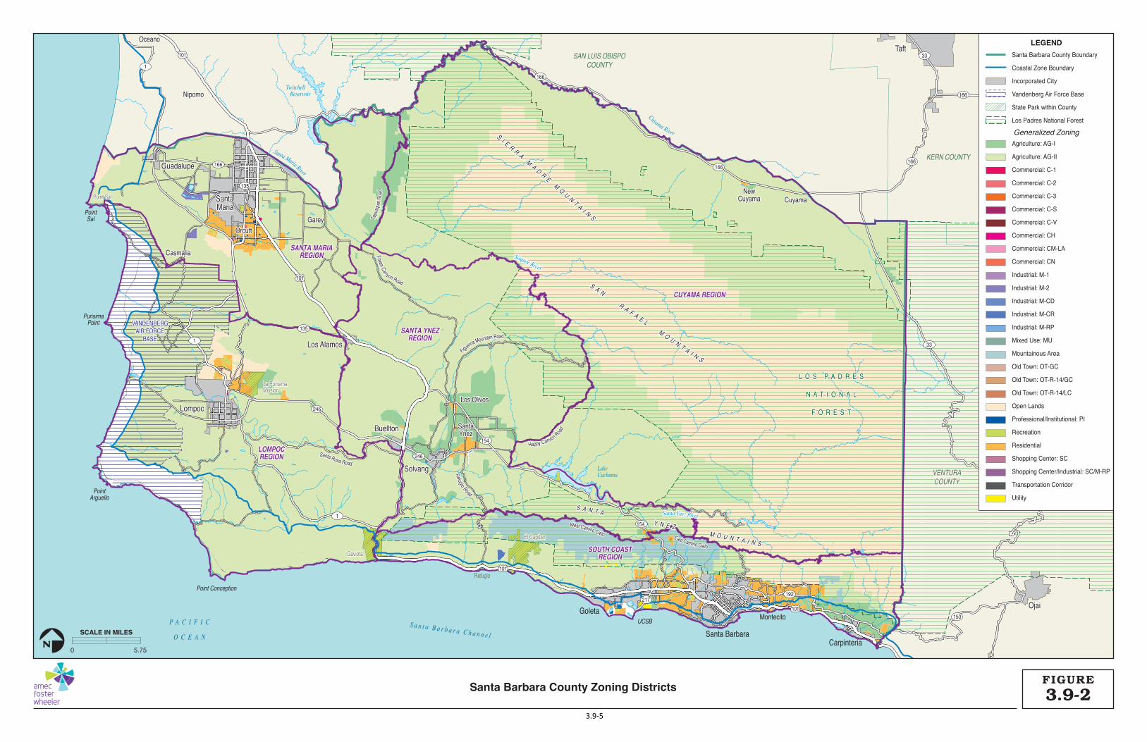
The Santa Barbara County Comprehensive Plan Land Use Element also guides the physical development of the County, establishes a pattern of land utilization, and sets out standards for both the density of population and the intensity of development for each of the land use classifications. The Land Use Element describes land use classifications, diagrams the distribution of land uses throughout the unincorporated County, and addresses the policies established for each community plan area. Figure 3.9-1 illustrates the Santa Barbara County Comprehensive Plan land use designations.
The LUDC (Chapter 35.20 through 28) carries out the policies of the Comprehensive Plan by classifying and regulating the uses of land within the County. Additionally, the MLUDC as well as the CZO carry out the policies of the Comprehensive Plan by classifying and regulating the use of land in accordance with the Montecito Community Plan and the CLUP, respectively. While land use designations characterize the physical uses and the intensity of that use, zoning designations legally define permitted uses and development guidelines for those uses. Figures 3.9-2 through 3.9-85 illustrate the zoning districts in Santa Barbara County. The following sections describe the land use designations and zoning districts that would apply under the proposed Project.
Currently, the LUDC does not allow cannabis activities on any land uses within the boundaries of Coastal Areas, Urban Areas, Inner-Rural Areas, Rural Areas, or EDRNs. In January 2016, the County Board of Supervisors adopted Ordinance No. 4954, adding a new Article X, titled “Medical Marijuana Regulations” to Section 35, Zoning, of the County Code, which prohibited the cultivation and delivery of medical cannabis with two exceptions: (1) cultivation for personal medicinal use, and (2) cultivation as a “legal non-conforming use” for sites in compliance with state and local laws, existing on January 19, 2016. On April 4, 2017, the Santa Barbara County Board of Supervisors adopted Ordinance No. 4992 that effectively prohibited all non-medical marijuana activities which would require a state license under the recently passed Adult Use of Marijuana Act (AUMA). Ordinance No. 4992 will remain in effect until the Board of Supervisors considers and adopts a comprehensive ordinance to prohibit or regulate non-medical marijuana activities within the County.
The sections below identify and describe the land use designations according to the Santa Barbara Comprehensive Land Use Plan and zoning districts according to the Santa Barbara LUDC, MLUDC, and CZO where cannabis cultivation, manufacturing, testing, distribution, and retail activities could occur under the proposed Project. This section does not describe land uses where cannabis activities are prohibited, such as Resource Protection Zones, Residential Zones, and most Special Purpose Zones.

La PurisimaLa PurisimaMissionMission
GaviotaGaviota
El CapitanEl Capitan
Point SalPoint Sal
GuadalupeGuadalupe
SantaSantaMariaMaria
TaftTaft
OjaiOjai
LompocLompoc
BuelltonBuellton
SolvangSolvang
Los AlamosLos Alamos
Santa Rosa Road
Refugio Road
West Camino Cielo
Figueroa Mountain Road
East Camino Cielo
Happy Canyon Road
Foxen Canyon Road
Tepu
sque
t Roa
d
OrcuttOrcutt
CasmaliaCasmalia
Los OlivosLos Olivos
SantaSantaYnezYnez
CuyamaCuyamaNewNew
CuyamaCuyama
NipomoNipomo
OceanoOceano
GareyGarey
101
101
101
101
166
166
166
166
166
1
1
1
135
135
246
246
154
217192
150
33
33
154
L O S P A D R E SL O S P A D R E S
N A T I O N A LN A T I O N A L
F O R E S TF O R E S T
VANDENBERGVANDENBERGAIR FORCEAIR FORCE
BASEBASE
VANDENBERGAIR FORCE
BASE
L O S P A D R E S
N A T I O N A L
F O R E S T
VENTURAVENTURACOUNTYCOUNTY
SAN LUIS OBISPOCOUNTY
KERN COUNTY
VENTURACOUNTY
Guadalupe
SantaMaria
Taft
Ojai
Lompoc
Buellton
Solvang
Los Alamos
Goleta
Santa BarbaraCarpinteria
CUYAMA REGIONCUYAMA REGION
SANTA YNEZSANTA YNEZREGIONREGION
SANTA MARIASANTA MARIAREGIONREGION
LOMPOCLOMPOCREGIONREGION
SOUTH COASTSOUTH COASTREGIONREGION
CUYAMA REGION
SANTA YNEZREGION
SANTA MARIAREGION
LOMPOCREGION
SOUTH COASTREGION
P A C I F I C
O C E A N
S a n t a B a r b a r a C h a n n e l
Point Conception
PointArguello
PurisimaPoint
PointSal
Sisquoc River
Santa Ynez River
Twitchell TwitchellReservoirReservoir
Cuyama River
Sisquoc River
Santa Ynez River
Santa Maria River
Twitchell Reservoir
LakeCachuma
La PurisimaMission
Gaviota
Refugio
El Capitan
Point Sal
Santa Rosa Road
Refugio Road
West Camino Cielo
Figueroa Mountain Road
East Camino Cielo
Happy Canyon Road
Foxen Canyon Road
Tepu
sque
t Roa
d
UCSB
Orcutt
Casmalia
Los Olivos
SantaYnez
CuyamaNew
Cuyama
Montecito
Nipomo
Oceano
Garey
S A N T A
Y N E Z M O U N T A I N S
S A N T A
Y N E Z M O U N T A I N S
SI E
RR
A M
AD
RE
MO
UN
T AI N
S
SI E
RR
A M
AD
RE
MO
UN
T AI N
S
S A N R A F A E L M
O U N T A I N S
S A N R A F A E L M
O U N T A I N S
S A N T A
Y N E Z M O U N T A I N S
SI E
RR
A M
AD
RE
MO
UN
T AI N
S
S A N R A F A E L M
O U N T A I N S
LEGEND
Generalized Land Use
Santa Barbara County Boundary
Coastal Zone Boundary
Incorporated City
Vandenberg Air Force Base
State Park within County
Los Padres National Forest
Agriculture: AG-I
Agriculture: AG-II
Agriculture: Commercial
Commercial
Community Facility
Educational Facility
Industrial
Institutional
Mixed Commercial/Industrial
Mixed Residential/Commercial
Mixed Residential/Open Land
Mountainous
Open Lands
Recreational
Residential
Transportation Corridor
Utility
0 5.75
SCALE IN MILES
N
3.9-1FIGURE
Santa Barbara County Comprehensive Plan Land Use Designations
3.9-3

County of Santa Barbara Section 3.9 Land Use and Planning
Cannabis Land Use Ordinance and Licensing Program Final Environmental Impact Report 3.9-4 December 2017
This page intentionally left blank.
La PurisimaLa PurisimaMissionMission
GaviotaGaviota
El CapitanEl Capitan
Point SalPoint Sal
GuadalupeGuadalupe
SantaSantaMariaMaria
TaftTaft
OjaiOjai
LompocLompoc
BuelltonBuellton
SolvangSolvang
Los AlamosLos Alamos
Santa Rosa Road
Refugio Road
West Camino Cielo
Figueroa Mountain Road
East Camino Cielo
Happy Canyon Road
Foxen Canyon Road
Tepu
sque
t Roa
d
OrcuttOrcutt
CasmaliaCasmalia
Los OlivosLos Olivos
SantaSantaYnezYnez
CuyamaCuyamaNewNew
CuyamaCuyama
NipomoNipomo
OceanoOceano
GareyGarey
101
101
101
101
166
166
166
166
166
1
1
1
135
135
246
246
154
217192
150
33
33
154
L O S P A D R E SL O S P A D R E S
N A T I O N A LN A T I O N A L
F O R E S TF O R E S T
VANDENBERGVANDENBERGAIR FORCEAIR FORCE
BASEBASE
VANDENBERGAIR FORCE
BASE
L O S P A D R E S
N A T I O N A L
F O R E S T
VENTURAVENTURACOUNTYCOUNTY
SAN LUIS OBISPOCOUNTY
KERN COUNTY
VENTURACOUNTY
Guadalupe
SantaMaria
Taft
Ojai
Lompoc
Buellton
Solvang
Los Alamos
Goleta
Santa BarbaraCarpinteria
CUYAMA REGIONCUYAMA REGION
SANTA YNEZSANTA YNEZREGIONREGION
SANTA MARIASANTA MARIAREGIONREGION
LOMPOCLOMPOCREGIONREGION
SOUTH COASTSOUTH COASTREGIONREGION
CUYAMA REGION
SANTA YNEZREGION
SANTA MARIAREGION
LOMPOCREGION
SOUTH COASTREGION
P A C I F I C
O C E A N
S a n t a B a r b a r a C h a n n e l
Point Conception
PointArguello
PurisimaPoint
PointSal
Sisquoc River
Santa Ynez River
Twitchell TwitchellReservoirReservoir
Cuyama River
Sisquoc River
Santa Ynez River
Santa Maria River
Twitchell Reservoir
LakeCachuma
La PurisimaMission
Gaviota
Refugio
El Capitan
Point Sal
Santa Rosa Road
Refugio Road
West Camino Cielo
Figueroa Mountain Road
East Camino Cielo
Happy Canyon Road
Foxen Canyon Road
Tepu
sque
t Roa
d
UCSB
Orcutt
Casmalia
Los Olivos
SantaYnez
CuyamaNew
Cuyama
Montecito
Nipomo
Oceano
Garey
S A N T A
Y N E Z M O U N T A I N S
S A N T A
Y N E Z M O U N T A I N S
SI E
RR
A M
AD
RE
MO
UN
T AI N
S
SI E
RR
A M
AD
RE
MO
UN
T AI N
S
S A N R A F A E L M
O U N T A I N S
S A N R A F A E L M
O U N T A I N S
S A N T A
Y N E Z M O U N T A I N S
SI E
RR
A M
AD
RE
MO
UN
T AI N
S
S A N R A F A E L M
O U N T A I N S
LEGEND
Generalized Zoning
Santa Barbara County Boundary
Coastal Zone Boundary
Incorporated City
Vandenberg Air Force Base
State Park within County
Los Padres National Forest
Agriculture: AG-I
Agriculture: AG-II
Commercial: C-1
Commercial: C-2
Commercial: C-3
Commercial: C-S
Commercial: C-V
Commercial: CH
Commercial: CM-LA
Commercial: CN
Industrial: M-1
Industrial: M-2
Industrial: M-CD
Industrial: M-CR
Industrial: M-RP
Mixed Use: MU
Mountainous Area
Old Town: OT-GC
Old Town: OT-R-14/GC
Old Town: OT-R-14/LC
Open Lands
Professional/Institutional: PI
Recreation
Residential
Shopping Center: SC
Shopping Center/Industrial: SC/M-RP
Transportation Corridor
Utility
0 5.75
SCALE IN MILES
N
3.9-2FIGURE
Santa Barbara County Zoning Districts
3.9-5

County of Santa Barbara
Section 3.9 Land Use and Planning
Cannabis Land Use Ordinance and Licensing Program Final Environmental Impact Report 3.9-6 December 2017
This page intentionally left blank.

County of Santa Barbara Section 3.9 Land Use and Planning
Cannabis Land Use Ordinance and Licensing Program Final Environmental Impact Report 3.9-7 December 2017
Figure 3.9-3. Santa Maria Area Zoning Districts
Figure 3.9-4. Lompoc Area Zoning Districts

County of Santa Barbara Section 3.9 Land Use and Planning
Cannabis Land Use Ordinance and Licensing Program Final Environmental Impact Report 3.9-8 December 2017
Figure 3.9-5. Santa Ynez Valley Area Zoning Districts
Agricultural Land Use and Zoning Lands with agricultural land use designations include, but are not limited to, land in existing agricultural use, lands with prime soils, prime agricultural land, grazing land, land with agricultural potential, and lands that are subject to Williamson Act contracts. The Comprehensive Plan defines three agricultural land use designations as follows:
Agriculture I (A-I, 5 or more acres minimum parcel size) – This designation applies to acreages of prime and non-prime farmlands and agricultural uses which are located within Urban, Inner-Rural, and EDRN areas.
Agriculture II (A-II, 40 or more acres minimum parcel size) – This designation applies to acreages of farm lands and agricultural uses located outside Urban, Inner-Rural and EDRNs areas. General agriculture is permitted, including but not limited to livestock operations, grazing, and beef production as well as more intensive agricultural uses.
Agricultural Commercial (AC) (40-320 or more acre minimum parcel size) – This category is for commercially farmed, privately owned land which meets the following criteria:
1) The land is subject to a Williamson Act contract, including contracts that have been non-renewed or,
2) Parcels 40 acres or greater, whether or not currently being used for agricultural purposes,but otherwise eligible for Williamson Act contract may be included if they meet therequirements of Uniform Rule No.6.
CATHEDRAL OAKS ROAD
LAS
POSI
TAS
ROAD
L A SPA
LMAS
DRI
VE
TURNPIKE ROAD
PATTERSO
N AVENUE
GLEN ANNIE ROAD
STORKE RO
AD
FAIRVIEW
AVENU
E
SAN MARCOS ROAD
HOLLISTER AVENUE
Santa BarbaraSanta BarbaraAirportAirport HopeHope
RanchRanch
GoletaGoleta
SOUTH COASTSOUTH COASTREGIONREGION
Goleta
Isla Vista
HopeRanch
GLEN ANNIE ROAD
STORKE RO
AD
CATHEDRAL OAKS ROAD
LAS
POSI
TAS
ROAD
L A SPA
LMAS
DRI
VE
TURNPIKE ROAD
PATTERSO
N AVENUE
FAIRVIEW
AVENU
E
SAN MARCOS ROAD
HOLLISTER AVENUE
SOUTH COASTREGION
UCSB
Santa BarbaraAirport
P A C I F I C
O C E A N
101
101
101
217
154
LEGEND
Generalized Zoning
Coastal Zone Boundary
Incorporated City
Los Padres National Forest
Agriculture: AG-I
Agriculture: AG-II
Commercial: C-2
Commercial: C-3
Commercial: CN
Mountainous Area
Open Lands
Professional/Institutional: PI
Recreation
Residential
Shopping Center: SC
Transportation Corridor
Utility
0 6,000
SCALE IN FEET
N
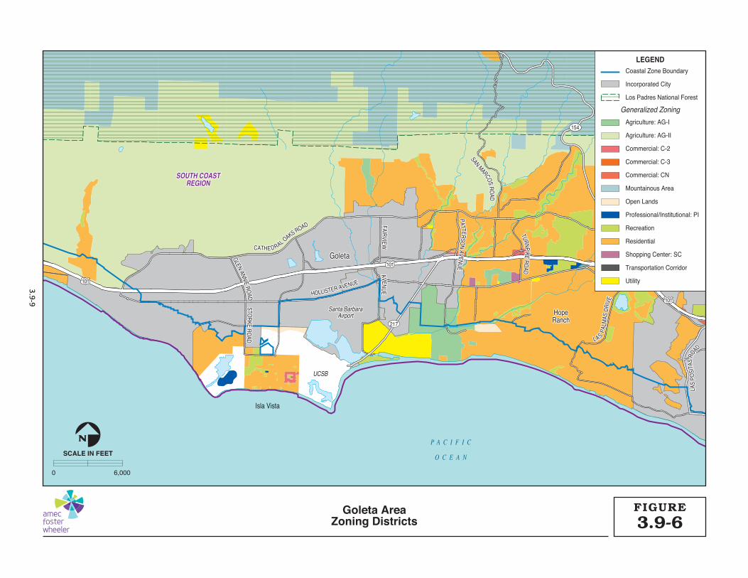
3.9-6FIGUREGoleta Area
Zoning Districts
3.9-9

Santa BarbaraSanta BarbaraMontecitoMontecito
Santa Barbara
SOUTH COASTSOUTH COASTREGIONREGION
CUYAMACUYAMAREGIONREGION
SOUTH COASTREGION
CUYAMAREGION
Montecito
P A C I F I C
O C E A N
CLIFF DRIVE
ALAMEDA PADRE SERRA
LAS
PALM
AS D
RIVE
MOUNTAIN AVENUE
MOUNTAIN AVENUE
LAGUNA STREET
LAGUNA STREET
MICHELT
ORENA STREET
MICHELT
ORENA STREET
LA CUMBRE RO
ADLA CUM
BRE ROAD
STATE STREETSTATE STREET
CABRILLO BOULEVARD
MILPAS STREET
MILPAS STREET
HOT SPRING
S ROAD
SAN YSIDRO RO
ADSAN YSIDRO
ROAD
LAS
POSI
TAS
ROAD
CLIFF DRIVE
ALAMEDA PADRE SERRA
LAS
PALM
AS D
RIVE
STATE STREET
LA CUMBRE RO
AD
CABRILLO BOULEVARD
MILPAS STREET
MOUNTAIN AVENUE
LAGUNA STREET
MICHELT
ORENA STREET
HOT SPRING
S ROAD
SAN YSIDRO RO
AD
LAS
POSI
TAS
ROAD
101
101
101
192
192
192
154
LEGEND
Generalized Zoning
Coastal Zone Boundary
Incorporated City
Los Padres National Forest
Agriculture: AG-I
Agriculture: AG-II
Commercial: C-1
Commercial: C-2
Commercial: C-3
Commercial: C-V
Commercial: CN
Industrial: M-RP
Mixed Use: MU
Mountainous Area
Open Lands
Recreation
Residential
Transportation Corridor
Utility
0 6,000
SCALE IN FEET
N
3.9-7FIGURESanta Barbara Area
Zoning Districts
3.9-10

Carpinteria
Summerland
P A C I F I C
O C E A N
VENTURAVENTURACOUNTYCOUNTYVENTURACOUNTY
SOUTH COASTSOUTH COASTREGIONREGION
SOUTH COASTREGION
CASITAS
PASS
RO
AD
LIINNDEN
AVEN
UE
SAN
TA M
OIC
AR
OAD
LADERA LANE
LADERA LANE
FOOTHILL ROAD
FOOTHILL ROAD
CARPINTERIA AVENUE
TOR
O C
ANYO
N R
OAD
LINDEN
AVEN
UE
SAN
TA M
OIC
AR
OAD
CASITAS
PASS
RO
AD
LADERA LANE
FOOTHILL ROAD
CARPINTERIA AVENUE
TOR
O C
ANYO
N R
OAD
101
101
101
192
150
192
LEGEND
Generalized Zoning
Coastal Zone Boundary
Incorporated City
State Park within County
Los Padres National Forest
Agriculture: AG-I
Agriculture: AG-II
Commercial: C-1
Industrial: M-RP
Mountainous Area
Open Lands
Recreation
Residential
Transportation Corridor
Utility
0 6,000
SCALE IN FEET
N
3.9-8FIGURECarpinteria Area
Zoning Districts
3.9-11
County of Santa Barbara
Section 3.9 Land Use and Planning
Cannabis Land Use Ordinance and Licensing Program Final Environmental Impact Report 3.9-12 December 2017
This category includes compatible land uses and land uses that are necessary and a part of the agricultural operations. All types of crops and livestock are included. Both prime and non-prime soils (as defined in the Williamson Act and the County's Uniform Rule No. 6) and irrigated and non-irrigated lands are included. Parcels which are smaller than 40 acres in size may be eligible for the AC designation if they are prime or super-prime as defined by the Uniform Rules and are eligible for agricultural preserve status.
Agricultural zones include minimum lot sizes that limit the subdivision potential and affect the range of allowable uses. The County has approximately 1,533,387 acres of lands zoned AG-I and AG-II. These zones are defined as follows (County of Santa Barbara 2016a):
AG-I (Agricultural I) zone – The AG-I zone is applied to areas appropriate for agricultural use within Urban, Inner-Rural, and EDRN areas, as designated on the Comprehensive Plan maps. The intent is to provide standards that will support agriculture as a viable land use and encourage maximum agricultural productivity.
AG-II (Agricultural II) zone – The AG-II zone is applied to areas appropriate for agricultural land uses on prime and non-prime agricultural lands located within the Rural Area as shown on the Comprehensive Plan maps. The intent is to preserve these lands for long-term agricultural use.
Commercial Land Use and Zoning Commercial land use designations include general commercial, neighborhood commercial, and service commercial. The Comprehensive Plan defines six commercial land use designations, two of which would be applicable under the proposed Project:
General Commercial (C) – This designation has been used to denote areas suitable for many types of commercial activities, including central business districts, district centers, service commercial, neighborhood centers, and design commercial. Permitted uses range from convenience activities, which serve day-to-day needs as food, drugs, gasoline, and other incidentals to wholesale facilities, which support agricultural, construction, and transportation activities.
Service Commercial (SC) – This designation is used to denote areas suitable for a limited range of service commercial activities, including wholesale business facilities, agriculture, construction, transportation, commercial distribution businesses, and warehouse and storage facilities. For this designation, ancillary offices and retail sales serving any of the above described uses are permitted on-site when subordinate to the principal service commercial activity.
The LUDC defines the zones for these land use designations as follows:
C-1 (Limited Commercial) zone – The C-1 zone is appropriate for both retail and service commercial activities that serve the local community and in the coastal zone, as well as the travelling public. This zone allows diverse uses, yet restricts allowable uses to those that are also compatible with neighboring residential uses to protect residential uses from negative impacts, including noise, odor, lighting, traffic, or degradation of visual aesthetic values.
C-2 (Retail Commercial) zone – The C-2 zone is appropriate for retail businesses and commercial needs including stores, shops, and offices supplying commodities or performing services for the residents of the surrounding community.

County of Santa Barbara
Section 3.9 Land Use and Planning
Cannabis Land Use Ordinance and Licensing Program Final Environmental Impact Report 3.9-13 December 2017
C-3 (General Commercial) zone – The C-3 zone is applied to areas appropriate for wholesale and heavy commercial uses and services that are not suited to the commercial zones that accommodate lighter commercial uses. The intent is to provide for commercial uses in these areas while protecting adjacent uses from negative impacts, including noise, odor, lighting, or traffic.
CM-LA (Community Mixed Use – Los Alamos) zone – The CM-LA zone applies to areas only within the Los Alamos Community Plan along the Bell Street Corridor. The purpose is to create a sense of place and provide certainty in the permitting process as to what is allowed within the Bell Street Commercial Core area.
CS (Service Commercial) zone – The CS zone is applied to areas appropriate for service commercial activities, including wholesale service and business facilities with ancillary offices inside storage areas, which are more limited in scope than the range of uses permitted in the general commercial zones. The intent is to provide local serving commercial establishments while preserving the residential character of the area.
PI (Professional and Institutional) zone – The PI zone is applied to areas appropriate for professional uses, and for educational, institutional, governmental, and other public facilities. It is the intent of this zone to ensure that these uses are well-designed and landscaped, and harmonious with surrounding land uses.
SC (Shopping Center) zone – The SC zone is applied to areas appropriate for clustered shopping center uses. The intent is to establish provisions for the comprehensive development of property suitable for commercial use, and to prevent piecemeal commercial development in areas that may be more appropriate for a clustered shopping center use.
Industrial Land Use and Zoning Industrial land use designations include industrial park, light industry, and general industrial uses. The Comprehensive Plan defines four industrial land use designations, three of which are under consideration for certain cannabis activities as part of the proposed Project:
Industrial Park – This designation includes any industrial use, which is housed in a well-designed building set in an attractively landscaped ground. This consists of industry in a park-like atmosphere. The uses permitted are consistent with the Industrial Park zone and may include commercial, as specified in the Santa Barbara County Zoning Ordinance.
Light Industry – This designation includes industrial plants and warehouses without nuisance features, but not necessarily in an industrial park.
General Industry – This designation includes all industrial uses.
The LUDC defines the zones for these three land use designations as follows:
M-RP (Industrial Research Park) zone – The M-RP zone is intended to provide areas exclusively for light industry, technical research, and business headquarters offices as the primary land use types, uses in well-designed buildings and attractively landscaped areas. The intent is to establish development standards and landscaping requirements to ensure a park-like environment for the uses permitted and compatibility with adjacent non-industrial areas.
M-1 (Light Industry) zone – The M-1 zone is intended to provide areas exclusively for light industrial uses. The intent is to encourage sound industrial development through appropriate

County of Santa Barbara
Section 3.9 Land Use and Planning
Cannabis Land Use Ordinance and Licensing Program Final Environmental Impact Report 3.9-14 December 2017
areas for these uses, and to protect nearby residential, commercial, and industrial uses from hazards, noise, and other disturbances.
M-2 (General Industry) zone – The M-2 zone is intended to provide areas for all types of industrial uses while providing the level of project review necessary to ensure that adverse impacts will be minimized and that these uses will be compatible with surrounding properties.
Special Purpose Land Use and Zoning Mixed uses may be allowed in special purpose zones. These zones are defined in the LUDC as follows:
MU (Mixed Use) zone – The MU zone is applied to areas that are suited for mixed-use development (i.e., residential, commercial, and/or industrial uses) because of their location in relation to existing or planned land uses of adjacent areas and infrastructure improvements, such as transportation corridors.
OT-R/LC (Old Town – Residential/Light Commercial) zone – The OT-R/LC zone allows for residential and commercial uses, individually or combined, in areas that contain predominantly one-family dwellings, or that are in close proximity to one-family residential zones, to provide neighborhood-oriented goods and services, and to create a buffer area of low intensity commercial land uses combined with residential uses between areas of strictly residential and general commercial use. The intent is to maintain the existing mixture of residential and commercial uses, and to preserve the character and architectural styles of the neighborhood areas.
3. OT-R/GC (Old Town - Residential/General Commercial) zone. The OT-R/GC zone allows for residential and commercial uses, individually or combined, especially in older urban areas where an "Old Town" atmosphere is to be maintained, and to provide for local business and commercial needs and services for the community, while maintaining a residential quality in the area. The intent is to maintain a mixture of residential and commercial uses, and to preserve the character and architectural style of the neighborhood areas.
The proposed Project would prohibit commercial cannabis activities in all other zone districts including all Residential, Mountainous Areas (MT), Highway Commercial (CH), Resort/Visitor Serving Commercial (C-V), Coastal Dependent Industry (M-CD), Coastal Related Industry (M-CR), Public Works Utilities and Private Service Facilities (PU), Recreation District (REC), Resource Management (RES), and Transportation Corridor (TC) zone districts, Mountainous – Gaviota (MT-GAV), Mountainous – Goleta (MT-GOL), Mountainous – Toro Canyon (MT-TORO), and Resource Management (RMZ). However, the proposed Project would permit the personal use of cannabis in all zone districts that allow for residential uses provided that the personal use of cannabis complies with specific standards.
Regions of Santa Barbara County Santa Barbara County consists of 8 incorporated cities and 24 unincorporated areas and communities, as well as the sovereign nation of the Santa Ynez Indian Reservation. As described in Section 2.2.2 of the Project Description, five regions of the County are used as a geographic basis for the proposed Project and to support the land use analysis. The five regions used to analyze Project data and impacts within this EIR include: Santa Maria, Lompoc, Santa Ynez, Cuyama, and South Coast. (See Figure 2-1.) Each of these five regions and their associated land use context are described below.

County of Santa Barbara
Section 3.9 Land Use and Planning
Cannabis Land Use Ordinance and Licensing Program Final Environmental Impact Report 3.9-15 December 2017
Santa Maria Region
The Santa Maria Valley Region constitutes the northern-most portion of the County, containing rolling lowlands surrounding the Santa Maria River, the incorporated cities of Santa Maria and Guadalupe, and the unincorporated communities of Casmalia, Orcutt, Garey, Sisquoc, and Tepusquet. Land use in the Santa Maria Valley is predominantly agricultural land consisting of vineyards, pastures, and industrial agricultural areas cultivated with row crops and lands developed with greenhouses, with agriculture-related commercial facilities, light industrial uses, ranchette, and low-density residential development that support the agriculture industry. According to the Registry data, the Santa Maria Region contains few cannabis activity operations, primarily located within the Tepusquet area.
Lompoc Region
The Lompoc Region constitutes the western-most portion of the County, containing the incorporated City of Lompoc, and the unincorporated communities of Vandenberg Village and Mission Hills, as well as Cebada Canyon and Tularosa EDRNs and the federally-owned Vandenberg Air Force Base (VAFB). Land uses within the unincorporated areas of the region are mainly agriculturally designated, and contain open spaces, vineyards, agricultural fields, pastures, and ranch-style residences. Lands containing an ecological reserve and natural open spaces surround Mission Hills and Vandenberg Village. According to the Registry data, the Lompoc Region contains existing and planned cannabis activities.
Santa Ynez Region
The Santa Ynez Region constitutes the central portion of the County, containing the incorporated cities of Buellton and Solvang, and the unincorporated communities of Ballard, Los Alamos, Los Olivos, and Santa Ynez. Several EDRNs surround these Urban Areas, including Ballard Canyon, West Olivos, Bobcat Springs, West Buellton, Woodstock Oak Trails, East Baseline Ranch Estates, Meadowlark, and Highway 246 EDRNs. Similar to the Lompoc Region, land uses outside of Urban Areas are mainly agricultural designated, and contain open spaces, vineyards, agricultural fields, pastures, ranch-style residences, and agriculture-serving commercial uses. According to the Registry data, existing and planned cannabis activities are scattered within the Santa Ynez region; there is also a large known cannabis operation in the Los Alamos region.
Santa Maria Region Project-applicable
Zoning Districts Acres AG-I 6,888 AG-II 140,191 C-1 5 C-2 137 C-3 9 C-S 63 M-1 62 M-2 1,640
OT-R/GC 41 OT-R/LC 8
PI 211 SC 43
Lompoc Region Project-Applicable
Zoning Districts Acres AG-I 1,561 AG-II 150,163 C-2 36
CM-LA 3 M-2 53 PI 12 SC 28
Santa Ynez Region Project-Applicable
Zoning Districts Acres AG-I 19,099 AG-II 166,840 C-1 2 C-2 109 C-3 34
CM-LA 31 M-1 35 M-2 40 PI 6

County of Santa Barbara
Section 3.9 Land Use and Planning
Cannabis Land Use Ordinance and Licensing Program Final Environmental Impact Report 3.9-16 December 2017
Cuyama Region
The Cuyama Region constitutes the largest area of the County and includes the northeast and eastern-most portion of the County, and is primarily comprised of the federally-owned lands of the Los Padres National Forest (LPNF). The northern region along the County’s boundary constitutes the Cuyama Valley Rural Region, which contains the communities of Cuyama, New Cuyama, and Ventucopa. These communities are predominantly agricultural in use, with commercial, educational, industrial, recreational, and residential uses limited to the Cuyama and New Cuyama communities. Land use in the Cuyama Valley consists primarily of irrigated agriculture, dry farming, grazing pastures, and rural residential development. Irrigated agriculture is a dominant land use in the Cuyama Valley, comprising approximately 23,500 acres (County of Santa Barbara 2012). There is one known cannabis activity site located near the Cuyama community, while the majority are located near the Tepusquet area.
South Coast
The South Coast Region constitutes the southern-most portion of the County, containing the incorporated cities of Santa Barbara, Goleta, and Carpinteria, and the unincorporated communities of Gaviota, Hope Ranch, Mission Canyon, Toro Canyon, Montecito, and Summerland. In addition, the South Coast Region supports the greatest amount of State Parks, as well as the UCSB campus and portions of the LPNF. The South Coast region also supports the largest cannabis cultivators when compared to the other four regions, with most of the existing cannabis activities concentrated in the Carpinteria agricultural district and urban foothills.
Cuyama Region Project-Applicable
Zoning Districts Acres AG-I 4,850 AG-II 138,000 C-2 21 C-3 1 M-1 6
M-RP 25
South Coast Region Project-Applicable
Zoning Districts Acres AG-I 8,968 AG-II 32,477 C-1 42 C-2 43 C-3 48
M-RP 30 MU 59 PI 67
The Santa Ynez Region contains the most land designated for agricultural purposes, via AG-I and AG-II zoning, within the County, and is characterized by open spaces, vineyards, agricultural fields, pastures, ranch-style residences, and agriculture-serving commercial uses.
The South Coast Region contains the largest greenhouse district in the County, located in the Carpinteria Valley, primarily within AG-I zoning. The district is adjacent to developed urban coastal areas and incorporated beach cities located in the foothills of the Santa Ynez Mountains and coastal bluffs of the Pacific Ocean.

County of Santa Barbara
Section 3.9 Land Use and Planning
Cannabis Land Use Ordinance and Licensing Program Final Environmental Impact Report 3.9-17 December 2017
3.9.3 Regulatory Setting The land use and planning analysis was conducted in conformance with the goals and policies of local regulations.
3.9.3.1 Local
Coastal Land Use Plan The CLUP lays out the general patterns of development throughout the coastal areas of the County. Its purpose is to protect coastal resources while accommodating land use development within the coastal zone (County of Santa Barbara 1982). The other elements of the Comprehensive Plan are applicable within the coastal zone; however, when there is a conflict, the CLUP takes precedence.
Pursuant to the Coastal Act, each of the 15 counties and 53 cities along the California coast is required to prepare a LCP. The LCP consists of the local government’s land use plans, zoning ordinances, zoning district maps, and implementing actions which, when taken together, meet the requirements of, and implement the provisions and policies of (the Coastal Act) at the local level.
The Coastal Act policies focus on the protection of coastal resources and the regulation of development in the coastal zone. The policies govern land uses, including environmentally sensitive habitat areas and prime agricultural lands, recreational resources, the marine environment, scenic resources, and air quality. While the focus of the policies is on resource protection, the policies also govern land use, industrial development, and public works facilities in order to encourage well-planned and orderly development that is compatible with resource protection and conservation. The following CLUP policies are applicable to the proposed Project (County of Santa Barbara 1982):
General Policies
Policy 1-2: Where policies within the land use plan overlap, the policy which is the most protective of coastal resources shall take precedence.
Policy 1-3: Where there are conflicts between the policies set forth in the coastal land use plan and those set forth in any element of the County’s Comprehensive Plan or existing ordinances, the policies of the coastal land use plan shall take precedence.
Policy 1-4: Prior to the issuance of a coastal development permit, the County shall make the finding that the development reasonably meets the standards set forth in all applicable land use plan policies.
Development Policies
Policy 2-6: Prior to issuance of a development permit, the County shall make the finding, based on information provided by environmental documents, staff analysis, and the applicant, that adequate public or private services and resources (e.g., water, sewer, roads) are available to serve the proposed development. The applicant shall assume full responsibility for costs incurred in service extensions or improvements that are required as a result of the proposed project. Lack of available public or private services or resources shall be grounds for denial of the project or reduction in the density otherwise indicated in the land use plan.

County of Santa Barbara
Section 3.9 Land Use and Planning
Cannabis Land Use Ordinance and Licensing Program Final Environmental Impact Report 3.9-18 December 2017
Policy 2-9: The County shall give equal priority to the following land uses in the coastal zone of Montecito and Summerland:
• Expansion of public recreational opportunities • Visitor-serving commercial uses (e.g., restaurants, retail commercial, motels). • Low- and moderate-income housing • Agricultural expansion
In Goleta, the County shall give highest priority to low and moderate income housing and agricultural expansion followed by public recreation and visitor-serving commercial uses.
Policy 2-11: All development, including agriculture, adjacent to areas designated on the land use plan or resource maps as environmentally sensitive habitat areas, shall be regulated to avoid adverse impacts on habitat resources. Regulatory measures include, but are not limited to, setbacks, buffer zones, grading controls, noise restrictions, maintenance of natural vegetation, and control of runoff.
Coastal Act Policies
30250. (a) New residential, commercial, or industrial development, except as otherwise provided in this division, shall be located within, contiguous with, or in close proximity to, existing developed areas able to accommodate it or, where such areas are not able to accommodate it, in other areas with adequate public services and where it will not have significant adverse effects, either individually or cumulatively, on coastal resources. In addition, land divisions, other than leases, for agricultural uses, outside existing developed areas shall be permitted only where 50 percent of the usable parcels in the area have been developed and the created parcels would be no smaller than the average size of surrounding parcels. (b) Where feasible, new hazardous industrial development shall be located away from existing developed areas.
30231. The biological productivity and the quality of coastal waters, streams, wetlands, estuaries, and lakes appropriate to maintain optimum populations of marine organisms and for the protection of human health shall be maintained and, where feasible, restored through, among other means, minimizing adverse effects of waste water discharges and entrainment, controlling runoff, preventing depletion of ground water supplies and substantial interference with surface water flow, encouraging wastewater reclamation, maintaining natural vegetation buffer areas that protect riparian habitats, and minimizing alteration of natural streams.
30251. The scenic and visual qualities of coastal areas shall be considered and protected as a resource of public importance. Permitted development shall be sited and designed to protect views to and along the ocean and scenic coastal areas, to minimize the alteration of natural land forms, to be visually compatible with the character of surrounding areas, and, where feasible, to restore and enhance visual quality in visually degraded areas.
Policy 3-14: All development shall be designed to fit the site topography, soils, geology, hydrology, and any other existing conditions and be oriented so that grading and other site preparation is kept to an absolute minimum. Natural features, landforms, and native vegetation, such as trees, shall be preserved to the maximum extent feasible. Areas of the site which are not suited for development because of known soil, geologic, flood, erosion or other hazards shall remain in open space.
Policy 3-15: For necessary grading operations on hillsides, the smallest practical area of land shall be exposed at any one time during development, and the length of exposure shall be kept to the shortest practicable amount of time. The clearing of land should be avoided during the winter rainy season and

County of Santa Barbara
Section 3.9 Land Use and Planning
Cannabis Land Use Ordinance and Licensing Program Final Environmental Impact Report 3.9-19 December 2017
all measures for removing sediments and stabilizing slopes should be in place before the beginning of the rainy season.
Policy 3-16: Sediment basins (including debris basins, desilting basins, or silt traps) shall be installed on the project site in conjunction with the initial grading operations and maintained throughout the development process to remove sediment from runoff waters. All sediment shall be retained on site unless removed to an appropriate dumping location.
Policy 3-17: Temporary vegetation, seeding, mulching, or other suitable stabilization method shall be used to protect soils subject to erosion that have been disturbed during grading or development. All cut and fill slopes shall be stabilized immediately with planting of native grasses and shrubs, appropriate nonnative plants, or with accepted landscaping practices.
Policy 3-18: Provisions shall be made to conduct surface water to storm drains or suitable watercourses to prevent erosion. Drainage devices shall be designed to accommodate increased runoff resulting from modified soil and surface conditions as a result of development. Water runoff shall be retained on-site whenever possible to facilitate groundwater recharge.
Policy 3-19: Degradation of the water quality of groundwater basins, nearby streams, or wetlands shall not result from development of the site. Pollutants, such as chemicals, fuels, lubricants, raw sewage, and other harmful waste, shall not be discharged into or alongside coastal streams or wetlands either during or after construction.
Policy 3-20: All development within the coastal zone shall be subject to the slope density curve (Plate A) of the County Zoning Ordinance No. 661 (Article VII, Section 20). However, in no case shall above-ground structures, except for necessary utility lines and fences for agricultural purposes, be sited on undisturbed slopes exceeding 40 percent.
Policy 3-23: In order to protect scenic resources, water quality, and community character, and reduce land form alteration, greenhouses and greenhouse related development shall be prohibited on slopes in excess of 10 percent within Area B of the Carpinteria Agricultural Overlay District. Greenhouse or greenhouse related development may be approved on slopes between 5 and 10 percent, subject to a Conditional Use Permit.
Visual Resource Policies
Policy 4-1: Areas within the coastal zone which are now required to obtain approval from the County Board of Architectural Review (BAR), because of the requirements of the “D”- Design Supervision Combining Regulations or because they are within the boundaries of Ordinance #453, shall continue to be subject to design review. In addition, developments in all areas designated on the land use plan maps as Commercial, Industrial, or Planned Development and residential structures on bluff top lots shall be required to obtain plan approval from the County BAR.
Policy 4-2: All commercial, industrial, planned development, and greenhouse projects shall be required to submit a landscaping plan to the County for approval.
Policy 4-3: In areas designated as rural on the land use plan maps, the height, scale, and design of structures shall be compatible with the character of the surrounding natural environment, except where technical requirements dictate otherwise. Structures shall be subordinate in appearance to natural landforms; shall be designed to follow the natural contours of the landscape; and shall be sited so as not to intrude into the skyline as seen from public viewing places.

County of Santa Barbara
Section 3.9 Land Use and Planning
Cannabis Land Use Ordinance and Licensing Program Final Environmental Impact Report 3.9-20 December 2017
Policy 4-4: In areas designated as urban on the land use plan maps and in designated rural neighborhoods, new structures shall be in conformance with the scale and character of the existing community. Clustered development, varied circulation patterns, and diverse housing types shall be encouraged.
Agriculture
Policy 8-5: All greenhouse projects of 20,000 or more square feet and all additions to existing greenhouse development, i.e., greenhouse expansion, packing sheds, or other development for a total of existing and additions of 20,000 or more square feet, shall be subject to County discretionary approval and, therefore, subject to environmental review under State CEQA guidelines and County significance thresholds.
Policy 8-6: No greenhouse, hothouse, or accessory structure shall be located closer than 50 feet from the boundary line of a lot zoned residential.
Policy 8-7: Landscaping and screening shall be installed within 6 months of completion of new greenhouses and/or accessory buildings. Such landscaping shall reasonably block the view of greenhouse structures and parking areas from the nearest public road(s) within 5 years of project completion.
Policy 8-11: The following requirements shall apply to greenhouse and greenhouse related development within the Carpinteria Valley to protect the long-term productivity of prime agricultural soils. a. Greenhouse operations on prime agricultural soils shall encourage use of in-soil cultivation methods b. Prime agricultural soils shall not be modified with sterilants or other chemicals that would adversely affect the long-term productivity of the soil. c. The removal of prime agricultural soils shall be prohibited, including removal of indigenous prime soils used as a growing medium for container plants which are sold intact.
Policy 8-12: No increase in greenhouses or greenhouse related development within the Carpinteria Valley shall result from divisions or redivisions of land, redesignations or rezonings of AG-I or AG-II, or other land uses, subsequent to the date of Commission action on LCP amendment STB-MAJ-2-02.
Environmentally Sensitive Habitat Areas
Policy 9-1: Prior to the issuance of a development permit, all projects on parcels shown on the land use plan and/or resource maps with a Habitat Area overlay designation or within 250 feet of such designation or projects affecting an environmentally sensitive habitat area shall be found to be in conformity with the applicable habitat protection policies of the land use plan. All development plans, grading plans, and comparable plans/applications, shall show the precise location of the habitat(s) potentially affected by the proposed project. Projects which could adversely impact an environmentally sensitive habitat area may be subject to a site inspection by a qualified biologist to be selected jointly by the County and the applicant.
Santa Barbara County Code, Article II. Coastal Zoning Ordinance This ordinance is applicable to the unincorporated coastal zone within the County of Santa Barbara, as well as the Channel Islands. The CZO implements the Coastal Land Use Plan by classifying and regulating the uses of land, buildings, and structures in the coastal zone. Pursuant to Public Resources Code Section 30500 of the California Coastal Act of 1976, the County must prepare a LCP for the

County of Santa Barbara
Section 3.9 Land Use and Planning
Cannabis Land Use Ordinance and Licensing Program Final Environmental Impact Report 3.9-21 December 2017
unincorporated areas of the County within the coastal zone. The ordinance contains the coastal zoning district maps, which apply regulations of the ordinance to the properties in the coastal areas.
Santa Barbara County Comprehensive Plan The Comprehensive Plan provides general goals, policies, and programs applicable to the unincorporated portions of the County. The Comprehensive Plan is required to maintain internal consistency between all adopted elements. The Land Use Element defines the blueprint for physical development with goals, policies, actions, and development standards that provide the framework for physical development and use of land. The Land Use Element also defines land use categories (Rural, Urban, Inner-Rural and, Existing Development Rural Neighborhood Areas) and land use designations. Other State-mandated elements included in the Comprehensive Plan are the Circulation, Conservation, Noise, Open Space, Housing, and Safety Elements. In addition, the Comprehensive Plan contains the following elective elements: Agricultural, Environmental Resource Management Element (ERME), Scenic Highway, Seismic Safety, Hazardous Waste, and Energy Elements. Key relevant goals, objectives and policies of the Land Use and Agricultural Elements are provided below. For resource-specific policies (e.g., geology, noise, public services), refer to the relevant section of this EIR.
Land Use Element
The Comprehensive Plan Land Use Element has four fundamental goals (County of Santa Barbara Comprehensive Plan 2016):
Environment: Environmental constraints on development shall be respected. Economic and population growth shall proceed at a rate that can be sustained by available resources.
Urbanization: In order for the County to sustain a healthy economy in the urbanized areas and to allow for growth within its resources and within its ability to pay for necessary services, the County shall encourage infill, prevent scattered urban development, and encourage a balance between housing and jobs.
Agriculture: In the rural areas, cultivated agriculture shall be preserved and, where conditions allow, expansion and intensification should be supported. Lands with both prime and non-prime soils shall be reserved for agricultural uses.
Open Lands: Certain areas may be unsuited for agricultural uses due to poor or unstable soil conditions, steep slopes, flooding or lack of adequate water. These open lands have importance as grazing, watershed, wildlife habitat, mineral resources, recreation, and scenic qualities. These lands are usually so located that they are not necessary or desirable for urban uses. There is no basis for the proposition that all land, no matter where situated or whatever the need, must be planned for urban purposes if they cannot be put to some other profitable economic use.
The following applicable policies implement these goals:
Land Use Development Policies
4. Prior to issuance of a development permit, the County shall make the finding, based on information provided by environmental documents, staff analysis, and the applicant, that adequate public or private services and resources (e.g., water, sewer, roads) are available to serve the proposed development. The applicant shall assume full responsibility for costs incurred in service extensions or improvements that are required as a result of the proposed project. Lack of

County of Santa Barbara
Section 3.9 Land Use and Planning
Cannabis Land Use Ordinance and Licensing Program Final Environmental Impact Report 3.9-22 December 2017
available public or private services or resources shall be grounds for denial of the project or reduction in the density otherwise indicated in the land use plan. Affordable housing projects proposed pursuant to the Affordable Housing Overlay regulations, special needs housing projects or other affordable housing projects which include at least 50 percent of the total number of units for affordable housing or 30 percent of the total number of units affordable at the very low income level shall be presumed to be consistent with this policy if the project has, or is conditioned to obtain all necessary can and will serve letters at the time of final map recordation, or if no map, prior to issuance of land use permits.
Hillside and Water Protection Policies
2. All developments shall be designed to fit the site topography, soils, geology, hydrology, and any other existing conditions and be oriented so that grading and other site preparation is kept to an absolute minimum. Natural features, landforms, and native vegetation, such as trees, shall be preserved to the maximum extent feasible. Areas of the site which are not suited to development because of known soil, geologic, flood, erosion or other hazards shall remain in open space.
3. For necessary grading operations on hillsides, the smallest practical area of land shall be exposed at any one time during development and the length of exposure shall be kept to the shortest practicable amount of time. The clearing of land should be avoided during the winter rainy season and all measures for removing sediments and stabilizing slopes should be in place before the beginning of the rainy season.
4. Sediment basins (including debris basins, desilting basins, or silt traps) shall be installed on the project site in conjunction with the initial grading operations and maintained through the development process to remove sediment from runoff waters. All sediment shall be retained on site unless removed to an appropriate dumping location.
5. Temporary vegetation, seeding, mulching, or other suitable stabilization method shall be used to protect soils subject to erosion that have been disturbed during grading or development. All cut and fill slopes shall be stabilized as rapidly as possible with planting of native grasses and shrubs, appropriate non-native plants, or with accepted landscaping practices.
6. Provisions shall be made to conduct surface water to storm drains or suitable watercourses to prevent erosion. Drainage devices shall be designed to accommodate increased runoff resulting from modified soil and surface conditions as a result of development. Water runoff shall be retained onsite whenever possible to facilitate groundwater recharge.
7. Degradation of the water quality of groundwater basins, nearby streams, or wetlands shall not result from development of the site. Pollutants, such as chemicals, fuels, lubricants, raw sewage, and other harmful waste, shall not be discharged into or alongside coastal streams or wetlands either during or after construction.
8. On any lands not Comprehensive Planned and zoned for agriculture, grading and “brushing” shall require a permit. Exceptions shall be grading of 50 cubic yards or less and “brushing” within a radius of 100 yards of a residential structure for fire purposes.
Visual Resource Policies
2. All commercial, industrial, and planned developments shall be required to submit a landscaping plan to the County for approval.

County of Santa Barbara
Section 3.9 Land Use and Planning
Cannabis Land Use Ordinance and Licensing Program Final Environmental Impact Report 3.9-23 December 2017
3. In areas designated as rural on the land use plan maps, the height, scale, and design of structures shall be compatible with the character of the surrounding natural environment, except where technical requirements dictate otherwise. Structures shall be subordinate in appearance to natural landforms; shall be designed to follow the natural contours of the landscape; and shall be sited so as not to intrude into the skyline as seen from public viewing places. 3. In areas designated as urban on the land use plan maps and in designated rural neighborhoods, new structures shall be in conformance with the scale and character of the existing community. Clustered development, varied circulation patterns, and diverse housing types shall be encouraged.
Agricultural Element The Comprehensive Plan Agricultural Element serves as a guide for addressing the future use of agricultural lands and resources. It includes goals and policies applicable to projects that affect agricultural resources. The Element contains the following applicable goal and implementing policies (County of Santa Barbara 1991).
GOAL I. Santa Barbara County shall assure and enhance the continuation of agriculture as a major viable production industry in Santa Barbara Country. Agriculture shall be encouraged. Where conditions allow, (taking into account environmental impacts) expansion and intensification shall be supported.
Policy IA. The integrity of agricultural operations shall not be violated by recreational or other non-compatible uses.
Policy I.B. The County shall recognize the rights of operation, freedom of choice as to the methods of cultivation, choice of crops or types of livestock, rotation of crops and all other functions within the traditional scope of agricultural management decisions. These rights and freedoms shall be conducted in a manner which is consistent with: (1) sound agricultural practices that promote the long-term viability of agriculture and (2) applicable resource protection policies and regulations.
Policy I.C. To increase agricultural productivity, the County shall encourage land improvement programs.
Policy I.E. The County shall recognize that the generation of noise, smoke, odor, and dust is a natural consequence of the normal agricultural practices provided that agriculturalists exercise reasonable measures to minimize such effects.
Policy I.F. The quality and availability of water, air, and soil resources shall be protected through provisions including but not limited to, the stability of Urban/Rural Boundary Lines, maintenance of buffer areas around agricultural areas, and the promotion of conservation practices.
Policy I.G. Sustainable agricultural practices on agriculturally designated land should be encouraged in order to preserve the long-term health and viability of the soil.
GOAL II. Agricultural lands shall be protected from adverse urban influence.
Policy II.B. Santa Barbara County shall recognize, and give high priority to, the need for protection from trespass and other issues (e.g., thievery, vandalism, roaming dogs), on all agricultural lands.
GOAL III. Where it is necessary for agricultural lands to be converted to other uses, this use shall not interfere with remaining agricultural operations.

County of Santa Barbara
Section 3.9 Land Use and Planning
Cannabis Land Use Ordinance and Licensing Program Final Environmental Impact Report 3.9-24 December 2017
Policy III.B. It is a County priority to retain blocks of productive agriculture within Urban Areas where reasonable, to continue to explore programs to support that use, and to recognize the importance of the objectives of the County’s Right to Farm Ordinance.
GOAL IV. Recognizing that agriculture can enhance and protect natural resources, agricultural operations should be encouraged to incorporate such techniques as soil conservation and sound fire risk reduction practices.
Policy IV.A. Major wildfires cause severe erosion, property damage, and safety hazards. The County shall encourage range improvement and fire hazard reduction programs, including prescribed burning of brush and alternative non-burning techniques. Such programs shall be designed and conducted to avoid excessive erosion and other significant adverse effects on the environment for the purpose of increasing water yields, improving wildlife habitat, wildlife protection, and increasing agricultural productivity.
Policy IV.B. Because of fire-risk reduction or soil instability, the use of certain slopes for agricultural production may be preferable to leaving the land in its natural state, or allowing non-agricultural development provided that adverse effects are minimized.
Policy IV.C. Grading and brush clearing for new agricultural improvements on hillsides shall not cause excessive erosion or downslope damage.
GOAL V. Santa Barbara County shall allow areas and installations for those supportive activities needed as an integral part of the production and marketing process on and/or off the farm.
Policy V.A. Santa Barbara County shall permit on-farm supportive installations for product handling and selling as prescribed in the Uniform Rules of the County’s Agricultural Preserve Program.
Policy V.B. Santa Barbara County should allow areas for supportive agricultural services within reasonable distance and access to the farm user.
GOAL VI: The County should make effective-provision for access to agricultural areas and for the necessary movement of agricultural crops and equipment.
Policy VI.A. To the maximum extent feasible, the County Public Works Department shall design roads with the type and size of vehicles and/or equipment in mind which are used in the agricultural operations of the area.
Community and Area Plans The Comprehensive Plan also includes numerous community, regional, and Rural Region plans and guidelines that serve as blueprints for physical development of unincorporated towns and watershed-based areas. Below are brief descriptions of the County’s community plan areas; several of the community plans contains goals and policies that promote the agricultural industry, including components such as the production and sale of agricultural products (e.g., manufacturing, testing, distribution, retail).
Orcutt Community Plan
The Orcutt Community Plan updates the Santa Barbara County Comprehensive Plan for the unincorporated area of Orcutt and sets goals, policies, programs, actions, and development standards

County of Santa Barbara
Section 3.9 Land Use and Planning
Cannabis Land Use Ordinance and Licensing Program Final Environmental Impact Report 3.9-25 December 2017
for all future development in Orcutt (County of Santa Barbara 2004a). The Orcutt Community Plan area is located within the Santa Maria Valley Rural Region, south of the City of Santa Maria. It encompasses 14,650 acres of mostly Urban Area. Given the zoning designations within the Community Plan area, some cannabis cultivation activities could occur within the jurisdiction of the Community Plan, but primarily within the A-II-40 and A-II-100 zoned areas, as the majority of the plan area consists of planned development, other open land, and open space.
Lompoc Interpretive Guidelines
The unincorporated urban areas of the Lompoc Valley consist of three distinct communities: Vandenberg Village, Mission Hills, and Mesa Oaks. The Interpretive Guidelines outline general policies that apply to the Lompoc Valley Area and address specific issues of the Lompoc Valley, and as a result additional measures may be required for development to achieve consistency with the Comprehensive Plan (County of Santa Barbara 1999). Cannabis cultivation activities currently occur in this urban area, and future uses could occur within the jurisdiction of the area, but primarily within agricultural zoned parcels.
Santa Ynez Valley Community Plan
The Santa Ynez Valley Community Plan provides policy direction for issues and development trends specific to the Santa Ynez Valley Rural Region and sets the framework for planning future development (County of Santa Barbara 2009). The Santa Ynez Valley Community Plan applies to the incorporated cities of Solvang and Buellton, the unincorporated urban areas of Santa Ynez, Los Olivos, and Ballard, EDRNs within the vicinity of these communities, and surrounding Rural and Inner-Rural Areas within the Community Plan area. Cannabis activities within the Community Plan boundary would be subject to development standards and policies outlined in the Community Plan. Cannabis activities are currently scattered throughout the Santa Ynez Valley and future uses could occur within the areas zoned for agriculture located around the residential areas located east of the City of Solvang in Santa Ynez, agricultural uses around Los Olivos, and agricultural uses located north and south of Baseline Avenue near Ballard.
Los Alamos Community Plan
The Los Alamos Community Plan establishes and regulates land uses in the Town of Los Alamos (County of Santa Barbara 2011) within the Santa Ynez Valley Rural Region. The Plan Area encompasses approximately the 460 acres within the Los Alamos urban/rural boundary. There are currently existing cannabis operations in Los Alamos. However, given the small size of the plan area, only a few parcels zoned for commercial and industrial uses along the Highway 135 corridor, along Drum Canyon Road, and east of town would be suitable for cannabis manufacturing and retail. Relatively large agricultural holdings that are predominantly used for vineyards and cattle grazing operations, surround the community planning area.
Cuyama Planning Area
The Cuyama Valley lies in northern Santa Barbara County between San Luis Obispo County and the northern slopes of Sierra Madre Mountains. It includes the communities of Cuyama, New Cuyama, and Vetucopa, which make up the Cuyama Valley Rural Region. Although there is not a specific community plan for this area, the County’s Comprehensive Plan outlines policies that apply to the area, and provides a land use and zoning map for the area. Cuyama and New Cuyama contain commercial and

County of Santa Barbara
Section 3.9 Land Use and Planning
Cannabis Land Use Ordinance and Licensing Program Final Environmental Impact Report 3.9-26 December 2017
industrial land uses that may allow cannabis manufacturing and retail. However, the majority of the area consists of AG-I-10 and AG-II-100 zoned parcels that may allow cannabis cultivation. Ventucopa consists of mainly AG-I-40 and AG-II-100 zoned parcels east of the Cuyama River (County of Santa Barbara 2014a). This region contains the fewest existing cannabis operations.
Gaviota Coast Plan
The Gaviota Coast planning area is a rural landscape within the South Coast Rural Region characterized by rugged mountains in the east, rolling hills and lowland coastal area, and a rich agricultural area. It includes 101,199 acres within the County and it remains one of the largest undeveloped coastline areas in southern California (County of Santa Barbara 2016c). This area contains 38 miles of rural coastline; it also includes working agricultural areas and is a dominant land use with 77,820 acres of land zoned for agriculture (County of Santa Barbara 2016c). In the eastern Plan Area, most agricultural lands are zoned AG-II-100 with minimum parcel sizes increasing from east to west. All agricultural land in the coastal zone west of El Capitan State Park is zoned AG-II-320. Many of the lands within this area may allow cannabis cultivation.
Mission Canyon Community Plan
Mission Canyon is an unincorporated area in southern Santa Barbara County within the South Coast Rural Region (County of Santa Barbara 2014b). The planning area for the Mission Canyon Community Plan is approximately 1,122 acres located in the lower foothills of the Santa Ynez Mountains, immediately north and contiguous to the City of Santa Barbara. The land uses consist almost exclusively of single-family residential development with the exception of some commercial and public uses, and parcels zoned for agricultural use in the northern portion of the plan area. This planning area also is designated a Special Problems Area, given existing or anticipated special and unique problems pertaining to flooding, drainage, soils, geology, access, sewage disposal, water supply, location, or elevation that have the potential to effect public health, safety, and general welfare. A Special Problems Committee (Committee) of interdepartmental County staff reviews proposed buildings and structures. The Committee may impose conditions to prevent or mitigate present or anticipate problems that may result from a development project. The Committee has the authority to prohibit construction if the Committee unanimously agrees that there is no other feasible way to prevent a serious risk of substantial damage to property, public or private, or of injury to persons.
Toro Canyon Community Plan
The Toro Canyon Planning Area is located in southeastern Santa Barbara County, also within the South Coast Rural Region in the western portion of the Carpinteria Valley between the Santa Ynez Mountains and the Santa Barbara Channel. Toro Canyon is bordered by the Summerland and Montecito Community Plan areas to the west, the Pacific Ocean to the south, the Los Padres National Forest to the north, and Rancho Monte Alegre and the Carpinteria City limits to the east. The southern portion of Toro Canyon lies within the state coastal zone and includes Padaro and Santa Claus Lanes (County of Santa Barbara 2004b). Toro Canyon contains approximately 2,700 acres designated for agriculture with zoning ranging from AG-I-5 to AG-II-100. The Plan Area also supports greenhouse development in the Carpinteria Valley (i.e., 117 acres), and most of these are located south of Foothill Road and east of Nidever Road (County of Santa Barbara 2004b).

County of Santa Barbara
Section 3.9 Land Use and Planning
Cannabis Land Use Ordinance and Licensing Program Final Environmental Impact Report 3.9-27 December 2017
Montecito Community Plan
The Montecito Planning Area lies between the Pacific Ocean and the foothills of the Santa Ynez Mountains, with the City of Santa Barbara to the west and the unincorporated community of Summerland to the east in the South Coast Rural Region. The southern portion lies within the coastal zone. Montecito is one of the older settlements in Santa Barbara County. The area was originally settled by the Spanish in 1700’s and 1800’s with land grants given or sold to retiring soldiers of the Santa Barbara Presidio (County of Santa Barbara 1992).
The Montecito Community Plan area is divided into three areas: the central urban sub-area, coastal sub-area, and the mountain sub-area. The central urban sub-area is characterized as semi-rural, consisting of primarily single-family homes on lots 1 acre or larger. The central urban sub-area also contains the central core of Montecito and the main commercial center. The coastal sub-area is primarily developed with cottages and duplexes, and coastline development consists of an exclusive residential community, hotel complexes, and several condominium and clustered developments. The mountain sub-area is characterized by mountainous terrain and open space (County of Santa Barbara 1992). Cannabis cultivation may be allowed on the agriculturally-zoned parcels, which limits eligible cultivation to one approximately 35.35-acre area located north of Jameson Lane, between San Ysidro Road and San Ysidro Creek. The MLUDC, Montecito Growth Management Ordinance (MGMO), and Montecito Architectural Guidelines and Development Standards also apply to development in this area.
Summerland Community Plan
The Summerland Plan Area is located in the southern portion of Santa Barbara County between the cities of Santa Barbara and Carpinteria in the South Coast Rural Region. The Plan Area boundary includes the unincorporated area of the County of Santa Barbara known as Summerland. The Plan Area is bordered by Ortega Ridge Road on the west, the Montecito Planning Area on the north, Padaro Lane and the Toro Canyon Planning Area on the east, and the Pacific Ocean on the south. The Plan Area totals 907 acres and is situated within the coastal zone with the exception of a residential enclave along Ortega Ridge Road, which is located in the inland area (County of Santa Barbara 2014c). Cannabis cultivation may be allowed on the AG-I-10 and AG-II-20 zoned parcels, and manufacturing and retail may be allowed on the commercial and industrial zoned parcels within the Community Plan boundary.
Goleta Valley Community Plan
Land use in Goleta Valley, with the exception of the incorporated area of the City of Goleta and the eastern portion, is guided by the Goleta Valley Community Plan (County of Santa Barbara 1993). The western portion of the Goleta Valley Planning Area lies north and west of the City of Goleta, extending northward to the crest of the Santa Ynez Mountains, and from approximately the intersection of Los Carneros Road and Cathedral Oaks Road westward to the eastern boundary of the Gaviota Coast Planning Area. In addition, several isolated pockets of unincorporated land in the southwest, such as Isla Vista, which are surrounded by the City of Goleta and UCSB, are part of the western portion of Goleta Valley. A majority of the Goleta Valley planning area consists of outer rural areas.
Eastern Goleta Valley Community Plan
The eastern portion of the Goleta Valley Planning Area lies primarily on the coastal shelf between the Pacific Ocean and the Santa Ynez Mountain Range, east of the City of Goleta and west of the City of Santa Barbara, and includes the southern slopes of the mountains up to the crest. Land use in the

County of Santa Barbara
Section 3.9 Land Use and Planning
Cannabis Land Use Ordinance and Licensing Program Final Environmental Impact Report 3.9-28 December 2017
eastern portion of the valley is guided by the Eastern Goleta Valley Community Plan (County of Santa Barbara 2015). The Eastern Goleta Valley plan area encompasses the unincorporated coastal plain and foothills reaching from Camino Cielo Road on the north to the Pacific Ocean on the south and cover approximately 23,300 acres of land between the Cities of Santa Barbara and Goleta. Of this area, about 15,300 acres lie within the designated Rural Area, and 7,900 acres lie within the designated Urban Area where the majority of the approximately 36,000 residents of Eastern Goleta Valley live (County of Santa Barbara 2015). The Plan highly encourages the use of mixed-use zoning with the planning area, to allow for maximum compatibility and complementary transitions between uses. Outside the residential areas and along the northern portion of the plan area, most of the lands consist of mountainous areas where cannabis cultivation would not be permitted. The areas south of the mountains are designated for agriculture (A-I and A-II) and agriculture commercial (AC), where cultivation activities would be permitted.
Santa Barbara County Land Use and Development Code The LUDC constitutes a portion of Chapter 35 of the Santa Barbara County Code. The LUDC carries out the policies of the Comprehensive Plan by classifying and regulating the uses of land and structures within the County, consistent with the Comprehensive Plan. The LUDC is adopted to protect and to promote the public health, safety, comfort, convenience, prosperity, and general welfare of residents and businesses in the County (Section 35.10.010 - Purpose of Development Code).
The County uses the LUDC as a tool to implement the goals, objectives, and policies of the Comprehensive Plan, including any applicable community, specific, or area plan. Provisions of the LUDC and any land use, subdivision, or development approved in compliance with these regulations must be consistent with other components of the Comprehensive Plan, including any applicable community, specific, or area plan. Currently, Section 35 does not address cannabis activities as an allowable use in any zoning district.
Montecito Land Use Development Code
The MLUDC constitutes a portion of Section 35 of the County Code and implements the Comprehensive Plan and the Montecito Community Plan by classifying and regulating the uses of land, buildings, and structures in Montecito located outside of the coastal zone (County of Santa Barbara 2008a). Currently, the MLUDC does not address cannabis activities.
Santa Barbara County Code, Article V. Right-to-Farm Ordinance No. 4907 Pursuant to the California Right to Farm Act, as discussed in Section 3.2, Agricultural Resources, which allows local jurisdictions to support agricultural activities in regards to public nuisance claims, the Santa Barbara County Right-to-Farm Ordinance protects agricultural land uses from conflicts with nonagricultural land uses that may result in financial hardship to agricultural operators or the termination of their operation. The purpose of the ordinance is to preserve and protect agricultural zoned lands for exclusive agricultural use; to support and encourage continued agricultural operations in the County; and to forewarn prospective purchasers or residents of property adjacent to or near agricultural operations of the inherent potential problems associated with such purchase or residence including, but not limited to, the sounds, odors, dust, and chemicals that may accompany agricultural operations. Projects that are proposed and/or approved in the County proximate to agriculturally zoned lands are often required to provide notice to future residents, tenants, and users of the Right-to-Farm.

County of Santa Barbara
Section 3.9 Land Use and Planning
Cannabis Land Use Ordinance and Licensing Program Final Environmental Impact Report 3.9-29 December 2017
Santa Barbara County Grading Ordinance Chapter 14 (Grading Code) of the County Code regulates and controls the design, construction, quality of materials, and location and maintenance of grading, drainage, erosion and sediment control. It also addresses compliance with the National Pollutant Discharge Elimination System (NPDES) Phase II storm water regulations. These regulations set forth local storm water requirements for the disturbance of less than 1 acre to avoid pollution of water courses and drainage ways with sediments or other pollutants generated on or caused by surface runoff on or across the construction site.
Santa Barbara County Cannabis Regulations
Ordinance No. 4739
In February 2010, the County Board of Supervisors adopted Ordinance No. 4739, An Interim Urgency Ordinance of the County of Santa Barbara on Establishing a Moratorium on the Establishment and Operation of Medical Marijuana Dispensaries.
Ordinance No. 4954
In response to the passage of the Medical Marijuana Regulation and Safety Act (MMRSA) in 2015, the County Board of Supervisors adopted Ordinance No. 4954 in January 2016. Ordinance No. 4954 added a new Article X, titled “Medical Marijuana Regulations” to Section 35, Zoning, of the County Code. Ordinance No. 4954 prohibited the cultivation and delivery of medical cannabis, except for cultivation for personal use within the unincorporated areas of the County in accordance with MMRSA, the Federal Controlled Substances Act (CSA) of 1970, and Medical Marijuana Program Act. Article X of the County Code provided a limited exemption for cannabis cultivation as a “legal non-conforming use” for cultivation sites that comply State and local regulations, and existing as of January 19, 2016.
Ordinance No. 4992
In April 2017, the Santa Barbara County Board of Supervisors adopted Ordinance No. 4992, the Nonmedical Marijuana Interim Urgency Ordinance imposing a temporary moratorium on any activities that would require a state license under the recently passed AUMA, as well as the prohibition of industrial hemp until County staff could develop a permanent ordinance to prohibit or regulate non-medical marijuana activities within the County. The moratorium was extended in May 2017 and is set to expire in March 2019.
Uniform Rules for Agricultural Preserves and Farmland Security Zones The Uniform Rules of Agricultural Preserves and Farmland Security Zones (Uniform Rules) are used to implement the Williamson Act and administer the Agricultural Preserve program in Santa Barbara County. The Uniform Rules define eligibility requirements and compatible uses to which each participating landowner must adhere in order to receive a reduced tax assessment. The Uniform Rules state that uses on contracted lands shall be compatible with current or reasonably foreseeable agricultural operations and shall not significantly compromise the long-term agricultural capabilities of a parcel. The Uniform Rules also require that uses on contracted lands do not result in significant temporary population increases to an extent that could hinder or impair agricultural operations on lands within the vicinity.

County of Santa Barbara
Section 3.9 Land Use and Planning
Cannabis Land Use Ordinance and Licensing Program Final Environmental Impact Report 3.9-30 December 2017
The County Uniform Rules do not currently allow cannabis activities. However, the Project may include adoption of amendments to the County Uniform Rules for Agricultural Preserves and Farmland Security Zones.
County of Santa Barbara Clean Air Plan The federal Clean Air Act Amendments (CAAA) of 1990 and the California Clean Air Act (CCAA) of 1988 mandate the preparation of Clean Air Plans (CAPs) that provide an overview of air quality and sources of air pollution, and identify pollution-control measures needed to meet federal and state air quality standards. The Santa Barbara Air Pollution Control District (SBCAPCD) and the Santa Barbara County Association of Governments (SBCAG) are responsible for formulating and implementing the CAP for the County. The CAP provides an overview of the regional air quality and sources of air pollution, and identifies the pollution-control measures needed to meet clean-air standards. The schedule for plan development is outlined by state and federal requirements, and is influenced by regional air quality. CAPs affect the development of SBCAPCD rules and regulations and other programs. They also influence a range of activities outside the district including transportation planning, allocation of monies designated for air-quality projects, and more.
Santa Barbara County Regional Transportation Plan and Sustainable Communities Strategy
The Santa Barbara County Regional Transportation Plan and Sustainable Communities Strategy (RTP-SCS) is a long-range transportation plan that sets forth how the region will meet its transportation needs for the 30-year period from 2010 to 2040. Existing and future land use patterns, and forecasted population and job growth were used to identify and prioritize transportation projects of all transportation modes: highways, streets and roads, transit, rail, bicycle and pedestrian, as well as transportation demand management measures and intelligent transportation systems. SBCAG updates regional growth forecasts which inform this document every 4 years (SBCAG 2013).
Goal 1, Environment: Foster patterns of growth, development and transportation that protect natural resources and lead to a healthy environment.
Policy 1.1 Land Use: The planning, construction, and operation of transportation facilities shall be coordinated with local land use planning and should encourage local agencies to:
Make land use decisions that adequately address regional transportation issues and are consistent with the RTP-SCS.
Promote better balance of jobs and housing to reduce long-distance commuting by means of traditional land use zoning and other, unconventional land use tools, such as employer-sponsored housing programs, economic development programs, commercial growth management ordinances, average unit size ordinances and parking pricing policies.
Plan for transit-oriented development consistent with the RTP-SCS by:
o concentrating residences and commercial centers in urban areas near rail stations, transit centers and along transit development corridors.
o designing and building “complete streets” serving all transportation modes that connect high-usage origins and destinations.

County of Santa Barbara
Section 3.9 Land Use and Planning
Cannabis Land Use Ordinance and Licensing Program Final Environmental Impact Report 3.9-31 December 2017
Policy 2.6 Consistency with Other Plans: The planning, construction, and operation of transportation facilities and of the system as a whole shall be consistent with (1) the California Transportation Plan, (2) SBCAG’s Transportation Connections: The Public Transit Human Services Transportation Plan for Santa Barbara County, (3) adopted local General Plans, and (4) other regional policies.
Goal 5, Prosperous Economy: Achieve economically efficient transportation patterns and promote regional prosperity and economic growth.
Policy 5.1 Commuter Savings: The RTP-SCS shall strive to reduce average commute time and cost by encouraging measures that bring worker housing closer to job sites.
Policy 5.2 Support Business and Local Investment: The RTP-SCS shall:
• Promote a mix of land uses responsive to the needs of businesses, including agriculture and tourism.
• Support investment by businesses in local communities. • Encourage the creation of high-paying jobs, especially in areas with an imbalance of
housing relative to jobs.
3.9.4 Environmental Impact Analysis This section discusses the potential land use and planning impacts associated with the Cannabis Land Use Ordinance Project. Table 3.9-2, County Land Use Plans and Policies Consistency Summary provides an overview of the proposed Project’s consistency with the Comprehensive Plan, and other applicable plans, policies, and regulations, and the compatibility of the Project with existing and planned land uses in the County. While an inconsistency with these plans or policies in itself would not constitute an impact to the physical environment, an inconsistency with an adopted plan or policy might suggest that the Project would be conducted in such a way that it would result in an impact to the physical environment that is subject to CEQA review. Therefore, potential impacts focus on consistency with adopted plans and policies and compatibility of the proposed Project with existing and planned land uses in the County. Should the Board of Supervisors determine that the Project is inconsistent with an existing County general plan policy, the project could not be approved unless measures are identified to eliminate this inconsistency.
The analysis considers the proposed amendments to the County Code to establish a new permitting and licensing program for cannabis activities, and amendments to the LUDC, MLUDC, and the County CZO to address cannabis activities. The analysis also considers the proposed Project’s possible adoption of amendments to the County Uniform Rules for Agricultural Preserves and Farmland Security Zones.
3.9.4.1 Thresholds of Significance
California Environmental Quality Act Guidelines With respect to land use and planning, applicable sections of Appendix G of the State CEQA Guidelines establishes that a project would normally have a significant impact on the environment if it would:
Physically divide an established community.

County of Santa Barbara
Section 3.9 Land Use and Planning
Cannabis Land Use Ordinance and Licensing Program Final Environmental Impact Report 3.9-32 December 2017
Conflict with any applicable land use plan, policy, or regulation of an agency with jurisdiction over the project (including, but not limited to, a general plan, specific plan, local coastal program, or zoning ordinance) adopted for the purpose of avoiding or mitigating an environmental effect.
Conflict with any applicable habitat conservation plan or natural community conservation plan.
Santa Barbara County Thresholds The following five thresholds of significance for “Quality of Life,” as outlined in Section 13 of the County’s Environmental Thresholds and Guidance Manual (County of Santa Barbara 2008b), are used herein to determine project impacts (i.e., impacts to the physical environment that are related to quality of life impacts): 1. Loss of privacy 2. Neighborhood incompatibility 3. Nuisance noise levels (not exceeding noise thresholds) 4. Increased traffic in quiet neighborhoods (not exceeding traffic thresholds) 5. Loss of sunlight/solar access
3.9.4.2 Project Impacts This impact analysis analyzes the potential land use and planning impacts associated with the proposed Cannabis Land Use Ordinance Project. Table 3.9-1 below provides a summary of the impacts related to land use from the proposed Project. The discussion of the impact follows, and development standards and mitigation measures are presented in Section 3.9.4.3.
Table 3.9-1. Summary of Land Use Impacts
Land Use Impacts Mitigation Measures Residual Significance Impact LU-1. Cannabis cultivation, manufacturing, testing, distribution, and retail would potentially conflict with an applicable land use plan, policy, or regulation.
MM LU-1. Public Lands Restriction
Less than Significant with Mitigation (Class II)
Impact LU-2. Cannabis cultivation, manufacturing, testing, distribution, and retail could result in adverse quality of life effects to existing communities due to increases in traffic, odors, noise, or other quality of lifephysical environmental impacts.
MM LU-1. Public Lands Restriction MM AQ-3. Cannabis Site Transportation Demand Management MM AQ-5. Odor Abatement Plan MM TRA-1. Payment of Transportation Impact Fees
Less than Significant with Mitigation (Class II)
Cumulative Impacts No mitigation required Less than significant (Class III)
Impact LU-1. Cannabis cultivation, manufacturing, testing, distribution, and retail would potentially conflict with an applicable land use plan, policy, or regulation.
The following discussion of County policies and preliminary determinations regarding the consistency of the proposed Project with these policies is presented to comply with Section 15125 (d) of the State CEQA Guidelines, which require that an EIR “shall discuss any inconsistencies between
County of Santa Barbara
Section 3.9 Land Use and Planning
Cannabis Land Use Ordinance and Licensing Program Final Environmental Impact Report 3.9-33 December 2017
the proposed Project and applicable general plans and regional plans.” This analysis focuses on applicable County-adopted plans and policies. Table 3.9-2 summarizes relevant Santa Barbara County CLUP goals and policies, goals and policies from the Land Use and Agricultural Elements, and other relevant plans and policies (e.g., Grading Ordinance). Where potential policy inconsistencies are identified that can be demonstrated to relate to an adverse impact to the physical environment, the EIR analyzes athe need for feasible mitigation. mitigation measure in the subsequent discussion to address the adverse physical impact of the project, which is associated with the Project’s inconsistency with a policy. Section 3.9.3.1 identifies relevant goals and policies and regulations that are related to and consistent with the proposed Project. Additional policies related to the Circulation Element are included in Section 3.12, Transportation and Traffic.
Overall, the Project is consistent with the goals and policies established in the County’s plans and ordinances. (See Table 3.9-2.) Potential impacts are primarily associated with potential inconsistencies with the CLUP and the Comprehensive Plan goals and policies focused on future cannabis facilities connection to public services, as well as numerous policies focused on natural resource protection, water quality, vegetation, hillside protection, and visual resources. As mentioned previously, Project inconsistencies with County plans and policies would indicate the Project would result in adverse physical impacts. Impacts associated with land use and planning inconsistencies would result from land use conflicts related to the construction of new cannabis facilities (e.g., cultivation accessory and support facilities, such as outbuildings and warehouses; new service roads and parking areas) and other public utilities and infrastructure connections (e.g., irrigation systems, water lines and tanks) that may be installed to support these activities.
Currently, MU zone districts support and allow the development of a number of land uses, including residential, commercial retail, automotive repair, bars and taverns, and small-scale handcraft manufacturing. While many of these uses may be allowed adjacent to or within close proximity to MU-zoned residential uses, to address issues from potential land use incompatibility in MU zones, the Comprehensive Plan requires the review and approval of a Development Plan, a more comprehensive review process which provides for the discretion in determining the appropriateness of a proposed development based on location, scale, or type of development. Under the Project, while Type 6 and Type 11 cannabis licenses would be permitted in MU zones, such development would additionally be subject to discretionary Development Plan review and associated CEQA requirements, which would further address potential land use incompatibility impacts in MU zones.
The development of new cultivation facilities (e.g., greenhouses) and accessory units, as well as the installation of utilities or roads, may involve potential habitat disturbances and fragmentation, vegetation clearing (Section 3.4, Biological Resources), grading, cut and fill activities, temporary erosion and runoff, water quality (Sections 3.6, Geology and Soils, and 3.8, Hydrology and Water Quality), and visual resource impacts (Section 3.1, Aesthetics and Visual Resources).

County of Santa Barbara
Section 3.9 Land Use and Planning
Cannabis Land Use Ordinance and Licensing Program Final Environmental Impact Report 3.9-34 December 2017
Table 3.9-2. County Land Use Plans and Policies Consistency Summary
Policy Requirement Project Consistency Analysis Santa Barbara County Coastal Land Use Plan (CLUP)
General Policies Policy 1-2: Where policies within the land use plan overlap, the policy which is the most protective of coastal resources shall take precedence.
Consistent. In the coastal zone, the Project and associated licensing of activities upon eligible lands would be reviewed to ensure that the most coastal resource protective policies would prevail. As discussed in Section 2.2.4, Current Agricultural Context of Cannabis, and Section 3.2, Agricultural Resources, cannabis cultivation is considered an agricultural use. While agricultural uses are permitted in designated agricultural and industrial zones in coastal areas, cannabis cultivation would be prohibited in Coastal Dependent Industry (M-CD), Coastal Related Industry (M-CR), Mountainous Areas, Environmentally Sensitive Habitat Overlay, and Resource Management (RES) zone districts. Therefore, the proposed Project would be consistent with this policy.
Policy 1-3: Where there are conflicts between the policies set forth in the coastal land use plan and those set forth in any element of the County’s Comprehensive Plan or existing ordinances, the policies of the coastal land use plan shall take precedence.
Consistent. In the coastal zone, future zoning permit and licensing applications would be evaluated by the County Planning and Development Department for consistency with coastal resource protection policies. Therefore, the Project would be consistent with this policy.
Policy 1-4: Prior to the issuance of a coastal development permit, the County shall make the finding that the development reasonably meets the standards set forth in all applicable land use plan policies.
Consistent. All development of cannabis-related structures in the coastal zone would be subject to existing County policies and regulations protecting environmental and natural resources to control where and how development occurs. The Program allows for cultivation where public services would meet the needs of cannabis cultivation operations. County Planning and Development staff would also review all permit and license applications for cannabis cultivation, manufacturing, testing, distribution, and retail activities on a case-by-case basis. Through this project review process, , the decision-making authority can make findings on whether the cannabis facilities meet applicable coastal policies. If in the event that the decision-making authority cannot make the requisite findings of approval to issue a coastal development permit, the application for a coastal development permit must be denied. Therefore, the Project would be consistent with this policy.
Coastal Act Policies 30250. (a) New residential, commercial, or industrial development, except as otherwise provided in this division, shall be located within, contiguous with, or in close proximity to, existing developed areas able to accommodate it or, where such areas are not able to accommodate it, in other areas with adequate public services and where it will not have significant adverse effects,
Consistent. The Project includes development standards that apply to and serve to regulate cannabis activities. As such, the proposed Project would allow certain types of cannabis activities, by zone district. The Project also allows for cultivation in urban and rural areas where public services would meet the needs of cannabis cultivation operations. While most existing cannabis activities in the coastal zone would be sited on existing developed areas where there are adequate public services, such as roads and

County of Santa Barbara
Section 3.9 Land Use and Planning Table 3.9-2. County Land Use Plans and Policies Consistency Summary (Continued)
Cannabis Land Use Ordinance and Licensing Program Final Environmental Impact Report 3.9-35 December 2017
Policy Requirement Project Consistency Analysis either individually or cumulatively, on coastal resources. In addition, land divisions, other than leases, for agricultural uses, outside existing developed areas shall be permitted only where 50 percent of the usable parcels in the area have been developed and the created parcels would be no smaller than the average size of surrounding parcels. (b) Where feasible, new hazardous industrial development shall be located away from existing developed areas.
water supply connections, additional regulatory requirements and standard operating procedures for specific cannabis businesses may be necessary to avoid or minimize the effects of cultivation activities that may require the construction of new infrastructure, such as roads and utility connections to support operations. Site specific permit review by Planning and Development staff would enable additional development measures to ensure consistency with this policy.
30231. The biological productivity and the quality of coastal waters, streams, wetlands, estuaries, and lakes appropriate to maintain optimum populations of marine organisms and for the protection of human health shall be maintained and, where feasible, restored through, among other means, minimizing adverse effects of waste water discharges and entrainment, controlling runoff, preventing depletion of ground water supplies and substantial interference with surface water flow, encouraging wastewater reclamation, maintaining natural vegetation buffer areas that protect riparian habitats, and minimizing alteration of natural streams.
Consistent. One of the objectives of the proposed Project is to minimize adverse effects of cannabis activities on the environment. The implementation of development standards would regulate commercial activities and would ensure cannabis activities maintain biological productivity and minimize effects of waste water discharges. Additional regulatory measures, such as BMPs, may be imposed on a case-by-case basis during site-specific project review to protect natural resources. Therefore, the Project would be consistent with this policy.
30251. The scenic and visual qualities of coastal areas shall be considered and protected as a resource of public importance. Permitted development shall be sited and designed to protect views to and along the ocean and scenic coastal areas, to minimize the alteration of natural land forms, to be visually compatible with the character of surrounding areas, and, where feasible, to restore and enhance visual quality in visually degraded areas.
Consistent. The Project involves the implementation of development standards and all development of cannabis-related structures would be subject to existing County regulation protecting environmental and natural resources to control where and how development occurs in the urban and rural area of the coastal zone. Coastal development permits would also be issued by the County Planning and Development on a case-by-case basis and may include site-specific standards related to site fencing and lighting, which are required as part of the project to ensure scenic views are maintained and the activities are compatible with the surrounding areas. Such standards would ensure cannabis facilities sited within the coastal zone protect scenic and visual qualities. Therefore, the Project would be consistent with this policy.
30241. The maximum amount of prime agricultural land shall be maintained in agricultural production to assure the protection of the areas’ agricultural economy, and conflicts shall be minimized between agricultural and urban land uses through all of the following:
Consistent. As discussed within Section 3.2, Agricultural Resources, the Project would not result in the conversion of prime or non-prime agricultural land to non-agricultural uses. Though the loss of prime soils would potentially occur due to the construction of ancillary agricultural support structures, these ancillary structures (e.g. roads, buildings) would be constructed in support of the agricultural use of

County of Santa Barbara
Section 3.9 Land Use and Planning Table 3.9-2. County Land Use Plans and Policies Consistency Summary (Continued)
Cannabis Land Use Ordinance and Licensing Program Final Environmental Impact Report 3.9-36 December 2017
Policy Requirement Project Consistency Analysis a. By establishing stable boundaries
separating urban and rural areas, including, where necessary, clearly defined buffer areas to minimize conflicts between agricultural and urban uses.
b. By limiting conversions of agricultural lands around the periphery of urban areas to the lands where the viability of existing agricultural use is already severely limited by conflicts with urban uses or where the conversion of the lands would complete a logical and viable neighborhood and contribute to the establishment of a stable limit to urban development.
c. By permitting the conversion of agricultural land surrounded by urban uses where the conversion of the land would be consistent with Section 30250.
d. By developing available lands not suited for agriculture prior to the conversion of agricultural lands.
e. By assuring that public service and facility expansions and non-agricultural development do not impair agricultural viability, either through increased assessment costs or degraded air and water quality.
f. By assuring that all divisions of prime agricultural lands, except those conversions approved pursuant to subdivision (b) of this section, and all development adjacent to prime agricultural lands shall not diminish the productivity of such prime agricultural lands.
the land, similar to existing agricultural support infrastructure. Because cannabis is considered an agricultural product and construction under the Project would consist of supporting this agriculture, there would not be the conversion of agricultural land to non-agricultural uses with implementation of the Project. Therefore, the Project is consistent with Coastal Act Policy 30241 a through f.
30242. All other lands suitable for agricultural use shall not be converted to nonagricultural uses unless: (1) continued or renewed agricultural use is not feasible, or (2) such conversion would preserve prime agricultural land or concentrate development consistent with Section 30250. Any such permitted conversion shall be compatible with continued agricultural use on surrounding lands.
Consistent. The Project would not result in the conversion of lands suitable for agricultural use to non-agricultural uses. Please also refer to the Coastal Act Policy 30241 discussion above.

County of Santa Barbara
Section 3.9 Land Use and Planning Table 3.9-2. County Land Use Plans and Policies Consistency Summary (Continued)
Cannabis Land Use Ordinance and Licensing Program Final Environmental Impact Report 3.9-37 December 2017
Policy Requirement Project Consistency Analysis Development Policies Policy 2-9: The County shall give equal priority to the following land uses in the coastal zone of Montecito and Summerland: Expansion of public recreational
opportunities Visitor-serving commercial uses (e.g.,
restaurants, retail commercial, motels) Low- and moderate-income housing Agricultural expansion In Goleta, the County shall give highest priority to low and moderate income housing and agricultural expansion followed by public recreation and visitor-serving commercial uses.
Consistent. This policy requires the County to prioritize certain land use projects in the coastal zone, including agricultural expansion. Cannabis cultivation is considered an agricultural use and this use is promoted under the Project. Further, the Project would promote the development of an agricultural use that is consistent with applicable plans, policies, and development standards. Therefore, the Project would be consistent with this policy.
Policy 2-11: All development, including agriculture, adjacent to areas designated on the land use plan or resource maps as environmentally sensitive habitat areas, shall be regulated to avoid adverse impacts on habitat resources. Regulatory measures include, but are not limited to, setbacks, buffer zones, grading controls, noise restrictions, maintenance of natural vegetation, and control of runoff.
Consistent. One of the objectives of the proposed Project is to minimize adverse effects of cannabis activities on the environment, natural resources, and wildlife, including riparian corridors, wetlands and sensitive habitats, as well as effects on water supply, water quality, and instream flows. The implementation of development standards (e.g., the prohibition of licensed cannabis activities on environmentally sensitive habitat areas [ESHAs]) would regulate cannabis cultivation activities and ensure development adjacent to environmentally sensitive habitat areas avoids impacts on habitat resources. Additionally, MM BIO-1b, Habitat Protection Plan, addresses impacts to sensitive habitat. The mitigation identifies and implements a range of feasible BMPs to protect ESHA and other environmental features on a case-by-case basis during site-specific project review.
Hillside and Watershed Protection Policies Policy 3-14: All development shall be designed to fit the site topography, soils, geology, hydrology, and any other existing conditions and be oriented so that grading and other site preparation is kept to an absolute minimum. Natural features, landforms, and native vegetation, such as trees, shall be preserved to the maximum extent feasible. Areas of the site which are not suited for development because of known soil, geologic, flood, erosion or other hazards shall remain in open space.
Consistent. The Project involves the regulation of cannabis activities by zoning restrictions and the implementation of development standards to minimize effects on the environment. Site-specific standards may also be required on a case-by-case basis. Additionally, individual proposed cannabis sites would be subject to the County’s Grading Ordinance and NPDES requirements, which regulate local storm water to avoid sediment and other pollution to local water courses and drainages. These development and site-specific standards would ensure cannabis activities minimize impacts related to topography, soils, geology, and hydrology. Therefore, the Project would be consistent with this policy.
Policy 3-15: For necessary grading operations on hillsides, the smallest practical area of land shall be exposed at any one time during development, and the
Consistent. The Project involves the implementation of development standards to ensure cannabis activities do not compromise the quality of the environment. Site-specific standards may also be required on a case-by-case basis.

County of Santa Barbara
Section 3.9 Land Use and Planning Table 3.9-2. County Land Use Plans and Policies Consistency Summary (Continued)
Cannabis Land Use Ordinance and Licensing Program Final Environmental Impact Report 3.9-38 December 2017
Policy Requirement Project Consistency Analysis length of exposure shall be kept to the shortest practicable amount of time. The clearing of land should be avoided during the winter rainy season and all measures for removing sediments and stabilizing slopes should be in place before the beginning of the rainy season.
These development standards, as well as site-specific standards would apply to all cannabis activities to ensure appropriate erosion and sediment control measures are implemented in accordance with Grading Ordinance regulations (Ord. No. 4766, 11-9-2010). Therefore, the Project would be consistent with this policy.
Policy 3-16: Sediment basins (including debris basins, desilting basins, or silt traps) shall be installed on the project site in conjunction with the initial grading operations and maintained throughout the development process to remove sediment from runoff waters. All sediment shall be retained on site unless removed to an appropriate dumping location.
Consistent. The Project involves the implementation of development standards, as well as site-specific standards that may be required on a case-by-case basis to ensure cannabis activities that involve initial grading include the installation of sediment basins and other features to capture and remove on-site sediment. Specific permit requirements may also be required to ensure appropriate erosion and sediment control measures are implemented in accordance with Grading Ordinance regulations (Ord. No. 4766, 11-9-2010).
Policy 3-17: Temporary vegetation, seeding, mulching, or other suitable stabilization method shall be used to protect soils subject to erosion that have been disturbed during grading or development. All cut and fill slopes shall be stabilized immediately with planting of native grasses and shrubs, appropriate nonnative plants, or with accepted landscaping practices.
Consistent. The Project involves the implementation of development standards, and may require site-specific standards on a case-by-case basis to ensure cannabis activities protect existing slopes and vegetation during grading or development. These standards would apply to all cannabis activities. Specific permit application requirements may also be required to ensure appropriate slope stability, soil protection, erosion, and sediment control measures are implemented in accordance with Grading Ordinance regulations (Ord. No. 4766, 11-9-2010).
Policy 3-18: Provisions shall be made to conduct surface water to storm drains or suitable watercourses to prevent erosion. Drainage devices shall be designed to accommodate increased runoff resulting from modified soil and surface conditions as a result of development. Water runoff shall be retained on-site whenever possible to facilitate groundwater recharge.
Consistent. One of the objectives of the Project is to minimize adverse effects of cannabis activities on the environment, natural resources, and wildlife, including riparian corridors, wetlands and sensitive habitats, as well as effects on water supply, water quality, and instream flows. The implementation of the development standards, as well as site-specific standards on a case-by-case basis through Planning and Development permit review would ensure development prevents erosion and minimizes on-site runoff. The Project would be consistent with this policy.
Policy 3-19: Degradation of the water quality of groundwater basins, nearby streams, or wetlands shall not result from development of the site. Pollutants, such as chemicals, fuels, lubricants, raw sewage, and other harmful waste, shall not be discharged into or alongside coastal streams or wetlands either during or after construction.
Consistent. One of the objectives of the Project is to minimize adverse effects of cannabis activities on the environment. Additionally, MM HWR-1, Cannabis Waste Discharge Requirements Draft General Order, addresses impacts to water quality. The mitigation requires that cannabis cultivators provide evidence of compliance with the State Water Resources Control Boards’ requirements (or certification by the appropriate Water Board stating a permit is not necessary) prior to permit and license issuances. Additional regulatory measures, such as BMPs may be imposed on a case-by-case basis during site-specific project review to protect natural resources. Therefore, the Project would be consistent with this policy.

County of Santa Barbara
Section 3.9 Land Use and Planning Table 3.9-2. County Land Use Plans and Policies Consistency Summary (Continued)
Cannabis Land Use Ordinance and Licensing Program Final Environmental Impact Report 3.9-39 December 2017
Policy Requirement Project Consistency Analysis Policy 3-20: All development within the coastal zone shall be subject to the slope density curve (Plate A) of the County Zoning Ordinance No. 661 (Article VII, Section 20). However, in no case shall above-ground structures, except for necessary utility lines and fences for agricultural purposes, be sited on undisturbed slopes exceeding 40 percent.
Consistent. One of the objectives of the Project is to minimize adverse effects of cannabis activities on the environment, natural resources, and wildlife, including riparian corridors, wetlands and sensitive habitats, as well as effects on water supply, water quality, and instream flows. As such, cannabis activities are not eligible for licensing in the MT overlay zones, which are marked by 40 percent or greater slops. Therefore, the Project would be consistent with this policy.
Policy 3-23: In order to protect scenic resources, water quality, and community character, and reduce land form alternation, greenhouses and greenhouse related development shall be prohibited on slopes in excess of 10 percent within Area B of the Carpinteria Agricultural Overlay District. Greenhouse or greenhouse related development may be approved on slopes between 5 and 10 percent, subject to a Conditional Use Permit.
Consistent. One of the objectives of the Project is to minimize adverse effects of cannabis activities on the environment, as well as effects on water supply, water quality, and instream flows. The implementation of development standards, as well as site-specific standards may ensure cannabis cultivation, including greenhouses are sited on slopes between 5 and 10 percent. While additional regulatory measures, such as BMPs may be implemented on a case-by-case basis to protect steep slopes, cannabis activities must be consistent with all applicable County policies, prohibiting greenhouse and greenhouse related development on slopes greater than 10 percent in Area B of the Carpinteria Agricultural Overlay District. Therefore, the Project would be consistent with this policy.
Visual Resource Policies Policy 4-1: Areas within the coastal zone which are now required to obtain approval from the County Board of Architectural Review, because of the requirements of the “D”- Design Supervision Combining Regulations or because they are within the boundaries of Ordinance #453, shall continue to be subject to design review. In addition, developments in all areas designated on the land use plan maps as Commercial, Industrial, or Planned Development and residential structures on bluff top lots shall be required to obtain plan approval from the County BAR.
Consistent. Cannabis cultivation, manufacturing, testing, distribution, or retail activities proposed in coastal areas, and those on bluff top lots would require approval from the County BAR as outlined in the coastal zone policy. This policy would apply to buildings and structures, including ancillary structures to cultivation operations such as processing and packaging facilities, and not necessarily cannabis activities which do not include the construction of buildings and/or structures. All cannabis activities would also be subject to project and development and environmental review on a case-by-case basis. The implementation of development standards would provide additional protections in bluff top lots in the coastal zone. Therefore, the Project would be consistent with this policy.
Policy 4-2: All commercial, industrial, planned development, and greenhouse projects shall be required to submit a landscaping plan to the County for approval.
Consistent. Types of cannabis cultivation generally include medium to large greenhouse growers. Given the County currently contains a range of cultivation types, including greenhouses, these projects would be reviewed on a case-by-case basis, which includes compliance with existing policy requirements. Where existing facilities are proposed for cannabis-related use, and no new physical development or minor development is proposed, the County may reduce the extent of landscape plan review on a case-by-case basis. The Project is consistent with this policy.

County of Santa Barbara
Section 3.9 Land Use and Planning Table 3.9-2. County Land Use Plans and Policies Consistency Summary (Continued)
Cannabis Land Use Ordinance and Licensing Program Final Environmental Impact Report 3.9-40 December 2017
Policy Requirement Project Consistency Analysis Policy 4-3: In areas designated as rural on the land use plan maps, the height, scale, and design of structures shall be compatible with the character of the surrounding natural environment, except where technical requirements dictate otherwise. Structures shall be subordinate in appearance to natural landforms; shall be designed to follow the natural contours of the landscape; and shall be sited so as not to intrude into the skyline as seen from public viewing places.
Consistent. The County currently contains a wide range of cannabis cultivation types and locations, including medium to large greenhouse growers, outdoor growers on mountain hillsides, and indoor growers in commercial and industrial areas. All of these cultivation types would need to ensure the design and layout of the facility structures are compatible with the surrounding natural environment in order to minimize visual effects. As a result, each activity would be reviewed on a case-by-case basis by Planning and Development staff during permit review and prior to issuance of a license. Further, cannabis sites proposed within areas that are subject to design guidelines (e.g., within community planning areas) would undergo architectural review and would be required to be proven consistent with all applicable design guidelines. These review processes would ensure the proposed activities and any structures are designed to be compatible with the surrounding environment. As a result, the Project would be consistent with this policy.
Policy 4-4: In areas designated as urban on the land use plan maps and in designated rural neighborhoods, new structures shall be in conformance with the scale and character of the existing community. Clustered development, varied circulation patterns, and diverse housing types shall be encouraged.
Consistent. The County currently contains a wide range of cannabis cultivation types and locations, including medium to large greenhouse growers, outdoor growers on mountain hillsides, and indoor growers in commercial and industrial areas. All of these cultivation types would need to ensure the commercial structures, such as outbuildings, warehouses, and other structures are compatible with the existing community. Each new structure would be reviewed on a case-by-case basis during environmental review and prior to project approval. Additionally, as described above, cannabis sites proposed within areas that are subject to design guidelines would undergo architectural review and would be required to be proven consistent with all applicable design guidelines. This review process would ensure the proposed activities and any structures are designed to be compatible with the scale and character of the existing community. As a result, the Project would be consistent with this policy.
Agriculture Policies Policy 8-5: All greenhouse projects of 20,000 or more square feet and all additions to existing greenhouse development, i.e., greenhouse expansion, packing sheds, or other development for a total of existing and additions of 20,000 or more square feet, shall be subject to County discretionary approval and, therefore, subject to environmental review under County CEQA guidelines.
Consistent. The County supports a range of agricultural greenhouses, particularly in the Carpinteria, Lompoc, and Los Alamos areas. Consistent with this policy, all cannabis cultivation greenhouses that involve new construction or additions over 20,000 or more square feet are subject to County discretionary approval and environmental review; these projects would be reviewed on a case-by-case basis and site-specific standards may apply. Therefore, the proposed Project is consistent with this policy.
Policy 8-6: No greenhouse, hothouse, or accessory structure shall be located closer
Consistent. The County supports a range of agricultural greenhouses, hothouses, and accessory structures for

County of Santa Barbara
Section 3.9 Land Use and Planning Table 3.9-2. County Land Use Plans and Policies Consistency Summary (Continued)
Cannabis Land Use Ordinance and Licensing Program Final Environmental Impact Report 3.9-41 December 2017
Policy Requirement Project Consistency Analysis than 50 feet from the boundary line of a lot zoned residential.
agricultural uses. Consistent with this policy, cannabis cultivation facilities would need to be sited 50 feet or more from the boundary line of a residential use within the coastal zone. All permits will would be reviewed to ensure consistency with this policy, and such measures as a revision to the site plans may be imposed. Therefore, the proposed Project is consistent with this policy.
Policy 8-7: Landscaping and screening shall be installed within 6 months of completion of new greenhouses and/or accessory buildings. Such landscaping shall reasonably block the view of greenhouse structures and parking areas from the nearest public road(s) within 5 years of project completion.
Consistent. All new greenhouses and agricultural accessory buildings would include landscaping and screening on a case-by-case basis. The proposed Project includes development standards that require site fencing, lighting, and other controls, but the standards do not require landscaping. The landscape and screening requirement would ensure views from public roads into the agricultural facilities are minimized. Therefore, the proposed Project would be consistent with this policy.
Policy 8-11: The following requirements shall apply to greenhouse and greenhouse related development within the Carpinteria Valley to protect the long-term productivity of prime agricultural soils: a. Greenhouse operations on prime agricultural soils shall encourage use of in-soil cultivation methods b. Prime agricultural soils shall not be modified with sterilants or other chemicals that would adversely affect the long-term productivity of the soil. c. The removal of prime agricultural soils shall be prohibited, including removal of indigenous prime soils used as a growing medium for container plants which are sold intact.
Consistent. The proposed Project would allow cultivation of cannabis in AG-I, AG-II, M-RP, M-1, and M-2 zone districts. As such, all cultivation activities would need to follow applicable coastal plan policies related to greenhouse development in the Carpinteria Valley to ensure the protection of prime agricultural soils. The proposed Project does not specifically reference applicable coastal policies, but each project would be reviewed on a case-by-case basis to ensure consistency with this policy, and conditions may be imposed. Therefore, the proposed Project is consistent with this policy.
Policy 8-12: No increase in greenhouses or greenhouse related development within the Carpinteria Valley shall result from divisions or redivisions of land, redesignations or rezonings of AG-I or AG-II, or other land uses, subsequent to the date of Commission action on LCP amendment STB-MAJ-2-02.
Consistent. The proposed Project may result in an increase in greenhouse growers. However, the proposed Project does not promote the division or redivision of land, or redesignation or rezoning of AG-I or AG-II parcels, and all cannabis activities would be reviewed on a case-by-case basis by Planning and Development staff for compliance with the requirements of this policy. Therefore, the proposed Project would be consistent with this policy.
Environmentally Sensitive Habitat Areas Policy 9-1: Prior to the issuance of a development permit, all projects on parcels shown on the land use plan and/or resource maps with a Habitat Area overlay designation or within 250 feet of such designation or projects affecting an environmentally sensitive habitat area shall
Consistent. The proposed Project would not allow the permitting or operation of cannabis activities within any ESHA; however, the proposed Project would be subject to a conformity analysis with applicable habitat protection policies of the land use plan as part of a case-by-case basis, if the cannabis activity is were located adjacent to or otherwise in proximity to a Habitat Area overlay. As a result,

County of Santa Barbara
Section 3.9 Land Use and Planning Table 3.9-2. County Land Use Plans and Policies Consistency Summary (Continued)
Cannabis Land Use Ordinance and Licensing Program Final Environmental Impact Report 3.9-42 December 2017
Policy Requirement Project Consistency Analysis be found to be in conformity with the applicable habitat protection policies of the land use plan. All plans (e.g., development plans, grading plans), shall show the precise location of the habitat(s) potentially affected by the proposed project. Projects which could adversely impact an environmentally sensitive habitat area may be subject to a site inspection by a qualified biologist to be selected jointly by the County and the applicant.
the approval of any grading plan, or related development permit may be subject to a site inspection by a qualified biologist prior to approval by the County. The proposed Project is required to comply with this policy and conditions may be imposed as part of the cannabis activity permit approval process. The proposed Project would be consistent with this policy.
Santa Barbara County Comprehensive Plan– Land Use Element 4. Prior to issuance of a development permit, the County shall make the finding, based on information provided by environmental documents, staff analysis, and the applicant, that adequate public or private services and resources (e.g., water, sewer, roads) are available to serve the proposed development. The applicant shall assume full responsibility for costs incurred in service extensions or improvements that are required as a result of the proposed project. Lack of available public or private services or resources shall be grounds for denial of the project or reduction in the density otherwise indicated in the land use plan. Affordable housing projects proposed pursuant to the Affordable Housing Overlay regulations, special needs housing projects or other affordable housing projects which include at least 50 percent of the total number of units for affordable housing or 30 percent of the total number of units affordable at the very low income level shall be presumed to be consistent with this policy if the project has, or is conditioned to obtain all necessary can and will serve letters at the time of final map recordation, or if no map, prior to issuance of land use permits.
Consistent. Cannabis activities would not conflict with this policy because land use permits would be subject to County environmental, site development, and design standards prior to approval. This case-by-case review process would ensure the proposed activities can be connected to adequate public or private public services and utilities. However, given that cannabis cultivation has historically been known to use illegal water sources, additional provisions requiring the development be connected to an adequate public or private water connection may be required. As a result, the proposed Project would be consistent with this policy.
Hillside and Water Protection Policies 2. All developments shall be designed to fit the site topography, soils, geology, hydrology, and any other existing conditions and be oriented so that grading and other site preparation is kept to an absolute minimum. Natural features,
Consistent. One of the objectives of the Project is to minimize adverse effects of cannabis activities on the environment, natural resources and wildlife, including riparian corridors, wetlands and sensitive habitats, as well as effects on water supply, water quality, and instream flows. The implementation of development standards (e.g.,

County of Santa Barbara
Section 3.9 Land Use and Planning Table 3.9-2. County Land Use Plans and Policies Consistency Summary (Continued)
Cannabis Land Use Ordinance and Licensing Program Final Environmental Impact Report 3.9-43 December 2017
Policy Requirement Project Consistency Analysis landforms, and native vegetation, such as trees, shall be preserved to the maximum extent feasible. Areas of the site which are not suited to development because of known soil, geologic, flood, erosion or other hazards shall remain in open space.
compliance with the County’s Grading Ordinance, the prohibition of cannabis sites in ESHA and MT overlay areas), as well as site-specific standards on a case-by-case basis would ensure development is designed to fit the site topography, soils, geology, and hydrology. However, additional BMPs would need to be implemented to ensure the Project would be consistent with this policy.
3. For necessary grading operations on hillsides, the smallest practical area of land shall be exposed at any one time during development and the length of exposure shall be kept to the shortest practicable amount of time. The clearing of land should be avoided during the winter rainy season and all measures for removing sediments and stabilizing slopes should be in place before the beginning of the rainy season.
Consistent. All cannabis activities would be subject to development standards, as well as site-specific development standards, that would be developed on a case-by-case basis during discretionary and environmental review. Standards would include compliance with the County’s Grading Ordinance. As a result, the proposed Project would be consistent with this policy.
4. Sediment basins (including debris basins, desilting basins, or silt traps) shall be installed on the project site in conjunction with the initial grading operations and maintained through the development process to remove sediment from runoff waters. All sediment shall be retained on site unless removed to an appropriate dumping location.
Consistent. All cannabis activities under the proposed Project would be subject to development standards, as well as site-specific standards to ensure cannabis activities that involve initial grading include the installation of sediment basins and other features to capture and remove on-site sediment. These standards would be developed on a case-by-case basis during Planning and Development permit review. As a result, the proposed Project would be consistent with this policy.
5. Temporary vegetation, seeding, mulching, or other suitable stabilization method shall be used to protect soils subject to erosion that have been disturbed during grading or development. All cut and fill slopes shall be stabilized as rapidly as possible with planting of native grasses and shrubs, appropriate non-native plants, or with accepted landscaping practices.
Consistent. All cannabis activities under the proposed Project would be subject to development standards, as well as site-specific development standards that would be developed on a case-by-case basis during Planning and Development permit review. The Project’s development standards include compliance with the County’s Grading Ordinance. Site-specific standards may include temporary vegetation, seeding, and mulching activities to prevent soil erosion during grading. However, the Project does not include best management practices (BMPs) to specifically address impacts to sensitive habitat. With mitigation to identify and implement a range of feasible best management practices for the cannabis industry to prevent soil erosion and promote revegetation, the Project would be consistent with this policy.
6. Provisions shall be made to conduct surface water to storm drains or suitable watercourses to prevent erosion. Drainage devices shall be designed to accommodate increased runoff resulting from modified soil and surface conditions as a result of development. Water runoff shall be
Consistent. One of the objectives of the Project is to minimize adverse effects of cannabis activities on water supply, water quality, and instream flows. Compliance with the County’s Grading Ordinance and the implementation of development standards would ensure cannabis facilities minimize water quality discharges, prevent erosion, and retain on-site water runoff. Specific permit application requirements may also be required to ensure appropriate

County of Santa Barbara
Section 3.9 Land Use and Planning Table 3.9-2. County Land Use Plans and Policies Consistency Summary (Continued)
Cannabis Land Use Ordinance and Licensing Program Final Environmental Impact Report 3.9-44 December 2017
Policy Requirement Project Consistency Analysis retained onsite whenever possible to facilitate groundwater recharge.
slope stability, soil protection, erosion, drainage, and sediment control measures are implemented in accordance Grading Ordinance regulations (Ord. No. 4766, 11-9-2010).
7. Degradation of the water quality of groundwater basins, nearby streams, or wetlands shall not result from development of the site. Pollutants, such as chemicals, fuels, lubricants, raw sewage, and other harmful waste, shall not be discharged into or alongside coastal streams or wetlands either during or after construction.
Consistent. One of the objectives of the Project is to minimize adverse effects of cannabis activities on water supply, water quality, and instream flows. The implementation of development standards would ensure cannabis facilities minimize water quality impacts. Additionally, MM HWR-1, Cannabis Waste Discharge Requirements Draft General Order, addresses impacts to water quality. The mitigation requires that cannabis cultivators provide evidence of compliance with the State Water Resources Control Boards’ requirements (or certification by the appropriate Water Board stating a permit is not necessary) prior to permit and license issuances. All cannabis activity permits are would be reviewed to ensure appropriate standards are in place, compliant with federal, state, and local regulations for the treatment of wastewater, solid waste, and other hazardous materials affecting water quality through project design and/or permit conditions. The Project would be consistent with this policy.
8. On any lands not Comprehensive Planned and zoned for agriculture, grading and “brushing” shall require a permit. Exceptions shall be grading of 50 cubic yards or less and “brushing” within a radius of 100 yards of a residential structure for fire purposes.
Consistent. All cannabis activities under the proposed Project would be subject to development standards, as well as site-specific standards that would be developed on a case-by-case basis during Planning and Development permit review. Existing County regulations, such as those discussed within Section 3.6, Geology and Soils, and Section 3.8, Hydrology and Water Quality, would also be applied to individual proposed cannabis sites. As a result, the Project would be consistent with this policy.
Visual Resource Policies 2. All commercial, industrial, and planned developments shall be required to submit a landscaping plan to the County for approval.
Consistent. The proposed Project includes development standards that require site fencing, lighting, and other controls, but the standards do not require landscaping. Cannabis activities would be reviewed on a case-by-case basis. This review may include requirements for a landscaping plan. Therefore, the Project would be consistent with this policy.
3. In areas designated as rural on the land use plan maps, the height, scale, and design of structures shall be compatible with the character of the surrounding natural environment, except where technical requirements dictate otherwise. Structures shall be subordinate in appearance to natural landforms; shall be designed to follow the natural contours of the landscape; and shall be sited so as not to
Consistent. All cannabis activities would be subject to development standards, as well as site-specific standards that may be required on a case-by-case basis. This review process would ensure all activities with structures proposed in rural regions are designed to be compatible with the natural environment. As a result, the Project would be consistent with this policy.

County of Santa Barbara
Section 3.9 Land Use and Planning Table 3.9-2. County Land Use Plans and Policies Consistency Summary (Continued)
Cannabis Land Use Ordinance and Licensing Program Final Environmental Impact Report 3.9-45 December 2017
Policy Requirement Project Consistency Analysis intrude into the skyline as seen from public viewing places. In areas designated as urban on the land use plan maps and in designated rural neighborhoods, new structures shall be in conformance with the scale and character of the existing community. Clustered development, varied circulation patterns, and diverse housing types shall be encouraged. Santa Barbara County Comprehensive Plan – Agriculture Element GOAL I. Santa Barbara County shall assure and enhance the continuation of agriculture as a major viable production industry in Santa Barbara Country. Agriculture shall be encouraged. Where conditions allow, (taking into account environmental impacts) expansion and intensification shall be supported. (Supporting Policies I.A through I.F)
Consistent. As discussed in Section 2.2.4, Current Agricultural Context of Cannabis, and Section 3.2, Agricultural Resources, cannabis cultivation is considered an agricultural use, and the proposed Cannabis Land Use Ordinance project would support, encourage, and enhance the continuation of agriculture as a major viable production industry in the County. The proposed Project would also support the expansion and intensification of agriculture by designating zoning districts where cannabis cultivation and manufacturing is permitted. The proposed Project would also be consistent with the supporting policy that states the County shall recognize crop choice and agricultural management decisions given when an existing crop may be replaced by licensed cannabis activities and current agricultural practices surrounding cannabis cultivation are evolving and improving. Additionally, as part of the proposed Project, the County does recognize that cannabis cultivation activities may generate noise, odor, and dust as a known consequence of the normal agricultural practices for cannabis cultivation, as discussed in Section 3.3 Air Quality, and Section 3.10, Noise. As a result, the proposed Project would be consistent with this goal and its supporting policies.
GOAL II. Agricultural lands shall be protected from adverse urban influence. (Supporting Policy II.B) Santa Barbara County shall recognize, and give high priority to, the need for protection from trespass, thievery, vandalism, roaming dogs, and other similar concerns on all agricultural lands.
Consistent. Cannabis cultivation has been recognized as an agricultural use that requires additional security measures related to trespass, thievery, vandalism, and crime given the existing cannabis industry has historically been an illegal activity and subject to law enforcement actions. The proposed Project contains zoning restrictions and development standards designed to prevent the activities associated with cannabis cultivation uses that may impact urban uses. The development standards also contain specific measures related to site fencing and security. As a result, the Project would be consistent with this goal and its supporting policy.
GOAL III. Where it is necessary for agricultural lands to be converted to other uses, this use shall not interfere with
Consistent. Cannabis cultivation has been recognized as an agricultural use that requires supporting manufacturing, testing, distribution and retail uses on commercial and industrial zoned parcels. The proposed Project permits

County of Santa Barbara
Section 3.9 Land Use and Planning Table 3.9-2. County Land Use Plans and Policies Consistency Summary (Continued)
Cannabis Land Use Ordinance and Licensing Program Final Environmental Impact Report 3.9-46 December 2017
Policy Requirement Project Consistency Analysis remaining agricultural operations. (Supporting Policy III.B)
cannabis cultivation and allows accessory uses, such as outbuildings and warehouses subject to a discretionary zone permit. The proposed Project does not limit agriculture in Urban Areas; rather the Project supports agricultural uses and the County’s Right to Farm Ordinance in both urban and rural areas. As a result, the proposed Project would be consistent with this goal and its supporting policy.
GOAL IV. Recognizing that agriculture can enhance and protect natural resources, agricultural operations should be encouraged to incorporate such techniques as soil conservation and sound fire risk reduction practices. (Supporting Policies IV.A through IV.C)
Consistent. The proposed Cannabis Land Use Ordinance includes use restrictions and development standards; however, as discussed in Section 3.2, Agricultural Resources, Section 3.6, Geology and Soils, and Section 3.7, Hazards and Hazardous Materials, the County implements soil conservation and fire risk reduction practices, in addition to grading and brush clearing measures. These specific conditions may be applied to the project on a case-by-case basis during the discretionary and environmental review process. As a result, the Project is consistent with this goal and its supporting policies.
GOAL V. Santa Barbara County shall allow areas and installations for those supportive activities needed as an integral part of the production and marketing process on and/or off the farm. (Supporting Policies V.A through V.B)
Consistent. The proposed Cannabis Land Use Ordinance Project includes use restrictions and development standards; but these restrictions allow supporting cannabis activities that involve manufacturing, testing, distribution, and retail to occur on appropriately zoned parcels, even though these parcels may not be contiguous with the cultivation activities. There are commercial and industrial zoned parcels within the vicinity of the currently operating cultivators in the County (e.g., Carpinteria, Lompoc Valley, and Santa Ynez Valley) that could provide areas for supportive agricultural services. Therefore, the proposed Project is consistent with this goal and its supporting policies.
GOAL VI: The County should make effective-provision for access to agricultural areas and for the necessary movement of agricultural crops and equipment. (Supporting Policy VI.A)
Consistent. Supporting infrastructure may be necessary to facilitate cannabis cultivation, manufacturing, distribution, testing, and retail activities. These proposed activities would rely on and use existing County-maintained roads. The proposed Project does not conflict with this goal or its supporting policy.
Impacts would be limited on land uses and zone districts where the proposed Project prohibits cannabis activities, including all residential, mountainous (MT) areas, as well as special purpose and resource protection overlay zones, including ESHA, Highway Commercial (CH), Resort/Visitor Serving Commercial (C-V), Coastal Dependent Industry (M-CD), Coastal Related Industry (M-CR), Public Works Utilities and Private Service Facilities (PU), Recreation District (REC), Resource Management (RES), and Transportation Corridor (TC) zone districts. However, impacts to land use compatibility and natural resources may occur within these land uses and zone districts associated with medical and adult personal use, as well as from unlicensed cannabis activities.

County of Santa Barbara
Section 3.9 Land Use and Planning
Cannabis Land Use Ordinance and Licensing Program Final Environmental Impact Report 3.9-47 December 2017
The location, extent, and type of environmental land use impacts from cannabis activities would vary throughout all regions of the County, including within the coastal zone boundary. It is unclear what environmental land use impacts will occur on land under the jurisdiction of incorporated cities, the federal government (LPNF, Channel Islands National Park, and VAFB), the state (University of California Santa Barbara [UCSB]), and sovereign nations (Santa Ynez Indian Reservation). Cannabis activities may be permitted within incorporated cities (e.g., City of Carpinteria) based upon their own enabling legislation, but would not be allowed on federal or state public lands. As a result, where lands would be eligible for licenses by zoning that are also public lands (e.g., Gaviota, El Capitan, Refugio State Parks), there is a potential land use consistency issue. Allowing cannabis activities on lands that are eligible for licenses by zoning would be in conflict with public uses of these lands (e.g., recreation). Mitigation would be necessary to reduce neighborhood compatibility and quality of life impacts. This potential land use conflict would result in a potentially significant impact, and would require implementation of MM LU-1, Public Lands Restriction, which amends the proposed Project to specify that no cultivation would be allowed on or within 1,200 feet of public lands, to reduce impacts.
Taken together, the Project would is be substantially consistent with County policies, regulations, and plans, but would potentially conflict where cannabis activities would be eligible on public lands that involve jurisdictional boundaries. Implementation of MM LU-1, Public Lands Restriction, would be required to reduce this impact to less than significant (Class II).
Impact LU-2. Cannabis cultivation, manufacturing, testing, distribution, and retail could result in adverse quality of life effects to existing communities due to increases in traffic, odors, noise, or other quality of lifephysical environmental impacts.
This discussion summarizes a range of environmental impacts, and their contribution to quality of life impacts. The proposed Project would license cannabis activities in existing agricultural, commercial, mixed use, and industrial communities in the County. The direct impacts to existing nearby residential communities and to agricultural, commercial, and industrial areas or business parks could result from land use conflicts related to the cultivation of cannabis plants, manufacturing of cannabis products, and related licensing activities (e.g., processing, transportation, distribution, testing). Impacts to existing communities could result from land use conflicts related to the construction of new cannabis cultivation facilities, such as indoor facilities, greenhouse and permanent agricultural structures, and outdoor cultivation facilities (e.g., hoop structures). Indirect impacts to existing communities could also result from land use conflicts related to site improvements associated with vegetation clearing, grading, installation of water infrastructure, new roads, as well as utilities to support cannabis cultivation and manufacturing sites. Cannabis cultivation and manufacturing activities occurring within or adjacent to existing communities could also potentially cause quality of life and business issues. While cannabis cultivation can be both an indoor and outdoor use, it can generate a distinct odor that could potentially cause impacts on neighboring properties, thereby resulting in compatibility issues. Nearby residents may perceive a change in the quality of life if they were to experience an ongoing and notable difference in odor, as welland/or as an increase in traffic- and noise-related issues levelsthat may not be a significant threshold issue pursuant to CEQA, but nonetheless result in perceived or nuisance-related quality of life concern(s) with the established neighborhood due to due to cannabis cultivation and manufacturing activities. Residents may also perceive a change in neighborhood character, particularly if the activities are known to be associated with other nuisances (e.g., increased loitering, litter), theft, or crime. Similar to other agricultural crop harvesting cycles, with industry harvests generally occurring 3 to 5 times per year, cannabis activities may also result in temporary increases of traffic and limited parking at cannabis cultivation sites
County of Santa Barbara
Section 3.9 Land Use and Planning
Cannabis Land Use Ordinance and Licensing Program Final Environmental Impact Report 3.9-48 December 2017
during harvesting and product batching. In particular, residents have expressed concerns relating to crime;, population increases;, and nuisance-based traffic, parking, odors, noise, water pollution;, and decreased home values near cannabis operations associated with the Project during the scoping period for this EIR.
While the proposed Project would apply to certain zoning districts Countywide, the Registry data indicates that most cannabis activities that involve manufacturing planned by current registrants would occur in the South Coast Region, which currently contains the highest number of registrants for licensing of existing and future cannabis activities, followed by the Lompoc Region. Based on the raw Registry data, existing manufacturing operations are mostly concentrated within Carpinteria and Lompoc Valley areas, and these operators have indicated their desire to expand manufacturing operations largely within these areas.
Under the SBCAG Regional Growth Forecast, which utilized values estimated at the state level and may not accurately represent local trends, employment from both the agricultural and manufacturing economic sectors (i.e., the sectors with which the 2017 Cannabis Registry indicated 54.2 percent and 15.5 percent of desired future license types would be associated, respectively,) is expected to decrease due to a projected below-average rate of growth in these industries, over the next few decades. Forecasts predict the loss of an estimated 2,100 local agricultural jobs and an estimated 400 local manufacturing jobs by 2040. Given that the 2017 Cannabis Registry identifies growth related to cannabis activities in both economic sectors, the Project has a reasonable potential to result in exceedance of growth projections for the agricultural and manufacturing industries within the County. For this reason, and as is discussed in Section 3.3, Air Quality and Greenhouse Gas Emissions, and Section 3.12, Transportation and Traffic, the Project is inconsistent with the SBCAG’s regional planning forecast, and the Project is not considered within the growth forecast upon adoption in 2013. Nevertheless, the Project is substantially in conformance with goals and policies of the plan, including Policy 2.6, Consistency with Other Plans, Goal 5, Prosperous Economy, and Policy 5.2, Support Business and Local Investment, and would be incorporated in future Regional Growth Forecast projections prior to buildout of the Project in 2023. Refer to Chapter 5, Other CEQA Considerations, for further analysis of potential growth inducement associated with the Project.
The physical environmental impacts which comprise one’s quality of life (e.g., noise, air quality, traffic impacts) are assessed within Sections 3.3, Air Quality and Greenhouse Gas Emissions, 3.10, Noise, and 3.12, Transportation and Traffic. Each of these sections identified significant and unavoidable physical environmental impacts that would not be fully mitigated, despite the inclusion of MM AQ-3, Cannabis Site Transportation Demand Management, MM AQ-5, Odor Abatement Plan, and MM TRA-1, Payment of Transportation Impact Fees. These physical environmental impacts which contribute to one’s quality of life would be mitigated to the furthest extent feasible.
The regulations, restrictions, and development standards included in the Project, including zoning restrictions, development standards, such as setbacks from sensitive uses, and prohibitions on noise and odor generation that can be perceived offsite, would regulate cannabis activities and restrict the potential for neighborhood incompatibility. These project requirements also define restrictions within each permit tier to help address neighborhood compatibility issues and quality of life impacts related to crime, population increases, traffic, parking, odors, and noise. As detailed in Section 2.3.3, Summary of Proposed Project, these include the requirement of cannabis activity site setbacks of at least 600 feet from the property line of the lot in which cannabis operations are proposed to the property line of a lot containing a school, day care center, or youth center; at least 1,200 feet from the property line of the lot in which volatile manufacturing operations are proposed to the property line

County of Santa Barbara
Section 3.9 Land Use and Planning
Cannabis Land Use Ordinance and Licensing Program Final Environmental Impact Report 3.9-49 December 2017
of a lot containing a school, day care center, or youth center; restrictions on the size of cultivation nurseries; as well as additional commercial development standards that require site fencing, and lighting, noise, odor controls, and site security measures. Additionally, site-specific standards, measures, or permit conditions may be imposed prior to project approval on a case-by-case basis during the development plan and environmental review process. Further, cannabis cultivation and manufacturing is prohibited in all residential areas, mountainous areas, highway commercial and visitor-serving uses, several coastal areas, recreation districts, resource management areas, and transportation corridors. These project requirements would minimize or eliminate potential adverse environmental effects, which contribute to one’s quality of life associated with traffic, odor, and noise, on the surrounding neighborhood, despite the significant and unavoidable physical environmental impacts identified with each of these resource areas. Therefore, as these physical environmental impacts would be mitigated to the furthest extent feasible, impacts would be less than significant with mitigation. The incorporation of the proposed Project’s development standards and existing County regulations would reduce direct and indirect impacts to existing communities related to neighborhood compatibility and quality of life. Nevertheless, as discussed in Impact LU-1, impacts associated with inconsistencies with existing land uses could result in quality of life concerns, which would require implementation of MM LU-1, Public Lands Restriction to reduce potentially significant impacts.
3.9.4.3 Cumulative Impacts As described in Section 3.0, cumulative development with regard to projected cannabis activities in the County is expected to more than double in the future. According to the EIR assumptions for the Project, which were based on raw Registry data and considered speculative, the demand for new cannabis canopy coverage could grow from 730 acres to 1,216 acres, representing a 284 percent increase. Additionally, it is anticipated that a majority of this acreage would occur within existing agricultural areas, resulting in conversion from one crop to another. The buildout of 1,126 acres would represent approximately 0.2 percent of the County’s total 712,823 acres of harvested agricultural land. This amount of canopy coverage on cultivation sites may require an additional 957,100 square feet for manufacturing, packaging, and distribution space. Also, if the potential for future buildout is unlimited, these buildout values may not accurately represent cumulative development, nor potential future demand. Nonetheless, these assumptions provide a general understanding of existing operations, project impacts, and the approximate cumulative impacts associated with cannabis cultivation and manufacturing activities.
Based on these assumptions, it is anticipated that the majority of license types would consist of cultivation and nursery licenses that would be confined to designated agricultural and industrial lands in the County. Most cultivation activities would occur outdoors or include a combination of indoor and outdoor structures, such as drying and processing buildings and storage facilities. The other portion of the licenses would consist of non-volatile and volatile manufacturing licenses within eligible commercial and industrial areas of the County. Most of these activities would require warehouses and accessory buildings to support manufacturing. The distribution and retail activities would make up another portion of the licenses. These activities are expected to occur within commercial and industrial zoning districts in existing buildings and warehouses in the County, as there is limited land available for new buildings.
Concurrent development of residential, agricultural, commercial, and industrial land uses with cannabis cultivation and manufacturing could potentially result in conflicts related to neighborhood

County of Santa Barbara
Section 3.9 Land Use and Planning
Cannabis Land Use Ordinance and Licensing Program Final Environmental Impact Report 3.9-50 December 2017
character and physical environmental impacts which contribute to one’s quality of life. The potential for cumulative development in the County’s urban communities could lead to an increase in the perceived quality of life impacts to residents and established communities located near future cannabis cultivation, manufacturing, testing, distribution, and retail areas. Cumulative development associated with the County’s development projects (Table 3.0-6, County Policies and Initiatives that Could Impact the Cannabis Land Use Ordinance) may be compounded and most apparent in the South Coast Region, which currently contains the highest number of current registrants for licensing of existing and future cannabis activities, followed by the Lompoc Region. For example, existing manufacturing operations are most largely concentrated within the Carpinteria and Lompoc Valley areas, and these registrants have indicated their desire to expand manufacturing operations within these areas. Also, cannabis activities may increase or decrease in different locations in the County depending on the County’s proposed amendment to Article X of the County Code, which would require acknowledgement, relocation, or closure of existing legal nonconforming cannabis operations in the County. However, it is expected that overall increases in emissions would occur given the potential for growth in the agricultural and manufacturing industries under the Project.
Quality of life impacts,Physical environmental impacts which affect quality of life would also occur in rural communities within residential, agricultural, commercial-industrial, and remote valley areas. One of the largest outdoor cannabis canopies occurs in Los Alamos in the Santa Ynez region, and there are numerous other cultivation sites scattered throughout this region. For both urban and rural communities, impacts would likely be related to changes to the existing character of these neighborhoods, land use conflicts, and cannabis-related traffic, odor, and noise increases, parking impacts, and public concerns regarding increased crime and other nuisances. However, it is anticipated that the proposed Project restrictions and development standards, the proposed mitigations from Impact LU-1 and Impact LU-2, as well as review processes for facility plans and discretionary zoning permits would address land use conflicts and existing community issues on a project-specific level, or case-by-case basis before permit or cannabis license issuance. Therefore, cumulative impacts to land use and planning are anticipated to be less than significant (Class III).
3.9.4.4 Proposed Mitigation Measures MM LU-1. Public Lands Restriction. The County shall amend the Project to specify that there shall be no cannabis activities licensed on or within 600 feet, nor cannabis volatile manufacturing activities within 1,200 feet, of publicly owned lands within the County.
Plan Requirements and Timing: The cannabis cultivation ordinance and manufacturing ordinance shall be amended prior to adoption of the Project. The County Cannabis Licensing Office shall submit these amendments to the Board of Supervisors for review and approval.
Monitoring: The Licensing Officer shall review these amendments and confirm that no licenses are issued for parcels located within publicly owned lands.
Implement MM AQ-3. Cannabis Site Transportation Demand Management. To reduce impacts associated with increases in traffic under the Project, MM AQ-3, requiring reduction of vehicle trips through the implementation of feasible transportation demand management (TDM) measures, shall apply to Impact LU-2.

County of Santa Barbara
Section 3.9 Land Use and Planning
Cannabis Land Use Ordinance and Licensing Program Final Environmental Impact Report 3.9-51 December 2017
Implement MM AQ-5. Odor Abatement Plan. To reduce odor impacts adjacent to residential areas, MM AG-5, addressing requirements to limit odors and report measures taken to reduce odors on nearby residential areas shall apply to Impact LU-2.
Implement MM TRA-1. Payment of Transportation Impact Fees. To reduce impacts of the Project on the overall performance of the circulation system and potential for increased demand for transportation infrastructure and traffic congestion, MM TRA-1, requiring all cannabis licensees to pay into the County’s existing Development Impact Mitigation Fee Program, shall apply to Impact LU-2.
3.9.4.5 Residual Impacts Impacts LU-1. and LU-2. As discussed above, the Project would potentially conflict with County policies, regulations, plans that promote development with connection to public services; , policies that focus on natural resource, water quality, and hillside protection, and landscaping and screening measures; and jurisdictional boundaries that involve public lands. However, these inconsistencies are addressed with mitigation that would amend the proposed Project to reflect limitations to licensing based on site-specific conditions, and to would provide flexibility and discretion when issuing licenses in areas where cannabis cultivation and manufacturing would be consistent with the CLUP, Santa Barbara Comprehensive Plan, LUDC, MLUDC, SBBC, and other County land use regulations. The County and SBCAG’s local and regional growth projections would accommodate Project increases in employment, housing, and population by 2025, by which the Project is anticipated to reach a level of buildout or market saturation and would be in conformance with their adopted plans and policies. Additionally, ongoing Housing Element implementation would help to address changing housing demand from cannabis employment, including potential farmworker and affordable housing needs. Implementation of MM LU-1, Public Lands Restriction, which amends the proposed Project to specify that no cannabis activities would be allowed on or within 600 feet, nor cannabis volatile manufacturing activities within 1,200 feet, of public lands, would reduce land use conflicts with public lands in the County, and land use conflicts with public lands in the County would be resolved. Residual impacts to Impacts LU-1 and LU-2 would be less than significant with mitigation after implementation of mitigation, development standards under the proposed Project, LUDC, and consistency with the County’s Comprehensive Plan, as well as review processes for facility plans and discretionary permits for cannabis activities (Class II).
Impact LU-2. With integration of MM AQ-3, Cannabis Site Transportation Demand Management, MM AQ-5, Odor Abatement Plan, and MM TRA-1, Payment of Transportation Impact Fees, the physical environmental impacts which contribute to one’s quality of life would be mitigated to the furthest extent feasible, and all feasible measures would be integrated to reduce the potential effects of the Project. Therefore, impacts would remain less than significant (Class III).

County of Santa Barbara
Section 3.9 Land Use and Planning
Cannabis Land Use Ordinance and Licensing Program Final Environmental Impact Report 3.9-52 December 2017
This page intentionally left blank.