section 5.4.1 - flood - 112509 - finalsaratogacountyny.gov/upload/2011100613.pdfdefined above; sea...
TRANSCRIPT

SECTION 5.4.1: RISK ASSESSMENT – FLOOD
DMA 2000 Hazard Mitigation Plan – Saratoga County, New York 5.4.1-1 November 2009
5.4.1 FLOOD
This section provides a profile and vulnerability assessment for the flood hazard. The hazard profile is presented below followed by vulnerability assessment at the end of the section.
HAZARD PROFILE
This section provides hazard profile information including description, extent, location, previous occurrences and losses and the probability of future occurrences.
Description
Floods are one of the most common natural hazards in the U.S. They can develop slowly over a period of days or develop quickly, with disastrous effects that can be local (impacting a neighborhood or community) or regional (affecting entire river basins, coastlines and multiple counties or states) (Federal Emergency Management Agency [FEMA], 2008). Most communities in the U.S. have experienced some kind of flooding, after spring rains, heavy thunderstorms, coastal storms, or winter snow thaws (George Washington University, 2001). Floods are the most frequent and costly natural hazards in New York State in terms of human hardship and economic loss, particularly to communities that lie within flood-prone areas or floodplains of a major water source. The FEMA definition for flooding is “a general and temporary condition of partial or complete inundation of two or more acres of normally dry land area or of two or more properties from the overflow of inland or tidal waters or the rapid accumulation of runoff of surface waters from any source (FEMA, Date Unknown).” The New York State Disaster Preparedness Commission (NYSDPC) and the National Flood Insurance Program (NFIP) indicates that flooding could originate from one of the following:
Riverine flooding, including overflow from river channels, flash floods, alluvial fan floods, ice-jam floods and dam-break floods;
Local drainage or high groundwater levels;
Fluctuating lake levels;
Coastal flooding from storm surge or coastal storms;
Coastal erosion;
Unusual and rapid accumulation or runoff of surface waters from any source;
Mudflows (or mudslides);
Collapse or subsidence of land along the shore of a lake or similar body of water caused by erosion, waves or currents of water exceeding anticipated cyclical levels that result in a flood as defined above;
Sea Level Rise; or
Climate Change (Global Warming) (NYSDPC, 2008; Floodsmart.gov, 2008).
A floodplain is defined as the land adjoining the channel of a river, stream, ocean, lake, or other watercourse or water body that becomes inundated with water during a flood. Most often floodplains are referred to as 100-year floodplains. A 100-year floodplain is not the flood that will occur once every 100 years, rather it is the flood that has a one-percent chance of being equaled or exceeded each year. Thus, the 100-year flood could occur more than once in a relatively short period of time. With this term being misleading, FEMA has properly defined it as the 1 percent annual chance flood. This one percent annual

SECTION 5.4.1: RISK ASSESSMENT – FLOOD
DMA 2000 Hazard Mitigation Plan – Saratoga County, New York 5.4.1-2 November 2009
chance flood is now the standard used by most Federal and State agencies and by the National Flood Insurance Program (NFIP) (FEMA, 2002). Figure 5.4.1-1 depicts the flood hazard area, the flood fringe, and the floodway areas of a floodplain. Figure 5.4.1-1. Floodplain
Source: NJDEP, Date Unknown As presented by the Association of State Floodplain Managers (ASFPM), FEMA’s NFIP Floodplain Management Requirements: A Study Guide and Desk Reference for Local Officials (FEMA-480), indicates that most floods fall into three categories: Riverine, Coastal and Shallow (ASFPM, 2005). Other types of floods could include ice-jam floods, alluvial fan floods, dam failure floods, and floods associated with local drainage or high groundwater (as indicated in the previous flood definition). For the purpose of this HMP and as deemed appropriate by the County: Riverine, Flash, Ice Jam and Dam Failure flooding are main flood types of concern that could impact Saratoga County. An additional cause of occasional flooding in Saratoga County has been attributed to beaver dams. All flood types are further defined as follows:
Riverine/Flash Floods – Riverine floods, the most common flood type, occur along a channel and include overbank and flash flooding. Channels are defined features on the ground that carry water through and out of a watershed. They may be called rivers, creeks, streams or ditches. When a channel receives too much water, the excess water flows over its banks and inundates low-lying areas. Theses floods usually occur after heavy rains, heavy thunderstorms, or snowmelt, and can be slow or fast-rising, and generally develop over a period of hours to days (FEMA, Date Unknown; The Illinois Association for Floodplain and Stormwater Management, 2006). According to the National Weather Service (NWS), flash floods are “a rapid and extreme flow of high water into a normally dry area, or a rapid water level rise in a stream or creek above a predetermined flood level, beginning within six hours of the causative event (e.g., intense rainfall, dam failure, ice jam). However, the actual time threshold may vary in different parts of the country. Ongoing flooding can intensify to flash flooding in cases where intense rainfall results in a rapid surge of rising flood waters” (NWS, 2005). FEMA’s “Are You Ready” Flood Preparedness Guide, indicates that flash floods often have a dangerous wall of roaring water that carries rocks, mud, and other debris and can sweep away most things in its path. They usually result from intense storms dropping large amounts of rain within a brief period with little or no warning; can reach their peak in only a few minutes. They normally occur in the summer during the thunderstorm season. The most severe flooding conditions usually occur when direct rainfall is augmented by snowmelt. If the soil is saturated or frozen, stream flow may increase due to the inability of the soil to absorb additional precipitation.

SECTION 5.4.1: RISK ASSESSMENT – FLOOD
DMA 2000 Hazard Mitigation Plan – Saratoga County, New York 5.4.1-3 November 2009
Flooding can also occur when a dam fails or breaks, producing effects similar to flash floods. Areas that are most susceptible to the effects of floods are low-lying areas that are near water or downstream from a dam (FEMA, 2008). Ice-Jam Floods - As indicated by the Northeast States Emergency Consortium (NESEC), an ice jam is an accumulation of ice in a river that acts as a natural dam and can flood low-lying areas upstream. Downstream areas also can flood if the jam releases suddenly, releasing a wave of ice and water. Freezeup jams are composed primarily of frazil ice, with some fragmented ice included, and occur during early winter to midwinter. The floating frazil may slow or stop due to a change in water slope from steep to mild because it reaches an obstruction to movement such as a sheet ice cover, or because some other hydraulic occurrence slows the movement of the frazil. Breakup jams occur during periods of thaw, generally in late winter and early spring, and are composed primarily of fragmented ice formed by the breakup of an ice cover or freeze-up jam. The ice cover breakup is usually associated with a rapid increase in runoff and corresponding river discharge due to a significant rainfall event or snowmelt. Late season breakup is often accelerated by increased air temperatures and solar radiation. An ice jam occurs when warm temperatures and heavy rains cause rapid snow melt. The melting snow combined with the heavy rain, causes frozen rivers to swell. The rising water breaks the ice layers into large chunks, which float downstream and often pile up near narrow passages and obstructions, such as bridges and dams. The ice jam may then build to a thickness great enough to raise the water level and cause flooding (NESEC, Date Unknown). Some of the most devastating winter floods have been associated with a combination of heavy rainfall, rapid snowmelt, and ice jams. The severity of an ice jam is a function of the preceding rise in water level (and velocity), the amount of ice traveling with the break-up front, and the nature of the obstacle that initiates the jam. Ice jams can be expected when the ice is thick, snow accumulations are heavy, and the temperature increases dramatically or there is a heavy rainfall. As indicated by the U.S. Army Corps of Engineers (USACE) November 1994 Engineer Pamphlet 1110-2-11 “Ice Jam Flooding: Causes and Possible Solutions,” the following influence or cause ice jam events:
River geometries, weather characteristics, and floodplain land-use practices;
When ice transport capacity or ice conveyance of the river is exceeded by the ice transported to that location by the river’s flow;
Location (the confluence of a tributary stream and a larger river, lake, or reservoir);
Collection of ice in riverbends limiting movement or flow;
Obstructions to ice movement, for example closely spaced bridge or dam piers; and/or
Structural or operational changes in reservoir regulation (USACE, 1994).
It is difficult to identify particular areas that are generally prone to ice jams because the hazard can be very localized. However, based on causal characteristics, ice jam flood hazard is most prevalent in locations of flat terrain but also where climate includes extended periods of below freezing temperatures. Most ice jam events create significant economic, environmental and social impacts to areas located along rivers, streams, reservoirs and/or tributaries. Impacts can include structural damages, disruption of geomorphology (bank erosion, channel shifting), and natural habitat loss to fish populations and microbial communities. Ice jams can result in damage to infrastructure through direct impact or through associated flooding of roads, bridges, buildings, and homes. This can cost
SECTION 5.4.1: RISK ASSESSMENT – FLOOD
DMA 2000 Hazard Mitigation Plan – Saratoga County, New York 5.4.1-4 November 2009
communities thousands to millions of dollars. However, ice jam damages tend to be localized and often do not meet the requirements for FEMA disaster assistance. Given its responsibility to support water infrastructure (rivers, bridges, etc.), the USACE plays a large role in ice jam emergency response and long-term mitigation (Darling, 2001). Dam Failure Floods – A "dam" is an artificial barrier that has the ability to impound water, wastewater, or any liquid-borne material for the purpose of storage or control of water (different types of dams). Dams are man-made structures built for the purpose of power production, agriculture, water supply, recreation, and flood protection. A levee is a natural or artificial barrier that diverts or restrains the flow of a stream or other body of water for the purpose of protecting an area from inundation by flood waters. According to FEMA, dam failure is a catastrophic type of failure characterized by the sudden, rapid, and uncontrolled release of impounded water or the likelihood of such an uncontrolled release. It is recognized that there are lesser degrees of failure and that any malfunction or abnormality outside the design assumptions and parameters that adversely affect a dam's primary function of impounding water is properly considered a failure. These lesser degrees of failure can progressively lead to or heighten the risk of a catastrophic failure. They are, however, normally amenable to corrective action (FEMA, 2008). A dam failure can result in severe loss of life, economic disaster and extensive environmental damage, primarily due to their unexpected nature and high velocity floodwater. According to FEMA, dams can fail for one or a combination of the following reasons:
Overtopping caused by floods that exceed the capacity of the dam (inadequate spillway capacity);
Prolonged periods of rainfall and flooding;
Deliberate acts of sabotage (terrorism);
Structural failure of materials used in dam construction;
Movement and/or failure of the foundation supporting the dam;
Settlement and cracking of concrete or embankment dams;
Piping and internal erosion of soil in embankment dams;
Inadequate or negligent operation, maintenance and upkeep;
Failure of upstream dams on the same waterway; or
Earthquake (liquefaction / landslides) (FEMA, 2006).
Beaver Dam Flooding - The habitat modification by beavers, caused primarily by dam building, is often beneficial to fish, furbearers, reptiles, amphibians, waterfowl, and shorebirds. However, when this modification comes in conflict with human objectives, the nuisance, disruption and impact of damage may far outweigh the benefits. Most of the damage caused by beavers is a result of dam building, bank burrowing, tree cutting or flooding (Animal Nuisance Control, Date Unknown). Problem beaver situations may include an impoundment threatening downstream property, upstream flooding of land, trees or crops killed or damaged by flooding, flooding of homes, flooding of highways and railroads, damage to bridges, contamination of water supplies, impairment of drainage systems, damage to wildlife habitat or landowner distress (New York State Department of Environmental Conservation [NYSDEC], 2008). Housing developments, thousands of acres of cropland and young pine plantations have been threatened by beaver dam flooding. Experts estimated that the U.S. timber industry suffers more than $22 million in damage in a single year due to flooding caused by beaver dams (Silverman, Date Unknown). Identifying beaver damage generally is not difficult. Signs include dams, dammed-up
SECTION 5.4.1: RISK ASSESSMENT – FLOOD
DMA 2000 Hazard Mitigation Plan – Saratoga County, New York 5.4.1-5 November 2009
culverts, bridges, or drain pipes resulting in flooded lands, timber, roads, and crops; cut-down or girdled trees and crops; lodges and burrows in ponds, reservoir levees, and dams. Elevated Groundwater Flooding- Per the FEMA’s “Multi-Hazard Identification and Risk Assessment – The Cornerstone of the National Mitigation Strategy (1997), “high groundwater levels may be of concern and can cause problems even when there is no surface flooding. Basements are susceptible to high groundwater levels. Seasonally high groundwater is common in many areas, while in others high groundwater occurs only after long periods of above-average precipitation.” For the purposes of this planning effort, the elevated groundwater flooding hazard has been defined as the condition of a sufficiently shallow groundwater table (saturated zone) above the level of subsurface structures resulting in negative impacts.
Extent
In the case of riverine flooding, once a river reaches flood stage the flood extent or severity categories used by the NWS include minor flooding, moderate flooding, and major flooding. Each category has a definition based for associated property damage and public threat.
Minor Flooding - minimal or no property damage, but possibly some public threat or inconvenience
Moderate Flooding - some inundation of structures and roads near streams. Some evacuations of people and/or transfer of property to higher elevations are necessary.
Major Flooding - extensive inundation of structures and roads. Significant evacuations of people and/or transfer of property to higher elevations.
The severity of riverine flooding depends not only on the amount of water that accumulates in a period of time, but also on the land's ability to deal with this water. The amount of water that may accumulate depends on the size of rivers and streams in an area. Precipitation and snow melt are related accumulation factors. An equally important factor impacting flood severity is the land's ability to absorb water. When it rains, soil acts as a sort of sponge. When the land is saturated (soaked up all the water it can) any more water that accumulates must flow as runoff. Paved areas are less pervious to water than open land; therefore, development can decrease the soil’s ability to act as a sponge and can increase flood severity. Flood severity from a dam failure can be measured with a low, medium or high severity, which are further defined as follows:
Low severity occurs when no buildings are washed off their foundations. Use the low severity category if most structures would be exposed to depths of less than 10 ft (3.3 m).
Medium severity occurs when homes are destroyed but trees or mangled homes remain for people to seek refuge in or on. Use medium flood severity if most structures would be exposed to depths of more than 10 ft (3.3 m).
High severity occurs when the flood sweeps the area clean and nothing remains. High flood severity should be used only for locations flooded by the near instantaneous failure of a concrete dam, or an earthfill dam that turns into "jello" and washes out in seconds rather than minutes or hours. In addition, the flooding caused by the dam failure should sweep the area clean and little or
SECTION 5.4.1: RISK ASSESSMENT – FLOOD
DMA 2000 Hazard Mitigation Plan – Saratoga County, New York 5.4.1-6 November 2009
no evidence of the prior human habitation remains after the floodwater recedes (Graham, Date Unknown).
Two factors which influence the potential severity of a full or partial dam failure include (1) The amount of water impounded; and (2) The density, type, and value of development and infrastructure located downstream.
Location
Flooding has always been and continues to be a statewide concern for New York. Although some areas are more prone to certain types of flooding than others, there is no area of the State that is exempt from flood hazards altogether, including Saratoga County. In New York State, there are over 52,000 miles of river and streams, and along their banks there are 1,480 communities that are designated as flood prone. It is estimated that one and a half million people live in these flood-prone areas. Millions more work, travel through or use recreational facilities located in areas subject to flooding. Areas outside recognized and mapped flood hazard zones can also experience flooding (NYSDPC, 2008). Flooding is the primary natural hazard in New York State because the State exhibits a unique blend of climatological and meteorological features that influence the potential for flooding. Factors include temperature, which is affected by latitude, elevation, proximity to water bodies and source of air masses; and precipitation which includes snowfall and rainfall. Precipitation intensities and effects are influenced by temperature, proximity to water bodies, and general frequency of storm systems. The Cornell Climate Report also indicates that the geographic position of the State (Northeast U.S.) makes it vulnerable to frequent precipitation events. This is because nearly all storms and frontal systems moving eastward across the continent pass through, or in close proximity to, New York State. Additionally, the potential for prolonged periods of heavy precipitation is increased because of the available moisture of the Atlantic Ocean. This heavy rain can quickly saturate the ground leading to increased runoff and flooding. The heavy rainmakers New York State is subject to come in the form of coastal storms (Nor’easters, Tropical Storms, and Hurricanes) as well as thunderstorms. Flood problems in the State are most acute in the Susquehanna, Genessee, Chemung, Hudson, Mohawk, and Alleghany River Basins. These major waterways, along with their tributary streams in the basins are subject to direct flooding (NYSDPC, 2008). As indicated in the County Profile (Section 4), the streams in Saratoga County are tributary to the Hudson River and Mohawk River Basins of the Hudson River Watershed (Figure 5.4.1-2). In general, streams flowing easterly discharge into the Hudson River; and those flowing southerly discharge into the Mohawk River, which enters the Hudson River at the southeast corner of the County (NRCS, 2004). Much of the tributaries that fall within Saratoga County experience frequent flooding, including the Hudson, Mohawk and Sacandaga Rivers; Kayaderosseras, Mount Anthony, Sturdevant, Slade, Rowland Hollow, Ballston, Fish, Gordon, and Schuyler Creeks; Plum, Geyser and Putnam Brooks; Anthony, Dwaas, Alpaus, Snook and Morning Kills and along the shorelines of Saratoga, Ballston, Round Lakes and Sacandaga Reservoir (FEMA, 1995).

SECTION 5.4.1: RISK ASSESSMENT – FLOOD
DMA 2000 Hazard Mitigation Plan – Saratoga County, New York 5.4.1-7 November 2009
Figure 5.4.1-2 Hudson and Mohawk River Basins
Source: Musser, 2006 Note: Circle indicates the location of Saratoga County. As a result of the flooding that has historically occurred within the sub-basins, Saratoga County is ranked as the 23rd most flood vulnerable county in New York State, based on potential flood exposure and vulnerability to loss (NYSDPC, 2008). Details regarding the Hudson and Mohawk River Basins within Saratoga County are further defined below. Hudson River Basin The Hudson River extends approximately 315 miles (507 kilometer), from the headwaters in the Adirondack Mountains at Lake Tear of the Clouds to its confluence with the Atlantic Ocean at New York City (The New York Public Library [NYPL], 2001). In Saratoga County, the Upper Hudson River forms the eastern and northern boundary of the County. The Champlain Canal of the New York State Canal System extends through the County, parallel with the Hudson River. Many tributaries of the Hudson River have caused flooding within Saratoga County, including but not limited to, the Mohawk River, Sacandaga River, Heath Brook, Dry Brook, Stony Brook, North Branch, Snook Kill, Fish Creek, Plum Brook, Anthony Kill, and McDonald Creek. Flood stage and peak flow data along the Hudson River and its tributaries within Saratoga County can be determined at six continuously-recording streamflow gages or stations, maintained by the United States Geological Survey (USGS). These USGS stations represent six of eleven continuous-recording stream gages located throughout Saratoga County. USGS Station 1325000 along the Sacandaga River at Stewards Bridge in Hadley is the oldest station in the County, having the longest recorded flow data covering nearly 100 years. These gages measure the stage (or height) of the water surface at a specific location (updating the measurement every 15 minutes) (USGS, 2008). Further details regarding peak flood events in Saratoga County, recorded at each USGS gages along the Hudson River and its tributaries, and are presented in Table 5.4.1-2 in the “Previous Occurrences” section of this hazard profile. Mohawk River Basin
SECTION 5.4.1: RISK ASSESSMENT – FLOOD
DMA 2000 Hazard Mitigation Plan – Saratoga County, New York 5.4.1-8 November 2009
The Mohawk River is located in central New York State, with its headwaters located within the southwestern portion of the Adirondack Mountains and the eastern edge of the Tug Hill Plateau. From here the river flows south towards Rome. In the area of Rome where Wood Creek begins to flow west, the Mohawk turns due east and continues 140 miles to join the Hudson River in Cohoes (Oneida County). The Mohawk River is the largest tributary extending to the Hudson River, joining at its confluence in Cohoes, New York. The Mohawk River is the largest tributary to the Hudson River making up roughly 25-percent of the entire Hudson River drainage area, with a basin area approximately 3,460 square miles. The basin consists of roughly 6,656 miles of rivers, streams, and canals and 135 lakes, ponds, and reservoirs which are greater than 6.4 acres in size (Mohawk River Research Center, Inc., 2006). Flooding within the Mohawk River Basin has been a common occurrence almost every year for those living within its drainage basin since their settlement. Flooding in this river basin is associated with two main types, "free water" flood events and "break-up" events. "Free-water" flood events commonly occur in late summer and early fall, during the peak of hurricane season and are associated with large amounts of precipitation. “Break-up” events are associated with the break-up of river ice, resulting from rising temperatures, melting snow, and heavy rains and commonly occur during winter and early spring. “Break-up” events are exacerbated by the formation of ice jams and account for the majority of the large scale flooding events (greater than 15 feet) (Environmental Science and Policy Program-Union College, Date Unknown; Scheller et al., 2001). In Saratoga County, the Mohawk River forms the southernmost boundary of the County. The Eric Canal of the New York State Canal System extends through the County, parallel with the Hudson River. Many tributaries of the Mohawk River have caused flooding within Saratoga County, including but not limited to, the Stony Creek, Mud Creek, Kayaderosseras Creek, Alplaus Kill, Ballston Creek, and Dwaas Kill. Flood stage and peak flow data along the Mohawk River and its tributaries within Saratoga County can be determined at five continuously-recording streamflow gages or stations, maintained by the United States Geological Survey (USGS). These USGS stations represent five of eleven continuous-recording stream gages located throughout Saratoga County. Further details regarding peak flood events in Saratoga County, recorded at each USGS gages along the Mohawk River and its tributaries, are presented in Table 5.4.1-2 in the “Previous Occurrences” section of this hazard profile. Federal Emergency Management Agency (FEMA) Flood Hazard Areas According to FEMA, flood hazard areas are defined as areas that are shown to be inundated by a flood of a given magnitude on a map. These areas are determined using statistical analyses of records of riverflow, storm tides, and rainfall; information obtained through consultation with the community; floodplain topographic surveys; and hydrologic and hydraulic analyses. Flood hazard areas are delineated on FEMA’s Flood Insurance Rate Maps (FIRM), which are official maps of a community on which the Federal Insurance and Mitigation Administration has indicated both the Special Flood Hazard Areas (SFHA) and the risk premium zones applicable to the community. These maps identify the SFHAs; the location of a specific property in relation to the SFHA; the base (100-year) flood elevation (BFE) at a specific site; the magnitude of a flood hazard in a specific area; the undeveloped coastal barriers where flood insurance is not available and locates regulatory floodways and floodplain boundaries (100-year and 500-year floodplain boundaries) (FEMA, 2003; FEMA, 2004; FEMA, 2006; FEMA, 2008). The land area covered by the floodwaters of the base flood is the SFHA on a FIRM. It is the area where the National Flood Insurance Programs (NFIP) floodplain management regulations must be enforced and the area where the mandatory purchase of flood insurance applies. The SFHA includes Zones A, AO, AH, A1-30, AE, A99, AR, AR/A1-30, AR/AE, AR/AO, AR/AH, AR/A, VO, V1-30, VE, and V. (FEMA, 2007). This regulatory boundary is a convenient tool for assessing vulnerability and risk in flood-prone

SECTION 5.4.1: RISK ASSESSMENT – FLOOD
DMA 2000 Hazard Mitigation Plan – Saratoga County, New York 5.4.1-9 November 2009
communities since many communities have maps showing the extent of the base flood and likely depths that will be experienced. The base flood is often referred to as the “100-year” flood designation. The BFE on a FIRM is the elevation of a base flood event, or a flood which has a 1-percent chance of occurring in any given year as defined by the NFIP. The BFE describes the exact elevation of the water that will result from a given discharge level, which is one of the most important factors used in estimating the potential damage to occur in a given area. A structure located within a 100-year floodplain has a 26-percent chance of suffering flood damage during the term of a 30-year mortgage. The 100-year flood is a regulatory standard used by Federal agencies and most states, to administer floodplain management programs. The 100-year flood is used by the NFIP as the basis for insurance requirements nationwide. FIRMs also depict 500-year flood designations, which is a boundary of the flood that has a 0.2-percent chance of being equaled or exceeded in any given year (FEMA, 2003; FEMA, 2006). Available FIRMs and Digital FIRMs (DFIRMs) through FEMA for the County are dated August 16, 1995. These maps for the County are outdated; however, they give a general indication of the flood problem areas of the County, which lie primarily along the Hudson, Sacandaga and Mohawk Rivers (FEMA, 2008). In addition to FIRM and DFIRMs, FEMA also provides Flood Insurance Studies (FISs) for entire counties and individual jurisdictions. These studies aid in the administration of the National Flood Insurance Act of 1968 and the Flood Disaster Protection Act of 1973. They are narrative reports of countywide flood hazards, including descriptions of the flood areas studied and the engineered methods used, principal flood problems, flood protection measures and graphic profiles of the flood sources (FEMA, Date Unknown). The countywide FIS for Saratoga County was completed in August 16, 1995. Under FEMA’s Flood Map Modernization program, no update of the FIS for the County has been completed thus far. Currently, single jurisdictional FISs have not been completed for the County. This FIS does not present principle flood problems for all communities of the County. Also, since completion of this FIS, new flood conditions or major flood events may have developed and new flood protection measures may have been considered or implemented. The 1995 County FIS revealed the following information about the County:
“Heavy rainfall in the spring, combined with snowmelt causes high water and local flooding throughout Saratoga County. Winter-spring flooding is frequently aggravated by ice jams. Floods have also been produced by hurricanes and frontal storms in the summer and fall.
Principle flooding sources in Saratoga County are the Hudson and Mohawk Rivers; Kayaderosseras, Mount Anthony, Sturdevant, Slade, Rowland Hollow, Ballston, Fish, Gordon, and Schuyler Creeks; Plum, Geyser and Putnam Brooks; Anthony, Dwaas, Alpaus, Snook and Morning Kills and along the shorelines of Saratoga, Ballston, and Round Lakes; and occasionally, Spring Run (FEMA, 1995). Marshy areas adjacent to Ballston Creek also are subject to frequent flooding, particularly during the spring months. Also, since completion of the Sacandaga Reservoir, major floods have occurred on the Sacandaga and Hudson rivers, including events in January 1949, April 1976, and April 1979.
The location of the Town and Village of Waterford at the confluence of two major rivers and two major New York State Barge Canals (Erie and Champlain), makes the entire eastern part of the town subject to flooding whenever a major flood occurs on either stream. Figure 5.4.1-3 presents the mapped floodplains within the Village of Waterford.

SECTION 5.4.1: RISK ASSESSMENT – FLOOD
DMA 2000 Hazard Mitigation Plan – Saratoga County, New York 5.4.1-10 November 2009
Figure 5.4.1-3 Town / Village of Waterford FEMA Flood Insurance Rate Map
Source: FEMA, 1995 Note: These floodplains may have changed between 1995 and 2008. The peak discharge of the Hudson and Mohawk Rivers during the March 1977 flood had recurrence intervals on the order of 10 to 25 years. Backwater created by the larger Mohawk River flood contributed to the overflow of the Hudson River’s banks along the eastern corporate limits of the Town. The worst flood in recent times in Waterford was in March 1913 followed by a slightly less severe event in 1936 (which had damages averaging $2.9 million). Other major floods that affected the Town occurred in 1938, 1949, 1960, 1964 and 1977. Also, low-lying pockets and inlets of the Hudson River create flooding issues for the Towns of Hadley and Moreau. In the Village of Stillwater, the principle flooding sources are the Hudson River and Schuyler Creek.

SECTION 5.4.1: RISK ASSESSMENT – FLOOD
DMA 2000 Hazard Mitigation Plan – Saratoga County, New York 5.4.1-11 November 2009
Some flood protection is provided to Saratoga County by the Great Sacandaga Lake (or Reservoir) and Indian Lake, which are located in the upper Hudson River Basin. Great Sacandaga Lake provides flood control and low-water navigation regulation for sanitary improvement and power. Indian Lake is used for power development, to improve navigation in the lower Hudson River and to compensate for flow diverted into the Champlain Barge Canal. Dams located along the Hudson River upstream of the Town of Fort Edward (Washington County), including the South Glens Falls Dam are power dams and have no flood control function. Several dams in the Mohawk River drainage basin exist; however, none are operated for flood control. Delta Reservoir, located near Rome (Oneida County), is used only for canal protection. Hinkley Reservoir is used for canal operation and as a water supply for the City of Utica (Oneida County). Water from the Schoharie Reservoir is diverted out of the drainage basin to New York City for water supply. The Blenheim-Gilboa Pumped Storage Project on Schoharie Creek is used for power generation. In addition, the Mohawk River has a system of low-lying gates which are used to create pools for navigation, which are removed for part of the year. The Niagara Mohawk Power Corporation operates a stop-log dam which controls the water-surface elevation of Saratoga Lake. It is the policy of the Niagara Mohawk Power Corporation to attempt to minimize flooding in the area by using this structure. A levee is located along Champlain Canal. FEMA specifies that all levees must have a minimum of three feet freeboard against 100-year flooding to be considered a safe flood protection structure. This levee does not meet the FEMA criterion. The Village of Waterford and the part of the Town located along the Fourth Branch Mohawk River approved a flood control project in 1938, however it never became an active project. That project consisted of constructing a system of earth levees and concrete floodwalls extending along the north bank of the Fourth Branch Mohawk River and the west bank of the Hudson River. There are no plans for putting this project into active status. There are no known structural flood control measures existing in the Towns of Charlton or Moreau. However, in an effort to minimize the risk of flood hazard, promote the public health and general welfare and to minimize public and private losses due to flooding, the Towns of Charlton and Moreau have adopted Local Law No. 2 “Flood Damage Prevention”. Similarly, the Town of Northumberland utilizes non-structural measures of flood protection, such as land use regulations which control building within areas that have a high risk of flooding. There are no structural flood control measures existing in the Town of Milton. In an effort to minimize the risk of flood hazards and promote public health and general welfare and to minimize public and private losses due to flooding, the Town of Milton has adopted Local Law No. 3. There are no significant flood protection structures in the Village of Schuylerville; however, a small concrete dam within the community may provide attenuation for small storms (FEMA, 1995).”
According to the FIS and various other sources, flooding problems seem to particularly lie within the Town and Village of Waterford. The Town and Village of Waterford experience significant spring flooding approximately once every two years, causing substantial property damage, particularly along the Fourth Branch of the Mohawk River in the Village (River Street Planning and Development, Date Unknown). While much of the surrounding Town has a high elevation, the Village of Waterford is very
SECTION 5.4.1: RISK ASSESSMENT – FLOOD
DMA 2000 Hazard Mitigation Plan – Saratoga County, New York 5.4.1-12 November 2009
low. Its position at the convergence of the Erie and Champlain Canals, as well as the Mohawk and Hudson Rivers, and its relatively low elevation, has contributed to many floods. While major floods have been rare through the last half of the 20th century to the present, the most recent flood of significance was in late June and early July 2006. The flood forced the closing of the Erie Canal, stranding several boats in the locks. Town and Village of Stillwater Flood Mitigation Plan According to the Stillwater Flood Mitigation Plan (Final Draft in 2002), at the time of the Plan, there were 1,294 properties located within the 500-year floodplains for the Stillwater area, of which approximately 1,122 or 87-percent are residential properties. Areas identified that experience frequent flood events include the Hudson River; Hudson Riverfront Area; Lake Street, Park Avenue, Schuyler Creek Area; NYS RT 67, Meadow Lane, Anthony Kill Area; Price Road, Stratton Lane, Old Champlain Canal Area; and Saratoga Lakefront Area. All of these areas are in close proximity to one or more of the following watercourses or bodies: the Hudson River, the Anthony Kill, Schuyler Creek, Saratoga Lake or the Old Champlain Canal (The Chazen Companies, 2002). Hudson River: The approximately 9-mile stretch of the Hudson River bordering the Town and Village of Stillwater experiences frequent flooding. Factors that contribute to flood hazards in this area include the combination of ice jams with flood events creating above average water surface elevations upstream of the crest gates on the dam at lock C-3 and the accumulation of sediment in the river channel downstream of the confluence of the Hoosic River and below the dam at Lock C-3 in the Mechanicville water front area (The Chazen Companies, 2002). Hudson Riverfront Area: This area is located along the Town and Village of Stillwater’s approximately 9.3-mile long Hudson River frontage. At the time of the publication of the FMP, 166 properties were included in the identified affected area. The dates of the reported flood events were February 5, 1983; March 5, 1983; February 1, 1996; January 9-10, 1998 and February 28, 2000. Damages reported range from $0 to $20,000 per property per event. Estimated damages (reported and unreported) per flooding event to properties in this area is estimated at $267,100 (The Chazen Companies, 2002). The Lake Street, Park Avenue, Schuyler Creek Area: This area is located in the Village of Stillwater near the Village’s southern boundary with the Town. The boundaries of properties within the 500-year floodplain are: properties along Lake Street from the intersection of Palmer Street west approximately 700 feet to the intersection of American Legion Way; properties on the east side of Park Avenue from the intersection Lake Street south to the intersection of Hudson Avenue; and two properties (74 and 82 Hudson Avenue) on the southeast side of Hudson Avenue. The area on Lake Street susceptible to flooding is approximately from the intersection of Palmer Avenue and Lake Street west to the intersection of American Legion Drive. Estimated damages (reported and unreported) per flooding event to properties in this area is approximately $171,400 (The Chazen Companies, 2002). The NYS RT 67, Meadow Lane, Anthony Kill Area (also know as Willow Glen): This area is located on the Town of Stillwater’s southern boundary with the Town of Halfmoon, approximately centered east to west. The boundaries of the affected area include; properties fronting NYS RT 67 from the intersection of George Thompson Road west along NYS RT 67 approximately 3,500-feet to the eastern most of the two intersections of Meadow Lane. The area is bounded by three natural watercourses: on the west by Plum Brook which runs roughly parallel to George Thompson Road and flows south to its confluence with the Anthony Kill near the intersection of NYS RT 67 and George Thompson Road; on the east by a small unnamed water course which flows roughly southwest to its confluence with the Anthony Kill near the intersection of NYS RT 67 and Meadow Lane; and on the south by the Anthony Kill which runs roughly parallel to NYS RT 67 on the south side of the road and flows east about 2.5 miles to its confluence with

SECTION 5.4.1: RISK ASSESSMENT – FLOOD
DMA 2000 Hazard Mitigation Plan – Saratoga County, New York 5.4.1-13 November 2009
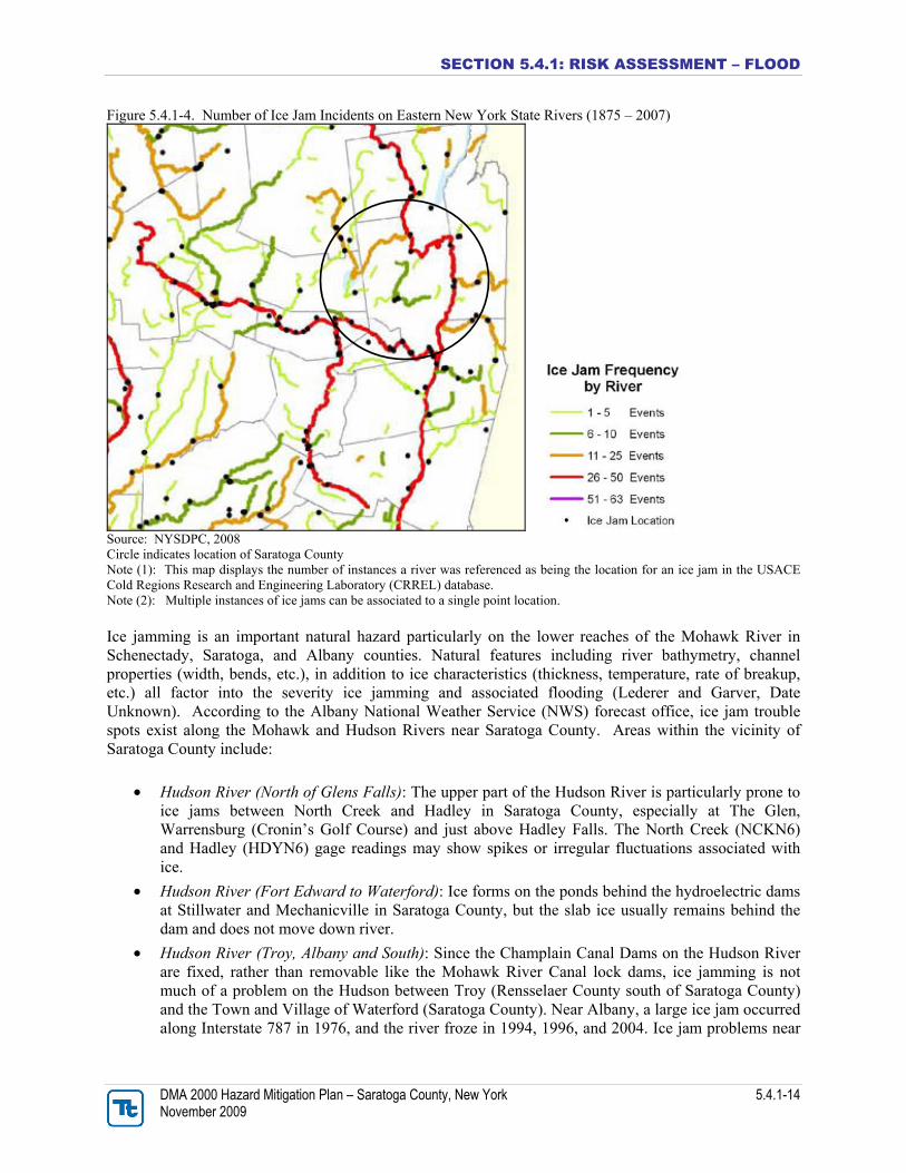
the Hudson River in the City of Mechanicville. Estimated damages (reported and unreported) per flooding event to properties in this area is approximately $42,500 (The Chazen Companies, 2002). The Price Road, Stratton Lane, Old Champlain Canal Area: This area is located near the Town of Stillwater’s eastern boundary, approximately centered north to south. The boundaries of the affected area include: properties fronting the west side of NYS RTS 4 & 32 from the intersection of Stratton Lane north along NYS RTS 4 & 32 approximately 1,750-feet to just north of the intersection of Price Road; properties along Price Road from the intersection of NYS RTS 4 & 32 southwest along Price Road approximately 2,500-feet to the intersection of Stratton Lane; properties fronting the north side of Stratton Lane from the intersection of Price Road east approximately 1,000-feet to the intersection of NYS RTS 4 & 32. Estimated damages (reported and unreported) per flooding event to properties in this area is approximately $32,500 (The Chazen Companies, 2002). The Saratoga Lakefront Area: This area is located along the Town of Stillwater’s approximately 2.8-mile long Saratoga Lake frontage found on its western border. Along the east shore of Saratoga Lake in the Town of Stillwater, there are a total of 147 properties. Of the 147 properties along the eastern shore of Saratoga Lake, 144 are located in the 500-year floodplain and 106 are located within the 100-year floodplain. Total reported damages for eight (8) properties for which documentation was available was $4,000 (The Chazen Companies, 2002). Other Areas: According to the FMA, the Riverside Area has a history of flooding and is located outside of the floodplain. This area is located just south of the Delaware and Hudson Railroad Bridge (the Iron Bridge) crossing of River Road (NYS RTS 4 & 32) and the Hudson River. During the December 16 and 17, 2001 and the January 19, 1996 storms, ice blocked culvert pipes that convey stormwater causing flooding along River Road from the Iron Bridge south to the intersection of Champlain Street, including the mobile home park (The Chazen Companies, 2002). The Stillwater FMA calculated fiscal impacts from flood events. Emergency response and repair costs quantified for the Town and Village Departments of Public Works, Fire Departments and Police Department were estimated to be $182,423 dollars annually or $58,155 per flood event (The Chazen Companies, 2002). Ice Jam Hazard Areas Ice jams are common in the Northeast U.S. and New York is not an exception. In fact, according to the USACE, New York State ranks second in the Nation for total number of ice jam events, with over 1,435 incidents documented between February 1, 1867 and March 16, 2007. Areas of New York State that include characteristics lending to ice jam flooding include the northern counties of the Finger Lakes region and far western New York, the Mohawk Valley of Central and Eastern New York (which includes all of Saratoga County) and the North Country (NYSDPC, 2008). Of the many streams, creeks and rivers that extend through the State, the Hudson and Mohawk River (which travel through Saratoga County) are two of the top ten rivers within the State experiencing the most amount of ice jams between 1875 and 2007 (NYSDPC, 2008). Figure 5.4.1-4 presents the number of ice jam incidences within the vicinity of the Mohawk River and Hudson River. Mohawk River has experienced over 48 ice jams and Hudson River has experienced over 36 ice jams. Other leading rivers within the state include the Cazenovia Creek (63 incidences), Genessee River (55 incidences), Great Chazy River (54 incidences) and the Walkill River (52 incidences).
SECTION 5.4.1: RISK ASSESSMENT – FLOOD
DMA 2000 Hazard Mitigation Plan – Saratoga County, New York 5.4.1-14 November 2009
Figure 5.4.1-4. Number of Ice Jam Incidents on Eastern New York State Rivers (1875 – 2007)
Source: NYSDPC, 2008 Circle indicates location of Saratoga County Note (1): This map displays the number of instances a river was referenced as being the location for an ice jam in the USACE Cold Regions Research and Engineering Laboratory (CRREL) database. Note (2): Multiple instances of ice jams can be associated to a single point location. Ice jamming is an important natural hazard particularly on the lower reaches of the Mohawk River in Schenectady, Saratoga, and Albany counties. Natural features including river bathymetry, channel properties (width, bends, etc.), in addition to ice characteristics (thickness, temperature, rate of breakup, etc.) all factor into the severity ice jamming and associated flooding (Lederer and Garver, Date Unknown). According to the Albany National Weather Service (NWS) forecast office, ice jam trouble spots exist along the Mohawk and Hudson Rivers near Saratoga County. Areas within the vicinity of Saratoga County include:
Hudson River (North of Glens Falls): The upper part of the Hudson River is particularly prone to ice jams between North Creek and Hadley in Saratoga County, especially at The Glen, Warrensburg (Cronin’s Golf Course) and just above Hadley Falls. The North Creek (NCKN6) and Hadley (HDYN6) gage readings may show spikes or irregular fluctuations associated with ice.
Hudson River (Fort Edward to Waterford): Ice forms on the ponds behind the hydroelectric dams at Stillwater and Mechanicville in Saratoga County, but the slab ice usually remains behind the dam and does not move down river.
Hudson River (Troy, Albany and South): Since the Champlain Canal Dams on the Hudson River are fixed, rather than removable like the Mohawk River Canal lock dams, ice jamming is not much of a problem on the Hudson between Troy (Rensselaer County south of Saratoga County) and the Town and Village of Waterford (Saratoga County). Near Albany, a large ice jam occurred along Interstate 787 in 1976, and the river froze in 1994, 1996, and 2004. Ice jam problems near

SECTION 5.4.1: RISK ASSESSMENT – FLOOD
DMA 2000 Hazard Mitigation Plan – Saratoga County, New York 5.4.1-15 November 2009
Albany (Albany County) and further south were reduced when the river was dredged and deepened for shipping in the 1930s.
Mohawk River: The Mohawk River is very prone to ice jamming due to its improved channel for the barge canal. During the winter, lock dams are pulled, leaving the river relatively shallow and straight. The Mohawk Valley acts to funnel west northwest winds during cold air outbreaks, which helps the cooling and freezing process. During high winds, snow will blow off the ice exposing it to the cold.
Mohawk River (Schenectady and Rexford Area): Most of the jam potential lies in Schenectady (Schenectady County), southwest of Saratoga County. Just below the GE plant the river widens out by the Western Gateway Bridge. About a half mile downstream is the railroad bridge which has numerous piers in the water, an ideal obstacle for the ice. Just upstream of the Gateway Bridge is Schenectady Community College. The parking lots, athletic fields, and Begley Hall are in the flood area. Between these bridges lies the Stockade neighborhood of Schenectady. This neighborhood is unprotected and can flood easily. Jams also occur at Rexford or at the Knolls near the Atomic Power Lab. There is an abrupt bend in the river and the channel is narrow. Sometimes the ice jams on the sheet ice behind Vischer Ferry Dam.
Mohawk River (Halfmoon, Crescent and Cohoes): A large crescent-shaped dam across the Mohawk just west of Cohoes (Albany County) falls backs up a lake that’s about five miles long and almost a mile wide in some areas. This extends west to Vischer Ferry. This area is lined with homes and some commercial property very close to the water. The lake usually freezes quite early in the season and the ice can get quite thick. The lake is divided in two by a narrows near Halfmoon and Dusbach Ferry where the Twin bridges of the Northway cross. Ice can jam in this narrow channel, and water will rise quickly and threaten homes and a restaurant. Below the Crescent Dam the ice is usually pulverized in the Cohoes Falls. However, some damage did occur in Waterford in 1964 when an upstream jam broke and released a sudden surge over the falls into the village (NWS, 2007).
The Ice Jam Database, maintained by the Ice Engineering Group at the USACE Cold Regions Research and Engineering Laboratory (CRREL), currently consists of approximately 15,000 records from across the U.S. According to the USACE-CRREL and the NYSDPC, Saratoga County experienced over 27 historic ice jam events between 1928 and 2007 (Ice Engineering Research Group, Date Unknown). Historical events are further mentioned in the “Previous Occurrences” section of this hazard profile. Dam Break Hazard Area According to the NYSDEC Division of Water Bureau of Flood Protection and Dam Safety, the hazard classification of a dam is assigned according to the potential impacts of a dam failure pursuant to 6 NYCRR Part 673.3. Dams are classified in terms of potential for downstream damage if the dam were to fail. These hazard classifications are identified and defined below:
Low Hazard (Class A) is a dam located in an area where failure will damage nothing more than isolated buildings, undeveloped lands, or township or county roads and/or will cause no significant economic loss or serious environmental damage. Failure or misoperation would result in no probable loss of human life. Losses are principally limited to the owner's property
Intermediate Hazard (Class B) is a dam located in an area where failure may damage isolated homes, main highways, minor railroads, interrupt the use of relatively important public utilities, and/or will cause significant economic loss or serious environmental damage. Failure or misoperation would result in no probable loss of human life, but can cause economic loss, environment damage, disruption of lifeline facilities, or impact other concerns. Significant hazard
SECTION 5.4.1: RISK ASSESSMENT – FLOOD
DMA 2000 Hazard Mitigation Plan – Saratoga County, New York 5.4.1-16 November 2009
potential classification dams are often located in predominantly rural or agricultural areas but could be located in areas with population and significant infrastructure.
High Hazard (Class C) is a dam located in an area where failure may cause loss of human life, serious damage to homes, industrial or commercial buildings, important public utilities, main highways or railroads and/or will cause extensive economic loss. This is a downstream hazard classification for dams in which more than 6 lives would be in jeopardy and excessive economic loss (urban area including extensive community, industry, agriculture, or outstanding natural resources) would occur as a direct result of dam failure (NYSDEC, 2006).
Refer to Table 4-18 and Figure 4-19 in the County Profile (Section 4) for dams located in Saratoga County.
Beaver Dam Hazard Areas
According to County Officials, beavers are becoming more and more of a problem throughout the County. Incidences of beaver dam disturbances have been reported particularly in the Towns Ballston, Charlton, Corinth, Greenfield and Galway. Information regarding beaver dam locations or reported dam problems / incidences within the Towns are further discussed below:
Ballston: At the northern send of Ballston Lake, a wetland is home to a group of beavers whose dams significantly slow the outflow from the lake. As a result, the water level has been known to rise significantly during heavy rains and recedes slowly through the wetland. The high water levels combined with powerboat wakes and natural waves have resulted in extensive erosion of the lakeshore (Capital District Regional Planning Commission, 2001).
Charlton: Town officials stated that they have problems with beavers building dams in the culverts on Root Road and Sweetman Road (Mills, 2008).
Corinth: In 2006, $1 million in funding was provided to the Town of Corinth to repair approximately 200 feet of railroad track that was damaged following a beaver dam break that caused the track and surrounding terrain to wash out (NYSDOT, 2006).
Galway: In 2006, a beaver dam let go and it washed away Greens Corners Road and many drive ways, resulting in the isolation of multiple homes (Lent, 2008).
Greenfield: In May 2006, a beaver dam breached in the Town of Greenfield, causing Daniels Road to be washed away. The release also washed away a rail road track owned by the Town of Corinth and Canadian Pacific Railroad. Serious flooding occurred in Saratoga Spa State Park and homes were threatened in Saratoga Springs, Greenfield and Milton. Approximate damages during this event were estimated at $200,000 (Lent, 2008). The instantaneous release of water also overtopped three small downstream reservoirs, called the Three Sisters Ponds, and breached the earthen dams upon which century old historic carriage trails were constructed (Arnold, 2007). In November 2008, beavers dammed a culvert along Mud Creek, forcing run off from the mountains and nearby ponds to back up along the same Canadian Pacific railroad bed that was affected in May 2006. This blockage created a huge lake where a field once was near Route 9N, between Greene and Spier Falls roads and created a potential cause for concern for many local residents (Figure 5.4.1-5). The county emergency services director estimated that the beaver “lake” was nearly 200 acres in size and consisted of over 1 billion gallons of water, with the an old railroad bed being the only thing holding it back (Mulholland, 2008; Kerr, 2008). The Towns of Corinth and Greenfield brought in 10 pumps to move the water and to prevent potential flooding in surrounding residential properties.

SECTION 5.4.1: RISK ASSESSMENT – FLOOD
DMA 2000 Hazard Mitigation Plan – Saratoga County, New York 5.4.1-17 November 2009
Figure 5.4.1-5. 200-Acre beaver “lake” in Greenfield, New York formed in November 2008
Source: Lent, 2008. This “lake” is normally a dry field.
Elevated Groundwater Hazard Area Elevated groundwater in Saratoga County was introduced as an additional flood hazard of concern towards the end of the planning process. All information gathered to date has been included in this profile. According to members of the Planning Committee, elevated groundwater occurs in the Towns of Moreau and Wilton. In 2007, Hanson Van Vleet, LLC cited that over 40 residents in the Town of Wilton experienced elevated groundwater and thus wet and flooded basements that spring. According to Hanson Van Vleet LLC the cause is an inter-relationship of the geology, hydrogeology and weather (mainly precipitation; however, the connection to rainfall is debated (Hanson Van Vleet, LLC; 2007). This type of flooding is sporadic and occurs mainly during the spring months, but also occurs other times throughout the year.

SECTION 5.4.1: RISK ASSESSMENT – FLOOD
DMA 2000 Hazard Mitigation Plan – Saratoga County, New York 5.4.1-18 November 2009
Figure 5.4.1-5a. Approximate Locations of Elevated Groundwater in the Town of Wilton
Source: Hanson Van Vleet, LLC
Previous Occurrences and Losses
Many sources provided historical information regarding previous occurrences and losses associated with flooding throughout New York State and Saratoga County. With so many sources reviewed for the purpose of this HMP, loss and impact information for many events could vary depending on the source.

SECTION 5.4.1: RISK ASSESSMENT – FLOOD
DMA 2000 Hazard Mitigation Plan – Saratoga County, New York 5.4.1-19 November 2009
Therefore, the accuracy of monetary figures discussed is based only on the available information identified during research for this HMP. Between 1953 and 2007, FEMA declared that New York experienced over 36 flood-related disasters classified as one or a combination of the following disaster types: flooding, heavy rains, severe storms, coastal storms and high tides (FEMA, 2007). Of those events, the NYS HMP and FEMA indicates that Saratoga County has been declared as a disaster area as a result of three flood events between 1955 and 2007 (FEMA, 2008; NYSDPC, 2008; NYSEMO, 2006). Although other flood disasters have occurred within the Saratoga County area; disaster declarations were not assigned to the County. However, flood losses associated with other disasters within the County are discussed further in this section. Table 5.4.1-1 summarizes the FEMA Presidential Disaster (DR) or Emergency (EM) Declarations for flood events in Saratoga County. Many of these federal disasters were the remnants of severe storms or tropical or extra tropical disturbances (hurricanes, tropical storms, ice storms, Nor’Easters) either passing over or located within proximity to the State. These disasters resulted in flooding in the County, hence the reason for the occasional categorization by FEMA as “severe storms and flooding” event. Because flooding was the primary impact of many of these types of hazard events, only the severe flooding impact of major events are discussed in this Hazard Profile and are also mentioned in their designated sections of this HMP: Section 5.4.3 (Severe Storm) and Section 5.4.2 (Severe Winter Storm). Table 5.4.1-1 Presidential Disaster Declarations for Flooding Events in Saratoga County (3 Declarations)
Type of Event* Date** Declaration
Number Cost of Losses (approximate)
Severe Storms and Flooding
January 1996
DR-1095
New York State experienced approximately $100 M in damages (NYSDPC). New York State received $16.7 M in individual assistance and $103.7 M in public assistance. NOAA-NCDC indicated that Saratoga County experienced $10 M in damages. Widespread flooding occurred throughout Saratoga County particularly along the Mohawk and Hudson Rivers. Flooding was most severe in Waterford, Stillwater and Halfmoon. Flooding resulted in evacuations, inundated homes, closed and washed out roads, and damages to local businesses throughout the County. USGS indicated that Saratoga County received approximately $328 K in individual aid and $1.3 M in public assistance.

SECTION 5.4.1: RISK ASSESSMENT – FLOOD
DMA 2000 Hazard Mitigation Plan – Saratoga County, New York 5.4.1-20 November 2009
Type of Event* Date** Declaration
Number Cost of Losses (approximate)
Severe Winter Storms (with
flooding)
January 1998
DR-1196
Although this event was identified as winter storm event (further discussed in Section 5.4.2), the heavy rain and snow melt during the event resulted in significant flooding throughout six counties of New York State, including Saratoga County. New York State experienced approximately $68.1 M in damages (NYSDPC). In the Albany NWS Forecast area, flooding resulted in significant damage to more than 180 homes, the evacuation of 185 people, and numerous road closures. NCDC indicated that Saratoga County experienced between $125 and $745 K in property damages. However, SHELDUS indicated that the County experienced $341 K in losses. In Waterford, 125 people were evacuated from their homes and electrical power was shut off to the flooded area. Seventy people were temporarily housed in shelters and approximately 150 homes sustained flood damage. In the Village of Stillwater in southern Saratoga County, a State of Emergency was declared. Several feet of water flooded Wrights Loop, Ferry Lane and River Road. The rising water forced the evacuation of 60 people. At the Town of Saratoga which includes Schuylerville, 15 to 20 homes were evacuated near the Hudson River. At the Town of Moreau in northern Saratoga County, houses along Dyke and Nolan Roads were surrounded by rising water. Many roads were also closed in the Towns of Milton and Malta due to the Kayaderosseras, Mourningkill and Gordon Creeks flooding onto roadways. The Kayaderosseras Creek flooded parts of State Route 9 and the Creek-n-Pines trailer park. A two thousand foot section of Wilton Mountain Road was washed out. State Route 9 in the Town of Wilton was flooded from Ballard Road to Ernst Road. Roads were also closed in the Towns of Northumberland and Clifton Park.
Severe Storms and Flooding
May-June 2004
DR-1534
New York State experienced approximately $14 M in damages (NYSDPC). More than $6.3 M in public assistance was approved for New York. In Saratoga County, the Town of Providence reported 10-inches of water on Clark Road. The Hudson River exceeded its flood stage in Mechanicville and Schuylerville. Estimated losses in Saratoga County are unknown.
Source: FEMA, 2007; NYSDPC, 2008; Hazards and Vulnerability Research Institute (SHELDUS), 2008; NOAA-NCDC, 2007; NYSEMO, 2006 * The ‘Type of Event’ is the disaster classification that was assigned to the event by FEMA. ** Date of Incident Note: Dollars rounded to nearest thousand. Recorded losses indicate the dollar value of covered losses paid, as available through the public records reviewed. Some of these events overlap with events shown under the Severe Storm and Severe Winter Storm hazard profiles of this Plan. As part of the USGS's program for disseminating water data within USGS, to USGS cooperators, and to the general public, the USGS maintains a distributed network of computers and fileservers for the acquisition, processing, review, and long-term storage of water data. This network of computers is called the National Water Information System (NWIS) and the data is continuously collected at over 1.5 million sites, also known as stream flow stations or gages, around the country and at some border and territorial sites. Many types of data are stored in NWIS, including comprehensive information for site characteristics, well-construction details, time-series data for gage height, streamflow, ground-water level, precipitation, and physical and chemical properties of water. Additionally, peak stream flows, chemical analyses for discrete samples of water, sediment, and biological media are accessible within NWIS (USGS, 2008). Saratoga County network consists of 11 USGS Stream flow stations along the Hudson and Mohawk Rivers and their tributaries, with each station having different periods of record up to 2007 (USGS, 2008).

SECTION 5.4.1: RISK ASSESSMENT – FLOOD
DMA 2000 Hazard Mitigation Plan – Saratoga County, New York 5.4.1-21 November 2009
The two oldest stations in the County are located in Hadley, New York, including USGS Station 1325000 along the Sacandaga River at Stewards Bridge (100 years of data) and USGS Station 1318500 located along the Hudson River at Hadley (87 years of data) (USGS, 2008). Each station collects peak flow data, which identifies the annual flood or largest flood with the highest maximum instantaneous peak streamflow (or discharge) and gage height for a given station of each water year. For the purpose of this HMP, the peak stream flows of each of these stations during their period of record were reviewed to identify the record peak events at those stations. These records indicate that the most prominent peak flow events that have impacted the stations of the County appear to have occurred in March 1913, December 1948, January 1949 and March 1977. Table 5.4.1-2 USGS Peak Stream Flows for Saratoga County
Period of Record Record Peak(s)
USGS Station
ID USGS Station Name
Begin Date End Date
Daily Average Discharge
(Cubic Feet / Second)
(approx. range) 1
Total Peak
Events
Event Date(s)
Peak Discharge
(Cubic Feet / Second)
1318500 Hudson River at Hadley
3/27/1913 4/24/2007 1,000 - 9,700 87 3/27/1913 1/1/1949
49,000 42,700
1325000 Sacandaga River at Stewards Bridge Near Hadley
4/29/1908 5/3/2007 700 – 3,000 100 3/28/1913 35,500
1328758 Pecks Creek at Fort Miller
3/18/1968 3/5/1979 NA 12 3/5/1979 230
1329780 Sessions Brook at Porters Corners
4/25/1968 3/15/1986 NA 19 3/14/1977 80
1329900 Glowegee Creek Tributary at Mosherville
4/25/1968 8/8/1986 NA 19 3/14/1977 139
1330000 Glowegee Creek at West Milton
12/31/1948 4/16/2007 5 - 170 32 12/31/1948 1/8/1998
1,670 1,370
1330500 Kayaderosseras Creek near West Milton
8/29/1927 1/9/1998 40 - 500 70 3/18/1936
12/31/1948 4,710 4,340
1330880 Saratoga Lake Tributary near Bemis Heights
3/17/1968 3/15/1995 NA 25 8/7/1986 1/26/1990
448 226
1335500 Hudson River at Mechanicsville
4/1/1869 3/16/1977 3,000 – 20,000 71 3/28/1913 1/1/1949
120,000 118,000
1335754 Hudson River above Lock 1 near Waterford
1/1/1949 4/25/2007 3,500 – 18,000 28 1/1/1949 3/15/1977
120,000 71,800
1356000 Mohawk River at Vischer Ferry Dam
3/28/1914 4/13/1919 1,000 – 32,000 6 3/28/1914 4/2/1916
140,000 113,000
Source: USGS, 2008 Note (1): Daily average discharge is the daily mean discharge amount for the period of record based on surface-water daily
statistics provided by the USGS data for each station. A constant discharge amount is not assigned to an individual station since stream flow is always changing.
cfs Cubic feet per second NA Not Available The NWS Advanced Hydrologic Prediction Service (AHPS) identifies the flood categories and top historical flood crests for four USGS water gauges throughout Saratoga County. This information is presented in Table 5.4.1-3 below.

SECTION 5.4.1: RISK ASSESSMENT – FLOOD
DMA 2000 Hazard Mitigation Plan – Saratoga County, New York 5.4.1-22 November 2009
Table 5.4.1-3 AHPS Water Gauges in Saratoga County – Historical Crests
USGS Water Gauge Hudson River
at Hadley Hudson River at Waterford
Sacandaga River at
Sacandaga Reservoir
Sacandaga River at Stewarts Bridge
Major Flood Stage (ft): 19 37 774 12
Moderate Flood Stage (ft): 17 35 773.5 11
Flood Stage (ft): 14 34 773 10 Flo
od
Cat
egor
ies
per
Gau
ge
Action Stage (ft): 8.5 33 768 8
23.00 ft on 03/27/1913
36.38 ft on 05/30/1984
773.55 ft on 04/21/2008
12.36 ft on 03/28/1913
21.21 ft on 01/01/1949
35.59 ft on 05/04/1983
773.53 ft on 06/30/2006
9.68 ft on 05/04/1983
19.71 ft on 04/12/1922
34.76 ft on 05/13/1996
773.29 ft on 05/04/1983
9.54 ft on 07/01/1968
19.59 ft on 03/18/1936
34.38 ft on 05/22/1990
772.11 ft on 05/22/1990
9.37 ft on 04/28/1993
17.49 ft on 04/02/1976
34.36 ft on 04/23/1993
771.26 ft on 04/26/1993
9.32 ft on 05/23/1990
17.32 ft on 06/04/1947
34.15 ft on 12/02/1996
770.52 ft on 05/14/1989
9.15 ft on 04/26/1977
17.08 ft on 01/10/1998
33.93 ft on 04/17/1994
770.32 ft on 05/14/1996
9.15 ft on 04/01/1976
16.68 ft on 03/28/1953
33.70 ft on 11/11/1990
770.17 ft on 05/06/1997
8.84 ft on 10/01/1986
16.14 ft on 05/05/1972
33.70 ft on 05/07/1989
769.81 ft on 05/06/1992
8.75 ft on 05/10/1989
Historical Crests
- - 769.15 ft on 05/02/1994
8.71 ft on 06/24/1972
Source: AHPS, 2008
SECTION 5.4.1: RISK ASSESSMENT – FLOOD
DMA 2000 Hazard Mitigation Plan – Saratoga County, New York 5.4.1-23 November 2009
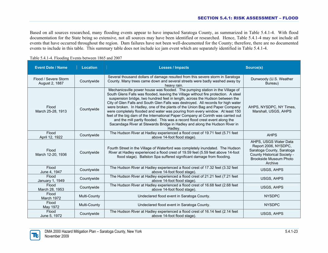
Based on all sources researched, many flooding events appear to have impacted Saratoga County, as summarized in Table 5.4.1-4. With flood documentation for the State being so extensive, not all sources may have been identified or researched. Hence, Table 5.4.1-4 may not include all events that have occurred throughout the region. Dam failures have not been well-documented for the County; therefore, there are no documented events to include in this table. This summary table does not include ice jam event which are separately identified in Table 5.4.1-4. Table 5.4.1-4. Flooding Events between 1865 and 2007
Event Date / Name Location Losses / Impacts Source(s)
Flood / Severe Storm August 2, 1887
Countywide Several thousand dollars of damage resulted from this severe storm in Saratoga County. Many trees came down and several streets were badly washed away by
heavy rain.
Dunwoody (U.S. Weather Bureau)
Flood March 25-28, 1913
Countywide
Mechanicsville power house was flooded. The pumping station in the Village of South Glens Falls was flooded, leaving the Village without fire protection. A steel suspension bridge, two hundred feet in length, across the Hudson between the
City of Glen Falls and South Glen Falls was destroyed. All records for high water were broken. In Hadley, one of the plants of the Union Bag and Paper Company were completely flooded and water was pouring from every window. At least 150 feet of the big dam of the International Paper Company at Corinth was carried out
and the mill partly flooded. This was a record flood crest event along the Sacandaga River at Stewards Bridge in Hadley and along the Hudson River in
Hadley.
AHPS, NYSDPC, NY Times, Marshall, USGS, AHPS
Flood April 12, 1922
Countywide The Hudson River at Hadley experienced a flood crest of 19.71 feet (5.71 feet
above 14-foot flood stage). AHPS
Flood March 12-20, 1936
Countywide Fourth Street in the Village of Waterford was completely inundated. The Hudson River at Hadley experienced a flood crest of 19.59 feet (5.59 feet above 14-foot
flood stage). Ballston Spa suffered significant damage from flooding.
AHPS, USGS Water Data Report 2006, NYSDPC,
Saratoga County, Saratoga County Historical Society -Brookside Museum Photo
Archive Flood
June 4, 1947 Countywide
The Hudson River at Hadley experienced a flood crest of 17.32 feet (3.32 feet above 14-foot flood stage).
USGS, AHPS
Flood January 1, 1949
Countywide The Hudson River at Hadley experienced a flood crest of 21.21 feet (7.21 feet
above 14-foot flood stage). USGS, AHPS
Flood March 28, 1953
Countywide The Hudson River at Hadley experienced a flood crest of 16.68 feet (2.68 feet
above 14-foot flood stage). USGS, AHPS
Flood March 1972
Multi-County Undeclared flood event in Saratoga County. NYSDPC
Flood May 1972
Multi-County Undeclared flood event in Saratoga County. NYSDPC
Flood June 5, 1972
Countywide The Hudson River at Hadley experienced a flood crest of 16.14 feet (2.14 feet
above 14-foot flood stage). USGS, AHPS

SECTION 5.4.1: RISK ASSESSMENT – FLOOD
DMA 2000 Hazard Mitigation Plan – Saratoga County, New York 5.4.1-24 November 2009
Event Date / Name Location Losses / Impacts Source(s)
Flood June 20-25, 1972
(Remnants of Tropical Storm Agnes)
Multi-State Resulted in a Disaster Declaration for 26 New York State counties (DR-338), however, it did not include Saratoga County. Saratoga County experienced
approximately $1.6 M in property damages and crop damages.
FEMA, Hazards and Vulnerability Research Institute
(SHELDUS), NYSEMO
Flood June 28-30, 1973
Multi-County Saratoga County experienced approximately $38 M in property damages and crop damages. However, based on the lack of available information regarding
this event, it appears that these estimated losses are inaccurate.
Hazards and Vulnerability Research Institute (SHELDUS)
Flood July 1975
Multi-County Undeclared flood event in Saratoga County. NYSDPC
Flood January 1976
Multi-County Undeclared flood event in Saratoga County. NYSDPC
Flood April 2, 1976
Multi-County Undeclared flood event in Saratoga County. The Hudson River at Hadley
experienced a flood crest of 17.49 feet (3.49 feet above 14-foot flood stage) NYSDPC, USGS, AHPS
Flood March 14, 1977
Multi-County
An early warm spell (temperatures into the 70s and 80s), combined with a heavy snowpack, and 3 inches of rain, produced near record floods in
Kaydeross/Saratoga area. Ramps to new Interstate 787 in downtown Albany were flooded, and the current in the Hudson River undermined the Green Island
Bridge causing it to buckle and eventually collapse (no fatalities or injuries).
NWS
Flood May 4, 1983
Countywide The Hudson River at Waterford experienced a flood crest of 35.59 feet (1.59 feet
above 34-foot flood stage). USGS, AHPS
Flood December 12, 1983
Multi-County Saratoga County experienced approximately $227 K in property damages. Hazards and Vulnerability
Research Institute (SHELDUS)
Flood May 28-30, 1984
Multi-County Saratoga County experienced approximately $2.4 M in property damages. The
Hudson River at Waterford experienced a flood crest of 36.38 feet (2.38 feet above 34-foot flood stage).
Hazards and Vulnerability Research Institute (SHELDUS),
AHPS
Flood March 14, 1986
Multi-County Saratoga County experienced approximately $1.4 M in property damages. Hazards and Vulnerability
Research Institute (SHELDUS)
Flood August 7, 1986
Multi-County Saratoga County experienced approximately $500 K in property damages and $5
K in crop damages. Hazards and Vulnerability
Research Institute (SHELDUS)
Flood June 22, 1987
Multi-County Saratoga County experienced approximately $50 K in property damages and $5
K in crop damages. Hazards and Vulnerability
Research Institute (SHELDUS)
Flood April 3-6, 1987
(FEMA DR-792) Multi-County
Resulted in a Disaster Declaration for multiple New York State counties (DR-52), however, it did not include Saratoga County. Saratoga County experienced approximately $2.1 M in property damages, $208 K in crop damages and 3
FEMA, Lumia (USGS WRIR 97-4252), NYSEMO, Hazards
and Vulnerability Research

SECTION 5.4.1: RISK ASSESSMENT – FLOOD
DMA 2000 Hazard Mitigation Plan – Saratoga County, New York 5.4.1-25 November 2009
Event Date / Name Location Losses / Impacts Source(s)
injuries. Institute (SHELDUS)
Flood March 29, 1993
Multi-County Saratoga County experienced approximately $50 K in property damages and $5
K in crop damages. Hazards and Vulnerability
Research Institute (SHELDUS)
Flood April 17, 1993
Multi-County Saratoga County experienced approximately $50 K in property damages and $5
K in crop damages. Hazards and Vulnerability
Research Institute (SHELDUS)
Flood April 17, 1994
Countywide
Minor lowland flooding was reported along the Susquehanna River from Bainbridge to Waverly; along the Chenango River at Sherburne; the Tioughnioga
River at Cortland; the Upper Mohawk River between Utica and Little Falls including the East Canada Creek and Spruce Creek; the Sacandaga River north
of the Northville; the Schroon River from Schroon Lake to near Athol; and the Hudson River in the vicinity of Stillwater Flats. Counties affected experienced
approximately $50 K in property damage.
NOAA-NCDC
Severe Storms and Flood January 18-20, 1996
(FEMA DR-1095) “Deluge of 1996”
Northeastern U.S.
See FEMA Disaster Declarations (Table 5.4.1-1)
FEMA, NOAA-NCDC, NYS HMP, NWS, Lumia (USGS
WRIR 97-4252), Hazards and Vulnerability Research Institute
(SHELDUS)
Flood April 16, 1996
Countywide
Additional rain on already saturated soil caused road washouts and one bridge closure in Saratoga County. In the Town of Halfmoon the Hudson River Road
was washed out. In the Town of Ballston along Outlet Road a bridge was closed due to high water and in the Town of Moreau, Spier Falls Road was washed out.
Saratoga County experienced approximately $40 K in property damage.
NOAA-NCDC
Flood May 13, 1996
Countywide The Hudson River at Waterford experienced a flood crest of 34.76 feet (.76 feet
above 34-foot flood stage). USGS, AHPS
Severe Storms and Flood November 8-15, 1996
(FEMA DR-1148) Multi-State
Resulted in a Disaster Declaration for multiple New York State counties (DR-1148), however, it did not include Saratoga County. Minor flooding occurred along the Hudson River in Saratoga County from Schuylerville to Waterford. Wrights Loop in the Stillwater Flats and First Street in Waterford were both flooded. Saratoga County experienced approximately $404 K in property
damage.
NOAA-NCDC, Hazards and Vulnerability Research Institute
(SHELDUS)
Winter Storm / Flood January 5-17, 1998
Countywide See FEMA Disaster Declarations
(Table 5.4.1-1)
FEMA, NYSEMO, NOAA-NCDC, Hazards and
Vulnerability Research Institute (SHELDUS), NWS, Forsing

SECTION 5.4.1: RISK ASSESSMENT – FLOOD
DMA 2000 Hazard Mitigation Plan – Saratoga County, New York 5.4.1-26 November 2009
Event Date / Name Location Losses / Impacts Source(s)
Flood January 25, 1999
Stillwater
In Saratoga County, Route 103 was closed due to water on the road. Portions of Route 9P were also under water between route 423 and Brown Water road. Five
people had to be evacuated from their homes at Quaker Springs as Saratoga Lake flooded. Saratoga County experienced approximately $40 K in property
damage.
NOAA-NCDC
Flood (Remnants of
Hurricane/Tropical Storm Floyd)
September 19, 1999
Multi-State Resulted in a Disaster Declaration for multiple New York State counties (DR-
1296), however, it did not include Saratoga County. Precipitation totals in the County ranged between 4.5 inches in Galway to 7.00 inches in Ballston Spa.
FEMA, NYSDPC, NYSEMO, NWS, Freedom
Communications (CBS06)
Flood February 26, 2000
Multi-County
Forty people were evacuated from their homes in the Town of Halfmoon as water from the Mohawk River encroached upon their homes. Fifty residences were evacuated in the Crescent area of the Town of Halfmoon in southern Saratoga county, some by boat. The Hudson River overflowed onto the Mechanicville Wharf and also went over the Mohawk Wharf into the village of Waterford. Saratoga County experienced approximately $63 K in property damages.
NOAA-NCDC
Flood June 6, 2000
Multi-County
Widespread small stream and urban flooding occurred throughout Schoharie, Albany, Saratoga, Schenectady, Columbia, Delaware, Greene, and Ulster
counties. Precipitation totals in Saratoga County ranged between 2.4 inches in Saratoga Springs to 4.10 inches in Mechanicsville.
Freedom Communications (CBS06)
Severe Storms May 3, – September, 14,
2000 Statewide
Resulted in a Disaster Declaration for multiple New York State counties (DR-1335), however, it did not include Saratoga County. Saratoga County experienced approximately $80 K in property damages from this event.
Governor Pataki Press Release, FEMA, NYSDPC, NOAA-NCDC, Hazards and
Vulnerability Research Institute (SHELDUS), NYSEMO
Flood December 16-17, 2000
Countywide
Both Saratoga and Rensselaer Emergency Management Authorities reported widespread flooding in their respective counties, including many roads washed
out. Significant flooding occurred in Saratoga County, in the towns of Mechanicsville, Waterford and Stillwater. The mayor of Mechanicville declared a
state of emergency after the Anthony Kill overflowed, and the Hudson River began to approach the city wharf. The Hudson River rose to 92.50 at
Schuylerville and 54.7 feet at Mechanicville, 2.5 and 1.7 feet above flood stage respectively. With the exception of minor flooding on the Stillwater Flats, there
were no flooding problems reported to the National Weather Service on either the Mohawk or Hudson Rivers. Saratoga County experienced approximately $190 K
in property losses.
NOAA-NCDC, Freedom Communications (CBS06)
Flood May 13, 2002
Saratoga Springs
Heavy rains caused an earthen berm, part of the 1830s Champlain Canal, to give way under the weight of the water. The end result was that Route 4, along the Stillwater Flats in Saratoga County, became flooded and had to be closed for a couple of days. There was some minor damage reported along the roadway.
Saratoga County experienced approximately $25 K in property losses.
NOAA-NCDC, New York Parks and Conservation
Association

SECTION 5.4.1: RISK ASSESSMENT – FLOOD
DMA 2000 Hazard Mitigation Plan – Saratoga County, New York 5.4.1-27 November 2009
Event Date / Name Location Losses / Impacts Source(s)
Severe Storms, Tornados and Flood
July-August 2003 Multi-County
Resulted in a Disaster Declaration for multiple New York State counties (DR-1486), however, it did not include Saratoga County. Thunderstorms produced
torrential rain, with up to five inches falling between Mechanicville, Stillwater and Clifton Park in about two hours time. Saratoga County experienced between
$100 and $160 K in property losses.
FEMA, NOAA-NCDC, NWS, Hazards and Vulnerability
Research Institute (SHELDUS), NYSEMO
Severe Storm and Flood May 13 – June 17, 2004
Multi-County See FEMA Disaster Declarations
(Table 5.4.1-2) FEMA, NYSDPC, NYSEMO,
NOAA-NCDC
Severe Storms and Flood April 2-4, 2005
Multi-State
Resulted in a Disaster Declaration for multiple New York State counties (DR-1589), however, it did not include Saratoga County. In Clifton Park, Riverview
Road between Boyack and Van Vranken, closed due to Hudson River has overflowed into the area. Moderate flooding occurred along the Mohawk River at
Waterford.
NCDC, NWS, FEMA, NYSDPC, NOAA-NCDC, Hazards and Vulnerability
Research Institute (SHELDUS), Freedom Communications
(CBS06)
Flood July 14, 2005
Saratoga Springs
A cold front triggered severe thunderstorms during the afternoon which blew down trees in the southern Adirondacks, Mohawk valley and Saratoga region.
Heavy rainfall produced flash flooding at Saratoga Springs in Saratoga County. The intersection of East Avenue and Excelsior Avenue was under water.
NOAA-NCDC
Heavy Rain October 7-9, 2005
Multi-County Rainfall totals in the County ranged between 2.70 inches at Round Lake to 4.39
inches in Hadley. NWS, Freedom
Communications (CBS06)
Heavy Rain April 24, 2006
Multi-County Rainfall totals in the County ranged between 2.28 inches at the Conkingville Dam
to 3.34 inches in Round Lake. NWS
Beaver Dam Flood May 18, 2006
Town of Greenfield
An abandoned beaver dam on Putnam Brook in Greenfield, Saratoga County, broke. This brook eventually feeds water through Saratoga State Park via Slade Creek and Geyser Brook. Flooding occurred over several roadways and there
were partial washouts on three streets. Roads affected by flooding were: Daniels Road, Clinton Street, Bloomfield Road, Denton Road, Clement Avenue and Locust Grove Road. Those that were partially washed out were: Bloomfield,
Daniels and Denton. These washed out roads were closed for awhile. Low-lying areas of Saratoga State Park were evacuated as a result of flooding. County
officials indicate the there was an estimated $200 K in damages.
NOAA-NCDC, Gowan, Lent
Severe Storms and Flood June 26 – July 10, 2006
Multi-State
Resulted in a Disaster Declaration for multiple New York State counties (DR-1650), however, it did not include Saratoga County. Precipitation totals in
Saratoga County ranged between 3.08 inches in Vischer Ferry, (a hamlet of the Town of Clifton Park) to 5.08 inches in the Town of Charlton. Front Street and Lock 3 of the Eric Canal in Waterford experienced significant flooding. Some
residents at the Pine Ridge apartments in Clifton Park were trapped in their homes after a nearby stream overflowed its banks. It washed out part of an
access road they use to get in and out. Cars became stuck when trying to drive through water on Clifton Country Road. Major power outages occurred in
FEMA, NOAA-NCDC, NWS, NYSEMO, Weather
Underground, News10Now, WTEN, Freedom
Communications (CBS06)

SECTION 5.4.1: RISK ASSESSMENT – FLOOD
DMA 2000 Hazard Mitigation Plan – Saratoga County, New York 5.4.1-28 November 2009
Event Date / Name Location Losses / Impacts Source(s)
Saratoga Springs (1,000 residents), Malta and Stillwater (700 residents) and Waterford (500 residents). The New York State Canal Corp. was forced to close the Erie Canal from Lock E-2 in Waterford to Lock E-22 in New London/Sylvan. The entire Champlain Canal was closed due to the violently high flowing water. The closure of the canal systems left hundreds of boaters stranded for weeks in some cases until water levels dropped and the swift currents eased and repairs
to the system were made.
Flash Flood July 22, 2006
Hadley, Clifton Park
Law enforcement personnel reported that a sink hole formed on Route 9N in Hadley due to flash flooding. Also, 2 children were trapped in a car as a result of flash flooding in Clifton Park. Rainfall totals in the County ranged between 1.45
inches in Saratoga Springs to 3.85 inches in Corinth.
NOAA-NCDC, NWS
Severe Storms / Inland and Coastal Flood April 14-17, 2007
(also identified as a Nor’easter)
Multi-State Resulted in a Disaster Declaration for multiple New York State counties (DR-
1692), however, it did not include Saratoga County. Rainfall totals in the County ranged between 2.43 inches in Saratoga Springs to 3.61 inches in Hadley.
FEMA, NYSEMO, NYSDPC, NWS
Flood March 5, 2008
Rexford, Stillwater
State Route 4 was closed from Route 32 in Bemis Heights to Wilbur Road in Stillwater due to flooding. Flooding was also reported on Talbot Court in Rexford,
on Route 9 in Halfmoon, and also on Bluebird Road in Moreau. NOAA-NCDC
Flood April 9, 2008
Hadley, Schuylerville
The melting of a deep snowpack led to moderate or higher river flooding across portions of the upper Hudson River basin, including the Great Sacandaga Lake,
and the Hudson River between Schuylerville and Mechanicville. Snow water equivalents of nearly one foot began to melt during a warm period beginning around April 10th, and led to river flooding which persisted through the end of April. On the Hudson River near Schuylerville, a sod farm suffered estimated losses of $225 K due to prolonged submersion of sod in Hudson River flood
waters. In addition, the New York State Canal Corporation was unable to open the Hudson-Champlain Canal in April due to high water levels. Furthermore, the
crest of the Great Sacandaga Lake level was a new record.
NOAA-NCDC
Flood April 21, 2008
Countywide The Sacandaga River at Sacandaga Reservoir experienced a flood crest of
773.55 feet (0.55 feet above 773-foot flood stage). AHPS
Note (1): This table does not represent all events that may have occurred throughout the County. NOAA/NCDC storm query indicated that Saratoga County has experienced 69 flood events between January 1, 1950 and July 31, 2008 (including flash floods). However, not all of these events were identified in this table due to a lack of detail and their minor impact upon the County. Note (2): Monetary figures within this table were U.S. Dollar (USD) figures calculated during or within the approximate time of the event. If such an event would occur in the present day, monetary losses would be considerably higher in USDs as a result of increased U.S. Inflation Rates. * According to many sources, these event were known as Nor’easters, therefore, only the flood impact of these events (if applicable) is briefly discussed further in this hazard profile and are further mentioned in Section 5.4.2 (Severe Winter Storms). AHPS Advanced Hydrologic Prediction Service DR Federal Disaster Declaration
EM Federal Emergency Declaration FEMA Federal Emergency Management Agency

SECTION 5.4.1: RISK ASSESSMENT – FLOOD
DMA 2000 Hazard Mitigation Plan – Saratoga County, New York 5.4.1-29 November 2009
HMP Hazard Mitigation Plan K Thousand ($) M Million ($) NA Not Available NCDC National Climate Data Center NOAA National Oceanic Atmospheric Administration NPDP National Performance of Dams Program NRCC Northeast Regional Climate Center NSIDC National Snow and Ice Data Center
NTSB National Transportation Safety Board NWS National Weather Service NYS New York State NYSDPC New York State Disaster Preparedness Commission NYSEMO New York State Emergency Management Office SHELDUS Spatial Hazard Events and Losses Database for the U.S. USDA U.S. Department of Agriculture USGS U.S. Geological Survey WRIR Water Resources Investigation Report

SECTION 5.4.1: RISK ASSESSMENT – FLOOD
DMA 2000 Hazard Mitigation Plan – Saratoga County, New York 5.4.1-30 November 2009
According to the CRREL database, ice jams have historically formed at various points along the Mohawk River in Vischer Ferry, Rexford (hamlets of the Town of Clifton Park), and Crescent (a hamlet in the Town of Halfmoon); the Hudson River in the Town of Hadley, Village of Schuylerville and Town of Corinth; and the Kayaderosseras Creek and Glowegee Creek in West Milton (a hamlet in the Town of Milton) (Ice Engineering Research Group, Date Unknown). Locations of historical ice jam events are indicated in Figure 5.4.1-6 below. Figure 5.4.1-6. Saratoga County Ice Jam Events
Source: Ice Engineering Research Group, Date Unknown. Based on review of all available sources, Table 5.4.1-5 lists the ice jam events that have occurred in Saratoga County between 1900 and 2008. Information regarding losses associated with these reported ice jams was limited. Table 5.4.1-5. Ice Jam Events in Saratoga County between 1900 and 2008
Event Date
River / Location
Description Source(s)
1900
Mohawk, River - Vischer Ferry
(Town of Clifton Park), NY
A bridge was washed out in Vischer Ferry, a hamlet of the Town of Clifton Park, as a result of an ice jam.
Gombach Group
February 27, March
1, 1910
Mohawk River, Crescent and Vischer Ferry
(Town of Clifton Park), NY
The March 1, 1910 flood of the Mohawk River was the second significant flood of the century. Although it was not the first flood of the century, a new high flood mark resulted. The flooding resulted from rising temperatures and steady
rain, which produced significant snowmelt. During the flood, water backed up due to the formation of a large ice gorge
Scheller et al.
SECTION 5.4.1: RISK ASSESSMENT – FLOOD
DMA 2000 Hazard Mitigation Plan – Saratoga County, New York 5.4.1-31 November 2009
Event Date
River / Location
Description Source(s)
near the hamlet of Crescent (downstream of Lock 7) in the Town of Halfmoon. The high water mark in the Schenectady region was 17.5, within four and a half feet of the decking of
the Scotia Bridge (31). The high water mark at Vischer Ferry (downstream at Lock 7), in Clifton Park, was twenty
feet above normal.
March 27-28, 1914
Mohawk River – Vischer Ferry
(Town of Clifton Park), NY
Discharge of 140,000 cfs resulted from a release of an ice jam; discharge estimated by State engineer and surveyor of New York. Gage height of 7.6 feet, reported at USGS gage Mohawk River at Vischer Ferry Dam in the Town of Clifton Park, on March 28, 1914. Rexford Bridge gave way from
the pressure of the ice jam.
CRREL, Scheller et al.
March 19, 1927
Hudson River – Hadley, NY
Maximum annual gage height of 10.7 feet, affected by backwater from ice, was reported at USGS gage Hudson
River at Hadley, on March 19, 1927. CRREL
March 5, 1934
Kayaderosseras Creek- West
Milton (Town of Milton), NY
Maximum annual gage height of 7.34 feet, affected by backwater from ice, was reported at USGS gage
Kayaderosseras Creek near West Milton, a hamlet in the Town of Milton, on March 5, 1934.
CRREL
January 10, 1935
Kayaderosseras Creek- West
Milton (Town of Milton), NY
Gage height of 6.95 feet, affected by backwater from ice, was reported at USGS gage Kayaderosseras Creek near
West Milton, a hamlet in the Town of Milton, on January 10, 1935. Discharge 1,900 cfs.
CRREL
December 30, 1942
Kayaderosseras Creek- West
Milton (Town of Milton), NY
Maximum annual gage height of 5.48 feet, affected by backwater from ice, was reported at USGS gage
Kayaderosseras Creek near West Milton, a hamlet in the Town of Milton, on December 30, 1942.
CRREL
March 23, 1948
Hudson River – Hadley, NY
Maximum annual gage height of 11.98 feet, affected by backwater from ice, was reported at USGS gage Hudson
River at Hadley, on March 23, 1948. CRREL
January 26, 1950
Glowegee Creek – West
Milton (Town of Milton), NY
Gage height of 4.29 feet, affected by backwater from ice, was reported at USGS gage Glowegee Creek at West
Milton, a hamlet in the Town of Milton, on January 26, 1950. Discharge 401 cfs.
CRREL
February 18, 1954
Kayaderosseras Creek- West
Milton (Town of Milton), NY
Maximum annual gage height of 5.06 feet, affected by backwater from ice, was reported at USGS gage
Kayaderosseras Creek near West Milton, a hamlet in the Town of Milton, on February 18, 1954.
CRREL
March 1, 1955
Kayaderosseras Creek- West
Milton (Town of Milton), NY
Maximum annual gage height of 5.87 feet, affected by backwater from ice, was reported at USGS gage
Kayaderosseras Creek near West Milton, a hamlet in the Town of Milton, on March 1, 1955
CRREL
March 11, 1955
Glowegee Creek – West
Milton (Town of Milton), NY
Gage height of 5.98 feet, affected by backwater from ice, was reported at USGS gage Glowegee Creek at West
Milton, a hamlet in the Town of Milton, on March 11, 1955. Discharge 575 cfs.
CRREL
January 23, 1957
Kayaderosseras Creek- West
Milton (Town of Milton), NY
Maximum annual gage height of 5.46 feet, affected by backwater from ice, was reported at USGS gage
Kayaderosseras Creek near West Milton, a hamlet in the Town of Milton, on January 23, 1957.
CRREL
January 28, 1958
Kayaderosseras Creek- West
Milton (Town of Milton), NY
Maximum annual gage height of 4.69 feet, affected by backwater from ice, was reported at USGS gage
Kayaderosseras Creek near West Milton, a hamlet in the Town of Milton, on January 28, 1958.
CRREL
December 29, 1973
Mohawk River Ice jams on the Mohawk River created a flood threat for the
low-lying communities of Cohoes (Albany County) and Waterford, near Albany.
NY Times
March 7, 1979
Kayaderosseras Creek- West
The USGS reported an ice jam on the Kayaderosseras Creek near West Milton, NY, a hamlet in the Town of Milton,
CRREL

SECTION 5.4.1: RISK ASSESSMENT – FLOOD
DMA 2000 Hazard Mitigation Plan – Saratoga County, New York 5.4.1-32 November 2009
Event Date
River / Location
Description Source(s)
Milton (Town of Milton), NY
on March 7, 1979. The water discharge was 1,400 cubic feet per second. The gage height was 6.18 ft.
February 1, 1985
Hudson River – Corinth, NY
Controlled river ice breakup on Hudson River using pulses from Hydro plants on the Sacandaga River. Jam formed
near carwash in the Town of Corinth. CRREL
January 20-21, 1996
Mohawk River – Town of
Halfmoon, Crescent
(hamlet of the Town of
Halfmoon), Vischer Ferry
(Town of Clifton Park)
Following the flood disaster on January 18-20, 1996 (DR-1096), ice jams formed at Crescent in the Town of
Halfmoon. Ice blocks at Crescent were measured at 8’ by 30’ square. Significant ice jamming occurred between Lock
7 and Lock 8.
Scheller et al., Lederer et al.
February 22, 1997
Mohawk River – Crescent
(hamlet of the Town of
Halfmoon)
Around February 22nd, high water levels caused low-land flooding between Crescent and the Waterford/Troy areas
and on River Street between Route 69 in Oriskany (Oneida County) and Route 49 in Marcy (Oneida County), both of which have been closed. On February 27th, ice jams in
Crescent remained in place. There was also a jam in the vicinity of the Twin Bridges (Town of Clifton Park).
CRREL
February 27, 1997
Mohawk River – Vischer Ferry
(Town of Clifton Park) NY
Ice jam existed between the Vischer Ferry Preserve and the Cresent Bridge. It was being blocked by a sheet ice on the
Crescent pool. CRREL
February 4, 1999
Mohawk River – Rexford (Town of Clifton Park),
NY
The ice jam on the Mohawk River at Rexford was intact. Water was running under the jam. Below the jam the sheet ice was intact with some water puddles on top. Above the jam the broken ice was packed solid, with the exception of
an open water pool at the sharp turn in the river just downstream of the Rexford bridge.
CRREL
February 28-29, 2000
Mohawk River – Crescent (Town of Halfmoon),
NY
NWS reported on February 29, 2000 that flooding was occurring along the Mohawk River at Crescent, NY. The
Mohawk River in this area fluctuated due to ice jams. Flooding was reported along Canal Road, River Road, River View Road and Rosendale Road. The worst flooding from this event occurred in the Town of Halfmoon between Lock
6 and Lock 7 of the Erie Canal.
CRREL, Lederer and Garver
March 20, 2003
Mohawk River – Vischer Ferry
(Town of Clifton Park), NY
The NWS indicated that the Mohawk river near Schenectady remained near flood stage due to breakup ice jams between Scotia and Vischer Ferry. There is more ice in the Rexford Gorge just upstream from the Vischer Ferry
Dam. Flood warning in effect for the Mohawk River between Scotia and Vischer Ferry, including the city of Schenectady.
The ice released on March 21.
CRREL
March 21, 2003
Mohawk River – Rexford (Town of Clifton Park),
NY
The ice jam near Rexford moved over the Vischer Ferry Dam and was located in the Flats near the Vischer Ferry Preserve. Ahead of the jam was open water down to the Twin Bridges (Town of Clifton Park). The Crescent Pool
remained ice covered.
CRREL
March 22, 2003
Mohawk River – Crescent (Town of Halfmoon),
NY
According to a NWS report on March 22, the ice jam that was on the Mohawk River at the Northway bridges broke.
The ice moved about a mile down river toward the Crescent Dam where it was stopped by the flat ice behind the dam.
CRREL
March 26, 2003
Hudson River – Hadley, NY
A breakup ice jam appeared to be forming near Hadley on the Hudson River. The Saratoga County Sherriff reported that there was a lot of ice near the Route 4 bridge but that
the river was flowing.
CRREL

SECTION 5.4.1: RISK ASSESSMENT – FLOOD
DMA 2000 Hazard Mitigation Plan – Saratoga County, New York 5.4.1-33 November 2009
Event Date
River / Location
Description Source(s)
January 13, 2004
Hudson River – Corinth, NY
A freeze-up jam on the Hudson River occurred near Corinth. Apparently, there used to be a paper mill nearby,
and discharges from the mill were just warm enough to keep jams from forming. It may be coincidental, but freeze-
up accumulations occur since the mill has closed.
CRREL, NYSDPC
March 7, 2004
Mohawk River – Rexford (Town of Clifton Park),
NY
An ice jam formed near the Rexford Bridge on the Mohawk River at Rexford, in the Town of Clifton, NY. The ice that
had broken out of Schenectady had jammed in the Rexford Gorge upstream of the Vischer Ferry Dam causing the river to overflow into a low lying neighborhood just downstream of Rexford. Flooding was confined to the south side of the
river. Several homes were flooded in that area.
CRREL, NYSDPC
March 7, 2004
Mohawk River – Vischer Ferry
(Town of Clifton Park), NY
The NWS reported an ice jam upstream of Vischer Ferry, NY on the Mohawk River on March 7, 2004. No other
information available. CRREL, NYSDPC
February 7, 2007
Hudson River - Schuylerville,
NY
An ice jam was noted south of the Village of Schuylerville NY, on the Hudson River. The freeze-up jam had caused
the water level to raise several feet, to near bank-full level, however the jam's location was upstream of the flood prone areas of the Stillwater Flats (in the Town of Stillwater), such
as Wrights Loop and Ferry Lane.
CRREL
March 15, 2007
Mohawk River
A March 15 ice jam occurred in the Mohawk River in Schenectady and Saratoga Counties. The ice floes that
worked their way through the City of Schenectady (in Schenectady County) were loosened by warming weather that melted a considerable snow pack and relatively well-
formed ice cover. This was a moderate ice jam that produced significant flooding in the Stockade district of the
City of Schenectady. At the time of maximum backup (maximum stage elevation) in Schenectady, houses in lower
areas were evacuated, power was cut, and a state of emergency was declared. In Saratoga County, the ice jam resulted in flooding between the Towns of Halfmoon and Clifton Park. The flooding led to several road closures,
including Riverview Road between Boyack Road and Van Vranken Road.
Garver, NOAA-NCDC
March 2007
Hudson River, Schuylerville
and Troy Not information available NYSDPC
Note: Although many events were reported for Saratoga County, information pertaining to every event was not easily ascertainable; therefore this table may not represent all ice jams in the County. Further descriptions of particular flood events that have impacted Saratoga County are provided below where details regarding their impact were available. These descriptions are provided to give the reader a context of the flood events that have affected the County and to assist local officials in locating event-specific data for their municipalities based on the time and proximity of these events. Flood impacts of some major coastal storm events (e.g., tropical storms/hurricanes and Nor’easter), such events that apply to Saratoga County, are discussed further in this profile and are also mentioned in their designated hazard profiles (Section 5.4.3 Severe Storms and Section 5.4.2 Severe Winter Storms). Monetary figures within the following event descriptions were U.S. Dollar (USD) figures calculated during or within the approximate time of the event (unless present day recalculations were made by the sources reviewed). If such an event would occur in the present day, monetary losses would be considerably higher in USDs as a result of increased U.S. Inflation Rates.

SECTION 5.4.1: RISK ASSESSMENT – FLOOD
DMA 2000 Hazard Mitigation Plan – Saratoga County, New York 5.4.1-34 November 2009
March 25-28, 1913: A major flood occurred in the northeast, resulting in significant flooding throughout the region. In New York State, this flood event put vast areas of the State under water and hundreds of homes were swept away. Most low-lying areas along the Mohawk and Hudson Rivers were inundated (Scheller et al., 2001). In Saratoga County, Mechanicsville power house was flooded (New York Times, 1913). The pumping station in the Village of South Glens Falls was flooded, leaving the Village without fire protection. A steel suspension bridge, two hundred feet in length, across the Hudson between the City of Glen Falls and South Glen Falls was destroyed. Records for high water levels were broken along the rivers and streams within the County. In the Town of Hadley, one of the plants of the Union Bag and Paper Company was completely flooded and water was pouring from every window. At least 150 feet of the big dam of the International Paper Company in the Village of Corinth was carried out and the mill partly flooded (Marshall, 1913). This was a record flood crest event along the Sacandaga River at Stewards Bridge in the Town of Hadley and along the Hudson River in Hadley (USGS, 2008). Estimated losses for the State and Saratoga County have not been disclosed in the materials reviewed to develop this plan. March 12-20, 1936: Two major storm systems moved from Maryland and West Virginia across eastern Ohio, Pennsylvania, upstate New York and into New England during March 1936. The depths of rainfall marked that period as one of the greatest concentrations of precipitation, in respect to time and magnitude of area covered. At the time of the rain there were also large accumulations of snow on the ground over much of the region. The warm temperatures associated with the storms melted the snow and added significantly to the quantities of runoff, ranging between 10 to 30 inches. From Maine to Maryland and west to Ohio, hundreds of miles of rivers quickly spilled over their banks. Billions of tons of water poured in farmhouse, villages, towns and large cities. Upstate New York was affected by significant flooding from this event (Arnold, 1988). In Saratoga County, Fourth Street in the Village of Waterford was completely inundated. The Hudson River at Hadley experienced a flood crest of 19.59 feet (5.59 feet above 14-foot flood stage). Also, the Village of Ballston Spa suffered significant damage from flooding. As provided by the Brookside Museum of the Saratoga County Historical Society, Figure 5.4.1-7 through Figure 5.4.1-13 presents flood images within the Village of Ballston Spa during this event (Saratoga County Historical Society, Date Unknown). Estimated losses for Saratoga County have not been disclosed in the materials reviewed to develop this plan.

SECTION 5.4.1: RISK ASSESSMENT – FLOOD
DMA 2000 Hazard Mitigation Plan – Saratoga County, New York 5.4.1-35 November 2009
Figure 5.4.1-7 Ballston Spa, NY - Kaydeross Creek at Bischoff's Chocolate Factory
Source: Saratoga County Historical Society, Date Unknown Figure 5.4.1-8 Ballston Spa, NY – Floods Weakened Blue Mill Dam
Source: Saratoga County Historical Society, Date Unknown

SECTION 5.4.1: RISK ASSESSMENT – FLOOD
DMA 2000 Hazard Mitigation Plan – Saratoga County, New York 5.4.1-36 November 2009
Figure 5.4.1-9 Ballston Spa, NY – Kaydeross Creek at Bischoff's Chocolate Factory
Source: Saratoga County Historical Society, Date Unknown Figure 5.4.1-10 Ballston Spa, NY – Milton Avenue flooded with water.
Source: Saratoga County Historical Society, Date Unknown

SECTION 5.4.1: RISK ASSESSMENT – FLOOD
DMA 2000 Hazard Mitigation Plan – Saratoga County, New York 5.4.1-37 November 2009
Figure 5.4.1-11 Ballston Spa, NY – Railroad trestle engulfed with water.
Source: Saratoga County Historical Society, Date Unknown Figure 5.4.1-12 Ballston Spa, NY – Bath Street Bridge flooded by Gordon Creek
Source: Saratoga County Historical Society, Date Unknown

SECTION 5.4.1: RISK ASSESSMENT – FLOOD
DMA 2000 Hazard Mitigation Plan – Saratoga County, New York 5.4.1-38 November 2009
Figure 5.4.1-13 Ballston Spa, NY – Gordon Creek at Bath Street
Source: Saratoga County Historical Society, Date Unknown January 18-20, 1996 (FEMA DR-1095): Precipitation from a strong storm during January 18-20, 1996, combined with unseasonably warm temperatures that caused rapid snowmelt, resulted in extensive flooding throughout New York State. The storm and flooding claimed 10 lives, stranded hundreds of people, destroyed or damaged thousands of homes and businesses, and closed hundreds of roads. The most severely affected region was within and surrounding the Catskill Mountains. More than 4.5 inches of rain fell on at least 45 inches of melting snow in the Catskill Mountain region during this event and caused major flooding in the area. The most destructive flooding was along Schoharie Creek and the East and West Branches of the Delaware River. The State experienced between $100 and $160 million in property damages from this event (Lumia, 1998; NYSDPC, 2008). In Saratoga County, widespread flooding occurred along the Mohawk and Hudson Rivers. Small streams flooded across the entire County with many roads being washed out. Flooding was most severe in the Town and Village of Waterford, Town and Village of Stillwater and Town of Halfmoon. In Waterford the flooding of the Mohawk and Hudson Rivers forced evacuation of 150 people and 180 dwellings had some damage. Many businesses along the Hudson River sustained damage including the Ursula of Switzerland which lost over $1 million worth of women's clothes. Many roads were closed during the event including Route 67 between Route 9 and Mechanicville, Routes 4 and 32 north of Stillwater and parts of Route 50. A seventy-foot section of Vischer Ferry Road in the Town of Clifton Park was washed out where it crosses the Dwaas Kill. The flooding inundated 250 homes and businesses and over twenty roads were closed throughout the County (NCDC, 2008). NOAA-NCDC and SHELDUS indicated that Saratoga County experienced approximately $10 million in property damages as a result of this event (NCDC, 2008; Hazards and Vulnerability Research Institute, 2008). Additionally, this thaw-induced breakup flood was characterized by severe ice jams along the lower reaches of the Mohawk River, particularly in Schenectady and Saratoga Counties. As the ice floe moved through Schenectady and further through Saratoga County, it caused excessive damage to trees and other structures along the river edge. Based on eyewitness accounts the ice floe had jammed between Lock 7
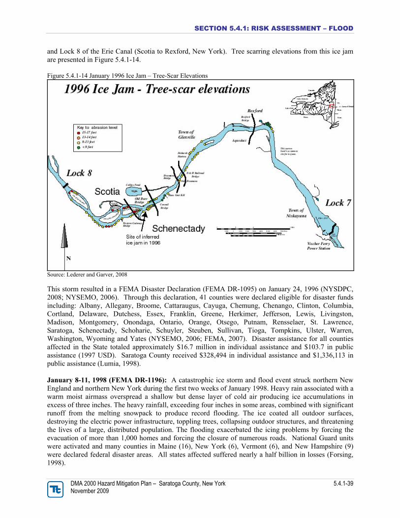
SECTION 5.4.1: RISK ASSESSMENT – FLOOD
DMA 2000 Hazard Mitigation Plan – Saratoga County, New York 5.4.1-39 November 2009
and Lock 8 of the Erie Canal (Scotia to Rexford, New York). Tree scarring elevations from this ice jam are presented in Figure 5.4.1-14. Figure 5.4.1-14 January 1996 Ice Jam – Tree-Scar Elevations
Source: Lederer and Garver, 2008 This storm resulted in a FEMA Disaster Declaration (FEMA DR-1095) on January 24, 1996 (NYSDPC, 2008; NYSEMO, 2006). Through this declaration, 41 counties were declared eligible for disaster funds including: Albany, Allegany, Broome, Cattaraugus, Cayuga, Chemung, Chenango, Clinton, Columbia, Cortland, Delaware, Dutchess, Essex, Franklin, Greene, Herkimer, Jefferson, Lewis, Livingston, Madison, Montgomery, Onondaga, Ontario, Orange, Otsego, Putnam, Rensselaer, St. Lawrence, Saratoga, Schenectady, Schoharie, Schuyler, Steuben, Sullivan, Tioga, Tompkins, Ulster, Warren, Washington, Wyoming and Yates (NYSEMO, 2006; FEMA, 2007). Disaster assistance for all counties affected in the State totaled approximately $16.7 million in individual assistance and $103.7 in public assistance (1997 USD). Saratoga County received $328,494 in individual assistance and $1,336,113 in public assistance (Lumia, 1998). January 8-11, 1998 (FEMA DR-1196): A catastrophic ice storm and flood event struck northern New England and northern New York during the first two weeks of January 1998. Heavy rain associated with a warm moist airmass overspread a shallow but dense layer of cold air producing ice accumulations in excess of three inches. The heavy rainfall, exceeding four inches in some areas, combined with significant runoff from the melting snowpack to produce record flooding. The ice coated all outdoor surfaces, destroying the electric power infrastructure, toppling trees, collapsing outdoor structures, and threatening the lives of a large, distributed population. The flooding exacerbated the icing problems by forcing the evacuation of more than 1,000 homes and forcing the closure of numerous roads. National Guard units were activated and many counties in Maine (16), New York (6), Vermont (6), and New Hampshire (9) were declared federal disaster areas. All states affected suffered nearly a half billion in losses (Forsing, 1998).
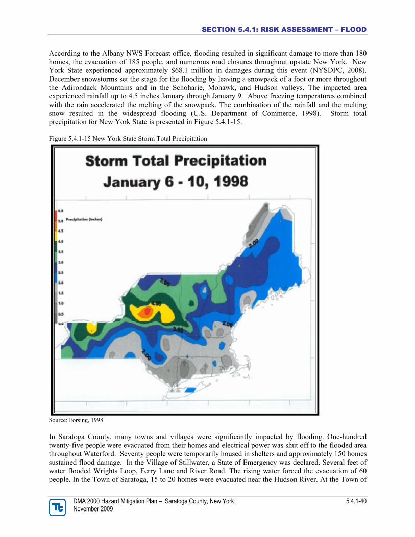
SECTION 5.4.1: RISK ASSESSMENT – FLOOD
DMA 2000 Hazard Mitigation Plan – Saratoga County, New York 5.4.1-40 November 2009
According to the Albany NWS Forecast office, flooding resulted in significant damage to more than 180 homes, the evacuation of 185 people, and numerous road closures throughout upstate New York. New York State experienced approximately $68.1 million in damages during this event (NYSDPC, 2008). December snowstorms set the stage for the flooding by leaving a snowpack of a foot or more throughout the Adirondack Mountains and in the Schoharie, Mohawk, and Hudson valleys. The impacted area experienced rainfall up to 4.5 inches January through January 9. Above freezing temperatures combined with the rain accelerated the melting of the snowpack. The combination of the rainfall and the melting snow resulted in the widespread flooding (U.S. Department of Commerce, 1998). Storm total precipitation for New York State is presented in Figure 5.4.1-15. Figure 5.4.1-15 New York State Storm Total Precipitation
Source: Forsing, 1998 In Saratoga County, many towns and villages were significantly impacted by flooding. One-hundred twenty-five people were evacuated from their homes and electrical power was shut off to the flooded area throughout Waterford. Seventy people were temporarily housed in shelters and approximately 150 homes sustained flood damage. In the Village of Stillwater, a State of Emergency was declared. Several feet of water flooded Wrights Loop, Ferry Lane and River Road. The rising water forced the evacuation of 60 people. In the Town of Saratoga, 15 to 20 homes were evacuated near the Hudson River. At the Town of