section2 lagniappe louisiana’s the gulf intracoastal waterways · thousands of vehicles cross the...
TRANSCRIPT
Louisiana’sWaterwaysLouisiana’sWaterwaysAs you read, look for:• Louisiana’s major rivers and lakes, and• vocabulary terms navigable and bayou.
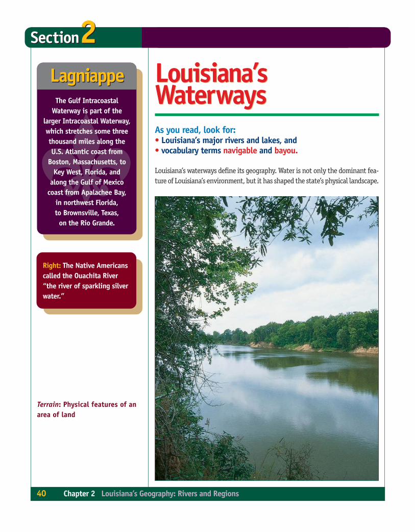
Louisiana’s waterways define its geography. Water is not only the dominant fea-ture of Louisiana’s environment, but it has shaped the state’s physical landscape.
Section2Section2LagniappeLagniappe
Terrain: Physical features of anarea of land
Right: The Native Americanscalled the Ouachita River“the river of sparkling silverwater.”
40 Chapter 2 Louisiana’s Geography: Rivers and Regions
�The Gulf Intracoastal
Waterway is part of thelarger Intracoastal Waterway,which stretches some threethousand miles along theU.S. Atlantic coast from
Boston, Massachusetts, toKey West, Florida, and
along the Gulf of Mexicocoast from Apalachee Bay,
in northwest Florida,to Brownsville, Texas,on the Rio Grande.
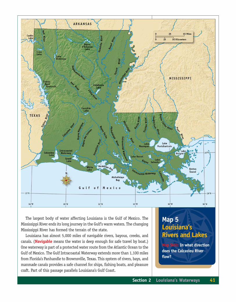
Map 5Louisiana’sRivers and LakesMap Skill: In what directiondoes the Calcasieu Riverflow?
The largest body of water affecting Louisiana is the Gulf of Mexico. TheMississippi River ends its long journey in the Gulf’s warm waters. The changingMississippi River has formed the terrain of the state.
Louisiana has almost 5,000 miles of navigable rivers, bayous, creeks, andcanals. (Navigable means the water is deep enough for safe travel by boat.)One waterway is part of a protected water route from the Atlantic Ocean to theGulf of Mexico. The Gulf Intracoastal Waterway extends more than 1,100 milesfrom Florida’s Panhandle to Brownsville, Texas. This system of rivers, bays, andmanmade canals provides a safe channel for ships, fishing boats, and pleasurecraft. Part of this passage parallels Louisiana’s Gulf Coast.
Section 2 Louisiana’s Waterways 41
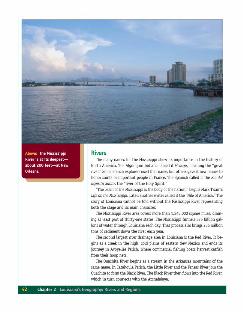
Above: The MississippiRiver is at its deepest—about 200 feet—at NewOrleans.
RiversThe many names for the Mississippi show its importance in the history of
North America. The Algonquin Indians named it Messipi, meaning the “greatriver.” Some French explorers used that name, but others gave it new names tohonor saints or important people in France. The Spanish called it the Rio delEspiritu Santo, the “river of the Holy Spirit.”
“The basin of the Mississippi is the body of the nation,” begins Mark Twain’sLife on the Mississippi. Later, another writer called it the “Nile of America.” Thestory of Louisiana cannot be told without the Mississippi River representingboth the stage and its main character.
The Mississippi River area covers more than 1,245,000 square miles, drain-ing at least part of thirty-one states. The Mississippi funnels 375 billion gal-lons of water through Louisiana each day. That process also brings 256 milliontons of sediment down the river each year.
The second largest river drainage area in Louisiana is the Red River. It be-gins as a creek in the high, cold plains of eastern New Mexico and ends itsjourney in Avoyelles Parish, where commercial fishing boats harvest catfishfrom their hoop nets.
The Ouachita River begins as a stream in the Arkansas mountains of thesame name. In Catahoula Parish, the Little River and the Tensas River join theOuachita to form the Black River. The Black River then flows into the Red River,which in turn connects with the Atchafalaya.
42 Chapter 2 Louisiana’s Geography: Rivers and Regions
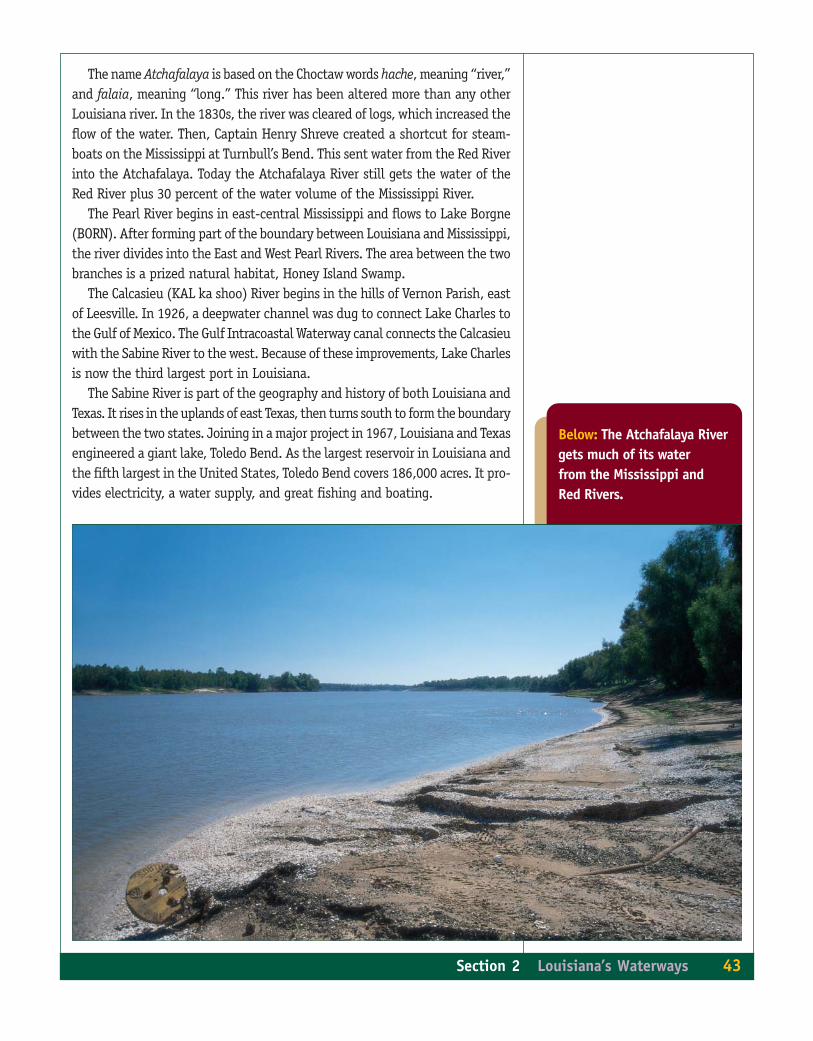
The name Atchafalaya is based on the Choctaw words hache, meaning “river,”and falaia, meaning “long.” This river has been altered more than any otherLouisiana river. In the 1830s, the river was cleared of logs, which increased theflow of the water. Then, Captain Henry Shreve created a shortcut for steam-boats on the Mississippi at Turnbull’s Bend. This sent water from the Red Riverinto the Atchafalaya. Today the Atchafalaya River still gets the water of theRed River plus 30 percent of the water volume of the Mississippi River.
The Pearl River begins in east-central Mississippi and flows to Lake Borgne(BORN). After forming part of the boundary between Louisiana and Mississippi,the river divides into the East and West Pearl Rivers. The area between the twobranches is a prized natural habitat, Honey Island Swamp.
The Calcasieu (KAL ka shoo) River begins in the hills of Vernon Parish, eastof Leesville. In 1926, a deepwater channel was dug to connect Lake Charles tothe Gulf of Mexico. The Gulf Intracoastal Waterway canal connects the Calcasieuwith the Sabine River to the west. Because of these improvements, Lake Charlesis now the third largest port in Louisiana.
The Sabine River is part of the geography and history of both Louisiana andTexas. It rises in the uplands of east Texas, then turns south to form the boundarybetween the two states. Joining in a major project in 1967, Louisiana and Texasengineered a giant lake, Toledo Bend. As the largest reservoir in Louisiana andthe fifth largest in the United States, Toledo Bend covers 186,000 acres. It pro-vides electricity, a water supply, and great fishing and boating.
Below: The Atchafalaya Rivergets much of its waterfrom the Mississippi andRed Rivers.
Section 2 Louisiana’s Waterways 43
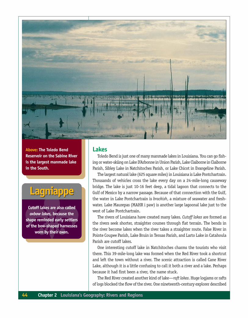
Above: The Toledo BendReservoir on the Sabine Riveris the largest manmade lakein the South.
LakesToledo Bend is just one of many manmade lakes in Louisiana. You can go fish-
ing or water-skiing on Lake D’Arbonne in Union Parish, Lake Claiborne in ClaiborneParish, Sibley Lake in Natchitoches Parish, or Lake Chicot in Evangeline Parish.
The largest natural lake (625 square miles) in Louisiana is Lake Pontchartrain.Thousands of vehicles cross the lake every day on a 24-mile-long causewaybridge. The lake is just 10-16 feet deep, a tidal lagoon that connects to theGulf of Mexico by a narrow passage. Because of that connection with the Gulf,the water in Lake Pontchartrain is brackish, a mixture of seawater and fresh-water. Lake Maurepas (MAHR i paw) is another large lagoonal lake just to thewest of Lake Pontchartrain.
The rivers of Louisiana have created many lakes. Cutoff lakes are formed asthe rivers seek shorter, straighter courses through flat terrain. The bends inthe river become lakes when the river takes a straighter route. False River inPointe Coupee Parish, Lake Bruin in Tensas Parish, and Larto Lake in CatahoulaParish are cutoff lakes.
One interesting cutoff lake in Natchitoches charms the tourists who visitthere. This 39-mile-long lake was formed when the Red River took a shortcutand left the town without a river. The scenic attraction is called Cane RiverLake, although it is a little confusing to call it both a river and a lake. Perhapsbecause it had first been a river, the name stuck.
The Red River created another kind of lake—raft lakes. Huge logjams or raftsof logs blocked the flow of the river. One nineteenth-century explorer described
44 Chapter 2 Louisiana’s Geography: Rivers and Regions
�Cutoff lakes are also calledoxbow lakes, because the
shape reminded early settlersof the bow-shaped harnesses
worn by their oxen.
LagniappeLagniappe

Above: Cypress trees grow inthe shallow waters of LakeBistineau, an example of araft lake. Raft lakes arecreated when massivelogjams block the flow of ariver. Left: Lake Bruin atLake Bruin State Park is anexample of a cutoff lake,formed when the MississippiRiver changed direction.
Section 2 Louisiana’s Waterways 45

Below: Bayou Lafourche,seen here at Thibodaux,flows through Ascension,Assumption, and Lafourcheparishes.
the raft as “a matted mass of tree topsand trunks, weeds and canes, withcottonwood and willow trees growingon its surface.” This mass acted like adam blocking the flow of the river. Theswamps near the river filled with wa-ter, forming lakes.
Caddo Lake in Caddo Parish and LakeBistineau (BIS tin o) in Bossier andWebster parishes are raft lakes. Both feature the cypress trees and Spanish mossseen in the romantic Louisiana pictures recognized around the world.
Another kind of lake is found in the marsh. These marsh lakes form wherethe high ridges called chenieres (sha NEER) slow the rivers’ progress to theGulf of Mexico. These are freshwater lakes because the chenier ridges blocksaltwater from entering the lakes. White Lake in Vermilion Parish, Grand Lakein Cameron Parish, and Calcasieu Lake in Calcasieu Parish are all marsh lakes.
BayousNo other waterway name is more connected with Louisiana than bayou. In
fact, one of the state’s most popular slogans is “Louisiana, The Bayou State.”But it is hard to find someone who can give you an exact definition, becauseso many kinds of streams in Louisiana are called bayous.
46 Chapter 2 Louisiana’s Geography: Rivers and Regions
�LagniappeLagniappePart of Shreveport is in
Bossier Parish because of achange in the Red River.

Top: Bayou Robert, in theAtchafalaya Basin, is aperfect picture of “sleepingwater.”
1. What is the Gulf Intracoastal Waterway?2. What are the three largest rivers in the state?3. What is Toledo Bend?4. What is the largest natural lake in Louisiana?5. Name two important bayous.
Check for UnderstandingCheck for Understanding✓✓
The word bayou comes from the Choctaw Indian language and means “creek.”The early French called bayous “the sleeping water.” Some bayous are very smalland slow moving, but others can send floodwaters rushing out of their banks.Some are miles long and deep enough for large boats, but others are less thana mile long and shallow enough to walk across.
Hundreds of bayous thread across the landscape of Louisiana, with inter-esting names hinting of stories and legends. Some of the most well-knownbayous were once channels of the Mississippi River. Bayou Lafourche (lahFOOSH), called “the longest main street in the world,” has been the center oflife for the people whose houses line this water-road. Bayou Teche offered anavigation route for steamboats traveling to St. Martinville.
Section 2 Louisiana’s Waterways 47
�LagniappeLagniappeTeche is a Native American
word meaning “snake.”