sediment and stormwater guidelines and procedures€¦ · sediment and stormwater guidelines and...
TRANSCRIPT
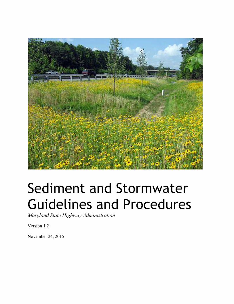
Sediment and Stormwater
Guidelines and Procedures Maryland State Highway Administration Version 1.2
November 24, 2015
Version 1.2
November 24, 2015
This document is organized into three parts:
Part A-Sediment and Stormwater Guidelines
The Guidelines provide the minimum erosion/sediment control and stormwater management
requirements for plans submitted by SHA to the SHA-PRD for review and approval.
Part B-Sediment and Stormwater Administrative Procedures
The administrative procedures contain information related to SHA’s plan submission, review,
approval, and compliance process. This document will be updated as questions arise, procedures
evolve, or resolutions are needed.
Part C-Sediment and Stormwater Technical Procedures (under development)
This document contains supplements to the 2011 Maryland Standards and Specifications for Soil
Erosion, the 2000 Maryland Stormwater Design Manual, and other clarifications as needed. This
document will be updated periodically as questions arise, procedures evolve, or resolutions are
needed.
If there are any questions or comments regarding these Guidelines or Procedures, please contact
the Plan Review Division in the Office of Highway Development of the State Highway
Administration at 410-545-8946.
Version 1.2
November 24, 2015
Part A
Sediment and Stormwater
Guidelines Maryland State Highway Administration Version 1.2 November 24, 2015
Version 1.2
November 24, 2015
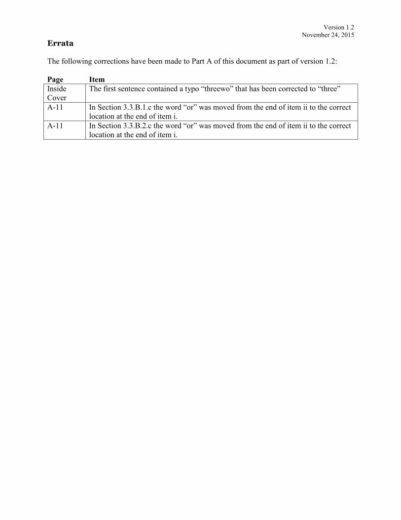
Errata
The following corrections have been made to Part A of this document as part of version 1.2:
Page Item
Inside
Cover
The first sentence contained a typo “threewo” that has been corrected to “three”
A-11 In Section 3.3.B.1.c the word “or” was moved from the end of item ii to the correct
location at the end of item i.
A-11 In Section 3.3.B.2.c the word “or” was moved from the end of item ii to the correct
location at the end of item i.
Version 1.2
November 24, 2015
i
INTRODUCTION
The Environment Article, Title 4, Subtitle 1 requires the Maryland Department of the
Environment (MDE) to implement a statewide erosion/sediment control program to control
sediment-laden runoff from land disturbing activities. MDE’s obligation in meeting this
mandate includes adopting regulations that establish criteria and procedures for erosion/sediment
control throughout Maryland. The Environment Article, Title 4, Subtitle 2 requires MDE to
implement a statewide stormwater management program to control runoff from development.
To meet this mandate, MDE has adopted regulations that establish criteria and procedures for
managing stormwater throughout Maryland.
The Stormwater Management Act of 2007 (the Act) requires that the Code of Maryland
Regulations (COMAR) be modified and guidance and ordinances be developed for the purpose
of implementing environmental site design (ESD) to the maximum extent practicable (MEP) on
all development projects. The Act defines ESD as “using small-scale stormwater management
practices, nonstructural techniques, and better site planning to mimic natural hydrologic runoff
characteristics and minimize the impact of land development on water resources." ESD
promotes conserving natural features, drainage patterns, and vegetation; minimizing impervious
surfaces; slowing down runoff; and increasing infiltration. Significant changes to COMAR and
the “2000 Maryland Stormwater Design Manual, Volumes I & II” (Design Manual) were
adopted in May 2009. These changes specify that ESD is to be implemented, that the MEP
standard is to be met, and that the reviews of stormwater management and erosion/sediment
control plans are to be integrated via a comprehensive review process.
In January 2012, MDE adopted revised erosion/sediment control regulations, along with the
“2011 Maryland Standards and Specifications for Soil Erosion and Sediment Control”
(Standards and Specifications). The revisions include more stringent stabilization requirements
and the establishment of grading unit criteria. Additionally, the Standards and Specifications
now describe how an erosion/sediment control plan will be designed in concert with a site’s
stormwater management plan as required by the Act. As part of this approach, the
erosion/sediment control regulations require developers, designers, and plan review agencies to
consider erosion/sediment control of runoff from the start of the land development design
process. Adhering to the planning principles found in the Standards and Specifications should
result in development that better fits existing site conditions and reduces both the extent and
duration of soil disturbance during construction.
On July 8, 2014, the Maryland State Highway Administration (SHA) and MDE signed a
Memorandum of Understanding (MOU) by which MDE designated approving authority for
erosion and sediment control and stormwater management plans for SHA projects to SHA. This
MOU is in accordance with the provisions of the Annotated Code of Maryland, Environmental
Article, Title 4, Subtitle 1, Sediment Control and Title 4, Subtitle 2, Stormwater Management as
amended through House Bill 97 effective October 1, 2013. The “Maryland State Highway
Administration Sediment and Stormwater Guidelines and Procedures” represents the next step
toward meeting obligations under current law and serve as guidance for developing, reviewing,
and approving both erosion/sediment control and stormwater management plans for SHA
projects. The definition of ESD, as well as the procedures, practices, and minimum plan
contents specified herein will guide SHA in submitting stormwater management and
erosion/sediment control plans to SHA-Plan Review Division (PRD).
Version 1.2
November 24, 2015
ii
Part A-Table of Contents
Page
1.0 Purpose and Authority ....................................................................................................... A-1
1.1 Reference Material
2.0 Definitions.......................................................................................................................... A-2
3.0 Applicability .................................................................................................................... A-10
3.1 Scope
3.2 Exemptions
3.3 Stormwater Management Waivers
3.4 Variances
3.5 General Approvals
3.6 Classification of Development
A. New Development
B. Redevelopment
C. Combination of New Development and Redevelopment
4.0 Stormwater Management Criteria .................................................................................... A-14
4.1 Minimum Control Requirements for New Development
4.2 Minimum Control Requirements for Redevelopment
4.3 Specific Design Criteria
5.0 Stormwater Management Measures ................................................................................. A-18
5.1 ESD Planning Techniques
5.2 ESD Practices
A. Alternative Surfaces
B. Nonstructural Practices
C. Micro-scale Practices
5.3 Structural Stormwater Management Practices
5.4 Alternative Stormwater Management Measures
5.5 Compensatory Stormwater Management
5.6 Institutional Stormwater Management Plan
6.0 Erosion/Sediment Control Criteria .................................................................................. A-22
6.1 Principles
6.2 Stabilization
6.3 Grading Units
6.4 Design Methodology
Version 1.2
November 24, 2015
iii
Table of Contents (continued)
Page
7.0 Plans ................................................................................................................................. A-24
7.1 Plan Submission
7.2 Preparation of Plans
7.3 Review and Approval of Plans
7.4 Contents of Plans
A. Concept Design
B. Site Development Design
C. Final Design
D. Report
E. Construction Plans
8.0 After Plan Approval ......................................................................................................... A-37
8.1 Prior to and During Construction
8.2 Inspection Requirements for As-Built Certification
8.3 Post Construction
9.0 Compliance ...................................................................................................................... A-40
10.0 Maintenance ..................................................................................................................... A-40
11.0 Additional Approvals ....................................................................................................... A-41
12.0 Tables ............................................................................................................................... A-42
Version 1.2
November 24, 2015
A-1
1.0 PURPOSE AND AUTHORITY
The purpose of the Guidelines is to protect, maintain, and enhance the public health, safety, and
general welfare by establishing minimum requirements and procedures to mitigate soil erosion,
minimize the discharge of pollutants, and reduce the adverse impacts associated with increased
stormwater runoff. The goal is to manage stormwater by using environmental site design (ESD)
to the maximum extent practicable (MEP) to reduce stream channel erosion, pollution, siltation,
sedimentation, and local flooding and to use appropriate structural best management practices
(BMPs) only when necessary. The intent of ESD is to restore, enhance, and maintain the
chemical, physical, and biological integrity of streams, minimize damage to public and private
property, and reduce the adverse impacts of land development.
The provisions of the Guidelines are pursuant to the Annotated Code of Maryland, Environment
Article, Title 4, Subtitles 1 and 2, the Erosion and Sediment Control Regulations, Code of
Maryland Regulations (COMAR) 26.17.01, and the Stormwater Management Regulations,
COMAR 26.17.02. The Guidelines provide the minimum erosion/sediment control and
stormwater management requirements for plans submitted by SHA to the SHA-PRD for review
and approval. These guidelines do not affect the validity of any portion of either the
Environment Article or COMAR.
1.1 Reference Material
The following documents complement the Guidelines:
A. The 2000 Maryland Stormwater Design Manual Volumes I & II, MDE, April 2000 and
Supplement 1, MDE, May 2009 and any subsequent revisions (Design Manual) serving as
the official guide for stormwater principles, methods, and practices;
B. The 2011 Maryland Standards and Specifications for Soil Erosion and Sediment Control,
MDE, December 2011 and any subsequent revisions (Standards and Specifications)
serving as the official guide for erosion/sediment control standard principles, details,
practices, and specifications;
C. The Conservation Practice Standard, Pond Code 378, United States Department of
Agriculture (USDA), Natural Resources Conservation Service (NRCS) Maryland,
January 2000, or latest revision, (Pond Code 378) serving as the official guide for small
pond principals, methods, and practices;
D. The Sediment and Stormwater Procedures for State Highway Administration (SHA)
Projects, SHA Plan Review Division as updated, (Procedures) serving as the standard
procedures for the design, submittal, review, and approval of SHA projects; and,
E. The SHA Field Guide for Erosion and Sediment Control (Field Guide), as updated.
Version 1.2
November 24, 2015
A-2
2.0 DEFINITIONS
For the purpose of the Guidelines, the definitions below describe the meaning of the following
terms:
1. “Adverse impact” means any deleterious effect on waters or wetlands, including
changes to quality, quantity, surface area, species composition, aesthetics or
usefulness for human or natural uses which are or may potentially be harmful or
injurious to human health, welfare, safety or property, to biological productivity,
diversity, or stability or which unreasonably interfere with the enjoyment of life
or property, including outdoor recreation.
2. “Applicant” means any of the SHA entities requesting official approval of
sediment and stormwater plans or associated documents to carry out construction
or maintenance activities of a project or site required to obtain regulatory approval
of such.
3. “Best management practice (BMP)” means a structural device or nonstructural
practice designed to temporarily store or treat stormwater runoff in order to
mitigate flooding, reduce pollution, or provide other amenities.
4. “Channel protection storage volume (CpV)” means the volume used to design
stormwater management practices to control stream channel erosion. For
environmental site design (ESD), CpV represents the portion of the ESD volume
requirement beyond one inch of rainfall. See also “recharge volume,” “water
quality volume” and “environmental site design (ESD).”
5. “Clear” means any activity which removes the vegetative cover while leaving the
root mat intact.
6. “Concept plan” means the first of three required plan approvals that includes the
information necessary to allow an initial evaluation of a proposed project as
described in Section 7.4.A. See also “site development plan” and “final plan”.
7. “Critical Area” means all land within 1,000 feet of tidal waters or adjacent tidal
wetlands to the Chesapeake and Atlantic Coastal Bays and their tributaries.
8. “Design Manual” means the 2000 Maryland Stormwater Design Manual and the
2009 Supplement which serves as the official guide for stormwater management
principles, methods, and practices.
9. “Detention structure” means a permanent structure that provides temporary
storage to control stormwater runoff to prevent an increase in downstream
channel erosion and decrease the frequency of overbank flooding without creating
a permanent pool of water within the structure.
10. "Develop land" means to change the runoff characteristics of a parcel of land in
conjunction with residential, commercial, industrial, or institutional construction
Version 1.2
November 24, 2015
A-3
or alteration.
11. “Development activity” means an activity that develops land.
12. “Direct discharge” means the concentrated release of stormwater to tidal waters or
vegetated tidal wetlands from new development or redevelopment projects in the
Critical Area.
13. “Disturbance” means an activity by which the surface cover is removed or altered,
therefore making the soil susceptible to erosion.
14. “Drainage area” means that area contributing runoff to a single point measured in
a horizontal plane, which is enclosed by a ridge line. When runoff leaves the
limit of disturbance or right-of-way line as concentrated flow, the “drainage area”
means the area from which all water drains to the point of investigation. When
runoff leaves the limit of disturbance or right-of-way as sheet flow, the “drainage
area” means the area from which all water drains to the line of investigation.
15. “Dry weather period” means a forecasted period with a maximum chance of
precipitation of 20 percent each day, as determined by the National Oceanic and
Atmospheric Administration (NOAA), for a specified number of consecutive days
for the region (ZIP code) in which the project is located.
16. “Easement” means a grant or reservation by the owner of land for the use of such
land, or a portion thereof, by others for a specific purpose or purposes and which
must be included in the conveyance of land affected by such easement.
17. “Environmental site design (ESD)” means using small-scale stormwater
management practices, nonstructural techniques, and better site planning to mimic
natural hydrologic runoff characteristics and minimize the impact of land
development on water resources. Methods for designing ESD practices are
specified in the Procedures and the 2000 Maryland Stormwater Design Manual
Volumes I & II.
18. “Erosion” means the process by which the land surface is worn away by the
action of wind, water, ice, or gravity.
19. “Erosion and sediment control” means a system of protective measures, devices,
and techniques that minimize soil erosion and off-site sedimentation.
20. “Erosion and sediment control plan” means an erosion/sediment control strategy
and plan, designed in accordance with the 2011 Maryland Standards and
Specifications for Soil Erosion and Sediment Control and prepared and approved
in accordance with the Guidelines and Procedures, that minimizes erosion and
prevents off-site sedimentation by containing sediment on-site or passing
sediment-laden runoff through sediment control measures before being released
from the site.
Version 1.2
November 24, 2015
A-4
21. “Exemption” means those land development activities that are not subject to
erosion/sediment control and/or stormwater management approval.
22. “Extended detention” means a stormwater design feature that provides gradual
release of a volume of water in order to increase settling of pollutants and protect
downstream channels from frequent storm events. Methods for designing
extended detention BMPs are specified in the 2000 Maryland Stormwater Design
Manual Volumes I & II.
23. “Extreme flood volume” means the storage volume required to control those
infrequent but large storm events in which overbank flows reach or exceed the
boundaries of the 100-year floodplain.
24. “Federal unit” means any federal agency that intends to or does clear, grade,
transport, or otherwise disturb the land or soil surface in the course of its
activities.
25. “Final plan” means the last of three required plans that includes the information
necessary to allow approval by SHA-PRD and the issuance of permits by MDE as
described in Section 7.4.C. See also “concept plan” and “site development plan.”
26. “Flow attenuation” means prolonging the flow time of runoff to reduce the peak
discharge.
27. “Grade” means to cause the disturbance of the earth. This includes, but is not
limited to excavating, filling, stockpiling of earth materials, grubbing, or
disturbance of root mat or topsoil.
28. “Grading unit” means the maximum contiguous area allowed to be graded at a
given time. A grading unit is limited to a maximum of 20 acres.
29. “Grub” means to expose the earth by removal of the root mat. It may also include
the removal of tree stumps and other embedded items.
30. “Highly erodible soils” means those soils with a slope greater than 15 percent or
those soils with a soil erodibility factor, K, greater than 0.35 and having slopes
greater than 5 percent.
31. “Impervious area” means any surface that does not allow stormwater to infiltrate
into the underlying soil. Examples include pavement, rooftops, and certain gravel
surfaces used for vehicular traffic.
32. “Impervious area requiring treatment (IART)” means the total impervious area
that shall be treated for water quality to satisfy stormwater management
requirements as outlined in the Procedures.
33. “Infiltration” means the passage or movement of water into the soil.
Version 1.2
November 24, 2015
A-5
34. “Institutional management plan (IMP)” means an approved, long-term, concept
plan developed by SHA that addresses stormwater management and future
development for an institution on an overall watershed basis.
35. “Limit of disturbance (LOD)” means the boundary outside of which earth
disturbance is not permitted to occur.
36. “Line of investigation (LOI)” means a location where runoff from a drainage area
sheet flows from the project site. See also “point of investigation (POI)”.
37. “Maintenance” means an activity whose purpose is to repair or restore an asset to
its original function. With regard to disturbance of impervious surfaces it means
pavement overlay, patching, and certain, limited in-kind replacement of
deteriorated impervious surfaces, as well as the replacement of impervious
surfaces removed for the purpose of underground utility and pipe work.
Maintenance activities in accordance with this document are not considered to be
redevelopment.
38. “Maximum extent practicable (MEP)” means designing stormwater management
systems such that all reasonable opportunities for using ESD planning techniques
and treatment practices are exhausted, and only where absolutely necessary are
structural BMPs implemented.
39. “MDE” refers to Maryland Department of the Environment, Water Management
Administration.
40. “MDE approved sediment control device or practice” means any control found in
the 2011 Maryland Standards and Specifications for Soil Erosion and Sediment
Control that when designed and installed per these standards, and when
maintained to ensure proper function, provides adequate treatment for a specific
drainage area.
41. “New construction” means the construction of impervious area over an existing
pervious area. “New construction” is not interchangeable with the definition for
“new development”. “New construction” refers to the construction activity, and
“new development” refers to the classification of development. “New
construction” is always “new development”, but not all “new development” is
“new construction.”
42. “New development” means any new construction performed on existing pervious
area as well as any reconstruction or alteration performed on existing impervious
area for which the existing percentage of impervious area within the stormwater
study area is 40 percent or less, at a project site where the existing land use is
commercial, industrial, institutional, or multifamily residential. “New
development” refers to the development classification and is not interchangeable
with the definition of “new construction”.
43. “Off-site stormwater management” means a BMP or stormwater system located
Version 1.2
November 24, 2015
A-6
outside the project site and designed and constructed to control stormwater from
one or more sites.
44. “On-site stormwater management” means a BMP or stormwater system designed
and constructed to control stormwater within the project site.
45. “Overbank flood protection volume (QP)” means the volume of stormwater runoff
controlled by BMPs to prevent an increase in the frequency of out-of-bank
flooding generated by development. Methods for calculating the overbank flood
protection volume are specified in the 2000 Maryland Stormwater Design Manual
Volumes I & II.
46. “Owner/developer” means the person undertaking, or for whose benefit, any or all
of the activities covered by the Guidelines commences or is carried on. This is
not necessarily the land owner. General contractors, subcontractors, or both,
without a proprietary interest in a project are not considered within this definition.
47. “PE” represents the rainfall, in inches, used to determine ESD goals and size
practices. Target rainfall (PE) is listed in Table 5.3 of the 2000 Maryland
Stormwater Design Manual Volumes I & II.
48. “Planning techniques” means a combination of strategies employed early in
project design to reduce the impact from development and to incorporate natural
features into a stormwater management plan.
49. “Point of investigation (POI)” means a location where concentrated runoff from a
drainage area flows from the project site. References within these guidelines to
POI also extend to LOI.
50. “Post-development” means conditions that result from the completion of the
proposed project. Post-development conditions are commonly referred to as
proposed conditions.
51. “Pre-development” means conditions that exist prior to the conception of the
proposed project. Pre-development conditions are commonly referred to as
existing conditions.
52. "Professional engineer" means an engineer duly registered by the State to practice
engineering in accordance with the provisions of Business Occupations and
Professions Article, Title 14, Annotated Code of Maryland.
53. “Project site” means a location, bounded by the limit of disturbance, where
development is proposed or occurring.
54. “Pollution” means the contamination or other alteration of the physical, chemical,
or biological properties of any waters of the State, including changes in
temperature, taste, color, turbidity, or odor of the waters, or the discharge or
deposit of any organic matter, harmful organisms, liquids, gaseous materials,

Version 1.2
November 24, 2015
A-7
solids, radioactive materials, or other substances into any waters of the State that
may render the water harmful, detrimental, or injurious to:
a. Public health, safety, or welfare;
b. Domestic, commercial, industrial, agricultural, recreational, or other
legitimate beneficial uses; or
c. Livestock, wild animals, birds, fish, or other aquatic life.
55. “Recharge volume (ReV)” means that portion of the water quality volume used to
maintain groundwater recharge rates at development sites.
56. “Reconstruction” means the removal of an existing impervious area and
construction of a new impervious area within the same footprint.
“Reconstruction” is not interchangeable with the definition of “redevelopment”.
“Reconstruction” refers to the construction activity, and “redevelopment” refers to
the classification of development. “Redevelopment” is always “reconstruction,”
but not all “reconstruction” is “redevelopment.”
57. “Redevelopment” means any construction, alteration, removal, or improvement
performed on existing impervious area at a project site where the existing land use
is commercial, industrial, institutional, or multifamily residential and the existing
imperviousness for the stormwater study area exceeds 40 percent.
“Redevelopment” refers to the development classification based on the percentage
of existing impervious and is not interchangeable with the definition of
“reconstruction”.
58. “Responsible personnel” means any foreman, superintendent, or project engineer
who is in charge of site clearing and grading operations or the implementation and
maintenance of an erosion/sediment control plan and who has received MDE
approved Responsible Personnel Certification Training for erosion/sediment
control.
59. “Retention structure” means a permanent structure, such as but not limited to a
pond, that provides for the storage of runoff by means of a permanent pool of
water.
60. "Retrofitting" means the construction of a BMP to provide stormwater
management in a previously developed area where stormwater management was
previously not provided, the modification of an existing BMP to enhance
functionality, or the implementation of a nonstructural practice to improve
existing water quality conditions.
61. “Same-day stabilization” means an erosion/sediment control procedure in which
the work area is stabilized by the end of the work day or within a 24-hour period
for around the clock construction.
62. “Sediment” means soils or other surficial materials transported or deposited by
the action of wind, water, ice, gravity, or artificial means.
Version 1.2
November 24, 2015
A-8
63. “Site” means any tract, lot, or parcel of land, or combination of tracts, lots, and
parcels of land that are in single ownership or are contiguous and in diverse
ownership, where development is to be performed as part of a unit, subdivision, or
project. For SHA, “site” means the right-of-way.
64. “Site development plan” means the second of three required plan approvals that
includes the information necessary to allow a detailed evaluation of a proposed
project as described in Section 7.4.B.
65. “Stabilization” means the prevention of soil movement by covering exposed earth
with erosion-resistant material including various vegetative and/or structural
means. Stabilization requirements are defined as temporary and permanent and
may be found in the 2011 Maryland Standards and Specifications for Soil Erosion
and Sediment Control.
66. “Stable conveyance” means there is no evidence of erosion, or potential for
erosion to occur, in the receiving water course.
67. “Standards and Specifications” means the 2011 Maryland Standards and
Specifications for Soil Erosion and Sediment Control and any subsequent
revisions.
68. “State unit” means any State agency that intends to or does clear, grade, transport,
or otherwise disturb the land or soil surface in the course of its activities.
69. “Steep slopes” means, for the purposes of erosion/sediment control, those slopes
with gradients of 20 percent or more.
70. “Stormwater” means water that originates from a precipitation event.
71. “Stormwater management” means, for:
a. Quantitative control, a system of measures that control the increased
volume and/or rate of surface runoff caused by man-made changes to the
land; and
b. Qualitative control, a system of measures that reduce or eliminate
pollutants that might otherwise be carried by runoff.
72. “Stormwater facility” means ESD, structural, or non-structural stormwater
practices that have an assigned SHA BMP number.
73. “Stormwater management system” means natural areas, ESD practices, BMPs,
and any other structural or nonstructural stormwater measures through which
stormwater flows, infiltrates, or filters prior to discharge from a site.
74. “Stormwater study area” means the boundary containing all areas necessary for
determining the development classification for a point of investigation as outlined
in the Procedures. It typically corresponds to the limit of disturbance.
Development is classified as either new development or redevelopment.
Version 1.2
November 24, 2015
A-9
75. “Variance” means the modification of the minimum stormwater management or
erosion and sediment control requirements for exceptional circumstances such
that strict adherence to the requirements would result in unnecessary hardship and
would not fulfill the intent of these guidelines.
76. “Waiver” means the reduction of stormwater management requirements for a
specific project on a case-by-case review basis.
77. “Watercourse” means any natural or artificial stream, river, creek, ditch, swale,
gutter, channel, canal, conduit, culvert, drain, waterway, gully, or ravine in and
including any adjacent area that is subject to inundation from overflow or flood
water.
78. “Water quality volume (WQV)” means the volume needed to capture and treat 90
percent of the average annual runoff volume at a project site. In terms of ESD,
the WQV represents the ESDV for PE = 1 inch.
79. “Watershed” means an extent of land or drainage area where surface runoff from
rain, melting snow, and ice contributes to a single point.
80. “Watershed management plan” means a county or local municipality approved
plan to manage specific watersheds that is acceptable to MDE.
81. “Waters of the State” includes:
a. Both surface and underground waters within the boundaries of the State
subject to its jurisdiction, including that portion of the Atlantic Ocean
within the boundaries of the State, the Chesapeake Bay and its tributaries,
and all ponds, lakes, rivers, streams, storm drain systems, public ditches,
tax ditches, and public drainage systems within the State, other than those
designated and used to collect convey, or dispose of sanitary sewage; and
b. The floodplain of free-flowing water determined by MDE on the basis of
the 100-year flood frequency.
82. “Wetlands” means an area having saturated soils or periodic high groundwater
levels and vegetation adapted to wet conditions and periodic flooding as defined
in Environmental Article, Title 5, Subtitle 9 and Title 16, Annotated Code of
Maryland and COMAR 26.23.01 and 26.24.01 or by federal regulations.
Version 1.2
November 24, 2015
A-10
3.0 APPLICABILITY
3.1 Scope
State Highway Administration shall not clear, grade, develop, or redevelop any land without
implementing an approved construction plan that provides erosion/sediment control measures and
stormwater management to control or manage runoff from such activities during and after
construction, except as provided within this section. Measures for clearing, grading, new
development and redevelopment shall be consistent with the Design Manual, the Standards and
Specifications, the SHA Standards and Specifications, and the SHA Sediment and Stormwater
Guidelines and Procedures, and be constructed according to the final plan approved by the SHA
Plan Review Division (PRD).
Projects involving multiple phases of work will be assigned one approval number. The initial phase
will receive approval for that phase only. Subsequent phases will be approved as modifications to
the original approval.
3.2 Exemptions
The following are exempt from the provisions of the Guidelines:
A. Stormwater Management:
1. Agricultural land management practices;
2. Any project that does not disturb over 5,000 square feet of land area.
B. Erosion/Sediment Control:
1. Agricultural land management practices and agricultural BMPs;
2. Clearing or grading activities that disturb less than 5,000 square feet of land area
and disturb less than 100 cubic yards of earth.
3.3 Stormwater Management Waivers
The 2007 Stormwater Management Act restricts stormwater management waivers because ESD
must be implemented to the MEP. However, there will be development situations that warrant
relaxing management obligations due to site specific circumstances.
A. SHA-PRD may grant a waiver of all quality and quantity stormwater management control
requirements when the applicant demonstrates to the satisfaction of SHA-PRD that the
disturbed area will be returned to the existing condition and will result in no hydrologic
changes. Examples include maintenance projects, landscaping projects, and underground
activities involving pipelines, conduits, tunnels, sanitary sewers, and in-kind storm drain
replacement/remediation.
B. SHA-PRD may grant a waiver of the stormwater management quantity control
requirements when the applicant demonstrates to the satisfaction of SHA-PRD that the
cumulative effects of waivers granted previously cause no adverse impacts to the
downstream watercourse, that ESD has been implemented for a minimum of one inch of
rainfall (i.e. PE= 1 inch), that the outfall is stable, and that:
Version 1.2
November 24, 2015
A-11
1. The POI discharges to tidally influenced receiving waters:
a. For direct discharges (CpV* and QP);
b. For discharges within the site and with safe and stable conveyance from
the POI to the tidal waters (QP) [see Section 4.1.A.5];
c. For discharges into an existing closed storm drain system or lined channel
that outfalls directly to tidally influenced waters and the storm drain
system has:
i. Adequate capacity for Q1-year (CpV*); or
ii. Adequate capacity for Q10-year (CpV* and QP);
* Projects located in the Critical Area must comply with the respective
Critical Area regulations which may include treating a runoff volume
inclusive of the CpV.
2. The POI discharges into a major waterway as identified in Table 1:
a. For direct releases (CpV and QP);
b. For discharges within the site and with safe and stable conveyance from
the POI to the main stem of the waterway (QP) [see Section 4.1.A.5.];
c. For discharges into an existing closed storm drain system or lined channel
that outfalls directly to a major waterway and the storm drain system has:
i. Adequate capacity for Q1-year (CpV); or
ii. Adequate capacity for Q10-year (CpV and QP);
3. Historical downstream flooding problems do not exist and management of the
overbank flood protection (QP) volume within the watershed (see Table 2) is not
required by the local jurisdiction and is stated as such in a letter provided by the
local jurisdiction to SHA. CpV shall be provided as required by the Design
Manual.
C. A Stormwater Management Waiver Application shall be submitted to SHA-PRD by the
applicant or authorized representative and specifically indicate the appropriate waiver
category. The application shall include sufficient descriptions, drawings, and other
pertinent information necessary to evaluate the proposed project and confirm the
applicability of the waiver request. A new Stormwater Management Waiver Application
may be required in accordance with the provisions of this section when there are
subsequent additions, extensions, or modifications to any portion of a project for which a
waiver has already been applied. Waivers are only valid upon receipt of a written
approval from SHA-PRD. A Stormwater Management Waiver Application is generally
required for each eligible point of investigation (POI) and line of investigation (LOI).
For projects with multiple POIs, waivers only apply to specific POIs and not the entire
project. Depending on the nature of the proposed work activities or purpose, some
projects will not require separate waiver applications for each point of investigation. This
determination will be made by SHA-PRD. Examples of the types of projects that may
not require separate waiver applications include utility, guardrail, and sidewalk projects.
A copy of the Stormwater Management Waiver Application may be found in the
Procedures. The following types of projects may qualify for a Section 3.3.A waiver from
SWM: pavement overlays, asphalt resurfacing, asphalt grinding, roadway and pavement
patching, in-kind replacement of deteriorated impervious surfaces, replacement of
Version 1.2
November 24, 2015
A-12
sidewalks within the same footprint for meeting other regulatory agency mandates such
as ADA requirements, and replacement of impervious surfaces removed for the purpose
of underground utility work. Other projects that may qualify for a Section 3.3.A. waiver
include landscaping projects and underground activities involving pipelines, conduits,
culvert replacement, tunnels, sanitary sewers, and in-kind storm drain
replacement/remediation. If there is no significant change in the site hydrology or
hydraulic flow rates, storm drain projects may qualify for a Section 3.3.A waiver. A
copy of the Stormwater Management Waiver Application and associated submittal
requirements may be found in the Procedures.
3.4 Variances
SHA-PRD may grant a written variance from any requirement of Section 4.0 Stormwater
Management Criteria of the Guidelines or from the requirements of the Standards and
Specifications if there are unique circumstances applicable such that strict adherence will result
in unnecessary hardship and not fulfill the intent of the Guidelines. A written request for a
variance, stating the specific variance sought, explaining the reasons for the request, and
providing any evidence necessary to justify the request, shall be provided to SHA-PRD. A
variance will not be granted by SHA-PRD unless and until sufficient justification, as deemed
appropriate by SHA-PRD, is provided.
3.5 General Approvals
A general approval is a single approval under one SHA-PRD assigned number that extends to
more than one project involving a particular type of activity or activities. The general approval
requires a standard sediment control plan or plans for the activity covered. General approvals are
only given to projects that qualify for Section 3.3.A waivers, and limitations are set on the size of
the disturbance at each location. Examples of these types of projects include small structure
repairs, culvert replacements, traffic signal replacements, and routine maintenance on SWM
facilities. These contracts typically encompass multiple project sites located within different
watersheds. The project site with the largest disturbance will be used to determine whether the
project qualifies for a general approval.
3.6 Classification of Development
A. New Development. A new development POI is classified as such by determining the
existing imperviousness of the stormwater study area for the POI. If the existing
imperviousness of the stormwater study area is equal to or less than 40 percent, the POI is
classified as new development. This applies regardless of whether or not the drainage
area to the POI includes reconstruction of existing impervious area and/or a decrease in
impervious surfaces. New development POIs shall be designed in accordance with
Section 4.1 Minimum Control Requirements for New Development.
B. Redevelopment. A redevelopment POI has no net increase in impervious surface within
the drainage area. If the existing imperviousness of the stormwater study area exceeds 40
percent and there is no net increase in impervious area, the POI is classified as
redevelopment. This applies regardless of whether or not the drainage area to the POI
includes new construction.

Version 1.2
November 24, 2015
A-13
The stormwater management goal for redevelopment is to gain water quality treatment on
existing developed lands while supporting initiatives to improve urban areas. All options
for ESD shall be exhausted during concept design of redevelopment POIs; however, it is
recognized that a wide range of site constraints may limit effective implementation of
ESD. Alternative management options after compliance with the ESD to the MEP are
available. Quantity management, including CpV treatment, is not required for
redevelopment POIs. Redevelopment will be designed in accordance with Section 4.2
Minimum Control Requirements for Redevelopment.
C. Combination of New Development and Redevelopment. Frequently a POI has a
combination of new development and redevelopment. When the study area for a POI has
an existing imperviousness greater than 40 percent and a net increase in the total
impervious area, the net increase portion shall be managed in accordance with Section
4.1 Minimum Control Requirements for New Development and the remaining portion
shall be managed in accordance with Section 4.2 Minimum Control Requirements for
Redevelopment.
Version 1.2
November 24, 2015
A-14
4.0 STORMWATER MANAGEMENT CRITERIA
4.1 Minimum Control Requirements for New Development
Stormwater management systems shall be designed such that all reasonable opportunities for
using ESD planning techniques and treatment practices from Chapter 5 of the Design Manual are
exhausted, and only where absolutely necessary are structural BMPs from Chapter 3
implemented. The standard of ESD to the MEP shall be implemented for all SHA projects.
Professional engineering judgment will be needed to determine whether site constraints prevent
reasonable implementation of ESD.
A. The minimum control requirements are as follows:
1. The ESD standard is met when post-development hydrology is restored to natural
hydrologic conditions assuring that channel stability is maintained, pre-
development groundwater recharge is replicated, and nonpoint source pollution is
minimized for the 1-year 24-hour frequency storm event. This requires capturing
and treating from 1 inch to 2.6 inches of rainfall depending on the site conditions.
Runoff from a minimum of 1 inch of rainfall must be treated using Chapter 5 ESD
practices. The rainfall (PE) above 1 inch should also be treated using ESD. Only
when management of the full ESDv using ESD practices is not practicable may
Chapter 3 structural BMPs be used for treating rainfall (PE) above 1 inch. When
the entire IART is treated for the full target rainfall (PE), thereby meeting the
ESDV storage volume requirements, the ESD requirements (including CpV, WQV,
and ReV) are completely satisfied. Management requirements shall be determined
using the method outlined in the Procedures and the specific rainfall targets in
Section 5.2 of the Design Manual. See the Procedures for clarifications on
computing ESDV, IART, WQV, ReV, and CpV.
2. The IART is an integral part of meeting stormwater management quality
requirements. Stormwater management plans shall incorporate a design to
capture the entire IART as outlined in the Procedures.
3. Project sites may include previously approved or credited stormwater
management measures, such as buffers or disconnections, or existing stormwater
management facilities that provide quality and/or quantity management for
existing conditions. A check shall be done to determine whether the proposed
development results in a loss of existing management. If so, these losses shall be
replicated in full, using current standards, by the proposed stormwater
management design.
4. Refer to Table 2 to determine whether quantity control of the 2-year or 10-year
24-hour frequency storm events is required for addressing overbank flood
projection volume (Qp). When Qp management is required, the design shall be in
accordance with the Design Manual and the Procedures.
5. Stable and safe conveyance of the 10-year 24-hour frequency storm shall be
provided for all points where flow leaves the project site. Discharge velocities for
Version 1.2
November 24, 2015
A-15
the 10-year 24-hour frequency storm shall be non-erosive. The downstream
impact analysis shall extend to a point downstream where the contributory
drainage area is two times the drainage area to the POI or to the first downstream
tributary whose drainage area equals or exceeds the contributory drainage area to
the POI.
6. Management of extreme flood volume (Qf) shall be based on requirements of the
local jurisdiction in which the project is located.
7. Projects located in designated inter-jurisdictional Flood Hazard Watersheds
(Jones Falls, Gwynns Falls, and Herring Run in Baltimore City/County and
Carroll Creek in Frederick City/County) are required to provide management
measures necessary to maintain the post-development peak discharges for the
100-year 24-hour frequency storm event at a level that is equal to, or less than, the
100-year 24-hour pre-development peak discharge rates. The stormwater
management practices in these watersheds shall control the volume, timing, and
rate of flow necessary to maintain no increase in the downstream peak discharge
for the 100-year 24-hour frequency storm event.
B. SHA-PRD may require more than the minimum control requirements specified in the
Guidelines when hydrologic or topographic conditions warrant, when historical
downstream flooding exists, as determined by SHA-PRD or local jurisdiction, or when
receiving channel degradation exists or has the potential to occur as a result of the
project.
C. If a development activity changes runoff characteristics in a manner that creates points of
concentrated flow, where previously there was sheet flow, or increases discharge rates or
discharge volumes for the 1-year, 2-year, and/or 10-year 24-hour frequency storms, SHA-
PRD may require additional quantity management and/or written consent from the
downstream property owner affected by these changes. Affected downstream property
owners include owners of those properties through which the runoff will travel before
entering waters of the State.
D. SHA-PRD may institute alternate minimum control requirements. Alternative
requirements may include preventative and corrective control measures for flood damage,
accelerated stream erosion, water quality, and sedimentation. Comprehensive watershed
studies may also be required.
E. Where applicable, stormwater management plans shall be consistent with adopted and
approved institutional management plans, watershed management plans, or flood
management plans in accordance with the Flood Hazard Management Act of 1976.
F. Additional protection measures for Tier II streams, Critical Areas, impaired waters, or
waters with an established total maximum daily load (TMDL) may be required by SHA-
PRD above ESD to the MEP.
Version 1.2
November 24, 2015
A-16
4.2 Minimum Control Requirements for Redevelopment
A. Stormwater management for redevelopment shall be in accordance with the following:
1. The redevelopment design shall reduce existing impervious areas within the LOD
by a minimum of 50 percent. When redevelopment reduces the existing
impervious area within the LOD by 50 percent or more, water quality treatment is
satisfied; or
2. Alternatively, ESD shall be implemented to the MEP to provide water quality
treatment for a minimum of 50 percent of the existing impervious area within the
LOD. To meet stormwater management requirements for redevelopment,
treatment shall be provided for the runoff from 1 inch of rainfall (PE = 1 inch) for
50 percent of the redeveloped impervious area. See the Procedures for
clarifications on treatment.
3. When a combination of impervious area reduction and stormwater management
facilities is used, the combined reduction and treated areas shall equal, or exceed,
50 percent of the existing impervious area within the LOD.
B. Where conditions prevent impervious area reduction and/or the implementation of
Chapter 5 ESD facilities, alternative management practices may be considered in
accordance with Section 5.4 Alternative Stormwater Management Measures.
C. If a redevelopment activity changes the site runoff characteristics in a manner that creates
points of concentrated flow, where previously there was sheet flow, or increases
discharge rates or discharge volumes for the 1-year, 2-year, and/or 10-year 24-hour
frequency storms, SHA-PRD may require quantity management and/or written consent
from the downstream property owner affected by these changes. Affected downstream
property owners include owners of those properties through which the runoff will travel
before entering waters of the State.
D. Certain activities, such as pavement overlay and/or patching and sidewalk replacement,
may be considered maintenance, subject to approval by SHA-PRD, and thereby
redevelopment requirements are not be applicable.
4.3 Specific Design Criteria
The design criteria, methodologies, and construction specifications for stormwater management
systems are those found in the Design Manual and the Procedures. The following shall be
addressed when designing a stormwater management system:
A. Velocity dissipation devices or flow spreaders shall be placed at the outfall of all
detention or retention structures, all storm drain outfalls, and along the length of any
outfall channel as necessary to provide non-erosive velocities or promote sheet flow at
the point of discharge.
B. If an increase in flooding or stream channel erosion could occur at a downstream dam,
Version 1.2
November 24, 2015
A-17
highway, structure, or natural point of restricted stream flow, the designed post-
development release rate of the facility shall be reduced to existing discharge rates for the
10-year storm event, and in certain watersheds, the 100-year storm event.
C. When a structure meets the definition of a small pond as outlined by Pond Code 378 and
the Procedures, the structure shall be designed in accordance with Pond Code 378 and
approved by MDE pursuant to the Environmental Article, Annotated Code of Maryland,
Title 5, Subtitle 5. The hazard class of the structure shall be determined by a dam breach
analysis.
D. Acceptable methods of modeling the stormwater discharge from a site are TR-55, TR-20
or other modeling software that uses the NRCS Type II Hydrograph method as approved
by SHA-PRD. Model output sheets shall state that the NRCS Type II Hydrograph
method is used and shall clearly show all required data and information in an organized
manner.
E. In situations where controlling the peak discharge rate has the potential to adversely
impact the hydrology or hydraulics downstream of the POI, the applicant shall submit to
SHA-PRD an analysis of the impacts of stormwater flows downstream in the watershed.
The analysis shall include hydrologic and hydraulic calculations necessary to determine
the impact of hydrograph timing due to the proposed development upon a dam, highway,
structure, or natural point of restricted stream flow. The point of analysis shall be
established with the concurrence of SHA-PRD and should be located either at the point
downstream of the POI where the contributory drainage area is two times the
contributory drainage area to the POI, or at the point downstream of the first downstream
tributary whose drainage area equals or exceeds the contributing area to the POI. Based
on the results of the analysis, appropriate management requirements will be determined.
F. When the existing impervious area being reconstructed drains to an existing stormwater
management BMP, this area is considered treated as previously designed. If the BMP
was constructed in accordance with current regulations, no additional management is
necessary for the respective area. If the BMP was not constructed in accordance with
current standards, current management requirements shall apply. For those existing
BMPs where management upgrades are not necessary, the applicant shall verify the BMP
is functioning as designed or shall provide necessary improvements to meet current
standards. If an existing BMP is retrofitted, modified, or disturbed in any way, it shall be
redesigned and reconstructed to meet the current requirements for that type of facility as
well as to maintain existing management levels in accordance with the Procedures. All
unmanaged existing impervious areas within the LOD shall be controlled in accordance
with Section 4.1 or 4.2 as applicable. Impervious area being directed to an existing BMP
under proposed conditions that was not directed to the existing BMP under existing
conditions shall be treated in accordance with Section 4.1.
Version 1.2
November 24, 2015
A-18
5.0 STORMWATER MANAGEMENT MEASURES
The planning techniques, nonstructural practices, microscale practices, and design methods
specified in Chapter 5 of the Design Manual and the Procedures shall be used to implement ESD
to the MEP. The use of ESD planning techniques and treatment practices shall be exhausted to
SHA-PRD’s satisfaction before using structural BMPs from Chapter 3 of the Design Manual.
Stormwater management plans shall be designed using ESD sizing criteria for ESDV, ReV, WQV,
CpV, and IART according to the Procedures and the Design Manual. Additionally, stormwater
management plans shall be designed to provide overbank flood protection (Qp) and to prevent
flood damage from large storms (Qf).
5.1 ESD Planning Techniques
The following fundamental ESD planning techniques shall be applied according to the Design
Manual to satisfy the applicable minimum control requirements established in Section 4.0 of the
Guidelines:
A. Plan the development to fit the site;
B. Preserve and protect natural resources;
C. Protect and avoid steep slopes and highly erodible soils;
D. Conserve natural drainage patterns;
E. Minimize impervious area;
F. Use green roofs, permeable pavement, reinforced turf, and other alternative surfaces;
G. Reduce runoff volume;
H. Maintain 100 percent of the annual pre-development groundwater recharge volume;
I. Cluster development;
J. Limit soil disturbance, mass grading, and compaction; and
K. Use other measures that promote ESD as approved by SHA-PRD
5.2 ESD Practices
The following ESD treatment practices shall be designed in accordance with the Design Manual
and Procedures to satisfy the applicable minimum control requirements established in Section
4.0 of the Guidelines:
A. Alternative Surfaces:
1. Green roofs;
Version 1.2
November 24, 2015
A-19
2. Permeable pavements; and
3. Reinforced turf.
B. Nonstructural Practices:
1. Disconnection of rooftop runoff;
2. Disconnection of non-rooftop runoff; and
3. Sheetflow to conservation areas.
C. Micro-scale Practices:
1. Rainwater harvesting;
2. Submerged gravel wetlands;
3. Landscape infiltration;
4. Infiltration berms;
5. Dry wells;
6. Micro-bioretention;
7. Rain gardens;
8. Grass swales;
9. Bio-swales;
10. Wet swales; and
11. Other practices approved by SHA-PRD.
D. ESD treatment practices that do not allow or promote groundwater recharge (i.e. practices
with underdrains, green roofs) require additional measures to meet ReV to fully satisfy the
ESDV requirement. An enhanced filter or an acceptable gravel reservoir shall be
provided to satisfy ReV within a practice that contains an underdrain system. Note that
the enhanced filter in Chapter 5 of the Design Manual is not a stand-alone ESD treatment
practice.
E. The use of ESD planning techniques and treatment practices specified in this section shall
not conflict with existing State law, regulations, or policies.
Version 1.2
November 24, 2015
A-20
5.3 Structural Stormwater Management Practices
A. When the required ESDV has not been fully provided after implementing ESD to the
MEP and/or quantity management is required, structural BMPs shall be designed in
accordance with Chapter 3 of the Design Manual and the Procedures, to satisfy the
applicable minimum control requirements established in Section 4.0 of the Guidelines.
These include:
1. Stormwater management ponds;
2. Stormwater management wetlands;
3. Stormwater management infiltration;
4. Stormwater management filtering systems; and
5. Stormwater management open channel systems.
B. When required by Section 4.1 of the Guidelines, structural BMPs shall be designed to
provide stormwater quantity management for QP management and extreme flood events.
C. When selecting structural BMPs, the performance criteria specified in the Design Manual
and the Procedures with regard to general feasibility, conveyance, pretreatment, treatment
and geometry, environment and landscaping, and maintenance apply.
D. Structural BMPs shall be selected and designed to accommodate unique hydrologic or
geologic conditions, such as high groundwater and Karst topography, encountered within
certain regions of the State.
5.4 Alternative Stormwater Management Measures
Where conditions prevent impervious area reduction and/or the implementation of ESD,
alternative management measures may be considered subject to the discretion of SHA-PRD.
Alternative planning techniques, treatment practices, innovative technologies, and structural
stormwater measures may only be used for managing stormwater when they meet the
performance criteria established in the Design Manual, the Procedures, and all subsequent
revisions and are approved by MDE and SHA-PRD. The following order of preference shall
apply:
A. An on-site structural BMP designed in accordance with Chapter 3 of the Design Manual
and the Procedures;
B. An off-site structural BMP, designed in accordance with Chapter 3 of the Design Manual
and the Procedures, located within the project watershed, included as part of the project;
C. Retrofitting an existing BMP in the project watershed to meet current standards;
D. Stream restoration of a stream or tributary within the project watershed; or
Version 1.2
November 24, 2015
A-21
E. Innovative technologies as approved by MDE.
5.5 Compensatory Stormwater Management
SHA-PRD may allow compensatory stormwater management for a specific project or portion of
a project.
Compensatory management means the stormwater from an area different from the area being
developed is being managed. The level, type, and location of management provided by
compensatory management shall meet the requirements of Section 4.0 of the Guidelines.
Additionally, compensatory stormwater management must meet the specific requirements
detailed in the Procedures for one of the following categories:
A. Compensatory stormwater management shall be provided as part of the project’s
stormwater management plan; or
B. Compensatory stormwater management (i.e., the Water Quality Bank) shall be
implemented in accordance with a previously approved Memorandum of Agreement
(MOA) between MDE and the SHA; or
C. The compensatory stormwater management shall be consistent with any applicable
watershed management plan approved by the local stormwater management authority and
acceptable to MDE and SHA-PRD.
5.6 Institutional Stormwater Management Plan
SHA may develop Institutional Management Plans (IMP) for its properties such as Hanover Office
Complex, District Offices, etc. When such plans are developed, they shall be approved by SHA-
PRD and shall meet all the requirements for IMP as outlined in the Maryland Stormwater
Management and Erosion & Sediment Control Guidelines for State and Federal Projects.
Version 1.2
November 24, 2015
A-22
6.0 EROSION/SEDIMENT CONTROL CRITERIA
Erosion/sediment control plans, details, practices, and measures shall be designed in accordance
with the Standards and Specifications and the Procedures.
6.1 Principles
Acceptable erosion/sediment control plans are designed to capture sediment on-site, mitigate on-
site soil erosion, and protect against downstream erosion by preventing increases in runoff from the
construction area. The following principles described in Section A of the Standards and
Specifications shall be followed in developing erosion/sediment control plans that prevent erosion,
protect against downstream erosion, capture sediment on-site, and meet applicable requirements:
A. Use ESD Planning Techniques from Section 5.1 of the Guidelines;
B. Minimize disturbed areas;
C. Stabilize exposed soils as soon as practicable;
D. Control and/or manage on-site and off-site runoff;
E. Protect perimeter areas and retain sediment on-site; and
F. Make provisions for inspecting and maintaining sediment controls.
6.2 Stabilization
Earth disturbances shall be stabilized as soon as possible and as dictated by the approved plan. At
a minimum, all perimeter controls and slopes steeper than 3:1 require stabilization within three (3)
calendar days of initial soil disturbance or re-disturbance, and all other disturbed areas require
stabilization within seven (7) calendar days of initial soil disturbance or re-disturbance. Only areas
under active grading, or on certain sites such as interior areas of surface mines and sanitary landfill
cells, are exempt from these requirements. Accelerated stabilization may be required based on site
characteristics or as specified by SHA-PRD. All stabilization requirements shall be indicated on
the erosion/sediment control plan.
6.3 Grading Units
To reduce the potential for erosion, the extent and duration of soil exposure shall be minimized,
and grading shall be completed and stabilized as soon as possible after it is initiated. Plans shall
phase construction and earth disturbance activities to ensure that only areas under active
construction are exposed.
As defined in COMAR 26.17.01, a grading unit is the maximum contiguous area allowed to be
graded at a given time and is limited to 20 acres. Plans shall include phasing and/or sequencing
demonstrating how a project will comply with the 20 acre grading unit restriction. A project
shall be sequenced so that grading activities begin on one grading unit at a time. Work may
Version 1.2
November 24, 2015
A-23
proceed to a subsequent grading unit when at least 50 percent of the disturbed area in the preceding
grading unit has been stabilized and approved by SHA-PRD. Unless otherwise specified and
approved by SHA-PRD, no more than 30 acres cumulatively may be disturbed at a given time.
Any activity pursuant to Title 15 Mines and Mining of the Environment Article or Title 9,
Section 204 regarding sanitary landfills, as defined in COMAR 26.04.07.02(26), is exempt from
the grading unit restriction.
All projects with a disturbed area greater than 20 acres shall comply with the grading unit
criteria. An exception may be granted by SHA-PRD only when the applicant has sufficiently
demonstrated that a project cannot be phased or sequenced to meet the criteria due to the
uniqueness of the project or the site. The justification for an exception will not include the cost
of moving dirt multiple times, the need to install interim sediment practices, or an increase in the
cost and/or total construction time due to phasing requirements.
6.4 Design Methodology
The design of erosion/sediment control must be integrated with the stormwater management plan.
Specific erosion/sediment control submittal requirements for meeting ESD to the MEP include:
showing and labeling slopes steeper than 20 percent, highly erodible soils, and vegetative buffer
strips on drainage area maps; including a narrative describing how erosion/sediment control will
be integrated into the stormwater management strategy; and providing a detailed sequence of
construction that describes how the grading unit restriction will be met. The following steps are
necessary for an erosion/sediment control plan to achieve ESD to the MEP:
A. Identify existing drainage patterns, drainage area boundaries, and slopes (concept plan);
B. Identify areas of special concern (concept plan);
C. Fingerprint project. Develop site layout (concept plan);
D. Determine phasing requirements and select initial erosion/sediment controls (site
development and final plans);
E. Identify interim drainage patterns, drainage area boundaries, and slopes; and select interim
controls (site development and final plans);
F. Identify proposed drainage patterns, drainage area boundaries, and slopes; and select final
controls (site development and final plans); and
G. Provide sequence(s) of construction (site development and final plans).

Version 1.2
November 24, 2015
A-24
7.0 PLANS
The ESD process begins at project conception and proceeds through final approval. Plans shall
be developed for the concept, site development, and final project designs. Additionally,
stormwater management and erosion/sediment control strategies shall be considered together
starting in the initial stages of site development. The objective is that review comments be
obtained early in the approval process to promote feedback for more effective and improved
erosion/sediment control and stormwater plans.
The design, review, and approval process for the three phases of project development will better
ensure that all important resources have been mapped and protected and all opportunities to
enhance natural areas have been explored early in project design. Impervious cover should be
minimized, nonstructural practices should be used to disconnect impervious surfaces where
possible, and the use of alternative surfaces should be explored. Additionally, project planning
shall incorporate the erosion/sediment control design to prevent sediment contamination and
constructability issues in later phases.
7.1 Plan Submission
A. Plans shall be submitted and approval obtained for the concept, site development, and final
project designs. SHA-PRD will review the stormwater management and erosion/sediment
control plans and documentation in each submittal and provide the applicant with comments or
marked plans/reports as warranted. With each resubmission of the plans and documentation,
the applicant shall provide a point-by-point response with substantive responses to all of SHA-
PRD’s comments. For the site-development submission, the applicant may elect to submit
more than the minimum submission requirements to expedite the review and approval process.
The following items are required for plan submissions at the indicated submission level:
1. Concept: Include one hard copy and one PDF of the following:
a. Combined Application for PRD Number Request and Sediment
Control/Stormwater Management Plan Approval;
b. Concept Plan satisfying Section 7.4.A;
c. Concept Report satisfying Section 7.4.A; and
d. Concept Plan submission checklist, signed by Project Engineer,
Note: Certain maintenance projects may proceed from concept approval to final
plan submission upon written request and concurrence from SHA-PRD.
2. Site Development: Include one hard copy and one PDF of the following:
a. Combined Application for PRD Number Request and Sediment
Control/Stormwater Management Plan Approval;
b. Site Development Plan satisfying Section 7.4.B;
c. Site Development Report satisfying Section 7.4.B; and
d. Site Development Plan submission checklist, signed by Project Engineer;
3. Final: Include one hard copy and one PDF of the following:
a. Combined Application for PRD Number Request and Sediment
Control/Stormwater Management Plan Approval;
b. Final Plan satisfying Section 7.4.E;
Version 1.2
November 24, 2015
A-25
c. Final Report satisfying Section 7.4.D;
d. Final Plan submission checklist, signed by Project Engineer;
e. Signed Waiver Requests (as applicable);
f. Signed Variance Letters (as applicable); and
g. Signed Water Quality Summary Sheet, Signed (as applicable)
h. MDE approval of Code 378 small pond or hazard class structures; and
i. Copies of other agency approvals and permits.
4. Proposed Modifications to Approved Plans: Include one hard copy and one PDF of
the following:
a. Proposed plan changes; and
b. Supporting documentation, including the reason for the requested
modification.
B. Proposed modifications to an approved stormwater management and/or erosion/sediment
control plan shall be submitted to and approved by SHA-PRD in accordance with Section 8.1
and the Procedures.
7.2 Preparation of Plans
A. The stormwater management and erosion/sediment control plans shall be prepared by an
individual whose qualifications are acceptable to SHA-PRD. SHA-PRD requires that
stormwater management and erosion/sediment control plans be prepared, stamped, and
signed by a professional engineer, professional land surveyor, or landscape architect
licensed in the State of Maryland. For designs and plans prepared “in-house” by the State
Highway Administration, the same is encouraged.
B. If a Dam Safety Permit or small pond approval is required by MDE, the plans and design
computations for the respective pond shall be prepared, stamped, and signed by a
professional engineer licensed in the State of Maryland. For designs and plans prepared
“in-house” by SHA, the same is encouraged. An MDE Pond Summary Sheet shall be
completed and submitted to MDE. If small pond approval is required, the applicant shall
submit plans to the Sediment and Stormwater Plan Review Division of MDE for review
and approval. For significant hazard and high hazard structures, as well as ponds located
in Use III Watersheds, the applicant shall submit plans to MDE Dam Safety Division for
review and approval. The applicant shall submit a copy of the applicable MDE permit or
approval letter to SHA-PRD. SHA-PRD will not issue final approval until MDE’s Dam
Safety Permit or small pond approval is issued.
7.3 Review and Approval of Plans
A. Stormwater management and erosion/sediment control plans are reviewed to determine
compliance with the Guidelines, the Procedures, the Design Manual, the Standards and
Specifications, and Pond Code 378 prior to approval. In approving the plan, SHA-PRD
may impose additional conditions that may be deemed necessary to ensure compliance
with the provisions of COMAR 26.17.01, COMAR 26.17.02, COMAR 26.17.04, and the
preservation of public health and safety.
Version 1.2
November 24, 2015
A-26
B. Concept and site development approvals expire two (2) years from the date of issuance
unless extended or renewed by SHA-PRD.
C. The final erosion/sediment control and stormwater management plan for the project is
considered approved upon being stamped, dated, and signed by the SHA-PRD and with
issuance of a written approval letter.
D. Approved plans remain valid for two (2) years from the date of approval unless extended
or renewed by SHA-PRD.
E. SHA-PRD reserves the right to deny approval, re-approval, or extensions or to impose
conditions necessary to prevent a nuisance or dangerous condition, sediment pollution, or
adverse impacts to public safety and welfare.
7.4 Contents of Plans
The plan shall be accompanied by a report that includes sufficient information to evaluate the
environmental characteristics of affected areas, the potential impacts of the proposed
development on water resources, and the effectiveness and acceptability of measures proposed
for managing stormwater runoff. The minimum information submitted to support the stormwater
management and erosion/sediment control plans or waiver application shall be in accordance
with the following:
A. Concept Design. The applicant shall submit a concept plan that provides sufficient
information for an initial assessment of the proposed project. The plan and report
submitted for concept design approval shall include at minimum:
1. A narrative that supports the concept design for both erosion/sediment control and
stormwater management; describes how ESD to the MEP will be used to meet the
minimum requirements; justifies any management measures not considered ESD;
and addresses the overbank flood protection and extreme flood volume, if deemed
appropriate;
2. A plan at a minimum scale of 1 inch = 100 feet, or other as deemed necessary by
SHA-PRD, showing:
a. Site location, property boundaries or right-of-way, topography, existing
natural features, drainage patterns, bodies of water, highly erodible soils,
steep slopes, wetlands, and any other sensitive resources requiring special
protection during construction.
b. The proposed limit of disturbance, the preliminary location of all existing
and proposed improvements including but not limited to buildings,
roadways, parking areas, sidewalks, other impervious areas, alternative
surfaces, existing stormwater management facilities, proposed stormwater
management facilities, storm drain systems, utilities, and hot spots.
c. Preliminary drainage area delineations to all proposed BMPs.
d. Aerial mapping of the area.
Version 1.2
November 24, 2015
A-27
3. A general description of the predominant soil types on the project site, as
described by the appropriate soil survey information available through the soil
conservation district or from the USDA Natural Resources Conservation Service;
4. Preliminary drainage area maps at a minimum scale of 1 inch = 100 feet, or other
as deemed necessary by SHA-PRD, showing the location of all existing and
proposed locations of discharge from the project site to be identified as points or
lines of investigation;
5. The identification of new points of concentrated discharge as well as overall
impacts to adjacent property owners. Note that SHA-PRD may require easements
or other necessary property interests concerning stormwater discharge onto
adjacent properties, where deemed necessary due to increased volume or rate of
discharge from the project site. Approval of a stormwater management plan does
not create or affect any right to direct runoff onto adjacent property without that
property owner’s permission. It is the responsibility of SHA to secure said
easements or other necessary property interests prior to final plan approval.
Alternatively, a right-to-discharge agreement may be signed by the affected
downstream property owner(s) when an increased volume and/or rate of discharge
is proposed from the project site;
6. A preliminary drawing showing a breakdown by POI of the project site’s
impervious area including new construction, reconstruction, impervious areas
removed (i.e. demolition), and maintenance areas. The acreage/square footage of
these areas shall be estimated on the drawing;
7. Preliminary estimates of the unified sizing criteria for each POI based on the
identified stormwater study area as well as including IART, target PE, ESDV,
WQV, CpV, ReV, and QP as outlined in the Procedures. Intentions to seek waivers
and/or variances shall be indicated;
8. The selection and location of alternative surfaces, non-structural ESD practices,
micro-scale ESD practices, structural BMPs, and alternative management
measures to be used;
9. Identification of any additional protection measures for Tier II streams, Critical
Areas, impaired waters, or waters with an established Total Maximum Daily Load
(TMDL) above the required ESD to the MEP; and
10. Completed and signed checklists; and
11. Other information in the Procedures and as required by SHA-PRD subsequent to
the submissions made or as described in SHA procedures shall be provided.
B. Site Development Design. Following concept plan approval by SHA-PRD, the applicant
shall submit a site development plan that addresses comments received during the
previous review phase. Plans and reports submitted for site development approval shall
Version 1.2
November 24, 2015
A-28
be of sufficient detail to allow site development to be reviewed and shall include but are
not limited to:
1. A report providing the content information listed in Section 7.4.D of these
guidelines;
2. A plan overlaying the types and locations of sediment control and stormwater
management practices to be used;
3. Construction plans containing the content information listed in Section 7.4.E of
these guidelines;
4. Any information required for the Final Plan that the applicant elects to include as
part of the Site Development Plan;
5. Completed and signed checklists; and
6. Other information in the Procedures and as required by SHA-PRD subsequent to
the submissions made or as described in the Procedures shall be provided.
C. Final Design. Following site development approval by SHA-PRD, the applicant shall
submit final erosion/sediment control and stormwater management plans that address the
comments received during the previous review phase. Plans and reports submitted for
final approval shall be of sufficient detail to allow all approvals and permits to be issued
in accordance with the following:
1. The final stormwater management and erosion/sediment control plans shall be
submitted for approval in the form of construction drawings accompanied by a
copy of a report. The plans and report shall include the sufficient information to
evaluate the effectiveness of the proposed runoff control design as listed in
Sections 7.4.D and 7.4.E of these guidelines;
2. When applicable, Stormwater Management Waiver Applications, indicating the
appropriate waiver category, shall be signed and submitted for each POI for
which a waiver is being requested;
3. When a variance has been sought, a formal letter explaining the variance being
requested and providing the justified basis for the variance shall be prepared and
signed by the owner/developer;
4. When deemed necessary, an easement shall be secured or a right-to-discharge
agreement shall be signed by the affected downstream property owner(s) when an
increased volume and/or rate of discharge is proposed from the project site;
5. The Design Certification shall be signed and dated;
6. The Owner/Developer Certification shall be included on the title sheet adjacent to
the signature block;
Version 1.2
November 24, 2015
A-29
7. Water Quality Summary Sheets shall be prepared, signed, and dated (see
Procedures);
8. When applicable, Pond Summary Sheets shall be signed and dated by the
professional engineer certifying the design:
9. Checklists shall be completed and signed; and
10. Other information as listed in the Procedures or as required by SHA-PRD shall be
provided.
D. Report. A stormwater management and erosion/sediment control report shall be
submitted for concept, site development, and final plan approval in accordance with the
following:
1. The report shall be on 8 1/2" x 11" paper and bound in a 3-ring binder. The report
shall be typed, however certain computational sheets may be handwritten. Any
maps, diagrams, or figures that are larger than 8 1/2" x 11" shall be folded to a
size of 8 1/2" x 11" or smaller and placed within the report. All maps, diagrams,
or figures shall be clearly labeled and legible. All pages, including appendices,
shall be numbered.
2. The report shall be formatted as follows:
a. Cover sheet with applicant’s name, project title, date, SHA-PRD number,
and name and address of designer;
b. Table of contents;
c. List of figures or tables;
d. Introduction;
e. Methodologies used;
f. A narrative supporting the stormwater management and sediment control
designs;
g. Summary and conclusions of stormwater management analysis;
h. Stormwater management analysis;
i. Erosion/sediment control analysis; and
j. Appendices with all the background information and supporting
documentation used in the erosion/sediment control design, stormwater
management analysis, and, when applicable, pond design. The
Version 1.2
November 24, 2015
A-30
background information shall be sufficient to facilitate a straightforward
review.
3. At a minimum, each report shall contain the following:
a. An updated narrative that supports the final design for both
erosion/sediment control and stormwater management; describes how
ESD to the MEP will be used to meet the minimum requirements; justifies
any management measures not considered ESD; and addresses the
overbank flood protection and extreme flood volume, if deemed
appropriate;
b. A final drawing showing a breakdown of the site’s impervious area
including new construction, reconstruction, impervious areas removed (i.e.
demolition), and maintenance areas. The acreage/square footage of these
areas shall be quantified on the drawing;
c. Stormwater management drainage area maps, at a minimum scale of 1
inch = 100 feet, or other as deemed necessary by SHA-PRD, depicting
both pre-development and post-development conditions. The drainage
area maps shall delineate drainage area boundaries and show acreage to all
stormwater management practices and to all points of discharge from the
site. Maps will include soil types, ground cover, land uses, point(s) of
investigation, line(s) of investigation, and time of concentration (tc) flow
paths;
d. Pre-development photographs of the overall site and each point of
investigation clearly labeled on a location map. Photographs shall be
labeled to match the map, include point of investigation numbers and
direction of view, and show upstream and downstream views;
e. A final assessment and summary table(s) of unified sizing criteria
requirements for each point of investigation as well as and including
IART, target PE, ESDV, WQV, CpV, ReV, and QP compared with
stormwater management provided by all the ESD practices, BMPs, and
alternative management measures in the respective point of investigation;
f. Hydrologic computations for all ESD practices, BMPs, and alternative
management measures in accordance with the Design Manual and the
Procedures;
g. TR-55 work sheets including computations for drainage, runoff curve
number and time of concentration;
h. Hydraulic computations for all ESD practices, BMPs, and alternative
management measures including those used to develop elevation-
discharge-storage tables;
Version 1.2
November 24, 2015
A-31
i. TR-20 analysis including schematic diagrams showing reach lengths,
curve numbers, drainage areas, and structure locations, and clearly labeled
printouts giving input data, output data and hydrographs;
j. All spillway computations;
k. Results from geotechnical investigations including boring logs and
locations, site specific recommendations, and any additional information
necessary for the final stormwater management design;
l. Where deemed necessary by SHA-PRD, an analysis of the impacts of
stormwater flows downstream in the watershed. The analysis shall
include photographs as well as hydrologic and hydraulic calculations
necessary to determine the impact of hydrograph timing and flow rate
modifications resulting from the proposed development upon a dam,
highway, structure, or natural point of restricted stream flow, established
with the concurrence of SHA-PRD, and shall extend downstream:
i. To the first downstream tributary whose drainage area equals or
exceeds the contributing area to the BMP; or
ii. To the downstream point where the contributing drainage area is
two times the contributing drainage area at the point of
investigation.
m. Signed, completed Stormwater Management Waiver Applications for each
POI as appropriate (see Procedures);
n. Signed variance request letter(s) and supporting documentation as
appropriate;
o. Signed, completed Water Quality Summary Sheets as appropriate (see
Procedures);
p. Pond Summary Sheets and dam breach analyses as appropriate for Code
378 small ponds (see Procedures);
q. Erosion/sediment control computations and supporting documentation;
r. Any non-standard erosion/sediment control specifications; and
s. Other information specified in the Procedures or otherwise required by
SHA-PRD.
E. Construction Plans. At a minimum, drawings submitted for site development and final
plan approval shall include:
1. SHA project name and the designer (all sheets);
Version 1.2
November 24, 2015
A-32
2. Title Sheet;
3. An index of plan sheets;
4. SHA-PRD project number;
5. Date and subsequent revision dates (all sheets);
6. Certification by the owner or developer (see Procedures) that any clearing,
grading, construction, or development will be done pursuant to the approved plan
and that responsible personnel involved in the construction project will have a
Certificate of Training at an MDE approved training program for the control of
erosion/sediment prior to beginning the project. Additionally, the owner or
developer shall certify right of entry for periodic on-site evaluation by State of
Maryland, Department of the Environment, Compliance Inspectors;
7. Certification by the designer (see Procedures) that the plans have been designed in
accordance with appropriate approved stormwater management and sediment control
regulations and standards. The certification shall be completed and signed on final
plan.
8. Professional Certification, seal, and signature by a Professional Engineer licensed
in the State of Maryland on projects involving Code 378 Ponds or when deemed
appropriate by SHA-PRD;
9. Standard Stabilization Note stating, “Following initial soil disturbance or
disturbance, permanent or temporary stabilization shall be completed within three
(3) calendar days as to the surface of all perimeter controls, dikes, swales, ditches,
perimeter slopes, and all slopes steeper than 3 horizontal to 1 vertical (3:1); and
seven (7) days as to all other disturbed or graded areas on the project site not
under active grading.”;
10. A vicinity map (title sheet);
11. A location map (title sheet);
12. North arrow (all plan sheets and drainage area maps);
13. Horizontal/vertical datum used;
14. Minimum scale of 1 inch = 50 feet, or other as deemed necessary by SHA-PRD;
15. A legend including standard symbols for sediment controls and other relevant
content;
16. A plan note to contractor stating: “Note to Contractor: Erosion/sediment control
will be strictly enforced” (all E&SC plans);
Version 1.2
November 24, 2015
A-33
17. Existing site characteristics including but not limited to:
a. A topographic survey, showing all existing contours at a minimum of 2
foot intervals, and extending a minimum of 200 feet downstream of the
outfalls or to the next conveyance system, or other as deemed necessary
by SHA-PRD;
b. All easements, rights-of-entry, rights-of-way, and property lines;
c. All existing features including, but not limited to, watercourses,
impoundments, wooded areas, structures, hot spots, and utilities;
d. Delineation, if applicable, of the 100-year floodplain, any wetlands, and
waters of the State within or adjacent to the project that receive runoff
from the project site; and
e. All existing stormwater management BMPs and ESD practices including
buffers, disconnections, conservation areas, etc.
18. Proposed site improvements including but not limited to:
a. Contours for proposed grading at a minimum of 2 foot intervals, or other
as deemed necessary by SHA-PRD;
b. New or proposed changes to easements, rights-of-entry, rights-of-way, and
property lines;
c. Site layout showing all proposed improvements including the location of
buildings and other structures, roads and other impervious surfaces, hot
spots, utilities, and storm drain systems;
d. Stormwater management practices including alternative surfaces,
disconnections, conservation areas, ESD practices, and structural BMPs;
e. Profiles for all components of the proposed drainage system(s) and
stormwater management facilities, including the hydraulic grade lines as
well as velocities (V10) and discharge flow rates (Q10) from all stormwater
management facilities and outfalls;
f. Construction details including representative sections for all components
of the proposed drainage system and stormwater management facilities
including appurtenances, drawn to scale unless a typical detail is provided
with a table of values to address multiple uses of the detail. The typical
detail shall be drawn to be proportionately correct;
g. All necessary construction and material specifications including, but not
limited to, those from Maryland Pond Code 378 and pertinent tables from
Version 1.2
November 24, 2015
A-34
Appendix B of the Design Manual; and
h. Permanent maintenance access to all stormwater management facilities.
19. Erosion/sediment control measures to minimize on-site erosion and prevent off-
site sedimentation including:
a. Limit of disturbance delineated using the standard LOD symbol;
b. Limit of grading (as applicable);
c. A grading unit plan that identifies grading unit boundaries of 20 acres or
less and clearly labels the unit areas and order of progression to minimize
disturbance and comply with the grading unit restriction;
d. Phased sediment control plans as appropriate for transitioning from one
project segment to another or from one grading unit to another (horizontal
phasing);
e. Phased sediment control plans as appropriate for depicting significant
changes between initial, interim, and final conditions during grading
operations (vertical phasing);
f. A minimum of one stabilized construction entrance for site ingress into
and egress out of site;
g. When applicable, a designated staging/stockpile area with appropriate
sediment controls;
h. Location and type of all proposed sediment control devices shown using
the standard symbols and drawn to scale when appropriate. All disturbed
areas shall drain to a sediment control device during all phases of
construction, and all proposed controls shall meet the design criteria
established in the E&SC Standards and Specifications;
i. Erosion/sediment control drainage area maps, at a minimum scale of 1
inch = 100 feet, or other as deemed necessary by SHA-PRD. Both pre-
development and post-development phases shall be depicted, either
together or on separate maps. Additional interim phases shall be shown,
as applicable. All erosion/sediment controls applicable to the respective
phase of construction shall be shown clearly on the drainage area map(s).
The drainage area boundaries shall be delineated and the acreage to each
erosion/sediment control stated, as applicable;
j. Velocities (V10) and flow rates (Q10) at all points of concentrated
discharge for initial, interim, and final conditions;
k. Temporary maintenance access to all sediment control practices;
Version 1.2
November 24, 2015
A-35
l. Pertinent SHA and MDE standard details from the Standards and
Specifications and the Procedures for all proposed standard sediment
control measures;
m. Design details drawn to scale and specifications for sediment control
measures not found in the Standards and Specifications; and
n. Provisions to salvage and reuse topsoil.
20. A sequence of construction that addresses the implementation of both sediment
control and stormwater management and at a minimum includes the following
steps, in correct order, and considers phasing:
a. Notification of SHA’s Erosion and Sediment Control Quality Assurance
(SHA QA) Program at 410-365-0164 a minimum of seven (7) days in
advance of any earth disturbance activity to schedule a pre-construction
meeting;
b. Clearing and grubbing as necessary for the installation of perimeter
controls;
c. Construction and stabilization of perimeter controls;
d. Remaining clearing and grubbing within installed perimeter controls;
e. Installation of interior sediment control measures;
f. Road grading;
g. Grading for the remainder of the site;
h. Utility installation and connections to existing structures;
i. Construction of buildings, roads, and other features;
j. Final grading, landscaping, and stabilization;
k. Progression to a subsequent phase of construction;
l. Installation of stormwater management measures;
m. Approval of SHA QA Program prior to removal of sediment controls;
n. Removal of controls and stabilization of areas that are disturbed by
removal of sediment controls; and
Version 1.2
November 24, 2015
A-36
o. Final site survey and as-built submission in accordance with SHA as-built
directive.
21. Standard Erosion and Sediment Control Notes (see Procedures) including the
following site information:
a. Total site area;
b. Total disturbed area;
c. Area to be roofed and/or paved (includes new construction and
reconstruction);
d. Total volume of spoil material (cut);
e. Total volume of borrow material (fill); and
f. Off-site waste/borrow area location (if known).
22. Vegetative Stabilization Specifications from Section B-4 of the E&SC Standards
and Specifications as well as temporary and permanent stabilization tables listing
selected seed mixes for the correct hardiness zone (see Procedures);
23. A planting plan and schedule for the stormwater management facilities that meet
the requirements of the Design Manual and are appropriate for the type of
proposed facilities;
24. A maintenance schedule for each type of BMP (see Procedures);
25. An As-Built Certification with signature block for execution after project
completion;
26. Appropriate As-Built Schedule(s) for all BMPs; and
27. Any additional protection measures or information as required by SHA-PRD or
the Procedures.
Version 1.2
November 24, 2015
A-37
8.0 AFTER PLAN APPROVAL
8.1 Prior To and During Construction
A. The applicant or responsible party shall notify the SHA QA Program at least seven (7)
days before commencing any work in conjunction with the approved erosion/sediment
control and stormwater management plans.
B. The applicant or responsible party shall request that the SHA QA Program approve the
work in accordance with the approved erosion/sediment control plan:
1. Upon completion of installation of perimeter erosion/sediment controls;
2. Upon establishment of permanent stabilization and prior to removal of
erosion/sediment control measures.
C. A copy of the stamped approved plan with any approved modifications and approval
letters shall be available at the construction site for reference during the construction
period.
D. The Standards and Specifications shall be available on the project site at all times.
E. For each ESD practice or other BMP, regular inspections shall be performed by the SHA
construction staff and contractor as-built certifier and documented at the stages of
construction specified in the Procedures, or as required by SHA-PRD. Oversight
inspection of SWM construction progress and as-built checks shall be performed by SHA
Quality Assurance (QA) Program. Additionally, all ESD practices and other BMPs shall
be inspected upon completion of final grading and upon the establishment of permanent
stabilization by the SHA’s Stormwater Management Asset Manager or SHA Landscape
Operations or SHA maintenance.
F. Proposed modifications to an approved stormwater and/or sediment control plan shall be
submitted to and approved in writing through the SHA QA Program/HHD/SHA-PRD
review process. A request for modification shall be accompanied by a completed
transmittal form and shall include the following at a minimum: the reason for and a
description of the proposed change; plan sheet(s) showing the proposed changes using
color and/or ‘clouded areas’; and a copy of the originally approved affected plan sheet(s),
showing the SHA-PRD approval stamp. Minor modifications may be reviewed and
approved by the SHA QA Program or the SHA Highway Hydraulics Division in
accordance with Section 1.5 of the Procedures and accompanying Administrative
Appendices.
G. Proposed modification to a Code 378 small pond or a hazard class dam structure shall be
submitted to and approved by MDE in writing.
Version 1.2
November 24, 2015
A-38
8.2 Inspection Requirements for As-Built Certification
A. Regular inspections shall be made and documented during and after completion of
construction for the following practices using the checklists provided in the Procedures:
1. Alternative surfaces:
a. Permeable pavers;
b. Green roofs;
2. Nonstructural ESD practices:
a. Disconnection of rooftop runoff;
b. Disconnection of non-rooftop runoff; and
c. Sheetflow to conservation areas;
3. Micro-scale ESD practices:
a. Rainwater harvesting;
b. Submerged gravel wetlands;
c. Landscape infiltration;
d. Infiltration berms;
e. Dry wells;
f. Micro-bioretention;
g. Rain gardens;
h. Bio-swales;
3. Stormwater ponds;
4. Stormwater wetlands;
5. Stormwater infiltration;
6. Stormwater filtering systems including bioretention;
7. Open channel systems; and
8. Innovative technologies as approved by SHA-PRD.
Version 1.2
November 24, 2015
A-39
8.3 Post Construction
A. Once construction of a stormwater facility is complete, as-built plans certified by a
professional engineer, a professional land surveyor, or landscape architect licensed in the
State of Maryland shall be submitted in accordance with SHA as-built submission
procedures and specifications to ensure that constructed stormwater management practices
and conveyance systems comply with the approved plans. For a project to be closed out
by the SHA QA Program, as-built acceptance is required from SHA-PRD. The As-Built
Certification, As-Built Data Schedules, and submission requirements can be found in the
Procedures.
B. The intended function of any BMP constructed in accordance with an approved plan shall
not be altered after construction without approval from SHA-PRD.
C. Upon acceptance of the as-built by SHA-PRD, a Notice of Construction Completion Form
(NOCC) will be submitted by SHA-PRD to MDE Science Services Administration.
D. The responsible party in charge of construction will notify SHA QA Program upon
completion of the project.
E. SHA QA Program will submit Notice of Termination (NOT) to MDE Compliance Program
and notify SHA-PRD.
Version 1.2
November 24, 2015
A-40
9.0 COMPLIANCE
A. As the authorized inspection agency, SHA-QA and SHA-PRD have the right to enter the
project site periodically to inspect for compliance with the approved plan.
B. SHA-QA Program will accept and investigate complaints concerning sediment control and
stormwater from any interested parties.
C. SHA-QA Program will take compliance action when erosion & sediment control and
stormwater management violations of contract documents occur.
D. SHA-QA Program will stop work on a site where land disturbance is occurring without an
approved erosion/sediment control plan. Measures shall be required to be implemented to
prevent off-site sedimentation.
10.0 MAINTENANCE
A. SHA or any other person or agent in control of the approved activity for which work has
been done pursuant to these guidelines shall maintain in good condition and promptly
repair and restore all graded surfaces, walls, drains, dams and structures, vegetation,
erosion/sediment control measures, and other protective devices. Such repairs or
restoration and maintenance shall be in accordance with the SHA-PRD approved plans.
B. A maintenance schedule shall be implemented for all SHA stormwater management
facilities and shall state the maintenance to be completed, the time period for completion,
and who shall perform the maintenance. Refer to the Maryland State Highway
Administration Stormwater National Pollution Discharge Elimination System (NPDES)
Program Standard Procedures Manual for minimum maintenance schedule requirements
for all of SHA’s SWM facilities.
Version 1.2
November 24, 2015
A-41
11.0 ADDITIONAL APPROVALS
It is the responsibility of the applicant to ensure all required approvals and permits for the project
beyond stormwater management and erosion/sediment control, are obtained prior to earth
disturbance. Additional approvals that may be required include, but are not limited to, the
following:
A. National Pollutant Discharge Elimination System (NPDES) General Permit for
Construction Activity;
B. U.S. Army Corps of Engineers (COE) Wetlands and Waterways permits
C. MDE Non-Tidal Wetlands and Waterways permit;
D. Maryland Tidal Wetlands License or permit (MDE or Board of Public Works);
E. Chesapeake Bay Critical Area Commission Approval;
F. Code 378 small pond approval from MDE
G. MDE Dam Safety Permit;
H. NPDES Industrial Discharge Permit for Stormwater;
I. Roadside Tree, Forestation and Reforestation Permit or Approvals; and
J. Anne Arundel Soil Conservation District Approval for projects located in the Severn
River Watershed.
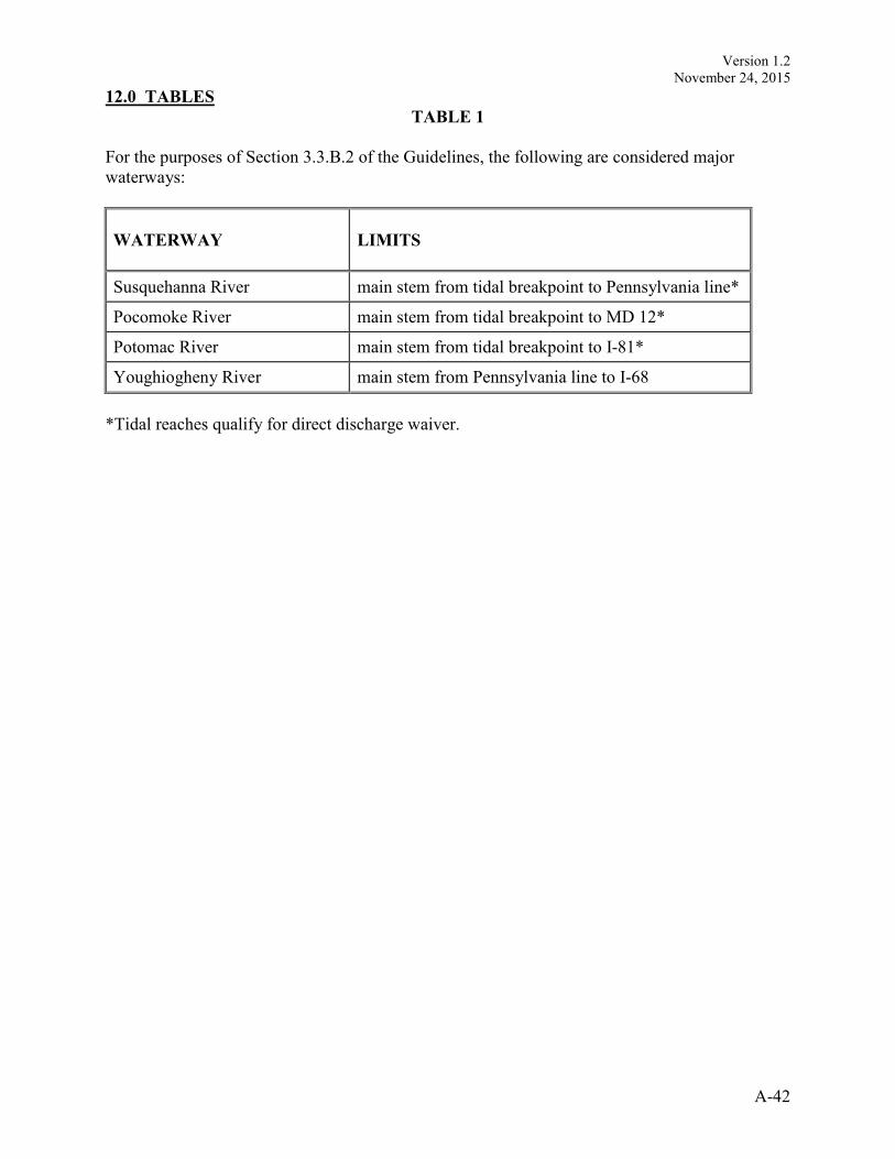
Version 1.2
November 24, 2015
A-42
12.0 TABLES
TABLE 1
For the purposes of Section 3.3.B.2 of the Guidelines, the following are considered major
waterways:
WATERWAY
LIMITS
Susquehanna River main stem from tidal breakpoint to Pennsylvania line*
Pocomoke River main stem from tidal breakpoint to MD 12*
Potomac River main stem from tidal breakpoint to I-81*
Youghiogheny River main stem from Pennsylvania line to I-68
*Tidal reaches qualify for direct discharge waiver.
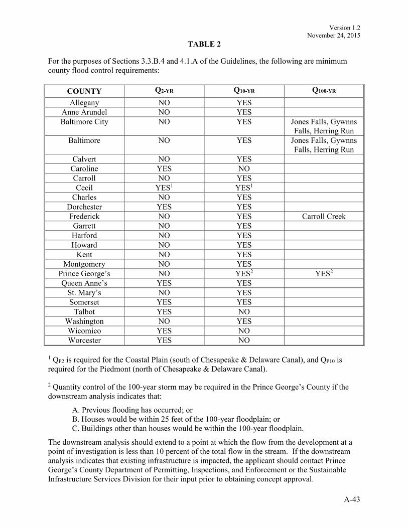
Version 1.2
November 24, 2015
A-43
TABLE 2
For the purposes of Sections 3.3.B.4 and 4.1.A of the Guidelines, the following are minimum
county flood control requirements:
COUNTY Q2-YR Q10-YR Q100-YR
Allegany NO YES
Anne Arundel NO YES
Baltimore City NO YES Jones Falls, Gywnns
Falls, Herring Run
Baltimore NO YES Jones Falls, Gywnns
Falls, Herring Run
Calvert NO YES
Caroline YES NO
Carroll NO YES
Cecil YES1 YES1
Charles NO YES
Dorchester YES YES
Frederick NO YES Carroll Creek
Garrett NO YES
Harford NO YES
Howard NO YES
Kent NO YES
Montgomery NO YES
Prince George’s NO YES2 YES2
Queen Anne’s YES YES
St. Mary’s NO YES
Somerset YES YES
Talbot YES NO
Washington NO YES
Wicomico YES NO
Worcester YES NO
1 QP2 is required for the Coastal Plain (south of Chesapeake & Delaware Canal), and QP10 is
required for the Piedmont (north of Chesapeake & Delaware Canal). 2 Quantity control of the 100-year storm may be required in the Prince George’s County if the
downstream analysis indicates that:
A. Previous flooding has occurred; or
B. Houses would be within 25 feet of the 100-year floodplain; or
C. Buildings other than houses would be within the 100-year floodplain.
The downstream analysis should extend to a point at which the flow from the development at a
point of investigation is less than 10 percent of the total flow in the stream. If the downstream
analysis indicates that existing infrastructure is impacted, the applicant should contact Prince
George’s County Department of Permitting, Inspections, and Enforcement or the Sustainable
Infrastructure Services Division for their input prior to obtaining concept approval.