sediment transport and coastal evolution at thuan an … transport and coastal evolution ... övrig...
TRANSCRIPT

169VATTEN · 3 · 14
Sediment tranSport and coaStal evolution at thuan an inlet, vietnam
Sedimenttransport och kustutveckling vid thuan an-inloppet, vietnam
by Eva-LEna Eriksson 1 and MadELEinE HjErtstrand PErsson 2
1 Horsensgatan 218, 654 58 karlstade-mail: [email protected]
2 s:t Laurentiigatan 3, 222 21 Lunde-mail: [email protected]
abstractThe Tam Giang-Cau Hai lagoon in Vietnam has two inlets and outside one of them, the Thuan An inlet, a groin was constructed in 2008 to reduce sediment transport and prevent the inlet from closing. This groin has caused erosion and accretion of sediment on the adjacent coastline. The objectives of this study were to make a model of the sediment transport on the southeast side of the groin and analyze how different measures to reduce the erosion of the inlet would affect the sediment transport past the groin. Field measurements were made in Vietnam during 2013, other data used in this study was obtained from Institute of Mechanics in Hanoi, Uni-versity of Agriculture and Forestry in Hue and from The Oceanographic Institute in Nha Trang. The modeling software GENESIS was used to model the sediment transport past the groin. First, the case where no measures were taken was modeled and after that three different measures to decrease the accretion of sediment on the southeast side of the groin were modeled and analyzed. The conclusion was that interventions to reduce the erosion of the inlet are needed to protect the lagoon and the people living around it and making their livelihood from it.
key words – Thuan An, Tam Giang-Cau Hai lagoon system, lagoon, inlet, groin, longshore sediment transport, Hue, GENESIS, preventing measures
SammanfattningTam Giang-Cau Hai-lagunen i Vietnam har två inlopp och utanför ett av dem, Thuan An-inloppet, byggdes en hövd 2008 för att reducera sandtransport och förhindra att inloppet stängdes. Denna hövd har orsakat erosion och ansamling av sediment vid den närliggande strandlinjen. Målsättningen med denna studie var att göra en modell över sedimenttransporten på den sydöstra sidan av hövden och analysera hur olika åtgärder för att minska erosionen av laguninloppet påverkar sedimenttransporten förbi hövden. Fältstudier utfördes i Vietnam under 2013, övrig använd data erhölls från Institute of Mechanics i Hanoi, University of Agriculture and Forestry i Hue och från The Oceanographic Institute i Nha Trang. Modelleringsprogrammet GENESIS använ-des för att modellera sedimenttransporten förbi hövden. Först modellerades fallet då ingen åtgärd vidtogs och efter det modellerades och analyserades tre olika åtgärder för att minska ansamling av sediment. Slutsatsen var att åtgärder för att minska erosionen är nödvändiga för att skydda lagunen samt de som lever av den och bor i området.
VATTEN – Journal of Water Management and Research 70:169–179. Lund 2014
introductionThe Tam Giang-Cau Hai lagoon system is located out-side of the city Hue in central Vietnam and has two in-lets – Thuan An inlet and Tu Hien inlet, see Figure 1. Before the groin was constructed, one of the largest
problems in the region and around Thuan An inlet was the erosion of the barrier islands southeast of the inlet and the infilling of the inlet. The erosion of the beach southeast of Thuan An inlet results in a movement of the inlet that cause problems for navigation, fishery, flooding discharge, and the ecological system inside the

170 VATTEN · 3 · 14
lagoon. In the area different fishing industries are of sig-nificant economic value, so the marine environment has a main role in the provinces’ economic growth. The ero-sion of the shoreline also causes damage to the infra-structure and the beaches, which for example affects the tourism and the people living in the area (Tung, 2001). In 2008 a groin was built just south of the inlet (see Figure 2), which altered the pattern of sediment trans-
port in the area. The shoreline southeast of the groin was eroding before the groin was built and after the con-struction of the groin the beach started to accrete on the upstream side of the groin. The severe siltation of Thuan An inlet ended when the groin was built and today the inlet lack accretion of sediment, which is leading to ero-sion of the eastern banks of the inlet. The main objective of this study was to investigate the
Figure 1. the system of lagoons, inlets and rivers at thua thien-Hue province, vietnam (tung, 2011).
Figure 2. Groin at thuan an inlet, january 2013 (Photo: Eva-Lena Eriksson).

171VATTEN · 3 · 14
sediment transport pattern and resulting coastal evolu-tion at Thuan An inlet near Hue City in Vietnam. The main objective included modeling of the sediment trans-port on the southeast side of the groin and discussing the effect of different measures to reduce the erosion of the inlet. Also the perspective of how the inlet erosion could affect the socio-economic situation was dis-cussed. The modeling only focused on the groin and the shoreline southeast of the groin, the inlet at Thuan An was not included in the model. This limitation was set due to that the hydromechanics of the inlet are compli-cated to re-create and it would have taken to long time to build a model. The chosen modeling program (GEN-ESIS) models in one dimension and this is not sufficient to build a model of the whole study area.
methodologyA literature study was carried out to collect relevant in-formation and to get a good understanding of the proc-esses and problems in the area. Previous studies of the inlet and already collected data were also reviewed and relevant data compiled. Field measurements to record the location of the shoreline were carried out during January 2013 along with researchers from Institute of Mechanics in Hanoi (IMS) and took place at Thuan An inlet. Additional data was also collected from Hue Uni-versity of Agriculture and Forestry (HUAF) and the Oceanographic Institute in Nha Trang. Besides the data collected during the field measurements, previously measured data was obtained from IMS. The received data was wave characteristics from the years 1991–2012, shoreline measurements at Thuan An inlet from 2007–2012, bathymetry data and information regarding the groin. Data concerning beach profiles, sediment samples and grain-size analysis was found through earlier con-ducted studies and thesis. To simulate the coastal evolu-tion around the inlet the shoreline change model GEN-ESIS was used. After the model was calibrated and vali-dated with available field data, different measures to lessen the impact of the groin and to reduce inlet erosion were modeled.
coastal processesGenerally about littoral transport
Littoral transport processes is a common name for long-shore transport and onshore-offshore transport of sedi-ment (Hung, 2012). These transports are generated by winds, waves, tide, currents and other processes active in
the littoral zone (Tung, 2001). When talking about lit-toral drift it often refers to the actual volume of sand that is transported by the longshore sediment transport (Komar, 1998). Onshore-offshore sediment transport has a direction that is perpendicular to the coastline and occurs when waves are travelling towards shallow water of such depth that the water motion affects the sediment on the sea bottom and the sediment grains are moved. To have an equilibrium in the near shore zone, the average addition and subtraction of sand at a certain point at the sea bot-tom must be equal (Hung, 2012). The transport of sediments in a parallel direction to the shoreline is called longshore sediment transport and has a great impact on long-term changes of the coastline. Breaking waves stir up sediment from the sea bottom, which is transported away with longshore currents. The longshore sediment transport is dependent on the angle of the wave crest to the shore and the breaking wave heights. The extent of the longshore sediment transport may vary seasonally due to that it is affected by different factors such as wind climate, tidal climate and wave cli-mate. The wave climate is the major influencing factor on the coastal geometry and composition and is directly affected by the wind climate, which is determined by the monsoon seasons. The direction of incoming waves are often measured with respect to the true north and later on transformed to the local orientation of the coastline (Tung, 2001).
coastal lagoonA coastal lagoon is a body of water that is separated from the ocean by a barrier, which is a narrow, extended sand ridge, and connects with the sea through one or more inlets. In the waters of a lagoon a habitat for an extensive variety of marine species and birds is provided and it can also serve as a safe harbour for boats (SPM, 1984a). The lagoon is usually oriented parallel to the coast and its depth is typically a couple of metres (Kjerve, 1994). Morphologically are tidal inlets a highly dynamical sys-tem that link the nearby coast with a lagoon and the whole system have an important part in the sediment budget of the coastal area, which over time have an im-pact on the coastal evolution (Tung, 2011).
mechanisms affecting a tidal inletA tidal inlet has its main channel kept open by tidal flux or river discharge. The inlet size and evolution are relat-ed to how large the tide is in the area, the wave climate, the supply of sediment and the structure of the lagoon (Tung, 2011). A coast that is dominated by wave in-duced longshore sediment transport usually has inlets

172 VATTEN · 3 · 14
that migrate and barrier spit development (Tung, 2011). The migration of an inlet depends on interactions of the tidal prism, wave energy and sediment supply. The lit-toral system is considered to be the primary sediment source that affects the stability of an inlet (Morang and Parson, 2002). Inlets vary in both size and stability, and some have a tendency to change and to migrate while others can be relatively fixed and permanent (Tung, 2011). Currents, both wave-generated and others, will continuously push sand into the inlet and the flow of the inlet, created by tide, wind and river flow, will carry the sediment seaward or into the lagoon. An inlet is also af-fected by severe storms that can both create new inlets and close existing ones (Tung, 2011).
coastal protectionWhen deciding what actions to take due to erosion of the coastal area the key elements are planning and tim-ing (Hanson, 2012). The emphasis regarding coastal structures in this thesis will be on groins, since it is the structure that was built to stabilize Thuan An inlet. A groin is designed and built to hinder longshore drift and is most commonly constructed perpendicular to the shoreline as a narrow structure designed with varying lengths and heights. The groin function is to block some of the sediment that is transported along the shore and the sand accumulates on the updrift side of the groin. The sedimentation on the updrift side results in a reori-entation of the shoreline and this in turn changes the angle between the beach and the incoming direction of the dominant wave train. On the downdrift side the sand transport is greatly reduced or eliminated by the groin, which causes the beach to erode (Basco, 2003). Bypassing of sand can be done through overpassing the top of the groin or endpassing by going around the sea-ward end of the groin (SPM, 1984b).
the tam Giang-cau hai lagoonphysical Settings
The valley of Hue contains the Tam Giang-Cau Hai lagoon system that is divided into four smaller lagoons; Tam Giang, Thanh Lam, Thuy Tu and Cau Hai lagoon (Borsje, 2003). Together they make the biggest lagoon system in South East Asia with an area of approximately 216 km2, a length of 68 km (Tung, 2001; Lam, 2009) and a maximum width of 10 km (Hung, 2012). The water depth is between 1–5 m in the Tam Giang lagoon and 1–3 m in the Cau Hai lagoon. In the channels close to the Thuan An inlet the water depth is at its deepest, between 5–10 m (Lam, 2009).
Five rivers flow into the lagoon system coming from the Truong Son Mountains (Tung, 2001). The river flow varies with the rainfall and monsoon cycle (Lam, 2009). The total catchment area of the whole river system in Thua Thien province is 4000 km2 and the total runoff that is discharged into the lagoon by the rivers is esti-mated to be 6 km3 per year. Fresh water is coming into the lagoon via the rivers and saline water enters the la-goon via the two inlets Thuan An and Tu Hien (Tung, 2001). The rivers carry with them a lot of sediment to the lagoon. They also carry plankton and algae, which makes good conditions for shrimps, fish, crabs and other species living in the lagoon water (Tung, 2001). The changes in regional climate affect the Tam Giang-Cau Hai lagoon and the littoral transport in different ways, e.g. rainfall, wind strength and wind direction, river flow and temperature are factors that change with season (Tung, 2001). Vietnam and the South China Sea are located in the tropical belt of the Northern Hemi-sphere and in comparison with other belts the tropical belt is the one with the highest solar radiation on Earth. The area is also a typical tropical monsoon zone and the seasonal changes of atmospheric circulation that results in a weather system dominated by the two yearly mon-soons, the northeast monsoon (or the winter monsoon) from September to March and the southwest monsoon (or summer monsoon) from May to September (Lam, 2009). The northeast monsoon has a large impact on the northern parts of Vietnam and the southwest mon-soon has high intensity in the central and south regions of Vietnam (Hung, 2012). The northeast monsoon is the rainiest season of the year, called the “flood” or “rainy” season. During this period more than 70 % of the Huong river basin’s precipitation (which is approxi-mately 3 300 mm/year) takes place. This is also the most common period for tropical cyclones to occur, which also adds on to the rainfall in the river basin (Lam, 2009). Strong winds can occur, most often northern or north-western winds, with speeds up to 18 m/s. These winds affect the area where Thuan An river is located and begins in October, with its peak in December and January (Inman and Harris, 1966). During the summer monsoon the dominant wind is southwest offshore. Rain during this period is often topographically driven. In coastal areas the climate becomes hot and dry; river flow and rainfall diminishes considerably, giving it the name the “dry” or “low flow” season (Lam, 2009). In May and June the southwest monsoon reverses the cur-rents (Inman and Harris, 1966). Around 70 % of the river basin area is mountainous and hilly and the rest is narrow lowland plain. Geologi-cally, the area in and around Hue consists of hard rock. Outside of Hue is the longest reach of sandy coastline in Vietnam with a length of 128 km (Inman and Harris,

173VATTEN · 3 · 14
1966). Approximately 70 km consists of sandy beach supported by sand dunes and the rest of the coast has sandy beaches between rocky headlands or rocky coasts (Lam, 2009). The valley that Hue is situated in has an average width of 20 km and a lot of sediment is carried to the Tam Giang-Cau Hai lagoon system by the rivers that enter the sea through the valley (Inman and Harris, 1966). The tropical monsoon climate has a great impact on the morphology of the inlets with its seasonal varia-tion of currents, wave climate and river flow (Lam, 2009). In the area around the lagoon there are also ap-proximately five tropical typhoons every year between June and November and over 80 % of the local flooding is a result of these typhoons and the storm surges and heavy rainfall that they cause (Tushaj, 2009). Morpho-logical changes are naturally affected by changes in pre-cipitation and consequently also changes in runoff and river flows. Also the longshore sediment transport is an affecting factor. For example during the Northeast mon-soon when runoff and river flows are large remarkable morphological changes may happen that can e.g. change the structure of the lagoon inlets (Tushaj, 2009). The salinity of the lagoon also varies with the seasons. During flood/rainy season it is the flow from the rivers that is dominating the lagoon, leading to a low salinity of approximately 0.2–2.0 ‰ (the water is nearly fresh). During this time the water is also assumed to be fresh in the inlet. In the dry season the flow from the rivers is very low and the lagoon is mainly filled with seawater, and salt water is penetrating the rivers deeply upstream. The water in the inlets is mixed at this time and has a salinity around 29.4–32.4 ‰ (Lam, 2009).
Socio-economic situation in the lagoon areaThe Tam Giang-Cau Hai lagoon is the largest lagoon in Southeast Asia and approximately one third of the prov-inces’ population earn their living out of the lagoon. The main things that people living around the lagoon work with are aquaculture, agriculture, capture fisheries, for-estry and livestock. Especially the fishery and aquacul-ture has an important role in the area due to its long coastline and the existing lagoon, and particularly aqua-culture has grown in recent years. Aquaculture has been considered an important economical activity and also a way to get out of poverty, it is said to have increased the income of many people living around the lagoon. The main part of aquaculture started in the lagoon approxi-mately 25 years ago and regards shrimp farming, al-though several marine, brackish and fresh water fish spe-cies are also caught in and around the lagoon. Agricul-ture is also a traditional occupation for many people living around the lagoon, and it is believed to provide a stable income to many people living around the Tam
Giang-Cau Hai lagoon system or one of the rivers falling out into it (IMOLA, 2006). The area around the lagoon is at risk due to annual flooding, water pollution and over-exploitation (IMO-LA, 2006). Flooding can have severe consequences for people due to the loss of habitations, crops, properties, livestock and destroyed infrastructure and can also cause pollution of the environment. New inlets opening or existing inlets closing, could give e.g. changed ecological and physical properties of the lagoon (such as changed water environment and disturbed ecosystems) (Tung, 2011), which could change circumstances for fishing, agriculture, aquaculture, navigation and other activities of the lagoon (Brzeski and Newkirk, 2002). Many fish-ing villages use the inlets as navigation channels and fishing boats can also take shelter in the lagoons during typhoons. If an inlet is closed it can also affect the water exchange and circulation of the lagoon, and thus also the water quality, which can have an impact on species liv-ing there and the biodiversity. The water salinity can change and it is affecting especially the aquaculture by fluctuating, some crops grow better and some grow slower depending on the salinity of the water. Some types of aquaculture can also suffer if the turbidity of the water is changed (Tung, 2011).
problems at thuan an inletThuan An inlet is one of the two inlets of the Tam Giang-Cau Hai lagoon system (see Figure 3). Coastal erosion is a great and serious threat to people living in coastal areas, and it keeps on increasing. Erosion causes great and severe losses for the state as well as for the people (Hung, 2012). One of the largest problems in the region of the Tam Giang-Cau Hai lagoon system and around Thuan An inlet is the erosion of the barrier is-
Figure 3.thuan an inlet photographed from the south, january 2013 (Photo Eva-Lena Eriksson).

174 VATTEN · 3 · 14
lands and the infilling of the inlet. The erosion of the beach southeast of Thuan An inlet results in a move-ment of the inlet that cause problems for navigation, fishery, flooding discharge, and the ecological system in-side the lagoon. In the area different fishing industries are of significant economic value, so the marine environ-ment has a main role in the province’s economic growth. A lot of money has earlier, before the building of the groin in 2008, been invested every year to dredge the access channel. The erosion of the shoreline also causes damage to the infrastructure and the beaches, which for example affects the tourism (Tung, 2001). The main ex-change of water between the lagoon system and the sea takes place through Thuan An inlet and when the inlet is narrowed due to sedimentation the quality of water in the lagoon deteriorates and it could ruin the aquatic eco-system (Tushaj, 2009). To stop the erosion of the beach at Hoa Duan and to protect the banks at the inlet at Thuan An, and stabilize the navigation channel, a groin was built on the barrier island southeast of the inlet in 2008 (Hung et al., 2012). Before the groin was built there were severe problems with sedimentation of the inlet, but five years after the construction of the groin the main problem is that the eastern sand spit at the inlet is eroding due to lack of sediment transport from the south, because of the groin. The sediment accumulates on the southeast side of the groin.
Field measurements and data analysis
The required data to create the model used in this study is wave data, information regarding the groin, position of the shoreline, characteristics of the beach and the
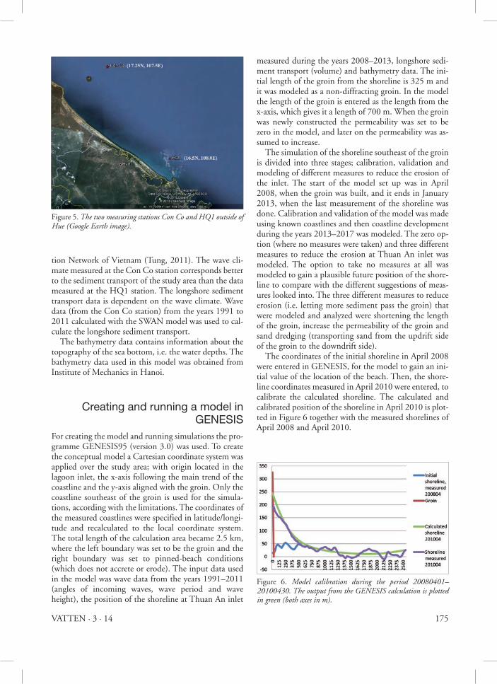
beach profile. The position of the shoreline was meas-ured during the field study in January 2013. The re-quired field measurements were carried out outside of the Tam Giang-Cau Hai lagoon, outside of the city of Hue in central Vietnam, as the investigated groin is situ-ated there. In order to study the effects on the erosion and sediment transport caused by the groin placed close to the Thuan An inlet, the shoreline has been measured with a GPS during several years, to see how it changes due to the impact of the groin. The measurements were performed by walking with a GPS along the coastline at Thuan An inlet. During the field study made in January 2013 only data regarding the position of the shoreline was collect-ed; other data have been collected earlier. The relevant data for this study that had been collected previously was obtained from the Institute of Mechanics in Hanoi. This data include wave data, bathymetry data, informa-tion on coastal structures and measurements of the shoreline positions. Data regarding the position of the coastline has been collected during the years 2007 and 2013 and the changing coastline over these years is pre-sented in Figure 4. As can be seen in the figure the devel-opment trend is that the inlet is getting larger and larger over time due to the erosion of the coastline on the northwest side of the groin. The wave data has been calculated at two measuring stations outside Hue; Con Co and HQ1, see Figure 5. The wave data used in this study contain information about wave direction (degrees), wave height (meters) and wave period (seconds). In this study it is the data hindcasted at the Con Co station (calculated wave data based on measurements) that is used and it contains data values for every third hour during the years 1991 to 2012, compiled by the Hydrometeorological Observa-
Figure 4. Longshore sediment transport and shoreline change at thuan an inlet during the years 2005 to 2012 (Cour-tesy of dien d.C.).
175VATTEN · 3 · 14
tion Network of Vietnam (Tung, 2011). The wave cli-mate measured at the Con Co station corresponds better to the sediment transport of the study area than the data measured at the HQ1 station. The longshore sediment transport data is dependent on the wave climate. Wave data (from the Con Co station) from the years 1991 to 2011 calculated with the SWAN model was used to cal-culate the longshore sediment transport. The bathymetry data contains information about the topography of the sea bottom, i.e. the water depths. The bathymetry data used in this model was obtained from Institute of Mechanics in Hanoi.
creating and running a model in GeneSiS
For creating the model and running simulations the pro-gramme GENESIS95 (version 3.0) was used. To create the conceptual model a Cartesian coordinate system was applied over the study area; with origin located in the lagoon inlet, the x-axis following the main trend of the coastline and the y-axis aligned with the groin. Only the coastline southeast of the groin is used for the simula-tions, according with the limitations. The coordinates of the measured coastlines were specified in latitude/longi-tude and recalculated to the local coordinate system. The total length of the calculation area became 2.5 km, where the left boundary was set to be the groin and the right boundary was set to pinned-beach conditions (which does not accrete or erode). The input data used in the model was wave data from the years 1991–2011 (angles of incoming waves, wave period and wave height), the position of the shoreline at Thuan An inlet
measured during the years 2008–2013, longshore sedi-ment transport (volume) and bathymetry data. The ini-tial length of the groin from the shoreline is 325 m and it was modeled as a non-diffracting groin. In the model the length of the groin is entered as the length from the x-axis, which gives it a length of 700 m. When the groin was newly constructed the permeability was set to be zero in the model, and later on the permeability was as-sumed to increase. The simulation of the shoreline southeast of the groin is divided into three stages; calibration, validation and modeling of different measures to reduce the erosion of the inlet. The start of the model set up was in April 2008, when the groin was built, and it ends in January 2013, when the last measurement of the shoreline was done. Calibration and validation of the model was made using known coastlines and then coastline development during the years 2013–2017 was modeled. The zero op-tion (where no measures were taken) and three different measures to reduce the erosion at Thuan An inlet was modeled. The option to take no measures at all was modeled to gain a plausible future position of the shore-line to compare with the different suggestions of meas-ures looked into. The three different measures to reduce erosion (i.e. letting more sediment pass the groin) that were modeled and analyzed were shortening the length of the groin, increase the permeability of the groin and sand dredging (transporting sand from the updrift side of the groin to the downdrift side). The coordinates of the initial shoreline in April 2008 were entered in GENESIS, for the model to gain an ini-tial value of the location of the beach. Then, the shore-line coordinates measured in April 2010 were entered, to calibrate the calculated shoreline. The calculated and calibrated position of the shoreline in April 2010 is plot-ted in Figure 6 together with the measured shorelines of April 2008 and April 2010.
Figure 5. the two measuring stations Con Co and HQ1 outside of Hue (Google Earth image).
Figure 6. Model calibration during the period 20080401–20100430. the output from the GEnEsis calculation is plotted in green (both axes in m).

176 VATTEN · 3 · 14
For the second calibration period the previous calcu-lated shoreline for April 2010 was entered as the initial shoreline into the model and the measured shoreline in April 2011 was entered for the model to calibrate with. The two calibration periods were run in connection to each other, and not separately, to find the calibration parameters that best matches the both periods together. The result of the second calibration period is shown in Figure 7. When running the two validation periods none of the parameter values in the model are changed, the validation years are used to check that the tuning of the calibration coefficients done during the calibration pe-riod to gain a reliable model is correct and correlates with the processes taking place over time. The perme-ability of the groin is set to 0.1 during the two valida-tion periods.
For the first validation period the measured position of the shoreline in May 2011 is entered into the model and the measured shoreline at June 2012 is entered for the model to compare with. The result from the first validation period is shown in Figure 8. The calculated shoreline from the first verification pe-riod is entered into the model as the initial shoreline for the second verification period. The measured shoreline in January 2013 is entered into the model for it to com-pare with. The result from the second calibration period is shown in Figure 9. There is not a big difference in the positions between the initial shoreline in June 2013 and the calculated shoreline in January 2013. Some com-ments can be made to the result; the period the model is run is shorter than the earlier periods of calibration and validation (which gives less time for change) and the ac-cretion of sediment is low.
results Only the coastline on the southeast side of the groin has been modelled, therefore it is hard to obtain a complete picture of how the sediment transport along the coast-line all the way towards the Thuan An inlet is affected. This study discusses measures that could be useful to reduce erosion and stabilize the coastline of the area and the Thuan An inlet. The modelling employed in this re-port focuses mainly on reducing the erosion of the coast-line on the northwest side of the groin. The calibration and validation of the model cannot be carried out with full accuracy. The resulting model is however assumed to have a satisfactorily precision and can be used to model different measures for the groin at Thuan An. The coastline will accrete on the southeast side of the
Figure 7. Model calibration during the period 20100501–20110430. the initial shoreline (blue) is the calculated shoreline from the first calibration period. the output from the GEnEsis calculation is plotted in green (both axes in m).
Figure 8. Model validation during the period 20110501–20120630. the output from the GEnEsis calculation is plotted in green (both axes in m).
Figure 9. Model validation during the period 20120601–20130131. the initial shoreline (blue) is the calculated shoreline from the first validation period. the output from the GEnEsis calculation is plotted in green (both axes in m).

177VATTEN · 3 · 14
groin with 268 000 m3 of sediment between January 2013 and December 2017 if no measures are performed. This situation was modelled to get a picture of what will happen if the current situation will continue. The accre-tion implies that further erosion on the northwest side of the groin (and also at the Thuan An inlet) will take place during these years, resulting in that the groin is preventing sediment from passing it, leading to prob-lems with erosion rather than of too much accretion at the Thuan An inlet. The option of not doing anything and relocating is therefore found not to be a suitable ac-tion due to that the continuing erosion will damage the tourist beach and constructions, such as roads, build-ings, electricity lines and so on. When modeling the sediment transport three differ-ent measures to reduce erosion were analyzed: different lengths of the groin, different values of the permeability of the groin and different modes of sand dredging.
reducing the length of the groinThe length of the groin is today 325 m. By shortening the length of the groin a higher rate of the sediment transported alongshore is enabled to pass around the edge of the groin. This will reduce the amount of sedi-ment settling on the downside of the groin and increase the amount being transported into the inlet. Five differ-ent lengths were modelled; 275 m, 225 m, 175 m, 125 m and 75 m, and the resulting sediment transport can be seen in Figure 10.
higher permeability of the groinThe permeability can be made higher by removing some of the stones that the groin is built by and thereby create
more space for sand to pass through the groin. Three different sizes on the permeability were modelled; 0.3, 0.4 and 0.6. The sediment transport with different val-ues on the permeability of the groin is presented below in Figure 11.
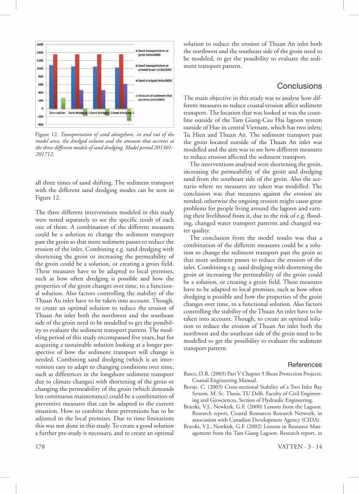
Sand dredgingSand from the updrift of the groin is dredged to gain a better balance regarding the amount of sediment. The most suitable location to move the sand to is to the up-side of the groin, which is towards the inlet. Thus, only the removal of the sand will be modelled, and not the adding of sediment to the inlet, since the inlet is not lo-cated in the modelling area. Three different types of sand drainages was modelled, with regard to how many times the moving of sediment was conducted, for how many months the drainage lasted each time and how much sand that was removed. The first model of sand dredging is done at one occa-sion during a period of four months. The total area from were sand is removed has a length along the shoreline of 1450 m and a depth of the beach of 40 m. The second model of sand dredging is done from two occasions of sand shifting, which are done during a period of four plus four months. The total area from were sand is re-moved at every dredging event has a length along the shoreline of 1450 m and a depth of the beach of 20 m. The third model of sand dredging is done from three occasions of sand shifting and each occasion has a length of four months. The length of area from were sand is removed has a length along the shoreline of 1450 m for the first and second transportation occasion and a length of 950 m for the last. The depth of the beach is 20 m for
Figure 10.transportation of sand alongshore, in and out of the model area, and the amount that accretes or erodes at different lengths of the groin. Model period 2013–2017.
Figure 11. transportation of sand alongshore, in and out of the model area, and the amount that accretes or erodes at different values of permeability of the groin. Model period 201301–201712.
178 VATTEN · 3 · 14
all three times of sand shifting. The sediment transport with the different sand dredging modes can be seen in Figure 12.
The three different interventions modeled in this study were tested separately to see the specific result of each one of them. A combination of the different measures could be a solution to change the sediment transport past the groin so that more sediment passes to reduce the erosion of the inlet. Combining e.g. sand dredging with shortening the groin or increasing the permeability of the groin could be a solution, or creating a groin field. These measures have to be adapted to local premises, such as how often dredging is possible and how the properties of the groin changes over time, to a function-al solution. Also factors controlling the stability of the Thuan An inlet have to be taken into account. Though, to create an optimal solution to reduce the erosion of Thuan An inlet both the northwest and the southeast side of the groin need to be modelled to get the possibil-ity to evaluate the sediment transport pattern. The mod-eling period of this study encompassed five years, but for acquiring a sustainable solution looking at a longer per-spective of how the sediment transport will change is needed. Combining sand dredging (which is an inter-vention easy to adapt to changing conditions over time, such as differences in the longshore sediment transport due to climate changes) with shortening of the groin or changing the permeability of the groin (which demands less continuous maintenance) could be a combination of preventive measures that can be adapted to the current situation. How to combine these preventions has to be adjusted to the local premises. Due to time limitations this was not done in this study. To create a good solution a further pre-study is necessary, and to create an optimal
solution to reduce the erosion of Thuan An inlet both the northwest and the southeast side of the groin need to be modeled, to get the possibility to evaluate the sedi-ment transport pattern.
conclusionsThe main objective in this study was to analyse how dif-ferent measures to reduce coastal erosion affect sediment transport. The location that was looked at was the coast-line outside of the Tam Giang-Cau Hai lagoon system outside of Hue in central Vietnam, which has two inlets; Tu Hien and Thuan An. The sediment transport past the groin located outside of the Thuan An inlet was modelled and the aim was to see how different measures to reduce erosion affected the sediment transport. The interventions analysed were shortening the groin, increasing the permeability of the groin and dredging sand from the southeast side of the groin. Also the sce-nario where no measures are taken was modelled. The conclusion was that measures against the erosion are needed; otherwise the ongoing erosion might cause great problems for people living around the lagoon and earn-ing their livelihood from it, due to the risk of e.g. flood-ing, changed water transport patterns and changed wa-ter quality. The conclusion from the model results was that a combination of the different measures could be a solu-tion to change the sediment transport past the groin so that more sediment passes to reduce the erosion of the inlet. Combining e.g. sand dredging with shortening the groin or increasing the permeability of the groin could be a solution, or creating a groin field. These measures have to be adapted to local premises, such as how often dredging is possible and how the properties of the groin changes over time, to a functional solution. Also factors controlling the stability of the Thuan An inlet have to be taken into account. Though, to create an optimal solu-tion to reduce the erosion of Thuan An inlet both the northwest and the southeast side of the groin need to be modelled to get the possibility to evaluate the sediment transport pattern.
referencesBasco, D.R. (2003) Part V Chapter 3 Shore Protection Projects:
Coastal Engineering Manual.Borsje, C. (2003) Cross-sectional Stability of a Two Inlet Bay
System. M. Sc. Thesis, TU Delft, Faculty of Civil Engineer-ing and Geosciences, Section of Hydraulic Engineering.
Brzeski, V.J., Newkirk, G.F. (2000) Lessons from the Lagoon. Research report, Coastal Resources Research Network, in association with Canadian Development Agency (CIDA).
Brzeski, V.J., Newkirk, G.F. (2002) Lessons in Resource Man-agement from the Tam Giang Lagoon. Research report, in
Figure 12. transportation of sand alongshore, in and out of the model area, the dredged volume and the amount that accretes at the three different models of sand dredging. Model period 201301–201712.

179VATTEN · 3 · 14
association with Coastal Resources Research Network and Canadian Development Agency (CIDA).
Hanson, H. (2012) Lecture in Coastal Hydraulics, Depart-ment of Water Resources Engineering, University of Lund, Coastal Protection (2012-04-19).
Hung, N.M. (2012) Coastline and river mouth evolution in Vietnam. Publishing House for Science and Technology. Khoa hoc & Cong nghe Printing Company Limited.
IMOLA (Intergrated Management of Lagoon Activities) (2006) Socio-economic Baseline Survey of Hue Lagoon, Part I. Survey Report. The Network of Aquaculture Cen-tres in Asia-Pacific (NACA), Hanoi.
Inman, D.L., Harris, R.W. (1966) Oceanographic and Engi-neering report on investigation of sedimentation silting and dredging requirements. Vietnam & California.
Kjerve, B. (1994) Coastal Lagoon Processes. Elsevier Science Publishers B.V.
Komar, P.D. (1998) Beach processes and sedimentation. Col-lege of Oceanic & Atmospheric Sciences, Oregon State University, Prentice-Hall, Inc.
Lam, N.T. (2009) Hydrodynamics and morphodynamics of a seasonally force tidal inlet system. Ph.D. Thesis, Delft Uni-versity of Technology.
Morang, A., Parson, L.E. (2002) Part IV Chapter 3 Coastal Morphodynamics: Coastal Engineering Manual.
SPM (1984a) Chapter 1. Introduction to coastal engineering: Shore Protection Manual, Volume I. Fourth edition.
SPM (1984b) Chapter 5. Planning analysis: Shore Protection Manual, Volume I. Fourth edition.
Tung, T.T. (2001) Coastal erosion along the sand barrier, case study in Hue – Vietnam. M.Sc. Thesis, Delft University of Technology.
Tung, T.T. (2011) Morphodynamics of seasonally closed coast-al inlets at the central coast of Vietnam. Ipskamp Drukkers B.V., The Netherlands.
Tushaj, M.C. (2009) An investigation of exchange rates in the Tam Giang-Cau Hai lagoon system, Vietnam, through hy-drodynamic modelling. Master’s Thesis TVVR 09/5010, Division of Water Resources Engineering, Lund University.

180 VATTEN · 3 · 14
AnoxKaldnes ABAquaPArboga KommunBrenntag Nordic ABChristian Berner ABFalköpings KommunGolder Associates ABGryaab ABGöteborgs Stad Kretslopp och vattenHudiksvalls KommunHässleholms Vatten ABKalmar Vatten ABKarlstads kommunKemira Kemi ABKristianstads kommunKäppalaförbundetKöpings KommunLjusdal Vatten ABMalmberg Water ABMiljö och vatten i Örnsköldsvik MIVA ABMittskåne VattenMälarenergi ABMönsterås Kommun, Norconsult ABNordiska PlaströrsgruppenNorrvattenNSVARagn-Sells Avfallsbehandling ABSjöbo Kommun, Skellefteå Kommun
Sollefteå Kommun
Stockholm Vatten VA AB
Stora Enso Hylte AB
Strömsunds Kommun
SWECO Environment AB
SYVAB
Säffle Kommun
Tekniska förvaltningen
Trelleborgs Kommun
Trollhättan Energi
Tyréns AB
Uddevalla Vatten AB
UMEVA
Uppsala Vatten och Avfall AB
Urban Water Management Sweden AB
VA-avdelningen NVK
VA-Ingenjörerna AB
Vattenfall AB
Va-verket
Veolia Vatten AB
WSP Sverige AB
Vänersborgs Kommun
Växjö Kommun
Xylem Water Solutions Sweden AB
Yara AB/ Industrial
Ånge Kommun
Östersunds Kommun
Stödjande medlemsföretag
vill ni synas bättre i listan? För 2000 kr om året kan ni få er logotyp i listan ovan.