sedimentology and stratigraphy of the holocene formations...
TRANSCRIPT
SEDIMENTOLOGY AND STRATIGRAPHY OF THE HOLOCENE FORMATIONS OF THE FRENCH GUIANA COASTAL PLAIN
M. T. Prost 3, Bd. Jubelin - 97301 - Cayenne, GUYANE
X I c 'I
ABSTRACT
The Holocene coastal plain of French Guiana is a chenier plain. The shoreline is composed of extensive shore- face-attached mudflats and characterized by waterfront man- groves and by sub-coastal swamps and marshes. The cheniers, recording former coastlines, form a series of elongated narrow sandy ridges across the inner portions of the coastal plain.
The analysis of the present-day morphodynamic conditions brings to light the significance of Holocene evolution. Its major stages are presently .well-known particularly thanks to the sedimentological research and radiocarbon dating that have been carried out in Suriname. In French Guiana there are only very scarce absolute datings.
The Holocene sediments belong to the Demerara Se-
Middle Holocene), the Moleson Phase (Late Holocene) and the Comowine Phase (Recent to Present). These phases, composed of fine grained marine and fluvio-marine deposits, are separated each other by the chenier sandy ridges.
ries. The deposits are composed of the Mara Phase (Early to /
I RÉSUMÉ
M. Lointier Centre ORSTOM - Cayenne, GUYANE
La plaine côtière holocène de la Guyane française, ouverte vers l'Atlantique équatorial, est une vaste plaine à
P cheniers. La ligne du rivage est caracterisée par la présence de grands bancs de boue qui migrent vers l'Ouest sous l'action
n des courants et des vagues. Cette côte, basse et uniforme, est bordée par la mangrove de front de mer derrière laquelle s'ouvrent
Proccedings of the IGCP Project 201 Mérida (Venezuela) meeting: k
Fonds Documentalre ORSTOM
Fonds Cote :
Documentaire
5 6
d ' immenses espaces amphibies. Les cheniers , témoins d'anciennes lignes de rivage, forment un système de rides sableuses dis-
s'étendent par des dizaines de km, interrompus seulement par les estuaires et, beaucoup plus rarement, par des affleure- ments du socle.
éclai- re celle du passé holocène. Les etapes majeures de cette évo- lution sont connues, grâce notamment aux recherches surinamien nes, appuyées sur des datations absolues. En Guyane française, par contre, ces datations restent très rares.
Les sédiments holocènes appartiennent la série Demerara composée des différentes phases: la phase Mara (Holo- cène Inférieur et Moyen), la phase Moleson (Holocène Supérieur) et la phase Comowine (Récent et Actuel). Ces phases de sédi- mentation fine sont séparées les unes des autres par les Che- niers.
posées, grosso modo, parallèlement à la cGte actuelle. Ils
L'analyse de la dynamique côtière actuelle
RESUMO
A planicie lamosa holocênica da GÜiana Francesa 6 bai-xa e uniforme. A monotonia da paisagem SÓ 6 quebrada pela presença de cheniers que constituem uma das feiçÕes morfológi- cas fundamentais. Imensos manguezais emolduram a fachada atlân tica da planicie; grandes esPaCos palustres seguem aos mangues para o interior das terras.
Os cheniers, testemunhos de antigas linhas da cos - ta, formam sistemas de cristas arenosas espaçadas e retili- neas, cuja base encontra-se próxima ao nivel do mar atual e es tá em contato com um substrat0 argiloso. Parte integrante do sistema de acreçã0 e de abrasã0 costeiras, os cheniers acompa- nham a direçã0 da costa atual por dezenas de quilômetros, S Ó sendo interrompidos pelos estuários ou, muito mais raramente, pelos afloramentos do escudo cristalino quando este aproxima- se do mar.
A anslise da dinâmica atual esclarece a evolução holocênica pré-atual. As etapas principais desta Última são CO - nhecidas sobretudo graças as pesquisas feitas em Suriname com base em dataçÕes absolutas. Na GÜiana Francesa este tipo de data- ção ainda é muito raro.
f
57
Os sedimentos holocênicos pertencem 5 Série Deme- rara, formada pelas seguintes fases de acumulação: fase Mara (Holoceno Inferior e Médio), fase Moleson (Holoceno Superior ) e fase Comowine (Recente e Atual).
Os depósitos marinhos e flÚvio-marinhos sao predo- minantemente lamosos e são separados uns dos outros pelos Che- niers.
INTRODUCTION
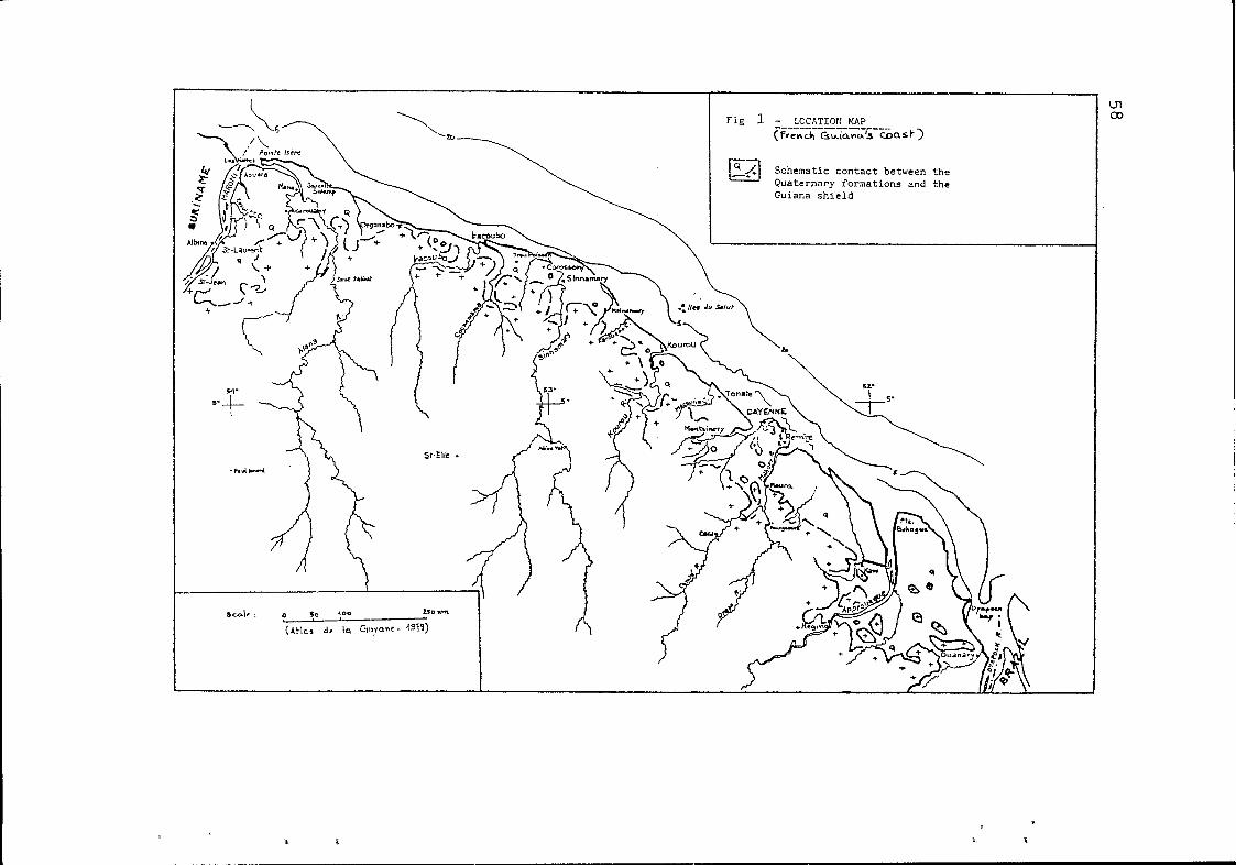
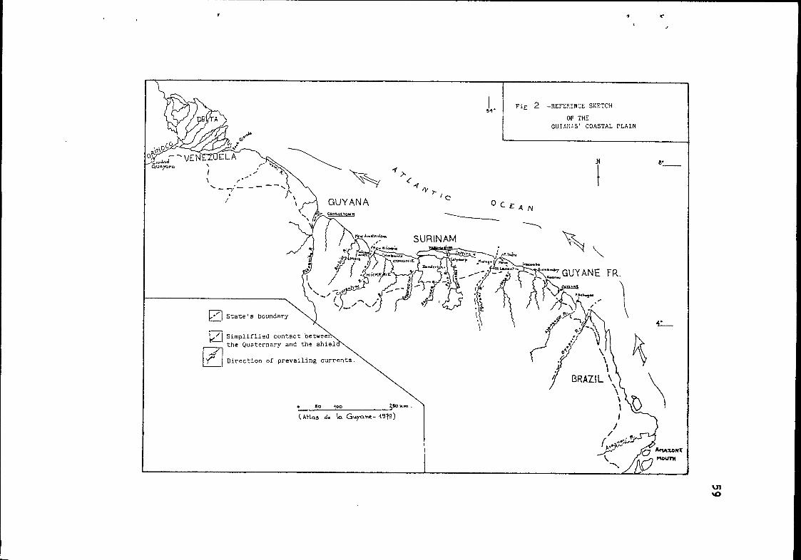
The coastline in French Guiana is low-lying and homogeneous for 320 km from the Oyapock River in the east to the banks of the Maroni in the west (fig. 1). Bordered by the waterfront mangrove it formes a part of the extensive mudflats and sub-coastal swamp-lands of the Guianas' region (fig.2).
The Quaternary littoral formations generally se- parate the crystalline basement from the ocean all along the Atlantic coast, the only discontinuity being composed of basement rocks just out between Cayenne and Organabo. These lowlandsare only a small fraction (3,700 km') of the total surface area of French Guiana (90,000 k'). Their width varies between a maximum of 50 km at Pointe Behague and a minimum of 5 km east of Cayen- ne. The slopes are very low and these lowlands play in part the role of intercepting fluvial deposits under the coupled effect of the diminished river slopes and a lower speed of flow.
Two important morphological units have been dis- tinguished between the ocean and the shield (CHOBERT, 1957; BOYE, 1959; BRINKMAN & PONS, 1968; TURENNE, 1978) (fig. 3 ) , namely:
- the lfYoung Coastal Plain" (Holocene) situated roughly between O and 5 m and composed of saline marine clays, waterfront man- grove and swampland. The latter are crossed by straight narrow sandy ridges having one or several sandy crests and more or less parallel to the shoreline. These ridges are separated from each other by phases of fine-grained sedimentation and sit upon marine clays, their base being very close to the present-day average sea level.
- the "Old Coastal Plain" (Pleistocene), situated roughly
I"/-I Schematic contact between the Quaternary formations and the Guiana shield
L’i Simpliflied contact the Quzternary and
Direction of prevailing currents.
. so 4 0 0 \ (Atlas dc ka Cuyunc- i9’fs) I
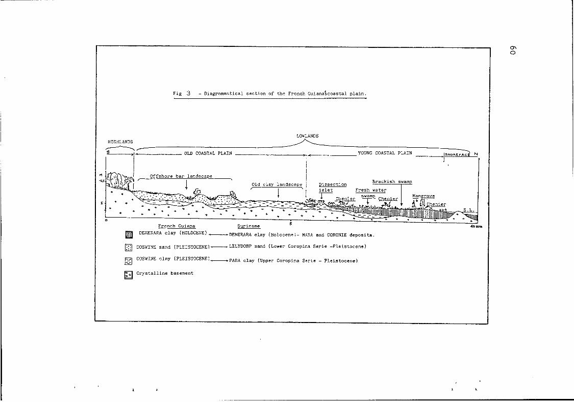
F i g 3 - Diagrammatical s e c t i o n of t h e French S u i a n a i c o a s t a l p l a i n .
I cn O
LOWLANDS HIGHLANDS
OLD COASTAL PLAIN YOUNG COASTAL PLAIN I S U O R E F ~ N ' I i
n Y'
F
Offshore b a r landscape , Dissecr ion
(HoLoCENE) -DEMERARA clay (Holocene)- MAZA and CORONIE d e p o s i t s .
0 COSWINE sand (PLEISTOCENE)-LELYDORP s a n d (Lower Coropira S e r i e - F l e i s t o c e n e )
COSWINE c l a y (PLEISTOCENE)-PARA c l a y (Upper Coropina S e r i e - P l e i s t o c e n e )
C r y s t a l l i n e basement
61
between 5 to 25/30 m, is composed of savannas and some swamps.. The plain is also marked by sandy ridges, wider and flatter than those of the Holocene plain. These ridges, with multiple crests, are found in close proximity to each other and are separated by narrow hydromorphic depressions; these ridges re- present an old offshore bar landscape which sits on a substratum of developped desalinated marine clays.
This study concerns the Holocene plain. After a brief look at the present-day coastal dynamics, which sheds a light on those of the recent past, an analysis of the sedi- mentation and stratigraphy of the Holocene formations will be presented allowing somme concluding comparisons with the neigh- boring regions.
PRESENT-DAY CHANGES OF THE SHORELINE
Unerstanding of the dynamics in the present coastal environment is important for two reasons: the obvious relation to the economic interest of the countries concerned on the one hand; and the lights it sheds on the changes in the recent past long-term evolution, on the other hand.
During the last 20 years, research done on the Guianas' shoreline attained considerable progress. It has be- come clear that there are extremely active coastal dynamics. The major factors responsible for morphological modifications have been defined. However, the problem has arisen to determine the range of these variations as well as the critical values' of activity and a total assessment of sedimentation. Another problem concerns the correlation of results within the region: although many studies have been done in Suriname and French Guiana, but there is little data for the Brazilian territory of Amapá, where such studies are much fragmented.
Given points
The most striking phenomenon influencing the coastal evolution is the longshore supply of the enormous mass of fine- grained sediments discharged by the Amazon River (100 to 200 million tons per year) ,carried steadily westward by the combined action of waves and currents (Guiana Current and longshore current created by trade-wind driven waves). Clays, silts and
.. . .
62
fine-grained sands are transported partially in suspension by the current and partially by means of westward migrating shore- face-attached mudbanks. The tidal currents (ebb and flow tides at river mouths) also play an important role in the trans- portation of sediments. However, the amount of sediment load carried down by the rivers in French Guiana is very small in comparison with that from the Amazon River.
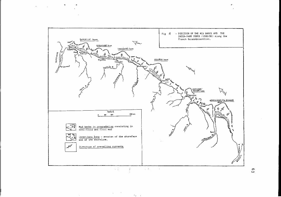
The French Guiana coastline is presently constituted by 6 large mudflats 20 to 40 km long (fig. 4) prograding towards the ocean and forming an oblique angle to the coast. They are
inter-bank zones) where erosion is dominant. separated from each other by deeper parts: the troughs (or
These banks migrate westward owing to the abrasion of the flat eastern border and the accretion of the west side (fig. 5). Accumulation is due to the presence of a semi-fluid mud, "slingmud"(' I, which causes wave dampening, particularly during the low water slack, when the silt concentration in the seawater is the highest(2). During the next flood, ltslingmudll may be transported in a fluidized state but only for short distances and always in the immediate environment. After the tide has receded once more the soft silt is exposed to the air and the consolidation accelerated (AUGUSTINUS, 1978). These events may be repeated several times.
The accumulation diminishes towards the middle and eastern flank of the mudbanks with increasing consolidation of mud and the emergence of sediments. Little by little, they lose their original capacity to subdue wave action, because there is hardly any "slingmud" in this sector. The energy of the waves is greater and they acquire an increased power of erosion. For this reason, in contrast with the smooth surfaces of the west side the eastern flank appears in aerial photos as an irregular and discontinuous surface, marked by a system of gullies. 1 Finally, in the interbank zones where the water is
( 1 ) "Slingmudlr is a gelatinous agglomerate of clayed particles in water which develops when concentrations exceed a critical value (between 5 ,O0 and 10, O mg/l) (AUGUSTINUS, 1982).
( 2 ) YX.ngmudt' deposition takes place especially during periods of strong winds and during low tide (AUGUSTINUS, 1986 - in press).
c
,...”) Mud banks in proeradation consistlng in seni-fluid and fluid mud
Inter-banK bone - erosion of the shoreface ana of the shoreline.
Direction of prevailinc currents w i cn
w
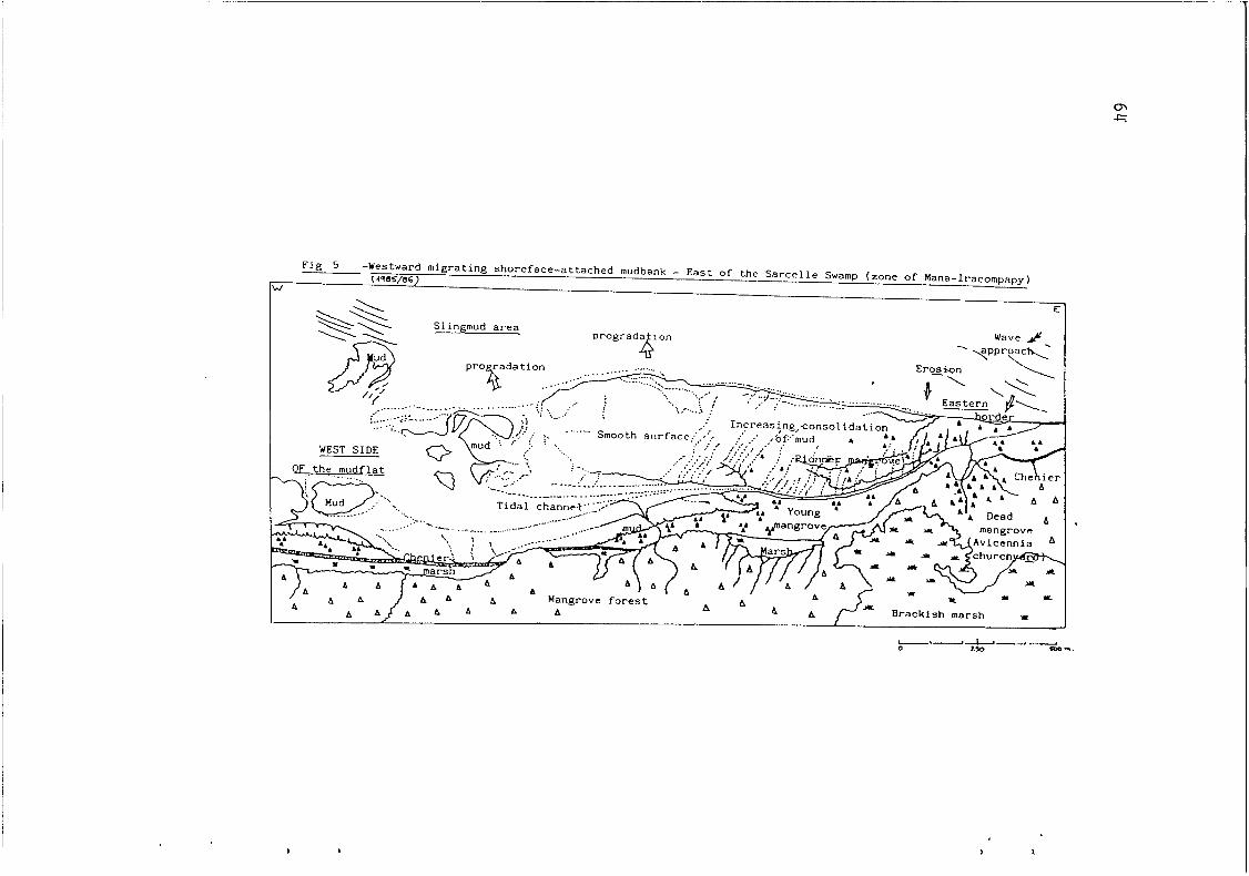
F i g 5 -Westward migrating shoreface-attached mudbank - East of the Sarcelle Swamp (zone of Mana-Iracompapy) (+7SS,46)
W
E
Slingmud area Wave f i . -. -qpryac\
65
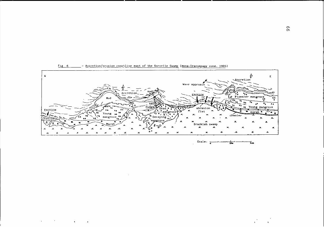
deeper and where the substratum is composed of more consolidated mud, erosion takes over and the shoreline recedes. On the whole, these dynamic processes take place in a relatively high energy environment, as noted by RINE and GINSBURG (1985), muds are accumulated by high current and wave activities. In the interbank zones, the waves not only erode the eastern flank of the mudflat but also cause the shoreline to recede. In other words, at the same time, there are as many sectors under accumulation as under recession along the coastline (fig. 6).
Measurements have been taken of the rate of migration of mudbanks and interbank zones. In French Guiana, it averages 900 m annually (between 300 and 1200 m/year - CORDET Report, 1985). In Suriname, it varies between 0,5 and 2,5 km/year (NEDECO, 1968; ALLERSMA, 1971; AUGUSTINUS, 1978, 1980, 1982, 1985). On the Guyana coast, the average rate of propagation is 1,3 km/ year (DELFT, 1962). The differences emphasize the greater angle between the coastline and the direction of the prevailing winds (AUGUSTINUS, 1985). Lastly, the average period of mudbank migration along a given point of shoreline is about 30 years (DELFT, 1962; BOYE, 1962; TURENNE, 1978; AUGUSTINUS, 1978;RINE & GINSBURG, 1985; historical information, etc.).
Then, it is possible to reach the conclusion that:
a) The source of the considerable amount of sediment transported alongshore in suspension or by migrating shore- attached mudflats is related to argillaceous muds supplied by
from the local rivers. the Amazon River in striking contrast with the small supply
b) The littoral morphogenetic processes take place in a relatively high energy environment.
Controversial points
We will introduce only the three following qustions: - What is the role played by estuaries in the transport of sedi-
ment along the coast?
- What is the origin of the sand composing beaches and present- day sandy ridges?
- What are the repercussions of coastal dynamics on the paralic sub-coastal environment?
cn cn
F i g 6 - Accretion/erosion coastline east of the Sarcelle Swamp (Mana-Iracompapy zone. 1985)
W E
Brackish swamp
6 7
a) The role played by estuaries
The relative importance of estuaries in the transportation of coastal sediments is still unclear. Some believes that they play an important role; others, only a lesser one. Do local river mouths check the passage of fine- grained sediment?
AUGUSTINUS (1978) observed that the advance and retreat of the 2 m isobath in the western part of the Suriname estuaries does not appear to have a direct connection with the
change very little over the years. This stability is possibly
estuaries and caused by river discharge during the ebb tide which prevents the silt from settling down. Research done in Surina- me therefore also shows a differential behaviour of river mouths; when they are large, the pressure exerted by the supplied water is too high to introduce major changes. For example, in the case of the Essequibo River, the discharge causes perturbations in the Guiana Current and introduces changes in the transport of sediments (DELFT, 1962).
When river mouths are smaller they are deflected by the coastal sedimentary transport. AUGUSTINUS (1978) has shown that at the Mana River (French Guiana) this development started in the 18th century; in 1785, the river mouth was much further east than at present. After 1865, it began deviating westward and Pointe Isère began to take form. At present, the Mana and the Maroni Rivers share a common mouth, with Pointe Isère became the principal morphological feature of this part of the coast. The same process has resulted in a common river mouth for the Counamama and the Iracoubo Rivers. Several examples of deflection of river mouths can be found in the Young Coastal Plain of Su- riname (for instance, the Cottica, Commewijne, Saramacca and Nickerie Rivers).
westward shifting mudbanks; the 2-m depth contour seems to
due to the higher current velocities on the west side of
At which moment and under what conditions are river mouths affected by the westward transport of sediment? Until now, no comprehensive study of the processes has been published. Further information is necessary concerning the hydrological, sedimentary and morphogenetic processes involved particularly when we attempt to assess their critical values of activity. Moreover, observations have been random and local conditions cannot be easily generalized. Although some tendencies can be
-. . . . - - . . . .
6 8 .
d e t e c t e d , t h e i r e x t e n t i s s t i l l unknown.
b ) O r i g i n o f s a n d y b e a c h e s a n d r i d g e s
S a n d y ma te r i a l i s r a t h e r ra re i n t h i s mud- d o m i n a t e d e n v i r o n m e n t ( 3 ) . S a n d a c c u m u l a t e s a s c h e n i e r s a n d smal l b e a c h e s . B u t , f r o m t h e g e o m o r p h o l o g i c a l p o i n t o f v i e w , t h e s a n d y mater ia l i s of a m a j o r i m p o r t a n c e , c o r r e l a t e d w i t h a t y p e of c o a s t a l l a n d s c a p e d e f i n e d by AUGUSTINUS ( 1 9 7 8 ) . B u t w h e r e d o t h e s e s a n d s o r i g i n a t e ?
Researches i n Guyana a n d S u r i n a m e a r e i n a g r e e m e n t o n two p o s s i b l e s o u r c e s :
- T h a t o f a n Amazon-born f i n e a n d v e r y f i n e - g r a i n e d s a n d s i s u p h o l d by K R O O K ( 1 9 7 6 ) a n d by AUGUSTINUS ( 1 9 7 8 , 1 9 8 0 , 1 9 8 2 , 1985). A c c u m u l a t e d a t t h e mouth o f t h e Amazon, t h e y would be h e l d i n s u s p e n s i o n a n d c a r r i e d a l o n g w i t h t h e p e l i t i c p a r t i c l e s by t h e Guyana C u r r e n t ( M I L L I M A N , 1 9 7 5 ; EISMA a n d V A N D E R MAREL, 1 9 7 1 ) . A s t h e r e s u l t o f t h e e r o s i o n of t h e m u d f l a t s , t h e s a n d s a r e "washed o u t " of t h e muddy s e d i m e n t s . The muds are then c a r r i e d f u r t h e r a n d t h e s a n d s remain a s b e a c h e s a n d c o a s t a l r i d g e s .
A c c o r d i n g t o K R O O K ( 1 9 7 6 ) , t h e h e a v y m i n e r a l a s s o c i a t i o n i s d o m i n a t e d by e p i d o t e a n a h o r n b l e n d e ( 2 0 t o 4 0 % ) . AUGUSTINUS ( 1 9 7 8 ) e m p h a s i z e s t h a t t h e s e s a n d s o c c u r s o n l y a t west of t h e S u r i n a m e R i v e r .
- Medium a n d c o a r s e s a n d s a r e a c c e p t e d by t h e m a j o r i t y of a u t h o r s a s r i v e r - b o r n . JEANTET ( 1 9 8 2 ) c o n s i d e r s i t obvious "even i f t h e i r z o n e o f i n f l u e n c e s l i g h t l y e x c e e d s t h e e s t u a r y o r s t r i c t l y c o a s t a l a r eas" . The r i v e r - b o r n s o u r c e i s a l s o s h a r e d by LEVEQUE (1962), B L A N C A N E A U X ( 1 9 8 1 ) a n d FROIDEFOND ( 1 9 8 5 ) .
The h e a v y m i n e r a l assemblage i s d o m i n a t e d by t h e s t a u r o l i t e ( 4 5 / 7 5 % ) . The r i v e r a i n - s u p p l i e d s a n d i s n o t b r o u g h t f a r o u t s i d e t h e r i v e r m o u t h s or e s t u a r i e s . Some d e p o s i t s i n S u r i n a m e seem t o b e s u p p l i e d by t h e Mana a n d t h e M a r o n i Rivers , t h e l a t t e r c a r r y i n g w e a t h e r e d p r o d u c t s o f t h e h i g h l y metamor- p h o s e d s c h i s t s o f t h e Armina F o r m a t i o n i n S u r i n a m e ( c o r r e l a t e d w i t h t h e s c h i s t s o f t h e O r a p u F o r m a t i o n i n F r e n c h G u i a n a ) .
( 3 ) O n l y 2 % o f t h e t o t a l amoun t o f t h e p e l i t i c s e d i m e n t s ( A U - GUSTINUS, 1 9 8 6 , i n p r e s s ) .
69
‘r
P
However, the hypothesis concerning the present- day river supply comes up against the problem of the small quantities of suspended load in French Guiana rivers (ORSTOM/ Cayenne, 1985-86). The load of colloids is very constant, at about 10 mg/l. Furthermore, the bed load affects only a thin few cm thick layer of the bed. Under these conditions, the solid load is insufficient to nourish and maintain the sandy accumulations along the coast. A l l the more so as the slopes are extremely small: on the Sinnamary River, for example, the river slopes is 0,gO m for the last 30 km (LOINTIER, 1984).
Subject to new observations and data, river transport of solid matter seems to be very small. This point reveals the complex problem of the present and past causes of the coastal sand accumulations.
c> Repercussions of coastal dynamics on paralic en- vironments
Vast amphibious spaces occupy a very large part of the Younger Coastal Plain and constitute a privileged ,zone of action of marine and continental processes. They are. the object of a recent study in the Sarcelle Swamp zone (LOINTIER & PROST, 1986). Two distinct units have been identified: - The first, regularly covered by the tide, extends orver a very limited area. Occupied by the waterfront mangrove and crossed by tidal channels, it evolves according the rhythm of the ocean (semi-diurnal tides and cycles between the syzygies). - The second is a marshy area formed by vast depressions of brackish swamps and low vegetation, with litt.le or practically no water circulation. Its evolution depends primarily of rain- fall and evaporation.
LOINTIER shows a clear limit between the two units: as a general rule, there is no intrusion of sea water into the brackish water basins. But, when the rainfall exceeds 30 to 50 mm, the overflow of the brackish swamp fills the net- work of tidal channels which slowly drain the water towards the sea. Thus, at this time - and only under these conditions - a one way connection is established.
The paralic environment under consideration is influenced more greatly by continental rather than marine

70
c o n d i t i o n s . N o t a b l y , when d r y s e a s o n i s more i n t e n s e o r l a s t s l o n g e r t h a n t h r e e m o n t h s , t h e c e n t r a l b a s i n d r i e s o u t a n d become a v a s t s u r f a c e o f c r a c k e d c l a y , a " d r y
A s f o r t h e r e p r e c u s s i o n s o f r e c e n t c o a s t a l d y n a m i c s o n t h e e v o l u t i o n o f s u b - c o a s t a l swamps a n d m a r s h e s , i t a p p e a r s t h a t :
- On t h e o n e h a n d , s o i l d e v e l o p m e n t , l i n k e d t o r e c e n t p h a s e s of a c c r e t i o n a n d a b r a s i o n o f t h e c o a s t , exp la ins t h e high s a l i n i t y of t h e s u b - l i t t o r a l m a r s h a s t h e r e i s n o s a l i n e i n t r u s i o n i n t o t h e b r a c k i s h b a s i n s ;
- On t h e o t h e r h a n d , a c o m p a r a t i v e s t u d y d o n e i n a n e i g h b o r i n g f r e s h w a t e r m a r s h s i t u a t e d f u r t h e r i n l a n d a n d h a v i n g d e v e l o p e d s o i l s p r o v e s t h e p e r s i s t a n c e o f l i t t o r a l c o n d i t i o n s a n d t h e phenomena o f t h e a c c r e t i o n / a b r a s i o n c y c l e .
On t h e w h o l e , t h e s u b - c o a s t a l e n v i r o n m e n t a l s o a p p e a r s t o b e v e r y d y n a m i c . If t h e m a r i n e e n v i r o n m e n t a p p e a r s t o b e r e l a t i v e l y u n s t a b l e , t h e r e i s n o p r o o f t h a t o n c e t h e mudbank h a s m i g r a t e d w e s t w a r d , t h e e v o l u t i o n of t h i s e n v i r o n - m e n t , as w e l l a s t h e b e a c h e s a n d s a n d y r i d g e s , w i l l n o t b e m o d i f i e d ( L O I N T I E R , 1 9 8 6 ) . A c t u a l l y , i t i s more t h a n l i k e l y . The b r a c k i s h swamp a p p e a r s t o b e r a t h e r more s t a b l e b u t t h i s s t a b i l i t y i s v e r y p r e c a r i o u s ; o n l y s l i g h t m o d i f i c a t i o n s a r e s u f f i c i e n t t o c h a n g e t h e b r a c k i s h swamp i n t o a " d r y t a n n e " o r a s t r e t c h o f o p e n water. F i n a l l y , t h e f r e s h w a t e r m a r s h seems t o be t h e most s t a b l e o f t h e t h r e e , w i t h d e v e l o p e d s o i l s a n d a d e n s e c o v e r o f v e g e t a t i o n .
T h e e n l a r g e m e n t o f o n e u n i t i n t h e d e t r i m e n t o f a n o t h e r h a s a l s o * c h a n g e d o n t ime , a s h a s b e e n shown by s e d i - m e n t o l o g i c a l a n d s t r a t i g r a p h i c d a t a .
S T R A T I G R A P H Y A N D SEDIMENTOLOGY OF THE H O L O C E N E FORMATIONS A N D SHORELINE CHANGES
S t r a t i g r a p h y o f t h e Q u a t e r n a r y f o r m a t i o n s
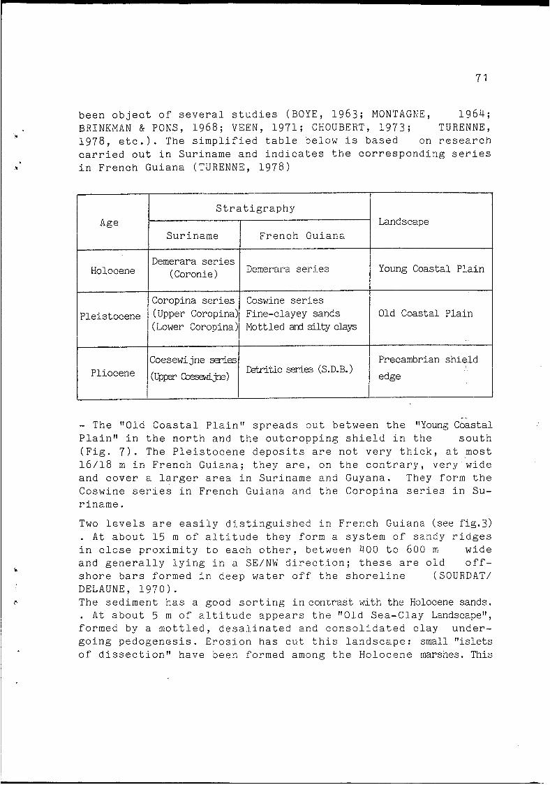
The s t r a t i g r a p h y of t h e G u i a n e s e c o a s t a l p l a i n h a s
(4) T a n n e : e x p a n s e s w i t h no v e g e t a t i o n o r a h e r b a c e o u s c a r p e t , a n d s i t u a t e d i n t h e d e p t h s o f t h e m a n g r o v e .
I
c
S u r i n a m e
71
b e e n o b j e c t o f s e v e r a l s t u d i e s ( B O Y E , 1 9 6 3 ; M O N T A G N E , 1 9 6 4 ; B R I N K M A N & PONS, 1 9 6 8 ; VEEN, 1 9 7 1 ; C H O U B E R T , 1 9 7 3 ; T U R E N N E , 1 9 7 8 , e t c . ) . The s i m p l i f i e d t a b l e b e l o w i s b a s e d on r e s e a r c h c a r r i e d o u t i n S u r i n a m e a n d i n d i c a t e s t h e c o r r e s p o n d i n g s e r i e s i n F r e n c h G u i a n a ( T U R E N N E , 1 9 7 8 )
F r e n c h G u i a n a
Holocene
~~ ~
Coropina series (Upper Coropina) (Lower Coropina)
P le i s tocene Coswine series Fine-clayey sands Old Coastal P l a i n Mottled 4 silty clap
I
Pliocene Coesewijne SeYies
(UPFer -*> 1 Precambrian s h i e l d ktritic SeYies (S.D.B.)
I edge
Demerara series (Coronie) Demerara series Young Coastal P l a i n
- The " O l d C o a s t a l P l a i n f f s p r e a d s o u t b e t w e e n t h e "Young Coastal P l a i n " i n t h e n o r t h a n d t h e o u t c r o p p i n g s h i e l d i n t h e s o u t h ( F i g . 7 ) . The P l e i s t o c e n e d e p o s i t s a r e n o t v e r y t h i c k , a t most 1 6 / 1 8 m i n F r e n c h G u i a n a ; t h e y a r e , o n t h e c o n t r a r y , v e r y w i d e a n d c o v e r a l a r g e r a r e a i n S u r i n a m e a n d G u y a n a . They form t h e C o s w i n e s e r i e s i n F r e n c h G u i a n a a n d t h e C o r o p i n a s e r i e s i n Su- r i n a m e .
Two l e v e l s a r e e a s i l y d i s t i n g u i s h e d i n F r e n c h G u i a n a (see fig.3) . A t a b o u t 15 m of a l t i t u d e t h e y f o r m a s y s t e m o f s a n d y r i d g e s i n c l o s e p r o x i m i t y t o e a c h o t h e r , b e t w e e n 4 0 0 t o 600 m w i d e a n d g e n e r a l l y l y i n g i n a SE/" d i r e c t i o n ; t h e s e a r e o l d o f f - s h o r e b a r s formed i n d e e p water off t h e s h o r e l i n e (SOURDAT/ D E L A U N E , 1 9 7 0 ) . The s e d i m e n t h a s a good s o r t i n g i n c o n t r a s t w i t h t h e Holocene sands. . A t a b o u t 5 m o f a l t i t u d e a p p e a r s t h e " O l d S e a - C l a y Landscape", f o r m e d by a m o t t l e d , d e s a l i n a t e d a n d c o n s o l i d a t e d c l a y u n d e r - g o i n g p e d o g e n e s i s . E r o s i o n h a s c u t t h i s l a n d s c a p e : small f f is le ts of d i s s e c t i o n " h a v e b e e n formed among t h e H o l o c e n e marshes. This
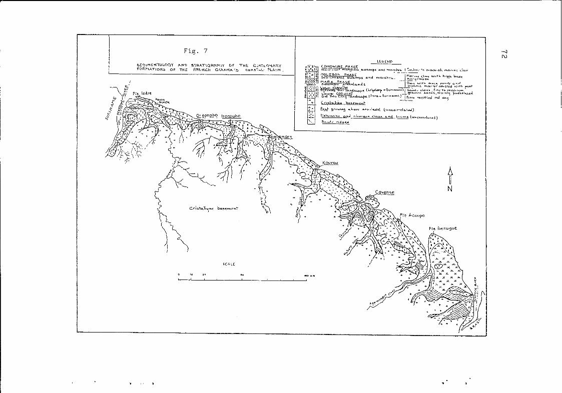
Fig. 7
D N
I
T ?
73
Deposit
Coronie
type of morphology is clearly seen in the region of Mana and also in the Cayenne area.
- 'Holocene deposits (fig. 7), composed mainly of fine-grained marine sediments, occur since 8000 BP up to the present. Strati-
dating, pedological research, pollen analyses, studies on mollusks, etc.) and are presented below in a simplified form.
graphic data based on studies carried out in Suriname ( '4c
Phases Sediments
Comowine Saline to brackish marine clay
Serie
Demerara
I I I Comowine/Moleson
with or without vague or brown mottles.
Sandy ridges ~
Moleson
Moleson/Mara
1 Mara Partially desalinated, yellow and brown mottled marine clay
Sandy ridges Heterogenous clays with organic matter and sand layers.
t I I l I 1 Non-correlated Peat I
The Wanica phase (yellow mottled marine clays) - post- Mara and pre-Moleson - decribed in Suriname is not recognized in French Guiana.
The Mara Phase is the oldest, dating to 8,000/6,000 years BP (BOYE, 1959; LEVEQUE, 1962; VAN DER HAMMEN, 1963; ROE- LEVELD, 1968; BRINKMAN and PONS, 1968; TURENNE, 1978, etc.).
The peat from the Mara phase has been the object of age dating. It is accepted that peat from this period was formed
Rhyzophora. The pollen analyses carried out by ROELEVELD indicated nearly 100% of Rhyzophora pollen. Based on this data, VAN DER HAMMEM accepts a transgressive maximum of +3 m towards 67000 BP. However, BRINKMAN and PONS believe that this type of de- posit precedes the marine maximum of 6,000 BP and that it corresponds to the "Old Mara Phase". In other words, the old Holocene deposits have appeared in several stages and their summits are not found at the same altitude everywhere in relation
very close to sea-level, frequently in brackish marshes of
. ..
74
to present-day sea level. Other studies will be necessary to determine these differences, especially in light of the fact that the littoral sea board has been subjected to subsidence.
The Moleson and Comowine Phases are dated res- pectively as being 2,600/1,300 BP and 1,000 BP t o the present. In Suriname and Guyana, the Wanica/Moleson/Comowine sediments correspond to the Coronie deposits.
BRINKMAN & PONS (1968) estimated that the Wanica phasestarted about 6,360 BP. This age is based in a layer of a old peat (Mara phase) of a meter in thickness found in the zone of Nickerie; it is situated 1.50 m below average present-day sea level and lies on Pleistocene clays. A 4-m high sandy ridge containing shell fragments sits on top of the peat; it was therefore formed after 6,360 BP, and has been recognized as Wanica phase by the nature and degree of soil developement in the ridge. The end of the Wanica phase is dated at 3,500/ 3,000 BP.
The beginning of the Moleson Phase in Suriname can be estimated as about 2,800 BP thanks to the 14C analyses of shells in the Hertenrits archeological site situated north of Wageningen (Nickerie). The end of the phase is placed at1,000 BP (PONS 1966). Pollen analyses at the Hertenrits site as well as new I4C data permitted the definition of several stages within the Moleson phase and linked them with the advance and retreat os swampland in relation to changes of the shoreline. A few minor differences appear in the ages proposes by BRINK- MAN & PONS (1968): beginning of Moleson at 2,500 BP ( O l d Moleson); intermediate stage at 2,000/1,500 BP (Middle Moleson); end of the phase at 1,300 BP (Young Moleson).
The Comowine Phase is the most recent. Towards 1,055 BP flooding left accumlations of marine clay at the foot of the Hertenrits amerindian mounds, where the Avicennia grow. The amerindians were forced to leave the site; they probably moved to the ridges. GEYSKES (1961) found a radio- carbon age of 480 - 150 years BP at an amerindian site north of Paramaribo situated in the center of the belt of Comowine sediments.
+
Geographical maps of the 17th century show Parama- ribo as much closer to the sea than at present. Progradation of the coast near the Coronie continued until 1914 (REYNE,
b
* ?
*
n
75
,1961). As a matter of fact, the Comowine phase of sedimentation has therefore continued up until present times.
The stratigraphy here presented formed the basis for the identification of the phases of fine sedimentation - and the sandy ridges which separate them - within the three Guia- nas. In French Guiana, absolute datings are rare and the strati- graphy has been done mainly by analogy with that of Suriname and thanks to pedological studies. Only a few radiocarbon dates exist, taken during the CORDET Project. They show that the coast between Mana and the Maroni River prograded during 3,500 years oceanward while during the same period, it was in re- gression towards the Sinnamary (CORDET Report, 1985).
Sedimentology of the Holocene formations
a) Fine-grained sediments
The Holocene sediments are composed mostly of marine clays (fig. 7 ) .
The grey clays of the Mara Phase are the most heterogeneous, accumulated in a brackish and/or in a marine environment (TURENNE, 1978) with a transgressive event and sedimentation in the estuaries. They have been accumulated within brackish lagoons and marshes situated behind coastal sandy ridges and in rias. For this reason, these clays contain organic matter and sandy layers. Further inland from the coast (zone of Mana-Iracompapay; Kaw marshes; Pointe Behague)appears
gasse". The soils developed in the Mara sediments are very rich in pyrites (pyrite clay or sulfurous clay) and would give rise to "cat clays" or "acid sulphate clay" after oxidation.
a type of loose, acidic spongy and/or fibrous peat, the ??pé- _ .
The Mara sediments cover only a small area in French Guiana, especially at the west coast (region of Mana- Iracompapay). Between Organabo and Cayenne, they are scarce and between the Mahury and the Oyapock Rivers, they appear only in small areas. They occur, on the con-trary, in large areas in Suriname and especially in Guyana.
The Moleson sediments are composed of soft,brown and yellow-mottled, greyish-blue clays, superficially des-
These alinized. They occur mainly to the east of Cayenne. sediments correspond partially to the site of brackish marshes
7 6
and are most frequently located above the highest tide level. BRINKMAN & PONS (1968) observed that in certain cases the Moleson sediments in Suriname occur approximately one meter lower than the present high-tide level. Moreover, no erosion of the surface has been observed in this phase (in contrast with the Mara phase) which indicates that after deposition,the sea level must have remained essentially constant (BRINKMAN & PONS, 1968).
The Comowine Phase, however, is composed of highly
constitutes the waterfront mangrove landscape and the present- day shoreline which is being subjected to the most striking morphological changes.
saline, blue marine clays, covered by normal high tides. It
b) Peat
Peat has not been found in the Holocene deposits. It should, however, be noted that a large majority of these peat swamps covered mainly the Mara deposits. However, BRINKMAN & PONS point out that besides the freustaticfr peat of the Mara Phase, there exist another kind of peat mounds growing above sea level, known as Rombragenous peat" from their appearence on aerial photos. They correlate these peats with the Wanica/ Moleson phase. At present, they continue to grow.
Because of the great difficulty of access, peat swamps in French Guiana have not been object of systematic studies and dating. However, we hope that radiocarbon dating will be done in future research.
c) Sandy ridges
The perched sandy ridges interspersed within different phases of the fine-grained sedimentation are cheniers ( "ritsen'f in Suriname and in Guyana). They rest on a substratum of marine clays and their base is very near the present-day sea level.
Cheniers are essentially built up of medium to coarse sand in French Guiana, and by sand and shell fragments in Su- riname and Guyana with a small proportion of fine-grained se-
SOURDAT and MARIUS (1964). According to these authors grain size varies between 0.1 and 1.0 mm although coarser sand ( I to 2 mm) is not uncommon. It is marine, "essentially composed of
I
diments. Sandy ridges have been studied in French Guiana by
. LI c
*
77
quartz and rare heavy minerals, containing mica and occasionally shell clasticsfl (TURENNE, 1978).
These ridges are straight and narrow (width between 70 to a maximum of 200 m) with one or several crests (see fig. 3). They occur mainly east of Cayenne. In the Mana-Aouara-Les Hattes region, they form complex systems curved toward the Maroni's mouth, the same feature occurring at the Suriname bank towards Pointe Galibi.
The cheniers spread out widely in Suriname and Guya- na. AUGUSTINUS consecrated a large amount of his research to them from 1978 until 1986. He distinguished two types of cheniers
coarse along the Suriname coast; those formed by medium and sands from the Maroni to the Mara River, and cheniers on the west coast, composed of fine grained sand and shell clastics. The fine-grained sands are carried from the Amazon. The author defines a typology of the erosion and accumulation coasts of Suriname; this typology is based largely on chenier development.
The cheniers need further studies in French Guiana, particularly concerning their ages. Until now, we used. only relative ages ( rroldll, llrecentll, llpresent-dayll cheniers) , based on their geomorphological position and on their degree of pedo- genesis. But such an interpretation is insufficient and im- precise and must be replaced by a more accurate research es- pecially in complex formations of sandy ridges, as often observed in the field.
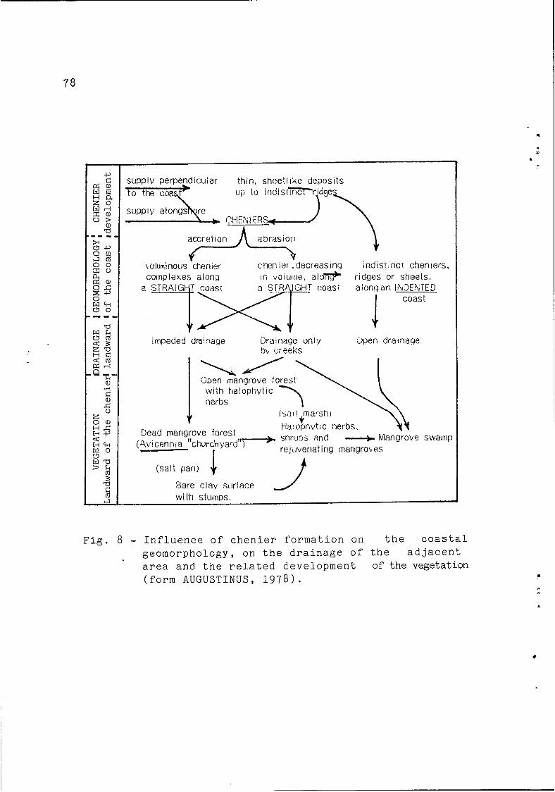
In general, the cheniers are considered as built up on a relatively stable coast (AUGUSTINUS, 1978), shoreline changes occurring by progradation and retreat as at present. It is certain that they serve as a barrier for the brackish marshes developing behind the sandy ridges. AUGUSTINUS recalls that their development has many consequences for the geomorpho- logy, drainage and the development of soils and vegetation in the coastal zone. He presents a diagram showing a synthesis of these interactions (fig. 8Y. RINE & GINSBURG (1985)'have also emphasized the role of cheniers in the morphodynamic sequences of the French Guianese coast.
The Holocene coastal plain of the Guianas is one of the longuest continuous "open ocean" chenier plain, similar to the one in southwestern Louisiana. It is the result of a continuous and abundant supply of fine-grainde sediments and of the
7 8
SLIPPIY perpendicuiar thin, sheet1 ike deposits
accr et I on R bras ioí1
wiuminoiis &srlier chen i ? t .decreasing indislincr cheniers, complexes along :n vo!urnr-?. a l o e ridges or sheets.
Impeded drainage ilrainage only upen drainage b\; c:eeks
Cuen mangrove forest with ha!ophytic
(salt marstì) Ha:opr,ytic :ierbs,
~ s;h,.,~ltjs and rejidvenating rnarigrobes
.-+ Mangrob Dead mangrove forest [.Av i cen n 1 a "church yard 1
I 7
' E : swamp
(salt pan) J. Pare clay scirface with stumps.
F i g . 8 - I n f l u e n c e o f c h e n i e r f o r m a t i o n on t h e c o a s t a l g e o m o r p h o l o g y , on t h e d r a i n a g e o f t h e a d j a c e n t area a n d t h e r e l a t e d d e v e l o p m e n t of t h e vege ta t ion ( f o r m AUGUSTINUS, 1978).
79
a
4 i
z
development of sandy ridges which res't on clay and insert them- selves between fine deposits.
Considering the Holocene as a whole, progradation is dominant; in the past 67000 years the Suriname-
GINSBURG, 1 9 8 5 ) . However, during this time interval, depositional phases are separated by periods of prevailing erosion or non- deposition (BRINKMAN & PONS, 1968; ROELEVELD & VAN LOON, 1979).
se coastline advanced seaward for approximately 30 km (RINE &
CONCLUSION
We have shown that the Guianas' coast is composed of immense amphibious space situated behind the waterfront man- grove, where cheniers are, apart from a few exceptions, often the only prominent landform. The coastline is generally low- lying and homogeneous. However, the morphogenic processes are not tediously invariable: on the contrary, coastal dynamics are very active and characterized by large accumulations of argillaceous mud supplied from the Amazon and carried westward by currents and waves. Vast mudflats prograde into the ocean and are separated by interbank zones where the coast is undergoing erosion. Mudbanks and interbank zones migrate westward; the intensity and frequency of this migration are variable accord- ing to location and time period.
These dynamics have several repercussions in the present coastal environment. However, the paralic space is partially free of the direct influence of the ocean and evolves according to continental conditions. A limited relationship has been observed between these two types of evolutionat the Sarcelle Swamp and a comparison was made with neighboring fresh-water marshes.
All the elements show that conditions of ffstabilityff and flinstabilitylf can be defined; however, the concept of land- scape llstabilityff is very precarious. In order to provide a better understanding of the evolution of this natural environ- ment, a synthesis of studies on stratigraphy and sedimentology of the Quaternary formations has been made. The aim was to provide the ages of the global changes affecting coastal areas (sedimentation, peat development, etc.). The different phases of sedimentation have been the object of radiocarbon dating establishing a chronology of the main events.
.
\
i
80
Subject to new data and observations,the behaviour of the Holocene littoral dynamics appears to be similar to those of the present time. It is certain that there was a regular rise in sea-level between 10,000 and 6,000 BP, the maximum transgressive coinciding with the Mara Phase. But - at least up to present day - there is no evidence of any subsequent vertical oscillation in sea level, The chenier characteristics argue in favor of progradation and recession similar to that of the present coastal dynamic. The Guiana's open ocean chenier plain does not seem to have undergone an evolution analogous to that of the Brazilian coastline, where a high number of detailed surveys indicate Holocene sea-levels higher than today.
REFERENCES
ATLAS DE LA GUYANE (1978) Atlas des Départements Français d' Outre-Mer. C.E.G.E.T.-ORSTOM.
ALLERSMA, E. (1971) Mud on the oceanic shelf of Guiana. Symp. on Investigation and Resources of the Caribbean Sea and Ad- jacent Regions. UNESCO. 193-203. Paris.
AUGUSTINUS, P.G.E.F. (1978) The changing shoreline of Suriname. Natuurwetenschappelijke Stuiekring Suriname. Thesis Utrecht, 232 P*
AUGUSTINUS, P.G.E.F. (1980) Actual development of the chenier coast of Suriname. Sedimentary Geology,26:91-113, Elsevier Scient. Publ. Comp. Amsterdam.
AUGUSTINUS, P.G.E.F. (1982) Coastal changes in Suriname since 1948. Proceedings FURORIS Congress, 329-338. Univ. of Suri- name and Delft Univ. of Techndlogy.
AUGUSTINUS, P.G.E.F. (1985) The geomorphological development of the coast of Guyana between the Corentyne River and the Essequibo River. Proceedings of the First Intern. Conf. on Geomorphology, United Kingdom.
AUGUSTINUS, P.G.E.F. (1986) Artificial Structures and Shore- lines (in press).
BOYE, M. (1959) Rapport sur l'état du dévasement du littoral de la Guyane française et spéciallement des abords de Cay- enne. ORSTOM-IFAT, 32 p.
i.
r
81
BOYE, M. (1962) Les palétuviers du littoral de la Guyane fran- çaise. Cahiers d'Outre-Mer, 15(59):271-290, 2 fig., 3 tabl., 8 pl.
BOYE, M. (1963) La géologie des plaines basses entre Organabo et le Maroni (Guyane française). Thèse 3ème cycle. Géologie,
Paris. Paris-Sorbonne, 1960, Mém. Carte Géol. de France, 143 P * ?
BRINKMAN, R. & PONS, C.J. (1968) A pedo-geomorphological classification and map of the Holocene sediments in the coastal plain of the three Guianas. Soil Survey Papers 4:40 p., Netherlands Soil Survey Inst. Wageningen.
BLANCANEAUX,P. (1981) Essai sur le milieu naturel de la Guya- ne française. Travaux et Documents ORSTOM nQ 137.
CHOUBERT, B. ( 1 9 5 7 ) Essai sur la morphologie de la Guyane fran- çaise (photogéologie). Mém. Carte Géol. France, 43 p., BRGM, Paris.
DEMERARA COASTAL INVESTIGATION (1962) DELFT HYDRAULIC LAB.
EISMA, D. & VAN DER MAREL, H.W. (1971) Marine muds along - the Guiana Coast and their origin from the Amazon Basin. Contrib. of Min. and Petrog. 3l:321-334, Springer Verlag.
FROIDEFOND, J.M.; PROST, M.T. & GRIBOULARD, R. (1985) * Étude de l'évolution morpho-sédimentaire des littoraux argileux sous climat équatorial: l'exemple du littoral guyanais. Dép. Géol. Océan. I.G.B.A., Talence, 189 p . , CORDET report.
GEYSKES, D.C. (1961) Archeology of Suriname. ler Congrès Intern. dIÉtudes des civilisations pré-colombiennes. Fort-de-France, Martinique, Juillet 1961.
JEANTET, D. (1982) Processus sédimentaires et évolution du pla- teau guyanais au cours du Quaternaire Terminal. Thèse 3ème cycle. Dép. Géol. Océanogr. I.G.B.A., Univ. Bordeaux-1, Ta- lence.
KROOK, L. (1968) Sediment petrographical studies in northern Suriname. Thesis. Acad. Proefsch., Vrije Univ. Amsterdam.
LEVEQUE, A. (1962) Mémoire explicatif de la carte de sols de Terres Basses de la Guyane française. ORSTOM. (Mém. ORSTOM 3) 88 p., 1 carte h.t.
LOINTIER, M. (1982) Dynamique des eaux et de l'intrusion sa-
. ..
82
line dans l'estuaire du Sinnamary. ORSTOM/Cayenne.
LOINTIER, M. & PROST, M.T. (1986) Morphologie et hydrologire d' un marais côtier équatorial: l'exemple du Marais Sarcelle, en Guyane française. Intern. Symp. on Sea-Level Changes and Quaternary Shorelines, São Paulo, Brésil (in press).
MILLIMAN, J.D.; SUMMERHAYES, C.P. & BARRETO, H.T. (1975) Qua- ternary sedimentation on the Amazon Continental Margin: a model. Geol. Soc. American Bull. 86:610-614.
MONTAGNE, G.D. (1964) New facts on the geology of the rlyoungll unconsolidated sediments of northern in Suriname. Geologie en Mijnbouw, 43:419-515.
NEDECO (1968) Surinam Transport Study. Report on hydraulic in- vestigation, 23 p., The Hague.
PONS, L.J. (1966) Geogenese en pedogenese in de jong-Holocene kustviake van de drie Guyanas. Tijdschr. Kon. Ned. Aarde. Gen. 83:153-172.
PROST, M.T. (1985) Morphologie et dynamique côtières dans la région de Mana (Guyane française). Congrès SEPANRIT, Cay- enne.
PROST, M.T. (1986) Aspects of the morpho-sedimentary evolution of French Guiana's coastline. Intern. Symp. on Sea-Level Changes and Quaternary Shorelines, São Paulo, Brésil (in press).
SOURDAT, M. & DELAUNE, M. (1970) Contribution 5 l'étude des sé- diments meubles grossiers du littoral guyanais. Cahiers ORSTOM, série Pédologie (8)1:81-97.
SOURDAT, M. & MARIUS, C. (1964) Prospections des cordons lit- toraux de sables grossiers entre Macouria et Organabo. ORSTOM/Cayenne, 13 p. (multigr.).
TURENNE, J.F. (1978) Sédimentologie des plaines côtières (Guya- ne française). Atlas de la Guyane. CNRS/ORSTOM.
RINE, J.M. & GINSBURG, R.N. (1985) Depositional facies of the mud shoreface in Suriname. Comp. Sed. Lab. Univ. of Miami: 633-651.
REYNE, A. (1961) On the contribution of the Amazon River to accretion of the coast of the Guianas. Geol. en Mi jnbouw '40:219-226.
c
83
ROELEVELD, W. (1968) Pollen analyses of twq profiles in the young coastal plain of Suriname. Geol. en Mijnbouw 47.
ROELEVELD, W. & VAN LOON, A.J. (1978) The Holocene development of the Young Coastal Plain of Suriname. Geol. en Mijnbouw, 54 : 21-28.
VEEN, A.W.L. (1970) On geogenesis and pedogenesis in the Old Coastal Plain of Suriname. Sol offset druck, Amsterdam. Pu- blicates van het Fysisch-Geografisch en Bodelkundig La- boratorium van de Univ. van Amsterdam 14.
VAN DER HAMMEN, Th. (1963) The geomorphology of the Guiana Coast. Proceedings 2nd Geom. Conf.: 153-187.