seismic data management and mining systems – an...
TRANSCRIPT
Seismic data management and miningsystems – An Overview
Gerasimos MMarketos aand YYannis TTheodoridis
Department of Informatics, University of Piraeus
Abstract
We present the architecture of a so-called Seismic Data Management and MiningSystem (SDMMS) for quick and easy data collection, processing, and visualization.The proposed SDMMS architecture includes, among others, a seismological databasefor efficient and effective querying and a seismological data warehouse for OLAPanalysis and data mining. We provide template schemes for these two componentsas well as examples of their functionality. We also provide a survey of existingoperational or prototype SDMMS.Keywords: seismological databases, data warehousing, data mining
11.. IInnttrroodduuccttiioonn
For centuries, humans have been feeling, recording and studyingearthquake phenomena. Taking into account that at least oneearthquake of magnitude M<3 (M>3) occurs every one second(every ten minutes, respectively) worldwide, the seismic datacollection is huge and, unfortunately, rapidly increasing. Scientistsrecord this information in order to describe and study tectonicactivity. Tectonic activity can be described by recording attributes,
ÄÏÊÉÌÉÏ ÁÁ´629
ÐáíåðéóôÞìéï Ðåéñáéþò – University of Piraeus
Ôéìçôéêüò ôüìïò Ïìüôéìïõ Êáèçãçôïý Áíôùíßïõ ×. Ðáíáãéùôüðïõëïõ (2006) 629–646
Volume of essays in honour of Professor Antonios C. Panayotopoulos (2006) 629–646
630 Gerasimos Marketos and Yannis Theodoridis
such as geographic information (epicenter location and disasterareas), magnitude, depth, etc.
On the other hand, computer engineers specialized in thearea of Information & Knowledge Management find an invaluable«data treasure», which they can process and analyze helping inthe discovery of knowledge from this data. Recently, manyapplications that can manage and analyze seismological or, ingeneral, geophysical data have been proposed in the literature(Han et al., 1997; Andrienko and Andrienko, 1999; Theodoridis,2003). In general, the collaboration between the data miningcommunity and physical scientists was recently initiated (Behnkeand Dobinson, 2000).
Desirable components of a so-called Seismic Data Managementand Mining System (SDMMS) include tools for quick and easydata exploration and inspection, algorithms for generating historicprofiles of specific geographic areas and time periods, techniquesproviding the association of seismic data with other geophysicalparameters of interest such as soil profile, geographic and perhapsspecialized (e.g. topological and climatological) maps for the pre-sentation of data to the user and, topline, visualization componentssupporting sophisticated user interaction.
The rest of the paper is organized as follows. In the SectionII we sketch a desired SDMMS architecture, including its databaseand data warehouse design. Section III presents online analyticalprocessing (OLAP) and data mining functionality a SDMMS couldoffer. In Section IV, we survey and compare proposed systemsand tools found in the literature for the management of seismo-logical or, in general, geophysical data. Finally, Section V concludesthe paper.
22.. TThhee AArrcchhiitteeccttuurree ooff aa SSeeiissmmiicc DDaattaa MMaannaaggeemmeenntt aanndd MMiinniinngg SSyysstteemm
Earthquake phenomena are instantly recorded by a number oforganizations (e.g. Institutes of Geodynamics and Schools ofPhysics) worldwide. The architecture of a SDMMS might allowfor the integration of several remote sources. The aim is to
Seismic data management and mining systems 631
collect and analyse the most accurate seismic data among differentsources. Obviously, some sources provide data about the sameearthquakes though with slight differences in their details (themagnitude or the exact time of the recorded earthquake). SDMMSshould be able to integrate the remote sources in a proper wayby refining and homogenizing raw data.
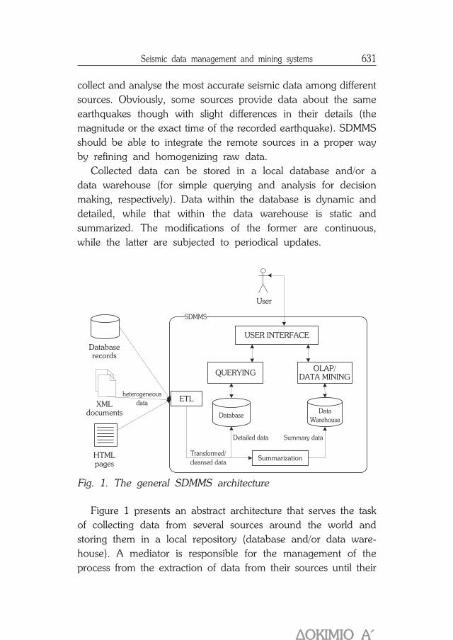
Collected data can be stored in a local database and/or adata warehouse (for simple querying and analysis for decisionmaking, respectively). Data within the database is dynamic anddetailed, while that within the data warehouse is static andsummarized. The modifications of the former are continuous,while the latter are subjected to periodical updates.
Fig. 1. The general SDMMS architecture
Figure 1 presents an abstract architecture that serves the taskof collecting data from several sources around the world andstoring them in a local repository (database and/or data ware-house). A mediator is responsible for the management of theprocess from the extraction of data from their sources until their
User
ETL
QUERYINGOLAP/
DATA MINING
USER INTERFACE
SDMMS
heterogeneous
data
Transformed/
cleansed data
Detailed data Summary data
Database
Summarization
Data
Warehouse
Databaserecords
XMLdocuments
HTMLpages
ÄÏÊÉÌÉÏ ÁÁ´

632 Gerasimos Marketos and Yannis Theodoridis
load into the local repository, the so-called Extract-Transform-Load (ETL) approach.
In the following paragraphs, we present efficient design pro-posals for the core components of SDMMS architecture, namelythe database and the data warehouse.
2.1 SSDMMS ddatabase
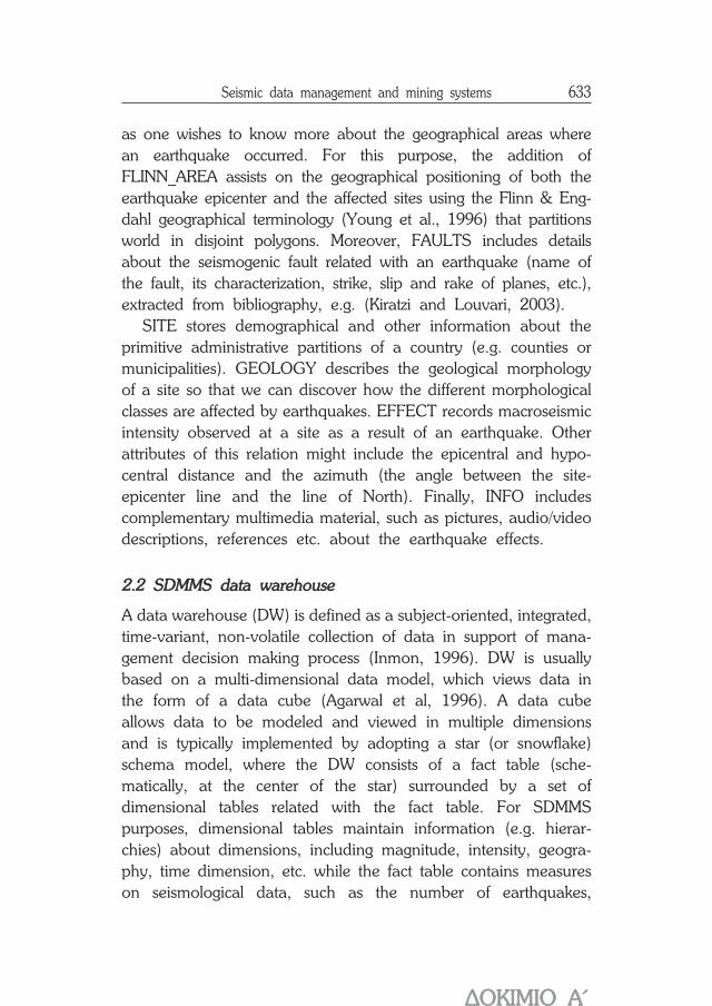
Remote sources provide SDMMS with a variety of seismologicalinformation to be stored in the local database. Figure 2 illustratesthe relational design of a local database for SDMMS purposes.
Fig. 2. Relational design of a seismological database forSDMMS purposes
The minimum information required to describe an earthquakeevent includes timestamp of its appearance, location (in latitude/ longitude coordinates) and depth (QUAKE). Just this informationis not adequate for user-friendly querying and further data analysis
belongs-to
occurs-in
affects is -affected-by
has
includes
FA ULT
QUAK E EFFECT
FLINN_ AREA
SITE
GEOLOGY
relates-with
IN FO
Seismic data management and mining systems 633
as one wishes to know more about the geographical areas wherean earthquake occurred. For this purpose, the addition ofFLINN_AREA assists on the geographical positioning of both theearthquake epicenter and the affected sites using the Flinn & Eng-dahl geographical terminology (Young et al., 1996) that partitionsworld in disjoint polygons. Moreover, FAULTS includes detailsabout the seismogenic fault related with an earthquake (name ofthe fault, its characterization, strike, slip and rake of planes, etc.),extracted from bibliography, e.g. (Kiratzi and Louvari, 2003).
SITE stores demographical and other information about theprimitive administrative partitions of a country (e.g. counties ormunicipalities). GEOLOGY describes the geological morphologyof a site so that we can discover how the different morphologicalclasses are affected by earthquakes. EFFECT records macroseismicintensity observed at a site as a result of an earthquake. Otherattributes of this relation might include the epicentral and hypo-central distance and the azimuth (the angle between the site-epicenter line and the line of North). Finally, INFO includescomplementary multimedia material, such as pictures, audio/videodescriptions, references etc. about the earthquake effects.
2.2 SSDMMS ddata wwarehouse
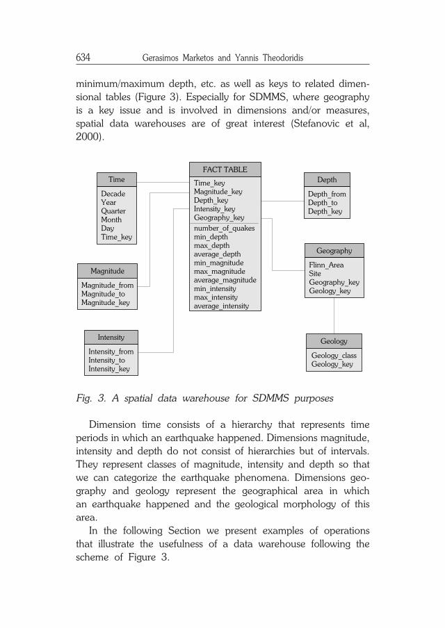
A data warehouse (DW) is defined as a subject-oriented, integrated,time-variant, non-volatile collection of data in support of mana-gement decision making process (Inmon, 1996). DW is usuallybased on a multi-dimensional data model, which views data inthe form of a data cube (Agarwal et al, 1996). A data cubeallows data to be modeled and viewed in multiple dimensionsand is typically implemented by adopting a star (or snowflake)schema model, where the DW consists of a fact table (sche-matically, at the center of the star) surrounded by a set ofdimensional tables related with the fact table. For SDMMSpurposes, dimensional tables maintain information (e.g. hierar-chies) about dimensions, including magnitude, intensity, geogra-phy, time dimension, etc. while the fact table contains measureson seismological data, such as the number of earthquakes,
ÄÏÊÉÌÉÏ ÁÁ´
634 Gerasimos Marketos and Yannis Theodoridis
minimum/maximum depth, etc. as well as keys to related dimen-sional tables (Figure 3). Especially for SDMMS, where geographyis a key issue and is involved in dimensions and/or measures,spatial data warehouses are of great interest (Stefanovic et al,2000).
Fig. 3. A spatial data warehouse for SDMMS purposes
Dimension time consists of a hierarchy that represents timeperiods in which an earthquake happened. Dimensions magnitude,intensity and depth do not consist of hierarchies but of intervals.They represent classes of magnitude, intensity and depth so thatwe can categorize the earthquake phenomena. Dimensions geo-graphy and geology represent the geographical area in whichan earthquake happened and the geological morphology of thisarea.
In the following Section we present examples of operationsthat illustrate the usefulness of a data warehouse following thescheme of Figure 3.
DepthTime_keyMagnitude_keyDepth_keyIntensity_keyGeography_key
DecadeYearQuarterMonthDayTime_key
number_of_quakesmin_depthmax_depthaverage_depthmin_magnitudemax_magnitudeaverage_magnitudemin_intensitymax_intensityaverage_intensity
FACT TABLE
Time
Magnitude_fromMagnitude_toMagnitude_key
Intensity_fromIntensity_toIntensity_key
Depth_fromDepth_toDepth_key
Geography
Flinn_AreaSiteGeography_keyGeology_key
Geology
Geology_classGeology_key
Magnitude
Intensity

Seismic data management and mining systems 635
33.. OOLLAAPP aannaallyyssiiss aanndd ddaattaa mmiinniinngg
Traditional Database Management Systems (DBMS) are knownas operational databases or OLTP (on-line transaction processing)systems as they support the daily needs of Information Systemsfor storage and retrieval. They support three main operations(insertions, updates and deletions) that can be formalized andexecuted against a DBMS using a Structured Query Language(SQL).
However, Information Systems are not responsible only fordata storage and retrieval but also for supporting decision making.As already mentioned, maintaining summary data in a local datawarehouse can be used for data analysis purposes. Two populartechniques for analyzing data and interpreting their meaning areOLAP analysis and data mining.
An important aspect in decision making is the level of detailsthat the decision maker needs. Middle and upper managementmake complex and important decisions and therefore detaileddata can not satisfy these requirements. Summarized data andhidden knowledge acquiring from the stored data, can lead tobetter decisions. Similarly, summarized seismological data aremore useful to scientists because they can study them from ahigher level and search them for hidden, previously unknownknowledge.
In the following paragraphs, we present OLAP analysis anddata mining techniques for extracting useful conclusions aboutseismological data stored in a SDMMS.
3.1 OOLAP aanalysis
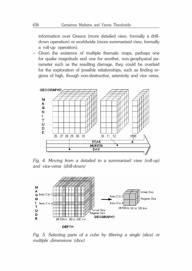
Additional to (naive or advanced) database queries on detailedseismological data, a data warehouse approach utilizes on-lineanalytical processing (OLAP). We illustrate the benefits obtainedby such an approach with two examples of operations supportedby spatial data warehouse and OLAP technologies:– A user may ask to view part of the historical seismic profile,
i.e. the ten most destructive quakes in the past twenty years,over Europe, and, moreover, he/she can easily view the same
ÄÏÊÉÌÉÏ ÁÁ´
636 Gerasimos Marketos and Yannis Theodoridis
information over Greece (more detailed view, formally a drill-down operation) or worldwide (more summarized view, formallya roll-up operation).
– Given the existence of multiple thematic maps, perhaps onefor quake magnitude and one for another, non-geophysical pa-rameter such as the resulting damage, they could be overlaidfor the exploration of possible relationships, such as finding re-gions of high, though non-destructive, seismicity and vice versa.
Fig. 4. Moving from a detailed to a summarized view (roll-up)and vice-versa (drill-down)
Fig. 5. Selecting parts of a cube by filtering a single (slice) ormultiple dimensions (dice).
Seismic data management and mining systems 637
Further to roll-up and drill-down operations described above,typical data cube operations include slice and dice, for selectingparts of a data cube by imposing conditions on a single ormultiple cube dimensions, respectively.
Another important issue in data warehousing is the physicalrepresentation of a data warehouse (cube). ROLAP (RelationalOLAP) and MOLAP (Multidimensional OLAP) are the twoproposed principal models. The advantage of ROLAP is that itcan handle large volumes of data (as relational databases cando) as these are stored in relational tables. On the other hand,MOLAP is much faster as it uses specialized data structuresinstead of relational tables. As a result, in MOLAP model, mainmemory is extensively used for the various operations.
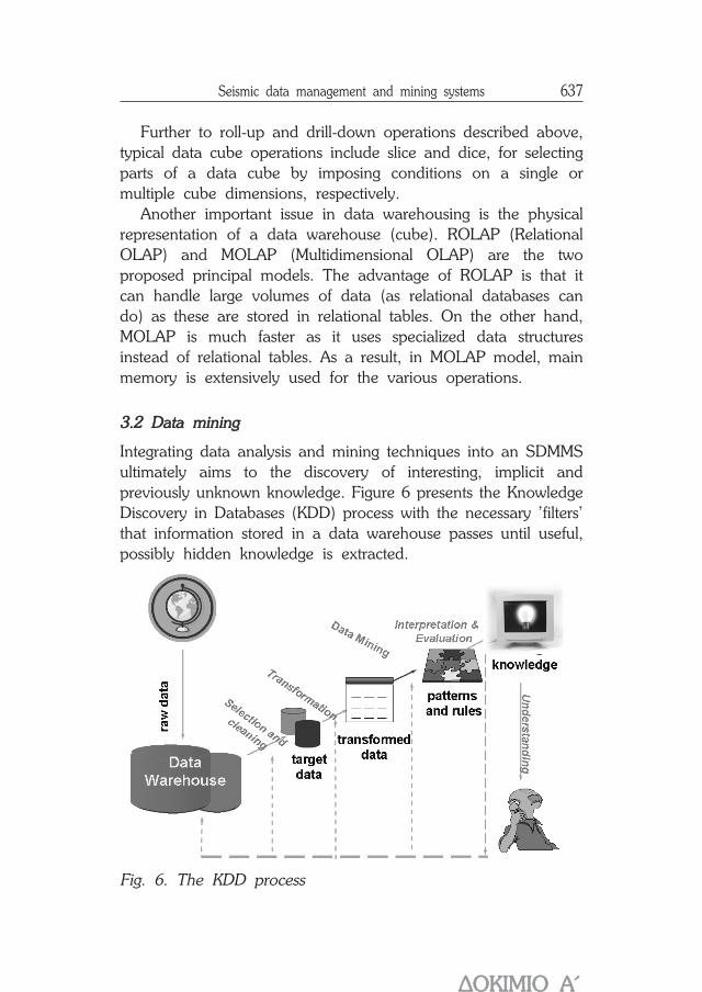
3.2 DData mmining
Integrating data analysis and mining techniques into an SDMMSultimately aims to the discovery of interesting, implicit andpreviously unknown knowledge. Figure 6 presents the KnowledgeDiscovery in Databases (KDD) process with the necessary 'filters'that information stored in a data warehouse passes until useful,possibly hidden knowledge is extracted.
Fig. 6. The KDD process
ÄÏÊÉÌÉÏ ÁÁ´

638 Gerasimos Marketos and Yannis Theodoridis
Examples of useful patterns found through KDD process includeclustering of information (e.g. shocks occurred closely in spaceand/or time), classification of phenomena with respect to areaand epicenter, detecting phenomena semantics by using patternfinding techniques (e.g. characterizing the main shock and possibleintensive aftershocks in shock sequences, measuring the similarityof shock sequences, according to a similarity measure specifiedby the domain expert, etc.).
In the following, we study the integration of three basictechniques for this purpose: methods for finding association rules,algorithms for data clustering and classification techniques.Recently, there have been proposals that expand the applicationof knowledge discovery methods on multi-dimensional data(Koperski and Han, 1995; Koperski et al, 1998).
Fig. 7. Discovering clusters of earthquake epicenters (extractedfrom (Theodoridis, 2003))
Seismic data management and mining systems 639
Clustering
Data clustering algorithms (Jain and Murty, 1999) group sets ofobjects into classes of similar objects. Thus, the behavior ofgroups can be studied instead of that of individuals. Applicationson seismic data could be for the purpose of finding denselypopulated regions (according to the Euclidean distance) betweenthe epicenters, and, hence, locating regions of high seismicfrequency or dividing the area of a country into a set of seismicityzones (e.g. low / medium / high seismic load).
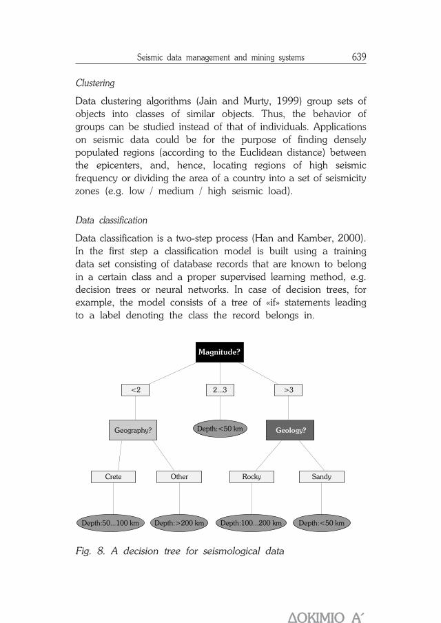
Data classification
Data classification is a two-step process (Han and Kamber, 2000).In the first step a classification model is built using a trainingdata set consisting of database records that are known to belongin a certain class and a proper supervised learning method, e.g.decision trees or neural networks. In case of decision trees, forexample, the model consists of a tree of «if» statements leadingto a label denoting the class the record belongs in.
Fig. 8. A decision tree for seismological data
Geography? Depth:<50 km
Depth:<50 kmDepth:>200 km Depth:100...200 kmDepth:50...100 km
Geology?
Crete Other Rocky Sandy
2...3 >3<2
Magnitude?
ÄÏÊÉÌÉÏ ÁÁ´
640 Gerasimos Marketos and Yannis Theodoridis
The decision tree illustrated in Figure 8 «predicts» the depthof a future earthquake given the magnitude and details aboutthe area in which it will happen. Obviously, it is not a kind ofearthquake prediction since it assumes that we know some detailsof the earthquake before it happens. However, the above treecould uncover some hidden relationships among the characteristicsof earthquakes.
44.. PPrroottoottyyppee ssyysstteemmss aanndd ttoooollss:: aa ssuurrvveeyy
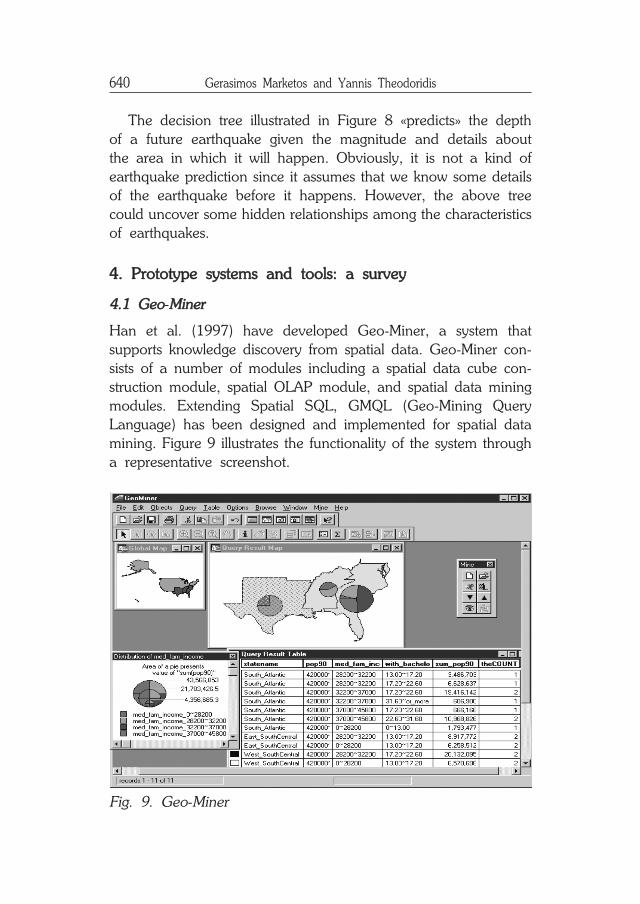
4.1 GGeo-MMiner
Han et al. (1997) have developed Geo-Miner, a system thatsupports knowledge discovery from spatial data. Geo-Miner con-sists of a number of modules including a spatial data cube con-struction module, spatial OLAP module, and spatial data miningmodules. Extending Spatial SQL, GMQL (Geo-Mining QueryLanguage) has been designed and implemented for spatial datamining. Figure 9 illustrates the functionality of the system througha representative screenshot.
Fig. 9. Geo-Miner
Seismic data management and mining systems 641
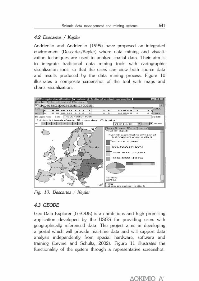
4.2 DDescartes // KKepler
Andrienko and Andrienko (1999) have proposed an integratedenvironment (Descartes/Kepler) where data mining and visuali-zation techniques are used to analyze spatial data. Their aim isto integrate traditional data mining tools with cartographicvisualization tools so that the users can view both source dataand results produced by the data mining process. Figure 10illustrates a composite screenshot of the tool with maps andcharts visualization.
Fig. 10. Descartes / Kepler
4.3 GGEODE
Geo-Data Explorer (GEODE) is an ambitious and high promisingapplication developed by the USGS for providing users withgeographically referenced data. The project aims in developinga portal which will provide real-time data and will support dataanalysis independently from special hardware, software andtraining (Levine and Schultz, 2002). Figure 11 illustrates thefunctionality of the system through a representative screenshot.
ÄÏÊÉÌÉÏ ÁÁ´

642 Gerasimos Marketos and Yannis Theodoridis
Fig. 11. GEODE functionality
4.4 SSeismo-SSurfer
Last but not least, Seismo-Surfer is a tool for collecting, querying,and mining seismological data following the SDMMS concept.Its database is automatically updated from remote sources,querying on different earthquake parameters is allowed, whiledata analysis for extracting useful information is limited to adata clustering algorithm. Querying and mining results aregraphically presented via maps and charts.
Seismo-Surfer architecture in general follows the SDMMS ar-chitecture illustrated in Figure 1. A number of filters «clean» andhomogenize the data (mainly concerning duplicate entries), whichare available from remote sources and cleansed data are storedin the local database. Users interact with the database via a gra-phical user interface (called, Query Manager). KDD techniquesapply data mining on stored data. Querying and data miningresults are presented in graphical mode (maps, charts, etc.).
In its current version, Seismo-Surfer supports links with tworemote sources: one at a national level for Greece (GI-NOA)and one worldwide (NEIC-USGS). Querying on earthquake para-meters includes variations of spatial queries, such as range,distance, nearest-neighbor and closest-pair queries (Figure 12).

Seismic data management and mining systems 643
Fig. 12. Querying facilities using Seismo-Surfer
55.. CCoonncclluussiioonnss
In this paper, we outlined the architecture of a so-called SeismicData Management and Mining System (SDMMS) for quick andeasy data collection, processing (generating historic profiles of spe-cific geographic areas and time periods, providing the associationof seismic data with other geophysical parameters of interest, etc.),and visualization supporting sophisticated user interaction.
The core components of such a SDMMS architecture includea seismological database (for querying) and a seismological datawarehouse (for OLAP analysis and data mining). We providedtemplate schemes for both components as well as examples oftheir functionality.
Finally, we provided a survey of existing operational orprototype systems following (at a low or high percentage) theproposed SDMMS functionality.
ÄÏÊÉÌÉÏ ÁÁ´
644 Gerasimos Marketos and Yannis Theodoridis
RReeffeerreenncceess
Agarwal, S., Agrawal, R., Deshpande, P., Gupta, A., Naughton, J.,Ramakrishnan, R., Sarawagi, S. (1996): On the computation ofmultidimensional aggregates. In Proceedings of the 22nd InternationalConference on Very Large Databases, VLDB'96, pp. 506-521, Bombay,India.
Andrienko, G., Andrienko Í. (1999): Knowledge-based visualization tosupport spatial data mining. In Proceedings of the 3rd Symposium onIntelligent Data Ánalysis, IDA'99, pp. 149-160, Amsterdam, theNetherlands.
Behnke, J., Dobinson, E. (2000): NASA Workshop on Issues in theApplication of Data Mining to Scientific Data, ACM SIGKDD ExplorationsNewsletter, 2(1), pp. 70-79.
GI-NOA: Earthquake Catalog. Available at http://www.gein.noa.gr/services/cat.html (accessed 26 January 2005).
Han, J., Kamber, M. (2000): Data Mining: Concepts and Techniques.Morgan Kaufmann.
Han, J., Koperski Ê., Stefanovic Í. (1997): GeoMiner: A System Proto-type for Spatial Data Mining. In Proceedings of ACM SIGMOD Interna-tional Conference on Management of Data, SIGMOD'97, pp. 553-556, Tucson, AZ, USA.
Inmon, W. (1996): Building the Data Warehouse, 2nd ed., John Wiley.
Jain, A., Murty, M., Flynn, P. (1999): Data Clustering: A Review.ACM Computing Surveys, 31(3), pp. 264-323.
Kiratzi, A., Louvari, E. (2003): Focal Mechanisms of Shallow Earthquakesin the Aegean Sea and the Surrounding Lands Determined by WaveformModeling: A New Database. Journal of Geodynamics, 36, pp. 251-274.
Koperski K., J. Han J. (1995): Discovery of Spatial Association Rulesin Geographic Information Databases. In Proceedings of the 4th Inter-national Symposium on Large in Spatial Databases, SSD'95, pp. 47-66, Portland, Maine, USA.
Koperski, K., Han, J., Adhikary, J. (1998): Mining Knowledge inGeographical Data. Communications of the ACM, 26(1), pp. 65-74.
Levine, M., Schultz, A. (2002): GEODE (Geo-Data Explorer) - A U.S.Geological Survey Application for Data Retrieval, Display, and Analysisthrough the Internet , U.S. Geological Survey, Fact Sheet 132-01,Online Version 1.0. Available at http://pubs.usgs.gov/fs/fs132-01/(accessed 26 January 2005).
Seismic data management and mining systems 645
NEIC-USGS: Earthquake Search. http://neic.usgs.gov/neis/epic/epic_global.html (accessed 26 January 2005).
Stefanovic, N., Han, J., Koperski, K. (2000): Object-Based SelectiveMaterialization for Efficient Implementation of Spatial Data Cubes. IEEETransactions on Knowledge and Data Engineering, 12(6), pp. 938-958.
Theodoridis, Y. (2003): Seismo-Surfer: A prototype for collecting,querying and mining seismic data. In Advances in Informatics - PostProceedings of the 8th Panellenic Conference in Informatics, pp. 159-171, LNCS #2563, Springer - Verlag, Berlin.
Young, J.B., Presgrave, B.W., Aichele, H., Wiens, D.A. Flinn, E.A.(1996): The Flinn-Engdahl Regionaligation Scheme: The 1995 Revision.Physics of the Earth and Planetary Interiors, 1996, pp. 223-297.
ÄÏÊÉÌÉÏ ÁÁ´

646 Gerasimos Marketos and Yannis Theodoridis