seismic reflection contribution to the study of the jerid...
TRANSCRIPT

1
Seismic Reflection Contribution to the Study of the Jerid Complexe
Terminal Aquifer (Tunisia)
Rihab Guellala1*, Mohamed Hédi Inoubli2, Lahmaidi Moumni3 and Taher Zouaghi1
1Laboratoire de Géoressources, CERTE, Pôle Technologique de Borj Cédria, 2Département des Sciences de la Terre, FST, Université Tunis El Manar,
3Arrondissement des Ressources en Eaux de Tozeur, Tunisia
1. Introduction
The North African Sahara is characterized by the immense aquifer system of the «Complexe Terminal» (Fig.1) covering 655.000 Km2
of the Algerian- Tunisian-Libyan domain (UNESCO,
1972c; OSS, 2003). The aquifer thickness is on average 340 m and its reserves are estimated of 11.000 109 m3 (Ould Baba Sy, 2005).
According to Kilan (1931) the term « Continental Terminal » concerns the sandy and clayey continental Formations dated Miocene-Pliocene. In 1966, Bel & Demargne highlighted a vertical communication between the aquifer contained in these Formations and the Eocene, Senonian and Turonian aquifers. Consequently, the Continetal Terminal is redefined as a multi-layered aquifer which extends from the Late Cretaceous to the Miocene –Pliocene. Frequently, this hydrogeological system is designated by the term «Complexe Terminal» proposed by Bel & Cuche in 1969.
The «Complexe Terminal» aquifer has been exploited since the XIX th century (Jus, 1890). The drilled wells provided much information about the aquifer. They encouraged the launching of various hydrogeological studies (Cornet, 1964 ; Ricolvi,1970; UNESCO, 1972a ; Mekrazi, 1975 ; Ben Salah & Lessi,1978 ; Levassor, 1978; Ben Baccar, 1982 ; Castany , 1982; PNUD, 1983 ; ARMINES & ENIT, 1984 ; Pizzi & Sartori, 1984 ; Besbès & Zammouri, 1985 ; Mamou, 1990; Zammouri, 1990 ; BRL, 1998; Swezey, 1999 ; Guendouz et al., 2003 ; OSS, 2003 ; Chalbaoui, 2005 ; Ould Baba Sy, 2005 ; Kamel et al., 2006; Guellala, 2010; Guellala et al., 2011).
The Jerid area (Fig.2), located in the Southwestern Tunisia is an arid region where the pluviometry doesn’t exceed 200 mm/year. The strong needs in water supply for domestic needs and irrigation render necessary the exploitation of the underground water reserves.
The «Complexe terminal» appears as a potential resource able to provide interesting flows. However, former geological and hydrogeological studies in this region were not sufficient to propose zones and strategies for the exploitation of this resource. Tectonic and sedimentary phenomena and their impact on the aquifer functioning had not been elucidated.
www.intechopen.com

New Achievements in Geoscience
2
Fig. 1. Extent of the Complexe Terminal aquifer (OSS, 2003, modified).
The aim of this study is therefore to precise the deposits structures in the Jerid area in view to guarantee a good knowledge of the «Complexe Terminal» geometry and an accurate estimation of the relations between the different hydrogeological units.
Usually, the aquifers prospection is the privileged application of the electrical method (Gasmi, 2002 ; Koussoubé et al., 2003; Zouhri et al., 2004; Gouasmia et al., 2006; Asfahani, 2007; Guellala et al., 2005; 2009a; 2009b; 2010; Tizro et al., 2010). In this study, the important depth of the «Complexe Terminal » aquifer (>500 m) incites the use of the seismic method associated to the deep wells data (Jaffal et al., 2002; Zouhri et al. ,2003 ;Larroque & Dupuy 2004; Sumanovac, 2006; Saidane et al., 2008 ; Guellala et al, 2008 ; 2011; Lachaal et al., 2011).
2. Geological context
Part of the Maghreb, Tunisia is characterized by two different geological domains: the
folded and faulted Atlas in the north and the stable saharan platform in the south
(Caire,1971; Aissaoui, 1984; Addoum, 1995; Jallouli & Mickus, 2000; Bouaziz et al., 2002;
Gabtni et al., 2005; Frizon de Lamotte, 2006 ; Missenard, 2006 ; Rigane & Gourmelen, 20011 ).
The Jerid area occupies an intermediate position between these domains. The anticlinal
structures of Draa Jerid and Sidi Bouhlel, situated between El Gharsa Chott and Jerid Chott
(Fig.2), constitute the western extent of the Chotts fold belt (Fakraoui, 1990; Zouaghi et al.,
2011), which corresponds to the most southern structures of the Atlassic domain
(Abdeljaoued,1983; Rabia ,1984 ; Zargouni, 1985; Abbes & Zargouni, 1986; Fakraoui, 1990;
Ben Ayed, 1993; Boukadi, 1994; Zouari, 1995; Bouaziz, 1995; Bédir, 1995; Hlaiem, 1999;
Zouaghi et al., 2005; Lazzez et al.,2008).
The «Complexe Terminal» Formations ranging from Late Cretaceous to Miocene –Pliocene
in age are largely outcropped in the Jerid area (Fig.3).They are characterized by different
facies indicating the combined action of continental and marine domains.
www.intechopen.com

Seismic Reflection Contribution to the Study of the Jerid Complexe Terminal Aquifer (Tunisia)
3
Fig. 2. Study area setting.
Fig. 3. Geological map of the Jerid area (Fakraoui & Mahjoub, 1995; Mahjoub, 1995; Regaya et al., 2001).
www.intechopen.com

New Achievements in Geoscience
4
The Late Cretaceous is represented by the lithostratigraphic Formations: Zebbag, Aleg and Berda.
The Zebbag Formation dated Late Albian –Cenomanian –Turonian is recognized from deep well data (Fig.3). It is subdivided in three members. The lower member (Late Albian –Cenomanian), thick on average 150 m, is constituted by dolomites and dolomitic limestones. The Middle member (Cenomanian) is composed of marls, clays, gypsums and thin dolomitic limestones beds. Its power exceeds 600 m in Mergueb and Tazrarit. It varies between 300 and 400 m in the other localities. The upper member (Turonian) is formed of fractured limestones and dolomitic limestones. This member with a thickness ranging from 130 to 300 m is an excellent stratigraphic marker. It corresponds to the «Gattar bar» described in the center and southern Tunisia (Burollet, 1956; Fournié, 1978; Boltenhagen, 1985; M’Rabet, 1987; Abdallah, 1987; Chaabani, 1995; Zouari et al., 1990; Negra, 1994; Ben Youssef, 1999).
The Aleg Formation attributed to the Lower Senonian is represented by clays and marls with limestone and gypsum intercalations. It reveals different thickness: 400 to 470 m in Mergueb, Hezoua and Nefta, 310 to 350 in Degache, Tazrarit and Tozeur and 220 to 280 m in Mahassen, Mzaraa and Hamma. The Aleg Formation constitutes the Sidi Bouhlel anticline core (Fakraoui, 1990).
The Berda Formation dated Late Senonian is marked by friable limestones intercalated by marly beds. It is thick of 120 to 380 m with remarkable thinning towards Sidi Bouhlel Jebel. Mahassen well and Degache well implanted on this structure are drilled on the Berda Formation outcrops (Fig.4).
Fig. 4. Geological cross-section at Sidi Bouhlel Jebel.
The Paleocene is made up of clays and marls. The Eocene is represented by limestones, phosphates and marls. The Paleocene –Eocene sedimentation is absent at Sidi Bouhlel Jebel. It is recognized in Hezoua, Mzaraa, Nefta, Mergueb and Tozeur and its thickness doesn’t reach 300 m.
The Paleocene –Eocene exposures characterize Metlaoui chain, northern border of the Jerid.
www.intechopen.com

Seismic Reflection Contribution to the Study of the Jerid Complexe Terminal Aquifer (Tunisia)
5
The Miocene –Pliocene largely outcropped in the Jerid area is characterized by continental sedimentation represented by Beglia Formation (Tayech-Mannai & Otera, 2005; Tayech-Mannai , 2006;2009; Swezy,2009) and Segui Formation .
The Beglia Formation (Miocene), thick on average 100 m, is made up of fine to coarse sands with thin clayey intercalations. At Sidi Bouhlel Jebel, this Formation is underlain by the Senonian deposits (Fig.4).
The Segui Formation (Miocene-Pliocene) is essentially clayey. It is enriched in sands and this thickness decreases towards the eastern part of the Jerid. Its power attains 500m in Mzaraa well implanted in the western part (Fig.3).
3. Hydrogeological context
On the basis of the preceding descriptions, the fractured limestones and dolomitic limestones of the Upper member of Zebbag Formation (Turonian), the friable limestones of Berda Formation (Upper Senonian) and the sands of Beglia Formation (Miocene) are the Jerid «Complexe Terminal» reservoirs (Fig.5).The clayey and marly deposits of the Lower and Middle members of Zebbag Formation, Aleg Formation, El Haria Formation and Segui Formation are aquicludes (Fig.5).
Fig. 5. Deep wells correlation.
The deep wells correlation (Fig.5) shows notable variation of the Complexe Terminal aquifer depth. It is characterized by raised and subsided zones (Fig.5). The Beglia Formation, the most superficial reservoir, is encountered at 570 m in Mzaraa well, at 100 m in Hezoua well and at 220 m in Mergueb well. It outcrops in many localities along Draa Jerid and Sidi Bouhlel structures. The Berda Formation reservoir is reached at 790 m in Mzaraa and about 350 m in Hezoua, Nefta and Tozeur. The Upper Zebbag Formation, the deepest reservoir, is encountered at 370 m in Mahassen and Degache. Its depth exceeds 1000 m in Hezoua, Mzaraa, Nefta and Mergueb.
www.intechopen.com
New Achievements in Geoscience
6
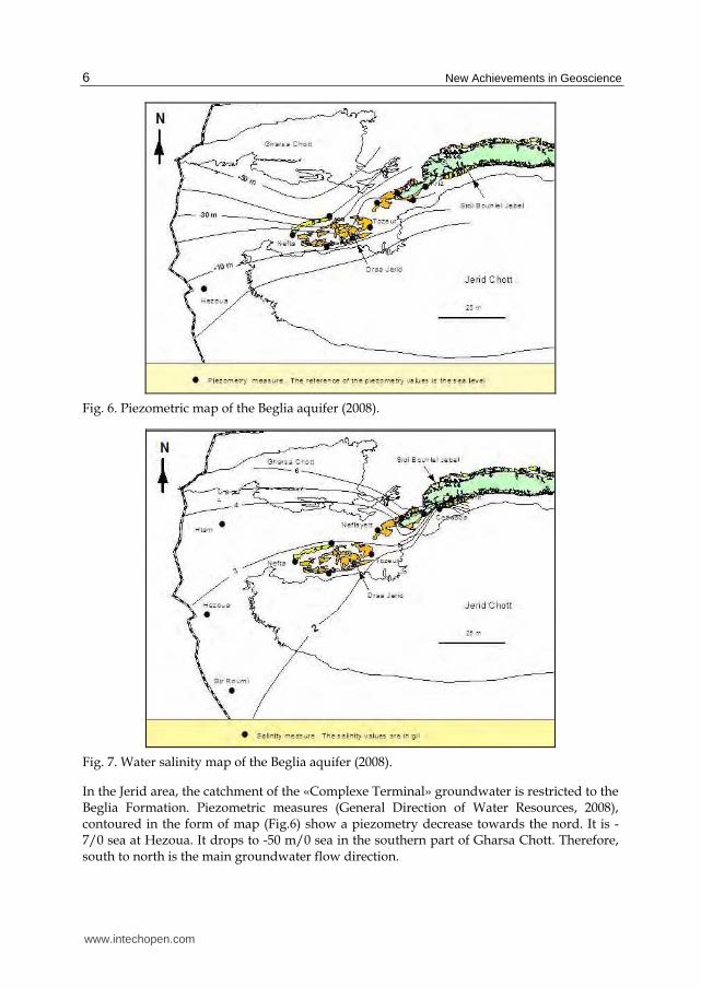
Fig. 6. Piezometric map of the Beglia aquifer (2008).
Fig. 7. Water salinity map of the Beglia aquifer (2008).
In the Jerid area, the catchment of the «Complexe Terminal» groundwater is restricted to the Beglia Formation. Piezometric measures (General Direction of Water Resources, 2008), contoured in the form of map (Fig.6) show a piezometry decrease towards the nord. It is -7/0 sea at Hezoua. It drops to -50 m/0 sea in the southern part of Gharsa Chott. Therefore, south to north is the main groundwater flow direction.
www.intechopen.com

Seismic Reflection Contribution to the Study of the Jerid Complexe Terminal Aquifer (Tunisia)
7
It is interesting to note the packed piezometric contours at the north flank of the Draa Jerid structure; the piezometry falls abruptly to -40 m/0 sea.
The water salinity measured for eleven groundwater samples collected from Beglia aquifer ranges from 2, 2 g/l to 5.9 g/l. The salinity map (Fig.7) reveals a clear increase of values from south to north which coincides with the groundwater flow direction. Additionally, this map exposes high values in the eastern part of the Jerid area, at Sidi Bouhlel Jebel: 3.7 g/l in Hamma well, 4.5 g/l in Kriz well and 5.9 g/l in Tazrarit well. Nearby, Ceddada well expresses a value of 2g/l. This sudden salinity change may indicate an obstructed lateral communication between the aquifers.
4. Data and methodology
The present study is based on seismic reflection sections associated to deep wells (Fig.8). These data are provided by the "General Direction of Water Resources" in Tunisia.
Fig. 8. Seismic profiles location.
www.intechopen.com

New Achievements in Geoscience
8
The seismic reflection (Lavergne, 1986) is a method of exploration geophysics which estimates the properties of the Earth's subsurface from reflected seismic waves (Cagniard , 1962 ; Telford et al., 1976). It requires a controlled seismic source of energy, such as seismic vibrator (Vibroseis) or dynamite explosion.
Seismic waves will be reflected when they encounter a boundary between two different materials with different acoustic impedances. They are detected using seismometers ; On land, the typical seismometer is the geophone. In water, hydrophone is used.
The recorded signals are plotted on a seismic section after significant amounts of processing (Gardner, 1985; Inoubli, 1993; Henry, 1997; Cox, 1999; Inoubli & Mechler, 1999; Robein, 1999; Mari et al., 2001; Upadhyay, 2004): demultiplexing, filtring, deconvolution, velocity analysis, stacking, migration…
A seismic section resembles a geological cross-section, but the vertical axis is in time, rather than depth. It still needs to be interpreted.
In this study, 31 seismic profiles (Fig.8) covering the Jerid area are interpreted .Realized by oil industry (Tab.1) during four seismic surveys using different parameters of acquisition and processing (Tab.1), these profiles show variable quality.
Survey MT MTB GSB MET
Date 1973 1974 1982 1989
Operator MOBIL MOBIL AGIP SCHELL
Seismic source Weight
dropping Dynamite Dynamite Vibroseis
Shot interval (m) 150 125 150 25
Distance between geophones (m) 150 125 75 25
Bandpass-filters (Hz) 3/8 -30/40 5/10 -32/428/12 - 50/57 7/10 - 40/46 6/8 - 32/37
8-75 8-45
Display for interpretation Stack Stack Stack Migrated
Table 1. Seismic reflection data.
The Miocene sands (Beglia Formation), the Upper Senonian (Berda Formation) and the Turonian (Upper Zebbag Formation) limestones which are the main reservoirs of the «Complexe Terminal» groundwater in the Jerid area constitute good seismic markers. The abrupt lithological change between these deposits and the clays and marly Formations originates a strong acoustic impedance contrast.
Seismic calibration (Fig.9) was performed using GNT-1 and to a lesser extent NF-1 petroleum wells. Seismic horizons and facies have been tied using the relation time-depth.
The different reflectors corresponding to the «Complexe Terminal » aquifers and aquicludes have been identified and picked on seismic profiles all over the area.
The interpolation between the interpreted seismic sections leads to the isochron maps construction. These maps display the tectonic structures which affect the « Jerid Complexe Terminal » aquifer. Their analysis specifies the reservoirs geometry.
www.intechopen.com

Seismic Reflection Contribution to the Study of the Jerid Complexe Terminal Aquifer (Tunisia)
9
The geoseismic cross sections, integrating wells data and seismic interpretation, clarify the
relations between the different hydrogeological units. They allow the comprehension of the
Jerid« Complexe Terminal» aquifer functioning.
Fig. 9. Seismic profile «K» calibrated with the «GNT-1» petroleum well.
5. Results and discussions
The isochron map (Fig.10) of the botton of the Beglia Formation (Miocene) reflects the main
deformations characterizing the «Complexe Terminal» multilayered aquifer in the Jerid
area. In the center, it reveals narrow anticlinals, overfolded towards the south (Fig.10). These
structures situated between 200 and 300 ms extend from Sidi Bouhlel Jebel in the east to
Hezoua region in the west. They allow the elongation of the Chotts fold belt, most southern
Atlassic structures, until the Tunisian-Algerian boundary.
Major reverse faults oriented E-W to NE-SW, mark the limit between anticlinal structures
and two large syncline basins highlighted along the northwestern border of Jerid Chott and
in the south of Gharsa Chott (Fig.11), where the depth of the Beglia aquifer bottom reach
respectively 800 and 600 ms.
The northern basin named «Jerid basin» widens and deepens towards the West (Fig.10). It is
limited by a raised structure (400 to 500 ms) characterizing the southern part of Gharsa
Chott. Towards the north, this structure evolves to a depression deep of 1600 ms.
Geodynamic studies (Ben Ayed , 1980 ;Ben Ayed & Viguier, 1981; Zargouni et al. ,1985; Fakraoui ,1990; Zouari, 1995; Bouaziz, 1995; Zitouni et al., 1997; Boutib & Zargouni,1998; Zouaghi et al., 2011) describe three main directions: NW – SE, E-W and NE-SW for the accidents which guided the formation of the Atlas folds attributed to the Tortonian compression. These accidents are reactivated in reverse faults during the post-Villafranchian compressive episode, responsible of the Chotts chain actual structure (Fakraoui, 1990).
In this study, the majority of tectonic accidents are exposed by N-S and NW-SE seismic
sections indicating the predominance of E-W and NE-SW directions.
www.intechopen.com

New Achievements in Geoscience
10
Fig. 10. Isochron map of the Beglia aquifer bottom.
Fig. 11. Seismic section «V» interpretation.
www.intechopen.com

Seismic Reflection Contribution to the Study of the Jerid Complexe Terminal Aquifer (Tunisia)
11
Therefore, the resulting structural map of the Jerid area (Fig.10) reveals that in addition to
the tectonic traits described on the geological map, exist in subsurface more important
structures which must be taken in consideration for the hydrogeological system
characterization.
The obtained results highlighted the tectonics influence on the« Complexe Terminal» aquifer
geometry; the Tortonian folding, the reverse faulting during the post-Villafranchian
compressive phase compartmentalized the aquifer in the form of tilted blocks.
The geosismic cross sections show the variability of this structure implication.
In Mzaraa-Hezoua sector, western part of the Jerid area , the tectonic deformations affecting
the «Complexe Terminal» series control the aquifers depth without influencing the
groundwater circulation. In fact, the geoseismic cross section corresponding to the profile E1
(Fig.12) reveals that the reservoirs formations in Hezoua anticlinal are in communication with
their equivalents in Jerid basin, at the north and in Chott Jerid, at the south. The Beglia
aquifer expresses similar chemical (chemical composition) and isotopic (14C, 2H, 18O tenor)
characteristics in Hezoua and Mzaraa regions (Kamel et al., 2005) reflecting this lateral
communication.
The geoseismic cross section corresponding to the profile V (Fig.13) describes the relations
between the different hydrogeological units in Tozeur –Mergueb sector, central part of the
Jerid area. It is controlled by Tozeur and Mergueb deep wells and Neflayett and Jhim wells
which exploit the Beglia aquifer.
The geoseismic cross section shows an important variation of the aquifers depth between
the exposed geological structures. In Draa Jerid anticlinal, the Beglia Formation outcrops
Fig. 12. Geoseismic cross section corresponding to the profile E1.
www.intechopen.com

New Achievements in Geoscience
12
Fig. 13. Geoseismic cross section corresponding to the profile V.
Fig. 14. Geoseismic cross section corresponding to the profiles L and L‘.
www.intechopen.com

Seismic Reflection Contribution to the Study of the Jerid Complexe Terminal Aquifer (Tunisia)
13
The Berda Formation is encountered at 300 m and the Upper Zebbag Formation is recognized at 845 m. In Jerid basin, these reservoirs are respectively reached at 220 m, 460 m and 1180 m.
Additionnaly, this cross section reveals an obstructed communication between the aquifers Formations. In Draa Jerid anticlinal, the Beglia sandy reservoir is isolated. It is wedged between the Segui clays of the Jerid basin and those deposed in the northern edge of the Jerid Chott.
In the same structure (Draa Jerid), the fractured limestones of Berda aquifer are in contact with their equivalents of the Jerid basin and with the Beglia aquifer situated in the Jerid Chott. The Upper Zebbag aquifer collides with the clays and marls of Aleg Formation in the north and in the south.
In the Eastern part of Jerid area, the seismic profiles L and L’ interpretation and the data of Tazrarit and Ceddada wells allow the « Complexe Terminal» aquifer characterization. The established geoseismic cross section (Fig.14) provides informations about the geometry of the aquifer and the groundwater flow.
At Sidi Bouhlel Jebel, the Beglia reservoir exists only in the southern flank , where it outcrops. At the northern edge of Jerid Chott, this reservoir is attained at 600 m. In the basin separating Sidi Bouhlel and Gantass anticlinals, the Beglia Formation depth and thickness decrease towards the south.
Equally, in this sector, the tectonic deformations affecting the «Complexe Terminal» series influence the groundwater circulation, the Beglia aquifer of Sidi Bouhlel anticlinal is opposite the Segui clays deposed in the synclinal basin at the south. This obstructed hydraulic communication between the folded structures explains the significant difference between the salinity of Beglia aquifer at Ceddada well: 2g/l and Tazrarit well: 5.9 g/l (Fig.7).
The Berda aquifer is exposed at Sidi Bouhlel Jebel. In the north it is in contact with its equivalent which shows an important thickness. In the south it is against the clayey Segui Formation.
A vertical communication between Beglia and Berda aquifers is noticed at the northern edge of Jerid Chott and at Sidi Bouhlel anticlinal. At Gantass-Sidi Bouhlel basin, they are separated by the Eocene-Paleocene deposits, pinched out nearby Sidi Bouhlel Jebel.
At Sidi Bouhlel anticlinal are located the most raised Upper Zebbag aquifer of the Jerid area (300 m). This aquifer is blocked between the clays and marls of Aleg Formation.
6. Conclusion
This study based on seismic reflection sections and wells data display the tectonic deformations which affect the multilayered «Complexe Terminal» aquifer in the Jerid area (Fig.15).
The Tortonian folding, the reverse faulting during the post-Villafranchian compressive phase compartmentalized the aquifer in raised and subsided blocks. The geoseismic cross sections reveal that this structure has variable implications; except Hezoua –Mzaraa sector where the reservoirs are in communication, it influences the depth of permeable formations and the circulation of groundwater
www.intechopen.com

New Achievements in Geoscience
14
These results should be useful for choosing the best sites for the «Complexe Terminal» aquifer exploitation in the Jerid area.
Additionally, the present study shows the interest of the seismic reflection method for the hydrogeological systems comprehension when the well data are limited for a precise characterization. Such prospection appeared particularly suitable in this study in view of the great depth of the aquifer and the importance of the tectonic structures which are not easily detectable by the simple well correlations.
Fig. 15. Geometry of the Jerid «Complexe Terminal» aquifer and communication between compartments.
7. References
Abdallah, H. (1987). Le Crétacé supérieur de la chaine nord des Chotts (Sud tunisien). Biostratigraphie, Sédimentation, Diagenèse. Thèse Doct., Univ. Bourgogne, 255p.
Abdeljaoued, S. (1983). Etude sédimentologique et structurale de la partie orientale de la chaine Nord des Chotts. Thèse Doct., Univ. Tunis II, 184p.
Addoum, B. (1995). L’Atlas saharien sud-oriental : cinématique des plis- chevauchements et reconstruction du bassin du sud-est constantinois confins algéro-tunsiens). Thèse Doct., Univ Paris Sud. Orsay. France, 200 p.
Aissaoui, D. (1984). Les structures liées à l’accident Sud-atlasique entre Biskra et Jebel Manndra, Algérie, évolution géométrique et cinématique. Thèse Doct., Univ. Louis Pasteur, 205p.
Asfahani, J. (2007). Geoelectrical investigation for characterizing the hydrogeological conditions in semi-arid region in Khanasser valley, Syria. Journal of Arid Environments, 68, pp31-52.
ARMINES & ENIT (1984). Modèle mathématique du Complexe Terminal Nefzaoua –Djerid. Ministère Agriculture Tunis. 87p. Tunisie.
www.intechopen.com

Seismic Reflection Contribution to the Study of the Jerid Complexe Terminal Aquifer (Tunisia)
15
Bédir, M. (1995). Mécanismes géodynamiques des bassins associés aux couloirs de coulissements de la marge atlasique de la Tunisie. Seismo-stratigraphie, seismotectonique et implications pétrolières. Thèse Doct. es Sciences, Univ. Tunis II, 412 p. Tunisie
Bel, F. & Demargne , F . (1966) .Etude géologique du Continental Terminal .DEC, ANRH, Alger, 22p. Algérie.
Bel, F. & Cuche, D. (1969). Mise au point des connaissances sur la nappe du Complexe Terminal. Projet ERESS ; Ouargla, 20p. Algérie.
Ben Ayed, N. (1980). Le rôle des décrochements E-W dans l’évolution structurale de l’Atlas tunisien. . C.R. Acad. Sci, pp.29-32. France.
Ben Ayed, N. & Viguier, C. (1981). Interprétation structurale de la Tunisie atlasique. C.R. Acad. Sci, pp 1445-1448.France.
Ben Ayed, N. (1993). Evolution tectonique de l’avant-pays de la chaine alpine de Tunisie du début du Mésozoïque à l’Actuel. Annales des Mines et de la Géologie de Tunisie, n°32. 286 p. Tunisie.
Ben Baccar, B. (1982). Contribution à l’étude hydrogéologique de l’ aquifère multicouche de Gabès Sud. Thèse Doct., Univ. Paris-Sud, 243p.
Ben Youssef, M. (1999). Stratigraphie génétique du Crétacé de Tunisie : micropaléontologie, stratigraphie séquentielle et géodynamique des bassins de la marge Sud et péritéthysienne. Thèse Doct. es-Sciences, Univ. Tunis II, 402 p. Tunisie.
Ben Salah, DH. & Lessi, J. (1978). Construction d’un modèle multicouche de la nappe de la Nefzaoua du Complexe Terminal. Description et résultats des simulations. Rapport inédit. Direction Générale des Ressources en Eau. Tunisie.
Besbès, M. & Zammouri, M. (1985). Modèle mathématique du Complexe Terminal. Nefzaoua-Djérid. Note sur les conclusions du rapport ARMINES-ENIT. Rapport inédit. Direction Générale des Ressources en Eau. Tunisie.
Boltenhagen C. (1985). Les séquences de sédimentation du Crétacé moyen en Tunisie centrale. Actes du 1er Cong. Nat. Sci. Terre. Tunis, Sepembre , 1985
Bouaziz, S. (1995). Etude de la tectonique cassante dans la plate-forme et l’Atlas Sahariens (Tunisie méridionale): Evolution des paléochamps de contraintes et implications géodynamiques. Thèse Doct. es-Sciences, Univ. Tunis II, Tunisie, 484 p. Tunisie.
Bouaziz, S. ;Barrier, E. ; Soussi, M. ; Turki, M.M. ; Zouari, H. (2002). Tectonic evolution of the northern African margin in Tunisia from paleostress data and sedimentary record. Tectonophysics, 375, pp. 227-253.
Boukadi, N. (1994). Structuration de l’Atlas de Tunisie : signification géométrique et cinématique des noeuds et des zones d’interférences structurales au contact de grands couloirs tectoniques. Thèse Doct. es-Sciences, Univ. Tunis II, 249 p.
Boutib, L. & Zargouni, F. (1998). Disposition et géométrie des plis de l’Atlas centro-méridional de Tunisie. Découpage et cisaillement en lanières tectoniques. C. R. Acad. Sci., 326, pp. 261-265.
BRL ingénierie (1998) Etude du Plan directeur général de développement des régions sahariennes– Modélisation du Complexe Terminal. Rapport, ANRH, Alger, Algérie.
Burollet, P. F. (1956). Contribution à l’étude stratigraphique de la Tunisie centrale. Annales des Mines et de la Géologie de Tunisie 18, 350 p.
Caire, A. (1971). Chaînes alpines de la Méditerranée centrale (Algérie et Tunisie septentrionale, Sicile, Calabre et Apennin méridional). Unesco, Tectonique de l’Afrique, Science de la Terre 6, pp. 61-90.
www.intechopen.com

New Achievements in Geoscience
16
Cagniard, L. (1962). Reflection and Refraction of progressive seismic waves. McGraw.Hill (New York). PUB.ID 101-196-361.
Castany, G. (1982) . Bassin sédimentaire du Sahara septentrional (Algérie-Tunisie). Aquifers du Continental Intercalaire et du Complexe Terminal. Bull. BRGM, Paris, 3, pp 127-147
Chaabani, F. (1995). Dynamique de la partie orientale du bassin de Gafsa au Crétacé et au Paléocène. Etude minéralogique et géochimique de la série phosphatée éocène, Tunisie méridionale. Thèse Doct. es-Sciences, Univ. Tunis II, 428p.
Chalbaoui, M. (2005). Première approche pour l’étude des bassins hydrogéologiques profonds du Sud-Ouest tunisien. C. R. Acad. Sci., 337, pp. 1484-1491
Coque, Ft. (1962). La Tunisie Presaharienne. Armand Colin, Paris, 476p. Cornet, A. (1964). Introduction à l'hydrogéologie saharienne. Rev. Géog. Phys. et Géol. Dyn. ,
pp. 5-72. Cox, M. (1999). Static corrections for seismic reflection surveys. Society of Exploration
Geophysicists. Digital Library. USA Fakraoui, M. (1990). Etude stratigraphique et structurale des chaînes des Chotts (Tunisie
méridionale) évolution géométrique et cinématique liée l’accident sud-atlasique. Thèse Doct., Univ. Tunis II, 243p.
Fakraoui, M. & Mahjoub, K. (1995). Notice de la carte géologique de la Tunisie 1/ 100.000. Feuille de Hamma Jérid. Serv. Géol., Tunisie.
Fournié, D. (1978). Nomenclature lithostratigraphique des séries du Crétacé supérieur au Tertiaire en Tunisie. Bull. Cent. Rech. Exploration-production, Elf-Aquitaine, Pau, 2, pp.97-148.
Frizon de Lamotte, D.; Michard, A. & Saddiqi, O. (2006). Quelques développements récents sur la géodynamique du Maghreb. C. R. Geoscience, Vol.336, pp.1-10.
Gabtni, H. ; Jallouli, C.; Mickus, K. & Zouari, H. (2005). Geophysical constraints on the location and nature of the North saharan flexure in southern Tunisia. Pure andApplied Geophysics. 162, pp. 2051-2069.
Gardner, G.H.F. (1985). Migration of seismic data. Society of Exploration Geophysicists. USA. Gasmi, M. (2002). Apports de la géophysique à la reconnaissance et la gestion des ressources
naturelles. Application en Tunisie. Thèse Doct. es-Sciences, Univ. Tunis II, 471p. General Direction of Water Resources. (2008). Annuaire piézométrique des nappes
profondes de la Tunisie ,2008. Gouasmia, M.; Gasmi, M.; Mhamdi , A. ; Bouri, S. & Ben Dhia, H. (2006). Prospection
géoélectrique pour l’étude de l’aquifère thermal des calcaires récifaux Hmeima-Boujaber (Centre-Ouest de la Tunisie). C.R. Acad. Sci . pp 1219-1227.
Guellala, R.; Inoubli, M. H.; Alouani, R.; Manaa, M. & Amri, F. (2005). Caractérisation des réservoirs aquifères de la Haute Vallée de la Mejerda (Tunisie). Jour. Afric. Geosci. Rev. 12,pp. 189–202.
Guellala, R.; Ben Marzoug, H.; Inoubli, M.H. & Moumni, L. (2008). Identification des structures profondes en Djérid (Tunisie) par sismique réflexion. Implications hydrogéologiques. 22nd Colloquium of African Geology, Hammamet, Tunisia, Novembre,2008
Guellala, R.; Inoubli, M. H. & Amri, F. (2009a). Nouveaux éléments sur la structure de l’aquifère superficiel de Ghardimaou (Tunisie): contribution de la géophysique électrique. Hydrol. Sci. J., 54, pp. 974-983.
www.intechopen.com

Seismic Reflection Contribution to the Study of the Jerid Complexe Terminal Aquifer (Tunisia)
17
Guellala, R. ; Inoubli, M.H. & Amri, F. (2009b). Apport de la méthode électrique à l’étude hydrogéologique de la plaine de Bousalem (Nord-Ouest de la Tunisie). Quatrième Congrès Maghrébin de Géophysique Appliquée. Hammamet, Tunisia, Mars,2009.
Guellala, R. (2010). Etude géologique et hydrogéologique des séries crétacées inférieures du Jérid (Sud-Ouest de la Tunisie). Apports des méthodes géophysiques. Thèse Doct., Univ. Tunis II, 165p
Guellala, R. ; Inoubli, M.H. & Amri, F. (2010). Hydrogeological study of Oued Bouhertma zone. Geoelectrical prospecting contribution. Proceeding of Tunisia-Japan Symposium. Regional Developement and water Resource. Tunis: November 28 to December 1st, 2010.
Guellala, R.; Ben Marzoug, H.; Inoubli, M.H. & Moumni, L. (2011). Apports de la Sismique Réflexion à l’étude de l’aquifère du Continental Intercalaire du Jérid (Tunisie). Hydrol. Sci. J.,5, pp. 1040-1052.
Guendouz, A.; Moullaa, S.; Edmunds, W.M. ; Zouari, K.; Shands, P. & Mamou, A. (2003). Hydrogeochemical and isotopic evolution of water in the complex terminal aquifer in Algerian Sahara. Hydogeology Journal , 11,pp. 483-495.
Henry, G. (1997). La sismique réflexion, principes et développements ISBN: 2710807254. TECHNIP, France.
Hlaiem, A. (1999). Halokinesis and structural evolution of the major features in eastern and southern Tunisian Atlas. Tectonophysics. pp 79-95.
Inoubli, M.H. (1993) Conception d’une méthodologie d’interprétation en géophysique : Apport du traitement et de l’inversion de données sismiques réelles. Thèse es Sci. Univ. Tunis II, 328 p.
Inoubli, M.H & Mechler P. (1999) Expression géologique et apport du champ de vitesse de sommation dans l'amélioration de la résolution sismique. Notes Serv. Géol. Tunisie. 54p
Jaffal, M.; Kchikach, A.; Lefort, J.P. & Hanich, L. (2002). Contribution à l’étude d’une partie du bassin d’Essaouira (Maroc) par sismique réflexion. C.R. Acad. Sci . pp 229-234.
Jallouli, C. & Mickus, K. (2000). Regional gravity analysis of the crustal structure of Tunisia. Journal of African Earth Sciences 30, pp. 63-78.
Jus, H. (1890). Résumé graphique des sondages exécutés dans la province de Constantine de 1er Juin 1856 au 1er Janvier 1890. Rapport. Constantine. Algérie
Kamel, S.; Dassi, L.; Zouari , K. & Abidi B. (2005). Geochemical and isotopic investigation of the aquifer system in the Djérid-Nefzaoua basin, southern Tunisia, Env. Geol.,49, pp. 159-170
Kamel, S. ; Dassi, L. & Zouari , K (2006). Approche hydrogéologique et hydrochimique des échanges hydrodynamiques entre aquifères profond et superficiel du bassin du Djérid, Tunisie, Hydrol. Sci. J., 51, pp. 713-730.
Kilan, C. (1931). Les principaux complexes continentaux du Sahara. C.R. Somm. Soc. Géol.Fr., pp109-111.
Koussoubé, Y. ; Nakolendoussé, S. ; Bazié, P. ; Savadogo, A.N. (2003). Typologie des courbes des sondages électriques verticaux pour la reconnaissance des formations superficielles et leur incidence en hydrogéologie de socle cristallin du Burkina. Sud Sciences et Technologies. , 10, pp. 26-32.
Lachaal, F.; Bedir, M.; Tarhouni,J.; Gacha, A.B.; Leduc, C. (2011). Characterizing a complex aquifer system using geophysics, hydrodynamics and geochemistry: a new distribution of Miocene aquifers in the Zeramdine and Mahdia-Jebeniana blocks (east-central Tunisia). Journal of African Earth Sciences, 60, pp. 222-236
www.intechopen.com

New Achievements in Geoscience
18
Larroque, F. & Dupuy, A. (2004). Apports de la méthode sismique réflexion haute résolution à l'identification des structures profondes des formations tertiaires en Médoc (Gironde, France): implications hydrogéologiques. C.R. Acad. Sci. pp 1111-1120.
Lavergne, M. (1986). Méthodes sismiques. Editions TECHNIP et l’Institut Francais de Petrole. ISBN 2.7108.0514.6.
Lazzez, M.; Zouaghi, T. & Ben Youssef, M. (2008) . Austrian phase on the northern African margin inferred from sequence stratigraphy and sedimentary records in southern Tunisia (Chotts and Djeffara areas). C.R. Acad. Sci. 340, pp. 543-552.
Levassor, A. (1978). Simulation et gestion des systèmes aquifères. Application aux nappes du « Complexe Terminal du bas-Sahara algérien. Thèse Doct., Univ. Paris.
Mahjoub, K. (1995). Notice de la carte géologique de la Tunisie 1/ 100.000. Feuille de Tozeur. Serv. Géol., Tunisie.
Mamou, A. (1990). Caractéristiques, Evolutions et Gestion des Ressources en Eau du Sud tunisien. Thèse Doct. es-Sciences, Univ. Paris Sud, 426p
Mannai-Tayech, B. & Otera, O. (2005). Un nouveau gisement miocène à ichthyofaune au Sud de la chaine des Chotts (Tunisie méridionale). C.R. Palevol. 4 pp.405-412.
Mannai-Tayech, B. (2006). Les series silicoclastiques miocènes du Nord-Est au Sud-Ouest de la Tunisie: une mise au point. Geobios 39, pp. 71-84.
Mannai-Tayech, B. (2009). The lithostratigraphy of Miocene series from Tunisia, revisited. Journal of African Earth Sciences 54, pp. 53-61.
Mekrazi, A. (1975). Contribution à l’étude géologique et hydrogéologique de la région de Gabès Nord. Thèse Doct., Univ. Bordeaux I.
Mari, J.L. ; Glangeaud, F. C.; Coppens, F. (2001). Traitement du signal pour géologues et géophysiciens : Techniques de base. Volume 2. Publications de l’Institut Francais de Pétrole. ISBN. 2710807858.France.
Missenard, Y. (2006). Le relief des Atlas marocains : contribution des processus asthénosphériques et du raccourcissement crustal, aspects chronologiques. Thèse Doct., Univ. Cergy Pontoise, France. 236p.
M’Rabet, A. (1987). Stratigraphie, sédimentation et diagenèse carbonatée des séries du Crétacé inférieur de Tunisie centrale. Annales des Mines et de la Géologie de Tunisie 30, 412 p.
Negra, M. E. H. (1994). Les dépôts de plate-forme à bassin du Crétacé supérieur en Tunisie centro-septentrionale (Formation Abiod et faciès associés), stratigraphie, sédimentation, diagenèse et intérêt pétrolier. Thèse Doct. es-Sciences, Univ. Tunis II, 649 p.
OSS. (2003). Système Aquifère du Sahara Septentrional. Volume 2 : Hydrogéologie. Projet SASS. Rapport interne. Direction Génerale des Ressources en Eau , Tunis. 275p. Tunisie
Ould Baba Sy, M. (2005). Recharge et paleorecharge du système aquifère du Sahara Septentrional. Thèse Doct., Univ. Tunis II, 261p
Pizzi, G. & Sartori, L. (1984). Interconnected groundwater systems simulation (IGROSS) –Description of the system and a case history application. J. Hydrol., 75, pp 255-285.
PNUD. (1983). Actualisation de l’Etude des Ressources en Eau du Sahara Septentrional. Projet RAB/80/011 Rapport final. Rapport interne. Direction Génerale des Ressources en Eau , Tunis. 490p. Tunisie
Rabia, M.C. (1984). Etude géologique de la region des Chotts (Sud tunisien) par Télédetection spatial, détection de la radioactivité naturelle et analyse hydrogéochimique. Thèse Doct., Univ. Bordeaux I, 196p
www.intechopen.com

Seismic Reflection Contribution to the Study of the Jerid Complexe Terminal Aquifer (Tunisia)
19
Regaya, K.; Ben Mamou, A.; Ben Youssef, M. & Ghanmi, M. (2001). Notice de la carte géologique de la Tunisie 1/ 100.000. Feuille de Metlaoui. Serv. Géol., Tunisie.
Rigane, A.& Gourmelen, C. (2011). Tunisian transtensive basins in tethyan geodynamic context and their post-Tortonian inversion New Frontiers in Tectonic Research - At the Midst of Plate Convergence. ISBN: 978-953-307-594-5. Intech Vienna, Austria.
Ricolvi, M. (1970). Programme d’exploitation et de surveillance de la nappe de Complexe Terminal dans la région du Djérid. Rapport interne. Direction Génerale des Ressources en Eau , Tunis. 21p. Tunisie
Robein, E. (1999). Vitesse et techniques d’imagerie en sismique réflexion : principes et méthodes. Doc. Lavoisier. France.
Saidane, H.; Bédir,M.& Zargouni, F. (2008). Le Néogène continental du bassin de Gafsa (Tunisie): Sismo-stratigraphie, structuration et potentialités aquifers. . Jour. Afric. Geosci. Rev. 15,pp. 51–68.
Sumanovac, F. (2006). Mapping of thin sandy aquifers by using high resolution reflection seismics and 2-D electrical tomography. Journal of Applied Geophysics, 58, pp.144- 157
Swezey, C. (1999). The lifespan of the Complexe Terminal Aquifer. Algerian-Tunisian Sahara. Journal of African Earth Sciences, 3, pp. 751-756
Swezey, C. (2009). Cenozoic stratigraphy of the sahara , northern Africa. Journal of African Earth Sciences 53, pp. 89-121.
Telford, W. M.; Gedrart, L.P.; Sherriff, R.E. & Key, D.A. (1976) Prospection géophysique – Tome 1: Prospection sismique. Cambridge Univ.
Tizro, A.T.; Voudouris, K.; Salehzade,M.; Mashayekhi, H. (2010) Hydrogeological framework and estimation of aquifer hydraulic parameters using geoelectrical data: a case study from West Iran. Hydrogeology Journal ,18, pp. 917–929
UNESCO. (1972a). ERESS: Etude des ressources en eau du Sahara septentrional. Rapport final . Rapport interne. Direction Génerale des Ressources en Eau , Tunis. 78p. Tunisie
UNESCO. (1972c). ERESS: Etude des ressources en eau du Sahara septentrional. Nappe du Complexe Terminal. Rapport interne. Direction Génerale des Ressources en Eau , Tunis. 59p. Tunisie
Upadhyay, S.K. (2004). Seismic reflection processing : with special reference to anisotropy. Springer. Amazon France.
Zammouri, M. (1990). Contribution à une révision des modèles hydrogéologiques du Sud tunisien. Thèse Doct., Univ. Tunis II, 90p.
Zargouni, F. (1985) Tectonique de l’Atlas méridional de Tunisie, évolution géométrique et cinématique des structures en zone de cisaillement. Thèse Doct. es-Sciences, Univ. Louis Pasteur Strasbourg, 292 p.
Zargouni, F.; Rabia, M. CH. & Abbès, CH. (1985) Rôle des couloirs de cisaillement de Gafsa et de Négrine –Tozeur dans la structuration du faisceau des plis des Chotts, éléments de l’accident Sud –Atlasique. C.R. Acad. Sci., 301, 831-834.
Zitouni, L. ; Bédir, M. ; Boukadi, N. ; Ibouh, H. ; Tlig, S. & Bobier, C. (1997). Géométrie, chronologie et cinématique des accidents N 120-140. Exemple: accident de Majoura-Mech (données de surface et de subsurface). Jour. Afric. Geosci. Rev. 15, pp. 373-380.
Zouaghi, T.; Bédir, M. & Inoubli, M. H. (2005). 2D Seismic interpretation of strike-slip faulting, salt tectonics, and Cretaceous unconformities, Atlas Mountains, central Tunisia. Journal of African Earth Sciences 43, pp. 464-486.
www.intechopen.com

New Achievements in Geoscience
20
Zouaghi, T.; Guellala, R.; Lazzez, M.; Bédir, M.; Ben Youssef, M.; Inoubli, M.H. & Zargouni, F. (2011). The Chotts Fold Belt of Southern Tunisia, North African Margin: Structural Pattern, Evolution, and Regional Geodynamic Implications. New Frontiers in Tectonic Research - At the Midst of Plate Convergence. ISBN: 978-953-307-594-5. Intech Vienna, Austria.
Zouari, H. ; Turki, M. M. & Delteil J. (1990). Nouvelles données sur l’évolution tectonique de la chaîne de Gafsa. Bulletin de la Société Géologique de France 8, pp. 621-628.
Zouari, H. (1995). Evolution géodynamique de l’Atlas centro-méridional de la Tunisie. Stratigraphie, analyses géométrique, cinématique et tectono-sédimentaire. Thèse Doct. es-Sciences, Univ. Tunis II, 278 p.
Zouhri, L.; Gorini, C.; Lamouroux, C.; Vachard, D.& Dakki M. (2003). Interprétation hydrogéologique de l’aquifère des bassins Sud-rifains (Maroc): apport de la sismique réflexion. C.R. Acad. Sci . pp 319-326.
Zouhri, L.; Gorini, C.; Mania, J; Deffontaines, B. & Zerouali, A. (2004). Spatial distribution of resistivity in the hydrogeological systems, and identification of the catchment area in the Rharb basin, Morocco: Hydrological Science Journal, 49, 387–398.
www.intechopen.com

New Achievements in GeoscienceEdited by Dr. Hwee-San Lim
ISBN 978-953-51-0263-2Hard cover, 212 pagesPublisher InTechPublished online 23, March, 2012Published in print edition March, 2012
InTech EuropeUniversity Campus STeP Ri Slavka Krautzeka 83/A 51000 Rijeka, Croatia Phone: +385 (51) 770 447 Fax: +385 (51) 686 166www.intechopen.com
InTech ChinaUnit 405, Office Block, Hotel Equatorial Shanghai No.65, Yan An Road (West), Shanghai, 200040, China
Phone: +86-21-62489820 Fax: +86-21-62489821
New Achievements in Geoscience is a comprehensive, up-to-date resource for academic researchers ingeophysics, environmental science, earth science, natural resource managements and their related supportfields. This book attempts to highlight issues dealing with geophysical and earth sciences. It describes theresearch carried out by world-class scientists in the fields of geoscience. The content of the book includesselected chapters covering seismic interpretation, potential field data interpretation and also several chapterson earth science.
How to referenceIn order to correctly reference this scholarly work, feel free to copy and paste the following:
Rihab Guellala, Mohamed Hédi Inoubli, Lahmaidi Moumni and Taher Zouaghi (2012). Seismic ReflectionContribution to the Study of the Jerid Complexe Terminal Aquifer (Tunisia)", New Achievements inGeoscience, Dr. Hwee-San Lim (Ed.), ISBN: 978-953-51-0263-2, InTech, Available from:http://www.intechopen.com/books/new-achievements-in-geoscience/seismic-reflection-contibution-to-the-study-of-the-jerid-complexe-terminal-aquifer-tunisia-

© 2012 The Author(s). Licensee IntechOpen. This is an open access articledistributed under the terms of the Creative Commons Attribution 3.0License, which permits unrestricted use, distribution, and reproduction inany medium, provided the original work is properly cited.