seismicity and earthquake hazard studies in gujarat : seismicity, earthquake hazard, earthquakes in...
TRANSCRIPT
http://www.joes.org.in
©JoESE Journal of Earthquake Science and Engineering, Vol-1, PP 110 -123
Publisher ISES 2014
110 * Corresponding author:
E-mail address [email protected] (B. K. Rastogi)
Seismicity and Earthquake Hazard Studies in Gujarat
B. K. Rastogi*
Institute of Seismological Research, Raisan, Gandhinagar-382 009
(Department of Science & Tech, Govt. of Gujarat)
Received: 13/04/2014; Accepted: 05/05/2014
Abstract
Gujarat has potential of magnitude 8 earthquake in Kachchh and magnitude up to 6 in other
parts. Subsequent to 2001 devastating Bhuj earthquake of magnitude 7.7, seismicity and
earthquake hazard studies in Gujarat are being done at the Institute of Seismological
Research (ISR), Gandhinagar. Earthquakes are monitored on 24-hour basis with 60
seismographs (the initiative with auto-location, dissemination and archiving of earthquake
information fetched 2013 national e-Governance gold award) and GPS stations across all
the faults. Laboratories of ISR include: The Geotechnical Lab which is equipped with all
conventional soil testing equipments including Triaxial- Cyclic Testing System, Optically
Stimulated Luminescence (OSL) Lab which has two units of OSL equipment for dating of
sediments which determine the dates of pre-historic earthquakes for last 20,000 yr, the
Geophysical Survey Labs which have geophysical survey instruments for determining
sedimentary thickness, nature of basement and hidden faults as well as layers of the crust.
The Geophysical Surveys which are carried out include Magnetotelluric, Transient EM,
Resistivity Imaging, Gravity, Magnetic and Ground Penetrating Radar. The Land Survey
Instruments include Total Station & RTK-GPS and the Engineering Geophysics Lab has PS-
Logging, Shallow Seismics setup and resistivity meter. Besides the fundamental research on
Physics of the earthquake process, ISR is carrying out research in 16 branches of
seismology by integrating Earthquake Engineering, Geotechnical Engineering, Geology,
Geophysics, Remote Sensing, Paleoseismology, Hydrology etc. ISR is carrying out
earthquake hazard assessment from macro to micro levels. On macro level it has prepared
a Probabilistic Seismic Hazard Assessment map of India which Bureau of Indian Standards
will recommend for use of construction industry. It is preparing detailed hazard maps at
state level and assessing vulnerability of critical installations in coastal regions of Gujarat.
At micro level seismic microzonation is being carried out for cities and Special Investment
Regions (SIR). It is advising seismic safety factor for nuclear power plants, dams, sky
scrapers clusters, Petrochemical plants and various other Industrial Development hubs
along Delhi-Mumbai Industrial Corridor in Gujarat. Most of the studies were so far confined
to Gujarat. In future, the Institute plans to extend its activities to other parts of India.
Keywords : Seismicity, Earthquake Hazard, Earthquakes in Gujarat, Seismicity in India
Journal of Earthquake Science and Engineering
111
Bhuj
Rajkot
Ahmedabad
VadodaraIII
IVVUdaipur
Jodhpur
Jhansi
Jaipur
Bikaner
I
II
Bhopal
Varanasi Allahbad
KanpurIII
LucknowAgra
BareillyIV
III
Gaya
Patna
Gorakhpur
Bahraich
LudhianaShimla
Dehradun
Almora
Nainital
Srinagar
Gangtok
Imphal
Agartala
Shillong
Sadiya
Tezpur
GuwahatiDarbhanga
Munger
BurdwanKolkata
IV
IV
V
V
BhubaneshwarCuttak
Ranchi
Raurkela
II
Raipur
II
III
Nagpur
Bokaro
Vishakapatnam
Machilipatnam
Nellore
Chennai
Pondicherry
Thiruvananthapuram
Calicut
Lakshadweep
Madurai
Coimbatore
Mysore
Chitradurga
Bangalore
III
IIIMangalore
Panaji
MumbaiPune
Nasik
IV
HyderabadVijaywada
II
III
INDRAPOINT
LEGEND
Zone II
Zone III
Zone IV
Zone V
72 76 80 84 88 92
8
12
16
20
24
28
32
36
9692888480767268
36
32
28
24
20
16
12
0
120 120
240
360
480 km
SEISMIC ZONATION MAP OF INDIAIS 1893
V
V
IV
V
1. Introduction
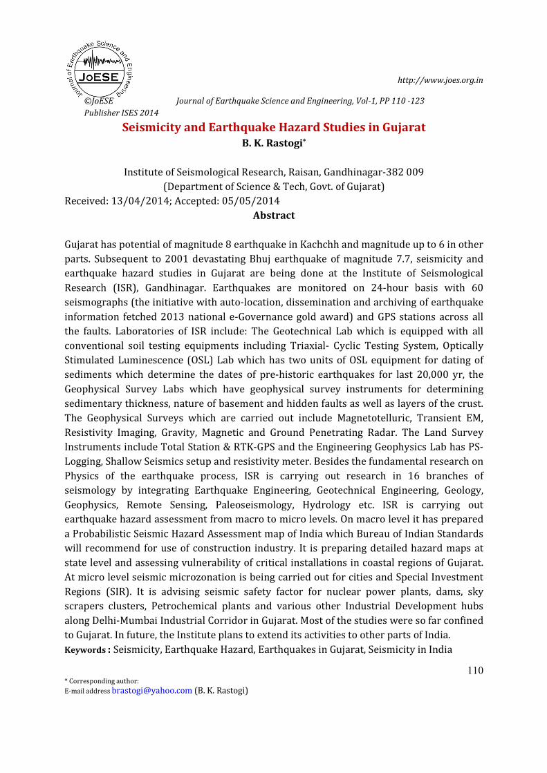
Kachchh is the only region outside Himalayan belt which has been assigned highest zone V
where great earthquakes of magnitude 8 can be expected (Fig. 1). After the 2001
magnitude 7.7 Bhuj earthquake which took a toll of 14,000 human lives and collapsed
several hundred thousand houses up to 300 km distance, it was realized that there is lack
of understanding of such earthquakes and how as well as in which ground conditions the
waves get amplified is not all known. As large scale development is planned, an acute need
of Seismological Research was felt which can help in sustaining such an accelerated
development. The Institute of Seismological Research (ISR) was established for this
purpose in 2006 and in a short time of 5 years it has become a center of Excellence. It is
unique in India as it is fully dedicated for ‘Earthquake Studies’. ISR is instrumentally well-
equipped and has expertise for earthquake monitoring, geophysical surveys, geotechnical
investigations, earthquake-prediction research and earthquake hazard assessment. These
studies are described.
Figure 1. Seismic Zoning map of India (Bureau of Indian Standards, 2000)
B. K. Rastogi 2014
112
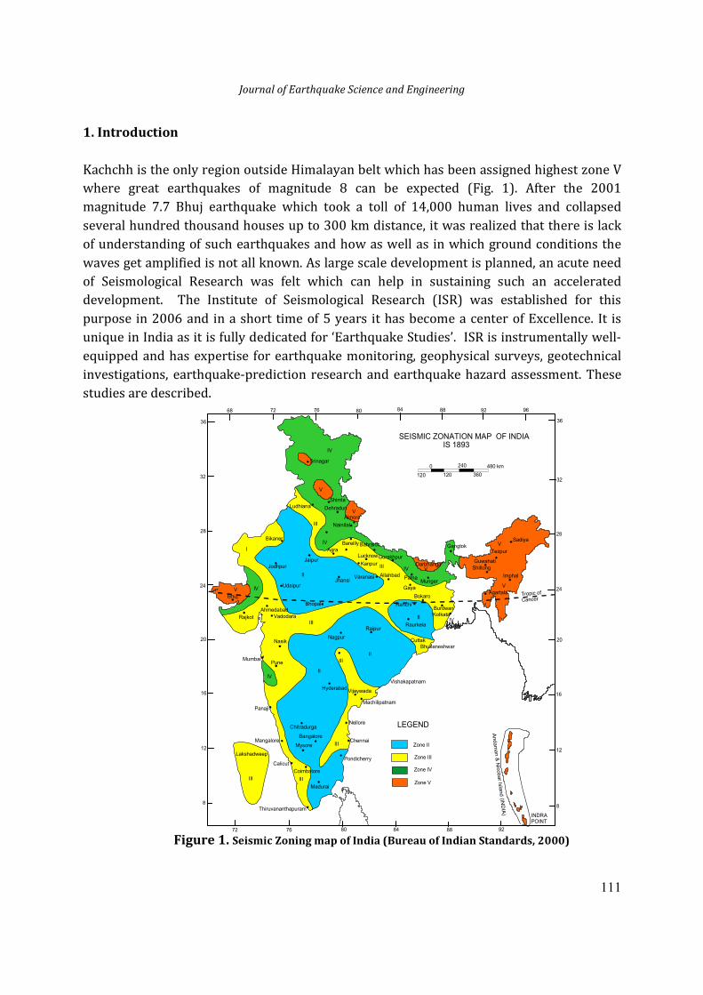
2. Monitoring of Earthquakes
Starting 1970s, seismicity in Gujarat was monitored with several analog seismographs in
the mainland and at Bhuj. It is believed that this network has not missed any earthquake of
M>3 in Gujarat in last four decades. Bhuj was upgraded to digital broadband seismograph
in 1999. Since mid 2006, ISR is monitoring seismicity in Gujarat with a dense network of
over 54 seismic stations in Gujarat and some in neighboring Maharashtra & Madhya
Pradesh (Chopra et al. 2008, Fig. 2). These observatories are equipped with state of art
seismographs. The seismic data from many of these observatories are received via VSAT at
ISR data center which works round the clock. All earthquakes of magnitude ≥ 2.5 in Gujarat
are well recorded. Earthquakes of magnitude ≥ 5 from anywhere in the World are usually
recorded. Information of earthquake epicenter and magnitude is sent to media and people
through website, SMS and telephone within minutes of the arrival of seismic waves. About
50 strong motion accelerographs are also being operated for recording acceleration at near
distances. Earthquake early warning system is planned.
Figure 2. Seismograph stations in Gujarat including 48 online Broad Band Seismographs, 6 offline
Broad Band Seismographs and 54 Accelerographs
Journal of Earthquake Science and Engineering
113
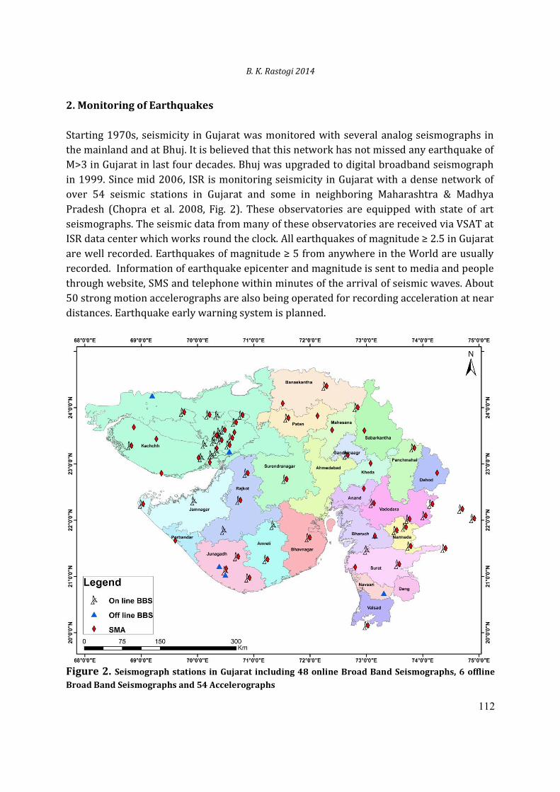
3. Seismicity Patterns and Seismotectonics
The Kachchh region is considered seismically one of the most active intraplate regions of
the World (Rastogi, 2010). It was known to have high hazard but low seismicity in view of
the occurrence of several large earthquakes but fewer moderate or smaller shocks (Fig. 3).
Normally, the number of earthquakes increases ten times for every unit of lower
magnitude. In Kachchh for two earthquakes of M7.8 and 7.7, earthquakes of M<7 are fewer.
In Saurashtra as part of regional seismicity earthquakes of M<6 have occurred on the
eastern part and around West Cambay Fault near Bhavnagar. Narmada rift zone has
experienced shocks of magnitude M5.4 at Bharuch in 1970, but M6 or more east of Gujarat.
The Cambay rift has shown less seismicity which is confined more to its southern part and
to M5.7 level.
Figure 3. Epicenters of earthquakes of M2 or greater from 1684 to 2013 excluding aftershocks
Prior to 2001, Kachchh had experienced three large earthquakes: M7.8 Allah Bund
(24.000N 69.000E) earthquake in 1819, M6.3 Lakhpat (23.800N 68.900E) earthquake of
1845 and M6 Anjar (23.300N 70.000E) earthquake in 1956. Smaller shocks include seven
earthquakes of magnitude 5-5.6, and only 71 of M3.5-4.9. Other areas of Gujarat have
B. K. Rastogi 2014
114
26 Jan,2001
experienced a few damaging earthquakes of magnitude < 6, for example the 1970 M5.4
earthquake in Bharuch (21.6250N 72.960E) along the South Narmada fault. In Saurashtra
the two significant earthquakes were 1919 M5.7 Ghogha (220N 720E) and 1938 M5.7
Paliyad (22.400N 71.800E).
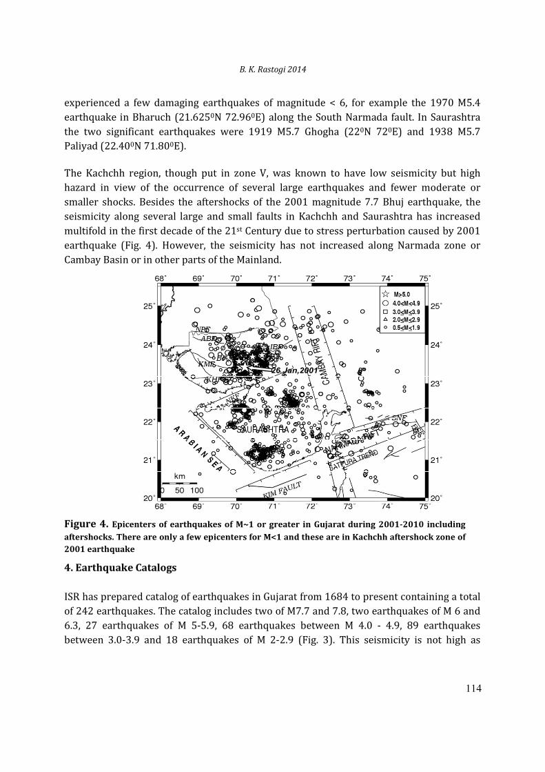
The Kachchh region, though put in zone V, was known to have low seismicity but high
hazard in view of the occurrence of several large earthquakes and fewer moderate or
smaller shocks. Besides the aftershocks of the 2001 magnitude 7.7 Bhuj earthquake, the
seismicity along several large and small faults in Kachchh and Saurashtra has increased
multifold in the first decade of the 21st Century due to stress perturbation caused by 2001
earthquake (Fig. 4). However, the seismicity has not increased along Narmada zone or
Cambay Basin or in other parts of the Mainland.
Figure 4. Epicenters of earthquakes of M~1 or greater in Gujarat during 2001-2010 including
aftershocks. There are only a few epicenters for M<1 and these are in Kachchh aftershock zone of
2001 earthquake
4. Earthquake Catalogs
ISR has prepared catalog of earthquakes in Gujarat from 1684 to present containing a total
of 242 earthquakes. The catalog includes two of M7.7 and 7.8, two earthquakes of M 6 and
6.3, 27 earthquakes of M 5-5.9, 68 earthquakes between M 4.0 - 4.9, 89 earthquakes
between 3.0-3.9 and 18 earthquakes of M 2-2.9 (Fig. 3). This seismicity is not high as
Journal of Earthquake Science and Engineering
115
compared to active regions of the world. For example, Taiwan may experience in 5 yr what
Gujarat may experience in 200 yr.
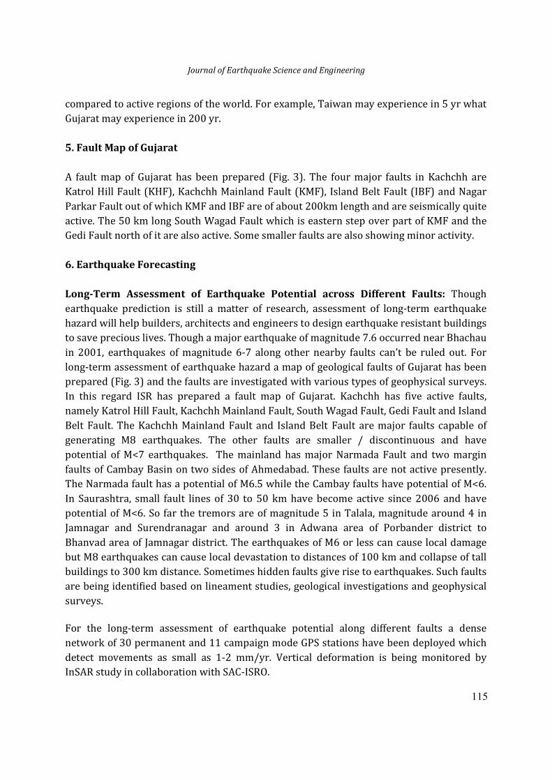
5. Fault Map of Gujarat
A fault map of Gujarat has been prepared (Fig. 3). The four major faults in Kachchh are
Katrol Hill Fault (KHF), Kachchh Mainland Fault (KMF), Island Belt Fault (IBF) and Nagar
Parkar Fault out of which KMF and IBF are of about 200km length and are seismically quite
active. The 50 km long South Wagad Fault which is eastern step over part of KMF and the
Gedi Fault north of it are also active. Some smaller faults are also showing minor activity.
6. Earthquake Forecasting
Long-Term Assessment of Earthquake Potential across Different Faults: Though
earthquake prediction is still a matter of research, assessment of long-term earthquake
hazard will help builders, architects and engineers to design earthquake resistant buildings
to save precious lives. Though a major earthquake of magnitude 7.6 occurred near Bhachau
in 2001, earthquakes of magnitude 6-7 along other nearby faults can’t be ruled out. For
long-term assessment of earthquake hazard a map of geological faults of Gujarat has been
prepared (Fig. 3) and the faults are investigated with various types of geophysical surveys.
In this regard ISR has prepared a fault map of Gujarat. Kachchh has five active faults,
namely Katrol Hill Fault, Kachchh Mainland Fault, South Wagad Fault, Gedi Fault and Island
Belt Fault. The Kachchh Mainland Fault and Island Belt Fault are major faults capable of
generating M8 earthquakes. The other faults are smaller / discontinuous and have
potential of M<7 earthquakes. The mainland has major Narmada Fault and two margin
faults of Cambay Basin on two sides of Ahmedabad. These faults are not active presently.
The Narmada fault has a potential of M6.5 while the Cambay faults have potential of M<6.
In Saurashtra, small fault lines of 30 to 50 km have become active since 2006 and have
potential of M<6. So far the tremors are of magnitude 5 in Talala, magnitude around 4 in
Jamnagar and Surendranagar and around 3 in Adwana area of Porbander district to
Bhanvad area of Jamnagar district. The earthquakes of M6 or less can cause local damage
but M8 earthquakes can cause local devastation to distances of 100 km and collapse of tall
buildings to 300 km distance. Sometimes hidden faults give rise to earthquakes. Such faults
are being identified based on lineament studies, geological investigations and geophysical
surveys.
For the long-term assessment of earthquake potential along different faults a dense
network of 30 permanent and 11 campaign mode GPS stations have been deployed which
detect movements as small as 1-2 mm/yr. Vertical deformation is being monitored by
InSAR study in collaboration with SAC-ISRO.
B. K. Rastogi 2014
116
Rate of deformation in the past 2Ma is studied by active fault investigations in Kachchh and
Narmada. Dates of earthquakes in the past 20,000 yr are determined by paleoseismological
and active fault investigations. Dating of sediments/prehistoric earthquakes is done in its
Optically Stimulated Luminescence Lab. Dates of pre-historic earthquakes give recurrence
rates of large earthquakes in order to assess earthquake hazard along different geological
faults. Active fault studies involve thorough examination of 3D satellite imageries,
geological investigations supported by geophysical surveys like GPR, shallow seismic and
resistivity imaging and finally observation of recent movements in trenches across faults.
Medium- and Short-term Precursors: Besides long-term earthquake hazard assessment
in Gujarat, ISR carries out research on medium and short-term earthquake forecasts by
measuring several types of precursory phenomenon. ISR has established three
Multiparametric Geophysical Observatories in Kachchh for earthquake prediction research.
Eleven types of precursory parameters are being observed with Broadband Seismographs,
GPS, magnetometers, ground water leveler, super-conducting gravimeter, helium and
radon detectors.
7. Earthquake Hazard Assessment
Earthquake hazard assessment for India is done at ISR from macro to micro level. At macro
level Institute has prepared Probabilistic Seismic hazard Assessment map of India for the
Bureau of Indian Standards. Earthquake hazard is also estimated at state level.
Vulnerability of coastal installations from earthquakes and tsunami is being studied in
coasts of Gujarat. Site characteristic map of Gujarat has been prepared based on Vs30,
shear-wave velocity to 30m depth measured by MASW shallow seismic and PS logging.
Various geological units have been assigned ranges of values. GIS based intelligent shake
map of Gujarat is being prepared. At micro level earthquake hazard assessments are made
for critical structures like Nuclear Power Plants, LNG Terminals and clusters of
Skyscrapers. The Institute has unique expertise of carrying out all aspects of seismic
microzonation. Seismic microzonation has been completed for Gandhidham and Dholera
SIR and is being carried out for Ahmedabad and Gandhinagar. In collaboration with
Geological Survey of India microzonation is undertaken for Bharuch and Surat.
8. Seismic Zoning Map of India
Seismic Zoning Map of India (Fig. 1, Bureau of Indian Standards, 2000) divides India in
zones II, III, IV and V having potential of earthquake intensities VI (M5), VII (M6), VIII (M7)
and ≥IX (M≥8), respectively. This map is prepared on the basis of intensities experienced at
places and their tectonic belts. Himalayan belt is assigned zone V and IV. Kachchh is the
only area outside Himalaya-Andaman belt which is assigned zone V. Koyna and Latur area
Journal of Earthquake Science and Engineering
117
is assigned zone IV. The Indo-Gangetic plains, Saurashtra peninsula, the west coast region
and the Narmada belt is zone III. Most other parts of peninsular India are in zone II. The
westernmost part of Gujarat, the Kachchh Peninsula is seismically one of the most active
intraplate regions of the World. It falls in zone V of the seismic zoning map of India with
potential of M8. The Saurashtra Peninsula south of it and the Mainland which is east of both
these regions mostly fall in zone III with M≤6 potential.
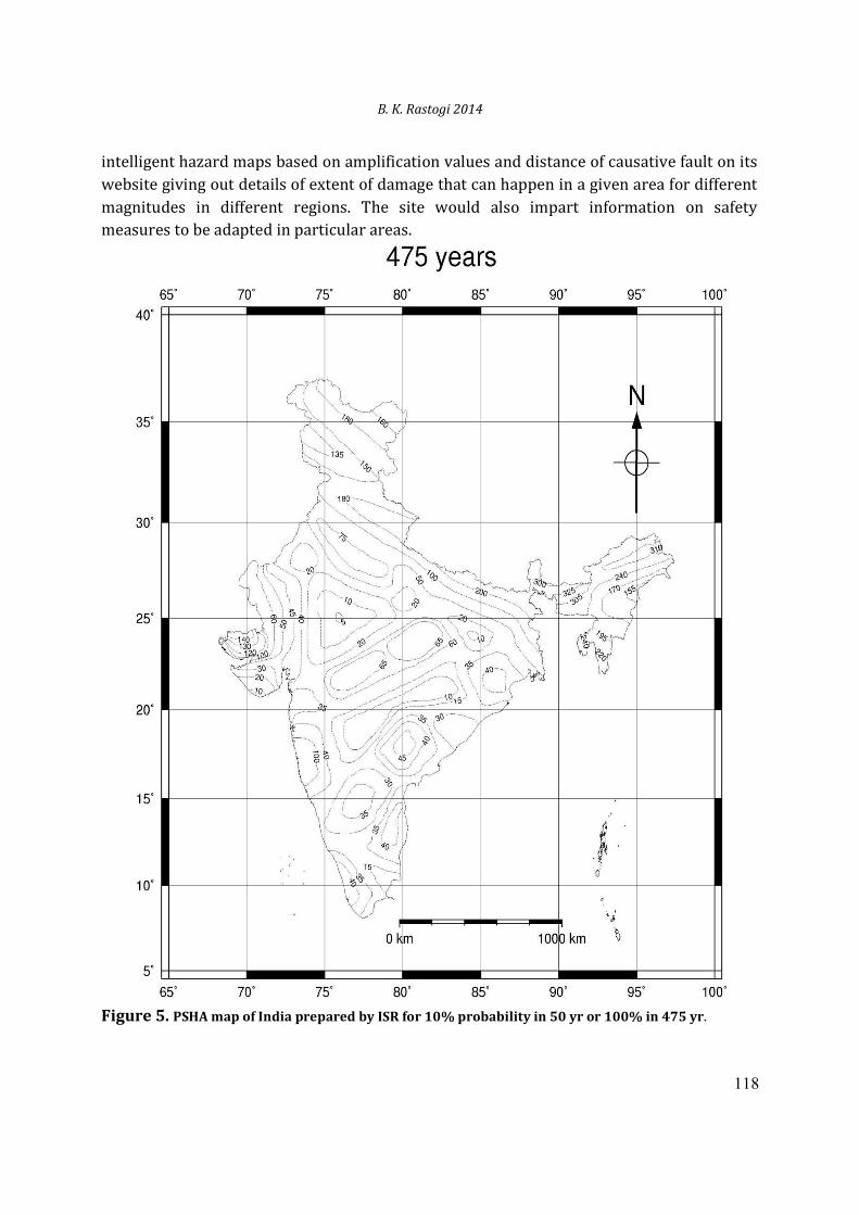
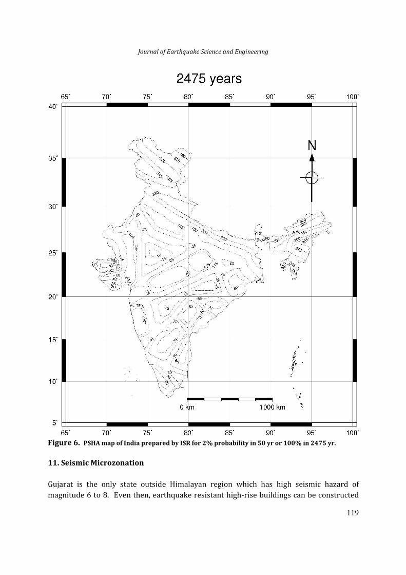
9. Probabilistic Seismic Hazard Assessment Map of India
ISR has prepared Probabilistic Seismic Hazard Assessment (PSHA) map of India for Bureau
of Indian Standards which will help all the citizens of India in adopting optimum seismic
coefficients for earthquake resistant designing of buildings based on the probability of
occurrence. The Seismic Zoning Map (SZ Map) of India currently recommended by BIS for
designing earthquake resistant buildings is based on the magnitudes of the past
earthquakes experienced in different tectonic (geological) zones. The logic used is what has
happened at some zone can happen again. However, according to the seismic gap theory
some seismologists believe that the areas which have not experienced earthquakes in the
past in any tectonic belt may be more prone than the areas which have already experienced
the earthquake. Hence the areas in Himalaya which are shown as zone 4 may have
potential of zone 5. Moreover, the present SZ Map tells the potential of different zones
without assigning any probability of occurrence. The assigned earthquake for a zone may
occur tomorrow or after 10,000 yr without giving any probability of occurrence. The
Probabilistic Seismic Assessment (PSHA) Map gives the probability of occurrence in
different time periods. Hence, the PSHA map is more practical. Also different types of
structures need assessment for different return periods for assigning maximum possible
earthquake in a tectonic zone. For example the ordinary buildings need only 475 years
return period (10% probability in 50 yr, while an LNG terminal will need 2475 year return
period (2% probability in 50 yr) and a Nuclear Power Plant will be designed for 10, 000
years return period (0.5% probability in 50 years). The PSHA map provides information
towards this need. The PSHA map also provides fine gradation of hazard in a particular
tectonic zone. Presently some zones like entire Kachchh are given zone 5. As the southern
portion of Kachchh has not experienced large earthquakes and there are no major faults, in
PSHA map the southern part of Kachchh is assigned lesser hazard (Figs. 5 and 6).
10. Site Characteristic and Amplification Maps of Gujarat
Site characteristic map of Gujarat has been prepared based on Vs30, shear-wave velocity to
30m depth measured by MASW shallow seismic survey and PS logging. Various geological
units have been assigned ranges of values. Amplification of acceleration at different sites is
being estimated based on the Vs map. In addition, ISR will soon display GIS based
B. K. Rastogi 2014
118
intelligent hazard maps based on amplification values and distance of causative fault on its
website giving out details of extent of damage that can happen in a given area for different
magnitudes in different regions. The site would also impart information on safety
measures to be adapted in particular areas.
Figure 5. PSHA map of India prepared by ISR for 10% probability in 50 yr or 100% in 475 yr.
Journal of Earthquake Science and Engineering
119
Figure 6. PSHA map of India prepared by ISR for 2% probability in 50 yr or 100% in 2475 yr.
11. Seismic Microzonation
Gujarat is the only state outside Himalayan region which has high seismic hazard of
magnitude 6 to 8. Even then, earthquake resistant high-rise buildings can be constructed
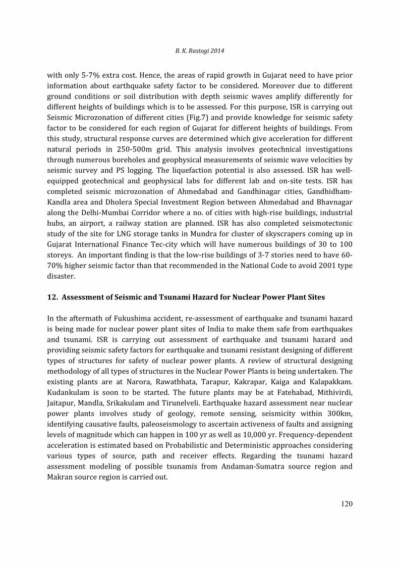
B. K. Rastogi 2014
120
with only 5-7% extra cost. Hence, the areas of rapid growth in Gujarat need to have prior
information about earthquake safety factor to be considered. Moreover due to different
ground conditions or soil distribution with depth seismic waves amplify differently for
different heights of buildings which is to be assessed. For this purpose, ISR is carrying out
Seismic Microzonation of different cities (Fig.7) and provide knowledge for seismic safety
factor to be considered for each region of Gujarat for different heights of buildings. From
this study, structural response curves are determined which give acceleration for different
natural periods in 250-500m grid. This analysis involves geotechnical investigations
through numerous boreholes and geophysical measurements of seismic wave velocities by
seismic survey and PS logging. The liquefaction potential is also assessed. ISR has well-
equipped geotechnical and geophysical labs for different lab and on-site tests. ISR has
completed seismic microzonation of Ahmedabad and Gandhinagar cities, Gandhidham-
Kandla area and Dholera Special Investment Region between Ahmedabad and Bhavnagar
along the Delhi-Mumbai Corridor where a no. of cities with high-rise buildings, industrial
hubs, an airport, a railway station are planned. ISR has also completed seismotectonic
study of the site for LNG storage tanks in Mundra for cluster of skyscrapers coming up in
Gujarat International Finance Tec-city which will have numerous buildings of 30 to 100
storeys. An important finding is that the low-rise buildings of 3-7 stories need to have 60-
70% higher seismic factor than that recommended in the National Code to avoid 2001 type
disaster.
12. Assessment of Seismic and Tsunami Hazard for Nuclear Power Plant Sites
In the aftermath of Fukushima accident, re-assessment of earthquake and tsunami hazard
is being made for nuclear power plant sites of India to make them safe from earthquakes
and tsunami. ISR is carrying out assessment of earthquake and tsunami hazard and
providing seismic safety factors for earthquake and tsunami resistant designing of different
types of structures for safety of nuclear power plants. A review of structural designing
methodology of all types of structures in the Nuclear Power Plants is being undertaken. The
existing plants are at Narora, Rawatbhata, Tarapur, Kakrapar, Kaiga and Kalapakkam.
Kudankulam is soon to be started. The future plants may be at Fatehabad, Mithivirdi,
Jaitapur, Mandla, Srikakulam and Tirunelveli. Earthquake hazard assessment near nuclear
power plants involves study of geology, remote sensing, seismicity within 300km,
identifying causative faults, paleoseismology to ascertain activeness of faults and assigning
levels of magnitude which can happen in 100 yr as well as 10,000 yr. Frequency-dependent
acceleration is estimated based on Probabilistic and Deterministic approaches considering
various types of source, path and receiver effects. Regarding the tsunami hazard
assessment modeling of possible tsunamis from Andaman-Sumatra source region and
Makran source region is carried out.
Journal of Earthquake Science and Engineering
121
Figure 7. Areas in Gujarat considered for seismic microzonation
Arrival times of tsunami, wave height and inundation distance are estimated. Tsunami
effects on nuclear power plant sites of India is assessed and described here. The existing
Tarapur, Kaiga, Kalapakkam. Kudankulam plants are close to the coast. The 2004 tsunami
touched the area of Kalapakkam plant. However, there was no damage as the cables and
other ancillary equipments were kept at sufficient height. The other existing coastal and
also the proposed coastal plants at Mithivirdi, Jaitapur, Srikakulam and Tirunelveli.are at
elevations much more than the expected tsunami run-up.
13. Some Secondary Findings of Great Commercial Value
While carrying out active fault investigations, some paleochannels were noticed in satellite
imageries in Kachchh which could be the source of water for drinking & irrigation in Kutch
and notice of gas bubbling indicated possibility of gas reserves. ISR is advising industry on
different types of issues besides seismic safety. ISR detected buried pipelines of ONGC in
Ankaleshwar for planning of a new township by Gujarat Industrial Development
Corporation. It has also estimated the thickness of limestone beds in Kutch for the benefit
of miners. ISR has advised a few petrochemical companies about the fault lines coming on
the way of new pipelines being laid by them.
B. K. Rastogi 2014
122
14. Public Outreach
ISR Geophysical data centre through its website shares different types of data sets,
information about current earthquakes and catalogues of earthquakes in different states.
Several students from Gujarat and other states are using this data for their PhD thesis.
Some 50-60 students are doing M.Sc., M.Sc. Tech. dissertation and about 100 students are
taking training annually.
Anywhere even small earthquakes are experienced people are scared after the 2001
experience. ISR has allayed unnecessary fear of people by explaining the possibilities of
damage potential, how to live with that and phenomena like subterranean sounds
generated by earthquakes.
Builders, industrialists as well as academicians from institutes such as Indian Concrete
Institution, CEPT, Nirma University and certain Cement plants in the State take regular
help of ISR for various seismic and academic works. ISR is training Govt. officers and
college teachers about earthquake safety factors and disaster management.
The Institute is helping in framing municipal laws to enforce earthquake safety norms for
Gujarat. Based on recent results, hazard in different parts of the state is assigned. Cities are given
importance factors and structural engineers are to be given categories 1 to 5. Depending upon the
importance factor of the city and height of the building structural engineer of a specified grade
only can design the building. Certificates of satisfactory implementation of design criteria are to
be ensured on different stages of construction Responsibility will be fixed in case of failure due
to an earthquake.
15. The Two Significant Future Plans of ISR
The autolocation program already installed gives the information about magnitude and
location of earthquake in seconds and has enabled early warning system. If a major
earthquake happens in Kachchh, the damaging waves take about 40 seconds to reach
Ahmedabad and if a warning can be given after 10 seconds, advance notice of 30 seconds
could save many lives.
The GIS based intelligent earthquake hazard maps will be soon available in website which
is useful for planning developmental activities. Anyone can log-in and see how much
damage can be in an area for different magnitudes in any region and what kind of safety
factors are to be considered in a particular area. GIS base Shake maps will be put soon after
any earthquake so that the Government and NGOs can plan rescue without delay of
Journal of Earthquake Science and Engineering
123
precious time in which a number of lives can be saved. It is an important issue as break
down in communications invariably happens after the earthquakes.
16. Concluding Remarks
More than 50% of Indian landmass has severe earthquake hazard and hazard is increasing
due to shoddy constructions and increasing population. With fast developing Special
Investment Regions, SEZs, Delhi-Mumbai Industrial Corridor and various other Industrial
Development hubs like those for Petrochemicals in Gujarat, the Institute of Seismological
Research planned to carry out earthquake hazard studies. Such studies are required from
macro to micro level requiring different strategies. In the aftermath of Fukushima disaster
of March 2011, a review of structural designing methodology of all types of structures in
the Nuclear Power Plants is being undertaken. By various types of projects, ISR is serving
as a one-stop solution for assessing seismic hazard for real estate and industries.
References
Chopra, S., R. B. S. Yadav, H. Patel, S. Kumar, K.M. Rao, B.K. Rastogi, A. Hameed, and S.
Srivastava, (2008). The Gujarat (India) Seismic Network, Seismological Research Letter,
79 (6), 806-815.
Rastogi, B.K. (2010). Causative Mechanisms of the Intraplate Earthquakes Occurring in
India, Advances in Geosciences, 26, 97-116.