seismicity of the sunda strait: evidence for crustal …...harjono et al.: seismicity and crustal...
TRANSCRIPT
HAL Id: insu-01354283https://hal-insu.archives-ouvertes.fr/insu-01354283
Submitted on 18 Aug 2016
HAL is a multi-disciplinary open accessarchive for the deposit and dissemination of sci-entific research documents, whether they are pub-lished or not. The documents may come fromteaching and research institutions in France orabroad, or from public or private research centers.
L’archive ouverte pluridisciplinaire HAL, estdestinée au dépôt et à la diffusion de documentsscientifiques de niveau recherche, publiés ou non,émanant des établissements d’enseignement et derecherche français ou étrangers, des laboratoirespublics ou privés.
Seismicity of the Sunda Strait: Evidence for crustalextension and volcanological implications
Hery Harjono, Michel Diament, Jacques Dubois, Michel Larue, MudahamTaufick Zen
To cite this version:Hery Harjono, Michel Diament, Jacques Dubois, Michel Larue, Mudaham Taufick Zen. Seismicity ofthe Sunda Strait: Evidence for crustal extension and volcanological implications. Tectonics, AmericanGeophysical Union (AGU), 1991, 10 (1), pp.17-30. �10.1029/90TC00285�. �insu-01354283�
TECTONICS, VOL. 10, NO. 1, PAGES 17-30, FEBRUARY 1991
SEISMICITY OF THE SUNDA STRAIT: EVIDENCE
FOR CRUSTAL EXTENSION AND VOLCANOLOGI-
CAL IMPLICATIONS
Hery Harjono, 1 Michel Diament, 2 Jacques Dubois, 2 and Michel Larue 3
Laboratoire de G6ophysique, Universit6 de Paris Sud, Orsay, France
Mudaham Taufick Zen
Laboratorium Geofisika, Bandung, Indonesia
Abstract. The Sunda Strait is located in the transitional zone between two different modes of subduction: the Java
frontal subduction and the Sumatra oblique subduction. This setting implies that the Sunda Strait region is a key to the understanding of the geodynamic processes involved. In order to study the shallow seismicity, a microearthquake survey was carried out in that region. Twelve stations, accu- rately located by the aim of satellite positionning, recorded about 300 local events in the summer 1984. From this set, 174 shallow earthquakes have been precisely located. The results of this study reveal that the crustal earthquakes in the Sunda Strait area occurs in three main areas: (1) beneath the Krakatau complex, where earthquakes are generated by double-couples and are of tectonic origin; (2) inside a graben in the western part of the strait; and (3) in a more diffused zone to the south of Sumatra. The individual and composite focal mechanisms from the events inside the strait show an
extensional regime. A stress tensor, which have been de- duced from the individual focal mechanisms of earthquakes of the Krakatau group shows that the tensional axis is orient- ed N130øE. This study confirms that the Sunda Strait is in an extensional tectonic regime as a result of the northwestward movement of the Sumatra sliver plate along the Semangko fault zone.
Also at Puslitbang Geoteknologi - LIPI, Bandung. Now at Institut de Physique du Globe de Paris. Also at ORSTOM, Noum6a, Nouvelle Ca16donie.
Copyright r901 by the American Geophysical Union.
Paper number 90TC00285. 0278-7407/90/90TC-00285510.00
INTRODUCTION
The Cenozoic collision between the Indian continent and
the Eurasian plate produced the displacement of several blocks or plates eastward or southeastward [Molnar and Tapponnier, 1975; Tapponnier et al., 1982] which must be studied in order to resolve the geodynamics of the Indone- sian region. The displacement of such a block along the Semangko fault was proposed by several authors [e.g., Huchon and Le Pichon, 1984; Deplus, 1987] in order to explain the origin of the trench junction in front of the Sunda Strait. Consequently, the Sunda Strait, which is also histori- cally famous due to the presence of the Krakatau volcano, is a key area to understanding the geodynamic evolution of western Indonesia.
The tectonic evolution of the western part of Indonesia is often related to a clockwise rotation of Sumatra by 20 ø rela- tive to Java with an axis of rotation lying close to the Sunda Strait during Late Cenozoic time [Ninkovich, 1976]. The opening of the Sunda strait would then be related to that rotation [e.g., Zen, 1983]. Other authors as Huchon and Le Pichon [1984] proposed that the Sunda Strait is an extension- al area which results from the northwestward displacement of the southern block of Sumatra along the Semangko fault system as a consequence of oblique subduction in front of Sumatra.
Until recently, very few geological and geophysical data were available in this area. A joint French-Indonesian study of geology and geophysics was carried out from June 1983 to February 1985 in order to collect marine and field data in and around the Sunda Strait. Marine geophysical data were intensively recorded during CORINDON IX and GEOIN- DON I cruises of R/V Coriolis (in 1983 and in 1984) and during KRAKATAU cruise of R/V Jean Charcot (in 1985). Furthermore, fieldwork including neotectonic studies and a microearthquake survey was conducted all around the Sunda
18 Harjono et al.: Seismicity and Crustal Extension, Sunda Strait
Strait. In this paper, we present the results of the micr- oearthquake survey.
If we consider the seismicity of the Sunda Strait area in the context of the worldwide network, the hypocenter loca- tions are poorly constrained, especially for shallow earth- quakes, because the nearest station which could control the focal depth is located about 125 km from the strait. More- over, no focal mechanism was available in the Sunda Strait. So, we carried out the survey in the summer of 1984 in order to constrain the shallow seismicity in the Sunda Strait area, and to better define the seismologically active tectonic fea- tures and their possible extension in the Sunda Strait. Fur- thermore, our goal was to check if the only active volcano in that area, Krakatau, presented some seismicity of tectonic origin and in such case to determine the relationship between the possible tectonic seismicity beneath or close to the Krakatau complex and the tectonic features of the Sunda Strait.
TECTONIC SETTING
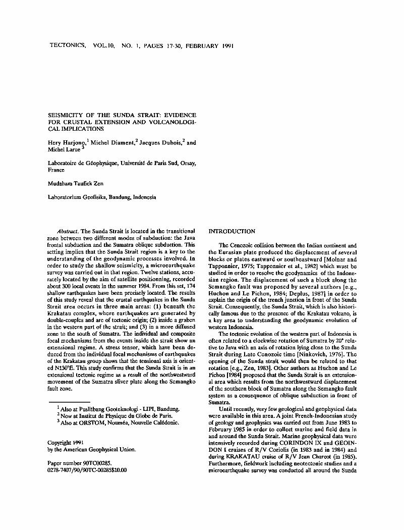
Figures 1 and 2 show the geodynamic pattern and the geological setting of the area. The main structural features are the Java and Sumatra trench system, the Semangko fault system, and the volcanic line going from Panaitan island to Sukadana through the Krakatau complex, Sebesi, Sebuku and Rajabasa.
Java-Sumatra Trench System The Indian-Australian plate underthrusts the Eurasian
plate northward beneath the Java and Sumatra islands along the Java-Sumatra trenches. The rate of convergence of the
104 e 108 ß I0• ß
Fig. 2. Geological map of the study area simplified from Nishimura [1986]. 1, Alluvial deposit, 2, Quaternary volcan- ic rocks, 3, Quaternary tuff, 4, Pliocene deposit, 5, Miocene deposit, 6, Basement, 7, Locations of oil exploration drill holes, 8, Refraction profries (A and B) of CORINDON IX. P, Panaitan island, K, Krakatau complex, Si, Sebesi volca- no, Su, Sebuku volcanic island, R, Rajabasa volcano, Sa, Sukadana basalt. Simplified bathymetry (every 400m) after M.Larue (unpublished data, 1983).
subducting plate is 7 cm/yr [Sclater and Fisher, 1974] and the directions of relative convergence, deduced from the India/Eurasia pole of the global model of Minster and Jordan [1978] are N24øE off Java and N23øE off Sumatra. More recently, Jarrard [1986] proposed that the direction of
102' 106' I10'
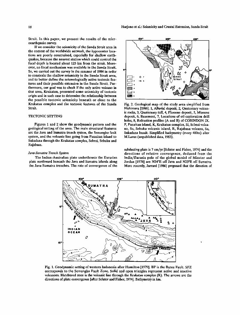
Fig. 1. Geodynamic setting of western Indonesia after Hamilton [1979]. BF is the Batee Fault. SFZ corresponds to the Semangko Fault Zone. Solid and open triangles represent active and inactive volcanoes. Hatchured zone is the volcanic line through the Krakatau complex (K). The arrows are the directions of plate convergence [after Sclater and Fisher, 1974]. Bathymetry in km.
Harjono et al.: Seismicity and Crustal Extension, Sunda Strait 19
plate convergence is nearly N-S. So, according to these direc- tions of relative convergence and since the azimuth of the Java trench is roughly N100øE and that of Sumatra trench is N140øE, the Sunda strait area has to be considered as a transition between a frontal and an oblique subduction [Huchon and Le Pichon, 1984; Deplus, 1987].
Note that, in addition to the variation in the trench direc- tions, the maximum depth of the Benioff zone changes, from 600 km beneath Java to 200 km beneath Sumatra [Fitch and Molnar, 1970; Hamilton, 1974; Newcomb and McCann, 1987]. Moreover, south of Java the maximum depth of the trench is greater than 6000 m, and decreases towards the Sumatra trench.
Semangko Fault System
The Semangko fault zone (Figure 1) [Van Bemmelen, 1949] runs parallel to the long axis of Sumatra and offsets right laterally the Sumatra island [Katili and Hehuwat, 1967]. According to Molnar and Tapponnier [1975], the origin of the Semangko fault is a consequence of the collision between the Indian and the Eurasian plates. The Semangko fault zone is supposed to accomodate the obliquity of the Sumatra subduction zone [Fitch, 1972; Beck, 1983; Huchon and Le Pichon, 1984].
Hamilton [1979] assumed that the fault continues south- ward and intersects the trench, while Huchon and Le Pichon [1984] proposed that the fault ends in the Sunda Strait as a graben. Indeed, there is no field indication that the fault extends to West Java [Nishimura et al., 1986]. However, the interpretation of gravity data from West Java indicates some trends nearly parallel to the trend of the Semangko fault [Untung and Sato, 1978]. Evidence of a NW-SE right lateral fault was recently observed during geological fieldwork in the western part of West Java (S. Pramumijoyo and M. S6brier, personal communication, 1988). So, the question of the exact location of the active Semangko fault system is still open and can be addressed with the use of seismological data.
The Semangko fault system is also considered as the limit between the Eurasian plate and the so-called Sumatra sliver plate or forearc plate to the south [Jarrard, 1986]. In that case the Sunda Strait area would be located just to the north of a triple junction between the Indian plate, the Eurasian plate, and the Sumatra sliver plate. Furthermore, as the Sumatra sliver plate moves northwestward, the Sunda Strait area would act as a trailing edge and should present extensional structural patterns [Huchon and Le Pichon, 1984; Jarrard, 1986].
Sunda Strait
The main feature of the bathymetric pattern in the strait, according to the detailed survey of CORINDON IX in 1983 [M.Larue, unpublished data from CORINDON IX cruise, 1983], is a N-S graben with a maximum depth of about 1800 m (Figure 2). In the eastern part of the strait the sea bottom is shallower than 100 m and relatively flat; except inside the Krakatau complex, where the depths are about 200 m but are related to the calderas. The stratigraphic interpretations of seismic reflection profiles across the eastern flank of the
graben clearly reveal rapid subsidence since Pliocene [Lassal et al., 1989; V.Renard et al., unpublished data from Kraka- tau'85 cruise, 1985]. Such rapid subsidence is also evidenced by the borehole data from an oil exploration area to the southeast of Krakatau (Figure 2) [Noujaim, 1976]. This drill- ing encountered a thick accumulation of Quaternary to Upper Pliocene sediment series (2450 m).
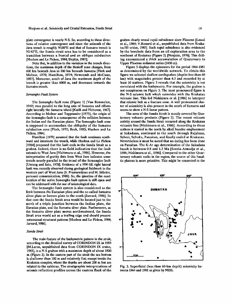
Figure 3 displays the epicenters for the period 1964-1981 as determined by the worldwide network. To obtain this figure we selected shallow earthquakes (depths less than 60 km) with magnitudes greater than 4.5 and recorded by at least 10 stations. Figure 3 reveals that the seismicity is not correlated with the bathymetry. For example, the graben is not conspicuous on Figure 3. The most pronounced figure is the N-S seismic belt which coincides with the Krakatau
volcanic line. This led Nishimura et al. [1986] to interpret that seismic belt as a fracture zone. A well pronounced dus- ter of seismicity is also present in the south of Sumatra and seems to show a N-S linear pattern.
The area of the Sunda Strait is mostly covered by Qua- ternary volcanic products (Figure 2). The recent volcanic activity around the Sunda Strait occurred along the Krakatau volcanic line [Nishimura et al., 1986]. According to these authors it started in the north by alkali basaltic emplacement at Sukadana, continued to the south through Rajabasa, Sebesi, Sebuku, Panaitan, and finally ended at Krakatau. Nevertheless it must be noted that no dating has been done on Panaitan. The K-At age determination of the Sukadana basalt is between 0.8 and 1.2 Ma [Soeria-Atmadja et al., 1986; Nishimura et al., 1986]. Compared to the other Quar- ternary volcanic rocks in the region, the source of this basal- tic plateau is more primitive. This might be connected to the
104' 105' i i
5' ß SUMATRA
6. 4
ii
106' i
o •D JAVA
7'
.. 20 km
" I I, I
Fig. 3. Superficial (less than 60-km depth) seismicity be- tween 1964 and 1981 as given by NEIS.
20 Harjono et al.: Seismicity and Crustal Extension, Sunda Strait
fact that the Sukadana basalt has been preferentially em- placed along NW-SE trending fractures which are subparallel to the Semangko fault system and not parallel to the Kraka- tau volcanic line. At present, the only active volcano in the area is the Anak Krakatau (child of Krakatau) volcano which was formed in 1927, 44 years after the famous explosion of Krakatau. According to various authors [e.g., Zen, 1983; Camus et al., 1987] Krakatau is a calc-alkaline volcano. Nevertheless petrological studies indicate some differences between the chemical compositions of the Krakatau products and those of the Java and Sumatra volcanoes nearby [Nishi- mura, 1986]. This would suggest that the Krakatau volcano differs from the other volcanoes in the area.
In summary, questions such as the existence of seismo- logically active features in the Sunda Strait, their exact loca- tions, their relationship to the opening of the strait and their relationship to the volcanic activity and the stress regime in the area need to be studied in order to better constrain the
geodynamic evolution of this region.
DATA AND ANALYSIS
Network
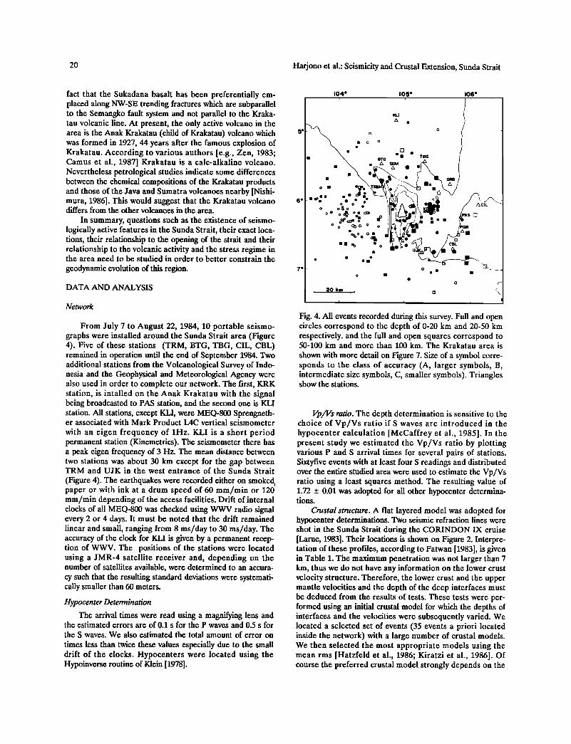
From July 7 to August 22, 1984, 10 portable seismo- graphs were installed around the Sunda Strait area (Figure 4). Five of these stations (TRM, BTG, TBG, CIL, CBL) remained in operation until the end of September 1984. Two additional stations from the Volcanological Survey of Indo- nesia and the Geophysical and Meteorological Agency were also used in order to complete our network. The first, KRK station, is intalled on the Anak Krakatau with the signal being broadcasted to PAS station, and the second one is KLI station. All stations, except KLI, were MEQ-800 Sprengneth- er associated with Mark Product L4C vertical seismometer
with an eigen frequency of 1Hz. KLI is a short period permanent station (Kinemetrics). The seismometer there has a peak eigen frequency of 3 Hz. The mean distance between two stations was about 30 km except for the gap between TRM and UJK in the west entrance of the Sunda Strait
(Figure 4). The earthquakes were recorded either on smoked i paper or with ink at a drum speed of 60 mm/min or 120 mm/min depending of the access facilities. Drift of internal clocks of all MEQ-800 was checked using WWV radio signal every 2 or 4 days. It must be noted that the drift remained linear and small, ranging from 8 ms/day to 30 ms/day. The accuracy of the clock for KLI is given by a permanent recep- tion of WWV. The positions of the stations were located using a JMR-4 satellite receiver and, depending on the number of satellites available, were determined to an accura- cy such that the resulting standard deviations were systemati- cally smaller than 60 meters.
Hypocenter Determination
The arrival times were read using a magnifying lens and the estimated errors are of 0.1 s for the P waves and 0.5 s for the S waves. We also estimated the total amount of error on
times less than twice these values especially due to the small drift of the clocks. Hypocenters were located using the Hypoinverse routine of Klein [1978].
104' 105' 106' , ,
KLI
A ß
-
BTG ß • ß TBG
ß . • "o '•.•% • / •.L . i
0
, 20 km • , a .
i • i
Fig. 4. • events recorded during this su•ey. Full and open circles correspond to the depth of 0-20 km and 20-50 km respectively. and the full and open squares correspond to 50-100 km and more than 100 kin. The Krakatau area is
shown •th more detail on Figure 7. Size of a s•bol corre- sponds to the class of accuracy (A, larger symbols, B, intermediate size symbols, C, smaller symbols). Triangles show the stations.
Vp/Vs ratio. The depth determination is sensitive to the choice of Vp/Vs ratio if S waves are introduced in the hypocenter calculation [McCaffrey et al., 1985]. In the present study we estimated the Vp/Vs ratio by plotting various P and S arrival times for several pairs of stations. Sixtyfive events with at least four S readings and distributed over the entire studied area were used to estimate the Vp/Vs ratio using a least squares method. The resulting value of 1.72 _+ 0.01 was adopted for all other hypocenter determina- tions.
Crustal structure. A flat layered model was adopted for hypocenter determinations. Two seismic refraction lines were shot in the Sunda Strait during the CORINDON IX cruise [Larue, 1983]. Their locations is shown on Figure 2. Interpre- tation of these profiles, according to Fatwan [1983], is given in Table 1. The maximum penetration was not larger than 7 km, thus we do not have any information on the lower crust velocity structure. Therefore, the lower crust and the upper mantle velocities and the depth of the deep interfaces must be deduced from the results of tests. These tests were per- formed using an initial crustal model for which the depths of interfaces and the velocities were subsequently varied. We located a selected set of events (35 events a priori located inside the network) with a large number of crustal models. We then selected the most appropriate models using the mean rms [Hatzfeld et al., 1986; Kiratzi et al., 1986]. Of course the preferred crustal model strongly depends on the
Harjono et al.: Seismicity and Crustal Extension, Sunda Strait 21
TABLE la. Velocity Model: Profile A
Depth (km) Vp(km/s)
0 2.6
2.2 3.1
4.9 4.0
6.8 5.7
Upper crustal model deduced from refraction data [after Fatwan, 1983]. See Figure 2 for location of profile A.
TABLE lb. Velocity Model: Profile B
Depth (km) Vp(km/s)
0 2.6
4.0 5.5
5.2 6.8
Upper crustal model deduced from refraction data [after Fatwan, 1983]. See Figure 2 for location of profile B.
TABLE lc. Crustal Model Used for
Determination of Hypocenters
Depth (km) Vp(km/s)
0 3.1
4.0 5.5
9.0 6.8
22.0 7.8
See text for explanation.
starting model. For the upper crust, we adopted an average between the two interpretations of seismic refraction. For the upper mantle velocity we adopted a starting value of 8.1 km/s, a common value for this parameter. The starting Moho depth was taken from a deep refraction survey per- formed in the south of Java (located at lat. 8øS and long. 108.5øE) [Raitt, 1967] which gave a value of 22 km. Note that Kieckhefer [1981] used a Moho depth at 25 km and an upper mantle velocity of 8.1 km/s in order to model the results of a microseismicity network installed in the north of Sumatra to study the Semangko fault system.
As concerns the upper part, results showed that the variations of the rms remained small. This is due to the fact
that most of the rays are refracted waves traveling in the lower crust. The best upper crustal model is given in Table lc.
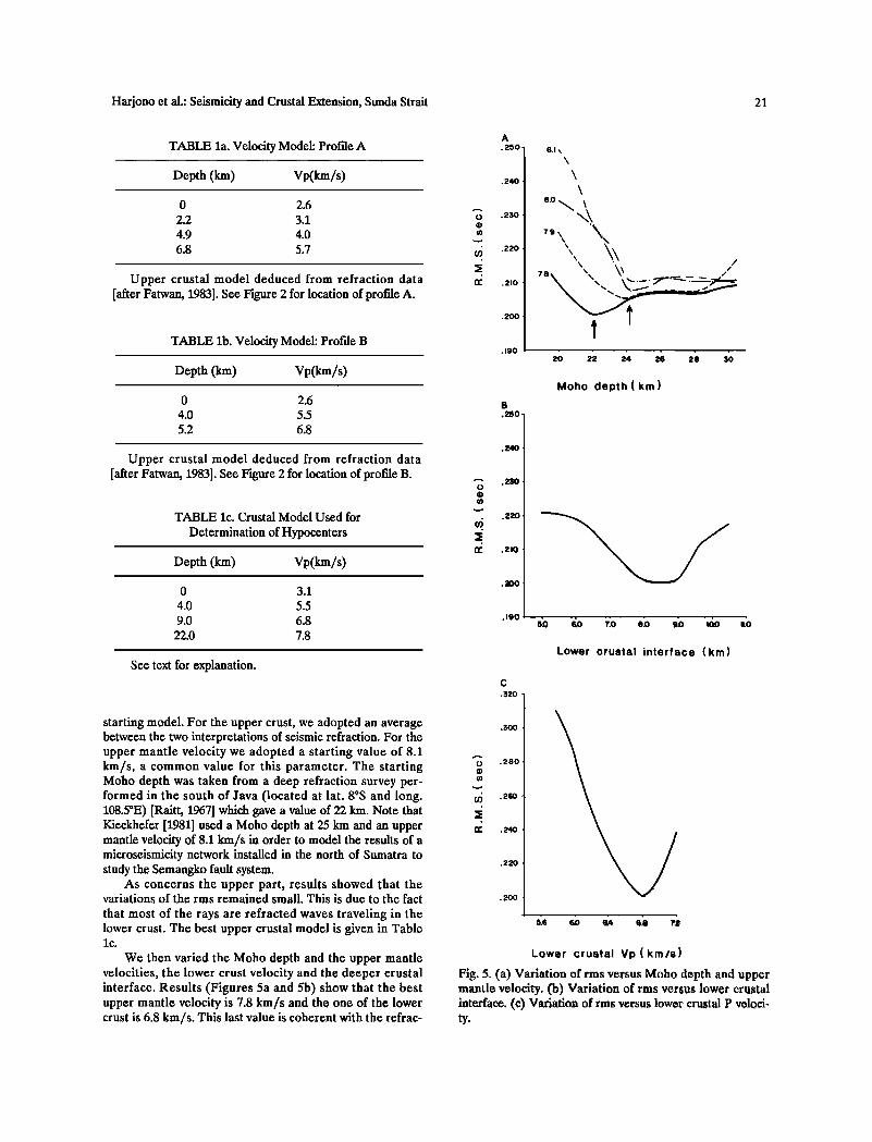
We then varied the Moho depth and the upper mantle velocities, the lower crust velocity and the deeper crustal interface. Results (Figures 5a and 5b) show that the best upper mantle velocity is 7.8 km/s and the one of the lower crust is 6.8 km/s. This last value is coherent with the refrac-
A ß 250
ß 240
ß 250
.220
.210
ß 200
ß 19o
B .250
8.1\
\
\ ,.
\x\
Moho depth(km)
o ß 2•)
.220
.2!0
.190
Lower crustal interface (km)
c
.$20
o .280
• .26o
.220
Lower crustal Vp(km/s)
Fig. 5. (a) Variation of rms versus Moho depth and upper mantle velocity. (b) Variation of rms versus lower crustal interface. (e) Variation of rms versus lower crustal P veloci- ty.
22 Harjono et al.: Seismicity and Crustal Extension, Sunda Strait
tion results and appears well constrained (Figure 5c). The Moho depth appears to be 22 km for the chosen upper mantle velocity and more than 24 km if a higher upper mantle velodty is taken (Figure 5a). Figure 5c shows that the lower crustal interface lies between 8 and 9 km. The resulting crustal model chosen to use for the hypocenter locations is given in Table lc. Of course, according to these results, slightly different crustal model can be used. Therefore in the following section we will discuss the displacements of the locations according to the crustal velocity structure and to the various classes of accuracy.
Earthquake locations. We classified our hypocenters as A, B, and C depending on the criteria of statistical error and station distribution (including the number of phases used during determinations). Several tests made with 10 selected events and our average crustal model were performed in order to define our classification. We chose 10 events located
inside the Krakatau complex, in the middle of the network, since the depths of these events are well controlled by the KRK station. These 10 events were first located using differ- ent sets of P arrival times (associated with S or not). In order to get an idea of the accuracy of poorly recorded events (for example, outside the network), we also relocated our test events using only readings from several limited sets of sta- tions, for example the Sumatra stations and CIL but exclud- ing KRK.
Results of these various tests showed that for events
occuring inside the network and located using at least seven P arrival times with a distribution of stations in the four
quadrants, we still got a good result, that is, the hypocenters were not shifted more than 2 kin. Using six P arrival times only, the epicenters were as close as 1 km to those deter- mined using seven arrival times but the error on the depth (ERZ) was larger (about 5 kin). For events located outside the network, we had to introduce at least one S arrival time in order to obtain an acceptable accuracy (about 5 kin) on the depth.
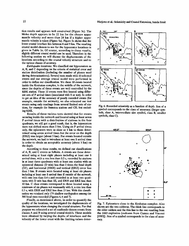
According to these results, we defined our classifications of A, B, and C events as follows. A events are those deter- mined using at least eight phases including at least one S arrival time, with arms less than 0.3 s, recorded by stations in at least three quadrants with at least one station with an epicentral distance (D rain) less than 2 times the focal depth (2Z), and horizontal (ERH) and vertical (ERZ) error less than 5 km. B events were located using at least six phases including at least one S arrival time if outside of the network, with rms less than 0.4 s and recorded in at least two quad- rants with D min less than 3Z, and ERH and ERZ less than 10 km. C class events correspond to those located using a minimum of six phases not necessarily with S, arms less than 0.5 s, with ERH and ERZ less than 15 kin. With this classifi- cation we retained only 174 shallow earthquakes among the 300 local ones recorded (Figures 4, 6 and 7).
Finally, as mentioned above, in order to quantify the quality of the locations, we investigated the displacements of the hypocenters when changing the crustal structure. For that purpose we relocated a set of randomly chosen events from classes A and B using several crustal models. These models were obtained by varying the depths of interfaces and the velocity of the lower crust with the limiting values deter-
A 104' 105'
O-2OKM
•.• SUMATRA ß
ß :
ß •
106'
20-5*0 KM ' '
ß ß ß ee ß ee e e eee ß • ß
D
IO0-:•00 KM I
ß
Fig. 6. Recorded seismicity as a function of depth. Size of a symbol corresponds to the class of accuracy; (larger sym- bols, class A, intermediate size symbol, class B, smaller symbols, class C).
IO5.3' IO5.5 ß , , ,
o
ß A
, I0 km , ß C:
ß i i i
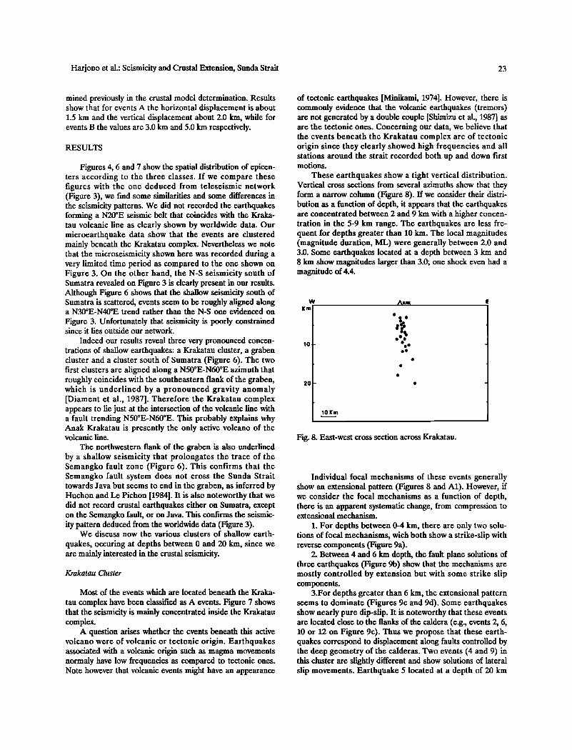
Fig. 7. Epicenters close to the Krakatau complex. Also shown are the two calderas. The thick line corresponds to the older caldera and the thin line to the one resulting from the 1883 explosion (redrawn from Camus and Vincent [1983]). Size of a symbol corresponds to the class of accu- racy.
6.2 ø
Harjono et al.: Seismicity and Crustal Extension, Sunda Strait 23
mined previously in the crustal model determination. Results show that for events A the horizontal displacement is about 1.5 km and the vertical displacement about 2.0 km, while for events B the values are 3.0 km and 5.0 km respectively.
RESULTS
Figures 4, 6 and 7 show the spatial distribution of epicen- ters according to the three classes. If we compare these figures with the one deduced from teleseismic network (Figure 3), we find some similarities and some differences in the seismicity patterns. We did not recorded the earthquakes forming a N20øE seismic belt that coincides with the Kraka- tau volcanic line as clearly shown by worldwide data. Our microearthquake data show that the events are clustered mainly beneath the Krakatau complex. Nevertheless we note that the microseismicity shown here was recorded during a very limited time period as compared to the one shown on Figure 3. On the other hand, the N-S seismicity south of Sumatra revealed on Figure 3 is clearly present in our results. Although Figure 6 shows that the shallow seismicity south of Sumatra is scattered, events seem to be roughly aligned along a N30øE-N40øE trend rather than the N-S one evidenced on
Figure 3. Unfortunately that seismicity is poorly constrained since it lies outside our network.
Indeed our results reveal three very pronounced concen- trations of shallow earthquakes: a Krakatau cluster, a graben cluster and a cluster south of Sumatra (Figure 6). The two first clusters are aligned along a N50øE-N60øE azimuth that roughly coincides with the southeastern flank of the graben, which is underlined by a pronounced gravity anomaly [Diament et al., 1987]. Therefore the Krakatau complex appears to lie just at the intersection of the volcanic line with a fault trending N50øE-N60øE. This probably explains why Anak Krakatau is presently the only active volcano of the volcanic line.
The northwestern flank of the graben is also underlined by a shallow seismicity that prolongates the trace of the Semangko fault zone (Figure 6). This confirms that the Semangko fault system does not cross the Sunda Strait towards Java but seems to end in the graben, as inferred by Huchon and Le Pichon [1984]. It is also noteworthy that we did not record crustal earthquakes either on Sumatra, except on the Semangko fault, or on Java. This confirms the seismic- ity pattern deduced from the worldwide data (Figure 3).
We discuss now the various clusters of shallow earth-
quakes, occuring at depths between 0 and 20 km, since we are mainly interested in the crustal seismicity.
Krakatau Cluster
Most of the events which are located beneath the Kraka-
tau complex have been classified as A events. Figure 7 shows that the seismicity is mainly concentrated inside the Krakatau complex.
A question arises whether the events beneath this active volcano were of volcanic or tectonic origin. Earthquakes associated with a volcanic origin such as magma movements normaly have low frequencies as compared to tectonic ones. Note however that volcanic events might have an appearance
of tectonic earthquakes [Minikami, 1974]. However, there is commonly evidence that the volcanic earthquakes (tremors) are not generated by a double couple [Shimizu et al., 1987] as are the tectonic ones. Concerning our data, we believe that the events beneath the Krakatau complex are of tectonic origin since they clearly showed high frequencies and all stations around the strait recorded both up and down first motions.
These earthquakes show a tight vertical distribution. Vertical cross sections from several azimuths show that they form a narrow column (Figure 8). If we consider their distri- bution as a function of depth, it appears that the earthquakes are concentrated between 2 and 9 km with a higher concen- tration in the 5-9 km range. The earthquakes are less fre- quent for depths greater than 10 kin. The local magnitudes (magnitude duration, ML) were generally between 2.0 and 3.0. Some earthquakes located at a depth between 3 km and 8 km show magnitudes larger than 3.0; one shock even had a magnitude of 4.4.
w E
2O
10Km
ß
ß
ß
ß
Fig. 8. East-west cross section across Krakatau.
Individual focal mechanisms of these events generally show an extensional pattern (Figures 8 and A1). However, if we consider the focal mechanisms as a function of depth, there is an apparent systematic change, from compression to extensional mechanism.
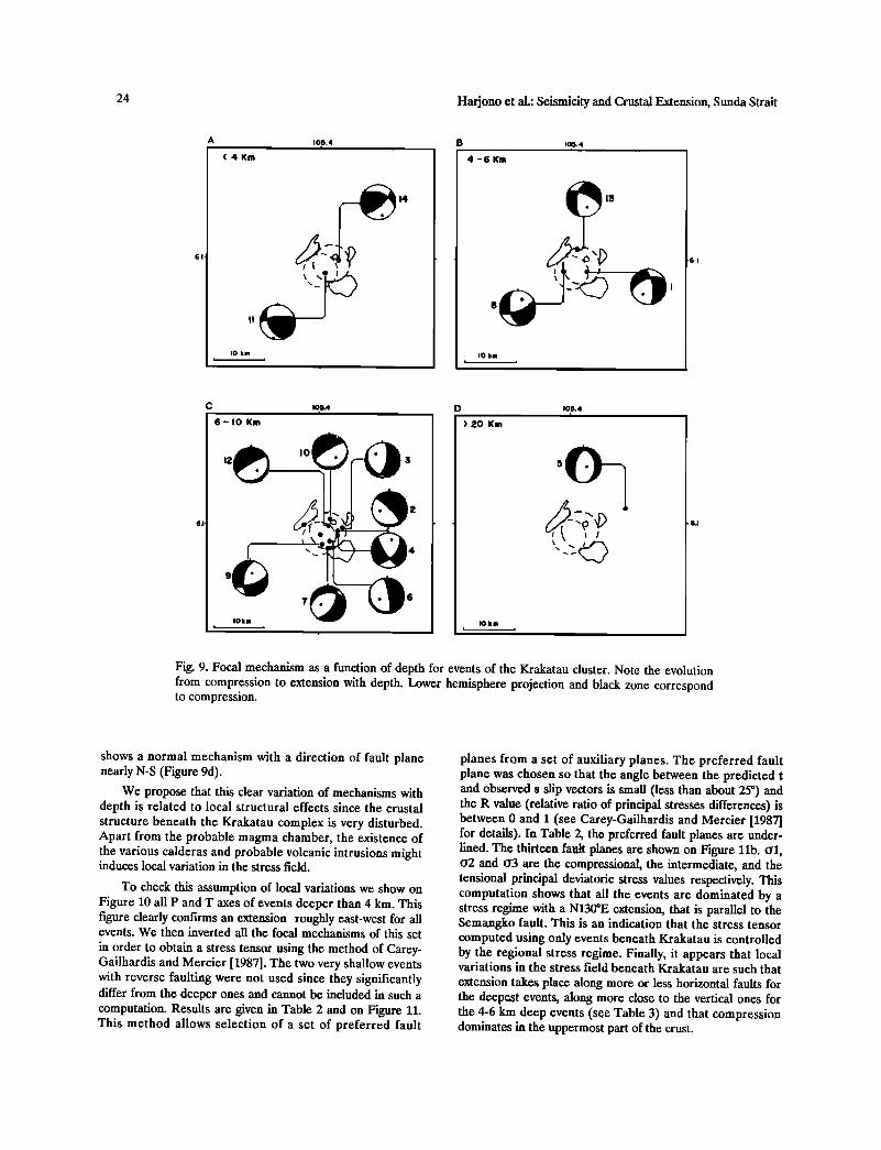
1. For depths between 0-4 km, there are only two solu- tions of focal mechanisms, wich both show a strike-slip with reverse components (Figure 9a).
2. Between 4 and 6 km depth, the fault plane solutions of three earthquakes (Figure 9b) show that the mechanisms are mostly controlled by extension but with some strike slip components.
3.For depths greater than 6 km, the extensional pattern seems to dominate (Figures 9c and 9d). Some earthquakes show nearly pure dip-slip. It is noteworthy that these events are located close to the flanks of the caldera (e.g., events 2, 6, 10 or 12 on Figure 9c). Thus we propose that these earth- quakes correspond to displacement along faults controlled by the deep geometry of the calderas. Two events (4 and 9) in this cluster are slightly different and show solutions of lateral slip movements. Earthquake 5 located at a depth of 20 km
24 Harjono et al.: Seismicity and Crustal Extension, Sunda Strait
A •0,5.4 B • ,o?.4 ( 4 Km 4 - 6 Km
I0 km • ,
14
IO km
6-10 Km
10![4 i
)20 Km
IO km
105.4
5
Fig. 9. Focal mechanism as a function of depth for events of the Krakatau cluster. Note the evolution from compression to extension with depth. Lower hemisphere projection and black zone correspond to compression.
shows a normal mechanism with a direction of fault plane nearly N-S (Figure 9d).
We propose that this clear variation of mechanisms with depth is related to local structural effects since the crustal structure beneath the Krakatau complex is very disturbed. Apart from the probable magma chamber, the existence of the various calderas and probable volcanic intrusions might induces local variation in the stress field.
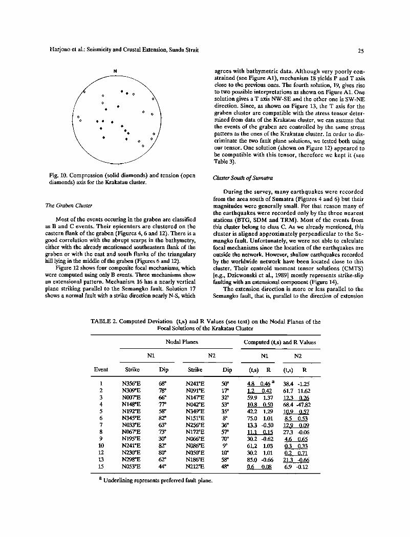
To check this assumption of local variations we show on Figure 10 all P and T axes of events deeper than 4 km. This figure clearly confirms an extension roughly east-west for all events. We then inverted all the focal mechanisms of this set
in order to obtain a stress tensor using the method of Carey- Gailhardis and Mercier [1987]. The two very shallow events with reverse faulting were not used since they significantly differ from the deeper ones and cannot be included in such a computation. Results are given in Table 2 and on Figure 11. This method allows selection of a set of preferred fault
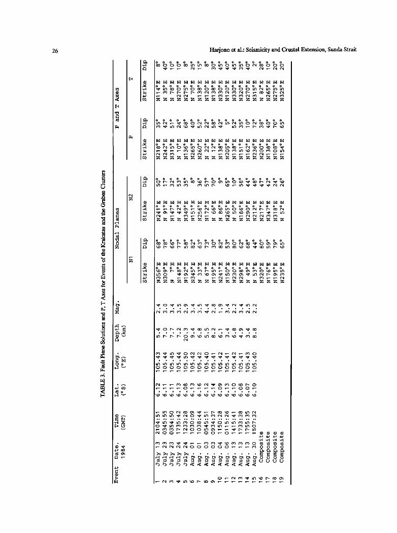
planes from a set of auxiliary planes. The preferred fault plane was chosen so that the angle between the predicted t and observed s slip vectors is small (less than about 25 ø) and the R value (relative ratio of principal stresses differences) is between 0 and ! (see Carey-Gailhardis and Mercier [1987] for details). In Table 2, the preferred fault planes are under- lined. The thirteen fault planes are shown on Figure 11b. O2 and o3 are the compressional, the intermediate, and the tensional principal deviatoric stress values respectively. This computation shows that all the events are dominated by a stress regime with a N130øE extension, that is parallel to the Semangko fault. This is an indication that the stress tensor computed using only events beneath Krakatau is controlled by the regional stress regime. Finally, it appears that local variations in the stress field beneath Krakatau are such that extension takes place along more or less horizontal faults for the deepest events, along more close to the vertical ones for the 4-6 km deep events (see Table 3) and that compression dominates in the uppermost part of the crust.
Harjono et al.: Seismicity and Crustal Extension, Sunda Strait 25
Fig. 10. Compression (solid diamonds) and tension (open diamonds) axis for the Krakatau cluster.
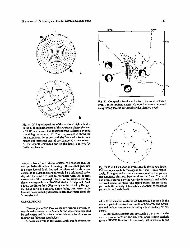
The Graben Cluster
Most of the events occuring in the graben are classified as B and C events. Their epicenters are clustered on the eastern flank of the graben (Figures 4, 6 and 12). There is a good correlation with the abrupt scarps in the bathymetry, either with the already mentionned southeastern flank of the graben or with the east and south flanks of the triangulary hill lying in the middle of the graben (Figures 6 and 12).
Figure 12 shows four composite focal mechanisms, which were computed using only B events. Three mechanisms show an extensional pattern. Mechanism 16 has a nearly vertical plane striking parallel to the Semangko fault. Solution 17 shows a normal fault with a strike direction nearly N-S, which
agrees with bathymetric data. Although very poorly con- strained (see Figure A1), mechanism 18 yields P and T axis close to the previous ones. The fourth solution, 19, gives rise to two possible interpretations as shown on Figure A1. One solution gives a T axis NW-SE and the other one is SW-NE direction. Since, as shown on Figure 13, the T axis for the graben cluster are compatible with the stress tensor deter- mined from data of the Krakatau cluster, we can assume that the events of the graben are controlled by the same stress pattern as the ones of the Krakatau cluster. In order to dis- criminate the two fault plane solutions, we tested both using our tensor. One solution (shown on Figure 12) appeared to be compatible with this tensor, therefore we kept it (see Table 3).
Cluster South of Sumatra
During the survey, many earthquakes were recorded from the area south of Sumatra (Figures 4 and 6) but their magnitudes were generally small. For that reason many of the earthquakes were recorded only by the three nearest stations (BTG, SDM and TRM). Most of the events from this cluster belong to class C. As we already mentioned, this cluster is aligned approximately perpendicular to the Se- mangko fault. Unfortunately, we were not able to calculate focal mechanisms since the location of the earthquakes are outside the network. However, shallow earthquakes recorded by the worldwide network have been located close to this cluster. Their centroid moment tensor solutions (CMTS) [e.g., Dziewonski et al., 1989] mostly represents strike-slip faulting with an extensional component (Figure 14).
The extension direction is more or less parallel to the Semangko fault, that is, parallel to the direction of extension
TABLE 2. Computed Deviation (t,s) and R Values (see text) on the Nodal Planes of the Focal Solutions of the Krakatau Cluster
Nodal Planes Computed (t,s) and R Values
N1 N2 N1 N2
Event Strike Dip Strike Dip (t,s) R (t,s) R
1 N356øE 68 ø N241øE 50 ø 4.8 0.46 a 38.4 -1.25 2 N309øE 78 ø N091øE 17 ø .1...2 0.42 61.7 11,62 3 N007øE 66 ø N147øE 32 ø 59.9 1.37 !2.3 0,26 4 N148øE 77 ø N042øE 53 ø 10.8, 0,50 68.4 .47.82 5 N192øE 58 ø N349øE 35 ø 42.2 1.29 10.9 0.57 6 N345øE 82 ø N151øE 8 ø 75.0 1.01 8.5 0.53
7 N033øE 63 ø N256øE 36 ø !3,3 -0.50 1,2.• 0.09 8 N067øE 73o N172øE 57o ill 0.15 27.3 -0.06 9 N!95øE 30 ø N066øE 70 ø 30,2-0.62 4,6 0.65 10 N241øE 82 ø N086øE 9 ø 61,2 1.03 0,3_. 0,33 12 N230øE 80 ø N050øE !0 ø 30,2 1.01 0.•..• 0,71 13 N298øE 62 ø N!86øE 58 ø 85.0 -0.66 21.3 ..... :0:66 15 N053øE 44 ø N212øE 48 ø 0.6 0.08 6.9 -0.12
a Underlining represents preferred fault plane.
26 Harjono et al.: Seismicity and Crustal Extension, Sunda Strait
••Z•Z•ZZZZZ•ZZ•
•ZZZZZZZZZZZZZZZZZZ
0 0 0 0 0 0 0 0 0 0 0 0 0 0 0
ß -- •-- •-- •-- 0 ',-- •-- •-- ',-- 0 ,,-- •-- 0 0 •--
Harjono et al.: Seismicity and Crustal Extension, Sunda Strait 27
Fig. 11. (a) Superimposition of the tensional right dihedra of the 13 focal mechanisms of the Krakatau duster showing a N130øE extension. The tensional zone is defined by area containing the number 13. The compression is shown by the dotted area, i.e. subvertical. (b) Deduced seismic fault planes and principal axis of the computed stress tensor. Arrows denote computed slip on the faults. See text for further explanation.
computed from the Krakatau cluster. We propose that the most probable direction of faulting is the one that gives rise to a right lateral fault. Indeed the plane with a direction normal to the Semangko Fault would be a left lateral strike slip which seems difficult to reconcile with the dextral movement of the Semangko fault. So, we propose that this duster corresponds to a NW-SE dextral strike slip fault. Such a fault, the Batee fault (Figure 1) was described by Karig et al. [1980] north of Sumatra. These faults, transverse to the fore-arc basin probably delineate blocks that rotate along the Semangko fault.
CONCLUSIONS
The analysis of the local seismicity recorded by a micr- oearthquake survey in the Sunda Strait area complemented by bathymetry and data from the worldwide network allow us to draw the following conclusions:
1. Seismic activity in the Sunda Strait area is concentrat-
104OE 106øE
_ - 5ø$
•' •8 •
!
eFivge •;s2• •2•hl•t pgO r Sai• •nf •l•lst •r•Cchoann•t fe• r2eør7 • o s e2;uCtt• using closely located earthquakes with identical depth.
N
Fig. 13. P and T axis for all events inside the Sunda Strait. Full and open symbols correspond to P and T axes respec- tively. Triangles and diamonds correspond to the graben and Krakatau clusters. Squares show the P and T axis of one event recorded by the worldwide network and which occurred inside the strait. This figure shows that the stress pattern in the vicinity of Krakatau is identical to the stress pattern in the Sunda Strait.
ed in three clusters centered on Krakatau, a graben in the western part of the strait and south of Sumatra. The Kraka- tau and graben dusters are linked by a fault striking N50øE - N60øE.
2. Our results confirm that the Sunda Strait area is under an extensional tectonic regime. The stress tensor analysis gives a N130øE direction of extension, that is parallel to the

28 Harjono et al,: Seismicity and Crustal Extension, Sunda Strait
104 • 105 • lOG • , ', , , ,
zo SUMATRA 12127185 {
I 39 618184
1213185
ltat• / JAVA 10122187 21 3125186 •//•.•.,,..•.._•,
20km
12114185
Fig. 14. Harvard centroid moment tensor solutions (CMTS) for the duster south of Sumatra [e.g. Dziewonski et al., 1989]. Numbers give the depth (in km).
Semangko fault. This crustal stretching should be a result of the NW movement of the Sumatra fore-arc plate (sliver plate) [Huchon and Le Pichon, 1984; Jarrard, 1986]. This result agrees with other geophysical data such as seismic reflection [Lassal et al., 1989].
3. Seismicity south of Sumatra is interpreted as a fault transverse to the fore arc basin. But, obviously, an additional survey which would also involve ocean bottom seismographs is necessary in order to better constrain that seismicity.
4. As a consequence of the crustal extension, the Sunda Strait is characterized by important volcanic activity as shown by large deposits of Quaternary material [Nishimura et al., 1986]. The fact that Krakatau differs from volcanoes common elsewhere in Indonesia can be related to the specif- ic, extensional, tectonic setting. The existence of the presently active Anak Krakatau also appears as a consequence of its location as the intersection of an active fault with the volcanic
line running from Panaitan to Rajabasa. 5. Seismicity beneath the Krakatau complex is controlled
by the regional stress field but we find a variation with depth that we relate to local effects.
Acknowledgments. We dedicate this work to Jean Bloyet, who enthusiastically participated in the field work and the preliminary interpretations. We thank M. R6gnier (ORSTOM), C. Jouannic (ORSTOM), I. Suhardi (BPPT), and S. Wirasantosa and M. E. Arsadi from Puslitbang, Geoteknologi-LIPI for their assistance during the survey and in arranging the field work. We also thank the technician group of Puslitbang Geoteknologi-LIPI (A. Sanyoto, D. Rahayu, Suyatno, Y. Sudrajat, E, Junaidi, D, Rusmana,
1 2 3 4
9 10
13 14
11 12
16 17 18 19
Fig. A1. Lower hemisphere equal area fault plane solution as shown in Figures 9 and 12. Compressional and dilata- tional first motions are shown as full and open circles respectively. The squares represent the direct waves and dots the refracted waves.
Jusuf, Eman D. Ruswandi, A. Tatang and Sardiman) for their help in operating the seismographs and thank the people of the area of the survey and the telecommunication stations of Tanjung Karang and Cilegon, Krakatau Observa- tory in Pasauran and PPA Ujung Kulon. We acknowledge D. Hatzfeld, who supplied us five MEQ instruments and the Volcanological Survey of Indonesia (VSI) and the Indonesian Meteorology and Geophysical Agency (BMG) for providing data of KRK and KLI. We thank E. Carey-Gailhardis for discussions and for providing a program for tensor analysis. The manuscript benefited of discussions with C. Deplus, J. Deverch•re, O. Lassal, P. Tucholka and from extensive and detailed reviews by H. Lyon-Caen and D. Hatzfeld. Figure 14 was drawn after original figures produced at I.P.G. Paris using a software program of G. Ekstr6m. This work was suported by A.T.P. "G6ologie et G6ophysique des Oc6ans" of C.N.R.S, IFREMER, ORSTOM, LIPI (Indonesian Institute of Sciences) and BPP. Teknologi (Agency for the Assessment and Application of Technology).

Harjono et al.: Seismicity and Crustal Extension, Sunda Strait 29
REFERENCES
Beck, Jr., M.E., On the mechanism of tectonic transport in zones of oblique subduction, Tectonoœhysics, 93, 1-11, 1983.
Camus, 6., and P. Vincent, Un si•cle pour comprendre l'Gruption du Krakatao, La Recherche, 149, 1452-1457, 1983.
Camus, G., A. Gourgaud, and P.M. Vincent, Petrologic evolution of Krakatau (Indonesia): Implication for a
future activity, J. Volcanol. Geotherm. Res., 33, 299-316, 1987.
Carey-Gailhardis, E. and J.L. Mercier, A numerical method for determining the state of stress using focal mechanisms of earthquake populations: Aplication to Tibetan tele- seisms and microseismicity of Southern Peru, Earth Planet. Sci. Lett., 82, 165-179, 1987.
Deplus, C., Comportement mGcanique de la lithosphere ocGanique: Cas d'une subduction complexe, Ph.D. thesis, Universit6 de Paris Sud, Orsay, 1987.
Diament, M., C. Deplus., M. Larue., P. Tucholka, H. Harjono, P.Kimpouni, C. Mercier, G. Okemba and J.-P. Quetier, Seasat altimetry, marine gravity and magnetism between Java and Sumatra, in Proceedings Indonesia- France Seminar on Sunda Strait, pp. 35-44, BPPT, Jakar- ta, 1987.
Dziewonski, A. M, G. EkstrGm, J.H. Woodhouse and G. Zwart, Centroid-moment tensor solutions for October- December 1988, Phys. Earth Planet. Inter., 57, 179-191, 1989.
Fatwan, S., Pendugaan lapisan bawah tanah permukaan dengan metoda seismik bias di daerah Selat Sunda, S1 Thesis, institut Teknologi Bandung, 1983.
Fitch, T.J., Plate convergence, transcurrent faults, and inter- nal deformation adjacent to Southeast Asia and western Pacific, J. Geophys. Res., 77, 4432-4460, 1972.
Fitch, T.J. and P. Molnar, Focal mechanisms along inclined earthquake zones in the Indonesian-Philippine region, J. Geoœhys. Res., 75, 1431-1444, 1970.
Hamilton, W., Earthquake map of the Indonesian region, U.S. Geol. Surv. Misc. Inv. Set. Map 1-875-C, 1974.
Hamilton, W., Tectonics of the Indonesian region, U.S. Geol. Surv. Prof. Pap., 1078, 345 pp., 1979.
Hatzfeld, D., S.W. Roecker, J. Nabelek and B. Tucker, Seismicity in the Garm region of Central Asia: Deforma- tion in a zone of continental convergence, Ann. Geophys., 4B, 555-566, 1986.
Hatzfeld, D., A•. Christodoulou, E.M. Scotdills, D. Panagi- otopoulos, and P.M. Hatzidimitriou, A microearthquake study of the Mygdonian graben (northern Greece), Earth Planet. Sci. Lett., 81, 379-396, 1987.
Huchon, P., and X. Le Pichon, Sunda Strait and Central Sumatra Fault, Geology, 12, 668-672, 1984.
Jarrard, R.D., Relations among subduction parameter, Rev. Geophys., 24, 217-284, 1986.
Karig, D.E., M.B. Lawrence, G.F. Moore and J.R. Curray, Structural framework of the fore-arc basin, NW Sumatra, J. Geol. Soc. London, 137, 1-15, 1980.
Katili, J.A., and F. Hehuwat, On the occurrence of large transcurrent faults in Sumatra, Indonesia, J. Geosci. Osaka City Univ., 10, 1-17, 1967.
Kieckhefer, R.M., Geophysical studies of the oblique subduction zone in Sumatra, Ph.D Thesis, 119 pp., Univ. of Calif., San Diego, 1980.
Kiratzi, A.A., E.E. Papadimitriou, and B.C. Papazachos, A microearthquake survey in the Steno dam site in north- western Greece. Ann. Geophys., 5B, 191-166, 1986.
Klein, F.W., Hypocenter Location Program: Hypoinverse, U.S. Geol. Surv., Open File Rep., 78-694, 113 pp., 1978.
Lassal, O., P. Huchon and H. Harjono, Extension crustale dans le d6troit de la Sonde (Indon6sie): Donn6es de la sismique r6flexion (Campagne Krakatau), C. R. Acad. Sci., Ser. 2, 309,, 205-212, 1989.
McCaffrey, R., P. Molnar, and S.W. Roecker, Microearth- quake seismicity and fault plane solution related to arc- continent collision in the eastern Sunda arc, Indonesia, J. Geophys. Res, 90, 4511-4528, 1985.
Minikami, T., Seisinology of volcanoes in Japan, in Physical Volcanology, edited by L. Civetta, P. Gasparini, G. Luongo and A. Rapolla, pp. 1-27, Elsevier, New York, 1974.
Minster, J.B., and T.H. Jordan, Present-day plate motion, J. Geophys. Res., 83, 5331-5354, 1978.
Molnar, P. and P. Tapponnier, Cenozoic tectonics of Asia: Effects of continental collision, Science, 189, 419-426, 1975.
Newcomb, K.R., and W.R. McCann, Seismic history and seismotectonic of the Sunda Arc, J. Geophys. Res., 92, 421-439, 1987.
Ninkovich, D., Late Cenozoic clockwise rotation of Sumatra, Earth Planet. Sci. Lett., 29, 269-275, 1976.
Nishimura, S., J. Nishida, T. Yokoyama, and F. Hehuwat, Neo-tectonics of the Strait of Sunda, Indonesia, J. South- east Asian Earth Sci, 1, 81-91, 1986.
Noujaim, A.K., Drilling in a high temperature and over- pressured area Sunda Straits, Indonesia, in Proceedings of Fifh Annual Convention, pp.211-214, Indonesian Petrole- um Association, Jakarta, 1976. ß
Raitt., R.W., Marine seismic studies of the Indonesian island arc (abstract), Eos Trans. AGU, 48, 217, 1967.
Sclater, J.G. and R.L. Fisher, Evolution of the east-central Indian Ocean, with 'emphasis on the tectonic setting of the Ninety-East Ridge. Geol. Soc. Am. Bull., 85, 683-702, 1974.
Soeria-Atmadja, R., R.C.Maury, H. Bougault, J.L. Joron, H. Bellon, and D. Hasanuddin, Pr6sence de tholelites d'arrib•re-arc Quarternaires en Indon6sie: Les basaltes de
Sukadana (Sud de Sumatra) (abstract), in R6union des Sciences de la Terre, Clermont-Ferrand, 1986.
Shimizu, H., S. Ueki, and J. Koyama, A tensile-shear crack model for the mechanism of volcanic earthquakes, Tecto- nophysics, 144, 287-300, 1987.
Tapponnier, P., G. Peltzer, A.Y. Le Dain, R. Armijo, and P. Cobbold, Propagating extrusion tectonics in Asia: New insights from simple experiments with plasticine, Geology, 10, 611-616, 1982.
Untung, M. and Y. Sato, Gravity and Geological Studies #t Java, Geoligical Survey of Indonesia and Geological Survey of Japan, 207 pp., 1978.
Van Bemmelen, R.W., The Geology of Indonesia, Govern- ment Printing Office, The Hague, 732 pp., 1949.

30 Harjono et al.: Seismicity and Crustal Extension, Sunda Strait
Zen, M.T., Krakatau and the tectonic importance of Straits of Sunda, Bul. Jurusan Geol., 12, 9-22, 1983.
M.T. Zen, Laboratorium Geofisika, Jurasan Geologi, Institut Teknologi Bandung, J1. Ganesha 10, Bandung 40132, Indonesia.
M. Diament, J. Dubois, H. Harjono and M. Larue, Laboratoire de G6ophysique (URA du CNRS 1369), B•t. 509, Universit6 Paris Sud, 91405 Orsay-Cedex, France.
(Received November 17, 1988; revised January 24, 1990; acc•'pted January 25, 1990.)