seismological grand challenges in understanding … · • evolution and coupling of the...
TRANSCRIPT
1
Seismological Grand Challenges in Understanding
Earth’s Dynamic Systems
2
Prepared by the Seismological Grand Challenges Writing Group
Thorne Lay, Editor
Richard C. Aster, workshop tri-chair Donald W. Forsyth, workshop tri-chair
Barbara Romanowicz, workshop tri-chair Richard M. Allen
Vernon F. Cormier Joan Gomberg John A. Hole Guy Masters Derek Schutt
Anne Sheehan Jeroen Tromp
Michael E. Wysession
December 2008
This report is drawn from the many presentations and discussions at the September 18-19, 2008 workshop on a Long Range Science Plan for Seismology (LRSPS), held in Denver and attended by ~120 members of the seismological and geophysical research community. Financial support for the LRSPS Workshop was provided by the National Science Foundation (NSF). Logistical support for the LRSPS Workshop and for preparation and dissemination of this report were provided by the Incorporated Research Institutions for Seismology (IRIS). Initial drafts of this report were openly available and commented on by the seismological community. This final report is being submitted to the NSF and other Federal agencies.
3
Table of Contents
Executive Summary ………………………………………………………………..…………… 1
Introduction – The Seismological Discipline…..……………………………..…………….. 5
Grand Challenges for Seismology………………………………………………………...…. 14
Grand Challenge 1: The Physics of Fault Failure …………………….....………. 14
Grand Challenge 2: The State of Stress and Rheology in the Crust and
Mantle …….……………………………………………………………..…….. 25
Grand Challenge 3: Physical Coupling of the Atmosphere/Ocean/Solid Earth
Systems…………………………………………………………………………. 31
Grand Challenge 4: Critical Interfaces and Seismic Waves in the Near-Surface
Environment…………………………………………………………………… 38
Grand Challenge 5: Distribution and Circulation of Fluids and Volatiles in
Earth’s Interior……………………………………………………………….. 46
Grand Challenge 6: Magma Dynamics in Earth’s Interior…………..………….. 54
Grand Challenge 7: Evolution and Coupling of Lithosphere and
Asthenosphere ………………………………………………………………... 61
Grand Challenge 8: Dynamical Systems at Plate Boundaries…………………… 68
Grand Challenge 9: Thermo-Chemical Structures and Dynamics of the Mantle
and Core………………………………………………………………………. 74
Grand Challenge 10: Earth’s Internal Boundary Layer Processes………….… 82
Sustaining a Healthy Future for Seismology ………………………………………..……... 88
Summary ……………………………………………………………………………..….…..…. 95
Appendix
Key Seismological Practices………….……………………………………………………... 96
Monitoring Dynamic Processes in Earth’s Environment……………………….. 96
Multi-scale 3D and 4D Imaging and Modeling of Complex Earth Systems..… 99
Recommended Additional Reading ………………………………………………………… 102
List of Acronyms and Titles ……………………………………………………………….… 103
1
Executive Summary Seismology, the study of Earth’s elastic vibrations, the sources that generate them, and
the structures through which they propagate, is a geophysical discipline that has a
remarkable diversity of applications to critical issues facing society and plays a leading
role in addressing key scientific frontiers involving Earth’s dynamic systems. Seismology
enjoys quantitative foundations rooted in continuum mechanics, elasticity, and applied
mathematics. Modern seismological systems utilize state-of-the-art digital ground motion
recording sensors, real-time communications systems, and openly accessible data
archives.
Seismologists ‘keep their ear’ on Earth’s internal systems, listening for signals arising
from both natural and human-made energy sources distributed around the globe. These
seismic signals contain a wealth of information that enables seismologists to quantify the
active wave sources and to determine structures and processes at all depths in the
planetary interior at higher resolution than is possible by any other approach, revealing
both present day and multi-billion year old dynamic events. Recent breakthroughs in
theory and data processing now allow every byte acquired of continuous seismological
data to be used for imaging sources and structures in the dynamic system, even extracting
coherent signal from what had previously been dismissed as background noise. Ground
motion recordings are intrinsically multi-use; seismic data collected to monitor any
specific Earth phenomenon, for example, underground nuclear tests, can also directly
advance studies of earthquake sources or deep Earth structure. This multi-use attribute of
seismic data places great value in the prevailing philosophies of open data access and
real-time data collection embraced by the U.S. seismological research community and
many of its international partners.
A rich panoply of societal applications of Seismology has emerged directly from basic
research programs focused on understanding Earth’s internal wave sources and structure.
Seismology plays central roles in energy and resource exploration, earthquake detection
and quantification, volcanic-eruption and tsunami-warning systems, nuclear testing
monitoring and treaty verification, aquifer characterization, earthquake hazard assessment
2
and strong ground motion prediction for the built infrastructure, including lifelines and
critical facilities. Seismology provides unique information about glacier systems,
landslide mass movements, the ocean wave environment, containment of underground
wastes, carbon sequestration and other topics relevant to climate and environmental
change.
A 2008 workshop on seismological research frontiers, funded by the National Science
Foundation (NSF), considered promising research directions for the next decade or two
and defined the following 10 Seismological Grand Challenge research topics:
• The physics of fault failure
• The state of stress and rheology of the crust and mantle
• Physical coupling of the atmosphere/ocean/solid Earth systems
• Critical interfaces and seismic waves in the near-surface environment
• Distribution and circulation of fluids and volatiles in Earth’s interior
• Magma dynamics in Earth’s interior
• Evolution and coupling of the Lithosphere and Asthenosphere
• Dynamical systems at plate boundaries
• Thermo-chemical structures and dynamics of the mantle and core
• Earth’s internal boundary layer processes
Further seismological research on these topics will both address fundamental problems in
understanding how Earth systems work and augment applications to societal concerns
about natural hazards, energy resources, environmental change, and national security.
Seismological contributions, research frontiers and required infrastructure for progress on
these 10 Seismological Grand Challenge topics are described in this report. Selected
examples of recent research advances are used to highlight rapid progress, outstanding
challenges, and diverse applications of Seismology for studying Earth’s dynamic
systems. The essence of associated seismological practices and approaches are further
defined in an appendix by discussion of two key disciplinary practices: (1) Monitoring
the full diversity of dynamical processes in Earth’s environment including human-
3
induced sources and processes and (2) Multi-scale 3D and 4D imaging and modeling of
Earth’s complex systems.
Maintaining a healthy national research capability in Seismology to pursue the many
societally-important applications of the discipline and to address the ten Grand Challenge
topics requires sustained and expanded support of seismic data acquisition, archival, and
distribution facilities. Global and regional seismological observatories with a
commitment to long-term operation, and pools of portable instruments for shorter-term
land- and sea-based deployments provide key observations essential to tackling the Grand
Challenges. The sparse instrumental coverage of the vast areas of unexplored ocean floor
needs to be expanded. Source facilities for controlled-source seismic data acquisition are
essential to support crustal reflection and refraction imaging, including marine airguns,
explosions in boreholes and vibrating trucks. Cooperation between academic,
government and industry efforts in controlled-source seismology must be enhanced to
support the Grand Challenge efforts. Completion of the planned deployment of the
EarthScope Transportable Array across the conterminous U.S. and Alaska is important
for achieving the manifold science goals of that major NSF program. International
participation in open seismic data exchange for diverse seismic networks around the
world must be diplomatically pursued and expanded. Interdisciplinary workshops
addressing critical problems of the near-surface environment should be promoted, with
active seismological participation.
Many of the government and private sector users of Seismology are now confronted with
serious workforce issues. Expanded efforts to attract quantitatively-oriented, diverse
graduate students to the discipline are required. This should be abetted by building on
current education and outreach efforts of the seismological community, and by
developing stronger partnerships between academic, industry and government
laboratories impacted by the workforce issue.
Seismology holds great promise for achieving major new breakthroughs on the
Seismological Grand Challenge topics and associated societal benefits over the next few
4
decades, as long as Federal agencies and industry continue to invest in the basic research
programs and infrastructure for this burgeoning geophysical discipline. With the well-
established practices of open data sharing and the multi-use aspect of all seismic data,
bountiful return on investments in seismological infrastructure and training is assured.
As progress on the Seismological Grand Challenges is made, the fundamental
understanding of Earth’s dynamic systems that is gained will advance the sustainability
and security of human civilization, along with satisfying our deep curiosity about how
planet Earth works.
5
Introduction - The Seismological Discipline
The ground beneath our feet usually seems solid and unmoving, but in reality it is in a
constant state of vibration; only intermittently are the motions strong enough for human
perception. Sensible motions may involve small vibrations from a large truck passing
nearby or possibly shaking from a distant earthquake. On rare occasions, the ground
moves violently, causing catastrophic loss of life as buildings collapse and Earth’s
surface is disrupted. These ground motions originate in the rocky interior of the Earth by
various processes that suddenly release stress, such as rapid sliding motions across a
fault, producing propagating disturbances that expand outward from the energy source
through the surrounding rocks as elastic P-waves and S-waves that reach and shake the
surface. About 140 years ago, scientists first invented instruments to record seismic
vibrations of the ground as a function of time, and theoreticians drew upon solid
mechanics and elasticity to develop deep understanding of elastic waves. Thus
commenced the discipline of Seismology, which involves the study of seismic waves,
their sources, and the medium in which they propagate. Because it is a discipline that
infers source and structural information from remotely observed data, the field has driven
numerous mathematical methods for inversion and inference. Seismology provides
quantitative models for structures and sources that guide many multidisciplinary Earth
Science research and monitoring efforts. During the 20th century the discipline grew into
a major international endeavor, developing a tremendous panoply of applications of
Earth’s vibrations to study both the dynamic sources of the seismic waves and the
characteristics of the rocks through which they transmit along with myriad industrial,
societal and scientific subfields.
Placing ground motion sensors, or seismometers, on the Earth’s surface is akin to putting
stethoscopes on the Earth system and listening for the internal rumblings and gurglings of
the planet’s internal processes. Over the past century seismologists have learned to
unravel the rich information contained in seismograms, applying quantitative elastic
wave theory to accumulating databases and distilling meaningful information from the
cacophony of seismic motions. Classic seismological applications include systematic
location and quantification of earthquakes and construction of models for Earth’s elastic
6
wave properties as functions of depth from the surface to the center of the Earth. This
dual effort to study both earthquake sources and Earth structure is now mature and still
frames the discipline.
Controlled human-created energy releases, such as buried explosions, underwater airguns
and large vibrating trucks, provide seismic wave sources at Earth’s surface that illuminate
the shallow crust with elastic waves. These active source techniques are analogous to
ultrasound methods used in medial imaging, and provide very high resolution of
subsurface conditions and detection of energy and mineral resources. Seismology
intrinsically provides unparalleled resolution of physical properties in the inaccessible
interior from the crust to the core. Seismic imaging of fossil fuel bearing geologic
structures is essential to discovering, exploiting, and managing essential energy resources
that power global civilization. When nuclear testing moved underground during the Cold
War, Seismology assumed a key role in treaty verification and in remote monitoring of
weapons development programs.
With these new roles in hydrocarbon exploration and national security monitoring efforts
complementing earthquake studies and Earth structure research, Seismology rapidly grew
into a major high-tech research discipline. Today, global seismometer networks transmit
ground motion recordings from around the world in real time via satellite, microwave or
internet telemetry to data analysis centers. Automated computer processing of the signals
by many government agencies and research programs produces rapid bulletins of global
seismic sources and prompt information for disaster mitigation as essential aspects of
continuous monitoring of the Earth system. Large-scale deployments of land- and sea-
based instruments utilize both active human-made sources and passive natural sources of
seismic waves, revealing multi-scale structures of the crust and deep Earth. Massive on-
line data repositories freely provide the data to researchers, enabling research and
monitoring applications across academic, government, and commercial sectors. The size
and complexity of seismic wave processing and modeling efforts combined with very lare
seismic data sets has placed Seismology as a primary driver of high performance
computing at universities, national laboratories and industry for many decades.
7
A defining attribute of seismograms is that they are simply records of ground motion as
function of time. Thus, seismic data recorded by a network of seismometers for any
particular purpose (e.g., monitoring nuclear testing or earthquake hazard analysis),
intrinsically provide signals that are valuable for multiple unrelated uses. One can
equally-well study Earth structure, earthquakes, explosions, volcanic eruptions and other
processes with the same seismograms. Studying the diverse Earth systems requires
globally-distributed sensors and international collaborations on data acquisition and
exchange. The multi-use attribute of seismic signals places great premium on
continuously recording ground motions over as wide as possible of a frequency band,
archiving all recordings in accessible formats, and openly sharing the data between
nations and institutions, no matter what the original motivation was for deploying the
seismic instrumentation. The U.S. seismological community, and its international
partners in the Federation of Digital Seismic Networks (FDSN), have strongly fostered
this framework of open-access of seismic data, establishing data centers that are
accessible to all researchers. Because the data play critical roles in rapid evaluation of
short-term changes in the Earth’s dynamic systems (e.g., earthquakes, tsunamis, volcanic
eruptions, explosions, mine collapses, rock bursts, landslides, etc.), near real-time access
to seismic data is also of great importance; whenever it is possible to transmit the ground
motion data to open archives in real-time, multiple societal applications of the signals are
enabled.
By its very nature, Seismology is intrinsically sensitive to many active, dynamic
processes happening today in the Earth’s dynamic systems, and the discipline has
expanded its scope to sensing and characterizing numerous aspects of environmental
change and near-surface processes, including ground water conditions, glacial motions,
storm migration, the ocean wave environment, and oceanic circulation. Much of modern
Earth science research addresses complex physical systems that involve interfaces
between multiple disciplines, Seismology offers powerful tools for remote sensing of
structures and sources that complement other approaches. This central importance of
Seismology is noted in many major scientific planning documents (e.g., BROES, 2001;

8
IUGG, 2007), and an alphabet soup of research community organizations (CIDER,
COMPRES, CSEDI, FDSN, IASPEI, IAVCEI, IRIS, Margins, RIDGE, SCEC,
UNAVCO – all acronyms are defined at the end of the report) engage seismologists with
synergistic disciplines in mineral physics, geodynamics, volcanology, geology, and
increasingly oceanography, hydrology, glaciology, and atmospheric sciences.
This centrality of Seismology in Earth science and monitoring engages multiple U.S.
Federal agencies in supporting the discipline, including the NSF, the United States
Geological Survey (USGS), the National Oceanic and Atmospheric Administration
(NOAA), the Department of Energy (DOE), the Department of Defense (DoD), the
Federal Emergency Management Agency (FEMA), and the National Aeronautics and
Space Administration (NASA). This diversity of supporting agencies has benefited the
discipline immensely, and reflects the multi-use nature of seismological data. U.S.
Seismology is deeply engaged in international activities such as the International
Monitoring System (IMS) of the Comprehensive (Nuclear) Test Ban Treaty Organization
(CTBTO), and the Global Earth Observations System of Systems (GEOSS), placing the
discipline in high-level, politically influential roles.
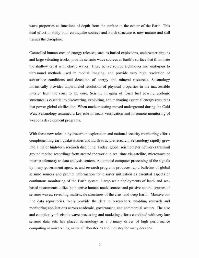
FIG. The cumulative volume of seismic data archived at the IRIS Data
Management Center (top) for major seismic networks totals 81.3 terabytes
as of August 2008. The annual number of terabytes shipped from the IRIS
9
DMC (bottom) for the same seismic network types is twice as much data
as new data arriving at the DMC, and will total more than 35 terabytes to
end users in 2008. (Image courtesy of T. Ahern).
One sign of a healthy scientific enterprise is the degree to which it is undergoing major
advances and paradigm shifts. As manifest in this report, Seismology is a dynamic and
energized field, with a continually expanding portfolio of important contributions.
Examples of recent transformative developments in the discipline include the following:
• Creation of the open-access on-line seismic data repository of the Incorporated
Research Institutions for Seismology (IRIS) Data Management System (DMS).
This facility, housing terabytes of data freely delivers seismic data to the entire
world, an approach being emulated internationally. Providing all researchers with
access to data enables proliferating discoveries and societal applications.
• The discovery of coherent information contained in recorded seismic ‘noise’. The
background vibrations of the Earth contain information about sources and
structures that was not recognized until recently. Processing of multiple station
data allows every data byte to be used for scientific application, and entirely new
approaches to structural studies and investigations of changes in the environment
have merged.
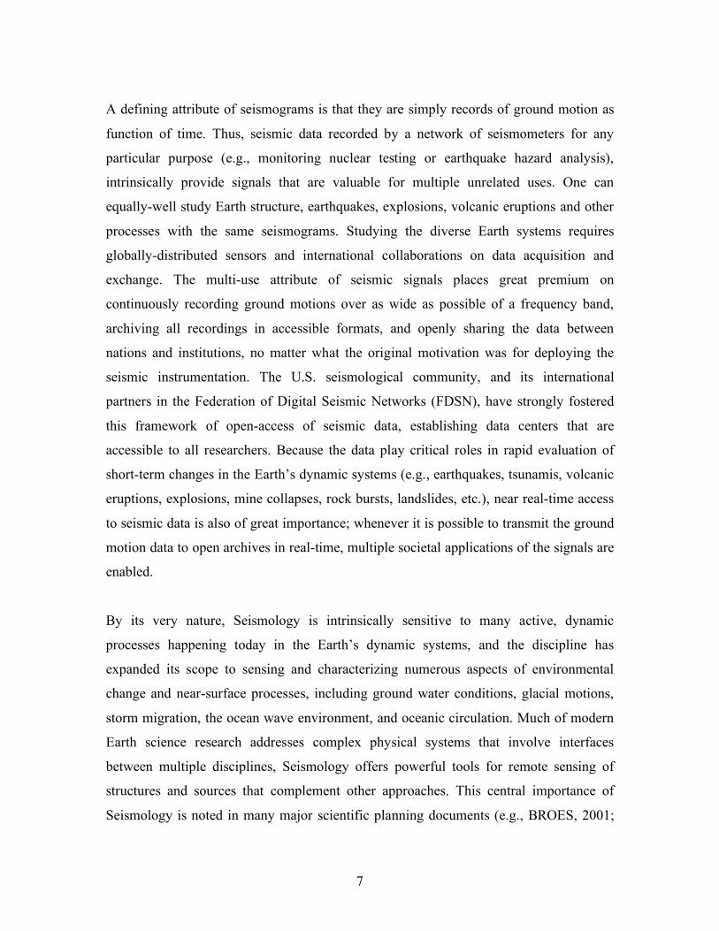
FIG. 2. Rayleigh wave group velocity map for 8 sec period waves derived
from more than 60,000 measurements. By cross-correlating up to three
10
years of continuous data from 512 western USA stations including the
EarthScope USArray Transportable Array and regional seismic networks,
inter-station empirical Green's functions for all available station pairs were
recovered and inverted for regional seismic velocity structure. Thick black
lines define the major tectonic boundaries in the region. (Image courtesy
of M. P. Moschetti, M. H. Ritzwoller, and N. M. Shapiro).
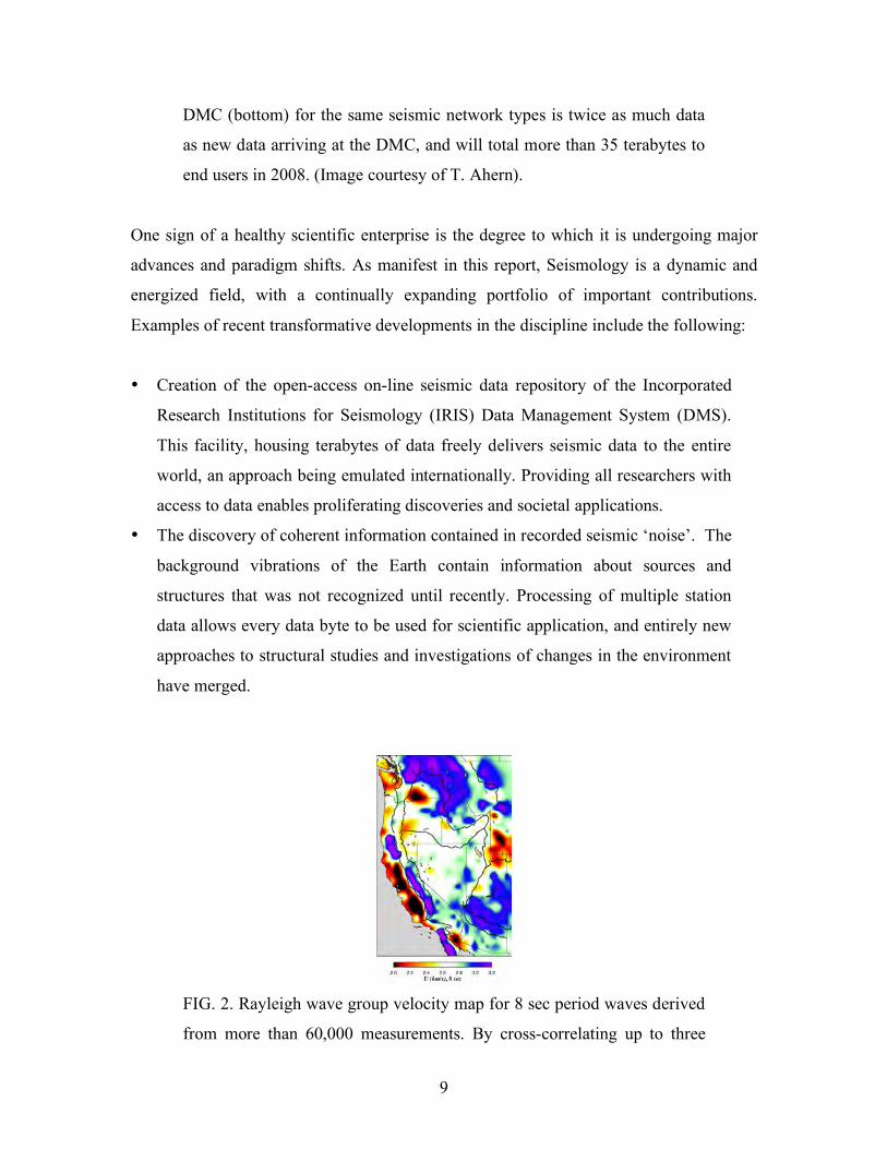
FIG. 3. The 2001 Kokoxili (Mw 7.8) earthquake ruptured about 400
km of the Kunlun fault in northern Tibet and is one of the longest
strike-slip events recorded by modern seismic networks. The
contours indicate the intensity of high-frequency seismic radiation as
imaged using back-projection of globally recorded P waves, with the
strongest regions plotted in red. Analysis shows that the rupture
propagated at ~2.6 km/s for the first 120 km and then accelerated to
~5.7 km/s, a super-shear (faster than S-wave speed) velocity which
continued for at least 290 km from the epicenter. (Image courtesy of
K. T. Walker and P. M. Shearer).
• Recent discovery of a continuous spectrum of faulting behavior, ranging from
conventional earthquakes, some of which rupture at great speeds (including super-
shear velocities) and some of which involve anomalously slow ruptures, some so
slow that fault sliding does not even radiate detectable seismic waves. This has
11
unified seismic and geodetic monitoring of fault zones and provides significant
new insights into frictional sliding and earthquake hazard.
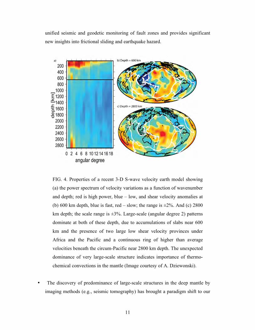
FIG. 4. Properties of a recent 3-D S-wave velocity earth model showing
(a) the power spectrum of velocity variations as a function of wavenumber
and depth; red is high power, blue – low, and shear velocity anomalies at
(b) 600 km depth, blue is fast, red – slow; the range is ±2%. And (c) 2800
km depth; the scale range is ±3%. Large-scale (angular degree 2) patterns
dominate at both of these depth, due to accumulations of slabs near 600
km and the presence of two large low shear velocity provinces under
Africa and the Pacific and a continuous ring of higher than average
velocities beneath the circum-Pacific near 2800 km depth. The unexpected
dominance of very large-scale structure indicates importance of thermo-
chemical convections in the mantle (Image courtesy of A. Dziewonski).
• The discovery of predominance of large-scale structures in the deep mantle by
imaging methods (e.g., seismic tomography) has brought a paradigm shift to our
12
understanding of mantle convection and thermal evolution of the Earth’s deep
interior, with new emphasis on thermo-chemical dynamics.
• Project EarthScope, a major research effort coordindated by the NSF is
accumulating unprecedented spatial coverage of seismic and geodetic
observations across North America, revealing remarkable crustal and lithospheric
structures that are divulging secrets of continental evolution.
• The emergence of quantitative physics-based predictions of surface ground
motions using realistic dynamic fault rupture models and 3-D geological
structures has begun to transform earthquake hazard analysis,
complementing the emergence of performance-based earthquake
engineering.
• The great 2004 Sumatra earthquake-generated tsunami reaffirmed the
catastrophic potential of natural events and the need for early warning
systems. Automated data collection and processing are enabling near real-
time responses to earthquake occurrence, including seismic shaking and
tsunami warning systems that have potential to save many lives in the
future.
13
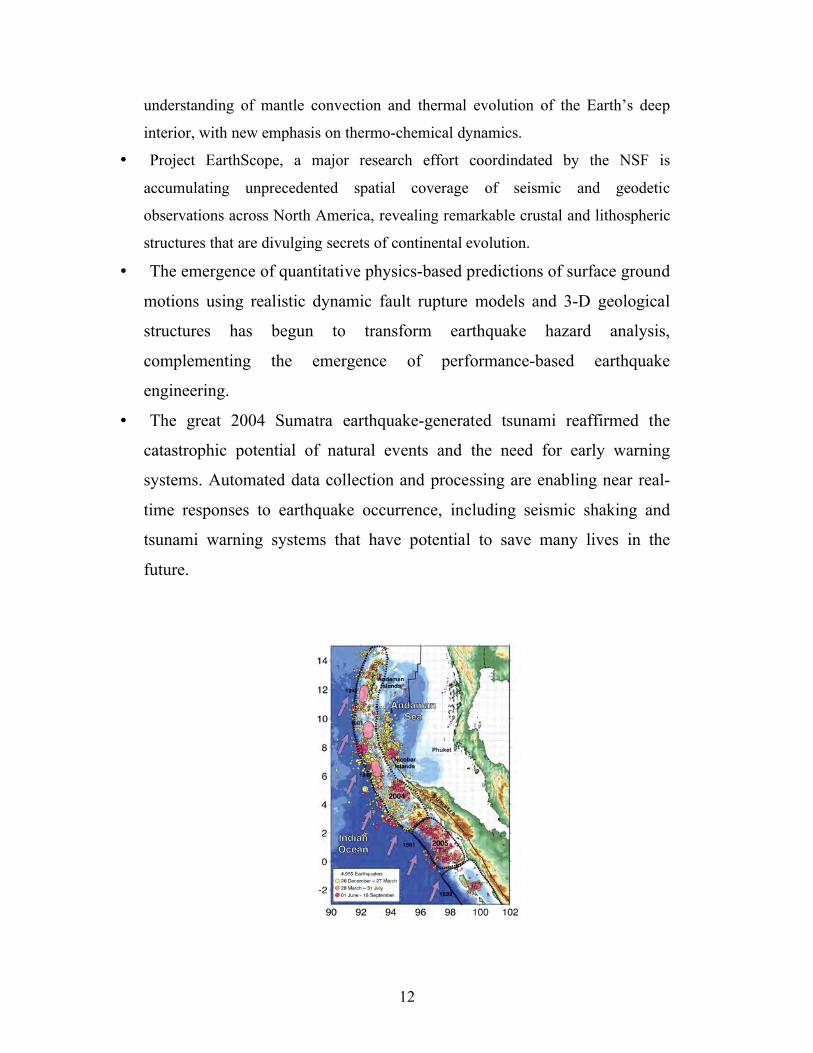
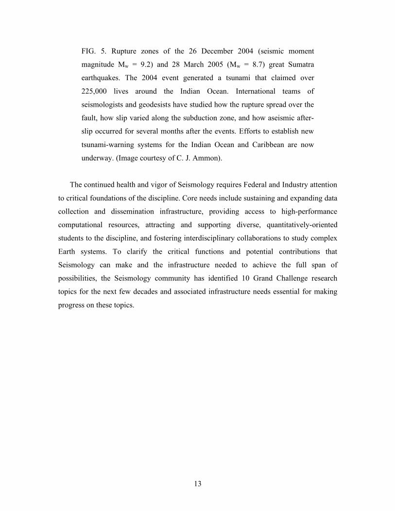
FIG. 5. Rupture zones of the 26 December 2004 (seismic moment
magnitude Mw = 9.2) and 28 March 2005 (Mw = 8.7) great Sumatra
earthquakes. The 2004 event generated a tsunami that claimed over
225,000 lives around the Indian Ocean. International teams of
seismologists and geodesists have studied how the rupture spread over the
fault, how slip varied along the subduction zone, and how aseismic after-
slip occurred for several months after the events. Efforts to establish new
tsunami-warning systems for the Indian Ocean and Caribbean are now
underway. (Image courtesy of C. J. Ammon).
The continued health and vigor of Seismology requires Federal and Industry attention
to critical foundations of the discipline. Core needs include sustaining and expanding data
collection and dissemination infrastructure, providing access to high-performance
computational resources, attracting and supporting diverse, quantitatively-oriented
students to the discipline, and fostering interdisciplinary collaborations to study complex
Earth systems. To clarify the critical functions and potential contributions that
Seismology can make and the infrastructure needed to achieve the full span of
possibilities, the Seismology community has identified 10 Grand Challenge research
topics for the next few decades and associated infrastructure needs essential for making
progress on these topics.
14
Grand Challenges for Seismology The history of seismological advances has validated the approach of sustaining diverse
seismological basic science research as the most effective way of developing and
enhancing the societally-critical applications of the discipline. This strategy ensures
workforce in university programs, incorporation of novel technologies and innovations
into seismological practices and operations, and cultivation of fertile ground for
serendipitous discoveries that can create whole new areas of application. Here, the
seismological research community has defined ten major Grand Challenge themes at the
forefront of research on Earth systems to which Seismology contributes significantly.
These Grand Challenges are framed by fundamental research issues, but encompass
environmental monitoring and resource extraction efforts of central importance to society
and supported by many Federal and State agencies.
Grand Challenge 1: The Physics of Fault Failure The general public tends to associate Seismology with earthquakes, making it one of the
most widely recognized of Earth science disciplines. Understanding the nature of
earthquake faulting continues to be a top priority seismological undertaking, holding
many implications for society. The relentless relative motions of Earth’s plates
concentrate stresses that are relieved mainly as slippage along faults on plate boundaries
and within their interiors. Complex, multi-scale non-linear fault zone systems are
involved in the process of earthquake initiation, rupture and termination, and seeking a
detailed physical understanding of these complex systems is a demanding Grand
Challenge for Seismology.
The sliding motion of faults exhibits a huge range of behavior. The most spectacular
releases of stress occur in conventional earthquakes, with potential energy stored up in
the rock over hundreds to thousands of years of adjacent relative plate motions rapidly
releasing as fault frictional resistance is overcome and shearing motions occur within
seconds, generating seismic waves that radiate outward. Recent observations reveal a rich
spectrum of additional fault slip behavior, from faults that offset steadily without
15
apparent resistance, to faults that slide sporadically, chattering as they slip in sequences
of numerous overlapping events, to others that slide at super-shear velocities (faster than
the speed of S-waves in the rocks) emitting seismic shock waves that can cause huge
ground motions.
Seismology provides many of the highest resolution tools for peering into fault zones. It
can image the geometry and time-dependent properties of the fault zones in diverse
environments. Variations of fluid concentrations along fault zones are likely to play
important roles in frictional behavior, and some seismological efforts have succeeded in
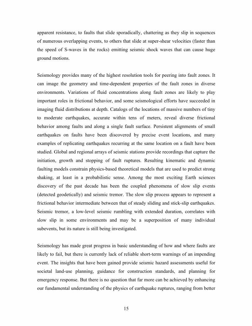
imaging fluid distributions at depth. Catalogs of the locations of massive numbers of tiny
to moderate earthquakes, accurate within tens of meters, reveal diverse frictional
behavior among faults and along a single fault surface. Persistent alignments of small
earthquakes on faults have been discovered by precise event locations, and many
examples of replicating earthquakes recurring at the same location on a fault have been
studied. Global and regional arrays of seismic stations provide recordings that capture the
initiation, growth and stopping of fault ruptures. Resulting kinematic and dynamic
faulting models constrain physics-based theoretical models that are used to predict strong
shaking, at least in a probabilistic sense. Among the most exciting Earth sciences
discovery of the past decade has been the coupled phenomena of slow slip events
(detected geodetically) and seismic tremor. The slow slip process appears to represent a
frictional behavior intermediate between that of steady sliding and stick-slip earthquakes.
Seismic tremor, a low-level seismic rumbling with extended duration, correlates with
slow slip in some environments and may be a superposition of many individual
subevents, but its nature is still being investigated.
Seismology has made great progress in basic understanding of how and where faults are
likely to fail, but there is currently lack of reliable short-term warnings of an impending
event. The insights that have been gained provide seismic hazard assessments useful for
societal land-use planning, guidance for construction standards, and planning for
emergency response. But there is no question that far more can be achieved by enhancing
our fundamental understanding of the physics of earthquake ruptures, ranging from better
16
prediction of ground shaking variations to expansion of early warning systems for
earthquake and tsunami hazards.
Key Questions and Issues
• What physical properties control the diverse types of fault sliding?
• Is there a preparatory stage for fault ruptures? How do ruptures stop?
• Are mechanisms of interplate and intraplate earthquakes different?
• What frictional constitutive laws govern faulting variability, and is friction
different for high-speed slip?
• What is the fundamental nature of asperities and the cause of friction
variations?
• How is episodic tremor and slip related to large earthquake occurrence?
• How do rupture zones recover and reload?
• How do large and small earthquakes differ, if they do?
• Can rupture directions be anticipated based on material properties?
• What is the fractal nature of fault distributions and how do fault networks and
fault surfaces evolve over time?
• Can we forecast the spatial and temporal occurrence of earthquakes and
accurately predict their effects on ground motions and the built environment?
• How quickly can the size of an event be determined and reliable shaking and
tsunami warnings issued?
Seismological Approaches and Requirements to Make Progress
• Seismic arrays of boreholes near faults.
• Pools of instruments for rapid deployment after earthquakes.
• Strong ground motion recordings for more large earthquakes are needed.
• Sustained long-term operation of global and regional networks is essential.
• Real time analysis of finite-faulting properties is needed for rapid earthquake
and tsunami warning systems.
• Communications with other disciplines studying earthquake science need to
increase.
17
_____________________________________________________________________
SIDEBAR #1
Seismicity
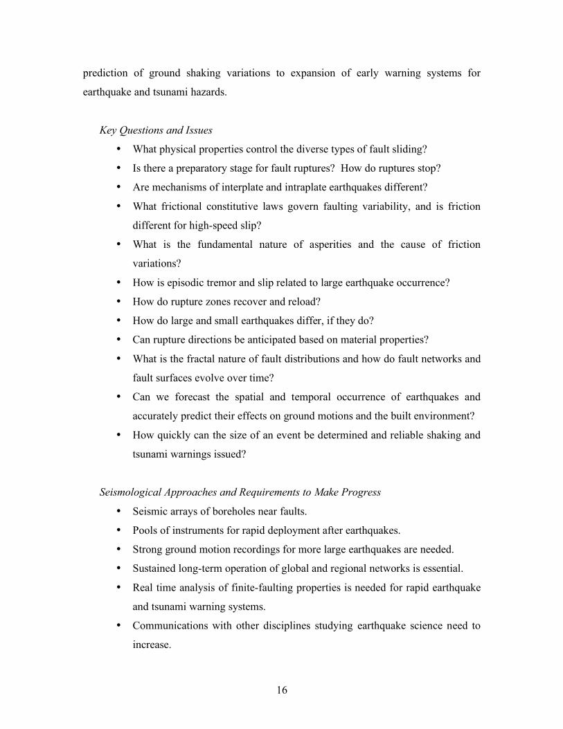
Seismic monitoring systems detect and locate thousands of earthquakes globally
every year, most of which go unnoticed by the public. The resulting earthquake
catalogs are extensively used for seismic hazard analysis as well as basic research
applications. The map on the left shows locations of 81,679 earthquakes along the
San Andreas Fault system between 1984 and 2003, detected by a dense regional
seismic network. The seismicity distribution reveals properties of faults and how
these change in space and time. Many events occur where no faults are mapped at
the surface, revealing hidden fault zones. New procedures for locating these events
provide very precise relative locations, sometimes with uncertainties as small as a
few meters. For the region of central California shown in the map on the right,
12% of all recorded earthquakes occurred on faults that failed multiple times
during the 19-year observation period. Repeating events tend to concentrate along
faults that are extensively creeping. This suggests that tiny patches on these
otherwise steadily sliding faults strengthen rapidly – within days to a few years –
so that they can become re-stressed by the nearby ongoing slip. (Image courtesy of
J. Gomberg).
_______________________________________________________________________
SIDEBAR #2
18
Earthquake Rapid Warning Systems
Before the next earthquake, you might get a warning. Maybe not much of a
warning — perhaps a few seconds or a few tens of seconds at best. But it may be
enough time that you could dive under that table, move away from that bookcase
or step back from that window. Your train could slow or stop and highway meter
lights could turn red. Nuclear power plants could lower their control rods while
refineries isolate tanks and vulnerable pipelines. The idea is to combine modern
digital seismic networks with modern communication systems to provide a
warning that comes before you are shaken off your feet and your world turns
upside down. This is all possible by very rapidly detecting earthquakes, locating
and estimating their completed or potential energy release, and alerting
surrounding regions after the earthquake has started but before the seismic waves
reach regions away from the earthquake source. In fact, earthquake early warning
is here today. In October 2007 Japan launched the first national earthquake
warning system. The system uses a network of over 1000 seismic stations linked
together to detect earthquakes ruptures automatically after they have initiated and
while sliding may still be underway, and issue immediate warnings to the public.
Taiwan, Turkey, Mexico and Romania also have limited warning systems in
place, and many other countries, including the U.S. have prototype systems under
development. Dense geophysical instrumentation in earthquake source regions,
with rapid and robust telemetry, and automated processing are required. Similar
strategies underlie enhanced tsunami-warning systems (which exploit the fact that
the sea wave generated by an underwater earthquake travels at less than the speed
of a jet airplane).
19
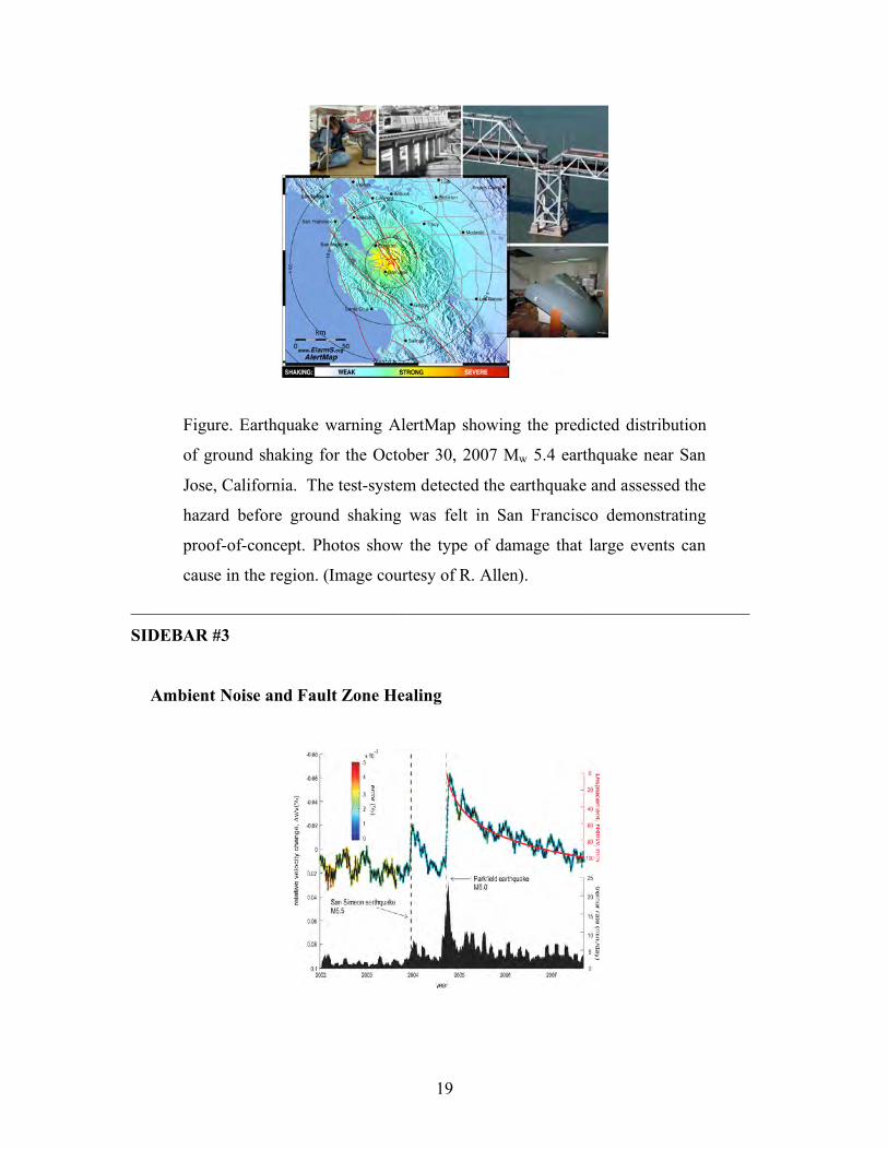
Figure. Earthquake warning AlertMap showing the predicted distribution
of ground shaking for the October 30, 2007 Mw 5.4 earthquake near San
Jose, California. The test-system detected the earthquake and assessed the
hazard before ground shaking was felt in San Francisco demonstrating
proof-of-concept. Photos show the type of damage that large events can
cause in the region. (Image courtesy of R. Allen).
_______________________________________________________________________
SIDEBAR #3
Ambient Noise and Fault Zone Healing
20
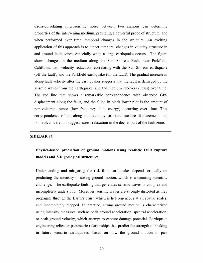
Cross-correlating microseismic noise between two stations can determine
properties of the intervening medium, providing a powerful probe of structure, and
when performed over time, temporal changes in the structure. An exciting
application of this approach is to detect temporal changes in velocity structure in
and around fault zones, especially when a large earthquake occurs. The figure
shows changes in the medium along the San Andreas Fault, near Parkfield,
California with velocity reductions correlating with the San Simeon earthquake
(off the fault), and the Parkfield earthquake (on the fault). The gradual increase in
along-fault velocity after the earthquakes suggests that the fault is damaged by the
seismic waves from the earthquake, and the medium recovers (heals) over time.
The red line that shows a remarkable correspondence with observed GPS
displacement along the fault, and the filled in black lower plot is the amount of
non-volcanic tremor (low frequency fault energy) occurring over time. That
correspondence of the along-fault velocity structure, surface displacement, and
non-volcanic tremor suggests stress relaxation in the deeper part of the fault zone.
_______________________________________________________________________
SIDEBAR #4
Physics-based prediction of ground motions using realistic fault rupture
models and 3-D geological structures.
Understanding and mitigating the risk from earthquakes depends critically on
predicting the intensity of strong ground motion, which is a daunting scientific
challenge. The earthquake faulting that generates seismic waves is complex and
incompletely understood. Moreover, seismic waves are strongly distorted as they
propagate through the Earth’s crust, which is heterogeneous at all spatial scales,
and incompletely mapped. In practice, strong ground motion is characterized
using intensity measures, such as peak ground acceleration, spectral acceleration,
or peak ground velocity, which attempt to capture damage potential. Earthquake
engineering relies on parametric relationships that predict the strength of shaking
in future scenario earthquakes, based on how the ground motion in past

21
earthquakes varied with quantities such as magnitude, distance to fault rupture,
and the character of surficial geology.
This empirical approach is adequate for moderate earthquakes; however, there are
very few on-scale recordings in close to large earthquakes, where the hazard is
highest. Physics-based strong ground motion simulations have the potential to fill
this gap, but only if they accurately reflect the true behavior in the Earth, and
encompass the full range of possible behaviors. Further improvements,
particularly in validation of simulation results against data, will be required for
these simulations to have an important impact on engineering practice. Physics-
based ground motion simulation is an area of intense research and rapid recent
progress. An important element of such simulations is dynamic rupture modeling,
which considers the joint stress-slip evolution during shear failure during an
earthquake as driven by the redistribution of stored strain energy. If the
assumptions that go into it are correct, dynamic modeling can serve as the
foundation for predicting fault behavior, and hence for predicting strong ground
motion. Dynamic rupture modeling is computationally extremely intensive
because representations of faults have to span inner and outer spatial scales
covering many orders of magnitude, and time-dependent stress must be calculated
at all causally connected points to account for stress and slip evolution. Progress
has required use of today’s most powerful supercomputers.
FIGURE. Ground motion intensities (warm colors correspond to high
intensities) for a simulated M 7.7 earthquake with SE to NW rupture on a
200-km section of the San Andreas Fault. There is strong rupture
directivity effect and strong amplification due to funneling of seismic
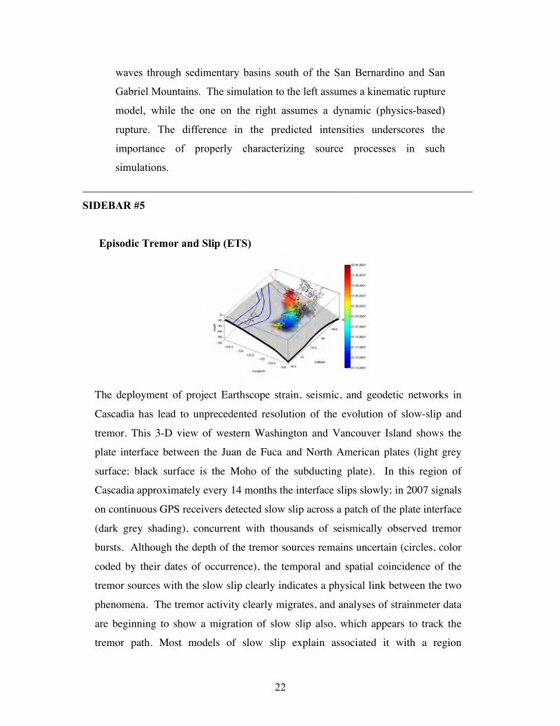
22
waves through sedimentary basins south of the San Bernardino and San
Gabriel Mountains. The simulation to the left assumes a kinematic rupture
model, while the one on the right assumes a dynamic (physics-based)
rupture. The difference in the predicted intensities underscores the
importance of properly characterizing source processes in such
simulations.
_______________________________________________________________________
SIDEBAR #5
Episodic Tremor and Slip (ETS)
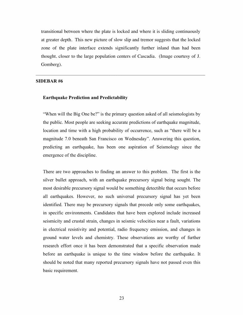
The deployment of project Earthscope strain, seismic, and geodetic networks in
Cascadia has lead to unprecedented resolution of the evolution of slow-slip and
tremor. This 3-D view of western Washington and Vancouver Island shows the plate interface between the Juan de Fuca and North American plates (light grey
surface; black surface is the Moho of the subducting plate). In this region of Cascadia approximately every 14 months the interface slips slowly; in 2007 signals
on continuous GPS receivers detected slow slip across a patch of the plate interface
(dark grey shading), concurrent with thousands of seismically observed tremor bursts. Although the depth of the tremor sources remains uncertain (circles, color
coded by their dates of occurrence), the temporal and spatial coincidence of the tremor sources with the slow slip clearly indicates a physical link between the two
phenomena. The tremor activity clearly migrates, and analyses of strainmeter data
are beginning to show a migration of slow slip also, which appears to track the tremor path. Most models of slow slip explain associated it with a region
23
transitional between where the plate is locked and where it is sliding continuously
at greater depth. This new picture of slow slip and tremor suggests that the locked zone of the plate interface extends significantly further inland than had been
thought, closer to the large population centers of Cascadia. (Image courtesy of J. Gomberg).
_______________________________________________________________________
SIDEBAR #6
Earthquake Prediction and Predictability
“When will the Big One be?” is the primary question asked of all seismologists by
the public. Most people are seeking accurate predictions of earthquake magnitude,
location and time with a high probability of occurrence, such as “there will be a
magnitude 7.0 beneath San Francisco on Wednesday”. Answering this question,
predicting an earthquake, has been one aspiration of Seismology since the
emergence of the discipline.
There are two approaches to finding an answer to this problem. The first is the
silver bullet approach, with an earthquake precursory signal being sought. The
most desirable precursory signal would be something detectible that occurs before
all earthquakes. However, no such universal precursory signal has yet been
identified. There may be precursory signals that precede only some earthquakes,
in specific environments. Candidates that have been explored include increased
seismicity and crustal strain, changes in seismic velocities near a fault, variations
in electrical resistivity and potential, radio frequency emission, and changes in
ground water levels and chemistry. These observations are worthy of further
research effort once it has been demonstrated that a specific observation made
before an earthquake is unique to the time window before the earthquake. It
should be noted that many reported precursory signals have not passed even this
basic requirement.
24
The second approach to answering the earthquake prediction question is to
develop our understanding of the complete physical system responsible for
earthquakes. Earthquakes involve processes occurring at multiple spatial and
temporal scales, for which direct observations are severely limited. Much progress
has been made understanding crustal deformation, stress accumulation, fault
interaction and rupture dynamics, but the challenge remains to link these
processes to provide an understanding of the underlying physics. Studying the
basic physical processes will reveal whether aspects of the complex earthquake
system are intrinsically predictable or not, and what observations may yield the
best prospects of providing some predictive capabilities.
The complexity of the earthquake process, and intrinsic observational limitations,
may make earthquake rupture a fundamentally unpredictable phenomenon. It is
important to note that even if earthquakes could be predicted with a high degree
of probability and accuracy, it would not solve society’s earthquake problem. The
fate of New Orleans after Hurricane Katrina illustrates that even when imminent
disaster is predicted several days in advance, terrible impacts can result. If not
built to withstand earthquakes, then homes and livelihoods will still be destroyed,
so commitment to improving earthquake engineering and mitigation efforts has to
be sustained whether or not some level of earthquake predictability is ever
achieved.
_______________________________________________________________________
25
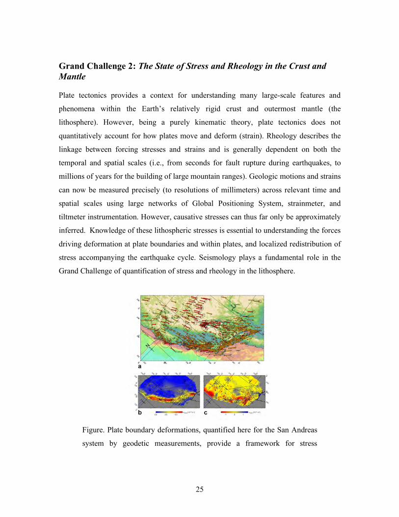
Grand Challenge 2: The State of Stress and Rheology in the Crust and Mantle Plate tectonics provides a context for understanding many large-scale features and
phenomena within the Earth’s relatively rigid crust and outermost mantle (the
lithosphere). However, being a purely kinematic theory, plate tectonics does not
quantitatively account for how plates move and deform (strain). Rheology describes the
linkage between forcing stresses and strains and is generally dependent on both the
temporal and spatial scales (i.e., from seconds for fault rupture during earthquakes, to
millions of years for the building of large mountain ranges). Geologic motions and strains
can now be measured precisely (to resolutions of millimeters) across relevant time and
spatial scales using large networks of Global Positioning System, strainmeter, and
tiltmeter instrumentation. However, causative stresses can thus far only be approximately
inferred. Knowledge of these lithospheric stresses is essential to understanding the forces
driving deformation at plate boundaries and within plates, and localized redistribution of
stress accompanying the earthquake cycle. Seismology plays a fundamental role in the
Grand Challenge of quantification of stress and rheology in the lithosphere.
Figure. Plate boundary deformations, quantified here for the San Andreas
system by geodetic measurements, provide a framework for stress
26
accumulation and release, but the overall driving process and resulting
earthquake stresses are not well understood.
Aftershocks provide the most general example of interacting earthquakes; changes in the
Earth’s static stress field surrounding the source region of a major earthquake can be
related to aftershock occurrence. In addition, since the 1992 Landers earthquake, it has
been clear that seismic waves from one event can trigger other earthquakes at much
greater distances (up to tens of thousands of kilometers) than is possible with static stress
changes. These local and remote triggering phenomena reveal attributes of stress in the
Earth and their relationship to earthquake occurrence, given that stress changes from
seismic waves and faulting can be quantified. Relationships between aftershocks and
slow deformations associated with post-earthquake re-equilibration from GPS and
strainmeter observations can be used to resolve rheology and stress transfer mechanisms.
Many of the limitations on what can be learned observationally posed by the slow pace of
geologic processes and our limited times of observation may be overcome using
computer simulations of the behavior of complex, interacting fault networks embedded in
ever-more realistic Earth models. Earthquake sequence simulations spanning many
thousands of earthquake cycles incorporate employ the latest in ‘peta-scale’ computing,
and can address how stress redistributes as fault systems evolve.
Seismically derived images constrain models of lithospheric structure, such as the depth
and topography of the Moho discontinuity between the crust and mantle, 3-D rigidity of
the lithospheric, and identification of the brittle/ductile transition separating stick-slip
faulting from creeping behavior of the rock. These models, combined with topographic
and gravity data, can be used to estimate lithospheric stress and to assess the relative
contributions between internal forces and plate boundary forces.
Studies of anisotropy, imprinted directionality in the structural and/or mineral fabric that
causes seismic shear waves with different shaking directions to travel with different
speeds, are providing constraints on the long-term history of strain in the lithosphere.
27
Anisotropy measurements permit estimation of the magnitude and orientation of shear
strain in the ductile sub-lithospheric mantle (the asthenosphere) and consequent
inferences about the orientation of the shear stress at the base of the lithosphere. In many
cases seismically measured mantle anisotropy is used as a proxy for flow or deformation.
These studies offer unique constraints on how flow affects plate motion and the transfer
of stress to and within the lithosphere.
Key Questions and Issues.
• What is the state of stress on active faults and how does it vary in space and time?
• What are the constituitive laws of faults and surround crust that give rise to slow
and fast slip?
• What is the role of pore-fluids in the fault zone stress environment?
• What is the relative importance of static versus dynamics stresses for earthquake
triggering?
• What is the time-dependent rheology of the crust and mantle?
• How are new faults initiated, and how are old faults reactivated?
• Are observed stochastic characteristics of earthquakes caused by
material/geometric heterogeneity or by non-linear dynamics?
• Can we develop general models of strain accumulation and release consistent with
geodesy, paleoseismology, landform evolution, and laboratory constraints on
rheology?
Seismological Approaches and Requirements To Make Progress
• Rapid post event drilling into fault zones can quantify frictional heating. Time-
dependent hydro-fracture modeling can quantify in situ stresses.
• New offshore deployments of OBS, pressure sensors, and seafloor geodesy are
needed for understanding submarine earthquake cycles.
• Interdisciplinary coordination on stress measurement and calibration procedures.
• 4-D imaging of changes in slip directions quantified relative to absolute stresses.
• Development of robust anisotropic models for the lithosphere is needed.
_______________________________________________________________________
28
SIDEBAR #7
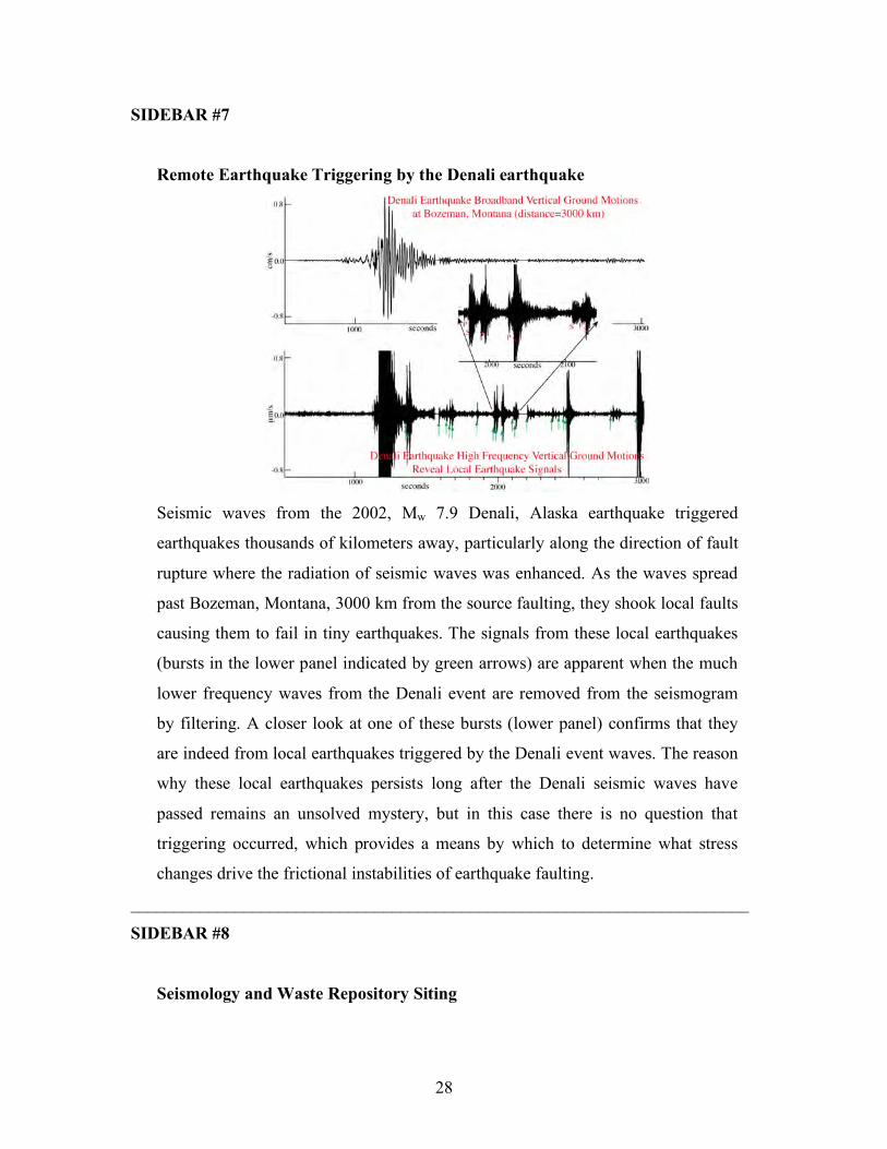
Remote Earthquake Triggering by the Denali earthquake
Seismic waves from the 2002, Mw 7.9 Denali, Alaska earthquake triggered
earthquakes thousands of kilometers away, particularly along the direction of fault
rupture where the radiation of seismic waves was enhanced. As the waves spread
past Bozeman, Montana, 3000 km from the source faulting, they shook local faults
causing them to fail in tiny earthquakes. The signals from these local earthquakes
(bursts in the lower panel indicated by green arrows) are apparent when the much
lower frequency waves from the Denali event are removed from the seismogram
by filtering. A closer look at one of these bursts (lower panel) confirms that they
are indeed from local earthquakes triggered by the Denali event waves. The reason
why these local earthquakes persists long after the Denali seismic waves have
passed remains an unsolved mystery, but in this case there is no question that
triggering occurred, which provides a means by which to determine what stress
changes drive the frictional instabilities of earthquake faulting.
_______________________________________________________________________
SIDEBAR #8
Seismology and Waste Repository Siting
29
The National Seismic Hazard maps (http://earthquake.usgs.gov/hazmaps/) provide
a probabilistic assessment of strong ground motions in any location across the
U.S. that is used as the design criteria for new construction. The catastrophic
nature of structural failure at critical facilities, such as nuclear power plants and
long-term waste repositories, requires construction to even higher standards of
ground shaking tolerance, involving shaking from very large events with very
small probabilities of occurrence. Historic records only document recent
earthquake activity and usually do not include the largest possible events in any
given region. It is thus necessary to extrapolate hazard curves to estimate ground
accelerations and velocities to levels that have never been historically recorded.
Advances in our understanding of the physics of earthquake rupture, combined
with massive computational capabilities, allow exploration of the range of
physically plausible ground motions. The challenges include generating
reasonable slip time-histories and accounting for the very small-scale near-surface
structure. Model validation and verification requires multiple modeling
approaches and additional constraints respectively. Validation of numerical codes
is ongoing using some of the largest computing facilities available today. The
search for more constrains on past ground motion is also underway. For example,
precariously balanced rocks, precipitous cliffs and fragile geological formations
can be used to bound ground motions experiences over geologic time scales.
30
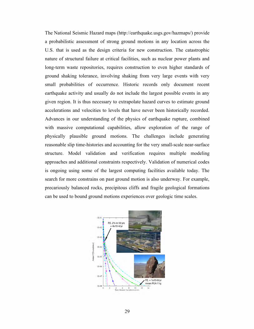
Figure: Probabilistic seismic hazard curve for Yucca Mountain, Nevada,
showing the peak ground acceleration (PGA) against the annual
probability of exceedance (P.E.). Most buildings are designed to withstand
shaking with a P.E. of around 2% in 50 years or a likelihood of 4x10⁻⁴/yr.
The design criteria for the proposed long-term nuclear waste repository at
Yucca Mountain is 1x10⁻⁸/yr. Photos: Balanced rocks can be used to
constrain limits on peak ground motions observed over geological time
scales (bottom). The Kashiwazaki-Kariwa Nuclear Power Plant in Japan
(top) was damaged during the July 16, 2007 Mw 6.6 Chūetsu Earthquake.
The reactor caught fire and there were leaks of fluids and gas. The ground
motion in this earthquake exceeded the design criteria and the reactor,
Japan’s largest, remains closed.
_______________________________________________________________________
31
Grand Challenge 3. Physical Coupling of Atmosphere/Ocean/Solid Earth
Systems.
Seismology readily detects signals from natural sources such as ocean storms and glacier
calving. A new era of research has opened up at the interface of solid Earth geophysics,
glaciology, oceanography and atmospheric science, with high potential for transformative
science and societal relevance, and this is one of the high priority Seismological Grand
Challenges.
There is great interest in understanding the coupling mechanisms between ocean waves
and seismic waves over broad frequency ranges. Earth’s long period “hum”, or
continuous excitation of the planet’s free oscillations at periods of hundreds of seconds,
was discovered just ten years ago in high quality continuous records from the Global
Seismographic Network (GSN) accumulated over several decades. It has now been
established that the primary sources of the “hum” are related to mid-latitude winter
storms that generate strong ocean waves which couple to the ocean floor via non-linear
mechanisms that are not yet well understood.
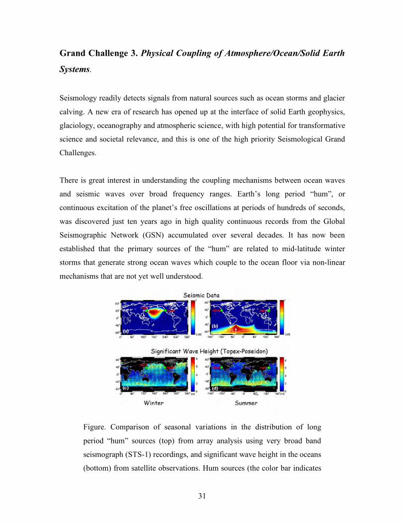
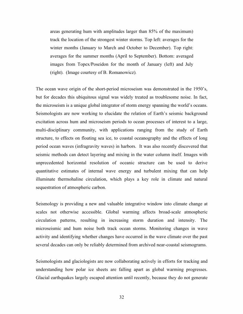
Figure. Comparison of seasonal variations in the distribution of long
period “hum” sources (top) from array analysis using very broad band
seismograph (STS-1) recordings, and significant wave height in the oceans
(bottom) from satellite observations. Hum sources (the color bar indicates
32
areas generating hum with amplitudes larger than 85% of the maximum)
track the location of the strongest winter storms. Top left: averages for the
winter months (January to March and October to December). Top right:
averages for the summer months (April to September). Bottom: averaged
images from Topex/Poseidon for the month of January (left) and July
(right). (Image courtesy of B. Romanowicz).
The ocean wave origin of the short-period microseism was demonstrated in the 1950’s,
but for decades this ubiquitous signal was widely treated as troublesome noise. In fact,
the microseism is a unique global integrator of storm energy spanning the world’s oceans.
Seismologists are now working to elucidate the relation of Earth’s seismic background
excitation across hum and microseism periods to ocean processes of interest to a large,
multi-disciplinary community, with applications ranging from the study of Earth
structure, to effects on floating sea ice, to coastal oceanography and the effects of long
period ocean waves (infragravity waves) in harbors. It was also recently discovered that
seismic methods can detect layering and mixing in the water column itself. Images with
unprecedented horizontal resolution of oceanic structure can be used to derive
quantitative estimates of internal wave energy and turbulent mixing that can help
illuminate thermohaline circulation, which plays a key role in climate and natural
sequestration of atmospheric carbon.
Seismology is providing a new and valuable integrative window into climate change at
scales not otherwise accessible. Global warming affects broad-scale atmospheric
circulation patterns, resulting in increasing storm duration and intensity. The
microseismic and hum noise both track ocean storms. Monitoring changes in wave
activity and identifying whether changes have occurred in the wave climate over the past
several decades can only be reliably determined from archived near-coastal seismograms.
Seismologists and glaciologists are now collaborating actively in efforts for tracking and
understanding how polar ice sheets are falling apart as global warming progresses.
Glacial earthquakes largely escaped attention until recently, because they do not generate
33
short period (1-10 s) seismic waves that are used for standard earthquake detection and
location algorithms. Glacial sources, such as calving, that involve floating ice systems,
excite tsunami-like ocean waves that can be detected with seismometers deployed both
on land and on floating ice and offer additional new opportunities for monitoring key
processes associated with the stability of tidewater glaciers and ice shelves.
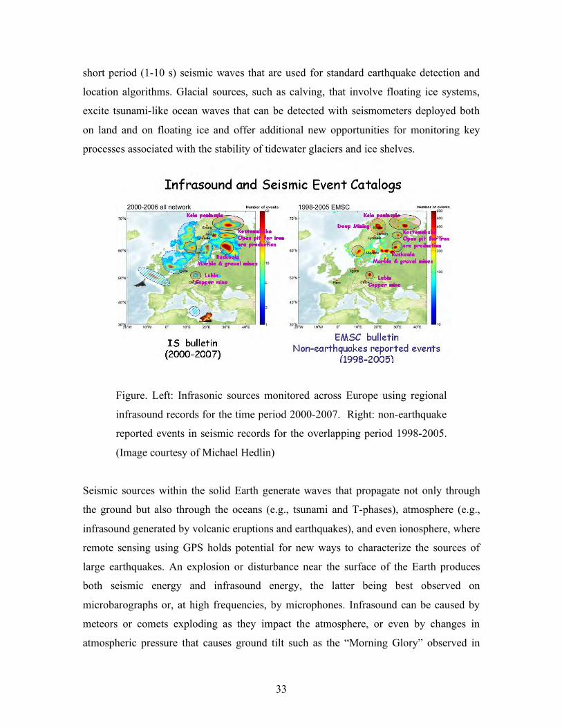
Figure. Left: Infrasonic sources monitored across Europe using regional
infrasound records for the time period 2000-2007. Right: non-earthquake
reported events in seismic records for the overlapping period 1998-2005.
(Image courtesy of Michael Hedlin)
Seismic sources within the solid Earth generate waves that propagate not only through
the ground but also through the oceans (e.g., tsunami and T-phases), atmosphere (e.g.,
infrasound generated by volcanic eruptions and earthquakes), and even ionosphere, where
remote sensing using GPS holds potential for new ways to characterize the sources of
large earthquakes. An explosion or disturbance near the surface of the Earth produces
both seismic energy and infrasound energy, the latter being best observed on
microbarographs or, at high frequencies, by microphones. Infrasound can be caused by
meteors or comets exploding as they impact the atmosphere, or even by changes in
atmospheric pressure that causes ground tilt such as the “Morning Glory” observed in
34
Los Angeles. Combining seismic and infrasound recordings can help elucidate the way in
which sound waves propagate through the atmosphere, and therefore provide
understanding of atmospheric structure and its variation with time at spatial and temporal
scales inaccessible by other means.
Key Questions and Issues.
• How are normal modes of the Earth excited by phenomena in the atmosphere and
oceans?
• How well do seismic background noise variations track climatic changes due to
global warming?
• Are models of thermo-haline circulation consistent with seismic images of
oceanic internal structure?
• Can bounds be placed on the energy budgets associated with bolide impacts,
glacial calving, volcanic eruptions and other sources observed by seismic and
atmospheric monitoring?
• What conditions lead to ice-shelf collapse and can we monitor them in advance?
• What is the nature of friction and the role of fluids at the base of glaciers?
Seismological Approaches and Requirements To Make Progress
• Sustained global observations of very low frequency seismic signals on land and
on the seafloor are important for evaluating mechanisms of hum excitation.
• Increase the number of co-located infrasound and seismic stations.
• Hydroacoustic and infrasound data sources need to be openly available for basic
research.
• Development of an authoritative catalog of non-earthquake events.
• Permanent broadband seismic networks in polar regions are needed for long-term
observations.
• Large numbers of low-temperature capable seismic and geodetic instruments for
portable deployments in polar regions are needed for experiments around ice-
shelves, glacial streams, and near glacier outlets.
35
_______________________________________________________________________
SIDEBAR #9
Cryoseismology
Cryoseismic research involves quantitative studies of ice processes that in many
cases are known or suspected to show sensitivity to climate change. For example,
high-quality seismographic networks can be deployed to study ice shelf
stability/disintegration. Recent research topics also include tectonic evolution of
west Antarctica and the history of ice cap changes; studies of tidally modulated
ice stream surging in west Antarctica; iceberg seismic and ocean acoustic tremor
and breakup processes arising from collisions and break-up of Earth’s largest
icebergs; remote detection of glacial calving via sea swell “mini-tsunamis” using
broadband seismometers deployed atop giant tabular icebergs, and monitoring and
study of a newly recognized class of globally detectable slow glacial earthquakes
from major tidewater outlet glaciers in Greenland. In each application, seismology
can quantify the sources and structures involved in the dynamic polar
environments.
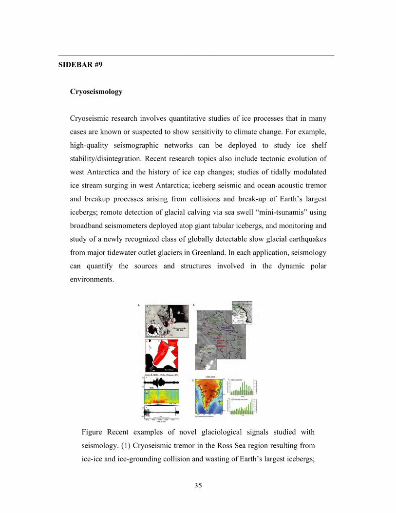
Figure Recent examples of novel glaciological signals studied with
seismology. (1) Cryoseismic tremor in the Ross Sea region resulting from
ice-ice and ice-grounding collision and wasting of Earth’s largest icebergs;
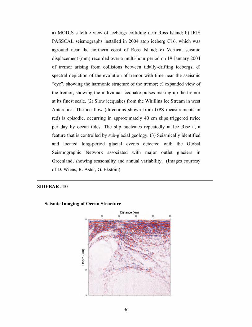
36
a) MODIS satellite view of icebergs colliding near Ross Island; b) IRIS
PASSCAL seismographs installed in 2004 atop iceberg C16, which was
aground near the northern coast of Ross Island; c) Vertical seismic
displacement (mm) recorded over a multi-hour period on 19 January 2004
of tremor arising from collisions between tidally-drifting icebergs; d)
spectral depiction of the evolution of tremor with time near the aseismic
“eye”, showing the harmonic structure of the tremor; e) expanded view of
the tremor, showing the individual icequake pulses making up the tremor
at its finest scale. (2) Slow icequakes from the Whillins Ice Stream in west
Antarctica. The ice flow (directions shown from GPS measurements in
red) is episodic, occurring in approximately 40 cm slips triggered twice
per day by ocean tides. The slip nucleates repeatedly at Ice Rise a, a
feature that is controlled by sub-glacial geology. (3) Seismically identified
and located long-period glacial events detected with the Global
Seismographic Network associated with major outlet glaciers in
Greenland, showing seasonality and annual variability. (Images courtesy
of D. Wiens, R. Aster, G. Ekstöm).
_______________________________________________________________________
SIDEBAR #10
Seismic Imaging of Ocean Structure
37
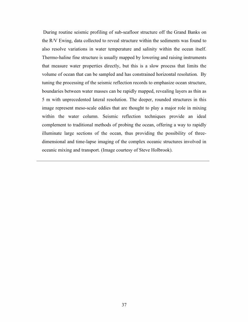
During routine seismic profiling of sub-seafloor structure off the Grand Banks on
the R/V Ewing, data collected to reveal structure within the sediments was found to
also resolve variations in water temperature and salinity within the ocean itself.
Thermo-haline fine structure is usually mapped by lowering and raising instruments
that measure water properties directly, but this is a slow process that limits the
volume of ocean that can be sampled and has constrained horizontal resolution. By
tuning the processing of the seismic reflection records to emphasize ocean structure,
boundaries between water masses can be rapidly mapped, revealing layers as thin as
5 m with unprecedented lateral resolution. The deeper, rounded structures in this
image represent meso-scale eddies that are thought to play a major role in mixing
within the water column. Seismic reflection techniques provide an ideal
complement to traditional methods of probing the ocean, offering a way to rapidly
illuminate large sections of the ocean, thus providing the possibility of three-
dimensional and time-lapse imaging of the complex oceanic structures involved in
oceanic mixing and transport. (Image courtesy of Steve Holbrook).
_______________________________________________________________________
38
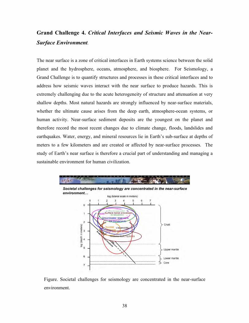
Grand Challenge 4. Critical Interfaces and Seismic Waves in the Near-
Surface Environment.
The near surface is a zone of critical interfaces in Earth systems science between the solid
planet and the hydrosphere, oceans, atmosphere, and biosphere. For Seismology, a
Grand Challenge is to quantify structures and processes in these critical interfaces and to
address how seismic waves interact with the near surface to produce hazards. This is
extremely challenging due to the acute heterogeneity of structure and attenuation at very
shallow depths. Most natural hazards are strongly influenced by near-surface materials,
whether the ultimate cause arises from the deep earth, atmosphere-ocean systems, or
human activity. Near-surface sediment deposits are the youngest on the planet and
therefore record the most recent changes due to climate change, floods, landslides and
earthquakes. Water, energy, and mineral resources lie in Earth’s sub-surface at depths of
meters to a few kilometers and are created or affected by near-surface processes. The
study of Earth’s near surface is therefore a crucial part of understanding and managing a
sustainable environment for human civilization.
Figure. Societal challenges for seismology are concentrated in the near-surface
environment.
39
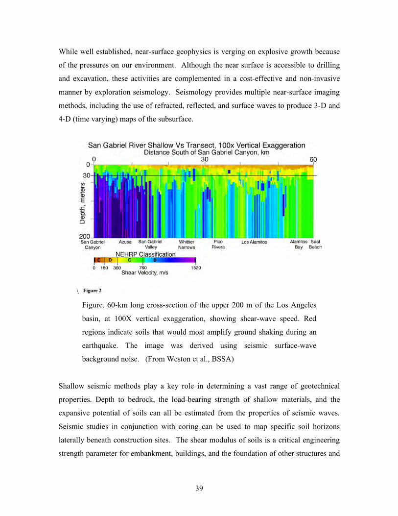
While well established, near-surface geophysics is verging on explosive growth because
of the pressures on our environment. Although the near surface is accessible to drilling
and excavation, these activities are complemented in a cost-effective and non-invasive
manner by exploration seismology. Seismology provides multiple near-surface imaging
methods, including the use of refracted, reflected, and surface waves to produce 3-D and
4-D (time varying) maps of the subsurface.
\
Figure. 60-km long cross-section of the upper 200 m of the Los Angeles
basin, at 100X vertical exaggeration, showing shear-wave speed. Red
regions indicate soils that would most amplify ground shaking during an
earthquake. The image was derived using seismic surface-wave
background noise. (From Weston et al., BSSA)
Shallow seismic methods play a key role in determining a vast range of geotechnical
properties. Depth to bedrock, the load-bearing strength of shallow materials, and the
expansive potential of soils can all be estimated from the properties of seismic waves.
Seismic studies in conjunction with coring can be used to map specific soil horizons
laterally beneath construction sites. The shear modulus of soils is a critical engineering
strength parameter for embankment, buildings, and the foundation of other structures and
40
it can be quantified in the subsurface by noninvasive seismic shear-wave studies using
either controlled sources or background seismic noise. The extent, thickness and volume
of unstable slopes and past landslides, and mapping weak horizons at their bases, can be
used to assess their hazard and develop mitigation strategies. Microearthquakes along the
sides and bottoms of landslides can potentially be used as a proxy to monitor creep using
seismic methods.
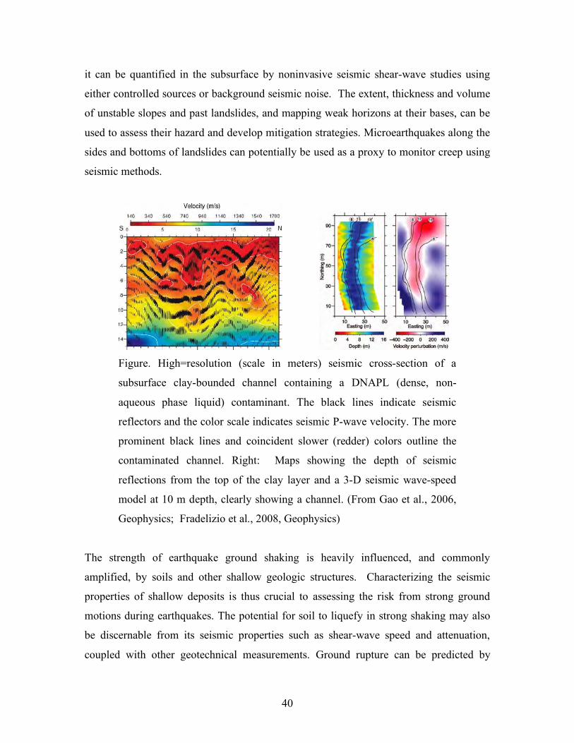
Figure. High=resolution (scale in meters) seismic cross-section of a
subsurface clay-bounded channel containing a DNAPL (dense, non-
aqueous phase liquid) contaminant. The black lines indicate seismic
reflectors and the color scale indicates seismic P-wave velocity. The more
prominent black lines and coincident slower (redder) colors outline the
contaminated channel. Right: Maps showing the depth of seismic
reflections from the top of the clay layer and a 3-D seismic wave-speed
model at 10 m depth, clearly showing a channel. (From Gao et al., 2006,
Geophysics; Fradelizio et al., 2008, Geophysics)
The strength of earthquake ground shaking is heavily influenced, and commonly
amplified, by soils and other shallow geologic structures. Characterizing the seismic
properties of shallow deposits is thus crucial to assessing the risk from strong ground
motions during earthquakes. The potential for soil to liquefy in strong shaking may also
be discernable from its seismic properties such as shear-wave speed and attenuation,
coupled with other geotechnical measurements. Ground rupture can be predicted by
41
mapping faults at the surface and in the subsurface using seismically imaged offsets in
shallow seismic layers.
Seismic refraction and reflection methods are well suited to mapping the geometry and
bulk mineralogy of shallow rock units, but also can be used to infer porosity and pore-
fluid saturation essential for hydrological characterization. In addition to delineating
aquifers in sedimentary basins, seismology can be used to map fractured rock aquifers in
regions with more limited groundwater supply. Compartmentalization or connectivity of
reservoirs, dictated by the presence of faults and other structures, is important to
predicting how much water may be pumped from a well, and is crucial to maintaining
water quality and mapping flow of natural or human groundwater contamination.
It is usually through a combination of shallow geophysical methods and subsurface
sampling that near-surface problems are addressed. Seismic measurements give part of
the picture, but the skilled incorporation of gravity, electrical, magnetic, radar, and
electromagnetic induction methods offers improved characterization of the shallow
subsurface. An important challenge is the joint inversion and interpretation of diverse
data for a single consistent subsurface model, including the direct identification of
sediment, rock and fluid properties (e.g., porosity and permeability). To date, such joint
inversions have required careful site-dependent calibration.
\Key Questions and Issues.
• How can the acute heterogeneity in the near- best be imaged and its material
properties constrained?
• How do soils respond to strong ground shaking, and how are non-linear properties
of near-surface materials best calibrated?
• Can seismology resolve permeability and changes in permeability at depth?
• Can physics-based predictions of strong ground motion couple with performance
based engineering to improve seismic hazard mitigation?
• Can time-dependent properties of shallow aquifers being characterized to monitor
water and contaminant transport?
42
• Can potential ground failures from landslides and karst be robustly characterized?
• Can nuclear testing be monitored with confidence levels necessary for the
Comprehensive Test Ban Treaty?
• Can unexploded ordinance, tunnels, buried landfills, and other human-made
hazards be detected?
Seismological Approaches and Needs To Make Progress
• Improved 3-D wave propagation capabilities for extremely heterogeneous media
need to be developed and made broadly available.
• Combined active and passive imaging using ambient noise needs further
development.
• 4-D characterizations of near-source systems requires dense instrument
deployments.
• Cross-disciplinary approaches are needed for material property and non-linearity
quantification.
• Large increases in numbers of inexpensive sensors to enable multi-scale near-
surface environments.
• Source facilities for high-resolution shallow subsurface mapping in diverse
environments are needed.
_______________________________________________________________________
SIDEBAR #11
Underground Nuclear Explosion Monitoring and Discrimination
Development of the discipline of seismology has been greatly facilitated by the
critical geopolitical need to monitor underground nuclear testing. This mission led
to the establishment of the first modern global seismographic network, the World
Wide Standardized Seismographic Network (WWSSN), which operated over 100
stations in dozens of nations in the 1960s and 1970s, as well as subsequent global
digital seismic networks. The nuclear test monitoring issue prompted investments
in the IRIS/USGS Global Seismographic Network (GSN), the United Nations
43
Comprehensive Test Ban Treaty Organization (CTBTO) International Monitoring
System (IMS), and U.S. Department of Defense efforts managed by the Air Force
Technical Applications Center (AFTAC), along with additional government,
academic, and private seismic networks worldwide. Data from many of these
efforts (the IMS is an unfortunate notable exception) are openly available in real
time via national or regional data centers to facilitate rapid scientific and forensic
analysis of anthropogenic and unusual natural events. Operational and basic
research in support of nuclear monitoring is carried out by a worldwide contingent
of seismologists in universities, national laboratories, and government agencies.
The extensive data and research activities have advanced the capabilities of
seismic monitoring significantly, particularly the ability to identify signals from
small nuclear explosions amidst a background of signals from earthquakes and
other natural sources. Whether the CTBT enters into force or not, Seismology will
continue to play a critical role in monitoring of nuclear testing treaties and
activities world-wide.
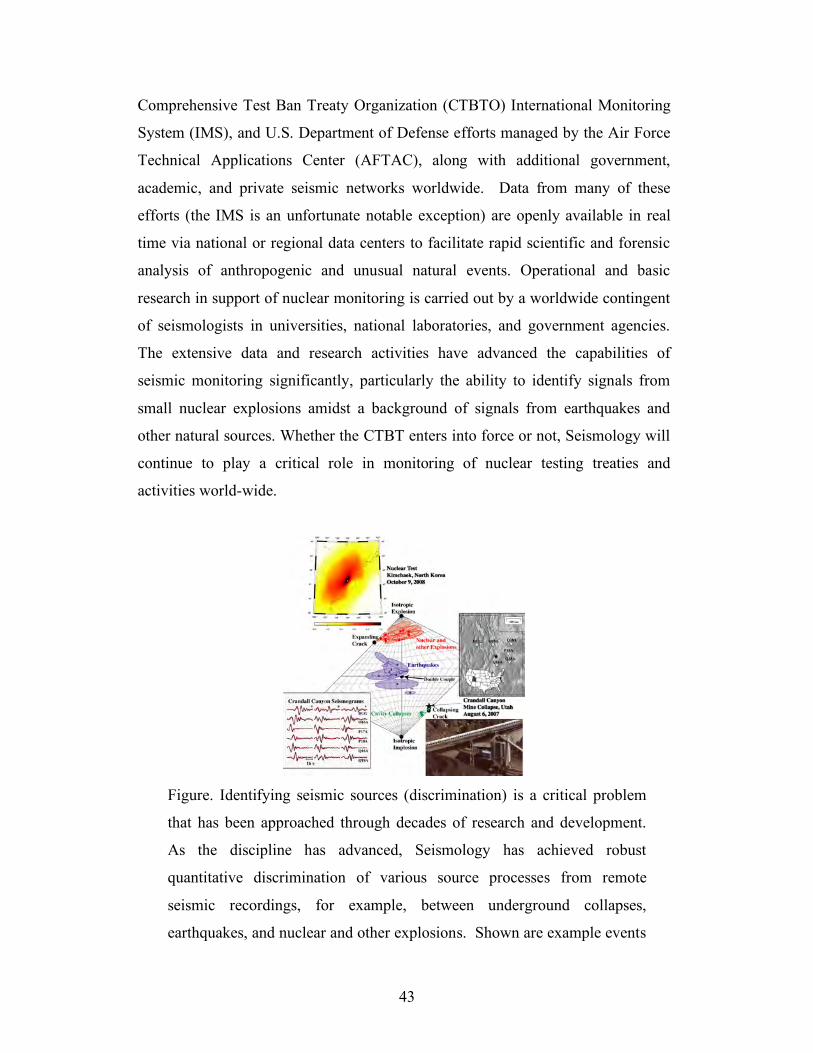
Figure. Identifying seismic sources (discrimination) is a critical problem
that has been approached through decades of research and development.
As the discipline has advanced, Seismology has achieved robust
quantitative discrimination of various source processes from remote
seismic recordings, for example, between underground collapses,
earthquakes, and nuclear and other explosions. Shown are example events
44
mapped according to the relative magnitude of their moment tensor
elements (force systems that describe the source type) estimated from
seismogram waveform inversions. (After Dreger et al., 2008).
_______________________________________________________________________
SIDEBAR #12
Seismic imaging of proxies for past climates
Determining Earth’s record of natural climate change relies in part on seismic
imaging of the shallow sedimentary deposits that record and respond to climactic
changes. In lake and near-shore settings, subtle climate changes alter water levels,
biologic activity, and stream sediment, leaving records in the type and thickness of
water-bottom deposits. Depositional patterns over large areas are best mapped by
sediment layering imaged in seismic reflection data that complement drilling
efforts. Seismic stratigraphy at the basin-scale and on continental margins has long
been used to identify sea level through time and these methods examine, at very
high resolution, the shallowest and youngest sediments to constrain climate during
the past few hundred thousand years. Drilling programs in lake and ocean
sediments are therefore best designed utilizing stratigraphic patterns mapped by 2-
D or 3-D by seismic reflection.
Materials in the pore spaces between mineral grains may contain information about
past climates. An important example is gas hydrates (frozen hydrocarbon gases,
predominantly methane), which are found at shallow depth below the seafloor
along continental margins in water depths of 300-500 m. These hydrates contain a
globally significant quantity of carbon. In addition, they hold potential as a vast
energy source. Changes in seafloor temperature or water depth can change the
stability conditions for frozen hydrates. Such changes have in the geologic past
resulted in massive releases of methane gas and CO2 from biologic methane
decomposition (both greenhouse gases) into the atmosphere. Because the bottom
of the gas-hydrate stability zone acts as a strong “bottom-simulating reflection” for
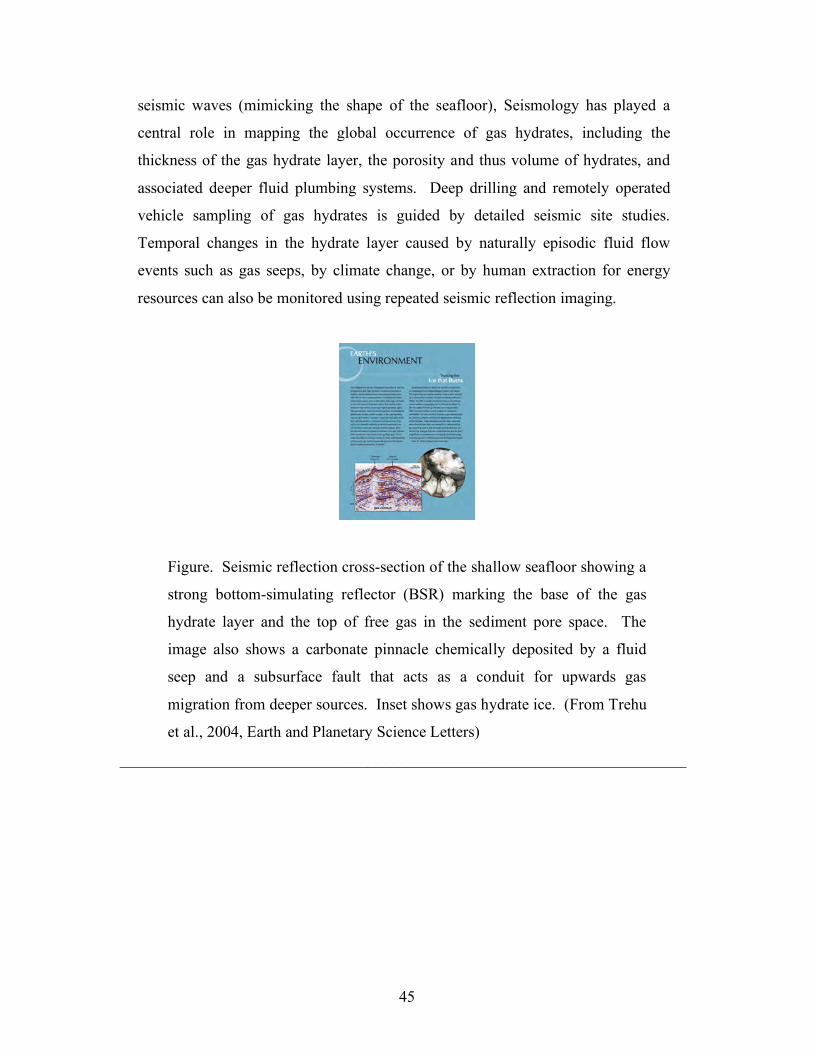
45
seismic waves (mimicking the shape of the seafloor), Seismology has played a
central role in mapping the global occurrence of gas hydrates, including the
thickness of the gas hydrate layer, the porosity and thus volume of hydrates, and
associated deeper fluid plumbing systems. Deep drilling and remotely operated
vehicle sampling of gas hydrates is guided by detailed seismic site studies.
Temporal changes in the hydrate layer caused by naturally episodic fluid flow
events such as gas seeps, by climate change, or by human extraction for energy
resources can also be monitored using repeated seismic reflection imaging.
Figure. Seismic reflection cross-section of the shallow seafloor showing a
strong bottom-simulating reflector (BSR) marking the base of the gas
hydrate layer and the top of free gas in the sediment pore space. The
image also shows a carbonate pinnacle chemically deposited by a fluid
seep and a subsurface fault that acts as a conduit for upwards gas
migration from deeper sources. Inset shows gas hydrate ice. (From Trehu
et al., 2004, Earth and Planetary Science Letters)
_______________________________________________________________________
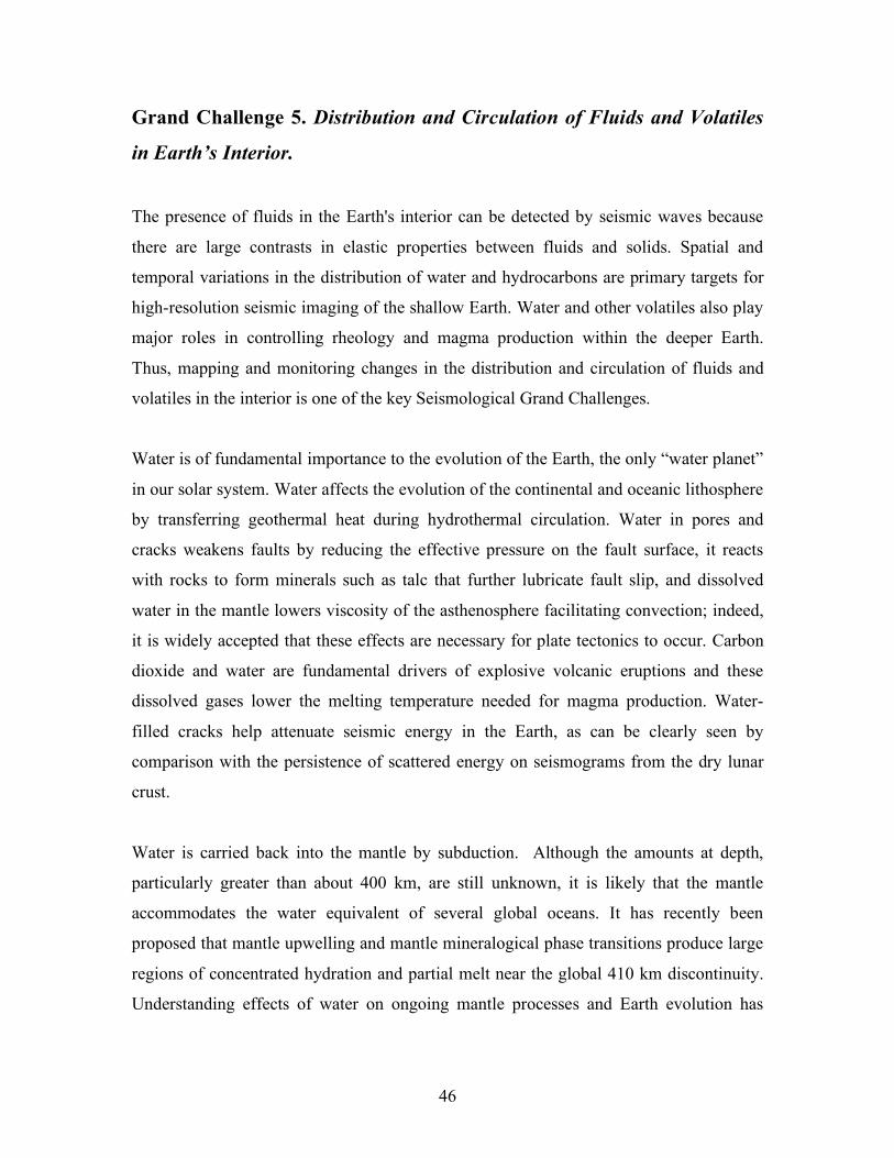
46
Grand Challenge 5. Distribution and Circulation of Fluids and Volatiles
in Earth’s Interior.
The presence of fluids in the Earth's interior can be detected by seismic waves because
there are large contrasts in elastic properties between fluids and solids. Spatial and
temporal variations in the distribution of water and hydrocarbons are primary targets for
high-resolution seismic imaging of the shallow Earth. Water and other volatiles also play
major roles in controlling rheology and magma production within the deeper Earth.
Thus, mapping and monitoring changes in the distribution and circulation of fluids and
volatiles in the interior is one of the key Seismological Grand Challenges.
Water is of fundamental importance to the evolution of the Earth, the only “water planet”
in our solar system. Water affects the evolution of the continental and oceanic lithosphere
by transferring geothermal heat during hydrothermal circulation. Water in pores and
cracks weakens faults by reducing the effective pressure on the fault surface, it reacts
with rocks to form minerals such as talc that further lubricate fault slip, and dissolved
water in the mantle lowers viscosity of the asthenosphere facilitating convection; indeed,
it is widely accepted that these effects are necessary for plate tectonics to occur. Carbon
dioxide and water are fundamental drivers of explosive volcanic eruptions and these
dissolved gases lower the melting temperature needed for magma production. Water-
filled cracks help attenuate seismic energy in the Earth, as can be clearly seen by
comparison with the persistence of scattered energy on seismograms from the dry lunar
crust.
Water is carried back into the mantle by subduction. Although the amounts at depth,
particularly greater than about 400 km, are still unknown, it is likely that the mantle
accommodates the water equivalent of several global oceans. It has recently been
proposed that mantle upwelling and mantle mineralogical phase transitions produce large
regions of concentrated hydration and partial melt near the global 410 km discontinuity.
Understanding effects of water on ongoing mantle processes and Earth evolution has
47
spawned scientifically rich multidisciplinary observational and theoretical efforts
employing Seismology, mineralogy, geodynamics, petrology, and rock mechanics.
Civilization is utterly dependent on access to fresh water from surface sources and from
near-surface aquifers. 95% of this accessible water is stored as groundwater (the vast
majority of near-surface water is either in the planet’s two remaining icecaps or in the
oceans). The recharge, flow, and storage of groundwater are heavily influenced by
geologic stratigraphy and faults. The principal imaging of these critically important
subsurface structures is through seismology, which also offers the ability to estimate the
volume of water stored within cracks and pores.
The formation, migration, and storage of Earth’s liquid and gas hydrocarbons, as well as
geothermal energy reserves, are similarly constrained by geological structures. Because
of its unique ability to resolve subsurface detail, Seismology is thus not only key to
surveying and assessing the large basins that hold most of the world’s usable
groundwater, but is also the cornerstone of the global hydrocarbon exploration,
production, and reservoir management industry. Seismological techniques, including 4-D
mapping, can be used to monitor the extraction and movement of hydrocarbons and water
in producing fields. Seismic exploration on land and at sea is a multi-billion dollar
industry with major workforce needs now and in the future.
Resources are currently being extensively applied worldwide to investigate geological
reservoirs for their carbon dioxide sequestration potential. Methodologies for managing
such sequestration efforts will rely critically on Seismology, both to monitor spatial and
temporal changes in seismic velocities corresponding to the fluid content, and to detect
brittle-failure-induced microearthquakes generated by the injection process. Such
methodologies are already in place in numerous producing hydrocarbon fields to monitor
production and are readily adaptable to the carbon sequestration applications.
Key Questions and Issues
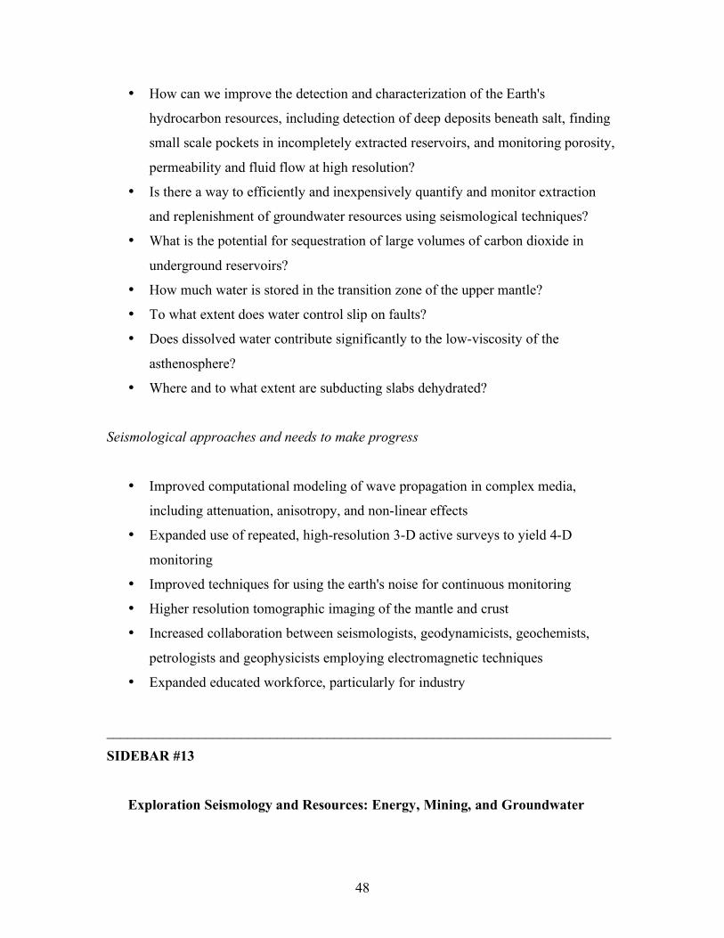
48
• How can we improve the detection and characterization of the Earth's
hydrocarbon resources, including detection of deep deposits beneath salt, finding
small scale pockets in incompletely extracted reservoirs, and monitoring porosity,
permeability and fluid flow at high resolution?
• Is there a way to efficiently and inexpensively quantify and monitor extraction
and replenishment of groundwater resources using seismological techniques?
• What is the potential for sequestration of large volumes of carbon dioxide in
underground reservoirs?
• How much water is stored in the transition zone of the upper mantle?
• To what extent does water control slip on faults?
• Does dissolved water contribute significantly to the low-viscosity of the
asthenosphere?
• Where and to what extent are subducting slabs dehydrated?
Seismological approaches and needs to make progress
• Improved computational modeling of wave propagation in complex media,
including attenuation, anisotropy, and non-linear effects
• Expanded use of repeated, high-resolution 3-D active surveys to yield 4-D
monitoring
• Improved techniques for using the earth's noise for continuous monitoring
• Higher resolution tomographic imaging of the mantle and crust
• Increased collaboration between seismologists, geodynamicists, geochemists,
petrologists and geophysicists employing electromagnetic techniques
• Expanded educated workforce, particularly for industry
_______________________________________________________________________
SIDEBAR #13
Exploration Seismology and Resources: Energy, Mining, and Groundwater
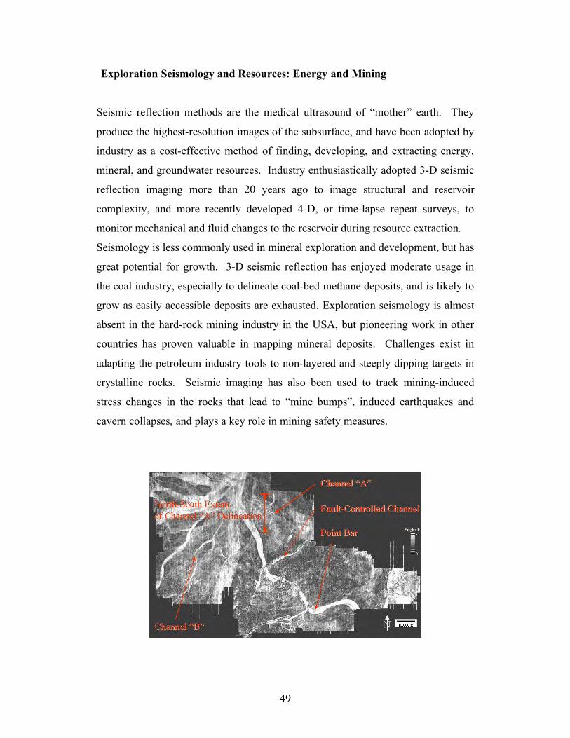
49
Exploration Seismology and Resources: Energy and Mining
Seismic reflection methods are the medical ultrasound of “mother” earth. They
produce the highest-resolution images of the subsurface, and have been adopted by
industry as a cost-effective method of finding, developing, and extracting energy,
mineral, and groundwater resources. Industry enthusiastically adopted 3-D seismic
reflection imaging more than 20 years ago to image structural and reservoir
complexity, and more recently developed 4-D, or time-lapse repeat surveys, to
monitor mechanical and fluid changes to the reservoir during resource extraction.
Seismology is less commonly used in mineral exploration and development, but has
great potential for growth. 3-D seismic reflection has enjoyed moderate usage in
the coal industry, especially to delineate coal-bed methane deposits, and is likely to
grow as easily accessible deposits are exhausted. Exploration seismology is almost
absent in the hard-rock mining industry in the USA, but pioneering work in other
countries has proven valuable in mapping mineral deposits. Challenges exist in
adapting the petroleum industry tools to non-layered and steeply dipping targets in
crystalline rocks. Seismic imaging has also been used to track mining-induced
stress changes in the rocks that lead to “mine bumps”, induced earthquakes and
cavern collapses, and plays a key role in mining safety measures.
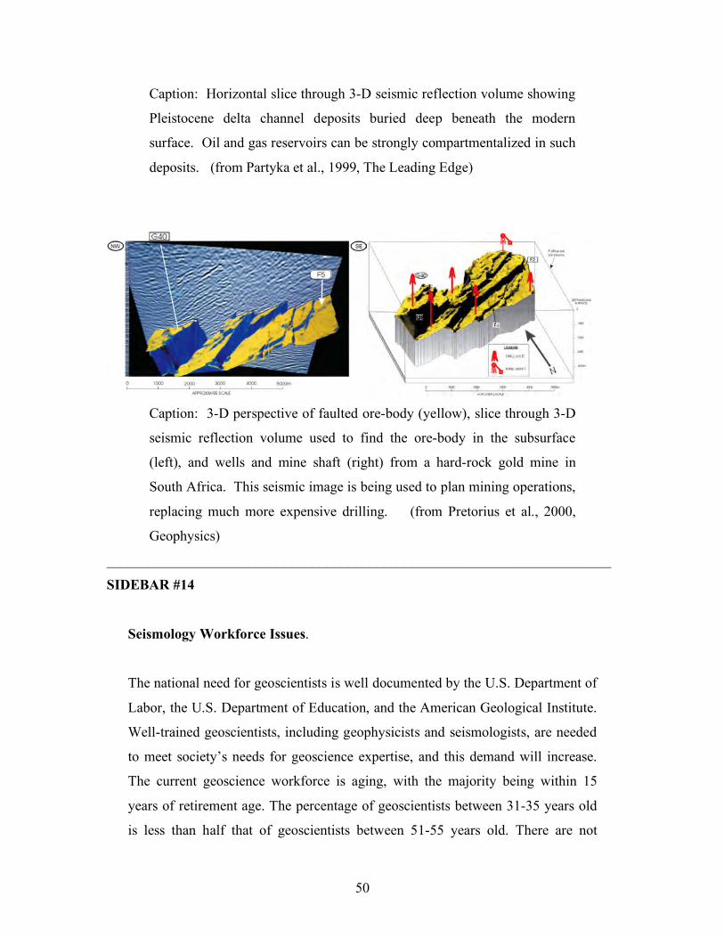
50
Caption: Horizontal slice through 3-D seismic reflection volume showing
Pleistocene delta channel deposits buried deep beneath the modern
surface. Oil and gas reservoirs can be strongly compartmentalized in such
deposits. (from Partyka et al., 1999, The Leading Edge)
Caption: 3-D perspective of faulted ore-body (yellow), slice through 3-D
seismic reflection volume used to find the ore-body in the subsurface
(left), and wells and mine shaft (right) from a hard-rock gold mine in
South Africa. This seismic image is being used to plan mining operations,
replacing much more expensive drilling. (from Pretorius et al., 2000,
Geophysics)
_______________________________________________________________________
SIDEBAR #14
Seismology Workforce Issues.
The national need for geoscientists is well documented by the U.S. Department of
Labor, the U.S. Department of Education, and the American Geological Institute.
Well-trained geoscientists, including geophysicists and seismologists, are needed
to meet society’s needs for geoscience expertise, and this demand will increase.
The current geoscience workforce is aging, with the majority being within 15
years of retirement age. The percentage of geoscientists between 31-35 years old
is less than half that of geoscientists between 51-55 years old. There are not
51
enough students being produced to fill the positions that will be vacated by
retirements. By 2020, the current U.S. workforce + new U.S. entries is estimated
to fall short of the projected geoscientist demand from the petroleum industry
alone by 20,000 jobs. The Bureau of Labor Statistics estimates an employment
growth of 22 percent for geoscientists between 2006 and 2016, much faster than
the average for all occupations. The need for energy, environmental protection,
and responsible land and water management is expected to spur employment
demand.
Geoscience Ph.D.’s are particularly needed, for teaching and training the next
generation of students, and for performing basic research. The Digest of
Educational Statistics documents the low number of Geological Sciences PhD’s
(505 in AY 2005-2006). Digest statistics show a high percentage of PhD’s being
awarded to nonresident aliens in Physical Sciences (44% in 2005-6), low
participation by women (30% of the 2005-6 PhD’s), and low participation rates
by underrepresented minorities (4%).
Addressing the geoscience workforce issue requires attention at the K-12 level,
where U.S. students are lagging in science and mathematics training relative to
international peers. Efforts are needed to alert entering university student to the
excitement and career potential for geoscience majors. A number of summer
internship programs for undergraduates have been successful in promoting
advanced study in seismology. The NSF research experiences for undergraduates
(REU) program has promoted internships associated with NSF funded projects.
Summer internships include those sponsored by IRIS, SCEC, and the UNAVCO
RESESS program. Summer camps such as SAGE provide technical training in
applied geophysics in the field. These internships provide experiences that
contribute to many students’ decisions to pursue graduate work in seismology and
geophysics. These efforts need to be sustained and expanded, and concerted
efforts need to address the pipelines that bring students into Seismology and other
geoscience disciplines.
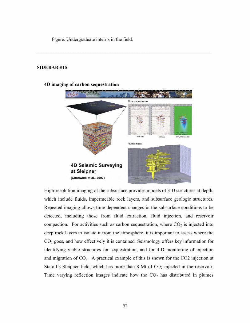
52
Figure. Undergraduate interns in the field.
_______________________________________________________________________
SIDEBAR #15
4D imaging of carbon sequestration
High-resolution imaging of the subsurface provides models of 3-D structures at depth,
which include fluids, impermeable rock layers, and subsurface geologic structures.
Repeated imaging allows time-dependent changes in the subsurface conditions to be
detected, including those from fluid extraction, fluid injection, and reservoir
compaction. For activities such as carbon sequestration, where CO2 is injected into
deep rock layers to isolate it from the atmosphere, it is important to assess where the
CO2 goes, and how effectively it is contained. Seismology offers key information for
identifying viable structures for sequestration, and for 4-D monitoring of injection
and migration of CO2. A practical example of this is shown for the CO2 injection at
Statoil’s Sleipner field, which has more than 8 Mt of CO2 injected in the reservoir.
Time varying reflection images indicate how the CO2 has distributed in plumes

53
throughout the medium. This provides a means by which to ensure integrity and full
utilization of the sequestration reservoir. (Image from Chadwick et al., 2007)
_______________________________________________________________________
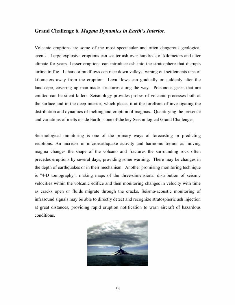
54
Grand Challenge 6. Magma Dynamics in Earth’s Interior.
Volcanic eruptions are some of the most spectacular and often dangerous geological
events. Large explosive eruptions can scatter ash over hundreds of kilometers and alter
climate for years. Lesser eruptions can introduce ash into the stratosphere that disrupts
airline traffic. Lahars or mudflows can race down valleys, wiping out settlements tens of
kilometers away from the eruption. Lava flows can gradually or suddenly alter the
landscape, covering up man-made structures along the way. Poisonous gases that are
emitted can be silent killers. Seismology provides probes of volcanic processes both at
the surface and in the deep interior, which places it at the forefront of investigating the
distribution and dynamics of melting and eruption of magmas. Quantifying the presence
and variations of melts inside Earth is one of the key Seismological Grand Challenges.
Seismological monitoring is one of the primary ways of forecasting or predicting
eruptions. An increase in microearthquake activity and harmonic tremor as moving
magma changes the shape of the volcano and fractures the surrounding rock often
precedes eruptions by several days, providing some warning. There may be changes in
the depth of earthquakes or in their mechanism. Another promising monitoring technique
is "4-D tomography", making maps of the three-dimensional distribution of seismic
velocities within the volcanic edifice and then monitoring changes in velocity with time
as cracks open or fluids migrate through the cracks. Seismo-acoustic monitoring of
infrasound signals may be able to directly detect and recognize stratospheric ash injection
at great distances, providing rapid eruption notification to warn aircraft of hazardous
conditions.
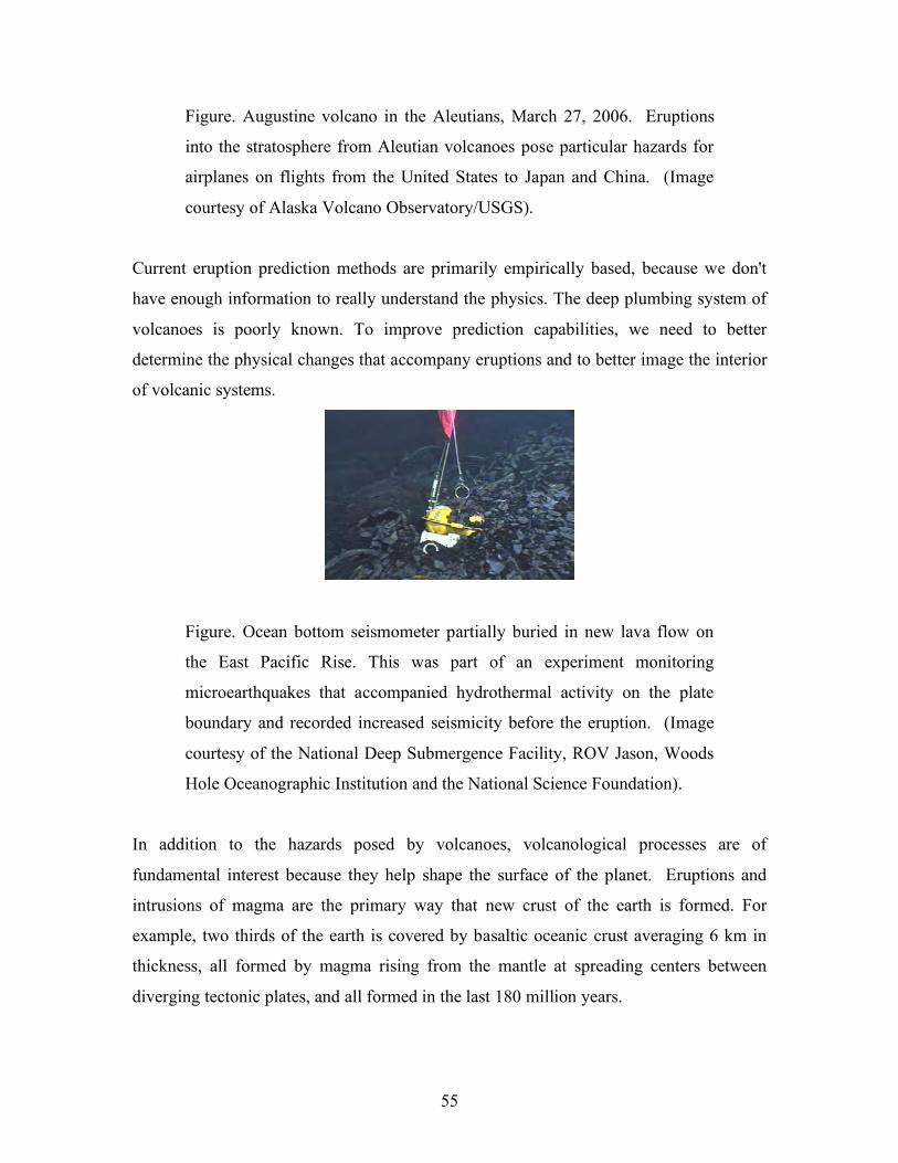
55
Figure. Augustine volcano in the Aleutians, March 27, 2006. Eruptions
into the stratosphere from Aleutian volcanoes pose particular hazards for
airplanes on flights from the United States to Japan and China. (Image
courtesy of Alaska Volcano Observatory/USGS).
Current eruption prediction methods are primarily empirically based, because we don't
have enough information to really understand the physics. The deep plumbing system of
volcanoes is poorly known. To improve prediction capabilities, we need to better
determine the physical changes that accompany eruptions and to better image the interior
of volcanic systems.
Figure. Ocean bottom seismometer partially buried in new lava flow on
the East Pacific Rise. This was part of an experiment monitoring
microearthquakes that accompanied hydrothermal activity on the plate
boundary and recorded increased seismicity before the eruption. (Image
courtesy of the National Deep Submergence Facility, ROV Jason, Woods
Hole Oceanographic Institution and the National Science Foundation).
In addition to the hazards posed by volcanoes, volcanological processes are of
fundamental interest because they help shape the surface of the planet. Eruptions and
intrusions of magma are the primary way that new crust of the earth is formed. For
example, two thirds of the earth is covered by basaltic oceanic crust averaging 6 km in
thickness, all formed by magma rising from the mantle at spreading centers between
diverging tectonic plates, and all formed in the last 180 million years.
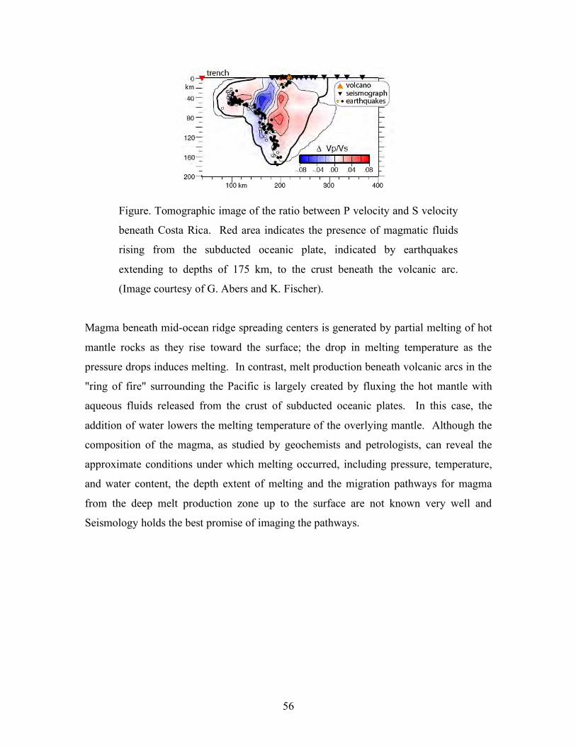
56
Figure. Tomographic image of the ratio between P velocity and S velocity
beneath Costa Rica. Red area indicates the presence of magmatic fluids
rising from the subducted oceanic plate, indicated by earthquakes
extending to depths of 175 km, to the crust beneath the volcanic arc.
(Image courtesy of G. Abers and K. Fischer).
Magma beneath mid-ocean ridge spreading centers is generated by partial melting of hot
mantle rocks as they rise toward the surface; the drop in melting temperature as the
pressure drops induces melting. In contrast, melt production beneath volcanic arcs in the
"ring of fire" surrounding the Pacific is largely created by fluxing the hot mantle with
aqueous fluids released from the crust of subducted oceanic plates. In this case, the
addition of water lowers the melting temperature of the overlying mantle. Although the
composition of the magma, as studied by geochemists and petrologists, can reveal the
approximate conditions under which melting occurred, including pressure, temperature,
and water content, the depth extent of melting and the migration pathways for magma
from the deep melt production zone up to the surface are not known very well and
Seismology holds the best promise of imaging the pathways.
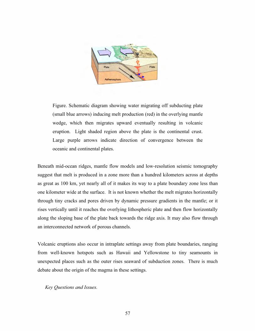
57
Figure. Schematic diagram showing water migrating off subducting plate
(small blue arrows) inducing melt production (red) in the overlying mantle
wedge, which then migrates upward eventually resulting in volcanic
eruption. Light shaded region above the plate is the continental crust.
Large purple arrows indicate direction of convergence between the
oceanic and continental plates.
Beneath mid-ocean ridges, mantle flow models and low-resolution seismic tomography
suggest that melt is produced in a zone more than a hundred kilometers across at depths
as great as 100 km, yet nearly all of it makes its way to a plate boundary zone less than
one kilometer wide at the surface. It is not known whether the melt migrates horizontally
through tiny cracks and pores driven by dynamic pressure gradients in the mantle; or it
rises vertically until it reaches the overlying lithospheric plate and then flow horizontally
along the sloping base of the plate back towards the ridge axis. It may also flow through
an interconnected network of porous channels.
Volcanic eruptions also occur in intraplate settings away from plate boundaries, ranging
from well-known hotspots such as Hawaii and Yellowstone to tiny seamounts in
unexpected places such as the outer rises seaward of subduction zones. There is much
debate about the origin of the magma in these settings.
Key Questions and Issues.
58
• Are there upwelling plumes from deep in the mantle that undergo pressure release
melting similar to that beneath mid-ocean ridges? If so, what is the depth extent
of melting?
• Is there melt widely distributed in the oceanic asthenosphere that finds its way to
the surface whenever some tectonic process cracks the overlying lithospheric
plate?
• What is the physical state of volcano plumbing systems and how do they change
with time?
• How does melting develop above subducting slabs and by what configuration
does it ascend? What is the influence of the sinking plate?
• Does melt pond at the base of the crust and thicken the crust by underplating?
Where is melt stored within the crust before erupting?
• Why do some magmas intrude while others erupt?
• How do volcanoes and earthquakes interact?
• How do volcanoes interact with each other
Seismological Approaches and Needs To Make Progress
• Densified long-term broadband seismic, geodetic, and infrasound instrumentation
around active volcanoes is needed.
• 4-D active source studies and ambient noise studies of volcanoes are needed.
• Experimental constraints on seismic velocity and attenuation properties of rocks
with melts are needed.
• Open access to data from volcano observatories, with improved data accessibility
and metadata.
• Form a “learning from eruptions” program.
• Develop a USGS volcano hazards external grants program with support for
seismology of volcano hazards.
_______________________________________________________________________
SIDEBAR #16
4-D monitoring of volcanoes using ambient seismic noise
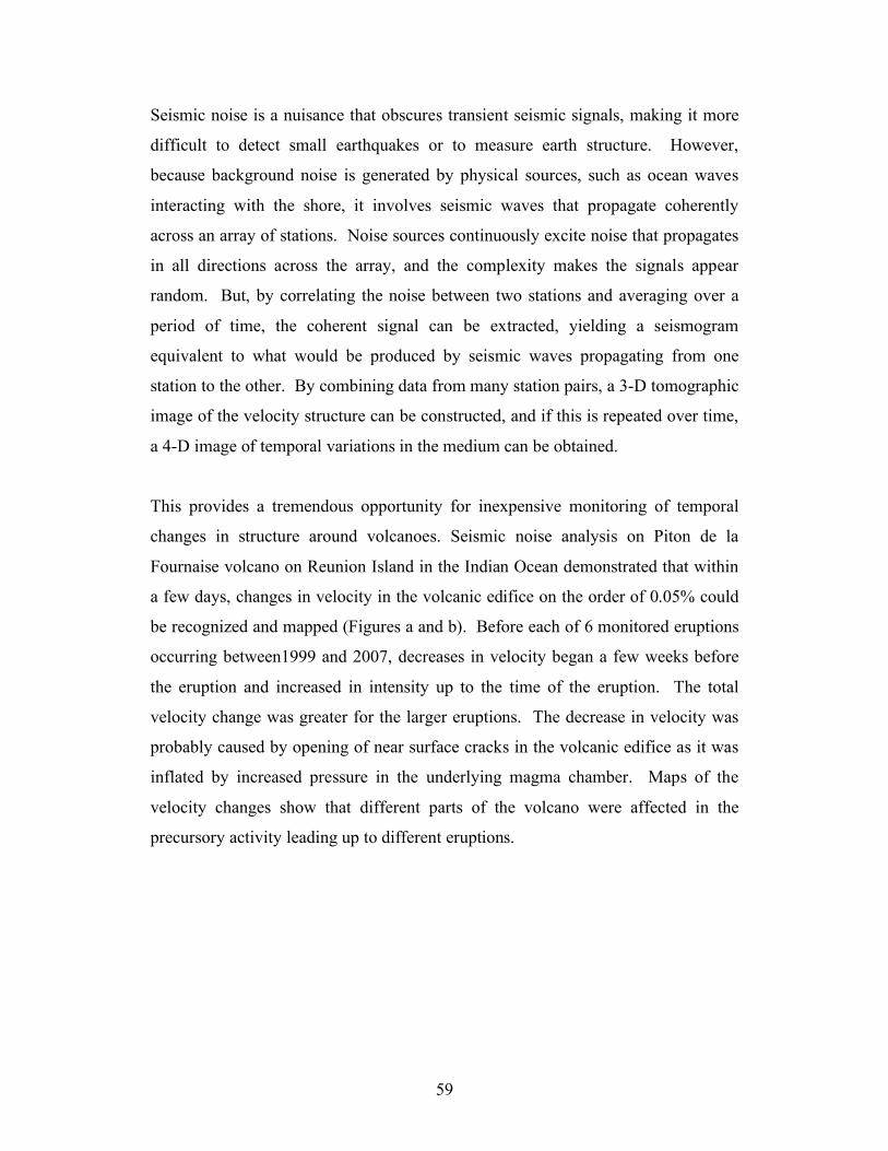
59
Seismic noise is a nuisance that obscures transient seismic signals, making it more
difficult to detect small earthquakes or to measure earth structure. However,
because background noise is generated by physical sources, such as ocean waves
interacting with the shore, it involves seismic waves that propagate coherently
across an array of stations. Noise sources continuously excite noise that propagates
in all directions across the array, and the complexity makes the signals appear
random. But, by correlating the noise between two stations and averaging over a
period of time, the coherent signal can be extracted, yielding a seismogram
equivalent to what would be produced by seismic waves propagating from one
station to the other. By combining data from many station pairs, a 3-D tomographic
image of the velocity structure can be constructed, and if this is repeated over time,
a 4-D image of temporal variations in the medium can be obtained.
This provides a tremendous opportunity for inexpensive monitoring of temporal
changes in structure around volcanoes. Seismic noise analysis on Piton de la
Fournaise volcano on Reunion Island in the Indian Ocean demonstrated that within
a few days, changes in velocity in the volcanic edifice on the order of 0.05% could
be recognized and mapped (Figures a and b). Before each of 6 monitored eruptions
occurring between1999 and 2007, decreases in velocity began a few weeks before
the eruption and increased in intensity up to the time of the eruption. The total
velocity change was greater for the larger eruptions. The decrease in velocity was
probably caused by opening of near surface cracks in the volcanic edifice as it was
inflated by increased pressure in the underlying magma chamber. Maps of the
velocity changes show that different parts of the volcano were affected in the
precursory activity leading up to different eruptions.
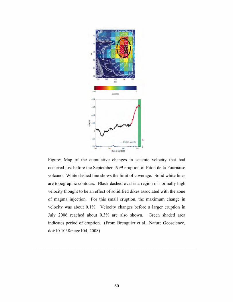
60
Figure: Map of the cumulative changes in seismic velocity that had
occurred just before the September 1999 eruption of Piton de la Fournaise
volcano. White dashed line shows the limit of coverage. Solid white lines
are topographic contours. Black dashed oval is a region of normally high
velocity thought to be an effect of solidified dikes associated with the zone
of magma injection. For this small eruption, the maximum change in
velocity was about 0.1%. Velocity changes before a larger eruption in
July 2006 reached about 0.3% are also shown. Green shaded area
indicates period of eruption. (From Brenguier et al., Nature Geoscience,
doi:10.1038/nego104, 2008).
_______________________________________________________________________
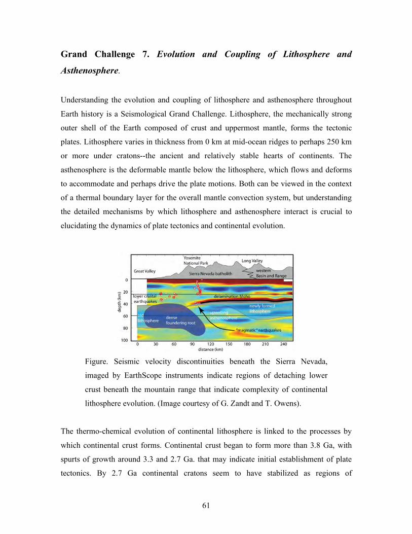
61
Grand Challenge 7. Evolution and Coupling of Lithosphere and
Asthenosphere.
Understanding the evolution and coupling of lithosphere and asthenosphere throughout
Earth history is a Seismological Grand Challenge. Lithosphere, the mechanically strong
outer shell of the Earth composed of crust and uppermost mantle, forms the tectonic
plates. Lithosphere varies in thickness from 0 km at mid-ocean ridges to perhaps 250 km
or more under cratons--the ancient and relatively stable hearts of continents. The
asthenosphere is the deformable mantle below the lithosphere, which flows and deforms
to accommodate and perhaps drive the plate motions. Both can be viewed in the context
of a thermal boundary layer for the overall mantle convection system, but understanding
the detailed mechanisms by which lithosphere and asthenosphere interact is crucial to
elucidating the dynamics of plate tectonics and continental evolution.
Figure. Seismic velocity discontinuities beneath the Sierra Nevada,
imaged by EarthScope instruments indicate regions of detaching lower
crust beneath the mountain range that indicate complexity of continental
lithosphere evolution. (Image courtesy of G. Zandt and T. Owens).
The thermo-chemical evolution of continental lithosphere is linked to the processes by
which continental crust forms. Continental crust began to form more than 3.8 Ga, with
spurts of growth around 3.3 and 2.7 Ga. that may indicate initial establishment of plate
tectonics. By 2.7 Ga continental cratons seem to have stabilized as regions of
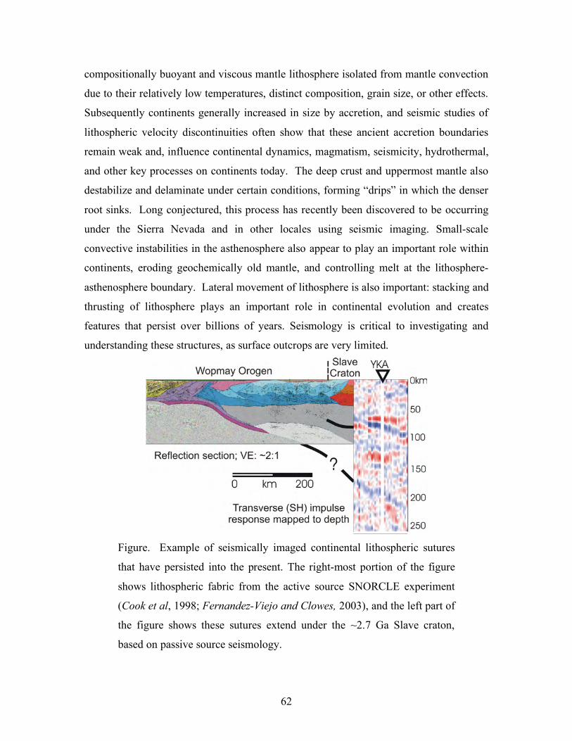
62
compositionally buoyant and viscous mantle lithosphere isolated from mantle convection
due to their relatively low temperatures, distinct composition, grain size, or other effects.
Subsequently continents generally increased in size by accretion, and seismic studies of
lithospheric velocity discontinuities often show that these ancient accretion boundaries
remain weak and, influence continental dynamics, magmatism, seismicity, hydrothermal,
and other key processes on continents today. The deep crust and uppermost mantle also
destabilize and delaminate under certain conditions, forming “drips” in which the denser
root sinks. Long conjectured, this process has recently been discovered to be occurring
under the Sierra Nevada and in other locales using seismic imaging. Small-scale
convective instabilities in the asthenosphere also appear to play an important role within
continents, eroding geochemically old mantle, and controlling melt at the lithosphere-
asthenosphere boundary. Lateral movement of lithosphere is also important: stacking and
thrusting of lithosphere plays an important role in continental evolution and creates
features that persist over billions of years. Seismology is critical to investigating and
understanding these structures, as surface outcrops are very limited.
Figure. Example of seismically imaged continental lithospheric sutures
that have persisted into the present. The right-most portion of the figure
shows lithospheric fabric from the active source SNORCLE experiment
(Cook et al, 1998; Fernandez-Viejo and Clowes, 2003), and the left part of
the figure shows these sutures extend under the ~2.7 Ga Slave craton,
based on passive source seismology.
63
Oceanic crust is continually forming at mid-ocean ridges. Basaltic oceanic crust and
cooled upper mantle make the oceanic lithosphere denser than its continental counterpart,
leading it to subduct as it ages—the oldest oceanic crust is only about 180 Ma. Oceanic
lithosphere thickening from 0 – 120 Ma seems to be consistent with conductive cooling
as the plates move away from the hot mid-ocean ridges, but older lithosphere is thinner
than a conductive cooling model would predict. It is generally hypothesized that small-
scale convection plays a major role in this phenomenon, but the exact nature of this
convection is still uncertain and the subject of many seismic imaging efforts.
A distinct low seismic velocity zone occurs beneath ocean lithosphere. This is associated
with the low viscosity asthenosphere. The nature of the low velocities seems to be caused
by some combination of temperature, melting, hydration, and grain size. velocities are
often found beneath continental lithosphere, but the structure is complex. At the
asthenosphere-lithosphere interface distinct seismic velocity jumps have been detected by
seismic waves and used to map continental lithospheric thickness variations. It may be
that the lithosphere-asthenosphere boundary is not simply a passive feature, but involves
small-scale convection associated with the motion of lithospheric “keels”. The relative
contributions of water, partial melt, or other factors in dictating the properties of the
asthenosphere remain largely unknown.
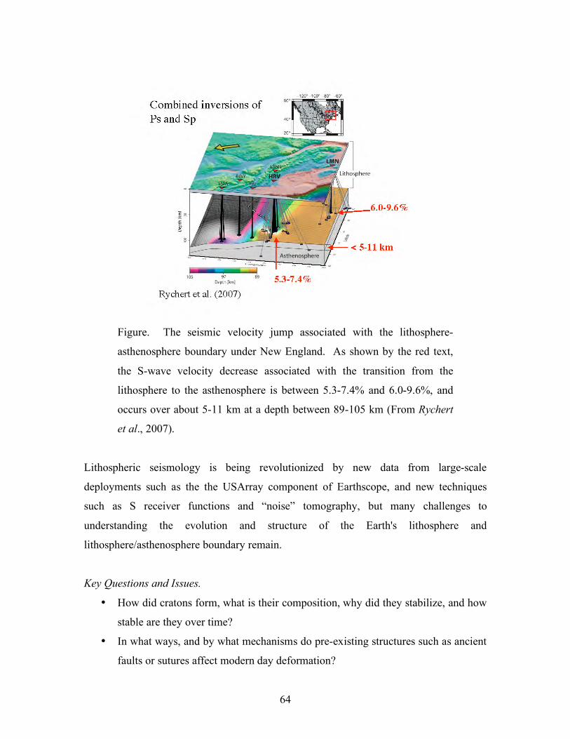
64
Figure. The seismic velocity jump associated with the lithosphere-
asthenosphere boundary under New England. As shown by the red text,
the S-wave velocity decrease associated with the transition from the
lithosphere to the asthenosphere is between 5.3-7.4% and 6.0-9.6%, and
occurs over about 5-11 km at a depth between 89-105 km (From Rychert
et al., 2007).
Lithospheric seismology is being revolutionized by new data from large-scale
deployments such as the the USArray component of Earthscope, and new techniques
such as S receiver functions and “noise” tomography, but many challenges to
understanding the evolution and structure of the Earth's lithosphere and
lithosphere/asthenosphere boundary remain.
Key Questions and Issues.
• How did cratons form, what is their composition, why did they stabilize, and how
stable are they over time?
• In what ways, and by what mechanisms do pre-existing structures such as ancient
faults or sutures affect modern day deformation?
65
• What aspects of melting, grain scale, and rock scale processes cause velocity
anisotropy, and how can we use this to deduce the flow and strain state of the
lithosphere and asthenosphere?
• What exactly is the asthenosphere: why is it weak, and why does it have low
seismic velocity and high attenuation? What controls the lithosphere-
asthenosphere boundary?
• Where and when does small-scale convection and lithospheric delamination
occur?
• Where does convection occur in the oceans and does it relate to surface features?
• What is the role of water, other volatiles, and composition in modulating the
stability and instability of the lithosphere?
• How is continental crust and lithosphere built over time? How deep do
boundaries associated with accreted terrains extend?
Seismological Approaches and Requirements To Make Progress
• Dense portable and permanent seismic arrays on continents and oceans provide
critical observations of discontinuities, anisotropy, attenuation and small-scale
heterogeneity of the lithosphere and asthenosphere.
• New computational methods for full waveform analysis and inversion are
computationally demanding and access to high-performance computing is needed.
• Inexpensive, abundant seismometers are needed for large-scale active and and
passive source deployments to image 3D structures of the lithosphere.
• Close collaboration among geoscientists across a range of disciplines are needed
for understanding the roles of fluids, variable rheology, and geologic history of
the lithosphere.
_______________________________________________________________________
SIDEBAR #17
Intraplate earthquakes
66
Seismologists face a major challenge in estimating earthquake hazards for areas
within continental plate interiors, such as the New Madrid and Charleston seismic
zones in the central and eastern U.S., for two basic reasons. First, regions far from
plate boundaries lack a context for the causes, nature, and rate of earthquakes.
Second, because intraplate earthquakes are rare owing to slow deformation rates,
relatively little is known about earthquakes and their effects in these regions.
Geological and paleoseismic observations indicate that many continental intraplate
faults have episodic seismicity separated by quiescent periods, with the seismicity
migrating across fault systems. This may be occurring in New Madrid, for which
GPS geodetic show little or none of the expected interseismic motion expected
before a future large earthquake. The earthquakes in this region in 1811 and 1812
may represent the end of activity, which will migrate elsewhere. In this model, the
present small earthquakes are simply aftershocks of the large earthquakes of 1811-
1812 rather than evidence for accumulating stress.
Understanding fundamental earthquake physics is crucial in estimating the
earthquake hazard for intraplate areas. Various assumptions yield different results.
For example, traditionally it has been assumed that future earthquakes are time
independent - equally probable immediately after the past one or much later. An
alternative is to use time-dependent models in which the probability is small shortly
after the past one, and then increases with time. Applying such models to New
Madrid and Charleston predicts significantly lower hazards because these are
"early" in their cycles. However, if the New Madrid cluster is ending, the
earthquake hazard in the New Madrid zone would be much lower than either model
predicts.
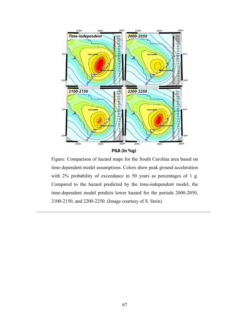
67
Figure: Comparison of hazard maps for the South Carolina area based on
time-dependent model assumptions. Colors show peak ground acceleration
with 2% probability of exceedance in 50 years as percentages of 1 g.
Compared to the hazard predicted by the time-independent model, the
time-dependent model predicts lower hazard for the periods 2000-2050,
2100-2150, and 2200-2250. (Image courtesy of S. Stein).
_______________________________________________________________________
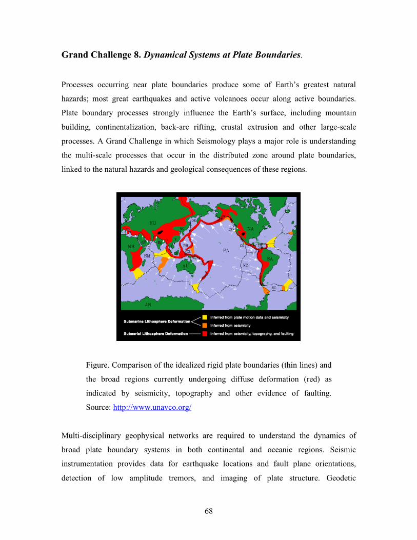
68
Grand Challenge 8. Dynamical Systems at Plate Boundaries.
Processes occurring near plate boundaries produce some of Earth’s greatest natural
hazards; most great earthquakes and active volcanoes occur along active boundaries.
Plate boundary processes strongly influence the Earth’s surface, including mountain
building, continentalization, back-arc rifting, crustal extrusion and other large-scale
processes. A Grand Challenge in which Seismology plays a major role is understanding
the multi-scale processes that occur in the distributed zone around plate boundaries,
linked to the natural hazards and geological consequences of these regions.
Figure. Comparison of the idealized rigid plate boundaries (thin lines) and
the broad regions currently undergoing diffuse deformation (red) as
indicated by seismicity, topography and other evidence of faulting.
Source: http://www.unavco.org/
Multi-disciplinary geophysical networks are required to understand the dynamics of
broad plate boundary systems in both continental and oceanic regions. Seismic
instrumentation provides data for earthquake locations and fault plane orientations,
detection of low amplitude tremors, and imaging of plate structure. Geodetic
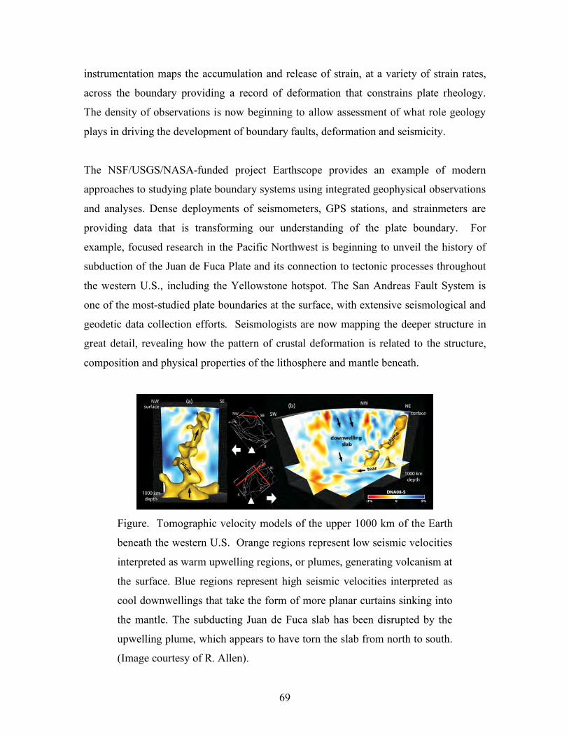
69
instrumentation maps the accumulation and release of strain, at a variety of strain rates,
across the boundary providing a record of deformation that constrains plate rheology.
The density of observations is now beginning to allow assessment of what role geology
plays in driving the development of boundary faults, deformation and seismicity.
The NSF/USGS/NASA-funded project Earthscope provides an example of modern
approaches to studying plate boundary systems using integrated geophysical observations
and analyses. Dense deployments of seismometers, GPS stations, and strainmeters are
providing data that is transforming our understanding of the plate boundary. For
example, focused research in the Pacific Northwest is beginning to unveil the history of
subduction of the Juan de Fuca Plate and its connection to tectonic processes throughout
the western U.S., including the Yellowstone hotspot. The San Andreas Fault System is
one of the most-studied plate boundaries at the surface, with extensive seismological and
geodetic data collection efforts. Seismologists are now mapping the deeper structure in
great detail, revealing how the pattern of crustal deformation is related to the structure,
composition and physical properties of the lithosphere and mantle beneath.
Figure. Tomographic velocity models of the upper 1000 km of the Earth
beneath the western U.S. Orange regions represent low seismic velocities
interpreted as warm upwelling regions, or plumes, generating volcanism at
the surface. Blue regions represent high seismic velocities interpreted as
cool downwellings that take the form of more planar curtains sinking into
the mantle. The subducting Juan de Fuca slab has been disrupted by the
upwelling plume, which appears to have torn the slab from north to south.
(Image courtesy of R. Allen).
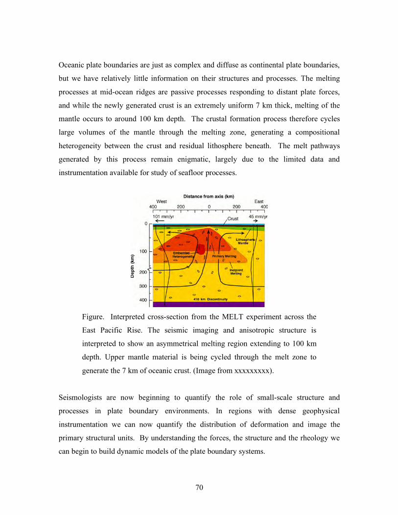
70
Oceanic plate boundaries are just as complex and diffuse as continental plate boundaries,
but we have relatively little information on their structures and processes. The melting
processes at mid-ocean ridges are passive processes responding to distant plate forces,
and while the newly generated crust is an extremely uniform 7 km thick, melting of the
mantle occurs to around 100 km depth. The crustal formation process therefore cycles
large volumes of the mantle through the melting zone, generating a compositional
heterogeneity between the crust and residual lithosphere beneath. The melt pathways
generated by this process remain enigmatic, largely due to the limited data and
instrumentation available for study of seafloor processes.
Figure. Interpreted cross-section from the MELT experiment across the
East Pacific Rise. The seismic imaging and anisotropic structure is
interpreted to show an asymmetrical melting region extending to 100 km
depth. Upper mantle material is being cycled through the melt zone to
generate the 7 km of oceanic crust. (Image from xxxxxxxxx).
Seismologists are now beginning to quantify the role of small-scale structure and
processes in plate boundary environments. In regions with dense geophysical
instrumentation we can now quantify the distribution of deformation and image the
primary structural units. By understanding the forces, the structure and the rheology we
can begin to build dynamic models of the plate boundary systems.
71
Key Questions and Issues
• Is the deformation at the surface driven by crustal properties or by forces
transmitted to the surface through the lithosphere?
• Are mantle wedges strongly coupled or decoupled from subducting slabs?
• How does continentalization occur in back-arc basins?
• How do sinking slabs interact with upwellings?
• What causes deep earthquakes and what are the stress and thermal conditions in
deep slabs?
• How and why do ridge jumps occur?
• How much lateral transport of material is there along ridge segments and between
ridges and hot spots?
• How are continental deformations in broad plate boundary zones accommodated
at depth?
• How do accretionary prisms evolve and what is their influence on trench
migration?
Seismological Approaches and Requirements To Make Progress
• Integrated geophysical observatories with long-term operation in multiple plate
boundary environments.
• Active and passive source deployments of large numbers of seismic sensors in
back-arc basins, coordinated with geodetic, geologic and geochemical
investigations.
• Large OBS deployments in diverse mid-ocean ridge spreading environments.
• Multi-channel active source seismic imaging and drilling of active margins.
• Large-scale passive imaging experiments along subduction zones.
_______________________________________________________________________
SIDEBAR #18
Field Laboratories
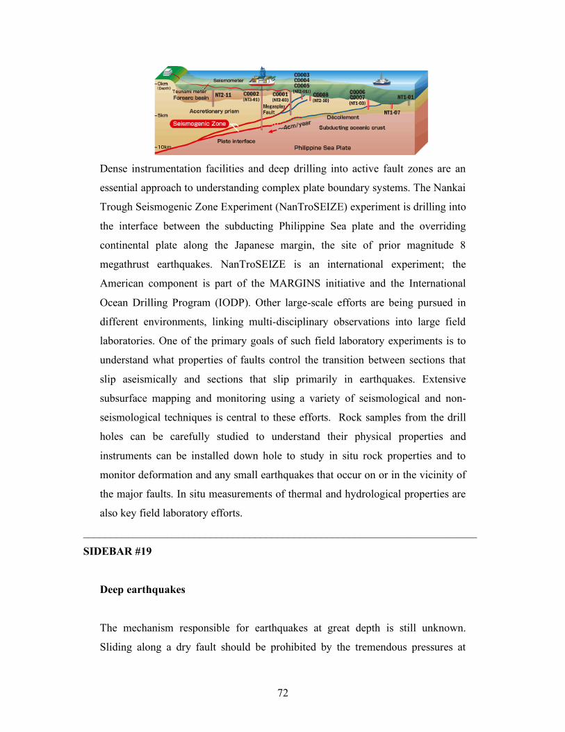
72
Dense instrumentation facilities and deep drilling into active fault zones are an
essential approach to understanding complex plate boundary systems. The Nankai
Trough Seismogenic Zone Experiment (NanTroSEIZE) experiment is drilling into
the interface between the subducting Philippine Sea plate and the overriding
continental plate along the Japanese margin, the site of prior magnitude 8
megathrust earthquakes. NanTroSEIZE is an international experiment; the
American component is part of the MARGINS initiative and the International
Ocean Drilling Program (IODP). Other large-scale efforts are being pursued in
different environments, linking multi-disciplinary observations into large field
laboratories. One of the primary goals of such field laboratory experiments is to
understand what properties of faults control the transition between sections that
slip aseismically and sections that slip primarily in earthquakes. Extensive
subsurface mapping and monitoring using a variety of seismological and non-
seismological techniques is central to these efforts. Rock samples from the drill
holes can be carefully studied to understand their physical properties and
instruments can be installed down hole to study in situ rock properties and to
monitor deformation and any small earthquakes that occur on or in the vicinity of
the major faults. In situ measurements of thermal and hydrological properties are
also key field laboratory efforts.
_______________________________________________________________________
SIDEBAR #19
Deep earthquakes
The mechanism responsible for earthquakes at great depth is still unknown.
Sliding along a dry fault should be prohibited by the tremendous pressures at
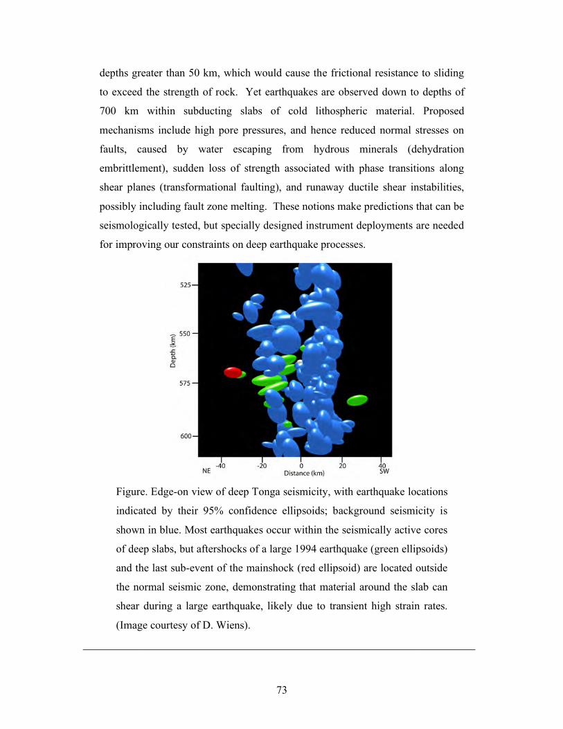
73
depths greater than 50 km, which would cause the frictional resistance to sliding
to exceed the strength of rock. Yet earthquakes are observed down to depths of
700 km within subducting slabs of cold lithospheric material. Proposed
mechanisms include high pore pressures, and hence reduced normal stresses on
faults, caused by water escaping from hydrous minerals (dehydration
embrittlement), sudden loss of strength associated with phase transitions along
shear planes (transformational faulting), and runaway ductile shear instabilities,
possibly including fault zone melting. These notions make predictions that can be
seismologically tested, but specially designed instrument deployments are needed
for improving our constraints on deep earthquake processes.
Figure. Edge-on view of deep Tonga seismicity, with earthquake locations
indicated by their 95% confidence ellipsoids; background seismicity is
shown in blue. Most earthquakes occur within the seismically active cores
of deep slabs, but aftershocks of a large 1994 earthquake (green ellipsoids)
and the last sub-event of the mainshock (red ellipsoid) are located outside
the normal seismic zone, demonstrating that material around the slab can
shear during a large earthquake, likely due to transient high strain rates.
(Image courtesy of D. Wiens).
_______________________________________________________________________
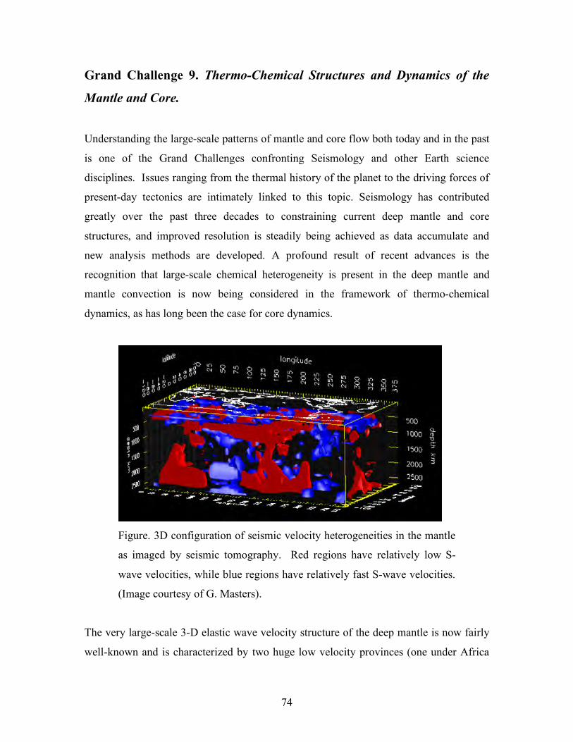
74
Grand Challenge 9. Thermo-Chemical Structures and Dynamics of the
Mantle and Core.
Understanding the large-scale patterns of mantle and core flow both today and in the past
is one of the Grand Challenges confronting Seismology and other Earth science
disciplines. Issues ranging from the thermal history of the planet to the driving forces of
present-day tectonics are intimately linked to this topic. Seismology has contributed
greatly over the past three decades to constraining current deep mantle and core
structures, and improved resolution is steadily being achieved as data accumulate and
new analysis methods are developed. A profound result of recent advances is the
recognition that large-scale chemical heterogeneity is present in the deep mantle and
mantle convection is now being considered in the framework of thermo-chemical
dynamics, as has long been the case for core dynamics.
Figure. 3D configuration of seismic velocity heterogeneities in the mantle
as imaged by seismic tomography. Red regions have relatively low S-
wave velocities, while blue regions have relatively fast S-wave velocities.
(Image courtesy of G. Masters).
The very large-scale 3-D elastic wave velocity structure of the deep mantle is now fairly
well-known and is characterized by two huge low velocity provinces (one under Africa
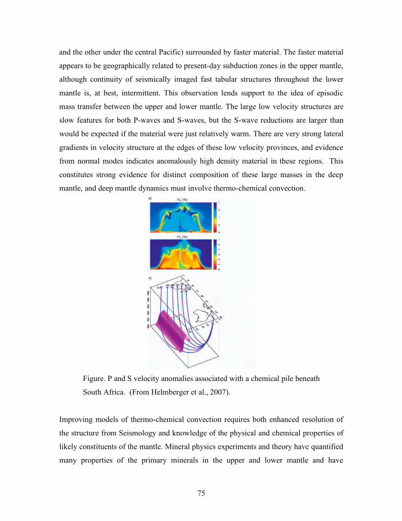
75
and the other under the central Pacific) surrounded by faster material. The faster material
appears to be geographically related to present-day subduction zones in the upper mantle,
although continuity of seismically imaged fast tabular structures throughout the lower
mantle is, at best, intermittent. This observation lends support to the idea of episodic
mass transfer between the upper and lower mantle. The large low velocity structures are
slow features for both P-waves and S-waves, but the S-wave reductions are larger than
would be expected if the material were just relatively warm. There are very strong lateral
gradients in velocity structure at the edges of these low velocity provinces, and evidence
from normal modes indicates anomalously high density material in these regions. This
constitutes strong evidence for distinct composition of these large masses in the deep
mantle, and deep mantle dynamics must involve thermo-chemical convection.
Figure. P and S velocity anomalies associated with a chemical pile beneath
South Africa. (From Helmberger et al., 2007).
Improving models of thermo-chemical convection requires both enhanced resolution of
the structure from Seismology and knowledge of the physical and chemical properties of
likely constituents of the mantle. Mineral physics experiments and theory have quantified
many properties of the primary minerals in the upper and lower mantle and have
76
characterized the nature of phase transformations expected as pressure and temperature
increase. Comparisons with seismic observations place bounds on viable chemistry and
temperature variations in the interior, and associated density heterogeneity. This
information then informs geodynamical simulations that seek to reconcile flow models
with the seismic observations. There remains evidence for some level of chemical
stratification between the upper and lower mantle in order to match observed seismic
measurements, but new discoveries from mineral physics such as the occurrence of high-
spin to low-spin transitions in iron with depth have added new degrees of freedom to the
problem. Enrichment of lower mantle minerals in iron would likely have the effect of
increasing density and lowering shear velocity so this is a possible contender for
explaining some of the properties of the large low velocity regions, which might be
chemically distinct, dense piles of material embedded in a large-scale circulation. These
piles may possibly serve as the reservoirs for geochemical tracers that are depleted in
near-surface samples. In particular, radioactive elements may be preferentially enriched
so that the piles could be sources of heat to drive convection in the overlying mantle.
While the velocity signature of the low velocity provinces is clearly present high above
the core-mantle boundary, seismic tomography cannot yet distinguish the fine structure,
and in particular determine whether the low velocity provinces are uniform structures or
are made up of groups of finer structures, or whether the wide piles have a roof at some
height above the core-mantle boundary, in which are rooted narrow thermal plumes that
rise to the produce surface hot spot volcanism. This lack of resolution results from a
combination limitations in global sampling by seismic waves due to lack of observations
from the oceans and in the southern hemisphere in particular, and limitations of seismic
imaging theory and applications that are currently being used. Improved imaging of
velocity structure at every scale is essential but there is also the challenging topic of
improving global anisotropy and attenuation models, which enhance our ability to
connect seismological observations to mineral physics and geodynamics.
Seismology constrains the structure of the fluid outer core and solid inner core to high
precision. To first order, there does not appear to be detectable seismic velocity
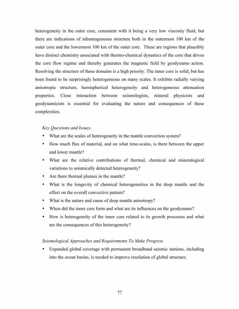
77
heterogeneity in the outer core, consistent with it being a very low viscosity fluid, but
there are indications of inhomogeneous structure both in the outermost 100 km of the
outer core and the lowermost 100 km of the outer core. These are regions that plausibly
have distinct chemistry associated with thermo-chemical dynamics of the core that drives
the core flow regime and thereby generates the magnetic field by geodynamo action.
Resolving the structure of these domains is a high priority. The inner core is solid, but has
been found to be surprisingly heterogeneous on many scales. It exhibits radially varying
anisotropic structure, hemispherical heterogeneity and heterogeneous attenuation
properties. Close interaction between seismologists, mineral physicists and
geodynamicists is essential for evaluating the nature and consequences of these
complexities.
Key Questions and Issues.
• What are the scales of heterogeneity in the mantle convection system?
• How much flux of material, and on what time-scales, is there between the upper
and lower mantle?
• What are the relative contributions of thermal, chemical and mineralogical
variations to seismically detected heterogeneity?
• Are there thermal plumes in the mantle?
• What is the longevity of chemical heterogeneities in the deep mantle and the
effect on the overall convective pattern?
• What is the nature and cause of deep mantle anisotropy?
• When did the inner core form and what are its influences on the geodynamo?
• How is heterogeneity of the inner core related to its growth processes and what
are the consequences of this heterogeneity?
Seismological Approaches and Requirements To Make Progress
• Expanded global coverage with permanent broadband seismic stations, including
into the ocean basins, is needed to improve resolution of global structure.
78
• Large portable deployments of three-component broadband sensors are needed to
resolve deep anisotropy and assess the fine-scale components of heterogeneity in
the deep mantle.
• Large data sets need to be applied in imaging methods that use finite-frequency
theory and wavefield backprojection to resolve deep structure.
• Interdisciplinary communication between seismologists, mineral physicists, and
geodynamicists is needed in workshops and community organizations such as the
CIDER program.
_______________________________________________________________________
SIDEBAR # 20
The Mysterious Inner Core
Seismology reveals that Earth’s inner core is surprisingly complex. While small,
the inner core plays an important role: freezing of the solid inner core from the
liquid outer core generates compositional buoyancy by expulsion of light alloy
components, this serves as an energy source for the outer core convection that
maintains Earth’s magnetic field. In the past two decades seismic analyses have
revealed variations in elastic properties of the inner core both in depth and
laterally, including multi-scale variations in attenuation and anisotropy. To first
order, the inner core has an overall anisotropic structure, such that waves travel
faster from pole to pole than they do across the equator, but the central region of
the inner core has a distinct orientation of anisotropy, and the outermost region is
almost isotropic. Large-scale lateral heterogeneities occur both in latitude and
longitude in the outer portions of the inner core, with the eastern hemisphere
having higher velocities and less attenuation than the western hemisphere. There is
also fine-scale (few kilometer) heterogeneity within the inner core. All of this
complexity is unexpected, and has prompted mineral physics and geodynamic
modeling of high pressure iron phases and crystallization mechanisms.
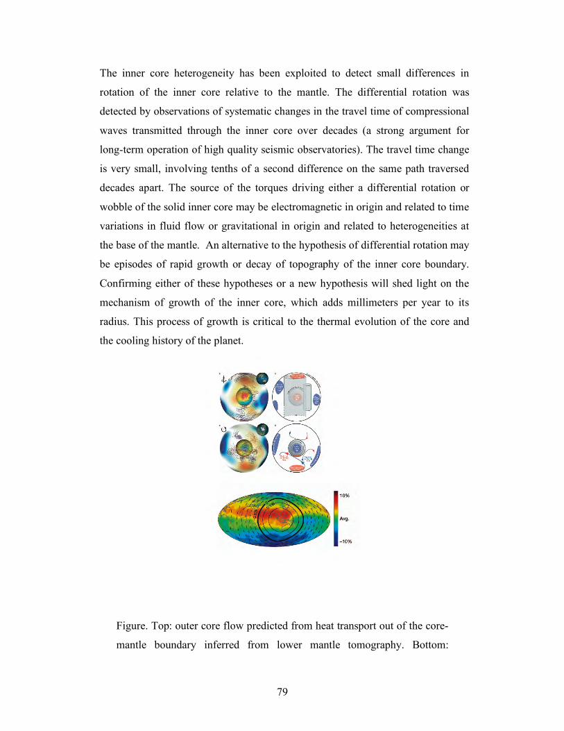
79
The inner core heterogeneity has been exploited to detect small differences in
rotation of the inner core relative to the mantle. The differential rotation was
detected by observations of systematic changes in the travel time of compressional
waves transmitted through the inner core over decades (a strong argument for
long-term operation of high quality seismic observatories). The travel time change
is very small, involving tenths of a second difference on the same path traversed
decades apart. The source of the torques driving either a differential rotation or
wobble of the solid inner core may be electromagnetic in origin and related to time
variations in fluid flow or gravitational in origin and related to heterogeneities at
the base of the mantle. An alternative to the hypothesis of differential rotation may
be episodes of rapid growth or decay of topography of the inner core boundary.
Confirming either of these hypotheses or a new hypothesis will shed light on the
mechanism of growth of the inner core, which adds millimeters per year to its
radius. This process of growth is critical to the thermal evolution of the core and
the cooling history of the planet.
Figure. Top: outer core flow predicted from heat transport out of the core-
mantle boundary inferred from lower mantle tomography. Bottom:
80
predicted regions of outer core upwelling (red) and downwelling (blue)
near the core mantle boundary. Contours of the region of fast
compressional wave velocity observed in the uppermost inner core in its
quasi-eastern hemisphere (Aubert et al., 2008).
_______________________________________________________________________
SIDEBAR #21
Planetary Seismology
Seismology can potentially reveal internal structure and dynamic processes of
other terrestrial bodies – planets, moons and asteroids – in the solar system, if
seismic sensors can be deployed and data retrieved. A very limited amount of
seismic data obtained from the Moon during the Apollo program revealed
important information about the Moon’s internal structure including thickness of
the surface regolith layer, presence of a low-velocity zone near a depth of 400 km
and possible existence of a partially-molten silicate core. Deployments of
seismometers on other planetary bodies can potentially address many significant
questions such as the extent of water within the crust of Mars, the dimensions of
the salt-water ocean on Europa, and the reason for the lack of a magnetic field on
Venus. While every planet presents formidable challenges to seismological
approaches, the long-reach of seismological methods can provide a bountiful
return of important information that cannot be obtained by any other method.
A return of seismometers to the Moon would provide opportunities to explore
important basic questions, including: Does the Moon’s internal structure support
the model of lunar formation from ejecta of a large impact on Earth? What is the
nature of the mantle/core boundary within the Moon and what is its connection
with deep moonquakes? What is the physical mechanism that controls the
correlation between moonquakes and tidal stresses excited by Earth’s
gravitational field? Are the mechanisms of failure for deep lunar quakes similar to
the mechanisms responsible for deep earthquakes on Earth? Are these events
81
related to solid phase changes in silicate minerals? How large are lateral
heterogeneities in composition and structure, as determined using 3-D
tomography?
A similar broad range of topics can be addressed by deploying seismometers on
Mars, if engineering challenges of designing, building and deploying rugged
seismometers protected from extreme temperatures, winds, and cosmic radiation,
can be overcome. Mars is likely to be relatively lacking in faulting quakes, but
mapping the crust and lithosphere will be feasible using artificial sources and the
new seismic techniques of analyzing correlated noise excited by the strong
atmospheric winds. Key topics that could be addressed include the radial layering
of the crust mantle and core of the planet, the distribution of ground water/ice in
the near-surface, and the internal structural variations associated with the bimodal
surface morphology of the planet.
Venus and Mercury present formidable environmental challenges, but
seismological technologies that can overcome them may be within reach. Smaller
planetary bodies like Europa and Ganymede are good targets for seismological
methods to determine the presence and extent of internal fluid water levels.
Asteroids have highly uncertain material properties, and design of seismological
probes of their interiors can complement other approaches such as ground
penetrating radar. Essentially every mission to a solid body in the planet should
include consideration of the potential of seismological instrumentation and data
collection given the great payoff from even limited seismic recordings.
PLANETARY SEISMOLOGY FIGURE NEEDED
Figure. Location of deep moonquakes and/or correlation with tidal stresses.
_______________________________________________________________________
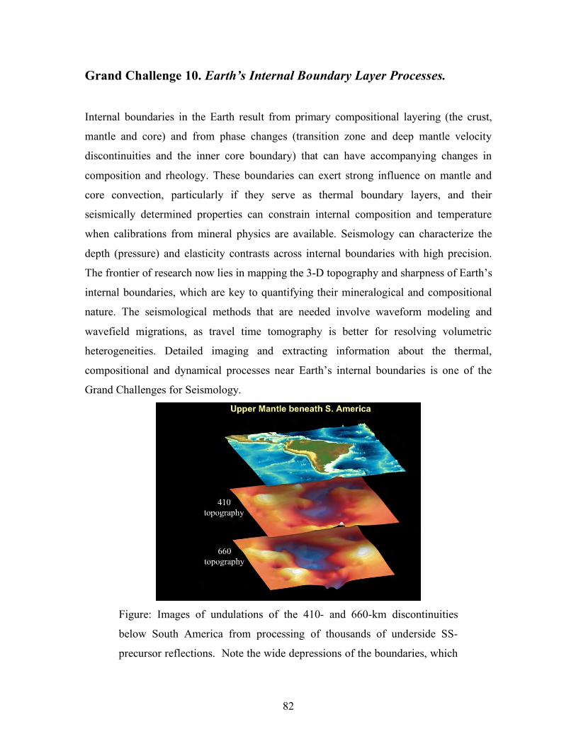
82
Grand Challenge 10. Earth’s Internal Boundary Layer Processes.
Internal boundaries in the Earth result from primary compositional layering (the crust,
mantle and core) and from phase changes (transition zone and deep mantle velocity
discontinuities and the inner core boundary) that can have accompanying changes in
composition and rheology. These boundaries can exert strong influence on mantle and
core convection, particularly if they serve as thermal boundary layers, and their
seismically determined properties can constrain internal composition and temperature
when calibrations from mineral physics are available. Seismology can characterize the
depth (pressure) and elasticity contrasts across internal boundaries with high precision.
The frontier of research now lies in mapping the 3-D topography and sharpness of Earth’s
internal boundaries, which are key to quantifying their mineralogical and compositional
nature. The seismological methods that are needed involve waveform modeling and
wavefield migrations, as travel time tomography is better for resolving volumetric
heterogeneities. Detailed imaging and extracting information about the thermal,
compositional and dynamical processes near Earth’s internal boundaries is one of the
Grand Challenges for Seismology.
Figure: Images of undulations of the 410- and 660-km discontinuities
below South America from processing of thousands of underside SS-
precursor reflections. Note the wide depressions of the boundaries, which
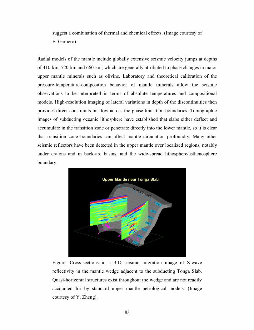
83
suggest a combination of thermal and chemical effects. (Image courtesy of
E. Garnero).
Radial models of the mantle include globally extensive seismic velocity jumps at depths
of 410-km, 520-km and 660-km, which are generally attributed to phase changes in major
upper mantle minerals such as olivine. Laboratory and theoretical calibration of the
pressure-temperature-composition behavior of mantle minerals allow the seismic
observations to be interpreted in terms of absolute temperatures and compositional
models. High-resolution imaging of lateral variations in depth of the discontinuities then
provides direct constraints on flow across the phase transition boundaries. Tomographic
images of subducting oceanic lithosphere have established that slabs either deflect and
accumulate in the transition zone or penetrate directly into the lower mantle, so it is clear
that transition zone boundaries can affect mantle circulation profoundly. Many other
seismic reflectors have been detected in the upper mantle over localized regions, notably
under cratons and in back-arc basins, and the wide-spread lithosphere/asthenosphere
boundary.
Figure. Cross-sections in a 3-D seismic migration image of S-wave
reflectivity in the mantle wedge adjacent to the subducting Tonga Slab.
Quasi-horizontal structures exist throughout the wedge and are not readily
accounted for by standard upper mantle petrological models. (Image
courtesy of Y. Zheng).
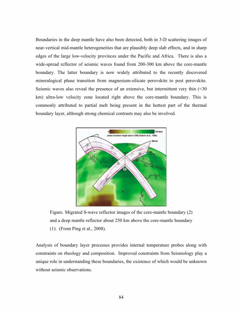
84
Boundaries in the deep mantle have also been detected, both in 3-D scattering images of
near-vertical mid-mantle heterogeneities that are plausibly deep slab effects, and in sharp
edges of the large low-velocity provinces under the Pacific and Africa. There is also a
wide-spread reflector of seismic waves found from 200-300 km above the core-mantle
boundary. The latter boundary is now widely attributed to the recently discovered
mineralogical phase transition from magnesium-silicate perovskite to post perovskite.
Seismic waves also reveal the presence of an extensive, but intermittent very thin (<30
km) ultra-low velocity zone located right above the core-mantle boundary. This is
commonly attributed to partial melt being present in the hottest part of the thermal
boundary layer, although strong chemical contrasts may also be involved.
Figure. Migrated S-wave reflector images of the core-mantle boundary (2)
and a deep mantle reflector about 250 km above the core-mantle boundary
(1). (From Ping et al., 2008).
Analysis of boundary layer processes provides internal temperature probes along with
constraints on rheology and composition. Improved constraints from Seismology play a
unique role in understanding these boundaries, the existence of which would be unknown
without seismic observations.
85
Key Questions and Issues.
• How sharp are internal mantle and core boundaries?
• What is the small-scale topographic structure and lateral extent of mantle
boundaries, including the core-mantle boundary?
• What are the effects of the transition zone boundaries on mass flux from upper to
lower mantle?
• Are there sources of thermal plumes at any of the internal boundaries?
• Is post-perovskite present in the mantle and does it exist in lenses or as a layer?
• What is the cause of the ultra-low velocity zone at the base of the mantle, and
how has it evolved?
• Can heat flux across the boundaries be seismologically constrained?
• Can we detect time-dependent changes in boundary properties?
• Are there stable thermo-chemical boundary layers in the outermost outer and
lowermost outer core?
• What causes hemispherical variations just below the inner core boundary and
what is the source of deeper anisotropy?
Seismological Approaches and Requirements To Make Progress
• Dense seismic array observations are needed for resolving fine-scale structure of
boundaries in the upper and lower mantle and core.
• Seismic wave propagation methods for handling rough boundaries and for
imaging their 3-D configurations need to be enhanced.
• Expanded global coverage of boundary structures is needed with new sites in the
oceans and at high latitudes being valuable.
• Communications with mineral physicists and geodynamicists need to be fostered
to formulate testable hypotheses that Seismology can pursue
_______________________________________________________________________
SIDEBAR #22
CMB heat flow.
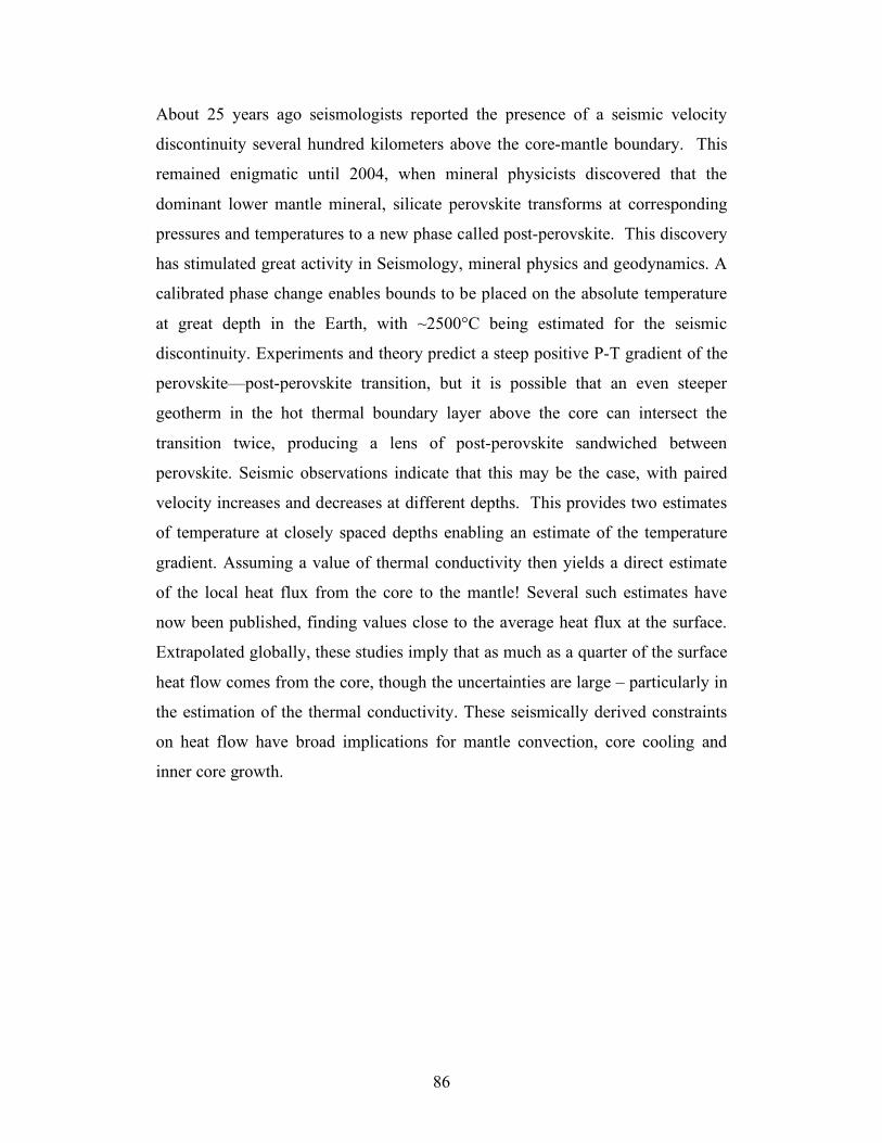
86
About 25 years ago seismologists reported the presence of a seismic velocity
discontinuity several hundred kilometers above the core-mantle boundary. This
remained enigmatic until 2004, when mineral physicists discovered that the
dominant lower mantle mineral, silicate perovskite transforms at corresponding
pressures and temperatures to a new phase called post-perovskite. This discovery
has stimulated great activity in Seismology, mineral physics and geodynamics. A
calibrated phase change enables bounds to be placed on the absolute temperature
at great depth in the Earth, with ~2500°C being estimated for the seismic
discontinuity. Experiments and theory predict a steep positive P-T gradient of the
perovskite—post-perovskite transition, but it is possible that an even steeper
geotherm in the hot thermal boundary layer above the core can intersect the
transition twice, producing a lens of post-perovskite sandwiched between
perovskite. Seismic observations indicate that this may be the case, with paired
velocity increases and decreases at different depths. This provides two estimates
of temperature at closely spaced depths enabling an estimate of the temperature
gradient. Assuming a value of thermal conductivity then yields a direct estimate
of the local heat flux from the core to the mantle! Several such estimates have
now been published, finding values close to the average heat flux at the surface.
Extrapolated globally, these studies imply that as much as a quarter of the surface
heat flow comes from the core, though the uncertainties are large – particularly in
the estimation of the thermal conductivity. These seismically derived constraints
on heat flow have broad implications for mantle convection, core cooling and
inner core growth.
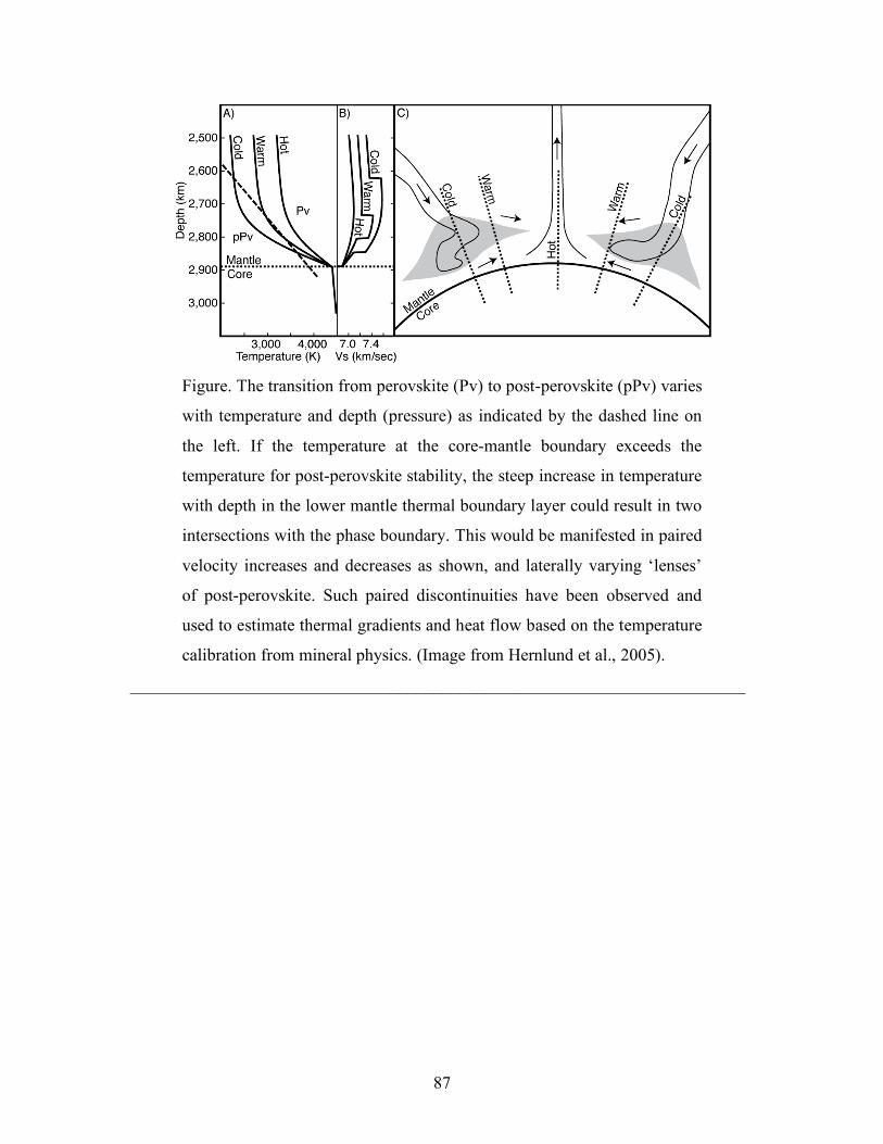
87
Figure. The transition from perovskite (Pv) to post-perovskite (pPv) varies
with temperature and depth (pressure) as indicated by the dashed line on
the left. If the temperature at the core-mantle boundary exceeds the
temperature for post-perovskite stability, the steep increase in temperature
with depth in the lower mantle thermal boundary layer could result in two
intersections with the phase boundary. This would be manifested in paired
velocity increases and decreases as shown, and laterally varying ‘lenses’
of post-perovskite. Such paired discontinuities have been observed and
used to estimate thermal gradients and heat flow based on the temperature
calibration from mineral physics. (Image from Hernlund et al., 2005).
_______________________________________________________________________
88
Sustaining a Healthy Future for Seismology
The panoply of seismological research topics and societal applications overviewed above
is the result of past extensive investment by many Federal agencies, industry and
universities. Sustaining the positive trajectory of Seismology’s contributions requires
strategic investment of future resources. Discussion of the disciplinary needs and
recommendations for the future are summarized here.
Key to all undertakings in Seismology is maintaining a steady flux of talented people
with solid quantitative skills into university programs, training in fundamentals of
seismological theory and practices, and retention of the expertise in academic, industry,
national laboratory, regulatory and Federal agency careers. Attracting more students to
this exciting and important discipline requires improved visibility of its many societal
contributions and exciting research frontiers, along with stable funding for graduate
programs that prepare new seismologists for the tasks of tomorrow. The Seismology
workforce demands of industry are not now being fully met and new partnerships
between relevant industries (e.g., energy exploration, insurance, engineering) and
academic programs could be developed to attract undergraduates to the discipline.
Broadly based efforts to enhance public awareness of the importance of the discipline, as
conducted by Education and Outreach (E&O) efforts of IRIS, SCEC, and EarthScope as
well as many university programs, are highly beneficial long-term investments that play
an important role in informing society about the importance of the science and how it
contributes to society.
RECOMMENDATIONS:
• Seismology community organizations like IRIS, SCEC, EERI and the SSA should
engage with industry to establish pipelines of undergraduate students to the
discipline.
• E&O efforts of these organizations should expand public awareness of the
contributions of the discipline, along with supporting undergraduate and
graduate training materials and opportunities.
89
Analysis of huge seismic data sets, inversion for 3-D and 4-D multi-scale models of the
interior, and robust calculation of broadband seismic ground motions for realistic, non-
linear earthquake and explosion sources present huge computational challenges.
University research on these topics relies on access to moderate-size in-house computer
workstations and clusters and to large-scale computational capabilities of national
laboratories and integrated networks of cyberinfrastructure such as the Terragrid.
Standardization and dissemination of some advanced seismic software is being
undertaken by the Computational Infrastructure for Geodynamics (CIG) initiative of
NSF, and further development of these efforts will advance the discipline.
RECOMMENDATIONS:
• Carefully vetted seismological software and processing tools, along with
integrative data products should be made openly available to the research
community.
• Readily accessible pathways to use of massive computer resources should be
established by academic and national laboratory collaborations.
With availability of high-quality, widely distributed recordings of ground motion lying at
the heart of all seismological research and monitoring activities, strong commitments are
needed to sustain continuous, long-term observations at global observatories of the
FDSN, the IRIS Global Seismic Network (GSN) and the CTBTO IMS, as well as
completion of the Advanced National Seismic System (ANSS) within the United States.
Sustained maintenance and operation of these stations is essential for both national
security, global monitoring of the environment, earthquake and tsunami hazard warning
and response activities, and investigations of the Seismological Grand Challenges. As
instrumental bandwidths broaden in all disciplines, we need to look toward a more
holistic view of monitoring that includes not just signals from traditional seismometers
and accelerometers, but also signals traditionally monitored by geodesists,
meteorologists, oceanographers, glaciologists, and environmental scientists.
90
RECOMMENDATIONS
• Coordination with other environmental monitoring facilities should be pursued to
establish multi-disciplinary monitoring stations at global seismic facilities.
• Sustained support of IRIS GSN operations should be shared by all Federal
Agencies that rely upon global seismic data as part of their environmental
monitoring operations.
• Completion of the ANSS by the USGS is a priority.
Large pools of deployable instruments are essential for seismological investigations of
continental and oceanic environments at higher resolution that afforded by permanent
stations. The IRIS Program for Array Seismic Studies of the Continental Lithosphere
(PASSCAL), EarthScope Transportable and Flexible Array instruments, Ocean Bottom
Seismometer Instrumentation Pool (OBSIP), and R/V Marcus G. Langseth research
vessel provide key seismic data. While improved seismic instrumentation of the ocean
environments will be achieved by the new NSF Ocean Observatories Initiative (OOI), the
current seismological component has become very limited, and there is need for much
more extensive coverage of ocean environments using sub-surface borehole seismometer
deployments and an expanded pool of broadband ocean bottom seismometers.
Systematic deployment of broadband OBS instruments in targeted areas of the oceans
holds great promise for scientific break-throughs, as proposed in the Ocean Mantle
Dynamics Science Plan (2000) produced by the NSF-funded community. The controlled-
source community has expressed a need for increased numbers of 3-component
instruments, to enable dense deployments that are not possible with current instrument
pools.
RECOMMENDATIONS
• Federal agencies need to sustain seismic data collection facilities with long-term
amortization and investments in new technologies.
• The EarthScope Transportable Array deployment should be supported through
completion of its traverse across the United States, including Alaska.
91
• Global ocean bottom borehole installations should be deployed guided by the
Ocean Seismic Network plans for establishing uniform global coverage of the
Earth.
• Expansion of portable OBS instrumentations for systematic large-scale
deployments in portable arrays is highly recommended by the community.
• Significant increases in sensors for active source experiments including three-
component systems is needed for high resolution crustal imaging.
The highest-resolution imaging of the crust requires controlled and densely distributed
sources recorded on dense receiver arrays. The NSF-funded research vessel M/V
Langseth has a large airgun array and four 6-km streamers of dense hydrophones,
enabling community research in marine geologic studies. In contrast, the land community
has no shared source facility. The cost of controlled sources has become a limiting factor
in the funding of individual-PI grants, and as a result the number of surveys has
decreased and the technology has retreated far behind industry capabilities. Improved and
sustained availability of sources is required to achieve scientific advances and to broaden
the pool of academic scientists capable of conducting such surveys. The vibrator trucks
of the Network for Earthquake Engineering Simulation (NEES) facility could be made
more available for seismologic research on very shallow structure, which may require
increased flexibility in the current operations. These trucks are not suitable for crustal
scale applications. The continental imaging efforts of the USGS have largely diminished
over time, and there is no longer a dedicated internal program to collaborate with
universities in the permitting and handling of buried explosive sources, which requires
expertise and is facilitated by government participation. Drilling for explosives and
vibrator truck arrays can both be handled commercially, but the substantial cost is an
impediment to the individual PI. A community source facility that includes drill rigs and
a vibrator array would sustain the health of imaging of the continental crust. This facility
could work on a model similar to DOSECC, which provides scientific drilling rigs but
also provides expertise for the contract hiring of industry rigs where appropriate.
RECOMMENDATIONS
92
• Sustained and improved availability of seismic sources such as the vibrator trucks
of the Network for Earthquake Engineering Simulation (NEES) is needed for
near-surface imaging applications.
• Reinvigorated participation of the USGS in active-source seismology is
recommended.
• A facility or collection of facilities for sources used in active-source seismology is
needed if University programs in this area are to be sustained. It could possibly
be developed in partnership with industry.
Seismology is an intrinsically global, international undertaking, and it relies on strong
coordination and cooperation between governments, international organizations, and
universities. Seismology contributions are greatly served by open-access to real-time
seismic data from all international data collection activities, building on the examples of
the USGS NEIC, IRIS DMC and FDSN-participant data centers, along with many U.S.
University programs. Efforts to make available data that are not now freely available,
such as the IMS seismic recordings and other currently restricted seismic data sets, will
enhance multi-use of the corresponding signals for investigating important topics in the
Earth system. The global concerns about earthquake hazards, environmental change, and
nuclear testing present many opportunities for international partnerships and interactions
on technology transfer, capacity building, confidence building and integrative hazard
assessment that complement basic research undertakings. The advanced state-of-the-art
of the discipline in the developed world can be leveraged to directly impact developing
nations struggling to deal with challenging hazard issues and limited resources.
RECOMMENDATIONS
• Federal programs and Seismology organizations need to strongly advocate for
real-time open-access to seismic data from around the world.
• Seismological capabilities for addressing hazards and environmental monitoring
concerns should be communicated and fostered with developing nations by
international coordinated efforts.
93
Progress on the Seismological Grand Challenges listed in this document and the many
societal applications of Seismology hinges on improved interdisciplinary interactions and
communications. Strong synergisms exist within the Earth Sciences arena between
Seismology and other disciplines such as geodesy, geodynamics, mineral physics,
geology, and geochemistry. These connections are fostered by professional societies
such as the American Geophysical Union (AGU), the Society of Exploration
Geophysicists (SEG), and the International Association for Seismology and Physics of
Earth’s Interior (IASPEI). Research coordination is abetted by NSF-funded community
organizations and consortia such as the IRIS, the Southern California Earthquake Center
(SCEC), the Cooperative Institute for Deep Earth Research (CIDER), the Consortium for
Materials Properties Research in Earth Sciences (COMPRES) and the geodetic
consortium UNAVCO. NSF-programs such as MARGINS, RIDGE, and CSEDI also
enhance multidisciplinary communications. Coordination with the National Ecological
Observatory Network (NEON) can augment societal applications of Seismology. The
U.S. has much narrower ties between industry and academia for workforce training and
technology development in active-source seismology.
RECOMMENDATIONS
• Multi-disciplinary integration efforts need to be sustained, and improved
communications and coordination on Seismology activities needs to be fostered
between NSF Earth Sciences (EAR), Ocean Sciences (OCE), Atmospheric
Sciences (ATM) and Polar Programs (OPP) divisions. Coordination at the GEO
directorate level of NSF can help to overcome existing institutional barriers to
effective cross-divisional activities of Seismology.
• Interdisciplinary workshops on critical interfaces in the shallow Earth system,
extreme environments, and environmental change with active participation by
seismologists should be encouraged and supported by Federal Agencies.
• Improved interactions between academic, governmental and industrial efforts in
active-source seismology are needed to sustain the discipline.
94
Technological advances permeate the discipline of Seismology, which is quick to
embrace advances in computer storage and processing, telecommunications, internet
dissemination of information, and advances that come from other technologies. Specific
to the discipline are needs for seismic sensor and high-resolution data acquisition
advances. The current sensors for recording very broadband (VBB) seismic data at the
long-period end of seismic ground motions (Streckeisen STS-1 sensors deployed in many
seismic networks) are no longer being produced and will need replacement as they age.
Development of a next-generation VBB sensor is of high priority, and is required to
ensure on-scale, complete recordings of the very largest earthquakes such as the 2004
Sumatra tsunami earthquake, and to record the Earth’s free oscillations, slow earthquake
motions, and very long period ‘noise’ with high fidelity. New micro-electro mechanical
systems (MEMS) are being designed to sense short-period ground vibrations, and further
development of this technology may enable vast increases in numbers of inexpensive
sensors that can provide high density sampling of ground motions in urban and remote
areas, with many potential applications. New three-component seismic sensors for hostile
environments (extreme cold, ocean-bottom, and deep boreholes) are of great importance
for expanding the reach of Seismology and for addressing the discipline’s Grand
Challenges. University participation in seismic instrumentation development has
diminished over time, and sustaining specialized expertise in ground motion
measurement technologies is a challenge that confronts the discipline.
RECOMMENDATIONS
• Collaborations across Federal agencies that utilize very broadband seismic data
for monitoring purposes should support development of next-generation very
broadband seismometers to replace current instruments.
• MEMS technologies need to be explored to develop low cost seismic sensors that
can be deployed in great numbers.
• Partnerships with industry, national laboratories, and Federal agencies must be
developed to sustain seismic instrumentation innovation and enhanced
capabilities.
95
Summary
Seismology is an exciting, vigorous and important discipline, with broad relevance to
major challenges confronting society such as environmental change, coping with natural
hazards, energy resource development, and national security. Seismology provides the
highest resolution probes of inaccessible regions of the Earth’s interior from shallow
crustal sediments to the central core, and it thus plays a primary role in efforts to
understand the structure and dynamics of Earth’s many internal systems. The discipline
has grown to its current prominence by sustained Federal support of basic science
research, which ensures training of new generations of seismologists in university
research programs, along with technical developments that enhance applied research in
nuclear monitoring, exploration seismology, earthquake and volcano hazard monitoring,
and environmental change evaluation.
Looking to the next ten to twenty years, the seismological community has defined 10
Grand Challenge basic research topics to which Seismology offers fundamental
contributions. These topics all address Earth systems that can be probed and quantified by
the techniques of Seismology. The basic premise of this Grand Challenge plan is that by
identifying scientific challenges and opportunities for basic research in Seismology to be
supported by Federal and Industry programs, the discipline can sustain the infrastructure,
workforce and expanding capabilities that will enable it to contribute to society to an
even greater degree than it has in the past.
96
Appendix - Key Seismological Practices
Seismological approaches to solving the Grand Challenges described in this document
include a plethora of analysis techniques and distinct seismic wave analyses. Underlying
all of the methods are some intrinsic attributes of the discipline that warrant discussion.
These include the practices of monitoring Earth’s natural and human-made sources, and
the practices of imaging Earth’s systems and modeling the ground shaking using the
resulting Earth models.
Monitoring dynamic processes in Earth’s environment
Earthquakes, volcanoes, ocean storms, glacial flows, and many other natural sources are
located, identified, and quantified through fundamental monitoring practices of
seismology. This requires long-term operation of many seismometers in arrays and
networks of various scales with continuous data telemetry. Monitoring operations include
sparse global seismic networks with very broadband recording capabilities, dense
regional networks with high-resolution capabilities, and temporary deployments in
remote areas such as Antarctica, the oceans, mountain ranges, and dense jungles.
Commitment to long-term operations for monitoring natural hazards is essential, but
long-term monitoring is also crucial for investigation of relatively slow Earth processes
such as changes associated with global warming, inner core super-rotation, and many
other seismically observable phenomena. Open-access to the seismic data collected for
monitoring purposes ensures full exploitation of the signals for multi-use purposes of
basic research and diverse monitoring functions.
More than 200,000 earthquakes are located each year. Continuous seismic monitoring of
earthquakes provides the where and when of earthquakes and can guide emergency
response activities, and the same data provide information needed to understand the
physics of earthquake ruptures. Continuous monitoring has allowed the discovery of new
kinds of seismic data, such as the seismic tremor discussed above, which may help future
hazard reduction efforts. Seismic monitoring of earthquakes also provides critical
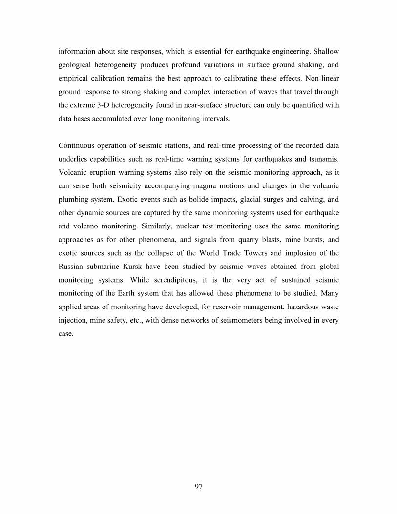
97
information about site responses, which is essential for earthquake engineering. Shallow
geological heterogeneity produces profound variations in surface ground shaking, and
empirical calibration remains the best approach to calibrating these effects. Non-linear
ground response to strong shaking and complex interaction of waves that travel through
the extreme 3-D heterogeneity found in near-surface structure can only be quantified with
data bases accumulated over long monitoring intervals.
Continuous operation of seismic stations, and real-time processing of the recorded data
underlies capabilities such as real-time warning systems for earthquakes and tsunamis.
Volcanic eruption warning systems also rely on the seismic monitoring approach, as it
can sense both seismicity accompanying magma motions and changes in the volcanic
plumbing system. Exotic events such as bolide impacts, glacial surges and calving, and
other dynamic sources are captured by the same monitoring systems used for earthquake
and volcano monitoring. Similarly, nuclear test monitoring uses the same monitoring
approaches as for other phenomena, and signals from quarry blasts, mine bursts, and
exotic sources such as the collapse of the World Trade Towers and implosion of the
Russian submarine Kursk have been studied by seismic waves obtained from global
monitoring systems. While serendipitous, it is the very act of sustained seismic
monitoring of the Earth system that has allowed these phenomena to be studied. Many
applied areas of monitoring have developed, for reservoir management, hazardous waste
injection, mine safety, etc., with dense networks of seismometers being involved in every
case.
98
Figure. Schematic view of the Earth monitoring environment. Energetic
processes in the atmosphere, solid earth, and hydrosphere (not shown)
create seismic and acoustic waves that are readily detected with sensor
networks, and frequently form a core component of multidisciplinary
monitoring efforts. (Image courtesy of W. Walter and D. Harris).
All seismic monitoring applications can be enhanced by increased number of stations.
Japan has led the world by deploying the densest networks of seismic instruments of very
high quality, prompted by an immense exposure to earthquake hazards across the entire
country. There is a significant demand for increased numbers of inexpensive and easily
deployed sensors for blanketing urban areas to assess local site response variations and
for high resolution studies of shallow crustal structure. Global observatories require new
generations of very broadband instrumentation to record all ground motions from future
great earthquakes so that rapid faulting assessments and tsunami-potential assessments
can be made. Robust portable sensors in great numbers are needed for deployments to
monitor aftershock sequences and to study transient phenomena in polar environments,
volcanic environments, and other areas that are only sparsely monitored by permanent
stations.
Extending monitoring into ocean-bottom environments is an important priority for the
future. Most earthquakes occur at ocean trenches, and tsunamis pose an additional marine
99
hazard. It is also impossible to uniformly monitor Earth’s activities and to understand its
global dynamics through seismic imaging when 70% of its surface is off-limits. This will
require additional research into the development of reliable and inexpensive broadband
OBS and oceanic borehole instruments, and methods for their cost-effective low noise
installation.
Seismic monitoring is an international undertaking, and all countries have some
monitoring needs. Coordination and seismic data sharing between national efforts in
clearly of benefit to all monitoring efforts. Continued U.S. advocacy of open, real-time
data access to monitoring networks is a very high priority.
Multi-Scale 3-D and 4-D Imaging and Modeling of Complex Earth
Systems
All of the Seismological Grand Challenges involve high-resolution determination of
source and/or structural properties by seismic wave analysis. The essence of this practice
is solution of wave propagation equations to resolve 3-D structural interactions or source
excitations. Source imaging is explicitly time-dependent and repeated structural imaging
can also be 4-D, with time-dependent changes in the medium being sensed. When
complex representations of sources and the medium are obtained, calculation of seismic
responses for new geometries can be used to predict shaking variations by forward
modeling. Imaging and modeling are coupled and comprise key attributes of the
discipline with specific data and computational needs.
Routine processing of long-period signals to determine earthquake source parameters is
now conducted by various programs. The resulting earthquake solutions are used for
tectonic studies, as starting points for more detailed rupture investigations for large
events, and for earthquake hazard assessments. Less routine determinations of finite-
source models for large events describe the spread of slip over the fault during an
earthquake, with the added information about the rupture being useful for studies of
frictional variations, hazard analysis, aftershock analysis and rupture mechanics.
100
Expanded coverage of Earth’s surface, particularly in the oceans can greatly abet this
detailed source imaging, particularly for very large earthquakes; this was one of the
original motivations for deploying more permanent ocean seismic observatories.
Resolution of detailed rupture processes is delimited by accuracy of the structural
models, so those must also improve.
Imaging methods also underlie all determinations of Earth structure. With the basic
spherically symmetric Earth structure having been determined by the 1980s,
seismologists subsequently turned their attention to resolving lateral variations in seismic
wave speeds using data from regional and global seismographic networks. This created
the still-booming field of seismic tomography, the seismological equivalent of medical
CAT-scan imaging, by which models for aspherical P-wave and S-wave heterogeneity of
the crust, mantle and core have been determined. Global images are non-uniform in
resolution due to the distributions of sources and receivers, and significant improvements
in models is driven primarily by new data collection efforts in previously unsampled
areas or with finer station spacing than before. Imaging of oceanic crust and upper mantle
structured continues to be particularly hampered by a lack of oceanic stations, and there
continues to be a pressing need for deployment of a global ocean bottom seismographic
network.
Seismic tomography is moving toward "finite-frequency" imaging, in which the full
bandwidth of seismic signals is harnessed to probe different aspects of the Earth's
structure. In addition, efforts have commenced to map anelastic attenuation structure and
anisotropic structure on regional and global scales using complete waveform information.
These efforts will provide improved constraints on thermal and compositional structure
and deformational processes in the interior.
The state-of-the-art in exploration seismology involves both 3-D and 4-D imaging,
involving acquisition, processing and interpretation of huge seismic data sets. The targets
of 3-D imaging are now very complex subsurface structures, which require improved
wavefield migration and modeling techniques. The goal of 4-D imaging is to monitor
101
changes in reservoirs due to oil and gas extraction and/or the injection of gas or water by
comparing repeated datasets. Using the same philosophy, crustal-scale seismology now
performs repeated applications of noise cross-correlation tomography in a geographical
area of interest to reveal subtle changes in seismic wave speeds related to fluid flow, fault
zone healing or magma migration.
The development of increasingly sophisticated 3-D models of the Earth's interior has led
to a need for rapid, accurate simulations of seismic wave propagation in multi-scale
media. Taking advantage of modern numerical algorithms and large parallel computers,
seismologists are now calculating fully 3-D synthetic seismograms in complex 3-D
anelastic, anisotropic Earth models for forward modeling of long-period (> 5 s) ground
motions. A current challenge lies in harnessing these numerical capabilities to enhance
the quality of the 3-D models, in conjunction with improving models of source rupture
processes. Strategies for addressing this formidable imaging problem are being explored,
and are driving Seismology computational demands. For a typical regional or global
dataset, complete waveform tomography methods may involve thousands of 3-D
simulations and hundreds of thousands of CPU hours; this requires convenient access to
large computational resources.
To image smaller scale features than resolved by current global tomography, such as the
detailed structure of mid-oceanic ridges and subduction zones, ULVZs and anisotropy
just above the CMB, the morphology of plumes, and the structure of the inner core, there
is need to accurately model 3-D wave propagation at short periods (< 5 s) over long
distances. Currently we can only compute short period solutions for simple spherically
symmetric Earth models, but the advent of peta-scale computing will enable of
simulations for 3D Earth models in the near future. It is critical to ensure that the solid
Earth science community has access to the necessary hardware.
102
Recommended Additional Reading American Geological Institute, Geoscience Workforce Age Distribution, Geoscience
Currents, No. 16, http://www.agiweb.org/workforce, 9 October 2008.
Basic Research Opportunities in Earth Sciences, 2001. National Research Council, National Academies Press, Washington, D.C. (http://books.nap.edu/catalog.php?record_id=9981)
Cooperative Studies of the Earth’s Deep Interior: Development, Discoveries, Future,
2004. CSEDI, 42 pp. (http://www.csedi.org/)
Critical Needs for the Twenty First Century: The Role of the Geosciences, 2008. The
American Geological Institute. (http://www.agiweb.org/gap/trans08.html)
Earthquake Risk Reduction: Addressing the Unmet Challenges, 2008. Earthquake
Engineering Research Institute, 32 pp. (http://www.eeri.org/cds_publications/catalog/product_info.php?products_id=291)
Current and Future Research Directions in High-Pressure Mineral Physics, 2004.
COMPRES, ESS Building, Stony Brook, NY 11794. (http://www.compres.stonybrook.edu/Publications/index.html)
Geosciences: The Future, 2007. International Union of Geodesy and Geophysics, 106 pp.
(http://www.iugg.org/publications/reports/) Living on an Active Earth, 2003. National Research Council, National Academies Press,
Washington, D.C. Ocean Mantle Dynamics Science Plan, 2000. National Science Foundation, Washington,
DC. XX pp. Origin and Evolution of Earth: Research Questions for a Changing Planet, 2008.
National Research Council, National Academies Press, Washington, D.C. (http://www.nap.edu/catalog.php?record_id=12161)
Securing Society Against Catastrophic Earthquake Losses, 2003. Earthquake Engineering
Research Institute, 62 pp. (http://www.eeri.org/cds_publications/catalog/product_info.php?products_id=230)
103
List of Acronyms and Titles AGU – American Geophysical Union ANSS – Anvanced National Seismic System ATM – Atmospheric Sciences Division of the NSF CIG – Computational Infrastructure for Geodynamics funded by the NSF CIDER – Cooperative Institute for Deep Earth Research CISN – California Integrated Seismic Network COMPRES – Consortium for Materials Properties Research in Earth Sciences CSEDI – Cooperative Studies of the Earth’s Deep Interior CTBTO – Comprehensive (Nuclear) Test Ban Treaty Organization DMS – IRIS Data Management System DoD – Department of Defense DOE – Department of Energy EAR – Earth Sciences Division of the National Science Foundation EarthScope – NSF/USGS/NASA Major equipment facility for studying North America continent EERI – Earthquake Engineering Research Institute FDSN – International Federation of Digital Seismograph Networks FEMA – Federal Emergency Management Agency GEO – Geosciences Directorate of the NSF GEOSS – Global Earth Observation System of Systems GSN – Global Seismic Network IASPEI – International Association for Seismology and Physics of Earth’s Interior IAVCEI – International Assocition for Volcanology and Chemistry of Earth’s Interior IMS – International Monitoring System of the CTBTO IODP – International Ocean Drilling Project ISC – International Seismological Centre InSAR – Interferometric Synthetic Aperture Radar IRIS – Incorporated Research Institutions for Seismology IUGG – International Union for Geodesy and Geodynamics MARGINS – Continental margins program of the National Science Foundation NASA – National Aeronautics and Space Administration NEES – Network for Earthquake Engineering Simulation funded by the NSF NEIC – National Earthquake Information Center operated by the USGS NEON – National Ecological Observatory Network funded by the NSF NOAA – National Oceanic and Atmospheric Administration NSF – National Science Foundation OBSIP – Ocean Bottom Seismometer Instrumentation Pool funded by the NSF OCE – Ocean Sciences Division of the National Science Foundation OOI – Ocean Observatories Initiative funded by the NSF OPP – Office of Polar Programs of the NSF PASSCAL – IRIS Program for Array Seismic Studies of the Continental Lithosphere RESESS – Research Experience for Solid Earth Science for Students RIDGE – Ocean ridge research program of the NSF SAFOD – San Andreas Fault Observatory at Depth SAGE – Summer of Applied Geophysical Experience SCEC – Southern California Earthquake Center SEG – Society of Exploration Geophysicists SSA – Seismological Society of America UNAVCO – University consortium for measurement of crustal deformation USGS – United States Geological Survey