selecting roadway design treatments to accommodate bicycles
TRANSCRIPT

•
u.s. Departmentaf Transportation
Federal HighwayAdministration
Publication No. FHWA-RD-92-073January 1994
Selecting Roadway DesignTreatments to Accommodate
Bicycles
Research and DevelopmentTurner·Fairbank Highway Research Center
6300 Georgetown PikeMcLean, Virginia 22101-2296

FOREWORD
There is a need for guidance on which type of on-road bicycle facility (widecurb lane, shoulder, shared lane, or marked bicycle lane) to provide underparticular roadway design and traffic operational conditions. To date,engineering judgment and trial and error have been used to make thesedecisions.
This report, FHWA-RD-92-073, presents a set of tables that can be used todetermine the recommended type of bicycle facility to be provided inparticular roadway situations. In addition, the report presents a briefdiscussion of the "design user" for bicycle facilities, and presents aplanning process for bicycle facilities.
Five criteria were used to determine recommended bicycle facilities: trafficvolume; average motor vehicle operating speed; traffic mix of automobiles,trucks, buses, and/or recreational vehicles; on-street parking; and sightdistance. Values for these criteria were determined and tables were developedfor urban and rural roadway sections for two groups of design users.
Sufficient copies of this report are being distributed to provide a minimum ofone copy to each Region and Division office and State highway agency.Additional copies for the public are available from the National TechnicalInformation Service (NTIS), Department of Commerce, 5285 Port Royal Road,Springfield, Virginia 22161. A small charge will be imposed by NTIS.
-ejJ~#- /~
Director, Office of Safety and TrafficOperations Research and Development
NOTICE
This document is disseminated under the sponsorship of the Department ofTransportation in the interest of information exchange. The United StatesGovernment assumes no liability for its contents or use thereof. This reportdoes not constitute a standard, specification, or regulation.
The United States Government does not endorse products or manufacturers.Trade and manufacturers' names appear in this report only because they areconsidered essential to the object of the document.

Technical Report Documentation Page
,..mpop(Pf V2.1. 6130192)
1. Report No. 2. Government ACOMelon No. 3. Reclplent'e C."og No.
FHWA-RD-92-073
4. nu. 8I'Id Subtitle5. ":i"a:I'u'l.'t!Y 1994
SELECTING ROADWAY DESIGN TREATMENTS TO ACCOMMODATE BICYCLE~ 6. P.rforming Organlzation CocM
7. Authorie'8. PlMforming Organintion~ No.
W.C. Wilkinson II I, A. Clarke,' B. Epperson, R. Knoblauch9. Performing Org....iz.tion N.me ....dA~ 10. Work Unit No. (TRAil)
Center for Applied Research, Inc. 4A 4C 2022930B Georgetown Pike 11. Contrect Of Or...t No.
Great Falls, VA 22066 DTFH61-B9-C-000B913. Type of "'pon 8I'Id P.riod Co-.d
12. Seoneorit' Agency Name ...cI AcicIrMe ManualOff,ce 0 Safety and Traffic Operations R&D November 19B9-May 1992Federal Highway Administration400 Seventh Street, SW 14. 8poneorlng Agency CocMWashington, DC 2059015. Supplement.. Not..
Subcontractor: Bicycle Federation of America, Washington, DC 20009Contracting Officer's Technical Representative (COTR): John Fegan, HEP-50'6. Ab~ect
This manual is designed to assist transportation planners and engineers in selectingroadway design treatments to accommodate bicycles. This is the fi rst attempt to providecomprehensive guidelines for this process. The recommendations are based on assumptionsregarding policy goals and the types of bicyclists to be accommodated, the state of thepractice, and professional judgment. More research, testing, and evaluation are needed toassess and refine these recommendations. A more deta i1ed fi na1 report on this study isavailable.
This manual is not intended to serve as a comprehensive guide to the design of bicyclefacilities. The user is referred to the current edition of the American Association of StateHighway and Transportation Officials' Guide to the Development of Bicycle Facilities fordetailed specifications. .
The manual describes the assumptions, principles, and approaches used to develop therecommendationsj provides a model planning process for identifying a network of routes onwh ich des ignated bi cyc1e fac i1 it ies shaul d be provi ded to accommodate bi cyc1i sts of moderateability (casual adult riders and children); and recommends design treatments andspecifications for roadways to serve different types of bicyclists under various sets oftraffic operational factors. The appendix contains a detailed discussion of the varioustypes of bicycle facilities.
17. K.y Word. 18. Dietribution Stetement
Bicycles, bicycle facilities, No restrictions. This documenttransportation planning, is available to the public throughhighway design. the National Technical Information
Service, Springfield, VA 22161.19. Security cr...n. lof tm reportl 20. Seeurity Cl-.if. lof thie pegej 21. No of Peeee 22._
UNCLASSIFIED UNCLASSIFIED 37onn LIUI r IIN./IIt-IL) R roduction of co lilted II IIllthorizlld

PREFACE
This manual is designed to assist transportation planners and engineers in the selection ofroadway design treatments to accommodate bicycles and motor vehicles. Therecommendations are based on the current state of the practice and reflect the judgment ofprofessionals working over the past 20 years to accommodate bicycles in highway design.This process is ongoing and these recommendations will likely be refined over time.
This manual is not intended to serve as a comprehensive guide to the design of highways toaccommodate bicycles. The user is referred to the current edition of the American Associationof State Highway and Transportation Officials' Guide to the Development of Bicycle Facilities(AASHTO GUide) for additional guidance on the design of bicycle accommodations.(1) Therecommendations included here do address one element of design: the desirable width forvarious types of design treatments based on the anticipated type of bicycle users and variouscombinations of traffic operational factors.
The recommendations reflect the first attempt to give specific guidance on the selection ofroadway design treatments to accommodate bicyclists. They are based on assumptions aboutpolicy goals and about the types of bicyclists to be accommodated. Further, given that manyof the conclusions and recommendations are based on professional judgment, and not onempirical research, they should be treated as "guidelines." More research, testing, andevaluation are needed to assess and refine these recommendations. (See the final report forthis project for additional information on the development of these recommendations.)
The project that produced this manual was originally suggested by the TransportationResearch Board's Committee on Bicycling and Bicycle Facilities. The Committee forwarded aproject recommendation to the Federal Highway Administration and it was selected forpossible funding through the Pooled-Fund Research Program. Twelve States contributed tothe fund, thus making the project possible:
DelawareFloridaGeorgiaMinnesotaNew JerseyNew Mexico
OhioPennsylvaniaTexasVirginiaWashingtonWisconsin
This manual is organized into three major sections and an appendix. Section 1 describes theassumptions, principles, and approaches used to develop the recommendations for theselection of roadway design treatments to accommodate bicycles. This includes adaptingroadway designs to accommodate bicycling on all streets and highways on which bicycle useis permitted. Section 2 is an overview of a sample planning process that can be used toidentify a network of routes on which designated bicycle facilities should be prOVided toaccommodate bicyclists of moderate ability (c;asual adult riders and children). Section 3presents recommended designs and specifications for roadway designs to serve differenttypes of bicyclists under various sets of traffic operational factors. The appendix presents adetailed discussion of the various types of bicycle facilities.
ii

•• •APPROXIMATE CONVERSIONS TO SI UNITS APPROXIMATE CONVERSIONS FROM SI UNITS
Symbol When You Know Multiply By To Find Symbol Symbol When You Know Multiply By To Find Symbol
LENGTH kENGTH
" """. 25.4 millimel8rs mOl mOl m~lme*. 0,039 inches "" feet 0.305 mot'" 01 01 met91's 3." feet ",d yards 0.91" meters 01 01 meters \.09 ,,,,,,. ,d
"" m~es 1.61 kilometers km km kilometers 0.621 milo. OIl
AREA AREA
", square inches 645.2 square millimeters mm' mOl' square milWrootors 0.0016 square inches ",II' sQUare leel 0.093 square meters 01' 01' .quare metor1 10.764 squweloet II',d' square yards 0.836 square meters 01' 01' square metor1 1.195 square yards """ acres 0.405 hectares ha ha hectares 2.47 a"". mil01' square miles 2.59 square kilometers km' km' square kilometors 0.386 square m~e.
VOLUME VOLUME
"o. ftuid ounces 29.57 mil~lilers OIl OIl mWI~ilera 0.034 lIuid ounces "o.gal gallons 3.785 Wiers I I ~ktrs 0.264 gallona gal_.
III II' cubic teet 0.028 cubic meters 01' 01' cubic motors 35.71 cubic leel It'_._.
,<1' cubic YlWds 0.765 cubic meters 01' 01' cubic motors 1.307 cubic y.ds ,<1'
NOTE: Volumes groater IhlWl 1000 I shal be shown in mI.
MASS MASS
o. ounoes 28.35 grams g g grams 0.035 """"'. o.b pound. 0.454 kiograms kg kg ki!ogfwns 2.202 pound. ~
T short Ions (2000 Ib) 0.907 megagrams Mg Mg megagrams 1.103 ,hor1lons (2000 Ibj T
TEMPERATURE (exact) TEMPERATURE (ex&ct)
Of Fahronhoil 5(F.32j19 Celcius "C "C Celciul l.ec ... 32 Fatvenheit OflOmperature Of (F.32)11.e. lemperaturo IOmperature lomperature
ILLUMINATION ILLUMINATION
'" foot-candlel 10.76 ~, I I, ~. 0.0929 loot-candle, '"" loot-Lamborts 3.426 caodolalml ""'01' ""'01' canoolalm! 0.2919 loot-Lamberts "FORCE and PRESSURE or STRESS FORCE and PRESSURE or STRESS
,., poundlorce 4.45 newtons N N nowtons 0.225 poundforoe ,.,p.' poundtorce per 6.89 kllopascals kPa kPa kllopascals 0.145 poundloroa pet ",I
aquwelnch lqun Inch
-• Sll. !he .ymbollor the InlamationaJ SyslOm 01 Units. ApproprialO (RoYisect Augus11992)
roundng ahooId ~ mads to comply wilh Soction 4 of ASTM E380.
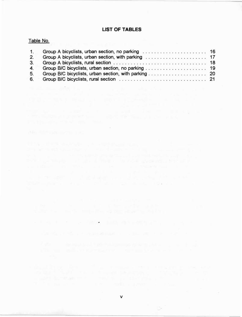
LIST OF TABLES
Table No.
1. Group A bicyclists, urban section, no par1<ing ...........•..•...•... 162. Group A bicyclists, urban section, with par1<ing ............•........ 173. Group A bicyclists, nural section . . . . . . . . . . . . . . . . . • . . . . . . . . . . . . .. 184. Group BIC bicyclists, urban section, no par1<ing . . . . . . . . . . . . • . . . . . . .. 195. Group BIC bicyclists. urban section, with par1<ing . . . . • . . . . . . • . . . . • . .. 206. Group BIC bicyclists, nural section ..............•...•.••....•... 21
v

TABLE OF CONTENTS
Section
1. INTRODUCTION. . . . . . . . . . . . . . . . . . . . . . . . . . . . . . . . . . . . . . . . . .. 1POLICY GOAL FOR BICYCLE USE ...................•.... 1THE "DESIGN BICYCLIST" ..........................••.. 1DESIGN APPROACH 3RELATED ISSUES 3SUMMARY 4
2. THE BICYCLE PLANNING PROCESS 5DEVELOPING A BICYCLE NETWORK PLAN 5
3. DESIGN SELECTION AND SPECIFICATIONS. . . . . . . . . . . . . . . . . . . .. 11TYPES OF FACILITIES. . . . . . . . . . . . . . . . . . . . . . . . . . . . . . . •. 11DESIGNATING BICYCLE FACILITIES . . . . . . . . . . . . . . . . . . . . .. 11PREPARING TO SELECT A FACILITY TREATMENT 12
APPENDIX: TYPES OF BICYCLE FACILITIES . . . . . . . . . . . . . . . . . . . . . . . .. 23
REFERENCES . . . . . . . . . . . . . . . . . . . . . . . . . . . . . . . . . . . . . . . . . . . . . . . .. 31
iv

1. INTRODUCTION
This manual is based on the answers to two key questions:
1. What is the Federal policy goal for bicycle use?
2. Who is the "design bicyclist?"
POLICY GOAL FOR BICYCLE USE
The two basic policy a~ernatives are: (1) to acccmmodate current bicycle use and/or(2) to increase the level of use. A review of recent policy statements by Congress, theU.S. Department of Transportation, and the Federal Highway Administration makes itclear that the Federal policy goal for bicycling is to acccmmodate current use and toencourage increased USB, while enhancing safety. (2-4) Therefore, the recommendationsin this manual are oriented toward meeting the needs of current and potentialbicyclists using the highway system.
THE "DESIGN BICYCLlSr
Nearly 100 million people in the United States own bicycles. (.j The Bicycle Federationof America estimates that fewer than 5 percent would qualify as experienced or highlyskilled bicyclists. Since the policy goal is to accommodate existing bicyclists andencourage increased bicycle use, there will be more novice riders than advancedbicyclists using the highway system. Therefore, any roadway treatments intended toaccommodate bicycle use must address the needs of both experienced and lessexperienced riders. One solution to this challenge is to deveiop the concept of a"design cyclist" and adopt a classification system for bicycle users such as thefollowing:
Group A-Advanced Bicyclists: These are experienced riders who can operateunder most traffic conditions. They comprise the majority of the current users ofcollector and arterial streets and are best served by the following:
Direct access to destinations usually via the existing street and highway system.
The opportunity to operate at maximum speed with minimum deiays.
Sufficient operating space on the roadway or shoulder to reduce the need foreither the bicyclist or the motor vehicle operator to change position whenpassing.
Group B-Basic Bievclists: These are casual or new adult and teenage riders whoare less confident of their ability to operate in traffic without special provisions forbicycles. Some will develop greater skills and progress to the advanced level, butthere will always be many millions of basic bicyclists. They prefer:
1

- Comfortable access to destinations, preferably by a direct route, using eitherlow-speed, low traffic-volume streets or designated bicycle facilities.
- Well-defined separation of bicycles and motor vehicles on arterial and collectorstreets (bike lanes or shoulders) or separate bike paths.
• Group C-Children: These are pre-teen riders whose roadway use is initiallymonitored by parents. Eventually they are accorded independent access to thesystem. They and their parents prefer the following:
- Access to key destinations surrounding residential areas, including schools,recreation facilities, shopping, or other residential areas.
- Residential streets with low motor vehicle speed limits and volumes.
- Well-defined separation of bicycles and motor vehicles on arterial and collectorstreets or separate bike paths.
While other distinctions can be added, these lists support combining groups Band Cbicyclists in most situations. Therefore, a "design cyclist" concept is proposed thatrecognizes two broad classes of bicyclists: group A riders and group B/C riders.
Generally, group A bicyclists will be best served by designing all roadways toaccommodate shared use by bicycles and motor vehicles. This can be accomplishedby:
• Establishing and enforcing speed limits to minimize speed differentials betweenbicycles and motor vehicles on neighborhood streets and/or by implementing"traffic-calming" strategies.
• Providing wide outside lanes on collector and arterial streets built with an "urbansection" (i.e., with curb and gutter).
• Providing usable shoulders on highways built with a "rural section" (i.e., no curband gutter).
Generally, group B/C bicyclists will be best served by a network of neighborhoodstreets and designated bicycle facilities, which can be provided by:
• Ensuring neighborhood streets have low speed limits through effective speedenforcement or controls and/or by implementing "traffic calming" strategies.
• Providing a network of designated bicycle facilities (e.g., bike lanes, separate bikepaths, or side-street bicycle routes) through the key travel corridors typicallyserved by arterial and collector streets.
• Providing usable roadway shoulders on rural highways.
2

DESIGN APPROACH
Given these two types of design bicyclists, a two-tiered approach to meeting theirneeds is proposed.
• Group A riders will be best served by making every street "bicycle-friendly." Thismay be accomplished by adopting highway design standards that include widecurb lanes and paved shoulders to accommodate shared use by bicycles andmotor vehicles. This approach will provide adequate space for bicycles and motorvehicles to share the roadway with minimum need for changing lanes or laneposition. The" desired outcome is to have sufficient space to accommodate shareduse by bicycles and motor vehicles with minimum delays and maximum safety forall users.
• Group BIC riders will be best served by identifying key travel corridors (typicallyserved bv arterial and collector streets) and by providing designated bicyclefacilities on selected routes through these corridors. These key travel corridors canbe identified through the type of planning process described in section 2 of thismanual.
Full implementation of this approach will result in a condition where every street onwhich bicycles are permitted to operate will incorporate at least the design treatmentsrecommended for group A bicyclists. In addition, a network of routes will be enhancedby incorporating the designated bicycle facilities recommended for group BlCbicyclists.
RELATED ISSUES
The approach to selecting and designing roadway treatments to accommodatebicycles and motor vehicles proposed in this manual relates to other bicycle facilityand program issues.
Signing and Marking Bicycle Facilities
Signs and pavement markings for bicycle facilities will encourage increased use. Inaddition to obvious traffic operations benefits, signs and pavement markings have theeffect of "advertising" bicycle use. {See part IX of the Manual of Uniform TrafficControl Devices for specific details.l6lj This helps legitimize the presence of bicycles inthe eyes of motorists and potential bicyclists. Also, while not discussed specifically inthis manual, use of bike route signs in combination with destination information or amap can contribute to development of a network of designated bicycle routes toprovide community access for group BlC bicyclists.
EducalionITraining and Law Enforcement
As with motor vehicle use, bicycle program specialists have long advocated includingeducationltraining and law enforcement activities as an integral part of encouraging
3

and managing bicycle use. Communities must develop regular programs to educateand train adults and children on the proper use of bicycles in traffic and make bicyclerelated law enforcement activities-for motorists as well as bicyclists-a routine,ongoing element of the local police department's duties.
Bicycles, Motor Vehicles, and Pedestrians
The highway transportation system is characterized by the interaction of three basicmodes of transportation: motor vehicles (including transit services), bicycles, andwalking. All decisions related to the planning, design, and implementation of highwaybased transportation facilities should address the potential impact on each of thesemodes. Regardless of the source of funding for transportation improvements, allmembers of the public are entitled to use public thoroughfares by their choice ofmode. Therefore, it is incumbent on transportation agencies to plan and designfacilities accordingly.
SUMMARY
Four principles define the basic approach used for this manual:
1. Two types of design bicyclists are recognized: group A (advanced) and group BIC(basic adult and child).
2. To paraphrase the AASHTO Guide, every street and highway on which bicyclesare permitted to operate is a "bicycle street" and should be designed andmaintained to accommodate shared use by bicycles and motor vehicles. Thus, ata minimum, all streets should include the design treatments recommended forgroup A bicyclists.
3. Given the stated policy goal, a supply-driven approach of providing designatedbicycle facilities to encourage increased use by group BIC riders (i.e., "if you buildthem they will come") is warranted.
4. Selecting design treatments to meet the needs of group BIC bicyclists involves twosteps:
• A planning process to identify key travel corridors andlor routes along whichaccess is important (section 2).
• A design decision to identify the most appropriate facility treatment for a givenroute or corridor (section 3).
4

2. THE BICYCLE PLANNING PROCESS
Transportation planning is a process for making decisions about the development oftransportation facilities. This includes providing accurate information about the effectsproposed transportation projects will have on the community and projected users. (1)
Bicycle planning is no exception. However, because much of the informationnecessary to reach sound decisions about providing for safe, efficient bicycle use isalready available as a byproduct of the normal operation of the road system, thebicycle planning process is a specific application of the overall transportation planningprocess.
This is especially true in the case of group A bicyclists, the more eXperienced andproficient bicyclists that comprise about 5 percent of bicycle users in the UnitedStates. These bicyclists are able to operate 00 the roadway in most traffic cooditionsand favor the directness and right-<lf-way preference given to roads with a highfunctional classification. The planning process used to develop or improve roadwaysfor motorists is equally valid for this type of bicyclist.
There are, however, some important design features to be taken into account to bestaccommodate group A bicyclists, and for this reason, planners and engineers shouldrefer to the AASHTO Guide during the planning process for streets and highways.Group A riders should be anticipated and provided for on all roadways where bicyclesare not excluded by statute or regulation, regardless of functional classification.
The situation is very different for group BIC bicyclists (bicyclists of average skill andexperience, and children). While these bicyclists value many of the same roadwayfeatures as group A bicyclists (Le., accessibility and directness), they also value othercharacteristics such as designated bicycle facilities and lower traffic volumes.
Group BIC bicyclists typically prefer to ride on neighborhood streets andlor designatedbicycle facilities. The location of these facilities is best determined through a planningprocess that seeks to detennine where designated facilities are needed and the typeof bicycle facilities that should be provided to accommodate and encourage group BICbicyclists.
DEVELOPING A BICYCLE NETWORK PLAN
The following discussioo details a planning process intended to identify a network ofroutes where special bicycle facility treatments should be employed to meet the needsof group BIC bicyclists.
Many model planning processes could be used to select routes and design facilitytreatments to accommodate group BIC bicyclists. Chapter 1 of the AASHTO Guidecontains several suggestions for establishing a bicycle planning program. Thef~lowing process is but one example. It consists of six steps:
5

1. Establish performance criteria for the bicycle network.
2. Inventory the existing bicycle facility and roadway system.
3. Identify bicycle travel desire lines and corridors.
4. Evaluate and select specific route alternatives.
5. Select appropriate design treatments.
6. Evaluate the finished plan against the established performance criteria.
Establish Performance Criteria for the Bicycle Network
Performance criteria define the important qualitative and quantitative variables to beconsidered in determining the desirability and effectiveness of a bicycle facilitynetwork. These can include:
• Accessibility: This is measured by the distance a bicycle facility is from a specifiedtrip origin or destination, the ease by which this distance can be traveled bybicycle, and the extent to which all likely origins and destinations are served.Some communities (e.g., Arlington, VA) have adopted a criterion of having abicycle facility within 1 mi (1.61 km) of every residence. More importantly, noresidential area or high priority destination (school, shopping center, businesscenter, or park) should be denied reasonable access by bicycle.
• Directness: Studies have shown that most bicyclists will not use even the bestbicycle facility if it greatly increases the travel distance or trip time over thatprovided by less desirable altematives(8,9) Therefore, even for group BIC bicyclists,routes should still be reasonably direct. The ratio of directness to comfort!perceived safety involved in this tradeoff will vary depending on the characteristicsof the bicycle facility (how desirable is it?), its more direct altematives (howunpleasant are they?), and the typical user's needs (in a hurry?, business orpleasure trip?).
• Continuity: The proposed network should have as few missing links as possible. Ifgaps exist, they should not include traffic environments that are unpleasant orthreatening to group BIC riders, such as high-volume or high-speed motor vehicletraffic with narrow outside lanes.
• Route Attractiveness: This can encompass such factors as separation from motortraffic, visual aesthetics, and the real or perceived threat to personal safety alongthe facility.
• Low Conflict: The route should present few conflicts between bicyclists and motorvehicle operators.
6

• Cost: This would include the cost to both establish and maintain the system.
• Ease of Implementation: The ease or difficulty in implementating proposedchanges depends on available space and existing traffic operations and patterns.
Inventory Existing System
Both the existing roadway system and any eXisting bicycle facilities should beinventoried and evaluated. The condition, location, and level of use of existing bicyclefacilities should be recorded to determine if they warrant incorporation into theproposed new network or if they should be removed. If existing bicycle facilities are tobe used as the nucleus of a new or expanded network, the inventory should notewhich improvements to the eXisting portions of the network may be required to bringthe entire new natwor1< up to uniform design and operations standards.
A simple inventory of the roadway system could be based on a map of the annualaverage daily traffic (AADT) counts on each road segment within a community orregion. A more complex inventory could include factors such as the number of trafficlanes, the width of the outside lane, the posted speed limit or actual average operatingspeed, the pavement condition, and certain geometric and other factors (e.g., thefrequency of commercial driveways, grades, and railroad crossings).
Identify Bicycle Travel Corridors
Predicting bicycle travel corridors for a community is not the same as identifying theroutes that bicyclists currently use. Instead, travel corridors can be thought of as·desire lines· connecting neighborhoods that generate bicycling trips with other zonesthat attract a significant number of bicycling trips.
For motor vehicle traffic, most peak morning trips are made between residentialneighborhoods and employment centers. In the evening peak, the opposite is true. Inthe evening or on weekends, the pattern of trip generation is much more dispersed aspeopie travel to shopping centers, parks, and the homes of friends or relatives.
Estimating these trip fiows for an entire city can be a complex, time-consuming effortrequiring significant amounts of raw data and sophisticated computer models.Fortunately, transportation planning for bicycles is much simpler. Unlike traditionaltransportation planning that attempts to predict travel demands between future zoneson as-yet-unbuilt streets and highways, bicycle planning attempts to provide for bicycleuse based on existing land uses assuming that the present impediments to bicycleuse are removed. These desire lines are, in fact, well represented by the traffic flowon the existing system of streets and highways.
The undertying assumption is that people on bikes want to go to the same places asdo people in cars (within the constraints imposed by distance), and the existingsystem of streets and highways reflects the existing travel demands of the community.Furthermore, most adults have a mental map of their community based on their
7
experience as motor vehicle operators. Thus, they tend to orient themselves by thelocation of major streets and highways.
Therefore, a good way to estimate desire lines for bicyclists and to project bicycle tripsis based on the existing pattern of motor vehicle flows. The simplest way to do this isto multiply the MDT of each segment of the road system by the bicycle mode split(the percentage of all trips that are made by bicycle) for the community or region. Forthe first time, the 1990 census will provide bicycle mode splits for census tracts andentire communities. Mode split estimates of total trips by bicycle in American citieshave ranged between 3 and 11 percent. (10-12)
Again, it is important to note that the resulting map may not be a representation ofwhere cyclists are now, but is instead a reflection of where bicyclists wish to go. Theactual travel patterns of group BIC cyclists are heavily influenced by their perception ofthe bicycling environment they face. Uncomfortable or threatening bicycling conditionswill cause these bicyclists to alter route choice from their most preferred alignment,choose a different travel mode, or not make the trip at all. Thus, the task of thetransportation planner for bicycling is to ask, "Where are the bicyclists now?" and"Where would they be if they could go where they preferred?"
Although this use of existing traffic flows is a useful overall predictor of bicyclists'desire lines, a few special situations may require adjustments to the corridor map:
• Schools-especially colleges and universities-and military bases can generate adisproportionately large share of bicycle trips. This is especially true for campuseswhere motor vehicle parking is limited.
• Parks, beaches, libraries, greenways, rivers and lakesides, scenic roads, and otherrecreational facilities attract a proportionately higher percentage of bicycle trips.
Evaluate and Select Specific Route Alternatives
The corridor identification procedure identifies desire lines for bicycle travel betweenvarious locations. The next step is to select specific routes within these corridors thatcan be designed or adapted to accommodate group BIC bicyclists and provide accessto and from these locations. The aim is to identify the routes that best meet theperformance criteria established in the first step of this planning process.
Typically, this step and the selection of appropriate design treatments are highlyinteractive processes. The practicality of adapting a particular route to accommodategroup BIC bicyclists may vary widely depending upon the type of design treatmentselected. For example, a less direct route may become the best option if comparatively few, inexpensive, and easily implemented design improvements are required.
Therefore, steps 4 and 5 should be approached as an iterative loop in which bothroute selection and design treatment are considered together to achieve a network
8

that is highly advantageous to the user, is affordable, has few negative impacts onneighbors and other nonusers, and can be readily implemented.
In summary, the selection of a specific route alternative is a function of several factors,including:
• The degree to which a specific route meets the needs of the anticipated users asopposed to other route options.
• The possible cost and extent of construction required to implement the proposedbicycle facility treatment.
• The comparative ease of implementing the proposed design treatment. Forexample, one option may entail the often unpopular decision to alter or eliminateon-street parking while another does not.
• The opportunity to implement the proposed design treatment in conjunction with aplanned highway construction or reconstruction project.
A more inclusive list of factors to be considered in the selection of a specific route ispresented in the AASHTO Guide.'"
Seled Appropriate Design Treatments
Guidelines for selecting an appropriate design treatment are presented in section 3 ofthis manual. In overview, the principal variables affecting the applicability of a designtreatment are:
• The design bicyclist. Is the proposed route projected to be' used primarily by groupA bicyclists, or is it intended to also serve as part of a network of routes for groupBIC bicyclists?
• The type of roadway project involved on the selected route. Is the roadwayscheduled for construction or reconstruction, or will the incorporation of designimprovements be retrofitted into existing geometries or right-of-way widths?
• Traffic operations factors. The most significant traffic operations factors fordetermining the appropriateness of various design treatments are:
Traffic volume.Average motor vehicle operating speeds.Traffic mix.On-street parking.Sight distance.Number of intersections and entrances.
9

Evaluate the Finished Network Plan Using the Established Performance Criteria
Will the proposed network meet the criteria established at the start of the planningprocess? If it does not meet most of these criteria, or inadequately meets a few criticalgoals, either the proposal will require further work, or the performance criteria must bemodified. In the latter case, the planning process as a whole should be reviewed todetermine if previously discarded routes should be reconsidered. They may now bemore preferred options in light of the newly modified criteria.
This reality check is important. Many well-considered proposals fail when it isdetermined that the finished product no longer meets its established objectives.
10

3. DESIGN SELECTION AND SPECIFICATIONS
This section provides recommendations for selecting roadway design treatments toaccommodate bicycles. Specific dimensions are suggested for the width of therecommended facility type. These recommendations reflect the current state of thepractice in the design of bicycle-friendly roadways. Users of this manual areencouraged to treat these recommendations as "guidelines" rather than absolutestandards.
TYPES OF FACILITIES
Five basic types of facilities are used to accommodate bicyclists:
• Shared lane: shared motor vehicle/bicycle use of a Rstandard"-width travel lane.
• Wide outside lane: an outside travel lane with a width of at least 14 ft (4.2 m).
• Bike lane: a portion of the roadway designated by striping, signing, andlorpavement markings for preferential or exclusive use of bicycles.
• Shoulder: a paved portion of the roadway to the right of the edge stripe designedto serve bicyclists.
• Separate bike path: a facility physicaliy separated from the roadway and intendedfor bicycle use.
Each of these facilities is discussed in detail in the appendix.
DESIGNATING BICYCLE FACILITIES
An important consideration regarding the five types of facilities designs is whether ornot they should be designated, by pavement markings andlor signs, as bicyclefacilities. As discussed in section 1, group BIC bicyclists prefer designated facilities forbicycle use. Therefore, when bike lanes or shoulders are provided to serve group BICriders, some designation should be included.
However, the legality of bicycle use on highway shoulders may not be well defined inevery State. This is due, in part, to the current language in the Uniform Vehicle Coderegarding where vehicles are permitted to operate. Users of this manual areencouraged to contact their State Attorney General's office to determine the currentsituation regarding bicycle use on selected highway shoulders. Consideration shouldbe given to amending some State vehicle codes to explicitly permit this widespreadpractice.
When design treatments are provided primarily to serve group A riders, designation isoptional. In some cases, it may be more desirable not to designate the facility for
11

bicycle use. For instance, if bicycle use is permitted on the shoulder of a controlledaccess freeway, it is usually not appropriate to designate this roadway as a bicyclefacility unless this route serves as the only link between two points.
Another consideration involves minor or marginal roadway improvements for bicyclists,such as providing a narrow (less than 4-ft [1.2-m]) shoulder. This can significantlyimprove riding conditions for group A bicyclists and should be considered if no bettertreatment is possible. However, this width is less than the minimum called for invirtually all design specifications and therefore should not be designated as a bicyclefacility. Where a facility is intended to be designated as a "bicycle facility" it isessential the design conform to the State standard or AASHTO guidelines.
PREPARING TO SELECT A FACILITY TREATMENT
To determine the appropriate highway design treatment to accommodate bicyclists,several factors associated with the specific route or project must be assessed:
• What types of bicyclists is the route most likely to serve?
• What type of roadway project is involved (new construction, reconstruction, orretrofit)?
• What are the current and anticipated traffic operations and design characteristicsof the route that will affect the choice of a bicycle design treatment?
What Types of Bicyclists is the Route Most Likely to Serve?
This manual takes its lead from the AASHTO Guide, which states:
To varying extents, bicycles will be ridden on all highways where they are permitted.All new highways, except those where bicyclists will be legally prohibited, should bedesigned and constructed under the assumption that they will be used as a bicyclestreet. (1)
Using the concept of two broad types of design bicyclists-group A and group B/Cthe recommendations included in tables 1 through 6 are keyed to the most likely typeof user. All streets and highways where bicycles are permitted to operate should, at aminimum, incorporate the design treatments recommended in the tables for group Abicyclists. Where it is determined that use by group BIC bicyclists is likely, the tablesrecommending design treatments for group BIC should be used. The group BICdesign treatments will also accommodate group A bicyclists.
At a minimum, all streets and highways open to bicycle use should have roadwaysincorporating the design treatments recommended for group A bicyclists. Where aplanning process has determined a given route is the best choice to form part of anetwork of routes to provide access to the community for group BIC bicyclists, therecommended design treatment appropriate to BIC riders should be implemented.
12

N_ Construction and Reconstruction vs. Retrofitting
The recommended design treatments in the tables are most easily implemented whennew construction or reconstruction is planned. It is a relatively straightforward processto adopt the specified design treatment for bicycles at the project planning stage.
When implementation involves retrofitting an existing roadway to accommodate bicycleuse, the project can be more complex. Existing streets built with a curb and guttersection will often be viewed as having a fixed width and improvements will likely belimited to -movi"9 paint,· that is, restriping the eXisting lanes.
When working with existing streets and highways, planners should investigate theopportunity to make at least minor or marginal improvements. However, where theneed is to serve group BIC bicyclists, it is essential to commit the resources necessaryto provide facilities that meet the recommended design treatments. Only then canroutes and facilities be designated for bicyclists and provide the desired access to thecommunity.{13)
Which Traffic Operations and Design Factors Help Detenmine the AppropriateDesign Treatment?
A general consensus has emerged among transportation planners and engineersworking with bicycle facilities on the traffic operations and design factors having thegreatest effect on bicycle useY2) Six factors are most often cited; five are used todefine the recommendations contained in the tables.
Each of these factors is discussed below along with the ranges of values used todifferentiate levels of needs. Detenmining these ranges was difficult; there is lillie in thestate of the practice to go by, and there is tremendous regional variation in prevailingconditions. Therefore, it is again suggested that the tables be used as a guide andthat adjustments be considered to reflect, for instance, different values for the rangesfor annual average daily traffic (AADT) volume.
The six major factors are as follows:
• Traffic volume. Higher motor vehicle traffic volumes represent greater potential riskfor bicyclists and the more frequent overtaking situations are less comfortable forgroup BIC bicyclists unless special design treatments are provided. Therecommendations contained in the tables are based on three ranges of AADT:
Under 2,000 AADT.2,000 to 10,000 AADT.Over 10,000 AADT.
• Average motor vehicle ooeratina SDeed. The average operating speed is moreimportant than the posted speed limit, and beller reflects local conditions. Again,
13

motor vehicle speed can have a negative impact on risk and comfort unlessmitigated by special design treatments. Four ranges of average speeds are used:
- Less than 30 mi/h (less than 48.3 km/h).- 30 to 40 mi/h (48.3 to 64.4 km/h).- 41 to 50 milh (66 to 80.5 km/h).- Over 50 mi/h (over 80.5 km/h).
• Traffic mix. The regular presence of trucks, buses, and/or recreation vehicles (i.e.,approximately 30 per hour or more) can increase risk and have a negative impacton comfort for bicyclists. At high speeds, the wind blast from such vehicles cancreate a serious risk of falls. Even at lower operating speeds, shared lane use isless compatible. All types of bicyclists prefer extra roadway width to accommodategreater separation from such vehicles. Many bicyclists will choose a different routeor not ride at all where there is a regular presence of such traffic unless they areable to remove themselves several feet from these motor vehicles(l) The recommendations contained in the tables suggest different design treatments and widthsdepending on whether or not the volume of truck, bus, and/or recreational vehiclesis likely to have a negative impact on bicycle use.
• On-street parking. The presence of on-street parking increases the width neededin the adjacent travel lane or bike lane to accommodate bicycles. This is primarilya concern associated with streets and highways built with an urban section. It isaddressed in the recommendations by including a separate set of tables for urbansections with on-street parking.
• Sight distance. "Inadequate sight distance" relates to situations where bicycles arebeing overtaken by motor vehicles and where the sight distance is likely less thanthat needed for a motor vehicle operator to either change lane positions or slow tothe bicyclist's speed. This problem is primarily associated with rural highways,although some urban streets have sight distance problems due to poor designand/or sight obstructions.
The most effective response to the problem is to correct it. Providing for bicycleoperation to the right of the designated motor vehicle lane (i.e., on a bike lane orshoulder) or, at speeds less than 41 mi/h (66 km/h), by adding extra width to awide outside lane, are viable options.
• Number of intersections. Intersections pose special challenges to bicycle andmotor vehicle operators, especially when bike lanes or separate bike paths areintroduced. The AASHTO Guide and various State design manuals include generalguidelines for intersection treatments..(1.14,15)
While not included as a selection factor in the tables, the number and/or frequencyof intersections should be considered when assessing the use of bike lanes. Thereis some evidence to suggest that the disruption in traffic operations associatedwith bike lanes is temporary. Over time, both bicyclists and motorists adapt to the
14

new traffic patterns, learning to look for each other and effect merges prior tointersections. (16)
How to Use the Tables to Determine the Recommended Treatment
Recommended roadway design treatments and widths to accommodate bicycles arepresented in tables 1 through 6. There are separate tables for group A and group BICbicyclists. The design treatments for group A bicyclists should be used as a guide tothe minimum design for any roadway on which bicycle use is permitted. Therecommended design treatments for group BlC bicyclists should be considered thedesirable design for any route on which this type of bicyclist is likely to ride.
There are separate tables for the two basic types of roadway sections: urban (withcurb and gutter) and rural (without curb and gutter). Separate tables are provided forhighways with urban sections with on-street parking and with no on-street parking.
[Note: Control/ed-access freeways are considered a special case and are notaddressed by the tables. Several States now permit bicyclists to operate on theshoulder of some or aI/ of their control/ed-access freeways.'13) Control/ed-accessfreeway rights of way also have been used for separate bike paths.]
The tables indicate the appropriate design treatment given various sets of trafficoperations and design factors. The tables do not include any specific recommendations for separate bike paths. The use of separate bike paths depends on specificright-of-way conditions (e.g., very few intersections, adequate set-back) that do notexist along most highways. These conditions are most often found along parkways,river and lake shores, in park and recreation areas, on abandoned railroad rights ofway, and on the right of way of some controlled-access freeways. Where such suitableconditions exist, separate bike paths can be pleasant additions to the facilitiesavailabie to bicyclists. However, they cannot take the place of access to the roadwayof the street and highway system.
Recommendations are provided for the width of the various recommended designtreatments. These recommended dimensions are considered to be "desirabie widths."They should be treated as "minimum widths" unless special circumstances precludesuch development. Any treatment specifically designated for bicycle use must meetthe minimum design standards called for in the AASHTO Guide or the appropriateState standard.
Finally, these recommendations are preliminary and should be tested and refined overtime. It is anticipated that this manual will be revised to reflect the continuing evolutionof the state of the practice in selecting design treatments for roadways toaccommodate shared use by bicycles and motor vehicles.
15

Table 1. Group A bicyclists, urban section, no parking.
average annual daily traffic (MDT) volume
inadequatesight distance
over 10,000
······~r~9~;lp$i •.w·.·i......... - -.- ,- ..
adequate sightdistance
we we we14 14 14
we we we15 14 15
sh we sh6 15 6
shI
sh sh6 6 6
inadequatesight
distance
2,000-10,000
adequatesight
distance
sl12
we14
inadequatesight
distance
less than 2,000
1~~yqK;~~~;'~
adequatesight
distance
sl12
we weI
we14 15 14
we we we15 15 15
sh sh sh6 6 6
average motorvehicle operating
speed
over 50 mi/h
less than 30 mi/h
41-50 mi/h
30-40 mi/h
......(J)
1 mi/h = 1.61 km/h
Key: * we = wide curb lane**applicable
sh = shoulder sl = shared lane** bl = bike lane na = not
* See page 11 for definitions.** we and SL numbers represent 'usable widths" of ou1er lanes, measured from lane stripe to the edge of gu1ter pan, rather than
to the face of the curb. If no gu1ter pan Is provided, add 1 ft (0.3 m) mlnlnum for shy distance from the face of the curb.

~
-oJ
Table 2. Group A bicyclists, urban section, with parking.
average annual daily traffic (MDT) volume
average motor less than 2,000 2,000-10,000 over 10,000vehicle operating
adequate inadequate adequate inadequate adequate sight inadequatespeedsight sight sight sight distance sight distance
distance distance distance distance, ,
truck, bus, rv tNCl<, bus, rv ..truck, bus, rv
less than 30 mi/h we we ><:j "'C: we we I«we we we we .»'I.l.e 'ii. we we14 14 14 14 14 Iii 14 14 14 14 15 15 14
30-40 milh we we jl,~: we we we we we we Bj~CL we we14 14 . 15 14 15 15 15 14 ':'~~115 15 15
,> .. 'W
41-50 milh we we we I·{we we &,'>- wewe we we we .. ·#we we15 15 15 15 15 16 16 16 15 :K~15+i; 16 16
..
over 50 mi/h na na na na na I> na na'( na na .loa ' na na. :;.~
.
1 milh = 1.61 km/h
Key:* we =wide curb lane·· 5h =shoulder 51 =shared lane bl =bike lane oa =not applicable• see page 11 for definitions.
.. we numbers represent "usable widths· of outer tfavellanes, measured from the left edge of the parking space (8 to 10 ft (2.4 to3.0 rnJ minimum from the curb face) to the left stripe of the travel lane.

Table 3. Group A bicyclists, rural section.
average annual daily traffic (AADT) volume
less than 2,000 2,000-10,000 over 10,000average motorvehicle operating
speed adequatesight
distance
inadequatesight
distance
adequatesight
distance
inadequatesight
distance
adequate sightdistance
inadequatesight distance
less than 30 mi/h I sl11!~llllliII we sl
11~lilll! 111;~1we we
!!llltl!1sh
12 14 12 14 14 4[!~i:iiii::!:::!:![![:~!jii::::!:!f~if:j:: :::;::~::::::::~:::::::::::::::::,:.:.:.
...;..:...;...................:,.;.;.;.;...;.......................
30-40 mi/h we IIII'II!!II sh we IIIlllllllll~11 sh sh!11111111111111,llll!11 sh
~ 14 4 14 4 4 40:>
~~jj:::::::[:[[[[[[[~i[[][[[[[[[][[[]~[[[;:;::;:;:;:::;:.:.;.;.:..............
:::::::::~::::::::::::;::::::::::::::::;:;.:;:;:.:.;.;.;...;.:......;.........
41-50 mi/h sh IIII sh sh1!11~I!!l! 81 sh sh IIII sh
4 4 6 6 6 6::::::::::::::;:::::::::::::::::::::;::;::: :::::::::::::::::~::::::::::::::::::::::: ~~(~t~:~:~:t:tf't: '::::::;::::::.:::::::~:::::::::.:.:.:.:.'
over 50 milh sh II111IIII Ir'jilII
sh sh ~11~lilll IIIiiiL,iiIIIsh sh 1111<!lf~lillll!I~I!lillli sh
4 ilmSmMi 4 6 6 6 6
1 mi/h =1.61 km/h
Key:* we = wide curb lane·· sh = shoulder sl = shared lane- bl = bike lane na = not applicable• See page 11 for definitions.
•• we and SL numbers represent "usable widths" of outer lanes, measured from the lane stripe to the edge of the pavement if asmooth, firm, level shoulder is adjacent. If rough or dropped pavement edges or a soft shoulder exists, add 1 ft (0.3 m) minimumfor shy distance from the edge of the pavement.

~
'"
Table 4. Group BIC bicyclists, urban section, no parking.
average annual daily traffic (MDT) volume
average motor less than 2,000 2,000-10,000 over 10,000vehicle operating
adequate inadequate adequate inadequate adequate sight inadequatespeedsight sight sight sight distance sight distance
distance distance distance distance
truck, bus, rv' truck, bus, rv tnJck, bus, rv r'C,
1··rJt!~r:~:tM bl lit bl bl dl* blless than 30 mi/h we we ·r:J!!IJ we we we
14 14 l:1V 14 14 14 5 5 . 5 .... 5""~ <{' Jt F
----~ III ~30-40 milh bl ~ bI-i!:' bl bl bl bl
l!i· ~~ . bl
5 5 ,,*k~ 5 5 l~~~~~"~ i " ,8 5 5 8#1~1 5klt:,c-';:;.'tit•41-50 milh bl ~ ~ bl bl Ill'! ~ bl bl ~ ~ bl
5 0 ,~ 5 6 !]la;~N ' I 6 6him I
I ; 6. 1¥ . ~J
over 50 mi/h bl ~• ·ill bl bl bl9i .
~ bl bl ~ ~ bl~@¥6 I el!' 6 6 .~. e I 6 6 e e 6
.··.t!· #r'~ Li. '\1#.{~:H}b •
1 milh = 1.61 km/h
Key: * we =wide eurb laoe- 'h =shoulder sl =shared lane bl =bike lane- nl =not apolicable• See page 11 for deflnltlons.
•• we numbers represent ·usable widths· of outer lanes, measured from lane stripe to edge of gutter pan, rather than to face of curb. Ifno gutter pan • provkted, add 1 ft (0.3 m) mininum for shy distance from face of curb. BL numbers Indk:ate minimum width from the curbface. The bike lane stripe should lie at least 4 ft (1.2 m) from the edge of the gutter pan, unless the gutter pan Is buitt with adequate width
to serve as a bike lane by itself.

Table 5. Group BIC bicyclists, urban section, with parking.
average annual daily traffic (AADT) volume
inadequatesight distance
over 10,000
adequate sightdistance
inadequatesight
distance~
2,000-10,000
adequatesight
distance
inadequatesight
distancern---
less than 2,000
adequatesight
distance
average motorvehicle operating
speed
less than 30 milh I ~~ IJ. ~~ ~~ I!I! ~~ ~' _ ~
~ 30-40 milh ~t 1111 ~ ~t 1111 ~ ~ 111111 ~
41-50 mi/h ~1~~III'I~~~U~I~!ii~~!! ~ ~'II~I'lllln~lljlllj ~I ~'~':ljl~~~!II~j~I~II'1111 ~I
over 50m~a Ifdllnal na I na IIImna((tnll na I na IIIna II Ina it na
1 mi/h =1.61 km/h
Key:* we =wide curb lane·· 5h =shoulder 51 =shared lane bl =bike lane na =not applicable• See page 11 for definitions.
•• we numbers represent "usable widths" of outer lanes, measured from left edge of the parking space (8 to 10ft [2.4 to 3.0 m]minimum from the curb face) to the left stripe of the travel lane.

'"~
Table 6. Group BIC bicyclists, rural section.
average annual daily traffic (AADT) volume
average motor less than 2,000 2,000-10,000 over 10,000vehicle operating
adequate inadequate adequate inadequate adequate sight inadequatespeedsight sight sight sight distance sight distance
distance distance distance distance.J, _} -~~'\:f))::, :"'tr:&k bus ni'·1>"truck, bUS, rv' tnick, bIis;' rv " , I,
iiii.:,
less than 30 milh sh shJ! sh sh sh '@;"~sh sh ",sh shiW sh
~m2'4 4 1 4 4 .. 4 4 :"',,4 4 'c' 4
it,,~::
.;i~V~ sh'ii1i' '.;' : iH~"";; ,rst.' '~%i8'
30-40 milh sh sh sh sh ~:';~.h sh sh sh'%' sh4 ;14
4,{4 4 8
';;IIi8 4 6 :,,'LfS 6',ti:w 6I® . i~}M~:iit ;.
.,:.:~:
. , .:<.
41-50 milh sh sh .h sh sh sh sh sh ®ISh. ~:~,,; sh6 /M;~~6 6'1 6 6 8 6 6
'" -..,6,·8 .•..
lit'P
; Sh);liover 50 mi/h sh :~~>sh sIlII> sh sh .h j®1.h sh sh I"~ sh6 6 6. 6 8 8 .8 8 8 .: 8 8
il; ®®i. i@ru [l - ,'M: ':®I®
1 milh : 1.61 km/h
Key:· we : wide curt:> lane sh - shQulder 51 = shared lane bl - bike lane na : not applicable• See page 11 for definitions.


APPENDIX:
TYPES OF BICYCLE FACILITIES
There are many ways in which bicycles can be accommodated on roadways and otherrights of way_ This section provides an overview of shared lanes, special designtreatments, and other possible improvements, including European traffic-calmingtechniques.
SHARED LANES
Shared lanes are streets and highways with no special provision for bicyclists. Sharedlanes typically feature 12-fl (3.6-m) lane widths or less with no shoulders, allowingcars to safely pass bicyclists only by crossing the center line or moving into anothertraffic lane. (17)
In residential areas with low motor vehicle traffic volumes and average motor vehiclespeeds of less than 30 milh (48.3 kmlh), this should present no problem for group Ariders, and will normally be adequate for group BIC bicyclists to use as well if the lanewidth is at least 12 fl (3.6 m). Where existing lane width is less than 12 fl (3.6 m),additional lane width or lower operating speed is calied for.
With higher speeds and traffic volumes, shared lanes become less attractive routes,especially to group BlC riders. As the AASHTO Guide notes, however:
To varying extents bicycles will be ridden on all highways where they are permitted.All new highways, except those where bicyclists will be legally prohibited, should bedesigned and constructed under the assumption that they will be used by bicyclists.Bieycle safe design practices should be followed to avoid the necessity for costlysubsequent improvements. (1)
The AASHTO Guide goes on to note other actions by which bicycle use of sharedroadways-regardless of lane widths or type of user-<:an be improved. Bicycle-safedrainage grates, smooth pavement, bicycle-safe railroad crossings, and traffic signalsthat respond to bicycles are all listed as examples.
Shared lanes do not usually require any special signing for bicyclists. Exceptions tothis include situations when:
• Specific destinations or potential alternate routes for bicyclists need to beshown.
• A short gap exists between special bicycle facilities, such as between two trails,and bicyclists require signing to lead them to the next facility.
23

SPECIAL DESIGN TREATMENTS
There are four general types of bicycle facilities that can improve upon sharedroadways where traffic volumes or speeds make it prudent to do so. In three of thefour cases, the facility allows bicyclists and motorists to operate parallel to each otherin the same lane without coming too close and without motorists having to changelanes to pass the bicyclists.
Wide Curb Lanes
Wide curb lanes, or wide outside lanes, can be defined as right-most through trafficlanes that are substantially wider than 12 ft (3.6 m). Most practitioners agree that 14 ft(4.2 m)-usually measured from the lane stripe to the edge of the gutter pan, ratherthan the curb face-is the minimum width necessary to allow a bicyclist and motoristto share the same lane without coming into conflict, changing lanes, or potentiallyreducing the motor vehicle capacity of the lane. Where traffic speeds exceed 40 mi/h(64.4 km/h), and when annual average daily traffic exceeds 10,000, 15- or 16-ft (4.5or 4.8-m) lanes are considered desirable.
Wide curb lanes have three widely accepted advantages. (16) They can:
Accommodate shared bicycle/motor vehicle use without reducing the roadwaycapacity for motor vehicle traffic.
Minimize both the real and perceived operating conflicts between bicycles andmotor vehicles.
Increase the roadway capacity by the number of bicyclists capable of beingaccommodated.
Many other benefits are claimed for wide outside lanes ranging from assisting turningvehicles in entering the roadway without encroaching into another lane to betteraccommodating buses and other wider vehicles(18)
Wide outside lanes require the least amount of additional maintenance of the differentfacilities. The sweeping effect of passing motor vehicles and routine highwaymaintenance is usually enough to keep the lane free of debris and in good conditionfor bicycling.
Wide outside lanes are especially valuable for, and often favored by, group A riderswho are not easily intimidated by high traffic volumes and speeds. These riders donot require a designated space in which to ride or designation of the street as a bikeroute. The same is not true for group B/C riders. Except on residential or low-volumestreets, wide outside lanes are not generally sufficient to provide the degree of comfortand safety required by less skilled bicyclists or children and will do little to encouragethem to ride.
24

Wide curb lanes will be most applicable, therefore, in urban areas on major streetswhere group A riders will likely be operating. If no alternative route exists for groupBlC riders, a bike lane or shoulder should typically be used. The Florida Department ofTransportation has recently amended its policy of always providing wide curb lanes onState highways in urban areas to that of providing bike lanes. (19)
Bike Lanes
The AASHTO Guide defines a bicycle lane as:
A portion of the roadway which has been designated by striping, signing andpavement markings for the preferential or exclusive use ofbicyclists.O)
Bike lanes are sometimes referred to as Class II Bikeways, according to theclassification system still used by the California Department of Transportation(Caltrans). (20)
Both Caltrans and the AASHTO Guide agree that bike lanes should always be oneway facilities carrying traffic in the same direction as adjacent motor vehicle traffic, andthat they should not be placed between parking spaces and the curb.<'·lO)
The recommended width for a bike lane is 5 ft (1.5 m), at least 4 ft (1.2 m) of whichshould lay to the left of the gutter pan seam. (However, the Florida DOT is currentlyexperimenting with slightly narrower undesignated lanes in some urban areas.)
Field studies carried out as part of the research for this manual indicate that bikelanes have a strong channelizing effect on motor vehicles and.bicycles. (16) TheCaltrans Highway Design Manual describes this effect very clearly:
Bike lane stripes are intended to promote the orderly "ow of traffic, by establishingspecific lines ofdemarcation between areas reserved for bicycles and lanes to beoccupied by motor vehicles. This effect is supported by bike lane signs andpavement markings. Bike lane stripes can increase bicyclists' confidence thatmotorists will not stray into their path of travel if they remain in the bike lane.Likewise, with more certainty as to where bicyclists will be, passing motorists areless apt to swerve towards opposing traffic in making certain they will not hitbicyclists.(2O)
The impact of marked bike lanes is parlicularly important for group BIC riders. Thelanes offer a designated and visible space for bicyclists and can be a significant factorin route choice. Motorists also benefit from the channelizing effect of bike lanes.
Use of bike lanes does require an additional commitment to maintenance. Bike lanesmust be kept free of debris and loose gravel to remain useful and safe, which mayrequire routine sweeping beyond that necessary for streets with no bike lanes. Asmotor vehicles are not allowed in the lanes, they cannot sweep the debris aside as
25

they do in ordinary (12-ft [3.6-m]) traffic lanes. The bike lane stripes themselves mustbe maintained on a regular basis.
Other important issues include the presence of on-street parking and the number andcomplexity of intersections. Parking movements and car doors opening have thepotential to cause crashes, so bike lanes should be designed to minimize theseconflicts. For example, on streets with parking lanes:
• Bike lanes should be at least 5 ft (1.5 m) wide.
Bike lanes should be placed between the outer motor vehicle lane and theparking lane.
Both sides of the bike lane should be marked. The righthand marking willdemarcate where motor vehicles should park and will allow sufficient clearancefor a bicyclist to avoid car doors that are opening.
Bike lanes are not advisable where angled parking is present.
Bicycle lanes can complicate tuming movements at intersections if they encouragebicyclists to keep right and motorists to keep left, regardless of their tuming intentions.Some jurisdictions have addressed this issue by ending bike lanes in advance ofintersections, or by striping the lane with a broken, rather then a solid, white line inadvance of the intersection to encourage merging.(14,15)
It is the conclusion of the current study that bike lanes do have wide applicability,especially for group BIC riders in urban areas. When average daily traffic flows exceed10,000 or average motor vehicle speeds exceed 30 milh (48.3 km/h), 5-ft (1.5-m) bikelanes will attract and serve group BIC riders better than wide outside lanes or otherdesign treatments.
Shoulders
AASHTO's "Policy on the Geometric Design of Highways and Streets" defines ashoulder as:
... the portion of the roadway contiguous with the traveled way for accommodationof stopped vehicles, for emergency use and for lateral support of the subbase,base and surface courses. (21)
Shoulders are also useful as places for bicyclists to ride. AASHTO and many Statesexplicitly recognize that adding or improving shoulders is often the best way toaccommodate bicyclists-especially in rural areas.(22)
Shoulders should be a minimum of 4 ft (1.2 m) wide when designed to accommodatebicycle travel. While group A (and even some group BIC cyclists) will benefit from
26
shoulder widths as narrow as 1 or 2 ft (O.3 to 0.6 m), these facilities should not besigned for bicyclists if they fail to meet prevailing State andlor MSHTO guidelines.
As traffic speeds increase, traffic mix includes heavier vehicles and trucks, and trafficvolumes rise, added width is desirable. For example, once vehicle speeds exceed 40milh (64.4 km/h) and MDT is 2,000 or more, shoulder widths should usually beincreased to 6 ft (1.8 m).
In urban areas, wide curb lanes are usually preferable to shoulders for group A ridersand bike lanes are usually preferable for group BlC riders. One exception will be onhigh-speed urban arterials (more than 50 milh [80 kmlh]) where 6-ft (1.8-m) shoulderswill serve group A riders better than wide curb lanes. Bike lanes, if used along theseroutes, should also be at least 6 ft (1.8 m) wide.
Bicyclists will use shoulders where they are paved and maintained to the samesurface standard as regular travel lanes. Where shoulders are designated'as bikefacilities, it is essential to keep them in good repair and free of debris, which oftenmeans a regular inspection and maintenance program.
Other surface irregUlarities, such as rumble strips, textured paving, and raised lanemar1<ers and reflectors, should be avoided on routes explicitly intended for bicyclists asthey can cause falls or force bicyclists to ride in the traffic lane. Where the use ofrumble strips is necessary, they should be located so as to leave a portion of theshoulder free for bicyclists.
Some State vehicle codes may, under a strict interpretation, prohibit or restrict the useof shoulders by all vehicles, including bicycles. Other States require bicyclists to useshoulders where they exist and are of an adequate standard for riding. (18) Additionalresearch may be required to determine the exact legal status of bicyclists usingshoulders in a particular State.
Comparable differences exist regarding the treatment of bicycles on controlled-accessfreeway or Interstate highway shoulders. Eighteen westem States allow bicyclists touse some or all of such shoulders (except in urbanized areas), whereas in all eastemStates except New Jersey, such use is currently prohibited. Additional attention shouldbe given to accommodating bicycle use on controlled-access freeway shoulders wheresuch use provides the only crossing of a river, lake, freeway, or other barrier.
Separate Bike Paths
The AASHTO Guide defines a bicycle path or bike path as:
A bikeway physically separated from motorized vehicular traffic by an open spaceor barrier and either within the highway right-of-way or within an independent rightof-way.!')
27
Separate bike paths are also known as Class I Bikeways, according to the classification used by the Caltrans. They also may be referred to as "multi-use trails" or "greenways," even though they are slightly different facilities.(20) A trail typically runs along anindependent right of way such as an abandoned railroad corridor, and a greenway is apark-type corridor of land that mayor may not incorporate a trail within its boundaries.
Two-way bike paths should be at least 10ft (3 m) wide. Where possible, especially ifbicycle or pedestrian traffic is expected to be high, paths should be a minimum of 12 ft(3.6 m) wide. Given the variety of users of most bike paths, 8-ft (2.4 m) widths willgenerally not be adequate. One-way bike paths have a limited application as withoutstrict enforcement, they will be used as two-way facilities. If they are provided,however, they should be at least 5 ft (1.5 m) wide.
Bike paths are a valuable addition to the highway system and to the range of facilitiesavailable to planners and engineers seeking to improve conditions for all categories ofbicyclist. They can serve both a transportation and recreation function and haveproven to be significant generators of bicycle use. Both groups A and BIC riders (aswell as other nonmotorized users) can benefit from the absence of motor vehicle trafficon these paths.
Bike paths are not inherently more dangerous than other bicycle facilities if they arewell designed, thoughtfully applied, and adequately maintained. For example, pathsshould not have their continuity destroyed by frequent motor vehicle cross flows andintersections with highways. These increase potential conflicts and are likely to makethe route less popular with riders seeking to maintain momentum, particularly group A.
Where adequate, uninterrupted right of way is available, separate bike paths can beused to good effect in providing long, continuous routes for commuting or recreationtrips, access to destinations not otherwise available to bicyclists, and as cut-throughsbetween buildings and other breaks in the street network.
OTHER POSSIBLE IMPROVEMENTS
Sidewalks
The AASHTO Guide states quite simply that "Sidewalks are generally not acceptablefor bicycling.,,(1)
This statement is qualified by a recognition that in a few, specific instances, such ason long, narrow bridges, the designation of a sidewalk as a bicycle facility may bebeneficial. Many States share this view.
Sidewalks are generally inappropriate for use by adults because they put the adultbicyclist in conflict with motorists using driveways, and with pedestrians, utility polesand signposts. Also, the cyclist is generally not visible or noticed by the motorist sothat the cyclist suddenly emerges at intersections, surprising the motorist andcreating a hazardous condition.(15)
28
Traffic Calming
Still relatively new to the United States, widespread neighborhood traffic calming aimsto reduce the dominance and speed of motor vehicles. Measures employed to achievethis include physical alterations to the horizontal and vertical alignment of the road andchanges in priority. For example, speed humps, diverlers, traffic throttles, trafficislands, sidewalk extensions, and mini-traffic circles have all been utilized to calm ortame traffic. Low speed zones-for example, 20 milh (32.2 kmlh) or lower-are oftenintroduced along with a package of these physical changes.(23)
Traffic calming was started as a means to reduce the impact of traffic in residentialneighborhoods and around schools. During the 1980's, the principles of traffic calmingwere extended and are now being applied to major roads in urban areas.
Four key benefits have been attributed to traffic calming:
• An average one-third reduction in road accidents.
• A greater feeling of security, particularly among vulnerable road users such asbicyclists and pedestrians.
• Reclamation of roadway space for nontraffic activities such as play and socialinteraction.
• Environmental improvements through landscaping and a reduction in theintrusive presence of motor vehicles. (23)
Much of the pioneering work in this field has been in Europe, parlicularly Germanyand the Netherlands. In areas of traffic calming in both countries it is rare to seespecial facilities for bicyclists since many of the benefits of traffic calming-slowervehicle speeds, better driver discipline, less traffic, environmental improvement-directly benefit bicyclists, especially group SIC riders.
Nevertheless, according to the Cyclists Touring Club in the United Kingdom:
III-designed traffic-ealming schemes can inconvenience or even endanger cyclists.Balanced on two wheels and without the benefit ofsuspension, cyclists areparticularly susceptible to changes in surface height and texture or may be put atrisk by poorly-considered road narrOWing.(23)
Careful design of traffic-calming schemes can overcome these potential pitfalls andensure that the benefits of such work encourage bicycling and make the activitysafer. (23.2-4)
Some U.S. cities, such as Seattle, have developed traffic-calming techniques similar tothose found in European countries, but not to the same geographic extent.
29

Other Roadway Improvements
It is possible to marginally improve some roadways for bicyclists-particularly group Ariders-by providing as little as 2 ft (0.6 m) of usable riding surface to the right of theedge stripe. While this will not meet the design specifications necessary for adesignated bicycle facility, it can provide an improved operating environment for bothbicyclists and motor vehicles and will reduce the impact of bicycles on highwaycapacity.
This and other marginal roadway improvements should be considered when theopportunity arises and there is no other option-such as wider shoulders, a bike lane,or wide curb lane-because of lack of space.
30
REFERENCES
1. Guide for the Development of Bicycle Facilities, American Association of StateHighway and Transportation Officials (AASHTO), Washington, DC, 1991.
2. "The Intermodal Surface Transportation Efficiency Act of 1991." PL 102-240,Dec. 18, 1991.
3. Moving America: New Directions, New Opportunities, U.S. Department ofTransportation, Washington, DC, Feb. 1990.
4. ·Policy on Bicycle and Pedestrian Projects," Federal Highway AdministrationMemorandum, Washington, DC, May 7,1991.
5. Bicycling Reference Book, 1992-93, Bicycle Institute of America, Washington,DC, May 1992.
6. Manual of Uniform Traffic Control Devices, U.S. Department of Transportation,Federal Highway Administration, Washington, DC, 1988.
'.
7. Graber and Hoel, Traffic and Highway Engineering:West Publishing, St Paul,MN,1988.
8. Kroll and Sommer, "Bicyclists' Response to Urban Bikeways," Journal of theAmerican Institute of Planners, Vol. 43, No.1, Jan. 1976.
9. Evaluation by Experienced Riders of a New Bicycle Lane in an EstablishedBikeway System, Transportation Research Record 683, TransportationResearch Board, Washington, DC, 1978.
10. Newman and Kenworthy, Cities and Automobile Dependence: An InternationalSourcebook, Gower Publishing, Aldershot, United Kingdom, 1989.
11. Alternatives to the Automobile: Transport for Livable Cities, Worldwatch PaperNo. 98, Worldwatch Institute, Washington, DC, Oct 1990.
12. Bicycle Use in Medium-Sized Cities, Lane Council of Governments, based on1980 census data, Eugene, OR, 1983.
13. Wm. C. Wilkinson, Highway Route Designation Criteria for Bicycle Routes,FHWA-RD-S6-??? Federal Highway Administration, Washington, DC, 1986.
14. Arizona Bicycle Facilities Planning and Design Guidelines, Arizona Bicycle TaskForce, Tucson, AZ, Nov. 1988.
15. Bicycle Master Plan, Oregon Department of Transportation, Salem, OR, May1988.
31

16. Wm. C. Wilkinson et aI., The Effect of Bicycle Accommodations onBicycle/Motor Vehicle Safety and Traffic Operations, Final Report, FHWA-RD92-069, Federal Highway Administration, Washington, DC, November 1992.
17. Highway Capacity Manual, Transportation Research Board, Washington, DC,1985.
18. "Policy for Incorporation of Bicycle Facilities in Design," Florida Department ofTransportation Memorandum, Tallahassee, FL, March 1984.
19. Personal communication with Dan Burden, Florida State Bicycle and PedestrianCoordinator, May 11, 1992.
20. Califomia Highway Design Manual, California Department of Transportation,Sacramento, CA, 1987.
21. A Policy on Geometric Design of Highways and Streets, AASHTO, Washington,DC, 1990.
22. "Paved Shoulders," Virginia Department of Transportation Memorandum,Richmond, VA, March 26, 1992.
23. Cyclists and Traffic Calming, Cyclists Touring Club (UK), Godalming, UnitedKingdom, 1991.
24. Rodney Tolley, Traffic Calming in Residential Areas, Brefi Press, Dyfed, UnitedKingdom, 1991.
32 ~ u.s. Government Printing Office: 1997 - 427-725 (70.32)

HSR-20/1-94 (2.51'1 OFHSR-20/P7-95'3~J
HSR-20/V7- 0712.711)