semantic enrichment of vgi using linked_data_stanislav_ronzhin_defence
TRANSCRIPT

Semantic enrichment of Volunteered Geographic Information using Linked
Data:a use case scenario for disaster
managementby Stanislav Ronzhin
Supervisor: Rob Lemmens
Professor: Menno-Jan Kraak
Reviewer: Marian de Vries

• Problem• Linked Data at work• Research Question & Objectives• Use case• Research steps• Results• Discussion• Conclusion
Content

Problem -1
“…information is very directly about saving lives…”
“we found the data was very rich and could be used for various other products that would aid in the response"
Sir John Holmes, The UN Emergency Relief Coordinator
“tweets were as accurate as official reports…; they were also at least two weeks faster”
Chunara et al., 2012
Mr. Andrej Verity, an UNOCHA veteran
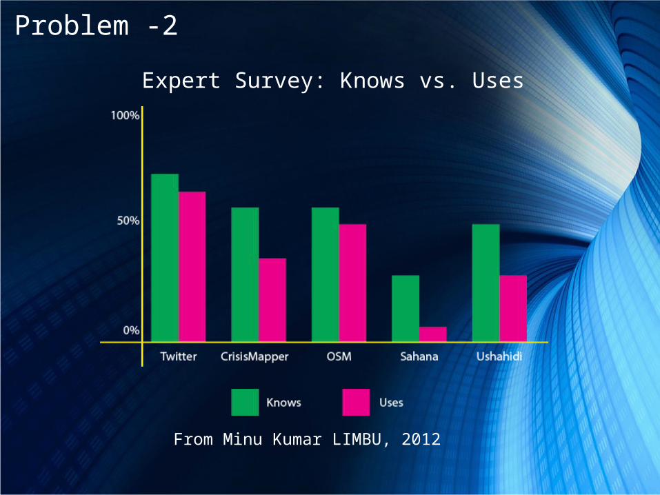
Problem -2
From Minu Kumar LIMBU, 2012
Expert Survey: Knows vs. Uses

Problem -3
From Minu Kumar LIMBU, 2012
Why did the service not help?

Problem -4
“…lives were saved…”
Ushahidi Independent Evaluation
To sum up:
• Unstructured data
• Lack of interoperability
• Semantic heterogeneity
• Uncertainty & reliability
=Problems of
crowdsourced content

LD at work - 1
Linked Data to the rescue!

• Smart and elegant• Graph Data Model• Subject-Predicate-Object statements – LEGO!
LD at work -2Resource Description Framework (RDF)
Relational DB Graph DB

LD at work - 3

LD at work -5

Linked Data:• Structured data• Integration between any
sources• Formal semantics• Giant Open data
repository• Sophisticated
informational retrieval
LD at work -6
Problem:
• Unstructured data
• Lack of interoperability
• Semantic heterogeneity
• Uncertainty & reliability
• Keyword search

+
=• Can we cross the bridge with a 12 ton fire truck?• How to reach the closest operating hospital avoiding road
blockages and who is in charge at that place?
LD at work -7
Volunteered Geographic Information

To what extent can the Linked Open Data cloud help to semantically enrich Volunteered Geographic
Information in order to better answer queries in the context of crisis and disaster relief operations?
Research Question & Objectives
Objectives:
1. To integrate VGI into the LOD cloud
2. To evaluate methods for the construction of semantic queries
3. To evaluate the results

Use case-1
Chile earthquake, 2010
1. The 6th largest ever
2. Magnitude of 8.8
3. 80% of population
4. Tsunami
5. 525 casualties

Russia, 2010Haiti, 2010Chili, 2010
Christchurch, 2011Libya, 2011 Australia, 2011
Kenya , 2007South Africa, 2008 Louisiana, 2010
Serial INCIDENT TITLE INCIDENT DATE LOCATION DESCRIPTION CATEGORY LATITUDE LONGITUDE APPROVED VERIFIED
1636 200 need food and water in Laboule.
20/01/2010 10:46
Laboule, Port-Au-Prince
AIDE POUR LA FONDATION REGARS SISE A LABOULE COORDONER PAR PETIT HOMME STANEL NOUS AVONS ENVIRON 200 PERSONNES
~~~~~~~~~~~~~~~~~~~~~~~~~
We need help for the Regars Foundation located in Laboule, directed by Stanel Petit-Homme. We have about 200 people who need help.~~~~~~~~~~~~~~~~~Category: 4a. Health services
2b. Penurie d'eau | Water shortage, 2a. Penurie d'aliments | Food Shortage, 3c. Besoins en materiels et medicaments | Medical equipment and supply needs,
18.49282 -72.3069 YES NO
Use case-2

Research steps -1 Step 1: to convert Ushahidi into RDF

Research steps-2Step 1: to convert Ushahidi into RDF
Column name ValueSerial number 4349Incident title SERVICIO DE SALUD CONCEPCIÓN
FUNCIONANDO
Incident date 3/4/2010 11:08:00 PMLocation Concepcion, ChileDescription Hospital Guillermo Grant Benavente ,
Hospital Traumatológico ,Hospital de Lota ,Hospital de Coronel
Category 4a. Servicios de Salud, Latitude -36.8148Longitude -73.0293Approved YESVerified NO
Thematic
Spatial
Spatial
Temporal

Research steps-3 Step 1: to convert Ushahidi into RDF
The MOAC vocabulary
The Dublin Core vocabulary LinkedGeoData

Research steps-4Step 1: to convert Ushahidi into RDF
http://linkedgeodata.org/triplify/node988381631 http://linkedgeodata.org/triplify/way126614190 http://linkedgeodata.org/triplify/way223990111 http://linkedgeodata.org/triplify/way124859821
"http://observedchange.com/moac/ns/#HospitalOperating"
Thu Mar 04 23:08:00 CET 2010

Research steps -5Step 2: to construct queries for a semantic enrichment
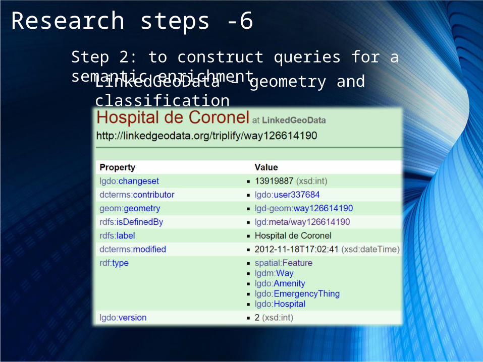
Research steps -6Step 2: to construct queries for a semantic enrichment
LinkedGeoData – geometry and classification

Research steps -7Step 2: to construct queries for a semantic enrichment
DBpedia – background information

Research steps -8 Step 3: to evaluate emerged data management techniques
Before After
Ushahidi classKeyword search
MOACMachine readable
Multi criteria filtering
Literal dateKeyword search
DateTemporal distanceMachine readable
One point per reportKeyword search
Georeferencing Spatial querying
Interoperable geometry

Results-1Extraction of geometries of blocked roads
# TITLE DATE LOCATION DESCRIPTION CATEGORY
LAT/LONG
4730
Ruta 5 sur esta cerrada/ Ruta 5 South
Closed
3/11/2010 17:48
Rancagua, Chile
Road N. 5 closed due to the structural damaged
inflicted by the aftershocks
1a. Estructur
a Colapsad
a,
-34.034
2/-
70.7056

Results-2
Selection of officials of populated places where operating hospitals are located

Prioritizing of the reports based on the density of population.
Results-3

Conclusion
“Challenge is to provide an appropriate categorization (with sufficient explanation) so that volunteers can classify correctly from the beginning…”
An UNOCHA veteran

Conclusion
• MOAC – domain knowledge - WHAT
• LGD – location – WHERE
• Spatial data access
• LOD is an integrated dataspace
• Approach can be applied to any VGI
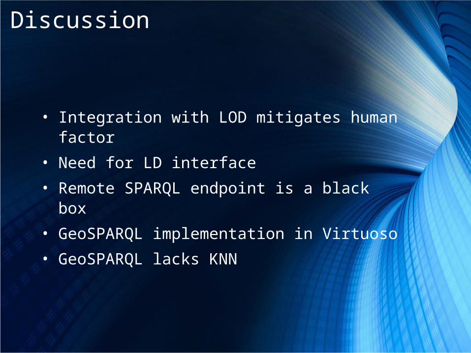
Discussion
• Integration with LOD mitigates human factor
• Need for LD interface
• Remote SPARQL endpoint is a black box
• GeoSPARQL implementation in Virtuoso
• GeoSPARQL lacks KNN

Thank you!Questions!?

Methodology – Software
• TripleGeo• SILK Workbench• RDF Online Validator• Parliament
• iSPARQL• Parliament
• Tabulator• SIMILE Widgets

Background – Linked Data resources• DBpedia – Wikipedia in RDF• GeoNames – Gazetteer, 10 million toponyms• LinkedGeoData (LGD) – OSM in RDF • WordNet & GeoWordNet - lexical database + Geo extension
http://lod-cloud.net/versions/2014-08-30/lod-cloud_colored.png

Methodology – data conversion to RDF

Methodology – data conversion to RDF

Background – Ontologies and Vocabularies

URI – to name things, conceptsOWL – to express formal semanticsSPARQL – query languageRDF – to wrap information
Hypothesis-4

Example of queries:• Find me all the KFC restaurants located in less than 1 km from
the school(s) where Barack Obama had classes.• Find me names of famous singers who lived in municipalities
along river Rhine and who used word “Rhine” in their songs.
LD in work -6

The MOAC vocabHaitian
Earthquake 2010 Chilean Earthquake 2010
Category number
English name
Category number Spanish English
translation
MOAC termsPrefix MOAC: <http://
observedchange.com/moac/ns/#>
Terms from other vocabularies
1 Emergency 1 Emergen
cia Emergency MOAC:Emergency
5a
Collapsed structure,
1a
Estructura Colapsada
Collapsed structure
MOAC:CollapsedStructure
1b Incendio Fire MOAC:Fire
1c Trapped people 1c
Personas atrapadas
Trapped people
MOAC:PeopleTrapped
1e Tsunami Tsunami
http://ontologi.es/WordNet/data/Tsunami

Report as a graph

Report as a graph

Results-2
Selection of bridges located in 10-km proximity to compromised bridges