semanticweb.com geospatial mashups beyond google maps from a geospatial semantic web perspective...
Post on 19-Dec-2015
246 views
TRANSCRIPT

SemanticWeb.comGeospatial
Mashups Beyond Google Maps
from a Geospatial Semantic Web Perspective
Harry ChenImage Matters LLC
(Geospatial Semantic Web Blog)
Networking Geospatial Information Technology for Interoperability and Spatial Ontology Workshop
NSF, Washington DC June 20, 2006

SemanticWeb.comGeospatial
Outline
I. Introduction• Google Maps & Google Earth• Shortcomings in the current mashups
II. How Semantics Can Help• Semantic Web vs. semantic web
III. Semantic Web Mashup Example• From triples to Google Maps
IV. Concluding Remarks
SemanticWeb.comGeospatial
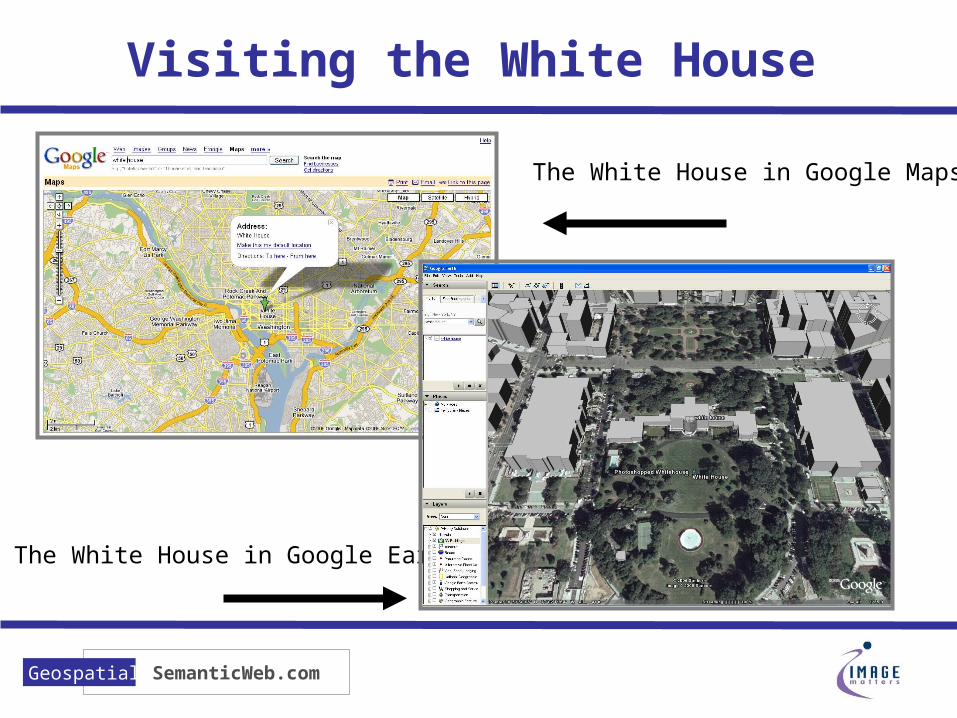
Visiting the White House
The White House in Google Earth
The White House in Google Maps

SemanticWeb.comGeospatial
Google Maps vs. Google Earth
Google Maps Google Earth
MapStreet maps, satellite, or hybrid
Satellite
DataStreet level details of the US, Canada, Western Europe, Japan
World data (cities, boundaries). Street level detail in US, Canada, Western Europe, and Japan
APIGoogle Maps API (pure JavaScript/DHTML)
Google Earth KML (a grammar and file format for modeling and storing geographic features)
System Requirement
Web Browser (javascript) PC, Mac OS X, and Linux

SemanticWeb.comGeospatial
Special Features in Google Earth
3D buildings and terrian
Measure Distances

SemanticWeb.comGeospatial
An Explosion of Mashups
A mashup is a website or web application that uses content from more than one source to create a completely new service.
Source: Wikipedia -- http://en.wikipedia.org/wiki/Mashup_(web_application_hybrid)
Check Real Estate Value Track StormsTrack Ski Conditions
So
urce
: Ne
w S
cien
tist (2
00
6-0
5-1
2)

SemanticWeb.comGeospatial
Questions
• Why is there a sudden explosion of “mashups”? Is it the “holy grail” in building the next generation Web?
• What’s the use of semantic technology in building mashups?
• Do we have the right semantic technology?

SemanticWeb.comGeospatial
Mashups are Growing Fast
• Ubiquitous web service API• Google Maps, Yahoo! Maps, Amazon,
Flickr, del.icio.us, etc.
• People can create new applications by reusing the existing parts• The whole is more than the sum of its
parts
• Maps are intuitive UI interface.

SemanticWeb.comGeospatial
Mashup Issues (1 of 3)
• The present Web is built for human users. Information is meant for humans to consume and not for computer programs.• A map image is a map to the humans,
but is a image to the machines.Map! GIF!

SemanticWeb.comGeospatial
Mashup Issues (2 of 3)
• It’s difficult to discover and integrate legacy data into new mashup applications.
Where can I find real estate data?Data format? Permission to use it?
Where can I find weather data?Data format? Permission to use it?
Real Estate Value Mashup
National Ski Condition Mashup

SemanticWeb.comGeospatial
Mashup Issues (3 of 3)
• Too many wrongly think that mashups must be Google Maps on “steroid”.
Web 2.0 Mashup Matrix
• Records 104 Web 2.0 API • 104 x 104 possibilities• Google Maps 1 of 104
http://www.programmableweb.com/matrix

SemanticWeb.comGeospatial
II. How Semantic Web Can Help

SemanticWeb.comGeospatial
How the Semantic Web Can Help
• Shared Semantic Web ontologies will enable mashups to share data and interoperate
• Expressively defined knowledge on the Web will enable mashups to better discover and access existing information
• Non-geographical semantic knowledge will encourage the innovation of non-map-based mashups

SemanticWeb.comGeospatial
Semantic Technology on the Web
• Semantic Web vs. semantic web• Publishing geospatial data on the Web• Exporting legacy data onto the Web• Searching semantic data on the Web
RDF
XML
OWLMicroformat
RSS GeoRSS
RDF/A
Structured Blogging
Geo
GML
KML
RDFS
rel-tag
hCard
XNF
SemanticWeb.comGeospatial
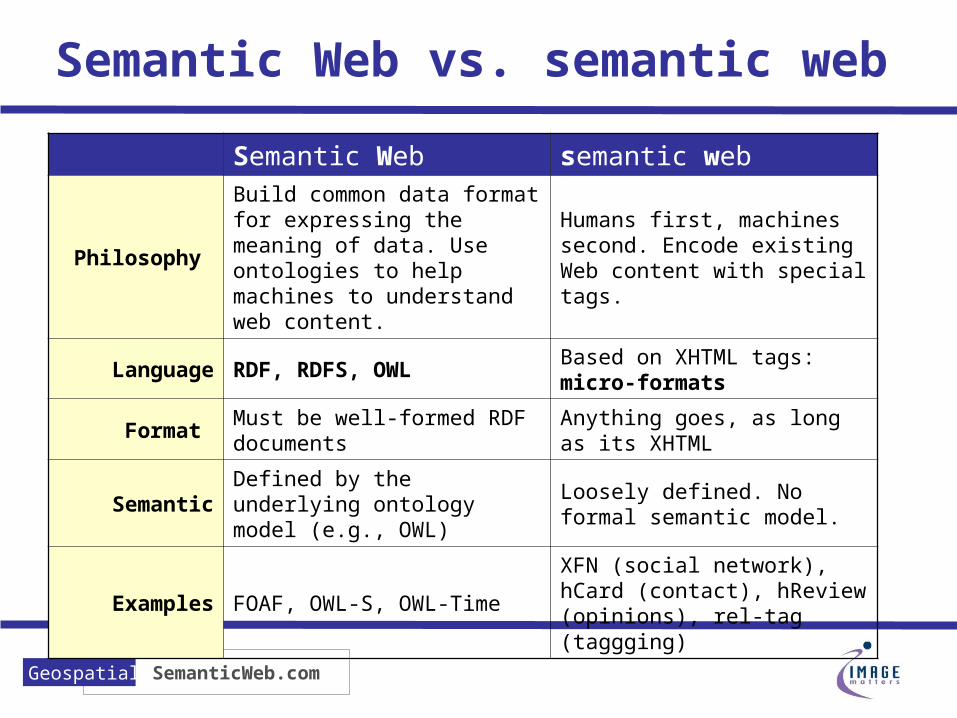
Semantic Web vs. semantic web
Semantic Web semantic web
Philosophy
Build common data format for expressing the meaning of data. Use ontologies to help machines to understand web content.
Humans first, machines second. Encode existing Web content with special tags.
Language RDF, RDFS, OWLBased on XHTML tags: micro-formats
Format Must be well-formed RDF documents
Anything goes, as long as its XHTML
SemanticDefined by the underlying ontology model (e.g., OWL)
Loosely defined. No formal semantic model.
Examples FOAF, OWL-S, OWL-Time
XFN (social network), hCard (contact), hReview (opinions), rel-tag (taggging)

SemanticWeb.comGeospatial
Publishing Geospatial Data
• Describing Geo coordinates• W3C RDF Geo Vocabulary (WGS 84)• Geo of Microformat (WGS 84)• GeoRSS – encoding GML geometry in
RSS
• Describing geographical locations• CIA Fact Book
• http://www-ksl-svc.stanford.edu:5915/doc/wfb/index.html
• Open Cyc Spatial Ontology• http://www.cyc.com/cyc-2-1/cyc-vocab.daml

SemanticWeb.comGeospatial
Using W3C Geo
<rdf:RDF xmlns:rdf="http://www.w3.org/1999/02/22-rdf-syntax-ns#" xmlns:rdfs="http://www.w3.org/2000/01/rdf-schema#" xmlns:geo="http://www.w3.org/2003/01/geo/wgs84_pos#" xmlns:dc="http://purl.org/dc/elements/1.1/" xmlns="http://xmlns.com/foaf/0.1/"> <Person> <name>Dan Brickley</name> <homepage dc:title="Dan's home page“ rdf:resource="http://danbri.org/"/> <based_near geo:lat="51.47026" geo:long="-2.59466"/> <rdfs:seeAlso rdf:resource="http:/danbri.org/foaf.rdf"/> </Person></rdf:RDF>
Subject Predicate Object
:_a rdf:type foaf:Person
:_a foaf:name “Dan Brickley”
:_a foaf:base_near :_geo
:_geo geo:long “-2.59466”
:_geo geo:lat “51.47026” Source: http://www.w3.org/2003/01/geo/

SemanticWeb.comGeospatial
Using Microformat Geo (1)

SemanticWeb.comGeospatial
Using Microformat (2)
…Currently he lives in Columbia, Maryland (<span class="geo"> <span class="latitude">391425N</span>, <span class="longitude">0765022W</span>) with his wife Gigi.</span> …
<p class="vcard"> <a class="url fn" href="http://harry.hchen1.com">Harry Chen</a> was born in Shanghai, China. He moved to Hong Kong with his parents when he was ten. During the last year of his high school, he studied in the US as an exchange student . He completed undergraduate and graduate studies in Computer Science at the <a title="UMBC" class="org" href="http://www.umbc.edu">University of Maryland, Baltimore County</a>. He was awarded a PhD fellowship from HP Labs for his work on intelligent agents in mobile and pervasive computing.</p>

SemanticWeb.comGeospatial
Technorati: Microformat Search
Not yet understand “geo”, but that’s okay. At least it works!
http://kitchen.technorati.com

SemanticWeb.comGeospatial
Exporting Legacy Data
• Much data is hidden in our legacy systems. We must find ways to export this data onto the Web
Web pages are designed for people. For the Semantic Web we need to look at existing databases and the data in them.
-Tim Berners-Lee, March 2006. http://www.bcs.org/server.php?show=ConWebDoc.3337

SemanticWeb.comGeospatial
Getting Data onto the Web
• Approach 1: Consolidate everything into a single database

SemanticWeb.comGeospatial
Getting Data onto the Web
• Approach 2: Dynamically integrate data into a uniformed representation

SemanticWeb.comGeospatial
Data Integration Systems
• Oracle RDF database (Oracle)• Supports full RDF and RDFS• Support SQL query over RDF graph model• Built-in subsumption support: subClassOf and subPropertyOf
• D2RQ (Freie Universität Berlin):• Declarative language for describing mappings between
relational DB schemas and RDFS/OWL ontologies• Support SQL• D2RQ Server allows accesses to SQL using SPARQL queries
over HTTP• KnowledgeSmarts (Image Matters LLC)
• A middle-ware system for knowledge integration over heterogeneous datastores
• Supports SQL, Shapefiles, XML, WFS and more.• Optimized for applications that require spatial and temporal
computation support.

SemanticWeb.comGeospatial
Searching Semantic Data
• Swoogle: a Semantic Web search engine• The Ebiquity Research Group at UMBC• Indexes 1.5 million SW documents (as of
2006/06)• Performs sophisticated statistic analysis on
triples, OWL classes, OWL properties, and documents (similar to Page Rank)
• How to search “geo” ontology using Swoolge• http://geospatialsemanticweb.com/2006/06/06/searchin
g-geospatial-ontologies-in-swoogle http://swoogle.umbc.edu

SemanticWeb.comGeospatial
III. Semantic Web Mashup Example

SemanticWeb.comGeospatial
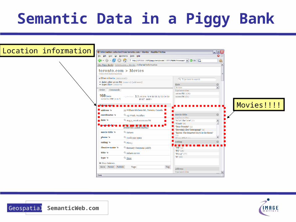
Semantic Mashup: Piggy Bank
• Piggy Bank is a Firefox extension that uses JavaScript to scrape RDF triples from the Web.• Part of MIT’s SIMILE project• http://simile.mit.edu/piggy-bank

SemanticWeb.comGeospatial
Movies at Toronto.Com
Typical movies listing
Piggy Bank this information
SemanticWeb.comGeospatial
Semantic Data in a Piggy Bank
Location information
Movies!!!!

SemanticWeb.comGeospatial
Location! Location! Location!

SemanticWeb.comGeospatial
IV. Concluding Remarks

SemanticWeb.comGeospatial
Mashups are HOT
• An explosion of “mashups” is fueled by • (1) ubiquitous Web Service API (esp.
Google Maps API)• (2) the idea that “everyone can create new
applications by reusing the existing parts”• (3) the rediscovery of the power of “maps”

SemanticWeb.comGeospatial
Semantics is the Key
• Developing more sophisticated mashups will require the use of Semantic Web technology • For publishing data on the Web• For exporting legacy data onto the Web• For search semantic data on the Web
• We should embrace both “Semantic Web” and “semantic web” technology

SemanticWeb.comGeospatial
You Mashup?
By Cathy Wilcox, the Sydney Morning Herald

SemanticWeb.comGeospatial
Resources
• Geospatial Semantic Web Blog• http://geospatialsemanticweb.com • Bookmarks, links to podcasts and more
• Questions?• Email: [email protected]• http://harry.hchen1.com